COUNTY TRAIL SYSTEM DESIGN: BROWN, LYON, REDWOOD ... · COUNTY TRAIL SYSTEM DESIGN: BROWN, LYON,...
55
JUNE 2010 COUNTY TRAIL SYSTEM DESIGN: BROWN, LYON, REDWOOD & RENVILLE COUNTIES
Transcript of COUNTY TRAIL SYSTEM DESIGN: BROWN, LYON, REDWOOD ... · COUNTY TRAIL SYSTEM DESIGN: BROWN, LYON,...

JUNE 2010
COUNTY TRAIL SYSTEM DESIGN: BROWN, LYON, REDWOOD & RENVILLE COUNTIES
ACKNOWLEDGEMENTS
This project was produced and completed by The Center for Changing Landscapes, College of Design, College of Food, Agricultural, and Natural Sciences at the University of Minnesota.
The project team included:
Mary Vogel, Co-Director
Roger Martin, Senior Research Fellow, Professor Emeritus
James Pettinari, Senior Research Fellow
Laura Detzler, Research Fellow
Egle Vanagaite, Research Fellow
Cindy Zerger, Research Fellow
Carlos Fernandez, Research Fellow
Cynthia Lapp, Research Fellow
Special thank you to:
Funding for this project was received by the Legislative-Citizen Commission on Minnesota Resources (LCCMR) from the Minnesota Environment and Natural Resources Trust Fund in ML 2008, Chapter [367], Section [2], Subdivision 3 [1]; West Central Regional Sustainable Partnership, Redwood County, Renville County, and Cities of Lamberton, Lucan, Morgan, and Redwood Falls.
This publication is available at http://ccl.design.umn.edu/.
For alternative formats, direct requests to:
Center for Changing Landscapes
151 Rapson Hall
89 Church Street
Minneapolis, MN 55455
612.624.7557
©2010 Regents of the University of Minnesota. All rights reserved.
The University of Minnesota is an equal opportunity educator and employer.
Printed on recycled and recyclable paper with at least 10 percent post consumer material.
INTRODUCTION
COUNTY TRAIL SYSTEM DESIGN: REGION CHAPTER
BROWN COUNTY
LYON COUNTY
REDWOOD COUNTY
RENVILLE COUNTY
RESOURCES
APPENDIX
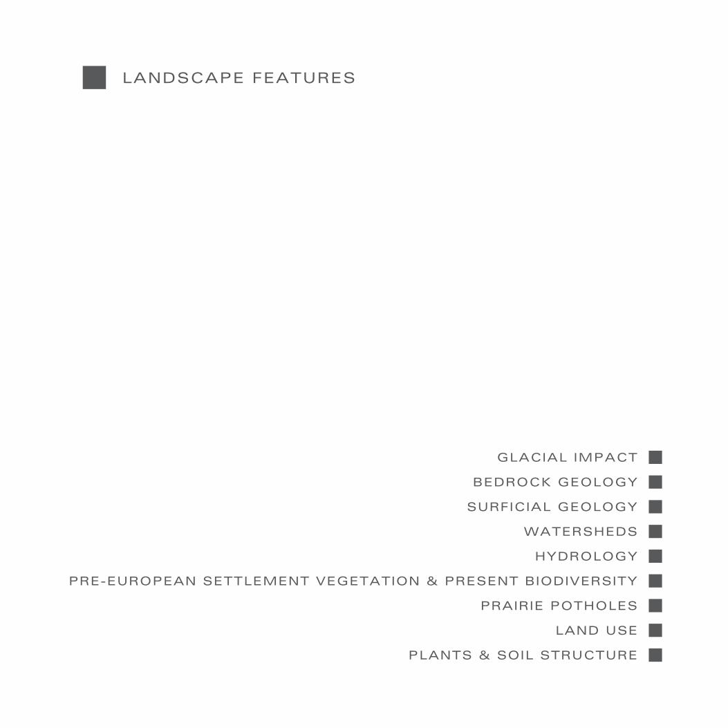
LANDSCAPE FEATURES
Glacial Impact
Bedrock Geology
Surficial Geology
Watersheds
Hydrology
Prairie Potholes
Pre-European Vegetation & Biodiversity
Plants & Soil Structure
Land Use
CULTURAL LANDSCAPE
The Dakota Presence
European Settlement
Agriculture
Cooperatives
The WPA/CCC Legacy
Telephone & Electric Corridors
Acquisitions & Improvements
REGIONAL TRAILS
Southwest Minnesota Regional Trails Plan
Proposed and Existing Trails
Horse Trails
Chief Sleepy Eye Trail
Proposed Trail Network
6-23A
6-7A
8-9A
10-11A
12-13A
14-15A
16-17A
18-19A
20-21A
22-23A
TABLE OF CONTENTS COUNTY TRAIL SYSTEM DESIGN: REGION CHAPTER
26-39A
26-27A
28-29A
30-31A
32-33A
34-35A
36-37A
38-39A
42-51A
42-43A
44-45A
46-47A
48-49A
51A
6-51A
2-87B
2-87C
2-91D
2-93E


INTRODUCTION

INTRODUCTION
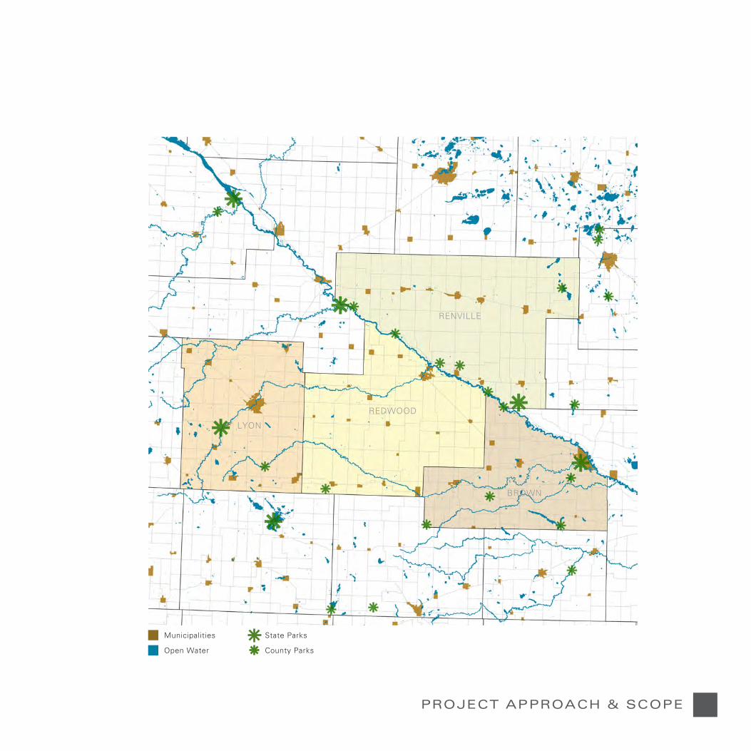
County trail plans/designs for Lyon, Redwood, Renville, and Brown Counties include designs/plans at the county, community, district, and site scales. A project team from the Center for Changing Landscapes, an interdisciplinary center at the University of Minnesota, has worked with counties, communities, trail groups, and citizens in a community-engaged process to ensure local and user input.
The plans/designs goals are to:
Create county trail plans/designs that support and promote recreation and environmental awareness and stewardship by addressing issues of environmental type, quality, and preservation along new trail corridors and in the larger trail landscapes to preserve, enhance, and interpret natural and cultural landscape systems and features;
Leverage the effectiveness of existing and planned local, regional, and state recreational, natural, and cultural assets such as parks, trails, historic sites, conservation lands;
Create community consensus around trail opportunities;
Create connections between and among the county trail systems in order to create the potential for a regional system that connects the counties together.
Empower counties and citizens to effectively seek regional trail funding by creating planning/design tools that can be used for grant applications; and
PROJECT APPROACH & SCOPE
3A
Municipalities
Open Water
PROJECT APPROACH & SCOPE
State Parks
County Parks
LYON
RENVILLE
REDWOOD
BROWN

LANDSCAPE FEATURES
PLANTS & SOIL STRUCTURE
HYDROLOGY
WATERSHEDS
PRE-EUROPEAN SETTLEMENT VEGETATION & PRESENT BIODIVERSITY
LAND USE
BEDROCK GEOLOGY
GLACIAL IMPACT
SURFICIAL GEOLOGY
PRAIRIE POTHOLES

Glacial River Warren
Minnesota River
Valley Walls Ancient River Terraces Valley Floor Ancient River Terraces Valley Walls
Bedrock
Till
Till
LANDSCAPE FEATURES
GLACIAL IMPACTGlaciers that periodically moved across the landscape formed the basis for the current topography of the four county region. Rocks left by the glaciers are found throughout the four counties.
Buffalo RidgeBuffalo Ridge or Coteau des Prairies, a large plateau in southwestern Minnesota, eastern Dakota, and northern Iowa rises from the Minnesota prairie to a height of 1730 feet above sea level. Composed of 900 feet of glacial deposits from repeated periods of glaciation, its height creates an opportunity for wind farms to harvest the wind. Drainage from the Ridge northward creates flooding in the flat prairie pothole region to the northeast of the Ridge.
Glacial River WarrenGlacial Lake Agassiz formed around 12,000 years ago; it was created from melt water from receding glaciers. When the ice dam broke
at Brown’s Valley and released melt waters from Lake Agassiz, the mighty River Warren, the predecessor to the Minnesota River was created. Today the large riverbed created by the torrent of melt waters is now the Minnesota River Valley within which the present much smaller Minnesota River flows.
Prairie PotholesLarge chucks of ice left by the glaciers created the region’s wetlands and lakes.
Design ImplicationsChanges in elevation provide challenges for siting bike trails that are usable by all cyclists.
Prairie potholes provide opportunities for interpretation.
Fieldstones left by the glaciers provide local material for interpretive elements.
Adapted from Minnesota’s Geology
Courtesy Minnesota River Basin Data Center
Glacial River Warren

7A
Municipalities
Open Water
GLACIAL IMPACT
730 - 905 Feet
1230 - 1480 Feet
1730 - 2000 Feet905 - 1230 Feet
1480 - 1730 Feet
LYON
RENVILLE
REDWOOD
BROWN

LANDSCAPE FEATURES
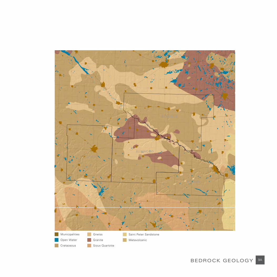
BEDROCK GEOLOGY
Granite FieldstoneSioux Quartzite
Deep layers of glacial till bury the region’s bedrock. The bedrock is most visible in rock outcroppings where the glacial till was eroded away by the Glacial River Warren and years of prairie winds. The different types of exposed bedrock reveal the story of the region’s shifting bedrock geology.
In the Redwood Falls area, Morton Gneiss outcroppings are extensive. Morton Gneiss or Rainbow Granite is considered one of the oldest rocks at 3,600 million years old (Ojakansas and Matsch). Morton has an active mine of this famous architectural stone that is operated by the Cold Spring Granite Company.
Towards New Ulm. Cretaceous Sandstone is most prevalent. This highly erosive substance is made of poorly consolidated soft shale, quartz sand, and lignitic clay. A small area of Sioux Quartzite is located northeast of New Ulm.
Fieldstones deposited by the glaciers are present in all four counties.
Design ImplicationsLocal rock offers an opportunity to use it in interpretive elements.
9A
Municipalities
Open Water
BEDROCK GEOLOGY
Cretaceous
Gneiss
Granite
Sioux Quartzite
Saint Peter Sandstone
Metavolcanic
LYON
RENVILLE
REDWOOD
BROWN

LANDSCAPE FEATURES
Municipalities
Open Water
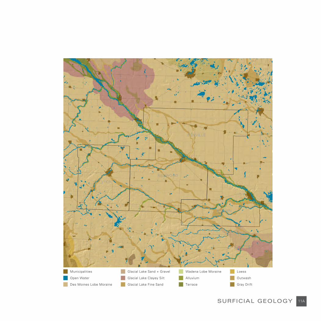
SURFICIAL GEOLOGYSurficial geology defines the majority of the landscape character and how that character is experienced. South Central and Southwestern Minnesota have distinct landscape types, each of which have been shaped by layers of glacial till and glacial movement. The surficial geology includes ground moraine, outwash channels, ancient terraces, stagnation moraines, an ancient lakebed, and a high plateau.
Ground moraine dominates the majority of the area creating level to slightly rolling terrain. Old outwash channels created by glacial streams are evident in the Geographic Information System (GIS) analysis mapping, but are not perceived in the actual landscape. The ancient terraces of the Glacial River Warren are still evident and are quite large in some areas. These terraces contribute to defining the width and breath of what was once the Glacial River Warren. Stagnation moraines are visible in the landscape and are characterized by a hillier terrain
that contains pothole lakes and wetlands caused by glacially formed depressions. The Buffalo Ridge is a small ridge covered with thick glacial deposits. This landscape has produced clays that support brick making industries in the area.
Design ImplicationsChanges in surficial geology provide changes in the trail experience as the trail moves through the landscape; the region’s landscape types offer opportunities to interpret these characteristics.
Brick made from local clays are potential materials for interpretive elements.
Supraglacial Drift
Till Plane
Lacustrine
Outwash
Alluvium
Terrace
Peat
Bedrock Dominated
Surficial Geomorphology
11A
Municipalities
Open Water
SURFICIAL GEOLOGY
Des Moines Lobe Moraine
Wadena Lobe MoraineGlacial Lake Sand + Gravel
Glacial Lake Fine Sand
Glacial Lake Clayey Silt Outwash
Loess
Gray DriftTerrace
Alluvium
LYON
RENVILLE
REDWOOD
BROWN

LANDSCAPE FEATURES
WATERSHEDSThere are 12 major watersheds n the Minnesota River Basin. A major tributary generally defines these major watersheds. The four county area’s major tributaries are the Redwood River which cuts through Redwood Falls in a deep, picturesque gorge, the Cottonwood River at New Ulm that has a culturally significant, beautiful state park, and the Yellow Medicine River that joins the Minnesota River at the Upper Sioux Agency.
Historically this area was dotted with prairie wetland complexes. As European settlers moved into the region and started to farm the land, the wetlands were drained by systems of drainage tiles and drainage ditches. This extensive drainage created a very rich and productive agricultural landscape, but it resulted in the loss of approximately 2-3 million acres or 90 percent of the historic prairie wetlands. Because of this, the Minnesota River and its tributaries are susceptible to frequent flooding and the Minnesota River is considered one of the most polluted rivers in the state and in the nation. (Minnesota River Basin Data Center). This water pollution affects more than just the environment of the Minnesota River Valley. “The Minnesota River is the state’s largest tributary to the Mississippi River. Where the Minnesota River flows into the Mississippi River, the flow of the Mississippi doubles” (Minnesota River Basin Data Center). The nutrients in the Minnesota River contribute to the pollution of the Gulf of Mexico and its ever-increasing hypoxia zone, the “dead zone” devoid of oxygen that cannot support life.
Yellow Medicine, Redwood, and Cottonwood Rivers, the major prairie rivers of South Central and Southwestern Minnesota, flow through Lyon, Redwood, and Brown Counties. Many small perennial and intermittent watercourses flow across the landscape.
Efforts by several organizations, individuals, and government bodies are being made to improve the water quality and restore wildlife habitat in South Central and Southwestern Minnesota. Many of the major tributaries to the Minnesota River are undergoing clean up and restoration. The U.S. Department of Agriculture’s Conservation Reserve Program (CREP) and Minnesota’s Reinvest in Minnesota Reserve Program (RIM) have worked together to provide competitive rates to farmers for enrolling their land into conservation easement programs that take land out of agricultural production. Riparian buffers, frequently flooded land in the Minnesota River Valley and its tributaries, and land that is near major identified pollutant sources are the first targets for these programs.
Design ImplicationsThe Minnesota River Watershed and the problems of pollutants are topics for interpretation as are the measures that are being taken to address the pollution.
Because the small prairie rivers greatly swell in the spring and most of the land along the rivers is in private ownership, siting trails along them may be difficult. However, creating trailheads, rest stops, and interpretative elements at key places along the rivers would provide opportunities for trail users to enjoy these rivers.
Reducing the number of new places that the trail is required to cross small watercourses is desirable because building new bridges to cross the many small streams add to trail costs. Using existing bridges will reduce the cost.

13A
Municipalities
Open Water
WATERSHEDS
Yellow Medicine River
South Fork Crow River
Minnesota RiverShakopee
Minnesota River - Mankato
Cottonwood River
Watonwan RiverWest Fork Des Moines River Headwaters
Redwood River
Rock River
Lac Qui Parle River
Minnesota River Headwaters
Chippewa River North Fork Crow River
Watersheds
Hawk Creek
LYON
RENVILLE
REDWOOD
BROWN
LANDSCAPE FEATURES
Municipalities, Present
Open Water, Present
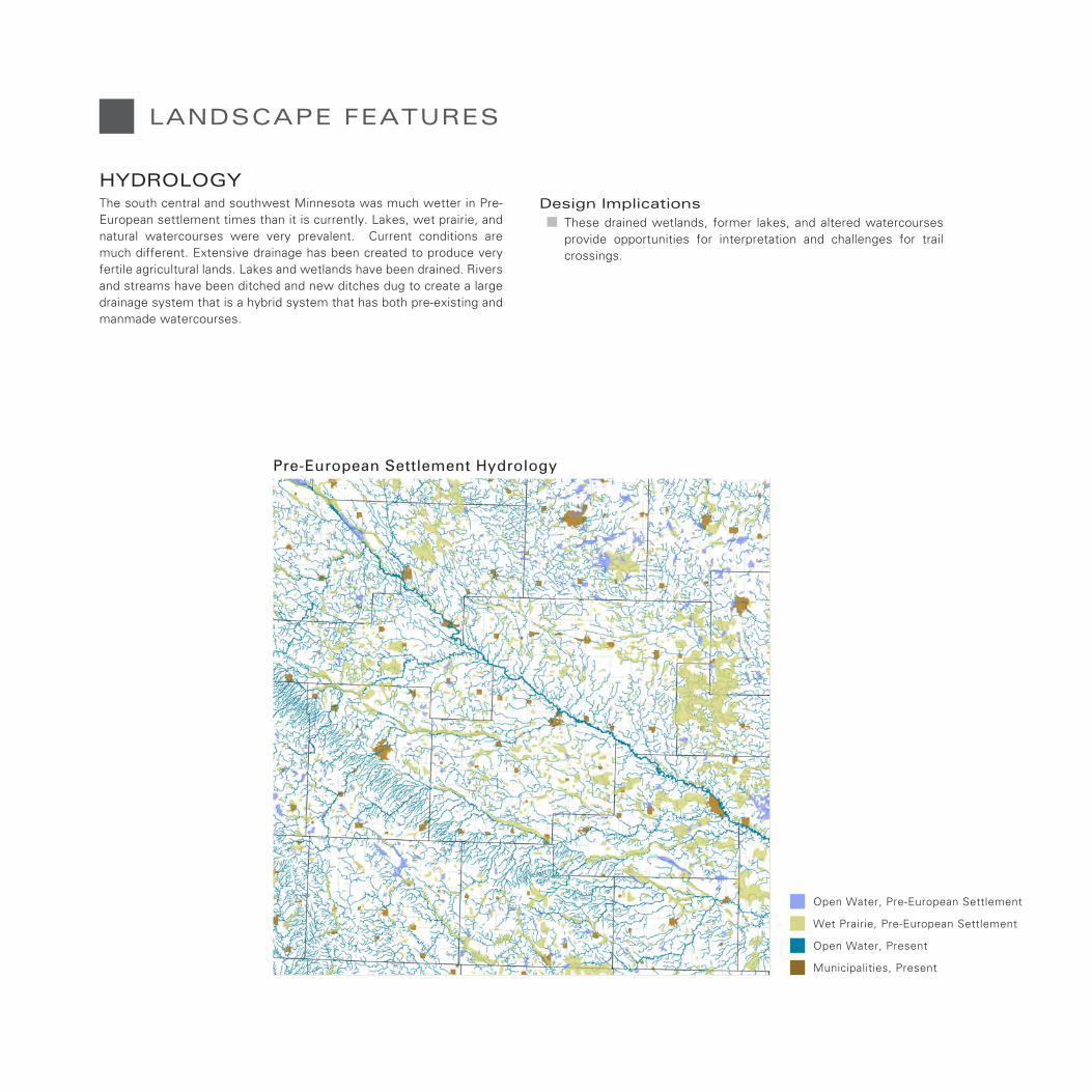
HYDROLOGYThe south central and southwest Minnesota was much wetter in Pre-European settlement times than it is currently. Lakes, wet prairie, and natural watercourses were very prevalent. Current conditions are much different. Extensive drainage has been created to produce very fertile agricultural lands. Lakes and wetlands have been drained. Rivers and streams have been ditched and new ditches dug to create a large drainage system that is a hybrid system that has both pre-existing and manmade watercourses.
Design ImplicationsThese drained wetlands, former lakes, and altered watercourses provide opportunities for interpretation and challenges for trail crossings.
Pre-European Settlement Hydrology
Open Water, Pre-European Settlement
Wet Prairie, Pre-European Settlement

15A
Municipalities
Open Water
Drainage Ditches & Ditched Streams
CURRENT HYDROLOGY
BROWN
RENVILLE
REDWOOD
LYON

LANDSCAPE FEATURES
Municipalities
Open Water
PRE-EUROPEAN SETTLEMENT VEGETATION & PRESENT BIODIVERSITYThe Pre-European Settlement vegetation of this landscape was once a majority of tall grass prairie dominated by big bluestem, little bluestem, switch grass and Indian grass with many large patches of wet prairie. In this prairie landscape it is easy to see how the river bottom forests and hardwood bluffs were areas of settlement for its first inhabitants.
Small patches of the transitional Aspen-Oak and Oak Savanna were found in South Central Minnesota west of the big woods in the eastern Minnesota. This landscape is very altered now. Agricultural land has replaced the wet and dry prairie. Fragmentation of these native plant communities has had a negative impact on wildlife. Most of the main sites of significant biodiversity that still exist are being managed through Scientific and Natural Areas (SNA), Wildlife Management Areas (WMA), and state park management systems.
Some of the most notable biodiversity sites in the study area are Cedar Rock WMA, Cedar Mountain SNA, Fort Ridgely State Park, and Camden State Park.
Design ImplicationsAligning county trails so that trail users can appropriately experience these areas of biodiversity is desired.
Prairie
Wet Prairie
Aspen + Oak
Big Woods
River Bottom Forest
Oak Openings + Barrens
Pre-European Settlement Vegetation
LYON
REDWOOD
RENVILLE
BROWN

17A
Municipalities
Open Water
PRE-EUROPEAN SETTLEMENT VEGETATION & PRESENT BIODIVERSITY
Native Plant Community Remnants
Remaining Native Plant Communities
LYON
RENVILLE
REDWOOD
BROWN

LANDSCAPE FEATURES
PRAIRIE POTHOLESThe South Central and Southwestern Minnesota shallow lakes and wetlands were created by the receding glaciers. These Prairie Potholes contribute to the region’s ecological health by helping to reduce flooding, maintaining streams during times of little rainfall, filtering pollutants from the water before it enters rivers and streams, and recharging the ground water table with snowmelt and rainfall.
The plant varieties found in these potholes provide organic matter with high water-holding capacity. Perennial and seasonal prairie wetlands are widely used as breeding grounds and rest areas for waterfowl providing important habitat for both resident and migrating species.
Today only 20% of these once abundant prairie wetland habitats remain. Extensive networks of field drain tile systems and drainage ditches have transformed many formerly wet areas into farm fields that
grow corn and other crops. Many of the prairie wetlands that remain are designated as wild life management areas and scientific and natural areas managed by the State of Minnesota’s Department of Natural Resources.
Design Implications Opportunities to site trails in proximity to these islands of water and habitat among the farm fields should be pursued because they are regional amenities that are prime spots for bird watching and landscape interpretation.

191919APRAIRIE POTHOLES
Prairie Potholes

LANDSCAPE FEATURES
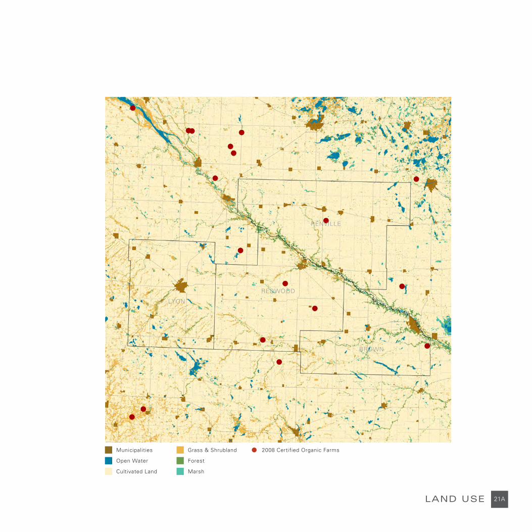
Agriculture has been dominant throughout the four counties starting in the mid-1800s with the first immigrant settlers. Prairie has been drained giving way to today’s landscapes: an agricultural matrix of cultivated land, farmsteads, windbreaks, and county roads.
Over the last half century, traditional farming has been radically changed. Agricultural technology has led to specialized crop production on much larger farms. Market forces and government programs have led to the consolidation of small, traditional farms into large farming and feedlot operations. Unused homes and barns surrounded by windbreaks of trees dot the landscape.
However, farming is the economic powerhouse of the region and farming is still very much part of the culture of this landscape. Its presence and its history are very important to the communities in the four counties. Historical societies and many independent groups have become very active in preserving the agricultural history of the region. Many of the barns and farmsteads have been placed on the National Register of Historic Sites. A century farm program celebrates farms that have been in continuous family ownership for at least 100 years and are at least 50 acres in size. Farm and farm machinery museums can be found in the region as well as many harvest and farm festivals.
Most recently, there has been some movement away from the larger farms. Those interested in sustainable agriculture have started to bring back the traditional smaller farm. Using agri-tourism ideas, sustainable farmers have formed networks and host events throughout the year. Many small farms have also diversified to include wineries, bed and breakfasts, or have become ‘U-pick’ or CSA (community supported agriculture) sites.
Design Implications Both large-scale conventional farming and smaller sustainable farming are features of the landscape to be experienced and interpreted by the trails.
LAND USE
21A
Municipalities
Open Water
LAND USE
Cultivated Land
Grass & Shrubland
Forest
Marsh
2008 Certified Organic Farms
LYON
RENVILLE
REDWOOD
BROWN

LANDSCAPE FEATURES
PLANTS & SOIL STRUCTUREThe structure of the four-county area’s soil has changed over time as the plants that grow upon it have changed. The topsoil is less deep than it formerly was. This is a consequence of cultivation and cultivation practices.
Tall Grass Prairie At the time of European settlement the region was native prairie with a palate of perennial plants that spread across the landscape. The region’s fertile topsoil was estimated to be 24 to 30 inches deep. Decomposition of prairie plants’ deep root systems over time increased soil fertility by increasing the soil’s organic material.
Deep root systems also reduced wind and water erosion by holding the soil. Their deep roots acclimated them to periods of little rain and absorbed rainfall to reduce flooding. Today, less than 4% of the original Tall Grass Prairie remains in North America.
Short Root CropsThe annual planting of corn, soybean, and sugar beets has replaced the original prairie landscape. Fertile soil made by the tall grass prairie has made South Central and Southwestern Minnesota a very productive farming area, but its fertile topsoil has been reduced to 12 inches. These short-root crops do not hold the soil as well as deep-root native prairie plants making them more vulnerable to wind and periods of reduced rainfall. Frequently these seasonal crops have led to soil degradation because dormant fields leave the fertile topsoil vulnerable to water and wind erosion reducing soil productivity through losses of nutrients, water storage capacity, and organic matter.
Design ImplicationsThe trail should be sited to provide opportunities for viewing native prairie plants.
Their attractiveness and environmentally sound qualities make native prairie plants desirable materials for trailheads and areas that need soil protection.

232323APLANTS & SOIL STRUCTURE
Root Structure
Topsoil Depth
Compass plant
Indian Grass
Prairie Drop-seed
Prairie Cord Grass
Porcupine Grass
Switch Grass
Little Blue Stem
False Bonneset
Pale Purple Coneflower
Side oats Gramma
Wild Indigo
Buffalo Grass
Purple Prairie Clover
Blazing Star
Rosin Weed
Smooth BromeBig Blue stem
Lead Plant
Corn Soybeans
Native Plants


CULTURAL LANDSCAPE
ACQUISITIONS & IMPROVEMENTS
AGRICULTURE
EUROPEAN SETTLEMENT
COOPERATIVES
THE WPA/CCC LEGACY
TELEPHONE & ELECTRIC CORRIDORS
THE DAKOTA PRESENCE

CULTURAL LANDSCAPE
“The Minnesota and Mississippi River Valleys have been home to the Dakota for centuries. The existence of our ancestors was sustained by their relationship with the earth and their surroundings. For generations, Dakota families fished from the rivers, gathered rice from area lakes, hunted game on the prairies and in the river valley woodlands, and established villages along the riverbanks and surrounding lakes. Our ancestors lived in harmony with the world around them, and Dakota culture flourished.
In the 1640s, the first recorded non-Indian contact with the Dakota took place. For the next 200 years, our ancestors tolerated the presence and ever increasing numbers of non-Indians encroaching on their homelands. Some Dakota villages took advantage of the presence of non-Indians by establishing trade, inter-marriage, and even adopting many non-Indian ways of life and religion. Still other villages did not accept or trust the newcomers and did not wish to have traditional ways of life changed. By the end of the 1700’s, the fur trade had become a major way of life for many Dakota, and almost all villages were trading goods with the non-Indians.
In 1805 US soldiers arrived at Mendota, and the world of the Dakota began to change drastically. A series of treaties forced on the Dakota nation over the next 50 years would see their homeland taken away, their ability to provide for themselves destroyed, and an increasing reliance upon the government’s promises for payments and goods. The traditional Dakota way of life was stolen and replaced by confinement to reservations. Missionaries, fur traders, Indian Agents and the U.S. government all worked to change the culture of the Dakota. The U.S. government broke treaties, made endless empty promises and slowly attempted to eradicate the Dakota nation.
Finally, in 1862, the Dakota could no longer allow this mistreatment. Our ancestors battled for their homelands, their way of life, their culture. The events of 1862 ended with the largest mass execution in United States history when 38 Dakota were hanged at Mankato.
As a result of the Dakota boldness in standing up for their rights, the United States Congress abrogated all treaties with our ancestors and decided that the Dakota had to be removed from Minnesota. The majority of Dakota were sent on barges to Crow Creek, South Dakota, in 1863, and eventually removed to Santee, Nebraska. Other Dakota traveled to Canada and settled there. Some Dakota never left their homeland. Those Dakota who remained in Minnesota spent many impoverished years attempting to gain support and help from the federal government. Generations of our ancestors experienced U.S. government control, Indian boarding schools, and little opportunity for success. Strong Dakota communities eventually developed at Lower Sioux, Prairie Island, Upper Sioux, and Shakopee.”
Excerpted from the Shakopee Mdewakanton website: http://www.ccsmdc.org
Design ImplicationsThe current and historic presence of the Dakota offers opportunities for the trails to celebrate Dakota culture and their presence in an appropriate and respectful way.
THE DAKOTA PRESENCE
After the 1825 Chippewa-Dakota Treaty
After 1830’s cessions After the 1851 Treaty of Traverse des Sioux
Dakota Land

272727A
Dakota VillagesReservation Lands
European SettlementsBattle Sites
Dakota Reservation
Ho-Chunk Reservation
1862 Village and Battle Sites
THE DAKOTA PRESENCE

CULTURAL LANDSCAPE
European SettlersAfter the 1851 Treaty of Traverse des Sioux between the United States Government and the Dakota peoples, land was offered for purchase by the federal government and the railroads. The railroads were given land by the government to subsidize their expansion across the unsettled territories west of the Mississippi River. Americans from the east and immigrants from northern Europe came as settlers to south central and southwest Minnesota. Many of the settlements are characterized by the nationality of the immigrants that first settled the farms and the small communities on the prairie.
Catholic ColonizationArchbishop John Ireland established Catholic colonies in southwestern Minnesota for immigrants that were suffering terrible working and living conditions in the factories and tenements of the large cities of the eastern seaboard. Working with the railroads, the Archbishop promoted homesteading and number of communities. Assuring prospective settlers that they would be able to practice their faith, he provided a priest for the farming communities that were created by the railroads to serve the railroads and the farms that surrounded them. Although not all the settlers were successful in surviving the cold winters, the droughts, the grasshopper invasions, and the challenges of creating a viable farm on the virgin prairie, many of these communities and their parishes are still part of the present landscape.
Design ImplicationsThere is an opportunity to interpret the ethnic character of the region’s communities.
EUROPEAN SETTLEMENT
Minneota, 1910
Bishop John Ireland, 1887
Convent, Ghent 1912

Avoca
Fulda
Iona
Minneota
Currie
Ghent
29A
Municipalities
Open Water
EUROPEAN SETTLEMENT
Catholic Bishop John Ireland Colonies
Colonies
LYON
RENVILLE
REDWOOD
BROWN

CULTURAL LANDSCAPE
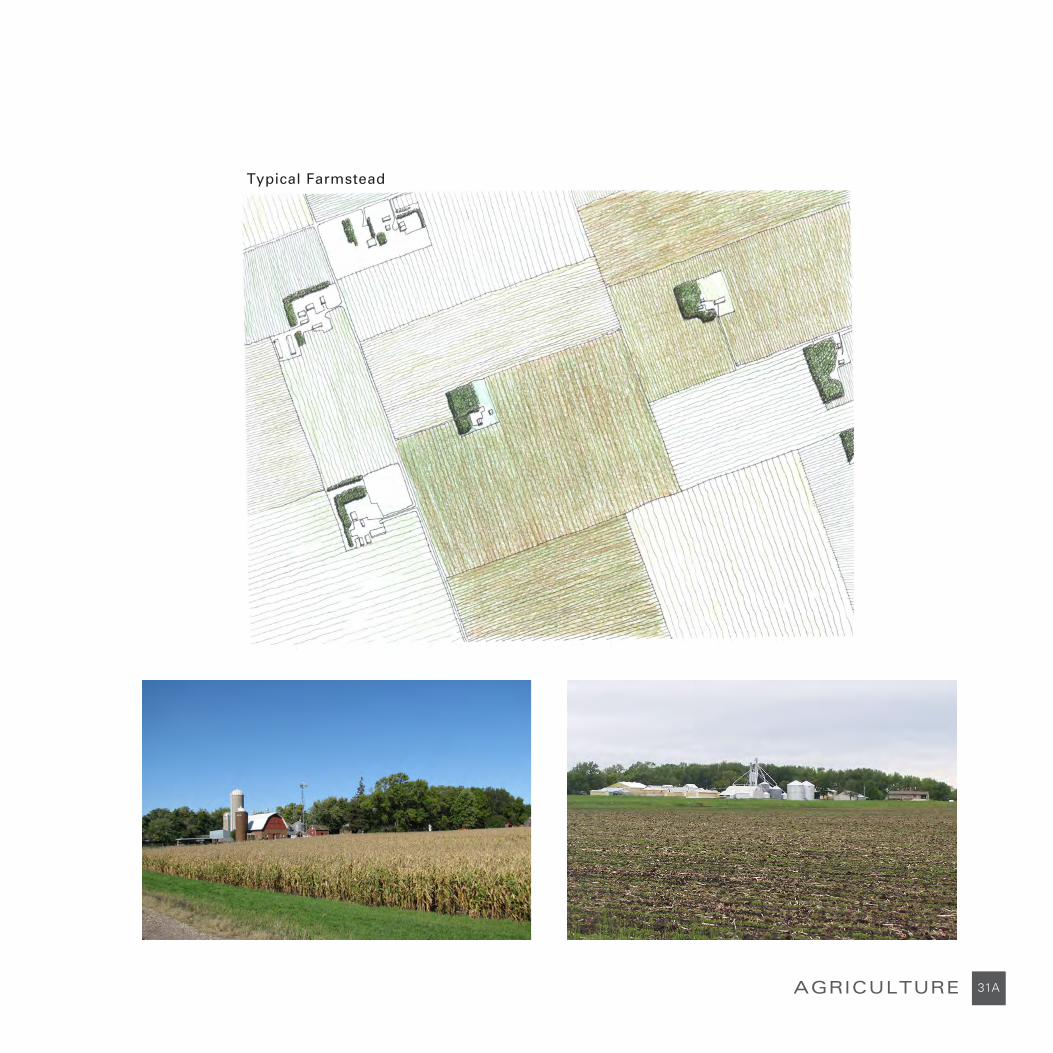
The Agricultural LandscapeThe landscape of South Central and Southwestern Minnesota is a vast quilt of farmland bisected by the Glacial River Warren Valley and the Minnesota River. The orthogonal pattern of land division is part of the Jeffersonian grid that characterizes the land west of the Mississippi River; land that was purchased from Spain, taken from the Indians, surveyed, and sold to settlers in the 19th century.
Typical Farms & FarmsteadsThe original farm settlement pattern consisted of many farmsteads dotting the landscape as new settlers transformed the prairie into small farms. After the lands were taken from the Indians by the federal government, pioneers purchased tracts of federal land or former federal land that was deeded to railroads as an incentive to develop rail lines across the prairie.
The original farms were modest by modern standards; a typical farm consisted of a portion of a section. Over time, farms increased in size as some original settlers left the land due to the challenges and hardships entailed in establishing and running a viable farming operation. The development of farming machinery made large farms possible; tilling, planting, fertilizing, weeding, and harvesting became less time consuming and arduous.
Farmhouses and farm buildings evolved from the original simple sod structures to modest frame buildings to large two story structures. Farm buildings and barnyards were shielded by trees from the strong and cold northwestern winter prairie winds. These patches of trees, shrubs, and buildings set in a green quilt of farm fields were visible across the landscape. Farms raised both crops and animals and hauled them to town for shipment on the railroad to the large cities to the east.
Today farms are large, a few of the old large barns and a few out buildings remain. Farming is concentrated on raising crops, not animals and farmsteads have large metal cylindrical grain storage facilities. Although many older farmhouses remain, new ranch style houses are popular. The windbreaks of trees and shrubs that shelter the farmstead from the relentless prairie winds still create lush green islands that are set among the fields of corn,soy beans and sugar beets.
Large Scale Animal & Bird Production Large facilities for the production of birds and large animals also dot the landscape. Some are associated with a farmstead, but many are large freestanding operations. Feedlots for livestock and many large poultry buildings for turkeys and chickens are typical of these big operations.
Sustainable AgricultureWith the emergence of the slow food movement locally and internationally, the number of smaller farms that focus on sustainable methods and/or organic food to produce locally grown food is increasing in the region. Green routes to travel to see the farms and buy the produce have been created.
Design ImplicationsThere is opportunity to interpret the agricultural landscape by siting trails to pass industrial and sustainable farms, large animal and bird production facilities, and traditional and contemporary farmhouses and buildings.
Opportunities to provide places to stop and buy locally grown food also exist.
Siting trails away from facilities that emit unpleasant odors is desirable.
AGRICULTURE
313131A
Typical Farmstead
AGRICULTURE

CULTURAL LANDSCAPE
COOPERATIVESIn the late 19th century transportation changed from river to rail, technologic innovation produced new farm implements and processing equipment, financial pressures mounted from railroads and large grain companies that raised farmers’ costs and lowered their profits, and farming communities had strong bonds of ethnicity and religious affiliation, These forces and conditions spawned cooperative efforts in rural Minnesota among its farmers. These efforts led to cooperative movements like the Grange and the Farmers’ Alliance, and the creation of cooperative creameries, elevators, stores, and fire insurance entities.
Although the railroad helped to establish a large number of “line elevators” in Minnesota that were owned and operated by large companies in the Twin Cities and Duluth, by 1914 there were 270 cooperative elevators owned by 34,500 farmers that handled 30% of the State’s grain. In Minnesota the cooperative elevators averaged 148,000 bushels, while the privately owned ones averaged 60,000.
The cooperative movement is part of the story of Lyon, Redwood, Renville, Brown Counties, and their communities. The cooperative movement started new crossroad towns such as Hanska. Redwood
Falls was the site of the wheat price war of 1904 between the local farmers’ cooperative elevator and the line elevator. Owners of the line elevator pulled down the farmers’ elevator at Vesta. Concerns were raised about the Sleepy Eye Farmers Warehouse’s relationship to the Farmers’ Alliance. Within the Redwood County Rural Telephone Company, farmers questioned the relationship between shares and voting rights. An early effort at a cooperative store took place in Renville County.
By 1922 Farmers’ Alliance Sub-alliance Groups were formed in Lyon County in Balaton, Cottonwood, Marshall, and Russell; in Brown County in Hanska, Iberia, New Ulm, and Sleepy Eye; and in Redwood County in Redwood Falls and Vesta.
Design ImplicationsCooperative buildings and other sites associated with the cooperative movement offer opportunities for interpretation.
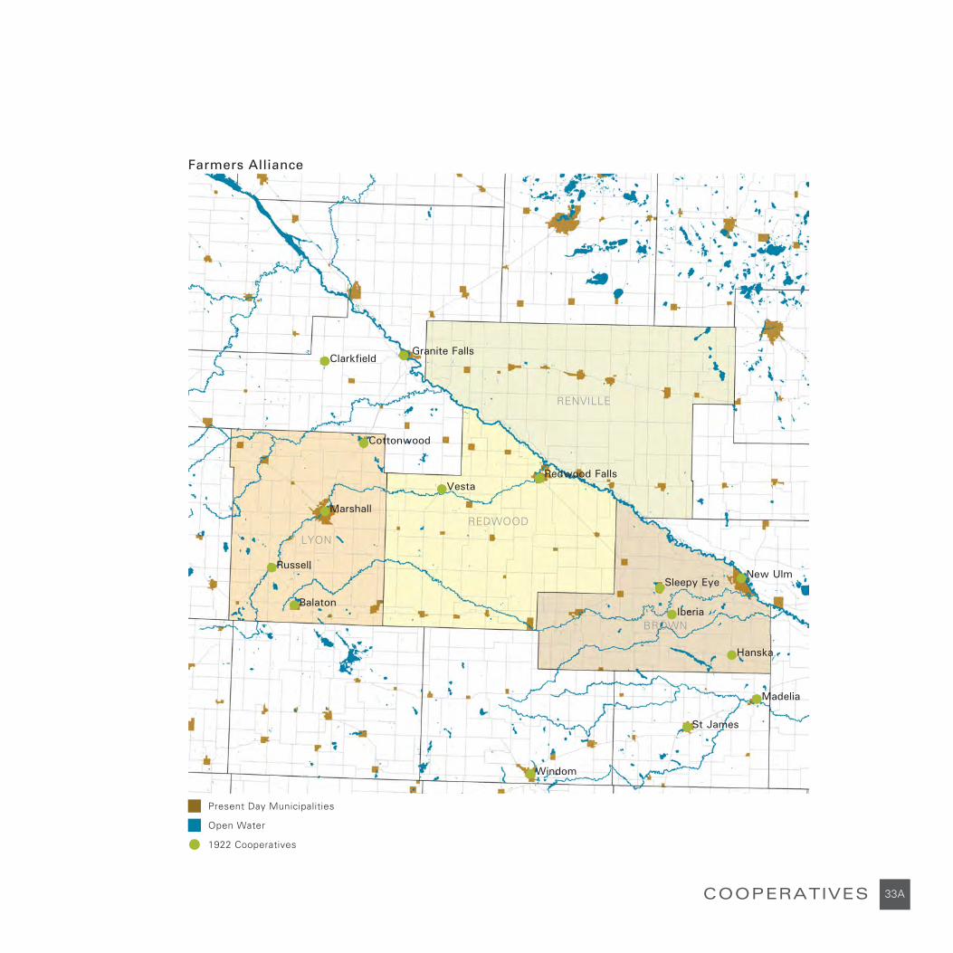
1922 Cooperatives
Farmers Alliance
Vesta
Madelia
St James
Windom
Granite Falls
Cottonwood
Marshall
Clarkfield
33A
Open Water
Present Day Municipalities
Sleepy Eye
Iberia
New Ulm
Hanska
Redwood Falls
Balaton
Russell
COOPERATIVES
LYON
RENVILLE
REDWOOD
BROWN

CULTURAL LANDSCAPE
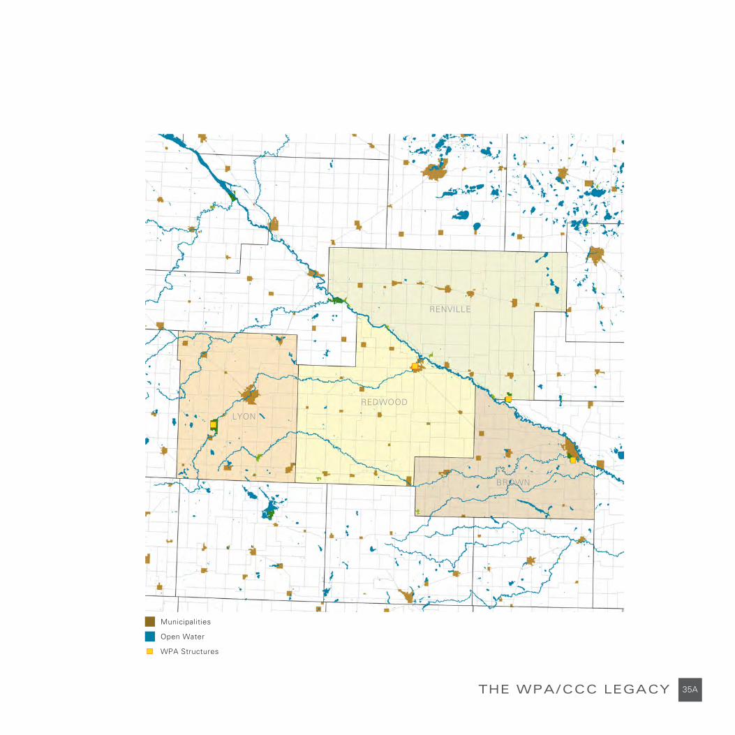
THE WPA/CCC LEGACYDuring the nineteen thirties and early forties a number of Works Progress Administration programs were active in the four counties. These included the Civilian Conservation Corps. There were camps in Camden, Fort Ridgely and Flandrau State Parks. Dams, bridges, swimming beaches, camp buildings, picnic shelters, refreshment buildings, staff residences, sanitary facilities, drinking fountains, etc were built. These works built in rustic style of local materials constitute a rich heritage. Although most of the work was done in the state parks, some works are also sprinkled across the landscape.
Design ImplicationsMarking and interpreting these works and siting the trail in ways that provide access to them is desirable.
35A
Municipalities
Open Water
THE WPA/CCC LEGACY
WPA Structures
LYON
RENVILLE
REDWOOD
BROWN
LANDSCAPE FEATURES
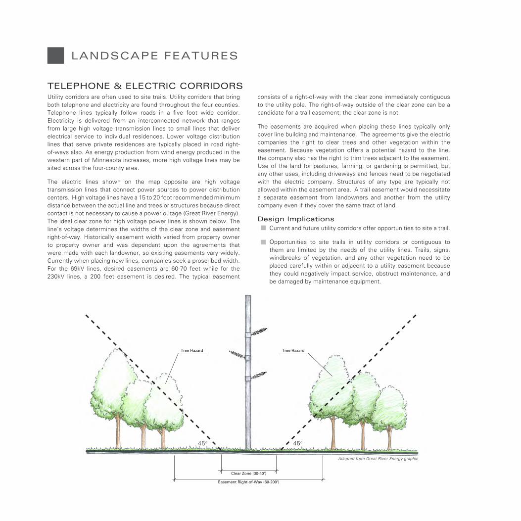
TELEPHONE & ELECTRIC CORRIDORSUtility corridors are often used to site trails. Utility corridors that bring both telephone and electricity are found throughout the four counties. Telephone lines typically follow roads in a five foot wide corridor. Electricity is delivered from an interconnected network that ranges from large high voltage transmission lines to small lines that deliver electrical service to individual residences. Lower voltage distribution lines that serve private residences are typically placed in road right-of-ways also. As energy production from wind energy produced in the western part of Minnesota increases, more high voltage lines may be sited across the four-county area.
The electric lines shown on the map opposite are high voltage transmission lines that connect power sources to power distribution centers. High voltage lines have a 15 to 20 foot recommended minimum distance between the actual line and trees or structures because direct contact is not necessary to cause a power outage (Great River Energy). The ideal clear zone for high voltage power lines is shown below. The line’s voltage determines the widths of the clear zone and easement right-of-way. Historically easement width varied from property owner to property owner and was dependant upon the agreements that were made with each landowner, so existing easements vary widely. Currently when placing new lines, companies seek a proscribed width. For the 69kV lines, desired easements are 60-70 feet while for the 230kV lines, a 200 feet easement is desired. The typical easement
consists of a right-of-way with the clear zone immediately contiguous to the utility pole. The right-of-way outside of the clear zone can be a candidate for a trail easement; the clear zone is not.
The easements are acquired when placing these lines typically only cover line building and maintenance. The agreements give the electric companies the right to clear trees and other vegetation within the easement. Because vegetation offers a potential hazard to the line, the company also has the right to trim trees adjacent to the easement. Use of the land for pastures, farming, or gardening is permitted, but any other uses, including driveways and fences need to be negotiated with the electric company. Structures of any type are typically not allowed within the easement area. A trail easement would necessitate a separate easement from landowners and another from the utility company even if they cover the same tract of land.
Design ImplicationsCurrent and future utility corridors offer opportunities to site a trail.
Opportunities to site trails in utility corridors or contiguous to them are limited by the needs of the utility lines. Trails, signs, windbreaks of vegetation, and any other vegetation need to be placed carefully within or adjacent to a utility easement because they could negatively impact service, obstruct maintenance, and be damaged by maintenance equipment.
Clear Zone (30-40’)
Easement Right-of-Way (60-200’)
Tree Hazard Tree Hazard
45o45o
Adapted from Great River Energy graphic

37A
Municipalities
Open Water
TELEPHONE & ELECTRIC CORRIDORS
Existing Electric Transmission Lines
Proposed CapX2020 Preferred and Alternate Routes
LYON
RENVILLE
REDWOOD
BROWN

CULTURAL LANDSCAPE
ACQUISITIONS & IMPROVEMENTSLand acquisitions funded by the Minnesota State Legislature using the Environmental and Natural Resource Trust Fund dollars through the Legislative Citizen Commission on Minnesota Resources process and the Legacy Funds through the Lessard-Sams Outdoor Heritage Council (LSOHC) process, and the parks and recreation Legacy Funds through a RFP process run by the Department of Natural Resources have created improvements and additions to existing facilities and public lands that increase the outdoor recreation opportunities in the four counties.
Lands acquired or lands seeking or acquisitions include:
A 30-acre addition to Ft. Ridgely State Park
The Beaver Falls AMA,
Two tracts expansion (60 acres) of Ft. Ridgely State Park
Whispering Ridge (182 acre)
Four Wildlife Management Areas (WMA) or Aquatic Management Areas (AMA). ($1.617 million) to be announced
LSOHC recommendation for FY2011pending legislative approval for $1.651 million for additional WMA and/or AMA development within the nine-county Green Corridor program area, and
Waukon Rim: 600 acres including the Cedar Mountain SNA/WMA, the Mann’s Lake WMA/Recreation Area, and the Waukon RIM WMA.
Design ImplicationsThe trails should provide access to these assets wherever it is appropriate.

Actual and pending LCCMR and Legacy Fund Land Aquisitions/Donations (2010)
39A
Municipalities
Open Water
ACQUISITIONS & IMPROVEMENTS
Legacy Funding
LYON
RENVILLE
REDWOOD
BROWN


REGIONAL TRAILS
SOUTHWEST MINNESOTA REGIONAL TRAILS PLAN
EXISTING & PROPOSED TRAIL SYSTEMS
CHIEF SLEEPY EYE TRAIL
HORSE TRAILS

REGIONAL TRAILS
The Southwestern Minnesota Regional Trail Plan was created in 2000. This effort was led by the Southwest Development Commission in response to the lack of trails in southwest region and the interest in developing a regional trail system by economic development officials and local governments. The plan did not address specific alignments; it identified general routes that connected communities and points of interest. Currently the Southwest Development Commission is convening a group to revise and update the plan.
Excerpts from the 2000 plan include:
“Vision: The vision for trails in Southwest Minnesota is to establish a network of trails in Southwest Minnesota for multiple users. “
“The Southwest Minnesota Regional Trails Plan during its first phase will examine alternative non-motorized transportation modes (primarily walking and bicycling) and recommend actions to improve access and mobility for bicyclist and pedestrians. This plan is an element of the Regional Long Range Transportation Plan.
Developed through a grass roots process involving local officials and citizen input, this plan provides guidance for land-use decision-makers at the state, regional and local level to follow.
While primarily focusing on walking and bicycling, it is recognized that there is an established network of snowmobile trails throughout the region. This network will be identified and acknowledged when contemplating any other type of trail. Future phases of Plan updates will include other trail types such as ATV, snowmobile, and equestrian, etc.”
Design ImplicationsIndividual county trail plans have an opportunity to contribute to a larger region-wide system in the future.
SOUTHWEST MINNESOTA REGIONAL TRAILS PLAN

43A
Municipalities
Open Water
SOUTHWEST MINNESOTA REGIONAL TRAILS PLAN
Trail Corridor
Proposed Trailheads
Proposed Corridors and Trailhead Locations
LYON
RENVILLE
REDWOOD
BROWN
NICOLLET
Source: Southwest Minnesota Regional Trails Plan
MURRAYCOTTONWOOD
WANTONWAN
SIBLEY
MEEKERKANDIYOHI
YELLOW MEDICINE
CHIPPEWA

REGIONAL TRAILS
Currently there are a number of trails and routes in South Central and Southwestern Minnesota that exist or are in planning stages. Some communities like Marshall, Sleepy Eye, and Redwood Falls have city trails. A portion of the Casey Jones State Trail has been built, another segment is being built, and additional segments will be planned in the future. Portions of the Minnesota River State Trail have been planned. The Birding Trail is a car route that brings birders to places in the area where local and migrating birds congregate. The Minnesota River Scenic Byway encourages driving in the historic Minnesota River Valley in this part of Minnesota.
Design ImplicationsThe existing and planned trails in South Central and Southwestern Minnesota offer opportunities to create a greater whole by connecting county trails to them.
EXISTING & PROPOSED TRAIL SYSTEMS

45A
Municipalities
Open Water
State Trails
EXISTING & PROPOSED TRAIL SYSTEMS
Scenic Byway
Birding Trail
Dakota Commemorative March
Local Trails
Proposed State Trails
State Parks
County Parks
Proposed State Trail Corridor
LYON
RENVILLE
REDWOOD
BROWN
Garvin Park
Camden State Park
Plum Creek Park
Skalbekken Park
Flandrau State Park
Mound Creek Park
Treml Park
Lake Hanska Park
Fort Ridgely State Park
Clear Lake Park
Lost Dog & Fox Hunters Park
Lake Allie Park
Lake Marion Park

REGIONAL TRAILS
Organized recreational trail riding within the Minnesota River Valley dates back to the 1940’s. There are multiple local saddle clubs in the Redwood and Renville County that have organized trail rides on private properties and within the county parks where trail riding is allowed. Both Fort Ridgely and Upper Sioux Agency State Parks have established horse trails. There are a number of horse camps in the four counties and acquisitions are enhancing existing horse trail and camp facilities. These are:
Whispering Ridge aquatic management area (AMA) was acquired west of Gold Mine Lake provides an opportunity in the future to connect horse trails from Vicksburg County Park to the Gold Mine Lake, and Cedar Rock Ranch. Horse trails are allowed on AMAs.
The Dick Brown Recreational Trail circles Mann’s Lake.
Future connections to the Cedar Rock Ranch and the North Redwood trail system and the Redwood Valley Riders Club property.
The horse camp along Fort Ridgely Creek in Fort Ridgely State Park was increased from 15 acres to 75 acres.
The Brickyard AMA acquisition and a pending acquisition expansion will create the potential to connect a horse trail from the Lower Sioux Community into Morton.
A 2010 bonding request was submitted to the Parks & Trails Council of Minnesota for a connecting horse trail from Morton to Fort Ridgely State Park. This trail would connect to both Mack Lake and Anderson Lake County parks.
HORSE TRAILS

47A
Municipalities
Open Water
HORSE TRAILS
Proposed Horse Trail
Sites with Horse Trails
LYON
RENVILLE
REDWOOD
BROWN
REGIONAL TRAILS
CHIEF SLEEPY EYE TRAIL, A SPUR OF THE MINNESOTA RIVER STATE TRAILThe Chief Sleepy Eye Trail offers an opportunity to link the City of Sleepy Eye, the Brown County Trail System, and the Redwood County Trail System and the Minnesota River State Trail, and the Casey Jones State Trail at a trail hub in downtown Redwood Falls. Sited on an abandoned rail line along most of its twenty six miles, the trail leaves Sleepy Eye heading north parallel to State Highway 4, turns on State Highway 68 before it joins the abandoned rail line south of Evan. From Evan it follows a diagonal route northwest through Morgan, past the Gilfillan Farm to the City of Redwood Falls.
The 100-foot trail right-of-way is to be planted with bands of native prairie plants and a windbreak of trees and shrubs. The plant palette includes big and little blue stem, switchgrass, heather aster, Indian grass, prairie cone flower, pale purple cone flower, Missouri goldenrod, black eyed Susan, buffalo grass, pale golden aster, prairie smoke, blue eyed grass, and butterfly weed,
Sleepy Eye TrailheadThe trailhead in Sleepy Eye is located at Sleepy Eye Lake and is connected to the city trail around Sleepy Eye Lake.
EvanThe trailhead at Evan interprets its past as a railroad community that served the farms and the farm families that surrounded it.
MorganThe trailhead at Morgan highlights the city’s historic buildings.
The Gilfillan EstateThe trail passes by the Gilfillan Estate, a farm site owned by the Redwood County Historical Society and host to Minnesota’s Farm Fest. The farm displays antique farm equipment. Tours of the home and farmhouse are available. Camping with hookups and showers are also available.
Redwood FallsThe Sleepy Eye Trail ends in downtown Redwood Falls at a trailhead hub that serves it, the future Minnesota River State Trail, and Casey Jones State Trail.

Gilfillan
49A
Municipalities
Open Water
CHIEF SLEEPY EYE TRAIL
Proposed Chief Sleepy Eye Trail
Proposed Trailheads
Sleepy Eye
Evan
Morgan
Redwood Falls
LYON
RENVILLE
REDWOOD
BROWN


51A
Municipalities
Open Water
State Trails
Proposed State Trails
State Parks
County Parks
Proposed State Trail Corridor
PROPOSED TRAIL NETWORK
Proposed County Trail
Proposed County Trail Through Private Land
Proposed County Trail Along Unpaved Road
LYON
RENVILLE
REDWOOD
BROWN


![The Redwood gazette. (Redwood Falls, Minn.), 1909-05-19, [p ].](https://static.fdocuments.net/doc/165x107/61f3066c4fb1c01f2e62eb08/the-redwood-gazette-redwood-falls-minn-1909-05-19-p-.jpg)


![The Redwood gazette. (Redwood Falls, Minn.), 1933-07-27, [p ].](https://static.fdocuments.net/doc/165x107/62986ea183583b25e317e403/the-redwood-gazette-redwood-falls-minn-1933-07-27-p-.jpg)