Cornwall Industrial Settlements Initiative STENALEES · Cornwall Industrial Settlements ... ports...
45
Report No: 2005R036 Cornwall Industrial Settlements Initiative STENALEES (Hensbarrow Area) 2005
Transcript of Cornwall Industrial Settlements Initiative STENALEES · Cornwall Industrial Settlements ... ports...

Report No: 2005R036
Cornwall Industrial Settlements Initiative
STENALEES (Hensbarrow Area)
2005

ii

CORNWALL INDUSTRIAL SETTLEMENTS INITIATIVE Conservation Area Partnership
Name: STENALEES Study Area: Hensbarrow
Council: Restormel Borough Council NGR:
Location: Mid-west Cornwall, in the clay lands about 3 miles north of St Austell
Existing CA?
No
Main period of industrial settlement growth:
1840s;
1893-1920s
Main industry:
China clay (earlier Tin)
Industrial history and significance Stenalees is in a sense a microcosm, a palimpsest, of all the various trends and processes that have overtaken the Hensbarrow massif over many centuries. The late medieval agricultural expansion into the moorland landscape is still discernible here, but with industrial sites around, and even within the study area, that may yet retain evidence of early tin streaming, tin mining and early (late 18th/early 19th century) clay working. Cutting across this was a developing communications pattern of roads and railways, allowing increasing exploitation of what was to become one of the main chain clay producing areas to the south and west of Stenalees.
Stenalees is less a nucleated village, more a dispersed conglomerate of inter-related settlements; it is in many respects a settlement that never finished its development; it is frozen in the midst of becoming a recognizable, nucleated place. The different strands of its development over both time and space are still discernible – mediaeval hamlets, 19th century industrial smallholdings, mid 19th century parochial centre and hierarchical landscape, early 20th century ribbon development - and have never quite coalesced.
Alternative local centres of population provided their own range of services and facilities, so that although it had church, school, shops, chapels, and trades they never developed to the full range or scale in Stenalees. Stenalees, like the more dominant centres nearby (Bugle for instance) only makes sense when seen in relation to all the other adjoining villages and centres that shared these economic and social functions.
Other comments The key to enhancing the sense of place in Stenalees, and in some respects to creating that sense, lies in recognising the diverse nature of settlement in this little valley, and most particularly in streetscape design and enhancements to the main road which cuts through it all.
Recommendations Historic areas
• Designate a Conservation Area
• Prepare a full Conservation Area appraisal
• Further designation of protected open spaces together with management and enhancement proposals
iii

• Protect and manage historic landscapes around the village
• Article 4 Direction to control alteration and partial demolition of walls in CA
• Article 4 Direction to control PD on single dwelling houses and alteration and partial demolition of small buildings in CA
Historic buildings
• Revise Statutory List.
• Prepare list of locally significant buildings
Policy and management
• Recognise and protect those surviving historic buildings which are currently underused or vacant or in poor condition
• A full survey of archaeological potential
• Prepare archaeological management plan
• Prepare landscape management plan
• Full survey of existing trees and ornamental landscapes with appropriate protection measures
• Proposals affecting areas of derelict land to be based on a thorough understanding of the unique historical and archaeological importance of the sites
• Limit or restrict development on the outskirts
• Recognise back-land areas and rear lanes as an important aspect of Stenalees’s character
• Develop interpretation of the village and other promotional initiatives
• Further study of historic pattern of ownership and development of properties within the village
• Further study of the development and design of the Treverbyn church/school/ornamental landscape complex
• Produce design guidance specific to the A 391 in its passage through the village
• Produce design and development briefs for specific sites
• Site-specific design guidance for the village
• Restoration/enhancement schemes to enhance some of Stenalees’s important focal points
iv

Conservation Area Partnership
Cornwall Industrial Settlements Initiative STENALEES
(Hensbarrow Area)
The Cahill Partnership
and
Historic Environment Service
Cornwall County Council
2005
Report No: 2005R036
v

Acknowledgements
This report presents the results of an assessment carried out by The Cahill Partnership following desktop research by Bryn Perry Tapper (CAU). Assistance was also provided by Terry Clarke, Restormel Borough Council. The report text and map drafts were prepared by The Cahill Partnership and edited by Peter Herring (CISI Project Manager CAU). The report maps were produced by John Brinkhoff (CCC Planning Directorate Technical Services Section) from roughs prepared by The Cahill Partnership.
Front cover illustration: Stenalees from the air (CCC HES F7/P42 – 19/06/1986)
©Cornwall County Council 2005 Historic Environment Service, Environment and Heritage, Planning, Transportation and Estates, Cornwall County Council, Kennall Building, Old County Hall, Station Road, Truro, Cornwall TR1 3AY. All rights reserved. No part of this document may be reproduced, stored in a retrieval system, or transmitted in any form or by any means without the prior permission of the publisher.
vi

Contents
Page 1 Introduction .................................................................................................................9
1.1 Background................................................................................................................................9 1.2 Project Aims ..............................................................................................................................9 1.3 Project methodology ................................................................................................................9 1.4 Date of Assessment ..................................................................................................................9
2 Location and setting .................................................................................................. 10 2.1 Geographical location ............................................................................................................10 2.2 Landscape setting....................................................................................................................10
3 History........................................................................................................................ 10 3.1 Agriculture and early settlement ...........................................................................................10 3.2 Tin .............................................................................................................................................11 3.3 Transport..................................................................................................................................12 3.4 Building stone quarries...........................................................................................................13 3.5 China clay and china stone ....................................................................................................13
4 Physical Development (Fig 2)..................................................................................... 15 4.1 Pre-1813 ...................................................................................................................................15 4.2 1813-1840.................................................................................................................................16 4.3 1840-82 .....................................................................................................................................17 4.4 1882-1906.................................................................................................................................18 4.5 1906-47 .....................................................................................................................................18 4.6 Post 1947..................................................................................................................................19
5 Current Character (Figs 3 & 4) .................................................................................... 19 5.1 General .....................................................................................................................................19 5.2 Distinct areas of character in Stenalees ...............................................................................20 5.3 Spaces, greenery and views ....................................................................................................21 5.4 Built environment ...................................................................................................................22
5.4.1 Public/ecclesiastical buildings ..........................................................................................22 5.4.2 Industrial remains ...............................................................................................................23 5.4.3 Housing................................................................................................................................24 5.4.4 Materials and local details..................................................................................................25
6 Industrial significance................................................................................................25 7 Designations ..............................................................................................................26
7.1 Scheduled monuments ...........................................................................................................26 7.2 Historic Buildings (Fig 4).......................................................................................................26 7.3 Historic Area Designations (Fig 4).......................................................................................26 7.4 Other designations..................................................................................................................26
8 Current issues and forces for change.........................................................................27 9 Recommendations .....................................................................................................28
9.1 Historic areas ...........................................................................................................................28 9.2 Historic buildings....................................................................................................................29 9.3 Policy and management .........................................................................................................30
10 References ..................................................................................................................33 10.1 Primary Sources.......................................................................................................................33 10.2 Publications..............................................................................................................................33
Appendix: Gazetteer of archaeological sites and historic buildings.................................35
vii

List of figures 1. Location map
2. Historical development
3. Surviving historic components
4. Gazetteer sites, existing designations and recommendations
Abbreviations in main text AGHV Area of Great Historic Value
AGSV Area of Great Scientific Value
AONB Area of Outstanding Natural Beauty
CA Conservation Area
CAU Cornwall Archaeological Unit (Historic Environment Service, CCC)
CCC Cornwall County Council
CISI Cornwall Industrial Settlements Initiative
GPDO General Permitted Development Order
HES Historic Environment Service, Cornwall County Council
HERS Heritage Economic Regeneration Scheme (English Heritage)
HLF Heritage Lottery Fund (ing)
LB Listed Building
OALS Open Areas of Local Significance to Settlement Character
OS Ordnance Survey
PD Permitted Development
SPG Supplementary Planning Guidance
THI Townscape Heritage Initiative (Heritage Lottery Fund)
UNESCO United Nations Educational, Scientific and Cultural Organisation
[1] Site number on Figure 4 and in the gazetteer (Appendix)
viii

1 Introduction 1.1 Background Cornwall’s industrial settlements are the subject of a Conservation Area Partnership under the heading Cornwall Industrial Settlements Initiative (CISI). This partnership between English Heritage (with the Heritage Lottery Fund), Cornwall County Council, and the District Councils is intended to assess the character and significance of the County’s industrial settlements. These include villages, ports and towns associated with Cornwall’s 19th century industrial revolution, based on metalliferous mining, slate and granite quarrying, and china clay extraction. The historic importance and distinctive character of such settlements has previously been undervalued, and their existing status does not adequately represent the industrial history of the county. CISI is aimed at redressing this imbalance.
The Cornish Mining World Heritage Site Bid is being prepared for submission to UNESCO by February 2004 (for inscription in June 2005). The bid areas will include the full range of 18th-20th century mining landscape components, including the settlements that were created or rapidly expanded as a result of mining and associated industries. All mining settlements are of significance to the World Heritage Site Bid - those that fall in the final Bid areas will be covered by the WHS Management Plan, while those that fall outside these areas will form part of the context for the World Heritage Site and will need to be sensitively managed in the light of this.
1.2 Project Aims The aim of CISI is to produce a settlement-by-settlement analysis in order to obtain an overview of the history, present character and importance of Cornwall’s industrial settlements. This will help determine where, for example, new Conservation Areas should be designated (and existing ones revised), and could provide the basis for Conservation Area Statements (to be drawn up subsequently for District Conservation Officers).
1.3 Project methodology The methodology involved historical research, followed by a site visit(s). For the historical research, a date range of 1750 to 1945 was chosen, as this represented the period of industrial growth and decline in Cornwall. Archaeological and historical sources housed at CCC (see Section 10.1) were consulted, together with Listed Building data supplied by the District Councils. Using this information, Ordnance Survey base maps were hand coloured to show: the different phases of historical development; surviving historic components from each development phase; archaeological sites; key historic buildings; and statutory designations. These maps (which formed the basis for Figures 2-4), together with copies of the primary sources consulted, were bound into a folder for each settlement, for use during site visits.
The focus of the site visits was to assess settlement character and consider ways in which this could be protected and enhanced in the future. This was achieved using a checklist drawn from Conservation Area Practice: English Heritage’s guidance on the management of Conservation Areas (1995) and Conservation Area Management - A Practical Guide (published by the English Towns Forum, 1998). The maps compiled during the historical phase were enhanced during the site visits, particularly with information relating to the survival and significance of historic buildings, and a general photographic record (colour prints) was made of each settlement. Meetings on site were arranged with the District Conservation Officers in order to discuss current initiatives and recommendations for future management.
1.4 Date of Assessment Stenalees was assessed as part of CISI during Spring 2004
9

2 Location and setting 2.1 Geographical location Lying in mid-west Cornwall, in the clay lands on the north-east slopes of the Hensbarrow massif, Stenalees is in the northern half of the parish of Treverbyn, itself created in 1847 from the northern half of the ancient parish of St Austell. It lies on the A391, the 1836 turnpike running from St Austell (some 3 miles to the south) and Bodmin, 8 miles to the north.
2.2 Landscape setting Stenalees is stretched out along and just off the main road which sweeps along the western slopes of a side valley of the upper River Par. At its southernmost point it reaches the watershed between the Par River system and the St Austell River to the south and west. This saddle-like pass is situated amid what were once remote and bleak moors surrounded by some of the highest parts of the massif – Hensbarrow Beacon to the north, Carloggas Beacon to the south-east. Once these heights were crowned by standing stones (‘Nine Stones’) and barrows (the Beacons); now they are covered in even higher clay tips, or gouged out by pits and quarries, unimaginably huge to the builders of those prehistoric monuments.
From the village itself, these tips and pits are not as obviously dominating as might be thought – although the wider panorama to the north is always seen over the white scar of the Rocks and Kerrow Moor clay pits - many, if not most, of the surrounding works are today landscaped, or covered in naturally regenerating scrub and woodland, and views are for the most part into and across the narrow valley, the lower slopes of which are heavily planted and wooded, particularly around Treverbyn. The skyline has returned in large measure to a natural setting, although the looming tips of Goonbarrow and Hensbarrow/Bluebarrow works to the north of Stenalees daily increase their height over Hensbarrow Beacon, once the highest point in the massif, and at the very head of the valley there are sometimes startlingly bold views over the china clay heartlands to the west and north; the sheer scale of the clay industry produces its own awesome landscapes.
Most of the village is set amid old fields clinging to the steep hillsides on the north-east facing valley, looking out to the north over the pits in the middle ground to the ancient enclosed landscape of the upper Par, a broad vale between Hensbarrow and Helman Tor, a landscape full of marshy flat valleys to the north, leading down into the deeply incised country around Luxulyan, with the hills beyond. Huge areas of mid Cornwall are laid out to spectacular view with Bodmin Moor in the background.
3 History This section should be read in conjunction with the mapped historical development in Figure 2. 3.1 Agriculture and early settlement The Hensbarrow massif is bounded by the low-lying, generally marshy, head valleys of the Fal (Goss Moor) on the north and the Par and Luxulyan Rivers to the east. There is a wealth of prehistoric remains on the heights overlooking these areas both on the massif (Hensbarrow and Carloggas) - at least there was before wholesale destruction by the china clay industry - and on the uplands standing on the far sides of the lowlands (Castle Downs and Helman Tor). This has been one of the most intensively occupied and exploited areas of Cornwall since at least the Neolithic period, based on the resources of reasonably good light soils on the margins of the higher ground, upland grazing, wetland woods and wildlife, and long exploitation of valuable tin streaming reserves.
10

The actual processes of occupation, abandonment and re-colonisation of the lands in and around the study area in the prehistoric through to early medieval periods lie mainly outside the scope of this report. It seems clear, however, that by the Middle Ages there were a few ancient settlement foci on the dryer slopes of the marshy valleys of the Luxulyan and Par Rivers (Treverbyn, recorded in Domesday 1086; Kerrow 1327), or on what were in effect island sites within the marshes (Molinnis 1357, Rosevear, Lavrean 1150, Rescorla 1170).
By the 14th century there had been a process of colonisation not only of the marshy valleys (Hallew – from ‘hal’ marsh, first recorded 1364), but also of the higher ground above the valley (Carnsmerry [Bugle] is first recorded in 1362, Chynoweth and Penwithick, have earliest references between 1357 and 1469). Small farming hamlets and farmsteads were set amidst open moor and marshland, surrounded by their individual field systems; these islands of cultivation in the wider commons are clearly shown on the 1813 OS first edition. Indeed they are still very clearly shown on the 1840 St Austell parish Tithe Map; the landscape had scarcely begun to change since the late middle ages.
The very names of the settlements reveal the process of colonisation, such as Chenoweth ‘new house’, or places named after tinworks (Stenalees, 1621). The process was still going on in the early 19th century, new farms and field systems appearing between 1813 and 1840 (Mount Whistle; field enclosures between Bugle and Molinnis).
This was a landscape of variety. It is difficult to speak of a true pre-industrial period in this area, since the expansion of farming was partly a response to the demands of growing industrial and commercial production, population and wealth throughout a wide area, and partly to do with more localised pressures - exploiting the rich local tin grounds (there is evidence of tin working at Lavrean from at least the 12th century) while the valleys saw processing and milling of both agricultural and industrial produce.
3.2 Tin These eastern valleys (Par/Luxulyan River headwaters) were one of the main tin streaming areas that made the Blackmore Stannary (centred on Hensbarrow) the most important in Cornwall in the late Middle Ages, when over 50% of all south-west tin was produced here. Although in the 16th to 18th centuries tin production declined almost to extinction in Blackmore, and most of Hensbarrow became something of a rural backwater, what little activity remained was still concentrated in these areas; tin streaming is recorded at Rescorla (1502) and Stenalees (1621). Early lode-back and shallow mining also concentrated in these areas (beam mines), with Great Beam working, like the great Carclaze open cast mine not far to the south, probably from the late 15th century, and certainly from the early 17th.
By 1813, at a time when the china clay industry had scarcely affected these eastern parts of the Hensbarrow massif, most of the local population was engaged in a long-established mixed economy of part-time farming and part-time tin working (with some less extensive copper and iron mining). The growing china clay industry fitted into this pattern, and even in the mid 19th century was something of a junior partner in terms of local economy and employment (even in the wider context, Joseph Treffry developed Par harbour after 1829 mainly for shipping copper ore – it only later became the principal china clay port). The 1841 census returns reveal about 5 clay workers in the Stenalees area. In contrast there were, apart from several farmers, 17 tin miners and tinners – most of the later clay working areas (Rocks Hill, Stenalees, Single Rose) were still being worked for tin; the 1850s sales particulars of the Bugle Inn stressed the importance of local mining and tin streaming as well as the expanding clay industry. The scale of tin working on these higher slopes was much less than down by Bugle or in the valley bottoms; this was still primarily an agricultural, not an industrial landscape.
11

Although the strength of mines and streaming works in this area were exceptional in Hensbarrow, it was still a marginal enterprise compared with the core mining areas of Cornwall, and when the price of tin plummeted in the 1870s, those mines that could still turned to china-clay to supplement their income, as with Great Beam and Rock Mine; the others abandoned their levels and stopes to the incoming water.
A commentator writing in 1878 summed up the state of mining in the district:
"Mining.... is now at a very low ebb; at the moment of writing, June 1878, I am not aware that there is single mine, whether of tin or iron, actually at work within the granite mass. ...on the whole, it would appear.... that the future prosperity of the district must consist in the continued development of the china-clay and china-stone, for the former of which new uses are being found almost every year." Collins, quoted in Herring and Smith 1991. There was a brief revival of fortune for some mines in the 1900s: an open-cast Rocks Tin Mine is shown on the 1906 OS map site on what had been in 1880 the Old Cleaves Clay works between Stenalees and Bugle (the 1840 site of Rock mine had been a little further east on the same lode), but it was to be short-lived; history subsequently proved Collins to be correct.
3.3 Transport Despite the relatively small scale of individual tin streaming works, mines and pits, the aggregate scale of local industry was already by the early 19th century beginning to have discernible economic, population and settlement effects and to make demands on the local transport infrastructure. The cost of transport was a critical aspect of the clay industry in particular; because of clay’s low bulk value (compared to metal ores, for instance) the distance to a port or railhead could be the single most important determining factor in the success of any particular pit. Local transport demands were a source of profit for local farmers and tradesmen - many farmers developed a major sideline as carriers and transport contractors (and were as often as not also independent clay merchants and agents).
There was an added factor in this area, in that the old road from the increasingly important commercial town of St Austell to the expanding county town at Bodmin followed a tortuous route through old lanes either via St Blazey-Lostwithiel, or via Rescorla and over the boggy and flood-prone valleys. Moreover, the expanding hamlets on the higher ground were still linked by nothing better than a maze of tracks and paths across the commons. The construction of the St Austell - Bodmin turnpike in 1836, which cut ruthlessly through the old field systems around Stenalees and Carnsmerry, was critical in opening up this area to further settlement.
The potential of both agricultural and industrial expansion in this area was clearly understood, and the creation of the turnpike road in 1836-7 was as much an effort to open up the potential of the area as it was to serve existing activities (it should be remembered that its primary function was to improve communication between the two burgeoning urban centres at St Austell and Bodmin).
A West Briton Newspaper report of 16th December 1836, notes that: ‘The present Turnpike through St. Blazey... is excessively hilly, and the direct route an execrable one, and positively dangerous for vehicles at night…’ and goes on to examine the potential for a new road:
‘The great importance to the County of this new cross Turnpike is, perhaps, not generally appreciated. ...When the new Assize-Halls are completed at Bodmin, the whole of the County judicial business will be transacted at that town. ... to the South… a population of from 20 to 30,000….the populous parish of St. Austell (population 10,000) with the fertile farming and maritime parishes of St. Ewe, Mevagissey, Gorran, and Veryan will be principally benefited. Several thousand acres of unenclosed land may be reclaimed when an easy carriage of lime and other manure from the coast can be obtained. Heavy articles of coal, timber, castings, &c are also required for the numerous mines in this extensive mineral district, which are now carried over miserable roads. The China Clay and Stone trade of this neighbourhood has, within the last quarter of a century, assumed a comparative
12
degree of county importance, from 20 to 30,000 tons of these articles are annually now exported from Charlestown and Pentuan to the Staffordshire, Welsh, French, and Belgian potteries.’ .... Like the new turnpike, many of the port and tram/rail schemes which were developed in and around the Hensbarrow area were a speculation on the potential of the clay industry as much as a reaction to the existing levels of production, and in fact, tin and copper were as much, if not more, of an immediate concern – both Par (from 1829) and Newquay (between 1825 and 1833) were initially developed as ore exporting ports (and for importing the huge quantities of coal and timber needed by the mines – but not at this stage for the much less capital-intensive clay works).
Much of the development of the new transport infrastructure was slow, piecemeal and achieved only after often ruthless competition and wasteful duplication of resources. That the tram and rail network in the end proved the most important factor in the success of the local clay works in the 19th and 20th centuries was due partly to the exceptionally good quality of the clay produced, and partly to the drive and ambitions of specific entrepreneurs, and particularly Joseph Treffry.
Treffry began acquiring interests in china clay exploitation around Bugle and needed better links between them and Par, and may already have been looking for a route to the north coast to improve links with the smelters and coal mines of South Wales. He had by 1844 constructed a horse drawn tramway from Ponts Mill (later extended to Par) through the Luxulyan Valley running to its terminus (Bugle Inn) over the Luxulyan viaduct constructed 1839-42. This continued as a horse-drawn system until the Cornwall Minerals Railway joined the Par and Newquay sections of Treffry’s tramways together as a steam-operated railway (1874). This was principally built to exploit large-scale iron mining near Newquay which never materialised, and the development of passenger services also failed to provide good returns; it was only the growth in the clay carriage - the scale of which seems to have been unexpected - that saved the line. Taken over by the GWR in 1877, major branches (and sidings) were constructed at Wheal Rose and Carbis, both north-west of Bugle. The Goonbarrow Junction to Carbean branch line up the valley past Stenalees was opened in 1893 (closed 1965).
The importance of the rail network to the profitable exploitation of the clay reserves cannot be overstated.
Late 19th century transport developments affecting the clay industry also included the introduction of slurry pipelines to ship wet clay from the pits to more distant kiln dries, but much of the clay continued to be moved by horse-drawn wagon until well into the 20th century, when motorised road transport took over.
3.4 Building stone quarries Without further research, it is difficult at this stage to assess the extent of quarrying for building stone; many of the pits probably lay alongside or within the clay areas, and are indistinguishable by superficial inspection either on maps or on the ground. Nearly all the buildings in Stenalees were built using local stone; small quarries are shown on OS maps near the Stenalees Hill/Single Rose housing where the local altered granite (‘petuntse’) is most clearly seen – but they could just as easily have been for china stone, or even clay production. There must have been an extensive network of probably small quarries, and the industry remained a locally significant but unquantifiable element of economic activity in the parish throughout the 19th and 20th centuries, awaiting much more detailed further research.
3.5 China clay and china stone This is not the place to give a generalised history of china clay and china stone, reference should be made to the bibliography. A working knowledge of the technologies and general trends of development is assumed in the reader, and only specific trends and sites relating to the Bugle/Stenalees area will be analysed here. Throughout, references
13

to the china clay industry are taken to incorporate the working and employment generated by china stone quarrying. By 1813, the developing china clay industry had scarcely impacted upon this area. The major 18th century areas of activity were almost exclusively in the western part of the Hensbarrow uplands, in the parishes of St Dennis and St Stephens. Here, from 1748 onwards, were the early quarries and pits exploited by Cookworthy and his successors, and the first of the larger scale works developed by the Staffordshire potters from 1775.
Between 1820 and 1858 there was a huge rise in demand for china clay for the pottery, textiles and paper industries. This was met largely by the opening of many new small pits, rather than deepening or intensifying production at old pits. In 1820 there were only 12 works in the Hensbarrow area; by 1845 this had quadrupled. Production in the industry as a whole grew from 2000 tons per annum to some 13000 tons by 1838. While most new pits were still in the west and south of the wider area, this was also the period when the first of the major works in the eastern part of the area opened – a lease dated 1828 gives permission to explore Littlejohns ground in Roche for clay, the first reference to what would become one of the principal china clay works. Wheal Prosper began production in the same period, while works like Rosevean pit were opening up around Bugle and Stenalees by 1843 - although the area was shown on the 1840 Tithe Map principally as a tin streaming and mining area. The marshy valley bottoms in particular were long dominated by extensive streamworks. Other industrial activity clearly marked in the area on the 1813 OS map included the old Beams Mine (Bugle), while there are possible indications of streamworks (isolated buildings) in the Stenalees valley bottom, and a quarry or pit is shown at the head of the valley on the site of the later Bluebarrow/Gunheath works, while ‘china clay’ is marked on the 1813 OS map around Gunheath/Ninestones – but these markings may be a later revision of the original map.
The great period of development around Bugle and Stenalees was from the 1850s onwards, during which time this area gradually became one of the principal clay producing areas, but as a whole the industry remained small well into the mid 19th century. Even after a period of enormous investment and expansion one of the largest pits in Hensbarrow, Goonvean, still only employed 34 people in 1838: in the 1841 Census returns, there were about 7 clay workers at both Goonbarrow and at Kerrow Moor – two of the largest local pits.
We should not look, therefore, for much early effect on local settlement; the vast impact china clay had in the later 19th/20th centuries tends to give a distorted view of its landscape and settlement importance at this early stage, although it may already have begun to make local demands for transport, servicing and infrastructure (including a stimulus to agriculture).
The history of the various local pits, their openings, closings, mergers and expansion is too complex (and not easy to recover from readily available sources) to be covered here; this area followed the general trend of the clay industry as outlined below. It is perhaps too easy to see the simple record of more and larger pits, larger and more capital-intensive companies, increasing miles of tramways and so on as a continuous graph-line of expansion and improvement, but this disguises a whole series of boom and bust periods, not unlike the contemporary tin and copper industries in Cornwall. There was, however, an undoubted trend for larger pits run by larger companies, although many remained small, duplicating resources and infrastructure and poorly capitalised – there were still 41 separate companies in 1939 operating in Hensbarrow.
The heyday of high numbers employed in the whole industry was in the early 1850s before technological change developed – the first recorded coal-fired pan-kiln, which would eventually transform the scale and nature of the industry, was at Greensplat in 1854.
14

About 7,200 men women and children were employed in the clay industry over the whole Hensbarrow area, this had declined to about 4000 or so in the early 1900s, although Bugle/Stenalees remained one of the primary producing areas, and the population figures (and settlement history) suggest that the area did rather better in the later 19th century than other parts of Hensbarrow. Thus in 1852 the population of the newly created parish of Treverbyn was 2,003; it was 2,712 in 1881 and 3,301 in 1901.
Within this broad picture of expansion the boom and bust economy affected the local pits: in 1873 with the end of the tin boom there was diversion of investment into clay, especially in the use of steam engines (going cheap second-hand), and opening up new pits, for instance the rich Rosemellin Pit near Bugle, which had four steam engines at work by 1878. However, trade recession, investment in labour-saving technologies and overproduction could lead to crises, such as in 1876 when there were pit and quarry closures, and the once-powerful labourers saw wage decline accompanied by strikes and riots, much of it centred on nearby Roche.
From about 1900 there was a great increase and diversification of uses and therefore demand for china clay, and, despite the disquiet and violence associated with the famous strike of 1912, working conditions, pay and housing were again relatively good in the clay industry, and indeed, it entered a boom period in the years up to the First World War. Bugle/Stenalees again saw much of this investment - the population of Treverbyn had increased to 4,283 by 1921, but then a period of relative stagnation set in, in both population and settlement terms, as the reorganisation of the industry maintained its local importance, but was no longer a significant driving force for new settlement.
The inter-war years saw huge rationalisation of the industry, creating massive conglomerates like English China Clays (1919), but there was still crisis in the early 1920s exacerbated by the pressures of finding jobs for 300 returning service men. The industry had only just stabilised by the start of WWII, during which production fell to the lowest level since 1876 (175,000 tons).
Export industries were vital to national economic recovery after 1945, and government subsidy regenerated the clay industry on a hitherto unknown scale. By 1966 2,000,000 tons per year were produced from only 24 highly mechanized ‘super pits’, while other uses were sought for sand waste - including ‘Cornish unit’ housing, kerbs, blocks and so-on. The pits and processing plants around Bugle/Stenalees continue to be economically active and important.
4 Physical Development (Fig 2) 4.1 Pre-1813 The huge 20th century expansion of the china clay industry has removed many old settlement sites with their attendant field systems, some of them certainly medieval, as well as most evidence of prehistoric activity. The valley of the St Austell River runs northwards from St Austell to its sources in the coombes on the southern flanks of Hensbarrow Beacon and Carloggas Beacon. It carried ancient routes across high passes, to the north-west to Roche, and to the north-east, past Ninestones and Gunheath, over a watershed into the Stenalees valley and the headwaters of the Par River system. By 1813 tin mining and streaming, the growing china clay industry and the urbanisation of St Austell had led to increasing density of settlement in the southern valley; the more remote Stenalees valley had yet to see the same degree of settlement development.
The Ninestones pass, and the Stenalees valley now seems a natural route way, but there was no clear through-route down to the site of Bugle before the construction of the 1836 turnpike. The road from St Austell/Carthew coming from the south turned at Stenalees Farm to Treverbyn and on eastwards to Rescorla, and the main St Austell-Bodmin route passed further to the east, running via Carclaze direct to Rescorla and on to Bodmin.
15

The local tracks and roads served only a string of small hamlets following a spring line and contour line between the higher moors and the boggy valley bottoms. These resulted from a period of late medieval (14th/15th century) agricultural, and perhaps industrial, colonisation of the higher moors, spreading out from much older settlements in the lower valleys. Treverbyn was a Domesday (11th century) manor and the main medieval settlement focus locally, with its own chapel and manorial court (the placename Stenalees, meaning ‘tin-ground with a court’, makes sense if the court was the nearby manor at Treverbyn); Kerrow was the largest local settlement in the early 19th century, and there are clear indications of medieval strip-field systems around Kerrow and Treverbyn (HER PRN 27347), contrasting greatly with the enclosures around the moor side hamlets (HER PRN 27348). These were partly farming, partly mining settlements (Stenalees, first recorded in 1621, incorporates the element stenec, tin ground) each with its own discrete field system surrounded by unenclosed commons, including Higher Stenalees (now Stenalees Farm), Lower Stenalees (the original settlement), Little Hallivet (Chillivit – from ‘hal’ marsh?), Chenoweth/Lower Hallivet, Higher Hallivet (Rock Hill Farm – the site of which is now within the Goonbarrow clay pit).
This settlement pattern had changed little by 1813 from the late medieval period of expansion. There is a suggestion in the surviving field patterns that there had been minor recent (18th/early 19th century) extension of the field systems and farmsteads up the western slopes. In other respects, settlement might actually have receded somewhat, since the principal medieval settlement at Treverbyn is not even named on the OS 1813 map.
4.2 1813-1840 The 1840 St Austell Tithe map provides a little more detailed information about the extent and nature of both settlement and industry in the area than did the sketchy 1813 1st edition OS maps.
The most obvious change had been the construction of the St Austell Bodmin turnpike (1836-7). This road was probably the single most important factor in developing this area and creating new settlement patterns. It cut ruthlessly through the old settlement and field pattern, and would change the main direction of movement and settlement focus – no longer hugging the contours or exploiting islands of dry ground in the valleys. But the most obvious first impression is how little it had yet affected either the extent or the pattern of settlement (compared even to the relatively modest, but still brand new, settlement created by the road at Bugle) – indeed, while there may have been a few more cottages in each of the small hamlets to cope with new population, the only extension of settlement appears to have been in the farming landscape creeping up the western flanks of the valley. This surely reflects the fact that the road was built in anticipation of opening this area up rather than as a response to an already flourishing industrial area. Industry was certainly expanding – and the Tithe Map gives a good idea of the extent of tin mining, streaming and china clay working. The greater concentration was further north, around Bugle, where there was a scatter of mine buildings (Beam Mine, Hallew Mine, Rock Mine) small clay works (Beam, Rosevear North), workshops, smithies, smallholdings and cottages all within the area of the present Bugle village. Around Stenalees, the evidence is less clear-cut, but there are clear indications of works (both tin streaming and clay) on the sites of what were to become the principal local works (Cleaves and New Cleaves/Caudledown China Clay works, the Stenalees Clay works below Stenalees and the Bluebarrow/Gunheath/Ninestones area).
Most of these works were small-scale compared to late periods, and employed few people; even in the aggregate, the effect on the local population, as on the settlement pattern, was still relatively small, and china clay was by no means the dominant local economic activity or employer. According to the 1841 census returns, in Stenalees there was a clay works captain, a single clay agent and three clay labourers, compared with 12 tin ‘miners’ or labourers (actually
16

probably tin-streaming workers), as well as a tailor and several farmers/farm workers. At Single Rose, later the site of a major clay-works, was a single tin miner; in the agricultural hamlets at Hallivet (‘Chelebet’) were also two tin miners. Kerrow Moor, just to the east, had its farmers and labourers and two tin miners, but also seven clay workers and one clay agent – but nearly all were from a single family, the Dyers, just as at Goonbarrow, where the works were largely run and operated by a single family, the Pascoes. At this level of intensity, there was little distinction between the tin worker, the clay worker or the agricultural labourer in terms of where they lived or their houses, they even moved from one source of employment to another – certainly the census returns show members of the same family and household worked in the different industries.
4.3 1840-82 The turnpike road of 1836-7 led to an intensification of the traditional local industrial, agricultural and settlement patterns, not to new settlements. The coming of the Treffry tramway to Bugle in the 1840s further opened up the wider area from relative obscurity and old-fashioned patterns of working and living. The Treffry tramway had originally, in the 1840s, terminated at Bugle, but had been extended to Newquay, was taken over by the Cornish Mineral Railway and converted to steam with branch lines constructed between 1872 and 1874 to Carbis, Wheal Rose, Retew, and to Drinnick Mill, and the station at Bugle built (as a passenger station) in 1876. The railway, and the turnpike that now served it, were the primary factors in opening up this rich clay-producing area.
However, the impact of both industry and population should not be exaggerated in this period; both industry and settlement were still seen as elements in a landscape, rather than swamping that landscape. The ancient farms and field systems had so far remained virtually unscathed; indeed, there was a marked expansion of agricultural fields taken in from the waste, and the creation of new smallholdings/cottages on the outer margins of the area, their occupants undoubtedly partly industrial, partly agricultural. The landscape of the 20th century should not be read back into the 1880s. The china clay works were still for the most part contained within the old moors and wastes, many were still worked in part for tin, and tin-steaming was still dominant in the valley bottoms, although by 1861 clay labourers had locally outstripped tin workers in numbers (in Stenalees there were 22 clay labourers, but 6 tin workers). Settlement was still largely confined to those scattered hamlets already seen in 1840, although they had got somewhat larger, and there were just the beginnings of a new village centre at Stenalees/Treverbyn.
The effect of spreading industry on the immediate locality may have been contained within established patterns, but the aggregate effect over a wide area was enormous; the whole of the northern half of St Austell parish was becoming an intensively industrialised and populated area, and led in 1846 to the creation of a new parish centred at Treverbyn. Here a new church (St Peter) was built on a site near the old manorial centre, with a churchyard and, slightly later, a vicarage (also acting as a small boarding school) in richly landscaped grounds. This complex stood to one side of the new turnpike road, indeed it stood across the other side of the valley, at that time being actively excavated and worked for tin and clay. The old farming/industrial hamlet of Lower Stenalees stood at the junction with the turnpike (the old road had turned off further south and run down the valley, its route now lost to the clay works). This was in the process of transforming itself into a small village centre, known simply as Stenalees.
While the hamlets around Caudledown and Chenoweth were more simply populated by farmers or clay labourers (with only occasional tin workers), Stenalees in 1861 had farmers, clay workers, a clay agent, tin workers, a flour dealer, the curate of Treverbyn and one ‘annuitant’ living off her investments; a Methodist chapel was built in 1861, and in 1877 a Board School was added to the church complex. This was no great population centre – it was scarcely larger than many of the surrounding hamlets - but it began to operate as a parish centre, a focus for the surrounding
17

hamlets. Its slow development must in part be explained by the existence of larger, older and better placed centres, Bugle in particular, or Rescorla down in the main valley; they tended to have the social facilities, crafts, trades and services that might elsewhere be expected to have developed in a churchtown.
4.4 1882-1906 The complexity of the various twists and turns in the clay and metal mining enterprises around Stenalees in the late 19th/early 20th centuries was reflected in equally complex and ever changing landscape and settlement patterns. A shift of focus is noticeable in much of the clay industry, as the older works around Stenalees decreased in scale or closed down and activity concentrated further down the valley around Bugle or shifted further up the valley to Single Rose and Gunheath/Carbean.
In the valley between Stenalees and Treverbyn, the old Stenalees works were also partly taken up by the new Carbean branch-line (1893). The principal industrial developments in the area were, indeed, largely associated with the improved rail communications of the Cornwall Minerals Railway (taken over by 1895-6 by the GWR) which further stimulated the clay works just to the south of Stenalees, and which were the main driving force for a major phase of expansion between 1900 and the 1920s. A new age had dawned for the clay producers with much enlarged production and shipping capacity, and with larger pits, and refineries and processing plants constructed close by.
Many of the smaller localised works within Stenalees became available for building for the ever-increasing population - this was especially true of the old clay pits around Stenalees Hill, where what was in effect a new village was created - but a far greater influence on settlement was the main road (the turnpike). Despite its 70 year history, the road had not yet noticeably influenced local settlement patterns; Stenalees had remained a loose aggregation of separate hamlets and farmsteads, most lying off the line of the road (the main trends of the smaller lanes and field sites was east-west, not north-south like the turnpike). Only in the years around 1900 did the road become the focus of development, with the beginnings of that long, strung out ribbon of housing which characterises Stenalees today.
In keeping with the shift in the location of local industry, the main stretches of road to be built up were the higher, southern section, between Stenalees and the Singlerose/Gunheath clay works, although a few houses were built lower down the road, close to the Caudledown/Rock Hill works. The village centre at Stenalees did not itself expand hugely at this period, housing had only just begun to be built on the edge of the old hamlet core by the time of the 1906 OS map, although it had obtained a post office/shop. The focus of public and community buildings remained slightly detached at Treverbyn (apart from the small band room set by itself along what became Band House Lane), with a Sunday-school/reading room (1883), graveyard and mortuary chapel, and extension to the Board School (1896).
4.5 1906-47 The first half of the 20th century, particularly in the boom years before the First World War, saw a continuation of the patterns and trends in the china clay industry already established by 1900; in the same way, development within the Stenalees area continued the patterns set around 1900: more substantial houses and terraces were built along the main road, more were built on former clay workings, especially on the road to Hensbarrow Beacon and Roche, and at Caudledown, where the houses and plots were fitted in amongst the remnant of the old Caudledown/Rock Hill clay works. At Treverbyn a few houses were built along the old lane from the south on the slopes of Carloggas Downs, and a recreation ground added to the school/church complex. The village itself had reached virtually its modern extent by 1947 – subsequent development has largely been a matter of infill.
18

Stenalees was overwhelmingly a china-clay community by this time, but still lacked much of the ‘churchtown’ characteristics that might have been expected – Bugle, Carthew and other places had more of the chapels, institutes, smithies, halls and so-on. Stenalees was always the parish centre, but only ever had one Methodist chapel (rebuilt on a new site early in the 20th century, the old chapel was converted at the time into housing), with just a handful of shops, post office and the early 20th century village institute – it never developed into the sort of churchtown settlement typical of the older centres round the china clay country (St Dennis, Roche, St Stephens).
4.6 Post 1947 In the post war period, unusually in the Cornish industrial context, the china clay industry expanded its range of operations, to a monumentally increased scale which increasingly dominated the area, despite the eventual closure (in the 1960s) of the Goonbarrow/Carbean branch line, the closure of some major local works (Rock works closed in the 1970s) and the recent closure of some of the huge processing plants (Imperial Goonbarrow). But this increasing scale did not lead to increased employment, and the industry became centred somewhat further away from Stenalees, so that there was no incentive for expansion and development here, which saw little new building until the very late 20th century.
Stenalees became a designated Island Settlement within the China Clay Winning and Working area, and in a real sense an island, almost completely surrounded by industry and remnant moorland. As an Island Settlement Stenalees has seen increased housing provision in recent years (no longer being built specifically for clay workers, but for commuters and for those relocated by the still-continuing process of removing population into the island settlements as the clay dumps continue to swallow up outlying land), but the development envelope is tightly drawn around the central area of the village, and there has been and remains limited land for development – the major new provision has been associated with the redevelopment of the Methodist chapel site.
5 Current Character (Figs 3 & 4) 5.1 General Stenalees is a combination of two settlement trends; a dispersed, extensive pattern of scattered hamlets and farmsteads, originating in late medieval agricultural colonisation of high moorland and, cutting through this, the ribbon development associated with the imposed line of the 1836 turnpike.
However, these two trends were not mutually exclusive nor was change from one to the other rapid, still less immediate. Smallholdings and part-industrial, part agricultural cottage holdings were still being created in the mid 19th century when the first landless cottages and houses were being built along the main road; the real period of expansion and ribbon development along the road did not come until the years between the 1890s (when the Carbean branch railway increased the scale of clay extraction on the high moors just to the south of Stenalees) and the 1920s, 70-80 years after the building of the road.
In addition there was a third influence on the shape and nature of the settlement, figuratively and literally off to one side of the main developments, with the creation of a new parochial centre, and with it a hierarchical landscape that harked back to the days of the medieval manor, chapel at Treverbyn.
By and large, the industrial sites which stimulated the growth of Stenalees had a less direct effect on shaping and containing its development than might be expected. The valley bottom had long been given over to tin streaming, then clay working and finally the railway, so that settlement
19

largely ignored it – certainly from the early 19th century - and, in any case, although it divided Treverbyn from Stenalees, it only intruded directly into the settlement area to a limited extent. Even those industrial sites which were within the settled areas (Stenalees China Clay Works, Caudledown) have now reverted to greenery, scrub and trees, their industrial nature fast becoming a matter of archaeology rather than visible landscape.
5.2 Distinct areas of character in Stenalees One consequence of settlement development in Stenalees being dispersed over both time and space is that there are distinct areas of differing character (unlike Bugle, for instance, where the tightly-knit village largely focuses inward around the central crossroads). At the southern, highest, end of the study area is Single Rose/Stenalees Hill. Here the main road is only part of a relatively dense concentration of cottages and houses; this is more like a true village than anywhere else in Stenalees. Cottages and rows built to traditional styles and materials are relatively densely set (although all with generous garden plots), within short, enclosed lanes and paths, with walls and hedges setting the tone as much as the houses. Although this area is closer to remnant (and working) clay works than most of Stenalees, it is focused in on itself, surrounded by fields (the outer edges still marked by smallholdings and farms) or reclaimed and landscaped clay works, the skyline and surroundings dominated by trees rather than anything else. The heart of the ‘village’ is formed by an old industrial yard/depot – surrounded by a high wall with small outbuildings, it has some historical interest, but is also a curious space within the enclosed grain of the surrounding settlement. Most of the rows are set facing south-east, stepping up the contour lines, the foreshortening effect increasing the impression of a tightly grained village rather than a dispersed settlement pattern.
This area extends along the main road as far as Stenalees Farm/Barn House Lane; the road here is more or less in the valley bottom, relatively shallow at this height, and the houses along and just off the road, although not forming continuous development by any means, all look across at each other – the open space of the old Stenalees Clay works site, now an informal open space, allows a degree of inter-visibility that helps draw the various buildings into the Stenalees Hill focus.
As the road moves on down the valley from Stenalees Farm, it moves off the line of the old routes, and the engineered line of the 1836 turnpike takes over, no longer part of an older landscape, but cutting across and through it. The result is that the land on the west side of the road rises abruptly up, that on the east side drops abruptly. Buildings no longer directly address the road frontage, being set up and back, behind hedges and cypress trees, or down and away, where for the most part rear elevations, or even just the tops of roofs, are seen amongst the canopies of garden trees. The plots are also much less densely built along the roadside, so that there is little cohesiveness in the streetscape; this is a small ribbon development leading into the central area of Stenalees (historically Lower Stenalees). The road junction here provides something of a focus, the raised pavement provides an element of streetscape interest and pedestrian protection, but this is largely negated by the sweep, width and speed of the main road, and its resolute treatment in engineering, traffic management and streetscape/street furniture terms as a through-road rather than as a village street. Most of the buildings here are late 19th/early 20th century – an eclectic and not uninteresting mix despite inappropriate alterations [30], being boarded up [38], or hidden behind palisades of fast-growing cypress trees that are not an enhancement to the street scene [31]. The small group of buildings leading off the road down to the valley and Treverbyn provide a little more sense of a nucleation; the ambience is quieter, less traffic-dominated, the trees and landscaping to the gardens and remnant industrial sites provide a more sheltered and pleasant environment, but there is still little sense of this being a village centre.
20

To the north of Stenalees, ribbon development stretches down along the main road; late 19th/early 20th century housing, detached, paired or terraced, set behind short front garden, runs tight against the roadside, interspersed with occasional older lanes running off past the old hamlets (especially on the west side of the road). There is little here but the main road; houses are separated by side plots filled with cars, garages, sheds and extensions, but with hints of quieter, sheltered gardens behind.
The lanes lead up into the patchwork of fields, smallholdings and cottages at Hallivet and Caudledown; a dispersed, extensive settlement pattern, lacking the formality of a true industrial ‘location settlement’ (the classic form of which is Halsetown, near St Ives), but nonetheless of a familiar type in industrial Cornwall. Houses are set amid overgrown lanes, old Cornish hedges, historic field patterns, the land rising ever further up, the views increasingly impressive. This is a small, self-contained rural landscape which seems quite separate from the main road: the noise of traffic has disappeared, the sense of exposure has gone, but there is still something of what used to be called ‘rurban fringe’ - abandoned cars, overgrown sheds and plots, overgrown industrial sites, extensions to buildings long left half-finished, the whole either untidy and shabby or informal and individualistic depending on viewpoint.
A similar scattered pattern of cottages and old farms [73-75] lies on the eastern side of the valley on the lower slopes of Caerloggas Downs along Band House Lane. Here the field pattern is, however, more regular, the straight lines and regular plots marking late 19th century enclosure from the waste – this was designed landscaping, organised enclosure (although now still with its fair share of dumped cars and shabbiness), enlightened creation of improved houses, achieved from the top down, as distinct from the organic, long-term clearances achieved by independent farmers associated with the old hamlets around Hallivet.
This landscape along Band House Lane should perhaps be regarded as an adjunct to the hierarchical landscape of Treverbyn newly created in the 1840s, emphasised by the placing of The Lodge [56] at its junction with the turnpike. Treverbyn is seen from across the valley principally as a landscape of mature trees, particularly rich in pines and ornamental evergreens, from a distance the impression is of rich parkland and pleasure grounds surrounding a large house. This impression is not lessened once under the canopy of those trees, looking through them to the church [45] (the old vicarage [44] beyond is now scarcely visible behind the rich undergrowth). This is a world apart from industrial Stenalees; it deserves qualities of design and management well above the bald traffic engineering of the school approach roads, or the crude boarding-up and partial demolition of the old school [46], or high chain link fences and tarmac playgrounds [48].
5.3 Spaces, greenery and views Nearly all of Stenalees is still contained within a landscape of fields, some of them medieval in origin. A scatter of smallholdings and farms still remains on the outer edges of the settled area, the denser housing sites along the main road are separated from industrial sites by a broad swathe of greenery.
While the overriding impression of Stenalees to most visitors and travellers is of a rather formless, suburban-looking ribbon development (without the urban core that might be expected), once away from the main road, and preferably out of a car, the more ancient settlement and landscape pattern still dominates: tracks and lanes trend east-west across the valley, not north-south like the road; houses and hamlets are sheltered, fitting snug into a landscape of green fields and working farms, unlike the exposed harsh streetscape of the main road. Views are often dramatic, sometimes magnificent, and even the ribbon development seen from the outside is picturesquely set against trees, fields, like a hilltop village clinging to the steep contours of the valley sides. It is a commonplace that Cornwall’s industrial settlements tend to
21

appear less gritty, less bleak and workaday once looked at carefully; rarely is this as markedly true as in Stenalees.
It would be easy to extend the discussion of the quality of the wider vistas and panoramas around Stenalees, particularly since they contrast so markedly with those along the main road. These are dispiritingly bleak, not because the surrounding buildings are bad, but because traffic moves through too quickly, the road itself is too wide, even with the numerous cars parked along is length, too bare, with long converging lines marked by suburban-quality concrete kerbs and blank pavements with anonymous grey steel light posts; there are rarely pedestrians to be seen.
The more intimate views and glimpses around and across the settlement are just as important in making the place pleasant and interesting as the wider vistas. These glimpses are almost all across the line of the road, and often are very contained; the various sub-areas identified in Stenalees are for the most part inward-looking and sheltered, looking not along the main road, but set around the lanes running off it. These are enclosed and inviting, whether as a sort of village street (Stenalees Hill), or green, sunken tracks between high hedges (Caudledown Lane), or the curving road running past walls, gates, ornamental trees (Treverbyn). All lead the eye, and the feet, into other, more intriguing places. And everywhere, these places are marked out by trees, either on hedges, or in the regenerating scrub and rough ground, or grouped around the old farmsteads, or rich and lushly planted as around Treverbyn, or the increasingly mature gardens of the houses spread around the steep valley bottom between Stenalees and Treverbyn.
These views can create images of the village totally at odds with those from the main road. Looking back at Stenalees from Caudledown, seen across fields and hedges, the houses along the main road are set amongst the trees and outbuildings of their own back gardens, the negative impact of the road itself is scarcely conceivable. Looking at Stenalees from Treverbyn, what is striking is how the houses cling to the contour line and the road, tumbling down slope amid trees and gardens; this is truly picturesque and surprisingly attractive, and again gives no hint of the nature of the road frontage.
5.4 Built environment
5.4.1 Public/ecclesiastical buildings Although Stenalees/Treverbyn is the parochial centre of Treverbyn parish, it never developed into a full-blown churchtown of the type found elsewhere in the clay lands, where church, schools, chapels, halls, crafts and trades, shops and commercial premises are concentrated to the exclusion of similar features in surrounding hamlets. The presence of Bugle, in particular, and the proximity of other centres like Carthew, Penwithick and Rescorla, meant that Stenalees did not have a concentration of this sort of development. Apart from the church/school complex [42-48] at Treverbyn, therefore, domestic buildings are overwhelmingly dominant (in contrast to Bugle, for instance). The short list of public/commercial buildings includes the very late Stenalees institute/reading rooms [38], the Band House [71], a post office [30], a couple of shops [30] and just a single chapel [40 & 36] (the other villages, each had their own chapels: Primitive Methodist in Rescorla, and Molinnis, Bible Christian at Carthew and Bugle; Free Methodist chapel at Greensplat and an unsectarian mission room at Rescorla).
What there is of public buildings has its distinctions nonetheless. Of the Methodist chapels, the older one of 1861 [40] was converted in the early 20th century to housing when the larger replacement was built [36] (which itself has since been demolished). What is left is the strangely tall, monumental terrace that was made out of the old chapel, stone faced in the principal elevations, with domestic windows and doors, but with the (south) gable end retaining its original rendered, moulded round-arched window surrounds and moulded gable. The small early 20th century Institute [38] is in its way one of the most interesting buildings in the whole area. It
22

is a neat, well-designed little building standing in a prominent position at the central junction in the village, made of concrete blocks, but richly decorated with cast patterns of rustication, fleur-de-lys, and lettering – an example of what could be achieved with what is usually considered a poor-quality facing material. A less decorative, but still interesting ornamented concrete building was built as the band house [72] along Band House Lane around 1900. With the single, much altered shop [30] opposite the Institute (an interesting building which could be very much enhanced by reinstating the original, or at least a more appropriate, design and finish of the boldly projecting first floor bays), that is the ‘public’ buildings of Stenalees exhausted.
Of far greater significance is the complex at Treverbyn, not just for its individual buildings, but also as a designed, ornamental, hierarchical landscape. This could be viewed either as an imposition of order, establishment, landlordly control, or, alternatively, as giving Stenalees a more than local perspective, a connection to the up-to-the minute architectural and social trends of the outside world, of a re-connection with the medieval, non-industrial past, a better past in the eyes of many, and with the promise of a better future, a spiritual, educated, enlightened and visually and spiritually enriched future. Whichever viewpoint is adopted, the unique character of the buildings and the context is undeniable. St Peter’s church [45] was the second of G. E. Street’s independent commissions in 1850, and this gives the building a national significance (it is currently the only listed building in the study area). Scarcely less significant than the church, the old vicarage [44] was built within five years, probably also by Street. The Board School [46] followed in 1877, extended in the 1890s. The Sunday school [43] (which doubled as village hall and reading room) was built in 1883, the churchyard and mortuary chapel [47] had followed by 1900, the tennis courts and recreation grounds [43], with its ornamental gateways and railings and war memorial [42], had been converted from a former quarry by the mid 20th century. The architectural descriptions of this group lie somewhat outside the scope of this report; suffice to say that all have a clearly architectural quality in design and materials (although still using broadly appropriate local stones and slates), an overwhelmingly Victorian Gothic aesthetic, and a quality of building, and, in their ornamented, park-like setting, a context distinct from the vernacular surrounds.
A curious off-shoot of this group is found on the main road, where the old road to Treverbyn splits off from the new turnpike (now, in part, Band House Lane). Here is The Lodge [56], probably conceived as a lodge-like entrance to Treverbyn (itself conceived of in landscape-design terms as if a great house and park), showing the same Gothic-influenced design characteristics (if not actually by Street himself). In the same area, the roof of a much older smallholding (7 Band House Lane) [72] is finished in large, well-laid banded slate, alternating silvery-grey and darker purple-grey; this careful choice and laying of material is a feature of architect-designed ‘gothic’ buildings, not of the local vernacular tradition, and is another aspect of the attempt to create something of the character of an estate village around Treverbyn. Opposite the Lodge, at Stenalees Farm, perhaps one of the oldest sites in the area, a pair of Gothic-styled farm cottages [78] had replaced earlier buildings at much the same time. Closer investigation into the origin and design of all these buildings could prove very interesting not only in understanding the buildings, but also in the aims and intentions behind creating a new parochial centre here.
5.4.2 Industrial remains There is an important group of surviving industrial remains within the study area at Caudledown. Here the houses and cottages were built right amidst the working (or only recently redundant) workings of the Caudledown China Clay works – an old site that had previously been the Cleaves and Rock Hill works. Heavily overgrown, mysteriously lurking behind hedges and trees, are leats, settling tanks and numerous other structures [3][7]. Elsewhere in Stenalees there are few above-ground industrial and engineering remains, but then there always were few within the study area, most of the major works were further up the moor side slopes. Those very important sites around the village which are outside the scope of this report are described and their
23

significance assessed in detail elsewhere (Herring and Smith 1991, Smith 1999). Most of the industrial sites in Stenalees are in the form of remnant landscapes; one of the major sites in the valley, through which the Carbean branch line was built in 1893, has seen much re-shaping and landscaping; there is little discernible of archaeological significance, and little enough in the way of structures apart from the road bridge [41] and tunnel [70].
5.4.3 Housing Although to the casual traveller shooting through Stenalees on the main A 391 road (Stannary Road), the village appears to be a simple long ribbon development, on closer inspection, the original, late medieval settlement pattern still survives, a scatter of farmsteads and hamlets each in their own discrete field system reached by a series of old lanes. In the same way, the older cottages rarely address the (newer) road directly (only Stenalees Farm seems to do this, but here the turnpike was still on the line of the old roads, and the frontage buildings here [78] are actually mid-late 19th century replacements anyway). The buildings associated with these old sites are all sheltered, surrounded by high hedges and outbuildings and with their little townplaces still evident. They are typical low, symmetrical, double fronted vernacular buildings of a familiar local type, built of roughly coursed stone or random rubble, with large, projecting stone stacks, large-scantle slates on the gabled roofs, and often extended with a parallel range added at the rear. Some examples may be 18th century [5][16][20], or even earlier, others are early-mid 19th century [1][4][21][72]; a close inspection is required to distinguish the various dating features. The various small outbuildings associated with them are rubble-built, with slate roofs, and are an important element of these little complexes. One [77], that behind the Stenalees Farm cottages, is of greater interest, and is of importance in its own right, a large, well-constructed barn/linney which may have had residential origins or uses, and may be 18th century or earlier.
The vernacular, stone-built style continued to influence house building in Stenalees well into the 19th century. Many of the smallholdings [10][64][73][93], cottages and rows [52][89-91] built in mid century, and even at the very end of the 19th century [28][82] are still very much to this vernacular pattern, stone built with brick lintels, slate roofed, gabled (although no longer with projecting stone stacks), and with generous garden plots – the traditional potato plot rather than a simple garden - sitting back from the roads as if still standing in rural isolation. This intermediate group is missing from Bugle, for instance, where little seems to have been built in the later 19th century; this presumably relates to very localised shifts in focus in industrial activity at the time.
This late vernacular group overlaps, around 1900, with larger, taller houses; these for the first time really addressed the main roads. In short terraces, pairs or detached, they have smaller gardens, especially on the fronts, usually a tighter grain/density than the old cottage rows, and they are typically rendered, even if still built with stone, although many were built from concrete (see for instance [22][23][76][79] etc.). There are also (unlike Bugle) examples of the early 20th century public or company terrace-housing types familiar from other parts of the clay country [37][92].
There are one or two larger or more ornate buildings, however, that do not fit into these broad categories; the Lodge [56] and Stenalees Farm [78], the Vicarage [44], and an ornately decorated rendered house in Stenalees village [31] from the mid 19th century for instance, or the good early 20th century veranda-bungalow [26] in the village centre.
There has been little building in Stenalees since the early-mid 20th century; a few bungalows and houses of little discernible character; the major recent building has been a new estate associated with the demolition of the Methodist Chapel. There is little here that relates to the historic scale, details, use of materials, topography, layout or character of the village; the dreary rebuilt chapel, more akin to an industrial shed than anything else, is perhaps symbolic of the fall from grace in local building styles and techniques.
24
5.4.4 Materials and local details The older buildings in Stenalees are all built of local granitic stone, with some killas; there is a particular use here of the silvery-grey altered granite, ‘petuntse’ (China Stone), best seen in a late 19th century terrace [82] where it is roughly squared, partially dressed and laid to courses; there were quarries marked in this area on 19th century OS maps. The humbler farmhouses and outbuildings are built, like the many surviving garden and plot walls, in roughly coursed rubble. In contrast, the church/school complex [42-47] at Treverbyn uses carefully selected and designed rubble, coursed masonry and fine ashlar detailing, as well as brick detailing. Despite the proximity to the railway (whence imported building materials) and of a major local brick producer (at Carbis, down by Bugle), brick is surprisingly limited in its use; its principal uses are for stacks and window dressings.
Although the typical facing material of nearly all the later housing in Stenalees is render/stucco, the underlying structural material for many being concrete, many others reveal the continuing use of rubble-stone construction in their flank walls. In contrast to Bugle, where there were more middle-class, ‘shop-class’ independent tradesmen and so-on, these houses in Stenalees tend to be rather plain, simply colour-washed or left grey. There is much less obvious decoration and display, although there is more colour wash visible on close inspection under the dust and grime sent up by the main road.
The rather dispiriting prevalence of a dull grey render on the buildings along the main road and on nearly all modern development within Stenalees is therefore not only not unpleasant, it is not dominantly characteristic of the village, and certainly not a necessary treatment.
The traditional slate roofing in Stenalees tends to use rather larger slates than is common in other areas of Cornwall (although not of the scale of the huge rag slates typical of north Cornwall, for instance). It survives remarkably well on both the older buildings and on the early 20th century houses, in contrast to nearby Bugle, for instance, where most has been lost. There seems no obvious reason why this should be so, Stenalees is much more exposed than Bugle, roofing should be more vulnerable.
Historic fenestration has survived very badly in Stenalees – most windows and many doors have been replaced with a variety of inappropriately detailed timber, metal or PVCu windows. Although the noisy main roads offer a partial explanation for this, replacement has been just as rife in the quiet, secluded and sheltered back lanes.
The materials and appearance of the walls that determine so much of the character of the village vary with their host buildings; the older farmsteads and cottages are surrounded by hedged enclosures, and approached by old unmetalled roads leading through overgrown stone hedges. The grander, architectural buildings of the church/school group have dressed and coursed stone walls, cast iron gates and railings (where they survive). The mid-late 19th century houses, especially around Stenalees Hill, are reached through a network of lanes and spaces lined by rubble-built walls, while the rendered early 20th century houses of the main road have rendered or (contemporary early 20th century) concrete block walls; the concrete walls stepping up-slope along Stannary Road, especially to the north of the village centre, match the stepped gables of the buildings. Many stone-built buildings along Stannary Road now have concrete front walls, suggesting older walls were taken down for road and/or footpath widening.
6 Industrial significance Little of great import seems to have happened in Stenalees in its long history; this in no way lessens its interest or significance, however, since it is in a sense a model, a microcosm, of all the various trends and processes that have overtaken the Hensbarrow massif over many centuries. While much of the earliest history and prehistory of the area has sadly been destroyed by the ruthless economics and mechanics of the modern china clay industry, here in this small
25

protected corner is a valuable palimpsest of much that has taken place since. The late medieval agricultural expansion into the moorland landscape is still discernible here; industrial sites around, and even within the study area, may yet retain evidence of early tin streaming, tin mining and early (late 18th/early 19th century) clay working. Cutting across this is the 19th century communications pattern of roads and railways, allowing increasing exploitation of what was to become one of the main chain clay producing areas to the south and west of Stenalees, leading to increasing population pressure.
Stenalees is less a village, a single place, than a much more interesting conglomerate, a location, an enclosed, surrounded, rather isolated valley in the uplands, with related settlements joined together by shared views, lanes, facilities and a sense of community rather than simple nucleation. Stenalees is in many respects a settlement that never finished its development; it is frozen in the midst of becoming a recognizable, nucleated place. The different strands of its development over both time and space are still discernible – mediaeval hamlets, 19th century industrial smallholdings, mid 19th century parochial centre and hierarchical landscape, early 20th century ribbon development, and have never quite coalesced.
The changing fortunes of industry, which left Stenalees half-formed, also created alternative centres of population and facilities, so that although it had church, school, shops, chapels, and trades they never developed to the full range or scale that might have been expected. Stenalees, like the more dominant centres nearby (Bugle for instance) only makes sense when seen in relation to all the other adjoining villages and centres that shared these economic and social functions.
7 Designations 7.1 Scheduled monuments There are no scheduled monuments in the study area.
7.2 Historic Buildings (Fig 4) There is one listed buildings in the study area – Treverbyn church (1850, G. E. Street, grade II).
There is no local list.
7.3 Historic Area Designations (Fig 4) There is no conservation area. There are no other historic area designations.
7.4 Other designations (All policy numbers refer to Restormel Local Plan)
There is a Village Development Limit (Policy H2—3) fairly tightly drawn around the present built-up area to retain the discrete character of the settlement and to prevent sporadic development.
There are a number of other designations in the Local plan indicating protection for and proposed extensions to both formal and informal open space (including school land) in and around Treverbyn, including a proposed area of special character around the Vicarage, Treverbyn (aimed particularly at protecting low densities and other aspects of special character). The site of the former china clay works off Stenalees Hill was proposed as housing/public open space; it has recently been landscaped and protected as informal public open space.
Road management and safety improvements are proposed in general terms for the central road junction at Stenalees and for the main road as it runs past Stenalees Hill; there are no details as to content or likelihood of any works taking place.
26

A footpath has been proposed, and partly implemented, along the line of the old Carbean branch line leading down towards Bugle.
The Cornwall County Council Minerals Local Plan identifies Stenalees as an Island Settlement (policy CC5), partly enclosed by a buffer zone, with a restricted presumption in favour of minerals working (policy C7).
8 Current issues and forces for change A curious aspect of Stenalees’s historic character continues to this day in that it has some good facilities of more than local significance – the parish church and hall, a Methodist chapel, a brand new school, a public park/recreation ground with some limited sports facilities and plenty of green fields and lanes and accessible open space - and yet it has limited facilities for the immediate community, just one shop/post office, no pub, no major sports, recreation or social facilities, no health or community centre.
A major problem which affects the whole image of the village is the state of some of its principal buildings, underused and in danger of disrepair and neglect. Policies should be developed to repair and find new uses for these, to the benefit of both the visual and community amenity of the village (Old School, Institute, Band House).
The noise and pollution associated with the road has led to a loss of traditional fenestration to a high degree in Stenalees; less understandable or justifiable is a similar loss on buildings in quiet, sheltered spots away from the road or extremes of weather.
The impression given of a lack of understanding or appreciation of the qualities of the village and its building stock extends to a lack of appreciation of the extreme importance and very high landscape value of the valley, even though the Restormel Local Plan has clearly recognized the value of the green spaces within and surrounding Stenalees, and has rightly left the dispersed settlement pattern in the wider context outside the development envelope. The quality of the environment around Treverbyn has also been recognised and strengthened. But all around Stenalees walls have been removed, garden plots given over to parking, hard standings, sheds and yards - although in some cases there is a genuine need for parking or small businesses associated with car repair (and collecting), in many case there are abandoned or dumped cars littering yards, sometimes whole fields.
At least one poem has been written that comments on the scenes:
The residents grow junk like jagged roses — refrigerators, washing machines, bikes, mattresses with tetanus-red tendrils askew on beds of wild valerian (Tappenden, 2003; Lost Gardens of Stenalees)
Planting and landscaping has all too often been a matter of inappropriate, alien and outrageously intrusive Lelandii hedges forced into a landscape of moors and hedges, or of a picturesque 19th century ornamental landscape.
While the outer fields and hamlets are rightly outside the development envelope, some degree of recognition of their qualities and historic importance is necessary (beyond the Minerals Plan ‘buffer zone’ designation), which will further protect them from piecemeal, unmanaged change, and engender a climate where dumping and untidy land are no longer issues.
By the same token, well-meaning landscaping of old industrial sites is in danger of damaging or removing valuable archaeological and landscape evidence and amenity, or of introducing supposedly traditional hedges, but made out of an inappropriate slate stone imported from outside the locality.
27

The archaeological potential of this valley is hard to overstate. Not only are there still valuable industrial remains (particularly at Caudledown), but the very landscape preserves its medieval origins.
But above all, the most pressing issue in Stenalees is the character of the main road. The A 391 is a bleak, heartless gash across this valley which is otherwise a rare and precious oasis within the tortured landscape of the china clay country. It is suburban in its appearance, over-engineered in its dedication to traffic, it is a classic instance of a road designed to move vehicle traffic that pays no heed to the fact that it is also a street, a space through which and around which people live and on which a community is centred. The roundabout and signage at Stenalees Hill is totally at odds with the qualities of the surrounding village streetscapes. Any proposed works on the road should concentrate not simply on traffic management, but on streetscape enhancement, on making a sense of place rather than a fast through-route, recognising the varying qualities and characteristics of the different parts of the village through which it passes.
Stenalees is an Island Settlement (Cornwall County Council Minerals Local Plan). The area outside the Island Settlements and their buffer zones is already either all taken up for industrial land, or is likely to be so. The pressures for relocating housing and services within the settlement area will only increase as the surrounding countryside and settlements are swallowed up by the expanding clay industry. Along the main road, there are opportunities for further development, which, if handled appropriately, could increase a sense of place and character. However, there is little guidance as to the potential development of the numerous opportunity sites within the village. For the most part these are of historic, environmental and amenity value and cramming will be severely detrimental, particularly given that one of the characteristics of the settlement is the quality of views and glimpses into and over the numerous gaps along the road – a blank wall would be unacceptable. As to quality of design, the recent development associated with rebuilt Methodist Chapel is insufficient in terms of site layout, access road, relationship to the main road and surrounding countryside, landscaping, and design of the buildings themselves. Stenalees demands the highest standards in all these issues.
9 Recommendations 9.1 Historic areas
Recommendation: 1 Conservation Area Designate CA in accordance with the proposed boundaries shown on Figure 4.
Reason: To recognise the areas of special architectural and historic importance in Stenalees, and to promote policies and schemes for the preservation and enhancement of those areas.
Recommendation: 2 Conservation Area Appraisal Prepare a full and detailed conservation area appraisal to accompany CA designation.
Reason: To accord with statutory requirements and policy advice, to ensure a full and adequate understanding of the special historic and architectural importance of the CA, the range of historic fabric and archaeological potential, and to establish effective parameters for management and policy proposals.
Recommendation: 3 Protect open areas that contribute to character Further designation of protected open areas that contribute to the character and setting of the proposed conservation area, both for amenity value, and, if the full extent of the proposed conservation area is not agreed, as a secondary conservation designation to protect the context and setting of any conservation area. Use a combination of Local Plan designations (archaeological priority areas/designated open space/OALS/area of great landscape value/area
28

of special character/area of local architectural and historic character etc.) and Minerals Local Plan designations (buffer zone/area of special environmental concern).
Reason: To retain both the discrete identity of Stenalees, and to manage and protect the setting of a conservation area.
Open areas of local significance, or similar designations (land to be kept free of development/rural gap etc.) are an extremely important and useful policy both to contain the spread of development around settlements and to act, in effect, as a secondary layer of management and control round a conservation area, preserving the setting of such an area.
Recommendation: 4 Protect historic landscapes around the village Pursue designations recognising the intrinsic value and importance of historic landscapes, including the remnant medieval field systems and associated hamlets and important areas of industrial archaeological significance. Use a combination of Local Plan designations (archaeological priority areas/designated open space/OALS/area of great landscape value/area of special character/area of local architectural and historic character etc.) and Minerals Local Plan designations (buffer zone/area of special environmental concern).
Reason: To preserve and enhance the valuable historic landscapes and the historic context of Stenalees within the wider environment of the expanding China Clay industry.
Recommendation: 5 Article 4 Directions (Walls) Article 4 Directions to control the demolition of walls and hedges, especially for the creation of access and hard standings.
Reason: To protect the character of Stenalees against inappropriate incremental alterations and demolition.
Recommendation: 6 Article 4 Directions (Buildings) Article 4 Directions to control the demolition of and alterations to individual houses and to prevent demolition of freestanding outbuildings.
Reason: To protect the character of Stenalees against inappropriate incremental alterations and demolition.
9.2 Historic buildings Stenalees has a number of architecturally interesting, as well as potentially old, buildings that merit revision of the existing List, more perhaps than in many similar industrial settlements.
A fuller understanding of the stock of historic structures in Stenalees as elsewhere in Cornwall, is urgently required – local list surveys, thematic surveys, detailed recording as part of Article 4 Directions should all be viewed not only as a first stage to Listing, but as an end in themselves, as critically important elements in the creation of policies, in prioritising action, in targeting funding strategies, and as a means of successfully managing change and promoting opportunities, and to raising the sense of value of the settlement and its components in the eyes of its inhabitants and owners.
The following list puts forward a range of structures that might be considered for listing - there are others not given here which on closer inspection might also be included; the intention here is to give an idea of the scale of any potential listing exercise. Treverbyn Church (re-assess grade) [45] The Old Vicarage [44] The Board School [46]
29

Mortuary Chapel [47] Churchyard, graveyard, Old Vicarage, recreation ground: - walls, gates and railings War memorial [42] The Lodge [56] Barns to rear of Stenalees Farm [77] 1, Chynoweth [5] 36, 38 Caudledown Lane [16] 3 Caudledown Lane [20] Stenalees Institute [38] Stenalees tunnel [70]
Recommendation: 7 Statutory listed building review Review the statutory list of buildings of special architectural or historic interest for the Stenalees area.
Reason: To update the statutory list to reflect changes in understanding of the historic environment, in order to preserve or enhance the special character of the buildings and the area.
Recommendation: 8 Non-statutory historic buildings survey (Local list) Prepare a list of locally significant structures which contribute substantially to the character of the settlement, based on the combined criteria of both listing and Article 4 Directions, and backed up by a Buildings-at-Risk survey, detailed Article 4 Directions and substantive and enforceable policies in the local plan. This could also back up applications for grant aid.
Reason: To ensure a full and accurate record of the historic fabric of the settlement, to strengthen existing Local Plan commitments to prevent proposals that would harm the historic heritage of the village and guide development and promote change that will preserve and enhance the character of the village.
9.3 Policy and management
Recommendation: 9 Vacancy A particularly urgent consideration in Stenalees must be to recognise and protect those surviving historic buildings which are currently underused or vacant or in poor condition; the Institute [38], the old school [46], the Band House [71]. Targeted repair, management and development briefs are urgently required for these critical sites.
Reason: To protect the character of Stenalees against loss of critical historic buildings, streetscape, topography, archaeology and character, to prevent inappropriate incremental alterations and demolition, and to enable enhancement of the community resource.
Recommendation: 10 Archaeology Undertake a full survey of archaeological potential in Stenalees and its immediate environs, backed up by an additional policy requiring proper recording of archaeologically sensitive sites before development.
Reason: To comply with and strengthen existing Local Plan commitments to prevent proposals that would harm the archaeological heritage of the village, and thereby preserve its special character.
30

Recommendation: 11 Archaeology management plan Institute a management plan for the remaining archeological sites in Stenalees, particularly those industrial sites around the Caudledown area, as well as those surrounding the study area. Such a plan should encompass recording schemes, interpretation, consolidation of structures and landscapes, and future repair.
Reason: To strengthen existing Local Plan commitments to prevent proposals that would harm the archaeological heritage of the village, and thereby preserve its special character.
Recommendation: 12 Landscape management plan Institute a management plan for the surviving agricultural landscapes, the 19th century ornamental landscapes around Treverbyn, and remnant and reclaimed industrial landscapes, that are based on a thorough understanding of their individual characteristics and their impact in the wider context, agreeing maintenance and replanting schemes where required.
Reason: To ensure that the contribution made by existing trees and landscapes to character on both private and public land is recognised and protected where necessary.
Recommendation: 13 Trees and ornamental landscapes Undertake a full survey of existing trees and ornamental landscapes and take protection measures where appropriate.
Reason: To ensure that the contribution made by existing trees and landscapes to character on both private and public land is recognised and protected where necessary.
Recommendation: 14 Derelict land Base proposals affecting the areas of derelict land that surround and permeate Stenalees on a thorough understanding of the unique historical and archaeological importance of the sites themselves, and also of their value to the setting of the village. Conserve surviving historic fabric and landscape.
Reason: To ensure that the sites retain both their historical relevance to Stenalees and Cornwall, and their own archaeological and historical integrity.
Recommendation: 15 Limit or restrict development Further development on infill sites within the village should be limited in extent and, where necessary, fully integrated into the historic topography and settlement form (including the highest standards of landscaping), and should be limited to those sites identified in the Local Plan.
Reason: To retain both the discrete identity of Stenalees and comply with existing Local Plan commitments.
Recommendation: 16 Back-land and trackways Recognise the importance to historic character of back-land areas, tracks and lanes as an important aspect of Stenalees’s character; preserve and enhance their informal qualities and important surviving buildings, walls and structures.
Reason: To preserve and enhance the special character of Stenalees, especially in areas unlikely to attract private investment and attention.
Recommendation: 17 Interpretation and Promotion The proposed new footpaths (Local Plan) following the line of old railways would enable the development of integrated historic trails, linked to the nearby proposed leisure and countryside access trails, especially if integrated with existing interpretive information (such as that developed
31

by the Wheal Martyn Museum), explaining and promoting not only the village, but its links with the surrounding landscapes, industries and settlements (medieval to industrial).
Reason: To present Stenalees’s heritage to a wider audience and to attract new visitors and associated regeneration initiatives.
Recommendation: 18 Further study (1) Undertake a more in depth study of the historic pattern of ownership and development of properties within the village; undertake fuller analyses of resources such as census returns.
Reason: to determine exactly the historic role and functions of the settlement and to increase our understanding of how much the settlement was influenced by the clay industry and how much by landowners.
Recommendation: 19 Further study (2) Study in detail the development and design of the Treverbyn church/school/ornamental landscape complex.
Reason: To ensure the full and accurate understanding, interpretation and protection of thesis complex of more than local significance.
Recommendation: 20 Road enhancement/design guidance Produce design guidance specific to the A 391 in its passage through the village, based on a detailed audit of surrounding landscapes, buildings, materials and streetscape as well as an imaginative approach to enhancement and improvement of streetscape; any scheme to be thoroughly grounded on the creation of a street and a sense of place rather than the mere exigencies of traffic management.
Reason: To preserve and enhance the special character of Stenalees, and promote change that will preserve and enhance the character of the settlement.
Recommendation: 21 Design and development briefs Produce design and development briefs for specific sites, offering site-specific guidance, based on a detailed audit of materials, designs, details and character and context; the old yard off Stenalees Hill, the fields to the rear and north-west of Stenalees farm in particular require guidance.
Reason: To preserve and enhance the special character of Stenalees, and promote change that will preserve and enhance the character of the settlement.
Recommendation: 22 Design Guidance Produce design guidance specific to the village, based on a detailed audit of materials, designs, details and character, both of standing buildings and of street paving materials, and of the role of landscaping, planting and trees.
Reason: To preserve and enhance the special character of Stenalees, and promote change that will preserve and enhance the character of the settlement.
Recommendation: 23 Restoration/enhancement schemes Concentrate restoration/enhancement schemes on some of Stenalees’s important focal points, particularly the area around the central road junction and the area around the church/school complex.
Reason: To recognise and enhance the importance of gateways and focal points in the development of Stenalees’s townscape and act as a catalyst for drawing down regeneration grants from schemes such as the Heritage Lottery Fund’s Townscape Heritage Initiative (THI).
32

10 References 10.1 Primary Sources 1699 Gascoyne Map
1813 OS 1 inch map
1840 Tithe Map, St Austell parish
1841 & 1861 Census Returns
1882 OS 25 inch map
1906 OS 25 inch map
1947 RAF air photographs
Post Office Directory, 1856
Kelly’s Directory, 1893
Cornwall Historic Environment Record (computerised database of archaeological sites maintained by CCC HES)
10.2 Publications Barton R M, 1966, A History of the Cornish China-Clay industry Cornwall County Council, 1988, Minerals Local Plan
Polsue, J, 1872, Lake’s Parochial History of the County of Cornwall, vol. IV
Restormel Borough Council, 2001, Local Plan, 2001-2011 Herring, P & Smith J R, 1991, The Archaeology of the St Austell China Clay Area Stengelhofen, J, 1988, Cornwall’s railway heritage Tappenden, Sandra, 2003, Bags of mostly water, Original Plus (isbn 0 953359 15 8)
33

34

Appendix: Gazetteer of archaeological sites and historic buildings Codes: PRN: Primary Record Number in Cornwall Sites & Monuments Record. NGR: National Grid Reference. LB: Listed Building. SM: Scheduled Monument. Date: MD = medieval, PM = post-medieval, C = century, c = approximately, cons = consecutively.
Ref. Street no. Name Street Site type Period Status SM or LB No PRN
01 Hallivet Bungalow Higher Bugle House 1813-1840 02 149-155 (odd) Stannary Road House 1906-47 03 Field system Chynoweth Field system MD 27348 04 147 & 148 Stannary Road House 1840-81 05 1 Chynoweth House Pre-181306 Chynoweth and adjacent Chynoweth House 1840-81;1882-
1906; 1906-47 07 Pan kiln Caudledown Pan kiln 1840-81 27222 08 18-24 (even) Caudledown Lane House 1906-47 09 Christmas Cottage Caudledown Lane House 1882-1906 10 15 Caudledown Lane House 1840-8111 17 Caudledown Lane House 1882-190612 30 Caudledown Lane House 1906-4713 14 & 16 Caudledown Lane House 1882-1906 14 26 & 28 Caudledown Lane House 1882-1906 15 2 & 8 Caudledown Lane House 1906-47 16 36 & 38 Caudledown Lane House Pre-1813 17 141-145 (odd) Stannary Road House 1906-47 18 137 & 139 Stannary Road House 1882-1906 19 133 & 135 Stannary Road House 1906-47 20 3 Caudledown Lane House Pre-181321 1 Caudledown Lane House 1813-184022 123-129 (odd) Stannary Road House 1882-1906 23 109-121 (odd) Stannary Road House 1906-47 24 105 Stannary Road House 1882-1906
35

Ref. Street no. Name Street Site type Period Status SM or LB No PRN
25 103 Stannary Road House 1906-47 26 101 Stannary Road House 1906-4727 Adj. 101 Stannary Road Outbuilding 1882-1906 28 99 Stannary Road House 1882-190629 97 Stannary Road House 1906-4730 93 & 95 Stannary Road House 1840-81 31 89 & 91 Stannary Road House 1882-1906 32 2 & 4 Telephone Lane House 1882-1906 33 8 Telephone Lane House 1906-4734 78-84 (even) Stannary Road House 1906-47 35 62-76 (even) Stannary Road House 1882-1906 36 Chapel (site of) Stannary Road Chapel & Sunday School (site of) 1906-47 37 46-60 (even) Stannary Road House 1906-47 38 Institute Stannary Road Institute 1906-47 39 40-44 (even) Stannary Road House 1840-81 40 1-4 Chapel Terrace Treverbyn Road Chapel (now houses) 1840-81;
converted 1882-1906
41 Goonbarrow Branch Stenalees Railway Bridge 1882-1906 27216.4 42 War memorial Treverbyn Road War memorial 1906-47 43 Sports/ Village Hall Treverbyn Road Sports/ Village Hall 1882-1906 44 The Old Vicarage Treverbyn Road Vicarage (now house) 1840-81 45 St Peter’s Church Treverbyn Road Church 1850 II 2306577 139752 46 Treverbyn County Primary
School Treverbyn Road School (now empty) 1876, enlarged
1896 33109
47 Mortuary chapel & graveyard Treverbyn Road Mortuary chapel & graveyard 33040 48 Treverbyn Farm Treverbyn Road House 1840-81 49 Sports Pavilion Treverbyn Road Sports Pavilion 1906-47 50 Field System Kerrow Field System MD 27347
36

Ref. Street no. Name Street Site type Period Status SM or LB No PRN
51 Stenalees China Clay Works Stenalees China Clay works C19 52 1-3 Fir View Treverbyn Road House 1840-81 53 36 & 38 Stannary Road House 1882-1906 &
1906-47
54 32 Stannary Road House 1840-8155 26 & 28 Stannary Road House 1882-1906 56 24 Stannary Road House 1840-8157 14-22 (odd) Stannary Road House 1882-1906 58 12 Stannary Road House 1840-8159 10 Stannary Road House 1882-190660 8 Stannary Road House 1882-190661 Quarry Stannary Road Quarry C19 2015562 2 & 4 & adj. Stannary Road House 1882-1906 63 Adj. 12 Singlerose Road House 1813-1840 64 12 Singlerose Road House 1840-8165 Singlerose China Clay Works Singlerose Road Pan kiln C19 20135.1 66 21 Singlerose Road House 1906-4767 15 Singlerose Road House 1882-190668 13 Singlerose Road House 1906-4769 11 Singlerose Road House 1882-190670 Goonbarrow Branch Stenalees Railway tunnel 1882-1906 27216.1 71 Band room Band House Lane Band room 1906-47 72 7 Band House Lane House 1813-1840 73 Carloggas Band House Lane House 1906-47 74 Little Acre; Hi-Folly; Hillside
Villa Band House Lane House 1906-47
75 Highfield; Treverbyn Band House Lane House 1906-47 76 57-85 (odd) Stannary Road House 1882-1906 77 Stenalees Farm Stannary Road Farm Pre-1813
37

Ref. Street no. Name Street Site type Period Status SM or LB No PRN
78 37 & 39; 53 & 55 Stannary Road House 1840-81 79 15-33 Stannary Road House 1906-4780 45-49 (odd) Stannary Road House 1906-47 81 41 & 43 Stannary Road House 1882-1906 82 1-11 (odd) Stannary Road House 1882-1906 83 1-6 (incl.) & 2
houses opposite Stenalees Hill House 1882-1906
84 2 & 4 Roche Road House 1882-1906 85 6 & 8 Roche Road House 1906-47 86 10 & adj. Roche House 1882-1906 87 1-8 (incl.)
18-22 (even) Wheeler HigmanClose
House
Roche Road
1906-47
88 24 Roche Road House 1882-190689 1 Roche Road House 1906-4790 3 Roche Road House 1882-190691 5 & 7 Roche Road House 1882-1906 92 11-21 (odd) Roche Road House 1906-47 93 26 Roche Road House 1840-8194 Adj. 26 Roche Road Outbuilding 1906-47 95 Stenalees China Clay Works Roche Road China Clay Works C19 20130 96 Goonbarrow Branch Roche Road Railway (site of) 1882-1906 97 Boundary stone, inscribed T Stenalees Hill Boundary stone C19 98 Telephone Box K6 Stannary Road Telephone Box K6 1906-47 99 Adj. 97 Raised pavement Stannary Road Raised pavement C19 100 Walls Roche Road Walls C19
38
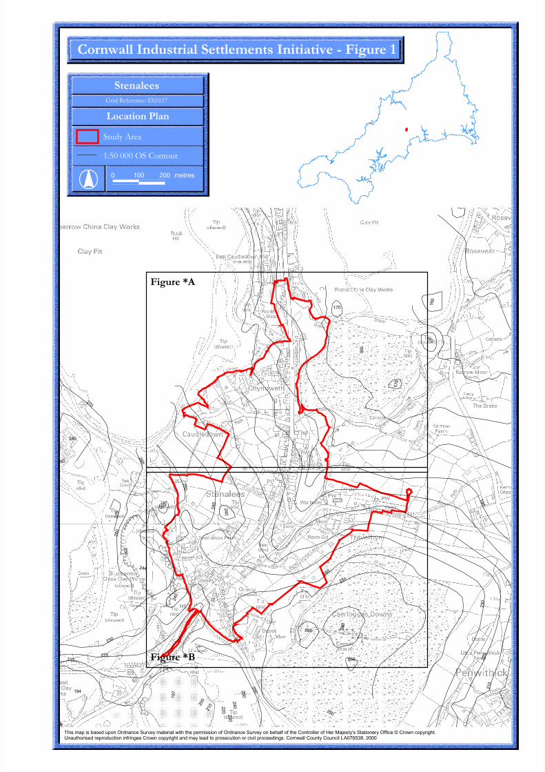
���
���
���
���
���
���
���
���
���
��� ���
���
���
���
��
��� ���
���
���
���
���
��
���
���
��
���
���
���
���
���
��� ���
��
���
��
������������
��
��
���
���
������������������������� ���
�����������
�� � �����������
����������
� ��� ��� �� ��
�����������������������������������������������
����������������������� ��������� ������� ���� ���������� ��������!�� ��������� ������������!��!�����"��� ���� ��!�#� �$�%����&���������� ���!!����'�" � ������ �(��)�*������ ����� �� �����������! ��(���" � ������ �(������������������� ����������� �������� �������(�)�"� � ����"������"�������+,�����-�����
��������
��������

������������������� ��� � �������������������������������� ������ � ��������� ��������������� ���������������������������� ��������������� ������������ ������������������ �� ��� ������� ������������ �������������������� ��������������� ������� �������� ������ ����!"#$%&'()�*###
# *& &# $& ����
��������������� ������������������ ����������������������������
������������������
���������
����������������
� ���� !�"�#��
���������$����%����&� '���(
������������������������������������������������

������������������� ��� � �������������������������������� ������ � ��������� ��������������� ���������������������������� ��������������� ������������ ������������������ �� ��� ������� ������������ �������������������� ��������������� ������� �������� ������ ����!"#$%&'()�*###
��������������� ��
���������������� ���������
��������������������
��� ���
# *& &# $& ����
�� �� ��� ������
��� �!�" �!!# �"��
�!$� �!!#
�!�" �!$� �"�� �"$%
����� ��������� �������������� ���������������

�
�
��
�
�
����
��
��
��
��
��
��
��
�
��
����
��
��
��
����
��
��
��
��
�
��
��
��
��
�
�
��
�
�
����
��
��
��
��
��
��
��
�
��
����
��
��
��
����
��
��
��
��
�
��
��
��
��
�
�
��
�
�
����
��
��
��
��
��
��
��
�
��
����
��
��
��
����
��
��
��
��
�
��
��
��
��
������������������� ��� � �������������������������������� ������ � ��������� ��������������� ���������������������������� ��������������� ������������ ������������������ �� ��� ������� ������������ �������������������� ��������������� ������� �������� ������ ����!"#$%&'()�*###
���
��
���
�������� ������������
�������������
������������������
�������������������
��������������������
�������������������������������� �����������������!
"#������ ����$�����
%������������������������
����������������
� ����������������������������� ����� ������� ��� �����
# *& &# $& ����
��������������
���� !�������&� ������'�()*+,
���
"���# !!�$��%���� !�����!� �����$���� ��&��'�(��%����)
���
���

��
���� ���
��
����
��
��
��
�
�� ��
��
��
��
��
��
��
�
��
��
��
��
��
��
��
�
��
��
��
��
��
���
��
����
��
��
��
���
���
��
��
�
����
��
��
��
��
��
��
�
�
���
�
�
��
��
��
�
��
��
�� ��
�
��
��
��
��
���� ���
��
����
��
��
��
�
�� ��
��
��
��
��
��
��
�
��
��
��
��
��
��
��
�
��
��
��
��
��
���
��
����
��
��
��
���
���
��
��
�
����
��
��
��
��
��
��
�
�
���
�
�
��
��
��
�
��
��
�� ��
�
��
��
��
��
���� ���
��
����
��
��
��
�
�� ��
��
��
��
��
��
��
�
��
��
��
��
��
��
��
�
��
��
��
��
��
���
��
����
��
��
��
���
���
��
��
�
����
��
��
��
��
��
��
�
�
���
�
�
��
��
��
�
��
��
�� ��
�
��
��
��
������������������� ��� � �������������������������������� ������ � ��������� ��������������� ���������������������������� ��������������� ������������ ������������������ �� ��� ������� ������������ �������������������� ��������������� ������� �������� ������ ����!"#$%&'()�*###
���
��
���
�������� ������������
�������������
������������������
�������������������
��������������������
�������������������������������� �����������������!
"#������ ����$�����
%������������������������
����������������
� ����������������������������� ����� ������� ��� �����
# *& &# $& ����
��������������
���� !�������&� ������'�()*+,
���
"���# !!�$��%���� !�����!� �����$���� ��&��'�(��%����)
���
���


![The Roman Rural Settlement Project · British] rural settlements, ... Farmstead morphology. Enclosed Farms Penhale Round, Fraddon, Cornwall (© J Stanley) • All or majority of domestic](https://static.fdocuments.net/doc/165x107/5f55325df1be735cbc7a9ec8/the-roman-rural-settlement-project-british-rural-settlements-farmstead-morphology.jpg)