Cornwall Industrial Settlements Initiative ST DAY · CORNWALL INDUSTRIAL SETTLEMENTS INITIATIVE...
69
Cornwall Industrial Settlements Initiative ST DAY (Gwennap Area) March 2002
Transcript of Cornwall Industrial Settlements Initiative ST DAY · CORNWALL INDUSTRIAL SETTLEMENTS INITIATIVE...

Cornwall Industrial Settlements Initiative ST DAY
(Gwennap Area)
March 2002

1
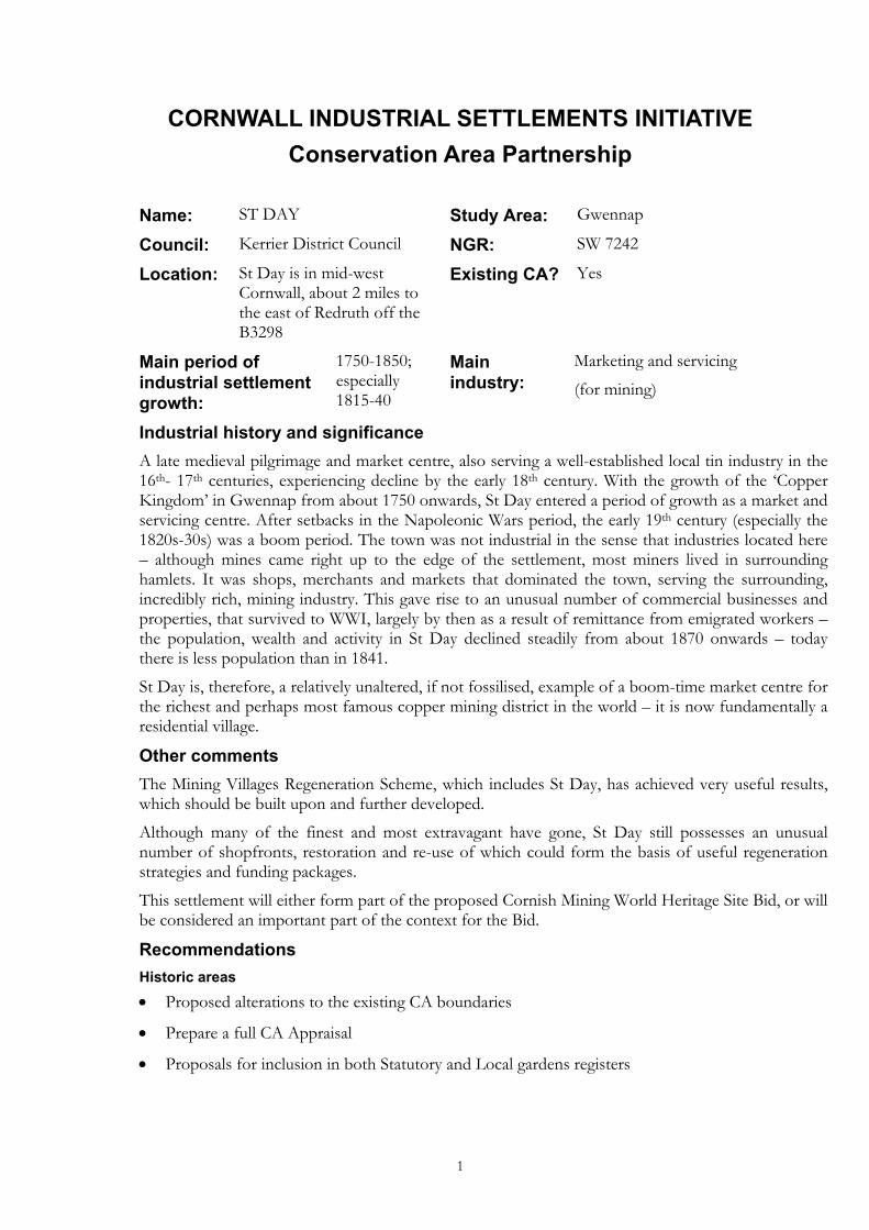
CORNWALL INDUSTRIAL SETTLEMENTS INITIATIVE Conservation Area Partnership
Name: ST DAY Study Area: Gwennap
Council: Kerrier District Council NGR: SW 7242
Location: St Day is in mid-west Cornwall, about 2 miles to the east of Redruth off the B3298
Existing CA? Yes
Main period of industrial settlement growth:
1750-1850; especially 1815-40
Main industry:
Marketing and servicing
(for mining)
Industrial history and significance A late medieval pilgrimage and market centre, also serving a well-established local tin industry in the 16th- 17th centuries, experiencing decline by the early 18th century. With the growth of the ‘Copper Kingdom’ in Gwennap from about 1750 onwards, St Day entered a period of growth as a market and servicing centre. After setbacks in the Napoleonic Wars period, the early 19th century (especially the 1820s-30s) was a boom period. The town was not industrial in the sense that industries located here – although mines came right up to the edge of the settlement, most miners lived in surrounding hamlets. It was shops, merchants and markets that dominated the town, serving the surrounding, incredibly rich, mining industry. This gave rise to an unusual number of commercial businesses and properties, that survived to WWI, largely by then as a result of remittance from emigrated workers – the population, wealth and activity in St Day declined steadily from about 1870 onwards – today there is less population than in 1841.
St Day is, therefore, a relatively unaltered, if not fossilised, example of a boom-time market centre for the richest and perhaps most famous copper mining district in the world – it is now fundamentally a residential village.
Other comments The Mining Villages Regeneration Scheme, which includes St Day, has achieved very useful results, which should be built upon and further developed.
Although many of the finest and most extravagant have gone, St Day still possesses an unusual number of shopfronts, restoration and re-use of which could form the basis of useful regeneration strategies and funding packages.
This settlement will either form part of the proposed Cornish Mining World Heritage Site Bid, or will be considered an important part of the context for the Bid.
Recommendations Historic areas • Proposed alterations to the existing CA boundaries
• Prepare a full CA Appraisal
• Proposals for inclusion in both Statutory and Local gardens registers
2
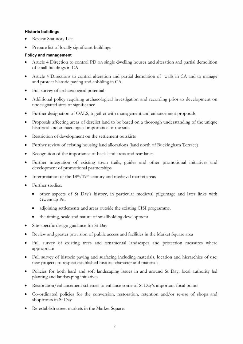
Historic buildings • Review Statutory List
• Prepare list of locally significant buildings Policy and management • Article 4 Direction to control PD on single dwelling houses and alteration and partial demolition
of small buildings in CA
• Article 4 Directions to control alteration and partial demolition of walls in CA and to manage and protect historic paving and cobbling in CA
• Full survey of archaeological potential
• Additional policy requiring archaeological investigation and recording prior to development on undesignated sites of significance
• Further designation of OALS, together with management and enhancement proposals
• Proposals affecting areas of derelict land to be based on a thorough understanding of the unique historical and archaeological importance of the sites
• Restriction of development on the settlement outskirts
• Further review of existing housing land allocations (land north of Buckingham Terrace)
• Recognition of the importance of back-land areas and rear lanes
• Further integration of existing town trails, guides and other promotional initiatives and development of promotional partnerships
• Interpretation of the 18th/19th century and medieval market areas
• Further studies:
• other aspects of St Day’s history, in particular medieval pilgrimage and later links with Gwennap Pit.
• adjoining settlements and areas outside the existing CISI programme.
• the timing, scale and nature of smallholding development
• Site-specific design guidance for St Day
• Review and greater provision of public access and facilities in the Market Square area
• Full survey of existing trees and ornamental landscapes and protection measures where appropriate
• Full survey of historic paving and surfacing including materials, location and hierarchies of use; new projects to respect established historic character and materials
• Policies for both hard and soft landscaping issues in and around St Day; local authority led planting and landscaping initiatives
• Restoration/enhancement schemes to enhance some of St Day’s important focal points
• Co-ordinated policies for the conversion, restoration, retention and/or re-use of shops and shopfronts in St Day
• Re-establish street markets in the Market Square.
3
Conservation Area Partnership
Cornwall Industrial Settlements Initiative ST DAY (Gwennap)
The Cahill Partnership and
Cornwall Archaeological Unit
February 2002

4
Acknowledgements This report presents the results of an assessment carried out by The Cahill Partnership following desktop research by Cornwall Archaeological Unit (Bryn Perry Tapper). Assistance was also provided by Andrew Richards, Kerrier District Council. The report text was prepared by The Cahill Partnership and edited by Jeanette Ratcliffe (HES CISI Project Manager). The report maps were produced by John Brinkhoff (CCC Planning Directorate Technical Services Section) from roughs prepared by The Cahill Partnership.
Front cover illustration St Day from the south-west (CAU 16256/15; F44/15/SW 730 425)
©Cornwall County Council 2002 Cornwall Archaeological Unit, (Historic Environment Section), Planning, Transportation and Estates, Cornwall County Council, Kennall Building, Old County Hall, Station Road, Truro, Cornwall TR1 3AY. All rights reserved. No part of this document may be reproduced, stored in a retrieval system, or transmitted in any form or by any means without the prior permission of the publisher.
5
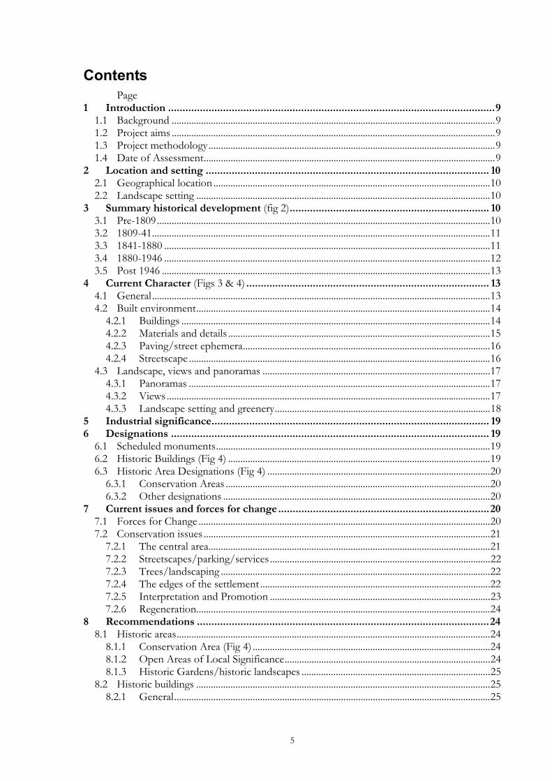
Contents Page
1 Introduction .................................................................................................................9 1.1 Background ....................................................................................................................................9 1.2 Project aims ....................................................................................................................................9 1.3 Project methodology.....................................................................................................................9 1.4 Date of Assessment.......................................................................................................................9
2 Location and setting .................................................................................................. 10 2.1 Geographical location .................................................................................................................10 2.2 Landscape setting ........................................................................................................................10
3 Summary historical development (fig 2)..................................................................... 10 3.1 Pre-1809........................................................................................................................................10 3.2 1809-41..........................................................................................................................................11 3.3 1841-1880 .....................................................................................................................................11 3.4 1880-1946 .....................................................................................................................................12 3.5 Post 1946 ......................................................................................................................................13
4 Current Character (Figs 3 & 4) .................................................................................... 13 4.1 General..........................................................................................................................................13 4.2 Built environment........................................................................................................................14
4.2.1 Buildings ..............................................................................................................................14 4.2.2 Materials and details ...........................................................................................................15 4.2.3 Paving/street ephemera.....................................................................................................16 4.2.4 Streetscape ...........................................................................................................................16
4.3 Landscape, views and panoramas .............................................................................................17 4.3.1 Panoramas ...........................................................................................................................17 4.3.2 Views ....................................................................................................................................17 4.3.3 Landscape setting and greenery........................................................................................18
5 Industrial significance................................................................................................ 19 6 Designations .............................................................................................................. 19
6.1 Scheduled monuments................................................................................................................19 6.2 Historic Buildings (Fig 4) ...........................................................................................................19 6.3 Historic Area Designations (Fig 4) ...........................................................................................20
6.3.1 Conservation Areas ............................................................................................................20 6.3.2 Other designations .............................................................................................................20
7 Current issues and forces for change.........................................................................20 7.1 Forces for Change .......................................................................................................................20 7.2 Conservation issues .....................................................................................................................21
7.2.1 The central area...................................................................................................................21 7.2.2 Streetscapes/parking/services ..........................................................................................22 7.2.3 Trees/landscaping ..............................................................................................................22 7.2.4 The edges of the settlement ..............................................................................................22 7.2.5 Interpretation and Promotion ..........................................................................................23 7.2.6 Regeneration........................................................................................................................24
8 Recommendations .....................................................................................................24 8.1 Historic areas................................................................................................................................24
8.1.1 Conservation Area (Fig 4) .................................................................................................24 8.1.2 Open Areas of Local Significance....................................................................................24 8.1.3 Historic Gardens/historic landscapes .............................................................................25
8.2 Historic buildings ........................................................................................................................25 8.2.1 General.................................................................................................................................25
6
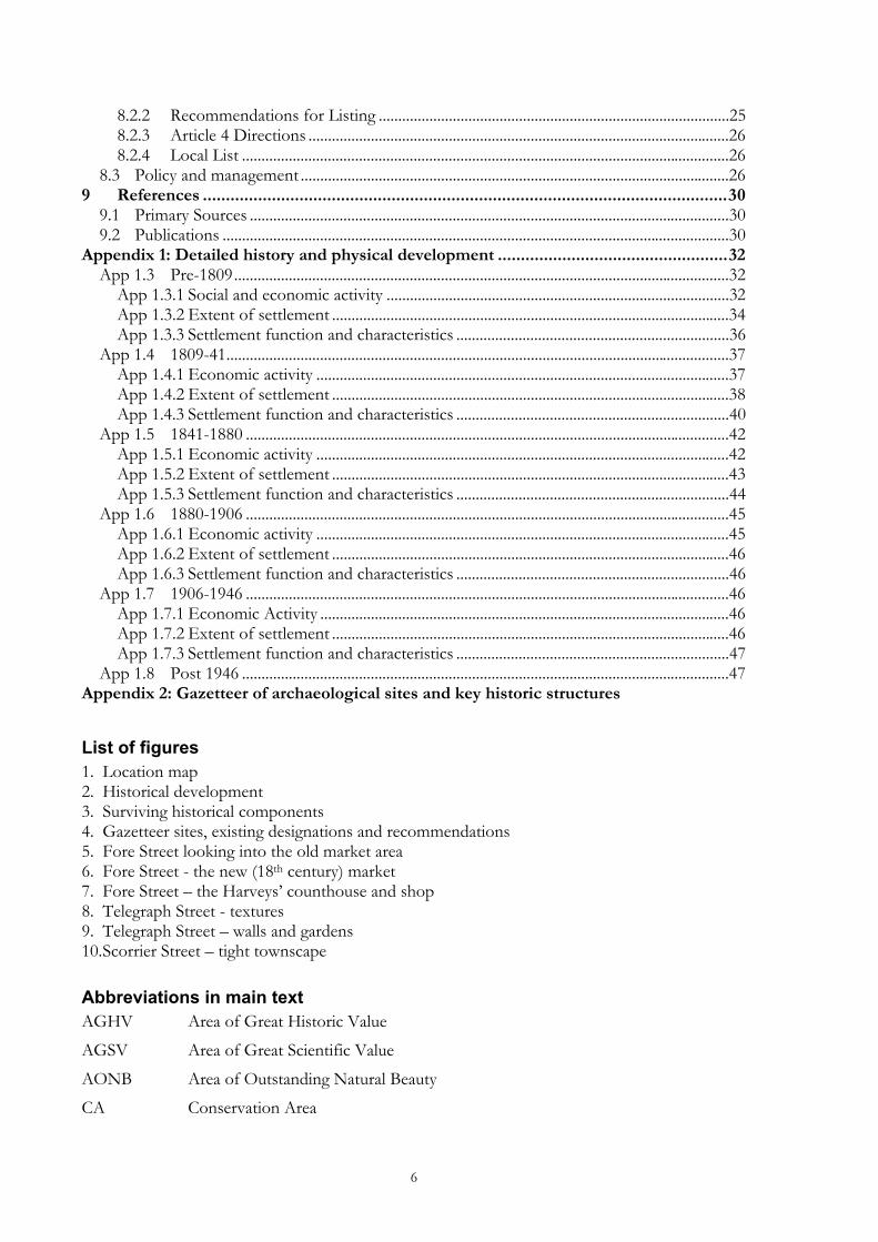
8.2.2 Recommendations for Listing ..........................................................................................25 8.2.3 Article 4 Directions ............................................................................................................26 8.2.4 Local List .............................................................................................................................26
8.3 Policy and management ..............................................................................................................26 9 References ..................................................................................................................30
9.1 Primary Sources ...........................................................................................................................30 9.2 Publications ..................................................................................................................................30
Appendix 1: Detailed history and physical development ..................................................32 App 1.3 Pre-1809...............................................................................................................................32
App 1.3.1 Social and economic activity ........................................................................................32 App 1.3.2 Extent of settlement ......................................................................................................34 App 1.3.3 Settlement function and characteristics ......................................................................36
App 1.4 1809-41.................................................................................................................................37 App 1.4.1 Economic activity ..........................................................................................................37 App 1.4.2 Extent of settlement ......................................................................................................38 App 1.4.3 Settlement function and characteristics ......................................................................40
App 1.5 1841-1880 ............................................................................................................................42 App 1.5.1 Economic activity ..........................................................................................................42 App 1.5.2 Extent of settlement ......................................................................................................43 App 1.5.3 Settlement function and characteristics ......................................................................44
App 1.6 1880-1906 ............................................................................................................................45 App 1.6.1 Economic activity ..........................................................................................................45 App 1.6.2 Extent of settlement ......................................................................................................46 App 1.6.3 Settlement function and characteristics ......................................................................46
App 1.7 1906-1946 ............................................................................................................................46 App 1.7.1 Economic Activity .........................................................................................................46 App 1.7.2 Extent of settlement ......................................................................................................46 App 1.7.3 Settlement function and characteristics ......................................................................47
App 1.8 Post 1946 .............................................................................................................................47 Appendix 2: Gazetteer of archaeological sites and key historic structures
List of figures 1. Location map 2. Historical development 3. Surviving historical components 4. Gazetteer sites, existing designations and recommendations 5. Fore Street looking into the old market area 6. Fore Street - the new (18th century) market 7. Fore Street – the Harveys’ counthouse and shop 8. Telegraph Street - textures 9. Telegraph Street – walls and gardens 10. Scorrier Street – tight townscape Abbreviations in main text AGHV Area of Great Historic Value
AGSV Area of Great Scientific Value
AONB Area of Outstanding Natural Beauty
CA Conservation Area
7
CAU Cornwall Archaeological Unit
CCC Cornwall County Council
CISI Cornwall Industrial Settlements Initiative
GPDO General Permitted Development Order
HES Historic Environment Section, Cornwall County Council
HERS Heritage Economic Regeneration Scheme (English Heritage)
HLF Heritage Lottery Fund (ing)
LB Listed Building
OALS Open Areas of Local Significance to Settlement Character
OS Ordnance Survey
PD Permitted Development
SPG Supplementary Planning Guidance
THI Townscape Heritage Initiative (Heritage Lottery Fund)
[1] Site number on Figure 4 and in the Gazetteer (Appendix 3)

8
9
1 Introduction 1.1 Background Cornwall’s industrial settlements are the subject of a Conservation Area Partnership under the heading Cornwall Industrial Settlements Initiative (CISI). This partnership between English Heritage (with the Heritage Lottery Fund), Cornwall County Council, and the District Councils is intended to assess the character and significance of the County’s 112 industrial settlements. These include villages, ports and towns associated with Cornwall’s 19th century industrial revolution, based on metalliferous mining, slate and granite quarrying, and china clay extraction. The historic importance and distinctive character of such settlements has previously been undervalued, and their existing status does not adequately represent the industrial history of the county. CISI is aimed at redressing this imbalance.
1.2 Project aims The aim of CISI is to produce a settlement by settlement analysis in order to obtain an overview of the history, present character and importance of Cornwall’s industrial settlements. This will help determine where, for example, new Conservation Areas should be designated (and existing ones revised), and could provide the basis for Conservation Area Statements (to be drawn up subsequently by District Conservation Officers).
A bid is being prepared for submission to UNESCO by February 2004 (for inscription in June 2005). The bid areas will include the full range of 18th-20th century mining landscape components, including the settlements that were created or rapidly expanded as a result of mining and its associated industries. All mining settlements are of significance to the World Heritage Site Bid – those that fall within the final Bid areas will be covered by the WHS Management Plan, while those that fall outside these areas will form part of the context for the World Heritage Site and will need to be sensitively managed in the light of this.
1.3 Project methodology The methodology involved historical research, followed by a site visit(s). For the historical research, a date range of 1750 to 1945 was chosen, as this represented the period of industrial growth and decline in Cornwall. Archaeological and historical sources housed at CCC (see Appendix 2) were consulted, together with Listed Building data supplied by the District Councils. Using this information, Ordnance Survey base maps were hand coloured to show: the different phases of historical development; surviving historic components from each development phase; archaeological sites, key historic buildings, and statutory designations. These maps (which formed the basis for Figures 2-4), together with copies of the primary sources consulted, were bound into a folder for each settlement, for use during site visits.
The focus of the site visits was to assess settlement character and consider ways in which this could be protected and enhanced in the future. This was achieved using a checklist drawn from Conservation Area Practice: English Heritage’s guidance on the management of Conservation Areas (1995) and Conservation Area Management - A Practical Guide (published by The English Towns Forum, 1998). The maps compiled during the historical phase were enhanced during the site visits, particularly with information relating to the survival and significance of historic buildings, and a general record was made of each settlement. Meetings on site were arranged with the District Conservation Officers in order to discuss current initiatives and recommendations for future management.
1.4 Date of Assessment St Day was assessed as part of CISI during spring/summer 2001.
10
2 Location and setting 2.1 Geographical location St Day is located approximately two miles to the east of Redruth and two miles to the north-east of Lanner on the B3298; it is in the parish of St Day (historically part of Gwennap parish) (fig 1).
2.2 Landscape setting St Day is on high ground that forms the north-east slope of Carn Marth. To the east is the Poldice Valley that starts from Little Beside, to become the Bissoe Valley running down to Devoran and the River Fal some 12 miles away. This is an area dominated by the legacy of mining with mines infiltrating St Day as well as forming its landscape setting; for example, an engine house for the St Aubyn Mine sits on the skyline to the west. In between this, though, are extensive remains of high moorland smallholdings and associated intricate field pattern.
3 Summary historical development (fig 2) This section should be read in conjunction with Fig 2, and summarises the more detailed analysis (Appendix 1), to which reference should be made for further information.
3.1 Pre-1809 • Possible lan (early Christian) enclosure on the site of the medieval Holy Trinity church on
sheltered but high ground on an ancient east-west route (Telegraph Road-West End-Vogue Hill).
• The medieval Chapel of the Holy Trinity situated on the great cross-Cornwall land route to St Michael’s Mount; by the 15th century it had become Cornwall’s second great medieval shrine.
‘ There was sometime a chappell, now decayde called Trinitye to which men and women came in times paste from far in pilgrimage; the resorte was so greate, as it made the people of the countrye, to bringe all kinde of provision to that place; and so long it contynued with increase that it gre to a kind of market; and by that means it grew and contynueth a kinde of market to this daye, without further charter.’ Norden, 1584.
• The market place was to the south of the Trinity churchyard at the junction of the main road with other routes from the south and south-east, (a market cross formerly stood at the junction of Fore Street and Telegraph Street), and was probably originally larger than the present space of the road junction.
• The market was also linked to the ancient but rapidly expanding tin industry in the Gwennap area. Poldice mine just to the east of St Day was already employing 1000 people in the early 17th century; by the early 16th century the local industry had become heavily capitalised by powerful local dynasties, with associated stamp mills, crazing mills and blowing houses.
• 18th century decline in local tin mining led to decline in St Day, especially its market function. Recovery came after the development of the local copper mines, especially with huge capital investment in steam engines and the creation of the Great Adit from 1748; both measures allowed the working of the deep, hot and very wet copper lodes.
• Despite recession caused by competition from the Parys Mountain mines in Anglesey and the loss of overseas trade because of the Napoleonic Wars, by 1809 there had been much intensification of use and population in the old core around the medieval market place (the old chapel and burial ground had been built over by the 1790s), together with expansion linked to the development of a new market (1798). Significantly it was the market function, the purpose-built shops and commercial premises along Fore Street and the spread of shops
11
and houses around the junction of what is now Fore Street, Scorrier Street and Church Street that typified the expansion of the town, not the provision of workers’ housing – perhaps one reason why non-conformism seems to have been slow to develop in St Day; the only contemporary chapel was a small Baptist chapel in Telegraph Street built in 1803.
• The density, scale and function of the settlement were markedly different from its neighbours and, although small, it was recognisably a town and market centre.
• A very important part of St Day’s development, linked with its commercial expansion, was the provision of substantial houses for some of the major figures in the town, especially the Harvey brothers (Carew House and The Cedars).
3.2 1809-41 • From about 1815-40, the Gwennap copper mines began a recovery based on further capital
investment sums that even contemporaries considered staggering; Gwennap became the richest known mineralised area in the world at the time – ‘the Copper kingdom’.
• While the immediate mines around St Day must have stimulated population growth in the town, the major mining areas were somewhat removed from St Day, which grew really because of the massive opportunity for supplying the industry and the new infrastructure.
• The first phase of 19th century growth in the town between 1803 and 1827 was one of commercial activity and building - the gigantic copper mines consumed huge quantities of stores and St Day housed the main merchants for both the local industries and the working population. The Harveys alone developed much of the Fore Street/Church Street area with stables, yards and warehouses adjacent to Carew House, a second yard on the old Wheal Quick site, shops and houses in Church Street, extensions to the grounds of The Cedars and Carew House, and they were involved in building the Town Clock and a public water supply.
• From about 1826 onwards, the economic stimulus of this commercial development led to a second phase of housing, provision of chapels and schools etc. (the church, churchyard and vicarage, and three non-conformist chapels were all completed in 1828).
• Although still with gaps along its length, by 1841 the whole of Scorrier Street/Church Street was now built up, while Simmons (Mills’) Street was in the first stages of development. There was also some limited development around the old core in Telegraph Street and Forth an Eglos.
• The major changes were the completely new developments to the west of St Day towards Vogue. Chapel Street (1827-8) and the whole length of Vogue Hill had mixed rows of cottages and middle class houses (Vogue House, 1837). Much of the new housing, although not for industrial workers, followed a recognisable pattern in Cornish industrial settlements, being built on old mine waste.
• The predominant form of industrial settlement around St Day remained the smallholding, and the development of Pink Moors at this time may be the most sizeable element of industrial housing in St Day. This development was remarkably different from anything else happening in the St Day area at the time (although recognisable in other Cornish industrial areas), i.e. a planned development of smallholdings and cottages on previously unworked or developed land.
3.3 1841-1880 • The 1840s were the technical and commercial apogee of the local copper industry, with
further massive capital investment - by 1845 both Tresavean and United Mines had installed man-engines. However, by 1850, although the industry remained on a substantial scale, there
12
were clear signs of retrenchment, new openings and re-investment were far exceeded by closures and amalgamations of mines, which continued with the collapse of copper prices in the 1860s. The Gwennap mining district was particularly badly hit, since there were no rich tin lodes beneath the copper as in Camborne.
• By 1872, copper mining in Gwennap had experienced an almost total collapse – even the great Consolidated Mine which had employed 2000 in 1870 was closed. Although there were considerable re-workings in parts of Gwennap parish in the 1880s, and again in the early 20th century, these made little impact on the overall pattern of decline in the area.
• The 1840s and, particularly, the 1850s saw the rise of numerous ancillary industries (quarrying, rope-works, safety fuse manufacture, arsenic and other processes, brickmaking from 1860), but these employed very few workers compared to the numbers losing their jobs in the mines.
• It is likely that nearly all of the built fabric of St Day was in place by about 1851 - the 1850s saw the peak population in the town and its surrounding hamlets, and it was probably only at this period that Methodism, so closely allied to industrialisation in Cornwall as it was, took full hold of the majority of the population.
• The surviving evidence of uncompleted rows of cottages dating from this period is testimony to the sudden end of expansion within the town. Whatever economic activity was going on around St Day after 1851 was never enough to warrant more housing.
• St Day remained, nevertheless, the centre of a still busy, if declining, industrial area for many years, and while the big yards and commercial premises of the Harveys were redeveloped, the individual shops in the town continued to be rebuilt and often enlarged.
• This is probably a reflection of the importance to the town and its hinterland of remittance (money sent back to Cornwall by miners and other workers who had emigrated to various parts of the world in search of what was often very lucrative work).
3.4 1880-1946 ‘Here is a picture of St Day, and many another Cornish mining village from 1890-1910. A large village, half denuded of its men. Monday, the great day of the week, for the africa mail comes in. Wives, hitherto used to a domestic economy based on a pound a week or less, suddenly blazing in the glory of £20-30 a month. A Bank Draft headed with the magic words ‘Standard bank of South Africa’….miserly saving or mad spending; new furniture, a piano…Methodist Chapels a tournament of fashion....ostrich plumes floating from head and neck, gold mounted lions’ claw brooches….’ Schwartz, (1998, p. 157)
• A new phase of post-industrial development began in St Day, lasting for the rest of the 19th and early 20th centuries. It was typified by statutory provision of facilities (Board School 1875), philanthropic or charitable donations (Passmore Edwards Library 1893, the conversion of Mills Street to almshouses c.1910) and the organisation of community activity, largely under the auspices of the various chapels, and more evidently by the local vicars (revived Cricket Club 1878, Rugby Club 1890, reading Rooms, evening schools etc.)
• Rather than an expansion of provision, activity was limited to the redevelopment of existing chapels, village halls, shops and other facilities (the market was demolished and converted to an old peoples’ garden in 1910); this continued until the 1930s.
• The population of St Day in 1911 was a little over 2000; virtually the same as it had been in 1801. By 1931, at 1803 souls, it was lower than it had been in the 18th century, and there were 23 shops compared with some 70 or more in the mid 19th century. By then, even
13
remittance payments had ceased to be an important factor in the local economy, effectively brought to an end by the Boer War and the First World War, and the growth of local economies in the global mining fields themselves.
3.5 Post 1946 • St Day’s function as a shopping and service centre has continued to decline, the settlement
becoming in effect a residential village. While provision of public facilities continued (slowly - piped water was only supplied in the 1950s, and mains sewerage in the 1960s), there was little building or expansion in the historic core of the town, and indeed a gradual decay and loss of many of its significant buildings.
• Infill housing and bungalows have been built in substantial numbers in the last three decades of the 20th century, especially within some of the enclosures at Pink Moors or utilising areas of former ornamental grounds and plantations, or on old mining waste (Wheal Quick, Wheal Gorland). Some of this building has been at the expense of historical fabric (Wheal Quick and Chapel Street in particular).
• There is a continuing spread of housing in St Day, although its rural location, limited infrastructure (especially drainage capacity) and difficult access will limit further expansion.
• There has been a local authority sponsored regeneration programme (in conjunction with Lanner and Carharrack) including the provision of a new sports club building, the improvement of the clock tower/Market Square, other townscape improvements, the repair of Holy Trinity Church and the opening of its shell as an interpretative centre and public space.
4 Current Character (Figs 3 & 4) 4.1 General St Day sits picturesquely on the top of a low, but locally prominent hill. The approach on all sides is up, and, until the late 20th century spread of housing, the edges of the settlement were well defined, often formed by relatively high rear garden walls – still a feature on the east side of the town. The romantic resemblance to a medieval defended hilltop town was not lost on the cartographers who created the 1772 map of the town which included a large vignette for the title plate of what appears to be a Tuscan hilltop village.
Today the surrounding countryside is dominated by lush fields of grass and extensive areas of woodland. Closer examination reveals the remains of intensive industry but, with a few exceptions, these are somewhat removed from the settlement itself. Even when the evidence of mining must have been at its baldest in the 1860s, St Day was described as ‘ a pretty little town’.
The greatest contrast today in St Day lies not between the picturesque setting of the town and the barren remnants of industry, but between the verdant, spacious and attractive outer streets, and the run-down core of the town. And it is, superficially, a startling contrast.
A brief drive through the centre of St Day would leave an impression of boarded-up shops, or those still in use with poor shopfronts and worse signs. Semi-derelict building plots stand here and there – even the church is a ruin. There appears to be lack of public facilities, no open or green or usable public spaces, with buildings hard against the pavement, no trees or shrubs, and the whole dominated by informal and intrusive parking. There is little evidence of employment opportunities in the town.
A more leisured tour of the town reveals a surviving medieval street pattern, with easy access through often beautiful paths into open countryside, many attractive buildings that pre-date the industrial heyday of the town, later buildings of real quality, well-detailed and presented, with a
14
ring of large enclosed gardens and plantations created by wealthy industrialists in the heart of the settlement, as well as smaller private gardens, and one of the best collections of historic paving and surfacing materials in Cornwall. The appeal of the town as a residential settlement becomes more obvious. The views and vistas both in and out of the town add to the attractive picture and a sense of discovery, as does an understanding of its complex history.
Even in the apparently run-down central area, Fore Street and its environs contain a unique collection of commercial and mercantile buildings, imposing, attractive and set in a good streetscape. While this area appears to contrast with the surrounding streets, its former role as an important commercial centre clearly explains the density and scale of the buildings, and the tightness of the streetscape. The two contrasting aspects of the town should be seen as the twin sides of its history and character – one makes sense only with the other.
The following sections highlight some of the principal elements in the current character of St Day.
4.2 Built environment 4.2.1 Buildings • The clock tower [91] and church tower [151] are landmarks from all sorts of places – the
church tower perhaps more so in the surrounding countryside – but there are surprising glimpses of both buildings along alleys and in-between buildings all through the town.
• There is a contrast between the vernacular buildings, which are generally earlier, granite and rough stone, slate, two storeyed cottages and half-houses, and the larger, usually very much higher, rendered buildings, especially those put up by the Harveys – some even timber framed. Mills' Street [170] is outstanding as probably the best preserved street of cottages from the industrial period in the District.
• Later 19th/early 20th century buildings are rare in St Day, and are not generally outstanding, although sometimes nicely detailed – a group of cottages at Vogue [25], Trinity House [56], the rebuilt chapels and Sundays Schools in Scorrier Street [167], Telegraph Street [119], Church Street [144][145], and the houses and shops [166] next to the Scorrier Street Chapel. These are probably by James Hicks, who designed the adjacent badly damaged chapel [167].
• On the edge of the town (and formerly within the heart of it) there remain some former smallholding farmsteads, with important groups of unconverted outbuildings. These are increasingly rare both in the context of St Day, in the context of the industrial settlements in Cornwall, and indeed as a building type in their own right. While some of the outbuildings are not particularly distinguished or old (such as some of those at Hillside [62], west of Wheal Quick), others are potentially very interesting and relatively early buildings. The very extensive group of buildings in Forth an Eglos, both outbuildings [64][66][68] and cottages [65][67], deserve much more detailed research and investigation. As a group, they stand somewhat apart from the rest of St Day now, but actually give a good impression of the very close relationship of a central market core with the surrounding industrial hamlets and smallholdings – a relationship gradually being eroded by contemporary development in and around the town.
• At Vogue, the spread of housing and development from St Day has incorporated some of the formerly isolated industrial cottages and smallholdings, whose buildings now stand amongst 20th century houses and gardens.
• One of the special elements that give St Day its unique character is the survival of many of the early shopfronts. There still remain a large number (24) for such a relatively small place, especially in Fore Street and Church Street – most now not used as shops. Scarcely any of
15
the remaining shops have historic shopfronts, and there are no modern shopfronts of quality in the town.
• As photographs show, many of the historic shops were very impressive and ornate, the best having free-standing colonnaded frontages projecting over the pavement. The remaining old shopfronts in the town are by and large the smaller examples, often earlier than the later grand ornate designs, less costly to maintain, easier to convert to domestic use, usually with smaller shop units behind the shopfronts. They give a somewhat distorted picture of local traditions of design and detailing. However, the surviving detailing is of high quality with very distinctive local features, such as very narrow fascias under deeply projecting cornices, and finely moulded mullions and spandrels.
• This high quality of early 19th century joinery work in the town is reflected not only in the fortunate and very symbolic survival of a carpenter/joiners works [130], but also in the good quality of some of the domestic frontages of contemporary buildings in St Day – the cottages at West End [52], for example, have extremely well detailed door cases. This makes it all the more regrettable that no contemporary chapel or church interior survives in-situ in St Day, since they would probably have been of the same high standard.
• Outbuildings are an extremely important part of the character of St Day, not only those larger groups associated with the old smallholdings, but also in the heart of the settlement –particular in Telegraph Street [107] and the rear of Scorrier Street [126] [132]. Some, like William Wilton’s workshop [165] in Church Street, and the carpenter’s shop in Telegraph Street [130] are quite rightly listed; others make just as much visual and historic impact (the Manor Workshop [181], Telegraph Street). The former girl’s school building [67] in Forth an Eglos is remarkable not only structurally, but for the fact that it reputedly was used as a slaughterhouse on the ground floor, and a school on the upper floor. Nearby is an extravagantly decorated small outbuilding [68] (now a garage), covered in enriched moulded render. The outbuildings in the rear yards of Mills' Street [170] are perhaps the best surviving unaltered group in the District.
• Similarly, walls and the enclosed areas they create, play an important part in defining the special character of St Day. There are large enclosing walls around the old ornamental grounds of the big houses, e.g. Carew House [137] and The Cedars [156]. Smaller domestic walls define the roadside along Vogue Hill [39][41] or Telegraph Street [103], as part of a designed and carefully controlled enclave like Mills Street [170], or as a part of the pattern of smallholdings and cottages as in Forth an Eglos [61] or Pink Moors [23]. A variation of some importance in St Day is the walled mine waste dump – seen especially at Wheal Quick [61][63] and in Bunt’s Lane [121], or in the fields leading to Poldice [173].
• In Telegraph Street, the walled enclosures around the old Chapel site [103] and to the front and rear of Buckingham Terrace [105 are important features, which have fortunately influenced the design of the recently completed parking and garden area in front of Buckingham Terrace.
4.2.2 Materials and details • Vernacular buildings are in granite and rough stone with slate roofs. Thatch was formerly
much evident in the village, there are no surviving examples, although corrugated iron roofs on outbuildings are still an interesting and attractive roofing material in St Day.
• ‘Polite’ buildings, usually early 19th century, especially those associated with the Harveys, are rendered, but usually with some architectural detailing, often a contrast between coloured roughcast walling and smooth stucco pilasters, door and window surrounds, plat-bands etc.
16
• There is a high quality of joinery work on shops and houses; many of the early-mid 19th century buildings are timber framed; some exposed timber cladding (joinery workshop, Telegraph Street).
• Older walls are built of moorstone and rough-dressed granite, with later examples especially made of sharp-edged mine waste.
• Granite chippings, replacement windows and render have become widespread; much texture has been lost from inappropriate rendering of granite cottages.
4.2.3 Paving/street ephemera St Day has a collection of paving materials of a range and quality rarely found elsewhere in Cornwall – the areas may not be extensive, but the surviving examples are of outstanding importance both to St Day and as exemplars to other local settlements which have either lost their historic surfaces, or are looking to improve existing streetscapes in a traditional and locally distinctive manner.
The particular areas of interest are briefly outlined below.
• [73] Patterned cobbling and granite paving at West End outside the Village Community Hall/Manor House.
• [54] Mixed hammer-dressed cobbles and patterned clay paviours (from St Day Brickworks presumably) with granite drainage channels, found in Chapel, Street and West End and recently restored.
• [55] Rough-dressed granite kerbstones outside Trinity House, West End –some possibly re-used from the ancient chapel on the site.
• [70][71] Rough cobbling and glinter post/bollard in Forth an Eglos
• [95] Cobbling in forecourt of the St Day Inn
• [84][180] Large granite paving slab and kerbstones placed in front of doors, associated with tarmac paths (probably formerly simply macadamised, i.e. with no tar) – found in Fore Street, Scorrier Street and Church Street.
• Boundary stones, such as at Vogue[12] and in Telegraph Street [127]. 4.2.4 Streetscape • One of the main elements in its character is the contrast between the enclosed, walled green
areas surrounding the centre of St Day, and the hard streetscape of the central streets, with the buildings right up against the pavement, with scarcely any views through them to surrounding gardens or countryside.
• Approaching this central area the streetscape grows tighter, more built up, the buildings massing together provide picturesque views into the central area from all the surrounding streets – especially from Church Street, from Forth an Eglos, and perhaps most strikingly from Telegraph Street looking south-west.
• These outer areas are also those with the most footpaths and back lanes, allowing movement and views through and around the walled gardens of the houses, and bringing the viewer often suddenly into the heart of the central area. This contrasts with the relatively flat, even frontages of the main central streets in Fore Street, Scorrier Street, Church Street.
• The central 18th/19th century market complex unfortunately now lacks much sense of having been the commercial heart of the town, although the fundamental structure of the old commercial core is still there. Despite demolition of the old market house [87], loss of
17
shopfronts and conversions of other buildings, the principal structures still remain (clock tower [91], shops around the old market building [85][178], the market square itself, Harvey’s shop/counthouse [79], warehouses [93] and yards [80].
• Scorrier Street has perhaps suffered more than the rest of the town from poor new buildings, infill, granite chippings, replacement windows and render. Like Upper Fore Street in Redruth, the dominance of traffic and cars, exacerbated by the narrowness of the road, has devalued the quality of the place and the monetary value of the properties, already relatively small in size and value, so that they have not benefited from the same degree of investment as other more desirable properties and streets in St Day.
4.3 Landscape, views and panoramas 4.3.1 Panoramas The long range views from St Day are among the finest to be found anywhere inland in West Cornwall, with clear views east and south-east towards Carnon Downs and the Roseland Peninsula. These views are dominated by trees, and the extent of the woodland hides a great deal of the industrially scarred landscape of the Poldice Valley and Crofthandy. To the north-west the mining legacy is exemplified by the disused Park-an–Chy mine that sits on the horizon while, to the west, an engine house for the St Aubyn mine is clearly visible. The rising ground to the south-west, leading up to Carn Marth, from the more distant views looks like a typical well-wooded agricultural area – little of the heavily industrialised history of the area is obviously visible, although careful inspection does reveal small areas of waste and a few industrial buildings. 4.3.2 Views • Since St Day sits on a ridge, its tallest features, such as the clock tower and the church, can
be seen from various points around the outskirts of the village, notably from the south and from Tolcarne and Pink Moors to the north-west. The combination, particularly of the church and clock tower, each with a distinctive form, gives St Day a distinctive character when seen on the skyline.
• This hilltop location, and the fact that the town was to a certain extent ringed by mining sites, means that there was historically a very clear edge to most of the streetscapes in St Day. Some of these are still very apparent – as at the southern end of Church Street, or in the long sweeping approach up Vogue Hill.
• Views into focal points are very important, such as from south of the church [151] into Church Street, from Lichfield House [120] into Scorrier Street and into Telegraph Street, and most especially from most adjoining streets and alleys in to the site of the medieval market place at the junction of Fore Street/Telegraph Street.
• Up Vogue Hill, the view of the open countryside reveals the most obviously industrially scarred local landscape in the Tolcarne Valley. The road itself is embanked at the lower end, the crest of the hill cut down with a raised pavement [41] and the whole area is one of the most imposing pieces of mid-19th century engineering surviving in the locality.
• The view up Vicarage Hill is crowned by trees and the enclosing rear walls of Chapel Street, together producing a strong demarcation between village and fields. The exception is around Glebe House [161] (the former vicarage) where ornamental grounds have spread into the surrounding countryside.
• There used to be clear views from the streets into the countryside or across waste dumps, but these views have been intruded upon by the spread of bungalows off Chapel Street and Mills Street.
18
• There are many streetscape views that contribute to the village’s character, some associated with attractive curves such as Telegraph Street and Fore Street, which allow glimpses of the village’s interesting buildings and create a sense of intimacy. This sense is furthered by the numerous back lanes and cuts, such as around the Buckingham Terrace area.
4.3.3 Landscape setting and greenery • The surrounding countryside, especially close to St Day, is now well-treed, in contrast with
the appearance of the area in the 19th century. The low scrub and coarse woodland seen today has grown up on what were previously areas of waste, moorland, grazing land or neat smallholdings and agricultural land, while the more ornamental woodland and shrubberies were part of the 19th century planting and landscaping associated with Scorrier and other large houses in the neighbourhood. The ornamental grounds and large trees in the centre of St Day would previously have stood in even more remarkable contrast with the surrounding fields and smallholdings – even the cottages at Vogue in their small plots would have been set amongst grassy paddocks, potatoes or flowers, not the shrubs and trees of today’s gardens.
• Trees are surprisingly important in St Day, given its rather bleak location, and they contribute both to the setting and townscape, whether deliberately planted en masse as at the church, churchyard and vicarage and in the former grounds of Carew House, or as natural perimeters of the streetscene throughout the village.
• The great swathe of ornamental grounds, plantations and gardens on the south-east side of St Day is a notable feature of the town, unusual in Cornwall in its scale in relation to the settlement area. It was remarked even in the 1860s, at the height of the industrial period, that St Day was a ‘pretty little town’.
• The churchyard is one of the most attractive features of the town, and indeed of the wider area. It has an outstanding group of headstones, chest tombs and monuments, as well as the listed church and cross, good enclosing walls, tree cover and wildlife value.
• At Vogue/Pink Moors the houses back directly onto fields, as they do near the church [151]; here the clear-cut edge of the village makes it difficult to justify including Burnwithian in the study area, even though in historical terms it was part of the wider settlement.
• The sloping areas of open land in-between the various old streets – especially the fields between Chapel Street and Pink Moors - are an important part of the landscape setting of the village.
• There is a great feeling of permeability within and out of the settlement area. The footpaths and lanes leading off into the countryside are important historically and as part of the pleasure of living in St Day.
• Around the village there are still some hints of the industrial past: at the north end of Chapel Street [47], the remaining patch of land at Wheal Gorland [114], West Wheal Jewel [58], the slopes leading down to Poldice (Simmons Street/Vicarage Hill) [173], Wheal Quick [141][147], Bunt’s Lane [122], along Tolgullow and Pink Moors [28].
• The still extensive areas of waste and semi-industrial buildings and yards associated with the brickworks site [18][19][20], while they are outside the immediate study area, are an important element in the local landscape, although not visible or prominent from the town itself, being hidden in a relatively narrow and enclosed valley below the main settlement.
• The whole of the Tolcarne and, to a lesser extent, the Tolgullow valleys were much more industrial in nature than the town and there are still important remains in these enclosed
19
valleys. With deep hedged lanes, streams, isolated cottages and paths into the surrounding fields and woods making pleasant walks, this fringing ring of hamlets and industrial sites, as has been emphasised throughout this report, is part and parcel of the character and history of St Day, although not covered by the current study. These deep valleys help to isolate the town from the surrounding industrial or relict industrial landscape, and help to proclaim it as something related to, but different from, that landscape.
5 Industrial significance St Day fits into a pattern of development recognisable in its broad themes elsewhere in Cornwall – that of a medieval churchtown that developed some form of market function by the 16th/17th centuries, based on a combination of local agricultural production, the early development of tin extraction and processing on more than just a local scale, and an element of popular religious pilgrimage and assembly. Other examples of this pattern of development include St Just-in-Penwith and Camborne.
Following some decay in the 18th century, St Day’s significance grew as it became the market, service, social, and to a lesser extent, religious focus for the surrounding copper mining area, widely known as the ‘richest square mile on earth’ in the early 19th century. It was accounted one of the most prosperous of the small towns in Cornwall, and retains an important stock of early 19th century public, commercial and larger domestic buildings. Herein lies its true industrial significance, although there are also important mining remains in and around the town, and there is tremendous buried archaeological potential associated with the medieval pilgrimage and market centre.
St Day also has great historical significance relating to the question of emigration and remittance, in itself a major element of Cornish industrial and social history. It was one of the principal Cornish industrial settlements where the apparent effects of the rapidly declining industrial base in the later 19th century were held at bay for decades by the substantial sums of money sent back by emigrant workers.
By about 1930 St Day had become a relatively unimportant residential backwater, its industrial significance and relevance now only a part of it historical legacy.
6 Designations 6.1 Scheduled monuments There are no scheduled ancient monuments in the study area.
6.2 Historic Buildings (Fig 4) There are 22 listed buildings in the study area all of which are listed Grade II. These range from the unusual Vogue Shute, small scale vernacular domestic architecture such as Lynmouth Cottage in Telegraph Street to more grandiose houses such as Carew House and, although only a shell now, the former Church of Holy Trinity.
As with most existing statutory lists, not only in Cornwall, there are certain biases in the selection of buildings. Buildings in a late classical or regency style rate highly, and most of the listings are of this category (Vogue House, Carew House /Cedars Lodge/The Clergy House/houses in Church Street/34 Telegraph Street). A number of humbler buildings have also been included on the list on the strength of the quality of their shopfronts, usually early 19th century, (1 Telegraph Street & 6 Fore Street/5 Fore Street/properties in Church Street).
The three principal public structures in St Day are listed - the clock tower, the shell of Holy Trinity Church, and Vogue Shute, as are three buildings of semi-industrial character – the
20
carpenter’s shop in Telegraph Street, William Wilton’s mathematical instrument making workshop (Church Street) and Harveys’ counthouse and shop (Pebbles, Fore Street).
Unusually, a relatively good selection of simple industrial housing is listed, for instance cottages in Telegraph Street, although clearly listed because of their 18th century date rather than their industrial or historical significance, and also the whole of Mills’ Street, listed as an ‘exceptionally well-preserved row of workers’ housing’. In fact, the list description does not reveal the real complexity and added interest of Mills’ Street, in that it was a late 19th century conversion of a simple street of cottages into what are in effect almshouses, the end result of which has been to preserve and protect the buildings, outbuildings and curtilages from inappropriate alterations and additions. More than that, the owners (The Mills Trust) have been inspired by the listing to reinstate, repair and do new work of excellent quality in keeping with the historic character. As a model for the successful effects of listing and conservation, few better examples could be found.
There is no ‘local list’ of historic buildings.
6.3 Historic Area Designations (Fig 4) 6.3.1 Conservation Areas The conservation area covers the central core of St Day including Chapel Street, Mills’ Street and as far south as the ruined church. 6.3.2 Other designations Policies have been taken from various sources, particularly the Cornwall Structure Plan (SP) and the relevant District Local Plan (LP); only those policies or allocations directly relevant to the preservation and enhancement of the historic environment or character of the settlement have been selected. Open Area of Local Significance (LP Policy ENV6): to the south and east of St Day including the playing fields on the site of the brickworks, the east part of the churchyard and the fields beyond (EL332).
Derelict Land Reclamation (LP Policy ENV24): sites are designated adjacent to the study area at north of Pink Moors (D288), at Tolcarne (D289) and the east of Vicarage Hill (D296)
Area of Great Historic Value (LP Policy BEN 3): bounds the study area to the north and north-east, including part of Wheal Gorland, and land towards Crofthandy
Housing: LP allocation on land to north of Buckingham Terrace (R679) (other allocations have been deleted in the revised Local Plan Deposit Draft since the draft version of this CISI report).
7 Current issues and forces for change 7.1 Forces for Change • Sources of employment within St Day are negligible. Since the inter-war years it has been
largely a residential settlement, and is identified as such in the Kerrier District Local Plan Deposit Draft. Opportunities for greatly expanding the size of the village (currently about 1700 population) are limited by its rural setting, poor road access, and limited drainage system capacity.
• Facilities are relatively limited (shops, doctors’ surgery, school at Burnwithian and also serving Carharrack) and unlikely to develop much because of the proximity to other centres at Carharrack, Lanner and Redruth.
• No large-scale expansion of commercial or industrial facilities is envisaged.
• The opportunities for development and change seem likely to focus on:
- limited expansion and infill of housing in and around the village
21
- upgrading of existing housing stock
- the provision of communal facilities (such as the recently completed sports ground facilities)
- the promotion and interpretation of the industrial and other elements of the heritage of the town and area
- heritage-led regeneration schemes involving a relatively high level of grant aid and public funding
- initiatives to make the best use of those special features of the town that survive to create a sense of place and local distinctiveness, perhaps especially the stock of unused or underused shops
• Any proposals in St Day within these, or other related parameters, could either represent enormous opportunities for enhancement of the historic character and current quality of the local environment or, if of insufficient quality, pose a serious threat, especially as they are likely to be small-scale and piecemeal in operation, and their cumulative effects not easily identified.
• A comprehensive conservation strategy and locally-specific design guide based on a thorough understanding of the unique historical and archaeological importance of St Day is therefore essential as a preliminary to evolving more pro-active projects and briefs.
7.2 Conservation issues 7.2.1 The central area • The central 18th/19th century market complex, although there has been loss of some
important structures, still retains many of its principal historical structures. The opportunity to interpret and re-affirm the crucial history of this area, and encourage the full use of the recently refurbished Market Square, could be an important part of any regeneration programme – a high quality of design and workmanship has already been exhibited in the resurfacing and the new-build cottages on the north of the Square. Strengthening the sense of a public space and replacing public facilities (there was formerly a public toilet block here, and the telephone box is hidden and apologetic in its presence) could overcome current confusion as to whether this is public or private space (used mainly for private parking). Part of the original intention of the regeneration scheme was to re-establish a market here, and this idea should be promoted.
• Paving and surfacing is one of the most interesting features of St Day, and it is therefore important that new projects maintain the excellent quality of recently completed paving projects. However, while the extensive use of granite setts may have been justified in the particular and unusual area of the Market Square paving scheme, they probably should not be used anywhere else in St Day (where they do not seem to have been used traditionally), but rather attention should be paid to establishing and following the historic paving materials and patterns – cobbles, paviours, rough stones, and above all tarmac and granite slabs.
• The current study, and other initiatives, should enable the recognition of the importance and fragility of the surviving historic fabric in St Day. There has been a curiously large amount of loss of historic fabric in the town compared with other places: the Wheal Quick row, the Cornish Arms public house, half of Chapel Street, for example. At an earlier date, the late 18th century market house was also lost. Shopfronts have vanished by the dozen, in some way the greatest loss, since it is difficult now to get an idea of the great numbers, high quality and sheer size of some of the St Day shopfronts seen in old photographs. The Forth an Eglos Chapel, which gave its name to the street, has gone to be replaced by housing that
22
makes no reference to the exceptional use or quality of design and streetscape of the demolished chapel. Other chapels have been demolished or converted and the alterations to James Hicks’ Scorrier Street chapel are unfortunately intrusive.
7.2.2 Streetscapes/parking/services • St Day has many quiet, attractive residential streets full of gardens, trees and well-looked
after houses (Telegraph Street, Forth an Eglos), and historic buildings and textures. However, the central area of the town is typified by ‘hard’ enclosed streetscapes, with some boarded up shopfronts and poorly maintained buildings, and the dominant presence of parked vehicles. The underlying quality of the townscape is such, however, that it would be worthwhile pursuing targeted grant-aid schemes for buildings and townscape improvements which could provide substantial benefits.
• Provision of service areas or access (for dustbins), rationalising parking provision and removal of unsightly or redundant telephone wires could all significantly improve streetscapes. To this end, new developments, or existing developments to the rear of the older core, should look to provide facilities for a wider area than the new development itself – provision of rear serving, parking or bin storage in either Balcoath or Trenant for houses in Chapel Street would do much to ease the visual downgrading of that very important streetscape.
7.2.3 Trees/landscaping • The loss of the ornamental grounds within St Day is a serious threat to its historic character.
Some of the larger specimen trees have been kept, and the private houses in Carew House grounds have retained something of an ornamental feel.
• Landscaping, tree-planting and preservation are issues that can be dealt with by public authorities, and need not rely as heavily in the ability of private owners to contribute as do building improvements. In St Day, publicly initiated schemes could have a significant impact on the whole character and appearance of the town. Cornwall County Council already operates schemes in some areas offering planting and garden improvements to private owners in conjunction with highways and/or landscaping schemes.
The inadequate landscaping of new developments in St Day is in great contrast to the quality of much of the older streets in the town. In Chapel Street a standard housing estate entrance road breaks into the historic rows on the site of demolished buildings. In Carew Road equally standard suburban roads and landscaping are in poignant contrast to the enclosed walls and greenery of the Carew House grounds while the bland and bare landscaping of Bosawna Close is a bleak testimony to the lack of regard paid to its outstanding context of high quality buildings and magnificent mature planted grounds. The bland and bare landscaping of Bosawna Close, in contrast, needs landscaping as a priority. 7.2.4 The edges of the settlement • The formerly well-defined edge of the built-up area relative to the surrounding countryside
has been gradually eroded by late 20th century housing developments – especially around the old Wheal Gorland site, in Vicarage Hill, and by Chapel Street. Further development should seek to maintain a discernible break with both the historic core and the surrounding countryside, to maintain the important sense of arrival at this hilltop town still discernible in Vicarage Hill for instance.
• The dumps and old mining areas need to be more fully examined and assessed for their historical importance. They should not be viewed simply as development land, they can be of both cultural and recreational significance and, irrespective of final use, the existing

23
remains need to be fully recorded. In particular, the shaft and dump area south of Mount Pleasant should be protected, dated and recorded.
• The new developments at the playing field are very good, but care should be taken to ensure that a limit is placed on expansion here to avoid municipalisation.
• New developments on old industrial sites could be better integrated into the fabric of the settlement. Some areas of critical importance in the town, like the junction of Telegraph Street and Scorrier Street, are very poorly defined – where the buildings were previously set amongst old dumps and workings, they now appear to be an uncoordinated scatter of disparate cottages, often hard against the roadside, with little sense of form or continuity between the buildings and plots. Enhancement schemes in these outlying gateway areas might do as much for the appearance and character of the town as schemes in the heart of the old streets.
• These areas are also the most affected by an unnecessary accumulation of highways signs, street lamps, overhead wires and public utilities (transformer stations) leading to much visual clutter and a downgrading of the potential qualities of the street scene. Since public authorities have a lead role to play in resolving these issues, significant enhancement of the townscape could be easily achievable without protracted negotiation with unwilling, or under-funded, private owners.
• The walled/enclosed paths with stiles, passing by old waste areas such as Bunt’s Lane or the Pink Moors path, which are such an important part of the link between the settlement and the countryside, are often indeterminate and poorly maintained in places, especially in and around the Wheal Gorland estate. Relatively minor investment, coupled with already well established voluntary programmes to improve footpaths, countryside access, nature conservation etc. would make substantial improvements in this key area.
• The integrity of Vogue as a separate enclave should be respected to preserve its historic character; further bungalows and inevitable suburbanisation of the settlement should be resisted. Infill development in the surrounding fields should ideally be avoided or limited in scope, and integrated more into the topography and grain of the historic settlement than has been the case with late 20th century developments at Vogue, Wheal Gorland/Bunt’s Lane, Wheal Quick or Burnwithian.
• The grounds of The Star Inn need addressing so as to improve the site’s gateway status to the settlement.
7.2.5 Interpretation and Promotion • The Mining Villages Regeneration Scheme, which is set to continue and expand its brief to
include Gwennap as well as Carharrack, Lanner and St Day, has already done much to promote the internationally significant history of the area, as well to take in hand projects on the ground, such as the restoration of St Day Church and creation there of an interpretation centre, as well as current initiatives in the churchyard (a living churchyards project, and investigation and recording of the gravestones). This remains a principal and vital vehicle for future schemes.
• Other parts of the local history could be explored and marketed as part of a co-ordinated strategy in the same way – especially the medieval pilgrimage history of St Day and its counterpoint in the Methodists’ pilgrimages to Gwennap Pit.
• More archaeological investigation on the chapel site is needed, especially to date the origins of St Day as well as its heyday as a pilgrimage centre. The full extent of the burial ground and the glebe, the chapel yard and a possible lan enclosure should be addressed; such
24
evidence as there is has been pieced together by the local history group, but leaves much unanswered. This is important as it could determine the scale and location of future infill, and of the development of the field behind Buckingham Terrace. Indeed, it brings into question whether this site should be developed at all, given its archaeological and historical importance. In addition, the field acts as a setting to the historic core, separating it from the bungalow estate on Wheal Gorland, giving a sense of place, of distinction, and of its original isolation, whatever archaeological remains may be buried there.
7.2.6 Regeneration • The Mining Villages Regeneration Scheme should be maintained and further extended, and
further schemes on the ground to retain, restore or re-use sites in and around St Day should be encouraged.
• Available publicly funded and partnership schemes appropriate to heritage-led regeneration should be explored – Lottery funding and Objective One funding as a priority. Such funding might cover further interpretation and educational schemes (Local Heritage Initiative funded) based on the history of the area, or further townscape improvements (Townscape Heritage Initiative).
• With relatively low property values and income levels (according to Local Authority survey information), maintenance and repair of both private and commercial properties in St Day is likely to need support funding, such as through a HERS programme.
• A key project should be the opportunity to re-use and/or restore some of the surviving shopfronts as part of a co-ordinated strategy encouraging small businesses not overly reliant on shop-based sales to open in the town.
• It may be necessary given the continued decline in the number of shops in the town to accept the conversion of old shops into residential use. However, it is also important to preserve the best surviving examples of the shopfronts themselves, not only as quality artefacts in their own right, but also as a vital element of St Day’s history. In some cases, restoration of a lost shop front could have considerable visual benefits for the whole centre. Number 2 Scorrier Street facing down Fore Street, for instance, is so important to the streetscape, that a good case could be made for creating a facsimile shopfront. This would in many ways lift the whole of Fore Street and give it back some sense of being the commercial heart of the town which is otherwise still on the decline, with the ongoing conversion of former shopfronts still an issue.
8 Recommendations 8.1 Historic areas 8.1.1 Conservation Area (Fig 4) It is recommended that the CA be extended (refer to Fig 4) to include parts of Bunt’s Lane, Vicarage Hill (to The Glebe), Wheal Quick (the playing field), Carew Road and Mount Pleasant, and to coincide with the Village Development Boundary from Vogue Terrace westwards, excluding only the new housing estate at Trenant, and including the paddock to the north of Penhallow/Trelawney in Pink Moors. A full and detailed conservation area appraisal is a necessity. 8.1.2 Open Areas of Local Significance The existing policies contained within the Deposit Draft Local Plan (ENV7) make the designation of OALS an extremely important and useful policy both to contain the spread of development around settlements like St Day and as, in effect, a secondary layer of management and control around the CA, preserving its setting.

25
The existing OALS on the south side of St Day could be complemented by designation of the areas to the north, east and west of the settlement, all of which more than adequately meet the criteria for designation, and all of which are vital to the setting of the conservation area, and the maintenance of the gap between St Day and adjacent hamlets.
In addition to the existing policies, management agreements and management and enhancement schemes could usefully be drawn up with the landowners, perhaps using existing countryside management agreements in Cornwall as a model. 8.1.3 Historic Gardens/historic landscapes Consideration should be given to surveying St Day and the wider area to see if any surviving gardens or plantation areas merit inclusion on the English Heritage Register of Historic Gardens.
Those in St Day itself may well be too altered but a local register could be developed in regard to such gardens (Carew House/The Cedars/Glebe House/The Churchyard/Vogue House). Such a local register should be backed up by suitable policies as well as enhancement and management schemes. Such schemes may be eligible for national and European funds currently available, and could be critical to the preservation and enhancement of the conservation area.
The current initiatives in the churchyard (a living churchyards project, and investigation and recording of the gravestones) could be the springboard for further research into the wider issues of landscaping and gardens in the town.
8.2 Historic buildings 8.2.1 General While the industrial past of St Day is partially represented in the listing, there are inconsistencies that arise from a lack of both a thematic approach and lack of acceptance of the distinctive local variations on nationally-recognised types. This is not a criticism of the individual inspectors and surveyors involved in the listing process in Cornwall, but a reflection of a general, strategic bias in the selection criteria and the low level of regional distinctiveness the current legislation promotes.
A fuller understanding of the stock of historic structures in St Day as elsewhere in Cornwall, is urgently required – local list surveys, thematic surveys, detailed recording as part of Article 4 Directions should all be viewed not only as a first stage to listing, but as an end in themselves, as critically important elements in the creation of policies, in prioritising action, in targeting funding strategies, and as a means of successfully managing change and promoting opportunities. 8.2.2 Recommendations for Listing The following list puts forward a range of structures that might be considered for listing - there are others not given here which on closer inspection might also be included; the intention here is to give an idea of the scale of any potential listing exercise.
• Tombstones/monuments in churchyard – impressive individual examples of both architectural and historical importance, and a good overall group.
• More substantial houses: The Cedars [157], the best in Vogue Terrace/Vogue Hill [37]-[41], Glebe House [161], Trinity House [56]
• Chapels: former Methodist chapel 1828, Chapel Street [50]; Holy Trinity Church (former Sunday School) and hall [143][144], Telegraph Street chapel – [119] (although late and modest, in a very unusual style for a Cornish Methodist church)
• The market complex (18th century) [85][86][178]

26
• Within St Day are a number of residential/commercial buildings which appear to be 18th century or earlier in origin, many no more or less altered (apart from superficial alterations) than other contemporary buildings which are listed. These include an important group around the old medieval market area [72][74][75][76][99][100]; cottages in and around the old chapel site and in Telegraph Road, the medieval/early modern main road through the village [102][111][112]; a very uniform and intact row of cottages [133] in Telegraph Street that (despite looking later) may be mid-late 18th century; the St Day Inn [94], a particularly good building occupying a prominent place in Fore Street, and early surviving cottages near the town clock tower [90]. Other good examples of early-mid 19th century domestic and commercial properties in Church Street and Scorrier Street could be added to those already listed
• Later residential/commercial buildings include houses in Scorrier Street (James Hicks architect?) [166]
• Early industrial cottages/smallholdings and small farms [4][5][23][33][62][64][65][66][123] [124] [146]
• Outbuildings and other former non-residential buildings [67][68][93][107][146] - in particular the manor workshop [181] would seem to merit more attention given to it. Negative statements such as that on the list description of the adjacent listed carpenter’s shop [130] that the manor workshop is not of special interest, while they relate to the statutory wording of the listing, would be better avoided in future descriptions, as prejudicing any change in perceived importance or likely review of the status of such buildings.
• Walls – the surviving walls in St Day form an important element of townscape, and are often substantial historic structures in their own right [103] – especially those around the ornamental grounds of Carew House [137], The Cedars [156], the church [155], Vogue Terrace [39], Vogue House [35], Vogue Hill - including virtually the only surviving original ornamental railings [42], and in and around Mount Pleasant [61].
8.2.3 Article 4 Directions Article 4 Directions should be sought that would control small scale and incremental alterations to the historic buildings in St Day, and prevent the loss of such features as unlisted shopfronts, especially when now in residential use.
Many smaller structures in the town, as well as walls and embankments, may be adequately recognised and protected by Article 4 Directions, such as the walled enclosures of the Pink Moors smallholdings [23].
Article 4 Directions would also enable the management and protection of the exceptionally important and varied areas of historic paving and cobbling which are not eligible for listing. 8.2.4 Local List A list of locally significant structures which contribute substantially to the character of the settlement would be a significant additional management tool, based on the combined criteria of both listing and Article 4 Directions, and backed up by a Buildings-at-Risk survey, detailed Article 4 Directions and substantive and enforceable policies in the local plan. This could also back up applications for grant aid.
8.3 Policy and management 1. Article 4 Directions (Walls)
Article 4 Directions to control the demolition of walls and hedges, especially for the creation of hard standings.
27
Reason: To protect the character of St Day against inappropriate incremental alterations and demolition.
2. Article 4 Directions (Buildings)
Article 4 Directions to control the demolition and alterations to individual houses, and to prevent demolition of free-standing outbuildings.
Reason: To protect the character of St Day against inappropriate incremental alterations and demolition.
3. Local List
A list of locally significant structures which contribute substantially to the character of the settlement backed up by Buildings-at-Risk surveys and substantive and enforceable policies in the local plan.
Reason: To ensure a full and accurate record of the historic fabric of the settlement, to strengthen existing Local Plan commitments to prevent proposals that would harm the historic heritage of the town and guide development and promote change that will preserve and enhance the character of the town.
4. Archaeology
A full survey of archaeological potential in St Day, backed up by an additional Local Plan policy requiring archaeological investigation and recording prior to development on undesignated sites of significance.
Reason: To comply with and strengthen existing Local Plan and PPG 16 commitments to prevent proposals that would harm the archaeological heritage of the town and mining remains in general (Policies B.EN1-5), and thereby preserve the special character of St Day.
5. Designation of OALS
Further designation of OALS, together with management and enhancement proposals.
Reason: To retain both the discrete identity of St Day and the historic interest of its mining remains, and to manage and protect the setting of the conservation area.
6. Derelict land
Any proposals affecting the areas of derelict land that surround and permeate St Day should be based on a thorough understanding, not only of the unique historical and archaeological importance of the sites themselves, but also of their value to the setting of St Day.
Reason: To ensure that the sites retain both their historical relevance to St Day and Cornwall, and their own archaeological and historical integrity.
7. Limitations to further development
Further development on the outskirts should ideally be avoided or limited in extent and, where necessary, fully integrated into the historic topography and settlement form, particularly between St Day and Vogue and between St Day and Lanner.
Reason: To retain both the discrete identity of St Day and the historic interest of its mining remains.
8. Housing land allocations
Review existing housing land allocations. In particular, the inclusion of the area north of Buckingham Terrace for housing should be re-considered.

28
Reason: To allow a review of existing designated areas in the town, to provide alternative sites for housing or provision of public open space or amenities, thereby relieving pressure from redevelopment on other sensitive historic areas within St Day and providing an appropriate setting and amenity for the historic core.
9. Back-land areas
The back-land areas and rear lanes and outbuildings of St Day should be recognised as an important aspect of its character, and their informal qualities enhanced, while at the same time preserving the often very important buildings that survive.
Reason: To preserve and enhance the special character of St Day, especially in areas unlikely to attract private investment and attention.
10. Interpretation and Promotion (1)
Further integrate existing town trails and guides and other promotional initiatives and promote as a single package, and develop partnerships with bodies like the National Trust, Trevithick Society etc. These should go beyond promotional activity, and seek to acquire, re-use, enhance and promote sites in St Day, as both an end result of and a stimulus to regeneration investment, and, by integration with existing initiatives such as the Mineral Tramways trails, to help develop completely new economic activities, such as specialist tourism.
Reason: To present St Day’s heritage to a wider audience and to attract new visitors and associated regeneration initiatives.
11. Interpretation and Promotion (2)
Interpretation and on-site presentation of the history and buildings of the 18th/19th century market area, which is at present unexplained and its history and importance to the town not obvious on the ground. Similar interpretation of the site of the medieval market would complement this.
Reason: To recognise the historical importance of the sequence of markets in the development of St Day.
12. Further study (1)
To promote other aspects of St Day’s history, in particular the medieval pilgrimage, and later links with Gwennap Pit.
Reason: To present St Day’s heritage to a wider audience and to attract new visitors and associated regeneration initiatives.
13. Further study (2)
Of adjoining settlements and areas outside the existing CISI programme, such as Tolgullow, Tolcarne, Poldice, Burnwithian, Little Beside.
Reason: To ensure a full and accurate record, and understanding of, the industrial settlements in this area in particular and Cornwall as a whole.
14. Further study (3)
Wider studies of the St Day area addressing a number of broad themes - the timing, scale and nature of smallholding development in relationship to the mines; of the influence of landownership; of the mine themselves; of the role of Methodism in St Day compared with other local centres (Gwennap, Carharrack, Lanner etc.)
29
Reason: To further understanding of the historical development of St Day.
15. Design Guidance
Site-specific design guidance for the town, based on a detailed audit of materials, designs, details and character, both of standing buildings and of street paving materials.
Reason: In order to build on the expertise already demonstrated, and guidance on general principles already produced, and to preserve and enhance the special character of St Day, and promote change that will preserve and enhance the character of the town.
16. Public facilities
In the Market Square there could be more in the way of clear public access and facilities, well designed but clearly sited, with rationalisation of such features such as the bollards, so as to make the square less intimidating and more clearly a public space.
Reason: To recognise the historical importance of Market Square and promote its use as a public space and central focus of the town.
17. Trees and ornamental landscapes
A full survey of existing trees and ornamental landscapes and protection measures taken where appropriate.
Reason: To ensure that the contribution made by existing trees to the townscape on both private and public land is recognised and protected where necessary.
18. Paving
Full survey of historic paving and surfacing including materials, location and hierarchies of use; new projects to respect established historic character and materials (cobbles, paviours, rough stones, and tarmac and granite slabs). Use of non-traditional materials (including granite setts) to be avoided and carefully justified where proposed.
Reason: To ensure that the contribution made by existing paving and surfacing to the townscape on both private and public land is recognised and protected where necessary.
19. Landscaping Policies
A policy for landscaping treatment to address both hard and soft landscaping issues around St Day. This would have the dual aims of maximising the potential of existing landscaping schemes of historical importance and in developing a consistent approach to future schemes. In particular, the remaining areas of ornamental grounds/gardens should be protected from further infill and development with trees protected, walls not breached, and a programme for maintenance and replanting agreed. Furthermore, local authority led landscaping and planting initiatives could make significant contributions to character, and can be developed from existing initiatives.
Reason: To ensure that the existing landscaping is maintained and future schemes respect the historic grain of St Day.
20. Restoration/enhancement schemes
Restoration/enhancement schemes to focus on some of St Day’s important focal points, for example, the closing buildings to vistas, as along Fore Street; and the buildings around focal points like the 18th/19th century market core.
Reason: To recognise and enhance the importance of focal points in the development of St Day’s townscape.
21. Shops and shopfronts strategy
30
Develop a co-ordinated policy for the conversion, restoration, retention and/or re-use of shops and shopfronts in St Day, coupled with an extensive programme of shopfront restoration and/or improvement should take place.
Reason: To preserve and enhance this most important element of the special character and appearance of the conservation area, enrich the character of the existing townscape, and act as a catalyst for drawing down regeneration grants funding and other linked schemes in the town.
22. Street Market
Re-establish street markets in the Market Square.
Reason: To regenerate economic activity in the town, and also to justify and fully integrate the refurbishment scheme of Market Square into the wider townscape and character of the town.
9 References 9.1 Primary Sources 1772 map of St Day, surveyed by Francis Welch 1772, mapped 1777 by William Hole, CRO X/148/1
1809 map of Manor of St Day/Tolgullow, by J. Hayward, CRO AD 512/2
1809 OS drawings
1841 Tithe Map
1877 OS 25 inch map
1908 OS 25 inch map
1946 RAF air photographs
Cornwall Sites and Monuments Record (computerised database of archaeological sites maintained by HES)
9.2 Publications Cornwall Structure Plan, 1997, Cornwall County Council
Kerrier District Local Plan Deposit Draft, 1999, Kerrier District Council
The Mining Villages. An exploration of the Gwennap Mining Area, n.d., Mining Villages Regeneration Scheme Project
Annear, P. , 1994, Some Notes on the History of the Church and Chapel of the Holy Trinity, St Day Buckly, J.A., 1989, The County Adit: A model of co-operation, Journal of the Trevithick Society, no. 16
Hamilton Jenkin, A K, 1963, Mines and Miners of Cornwall Vol. 6, Truro Bookshop
James, C.C., 1950, A History of the parish of Gwennap in Cornwall Davies Gilbert, 1838, The Parochial History of Cornwall, vol. II
Gilbert, C. S., 1820, An Historical Survey of the County of Cornwall, vol. II
Morrison, T. A., 1983, Cornwall’s Central Mines, The Southern District, 1810-1895, Alison Hodge
Murrays Handbook for Devon and Cornwall, 1859
Pigots Directory, 1823
Polsue, J., 1868, Lakes Parochial History of the County of Cornwall, Vol. II

31
Post Office Directory, 1856
Schwartz, S and Parker, R., 1998, Lanner, A cornish mining parish
32
Appendix 1: Detailed history and physical development App 1.3 Pre-1809 App 1.3.1 Social and economic activity Pilgrimage and the market The earliest reference to St Day is in 1269 and, despite attempts to push the ecclesiastical history of the site back to the 6th century and the legend of St They, there is no earlier certain reference. However, the topography of the site of Holy Trinity Chapel is very suggestive of a lan (early Christian) enclosure. Whatever the ancient activity on the site may have been (St Day was part of Tolgullow Manor although, at a later date, Carew House was probably the manor house for this manor), the foundation of the medieval Chapel of the Holy Trinity is not likely to be much older then 1269 – the original donor of the 4 acres of glebe attached to the chapel was still alive in 1281 and disputing his gift because the requisite masses were not being said for the sake of his soul at the chapel.
By the 15th century, the Trinity Chapel at St Day, situated on the great cross-Cornwall land route to St Michael’s Mount, had become Cornwall’s second great medieval shrine. There is little record of St Day before that date; Charles Henderson’s evidence, the source of later claims to an earlier medieval prominence, points to the relatively sudden and recent development of the shrine as an important pilgrimage centre in the early 15th century. 1427 saw the first recorded ordination ceremony at St Day, reflecting its growing importance, and probably marking a campaign of fund raising and publicity related to the extensive rebuilding of the chapel (the large tower that survived until 1798 was of 15th century date). Henderson also found extensive evidence of legacies left in Cornish (and English) wills to the chapel, but the first of these dates from 1435, continuing to 1525. This is entirely consistent both with a fund-raising programme to rebuild the chapel, and with the late medieval passion for pilgrimage in Britain.
The importance of the chapel and pilgrimage in creating St Day is encapsulated in Norden’s description of the town in 1584 – ‘ There was sometime a chappell, now decayde called Trinitye to which men and women came in times paste from far in pilgrimage; the resorte was so greate, as it made the people of the countrye, to bringe all kinde of provision to that place; and so long it contynued with increase that it gre to a kind of market; and by that means it grew and contynueth a kinde of market to this daye, without further charter.’ Contained within Norden’s description, however, is the clear suggestion that other forces were at work to continue the prosperity of the town despite the loss of the chapel (only finally dissolved and closed as recently as 1568). It is highly likely that the rise of the market in the 15th century was as much due, or at least as immediately beneficial to, the expanding tin industry in the Gwennap area as to the pilgrimage trade.
Tin Despite its later reputation as a great copper mining area, the whole of Gwennap parish, and especially that northern part which centres on St Day itself, was an ancient and important tin-producing area. Gwennap tin was being shipped out from Truro as early as 1305-06, and tin works are recorded on Carn Marth and Tolcarne in manorial surveys from 1327 (the sites still being worked in the 16th century).
All the later great copper and tin mines in Gwennap, concentrated in the north or west of the parish, seem to have been exploited in some measure from a very early date. There is archaeological and documentary evidence from the 15th century for working at what were later the various mines at Poldice, Trevethan, Tolcarne, West Wheal Damsel, United Mines, Trevarth and Tresavean, although these were probably less significant in the area as a whole than the extensive stream works in the Carnon Valley. By the early 16th century, this mining activity had already given rise to numerous stamp mills, crazing mills and blowing houses in the area and, despite the traditional and popular picture of small-scale mining run by independent tributers
33
and adventurers, the industry was already a heavily capitalised business giving rise to powerful families dominating the locality. The Sampson family of Tolgullow (or St Day) Manor were already prominent by 1543 as share holders in Poldice and other large local mines, and as owners of various mills. As late as 1731 Mark Sampson was described as ‘a man of great dealings in Tynworkes and Tyn adventures’.
The oldest and greatest of these ancient mines was Poldice. The earliest records are of a dispute between tin workers in 1512; by 1685, it is referred to as ‘unparalleled and inexhaustible’ (Hals), having since the 1640s employed 800-1000 and raised up £20,000 worth of tin each year ‘to the great enriching of the lords of the soil, the bound owners, and adventurers in those lands’. The mine was clearly associated in local minds with St Day – Hals, whether correctly or not, instructively derives the name of the mine as meaning ‘at the head of St Day town’.
In records dated between 1700-1710 18 tin works are listed in Gwennap and, between 1725 and 1729, 48 tin mines are recorded in Gwennap parish (Callenick Smelter records). Poldice was still the most important, employing about 1000.
Decline of tin and St Day There is some evidence of a decline in profitability and productivity of the great tin mines (in 1726 even Poldice was showing sign of decline). At the same time Redruth was experiencing a boom which must have badly affected the market at St Day. The market function continued to be of central importance to St Day, but there is some evidence that it declined in the early 18th century, ‘….the market which has long been discontinued has again revived…’ (C. S. Gilbert 1820). This may be as much to do with the continued rise of Redruth as a major market centre in West Cornwall, but it certainly indicates that St Day’s prosperity followed the economic fortunes of the declining local tin industry and the town’s revival is to be placed later in the 18th century, after the great mid-18th century expansion of the copper industry.
Copper and the Great Adit As with the Camborne area, the upper lodes of the old tin mines in Gwennap became worked out in the 1720s and more difficult to work, and their increasing depth led to a gradual development of copper lodes. In 1700/1710 four copper works are noted in Gwennap, while the first recorded copper sales from the parish were in 1729; most mines continued to work both metals.
By 1726 Poldice was described as so deep as unlikely to be profitable (in tin) much longer. The wetness and depth of the mine required massive capital investment. The relaxation of coal tax in 1741 allowed just this scale of investment, the lead shown by the Lemon family (as owners) and the Williams family (as managers) led to the massive expansion in the use of steam engines on the various mines in Gwennap. By 1750 there were 12 or more on the Lemon-owned mines in the parish alone. At the same time (1748), the need to drain Poldice led directly to the creation of what was to become the County or Great Adit and, incidentally, to the creation of the wealth and dominance of the Williams family. Starting as managers (by 1823, the family managed a fifth of all mines in Cornwall), they became great mine owners – by the mid-19th century 9 in every 10 mines locally were owned by them.
The adit system spread out from Poldice to include dozens of local mines, becoming a great exercise in co-operation by dozens of local mining concerns that contributed to the cost-book company that ran the enterprise, and which was itself controlled by the Williams family; eventually the system extended to 63 miles.
The Great Adit was important in the exploitation of many of the great mines elsewhere in the parish, especially the United/Consolidated group to the south-east of the town. The earliest records of copper production on what became the Consolidated sett were in 1757 and, by 1779, copper was overtaking tin as the main product of the area. The increasing use of steam power,
34
and the development of the Great Adit, stimulated the amalgamation of the many local mines into the great conglomerates. These mines were immediately, and often spectacularly, rich.
At the same time the great mines in the south-west of the parish, especially Tresavean, were also undergoing the beginnings of massive investment and expansion. However, Tresavean and its neighbouring mines, and the United and Consolidated groups, were of secondary influence on the growth of St Day. While they undoubtedly added to St Day’s growing servicing and marketing role, the creation of almost equally large and self-contained mining settlements at Lanner and Carharrack as well as the densely settled area of small holdings and hamlets around Crofthandy, Little Beside, Todpool etc., was directly related to these mines, and in many ways actually limited the development of St Day.
The St Day mines Close to St Day, the Great Adit was extended eastward from Poldice into Wheal Gorland by 1792, on to Tolcarne, and thence into Trefula (Vogue). Wheal Gorland was a ‘bunchy’ mine, sometimes barren, sometimes so rich that the men sold the mineral to dealers as specimens (it was the prime source of many famous mineral collections). In 1795 the prospects were so good that it was decided to erect an engine and sink deep shafts - William Jenkin, a contemporary mine adventurer, manager and commentator, was moved to remark ‘This is mining on a large scale indeed.’ Despite the general reduction in pumping charges brought about by the Great Adit and the massive scale of investment in the St Day mines, they had not proved particularly profitable by the close of 1809 – Gorland had hardly made a profit by 1804 (while Wheal Unity further east on the same lodes had given £200,000 profit over roughly the same period). Wheal Muttral, the north part of Gorland, was worked separately for tin in the 1790s, but had to merge with Gorland in 1798.
Tolcarne and Roselabby (South Wheal Gorland) to the south of the town also proved poor. Tolcarne was eventually the most spectacular failure of the area. Although it lay immediately east of the very productive Wheal Jewell, and the adventurers tried to improve prospects by connecting to the Great Adit and investing in steam engines in 1805, by 1807 the mine had stopped working.
Although the greater Gwennap mines by and large survived the crisis in the 1780s caused by the opening of the Parys Mountain copper mine in Anglesey, price recovery was only limited, and by 1805 even the United and Consolidated groups closed with diminishing returns (even though still producing thousands of tons of ore). App 1.3.2 Extent of settlement To the mid 18th century Although the origin of St Day as a settlement is obscure, and the claim for an early medieval lan unproved, there is a strong suggestion in the curved walls around the old chapel site in St Day of such an early Christian enclosure. Whether this is an early development or is to be entirely associated with the medieval chapel foundation (13th century) is unknown.
The major programme of rebuilding, extension and legacies associated with the chapel in the 15th century probably saw the development of the market noted by Norden in the 16th century. A market cross formerly stood at the junction of Fore Street and Telegraph Street, and the topography of the property boundaries here suggests a much larger market area occupying the area at the junction of Telegraph Street, West End and Fore Street. Telegraph Street itself is a typical dog-leg diversion of the old cross-country route to St Michael’s Mount (running roughly along the rear boundary walls of Buckingham Terrace) into what may therefore be a planned market place. The existing 19th and 18th (perhaps 17th) century buildings on the north side of this appear to be infill onto the market place, and originally backed up against the curved enclosure
35
wall of the chapel. Little more substantive can be said about the extent of the medieval settlement, although burial finds in and around Telegraph Street suggest this area may have been more extensively occupied by a burial ground and large ecclesiastical enclosure than the modern map suggests.
St Day must have retained some economic activity throughout the 17th and 18th centuries (it was described specifically as a town in 1685), although there is little evidence of an increase in size. Indeed, there is some suggestion of decline in the town’s prosperity, with the failure for much of the 18th century of the market and, above all, by the decay of the chapel through the century.
The influence of copper, 1750-1772 The early growth in copper mining in Gwennap may have proved a stimulus to the town, but the scale of tin mining locally had been so great, for so long, that there was little effect on its size before the mid-late 18th century.
From about 1750, however, the whole of the Gwennap area, including St Day, experienced the major expansion of the copper industry. Increasing density as well as extent of development of the town becomes more evident from about this date. In 1745 the chapel remained, although in a ruinous state and, by 1797, the last remnants of the tower were pulled down because there had been damage to neighbouring houses built in what had been the chapel yard. By the 1770s, and certainly by 1809, the growth of the copper industry had clearly had a major impact on the size of the town. The existence of a detailed large-scale map of St Day in 1809, supplemented by an earlier one of 1772, provides an unusual chance to accurately interpret the otherwise very sketchy OS survey drawings of 1809.
The 1772 map shows settlement scarcely developed out of the medieval core area, with only partial development along Fore Street. Carew House in Fore Street is probably the medieval manorial centre of Tolgullow/St Day Manor, and the road led to the manor pound (in what is now Church Street). It is more likely that this manorial group predates the built-up street – a development certainly paralleled in nearby Redruth – since it is unlikely to have been placed among already established but relatively humble cottages and traders.
The principal mining works close to the town in 1772 were the very extensive works on the lode to the south (Wheal Quick). These included the whole of the later church site, and the mine’s presence limited housing development in this direction throughout the 18th and early 19th centuries. After the 1790s the massive investment to the north at Wheal Gorland had brought a second great line of works to the edge of the town, likewise closing off any potential spread of settlement in that direction.
1772-1809 By 1809 the major changes from 1772 were the development of the whole of Fore Street and the new market, and the spread of shops and houses around the junction of what is now Fore Street, Scorrier Street and Church Street. What is significant is not only the spread of the settlement, however, but also the clear relationship of this to the development of the commercial function of the town - it was the market function, the purpose-built shops and commercial premises along Fore Street and Scorrier Street that led to the expansion of the town, not the provision of miners’ housing. Indeed, at this early stage, the most population growth in the area was in the surrounding hamlets and smallholdings. The development of the yards, coal-yards, and industrial complex around Wheal Quick is also notable as it presents further evidence of a shift from mining to supply and servicing as the main role of the town.
The density and scale of the settlement was thus markedly different from neighbouring settlements and, although small, it was recognisably a town and market centre. Few of the cottages and other buildings had much land attached to them, and there were many plots within the centre that stood virtually without any curtilage at all, although there were still some small
36
farmsteads in the settlement, so that it would not have appeared overwhelmingly an industrial place at this time.
A very important part of St Day’s development, linked with its commercial expansion, was the provision of substantial houses for some of the major figures in the town. The Harvey brothers, related by marriage to the Williams family, had started building up their considerable business from about 1803, and built the first of their substantial properties, The Cedars, with its gardens, by 1809. App 1.3.3 Settlement function and characteristics To 1750 Little can be said with certainty about St Day’s character until the 15th century. It is only then that the chapel emerges definitely as a pilgrimage centre, with what appears to have been a major rebuilding programme, numerous bequests, and an increasing status as a centre for ordination.
It is clear that by the mid 16th century, when the chapel was dissolved, a thriving if small market town had developed around the chapel and the pilgrimage trade. It retained something of its urban, or at least market, character through to the 17th century, as suggested by Hals writing in 1685, who refers to it specifically as a town. The gradual decay of the chapel and the failure to replace it despite the needs of the local population may reflect as much a lack of growth and activity in the area, as the neglect and apathy of the local clergy – there were certainly no substantial non-conformist congregations in St Day to explain the abandonment of the chapel.
The decline of the chapel, the lack of substantial growth over this period, and the loss of the market suggests some serious levels of decline in the prosperity and status of the town, despite the scale of the local tin industry.
1750-1809 The late 18th century development of St Day, which had already started by the time of the 1772 survey and map, was a radical change in the character and prosperity of the town. As the new service centre for the greatly expanding copper mines, St Day grew at a staggering rate – even the growth of the mines immediately local to St Day would have been enough to stimulate some growth, recalling William Jenkin's remarks about Wheal Gorland in the 1790s ‘This is mining on a large scale indeed.’. Shops appeared and trade flourished. Gilbert, writing about the lack of a chapel in 1820, says that, ‘The fall of this Chapel is much to be lamented at this present day, the houses and population having amazingly increased within the last 30 years; and the market which has long been discontinued has again revived….the inconveniences arising from the want of a place of worship, is greatly felt …. It being seated in the most populous district [in] Cornwall.’ The open ground on the site of what became the new market place was called St Day Green at this time, and may already have been used as a market or fair ground. By 1798 the market had even started competing with Redruth and was important enough to warrant some considerable investment, with the building of a covered market house selling fish, meat and vegetables. Small cottages/shops were attached to the exterior of the market house, although the old Green was in part covered with mining waste from a nearby shaft, still recognisable as such in the 1840s.
Despite the early and prominent appearance of the Wesleyans in the Gwennap mining area, St Day itself seems not to have been a major non-conformist centre – the more purely mining communities round about were more committed, particularly Carharrack. Indeed, the first substantial religious community to develop in St Day (apart from the Quakers who had been recorded in small numbers since the 17th century) was that of the Baptists recorded in the 1780s, and which had, by 1803, built a small thatched chapel in Telegraph Street. The Wesley brothers first preached at Carharrack in the 1740s, and the great preaching powerhouse at Gwennap Pit was developed as a major focus from the 1760s onwards. The relatively slow growth of
37
Methodism in St Day may be explained by the late economic recovery of the town, and its wider economic base; while the proximity of large-scale mines at Wheal Gorland and Wheal Quick must have had an effect on the number of miners living in St Day, such expansion as there was being largely related to commercial functions and population, with specialist craftsmen, builders, suppliers, etc.
The unexpectedly slow development of Methodism in St Day points to a characteristic feature of the town throughout the 19th century - that it did not dominate the Gwennap copper region as much as might be expected. The whole of Gwennap parish should be viewed in many respects as a poly-focal settlement – facilities were spread out amongst the myriad hamlets and small settlements, and the larger centres at Churchtown, Lanner and Carharrack, as well as St Day.
App 1.4 1809-41 App 1.4.1 Economic activity Mining The early years of the 19th century were a recession period in the local mines, even the largest of them had been closed in 1805, and in 1811 William Jenkin noted that ‘the spirit of Mining was at a low ebb and the old Consols totally abandoned..’ From 1814, however, massive re-investment in both the United and Consolidated groups, under the dynamic management of the Williams and Taylor families, led to one of the greatest of all Cornish mining booms. When John Williams was appointed to take over United Mines, he was given a staggering (for the time) £50 000 capital to invest.
1815-40 was the heyday of Gwennap copper mining. Consolidated, United, Poldice, Tresavean all developed enormously, and Gwennap became the richest known mineralised area in the world at the time – the ‘Copper kingdom’. The United Mines sett was 1.5 miles long by now and, combined as a single enterprise with Consolidated (although keeping separate accounts), by 1822 was producing more ore than any other group in Cornwall, which it continued to do for nearly the next 30 years. By 1838 there were ten pumping engines, amongst them the largest steam engines then working in Cornwall, 11 other winding and crushing engines, with a total of 3,196 employed (1730 men, 869 women, and 597 children). The richest part of the sett was to the east on the Kenwyn parish boundary – separated from St Day by many scattered hamlets and smallholdings and the large new mining settlement at Carharrack.
Although investment in the setts was great, the outputs were enormous in relation to the capital employed. Consolidated on an initial outlay of £65 000, yielded 300 000 tons of ore, worth over £2m, and paid £480 000 in dividends between 1819-40. 63 miles of levels, shafts and winzes were cut in these 18 years.
The group of mines in the south-west of Gwennap parish (Tresavean, Treviskey, Trethellan, Pennance) all likewise grew in the period toward a peak of production in the 1840s – Tresavean produced more copper than any other mine in the western district apart from Dolcoath, and only Dolcoath and East Pool paid out more dividends. The installation of the first man-engine in Britain at Tresavean in 1840 marked the peak of technical and capital investment in the mine.
In the immediate neighbourhood of St Day, by 1840 Wheal Gorland had made £600 000 profit. Just as had been the case around 1800, not all the St Day mines were as successful or profitable as the rest of Gwennap – Wheal Squire, the western end of the United lode, was the least productive mine of the group while, by 1820, with little return and much expenditure, both Tolcarne and Roselabby closed, since they had only been worth operating because of natural water drainage into nearby Wheal Damsel.
While the immediate mines around St Day must have stimulated economic growth in the town, the major mining areas were somewhat removed from St Day and, as has been seen, Lanner, Carharrack and a host of smaller settlements were the real growth areas for the mining
38
population. Other developments growing from the copper industry in Gwennap, particularly in the Bissoe valley area (including arsenic and ochre production), probably affected St Day relatively little.
Lanner in particular operated in some sense as a rival to St Day, or at least looked elsewhere for markets and services. It was on the turnpike to Redruth, and that market was as close as, and easier to get to than, St Day.
Infrastructure and servicing The growing scale of local mines led to an increasing provision of engineering and transport infrastructure: the Great Adit continued to expand and was a key element in the co-operative success of the area; from 1809 the horse-drawn Scorrier-Portreath plateway was developed and by 1819 extended to Poldice and Crofthandy; in 1824 the Redruth-Chasewater railway was run through the parish down to Devoran and, in 1834, the Hayle-Tresavean branch line was extended to take the ore to Hayle, thus completing the connection of the Gwennap mines directly to the three major mineral ports in west Cornwall. It is perhaps significant that the train lines went near Lanner and Carharrack, not St Day.
What continued to be more important for the growth of St Day than the direct employment of the population in mining, was the massive opportunity for supplying the industry and the new infrastructure. The gigantic copper mines consumed huge stores – an invitation to tender supplies to Tresavean for just 2 months in May and June 1839 included 400 tons of coal, 5,000 lb. of blasting powder, 14 tons of common iron, 700 dozen candles, 50 dozen pick hilts, 50 dozen shovel hilts, 420 fathoms of flat rope, 80 fathoms round rope, 10 dozen powder cans, 200 kibble plates and 200 kibble bottoms.
The Great Adit also consumed large quantities of stores, and many local miners worked permanently for the adit company, and scarcely did any raising of ore. The Harvey Brothers between 1803 and 1850 were the main suppliers for the Adit, and for many local mines, supplying everything from agents’ underground clothes to tools and nails, while also running a major shop/stores in St Day for the miners on a truck system. Foxes (of Perranarworthal and Portreath, and like the Harveys related by marriage to the Williams family) supplied rope, timber, kibbles and tools; Hawkes of Tregullow also supplying material after 1821, while the Williams themselves remained pre-eminent as managers of the local mines.
The scale these firms operated on, the wealth they acquired and the wide sphere of influence and renown that they enjoyed, are reflected by their ability to undertake major engineering projects outside Gwennap – between 1811 and 1841 the Plymouth breakwater was constructed largely by the partnership of John Sampson of Treviskey and John Williams of Scorrier.
There is an interesting footnote to the medieval development of St Day as a market serving religious pilgrims. George Henwood, writing in the 1850s, describes the many days of preparations in and around St Day each year to accommodate and provision the crowds gathering for the huge annual Whit Tuesday Methodist meetings at Gwennap Pit. It was clearly something of a money spinner to local businesses. App 1.4.2 Extent of settlement This period saw the great expansion of St Day, which to all intents and purposes reached its maximum extent by 1841. Pigot’s 1830 Directory describes the growth in progress ‘..St Day..is a populous and prosperous village..being in the immediate neighbourhood of the Poldice and Consolidated Mines, is fast increasing its population…’. Interestingly, the Directory gives population figures for both the town itself (1000) and for the rest of the manor of St Day (also 1000), giving some idea of the scale of settlement in the scattered hamlets round the main centre. The development history of these hamlets lies outside the scope of this study, but was clearly an integral element of the character and size of the town itself.
39
Within St Day the main period of development lay between 1826 and 1840. An 1827 map of St Day shows that relatively little more had been built since 1809 except for the extension of housing along Church Street, associated with the development of the Harveys’ main stables, yards and warehouses adjacent to Carew House and a second yard, stables, coalyard etc. on the old Wheal Quick site.
The house and grounds at Cedars, another of the Harvey properties, had been enlarged by 1827, while the adjacent church and churchyard (started in 1826) were completed in 1828, as was the Vicarage, the whole joined with The Cedars by a great swathe of ornamental grounds that were mirrored west of Church Street by the extensive gardens of Carew House. The process continued into the following decade, with Rock House (now The Clergy House) built in 1837.
Although still with gaps along its length, particularly to the north of the 18th century covered market (still described in1841 as ‘waste near the town clock’), the whole of the Scorrier Street/Church Street was now built up as a recognisably urban street, while Simmons Street was in the first stages of development. There was also some limited intensification and spread of buildings around the old core, in Telegraph Street and Forth an Eglos.
West End The major changes, however, came with the completely new developments to the west of St Day. The first area to be developed was Chapel Street, partly built by the time of the 1827 map, the former chapel being dated 1828. The whole length of Vogue Hill was developed with mixed rows of cottages, middle class houses and one large house (built in about 1837). Trade directories show that the relatively substantial cottages and houses of Vogue Terrace were not inhabited by working miners, but by the more substantial middle classes, private residents and even gentry.
The new housing in St Day followed a pattern recognisable in other Cornish industrial settlements, with the rows of cottages utilising the cheap and otherwise useless areas of mine ‘deads’ and ‘wastes’. Chapel Street and Mills’ Street (formerly Simmons Street) were both laid out on old Wheal Gorland waste and adjacent to recently abandoned shafts. Just as with Vogue Terrace, however, the mid 19th century trade directories suggest that actually the inhabitants of Mills’ (Simmons) Street were professionals, shopkeepers and skilled tradesmen rather than miners working at the nearby mine. Even the contemporary row of small cottages by Wheal Quick probably had more to do with the adjacent Harveys’ yards than the already abandoned shafts and workings of the mine.
The predominant form of industrial settlement around St Day remained the smallholding in Vogue, Tolgullow, Tolcarne, Crofthandy, Poldice and Little Beside, and close to St Day itself in Bunt’s Lane and Vicarage Hill, where the cottages and smallholdings sat right amongst the mine workings.
Vogue It may be that developments at Pink Moors and Vogue were also more directly associated with the local mines - Wheal Pink, Wheal Gorland, West Wheal Jewel - the only commercial activity actually within the Pink Moors development was a malthouse.
The development at Vogue was remarkably different from anything else happening in the area of St Day at the time. Previously there had been nothing at Vogue in Gwennap parish, such settlement as there was in Redruth parish (The Star Inn, Lower Trefula Farm, and the water shute which was, and remained until the 1940s, the principal water supply for St Day). There was an as yet unexplained enclosure of part of Pink Moors, by several of the manorial lords, not just one, and the creation of a new settlement of rows and individual cottages set in substantial plots, although not quite smallholdings, but still quite distinct from the rows of cottages with their gardens. A similar pattern of development halfway between recognisable smallholdings and
40
simple cottage plots can be found in a few other locations in West Cornwall, where there was direct influence by the ground landlord (Halsetown/Leedstown). At Vogue, however, the development was going on side by side with the creation of rows of cottages, and on the same owners’ land.
The development of Vogue was so closely linked to the question of land-ownership, that it remains today contained within the parish and manorial boundary of St Day. Across the boundary in Trefula (Redruth), the ancient sites at Lower Trefula, Vogue Farm and The Star Inn remained relatively unchanged by the spread of settlement. App 1.4.3 Settlement function and characteristics If Gwennap is to be seen as a sort of poly-focal settlement – the Churchtown, Carharrack and Lanner as well as St Day provided facilities for the wider population, this explains why facilities that might be expected in St Day were actually scattered amongst the major settlements in the parish. The parish poor house was, in the 1830s, sited outside St Day at Burnwithian. While St Day did have a Wesleyan Mutual Improvement Society, Carharrack had the Miners and Mechanics Society (1830s), and the first Public Reading Rooms were set up in Lanner.
Redruth might have proved a serious drag to the development of St Day being only 2 miles or so from St Day, and Lanner certainly looked to it as its principal market and service centre. By and large, however, the Gwennap mining area maintained a separate existence from the larger town. The parish, and with it St Day, was in a different legal, ecclesiastical and administrative area from Redruth (i.e. Penryn), and in economic terms also looked to the south-east, with the major economic pulls of the foundry at Perranarworthal, the various industries in the Carnon valley, and the major outport at Devoran.
The location of some of the typically ‘industrial’ institutions outside St Day adds further to the impression that it was not a typical industrial settlement at the time. Lanner and Carharrack were clearly mining villages– perhaps one explanation why most of the parish’s 17 constables in 1842 were in Lanner, with 4 in Carharrack, and only 3 in the largest settlement of St Day, although the latter did have stocks (until 1850). Apart from the malthouse at Vogue there is no indication by 1841 of any manufacturing or processing industries going on in St Day. The trades people noted in contemporary trade directories were almost without exception grocers, merchants, shopkeepers, victuallers, drapers, boot and clothes makers, with only 2 blacksmiths, and none of these were operating on an industrial scale.
The increase in St Day’s size was more than matched by an intensification of activity. The business empire of the Harvey brothers in particular dominated the town both economically and physically. Between 1807 and about 1827 the Harveys built a large shop/counthouse, warehouses and stable yard, flour store, other shops and houses in and around Fore Street, as well as a second stable yard and warehouse yard at Wheal Quick in Church Street, and their own large houses and ornamental grounds at Carew House and The Cedars. The Harveys were the major figures in the commercial development of St Day, but not the only ones, and the growth in the number of shops and other specialist suppliers was matched by the growth in the importance of the market, which was said even to rival that of Redruth, just as the market clock tower built in 1821 rivalled that of the larger town.
In 1828 the Harveys built a reservoir, piped water supply and public fountain, although because of the charges levied it never replaced the old supply at Vogue Shute. By 1830 a post office opened in St Day, always an indication of a certain status in a settlement.
The new market place and clock tower, the purpose-built shops in Fore Street and Scorrier Street/Church Street, and the huge ranges of stables, yards and warehouses belonging to the Harveys dominated St Day. The great mining and processing areas were relatively distant from the town and the great swathe of ornamental grounds, gardens and plantations associated with
41
Carew House, The Cedars, Glebe House, Rock House and the Church itself formed the back ground and setting of the town. St Day would not have given the impression of being a rough, industrial shanty town like so many other industrial settlements at the time did. It was pre-eminently a marketing, service and distribution centre, and a centre for specialised and luxury goods. Above all, it serviced the needs of the surrounding mining districts. While much has been made of the truck system that the Harveys operated in partnership with the Williams-owned mines, their huge fortune simply could not have relied on the supply of the relatively modest needs of individual miners – they were actually major suppliers to the vast mining activity around them, (in which they were also investors and adventurers, as well as shareholders in William, Foster & Co. copper smelters and manufacturers of Swansea). The scale of their property ownership and their commercial premises puts them in the same standing as other major mine-related mercantile interests such as the (unrelated) Harveys of Hayle or the Fox family of Falmouth/Perranarworthal.
The more varied population profile of the town and the poly-focal settlement pattern undoubtedly accounts for some otherwise anomalous features in the ecclesiastical character of the town. Although there was a strong non-conformist element in the town, with Bible Christians (from 1809), and Wesleyan Methodist meeting houses, the only place of worship was the Baptist Chapel, until the Anglicans were unusually the first to undertake a major building programme. Methodism was early and strong in Carharrack, and perhaps this drew some potential away from St Day. But, as in Redruth, the mercantile, shop-keeping and trades interest were perhaps not so readily drawn away from the Anglican community as more purely industrial populations. A sort of godly competition marked St Day, as noted by Davies Gilbert in 1838: ‘The chapel, dedicated to St Dye, in Gwennap, had long been in ruins; but since the eager contest has grown up between the Establishment and Dissenter for retaining or acquiring power through the media of extensive education and proselytism, and Chapels, Meeting Houses, and Schools have arisen all over England, St Dye has seen a new and spacious building displace the ruins that remained from former times’. The strength of the Anglican position was such that St Day had become a separate parish by 1835.
1828 was in many respects a year of peak activity in St Day. The long-standing problems of distance from the parochial centre in Gwennap led in 1826 to the foundation of a new Anglican church, completed in 1828 and there were National Schools (Anglican) housed in the buildings behind the present parish church.
The non-conformist sects, whose strength no doubt influenced the building of the Anglican Chapel, seem to have been caught rather on the hop and, in consequence, 1828 also saw a rash of non-conformist chapels built – the Baptist Meeting House, the Primitive Methodist Chapel on the site of an older Baptist Chapel (the only place of worship in the village up to that time), and the Methodist Chapel in Chapel Street. Although these chapels had Sunday schools, there was no denominational day school to rival the Anglican National School.
The ‘eager contest’ noted by Gilbert perhaps also explains in part the large number of common day schools in Gwennap in 1840 compared with Redruth, with half the pupils being girls, compared to only 8.3% in Redruth (10 schools Gwennap, 3 Redruth). There were 3 or 4 private schools or academies in St Day in the 1830s and 1840s apart from the National School itself.
The picture of St Day embroiled in religious proselytising and competition, as a godly centre of progress, should perhaps be tempered by the simple fact of there being 6 inns (including at least one describing itself as an hotel) and 4 beer sellers in the town in the 1840s, essential components not only of industrial settlements but, more importantly, also of market towns.
The recession that was already beginning to be felt in some mining areas by the late 1830s does not seem to have affected the St Day area, and the evidence locally of emigration is of highly skilled men or managers going abroad seeking adventure or promotion.
42
App 1.5 1841-1880 App 1.5.1 Economic activity Mining in the 1840s and 1850s The 1840s were the technical and commercial apogee of the local copper industry. The length and productivity between 1840 and 1860 of the ‘hot lode’ at United Mines exceeded anything ever found in Cornwall, but the heat and soaking conditions also made it expensive to raise the ores, and the men were paid amongst the highest wages anywhere in Cornwall, with £100 per fathom paid for work that would normally pay only £12 or £13. Much the same conditions applied at Tresavean, and the scale of capital invested in the local mines continued at a rate far above the norm – by 1845 both Tresavean and United Mines had installed man-engines.
By the end of the decade there were clear signs that the massive levels of investment and running costs could not be sustained, despite the huge output that yet continued. Even at Tresavean the last dividend was paid in 1847 and it was wound up in 1858, although there were attempts at re-working throughout the 1860s and 1870s in this and the neighbouring mines, but with little success.
Consolidated and United continued despite some retrenchment in the copper industry in the 1840s, and by 1859 the surface working of ‘this gigantic mine’ was 2 miles long, with 16 steam engines and several water wheels.
Other industries The 1840s, and particularly the 1850s, saw the rise of numerous ancillary industries in the Gwennap area linked to the mining industry, mostly in and around the Carnon Valley. The processing of copper by precipitation from the Great Adit outflow began in 1854, while ochre processing was developed by the company, and largely offset the rising costs of maintenance throughout the period and into the 1880s. While the Harvey brothers had made much of their money supplying the Great Adit Company, by 1853 both their firm, and the Williams family had pulled out of the concern, but other businesses in and around St Day continued to be major suppliers. A major rope-works was operating at Tolgullow in the 1840s and 50s, and in 1865 the fuseworks at Scorrier moved to Unity Wood.
The principal new venture at St Day was the founding of the China clay and brickworks in the Tolcarne Valley in 1860; by 1874 it had expanded enough to warrant the building of what became known as The Big Kiln which dominated the site until the early 20th century. Two other brickworks developed in Gwennap at the same time, although shorter lived and on a very much smaller scale. Much of this expansion was fed by the contemporary expansion of Redruth, and the demand for house bricks gradually displaced that for industrial products which the works had regionally been set up to meet. This also stimulated large-scale quarrying on Carn Marth. Although this was a long-established quarrying area, it was only with the development of properly capitalised companies by the Hicks brothers in 1868, and slightly later the Harvey family (no relation to the merchants of St Day) that it became an economically important local industry. Total numbers employed remained small, however, numbered in tens rather than hundreds, and the quarries were anyway some distance from St Day itself; their economic effect on the town would have been minimal.
The industries local to St Day were relatively small and employed few people (in the town itself limited to such things as a smithy, slaughterhouse, carpenter’s workshop), and scarcely compensated for the decline in the mining industry, which continued with the collapse of copper prices in the 1860s. The Gwennap mining district was particularly badly hit, since there were not the rich lodes of tin beneath the copper as in Camborne.
43
1870-80 - The failure of copper mining Local mines closed, or went through a series of combinations and re-structuring in an effort to cut costs. Consolidated and United were re-organised as Clifford Amalgamated, combining 12 older mines, and in all 2000 people were still employed, but copper production was falling and outlay exceeded returns. By 1870 this great mine was abandoned, the surface machinery dismantled; by 1877 all the old buildings had been rifled, and the count house razed to the ground (where formerly £1000 had been spent on food and drink every month).
All the local mines close to St Day experienced a similar pattern of events, with sporadic re-working in the early 1870s, especially for tin, at Tolcarne, West Wheal Jewell and West Gorland, but all had failed and closed permanently by 1873.
1872 saw a crisis meeting of the Great Adit Company, the Killifreth mines in Chacewater were the only major ones still using the Adit, which from then on worked on a maintenance-only basis. The Great Adit had in many ways enabled the copper boom in Gwennap to develop. Its virtual abandonment marked the end of that boom. App 1.5.2 Extent of settlement There was clearly some rebuilding and other improvements within the town centre during this time (in 1845 Vogue Hill was improved, the upper section was levelled, creating the present raised pavement), and most of such development as took place by the time of the 1877 Ordnance Survey had been built in the 1840s (Simmons Street [Mills’ Street] was shown in the process of development on the 1841 Tithe Map). It is likely that nearly all of the built fabric of St Day was in place by about 1851.
The 1850s saw the peak population in St Day. After that date, development around the town was almost entirely in the provision of shops, and particularly in the newer and grander shopfronts that were such a feature of the town, and in the addition of a few scattered cottages, for instance at the top end of Scorrier Street, in Buckingham Terrace and infilling in the rear of the central area between Scorrier Street and Telegraph Street. Towards the end of the period, virtually the only development was the provision of regular rear gardens to properties along Scorrier Street. Of significance in this respect is the abortive development of a row on the south side of West End, of which only 3 cottages were actually built; the exposed toothing left for the addition of further cottages that were never built is redolent of the relatively sudden failure of fortunes in St Day.
In Vogue, there were minor additions to the smallholdings and cottages on the south side of the road around the old West Wheal Jewel site.
Although outside the study area, the scattered cottages and smallholdings of Tolcarne, originally one of the many mining settlement locations around St Day, must have benefited from the development of the brickworks at the same time as the mines at Tolcarne and West Wheal Jewell were collapsing – the brickworks certainly had a major physical effect on St Day, but the town was already in a phase of decline and population loss by 1860 when the brickworks started, so that it had scarcely any effect on the area of settlement. By and large, whatever economic activity was going on around St Day after 1851 was never enough to warrant more housing.
The poly-focal settlement pattern around St Day was reflected in the choice of Burnwithian as the location for the new Board School in 1875 (one of three in Gwennap Parish – the others at Cusgarne in the south-east and at Lanner). Burnwithian had long acted as a sort of institutional suburb of St Day - the Gwennap poorhouse had been built here in the early 19th century as had the Wesleyan New Connection Chapel in the 1830s. The school served a wider area than just St Day and again points to the hamlets around the town as an integral part of the whole local settlement pattern.

44
App 1.5.3 Settlement function and characteristics St Day was at a peak of prosperity and activity in the 1840s and 1850s, and maintained much of this level through the 1860s. The 1852 population of 3 907 (including the outlying hamlets) was never exceeded, although it was still 3 049 in 1871. The fact that it had stopped expanding and developing, which seems now to be a critical factor in the history of the settlement, was probably scarcely perceptible at the time.
In 1847 a local trade directory lists 63 businesses, including the Harveys’ mercantile business, 2 doctors, 2 chemists, several public houses, 2 watchmakers/jewellers, ironmongers, grocers, blacksmiths, boot and shoe works, and a scientific instrument manufactory (William Wilson and Son). There were markedly more specialist shops than the surrounding villages, although also markedly few ‘industrial’ businesses. The clothing and shoe-making businesses were a major feature of St Day – the predilection of mining wives and bal-maidens in Cornwall for fine clothing was a feature often noted, usually unfairly disparagingly, by commentators.
Many of the industrial areas of West Cornwall (Camborne, Pool, Redruth, Hayle) were noted as the home of numbers of great engineers, mine captains, inventors etc. Gwennap and St Day seemed to produce rather more in the way of mathematicians, instrument makers, surveyors and technicians, quite apart from the dominant presence of the great Williams family of Scorrier. While such figures can be found throughout the 18th and 19th centuries in the area (for instance the map maker Thomas Martyn, 1695-1751), the peak years of the mining industry not surprisingly threw up many more, including the Lean family (who instigated and ran the well-known Duty tables for Cornish steam engines), and Symons, the mid 19th century topographer and mining cartographer. In St Day perhaps the foremost figure was William Wilton, whose theodolites and scientific instruments had a world-wide reputation, and who eventually emigrated to Chile. Apprenticed to Wilton were many other well-known instrument makers, like the Letcher Brothers of Truro and John Teague, who was instrumental in the re-founding of Camborne School of Mines in the 1870s.
Subsequent directories of the 1850s and 60s show the social make-up of the town typified by the same mix of private residents, clergy, surgeons, a confectioner, grocers, postmaster, hotelier, stamp officer, with schools and academies prominent.
Institutions and facilities The basic public facilities had already been provided in St Day in the boom years of expansion up to 1841 (post office, market house, clock tower and water supply). By 1873 the Temperance Hall (used as a public room), the Stamp (Tax) Office and the Town Crier had been added. The Board School was built at Burnwithian by 1875, and added to the National School and the Sunday Schools run by the Wesleyan Methodists, Primitive Methodists and Bible Christians.
After a relatively slow start, this period saw the consolidation of the Methodist presence in St Day. In 1843 the Primitive Methodists built a new chapel in Telegraph Street, while the Wesleyan Methodist Association had moved into the old Baptist Chapel in Scorrier Street in 1851, and the great Wesleyan Methodist Chapel in Forth an Eglos was built in 1844. St Day was described as a Methodist town in 1851; Methodists of all sorts represented over 78% of the church-going population, but only about 30-40% of the population actually attended church or chapel according to the Religious Census of that year, and there still remained the many inns and beerhouses.
Although it is usually said that the Methodists provided alternatives to Feast and traditional Cornish games, in rugby clubs and brass bands, in St Day it was as often the Anglican vicars who pursued and provided these alternative activities throughout the 19th century, just as it was the Anglicans who had to some extent taken the lead in church and school building in the 1820s. Rev. Dr. John Bannister encouraged freemasonry, as much an icon of Cornish industrial society

45
as the chapels and liberalism, while Reverend Olivey in 1878 revived the cricket club, founded originally in the 1850s, and provided a field (and later founded the rugby club). Olivey was instrumental in setting up young men’s clubs, reading rooms and evening schools in the town, and had an extremely important role in providing some initiative in the post-industrial crisis times that began in earnest in the late 1870s.
Signs of trouble by 1870s In 1868 St Day was described in glowing terms: ‘The pretty little town of St Day is situated on an eminence in the centre of a very extensive mining district. It is inhabited by persons employed or interested in the surrounding mines. The houses are neatly built…’ An 1873 directory shows that there had been an increase over the period in the number of shops and small businesses, especially amongst the grocers, drapers, milliners and bootmakers of the town, as well as a general increase in the number of mine agents, surveyors, assay officers and other professionals.
However, there were clear signs of the start of the long decline in the town’s fortunes. Significantly absent were the great mercantile businesses, especially the Harveys, whose family had from the 1850s retired to landed comfort and obscurity. In 1874 the School Board in Gwennap had to consult the government inspector, because they were unsure how many spaces to provide in the new school given the already falling population.
Migration after the 1850s changed from being whole families seeking a better life to the typical pattern of skilled male miners leaving behind their families and sending money back. The skilled engineers and craftsmen of the district also emigrated to what were now bigger markets overseas. No clearer sign of the decline in opportunity locally was given than by the departure for Valparaiso, Chile in 1876 of William Wilton, the mathematical instruments maker. In the 1870s/80s there were at least 5 emigration agents working in St Day.
The importance of remittance from emigrating miners to St Day has not been studied in detail, but much contemporary anecdotal evidence, and some general modern studies, suggest that it played an abnormally important part in maintaining the town, and especially the clothing and luxury shops, also being invested in schools, chapels etc.
By 1875 Holy Trinity Church was already showing signs of decay, since the town could now no longer afford to repair it and such repairs as took place were reliant on the generosity of the Williams family. A contemporary perception of decay in local society led to the building of mission churches at Mount Hawke and Carharrack, and repeated calls in the 1870s and early 1880s for missionary work in St Day.
In 1879 soup kitchens were set up in St Day to meet local distress.
App 1.6 1880-1906 App 1.6.1 Economic activity There was a slight local revival in mining activity in the 1880s, largely centred on the formation in 1881 of a new company to work Tresavean. Despite £14 350 spent on equipment and supplies, by 1886 the enterprise had failed having produced only 54 tons of tin.
Generally, the period was one of continued decline in local industry – in 1880 the Poldice Plateway to Portreath finally closed, from 1886 even the Great Adit Company was more or less moribund, such maintenance work as was carried out was done directly by Lord Falmouth’s agents on behalf of his Killifreth mine group.
The brickworks kept going, fuelled by Redruth’s continuing building programme, although only the principal business at St Day survived out of the three local works. In the 1880s the St Day works employed only 24 men. The Carn Marth quarries, although visually dominant in the area, employed relatively few, and Harveys’ quarry at its 1880s peak employed only 40 men.
46
Emigration continued to be a major feature of local life, as did the large scale of remittance. In a report on nearby Lanner, it was found that in 1891 about 90% of the village households (largely inhabited by women and children) were supported by money from abroad. The apparent wealth of Lanner found in the report must have been reflected in similar conditions in St Day, whose close ties with mining still remained - ‘The business of the town consists in the supply of necessaries to the mining population’ (Kelly’s 1883 Directory). App 1.6.2 Extent of settlement By 1901 the population of the town and surrounding hamlets had fallen from their 1870s level of 3 050 to 2 059. There was unsurprisingly no expansion of the settlement in the late 19th century, apart from the opening of a new churchyard after the 1883 closure of the original. Within the town, development was largely restricted to the rebuilding or expansion of the various chapels and Sunday schools (Salvation Army, 1885; Primitive Methodist Chapel, 1886) and then mostly due to the generosity of patrons and philanthropists such as Passmore Edwards. Scarcely any secular building happened in the centre, except that associated with the rebuilt chapels and schools, Trinity House and a few cottages in and around Telegraph Street. App 1.6.3 Settlement function and characteristics Some limited new facilities continued to be provided in the town, but this was less the product of a confident and wealthy community, than the handouts of wealthy individual benefactors. In 1887 it was still lit by oil lamps (in contrast with the nearby industrial towns which were lit by gas). In 1892 the Sunday schoolrooms were described as dilapidated and unfit for use and, in 1893, Passmore Edwards provided for St Day Free Public Library and Institute and the Church school, in memory of his uncle John Edwards, a native of St Day, on land donated by Mr Mallock MP.
William John Mills, a native of St Day who made his fortune in Bristol and Tiverton, bought 28 houses in Simmons Street, 22 for the free use of old people, the other 6 rented out to provide an income. The houses were reconditioned, water supplied, gardens and side-walks laid out and the streets lit by oil lamps. Mills also provided local playing fields, while the Reverend Olivey (rather than any of his Methodist counterparts) founded the St Day Rugby Club in 1890.
App 1.7 1906-1946 App 1.7.1 Economic Activity In 1907 Tresavean Mine successfully re-opened, working until 1928 raising tin ore. 1908 also saw the resurrection of Wheal Gorland (wolfram working), Poldice and Parc an Chy as well as other Gwennap mines (largely in the Carnon valley).
This revival of activity lasted in the St Day area until the First World War, but did not prevent the continued overall decline of local industry. The St Day brickworks closed in 1912. The Redruth-Chasewater Railway was suspended 1915 through lack of custom; the Great Adit, which had been occasionally maintained since 1886 by Lord Falmouth’s agents on behalf of his Chacewater mines, was finally abandoned in 1927. App 1.7.2 Extent of settlement Although not a new development, the early 20th century recasting of Simmons Street into Mills’ Street (in effect the provision of almshouses) was amongst the few building projects undertaken in the town throughout this period. There was scarcely any other activity apart from the re-building of the Telegraph Street Chapel in 1913, the village hall, and a terrace and individual houses built at Pink Moors. Perhaps the most significant construction project in the town at the time (1911) was actually the demolition of the 18th century market house, the enclosed land being laid out as garden for the old people of St Day. As with most of the other contemporary building schemes, this was provided by the largess of a wealthy patron (William Mills).
47
Migration and remittance, although depopulating the surrounding area, had at least helped to maintain a certain level of income and consequently a number of businesses and shops in St Day probably far in excess of what the local population would otherwise have needed. But this process was badly affected by the Boer War and the First World War, and the growth of a skilled population in the global mining fields themselves and the depression of the 1920s/30s.
In 1911 the population of St Day and its hamlets was down to 2 031, scarcely more than it had been in 1801. By 1931 it had fallen to 1 803. The shops could no longer be supported by the local population, a change accelerated by greater mobility and access to larger towns (a bus service to Redruth had begun operating in 1910). In the 1870s trade directories there were some 90 shops and tradesmen in St Day. In 1931 there were 25, and those were all of a relatively simple utilitarian nature – grocers, butchers, bakers. There were none of the hatters, milliners, drapers, boot and shoe makers, mine surveyors and mathematical instrument makers etc. found in the previous century. App 1.7.3 Settlement function and characteristics ‘Here is a picture of St Day, and many another Cornish mining village from 1890-1910. A large village, half denuded of its men. Monday, the great day of the week, for the africa mail comes in. Wives, hitherto used to a domestic economy based on a pound a week or less, suddenly blazing in the glory of £20-30 a month. A Bank Draft headed with the magic words ‘Standard bank of South Africa’….miserly saving or mad spending; new furniture, a piano…Methodist Chapels a tournament of fashion....ostrich plumes floating from head and neck, gold mounted lions’ claw brooches….’. This report, given in 1935 by a former headmaster of St Day school and quoted in Schwartz, (op.cit., p157) is just one of many comments (between the 1870s and the 1920s) about the Gwennap mining district which spoke of the problem of the brightest men emigrating, while those left were called ‘the half-men’, often the least able to work or prosper.
While the years of emigration, associated still with the exploitation of Empire had, by 1914, seen the foundation of both a Liberal Club and Unionist Reading Rooms in St Day, the years after the First World War saw only the foundation of a Women’s Institute and an Ex-Servicemen’s Club.
App 1.8 Post 1946 Since 1946, St Day’s function as a shopping and service centre has continued to decline, the settlement becoming in effect a residential village. Infill housing and bungalows have been built within the whole of the village area, especially infilling some of the enclosures at Pink Moors or utilising areas of former ornamental grounds and plantations (Carew House, The Cedars), or old mining waste, such as at Wheal Quick and the extensive estate on the often unstable ground of the old Wheal Gorland mine site (known locally as ‘Sinking City’). Some of this building has been at the expense of historical areas of building (Wheal Quick and Chapel Street in particular).
Although provided with piped water in the 1950s, and mains sewerage in the 1960s, there was little building or expansion in the town, and indeed a gradual decay and loss of many of its significant buildings (Forth an Eglos Methodist Chapel an especially significant loss). The decay of the town was symbolised above all by the abandonment in 1955 of Holy Trinity Church.
Recent years have seen a continued spread in housing in St Day, although its rural location, limited infrastructure (especially drainage capacity) and difficult access will limit further expansion. There has been a local authority sponsored regeneration programme (in conjunction with Lanner and Carharrack) including the provision of a new sports club building, the improvement of the clock tower/Market Square, other townscape improvements, the repair of Holy Trinity Church and the opening of its shell as an interpretative centre and public space.

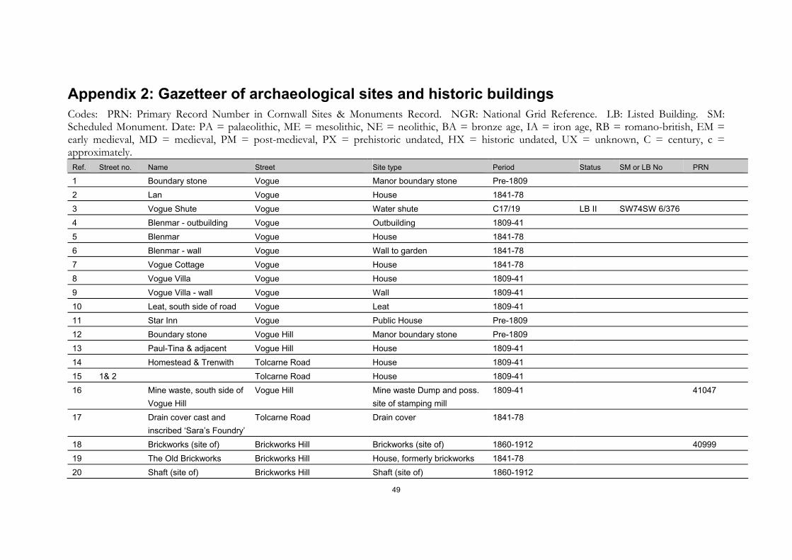
49
Appendix 2: Gazetteer of archaeological sites and historic buildings Codes: PRN: Primary Record Number in Cornwall Sites & Monuments Record. NGR: National Grid Reference. LB: Listed Building. SM: Scheduled Monument. Date: PA = palaeolithic, ME = mesolithic, NE = neolithic, BA = bronze age, IA = iron age, RB = romano-british, EM = early medieval, MD = medieval, PM = post-medieval, PX = prehistoric undated, HX = historic undated, UX = unknown, C = century, c = approximately.
Ref. Street no. Name Street Site type Period Status SM or LB No PRN
1 Boundary stone Vogue Manor boundary stone Pre-1809 2 Lan Vogue House 1841-78 3 Vogue Shute Vogue Water shute C17/19 LB II SW74SW 6/376 4 Blenmar - outbuilding Vogue Outbuilding 1809-41 5 Blenmar Vogue House 1841-78 6 Blenmar - wall Vogue Wall to garden 1841-78 7 Vogue Cottage Vogue House 1841-78 8 Vogue Villa Vogue House 1809-41 9 Vogue Villa - wall Vogue Wall 1809-41 10 Leat, south side of road Vogue Leat 1809-41 11 Star Inn Vogue Public House Pre-1809 12 Boundary stone Vogue Hill Manor boundary stone Pre-1809 13 Paul-Tina & adjacent Vogue Hill House 1809-41 14 Homestead & Trenwith Tolcarne Road House 1809-41 15 1& 2 Tolcarne Road House 1809-41 16 Mine waste, south side of
Vogue Hill Vogue Hill Mine waste Dump and poss.
site of stamping mill 1809-41 41047
17 Drain cover cast and inscribed ‘Sara’s Foundry’
Tolcarne Road Drain cover 1841-78
18 Brickworks (site of) Brickworks Hill Brickworks (site of) 1860-1912 40999 19 The Old Brickworks Brickworks Hill House, formerly brickworks 1841-78 20 Shaft (site of) Brickworks Hill Shaft (site of) 1860-1912
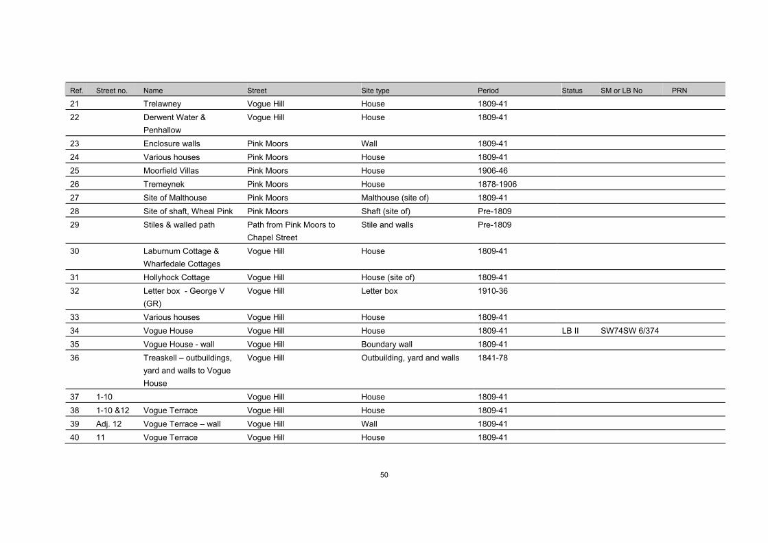
50
Ref. Street no. Name Street Site type Period Status SM or LB No PRN
21 Trelawney Vogue Hill House 1809-41 22 Derwent Water &
Penhallow Vogue Hill House 1809-41
23 Enclosure walls Pink Moors Wall 1809-41 24 Various houses Pink Moors House 1809-41 25 Moorfield Villas Pink Moors House 1906-46 26 Tremeynek Pink Moors House 1878-1906 27 Site of Malthouse Pink Moors Malthouse (site of) 1809-41 28 Site of shaft, Wheal Pink Pink Moors Shaft (site of) Pre-1809 29 Stiles & walled path Path from Pink Moors to
Chapel Street Stile and walls Pre-1809
30 Laburnum Cottage & Wharfedale Cottages
Vogue Hill House 1809-41
31 Hollyhock Cottage Vogue Hill House (site of) 1809-41 32 Letter box - George V
(GR) Vogue Hill Letter box 1910-36
33 Various houses Vogue Hill House 1809-41 34 Vogue House Vogue Hill House 1809-41 LB II SW74SW 6/374 35 Vogue House - wall Vogue Hill Boundary wall 1809-41 36 Treaskell – outbuildings,
yard and walls to Vogue House
Vogue Hill Outbuilding, yard and walls 1841-78
37 1-10 Vogue Hill House 1809-41 38 1-10 &12 Vogue Terrace Vogue Hill House 1809-41 39 Adj. 12 Vogue Terrace – wall Vogue Hill Wall 1809-41 40 11 Vogue Terrace Vogue Hill House 1809-41
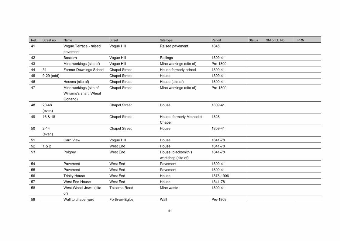
51
Ref. Street no. Name Street Site type Period Status SM or LB No PRN
41 Vogue Terrace - raised pavement
Vogue Hill Raised pavement 1845
42 Boscarn Vogue Hill Railings 1809-41 43 Mine workings (site of) Vogue Hill Mine workings (site of) Pre-1809 44 31 Former Downings School Chapel Street House formerly school 1809-41 45 9-29 (odd) Chapel Street House 1809-41 46 Houses (site of) Chapel Street House (site of) 1809-41 47 Mine workings (site of
Williams’s shaft, Wheal Gorland)
Chapel Street Mine workings (site of) Pre-1809
48 20-48 (even)
Chapel Street House 1809-41
49 16 & 18 Chapel Street House, formerly Methodist Chapel
1828
50 2-14 (even)
Chapel Street House 1809-41
51 Carn View Vogue Hill House 1841-78 52 1 & 2 West End House 1841-78 53 Polgrey West End House, blacksmith’s
workshop (site of) 1841-78
54 Pavement West End Pavement 1809-41 55 Pavement West End Pavement 1809-41 56 Trinity House West End House 1878-1906 57 West End House West End House 1841-78 58 West Wheal Jewel (site
of) Tolcarne Road Mine waste 1809-41
59 Wall to chapel yard Forth-an-Eglos Wall Pre-1809
52
Ref. Street no. Name Street Site type Period Status SM or LB No PRN
60 Methodist Chapel (site of) Forth-an-Eglos Chapel (site of) 1841-78 61 Wall (part enclosing
Wheal Quick dumps) Forth-an-Eglos Wall 1841-78
62 Hillside and outbuildings Brickworks Hill House and outbuildings Pre-1809 63 Mine waste, Wheal Quick Forth-an-Eglos Mine workings Pre-1809 64 Outbuildings south of
Chapel House Forth-an-Eglos Outbuilding 1809-41
65 1 & 2 Mount Pleasant House Pre-1809 66 Chapel House & adj. Forth-an-Eglos House 1809-41 67 Old School and
slaughterhouse Forth-an-Eglos School and slaughterhouse ,
now house Pre-1809
68 Outbuilding to former school
Forth-an-Eglos Outbuilding to former school Pre-1809
69 Community Centre West End Village hall 1906-46 70 Paving adj. Community
Cottage Fore Street Paving C19
71 Iron post and stone adj. Community Cottage
Fore Street Iron post and stone C19
72 Community Cottage Fore Street House Pre-1809 73 Paving adj. Manor House Fore Street Paving C19 74 Manor House Fore Street House Pre-1809 75 Gull House & Post Office Fore Street House & shop 76 House adj. Carew House Fore Street House Pre-1809-41 77 Outbuildings r/o Carew
House Fore Street Outbuildings Pre-1809
78 Carew House Fore Street House Pre-1809-41 LB II SW74SW 11/348

53
Ref. Street no. Name Street Site type Period Status SM or LB No PRN
79 Pebbles Fore Street House formerly counting house
1809-41 LB II SW74SW 18/10007
80 1-3 Williams Court, site of Harveys’ Warehouses, stables and yards
Fore Street Warehouse, stables and yards; now Houses
1809-41, converted 1997-8
81 5 & 7 Fore Street House 1809-41 82 Berlewen and former
shop to right House
shop Pre-1809 LB II SW74SW
11/347
83 1 Church Street House Pre-1809 LB II SW74SW 11/344
84 Paving Fore Street Paving 1809-41 85 Houses and shops Fore Street House and shops Pre-1809 86 Old Post Office Fore Street House, former post office 1841-78 87 Site of 1798 Market
House Market Square Market Place (site of) Pre-1809
88 1 & 2 Market Square House, (former chemist shop)
1809-41
89 3 – 5 Mills Terrace House 1809-41 90 Chysair, Penty Lowen Market Square House Pre-1809 – 1878 91 Clock tower Market Square Clock tower 1809-41 LB II SW74SW
11/349
92 Walls to clock tower Market Square Wall to clock tower 1809-41 LB II SW74SW 11/349
93 Freemason’s Hall Fore Street Hall, former warehouse 1809-41 94 St Day Inn Fore Street Hotel Pre-1809-41 95 Paving f/o St Day Inn Fore Street Paving 1809-41
54
Ref. Street no. Name Street Site type Period Status SM or LB No PRN
96 House, former shop adj. St Day Inn
Fore Street House, former shop 1809-41
97 Medieval cross (site of) Fore Street/Telegraph Street Medieval cross (site of) Pre-1809 98 1
6 Fore Street
Telegraph Street House, former shops Pre-1809 LB II SW74SW
11/350
99 6 Fore Street House 1809-41 100 The Cot Fore Street House Pre-1809 101 Trevean Cottage R/o Fore Street House Pre-1809 102 Sun Villa R/o Fore Street House Pre-1809 103 Wall adj. Trevean
Cottage R/o Fore Street Wall Pre-1809
104 Church (site of) adj. Trevean Cottage
R/o Fore Street Church (site of) Pre-1809
105 1-7 Buckingham Terrace House 1841-1906 106 Graveyard (poss. site of)
adj. Buckingham Terrace Graveyard (poss. site of) Pre-1809
107 Outbuildings r/o no. 3 Telegraph Street Outbuilding 1809-41 108 3 Telegraph Street House Pre-1809 109 Lynmouth Cottage Telegraph Street House Pre-1809 LB II SW74SW
11/359
110 House attached to the left of Lynmouth Cottage
Telegraph Street House Late-1809 LB II SW74SW 11/360
111 23 & 25 Telegraph Street House 1809-41 112 27 & 29 Telegraph Street House 1809-41 113 Outbuilding adj. 1 Wheal Gorland Road Outbuilding 1878-1906 114 Wheal Gorland (site of) Wheal Gorland Road Mine workings (site of) 1809-41 115 Walled track Chyrose Road and Balcoath Track PM
55
Ref. Street no. Name Street Site type Period Status SM or LB No PRN
116 Shaft (site of) adj. No. 2 Telegraph Street Shaft (site of) Pre-1809 117 Primrose and April
Cottages Telegraph Street House 1841-1878
118 1 & Norwyn Telegraph Street House 1841-78 119 Chapel Telegraph Street Chapel 1913 120 Lichfield House Telegraph Hill House 1841-78 121 Walls Bunt’s Lane Wall 1809-41 122 Mine workings (site of) Bunt’s Lane Mine workings (site of) 1809-41 123 Alma Cottage Bunt’s Lane House 1809-41 124 Bunt’s Lane Cottage Bunt’s Lane House 1809-41 125 34 & 36 Telegraph Street House 1878-1906 126 30 & 32 Telegraph Street House 1841-78 127 Boundary stone adj., 30 Telegraph Street Boundary stone PM 128 26 Telegraph Street House 1841-80 129 24 Stanley Villa Telegraph Street House 1841-78 LB II SW74SW
11/362
130 Carpenter’s shop opposite Lynmouth Cottage
Carpenter’s Workshop 1841-78 LB II SW74SW 11/361
131 12 Chapels (site of) Telegraph Street Chapels (site of) 1827 (site of earlier Baptist chapel)
132 Outbuilding r/o 12 Telegraph Street Outbuilding 133 2-10
(even) Telegraph Street House Pre-1809
134 1 Telegraph Street House Pre-1809 135 3 & Pot Pourri Church Street House and former shop Pre-1809-78 LB II SW74SW
11/345
56
Ref. Street no. Name Street Site type Period Status SM or LB No PRN
136 17 Church Street House 1809-41 LB II SW74SW 11/346
137 Walls to former ornamental grounds of Carew House
Church Street, Carew Road, r/o Carew House
Walls 1809-41
138 1 – 4 (cons)
Carew Close House, former reservoir 1809-41
139 Coach House Carew Road House 1809-41 140 7 – 14
(cons) Carew Road House (site of) 1809-41
141 Wheal Quick (site of) R/o Carew Road Mine workings (site of) now playing field
Pre-1809
142 Site of Harveys stable yard (earlier shaft of Wheal Quick)
Carew Road Stable Yard (site of) – earlier site of Shaft
1809-1841; shaftPre-1809
143 School hall adj. Holy Trinity Church
Church Street School hall 1878-1906
144 Holy Trinity Church Church Street Church, former Sunday School
1878-1906
145 33 & 36 Church Street House 1809-41 146 Jewell Cottage Church Street House Pre-1809 147 Wheal Quick (site of) R/o Carew Road Shaft (site of), now playing
field Pre-1809
148 St Day Primary School Burnwithian School 1841-78 149 St Day Primary School Burnwithian School wall 1841-78 150 Shaft (site of) Church Hill Shaft (site of) Pre-1809 151 Holy Trinity Church Church Street Former Church 1828 LB II SW74SW
11/339 19321
57
Ref. Street no. Name Street Site type Period Status SM or LB No PRN
152 Holy Trinity Churchyard Church Road Churchyard 1809-41 153 Holy Trinity Churchyard
extension Church Road Churchyard 1878-1906
154 The Clergy House Church Road House 1837 LB II SW74SW 11/341
155 Wall to churchyard Bosawna Close Wall to churchyard 1809-41 156 Walls adj. 22 Church Street Wall Pre-1809 157 22 The Cedars Church Street House Pre-1809 158 The Lodge with attached
gatepiers Church Street Lodge
Gate pier 1809-41 LB II SW74SW
11/342
159 Adj. 20 Site of Cornish Arms Church Street Public House (site of) 1809-41 160 The Coach House Vicarage Hill House & walls 1841-78 161 Glebe House Vicarage Hill Vicarage 1809-41 162 16 Church Street House Pre-1809 163 2 – 14
(even) Church Street
House Pre-1809 & 1841-78
164 2 – 16 (even)
Scorrier Street House Pre-1809
165 R/o 6 Wilton’s workshop at east end of garden
Scorrier Street Workshop 1841-78 LB II SW74SW 11/343
166 18 – 20 Scorrier Street Houses 1878-1906 167 Methodist Chapel
(Primitive), site of C18 Baptist Chapel
Scorrier Street Nonconformist Chapel, site of Baptist Chapel
1878-1906 (Baptist Chapel -
168 22 Scorrier Street House 1809-41
169 24 – 42 Scorrier Street House 1809-1841
58
Ref. Street no. Name Street Site type Period Status SM or LB No PRN
170 1 – 28 Mills Street House 1809-78 LB II SW74SW 11/10006 SW74SW 11/10005
171 Hall (Salvation Army) Barrack’s Lane Hall 1841-78 172 Dunromin Barrack’s Lane House 1841-78 173 Deads Hedge Barrack’s Lane Waste dump / deads hedge 1809-41 174 29-41 odd Scorrier Street Row 1841-78 175 15-25 odd Scorrier Street Row & shops 1809-41 176 Site of shaft, r/o surgery Scorrier Street Shaft (site of) 1809-41 177 7-13 odd Scorrier Street Row & shops 1841-78 178 1-5 Scorrier Street Row & shops Pre-1809, altered
mid C19
179 5-13 odd Church Street Row & shops 1809-41 180 Paving Scorrier Street Paving 1809-41 181 Manor Workshop Telegraph Street Manor Workshop Pre-1809 182 Cornish Cross approx.
25m west of Church of Holy Trinity
Church Street Cross MD LB II SW74SW 11/340
183 Site of Shafts Vicarage Hill Shafts (site of) Pre-1809 184 The Villa Vicarage Hill House 1809-41 185 Trelyn Vicarage Hill House 1809-41 186 19-25 Church Street Row & shops 1809-41 187 Paving Church Street Paving 1809-41 188 Site of Boot factory Scorrier Street Boot factory (site of) mid C19

59

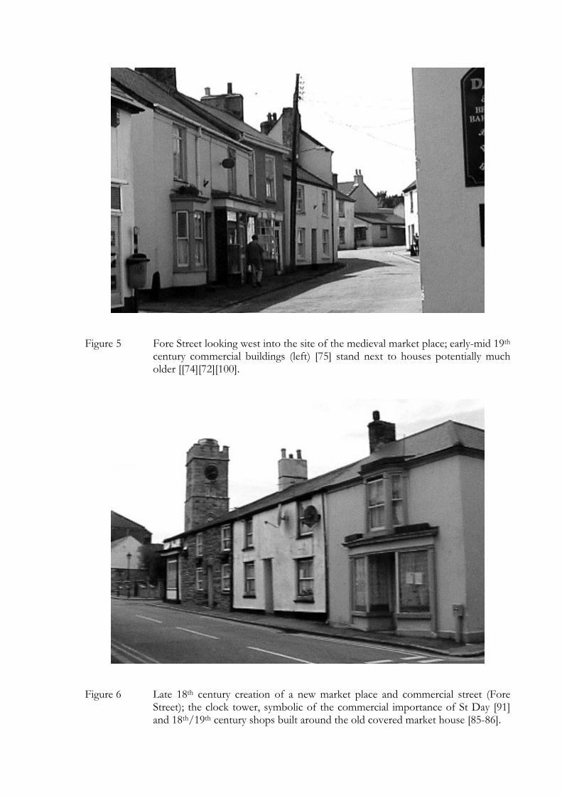
Figure 5 Fore Street looking west into the site of the medieval market place; early-mid 19th century commercial buildings (left) [75] stand next to houses potentially much older [[74][72][100].
Figure 6 Late 18th century creation of a new market place and commercial street (Fore Street); the clock tower, symbolic of the commercial importance of St Day [91] and 18th/19th century shops built around the old covered market house [85-86].
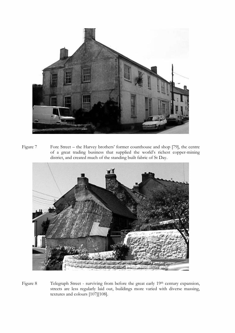
Figure 7 Fore Street – the Harvey brothers’ former counthouse and shop [79], the centre of a great trading business that supplied the world’s richest copper-mining district, and created much of the standing built fabric of St Day.
Figure 8 Telegraph Street - surviving from before the great early 19th century expansion, streets are less regularly laid out, buildings more varied with diverse massing, textures and colours [107][108].
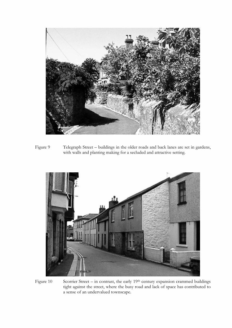
Figure 9 Telegraph Street – buildings in the older roads and back lanes are set in gardens, with walls and planting making for a secluded and attractive setting.
Figure 10 Scorrier Street – in contrast, the early 19th century expansion crammed buildings
tight against the street, where the busy road and lack of space has contributed to a sense of an undervalued townscape.
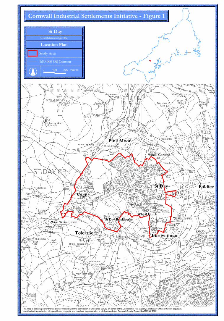
��
���
���
���
���
��
���
���
���
���
���
��
���������
���� ����
������������������
�������������
�����������
�������
������������������������������
�����������
�������������������� ���
������������
������������������
����������
� ��� ��� �� ��
����������������������� ����������!��"�#������$
����������������������� ��������� ������� ���� ���������� ��������!�� ��������� ������������!��!�����"��� ���� ��!�#� �$�%����&���������� ���!!����'�" � ������ �(��)�*������ ����� �� �����������! ��(���" � ������ �(������������������� ����������� �������� �������(�)�"� � ����"������"�������+,�����-�����
���������
���� ����
������������������
�������������
�����������
�������
������������������������������
�����������
���������
���� ����
������������������
�������������
�����������
�������
������������������������������
�����������

� �� �� �� ������
���������������������� ���
���������� � ��� ����������������������������������������������������������������
�� !"���#�! �"�!��$����������%�&�'����!��"�!!
�!! "�� !���"�! �
������������������ ��� � ������������� ������� ��
���� ������ ������������� ������������ ���� ��������������������������� ���������������� ���������������������������� ����� ���� ���������������!�������������"�#�$� ����������������������������"���������������"�� ���� ���� �����������������������������������"�#������ ������������������%&��'�()*�����
�����������
����� �����������������
��� ����� ����������
�� ��������
�� ���� � ������������
������������������
�� �� ����
�� ����
!������ �����
��� ����
��� �"#���
"��$�������
�������
�������%��&��
� � ���'�
�����
����%��&��
�� ���������
���������(�� �
������(��"��)�*�� ���������+
!�� �� ���� �����������
�������" �� �
����%�"�� �
"����
��"��
�
� � ���
'��"��
�
�� �"�� �� ������
���' ��"�� �
!�� �����
�������
�������
�� �������
������
�����
���"�,�$�����������
������
������ ����� ����� ���� � �
!��
"����-���*��+&� ���� )���
"�� �)����' �
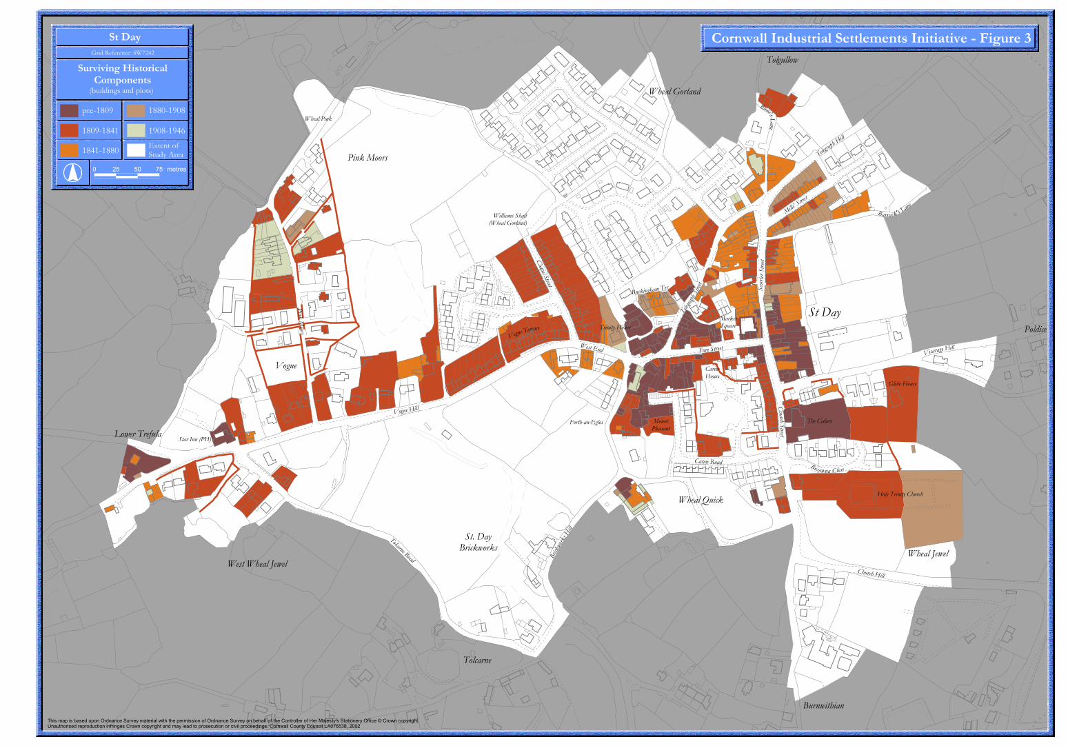
�������������� ����������������� � �� ������ �����
������������������� ��� � �������������������������������� ������ � ��������� ��������������� ���������������������������� ��������������� ������������ ������������������ �� ��� ������� ������������ �������������������� ��������������� ������� �������� ������ ����!"#$%&'()�*##*
��������������� ��
��� � ���� ���� �������������
��������������������
������
�������� ���������
���������
��������� ��������
# *& &# $& ����
�����������
����� �����
������������
��� ����� ����������
�� ��������
�� ���� � ������������
������������������
�� �� ����
�� ����
!������ �����
��� ����
��� �"#���
"��$�������
�������
�������%��&��
� � ���'�
�����
����%��&��
�� ���������
���������(�� �
������(��"��)�*�� ���������+
!�� �� ���� �����������
�������" �� �
����%�"�� �
"����
��"��
�
� � ���
'��"��
�
�� �"�� �� ������
���' ��"�� �
!�� �����
�������
�������
�� �������
������
�����
���"�,�$�����������
������
������ ����� ����� ���� � �
!��
"����-���*��+&� ���� )���
!" �� ��� ��#$��
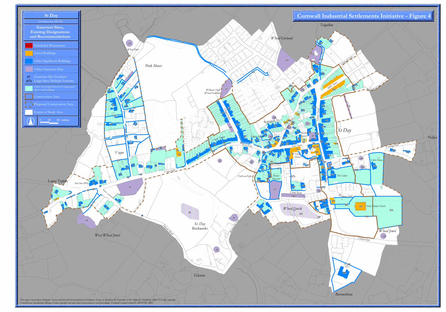
���������
������
�������
����
����
���
����
���
��
��
��
�
�
��
�
��
��
�� ��
��
��
��
��
��
��
��
��
��
��
��
��
����
��
��
��
��
� ��
��
��
�� �� �� ��
����
��
���
��
����
�
��
�� ����
����
��
����
��
����
��
��
�� ����
��
���
����
����
�������
�����
����
��
����
���
���
��� ������
�����
������
���������
���
���
������
������
������
������
���
���
�����
���
���
���
���
���
���
���
������
���
���
���
���
���
��� ���
���
���
��
��
�
��
��
��
��
��
��
��
��
��
��
���
���
���
���
���
���
���
��
���
��
� ��
� �
��
��
��
��
��
��
��
����
��
��
���
���
��
��
�
��
��
����
����
�������
��
���
���
���
���
�� ��
����
������
���
��
��
�
��� ���
��
��
��
��
���������
������
�������
����
����
���
����
���
��
��
��
�
�
��
�
��
��
�� ��
��
��
��
��
��
��
��
��
��
��
��
��
����
��
��
��
��
� ��
��
��
�� �� �� ��
����
��
���
��
����
�
��
�� ����
����
��
����
��
����
��
��
�� ����
��
���
����
����
�������
�����
����
��
����
���
���
��� ������
�����
������
���������
���
���
������
������
������
������
���
���
�����
���
���
���
���
���
���
���
������
���
���
���
���
���
��� ���
���
���
��
��
�
��
��
��
��
��
��
��
��
��
��
���
���
���
���
���
���
���
��
���
��
� ��
� �
��
��
��
��
��
��
��
����
��
��
���
���
��
��
�
��
��
����
����
�������
��
���
���
���
���
�� ��
����
������
���
��
��
�
��� ���
��
��
��
��
� ��������������������������������������������� �����
������������������� ��� � �������������������������������� ������ � ��������� ��������������� ���������������������������� ��������������� ������������ ������������������ �� ��� ������� ������������ �������������������� ��������������� ������� �������� ������ ����!"#$%&'()�*##*
!���������� �����+ �,-�.
/���
0���0����1��
������ �2��
������
����3��4���5���5�
4���5���5������
0����-� 5
-� 5������
-� 5������
/��������
����������
0���6 7�������
������������ ������ ����� �
�����������
�������� �� �
��� ��������/����
�����
0�������������,0����8���� .
4��5� �������
0����8���� 4� ����!�
������������
4�����5���!�
���������
-�������3�����5�
�9���
��������
/�����������
8�������
�������
�������� ����������
�����������
0����1��
0����:���5
4���� �����������2��
7����;� ;6���� ��� �-���� �
4�� ������
���
��
���
�������� ������������
�������������
������������������
�������������������
��������������������
�������������������������������� �����������������!
"#������ ����$�����
%������������������������
����������������
!�"������������#$%����� �&��� ���� ������'�( �������� ��
����&� ������'�()*+*
� �� �� ������
���
������������������,����������
���&�)