Planning Renewable Energy In Cornwall - Adrian Lea (Cornwall Council)
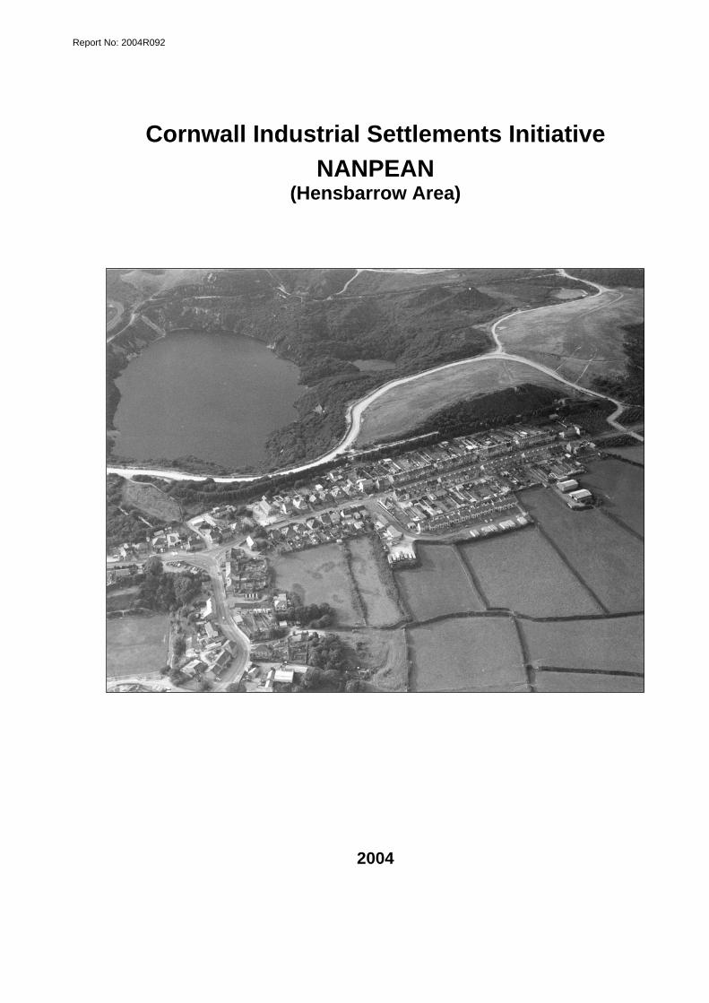
Report No: 2004R092
Cornwall Industrial Settlements Initiative
NANPEAN (Hensbarrow Area)
2004

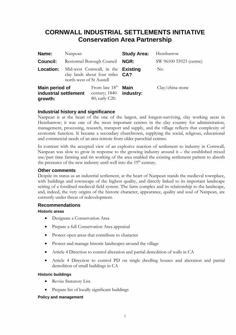
CORNWALL INDUSTRIAL SETTLEMENTS INITIATIVE Conservation Area Partnership
Name: Nanpean Study Area: Hensbarrow
Council: Restormel Borough Council NGR: SW 96100 55923 (centre)
Location: Mid-west Cornwall, in the clay lands about four miles north-west of St Austell
Existing CA?
No
Main period of industrial settlement growth:
From late 18th century; 1840-80; early C20.
Main industry:
Clay/china stone
Industrial history and significance Nanpean is at the heart of the one of the largest, and longest-surviving, clay working areas in Hensbarrow; it was one of the most important centres in the clay country for administration, management, processing, research, transport and supply, and the village reflects that complexity of economic function. It became a secondary churchtown, supplying the social, religious, educational and commercial needs of an area remote from older parochial centres.
In contrast with the accepted view of an explosive reaction of settlement to industry in Cornwall, Nanpean was slow to grow in response to the growing industry around it – the established mixed use/part time farming and tin working of the area enabled the existing settlement pattern to absorb the pressures of the new industry until well into the 19th century.
Other comments Despite its status as an industrial settlement, at the heart of Nanpean stands the medieval townplace, with buildings and townscape of the highest quality, and directly linked to its important landscape setting of a fossilised medieval field system. The farm complex and its relationship to the landscape, and, indeed, the very origins of the historic character, appearance, quality and soul of Nanpean, are currently under threat of redevelopment.
Recommendations Historic areas
• Designate a Conservation Area
• Prepare a full Conservation Area appraisal
• Protect open areas that contribute to character
• Protect and manage historic landscapes around the village
• Article 4 Direction to control alteration and partial demolition of walls in CA
• Article 4 Direction to control PD on single dwelling houses and alteration and partial demolition of small buildings in CA
Historic buildings • Revise Statutory List.
• Prepare list of locally significant buildings Policy and management
1

• A full survey of archaeological potential
• Proposals affecting areas of derelict land to be based on a thorough understanding of the unique historical and archaeological importance of the sites
• Limit or restrict development in the outskirts
• Recognise back-land areas and rear lanes as an important aspect of Nanpean’s character
• Develop interpretation of the village, and other promotional initiatives
• Further study of historic pattern of ownership and development of properties within the village
• In depth study of the architectural, development and social history of the Nanpean farm complex
• Full survey of existing trees and ornamental landscapes with appropriate protection measures
• Site-specific design guidance for the village
• Restoration/enhancement schemes to enhance some of Nanpean’s important gateway/ focal points
• Investigate Countryside Agency sponsored local heritage initiatives and similar schemes
• Develop a co-ordinated policy for the conversion, restoration, retention and/or re-use of commercial properties
2

Conservation Area Partnership
Cornwall Industrial Settlements Initiative NANPEAN
(Hensbarrow Area)
The Cahill Partnership and
Historic Environment Service
2004
Report No: 2004R092
3
Acknowledgements This report presents the results of an assessment carried out by The Cahill Partnership following desktop research by Bryn Perry Tapper (HES). Assistance was also provided by Terry Clarke, Restormel Borough Council. The report text and map drafts were prepared by The Cahill Partnership, and edited by Peter Herring (CISI Project Manager, HES). The report maps were produced by John Brinkhoff (CCC Planning Directorate Technical Services Section) from roughs prepared by The Cahill Partnership. Front cover illustration: Nanpean from the air (HES – F47/P1) ©Cornwall County Council 2004: Historic Environment Service, Planning, Transportation and Estates, Cornwall County Council, Kennall Building, Old County Hall, Station Road, Truro, Cornwall TR1 3AY. All rights reserved. No part of this document may be reproduced, stored in a retrieval system, or transmitted in any form or by any means without the prior permission of the publisher.
4
Contents Page
1 Introduction .................................................................................................................7 1.1 Background................................................................................................................................7 1.2 Project Aims ..............................................................................................................................7 1.3 Project methodology ................................................................................................................7 1.4 Date of Assessment ..................................................................................................................7
2 Location and setting ....................................................................................................8 2.1 Geographical location ..............................................................................................................8 2.2 Landscape setting......................................................................................................................8
3 History..........................................................................................................................8 3.1 Agriculture .................................................................................................................................8 3.2 Tin ...............................................................................................................................................9 3.3 Building stone quarries.............................................................................................................9 3.4 China clay and china stone ....................................................................................................10 3.5 Transport..................................................................................................................................12
4 Physical Development (Fig 2)..................................................................................... 12 4.1 Pre 1809....................................................................................................................................12 4.2 1809-42 .....................................................................................................................................13 4.3 1842-79 .....................................................................................................................................13 4.4 1879-1907.................................................................................................................................14 4.5 1907- 46....................................................................................................................................15 4.6 Post 1946..................................................................................................................................15
5 Current Character (Figs 3 & 4) .................................................................................... 16 5.1 General .....................................................................................................................................16 5.2 Built environment ...................................................................................................................16
5.2.1 Early, agricultural and pre-industrial remains.................................................................16 5.2.2 Public/ecclesiastical buildings ..........................................................................................17 5.2.3 Commercial/industrial structures ....................................................................................18 5.2.4 Housing................................................................................................................................18 5.2.5 Materials and local details..................................................................................................19 5.2.6 Paving, walls and street ephemera ...................................................................................20
5.3 Streetscape................................................................................................................................20 5.4 Views, Vistas and Green Space.............................................................................................21
5.4.1 Views and Vistas.................................................................................................................21 5.4.2 Greenery ..............................................................................................................................22
6 Industrial significance................................................................................................22 7 Designations ..............................................................................................................23
7.1 Scheduled monuments ...........................................................................................................23 7.2 Historic Buildings (Fig 4).......................................................................................................23 7.3 Historic Area Designations (Fig 4).......................................................................................23 7.4 Other designations..................................................................................................................23
8 Current issues and forces for change.........................................................................24 Protected areas within China Clay Industry .................................................................................24 Traffic, traffic calming and streetscape.........................................................................................24 Employment .....................................................................................................................................25 Historic topography and character ................................................................................................25 Encroachment into the medieval landscape ................................................................................25
9 Recommendations .....................................................................................................25 9.1 Historic areas ...........................................................................................................................25 9.2 Historic buildings....................................................................................................................26
5
9.3 Policy and management......................................................................................................... 27 10 References .................................................................................................................. 29
10.1 Primary Sources...................................................................................................................... 29 10.2 Publications ............................................................................................................................. 29
Appendix: Gazetteer of archaeological sites and historic buildings: Nanpean................ 31
List of figures 1. Location map
2. Historical development
3. Surviving historic components
4. Gazetteer sites, existing designations and recommendations
Abbreviations in main text AGHV Area of Great Historic Value
AGSV Area of Great Scientific Value
AONB Area of Outstanding Natural Beauty
CA Conservation Area
CAU Cornwall Archaeological Unit (Historic Environment Service, CCC)
CCC Cornwall County Council
CISI Cornwall Industrial Settlements Initiative
GPDO General Permitted Development Order
HES Historic Environment Service, Cornwall County Council
HERS Heritage Economic Regeneration Scheme (English Heritage)
HLF Heritage Lottery Fund (ing)
LB Listed Building
OALS Open Areas of Local Significance to Settlement Character
OS Ordnance Survey
PD Permitted Development
SPG Supplementary Planning Guidance
THI Townscape Heritage Initiative (Heritage Lottery Fund)
[1] Site number on Figure 4 and in the gazetteer (Appendix)
6
1 Introduction 1.1 Background Cornwall’s industrial settlements are the subject of a Conservation Area Partnership under the heading Cornwall Industrial Settlements Initiative (CISI). This partnership between English Heritage (with the Heritage Lottery Fund), Cornwall County Council, and the District Councils is intended to assess the character and significance of the County’s 112 industrial settlements. These include villages, ports and towns associated with Cornwall’s 19th century industrial revolution, based on metalliferous mining, slate and granite quarrying, and china clay extraction. The historic importance and distinctive character of such settlements has previously been undervalued, and their existing status does not adequately represent the industrial history of the county. CISI is aimed at redressing this imbalance.
The Cornish Mining World Heritage Site Bid is being prepared for submission to UNESCO by February 2005 (for inscription in June 2006). The bid areas will include the full range of 18th-20th century mining landscape components, including the settlements that were created or rapidly expanded as a result of mining and associated industries. All mining settlements are of significance to the World Heritage Site Bid - those that fall in the final Bid areas will be covered by the WHS Management Plan, while those that fall outside these areas will form part of the context for the World Heritage Site and will need to be sensitively managed in the light of this.
1.2 Project Aims The aim of CISI is to produce a settlement-by-settlement analysis in order to obtain an overview of the history, present character and importance of Cornwall’s industrial settlements. This will help determine where, for example, new Conservation Areas should be designated (and existing ones revised), and could provide the basis for Conservation Area Statements (to be drawn up subsequently by District Conservation Officers).
1.3 Project methodology The methodology involved historical research, followed by a site visit(s). For the historical research, a date range of 1750 to 1945 was chosen, as this represented the period of industrial growth and decline in Cornwall. Archaeological and historical sources housed at CCC (see Section 10.1) were consulted, together with Listed Building data supplied by the District Councils. Using this information, Ordnance Survey base maps were hand coloured to show: the different phases of historical development; surviving historic components from each development phase; archaeological sites, key historic buildings, and statutory designations. These maps (which formed the basis for Figures 2-4), together with copies of the primary sources consulted, were bound into a folder for each settlement, for use during site visits.
The focus of the site visits was to assess settlement character and consider ways in which this could be protected and enhanced in the future. This was achieved using a checklist drawn from Conservation Area Practice: English Heritage’s guidance on the management of Conservation Areas (1995) and Conservation Area Management - A Practical Guide (published by the English Towns Forum, 1998). The maps compiled during the historical phase were enhanced during the site visits, particularly with information relating to the survival and significance of historic buildings, and a general photographic record (colour prints) was made of each settlement. Meetings on site were arranged with the District Conservation Officers in order to discuss current initiatives and recommendations for future management.
1.4 Date of Assessment Nanpean was assessed as part of CISI during 2003
7
2 Location and setting 2.1 Geographical location Nanpean is situated on the western side of the Hensbarrow granite uplands in mid-west Cornwall. It is about four miles north-west of St Austell, two miles or so north-east of the parish churchtown at St Stephen, and a mile south of St Dennis. It is designated as an island settlement within the winning and working zones of the china clay industry, which surrounds it on all sides.
St Stephen’s parish occupies a broad, relatively sheltered basin between higher moorland; it is well watered and fertile with a landscape and settlement pattern already well established by the medieval period. Nanpean (the name means ‘little valley’) stands at the northern end of this vale – slightly isolated from the rest of the parish, at the point where the fertile valley rises up onto the higher and harsher moors; the road crossing over the moors from St Stephen to St Dennis passes through Nanpean. This northern corner of St Stephen’s has always been a place slightly apart –higher, standing on granite and dominated by china clay - whereas the southern half of the parish, off the granite, is much more agricultural, and the industry there remained predominantly mining in the 19th century.
2.2 Landscape setting The whole settlement is surrounded to the north, west and east by higher ground – formerly moor land, now mainly given over to the china clay industry; the huge depot and stores complex at Drinnick/Dubbers also covers virtually the whole of the floor and south slopes of the valley – for all the world looking like a defended, hilltop-village of old.
The slopes to the east of the village retain a largely unaltered fossilised medieval field pattern based on strips, and parts of the countryside beyond rolling down the valley to the south-east are as yet untouched by the expanding clay wastes. Some of the clay areas are of considerable interest as historic landscapes themselves, and are still seen as set within the older landscape. To the north of the village there is a more direct and immediate relationship with the looming presence of the clay pits – but here also is a strange landscape of overgrown century-old tips, abandoned processing plants and tree-clad engine houses; this is an historic landscape of great character and significance in its own right.
The panorama within which the village sits, contained as it is by some of the most blasted industrial landscapes in the country, is dramatic, interesting and, amazingly, even pretty in places. The landscape around is surprisingly green – overgrown rather than planted – but is full of bushes and trees and green fields, rather than just the processing plants, tips and vast holes one might expect.
Within the village area there are old clay/china stone quarries, some already disused by the mid 19th century, which frame the built-up area and helped to determine the shape of the settlement – Nanpean is still by-and-large only a single building plot deep along the roads, allowing direct communication with the wider countryside. The largest of these quarries (Victoria Bottoms) is now an essential part of the village, converted in 1936 to playing fields; others are there to be explored along the side of footpaths giving direct access into countryside.
3 History This section should be read in conjunction with the mapped historical development in Figure 2.
3.1 Agriculture By the time the clay industry came to Nanpean in the late 18th century, this was a relatively stable and well-established countryside of ancient hamlets and farmsteads (Nanpean, Drinnick, Hallew,
8
Goverseth, Currian) with enclosed arable fields (including the fossilised medieval strip field system east of Nanpean), attached upland grazing, and some tin streaming in the valleys.
Whereas some other parts of Hensbarrow saw extensive in-take from the moors through the 19th century for agricultural land, with new smallholdings and larger farms being created side-by-side with the expanding clay industry, this corner of St Stephen’s parish does not seem to have experienced this to the same degree (certainly not as much as in adjoining St Dennis). Perhaps most of the available land had already been taken–in by 1800, the adjacent moors too steep or barren to be enclosed, and the early development of large-scale clay and china stone works here were a more immediate competing source of land-use and employment.
Nonetheless, farming remained an important local activity – the heart of the village remained the large medieval farming townplace, and the surrounding hamlets (Drinnick, Hallew, Currian) were all primarily agricultural hamlets with some workers’ smallholdings and cottages. Local transport demands added a source of profit for local farmers and tradesmen operating as carriers, and horse-drawn wagons remained the basic form of transport for clay even after the railways arrived in the area. By the early 19th century there was a well-established grist mill at Drinnick, supplying feed for both the farming community and the large number of transport animals.
3.2 Tin There is evidence of streaming in the valleys east of Nanpean at Currian Vale and Goverseth, and on the moors to the north at Hendra and Trelavour Downs. There may well have been streaming, perhaps even early mining, within the current area of the village: the medieval well site near Nanpean Farm is said to have been destroyed by old mining.
Blackmore Stannary, centred on Hensbarrow, was the most important in Cornwall in the late Middle Ages when over 50% of all south-west tin was produced here. Early lode-back and shallow mining also concentrated in these areas: Stennagwyn Mine, towards Foxhole, was recorded in 1584, and there is evidence of early working on Trelavour Downs. Although in the 16th to 18th centuries tin production declined almost to extinction in Blackmore, and most of Hensbarrow became something of a rural backwater, much unrecorded activity continued. There were, for instance, still stamping mills not too distant in the upper Fal valley, and in 1800 when the Hendra Downs clay company was set up (actually closer to Nanpean than to its namesake Hendra, in St Dennis parish), it also leased the tin bounds on Hendra Common, and in fact it was the tin profits that kept the company going over the French War years when the clay industry all but collapsed. There remained a close relationship between the clay companies and tin production – many setts turned from either tin to clay, or the other way around depending on what was more profitable in the initial stages of opening up the works.
Tin mining continued throughout the 19th century in the southern half of St Stephen parish, well away from Nanpean, but a handful of operations continued here too. Tinners and tin miners were recorded in the 1851 census at Nanpean, as well as a tin mine agent, with other tinners at Whitemoor (and a few iron miners - there were short-lived but prosperous iron works near Roche). More detailed investigation of the subsequent census returns might reveal a small continuing presence of tinners in the community throughout the century.
3.3 Building stone quarries There was limited local quarrying of stone from the Middle Ages; china stone, or St Stephen’s porcelain, had been used for church interiors, fittings, and other quality building works in a wide area (for instance used in the interior of St Stephen and St Dennis, and for the tower of Probus Church). It was easily tooled and commonly found in association with tin streaming and lode-back work, although the exact location of these early quarries is not known; it continued to be
9
the favoured local building material throughout the 19th century. Unaltered granitic and other types of stone were also clearly sourced locally throughout the period.
The old quarries east of Nanpean Farm may have been for building stone rather than clay or china stone, but insufficient research has been done to establish their full history. Building stone quarrying remained a local but unquantifiable element of economic activity in the parish throughout the 19th and 20th centuries.
3.4 China clay and china stone This is not the place to give a generalised history of china clay and china stone; reference should be made to the bibliography. A working knowledge of the technologies and general trends of development is assumed in the reader, and only specific trends and sites relating to Nanpean will be analysed here. Throughout, references to the china clay industry are taken to incorporate the working and employment generated by china stone quarrying, a major activity in this part of Hensbarrow.
From the outset St Stephen’s parish was the primary clay and china-stone producing area in Hensbarrow, and remains at its core to the present day. Nanpean soon came to be one of, if not the principal, administrative and service centres for the industry on Hensbarrow, as well being in the centre of one of the most continuously productive groups of pits and quarries.
When, in 1748, William Cookworthy discovered good quality china stone and clay in Hensbarrow it was in St Stephen’s (especially around Carloggas - Cookworthy’s first mineral sett). On both the St Stephen’s Combe stream (Carloggas) and the slopes of the upper Fal River (Treviscoe), china clay lay easily accessed in the stream valleys while china stone, a necessary adjunct to the clay in the pottery making processes, bounded both areas to east and west. By 1775 the pottery manufacturers of Staffordshire started to take direct interest in the production and shipping of china clay and stone, starting with Josiah Wedgwood himself, who in 1798 set up the Hendra Company in partnership with the Minton and the New Hall Potteries, working both clay and china stone on Hendra Downs, while Hallew Moor set was working by 1799. By 1800, Nanpean had become the centre of the clay producing zone, ringed by the seven known pits operating in 1800 (Trethosa, Treviscoe, Trelavour Down, Hendra Downs, Carloggas Moor Goonamarris, Goonvean).
Despite the acute historic interest and importance of the early stages of the clay industry, the impact on local economies, and in particular on settlement, can be easily overstated. Even here, in the heartland of the new industry, it remained very localised and small-scale until the mid-late 19th century. Trethosa pit was one of the largest works but, in 1810, it was only about nine feet deep, produced only 300 tons of clay per year and employed only 13 people with occasional casual employment of women and girls. Even after a period of enormous investment and expansion in the 1820s and 1830s one of the largest pits, Goonvean, still only employed 34 people.
It is too easy to see the simple record of more and larger pits, larger and more capital-intensive companies, increasing miles of tramways and so on as a continuous graph-line of expansion and improvement, but this disguises a whole series of boom and bust periods, not unlike the contemporary tin and copper industries in Cornwall. The industry was always badly affected by foreign wars which hit both markets and coastal shipping. It had all but stopped by 1814 and the end of the French Wars, while in 1917 production levels were about half what they had been in 1912. In the 19th century kaolin was a specialised product and suffered in general trade recessions, as in the 1830s, which badly affected an industry which was already overstretching itself, entering a period of organisational and profit crisis.
Despite a continued trend for larger and larger companies over the whole 150 years or so covered by this report, most remained small, duplicating resources and infrastructure and poorly
10
capitalised – there were still 41 separate companies in 1939. However, Nanpean always remained a core area of the Hensbarrow china clay industry; and perhaps weathered the fluctuations better than most. Even when the scale of production was greater in the central and eastern parts of Hensbarrow, much of the industry was run and serviced from here, based on large amalgamated companies like the Cornwall China Stone and Clay Co. and the West of England Clay Co., with their principal depot at Nanpean/Drinnick.
Despite the cycle of boom and recession there was a general trend towards expansion. The 1820s and 1830s saw the growth of the industry with local entrepreneurs taking control of most of it, and the rise of St Austell as the principal financial and administrative centre for the whole clay area. A period of crisis followed in the 1840s but, by 1853, the larger companies were making good profits and labourers were in a good position to demand wage increases. But this was the heyday of high employment figures, before technological advancements – the first recorded coal-fired pan-kiln, which would eventually transform the scale and nature of the industry, was at Greensplat in 1854. The end of the tin boom in 1873 saw further diversion of investment into clay, especially in the use of steam engines (going cheap second hand).
Trade recession, investment in labour-saving technologies and overproduction would all lead to crises, such as in 1876 when there were pit and quarry closures, and the once-powerful labourers saw wages decline with strikes and riots (much of them centred on nearby Roche).
From 1880 onwards there was a slow revival in the trade; more machinery was bought, and the companies got still larger - by 1880 the West of England Clay Co. based on the St Stephen pits controlled about half of all south-west clay and china stone – their major depot at Drinnick Mill included a brick and tile works by 1869.
The huge levels of capital investment did not necessarily lead to the employment of more workers – about 4000 or so were employed in the clay industry over the whole Hensbarrow area in the early 1900s, less than in the 1850s when 7,200 men, women and children had been employed. From about 1900 there was a great increase and diversification of uses and, therefore, demand for china clay and, despite the disquiet and violence associated with the famous strike of 1912, working conditions, pay and housing were again relatively good in the clay industry - indeed, it entered a boom period in the years up to the First World War.
The inter-war years saw further rationalisation of the industry, creating massive conglomerates like English China Clays (1919). Again, despite the spread of the industry all over Hensbarrow, the new company was largely based on the old West of England Co.’s concentration of resources around Drinnick and Nanpean, including research facilities, brickworks, cooperages, stores, saw mills etc., while the large power station built in 1936 at Drinnick, replacing an earlier one of 1909, supplied virtually all of the vast ECC/Pochin enterprises in Hensbarrow. But there was still crisis in the early 1920s exacerbated by the pressures of finding jobs for 300 returning service men. The industry had only just stabilised by the start of WWII, during which production fell to the lowest level since 1876 (175,000 tons).
Export industries were vital to national economic recovery after 1945, and government subsidy regenerated the clay industry on a hitherto unknown scale. By 1966 2,000,000 tons per year were produced from only 24 highly mechanized ‘super pits’, while other uses were sought for sand waste - including ‘Cornish unit’ housing, kerbs, blocks and so-on. While Nanpean is now an ‘island settlement’, the depot at Drinnick is still in active use, Goonamarris, Treviscoe and Rostowrack are still major pit complexes and the landscape around is ringed with the ever-growing clay pits, settling ponds, china stone quarries and terraced dumps of the still active industry.
11
3.5 Transport Despite the small scale of individual pits, by the early 19th century the aggregate scale of the industry was already beginning to have discernable economic, population and settlement effects and to make demands on the local transport infrastructure. The cost of transport was a critical aspect of the industry, because of the low bulk value of the product (compared to metal ores, for instance), and the distance to a port or railhead could be the single most important determining factor in the success of any particular pit.
By 1800 the Hendra and Trelavour Downs Co. had its own ships exporting clay, mainly to Bristol. In 1791 Charles Rashleigh developed Charlestown; by 1829 rival ports like Pentewan, Par and Newquay (between 1825 and 1833) were being developed, with new tram roads proposed at an early stage to link them to the clay areas. Local transport demands were a source of profit for local farmers and tradesmen - many farmers developed a major sideline as carriers and transport contractors (and were as often as not also independent clay merchants and agents); much of the clay industry around St Dennis and St Stephen was based on lands belonging to the Boconnoc estate (owned successively by the Pit, Grenville and Fortescue families), and their tenant farmers were given preference in transport contracts.
Many of the port and rail schemes were a speculation on the potential of the area as much as a reaction to the existing levels of production and, in fact, much of the development was slow, piecemeal and achieved only after often ruthless competition and wasteful duplication of resources. The Cornwall China Stone and Clay Co. were promoting a tramway from Pentewan to Little Treviscoe in the 1840s, but this was baulked by Joseph Treffry’s Newquay Tramway coming in from the north to Treviscoe and Hendra Downs. This was itself pursued only with difficulty and slowly – it did not reach Hendra Downs until 1852. Other proposals to unite the tramways and improve communication with the clay ports on both north and south coasts were no less desultory. The Newquay and Cornwall junction railway coming from the St Austell main line, mooted since the late 1850s had, by 1867, only built two miles to Higher Carpalla (it was supposed to join up with the Newquay tramway at Hendra Downs) and was abandoned after reaching Drinnick Mill in 1869. Even the Cornwall Mineral Railway, opened in 1874, and which finally connected up the St Dennis and St Stephen pits via Treviscoe, failed to reach its anticipated levels of mineral (and passenger) capacity, while the further development of Par and Fowey meant the abandonment of Newquay as a clay port, and Treviscoe was served only by the southern rail route by 1907.
Later 19th century developments included the introduction of slurry pipelines to ship wet clay from the pits to more distant kiln dries, but much of the clay continued to be moved by horse-drawn wagon until well into the 20th century, when motorised road transport took over.
4 Physical Development (Fig 2) 4.1 Pre 1809 The parish of St Stephen in Brannel formed part of an extensive and old territory; the ancient lands of Brannel included St Dennis (and perhaps originally other areas too). The two parishes, which had become attached in the Middle Ages to St Michael Caerhayes, were not fully separated until 1852. This was a more densely settled area throughout antiquity than most of Hensbarrow - St Stephen’s or Foxhole Beacon is the only known Neolithic hilltop defended site on Hensbarrow, while St Dennis Church is in the only known Iron Age hill fort on the massif. Although Domesday Book (1086) recorded just a single large manor in Brannel, held by the earl of Cornwall (in effect, the Crown), this in itself suggests this was a valuable area and it disguises the true extent, density and antiquity of settlement.
12
At the head of the vale which makes up most of St Stephen’s parish, there is the site of an Iron Age round at Currian Vale and a fossilised medieval field system to the east of Nanpean, while Nanpean (1332) and Drinnick (1370) are both recorded medieval place names.
By 1809 there was a long-established scatter of hamlets in this northern corner of St Stephen’s parish, including Hallew, Drinnick, Menmundy and Currian, all clustered around the noticeably larger Nanpean. Nanpean itself comprised the large townplace around the farm, associated with its ancient holy well, with a few cottages and other buildings running down Fore Street. Somewhat separate was a building complex on the site of the Old Inn/smithy in Hallew Road. Nanpean, although already larger than its neighbours, was not a place of singular importance in 1809, and remains largely anonymous in the records of the time.
Nanpean’s population, as in all the hamlets, was primarily agricultural, although there was still residual tin streaming in the area, and clay working had been established for a number of years locally – particularly just north of Nanpean at Hendra Downs. The numbers involved in both industries were still very small, however (see section 3.4), and probably part-time, and the handful of workers would have been indistinguishable from agricultural labourers. The largest of the pits (Trethosa) regularly employed only 13 people. We should not look, therefore, for much effect on settlement at this time; the vast impact china clay had in the later 19th/20th centuries tends to give a distorted view of its landscape and settlement importance at this early stage.
4.2 1809-42 In the first half of the 19th century the clay industry was still largely an industry of low profit margins and little capital investment, reliant on manual labour – the initial impact of expansion was in simple numbers of clay and quarry workers that needed to be housed. The numbers involved in Nanpean were still not great, however (despite this being the period of most rapid population rise in the parish of St Stephen as a whole), and the clay, china stone, and tin workers were housed within the existing landscape by the traditional means of rented and leasehold or squatter cottages; the clay companies ran their businesses on traditional cost-book systems, they did not typically see the need nor have the capital available to build housing for workers. Nanpean, Drinnick, Hallew, Goverseth, Menmundy and Currian all remained farming hamlets, where clay labourers lived alongside and did not yet greatly outnumber farmers and agricultural labourers. The actual extent of the settled areas did not grow that much – each of the hamlets saw only a modest increase in size. The village was tightly hemmed in at this stage by workings to west and east of Fore Street (which had partly destroyed the site of the ancient holy well), and the clay works in the stream bottom between Nanpean and Drinnick.
There is little evidence at this early stage of a growth in trades or service provision in Nanpean, only one or two masons and a miller – indeed, the 1841 census returns record as many craftsmen in the outlying hamlets, with masons at Currian, a carpenter and milliners at Drinnick.
What is notable is the contrast between these hamlets, only gradually being transformed, and the new developments at Whitemoor; here was a virtually new industrial settlement on the edges of the commons, lived in almost exclusively by specialised clay, quarry, iron and tin labourers – and in much greater numbers than in the old farming hamlets; settlements like this clearly accounted for most of the population rise in St Stephen between 1811 (1904) and 1841 (2643).
4.3 1842-79 The population dynamics within Nanpean reflect the very localised effects of the clay industry, with major service depots established at this time in and around the village (even though the major pits began to be further away). Nanpean expanded hugely during this period, at a time when population growth in St Stephen’s parish as a whole was less than it had been in the previous 40 years (2643 in 1841, 3228 in 1881).
13
Nanpean grew - as did the adjoining hamlets like Hallew and Drinnick – stretching all the way up Fore Street to make a continuous village street from the valley bottom all the way up to the old Queen’s Arms, and most of the available space within the village core was infilled at the same time.
Much of this expansion seems to have taken place early in the period in the 1840s and 1850s (the time when a new Anglican church was first mooted). It was then that Nanpean first acquired those facilities and institutions, as revealed in the 1856 Post Office Directory, which distinguished it from its simpler and smaller neighbours, which remained largely farming hamlets with additional clay labourers’ cottages.
The parochial school was built here by 1856, and the village contained many carriers, with clay agents, smiths, carpenters, dressmakers, shopkeepers, an auctioneer, butcher, farmers and two inns: the Queen’s Arms and the Grenville Arms. Amongst these lived clay and quarry labourers, agricultural workers, tin workers and even one copper miner.
By 1869 a branch of the Cornwall railway had reached Nanpean (a mineral line), the mill and brickworks at Drinnick were established, and the village developed apace. By 1870, Nanpean was described as thriving, the chief village in St Stephen aside from the churchtown itself; both the Wesleyan Methodists and the Free Methodist had been established by 1872 (Lake) – the latter’s chapel was built in 1873. The Anglican chapel or mission church first proposed in the 1840s, when the lord of the manor acquired the old arcade of St Dennis Church removed in 1847, had been built by 1877-8.
Nanpean took on many characteristics of churchtown settlements elsewhere in the clay country, as a focus of trade, shopping, crafts, religion, education and social activities, as a relatively more select residential area, altogether a more complex place than many of the mushrooming industrial villages in the area. This was not a settlement simply of long lines of humble cottage rows; certainly rows of cottages were built, but there were also more substantial residential and commercial properties and workshops, chapels and school, all adjoining the large industrial complex, stores, railhead, brickworks, mills and so on, while in the centre of the village the old farm continued to be the largest and single most impressive group of buildings – as much a transport/carrier centre as it was a simple farm.
4.4 1879-1907 Population growth in St Stephen as a whole accelerated again in the late 19th century – from 3,228 in 1881 to 4,831 in 1911, a greater increase in these 40 years than in the previous 80 years, and most of it concentrated in the years around 1900-1910. The working population appears to have been relatively stable during this period (other settlements were developing in close proximity to the pits – for instance at Treviscoe and Foxhole); it was a time of great capital investment in the clay industry, but decline in the absolute numbers employed, particularly of labourers and general workers. In contrast, skilled workers, engineers and the managerial classes increased in Nanpean as the depots at Drinnick became more extensive, and most of the additional housing was large detached or semi-detached houses along St George’s Road for these classes– although the curate of St George’s church remained the only person of ‘gentry’ status in the village in late 19th century trade directories.
The village, which had long comprised a single street (Fore Street), became an offset L-shape, with the new houses, school and church facing the old clay works and expanding depot at Drinnick, while to the north lay the ancient farmlands of Nanpean and Menmundy.
Little changed in the make up of the trades, crafts and facilities in the village, apart from the presence of a post office (perhaps already there before 1880), although there were more shops, and a jeweller, tailor and dressmaker reflect changing levels of disposable income. Temperance
14
Rooms were set up in rivalry to the two pubs, Sunday schools were added to the chapels, and the parish school became a Board School following the 1870 Education Act. The school, rebuilt in 1898, was now the largest in the parish – a reflection of Nanpean’s local importance.
4.5 1907- 46 Population in St Stephen continued to grow to a peak in 1921 of 5064, thereafter declining to 4801 in 1931; the early period of continued growth was at a time when much of Cornwall had already experienced long decline, and when increasing investment and production in clay did not actually mean larger numbers employed. Despite this, the village continued to be relatively prosperous and well provided-for – a Board of Trade report thought the 1912 strike had been ill-advised, since most workers were quite well-off, owned their own houses, had savings, owned bikes, gramophones etc, and went on seaside trips in summer.
That Nanpean continued to expand was partly a reflection of the relative stability in the local industrial base, very much at the heart of the industry because of the laboratories, power station, stores and processing plants in and around Drinnick. But it also reflected the working of a marked 20th century phenomenon in the china clay area which was already beginning to show itself. Much of the later industrial housing, and early council housing, in the larger settlements like Nanpean was not just for new population, but for the increasing numbers displaced as the ever-larger pits and tips began to destroy outlying and scattered cottages and hamlets, and the big companies re-located key workers close to the main works.
With the change from the smaller, traditional cost-book clay companies to larger, limited liability companies with greater capital resources came a move to construct company-owned housing on a new scale (ECC owned workmen’s cottages sufficient to house 1590 by 1919). This had marked effects on the nature of development: on the location of housing - selected by the company, usually on large blocks along the roads and lanes, not simply slotted into the existing streetscape as before; on style and form, with uniform terraces rather than the traditional rows of individually detailed cottages; and on materials, with extensive use of mass-produced brick and concrete (both by-products of the industrial complex) in addition to, and usually instead of, the traditional stone of the area. Alongside the equally regular rows of speculative villas and bungalows, the terraces along Currian Road formed the largest single phase of development the village had ever seen (although still maintaining the established tendency to build along the roads leading into the centre), and actually changed the relative character of the village’s population – industrial workers perhaps for the first time forming an overwhelmingly dominant element.
At the same time, the cemetery at St George’s was considerably enlarged, and the village acquired Reading Rooms and a recreation ground converted from abandoned pits and quarries west of Fore Street, but little else seems to have changed in the local facilities and services.
4.6 Post 1946 The population of St Stephen continued to decline in the post-war years to 4436 in 1951, but Nanpean saw little of this decline, as its role as one of the key industrial centres for the clay country continued.
Recent population increase has seen relatively modest construction of housing estates. The houses are not being built for clay workers, although the post-war loss of the ancient hamlet at Hallew, just to the north of Nanpean, is a significant local example of the still-continuing process of removing population into the island settlements as the clay dumps continue to swallow up outlying land.
By and large, however, for the first time in the village’s history housing has not been built along the roads and lanes or on former industrial land, but on green fields. The intimate link with the history of the area has thus been broken in terms both of employment and the physical character
15
and shape of the village and its surrounding landscape, although this has so far been constrained by the tight confines of the development and ‘island settlement’ boundaries, the still expanding industrial lands close to the village, and the continuing agricultural use of the ancient field system to the east of the village.
5 Current Character (Figs 3 & 4) 5.1 General Nanpean, despite being an overtly industrial settlement, is actually more diverse in its character and surviving range of building types than might be thought; it was always more than a simple worker’s settlement, with just rows of cottages and perhaps a Methodist chapel. This reflects its complex development history.
5.2 Built environment
5.2.1 Early, agricultural and pre-industrial remains It might be expected that little would survive from the pre-industrial phase of the village’s history, in relation to how much was actually there before 1809, not only in terms of site and topography, but also built structures. In fact, survival is remarkably high.
The origin of the village was the farming hamlet – and those surrounding hamlets and farmsteads scattered around it – and these remained important elements in its make-up throughout the industrial period and even today. While the settlement at Hallew [18] has completely disappeared, those at Menmundy, Goverseth and Currian remain (outside the study area), still detached settlements from Nanpean, but the farming hamlet at Drinnick survives within the village area. It is much less complete than Nanpean Farm, and may not represent the medieval farmstead (perhaps under the depot site) but instead be a later cottage group, although the old farmhouse [69] is certainly pre-1809 in date and a good example of a vernacular stone-built farmhouse of the area. The adjoining buildings [68] [70] are more typically mid-late 19th century cottage rows, as much industrial as agricultural in origin. An interesting, but later survival of this agricultural tradition is what appears to be a smallholding with a good complex of outbuildings at Menears [78], St George’s Road. Parts of the former Queen’s Arms and the cottage adjoining [25] may survive from this earlier period, although the main facade of the old inn appears to be early 19th century.
The principal survival, however, lies at the very heart and origin of the village. Nanpean Farm [52-55] stands much as it was in its heyday in the mid 19th century. It is, paradoxically given its situation, one of the best surviving farm complexes of its date and size in the entire china clay area.
Because of the way Nanpean grew up as a scatter of cottages and buildings along the surrounding lanes, with little secondary development in the back lands, the farm complex still has a direct link with the medieval field system to the east – historical hedged tracks still pass out into the fields. The form of the medieval townplace, around which the farm buildings are grouped survives and still determines the shape and character of the village centre, as it has for hundreds of years – a green, rural oasis in the centre of one of the largest local industrial areas; even the site of the ancient holy well [56] may not be fully lost to quarrying.
Within this remarkable medieval landscape in miniature is the best group of buildings in Nanpean. Not only are they the earliest surviving structures – the old farmhouse in particular [55], and perhaps some of the farm buildings [54] may be at least 18th century in date – but the detailing of the granite stonework, with its carefully squared and coursed blocks and well-cut voussoirs [53] [54], its sense of architectural proportion and scale, makes these buildings actually among the best-built and most significant architecturally in the village.
16
The farm complex, moreover, not only has these intrinsic qualities, but also relates in the most clear-cut way to two wider aspects of the special interest and character of the area: the first is the extremely high quality of building in Nanpean to which these buildings make a significant contribution – the school [72], church [75], church hall [74], the Grenville Arms [26], certain of the larger houses [7], even some of the humbler cottages rows [29] [44] show a standard of design and detailing well above what might be expected in most similar industrial settlements. The second aspect of local character which this farm complex of medieval origin ties into is the remarkable quality of certain 18th/early 19th century agricultural buildings in the Hensbarrow area. This has been identified as one of the distinguishing characteristics of the clay country (Herring & Smith, 1991):-
‘In the farmyards barns …… shippons and even piggeries were also carefully designed; many survive to display the care and pride invested in them by Hensbarrow farmers.........all are as impressive as any contemporary dwelling in the area. Farm buildings are often the last examples of local vernacular architecture in a region and the loss of any is regretted. Those with medieval origins will be of national or county importance. The dominant buildings in most farmyards, barns were often carefully designed to look attractive and impressive. Some had symmetrical facades; door and window surrounds were usually well-finished. Most will be of county or local importance’.
The complex at Nanpean has additional significance since it is one of the best groups within an island settlement, and therefore perhaps one of the few that will potentially survive, into even the near future.
Reflecting the modest change between 1809 and 1842, there is little certainly surviving from the early 19th century, the possible exceptions all being within the existing built up area of 1809, and these may actually be earlier survivals than has been ascribed here (without benefit of close survey and further research). These include the additions to the main farm complex [54], the alterations to the former Queen’s Arms [25], the fine cottage in Fore Street [45] that has what is usually considered an early feature of a stone stack. Perhaps the other cottages probably from this date [21] [51] are also earlier.
With the creation of the enlarged village in the mid-late 19th century it is possible to analyse the typology of different building types.
5.2.2 Public/ecclesiastical buildings Nanpean’s importance as a second focus of settlement in St Stephen’s parish, with the churchtown, is reflected in the types and quality of its surviving institutional buildings. First among these, because a unique feature in the parish, and rare enough anywhere in Hensbarrow, is the new Anglican mission church/chapel of St George’s [75], which incorporates part of the medieval arcades of St Dennis church and from the outset had its own burial ground. The church, despite its simple form and restrained Early English lancet style detailing, is part of an important architectural, landscape and historic grouping including the cemetery, entrance gates and walls [77], graves, and war memorial [76]. Their character is enhanced by close proximity to other first-rate institutional buildings like the church hall [74], still attractive despite being boarded up and apparently unused at the time of survey, and the excellent school [72]. Both of these latter buildings are full of the typical flamboyant turn-of-the-century details and ornamentation and use of varied materials (as indeed are some of the quirky late 19th century villas adjoining) that make a significant splash amid the usual grey granite/china stone of the village buildings.
As if symbolic of the fact that Nanpean was never quite the typical non-conformist dominated industrial village, while the Anglican and establishment buildings survive in full glory the site of the Wesleyan chapel recorded in 1870 is unknown and the former United Free Methodist Church of 1873, which can be seen looming over the whole village on early photographs, has
17
been demolished; its undistinguished late 19th century Sunday school [10] was rebuilt in 1995 as the new chapel.
Of the other public buildings, most are simple in detailing and character - the reading rooms [51], now a private house, is a sober building, relying on well cut and laid stonework for its effect, the sports pavilion [40] is a typical mid 20th century rendered pavilion with veranda – a not unpleasant example of a common type – while, although domestic in style and detailing, the former Queen’s Arms [25] is distinguished from the simple cottages in the village by small details such as the absolute symmetry of the façade and the well-cut round-arched door head. In great contrast is the Grenville Arms [26], a Tudor style gabled building making a bold statement on its raised pavement at the top of the hill – perhaps an architect-designed ‘olde-englishe’ inn, it is placed in context and related to its neighbours by the use of the same carefully detailed and laid grey china-stone - despite the pattern-book design, it could not be mistaken for being anywhere else.
5.2.3 Commercial/industrial structures The historic pattern of shops and commercial enterprises standing cheek by jowl with residential properties continues to be a distinctive feature of Nanpean’s character. There are no surviving historic shopfronts, despite the fact that there still are a number of shops in the village; some may have evidence of earlier shops disguised in later alterations (there are overlarge windows on some properties in Fore Street that probably indicate former shops [43]) – some are themselves relatively early domestic buildings that have been heavily altered to commercial use in recent years – the engineering premises in Fore Street [47] in particular. Nor are there any obvious traces of the various smithies which once operated in the village.
There is an important sequence of substantial outbuildings, of indeterminate date and use, often as not rendered, perhaps stables [27], workshops or stores [13] [46] [50]; some may be simply domestic in origin – the large outbuildings attached to some of the villas in St George’s Road [79][80] may be stables, or early garages, matching the simple Art-Deco façade of Nanpean Garage [23].
Some of these buildings must have housed the various trades and crafts recorded in the village; others may have been connected to the quarries, clay works and various other parts of the local industry. For the most part, the surrounding industrial remains and standing buildings have not been considered as part of this report, except where they have a direct bearing on the village street scene, as with the large, traditionally built store building in St George’s Road [63], or where there are archaeological features or possible below-ground remains (indicated on Fig 4).
5.2.4 Housing In contrast to many industrial settlements, Nanpean is not a village of uniform cottage rows – it has always had a wide range of house types, and in fact detached or semi-detached houses and villas have for most of its history been predominant. There are good, typical cottage rows from the mid-late 19th century, some with extensive front or rear gardens [31][60][7], others with little land or frontage [43-45][29]. There is no orientation or layout to distinguish date or type; a typically early type of cottage elsewhere in Cornwall stands gable end on to the road in a small enclosure [21] – in Nanpean this type was still being constructed on perfectly traditional lines in the mid-late 19th century [37] [59]. Elsewhere, cottage rows typically address the road frontage –in Nanpean this type [29] alternates with long rows set at an angle to the road [31]. Terraces in Cornwall (built to a unified design rather than rows of disparate cottages) are usually a feature only of the period after 1900 – yet Nanpean has some rare, relatively early-mid 19th century terraces [29][44] that may reveal the guiding hand of the ground landlord.
The terrace/row only really becomes a major feature of the streetscape in Nanpean with the construction of the long groups in Currian Road; a type found in many of the ‘company’ villages
18
in the clay country, these are part stone, part render, traditional in their construction, but of a larger scale, with architectural qualities set up by the strong repeated elements of garden walls, gables and large stacks, and the syncopated rhythms of the variously sized windows. These features redeem the street from repetitiveness, density and linearity, emphasised by the too-insistent wirescape – features not found elsewhere in Nanpean. In its early stages the post-war housing at Parklands continued the terraced, slate roof tradition of well-built, simple housing but, even along Currian Road, the terraces are framed by individually designed houses [1][2][5] and bungalows [15], and these are perhaps more typical of Nanpean.
From the outset, free-standing houses were being built at the same time as cottage rows [12][14][59][68], but became much the favoured form in the later 19th century. Then they became larger [71] and ever more ornate [61] [79][82] – gables and verandas became favoured features [12][82]. Indeed the quality of construction and detailing distinguishes them from others of the same date elsewhere; The Villa [7], Currian Road, is quite simply in a class of its own – this is stone work and design of extreme refinement, and is an apt reflection of the historically significant numbers of skilled workers, clerks, managers etc. in Nanpean. The bungalows along Hallew and Currian Roads fit in nicely with this character [15], many with the same tendency to individual and quirky design.
What results is an unusual complexity of form, scale, type and layout for a relatively compact village, much of it a response to the special local circumstances of employment in the large industrial complex adjoining, to the wide range of institutions and services, to the sloping ground, and to the influence of working farms, quarries and clay pits at the time of development that is difficult to quantify now.
5.2.5 Materials and local details The universal traditional building material in Nanpean is the creamy or silvery-grey local stone, akin to the china stone quarried for the porcelain industry; known as St Stephen’s Porcelain it has been used since the Middle Ages in local churches. Although garden and boundary walls sometimes make use of flat rubble stone, often with large lumps of quartz (spar) used as a decorative top course, for the most part the buildings are constructed with large, squared and dressed blocks laid to courses. The stone cuts well, and finely-jointed and finished course work is a local feature, seen clearly in the continuous cill-bands and voussoir heads of the mid 19th century terraces [29][44], the later reading rooms [51] or the more complex mouldings and details of the Grenville Arms [26].
There has been a too ready use of render in the later 20th century, especially of a particularly deadening dull grey; on some buildings in the heart of the village, such treatment disguises historic buildings of significant age and character [47]. The modern housing south of Currian Road (Cul-Rian) is not in itself an inappropriate form, with stacks and simple details and terraced (although wilfully stepped in and out of the building line – in contrast to the earlier 20th century terraces which have the confidence in their detailing and design to set up rhythms, interest and individuality without recourse to such loose form), but the effect of all is lessened by the use of an unattractive dark-grey render, not mitigated by the lack of landscaping.
In contrast, again with other granite areas, the local stone matches closely the colour of the Cornish slate which was the ubiquitous roofing material until recently. Much survives in its traditional small sizes and diminished courses, but replacements have generally been of imported slate or man-made mineral slates; neither of these options is ideal, but the use of the much more intrusive and inappropriate clay-based interlocking tiles and red clay tiles has been fortunately minimal. Nanpean’s roofscape is an extremely significant part of its special character. The sloping terrain, stepped roofs, gables and stacks, the way the settlement curves around open ground between the upper and lower streets, all mean that roofs are highly visible; the
19
preservation of existing historic roofing materials, and the appropriate choice for replacement is of critical importance to its appearance and character.
5.2.6 Paving, walls and street ephemera There is little in the way of historic paving or street ephemera. Most pavements and road surfaces are tarmac with concrete kerbs – a result of extensive road engineering works in the late 20th century. The only extensive run of granite kerbstones is in front of and associated with the 1898 rebuild of the school. One of the interesting and attractive elements of Nanpean’s character, however, is the unpaved, gravel or grassy tracks, paths and lanes which run off from the main roads into the countryside or to former quarries and clay pits.
Walls of various dates and sizes are almost as important in the streetscape of the village as the buildings themselves. In some cases, this is simply as garden walls to cottage rows [60], or individual cottages, such as Cobblers Cottage, Fore Street [37] which has grass-covered rubble-stone walls emphasising the sense here of a cottage enclosed out of a tiny strip of land on the edge of a large quarry. Along Currian Road, the sense of enclosure and strong definition of line, of a rhythm set up by the garden walls, is one of the most striking elements in the character of the early 20th century terraces. These walls have not been cut into to create hard-standings – the gardens are too small. The contrast with the loss of walls and enclosure to some of the larger detached houses and bungalows further along the road is noticeable, and an indication just how damaging such losses can be to the street scene.
More than this, there are set-piece ensembles of walls, gates and piers which are part of the architectural context of buildings and village – the finely wrought walls to The Villa [7], Currian Road, or to the Church and cemetery, for instance [77].
Yet a third aspect of the importance of walls to the character of Nanpean is found mainly in Fore Street. The steeply sloping road is lined with retaining walls of sometimes great height and impact, some of them with evidence of former buildings in the structure. Although largely simple engineering structures (but no less impressive for that), they can become strong architectural statements, as in the raised pavement in front of the Grenville Arms and adjoining terrace.
5.3 Streetscape Nanpean divides into three or four distinct streetscapes, unusually for a relatively small settlement. Each has distinctive qualities and attractions, and each has serious intrusive elements and traffic-related issues. Fore Street is a picturesque twisting street climbing up a steep hill, geometric shapes of historic buildings at all angles piling up one atop the other, lanes, paths and alleys diverging intriguingly off to the sides and rears of plots, the main road widening out into an ancient grassy townplace, dominated by great mature trees and surrounded by ancient granite farm buildings. Yet, despite all these obvious and outstanding attractions, the pedestrian and visual environment here is not as pleasant as it could be. The road is dominant; it has been engineered in wide, sweeping curves that bear little relationship to the varied building lines, and which allow traffic to rush at surprising speeds up the hill, with little incentive to stop and explore. Pavements are wide, indistinct from the roadway, and bland (exacerbated by loss of some front boundary walls, and by indeterminate parking on parts of the forecourts). Signs and street lighting are intrusive and their details reveal standard highways-specification not related to the historic context. The road cuts through the heart of the village, with little reference to its true role as a village street; road works have made it easier for traffic to speed rather than building on natural traffic calming qualities of the topography and streetscape. Treated as a through route for traffic rather than as a street for people to live in, the road ignores fine spatial qualities (the centre of Fore Street is really a medieval farming townplace) and the hard streetscape is at odds
20
with the very green, well-treed building enclosures on either side; the best that can be said for it is that traffic is ushered through efficiently enough.
The head of Fore Street by the junction with Hallew Road is a slightly different place. Here a serious attempt has been made to create a sense of place, with a green, a parking area, a memorial clock tower, and some non-standard street lighting. That it is only partially successful is again a result of the road’s dominance; it lacks intimacy, enclosure and warmth. More sweeping curves ensure that traffic maintains its speed; pedestrians very much play second fiddle, and the built environment is somewhat cut-off from this modern-day village green; as a result it is already suffering from lack of maintenance and attention.
Currian Road, the third distinct area of streetscape, is a much simpler proposition. In front of the long terraces the road has not been widened or ‘improved’; cars park on the roadway, and the linear character is strong, the long vistas closed, symbolically, at either end by clay tips. Yet the sense of enclosure and strong rhythms have been dissipated by the bungalows and detached houses closer to the centre of the village, despite the fact that on-street parking would be as acceptable here as it is in front of the terraces. Front walls have been removed and gardens turned to hard-standings – the tarmac surface of the Methodist chapel is in visual terms one of the poorest areas of space in the whole village. The gaps thus caused are exacerbated by standard requirement for visibility splays and turning angles at the entrance to Cul-Rian, just at the point where there is a large unenclosed coach garage.
The unmodified application of standardised highways solutions forms a similarly intrusive element in the streetscape of the fourth distinct area of streetscape – St George’s Road. This is much more urban in character than much of the rest of Nanpean – a sense created by the huge industrial complex running along the south side, and the views along the road incorporate the housing on the western side of the Victoria Playing Fields. Not normally noticed from within the village, here they lend a greater sense of size and scale to the built-up area.
The Drinnick/Dubbers depot is larger and more imposing than the village itself; with its enclosing fence, watch towers, rather bland grass and conifer landscape boundary, it is more reminiscent of a large military camp or a city factory than the common image of an historic industrial site in Cornwall (ancient mineral dumps, abandoned engine houses, etc.). Yet it does give an effective context to the very high quality buildings, walls, lush gardens and landscaping along the northern ‘village’ side of the road. Separating the two, again, is a characterless wide, gently sweeping, fast road, with tall grey street lights and a plethora of signs (particularly intrusive and unnecessarily multiplied at the foot of Fore Street) and unimaginatively detailed junctions – the built out pavement and standard heavy duty plastic bollards at the base of Fore Street are particularly uninspired given the quality of the historic townscape around them, while the concrete-kerbed sweeping entrance way into the school, and the bright zigzag warning lines outside are amongst the most intrusive elements in the whole street, a perhaps necessary but heavy handed response to traffic speeds artificially boosted by the excessively generous standards of the highway.
5.4 Views, Vistas and Green Space
5.4.1 Views and Vistas The old core of Nanpean is on the sloping sides of the small valley that gives it its name; there is a notable height difference between the upper streets (Currian Road/Hallew Road) and the lower (St George’s Road). Not surprisingly, views and vistas are of immediate and obvious elements in the village’s character, too much so to detail them all, but glimpses and views out from the upper roads across the dramatic landscape punctuate even the most enclosed streetscapes along Currian Road – itself dramatically closed at either end by views of clay tips. The topography allows direct visual relationship between Currian Road and St George’s Road
21
below, so that the school and church, although apparently on the outer edge of the village, are drawn more closely into its parameters.
The changing and unfolding views up and down could be a delight if traffic noise and the inappropriate appearance of some sites (including the way the farm complex has for some time now been fenced off and advertised as a development site) did not intrude: the underlying streetscape, as described above, is of the highest quality.
The little lanes and paths that lead off the streets afford often very secretive and enclosed glimpses into other spaces - the rhododendron-lined playing field, the green landscape of the field system, the eerily overgrown clay pits at Hallew. This permeability of townscape also means that there are few rear elevations hidden from public view along here – as much care needs to be given to treatment of rear plots and elevations as to the fronts.
5.4.2 Greenery The setting and context of the village is as much one of mature countryside, hedgerows and trees as it is industrial. The valley bottoms are overgrowing with scrub and self-seeded woodland – in St George’s Road they form an attractive backdrop to match the mature gardens of the villas [82]. Nanpean’s outer limits are marked by trees and greenery, even along the edge of the industrial landscapes to north and south (the bland landscaping long the Drinnick complex could nevertheless be much improved).
The hard landscaping of the main streets is a characteristic only truly appropriate in the Currian Road terraces – although even they have glimpses through to greenery beyond, and are book-ended by gardens and trees.
Elsewhere there is a gradation throughout Nanpean from the hard streetscape and traffic-dominated road, unnecessarily and inappropriately so, with forecourts and front yards in addition sometimes too readily given over to tarmac, past the surprisingly lush planting of gardens and open spaces (the church is in a particularly attractive setting), through rear plots and lanes which tend to be much more informal, rough surfaced, full of odd, interesting outbuildings. This is a place that has not completely lost its rural setting. Sometimes, it has to be said, the informality has become unkempt – the small quarry [34] east of the farm complex has become a fly-tipping site, the entrance to the Victoria Bottoms Playing Field is less than inviting, and in no way reflects the care with which the fields themselves are planted up and maintained.
But most surprising is the impact that greenery and trees have on the heart of the village. Partly because of the varied angles that buildings and garden plots take in relation to the road, Fore Street is fronted alternately with buildings on the pavement line and mature gardens, starting at the bottom with the grounds of 1 & 2 the Brake [61], looking like a gothic lodge house; at the centre is Nanpean Farm. The trees here are large and old, the grassy townplace and rear lanes bring the countryside into the village and still, indeed, give direct access to the fields beyond. Trees dominate views up and down Fore Street every bit as much as do buildings and retaining walls.
The capacity is there to enhance this effect throughout the village by attention to the streets, pavements and public spaces.
6 Industrial significance The area around Nanpean was one of the first to be developed for china stone and china clay in the late 18th century; it subsequently remained at the heart of one of the largest and longest-surviving clay working areas in Hensbarrow. But Nanpean was not just about housing clay workers – this was also one of the most important centres in the clay country for administration, management, processing, research, transport and supply, and the village reflects that complexity of economic function. It became a secondary churchtown, supplying the social, religious,
22
educational and commercial needs of the northernmost part of St Stephen's parish as well as parts of adjoining parishes, remote from the parochial centres.
Despite this, the impact of the industry on the existing medieval hamlet was slow to develop – a measure of the small scale of the clay enterprises until well into the 19th century. By the mid-late 19th century, Nanpean had become a recognisably ‘industrial’ settlement, and yet at its heart remained the medieval farming townplace, set in a medieval landscape.
This is a distinctly local pattern of events; most industrial settlements in Cornwall – even those based on older cores - changed very rapidly with the onset of industrialisation. Nanpean took nearly a hundred years before it changed markedly; with a long history of small-scale industry intermixed with agriculture, the village was able to absorb whatever pressures the expanding clay industry put on it for many years. This merits further research to establish the process and timing involved, particularly as an instructive counter to the accepted view of an explosive response of settlement to industry in Cornwall.
7 Designations 7.1 Scheduled monuments There are no scheduled monuments in the study area.
7.2 Historic Buildings (Fig 4) There are no listed buildings.
There is no local list.
7.3 Historic Area Designations (Fig 4) The core of the historic settlement, Fore Street, extending up into the Hallew Road/Currian Road junction and along St George’s Road is designated as an area of local architectural and historic character (policy 32). There is no conservation area.
7.4 Other designations (Policy numbers refer to Restormel Local Plan adopted October 2001, or the Cornwall County Council Minerals Local Plan 1998).
A development envelope boundary (Policy 3) is fairly tightly drawn around the existing built-up area, except where there are two proposed housing site allocations:
• Parklands; mixed housing, allotments, formal open space (policy 109)
• Land of Currian Road; (policy R108) low density development of affordable housing.
There is a proposed area of extension to the existing school grounds; other existing educational and recreational areas are designated and protected by various local plan policies: school grounds/ church/cemetery land (informal open area) and Victoria Bottoms Playing Fields (formal open space).
Traffic calming and improvements are restricted to undefined traffic calming at the junction of Hallew Road/Fore Street /Currian Road, and a footpath link to Foxhole.
Parts of the china clay processing works and depots in the Dubbers/Drinnick valley are designated as a protected key employment site worthy of upgrading.
The Cornwall County Council Local Minerals Plane identifies Nanpean as an island settlement (policy CC5), partly enclosed by a buffer zone, with a restricted presumption in favour of
23
minerals working (policy C7), while the Drinnick area is a designated area for plant and ancillary development (policy CC4).
8 Current issues and forces for change The population in Nanpean stands at about 750; there has been a slight decline since the early 1990s. Nanpean has a relatively strong community base – it has shops, post office, public house, school, church, chapel, playing fields, clubs (including a football club) as well as, crucially, local sources of employment, notably in the clay industry and ancillary businesses, but also in transport and engineering. Local services not found in the village are available in adjacent communities – doctors’ surgeries at St Dennis and Foxhole for instance. It is increasingly a residential centre, catering for workers in the clay industry, displaced populations from settlements destroyed within the winning and working zones of Hensbarrow, and as a convenient and not unpleasant place to live near employment centres (St Austell/Bodmin/Victoria etc.).
The main issues facing Nanpean as an historic settlement are set out below.
Protected areas within China Clay Industry Working and Winning Area As an ‘Island Settlement’, pressure on the limited land available in Nanpean will be increasingly high; the tight development boundary will alleviate this to some extent, but it does put pressure on low density sites, such as the Nanpean Farm complex. Without a full recognition of just how important such sites are, not just to the village but in a much wider context, the historic character, and indeed the present charm and quality of Nanpean, could so easily be erased.
While there is a Buffer Zone (as defined by Policy C7 of the Minerals Local Plan) assuring the amenity and setting of the village, this needs to be extended, or added to by the designation of an Area of Special Environmental Concern (Policy CC3). Such designation should cover the full extent of the field system identified by CAU (Herring and Smith, FS 27498), associated medieval settlements at Menmundy, Drinnick, Currian and Goverseth, and should protect the corridor of good countryside linking Foxhole and Nanpean. Such designation should be backed up at Local Plan level by the use of designations such as Open Areas of Local Significance, historic landscape designations, or as an area of local architectural and historic character (by analogy with conservation area status, this may be applied to field systems and landscapes as much as built environments).
At the same time, the surviving industrial sites of archaeological and historic importance around Nanpean should be recognised, protected (by the same designation procedures set out above) and integrated into any future development; the fact that the area is allocated to plant and ancillary development rather than wholesale clay working or tipping should make it more easily achievable to integrate surviving landscape and structures into any future proposals.
Traffic, traffic calming and streetscape The road running through Nanpean is currently treated very much as a through-route, engineered in broad, wide sweeps allowing speeds greater than appropriate to the village setting. The appearance, streetscape and design of street furniture and ephemera are by and large not appropriate, and at worst extremely intrusive in the historic context. Attempts have been made to introduce some quality (at the Hallew Road/Fore Street junction), but these in their turn are adversely affected and cut off from the historic buildings by the divisive line of the roadway. Further traffic calming here needs to be very sensitively designed to fit in with historic character to avoid the feeling of an undervalued public realm.
A secondary effect has been to devalue the streetscape in the plots around the buildings - plot edges, rears and boundaries are often indistinctly defined and sometimes go beyond a welcome informality and become unkempt and eyesores.
24
Employment Employment in the clay industry is declining (Local Plan para. 47.24) and alternative sources of employment are required; Nanpean has a wide range of existing sites and skill base that mean it is likely to be a focus for such efforts; this may increase local demand for housing and services, perhaps injecting investment into the commercial properties in the village; principal negative issues will be the effect of transport and access.
Historic topography and character Recognition and understanding of the underlying pre-industrial historic topography and settlement morphology is paramount – medieval farming townplace, lanes and tracks leading into a remnant medieval landscape, with other surviving adjoining medieval hamlets; recognition, understanding, care and enhancement of the historic farm complex which remains the very heart of the village is particularly imperative, but there is also a general level of interest and quality above what might be expected for an industrial village.
The importance of the Nanpean Farm complex cannot be over-stressed (see 5.2.1). More than simply being a good group in its own right, the complex at Nanpean has additional significance since it is one of the best groups within an ‘Island Settlement’, and therefore perhaps one of the few that will potentially survive into even the near future. If there are other groups as good elsewhere, those out in the countryside within the working and winning area all under the very real threat of succumbing to the expanding pits and dumps of the clay industry - it is estimated that virtually all the land outside the island settlements will be lost to industry within the next few decades. To quote Herring and Smith (1991): -
‘Farm buildings are often the last examples of local vernacular architecture …. and the loss of any is regretted. Those with medieval origins will be of national or county importance…. designed to look attractive and impressive…..usually well-finished. Most will be of county or local importance’.
Encroachment into the medieval landscape The historic village remains for the most part a single building plot deep – late 20th century developments have begun to erode this, and extensions are proposed into the medieval field system (school grounds, housing development). However, the development boundary is drawn appropriately tightly.
The encroachment of both housing and school grounds into the fields east of Nanpean, if both are really necessary (and this may be questionable in the case of the housing, since the Local Plan states that current housing allocation in the area is ‘more than sufficient’ - Para 47.23) may be mitigated by careful landscaping of a sort that would fit in with the surprisingly high quality of landscape, trees, hedges and ornamental gardens in and around Nanpean, would make a transition between the village and the open landscape, and would allow visible and physical links through to the countryside from the contained, single plot depth of the street frontage.
Given that the Local Plan suggests lower density development here, the site presents rare opportunities for a standard of design, building and landscaping rarely fulfilled in such contexts.
9 Recommendations 9.1 Historic areas
Recommendation: 1 Conservation Area Designate Conservation Area, replacing and extending the existing area of local architectural and historic character, to include the whole of Currian Road and the Victoria Bottoms playing fields (Fig 4).
25

Reason: To recognise the areas of special architectural and historic importance in Nanpean, and to promote policies and schemes for the preservation and enhancement of those areas.
Recommendation: 2 Conservation Area Appraisal Prepare a full and detailed Conservation Area Appraisal to accompany Conservation Area designation.
Reason: To accord with statutory requirements and departmental policy advice, to ensure a full and adequate understanding of the special historic and architectural importance of the Conservation Area, the range of historic fabric and archaeological potential, and to establish effective parameters for management and policy proposals.
Recommendation: 3 Protect open areas that contribute to character Further designation of protected open areas that contribute to the character and setting of the proposed Conservation Area, particularly to the east and south-east of the village; use a combination of Local Plan designations (OALS/area of great landscape value/ area of local architectural and historic character etc) and Minerals Local Plan designations (buffer zone/ area of special environmental concern).
Reason: To retain both the discrete identity of Nanpean, and to manage and protect the setting of the proposed Conservation Area
Open areas of local significance, or similar designations (land to be kept free of development/rural gap etc.) are an extremely important and useful policy both to contain the spread of development around settlements and to act, in effect, as a secondary layer of management and control round a Conservation Area, preserving the setting of such an area.
Recommendation: 4 Protect historic landscapes around the village Pursue designations recognising the intrinsic value and importance of historic landscapes, including the remnant medieval field system and associated hamlets and important areas of industrial archaeological significance.
Reason: To preserve and enhance the valuable historic landscapes and the historic context of Nanpean within the wider environment of the expanding china clay industry.
Recommendation: 5 Article 4 Directions (Walls) Article 4 Directions to control the demolition of walls and hedges, especially for the creation of hard standings.
Reason: To protect the character of Nanpean against inappropriate incremental alterations and demolition.
Recommendation: 6 Article 4 Directions (Buildings) Extend Article 4 Directions to control the demolition and alterations to individual houses, to prevent demolition of freestanding outbuildings and to prevent the loss of such features as unlisted shop fronts, especially when now in residential use.
Reason: To protect the character of Nanpean against inappropriate incremental alterations and demolition.
9.2 Historic buildings A fuller understanding of the stock of historic structures in Nanpean as elsewhere in Cornwall, is urgently required – local list surveys, thematic surveys, detailed recording as part of Article 4 Directions should all be viewed not only as a first stage to Listing, but as an end in themselves, as critically important elements in the creation of policies, in prioritising action, in targeting funding strategies, and as a means of successfully managing change and promoting
26
opportunities, and to raising the sense of value of the settlement and its components in the eyes of its inhabitants and owners.
Recommendation: 7 Statutory listed building review Review the statutory list of buildings of special architectural or historic interest for the Nanpean area.
Reason: To update the statutory list to reflect changes in understanding of the historic environment, in order to preserve or enhance the special character of the buildings and the area.
The following list puts forward a range of structures that might be considered for listing - there are others not given here which on closer inspection might also be included; the intention here is to give an idea of the scale of any potential listing exercise. The Villa, Currian Road [7] The Old Inn and adj. Hallew Road [25] The Grenville Arms, Fore Street [26] Raised pavement, Fore Street [28] Cottage row, 1-5 Fore Street [29] 1-2 Hillside Cottages and adjacent to south, Fore Street [44][45] Nanpean Farm complex, Fore Street [52, 53, 54, 55] Hard To Come By, Drinnick [69] Nanpean School, St George’s Road [72] Church Hall, St George’s Road [74] St George’s Church, St George’s Road [75] War memorial, St George’s Church, St George’s Road [76] Gates, walls etc, St George’s Church, St George’s Road [77]
Recommendation: 8 Non-statutory historic buildings survey (Local list) Prepare a list of locally significant structures which contribute substantially to the character of the settlement, based on the combined criteria of both listing and Article 4 Directions, and backed up by a Buildings-at-Risk survey, detailed Article 4 Directions and substantive and enforceable policies in the local plan. This could also back up applications for grant aid.
Reason: To ensure a full and accurate record of the historic fabric of the settlement, to strengthen existing Local Plan commitments to prevent proposals that would harm the historic heritage of the village and guide development and promote change that will preserve and enhance the character of the village.
9.3 Policy and management
Recommendation: 9 Archaeology Undertake a full survey of archaeological potential in Nanpean, backed up by an additional policy requiring proper recording of archaeologically sensitive sites before development.
Reason: To comply with and strengthen existing Local Plan commitments to prevent proposals that would harm the archaeological heritage of the village, and thereby preserve its special character.
27
Recommendation: 10 Derelict land Base proposals affecting the areas of derelict land that surround and permeate Nanpean on a thorough understanding of the unique historical and archaeological importance of the sites themselves, and also of their value to the setting of the village. Conserve surviving historic fabric and landscape.
Reason: To ensure that the sites retain both their historical relevance to Nanpean and Cornwall, and their own archaeological and historical integrity.
Recommendation: 11 Limit or restrict development Further development on the outskirts should be avoided or limited in extent and, where necessary, fully integrated into the historic topography and settlement form (including the highest standards of landscaping), and should be limited to those sites identified in the Local Plan.
Reason: To retain both the discrete identity of Nanpean and comply with existing Local Plan commitments.
Recommendation: 12 Back-land and trackways Recognise the importance to historic character of back-land areas, tracks and lanes as an important aspect of Nanpean’s character; preserve and enhance their informal qualities and important surviving buildings.
Reason: To preserve and enhance the special character of Nanpean, especially in areas unlikely to attract private investment and attention.
Recommendation: 13 Interpretation and Promotion The high quality of the architecture and the historic and archaeological topography of the village and surrounding area would merit a village trail, especially if integrated with existing interpretive information (such as that developed by the Wheal Martyn Museum), explaining and promoting not only the village, but its links with the surrounding landscapes and settlements (medieval to industrial).
Reason: To present Nanpean’s heritage to a wider audience and to attract new visitors and associated regeneration initiatives.
Recommendation: 14 Further study (1) Undertake a more in depth study of the historic pattern of ownership and development of properties within the village; undertake fuller analyses of resources such as census returns.
Reason: to determine exactly the historic role and functions of the settlement and to increase our understanding of how much the settlement was influenced by the clay industry and how much by landowners.
Recommendation: 15 Further study (2) Undertake an in-depth study of the architectural, development and social history of the Nanpean Farm complex.
Reason: To determine its full historic and architectural significance; to quantify its full importance to the history, streetscape, character and appearance of Nanpean, and to set parameters to guide any future changes to the site.
Recommendation: 16 Trees and ornamental landscapes Undertake a full survey of existing trees and ornamental landscapes and take protection measures where appropriate.
28
Reason: To ensure that the contribution made by existing trees to the townscape on both private and public land is recognised and protected where necessary.
Recommendation: 17 Design Guidance Produce design guidance specific to the village, based on a detailed audit of materials, designs, details and character, both of standing buildings and of street paving materials.
Reason: To preserve and enhance the special character of Nanpean, and promote change that will preserve and enhance the character of the settlement.
Recommendation: 18 Restoration/enhancement schemes Concentrate restoration/enhancement schemes on some of Nanpean’s important focal points, particularly the area around the Hallew Road/Fore Street junction, Nanpean Farm, the Fore Street/St George’s Road junction, and at gateway points (St George’s Road and Currian Road).
Reason: To recognise and enhance the importance of gateways and focal points in the development of Nanpean’s townscape and act as a catalyst for drawing down regeneration grants from schemes such as the Heritage Lottery Fund’s Townscape Heritage Initiative (THI).
Recommendation: 19 Local heritage initiative Investigate Countryside Agency sponsored local heritage initiatives and similar schemes.
Reason: To act as a catalyst for drawing down regeneration/enhancement grants.
Recommendation: 20 Commercial property strategy Develop a co-ordinated policy for the conversion, restoration, retention and/or re-use of commercial properties in Nanpean, covering such issues as recognition of historic structures, including some of the important outbuildings, design and maintenance of forecourts, parking, access etc, signage and presentation within the streetscape.
Reason: To preserve and enhance this important element of the character of the proposed Conservation Area, enrich the character of the existing townscape, and act as a catalyst for drawing down regeneration grants.
10 References 10.1 Primary Sources 1813 OS 1 inch map
1841 Tithe Map for St Stephen in Brannel
1841 & 1851 Census Returns
1880 OS 25 inch map
1908 OS 25 inch map
Post Office Directory, 1856
Kelly’s Directories, 1893, 1914
Cornwall Sites and Monuments Record (computerised database of archaeological sites maintained by CCC HES)
10.2 Publications Barton R M, 1966, A History of the Cornish China-Clay industry, Bradford Barton, Truro
Polsue, J, 1872, Lake’s Parochial History of the County of Cornwall, vol. IV
29

Restormel Borough Council, 2001, Local Plan, 2001-2011 Herring, P & Smith J R, 1991, The Archaeology of the St Austell China Clay Area, CAU, Truro
30
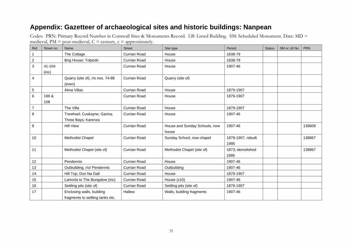
Appendix: Gazetteer of archaeological sites and historic buildings: Nanpean Codes: PRN: Primary Record Number in Cornwall Sites & Monuments Record. LB: Listed Building. SM: Scheduled Monument. Date: MD = medieval, PM = post-medieval, C = century, c = approximately.
Ref. Street no. Name Street Site type Period Status SM or LB No PRN
1 The Cottage Currian Road House 1838-79 2 Brig House; Tolpedn Currian Road House 1838-79 3 41-104
(inc) Currian Road House 1907-46
4 Quarry (site of), r/o nos. 74-88 (even)
Currian Road Quarry (site of)
5 Alma Villas Currian Road House 1879-1907 6 196 &
108 Currian Road House 1879-1907
7 The Villa Currian Road House 1879-1907 8 Trewheel; Cuskayne; Garina;
Three Bays; Karenza Currian Road House 1907-46
9 Hill View Currian Road
House and Sunday Schools, now house
1907-46 139609
10 Methodist Chapel Currian Road Sunday School, now chapel 1879-1907, rebuilt 1995
138867
11 Methodist Chapel (site of) Currian Road Methodist Chapel (site of) 1873; demolished 1995
138867
12 Pendennis Currian Road House 1907-4613 Outbuilding, r/o/ Pendennis Currian Road Outbuilding 1907-46 14 Hill Top; Dun Na Gall Currian Road House 1879-1907 15 Lamorla to The Bungalow (inc) Currian Road House (x10) 1907-46 16 Settling pits (site of) Currian Road Settling pits (site of) 1879-1907 17 Enclosing walls, building
fragments to settling tanks etc. Hallew Walls, building fragments 1907-46
31
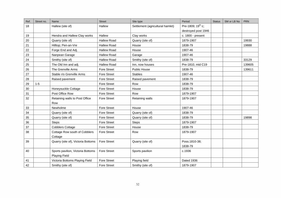
Ref. Street no. Name Street Site type Period Status SM or LB No PRN
18 Hallew (site of) Hallew Settlement (agricultural hamlet) Pre-1809; 19th c; destroyed post 1946
19 Hendra and Hallew Clay works Hallew Clay works c. 1800 - present 20 Quarry (site of) Hallew Road Quarry (site of) 1879-1907 19930 21 Hilltop; Pen-an-Vre Hallew Road House 1838-79 19888 22 Forge End and Adj. Hallew Road House 1907-46 23 Nanpean Garage Hallew Road Garage 1907-46 24 Smithy (site of) Hallew Road Smithy (site of) 1838-79 33129 25 The Old Inn and adj. Hallew Road Inn, now houses Pre-1810, mid C19 139605 26 The Grenville Arms Fore Street Public House 1838-79 13961127 Stable r/o Grenville Arms Fore Street Stables 1907-46 28 Raised pavement Fore Street Raised pavement 1838-7929 1-5 Fore Street Row 1838-7930 Honeysuckle Cottage Fore Street House 1838-79 31 Post Office Row Fore Street Row 1879-1907 32 Retaining walls to Post Office
Row Fore Street Retaining walls 1879-1907
33 Newholme Fore Street House 1907-4634 Quarry (site of) Fore Street Quarry (site of) 1838-7935 Quarry (site of) Fore Street Quarry (site of) 1838-79 1989836 Steps Fore Street Steps 1879-190737 Cobblers Cottage Fore Street House 1838-79 38 Cottage Row south of Cobblers
Cottage Fore Street Row 1879-1907
39 Quarry (site of), Victoria Bottoms Fore Street Quarry (site of) Poss.1810-38; 1838-79
40 Sports pavilion, Victoria Bottoms Playing Field
Fore Street Sports pavilion c.1936
41 Victoria Bottoms Playing Field Fore Street Playing field Dated 1936 42 Smithy (site of) Fore Street Smithy (site of) 1879-1907
32
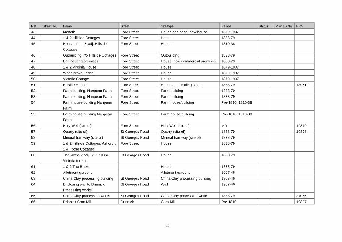
Ref. Street no. Name Street Site type Period Status SM or LB No PRN
43 Meneth Fore Street House and shop, now house 1879-1907 44 1 & 2 Hillside Cottages Fore Street House 1838-79 45 House south & adj. Hillside
Cottages Fore Street House 1810-38
46 Outbuilding, r/o Hillside Cottages Fore Street Outbuilding 1838-79 47 Engineering premises Fore Street House, now commercial premises 1838-79 48 1 & 2 Virginia House Fore Street House 1879-1907 49 Whealbrake Lodge Fore Street House 1879-1907 50 Victoria Cottage Fore Street House 1879-1907 51 Hillside House Fore Street House and reading Room 1838-79 139610 52 Farm building, Nanpean Farm Fore Street Farm building 1838-79 53 Farm building, Nanpean Farm Fore Street Farm building 1838-79 54 Farm house/building Nanpean
Farm Fore Street Farm house/building Pre-1810; 1810-38
55 Farm house/building Nanpean Farm
Fore Street Farm house/building Pre-1810; 1810-38
56 Holy Well (site of) Fore Street Holy Well (site of) MD 19849 57 Quarry (site of) St Georges Road Quarry (site of) 1838-79 1989858 Mineral tramway (site of) St Georges Road Mineral tramway (site of) 1838-79 59 1 & 2 Hillside Cottages, Ashcroft,
1 & Rose Cottages Fore Street House 1838-79
60 The lawns 7 adj., 7 1-10 inc Victoria terrace
St Georges Road House 1838-79
61 1 & 2 The Brake House 1838-79 62 Allotment gardens Allotment gardens 1907-46 63 China Clay processing building St Georges Road China Clay processing building 1907-46 64 Enclosing wall to Drinnick
Processing works St Georges Road Wall 1907-46
65 China Clay processing works St Georges Road China Clay processing works 1838-79 2707566 Drinnick Corn Mill Drinnick Corn Mill Pre-1810 19807
33
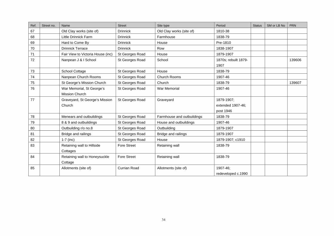
Ref. Street no. Name Street Site type Period Status SM or LB No PRN
67 Old Clay works (site of) Drinnick Old Clay works (site of) 1810-38 68 Little Drinnick Farm Drinnick Farmhouse 1838-7969 Hard to Come By Drinnick House Pre-1810 70 Drinnick Terrace Drinnick Row 1838-190771 Fair View to Victoria House (inc) St Georges Road House 1879-1907 72 Nanpean J & I School St Georges Road School 1870s; rebuilt 1879-
1907 139606
73 School Cottage St Georges Road House 1838-79 74 Nanpean Church Rooms St Georges Road Church Rooms 1907-46 75 St George’s Mission Church St Georges Road Church 1838-79 139607 76 War Memorial, St George’s
Mission Church St Georges Road War Memorial 1907-46
77 Graveyard, St George’s Mission Church
St Georges Road Graveyard 1879-1907; extended 1907-46; post 1946
78 Menears and outbuildings St Georges Road Farmhouse and outbuildings 1838-79 79 8 & 9 and outbuildings St Georges Road House and outbuildings 1907-46 80 Outbuilding r/o no.8 St Georges Road Outbuilding 1879-1907 81 Bridge and railings St Georges Road Bridge and railings 1879-1907 82 1-7 (inc) St Georges Road House 1879-1907; c191083 Retaining wall to Hillside
Cottages Fore Street Retaining wall 1838-79
84 Retaining wall to Honeysuckle Cottage
Fore Street Retaining wall 1838-79
85 Allotments (site of) Currian Road Allotments (site of) 1907-46; redeveloped c.1990
34