Circulation - City of Redwood City
64
T H E B U I L T E N V I R O N M E N T Circulation Redwood City General Plan Page BE-99 Circulation Moving around, to, and through Redwood City is facilitated by many modes of transport: car, bus, shuttle, train, bike, electric bike/scooter, boat, and our own two feet. Redwood City residents and businesses also have ready access to nearby San Carlos Airport, as well as major international airports in San Francisco and San Jose. Coordinated transportation planning has created a relatively efficient system of freeways, roads, rail, sidewalks, trails, and waterway facilities that give residents and the business community many mobility choices, including choices for recreation. Even so, the private automobile continues to dominate as the mode of choice; and local, regional, and national agencies traditionally have focused both planning efforts and spending on freeway and roadway improvements. This auto‐ and truck‐centric model has contributed to congestion, pollution, and elevated CO 2 levels, leading to increasing concerns regarding health and the environment. As such, Redwood City’s model for mobility in the 21 st century deviates from traditional transportation planning. We propose to shift circulation and associated land use planning toward options that will improve environmental quality, encourage healthier lifestyles, support economic development, and provide options for safe alternative modes of transportation. We recognize that the freedom of movement cars provide–and the fact that people often use cars as expressions of status and personality–will continue to influence circulation infrastructure investment choices, and that significant funds will be spent over the next 20 to 30 years on roads and freeways. For example, the U.S. 101/Woodside Road (State Route 84) interchange requires an extensive and expensive overhaul to improve operations, reduce associated congestion on Redwood City streets, remove barriers to non‐motorized travel, and mitigate impacts on nearby businesses. Similarly, the Whipple Road interchange with U.S. 101 can be a confusing intersection for drivers not familiar with the area. The City supports investment to remedy these and other traffic problem spots. However, in Redwood City, such spending will be balanced with commitments to improve access to bus and rail transit, improve bicycle access and safety, and enhance the pedestrian experience. Redwood City’s overarching transportation goal is to establish and maintain a balanced, multi‐modal transportation network that gets us where we want to go safely and minimizes environmental and neighborhood impacts.
Transcript of Circulation - City of Redwood City

T H E B U I L T E N V I R O N M E N T Circulation
R e d w o o d C i t y G e n e r a l P l a n P a g e B E - 9 9
Circulation Moving around, to, and through Redwood City is facilitated by many modes of transport: car, bus, shuttle, train, bike, electric bike/scooter, boat, and our own two feet. Redwood City residents and businesses also have ready access to nearby San Carlos Airport, as well as major international airports in San Francisco and San Jose. Coordinated transportation planning has created a relatively efficient system of freeways, roads, rail, sidewalks, trails, and waterway facilities that give residents and the business community many mobility choices, including choices for recreation. Even so, the private automobile continues to dominate as the mode of choice; and local, regional, and national agencies traditionally have focused both planning efforts and spending on freeway and roadway improvements. This auto‐ and truck‐centric model has contributed to congestion, pollution, and elevated CO2 levels, leading to increasing concerns regarding health and the environment. As such, Redwood City’s model for mobility in the 21st century deviates from traditional transportation planning. We propose to shift circulation and associated land use planning toward options that will improve environmental quality, encourage healthier lifestyles, support economic development, and provide options for safe alternative modes of transportation. We recognize that the freedom of movement cars provide–and the fact that people often use cars as expressions of status and personality–will continue to influence circulation infrastructure investment choices, and that significant funds will be spent over the next 20 to 30 years on roads and freeways. For example, the U.S. 101/Woodside Road (State Route 84) interchange requires an extensive and expensive overhaul to improve operations, reduce associated congestion on Redwood City streets, remove barriers to non‐motorized travel, and mitigate impacts on nearby businesses. Similarly, the Whipple Road interchange with U.S. 101 can be a confusing intersection for drivers not familiar with the area. The City supports investment to remedy these and other traffic problem spots. However, in Redwood City, such spending will be balanced with commitments to improve access to bus and rail transit, improve bicycle access and safety, and enhance the pedestrian experience. Redwood City’s overarching transportation goal is to establish and maintain a balanced, multi‐modal transportation network that gets us where we want to go safely and minimizes environmental and neighborhood impacts.

Circulation T H E B U I L T E N V I R O N M E N T
P a g e B E - 1 0 0 R e d w o o d C i t y G e n e r a l P l a n
Imagine Redwood City in 2030 Redwood City residents, employees, and visitors have their choice of transportation systems–whether it is bicycle, pedestrian, bus, train, streetcar, automobile, or ferry. We have substantially reduced our dependency on private, single‐occupant vehicles through the integration of land use and transportation planning. The city’s transportation network serves different users and various modes of travel, which is especially important for the city’s youth and elderly, as well as Redwood City residents who prefer not to drive. Pedestrian and bicycle connectivity is just as important as how quickly and efficiently automobiles move about the city. Our developments and public spaces are designed with pedestrians and cyclists in mind. Existing facilities have been enhanced to better accommodate pedestrians and cyclists. Our circulation system is balanced, safe, and efficient, and encourages travel by non‐automobile modes, including walking, biking, and transit via shuttle, bus, streetcar, rail, and ferry.
Pedestrian Circulation: Convenience, Comfort, and Safety Most trips begin and/or end with a person walking to/from a destination, at least for a short distance. Thus, the walking environment is one of the most basic elements of public space. The pedestrian network in Redwood City consists primarily of sidewalks provided along most roadways in commercial districts and residential neighborhoods. Sidewalks vary in width and physical conditions, making some more attractive to walking than others. Sidewalks also provide a primary transportation mode for mobility‐impaired population groups such as youth, seniors, and disabled persons. In addition, Class I bicycle paths are designed as multi‐use trails that pedestrians can also use. The many neighborhoods, centers, and corridors throughout the city offer different levels of “walkability.” Factors affecting walkability include sidewalk condition, destinations to walk to (parks, schools, and commercial areas), ease in crossing streets, connectivity between areas and modes of transportation, good lighting, and an overall perception of safety. Downtown is one of Redwood City’s most walkable areas: pedestrian visibility and access are prioritized at most pedestrian/vehicle conflict locations. As a result, Downtown has a high level of pedestrian activity. The commercial and entertainment destinations in Downtown,
Downtown Redwood City streets are walkable and comfortable for pedestrians.

T H E B U I L T E N V I R O N M E N T Circulation
R e d w o o d C i t y G e n e r a l P l a n P a g e B E - 1 0 1
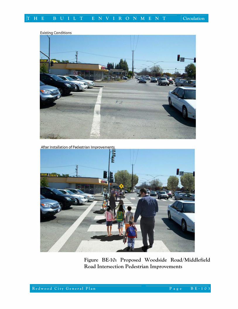
combined with easy access to transit, flat terrain, short blocks, wide sidewalks, street trees, pedestrian‐scale lighting, on‐street parking, crosswalks on all approaches of most intersections, and low‐speed roadways all contribute to create a safe and inviting pedestrian environment that encourages walking. Initiatives in the Downtown Precise Plan will continue to guide roadway, bikeway, and pedestrian‐way development in Downtown, and help link the Downtown core to surrounding neighborhoods. Downtown and the neighborhoods immediately adjacent to Downtown were established in the 19th and early 20th century based on the classic grid street pattern. This grid pattern was intended to accommodate walking, as few people had cars. Similarly, the neighborhoods immediately southwest of El Camino Real (generally 50+ years old) display a grid pattern. However, here there are some barriers to pedestrian movement, including busy collector streets, some sidewalks that are in poor condition or too narrow, lack of crosswalks on some approaches of larger intersections, and longer block lengths. Additional pedestrian barriers are evident in the design of some of the relatively newer neighborhoods west of Alameda de Las Pulgas, including hilly terrain, lack of sidewalks in some areas, roadway designs that encourage higher traffic speeds, and street networks that feature long blocks and circuitous routes. Physical barriers–such as freeways, major roadways with limited pedestrian crossings, railroad tracks, and creeks–also limit pedestrian activity in many parts of the city. These barriers discourage or in some places prohibit pedestrian access, and they limit pedestrian connectivity between many neighborhoods. Wide roadways with high speeds and long blocks, such as segments of Veterans Boulevard and Woodside Road, discourage pedestrian crossings. Many intersections along wide arterials prohibit pedestrian crossings at one or more approaches to signalized intersections, forcing pedestrians to take indirect routes or dash dangerously across busy roadways outside of crosswalks. Woodside Road is an example of a roadway that presents a significant barrier to pedestrian travel. Pedestrian improvements are important to better facilitate movement between the residential neighborhoods flanking the commercial corridor, proposed mixed‐use development nodes, and existing commercial destinations. Identified pedestrian improvements to Woodside Road and Middlefield Road provide a model that can be applied citywide to improve pedestrian circulation in a manner that will benefit residents and local businesses. Figures BE‐9 and BE‐10 indicate how the Woodside Road/Middlefield Road intersection and portions of mid‐corridor areas can be reconfigured to
Pedestrian crossing in Downtown Redwood City

Circulation T H E B U I L T E N V I R O N M E N T
P a g e B E - 1 0 2 R e d w o o d C i t y G e n e r a l P l a n
Figure BE-9: Proposed Middlefield Road Intersection Bicycle and Pedestrian Improvements provide at‐grade crossings without degrading vehicular operations. Relatively simple improvements recommended in this area include reducing pedestrian crossing distances by narrowing travel lanes, reducing corner curb radii, and adding sidewalk “bulbouts” at corners. Redwood City will apply the analysis and solutions proposed for Woodside Road and Middlefield Road to other arterial and secondary roadways, including El Camino Real and Jefferson Avenue, to create better pedestrian and bicycling environments that encourage walking and cycling. A key opportunity for improving connectivity among neighborhoods west of El Camino Real is the Hetch Hetchy easement, which has two paths across Redwood City. Redwood City will vigorously pursue options to create pedestrian and bicycle paths along the easement, as well as connections to other pedestrian‐ways and bikeways citywide.
Pedestrian Safety In addition to being convenient and comfortable, walking needs to be safe. In 2008, Redwood City conducted a Pedestrian Safety Assessment. The Pedestrian Safety Assessment created a framework for analyzing programs, policies, and practices related to pedestrian safety throughout the community. It also identified desired enhancements and opportunities for new program elements. Areas of focused attention include:
Bulbouts, also known as curb extensions, extend the sidewalk or curb out into the street, reducing the street pavement width. Bulbouts calm traffic speeds and improve pedestrian crossings by shortening crossing distances and reducing the time pedestrians are exposed to traffic. They also improve visibility for pedestrians and motorists. For cyclists, however, bulbouts may present an impediment as a bike lane may be reduced or removed at the location of a bulbout.
T H E B U I L T E N V I R O N M E N T Circulation
R e d w o o d C i t y G e n e r a l P l a n P a g e B E - 1 0 3
Figure BE-10: Proposed Woodside Road/Middlefield Road Intersection Pedestrian Improvements

Circulation T H E B U I L T E N V I R O N M E N T
P a g e B E - 1 0 4 R e d w o o d C i t y G e n e r a l P l a n
Kaiser Medical Center/Veterans Boulevard Sequoia High School area Woodside Road between Union Avenue and Gordon Street
These areas have demonstrated long‐standing pedestrian safety concerns, and are located near schools, hospitals, and retail centers with extensive pedestrian activity. To address pedestrian safety concerns at these locations and others identified over time, the City will pursue enhancements and other pedestrian safety measures, including:
Pedestrian count‐down signal heads (which let pedestrians know how much time is remaining to cross the street)
Corner bulbouts at intersections with limited sight distance Median “refuge” islands at unsignalized crossings Two‐stage mid‐block pedestrian signals on wide arterials Pedestrian‐scale lighting (lighting focused on illuminating the
sidewalk) Redwood City will also pursue more rigorous analysis of pedestrian conditions, such as measuring the pedestrian “level of service” for new development projects, to help the City move toward implementing citywide pedestrian improvements.
Bicycle Circulation Redwood City has many features that make cycling pleasurable: a mild climate, relatively flat terrain (east of Alameda de Las Pulgas), and proximity to many recreational and shopping destinations. Bicyclists generally can be grouped into four categories, with each category of rider having different expectations and tolerances for riding conditions:
The Casual Recreational Rider: The casual recreational rider hops on a bike for short errands or fun, generally on weekends and in good weather. Destinations are generally close by, such as parks and picnic areas. Bike routes chosen often follow a marked route and avoid roadway traffic. At times, the casual recreational rider may transport the bicycle to a bike path or trail.
The Bicycle Commuter: The bicycle commuter uses his or her bicycle to get to and from work or school. While the commuting cyclist generally will use marked bike routes, he or she is skilled Cyclist in Redwood City

T H E B U I L T E N V I R O N M E N T Circulation
R e d w o o d C i t y G e n e r a l P l a n P a g e B E - 1 0 5
at finding roadways that provide the shortest time distance between two points. Even so, bicycle commuters appreciate well‐marked, shared routes where car drivers are alerted frequently to the presence of bicyclists.
The Bicycle Transportationist: Bicycle transportationists are
people who get around on their bikes for most trips. Some are very educated about the rules of the road, and some may need additional information to help them be more visible and safe.
The Bicycle Enthusiast: On any terrain, in any conditions: this is
the mantra of the bicycle enthusiast. This rider can tolerate fast, heavy traffic, like that along El Camino Real during rush hour. Enthusiasts ride in all weather and often travel at high speeds. They are skilled and often ride in pairs or groups.
Bicycles are a convenient means of transportation for short trips within cities, especially those less than three miles in length. According to the U.S. Department of Transportation, one‐quarter of all trips (by all modes) in this country are under one mile; about 40 percent of all trips are two miles or shorter. In addition, bicycles are also a convenient form of transportation for children to travel between home, school, parks, and other local neighborhood destinations. Redwood City’s commitment is to accommodate all categories of bicycle riders, to encourage healthier lifestyles and a healthier environment. Redwood City seeks to make safety a goal for “8‐80” riders, making bicycle riding in the city comfortable and safe for 8 year old children as well as 80 year old adults.
Local Bike Facilities Redwood City has adopted three classes of bicycle facilities, which mirror the standard classifications used by Caltrans and commonly adopted by other jurisdictions (see Figure BE‐11):
Class I Bikeway (Bike Path): A completely separate facility designated for the exclusive use of bicycles and pedestrians, with vehicle and pedestrian cross‐flow minimized. Examples of Class I facilities in Redwood City include the Redwood Shores trail and the Bay Trail along U.S. 101 between the Whipple Avenue and Holly Street interchanges.
Class II Bikeway (Bike Lane): A striped lane designated for the use of bicycles on a street. Vehicle parking and
Bicycle lane on Redwood Shores Parkway

Circulation T H E B U I L T E N V I R O N M E N T
P a g e B E - 1 0 6 R e d w o o d C i t y G e n e r a l P l a n
vehicle/pedestrian cross‐flow are permitted at designated locations. Examples of Class II facilities in Redwood City include the bike lanes on Alameda de Las Pulgas between Woodside Road and Jefferson Avenue, and Industrial Way between Whipple Avenue and the San Carlos city limit.
Class III Bikeway (Bike Route): A route designated by signs or
pavement markings for bicyclists within the vehicular travel lane (i.e. shared use) of a roadway. Portions of Broadway and Roosevelt Avenue are examples of bicycle routes.
As part of a pavement resurfacing project in the Redwood Shores area, the City restriped some roadways to provide bicycle facilities. This effort consisted of narrowing vehicle travel lanes to provide 5‐foot Class II bicycle lanes on Marine Parkway and 4‐foot wide shoulders on Redwood Shores Parkway and Twin Dolphin Drive. In addition, several recreational paths are provided in Redwood City, including those as Stulsaft Park and the Bay Trail. However, bicycle access to these paths from other parts of Redwood City is limited. Although bicycle facilities are provided along many roadways, the bicycle network in Redwood City does not serve all areas. Figure BE‐12 identifies a conceptual bikeway network, developed through comprehensive outreach with Redwood City stakeholders. Prior to development and implementation of a complete Bicycle Master Plan, further study regarding feasibility of routes, safety, and adequate rights‐of‐way will be required. Barriers to bicycling include those cited above with regard to pedestrian connectivity, potential conflicts with buses or trucks on heavily traveled commercial corridors, turning vehicles, and steep terrain beyond Alameda de Las Pulgas. Many bicyclists–and casual recreational bicyclists in particular–prefer to take longer routes on flat terrain rather than direct routes on steep hills. Section 2100 of the California Vehicle Code permits bicycles to ride on all surface roadways unless explicitly prohibited by signage. Although arterials such as El Camino Real and Woodside Road often provide the most direct routes, few cyclists use them. Most riders are reluctant to use these roadways due to potential safety concerns, noise, exhaust fumes, and pollution. Instead, many bicyclists choose to use parallel local or collector roadways that carry less vehicular traffic and provide a more comfortable and safe, but often less direct, route.
Bicycle parking facility at the Redwood Shores Library

T H E B U I L T E N V I R O N M E N T Circulation
R e d w o o d C i t y G e n e r a l P l a n P a g e B E - 1 0 7
Class II Bike Lane
Class I Bike Path
Class III Bike Route
Figure BE-11: Bikeway Classifications

Circulation T H E B U I L T E N V I R O N M E N T
P a g e B E - 1 0 8 R e d w o o d C i t y G e n e r a l P l a n
FosterCity
San Carlos
Ather ton
Belm ont
SA
N F
RA
NC
I SC
O B
AY
Brewste
r Ave
Jeffe
rson A
ve
Roosevelt A
ve
Hudson St
Valota Rd
Farm Hill
Blvd
Middlefield Rd
Bay Rd
Alam
eda de l as
El Camino Real
Whipple Ave
Main
St
Veterans Blvd
Middlefield Rd
Selby
Ln
Stock
brid
ge A
ve
Ather
ton
Ave
Mar
sh R
d
Woo
dsid
e R
d
Edgewood Rd
Brittan AveClub Dr
San Carlo
s Ave
Ralston Ave
Beach Park Blvd
Seap
ort B
lvd
Redwood
M
a rin
e Pkwy
El Camino Real
Menlo Park
Fair Oaks Ave
9th
Ave
Broadway
5th
Ave
Pulgas
Elwood St
King St
Bayf rontPark
EdgewoodCounty Park
Arguello St
Shell Pkwy
Shearwater Pkwy
Bridge Pkwy
Pkwy
Shores
Twin Dolphin Dr
Bair Island
GrecoIsland
Redw
ood
Cre
ek
Smith Slough
Steinberg
er Sl
ough
Bird Island
Bel
mon
t Slou
gh
San CarlosAirport
Corks
crew
Westpoint Slough
Sloug
h
0 2,000 4,000 6,000Feet
City Boundary
Sphere of Influence
Freeway/Highway
Roadways
Railroad
Waterways
Data Source: Redwood City andFehr and Peers, 2009.
Map prepared by Hogle‐Ireland Inc., 2009.
Redwood City BikewaysExisting Class I ‐ Bike Path/Recreation Path
Community Proposed Class I ‐ Bike Path/Recreation Path
Existing Class II ‐ Bike Lane
Community Proposed Class II ‐ Bike Lane
Existing Class III ‐ Bike Route
Community Proposed Class II or III ‐ Bike Lane or Route
Community Proposed Bike Path/Bikeway (Highly Constrained)
Existing Class I
Existing Class II
Community Proposed Class II
Community Proposed Class II
Existing Class III
Bikeways Outside City
Note: The bikeway classifications and designated rights‐of‐way are considered representative rather than final plans. Additional evaluation will be required for implementation. Figure BE-12: Bikeway Plan

T H E B U I L T E N V I R O N M E N T Circulation
R e d w o o d C i t y G e n e r a l P l a n P a g e B E - 1 0 9
Although Downtown is a walkable destination, bicycle access and circulation can sometimes be a challenge here. However, bicycle lanes have recently been installed on some larger roadways including segments of Middlefield Road, Winslow Street, and Brewster Avenue; many Downtown streets are narrow and slow enough to be welcoming to cyclists. Bicycle parking has not been provided uniformly; expanding bicycle parking facilities is a simple and effective way to improve access. In addition, the odd‐angled intersections within the Downtown limit sight distance for cyclists.
San Francisco Bay Trail The San Francisco Bay Trail is a planned 400‐mile paved path network around San Francisco Bay for use by pedestrians and bicyclists. Segments of the trail between Whipple Avenue and Holly Street and around Redwood Shores and Pacific Shores have already been completed. However, these segments of the Bay Trail are not currently connected to each other, or to other portions of the trail in Menlo Park. Once the Bay Trail is complete, it will provide recreational and commute travel options by both bicyclists and pedestrians to and from a variety of destinations along the Bay.
San Mateo County Comprehensive Bicycle Route Plan The 2000 San Mateo County Comprehensive Bicycle Route Plan was developed to create a safe and effective bikeway network to serve commuter and recreational bikers throughout the county. The plan includes the following projects in Redwood City:
North‐South Bikeway Project: The initial phase consists of installing a north‐south bikeway (including both Class II bike lanes and Class III bike routes) between San Francisco and Palo Alto with bikeway signs and signal detectors. This effort is ongoing; Redwood City recently received grant funding to complete signage and other improvements along the portions of the bikeway within Redwood City. Future phases include other improvements such as new bike lanes, wider shoulder lanes, and other on‐street bicycle improvements.
Bay Trail Gap Closure: This project will complete the gaps in the
Bay Trail to provide a continuous trail within San Mateo County.
Cyclist in Redwood City

Circulation T H E B U I L T E N V I R O N M E N T
P a g e B E - 1 1 0 R e d w o o d C i t y G e n e r a l P l a n
Caltrain in Redwood City
Planned Bikeway Network and Support Facilities A comprehensive bikeway network for Redwood City would include a viable network of north‐south and east‐west facilities, incorporating components of the San Mateo County Comprehensive Bicycle Route Plan and planning for local routes to meet the needs of all cyclists: casual recreational riders, commuters, transportationists, and enthusiasts. Also necessary are potential locations for staging areas and other accommodations for cyclists, such as parking at key commute and recreation destinations. The Caltrain Bicycle Master Plan includes provisions to improve bicycle access and parking at Caltrain commuter rail stations. For Redwood City, this will include:
Relocating bicycle lockers to the parking lot near the southbound platform to provide a more convenient location
Providing bicycle parking facilities on the northbound side of tracks
It is also useful to note that Redwood City’s size, topography, and climate, which make it an ideal city for bicycling, also makes it a great place for electric bike/scooter (Segway) riding. Construction of a comprehensive citywide network and support facilities, such as bicycle and electric bike/scooter parking at employment locations and other destinations, could greatly increase this mode share, and would have sustainability benefits.
Public Transit Public transit takes many forms, including heavy rail, light rail, bus, shuttle, paratransit, streetcar, and ferry service. The San Francisco Bay Area has an extensive transit network managed by various agencies. With Redwood City’s focus on environmental sustainability, creating easier access to all types of transit is a key goal. While public transit is provided and maintained by other agencies, the City can greatly influence ridership through land use and zoning decisions, connectivity to other modes (including biking and walking), and improving traffic operations within key corridors to facilitate bus headways. The City can also dedicate rights‐of‐way for new systems where appropriate and continue extensive consultation with various agencies to expand transit service and accessibility.

T H E B U I L T E N V I R O N M E N T Circulation
R e d w o o d C i t y G e n e r a l P l a n P a g e B E - 1 1 1
Caltrain Redwood City station
Commuter Rail The Peninsula Corridor Joint Powers Board operates commuter rail service (Caltrain) between San Jose and San Francisco. During the peak commute period, Caltrain also provides extended service south of San Jose to Morgan Hill and Gilroy. Within Redwood City, the rail line runs parallel to and northeast of El Camino Real, with a station in Downtown between Jefferson Avenue and Broadway. Redwood Shores is closer to the San Carlos, Belmont, and Hillsdale stations than the Downtown Redwood City station. On a typical weekday, up to 80 trains serve the Redwood City station, including the “Baby Bullet” service, an express train with limited mid‐Peninsula stops.
Planned Caltrain Improvements Every year, Caltrain updates its Short‐Range Transit Plan (SRTP). The SRTP includes the goal to achieve a 58 percent increase in ridership between 2008 and 2017. Redwood City’s goal is to work in tandem with Caltrain to accommodate infrastructure and equipment through electrification (see below), improve station access for all travel modes including pedestrians and bicycles, and operate more frequent feeder shuttles. Electrification Caltrain plans to replace diesel locomotives with electric‐powered vehicles. Since electric trains can accelerate and decelerate faster than

Circulation T H E B U I L T E N V I R O N M E N T
P a g e B E - 1 1 2 R e d w o o d C i t y G e n e r a l P l a n
diesel trains, travel times are expected to be shorter along the Caltrain corridor, resulting in a potential increase in ridership. In addition, electric trains are quieter and emit less pollution than diesel trains, which will have positive impacts for those living, working, and visiting Downtown. Dumbarton Rail Service San Mateo County Transportation Authority is planning to establish rail service along the Dumbarton Bridge corridor, linking the Peninsula Caltrain system with the East Bay including connections with Altamont Commuter Express (ACE) and Capitol Corridor Trains. The new rail line is planned to connect with the existing Caltrain tracks at the Redwood City station. Full funding for the project was not yet committed at the time of this writing, although support for the project from various segments remains strong.
High-Speed Rail High‐speed rail is a statewide initiative to supplement air travel by providing rail connections between northern, central, and southern California. High‐speed rail trains travel at top speeds of 220 miles per hour in less populated areas and at slower speeds through more urban centers. The High‐Speed Rail Authority is currently envisioning high‐speed rail in the San Francisco Peninsula to be accommodated in the existing Caltrain right of way, with San Francisco as the ultimate northern destination. For safety and efficiency, high‐speed rail requires complete grade separation of rail and surface streets. The type of grade separations used will have dramatic impacts on Redwood City, particularly the Downtown area, which is bisected by the tracks. While the exact manner of grade separation will have to be determined at a later date, it is clear that certain methods would be harmful to Redwood City’s urban environment. As of this writing, it is the City’s preference that the grade separation takes the form of a covered trench. In any case, the grade‐separated railway can and must be carefully designed to become one of Downtown’s greatest assets and must also enact the principles of connectivity and compatibility to ensure that it respects all of the neighborhoods and planning areas along the corridor. Redwood City is a potential location for the Mid‐Peninsula high‐speed rail station. Such stations are likely to require more extensive parking facilities than are provided for Caltrain service, plus circulation accommodations for feeder transit service (such as buses, light rail, or streetcars). Redwood City will need to make an effort to ensure that if a

T H E B U I L T E N V I R O N M E N T Circulation
R e d w o o d C i t y G e n e r a l P l a n P a g e B E - 1 1 3
Bus transit in Redwood City
high‐speed rail station is located in our city, it is done in a manner that does not impede pedestrian travel or create an inactive zone, in terms of the location of tracks and station parking and amenities. Redwood City will need to make an effort to ensure that the high‐speed rail, with or without a station, unites rather than divides the community.
Bus and Shuttle Transit
Bus Service The San Mateo County Transit District (SamTrans) operates fixed‐route bus service in Redwood City along a variety of routes:
Community Routes: These routes serve local community destinations such as schools, shopping areas, and residential areas.
Express Routes: These routes typically operate during weekday morning and evening peak commute times only, and provide service to at least one BART station, San Francisco, or San Francisco International Airport.
Caltrain Connection Routes: These routes provide service to Caltrain stations. They typically operate throughout the weekday and weekends with shorter headways (distance between buses) during peak commute times.
BART and Caltrain Connection Routes: These routes provide service between Caltrain and Bay Area Rapid Transit (BART) stations, and provide regional bus service on weekdays and weekends.
Past transit surveys have revealed that the majority of riders in Redwood City use the Caltrain Connection or BART and Caltrain Connection routes. Interestingly, however, the bus routes along El Camino Real that parallel the Caltrain route have the highest ridership levels, indicating that El Camino Real is indeed a key connecter route through Redwood City. SamTrans projects a 20 percent increase in ridership between 2008 and 2017. Paratransit The Americans with Disabilities Act (ADA) is federal legislation that guarantees persons with disabilities full and equal access to the same

Circulation T H E B U I L T E N V I R O N M E N T
P a g e B E - 1 1 4 R e d w o o d C i t y G e n e r a l P l a n
Veterans Memorial Senior Center shuttle
services and accommodations that are available to people without disabilities. As such, ADA requires public transit operators to provide paratransit service to persons with disabilities comparable to the level of fixed‐route service. Persons with disabilities who cannot independently ride fixed‐route transit may be eligible for paratransit service. Although all SamTrans buses are ADA accessible, SamTrans also provides paratransit service to those individuals who cannot independently use the regular bus service. Redi‐Wheels, SamTrans’ paratransit service, serves San Mateo County, including Redwood City, and select surrounding cities. Shuttles Caltrain and the Peninsula Traffic Congestion Relief Alliance operate several shuttles in Redwood City. Most shuttles operate during peak commute times between the Caltrain stations in Redwood City, San Carlos, the Hillsdale Shopping Center, and major employers in the area. These shuttles are partially funded by participating employers and other agencies such as the Bay Area Air Quality Management District and the Peninsula Joint Powers Board. A mid‐day on‐demand community shuttle service started operations in Redwood City in 2008. The shuttle operates in the area approximately bounded by El Camino Real, Marsh Road, U.S. 101, and Whipple Avenue. The shuttle, available between 10:00 A.M. and 5:00 P.M. from Tuesdays to Saturdays, is free and open to the general public. However, riders must call on the day before their trip to reserve a pick‐up and drop‐off time within the service area. As part of the overall strategy to encourage transit use, the City may need to promote expanded shuttle service over time, particularly if commuter ferry service locates in Redwood City and bus rapid transit delivers additional commuters along El Camino Real. In addition to expanded services, it will be important to implement “best management” practices for shuttle services, including marketing and effective signage to help with wayfinding and schedule determination. Streetcar Streetcars are typically small (about 50 passengers), light‐weight, electric‐powered rail vehicles that run on fixed tracks, primarily on shared lanes in public streets. Typically, streetcars are intended for trips that are a couple of miles long within a city. These are trips that are too long for walking and too short for regional transit, such as heavy rail. In general, streetcars have a similar role as buses. However, streetcars can be more appropriate for corridors with higher densities due to their

T H E B U I L T E N V I R O N M E N T Circulation
R e d w o o d C i t y G e n e r a l P l a n P a g e B E - 1 1 5
ability to attract higher ridership than buses because of their more comfortable ride and reduced noise and pollution. Although streetcars cost more to construct and operate than typical bus systems, they cost dramatically less than heavy rail systems. Streetcar systems generally do not require right‐of‐way purchases, grade separations, or major reinforcement under the tracks; and as such are relatively inexpensive and quick to construct. Streetcars fill an important link in the transportation system, and have proven to be a great stimulus for walkable urban development in cities such as Portland, Seattle, and Little Rock. Figure BE‐13 shows corridors in Redwood City on which streetcars can potentially be implemented. The Broadway and Middlefield corridors were selected because they would connect existing and future high‐density neighborhoods to each other and to major activity centers such as Downtown and the Caltrain Station. The Seaport Corridor is selected because it would connect the proposed ferry and employment concentrations along Seaport Boulevard, the Port, Downtown, and Caltrain Station.
Commuter Ferry Our mid‐Peninsula location and deep‐water Port make Redwood City attractive as a potential commuter ferry terminal location. The San Francisco Water Emergency Transportation Authority, formed by the State Legislature in 2007 to consult and consolidate ferry transportation in the San Francisco Bay and to improve the region’s emergency response planning, established a priority to expand commuter ferry service to new areas. A potential ferry terminal in Redwood City, adjacent to the Pacific Shores Center, could initially provide service to and from San Francisco, with possible routes to and from the East Bay as well. With a ferry trip between San Francisco and Redwood City estimated to take about 45 minutes, commuters would have comparable travel times to drivers using U.S. 101 during peak commute times. Redwood City supports establishment of local ferry service as an environmentally sustainable and pleasant alternative to car commutes, with the added benefit of a water‐based emergency evacuation route in the event of a disaster. Planning for the ferry and its terminal will require dredging or other methods to create a deeper basin, coordinating with the Army Corps of Engineers, and linking bicycle facilities and local transit modes, such as shuttles and a possible
Example of a streetcar

Circulation T H E B U I L T E N V I R O N M E N T
P a g e B E - 1 1 6 R e d w o o d C i t y G e n e r a l P l a n
Brewster
Ave
Jeffe
rson A
ve
Roosevelt A
ve
Hudson St
V
amino Real
Whipple Ave
Main S
tVeterans Blvd
Middlefield Rd
odsi
de R
d
Seap
ort B
lvd
Fair Oaks Ave
9th
Ave
Broadway
5th
Ave
Elwood St
King StArguello St
Redw
ood
Cre
ek
Smith Slough
n los
por t
Westpoint Sl
0 2,500 5,000Feet
Legend
Potential Streetcar Network
General Plan Land Use
Hospital
Schools
Open Space ‐ Parks
City Boundary
Sphere of Influence
Railroad
Waterways
Proposed Ferry Terminal
Train Station
Base Map Features
Figure BE-13: Streetcar Network

T H E B U I L T E N V I R O N M E N T Circulation
R e d w o o d C i t y G e n e r a l P l a n P a g e B E - 1 1 7
streetcar line, from the terminal to local employment centers and other destinations.
Street System Redwood City’s well‐developed street system allows people to travel from their homes and businesses to destinations within the community with relative ease and to access the freeways and expressways that link the community to the region.
Street Typology Historically, Redwood City defined its roadway network according to the classification system used by State highway departments: freeways, expressways, arterials, collectors, and local streets. This traditional approach is primarily focused on ensuring access and mobility for automobiles, and generally does not account for other travel modes or the surrounding context. Redwood City has a variety of different contexts, however, and each one deserves a different type of transportation focus. For instance, in the Downtown Redwood City context, a much greater emphasis is placed on pedestrian mobility, amenities, and on‐street parking, whereas in an industrial or strip commercial district, focus is typically on automobile mobility and off‐street surface parking. To ensure a balanced, multi‐modal transportation network, the Redwood City General Plan organizes streets and other transportation facilities according to typologies that consider the context and prioritize different travel modes for each street. Together, the typologies provide a network of “complete streets” to accommodate all types of local transportation modes. These typologies will guide the development of standards, to ensure transportation plans and improvements consider relationships to surrounding land uses, appropriate travel speeds, and the need to accommodate multiple travel modes and various users. The following typology definitions apply to the streets and other facilities that make up Redwood City’s circulation plan, shown in Figure BE‐14. A sample cross‐section for each typology is provided in Figures BE‐15 through BE‐21. These cross‐sections show a prototypical configuration for each typology. The specific configuration for each individual street may be slightly different due to the unique needs and surrounding land uses on each street.
“Complete Streets”: a comprehensive approach to the practice and related policies of mobility planning. The complete street concept recognizes that transportation corridors have multiple users with different abilities and mode preferences (e.g., pedestrians, bicyclists, transit riders, and drivers) that need to be accounted for.

Circulation T H E B U I L T E N V I R O N M E N T
P a g e B E - 1 1 8 R e d w o o d C i t y G e n e r a l P l a n
FosterCity
San Carlos
Atherton
Belmont
SA
N F
RA
NC
I SC
O B
AY
Brewster
Ave
Jeffe
rson A
ve
Roosevelt A
ve
Hudson St
Valota Rd
Farm Hill
Blvd
Middlefield Rd
Bay Rd
Alam
eda de l as
El Camino Real
Whipple Ave
Main
St
Veterans Blvd
Middlefield Rd
Selby
Ln
Stock
bridge
Ave
Ather
ton A
ve
Mar
sh R
d
Woo
dsid
e R
d
Edgewood Rd
Brittan AveClub Dr
San Carlo
s Ave
Ralston Ave
Beach Park Blvd
Seap
ort B
lvd
Redwood
M
arin
e Pkwy
El Camino Real
Menlo Park
Fair Oaks Ave
9th
Ave
Broadway
5th
Ave
Pulgas
Elwood St
King St
Bayf rontPark
EdgewoodCounty Park
Arguello St
Shell Pkwy
Shearwater Pkwy
Bridge Pkwy
Pkwy
Shores
TwinDolphin Dr
Bair Island
GrecoIsland
Redw
ood
Cre
ek
Smith Slough
Steinberg
er Sl
ough
Bird Island
Bel
mon
t Slou
gh
San Car losAirpor t
Corks
crew
Westpoint Slough
Sloug
h
0 2,000 4,000 6,000Feet
City Boundary
Sphere of Influence
Railroad
Waterways
Data Source: Fehr & Peers TransportationConsultants, 2008.
Map prepared by Hogle‐Ireland Inc., 2009.
Proposed Street TypologyTransit Street
Bicycle Boulevard
Pedestrian Street
Connector Street
Industrial Street
Boulevard
Auto Dominant Highway
Local Street
Note: The street typology and road designations represent Redwood City’s intent. Further evaluation is required prior to implementation. Vera Avenue, Valota Road, and King Street have been suggested to replace Brewster Avenue, Roosevelt Avenue, and Hudson Street as Bicycle Boulevards.
Figure BE-14: Street Typology

T H E B U I L T E N V I R O N M E N T Circulation
R e d w o o d C i t y G e n e r a l P l a n P a g e B E - 1 1 9
Note: This graphic is illustrative; additional study will be required before implementation. Additionally, this graphic exemplifies goals, however not all streets of this class may be able to attain these conditions due to existing rights‐of‐way and conditions.
Transit Street Transit Streets are primary routes intended for a future streetcar system. Signal preemption for streetcars (where red lights are shortened and switched to green as a streetcar approaches), and streetcar stops are provided. Other travel modes, including automobiles, trucks, and bicycles are accommodated on a Transit Street, but if there are conflicts, transit has priority. These streets accommodate moderate to high volumes of through‐traffic within and beyond the city.
As most transit trips also involve some walking, pedestrians are accommodated with ample sidewalks on both sides of the street, and pedestrian amenities are enhanced around transit stops.
Bicycle Boulevard Bicycle Boulevards are through‐routes for bicycles, providing continuous access and connections to the local and regional bicycle route network.
Figure BE-15: Sample Transit Street Cross Section

Circulation T H E B U I L T E N V I R O N M E N T
P a g e B E - 1 2 0 R e d w o o d C i t y G e n e r a l P l a n
Local automobile, truck, and transit traffic are accommodated in the roadway, but in the event of conflicts, bicycles have priority. Neighborhood traffic management strategies slow and calm automobile and truck traffic. Pedestrians are also accommodated. In parts of Redwood City, where routes for Bicycle Boulevards are only available on very narrow rights‐of‐way, alternate creative cross‐sections will need to be developed.
Pedestrian Street Pedestrian Streets are streets on which exceptionally high volumes of pedestrian traffic are encouraged. Pedestrian streets are located primarily in Downtown. Sidewalks are wider with ample pedestrian amenities, building frontages provide a high level of pedestrian interest, and pedestrian crossings have a high priority at intersections. In some locations, well‐protected mid‐block crosswalks may be appropriate. These streets also discourage high volume and high‐speed vehicular traffic, adding to pedestrian comfort and convenience. In the event of conflicts, pedestrians have priority.
Note: This graphic is illustrative; additional study will be required before implementation. Additionally, this graphic exemplifies goals, however not all streets of this class may be able to attain these conditions due to existing rights‐of‐way and conditions.
Figure BE-16: Sample Bicycle Boulevard Cross Section

T H E B U I L T E N V I R O N M E N T Circulation
R e d w o o d C i t y G e n e r a l P l a n P a g e B E - 1 2 1
While oriented primarily around pedestrians, the low auto volumes and speed make pedestrian streets good for bicycling, as well.
Connector Street Automobiles, transit, bicycles, and pedestrians are accommodated equally on a Connecter Street. Some transit options may also be provided. These streets accommodate moderate to high volumes of through traffic within and through the city. Pedestrians are accommodated with sidewalks. Bicycle lanes are provided where feasible.
Figure BE-17: Sample Pedestrian Street Cross Section
Note: This graphic is illustrative; additional study will be required before implementation. Additionally, this graphic exemplifies goals, however not all streets of this class may be able to attain these conditions due to existing rights‐of‐way and conditions.

Circulation T H E B U I L T E N V I R O N M E N T
P a g e B E - 1 2 2 R e d w o o d C i t y G e n e r a l P l a n
A E E DD F CC AB B
A. PLANTED YARD (MULTI-FAMILY)B. PUBLIC SIDEWALKC. CURBSIDE PARKING WITH POTENTIAL PLANTED BULBOUTSD. BIKE LANESE. TRAVEL LANESF. PLANTED MEDIAN AND TURNING LANE
RESIDENTIAL - MEDIUMHIGH DENSITY
RESIDENTIAL - HIGHDENSITY
Note: This graphic is illustrative; additional study will be required before implementation. Additionally, this graphic exemplifies goals, however not all streets of this class may be able to attain these conditions due to existing rights‐of‐way and conditions.
Figure BE-18: Sample Connector Street Cross Section
(DEPENDING ON CONTEXT)
(WHERE SPACE PERMITS)
(WHERE SPACE PERMITS)
Local Street Automobiles, bicycles, and pedestrians are accommodated equally on a Local Street. Transit use, if any, is incidental. These streets accommodate low volumes of local traffic and primarily provide access to abutting property. Through‐traffic is discouraged, and truck traffic is prohibited. Neighborhood traffic management strategies to slow and discourage through‐automobile and truck traffic may be appropriate. Pedestrians are accommodated with sidewalks.

T H E B U I L T E N V I R O N M E N T Circulation
R e d w o o d C i t y G e n e r a l P l a n P a g e B E - 1 2 3
Local streets serve important functions in residential neighborhoods. They link residents to schools, parks, and neighborhood stores, and provide routes for neighbors to visit one another. A key goal is to create “complete” local streets that accommodate walking and biking safely, with a de‐emphasis on facilitating quick car trips.
Industrial Street Industrial Streets are designed to accommodate significant volumes of large vehicles such as trucks, trailers, and other delivery vehicles. Bicycle and pedestrian travel is more infrequent than in other areas, but still is accommodated. Bike lanes are provided where appropriate.
Note: This graphic is illustrative; additional study will be required before implementation. Additionally, this graphic exemplifies goals, however not all streets of this class may be able to attain these conditions due to existing rights‐of‐way and conditions.
Figure BE-19: Sample Local Street Cross Section
(DEPENDING ON CONTEXT)
Figure BE-20: Sample Industrial Street Cross Section
Note: This graphic is illustrative; additional study will be required before implementation. Additionally, this graphic exemplifies goals, however not all streets of this class may be able to attain these conditions due to existing rights‐of‐way and conditions.

Circulation T H E B U I L T E N V I R O N M E N T
P a g e B E - 1 2 4 R e d w o o d C i t y G e n e r a l P l a n
Boulevard Boulevards are major roadways that serve a gateway or civic purpose, and will be considered for special treatments such as expansive landscaped medians and wide sidewalks. Traffic flow is maintained and transit access prioritized.
An optional design element for Boulevards is a median that separates travel lanes from parking access lanes, reducing delays caused by on‐street parking and providing an additional buffer for adjacent land uses.
Auto Dominant Highway/Expressway Auto Dominant Highways are expressways, freeways, and other roads that serve high volumes of fast‐moving regional motor vehicle traffic. Express transit buses are also accommodated. Bicycle and pedestrian travel are typically prohibited, accommodated on separate parallel facilities, or provided with minimal facilities. Two freeways serve Redwood City: U.S. 101 and I‐280, with U.S. 101 running through the city and I‐280 southwest of our border. The
Figure BE-21: Sample Boulevard Cross Section
Note: This graphic is illustrative; additional study will be required before implementation. Additionally, this graphic exemplifies goals, however not all streets of this class may be able to attain these conditions due to existing rights‐of‐way and conditions.

T H E B U I L T E N V I R O N M E N T Circulation
R e d w o o d C i t y G e n e r a l P l a n P a g e B E - 1 2 5
California Department of Transportation (Caltrans) has responsibility for planning, operations, and maintenance along these freeways. U.S. 101 is a major north‐south regional route that passes through Redwood City on its course along the west coast of the United States. U.S. 101 is the primary San Francisco Peninsula commute route, bringing workers–and associated traffic congestion–into the city every day. Interchanges at Marsh Road (in Menlo Park), Woodside Road (State Route 84), and Whipple Avenue provide regional access to various parts of the city. Interchanges at Holly Street/Redwood Shores Parkway and Ralston Avenue/Marine Parkway provide access to the Redwood Shores area. Along the west edge of the city, I‐280 provides a more scenic commute route than U.S. 101, but does not provide immediate access to the local employment centers. Interchanges at Woodside Road, Farm Hill Boulevard, and Edgewood Road access Redwood City directly. Table BE‐3 indicates how different modes of transportation are accommodated on various facility types and which modes have priority. For reference purposes, Table BE‐4 shows the relationship between these street typologies and the prior functional classification system maintained by Redwood City Community Development.

Circulation T H E B U I L T E N V I R O N M E N T
P a g e B E - 1 2 6 R e d w o o d C i t y G e n e r a l P l a n
Table BE-3: Street Typologies and Travel Mode Priorities Facility Transit Bicycles Pedestrians Autos Trucks
Transit Street 1, 2 Bicycle Boulevard Pedestrian Street1 Connector Street 1,2 Local Street1 Industrial Street 2 Boulevard 1,2 Auto Dominant Road 2, 3
= Dominant, = Accommodated, = Incidental, = Prohibited
1. Bike routes (Class II and III) can be overlaid on these street types. 2. Truck routes can be overlaid on these street types. 3. Bicycles and pedestrians are typically prohibited, accommodated on separate parallel facilities, or provided with minimal facilities.
Table BE-4: Street Typologies and the Functional Classification System
Functional Classification System Street Typologies
Expressway Arterial Major
CollectorMinor
CollectorLocal Street
Transit Street Bicycle Boulevard Pedestrian Street Connector Street Local Street Industrial Street Boulevard Auto Dominant Road
= Primary Correspondence, = Secondary Correspondence, = No Correspondence

T H E B U I L T E N V I R O N M E N T Circulation
R e d w o o d C i t y G e n e r a l P l a n P a g e B E - 1 2 7
Truck Routes Freight movement largely originates from and travels to the industrial businesses located at the Port of Redwood City and adjacent areas, and along Seaport Boulevard, Bayshore Road, and Broadway. The Port, a heavy rail line, and established truck routes accommodate this movement, although conflicts with local traffic can occur during periods of intense trucking activities. The Redwood City Municipal Code establishes truck traffic routes for the movement of vehicles exceeding a maximum gross weight of three tons. Routes are designated based on the industrial districts served, access to freeways, industrial, and connector streets, and avoidance of residential neighborhoods. Identifying truck routes is important not just to preserve dedicated routes to serve industrial districts and reduce land use conflicts, but also to allow for proper street construction and maintenance, given that heavy truck traffic impacts physical street conditions more quickly than automobile traffic. Streets currently designated as truck routes are shown on Figure BE‐22. Currently, there are no designated truck routes in Redwood Shores. Truck routes will continue to be defined by ordinance via the Municipal Code and will require City Council approval for modification. At a minimum, the following roadways will continue to serve as truck routes to support industrial business activity:
Seaport Boulevard East Bayshore Road El Camino Real Woodside Road Middlefield Road Bay Road Broadway, south of Chestnut Street Chestnut Street
An effective and efficient goods movement system is essential to the economic livelihood of all districts in the city. Policies for goods movement address all transportation facilities’ abilities to accommodate the effective and efficient movement of goods, while balancing the needs of other travel modes.

Circulation T H E B U I L T E N V I R O N M E N T
P a g e B E - 1 2 8 R e d w o o d C i t y G e n e r a l P l a n
FosterCity
San Car los
Atherton
Belmont
SA
N F
RA
NC
I SC
O B
AY
Brewste
r Ave
Jeffers
on Ave
Roosevelt A
ve
Hudson St
Valota Rd
Farm Hill
Blvd
Middlefield Rd
Bay Rd
Alam
eda de l as
El Camino Real
Whipple Ave
Main
St
Veterans Blvd
Middlefield Rd
Selby
Ln
Stock
bridge
Ave
Ather
ton A
ve
Mar
sh R
d
Woo
dsid
e R
d
Edgewood Rd
Brittan AveClub Dr
San Carlo
s Ave
Ralston Ave
Beach Park Blvd
Seap
ort B
lvd
Redwood
M
a rin
e Pkwy
El Camino Real
Menlo Park
Fair Oaks Ave
9th
Ave
Broadway
5th
Ave
Pulgas
Elwood St
King St
Bayf rontPark
EdgewoodCounty Park
Arguello St
Shell Pkwy
Shearwater Pkwy
Bridge Pkwy
Pkwy
Shores
Twin Dolphin Dr
Bair Island
GrecoIsland
Redw
ood
Cre
ek
Smith Slough
Steinberg
er Sl
ough
Bird Island
Bel
mon
t Slou
gh
San Car losAirpor t
Corks
crew
Westpoint Slough
Sloug
h
0 2,000 4,000 6,000Feet
City Boundary
Sphere of Influence
Freeway/Highway
Major Roads
Railroad
Waterways
Data Source: Fehr & Peers TransportationConsultants, 2008.
Mapped by: Hogle‐Ireland Inc., 2009.
LegendTruck Route
Note: Truck routes shown here represent the City’s intent; however, additional evaluation will be required prior to implementation.
Figure BE-22: Truck Routes

T H E B U I L T E N V I R O N M E N T Circulation
R e d w o o d C i t y G e n e r a l P l a n P a g e B E - 1 2 9
Airports The San Carlos Airport, which separates Redwood Shores from the rest of Redwood City, is a general aviation airport. This airport, located in San Carlos and maintained and operated by the San Mateo County Public Works Department, generates about 155,000 annual aircraft operations (i.e. landings and take‐offs), with about half of the operations serving local businesses through corporate or charter services. There is an airport noise abatement program in place to minimize aircraft noise impacts on surrounding communities. The San Francisco, San Jose, and Oakland International Airports, located about 15, 20, and 30 miles away respectively, are the nearest commercial airports providing regular freight and passenger service.
Water Transportation
Port of Redwood City Use of our waterways for transportation dates back to the city’s early years, when logging companies moved harvested redwoods to bayside docks for easy transport via water to distant markets. Today, the deep waters of the Port of Redwood City continue this important function, allowing bulk, neo‐bulk, and liquid cargoes to be loaded onto and from large sea vessels. In 2008, about 1.5 million metric tons, consisting largely of recycled metal exports and building material imports, passed through the Port. As noted in the Economic Development Chapter of this Element, bulk recycling “green” businesses will be important businesses for years to come, and the continued ability of the Port to accommodate these and other Port‐dependent industries will help keep Redwood City’s economy diverse and sustainable. Thus, City policy supports Seaport Boulevard and U.S. 101 as critical freight movement routes necessary and complementary to Port operations.
Recreational Boating Local public and private marinas along the San Francisco Bay provide a way for recreational boaters and windsurfers to experience the beauty and fun of being on the water. Several generations of Redwood City youth have learned to sail and kayak near their homes. Redwood City has a unique community of floating homes at Docktown, as well as a number of live‐aboards at private marinas. These water connections expand opportunities for both recreation and housing for people of diverse income levels.

Circulation T H E B U I L T E N V I R O N M E N T
P a g e B E - 1 3 0 R e d w o o d C i t y G e n e r a l P l a n
Redwood City supports the managed use of water‐adjacent properties for recreation, unique residential lifestyles, and tourism, with the important aim of keeping access open to persons of all incomes. The long‐considered reconnection of Downtown and the Bay via small boats on Redwood Creek will be pursued.
Transportation Demand Management Transportation Demand Management (TDM) refers to a set of comprehensive strategies to reduce vehicle trips and vehicle miles traveled (VMT) by promoting alternatives such as public transit, carpooling, bicycling, walking, and telecommuting. TDM programs encourage multi‐modal travel by incentivizing options beyond single‐occupancy auto trips. As new developments occur, TDM programs can be expanded, formalized, and strengthened. TDM program efforts practiced in Redwood City at the time of this writing include:
TDM requirements with significant new development (100 peak hour net new trips)
Discount transit passes for City employees Parking pricing in Downtown Reduced parking provision requirements for Downtown and
new mixed‐use developments Employer‐based commute shuttle service On‐demand community shuttle
The following strategies can encourage the implementation and enhancement of TDM programs:
Developing a Transportation Management Association (TMA), responsible for the implementation and coordination of TDM programs in areas such as Downtown, where several employers can consolidate their efforts
Establishing a Trip Reduction Ordinance to require major employers to reduce companywide vehicle miles traveled or single‐occupancy vehicle trips
Developing a formal TDM Plan to be applied uniformly to new development
Appointing a City TDM coordinator/information officer Introducing car‐sharing programs in various residential and non‐
residential neighborhoods Using shared neighborhood electric vehicles (NEVs) and/or
Segways for short trips within residential neighborhoods or office parks.

T H E B U I L T E N V I R O N M E N T Circulation
R e d w o o d C i t y G e n e r a l P l a n P a g e B E - 1 3 1
Many of the features that are incorporated into this Built Environment Element are part of the City’s TDM strategy, including:
A street typology system that assigns priority to alternate modes of travel, including the concept of complete streets
Pedestrian and bicycle facilities, including Safe Routes to Schools and safe routes to transit
Expanded and enhanced public transit service, including exclusive bus lanes
Traffic‐calming measures Implementation of TDM measures such as shuttle services,
discounted transit passes, carpooling and car‐sharing that reduce vehicle trips
Compact land use pattern that reduces trip length and allows for “park once and walk” destinations
Balance of housing and jobs These measures are included in the plan for the City’s physical transportation infrastructure and implementing actions such as zoning requirements and supporting public transit operations.
Key Circulation Considerations Redwood City’s primary circulation issues over the next 20 years will likely be related to concerns over continued vehicular congestion, pedestrian and bicycle connectivity, rail/road conflicts, through‐traffic in neighborhoods, and increasing transit access.
Vehicular Congestion From a vehicular standpoint, a number of areas experience regular weekday peak period congestion. These include Woodside Road between El Camino Real and U.S. 101, the U.S. 101/Whipple Avenue Interchange, and Whipple Avenue at El Camino Real near the at‐grade railroad crossing. In addition, U.S. 101 through Redwood City is often congested throughout the day. Operations at several at‐grade rail crossings (most notably the El Camino Real/Whipple Avenue intersection) are temporarily disrupted (including signal pre‐emption for buses) as trains pass through the city. It is also important to note that maintaining acceptable traffic operations has historically come at the expense of pedestrians and cyclists when intersections are widened to accommodate additional vehicle lanes. Redwood City must ensure that pedestrians, bicycles, and

Circulation T H E B U I L T E N V I R O N M E N T
P a g e B E - 1 3 2 R e d w o o d C i t y G e n e r a l P l a n
transit are considered when new transportation improvements are planned. Between 1978 and 2008, Redwood City’s population increased by nearly 40 percent. A general trend nationwide has been that increases in vehicle trips and trip length proceed at a higher rate than growth in population. This is due to many complex factors, including an increase in two‐income families, the construction of streets and street patterns which do not accommodate pedestrians, a greater emphasis on road projects than transit projects, and the construction of housing further and further from job centers and services. The city’s roadways experience congestion during peak travel periods. Even with substantial increases in alternative mode shares expected in the years ahead, automobile travel in Redwood City will remain the form of transportation used for most trips. To this end, policies focus on maximizing efficiency of the existing street system and making minor capacity enhancements where feasible and not to the detriment of other modes.
Pedestrian and Bicycle Connectivity Some parts of Redwood City provide great pedestrian or bicycle amenities, such as the Bay Trail for bicycles and the Downtown area for pedestrians. However, major barriers impede pedestrian movement between certain areas and bicycle circulation and connectivity. Many of these barriers, such as U.S. 101, El Camino Real, and Woodside Road are designed to best accommodate vehicular traffic. In general, most people will walk when their destination is about one‐quarter of a mile away or less. However, long blocks, lack of crosswalks, and deficient street amenities in some parts of the city make walking unattractive to most people and discourage people from parking their vehicle once and walking to multiple destinations. As previously discussed, Woodside Road between U.S. 101 and El Camino Real is one of the most significant barriers to pedestrian and bicycle travel. Lack of sidewalks, lack of safe crossings, and high vehicle volumes and speeds are inconvenient, present safety concerns, and discourage pedestrians and bicyclists from traveling along or across Woodside Road. The proposed improvements at the Woodside Road/Middlefield Road intersection (as demonstrated in Figure BE‐10 above) are a good example of techniques to improve pedestrian and bicycle circulation along Woodside Road and other major arterials.

T H E B U I L T E N V I R O N M E N T Circulation
R e d w o o d C i t y G e n e r a l P l a n P a g e B E - 1 3 3
f
Union Pacific freight rail spur on Chestnut Street
At the time of this writing, there is no direct pedestrian or bicycle access between El Camino Real and Woodside Road, two major corridors in the city that are grade separated. The connectivity between these two major corridors could potentially be improved by demolishing the grade separation and providing an at‐grade intersection. There is also very limited pedestrian and bicycle linkage across U.S. 101. Pedestrians and bicyclists wishing to travel across U.S. 101 must use existing roadways such as Woodside Road that do not provide sidewalks or bike lanes. Providing additional pedestrian and bicycle facilities across U.S. 101 both northwest and southeast of Woodside Road would encourage more people to walk or bike within a better connected multi‐modal network, which will one day include the Bay Trail when it is completed in this area. In addition, a connection across U.S. 101 near Downtown is highly important to facilitate better connections between Downtown and the emerging Redwood Creek/Bayfront Center, as discussed in the Urban Form and Land Use Chapter. Maple Street is one possible location for a stronger connection.
Rail/Road Conflicts Railroad tracks that cross streets at street grade can create traffic delays and potential safety issues. Gates at at‐grade crossings close and prohibit vehicles, cyclists, and pedestrians from crossing the tracks when trains are passing. As a result, vehicle queues can stack up into intersections and disrupt the traffic flow of vehicles, bicycles, and pedestrians. As of 2009, only three of the roadways that cross Caltrain tracks within Redwood City and the Sphere of Influence are grade separated. Woodside Road crosses over the tracks and Jefferson Avenue crosses under the tracks. In the Sphere of Influence, Fifth Avenue also crosses under the tracks. All other railroad crossings are at grade, and with the numerous commuter trains passing through the city daily, the potential for delays and collisions is always present. In addition, the Union Pacific Railroad freight spur from the Port operates in the middle of Chestnut Street. Agreements to limit freight movement to night‐time hours minimize potential conflicts with this rail spur. Regardless of the establishment of high‐speed rail service, Redwood City supports the elimination of all at‐grade crossings in the city to increase safety for pedestrians, bicycles, and vehicles. To the extent feasible, the City will consult with the High‐Speed Rail Authority to determine the appropriate grade‐separations through Redwood City. In the absence of high‐speed rail or long‐term delay of such a project,

Circulation T H E B U I L T E N V I R O N M E N T
P a g e B E - 1 3 4 R e d w o o d C i t y G e n e r a l P l a n
Redwood City will prioritize and pursue with Caltrain additional grade separations to achieve improved local traffic flow. However, Redwood City also recognizes the impediments to pedestrian activity and land use viability that can come with grade separations. For example, when train tracks are kept at grade and roads are lowered beneath the tracks, valuable land area can be lost and pedestrians are often visually deterred from the area. Where possible, it is essential that grade separations be done in a manner that is aesthetically attractive and that provides maximum connectivity across the rail corridor for all modes (e.g. pedestrians, bicycles, and autos).
Through-Traffic in Neighborhoods Commute traffic along El Camino Real and Woodside Road frequently trails off into adjoining neighborhoods, seeking less‐congested travel paths; in the process, residential neighborhoods are subjected to additional, and sometimes speeding, through‐traffic. Traffic calming, sometimes called neighborhood traffic management, provides a set of strategies that can reduce vehicle speeds or volumes to improve the quality of life in neighborhoods and increase safety for vehicles, pedestrians, and bicyclists. Redwood City has implemented traffic calming measures on specific streets within neighborhoods based on requests of local residents and results of focused studies, and subject to approval by the participating residents and stakeholders. For example:
The City has installed novelty traffic signs throughout many neighborhoods to alert drivers of speed limits and generally encourage safe driving habits.
Several “Pedestrian Enhanced Designs” have been implemented, mostly near Downtown, including Industrial Way between Whipple Avenue and the City limits, as well as along segments of Jefferson Avenue and Broadway.
Despite the absence of adopted, uniform policies and processes, several successful traffic calming projects have been implemented. The City can use these experiences to help define a long‐term process and develop a formal Neighborhood Traffic Management strategy and program.
Novelty traffic signs located throughout Redwood City residential neighborhoods
“Pedestrian Enhanced Design” (PED) describes reduction in the number and/or width of travel lanes on a roadway. Potential benefits of a PED include lower vehicle speeds, more space available for bike lanes, sidewalks, or landscaping, and improved safety for all users. PEDs often reduce the capacity of the roadway and may increase vehicle delay, including transit vehicles. Typically, the amount of public right-of-way is maintained but vehicular right-of-way is converted to other uses.

T H E B U I L T E N V I R O N M E N T Circulation
R e d w o o d C i t y G e n e r a l P l a n P a g e B E - 1 3 5
Grand Boulevard Initiative The Grand Boulevard Initiative is a collaboration of 19 cities, San Mateo and Santa Clara Counties, and other local and regional agencies to transform El Camino Real between San Francisco and San Jose from an auto‐oriented commercial corridor into an attractive multi‐modal boulevard by coordinating various local efforts. Currently, El Camino Real is a State highway (State Route 82) and local jurisdictions do not have control over many design features on the roadway. Since many of the State requirements may not be sensitive to specific community needs, the Grand Boulevard Initiative seeks more coordination with local jurisdictions to transform El Camino Real to a pedestrian‐ and transit‐friendly multi‐modal corridor. The Initiative focuses on guiding member agencies to develop programs, policies, and strategies to allow for new design treatments, including those that require exceptions from Caltrans standards, and identifying future transit service along the corridor. The Grand Boulevard Initiative would not have control over local land use planning; but one key goal is to encourage cities to support high‐density housing and employment growth along the corridor, much like what is proposed in this General Plan. Redwood City is fully active in the Grand Boulevard Initiative and participates in the policy and technical advisory committees. The Redwood City General Plan establishes programs to implement the Grand Boulevard vision by encouraging mixed‐use urban development along El Camino Real, in Downtown, and around the Caltrain station.
Circulation Goals, Policies, and Programs The City’s goal is to establish and maintain a comprehensive, multi‐modal transportation system that improves safety and is achievable, efficient, environmentally and financially sound, accessible, and coordinated with land use policies. The Circulation goals, policies, and programs implement four of the General Plan’s Guiding Principles:
Work to develop attractive and convenient transportation alternatives, including transportation hub and ferry system.
Design for pedestrian and bicycle‐friendly streets and public spaces.
Plan for sustainable open space, water, energy, and air quality within our finite resources.
A “multi-modal transportation system” consists of a variety of urban transportation modes including walking, bicycling, public transit, private automobiles, and trucks.
Refer to the Public Safety Element’s Atmosphere and Climate Chapter for more information and policies regarding VMT.

Circulation T H E B U I L T E N V I R O N M E N T
P a g e B E - 1 3 6 R e d w o o d C i t y G e n e r a l P l a n
Strengthen economic vitality to provide jobs, services,
revenues, and opportunities.
Goal BE-25: Maintain a local transportation system that balances the needs of bicyclists, pedestrians, and public transit with those of private cars. Policy BE‐25.1: Accommodate and encourage alternative transportation modes
to achieve Redwood City’s mobility goals and reduce vehicle trip generation and vehicle miles traveled (VMT).
Policy BE‐25.2: Facilitate convenient and timely transfers between various
travel modes. Emphasis should be on transfers between alternative transportation modes that minimize the need for use of single‐occupant vehicles.
Policy BE‐25.3: Support using the concept of complete streets to design,
construct, operate, and maintain city and private streets to enable safe, comfortable, and attractive access and travel for pedestrians, bicyclists, motorists, and transit users of all ages, abilities, and preferences. Use the complete streets concept to better link the Port, Seaport Center, Pacific Shores, and other employment centers with Downtown and other nearby areas.
Policy BE‐25.4: Consider impacts on overall mobility and various travel modes
when evaluating transportation impacts of new developments or infrastructure projects.
Policy BE‐25.5: Continue to implement Pedestrian Enhanced Designs (PEDs),
especially on streets with projected excess vehicle capacity, to reduce either the number of travel lanes or the roadway width, and use the available public right‐of‐way to provide wider sidewalks, bicycle lanes, transit amenities, or landscaping.
Policy BE‐25.6: Ensure that the City’s transportation impact fee program
provides adequate funding for necessary transportation improvements that will benefit all travel modes, while also incentivizing development that is less dependent on expensive new transportation infrastructure.
Policy BE‐25.7: Consult with neighboring jurisdictions and County, State, and
federal agencies toward maintaining and improving the existing regional transportation network, and identifying, funding, and implementing regional improvements to the transportation network.
Sustainability Focus
Sustainability Focus
Sustainability Focus
Sustainability Focus

T H E B U I L T E N V I R O N M E N T Circulation
R e d w o o d C i t y G e n e r a l P l a n P a g e B E - 1 3 7
Goal BE-26: Improve walking, bicycling, and electric bicycle/scooter facilities to be more convenient, comfortable, and safe, and therefore more common transportation modes in Redwood City. Policy BE‐26.1: Coordinate the planning, funding, prioritization, and
implementation of bicycle, electric bicycle/scooter, and pedestrian policies, programs, and supporting infrastructure.
Policy BE‐26.2: Develop and maintain comprehensive master plans for the
citywide bicycle, electric bicycle/scooter, and pedestrian networks to identify short‐ and long‐range policies, programs, and improvement projects that will improve walking and bicycling.
Policy BE‐26.3: Encourage citizen participation in improving the city’s
“complete streets” and bicycle and pedestrian networks. Policy BE‐26.4: Consider street modifications to improve bicyclist, electric
bicycle/scooter, and pedestrian safety through such measures as the use of neighborhood traffic management strategies, the development of complete streets concepts, and implementation of Bicycle Boulevards.
Policy BE‐26.5: Integrate financing and implementation of pedestrian, bicycle,
and electric bicycle/scooter improvement projects with other related street modifications projects.
Policy BE‐26.6: Require new development projects to provide pedestrian,
bicycle, and electric bicycle/scooter facilities that connect to existing and planned pedestrian and bicycle facilities; and require large parking facilities to accommodate pedestrian, bicycle, and electric bicycle/scooter circulation.
Policy BE‐26.7: Promote the collection and maintenance of data on pedestrian,
bicycle, and electric bicycle/scooter activity to better understand where heaviest use and safety and improvement needs are and to assist in prioritizing improvement projects.
Policy BE‐26.8: Identify funding for the regular maintenance of all public
bicycle, electric bicycle/scooter, and pedestrian facilities. Policy BE‐26.9: Use portions of railroad and utility rights‐of‐way for use as
exclusive or shared bicycle, electric bicycle/scooter, and pedestrian facilities, as feasible.
Sustainability Focus
Sustainability Focus
Sustainability Focus

Circulation T H E B U I L T E N V I R O N M E N T
P a g e B E - 1 3 8 R e d w o o d C i t y G e n e r a l P l a n
Policy BE‐26.10: Prioritize bicycle, electric bicycle/scooter, and pedestrian safety
improvements at street crossings. Policy BE‐26.11: Prioritize implementation of pedestrian, bicycle, and electric
bicycle/scooter improvements near schools, transit, shopping, hospitals, and mixed‐use areas with higher pedestrian concentrations.
Policy BE‐26.12: Encourage more students to walk and bicycle to and from
schools. Policy BE‐26.13: Explore the implementation of uniform way‐finding signs to
guide bicycles, electric bicycles/scooters, and pedestrians to recommended travel routes and destinations throughout the community. Ensure consistency with countywide/regional signage wherever feasible.
Policy BE‐26.14: Support completion of the pedestrian network by providing
sidewalks or paths on at least one side of the street (preferably both sides where feasible) where they are missing and feasible. Crosswalks and sidewalks shall be universally accessible and designed for people of all abilities, wherever feasible.
Policy BE‐26.15: Improve the pedestrian experience through the use of
landscaping, medians, crosswalks, mid‐block crossings, pedestrian‐scale lighting, pedestrian traffic signals, appropriate street furniture, orienting new development toward the street, and increased education and enforcement.
Policy BE‐26.16: Encourage pedestrian activity by installing, maintaining, and
where appropriate, enhancing existing crosswalks at both mid‐block locations and all approaches of major intersections where feasible and where enhanced traffic control devices or roadway amenities would improve pedestrian access and safety.
Policy BE‐26.17: Encourage pedestrian activity by accommodating pedestrian
crossings on all intersection approaches and/or mid‐block with maximum spacing of 500 feet, where feasible, including enhanced traffic control devices or roadway amenities where appropriate to improve pedestrian access and safety, on all street types other than Auto Dominated Highways. Where necessary, traffic flow should be preserved with roundabouts or signal coordination rather than increased intersection spacing.
Sustainability Focus
Sustainability Focus
Sustainability Focus

T H E B U I L T E N V I R O N M E N T Circulation
R e d w o o d C i t y G e n e r a l P l a n P a g e B E - 1 3 9
Policy BE‐26.18: Maintain and encourage the use of existing pedestrian
walkways that enhance pedestrian connectivity throughout the city.
Policy BE‐26.19: Expand the bicycle system to provide a continuous system
within Redwood City by eliminating missing segments. Additionally, provide continuous bicycle facilities, where appropriate, through eliminating parking on one or both sides of the street and/or other roadway modifications. If exclusive bicycle facilities (i.e. Class I or II) are not feasible, provide shared facilities by posting appropriate signs and shared lane markings.
Policy BE‐26.20: Eliminate or minimize physical obstacles and barriers on city
streets that impede bicycle movement, including consideration of grade‐separated crossings at railroad tracks and freeways.
Policy BE‐26.21: Designate a system of Bicycle Boulevards with increased
amenities and safety features such as bicycle detectors at signalized intersections.
Policy BE‐26.22: Encourage bicycling by increasing bicycle safety and comfort at
signalized intersections. Policy BE‐26.23: Encourage bicycling and use of electric bicycles/scooters to
public transit nodes by providing appropriate amenities at stations and on‐board transit vehicles.
Policy BE‐26.24: Encourage bicycling and use of electric bicycles/scooters by
providing adequate bicycle parking. Policy BE‐26.25: Encourage bicycling and use of electric bicycles/scooters by
prioritizing routine street maintenance and sweeping for streets that are designated as bike facilities.
Policy BE‐26.26: Promote comprehensive pedestrian, bicycle, and electric
bicycle/scooter education throughout the community for pedestrians, cyclists, and drivers.
Goal BE-27: Create conditions to improve utilization of existing public transportation services to increase ridership.
Policy BE‐27.1: Locate bus, shuttle, and rail services on designated streets as
near as possible to areas with the highest ridership potential.
Sustainability Focus
Sustainability Focus

Circulation T H E B U I L T E N V I R O N M E N T
P a g e B E - 1 4 0 R e d w o o d C i t y G e n e r a l P l a n
Policy BE‐27.2: Pursue development of streetcar lines in areas for targeted
development intensification and to connect major destinations. Policy BE‐27.3: Provide for roadways designated as transit routes to
accommodate transit vehicle circulation and adequate access to and from transit stops.
Policy BE‐27.4: Consider prioritizing bus mobility along El Camino Real and
other heavily traveled transit corridors. Policy BE‐27.5: Require that new development and projects improve access to
and accommodations for public transit. Policy BE‐27.6: Site transit stops at safe, efficient, and convenient locations.
Provide transit stop amenities to facilitate access to and from transit stops and transfers between buses. Make transit an attractive alternative to driving.
Policy BE‐27.7: Pursue expanding the community‐serving shuttle program to
access neighborhoods throughout Redwood City. Policy BE‐27.8: Consult with employers and transit providers to establish and
maintain shuttle service serving major vehicle trip‐generating destinations in the city.
Policy BE‐27.9: Encourage new transit providers in Redwood City. Policy BE‐27.10: Maintain and improve access and mobility for the mobility
impaired population groups such as youth, the disabled, and seniors.
Goal BE-28: Provide maximum opportunities for upgrading passenger rail service for faster and more frequent trains, while making this improved service a positive asset to Redwood City that is attractive, accessible, and safe. Policy BE‐28.1: Support Caltrain to improve service and amenities that increase
daily ridership and reduce potential negative effects on the community.
Policy BE‐28.2: Support attractive and pedestrian‐friendly railroad track grade‐
separated crossings and other appropriate measures to mitigate potential noise, air pollution, safety, and traffic impacts of increased Caltrain service and new high‐speed rail service.
Sustainability Focus
Sustainability Focus
Sustainability Focus
Sustainability Focus

T H E B U I L T E N V I R O N M E N T Circulation
R e d w o o d C i t y G e n e r a l P l a n P a g e B E - 1 4 1
The vehicular Level of Service (LOS) grading system qualitatively characterizes traffic conditions associated with varying levels of vehicle traffic, ranging from LOS A (indicating free-flow traffic conditions with little or no delay experienced by motorists) to LOS F (indicating congested conditions where traffic flows exceed design capacity and result in long queues and delays).
Policy BE‐28.3: Support the development of related uses and amenities that contribute to increased ridership of potential high‐speed rail, while balancing the needs of the greater community.
Policy BE‐28.4: Balance high‐speed rail and freight rail needs, opportunities,
and advantages.
Goal BE-29: Maintain the city’s street network to promote the safe and efficient movement of people. Policy BE‐29.1: Develop and maintain a roadway network that categorizes
streets according to function and type, considering the surrounding land use context.
Policy BE‐29.2: Pursue programs that reduce vehicle speeds and cut‐through
traffic on local streets. Policy BE‐29.3: Support programs that identify safety issues and develop
appropriate countermeasures in Redwood City. Policy BE‐29.4: Encourage implementation of
Intelligent Transportation Systems (ITS) strategies to maximize the efficiency of the existing transportation systems.
Policy BE‐29.5: Support re‐evaluation of the City’s
Level of Service (LOS) policies for motor vehicle circulation to ensure efficient traffic flow and balance multi‐modal mobility goals.
Policy BE‐29.6: Develop a new Level of Service
(LOS) policy for Downtown that includes the following components:
Emphasis on pedestrian and bicycle access and circulation Maintenance of appropriate emergency vehicle access and
response time Support for reduced vehicle miles traveled Considers, but does not deem, auto congestion Downtown
to be an impact
Sustainability Focus

Circulation T H E B U I L T E N V I R O N M E N T
P a g e B E - 1 4 2 R e d w o o d C i t y G e n e r a l P l a n
Policy BE‐29.7: Maintain and enhance the interconnected network of streets and short blocks that support all modes of travel.
Policy BE‐29.8: Consider infrastructure projects that increase the efficiency of
the Woodside Road corridor (including the replacement of the El Camino Real/Woodside Road grade separation with an at‐grade intersection) and balance the needs of all travel modes.
Policy BE‐29.9: Support increasing the connectivity of all travel modes in the
areas east of U.S. 101.
Goal BE-30: Provide for safe and efficient movement of goods to support commerce and industry. Policy BE‐30.1: Minimize potential conflicts between trucks and pedestrian,
bicycle, and transit access and circulation on streets designated as truck routes.
Policy BE‐30.2: Minimize potential conflicts between truck loading and
unloading and pedestrian, bicycle, and transit access and circulation.
Policy BE‐30.3: Ensure that adequate freight movement capacity is provided at
the Port of Redwood City, balanced with the overall transportation needs within the Seaport Boulevard corridor.
Policy BE‐30.4: Maximize the efficiency of goods movement while working to
minimize related environmental impacts.
Goal BE-31: Encourage developments and implementation of strategies that minimize vehicle trips and vehicle miles traveled. Policy BE‐31.1: Explore alternative techniques and requirements as they
pertain to various transportation modes including parking, land use, and traffic mitigation that would encourage the use of alternative transportation modes.
Policy BE‐31.2: Promote transit‐oriented development with reduced parking
requirements and other amenities around appropriate transit hubs and stations to facilitate the use of available transit services.
Policy BE‐31.3: Encourage developments that minimize vehicle trips and vehicle
miles traveled.
Sustainability Focus
Sustainability Focus

T H E B U I L T E N V I R O N M E N T Circulation
R e d w o o d C i t y G e n e r a l P l a n P a g e B E - 1 4 3
Policy BE‐31.4: Support implementation of a citywide or areawide TDM
program. Policy BE‐31.5: Ensure that TDM programs initiated by private parties reduce
projected traffic impacts. Policy BE‐31.6: Encourage City employees to use other transportation modes
rather than single‐occupant automobiles. Policy BE‐31.7: Balance business viability and land resources by maintaining an
adequate supply of parking to serve demand while avoiding excessive parking supply that discourages non‐automobile travel modes usage.
Policy BE‐31.8: Support using parking supply and pricing as a strategy to
encourage use of non‐automobile modes where feasible. Policy BE‐31.9: Consider reducing parking requirements for mixed‐use
developments and for developments providing shared parking or a comprehensive TDM program, or developments located near major transit hubs.
Policy BE‐31.10: Encourage private property owners to share their underutilized
parking with the general public and/or other adjacent private developments.
Policy BE‐31.11: Explore “Parking Benefit Districts” that use revenues from
parking in the district to benefit the district.
Implementation Programs
Procedures, Permits, Agreements, Ordinances Program BE‐38: Transportation Impact Fee. Review and, if necessary, update
the City’s transportation impact fee program to ensure that funding is provided for necessary transportation improvements that will benefit all travel modes.
Timeframe: Immediate and Ongoing Responsible Party: Community Development; City Manager Office/Economic Development Funding Sources: General Fund
Sustainability Focus
Sustainability Focus
Sustainability Focus

Circulation T H E B U I L T E N V I R O N M E N T
P a g e B E - 1 4 4 R e d w o o d C i t y G e n e r a l P l a n
Program BE‐39: Transportation Funding Prioritization. Develop an overall policy to prioritize funding and timing for implementing transportation improvements. Consider prioritizing multi‐modal projects that provide the most benefit to all users. Also, account for other potential funding sources where feasible. Timeframe: Short Range Responsible Party: Community Development; City Manager Office/Economic Development Funding Sources: General Fund
Program BE‐40: Complete Streets Coordinator. Designate a citywide bicycle and
pedestrian coordinator to administer the planning, funding, prioritization, and implementation of bicycle and pedestrian policies, programs, and supporting infrastructure. Timeframe: Short Range Responsible Party: Community Development Funding Sources: General Fund
Program BE‐41: Pedestrian and Bicycle Facilities Maintenance. Identify funding sources for the regular maintenance and cleaning of all public bicycle, electric bicycle/scooter, and pedestrian facilities as part of the City’s regular budget. Prioritize routine street maintenance for streets designated as bike facilities.
Timeframe: Ongoing Responsible Party: Community Development; Finance Department; Public Works Services Department Funding Sources: General Fund, Redevelopment funds, grants, County, State, and federal funds
Program BE‐42: Pedestrian Connectivity. Develop a plan to maintain and enhance existing pedestrian walkways through the city that connect neighborhoods to parks, schools, other public/quasi‐public facilities and key destinations. Work with adjacent property owners to identify creative methods of preventing associated issues of security, vandalism, and litter. Eliminate walkways only to improve pedestrian safety.
Timeframe: Mid Range Responsible Party: Community Development; Public Works Services Department; Police Department Funding Sources: General Fund, grants, federal and State funds
Sustainability Focus
Sustainability Focus

T H E B U I L T E N V I R O N M E N T Circulation
R e d w o o d C i t y G e n e r a l P l a n P a g e B E - 1 4 5
Program BE‐43: Bicycle Detection Devices. Review 1) all new traffic signal
installations, 2) existing traffic signal modifications, and 3) projects included in the Capital Improvement Plan to include installation of bicycle detection devices where feasible.
Timeframe: Ongoing Responsible Party: Community Development; Public Works Services Department Funding Sources: General Fund, grants, County, State, and federal funds
Program BE‐44: Off‐Street Bicycle and Electric Bicycle/Scooter Parking and Storage Requirements. Encourage all public off‐street parking facilities, including
those owned by Redwood City, San Mateo County, and the San Mateo County Transit District (SamTrans), to set aside areas for aesthetically designed, secure, and convenient bicycle and electric bicycle/scooter parking in strategic and highly visible locations.
Require all new developments and reuse/redevelopment projects to provide safe, secure, and convenient long‐term and short‐term bicycle and electric bicycle/scooter storage facilities and other appropriate amenities.
Timeframe: Short Range Responsible Party: Community Development Funding Sources: General Fund, grants, County, State, and federal funds
Program BE‐45: Bus Facilities Funding. As part of the project development review process, require developers of new building and redevelopment/reuse projects located along bus routes to pay their fare share of the cost of providing improved bus stop facilities and related street furniture or, where appropriate, dedicate land for improved bus stop facilities. If new streets are proposed as part of new developments, determine the suitability of expanding transit service. If appropriate, the new streets shall be designed to accommodate transit vehicles and provide appropriate amenities.
Timeframe: Ongoing Responsible Party: Community Development Funding Sources: Development agreements
Sustainability Focus

Circulation T H E B U I L T E N V I R O N M E N T
P a g e B E - 1 4 6 R e d w o o d C i t y G e n e r a l P l a n
Program BE‐46: New Development Shuttle Service. As part of the entitlement process for large developments, explore the feasibility of providing shuttle service to and from other transportation hubs and activity centers such as Canada College, Caltrain Station, and Downtown.
Timeframe: Ongoing Responsible Party: Community Development; City Manager Office/Economic Development Funding Sources: Development agreements
Program BE‐47: Neighborhood Traffic Management Program. Update the City’s Neighborhood Traffic Management Program to formalize: Comprehensive strategies to improve safety and livability of
local and collector streets Procedures that can uniformly be applied to all
neighborhoods to identify and prioritize traffic management measures
A program that can be clearly followed by residents, City staff, and other stakeholders
Timeframe: Short Range Responsible Party: Community Development Funding Sources: General Fund
Program BE‐48: Smaller Street Blocks. As part of the development review
process for redevelopment/reuse of existing developments and for new development, encourage the construction or conversion of larger blocks into smaller blocks separated by a network of narrow short streets and/or pedestrian and bicycle corridors.
Timeframe: Ongoing Responsible Party: Community Development Funding Sources: General Fund
Program BE‐49: U.S. 101/Woodside Road Redesign. Continue to actively
participate in the process for the redesign of U.S. 101/Woodside Road interchange, and ensure that it provides access and circulation for all travel modes.
Timeframe: Ongoing Responsible Party: Community Development Funding Sources: General Fund
Sustainability Focus

T H E B U I L T E N V I R O N M E N T Circulation
R e d w o o d C i t y G e n e r a l P l a n P a g e B E - 1 4 7
Program BE‐50: Off‐Street Loading Requirements. As part of the project development review process, ensure that adequate off‐street loading areas in new large commercial, industrial, and residential developments are provided, and that they do not conflict with pedestrian, bicycle, or transit access and circulation. Timeframe: Ongoing Responsible Party: Community Development Funding Sources: General Fund
Program BE‐51: Parking Standards Update. Update existing parking standards that reduce parking requirements for transit‐oriented developments and mixed‐use projects, and that address shared parking and TDM programs. The standards should also require amenities and programs to support the reduced parking requirements.
Timeframe: Immediate Responsible Party: Community Development Funding Sources: General Fund
Program BE‐52: Parking Demand Analysis. As part of the entitlement process,
require large developments to complete a parking demand analysis that accounts for shared parking, TDM programs, and parking pricing to determine the appropriate parking supply. Encourage the use of parking reserve in landscaping concept (i.e. landscaping that can be converted to parking in the future if necessary) to ensure that excessive parking is not provided.
Timeframe: Ongoing Responsible Party: Community Development Funding Sources: General Fund
Plans and Studies Program BE‐53: New Development Roadway Consistency. Require new
development’s roads and all other roadway improvements to be consistent with the adopted street typologies.
Timeframe: Ongoing Responsible Party: Community Development Funding Sources: General Fund, project applicants

Circulation T H E B U I L T E N V I R O N M E N T
P a g e B E - 1 4 8 R e d w o o d C i t y G e n e r a l P l a n
Program BE‐54: Street Standards. Update and enforce the City’s engineering standards for public and private streets to require safe, comfortable, and attractive access and travel for pedestrians, bicyclists, motorists, and transit users of all ages, abilities, and travel mode preferences when new streets are established or existing streets are modified. High‐quality pedestrian facilities (such as sidewalks that provide direct walking routes with adequate width, pedestrian‐scale lighting, landscaping, and other appropriate amenities) shall be provided as part of all new development.
Timeframe: Ongoing Responsible Party: Community Development Funding Sources: General Fund, project applicants
Program BE‐55: Level of Service Policy Evaluation. Evaluate Redwood City’s
current Level of Service (LOS) policies for motor vehicle circulation. The evaluation shall consider the following to ensure efficient traffic flow and balance multi‐modal mobility goals: Maintaining LOS D or better for motor vehicles in all areas
of the city, except the Downtown area as defined by the Downtown Precise Plan. In Downtown, no minimum vehicular LOS standard will be maintained but vehicular LOS will be calculated and alternate LOS standards for other travel modes will be established.
Explore other areas of the city where vehicular LOS standard would either be lowered or eliminated. These areas may include gateway intersections providing access into the city, freeway ramps, or along Transit Streets including the proposed streetcar corridors.
Consider the effect of potential mitigation measures to improve vehicle LOS on the operations of other travel modes.
Evaluate the potential for elimination of vehicle LOS as the primary measure of impact assessment for developments in parts or the entire city.
Timeframe: Immediate Responsible Party: Community Development Funding Sources: General Fund
Program BE‐56: Multi‐Modal Level of Service Standards. Develop and adopt
multi‐modal level of service (LOS) standards that address each travel mode. Vary the standard by facility type, travel mode,

T H E B U I L T E N V I R O N M E N T Circulation
R e d w o o d C i t y G e n e r a l P l a n P a g e B E - 1 4 9
and location. This approach will help to apply a preference for selected modes based on the street type and/or location.
Timeframe: Short Range and Ongoing Responsible Party: Community Development Funding Sources: General Fund
Program BE‐57: Pedestrian Enhanced Design (PED) Criteria. Establish criteria to
identify roadways for implementing pedestrian enhanced design. Conduct engineering studies to determine feasibility of implementing PEDs that provide multi‐modal amenities within the public right‐of‐way by reducing the number and/or width of travel lanes on the following streets that are projected to have excess vehicle capacity: Veterans Boulevard (from 6 lanes to 4 lanes east of
Brewster Avenue) Middlefield Road east of Woodside Road (from 4 or 5 lanes
to 3 lanes) Jefferson Avenue between Hudson Street and Alameda de
Las Pulgas and between Marshall Street and Veterans Boulevard (from 4 lanes to 3 lanes), and potentially between Hudson Street and Clinton Street if traffic signals on El Camino Real can be appropriately timed to accommodate it.
Broadway between Maple Street and a quarter‐mile east of Douglas Avenue—where Broadway already provides a three lane cross‐section (from 4 lanes to 3 lanes)
Brewster Avenue between El Camino Real and Elwood Street (from 4 lanes to 3 lanes)
Farm Hill Boulevard (from 4 lanes to 3 or 2 lanes)
Timeframe: Mid Range Responsible Party: Community Development Funding Sources: General Fund
Program BE‐58: Complete Streets Master Plan. Fund, implement, and regularly
update master plans for the bicycle (including electric bicycle/scooter), and pedestrian systems in Redwood City. These documents shall accomplish the following: Identify streets, pedestrian walks, Bicycle Boulevards, and
bicycle routes that create a fully connected network throughout the city, and connect to neighboring communities and existing and planned regional trails. Corridors for potential bike facilities to provide a more
Sustainability Focus
Sustainability Focus

Circulation T H E B U I L T E N V I R O N M E N T
P a g e B E - 1 5 0 R e d w o o d C i t y G e n e r a l P l a n
complete interconnected network are illustrated on Figure BE‐12.
Identify and promote policies and programs that encourage walking, biking, and use of electric bicycles/scooters, and improve safety.
Develop design standards for various pedestrian, bicycle, and electric bicycle/scooter facilities, including sidewalks, off‐street paths, bicycle lanes, and bicycle paths. These standards shall be applicable to existing and future roadways.
Identify methodology to determine timing for implementation of infrastructure projects, with priority for projects that enhance pedestrian and bicycle safety and projects located in areas with potentially high pedestrian and bicycle usage.
Establish a citywide crosswalk policy to address installation, maintenance, removal, and enhancements of crosswalks at intersections and mid‐block locations. Crosswalk locations and treatment shall be based on criteria including, but not limited to safety, traffic volume, and concentration of pedestrian activity. Potential enhancements shall include leading pedestrian intervals at signalized intersections, bulb‐outs, and median refuges to reduce crossing distances. Crosswalks shall not be removed to improve automobile flow. Crosswalks may be removed to increase pedestrian safety, based on an engineering study finding that enhanced traffic control devices or roadway amenities to improve pedestrian safety are not feasible as an alternative to removal, and subsequent to the public notice and opportunity to be heard required by the California Vehicle Code.
Establish a uniform way‐finding program to guide bicycles, electric bicycle/scooters, and pedestrians to recommended travel routes and destinations citywide, and ensure consistency with countywide/regional signage where feasible.
Develop bicycle and electric bicycle/scooter parking standards.
Study the feasibility of providing the following infrastructure improvement projects: o Install a pedestrian walkway and bikeway along the
portion of Redwood Creek between Main Street and Bair Island Road.
o Provide a bicycle/pedestrian only or bicycle/pedestrian/ automobile connection across U.S. 101 south of

T H E B U I L T E N V I R O N M E N T Circulation
R e d w o o d C i t y G e n e r a l P l a n P a g e B E - 1 5 1
Woodside Road within a better connected multi‐modal network, which should include the Bay Trail when it is complete.
o Enhance bicycle and pedestrian connections across U.S. 101 between Woodside Road and Whipple Avenue.
o Develop bicycle paths along the Hetch Hetchy easement and the corridor parallel to Alameda de Las Pulgas rights‐of‐way.
o Daylight creeks in connection with proposed bicycle and pedestrian pathways.
Explore establishing pedestrian‐ and bicycle‐friendly travel ways that connect various part of the city. Potential corridors include: o Vera Avenue between Alameda de Las Pulgas and El
Camino Real, including an improved pathway through Red Morton Park. An alternative to Vera Avenue would be Madison Avenue between Alameda de Las Pulgas and El Camino Real; or, designate Vera Avenue and Madison Avenue as one‐way couplets for bicycles, with each street designed to accommodate bicycle traffic in one direction.
o Maple Street between El Camino Real and Veterans Boulevard.
o Industrial Way/Winslow Street/Middlefield Road between north and south City limits.
o Broadway between Hopkins Avenue and 5th Avenue. o King Street between Whipple Avenue and Jefferson
Avenue. o Harrison Avenue between El Camino Real and Alameda
de Las Pulgas. o A variety of northwest/southeast corridors that cross
Woodside Road. o During development of a Bicycle Master Plan, consult
with applicable agencies with jurisdiction over rights‐of‐way identified for use as pathways in the bicycle network. Evaluate any potential safety concerns and if necessary, identify safety mitigation measures.
Timeframe: Short Range Responsible Party: Community Development Funding Sources: General Fund, grants
Program BE‐59: Capital Improvement Program. Incorporate bicycle and
pedestrian facilities into the Capital Improvement Program.

Circulation T H E B U I L T E N V I R O N M E N T
P a g e B E - 1 5 2 R e d w o o d C i t y G e n e r a l P l a n
Timeframe: Ongoing Responsible Party: Community Development; Public Works Services Department Funding Sources: General Fund, Redevelopment funds, grants, County, State, and federal funds
Program BE‐60: On‐site Pedestrian, Bicycle, and Electric Bicycle/Scooter
Facilities. As part of the project development review process, require developers of new development and redevelopment/reuse projects, including parking facilities, to provide appropriate on‐site facilities such as bicycle and scooter storage and showers, provide connections to existing and planned facilities, dedicate land to expand existing facilities or provide new facilities such as sidewalks and/or bicycle lanes/paths, and/or pay a pro‐rata or other share of the cost of improvements.
Timeframe: Ongoing Responsible Party: Community Development Funding Sources: Development agreements
Program BE‐61: Pedestrian, Bicycle, and Electric Bicycle/Scooter Counts and
Survey. Collect pedestrian, bicycle, and electrical scooter counts as part of routine traffic counts. Quantifying pedestrian, bicycle, and electric scooter activities will measure the amount of pedestrian, bicycle, and electric bicycle/scooter usage throughout the city and assist in determining and prioritizing infrastructure improvement projects. In addition, survey bicyclists and electric bicycle/scooter users regarding their safety concerns.
Timeframe: Ongoing Responsible Party: Community Development Funding Sources: General Fund, project applicants
Program BE‐62: Street Modification Procedures. Develop standard procedures for evaluating and implementing street modifications that enhance bicycle and pedestrian facilities. Planning for each street modification shall require participation by the public, particularly local residents, business operators, students, property owners, and other stakeholders who will be directly affected by the proposal.
Sustainability Focus
Sustainability Focus

T H E B U I L T E N V I R O N M E N T Circulation
R e d w o o d C i t y G e n e r a l P l a n P a g e B E - 1 5 3
Timeframe: Mid Range Responsible Party: Community Development; Public Works Services Department Funding Sources: General Fund, grants, federal and State funds
Program BE‐63: Streetcar Route. Study the feasibility of implementing a streetcar or similar system in the following corridors: Broadway, Seaport Boulevard, and Middlefield Road as shown on Figure BE‐13. This system is proposed as a long‐term community asset that will enhance non‐automobile connectivity between neighborhoods; bus, rail, and water transit hubs; and the Downtown core. Work with the Federal Railroad Administration and the California Public Utilities Commission to determine appropriate alignments and consider grade crossing safety when analyzing feasibility of the streetcar system.
Timeframe: Long Range Responsible Party: Community Development Funding Sources: General Fund, grants, County, State, and federal funds
Program BE‐64: Community Shuttle Study. Conduct a feasibility study of providing and funding community‐serving shuttles to health facilities, community centers, parks, libraries, schools, and neighborhoods throughout Redwood City, including Redwood Shores. Consider specific routes and fares that facilitate use of a shuttle by seniors and teens. Likely destinations for both of these groups may include parks, centers, community libraries, theaters, and shopping destinations.
Timeframe: Mid Range Responsible Party: Community Development; Finance Department; Parks, Recreation and Community Services Department Funding Sources: General Fund, Redevelopment funds, grants, County, State, and federal funds
Program BE‐65: High‐Speed Rail Adjacent Land Use. If a high‐speed rail station is planned for Redwood City, conduct studies to determine the appropriate uses and amenities necessary to increase ridership, while balancing the needs of the greater community, without causing harm to the long‐term land use planning efforts in Downtown.
Sustainability Focus
Sustainability Focus
Sustainability Focus

Circulation T H E B U I L T E N V I R O N M E N T
P a g e B E - 1 5 4 R e d w o o d C i t y G e n e r a l P l a n
Timeframe: Short Range Responsible Party: Community Development; City Manager Office/Economic Development Funding Sources: General Fund, County, State, and federal funds
Program BE‐66: Intelligent Transportation System. Conduct a study of Intelligent Transportation Systems (ITS) strategies, such as adaptive signal controls, real‐time transit information, and real‐time parking availability information, which may maximize the efficiency of the existing transportation systems throughout Redwood City. Implement those improvements that would be most effective.
Timeframe: Short Range Responsible Party: Community Development Funding Sources: General Fund, grants, County, State, and federal funds
Program BE‐67: Grade Separation Removal Study. Study the feasibility of removing the grade separation at the Woodside Road/El Camino Real intersection.
Timeframe: Mid Range Responsible Party: Community Development Funding Sources: General Fund
Program BE‐68: Blomquist Street Extension. Develop plans to extend Blomquist
Street to East Bayshore Road to provide a continuous roadway east of U.S. 101 between Woodside Road and Whipple Avenue interchanges.
Timeframe: Mid Range Responsible Party: Community Development Funding Sources: General Fund, impact mitigation fees
Program BE‐69: Skyway Extension. Study the feasibility of extending Skyway to Whipple Avenue to provide an additional vehicular, including transit, connection between Redwood Shores and the rest of Redwood City.
Timeframe: Mid Range Responsible Party: Community Development Funding Sources: General Fund

T H E B U I L T E N V I R O N M E N T Circulation
R e d w o o d C i t y G e n e r a l P l a n P a g e B E - 1 5 5
Program BE‐70: Transportation Impact Fee Reduction. As part of the City’s transportation impact fee program update, reduce transportation impact fees for new developments that demonstrate a commitment to effective TDM strategies. Alternatively, explore the feasibility of providing reimbursements after monitoring shows effectiveness of TDM strategies.
Timeframe: Ongoing Responsible Party: Community Development Funding Sources: General Fund
Special Programs/Projects Program BE‐71: Pedestrian, Bicycle, and Electric Bicycle/Scooter Safety
Programs. Partner with other agencies and/or organizations to establish a comprehensive pedestrian, bicycle, and electric bicycle/scooter safety education program for pedestrians, bicyclists, scooter users, and motorists of all ages. Increase driver awareness of pedestrian safety and educate drivers about the legal obligation to yield to pedestrians at marked and unmarked crosswalks. Provide bicycle safety education at all public and private schools, parks, and community centers. Disseminate information through libraries, brochure mailings, and electronic media. Continue to enforce the California Vehicle Code and other applicable laws that promote safe bicycle and automobile operation. In addition, enforce pedestrian right‐of‐way at crosswalks through rigorous targeted police operations.
Timeframe: Short Range Responsible Party: Community Development; Parks, Recreation and Community Services Department; City Manager Office/Economic Development; Public Works Services Department Funding Sources: General Fund, grants, County, State, and federal funds
Program BE‐72: Collision Data Evaluation. Develop a program to regularly evaluate traffic collision data. Identify top collision locations for automobiles, bicycles, and pedestrians in Redwood City, and develop appropriate countermeasures.

Circulation T H E B U I L T E N V I R O N M E N T
P a g e B E - 1 5 6 R e d w o o d C i t y G e n e r a l P l a n
Timeframe: Ongoing Responsible Party: Community Development Funding Sources: General Fund
Program BE‐73: Truck Route Designation Review. Regularly review the City’s
designated truck routes (City’s Municipal Code Chapter 20, Section IV‐20.52) to ensure that truck freight movement is accommodated with minimal conflicts with pedestrian, bicycle, and transit access and circulation throughout the city, including Redwood Shores. As part of the review process for major developments, review if current truck routes should be eliminated or new truck routes should be designated. In addition, explore prohibiting trucks and deliveries on specific roadways during particular times of day such as on Downtown streets during the busy evening periods.
Timeframe: Ongoing Responsible Party: Community Development Funding Sources: General Fund
Program BE‐74: TDM Programs and Monitoring. Establish a citywide or areawide TDM program potentially
funded by annual fees or assessments on existing and new developments, or grants. The program may include free shuttle service, ridesharing, preferential carpool parking, flexible work schedules, car‐sharing, parking pricing, and other measures. Explore the feasibility of neighborhood electric vehicles (NEVs) or Segways for short trips within residential neighborhoods or office parks.
Establish a department procedure that reviews and monitors private party TDM programs to ensure that the programs are operational and are effective in reducing traffic impacts. If departmental review finds TDM programs are not operational or are not effective, consult with private party to initiate new programs before instituting a fee.
Update and enhance the existing TDM program for City of Redwood City employees. The program may include free shuttle service, preferential carpool parking, ridesharing, flexible work schedules, parking pricing, car sharing, and other measures.
Timeframe: Immediate, Ongoing Responsible Party: Community Development; City Manager Office/Economic Development Funding Sources: General Fund, grants
Sustainability Focus

T H E B U I L T E N V I R O N M E N T Circulation
R e d w o o d C i t y G e n e r a l P l a n P a g e B E - 1 5 7
Program BE‐75: Shared Parking Incentive. Establish a program and provide
potential incentives for private property owners to share their underutilized parking with the general public and/or other adjacent private developments.
Timeframe: Short Range Responsible Party: Community Development Funding Sources: General Fund, grants
Program BE‐76: Parking Benefit District. Establish Parking Benefit Districts that use revenues from parking in the district to enhance non‐motorized connections, security, and the physical environment of the district. A feasibility study can be completed as part of specific plans or master plans that are prepared for particular districts.
Timeframe: Short Range Responsible Party: Community Development Funding Sources: General Fund, parking revenues
Physical Improvements Program BE‐77: Street Typologies. Implement the street typologies presented in
this General Plan.
Timeframe: Following General Plan adoption Responsible Party: Community Development Funding Sources: General Fund, impact fees
Program BE‐78: Bus Route Street Improvements and Pavement Requirements. Review all capital improvement projects to ensure improvements located on existing and planned bus routes include modification of street, curb, and sidewalk configurations to allow for easier and more efficient bus operation and improved passenger access and safety while maintaining overall pedestrian and bicycle safety and convenience.
As part of routine street maintenance and repair programs, design streets designated as bus routes with a structural pavement cross‐section of sufficient strength to accommodate buses. Design the portion of the street used as a bus stop with additional pavement treatment to minimize street deterioration.

Circulation T H E B U I L T E N V I R O N M E N T
P a g e B E - 1 5 8 R e d w o o d C i t y G e n e r a l P l a n
Timeframe: Ongoing Responsible Party: Community Development; Public Works Services Department Funding Sources: General Fund, Redevelopment funds, grants, County, State, and federal funds
Outreach, Education Program BE‐79: “Complete Streets” Advisory Committee. Create a “Complete
Streets” Advisory Committee to provide opportunities for citizen input on bicycle and pedestrian facilities and planned improvements.
Timeframe: Short Range Responsible Party: Community Development Funding Sources: General Fund
Inter-Agency and Other Organizations Consultation Program BE‐80: Participate with Local, Regional, State, and Federal Agencies
and Other Organizations. Actively participate in regional transportation and land use
planning organizations to ensure development and maintenance of a transportation network and land uses that encourage non‐automobile travel. This includes consultation with adjacent jurisdictions.
Consult with local and regional transit providers including the Joint Powers Authority, to locate, plan, and design transit stops that facilitate transfers between various modes and various transit services (e.g., providing adequate bicycle parking at the Caltrain station or reasonable walking paths to bus stops)
Regularly participate with regional transportation planning and funding agencies such as the San Mateo County City/County Association of Governments and Metropolitan Transportation Commission.
Continue negotiations and discussions with the Caltrans on the following matters: o Maintenance of pavement surfaces under their
jurisdiction o Median and street landscaping o Design standards modifications o Traffic lights sensitive to accommodating cyclists on the
roadway
Sustainability Focus

T H E B U I L T E N V I R O N M E N T Circulation
R e d w o o d C i t y G e n e r a l P l a n P a g e B E - 1 5 9
o Better pedestrian accommodations to allow crossing at angles and all four corners of intersections
o Context‐sensitive measures to improve pedestrian and bicycle safety and circulation on El Camino Real and Woodside Road
Meet regularly with local schools to develop programs that encourage more students to walk and bicycle to and from schools. Also, participate in and support recommendations of the Safe Routes to School Program.
Consult with Caltrans and Samtrans to study the feasibility of prioritizing bus mobility along El Camino Real and other heavily traveled transit corridors by installing transit signal priority, queue jump lanes at congested intersections, and/or exclusive bus lanes.
Regularly consult with the San Francisco Water Emergency Transportation Authority to coordinate planning efforts for the proposed ferry station with appropriate land use designations and transportation connections.
Regularly consult with the Peninsula Corridor Joint Powers Board to coordinate planning efforts for the proposed Dumbarton Rail Corridor with appropriate land use designations and transportation connections.
Regularly consult with the paratransit service providers to meet the changing needs of the mobility impaired population in Redwood City.
Continue to regularly consult with Joint Powers Authority on the following matters: o Maintenance of rail lines, landscaping, and easements o Potential for rail electrification to increase the
frequency of train service o Potential for lobbying for full grade separations to
improve street connectivity and pedestrian and bicycle mobility at ground level
o Potential for providing timed transfers with other transit providers in the area
Anticipate, analyze, and mitigate potential negative impacts resulting from increased train service, corridor expansion, and the eventual upgrading of the rail line. Seek to balance opportunities provided by both freight rail and high‐speed rail.
Consult with the California High‐Speed Rail Authority to ensure that any modifications to rail corridors within the city are planned and constructed in a manner that prevents or minimizes physical or visual barriers.

Circulation T H E B U I L T E N V I R O N M E N T
P a g e B E - 1 6 0 R e d w o o d C i t y G e n e r a l P l a n
Consult with the Port of Redwood City to ensure that adequate capacity is provided for freight movement at the Port; determine the overall transportation needs within the Seaport Boulevard corridor.
Consult with ship operators and the trucking industry to ensure that the benefits of goods movements are maximized to the extent feasible, while environmental impacts are minimized.
Consult with rail operators to ensure that the benefits of goods movements are maximized to the extent feasible, while environmental impacts are minimized and goods movements on freight rail are balanced with high‐speed rail needs.
Establish procedures whereby Redwood City Community Development and the Planning section of the San Mateo County Transit District have full knowledge of each agency’s short‐ and long‐range plans for bus routes, bus stop locations, timed transfers, street improvements, land use policies, and new building projects so that each agency’s plans are complementary.
Consult with the San Mateo County Transit District, Corridor Joint Powers Board, and local shuttle operators to: o Encourage these agencies to permit riders to transport
bicycle and electric bicycles/scooters on the transit vehicles
o Provide appropriate facilities for bikes and electric bikes/scooters
o Provide secure bicycle and electric bicycle/scooter storage lockers for long‐term parking at all park‐and‐ride facilities and train stations for transit riders
Regularly consult with transit providers to: o Site transit stops at safe, efficient, and convenient
locations o Provide transit stop amenities such as pedestrian
pathways approaching stops, benches and shelters, traveler information systems, and bike storage to facilitate access to and from transit stops. Bus stops should accommodate timed transfers between buses and other transit services where necessary.
o Provide service to health centers and health facilities Consult with Caltrans and San Carlos and Belmont to
improve safety for cyclists near U.S. 101 interchanges in Redwood City.
Consult with SamTrans and Caltrain in the development of a Bicycle Master Plan that identifies bike paths within these

T H E B U I L T E N V I R O N M E N T Circulation
R e d w o o d C i t y G e n e r a l P l a n P a g e B E - 1 6 1
agencies’ rights‐of‐way. In the event that a bike route is established within a rail agency right‐of‐way in the Bicycle Master Plan, evaluate safety hazards and identify any needed safety mitigation in consultation with SamTrans and Caltrain.
Timeframe: Ongoing Responsible Party: Community Development; City Manager Office/Economic Development; Port of Redwood City; Public Works Services Department Funding Sources: General Fund, Redevelopment funds, grants, County, State, and federal funds

Economic Development
T H E B U I L T E N V I R O N M E N T
P a g e B E - 1 6 2 R e d w o o d C i t y G e n e r a l P l a n
This page intentionally left blank.