CHAPTER TWO : STUDY AREA 2.1 TERAI ARC LANDSCAPE...
30
7 CHAPTER TWO : STUDY AREA 2.1 TERAI ARC LANDSCAPE Terai Arc Landsccape spans over an area of 49,500 km 2 , that extends from Bagmati river of Nepal in the east to Yamuna river of India in the west. TAL Nepal encompassses 6 PAs, PWR, CNP, BaNP, BNP, Krishnasar Conservation Area (KrCA), SWR and four forest corridors (Khata, Basanta, Laljhadi, Mahadevpuri) in Nepal (Table 2.1). TAL-Nepal has been identified as the first landscape level conservation initiative in Nepal and is the largest conservation undertaking of Government in the conservation history of Nepal. In Nepal, 20 districts are in Terai physiographic zone. TAL program is implemented in the 12 of these 20 Terai districts namely Rautahat, Bara, Parsa, Chitawan, Nawalparasi, Rupandehi, Kapilbastu, Dang, Banke, Bardia, Kailali, and Kanchanpur. In addition, two mid hill districts, Makawanpur and Palpa are also included in the TAL program. The total area covered by these 14 districts is 27,108 km 2 but TAL extends only over an area of 23,199 km 2 of above mentioned 14 districts (Figure 2.1). The objective of TAL Nepal program is to protect the representative Terai biodiversity with unique species assemblages while supporting the livelihood of the people dependent on it. Table 2.1. Corridor in Terai Area Landscape, Nepal. SN Corridor Name CFCC District # of CF VDC+ Aarea (Km 2 ) 1 Khata 1 CFCC,1 Cooperative Bardia 48 4 43.5 (forest) 2 Basanta 4 CFCC, 4 cooperatives Kailalai 82 11 654 3 Laljhadi 2 CFCC, 2 Cooperative Kanchanpur 17 4 4 Mahadevpuri 1 CFCC, 1 Cooperative Banke 37 2 209 +VDC= Village Development Committee, is the lowest political unit in Nepal, CFCC=Community Foret Coordination Committee.
Transcript of CHAPTER TWO : STUDY AREA 2.1 TERAI ARC LANDSCAPE...

7
CHAPTER TWO : STUDY AREA
2.1 TERAI ARC LANDSCAPE
Terai Arc Landsccape spans over an area of 49,500 km2, that extends from Bagmati river of
Nepal in the east to Yamuna river of India in the west. TAL Nepal encompassses 6 PAs, PWR,
CNP, BaNP, BNP, Krishnasar Conservation Area (KrCA), SWR and four forest corridors
(Khata, Basanta, Laljhadi, Mahadevpuri) in Nepal (Table 2.1). TAL-Nepal has been identified as
the first landscape level conservation initiative in Nepal and is the largest conservation
undertaking of Government in the conservation history of Nepal. In Nepal, 20 districts are in
Terai physiographic zone. TAL program is implemented in the 12 of these 20 Terai districts
namely Rautahat, Bara, Parsa, Chitawan, Nawalparasi, Rupandehi, Kapilbastu, Dang, Banke,
Bardia, Kailali, and Kanchanpur. In addition, two mid hill districts, Makawanpur and Palpa are
also included in the TAL program. The total area covered by these 14 districts is 27,108 km2 but
TAL extends only over an area of 23,199 km2 of above mentioned 14 districts (Figure 2.1). The
objective of TAL Nepal program is to protect the representative Terai biodiversity with unique
species assemblages while supporting the livelihood of the people dependent on it.
Table 2.1. Corridor in Terai Area Landscape, Nepal.
SN Corridor Name CFCC District # of CF VDC+ Aarea (Km2)
1 Khata 1 CFCC,1 Cooperative Bardia 48 4 43.5 (forest)
2 Basanta 4 CFCC, 4 cooperatives Kailalai 82 11 654
3 Laljhadi 2 CFCC, 2 Cooperative Kanchanpur 17 4
4 Mahadevpuri 1 CFCC, 1 Cooperative Banke 37 2 209
+VDC= Village Development Committee, is the lowest political unit in Nepal, CFCC=Community
Foret Coordination Committee.

8
Figure 2.1. Districts of Terai under Terai Arc Landscape Program in Nepal.
Three distinct seasons prevailing in the study area are rainy, winter and summer. The cool winter
season occurs from October to February, spring starts from March and followed by summer that
ends on June. Monsoon begins from late June and ends on September. The average annual mean
temperature (2001-2006) of the TAL districts ranges from 21.70C (Ghorahi, Dang) to 25.3
0C
(Gaur, Rautahat). Lowest annual mean temperature was 20.50C in 2001 (Ghorahi Dang) and
26.10C in 2006 (Rautahat).The annual rainfall (during 1971-2000) of the TAL districts ranges
from 1,351mm (1,421 during 1999-2008) in Nepalgunj, Banke to 2,331 mm in Nijgadh, Bara.
About 2-5 % of the total annual rainfall occurred during the winter season (CBS 2008, 2011).

9
The total human population was 6.713 million (range Palpa 0.268- Rupandehi 0.708) in 1.122
million households (hh) (average 6.0 person/hh, range Chitwan 5.1-6.6 Kapilbastu). The average
population densities of these 14 districts are 247.7 person/Km2
(range Makawanpur 162-
Rupandehi 521) which increases up to 260 by excluding the two mid hill districts (Makawanpur
and Palpa) (CBS 2008). This population density is lower than the average population of Terai
physiographic zone of Nepal (392 person/Km2, CBS 2011).
The average household income in the TAL Nepal is only NRs. 7,200 per annum and the majority
of the population lives in poverty. The population composition pattern in Terai is a mix of local
and migrants.
More than three fourth (77%) of the households in Terai use fuel wood and cow dung for
cooking. The other sources of cooing energy are Kerosene (12.8%), LPG (7.7%), and Biogas
(1.7%) (CBS 2008).
The major habitat types in the TAL are sal forest, mixed forest, riverine forest, grassland,
degraded forest, water body and others (Figure 2.2, DoF 2001, Shrestha 2004). The sal (Shorea
robusta) forest is the ecologically climax vegetation of the Terai (Shrestha, 2004). Natural and
physical forces such as flood, fire, erosion, and soil aridity contribute to a continuously changing
mosaic of grasslands, mixed deciduous, dry-thorny and riverine forests in various stages of
succession in the Terai.
More than 75 % of the remaining forests of the Terai and foothills of Churia come under the
purview of TAL Nepal (Figure 2.3). 12,806.71 Km2 of forest (47.7%) and 1,168.16(4.4%) Km
2
of shrub land totaling 13,975 Km2 (51%) are recorded in TAL as of 2001. The highest forest and
shrub cover was in Kailali district 1,845 (Km2) and lowest was in Rupandehi district 238 (Km
2)

10
by 2001. Other districts having forest and shrub cover over 1,000 km2 were Makawanpur (1,598
km2), Chitwan (1,390 km
2), Nawalparasi (1,048 km
2), Dang (1,783 km
2) and Bardia (1,046 km
2).
Rest of the districts having forest and shrub cover less than 1,000 Km2 were Kanchanpur (866
km2), Rautahat (296 km
2), Bara (394 km
2), Parsa (741 km
2), Palpa (963 km
2), and Kapilbastu
(627 km2). There was reduction in forest cover in 8 districts (Kailali, Kanchanpur, Bara,
Rupandehi, Kapilbastu, Banke and Bardia) and increase in four districts (Chitwawn, Rautahat,
Nawalparas, and Dang) from 1991 to 2001 with overall reduction by 77 Km2.The highest loss
was 5% in Bardia and whereas the highest increase was 2.4% in Nawalparasi during the same
period. The average annual forest cover change in the twenty districts of Terai was 1.3% for the
same period (DoF 2001).
Agriculture and grassland (44.4 %) follows after forest (47.7%) and shrub cover (4.4%), barren
land (2.7%) and water body (0.8%) and remaining others in land use cover in TAL. TAL-Nepal
is considered as a 'biodiversity hotspot' and it comprises two of WWF's Global 2000 ecoregions
viz. Terai-Duar Savannas and Grasslands ecoregion and the Himalayan Subtropical Broadleaf
Forests ecoregion. It is a biologically diverse habitat with 86 species of mammals, 550 species of
birds, 47 species of herpetofauna, 126 species of fish and over 2,100 species of flowering plants.
The Himalayas were formed by the collision of the Indian sub-continent with Eurasia, which
began about 50 million years ago and continues today. Two of the four tectonic subdivisions of
the Himalayas are: 1) The "middle hills" below the Main Central Thrust south to the Lesser
Himalaya or Mahabharat lekh which is bounded by Main Boundary Thrust that abruptly elevates
the Mahabharats 1,000 to 2,000 meters above hills to south. 2) The Chure Hills or Siwaliks or
Subhimalaya are the southernmost foothills of the Himalayan Range and mainly composed of
folded and overlapping sheets of sediment from the erosion of the Himalaya.

11
Figure 2.2. Major habitat types of Terai Arc Landscape (2001), Nepal.
Figure 2.3. Forested area in the Terai Arc Landscape, Nepal.

12
They are bounded on the south by the Himalayan Frontal Thrust elevating them about 500
meters above the Gangetic plain. The Inner Terai valleys lie between the Churia/Siwalik (600-
900 m high) and Mahabharat ranges (2,000-3,000 m high) or sometimes between different
ranges in the Siwaliks. They hold flat plains with winding rivers that shift course from time to
time, running northwest or southeast along the axis of the Siwalik ranges until they find a break
and flow into the Outer Terai and Gangetic plain. Usually there is little difference in elevation
between the Inner Terai valley floors and the plains of the Outer Terai.
Chitwan Valley is in central lowland Nepal in Narayani Zone stretching 150 km in length and
roughly 30-48 km in width. The cities Bharatpur, Hetauda and Ratnanagar are in the valley. It is
drained by the (East) Rapti river flowing from the southern flank of Mahabharat range near
Hetauda, then west down the valley to join the Narayani west of Meghauli. The Narayani is also
called Gandaki further upstream and Gandak downstream in India. CNP is the part of Chitwan
valley (southwest of Kathmandu) and is one of our study areas.
The parallel Dang and Deukhuri valley in Rapti Zone of mid-western Nepal, in Dang District, is
part of our occupancy study area (Similar valleys in India are called Dun or Doon). Deukhuri
Valley is the longer but narrower valley where the West Rapti river emerges from its gorge
through the Mahabharat Range. Mahendra Highway crossing Nepal east to west follows
Deukhuri Valley. The Babai river drains Dang valley, also flowing WNW along the Siwalik axis
and finally exits the Siwaliks at BNP.
Babai valley (BV) is similar valley and lies within BNP. Outer Terai refers to the plains
extending south of the Churia or Siwalik Hills bordering India.

13
2.2 PROTECTED AREAS IN TERAI ARC LANDSCAPE
TAL Nepal encompassses 6 PAs, Parsa Wildlife Reserve, Chitwan National Park, Banke
National Park, Bardia National Park and Suklaphanta Wildlife Reserve and Krishnasar
Conservation Area (Figure 2.4). Except KrCA, rest five PAs have declared Buffer Zones (BZs).
The three flagship species of TAL PA‘s are tiger, elephant, and rhinoceros. PAs account for
approximately 25% of tiger habitat throughout the world (Smith et al. 1987b, Dinerstein et al.
1996); in contrast, 75% of tiger habitat is in forestlands where human activity is a dominant
component in the ecological system.
Figure 2.4. PAs of Terai Arc Landscape, Nepal including corridors and bottlenecks.

14
2.2.1 Parsa Wildlife Reserve
PWR (27015‘-27
033‘N and 84
041‘-84
058‘E, 499 km
2, alt. range 150-950m) is located in the
south-central lowland Terai. The resource profile (2003) estimated the area of the Reserve to be
558.1 Km2
with cultivated land 2.42 Km2, forest land 512.2 Km
2, shrub land 2.52 Km
2 and others
(river/sand) 40.94 Km2. It is connected with CNP in the west and extends to the Birgunj Hetauda
highway in the east, towards north Rapti river and Churia ridge marks the boundary, and towards
south is 3 Km long forest fire line. Two small villages, Ramouli and Pratapur, are located inside
the Reserve, along the Rapti river in the inner Terai.
The mean monthly temperature ranges between 150C in January-30
0C (June). The average
monthly maximum temperature ranges from 22.20C-35.3
0C and minimum temperature ranges
form 8.8-25.70C. The climate is monsoonal type and precipitation occruing between June to
September. The annual rainfall is 2,180 mm. Humidity ranges from 59-93%. Small amount of
winter rain from westerly winds from the Arabian Sea is observed in this area.
Soil is primarily composed of gravel and conglomerates, making it susceptible to erosion. Brown
shallow soil, brown black and red soils are found predominantly in the Reserve. Loamy texture
brown black and red soils are found in the forest, and, in and around the Siwalik Hills. Black
soils are found in the sal forest. Brown soil and well-sorted dry shallow soils are also found in
and around the area. Sal and tropical deciduous hardwood forests are found on brown shallow
soil. Pure pine and sal pine forest area found in the brown black and red soil. Acacia forest is
found in sandy loam and sandy soils. Grasslands are seen on well drained or poorly drained
brown soil.

15
The hills present a very rugged face with numerous gullies and dry streambeds. As the foothills
are very porous, water flows underground and surfaces at a distance of about 15 km. from the
hills base.
Perennial and seasonal streams flow from the watershed of Churia ridge through the Reserve.
Hasta khola, Bhalu khola, Bagai khola flow northward and joins with the Rapti river. Bhera
khola, Bhalu khola, Manbohi khola, Jamunia khola, Bhata khola, Oriya khola, Doharan khola
flows to the south (Upadhyaya 2001).
Major vegetation types are Sal forest (approx 90%), Acacia forest, Pine forest, Mixed riverine
forest, deciduous forest, and mixed hard wood deciduous forest. Chir pine (Pinus roxburghii)
grows along the streams of Churia. khair (Acacia catechu), sissoo (Dalbergia sissoo) and silk
cotton tree (Bombax ceiba) occur along the stream and river. Sabai grass (Eulaliopsis binata)
grows well on the southern face of the Churia hills.
333 species of vascular plants - five pteridophytes, one gymnosperm, and 327 angiosperms (258
dicots and 69 monocots) belonging to 234 genera and 83 families are recorded in the Reserve.
Life form characteristics are 52 herbs, 52 shrubs, 47 climbers and 83 tree species (Sah et al.
1999).
Parsa is home to 37 species of mammals, 500 species of birds, 13 species of reptiles/amphibians,
and 8 species of fishes (DNPWC, 2002), and 31 species of butterflies (Sah et al. 1999). Wild
elephants, tiger, leopard (Panthera pardus), sloth bear (Melursus ursineus), gaur, blue bull and
wild dog (Cuon alpinus), sambar, chital, barking deer, four horned antelope, langur, rhesus,
striped hyena (Hyaena hyaena), ratel (Mellivora capenis), palm civet (Paradoxuris
hemaphroditus) and jungle cat (Felis chaus) are recorded in the Reserve. Rhino do arrives here

16
occasionally from CNP and stay has been increasing after creation of new habitat in the relocated
village sites in Rambhori-Bhata. The Giant hornbill, an endangered bird species, is found in the
Southern flank. Peafowl, red jungle fowl, flycatchers and woodpeckers are a few of the other
common birds in the Reserve. Snakes like king cobra, common cobra, krait, rat snake and python
are also found in the Reserve.
PWR, true representation of Churia, is dry with confined water bodies. The recently relocated
villages have water body with some better habitat for the prey including rhino and tiger.
The BZ was declared in 2005 with 298 km2 area and accomodates 11 Village Development
Committees (VDCs) of three districts (Makawanpur, Parsa and Bara). More than forty three
thousand people from 7,228 households formed user groups (Table 2.2).
Table 2.2. Buffer Zone of Nepal’s Terai Arc Landscape tiger bearing Protected Areas.
SN BZ
Year of
Declaration
Area
( km2)
No of
District
No of
VDCs
No of
Households
Human
Population
1 CNP 1996 750 4 37 36,193 223,260
2
Bardia NP
1996 327 3 17 14,472 102,456
2010 180 1 4 - -
3 SWR 2004 243.5 1 12 17,006 100,953
4 Banke NP 2010 343 3 14 - -
5 Parsa WR 2005 298.17 3 11 7,228 43,238

17
2.2.2 Chitwan National Park
The CNP (27019-27
033‘N and 83
055‘-84
058‘E, 932 km
2, alt. range 110-850m.) lying in the south
central Nepal in the subtropical lowlands in the inner Terai was gazetted in 1973 as the first
National Park in Nepal. It is a world heritage site and occurs between the Siwalik outer range and
the Mahabharat Range or ―Middle Hills‖. Initially the park area was 544 km², which was later
extended in 1977 to its present size.
The forest area occupies 84.6%, grassland 4.7%, shrub land 0.5%, and others (river/sand) 10.2%.
There was reduction of 0.2% of forest and 1.4% of grassland whereas increase of 0.5% of shrub
land and 1.0% of others category between 1978-1992 (DNPWC 2000).
Two PAs, PWR to the east and Valmiki Tiger Reserve to the south in India, are adjacent and
together support one of the largest tiger populations in South Asia (Wikramanayake et al. 1998).
From the watershed of the Churia ridge numerous permanent and seasonal streams flow into the
Rapti and Reu rivers. In the southwest of the park where the Nepal-India border follows the crest
of the Someswor hill range, a number of similar streams flow throughout the year northwards
into the Reu river. The Rapti and Reu rivers flow through the park and ultimately join the
Narayani river. In between, there are several depressions forming lakes and marshes with
perennial water sources.
The Narayani river marks the western boundary and Rapti river marks the northern boundary of
the park.
About 85-90% of the total area of the park falls within the Rapti watershed and its major
tributary is Reu river. Average maximum discharge of Reu river was 200-400 cum./sec. and
minimum was 1.2 cum./sec. near the outlet of park area (Banskota et al. 1996).

18
There are about 40 lakes, ponds and marshes covering about 114 ha area in the park. The ox-bow
lakes, and flood plains of Rapti, Reu and Narayani rivers provide diverse habitat. Devi Tal (11
ha), Tamor Tal (10ha), Nandan Tal (9 ha), and Lami Tal (7ha) are important wetlands of the park
(DNPWC 2000). Beeshhazari Tal (100 ha), Devi Tal (2.6 ha), Pandethan Tal (2.1 ha), Khageri
canal, Baghmara lake, Kumrose ox-bow lake, Kathar lake, Gaida Tal, Gaida pokhari, Budhi
Rapti Tal, Narkat ghol, and Dabdabe ghol are important wetlands in the BZ. Beeshhazari Tal
(Ramsar site) is the main corridor linking the park to Mahabharat range towards north. Other
rivers that cut across the BZ are Manahari, Lothar, Amuwa khola, Khageri Khola, Chamka
khola, Audhori Khola, Bhalu khola, Harda Khola, Hasta khola, Dhode Khola, etc. All the rivers
are the tributaries of the Narayani river system and form rich and fertile flood plains.
The Chitwan valley lies within the Siwalik belt (upper and lower) and consists of thick alluvial
deposits. Upper Siwalik consists of gravel and conglomerate beds with sand and silt layers. The
rocks are well exposed in many places. Middle Siwalik rocks are represented by thick bedded
sandstone and siltstone. The upper part of middle Siwalik is accompanied by conglomerates. The
Siwalik dip northward. Gravel beds, sand and silt and silt-stones of upper siwaliks are weak in
nature. The northerly aspect is relatively more unstable (JICA 1973).
The valley lying within the Siwalik belt is filled with thick alluvial deposits of boulders, cobbles,
gravel, sand and silt. The fans are composed of fluvial deposits. Fans are located on the end of
the slopes where the stream also enters the flat terrain. The fans are composed of predominantly
sand, gravel, cobble and boulders with at little of silt and clay. River terraces were developed by
the rivers in long run.

19
Terrace and valley are dissected by parallel series of broad, north-south valleys. The stream
valleys have one to three terrace levels with slope gradient 2-5%. The side of the valley slopes
have 10-30% slope with occasional vertical bluffs. The soil are deep reddish sand loams and silt
loams. The streams make braided channels although it is full of water only during the monsoon.
Stream bank cutting is prevalent. Central valley occupies major part in an outwash plain with
several levels, slope 1-5%. Soils are deep, silt loams and sandy loams. Gravels are present in
scattered low ridges. Flood plains are formed along the south side of the valley including
lowlands of Rapti and Narayani rivers. The soil is deep, loamy and fine sands. Most of the area
inside the park is of this type.
The climate is tropical monsoon with relatively high humidity. The river flooding is important
which occurs between June-September. Average monthly maximum temperature ranges from
240 C (January) to 38
0 (May) and Minimum temperature varies from 11
0 C in January to 26
0 C in
June, and come down up to 60
C. The average annual rainfall ranges between years 2004-2007
was 2,437 mm but for the period between years 1971-1986 was only about 2,100 mm. The
minimum relative humidity was 89% (April-January) and highest was 98% (November-mid
February) and becomes average between spring and summer.
Six major vegetation types identified by Laurie (1978) are: 1. Sal and hill forest 2. Riverine
forest (Khair-Sissoo, b. Bombax-Trewia, c. Eugenia woodland, d. Tropical evergreen forest) 3.
Tall grassland (a. Themeda villosa, b. Sachharam - Narenga , c. Arundo-Phragmites
associations, d. Imperata cylindrica) 4. Short grasslands and river banks 5. Permanent lakes and
6. Scrub. Banskota et al. (1996) have described two more riverine forest types: Litsea-Bombax
forest and Machilus forest.

20
Lehmkull (1994) and Peet (1997) have further classified grasslands into 8 types-two Themeda
associations, four mixed tall grassland associations of Narenga porphyrocoma, Saccharum
bengalensis and S.spontaneum with weak woody components and two grass-shrub associations
with strong woody components with Saccharum spontaneum and Narenga porphyrocoma .
Sal forest covers more than 70%, followed by 20% of grasslands, riverine forest (7%) and sal
with chir pine (3%) in CNP. The floral diversity consists of about 570 species of plants (3
gymnosperms, 13 pteridophytes, 415 dicots, 137 monocots, 9 orchids). It is one of the highly
visited parks in Nepal.
More than 50 mammal species, over 526 bird species (Baral and Upadhyay 1998), 156 species of
butterflies, 49 species of reptiles and amphibians (Mitchell and Zug, 1986) and 120 species of
fishes (Edds 1986) are recorded from the park. Rhino, tiger, common leopard, wild dog, wild
elephant, sloth bear, gangetic dolphin, gaur, four-horned antelope, striped linsang (Prionodon
pardicollor), leopard cat, Pangolin are among the important mammals. Great hornbill, black
stork, white stork, sarus crane, bengal florican, lesser florican are important birds. Gharial,
python, common monitor lizard, Maskey frog (Tomoptera maskey, endemic) are important
herpeto fauna of the park.
750 km2 of buffer zone was declared in 1996 that consists 46% agricultural land and 43%
community forests and rest includes shrub land, grassland, and rivers/water bodies (DNPWC and
PPP 2000). There are more than 36 thousand households from the 37 village development
committees of four districts (Chitwan, Makawanpur, Nawalparasi and Parsa).

21
Tharu inhabitants are the aboriginal from the area. Other casts such as Brahmin and Chetri later
migrated from the hills. The BZ forests in the Madi valley watershed encompass 45% of the
entire BZ forest surrounding CNP (DNPWC and PPP 2000). About 264.21 Km2 of forest is
estimated in the bufffer zone VDCs, of which sal constitutes 130.53 Km2, riverine forest 16.59
Km2 and mixed hardwood 117.09 Km
2. Other than Barandabhar BZ, Dumkibas forest (links with
the forest of Siwalik hills) and Madi valley forest (link with VTR, India) serve as important
wildlife corridors (DNPWC 2000).
2.2. 3 Banke National Park
Banke National Park (27° 58‘ 13‘‘-28° 21‘ 26‘‘N 81°39‘ 29‘‘-82°12‘19‘‘E, 550 km2, altitudinal
range 153-1,247m) in Banke district is contiguous with the eastern boundary of BNP and was
declared on 12 July 2010 (DNPWC 2010).
The BaNP is divided in to Churia, the rugged foot hills, Bhabar zone and the Terai flat alluvial
land. The Churia ridge is made up of tertiary materials consisting of fine grained sandstone with
deposition of clay and shale. The Bhabar zone consists of boulders and gravels. The southern
part is flat lands consisting of fine alluvial soil with deposits of the quaternary materials. The
BaNP can be divided into parts in terms of drainage system. The southern aspect of the Churia
range falls in Rapti basin, whereas the northern aspect falls in the Babai basin. All the rivers of
BaNP originate from the Churia hills. Main rivers in the southern aspect are Jhanjhari, Baghsala,
Munguwa, Khairi, Sukhar and Bairiya and in the northern aspect is Malai khola. Flash flood
occurs in several streams originating from the Churia whereas seasonal flooding occurs in Babai
and Rapti rivers.
This park covers parts of Banke, Bardia, Dang and Salyan districts and includes heterogeneous
communities with a wide range of ethnic groups such as Brahmins, Chhetri, Newars, Matwali,

22
Khas, Magar, Bote, Tharu and others occupational castes including Kami, Tamang, Gurung, and
Magar. Tharus constitute about 10% of the total population and are present mainly in the
southern area. The population of Banke district in 1981 was 205,323 and reached 285,604 by
1991 (CBS 1992). More than 95% of the population of Banke has doubled within a period of two
decades. A total of 3,160 ha. land is under cultivation in the BZ. An average cultivated
landholding is about 0.65 ha per household and about 0.08 ha per capita which is less than the
national average. Livestock is the next source of income after agriculture crop. Short and long-
term migration to India and other countries is common for off-season employment opportunity.
Mean annual minimum and maximum temperature, mean annual precipitation and mean annual
relative humididy recorded during 1979-1998 at Sikta (195 masl-0.5 Km south of area) were
17.1 ° C., 30.9 ° C, 1,557.3 mm and 82% respectively.
Park encompasses eight ecosystems with 124 plant species in flood plains, river valleys and
Churia. The faunal components include 32 species of mammals (7 protected and 11 rare and
endangered), over 300 species of birds (protected, great pied hornbill, lesser florican), 24 species
of reptiles (protected, python, monitor lizard), 7 species of amphibians, and over 55 species of
fish. Tiger, Asian elephant, and four-horned antelope are main endangered species and other
species found are common Leopard, sloth bear, jackal, rhesus macaque, and common langur.
90% natural forest coverage is composed of mainly Sal, Adina, Khair, and Sissoo (Basnet 2001).
Stainton has described 6 types of vegetation in Bardia and Banke districts forests, which comes
under the Bhabar and Terai forest. Basnet (1989) classified vegetation types in to Sal forest
(dominated by Shorea robusta and associated species such as Terminalia tomentosa, T.belerica),
Khair-sissoo forest (Bombax ceiba, Streblus asper), deciduous revirine forest (Ficus glomerata,
Eugenia jambolona in upper layer, Mallotus philippinensis and Eguenia sp. lower layer,

23
Calamus tenuis climbing palm in the under storey), savannahs and grasslands (Imperata
cylindrica, Erianthus ravennae, Vetiveria zyzanoides, Arundo donax, Phragmites karka,
Panicum spp, Chrysopogan spp, Erianthus spp and Saccharum spontaneum), Mixed hardwood
forest (Colebrookia oppositifolia, Pogestomons plectranthoides, Murrya koeniggii), flood plain
community (Saccharum spontaneum, Tamarix dioica, Erianthus ravennae, Arundo donax,
Phragmites karka) and Bhabar/foot hill of Churia forest separately (common along the southern
flanks of the Churia). Canopy layer species includes Shorea robusta, Lagerstroemia parviflora,
Terminalia tomentosa, Bauhinia variegata, and Dillenia pentagyna.
BZ covers 344 km2 in 14 VDCs, seven from Banke district (Khaskusum, Kanchanpur,
Mahadevpuri, Kohalpur, Chisapani, Navbasta, Rajhena), three from Dang district (Goltauri,
Panchkule, Purandhara), three from Salyan district (Kalimati Rampur, Kalimati Kalche,
Kavrechaur) and one Surkhet district (Belawa).
4,861 households with 35,712 populations (Basnet 2001) reside in BZ. 90% of the local
economy is based on agriculture. People have low living standard because of insufficient land
(0.65 ha/HH). Rice, wheat, maize are the main crops. Animal husbandry is other source of
income. People depend on forest for timber, fodder, fuel and livestock grazing (Kuinkel, 2003).
During our field work, this park had a status of national and community forests under the
jurisdiction of Department of Forests.
2.2.4 Bardia National Park
Bardia National Park (28°15‘ to 28°35.5‘ N and 80°10‘ to 81°45‘ E, 968 km², altitudinal range
152-1440m., Estb.1969) is situated in the Bardia and Banke districts, Mid-Western lowlands. It
is located in the south western fringe of the country bordering India on the south and Banke,

24
Kailali and Surkhet districts to the east, west and north, respectively. It is the largest PAs in the
Terai. First established as the Royal Shikar (Hunting) Reserve (348 km²) which prominently
included the Karnali Flood Plain. During the establishment, human settlements (villages) were
relocated to the southern border of the Reserve. It was renamed as the Karnali Wildlife Reserve
and area was extended to the present size (1984) of 968 Km2 including Babai Valley to the east.
During extension, 1,500 families from 20 villages in 1981 were relocated (Upreti 1994) to
Taratal, near district headquarter Gularia. In was upgraded to National Park status in 1989
(Bhatta, 1994).
The park is drained by two large rivers, the Geruwa (a tributary of Karnali) in the west and the
Babai in the east (Figure 2.8). The average discharge of Karnali river at Chisapani was 1,346
cumec. (1,400 in 1971-214 in 1967) (Upreti 1994). Kareli and Orahi are other small rivers
present in the park. Some manmade water holes scattered in the park are used by the wildlife.
There are no oxbow lakes inside the park (GoN, 2007). The Bheri river is one of the main
tributaries of the Karnali river that originates in the glacier of the Himalayas and flows
westwards and joins the Karnali river about 15 Km upstream from Chisapani (Yadav 2002), just
above the NW corner of the park border. The Babai river, a tributary of the Karnali river, joins
the Karnali river about 50 Km downstream from Nepal-India border. Babai originates from a low
mountain in Siwalik and flow southwestward parallel to Bheri river then passes through Babai
valley (Yadav 2002).
Most of the rains (1,560 mm to 2,230 mm) fall between June and September, somewhat later
than in the eastern part of the country (Bolton, 1976 in Pradhan, 2007). Annual rainfall varies
from about 2,000 mm at Chisapani to about 1,400 mm at Gularia depending upon the proximity
of hills (GoN, 2006). Average annual minimum temperature is estimated at 18.5°C. The absolute

25
minimum temperature may fall to 3°C. Frequent occurrences of cold waves keep the area
covered with clouds for about four weeks (GoN, 2007). Average temperature in the cool season
drops to 10°C in January while in the hot-dry season temperature may rise up to 41°C in May
(Dinerstein, 1979).
The mosaic of the matrix has formed a unique landscape. Dinerstein (1979) described the
following six types of vegetation from Karnali section which lies in the south western section of
the park:
1. Shorea robusta-Buchanania latifolia forest = Sal forest, 2. Dalbergia sissoo-Acacia catechu
forest = early riverine forest, 3. Ficus glomerata-Mallotus philippinensis-Eugenia jambolana
forest = mixed riverine forest, 4. Bombax savannah/grassland = savannah/grassland, 5. Ecotonal
secondary open mixed hardwood forest and 6. Saccharum spontaneum-Tamarix flood plain = tall
grass flood plain
Janawali and Wegge (1993) revised it and brought into seven types by splitting type 5 and 6 into
three -Floodplain grassland, Wooded grassland and Phanta.
The south western part of the park created by the KFP (124 km²) is defined as a bio-diversity hot
spot (Wegge, at al., 2004).
The habitats were assembled into three associations based on similarity: Floodplain, riverine and
Sal forest, consisting of a total of 17 different habitat types. Four types in Sal forest association-
Dense Sal forest, Open Sal forest, Sal wooded grassland, Phanta; five types in riverine
association (riverine forest, Wet mixed hardwood forest, Dry mixed hardwood forest, Mallotus
dominated mixed hardwood forest, Terminalia forest) and six types in Floodplain association
(Tall floodplain grassland, riparian forest, Khair-Sissoo forest, Old Khair forest, Mixed wooded
grassland, Bushy pasture) were identified under the major habitat types with vegetation cover.

26
Other two major habitat types are aquatic habitat (rivers) and river bed. Sal forest (58.2 km2) was
more common association encountered, followed by Flood plain (28.8 km2) and riverine
associations (17 km2) respectively (Sharma 1999).
Park harbors 57 species of mammal, 407 species of birds, 42 species of reptiles and amphibians,
and 124 species of fish (BPP 1995 and DNPWC 2001). 33 species of fish (Hall et al. 2001) was
recorded alone in Babai river, BNP.
BZ (507 Km2) spreads over in 21 VDCs of Bardia, Banke and Surkhet districts. Over 102,456
people from 14,472 households (94 wards) have organized into 230 User Groups of 15 User
Committees and 1 BZ Management Committee. 88 eco clubs are formed in schools. The users
are combination of native Tharu and hill migrants- Brahmin, Chhetri, Magars, and Kami, Damai
and Sarkis. About 59% of the BZ covered with forest. Subsistence agriculture is prevalent in the
area with rice, wheat and maize comprising the major crops. Lentils, mustard, linseed and
potatoes are also cultivated. Ginger, turmeric and garlic are grown as accessory cash crops.
2.2.5 Krishnasar Conservation Area
Krishnasar Conservation Area (15.95 Km2) lies in Gularia Municipality (Bardia district)
and was declared in March 6, 2009 (2065/11/23 BS). It is the first PA after the name of an
endangered, protected wildlife, Blackbuck (Antelope cervicapra cervicapra) (NPWC Act 1973,
CITES - II) in Nepal. Krishnasar denotes blackbuck in vernacular Nepali.
When the last remaining herd of blackbuck was observed at Khairapur area in 1975, a team of
five staff were assigned with the task of protecting the area by constructing a guard post. Efforts
were on to compensate the crop damaged by blackbuck to individual households.

27
In 1995, 488 hectares of land (173 ha. registered land, 105 ha. unregistered government land and
210 ha forest) was legally set aside for blackbuck occurring habitat in Nepal. The Government
allocated NRs.18 million and procured 167 hectares of registered land out of the above
mentioned 173 hectares from the local community in the name of BNP.
The predation by stray dog, disease outbreak from nearby villages (eight blackbucks have lost
their lives due to Foot and Mouth Disease in Sep., 2009), habitat encroachment, inadequate
infrastructure and human resources are some of the problems that threatening the long term
survival of blackbuck in the area. The population of blackbuck had gone down to 9 in 1975 but
reached up to 177 in 1990 and reached highest of 217 (9 July, 2010).
With the primary objective of the long-term survival of the last remaining population of
blackbuck in Nepal through community participation, Blackbuck Conservation Action Plan was
prepared by DNPWC in 2007. The final approval of Blackbuck conservation action plan is
awaited.
The main habitat/forest types are Sissoo-mixed forest, degraded shrubland, and grassland. The
boundary area with seasonal water during the rain from the older channel of Babi river forms a
habitat and a natural boundary. The artificial supply of water from the pipe and recent of
construction of fish pond along the river channel fulfils the seasonal requirememt of water to
blackbuck. There are 32 species of plants (9 species of grass, 12 species of forbs, 4 species of
shrub and 7 species of trees) of which blackbucks feed on 9 species of grass and forbs and 3 tree
species. The supplements consists 6 species of agriculture crop and raiding crop in the
neighboring crop fields (DNPWC 2007).

28
Encroachment in the adjoining areas has reached 514 households including above 300
households of liberated bonded laborers and the rest of landless people. The KrCA includes
about 1663 households. The mjority are Tharu followed by Brahmin-Chetri, Matwali and lower
caste. Agriculture and livestock rearing are the main occupation of the local people. They depend
on the adjoining community forest and blackbuck habitat for firewood, fodder and grazing their
livestock. The households living farther away from the blackbuck habitat and community forests
use agricultural residue and steams of invasive species (Ipomoeia fistula) as energy (DNPWC
2007).
2.2.6 Suklaphanta Wildlife Reserve
SWR (28o
45‘- 28o
57‘ N to 80o
07‘ to 80o
21‘ E, 305 km2, gazetted 1973, 305 Km
2, altitudinal
range 80-600m) lies in the far Western Nepal in Kanchanpur district and is bordered by the
Chaudhar river on the east and by forests and cultivated fields on the north. Towards south, it is
bounded by the international boundary with Uttar Pradesh, and towards west by Mahakali river,
adjoining Uttarakhand, India. The land use is abandoned agriculture land 7.87%, forest 65.02%,
grassland 16.1%, shrub land 3.76% and water bodies 7.25% (DNPWC 2006). It consists mostly
of Terai and some areas lie in the Bhabar zone. Mahakali, Bauni, Chaudhar and Syauli rivers
drain the reserve. Major wetlands are located on the floodplains of these rivers and eight oxbow
lakes are found in the reserve (Sah 2002) of which Rani Tal (20 ha) and Kalikich Tal (10 ha) are
large and rich in biodiversity. The 155 Km2 reserve was extended in 1984.
Habitat types are forests, grasslands and wetlands (Sah 2002). Sal forest is the dominant forest
type (70%) in the Reserve, and is found in well drained upland areas. It contains more than 665
plant species belonging to 438 genera and 118 families. Riverine forest on the banks of rivers

29
and streams are dominated by Acacia catechu and Dalbergia sissoo. In Mixed Deciduous Forest,
there is an assemblage of species such as Adina cordifolia, Celtis tetrandra, Mallotus
philippinensis, Syzygium cumini, and Trewia nudiflora. The species composition of the forest is
Shorea robusta, Lagestroemia parviflora, Terminalia belerica and Terminalia chebula. Forest
can be grouped into sal forest and deciduous revirine forest. Under deciduous revirine forest, a)
Trewia forest, b) Syzizium forest, c) Mallotus forest, d) Bet forest, e) Acacia forest, and f) Sissoo
forest are found. Six type of Grassland: a) Themeda type, b) Imperata type, c) Chrysopogon
type, d) Paspalum type, e) Saccharum spontaneum type, f) Saccharum bengalensis type are
recorded. Under aquatic habitat, Mahakali river and its tributaries flow in the west of the reserve,
and Rani tal, Sikari tal, and Kalikitch tal host aquatic vegetations.
SWR is famous for the most extensive tracts of grasslands (20%) within the PA network of
Nepal. Suklaphanta is the largest grassland which covers an area of 54 Km2. Imperata cylindrica,
Saccharum bengalensis, Saccharum spontaneum, Narenga porphyrocoma, and Desmostachya
bipinata are the dominant species in Suklaphanta.
43 species of mammals including rhino, tiger, common leopard, Asian elephant, swamp deer,
hispid hare (Oliver 1985, Yadav 2006); 349 species of birds including Bengal florican
(Huboropsis bengalensis), great hornbill (Buceros bicornis), sarus crane (Grus antigone), lesser
florican (Sypheotides indicus), swamp francolin (Francolinus gularis); 5 species of amphibians –
khasre bhyaguto (Bufo melanostictus), madeshe bhyaguto (Limnonectes Teraiensis), rani
bhyaguto (Sphaerotheca swani), sirke paha (Hoplobatrachus tigerinus), tik-tike paha (Euphlytis
cyanophlyctis) and 20 species of reptiles-Bangali kalo kachuwa (Melanochelys trijuga
indopeninsularis), sun gohoro (Varanus flavencens), pani sarpa (Xenochrophis piscator), sarpa
(Lycodon jara), common krait (Bungraus caerulues), goman (Naja naja), dhaman (Ptyas mucosa

30
mucosa), machha gidhi (Enhydris enhydris), naram khabate kachuwa (Aspideretes gangeticus),
sirise rukh sarpa (Dendrelaphis tristis), ajingar (Python molurus bivittatus), tin dharke kachuwa
(Melanochelys tricarinata), Kareli ghar bhitti (Hemidactylus frenatus), bhaise gohoro (Varanus
bengalensis), bhalemungro (Asymblepharus sikimmensis), mugger gohi (Crocodylus palustris),
bhanemungro (Mabuya macularia macularia), girgit (Sitana schleichi), baghaichae chheparo
(Calotes versicolor versicolor), bhanemungro (Lygosoma albopunctatum) (Shrestha and
Shrestha 2008), 35 species of butterfly and 24 species of fishes have been recorded from the
reserve (DNPWC 2003, 2005).
The climate is tropical monsoon type. The highest and the lowest annual rainfall of 2,375 mm
and 1,257 mm occurred in the year 1998 and 1992, respectively. The average monthly maximum
and minimum temperatures of 38.8 0
C and 6.0 0
C were recorded in May 1995 and January 1997,
respectively in SWR. The maximum temp reaches up to 42 0
C in pre-monsoon. The relative
humidity was recorded max 95% (January) and min 37% (April) (Pokhrel 2005).
The soil is considered of light colored inseptisols. Soil types are loamy sand, sandy loam, silty
loam and clay loam.
The BZ of SWR was declared in 2004 with an area of more than 240 km2
in which more than 17
thousand households of 280 settlements (100,953 people) of 11 VDCs and one municipality
resides (Table 2.2). The yearly fuel wood need is 130 thousand ton and only 14 thousand ton can
be fulfilled by BZ forests. Fodder demand is 50 thousand ton and only 9 thousand ton gets
fulfilled. The timber yield is 7,745 ton and deficit is 3,157 ton (DNPWC 2003).
31
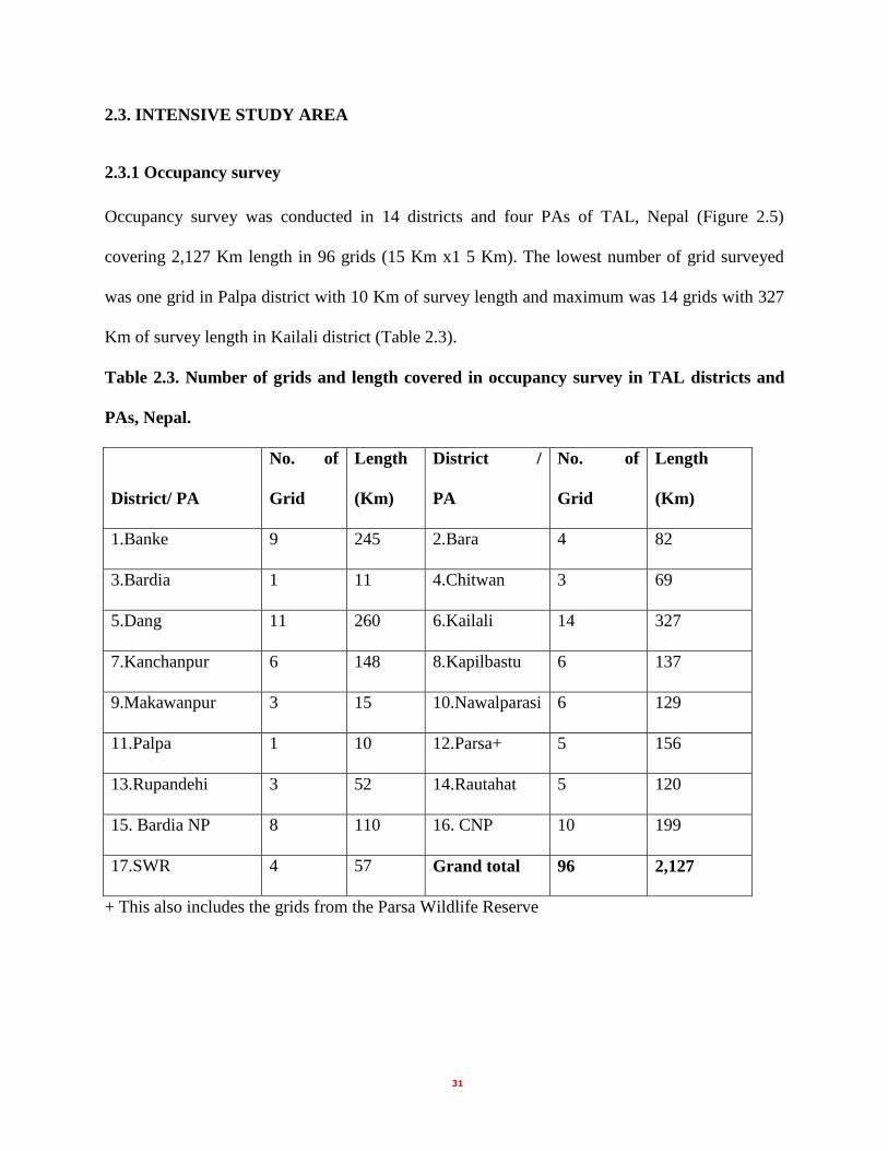
2.3. INTENSIVE STUDY AREA
2.3.1 Occupancy survey
Occupancy survey was conducted in 14 districts and four PAs of TAL, Nepal (Figure 2.5)
covering 2,127 Km length in 96 grids (15 Km x1 5 Km). The lowest number of grid surveyed
was one grid in Palpa district with 10 Km of survey length and maximum was 14 grids with 327
Km of survey length in Kailali district (Table 2.3).
Table 2.3. Number of grids and length covered in occupancy survey in TAL districts and
PAs, Nepal.
District/ PA
No. of
Grid
Length
(Km)
District /
PA
No. of
Grid
Length
(Km)
1.Banke 9 245 2.Bara 4 82
3.Bardia 1 11 4.Chitwan 3 69
5.Dang 11 260 6.Kailali 14 327
7.Kanchanpur 6 148 8.Kapilbastu 6 137
9.Makawanpur 3 15 10.Nawalparasi 6 129
11.Palpa 1 10 12.Parsa+ 5 156
13.Rupandehi 3 52 14.Rautahat 5 120
15. Bardia NP 8 110 16. CNP 10 199
17.SWR 4 57 Grand total 96 2,127
+ This also includes the grids from the Parsa Wildlife Reserve

32
Figure 2.5. Map of TAL Nepal showing occupancy grids in TAL districts and PAs.
2.3.2 Camera trap and line transects
The tiger bearing PAs are located in the lowlands and inner valley from central to west Nepal.
PWR in the east is in the outer foot hills and is connected with CNP towards west. Similarly,
BaNP is connected with BNP towards the west.
2.3.2.1 Parsa Wildlife Reserve
Except the Churia slope and small part of south west portion, remaining 242 Km2 was used for
camera trap and line transects (Figure 2.6).

33
Figure 2.6. Location of transect lines in Parsa wildlife Reserve, Nepal.
2.3.2.2 Chitwan National Park
The 612 Km2 area of CNP was covered for line transects and camera trap in 2008/09. Camera
trap was extended to whole park, including Churia ranges in 2009/10. For the ease of
understanding for the location of line transects, the area can be described in northern slope of
Churia from Sunachuri to Kasara, southern slope of Churia towards Madi valley from
Nirmalbasti to Bankatta, Barandabhar (BZ forest), Rapti-Reu flood plain between Kasara-
Bankatta in the east to Rapti-Reu confluence, northern foothill from tiger tops lodge area to
temple tiger lodge area, and Narayani island forest (Figure 2.7).

34
Figure 2.7. Location of transect lines in Chitwan National Park, Nepal.
2.3.2.3 Bardia National Park
Three strata, KFP, foot hill and Babai valley, were chosen for line transects and camera trap. The
occupancy survey was conducted in the same general area within the prescribed grid and
randomly selected sub-grid. The Babai valley, about 40 Km in length, and oriented east-west
extends north east from Parewawodad to Chepang has about 131 Km2 area and valley slope of
about 373 Km2 areas (Malla 2009). The study in Babai valley was concentrated in the Babai
river flood plain area, both for camera trap and line transects (Figure 2. 8).

35
Figure 2.8. Location of transect lines in Bardia National Park, Nepal.
2.3.2.4 Suklaphanta Wildlife Reserve
The 197 Km2 of the SWR, between the Mahakali river in the west and up to 5-6 kilometers east
of Chaudhar river in the east, has been used for the camera trap and line transects (figure 2. 9).
Towards south, it is bounded with the Laggabagga-Pilibhit forests in India. Suklaphanta is one of
the biggest grassland (53 Km2) in PAs of Nepal.

36
Figure 2.9. Location of transect lines in Suklaphanta Wildlife Reserve, Nepal.