Chapter 140, SUBDIVISION AND LAND DEVELOPMENT · congestion in the streets and highways, and the...
160
Township of Hilltown PC/CodeBook for Windows 1 C hapter 140, SUBDIVISION AND LAND DEVELOPMENT [HISTORY: Adopted by the Board of Supervisors of the Township of Hilltown 12-26-1995 by Ord. No. 95-9. Amendments noted where applicable.] GENERAL REFERENCES Construction codes -- See Ch. 65. Licensing of contractors -- See Ch. 68. Sale of lots within subdivisions -- See Ch. 120, Art. I. Sewers -- See Ch. 124. Stormwater management -- See Ch. 134. Water -- See Ch. 157. Zoning -- See Ch. 160. A RTICLE I, General Provisions § 140-1. Title. This chapter shall be known as the "Hilltown Township Subdivision and Land Development Ordinance." § 140-2. Purpose. These regulations are adopted for the following purposes: A. To protect and provide for the public health, safety, and general welfare of Hilltown Township. B. To guide the future growth and development of Hilltown Township, in accordance with the Comprehensive Plan and Act 537 Sewage Facilities Plan of Hilltown Township. C. To provide for adequate light, air, privacy; to secure safety from fire, flood, and other danger; and to prevent overcrowding of the land and undue congestion of population. D. To protect the character and social and economic stability of Hilltown Township and to encourage the orderly and beneficial development of Hilltown Township. E. To protect and conserve the value of land throughout Hilltown Township and the value of building(s) and improvements upon the land and to minimize the conflicts among the uses of
Transcript of Chapter 140, SUBDIVISION AND LAND DEVELOPMENT · congestion in the streets and highways, and the...

Township of HilltownPC/CodeBook for Windows
1
Chapter 140, SUBDIVISION AND LAND DEVELOPMENT
[HISTORY: Adopted by the Board of Supervisors of the Township of Hilltown 12-26-1995 byOrd. No. 95-9. Amendments noted where applicable.]
GENERAL REFERENCES
Construction codes -- See Ch. 65. Licensing of contractors -- See Ch. 68.
Sale of lots within subdivisions -- See Ch. 120, Art. I. Sewers -- See Ch. 124.
Stormwater management -- See Ch. 134. Water -- See Ch. 157. Zoning -- See Ch. 160.
ARTICLE I, General Provisions
§ 140-1. Title.
This chapter shall be known as the "Hilltown Township Subdivision and Land DevelopmentOrdinance."
§ 140-2. Purpose.
These regulations are adopted for the following purposes:
A. To protect and provide for the public health, safety, and general welfare of HilltownTownship.
B. To guide the future growth and development of Hilltown Township, in accordance with theComprehensive Plan and Act 537 Sewage Facilities Plan of Hilltown Township.
C. To provide for adequate light, air, privacy; to secure safety from fire, flood, and otherdanger; and to prevent overcrowding of the land and undue congestion of population.
D. To protect the character and social and economic stability of Hilltown Township and toencourage the orderly and beneficial development of Hilltown Township.
E. To protect and conserve the value of land throughout Hilltown Township and the value ofbuilding(s) and improvements upon the land and to minimize the conflicts among the uses of

Township of HilltownPC/CodeBook for Windows
2
land and buildings.
F. To guide public and private policy and action in order to provide adequate and efficienttransportation, water supply, sewerage, stormwater management, schools, parks,playgrounds, recreation, and other public requirements and facilities.
G. To provide the most beneficial relationship between the uses of land and buildings and thecirculation of traffic within Hilltown Township having particular regard to the avoidance ofcongestion in the streets and highways, and the pedestrian traffic movements appropriate tothe various uses of land and buildings, and to provide for the proper location and width ofstreets and building lines.
H. To establish reasonable standards of design and procedures for subdivision andresubdivisions, in order to further the orderly layout and use of land; and to insure properlegal descriptions and monumenting of subdivided land.
I. To insure that public facilities are available and will have a sufficient capacity to serve theproposed subdivision.
J. To prevent the pollution of air, streams, lakes, and ponds; to assure the adequacy of drainagefacilities; to safeguard the water table; and to encourage the wise use and management ofnatural resources in order to preserve the community and value of the land.
K. To control stormwater in a manner consistent with the Bucks County StormwaterManagement Plan.
L. To regulate the subdivision and/or development of land within any designated floodplaindistrict in order to promote the general health, welfare, and safety of the community.
M. To require that each subdivision lot in flood-prone areas include a safe building site withadequate access; and that public facilities which serve such uses be designed and installed tominimize flood damage.
N. To protect individuals from buying lands which are unsuitable for use because of flooding byprohibiting the improper subdivision and/or development of lands within the designatedfloodplain districts; and which are unsuitable for use because of topography, wetlands, steepslopes, and other environmental features.
O. To preserve the natural beauty and topography of Hilltown Township and to ensureappropriate development with regard to these natural features.
P. To provide for open spaces through efficient design and layout of the land.

Township of HilltownPC/CodeBook for Windows
3
§ 140-3. Applicability.
This chapter shall apply to all subdivision and land development plans submitted after theeffective date of this chapter and to all subdivision and land development plans submitted beforethe effective date of this chapter which no longer have protection from the effect of changes ingoverning ordinances granted by Section 508(4) of the Pennsylvania Municipalities PlanningCode.EN(1)
A. Subdivision control.
(1) No subdivision, as herein defined, of any lot, tract or parcel of land shall be effected andno street, alley, sanitary sewer, storm sewer, water main or other facilities in connectiontherewith, shall be laid out, constructed, opened or dedicated for public use or travel, orfor the common use of occupants of buildings abutting or to abut thereon, except instrict accordance with the provisions of this chapter. No lot in any subdivision may besold, and no permit to erect, alter or repair any building upon land in a subdivision maybe issued and no building may be erected in a subdivision, unless and until a subdivisionplan has been approved by the Board of Supervisors and recorded in the office of theRecorder of Deeds for Bucks County.
(2) There shall be no subdivision of any lot which has been restricted from furthersubdivision by a note or restriction on a plan or deed recorded at the office of the BucksCounty Recorder of Deeds.
B. Land development control.
(1) Land development, as herein defined, must comply with the regulations containedherein. Such compliance shall include but not be limited to the filing of preliminary andfinal plats, the dedication and improvements of rights-of-way, streets and roads, and thepayment of fees and charges as established by resolution of the Board of Supervisors.
(2) Land development plans shall indicate the location of each structure and clearly defineeach unit and shall indicate public easements, common areas, and improvements, alleasements appurtenant to each unit, and improvements to public rights-of-way.Developments are subject to the zoning regulations as they apply to use and densityrequirements, setbacks, parking and other features, and the same shall be indicated onthe land development plan.
§ 140-4. Interpretation and conflict.
A. Interpretation. In interpreting and applying the provisions of this chapter, they shall be heldto be the minimum requirements for the promotion of public health, safety, comfort,

Township of HilltownPC/CodeBook for Windows
4
convenience, and general welfare.
B. Conflict with public and private provisions.
(1) Public provisions. Where any provision of this chapter imposes restrictions differentfrom those imposed by any other provision of this chapter or any other ordinance, rule,or regulation, or other provisions of law, whether local, state or federal, whicheverprovisions are more restrictive or impose higher standards shall control.
(2) Private provisions. This chapter is not intended to abrogate any easement, covenant ofany other private agreement or restriction, provided that where the provisions of thischapter are more restrictive or impose higher standards or regulations than sucheasement, covenant, or other private agreement or restriction, the requirements of thischapter shall govern. Where the provisions of the easement, covenant or privateagreement or restriction impose duties and obligations more restrictive, or higherstandards than the requirements of these regulations, or the determinations of the Boardof Supervisors in approving a subdivision or in enforcing this chapter, and such privateprovision are not inconsistent with this chapter or determinations thereunder, then suchprivate provisions shall be operative and supplemental to these regulations anddeterminations made thereunder.
(3) Municipal liability. The grant of a permit or approval of a plan for any proposedsubdivision and/or land development to be located within any identified floodplain areaor district shall not constitute a representation, guarantee, or warranty of any kind byHilltown Township or by any official or employee thereof of the practicability or safetyof the proposed use, and shall create no liability upon Hilltown Township, its officials oremployees.
ARTICLE II, Definitions and Word Usage
§ 140-5. Word usage.
Unless otherwise expressly stated, the following words shall, for the purpose of this chapter,have the meaning herein indicated. The present tense shall include the future; the singularnumber shall include the plural; words used in the masculine gender shall include the feminineand the neuter; the word "shall" is always mandatory; the word "may" is always permissive.
§ 140-6. Definitions.

Township of HilltownPC/CodeBook for Windows
5
As used in this chapter, the following terms shall have the meanings indicated:
AGRICULTURAL SOILS -- Agricultural soils shall be as recognized and classified in the SoilSurvey of Bucks County, Pennsylvania, U.S. Department of Agriculture, National ResourcesConservation Service, May 2004 Update, or as amended: [Amended 5-23-2005 by Ord. No.2005-1]
A. PRIME AGRICULTURAL SOILS --
Manuscript Symbol Soil Name
AIA Alton gravelly loam, 0 to 3% slopes
ALB Alton gravelly loam, 3 to 8% slopes
ArB Arendtsville gravelly silt loam, 3 to 8% slopes
BeA Bedington channery silt loam, 0 to 3% slopes
BeB Bedington channery silt loam, 3 to 8% slopes
BrB Brecknock channery silt loam, 3 to 8% slopes
BsA Brownsburg silt loam, 0 to 3% slopes
BsB Brownsburg silt loam, 3 to 8% slopes
CdA Chester silt loam, 0 to 3% slopes
CdB Chester silt loam, 3 to 8% slopes
CmB Clarksburg silt loam, 3 to 8% slopes
DaA Delaware loam, 0 to 3% slopes
DaB Delaware loam, 3 to 8% slopes
DfB Duffield silt loam, 3 to 8% slopes
DuA Duncannon silt loam, 0 to 3% slopes
DuB Duncannon silt loam, 3 to 8% slopes
EcB Edgemont channery loam, 3 to 8% slopes
FoA Fountainville silt loam, 0 to 3% slopes

Township of HilltownPC/CodeBook for Windows
6
Manuscript Symbol Soil Name
FoB Fountainville silt loam, 3 to 8% slopes
GIB Gladstone gravelly silt loam, 3 to 8% slopes
GrA Glenville silt loam, 0 to 3% slopes
GrB Glenville silt loam, 3 to 8% slopes
LgA Lansdale loam, 0 to 3% slopes
LgB Lansdale loam, 3 to 8% slopes
LkA Lawrenceville silt loam, 0 to 3% slopes
LmA Lehigh channery silt loam, 0 to 3% slopes
LmB Lehigh channery silt loam, 3 to 8% slopes
Lt Linden loam
MaB Manor loam, 3 to 8% slopes
McA Matapeake silt loam, 0 to 3% slopes
McB Matapeake silt loam, 3 to 8% slopes
MdA Mattapex silt loam, 0 to 3% slopes
MIA Mount Lucas silt loam, 0 to 3% slopes
MIB Mount Lucas silt loam, 3 to 8% slopes
NbB Neshaminy silt loam, 3 to 8% slopes
PeA Penn channery silt loam, 0 to 3% slopes
PeB Penn channery silt loam, 3 to 8% slopes
PnB Penn-Lansdale complex, 3 to 8% slopes
RaA Raritan silt loam, 0 to 3% slopes
RaB Raritan silt loam, 3 to 8% slopes
ReA Readington silt loam, 0 to 3% slopes
Ro Rowland silt loam

Township of HilltownPC/CodeBook for Windows
7
Manuscript Symbol Soil Name
WaB Washington silt loam, 3 to 8% slopes
B. AGRICULTURAL SOILS OF STATEWIDE IMPORTANCE -- The following soil typesshall be recognized and classified as agricultural soils of statewide importance:
Manuscript Symbol Soil Name
AbA Abbottstown silt loam, 0 to 3% slopes
AbB Abbottstown silt loam, 3 to 8% slopes
AbC Abbottstown silt loam, 8 to 15% slopes
AmA Amell silt loam, 0 to 3% slopes
AmB Amell silt loam, 3 to 8% slopes
ArC Arendtsville gravelly silt loam, 8 to 15% slopes
BeC Bedington channery silt loam, 8 to 15% slopes
BrC Brecknock channery silt loam, 8 to 15% slopes
BsC Brownsburg silt loam, 8 to 15% slopes
BwB Buckingham silt loam, 3 to 8% slopes
CbA Chalfont silt loam, 0 to 3% slopes
CbB Chalfont silt loam, 3 to 8% slopes
CdC Chester silt loam, 8 to 15% slopes
CyB Culleoka-Weikert channery silt loam, 0 to 3% slopes
CyC Culleoka-Weikert channery silt loam, 8 to 15% slopes
DgC Duffield-Ryder silt loams, 8 to 15% slopes
EcC Edgmont channery loam, 8 to 15% slopes
FoC Fountainville silt loam, 8 to 15% slopes

Township of HilltownPC/CodeBook for Windows
8
Manuscript Symbol Soil Name
GIC Gladstone gravelly silt loam, 8 to 15% slopes
Ha Hatboro silt loam (farmland of statewide importance)
Ho Holly silt loam
KIB Klinesville very channery silt loam, 3 to 8% slopes
LgC Lansdale loam, 8 to 15% slopes
LgD Lansdale loam, 15 to 25% slopes
LkB Lawrenceville silt loam, 3 to 8% slopes
LmC Lehigh channery silt loam, 8 to 15% slopes
MaC Manor loam, 8 to 15% slopes
MIC Mount Lucas silt loam, 8 to 15% slopes
NbC Neshaminy silt loam, 8 to 15% slopes
NkA Nockamixon silt loam, 0 to 3% slopes
NkB Nockamixon silt loam, 3 to 8% slopes
NkC Nockamixon silt loam, 8 to 15% slopes
PeC Penn channery silt loam, 8 to 15% slopes
PkB Penn-Klinesville channery silt loam, 3 to 8% slopes
PkC Penn-Klinesville channery silt loam, 8 to 15% slopes
PkD Penn-Klinesville channery silt loam, 15 to 25% slopes
PnC Penn-Lansdale complex channery silt loam, 8 to 15% slopes
RaC Raritan silt loam, 8 to 15% slopes
ReB Readington silt loam, 3 to 8% slopes
RIA Reaville channery silt loam, 0 to 3% slopes
RIB Reaville channery silt loam, 3 to 8% slopes
RIC Reaville channery silt loam, 8 to 15% slopes
Township of HilltownPC/CodeBook for Windows
9
Manuscript Symbol Soil Name
StB Steinsburg gravelly loam, 3 to 8% slopes
StC Steinsburg gravelly loam, 8 to 15% slopes
WaC Washington silt loam, 8 to 15% slopes
ALLEY -- A strip of land over which there is a public or private right-of-way which serves asthe secondary means of vehicular access to the side or rear of two or more properties. Frontageon such a right-of-way shall not be construed as satisfying the requirements of Townshipordinances relating to frontage on a street.
ALLUVIAL SOILS (FLOODPLAIN SOILS) -- Areas subject to periodic flooding and listed inthe Soil Survey of Bucks and Philadelphia Counties, Pennsylvania, U.S. Department ofAgriculture, Soil Conservation Service, July 1975, as being "on, or in, the floodplain" or subjectto flooding. The following soil types are alluvial and/or floodplain soils:
A. Alluvial land.
B. Alton gravelly loam, flooded.
C. Bowmansville silt loam.
D. Hatboro silt loam.
E. Marsh.
F. Pope loam.
G. Rowland silt loam.
APPLICANT -- A landowner, or developer, as hereinafter defined, who has filed an applicationfor development including his/her heirs, successors and assigns.
APPLICATION FOR DEVELOPMENT -- Every application, whether tentative, preliminary, orfinal, required to be filed and approved prior to start of construction or development includingbut not limited to an application for a building permit, for the approval of a subdivision plat orplan or for the approval of a development plan.
ARCHITECT -- A professional architect licensed as such by the Commonwealth ofPennsylvania.
BERM -- An earth mound which physically blocks views without using architectural elements.
BLOCK -- A tract of land bounded by streets. Block length shall be measured along the center
Township of HilltownPC/CodeBook for Windows
10
line of a street between center lines of intersecting streets.
BUILDING -- Any structure having a roof supported by columns or walls and intended forshelter, housing, or enclosure of persons, animals or chattels, and including covered porches orbay windows and chimneys. Included shall be all manufactured homes and trailers to be used forhuman habitation.
CARTWAY or ROADWAY -- The portion of a street right-of-way normally paved or stonedand designed or intended for vehicular use.
CLEAR SIGHT TRIANGLE -- An area of unobstructed vision at street intersection defined bylines of sight between points at a given distance from the intersection of the street right-of-waylines.
COMMON OPEN SPACE -- A parcel of land or an area of water, or a combination of land andwater within a development site and designed and intended for the use or enjoyment of residentsof a development, not including streets, off-street parking areas, and areas set aside for publicfacilities.
CONDOMINIUM and COOPERATIVE -- (An ownership arrangement and not a land use.) Amethod of ownership which, when applied to a multifamily dwelling, provides for separateownership for each unit, title of which shall consist of ownership of the unit together with anundivided interest in the common element.
CONSERVATION DISTRICT -- Bucks Conservation District.
COUNTY -- The County of Bucks, Pennsylvania.
COUNTY PLANNING COMMISSION -- The Planning Commission of the County of Bucks.
CROSSWALK -- A right-of-way or easement for pedestrian travel which crosses a cartway.
CUL-DE-SAC -- A street intersecting another street at one end and terminating at the other in avehicular turnaround.
CULVERT -- A pipe, conduit, or similar structure including appurtenant works which conveysurface water.
DENSITY -- The measure of the number of dwelling units per acre as determined by regulationsof Chapter 160, Zoning.
DESIGN STANDARDS -- Regulations adopted pursuant to this chapter establishing minimumor maximum standards and a layout by which a subdivision and land development is developed.
DESIGN STORM -- The magnitude of precipitation from a storm event measured in probabilityof occurrence (i.e., fifty-year storm) and duration (i.e., twenty-four-hour), and used in computingstormwater management control system.
DETENTION BASIN -- A basin designed to retard stormwater runoff by temporarily storing
Township of HilltownPC/CodeBook for Windows
11
the runoff and releasing it at a predetermined rate.
DEVELOPER -- Any landowner, agent of such landowner, or tenant with the permission ofsuch landowner, who makes or causes to be made a subdivision of land or a land development.
DEVELOPMENT -- Any man-made change to improved or unimproved real estate including,but not limited to, the construction or placement of buildings or other structures, mobile homes,streets and other paving, utilities, mining, dredging, filling, grading, excavation, or drillingoperations, and the subdivision of land.
DEVELOPMENT PLAN -- The provisions for development including a planned residentialdevelopment, a plat of subdivision, all covenants relating to use, location and bulk of buildingsand other structures, intensity of use or density of development, streets, ways and parkingfacilities, common open space and public facilities. The phrase "provisions of development plan"when used in this chapter shall mean the written and graphic materials referred to in thisdefinition.
DRAINAGE FACILITY -- Any ditch, gutter, swale, culvert, basin, storm sewer or otherstructure designed, intended or constructed for the purpose of conveying, diverting or controllingsurface water or groundwater.
DRAINAGE RIGHT-OF-WAY -- The lands required for the installation of stormwater sewersor drainage ditches, or required along a natural stream or watercourse for preserving the channeland providing for the flow of water therein to safeguard the public against flood damage andunnatural erosion.
DRIVEWAY -- A private vehicular passageway providing access between a street and a privateparking area or private garage.
DRIVEWAY, SHARED -- A private vehicular passage way providing access between a streetand private parking area or garage serving four or less dwellings. Shared driveways may crossthrough lots provided access easements are established. Lot frontage on such easements shall notbe utilized to meet minimum lot width requirements of Chapter 160, Zoning.
DWELLING -- A building designed and occupied exclusively for residential purposescontaining one or more dwelling units on a single parcel of land, excluding hotel, roominghouse, tourist home, institutional home, guest house, residential club, motel, motor court, and thelike.
DWELLING UNIT -- Any room or group of rooms located within a residential building andforming a single, habitable unit with facilities used or intended to be used for living, sleeping,cooking and eating, by one family.
EASEMENT -- A grant for the use of a parcel of land by the public, a corporation, or a person,for a specified purpose.
ENCROACHMENT -- Any placement or obstruction in a delineated floodway, wetland,

Township of HilltownPC/CodeBook for Windows
12
right-of-way, easement, required yard, setback, or adjacent land.
ENGINEER -- A professional engineer licensed as such in the Commonwealth of Pennsylvania.
EROSION -- The removal of soil particles by the action of water, wind, ice, or other geologicalagents.
EXCAVATION -- Any act by which earth, sand, gravel, rock, or any other similar material isdug into, cut, quarried, uncovered, removed, displaced, relocated, or bulldozed; and shall includethe conditions resulting therefrom.
FILL
A. Any act by which earth, sand, gravel, rock, or any other material is placed, pushed, dumped,pulled, transported or moved to a new location above the natural surface of the ground, or ontop of a stripped surface; and shall include the conditions resulting therefrom.
B. The difference in elevation between a point on the original ground and a designated point ofhigher elevation on the final ground elevation.
C. The material used to fill.
FINANCIAL SECURITY -- Any approved security which may be in lieu of a requirement thatcertain improvements be made before the Board of Supervisors approves a final subdivision orland development plan, including performance bonds, escrow agreements, and other similarcollateral or surety agreements.
FLOOD -- A temporary inundation of normally dry land areas.
FLOODPLAIN (GENERAL FLOODPLAIN) -- A relatively flat or low land area which issubject to partial or complete inundation from an adjoining or nearby stream, river orwatercourse; and/or any area subject to the unusual and rapid accumulation of surface watersfrom any source.
FLOODPLAIN SOILS -- Areas subject to periodic flooding and listed in the Soil Survey ofBucks and Philadelphia Counties, Pennsylvania, U.S. Department of Agriculture, SoilConservation Service, July 1975, as being "on the floodplain" or "subject to flooding." Thefollowing soil types are floodplain soils: Alluvial land; Alton gravelly loam, flooded;Bowmansville silt loam; Hatboro silt loam; Marsh; Pope loam; and Rowland silt loam.
FLOODPROOFING -- Any combination of structural and nonstructural additions, changes, oradjustments to structures which reduce or eliminate flood damage to real estate or improved realproperty, water and sanitary facilities, structures, and their contents.
FLOODWAY -- The channel of the watercourse and portions of the adjoining floodplains whichare reasonably required to carry and discharge the one-hundred-year frequency flood. Unlessotherwise specified, the boundary of the floodway is as indicated on maps and flood insurancestudies provided by FEMA. In an area where no FEMA maps or studies have defined the

Township of HilltownPC/CodeBook for Windows
13
boundary of the one-hundred-year frequency floodway, it is assumed, absent evidence to thecontrary, that the floodway extends from both sides of the stream to 50 feet from the top of eachbank of the stream.
FLOODWAY FRINGE -- Area between the floodway and boundary of the one-hundred-yearflood. For purpose of definition, it is the area of the floodplain that could be completelyobstructed without increasing the water surface elevation of the one-hundred-year flood morethan one foot at any point. Floodway and floodway fringe are typically calculated by equalconveyance reduction from each side of the floodplain.
FOREST (WOODLANDS) -- Areas comprised of one or more acres of mature or largely maturetrees in which the largest trees measure at least six inches dbh (diameter at breast height, or 4 1/2feet above the ground). Forest shall be measured from the drip line of the outer trees. "Forest" isalso 10 or more individual trees which measure at least 10 inches dbh and form a contiguouscanopy.
FRONTAGE -- Refer "lot width."
GOVERNING BODY -- The Board of Supervisors of Hilltown Township, Bucks County,Pennsylvania.
GRADE -- The slope of a street, other public way, land area, drainage facility or pipe specifiedin percent.
GRADING AND DRAINAGE PLAN -- A plan showing all existing ground features andproposed grading, including existing and proposed surface and subsurface drainage facilities,described by grades, contours, and topography.
GROUNDWATER -- Natural underground water supplies.
HYDRIC SOILS -- Soils that are categorized as poorly drained that can support hydrophyticplants, but may not do so in many cases. For the purpose of this chapter, hydric soils are generalwetland indicator soils. (Refer "wetlands.") The following soils, classified in the Soil Survey ofBucks and Philadelphia Counties, Pennsylvania, U.S. Department of Agriculture, SoilConservation Service, July 1975, are hydric soils:
A. Bowmansville silt loam.
B. Doylestown silt loam.
C. Fallsington silt loam.
D. Hatboro silt loam.
E. Towhee silt loam.
F. Towhee extremely stony silt loam.

Township of HilltownPC/CodeBook for Windows
14
IDENTIFIED FLOODPLAIN AREA -- The floodplain area specifically identified in thischapter as being inundated by the one-hundred-year flood. Included would be areas identified asFloodway (FW), Flood-Fringe (FF) and General Floodplain (FA).
IMPERVIOUS SURFACE -- Impervious surfaces are those surfaces which do not absorbprecipitation and surface water. All buildings, parking areas, driveways, roads, sidewalks,swimming pools, and any areas in concrete, asphalt, packed stone, or other equivalent surfacesshall be considered impervious surfaces within this definition. In addition, other areasdetermined by the Township Engineer to be impervious within the meaning of this definitionwill be classified as impervious surfaces.
IMPROVEMENT CONSTRUCTION DOCUMENTS -- Include but are not limited to trafficstudy, stormwater management study, floodplain study, wetland studies, erosion andsedimentation pollution control narrative, geological studies for water supply, sewage facilitiesalternatives study, etc. Studies requiring engineering calculations shall be prepared, signed, andsealed by a licensed professional engineer when deemed necessary by the Township.
IMPROVEMENTS -- Those physical additions, installations, and changes required to renderland suitable for the use intended, including but not limited to grading, paving, curbing, streetlights and signs, fire hydrants, water mains, electric service, gas service, sanitary sewers, stormdrains, sidewalks, crosswalks, driveways, culverts, and street shade trees.
LAND DEVELOPMENT -- Any of the following activities:
A. The improvement of one or two or more contiguous lots, tracts or parcels of land for anypurpose involving:
(1) A group of two or more residential or nonresidential buildings, whether purposedinitially or cumulatively, or a single nonresidential building on a lot or lots regardless ofthe number of occupants or tenure; or
(2) The division or allocation of land or space, whether initially or cumulatively, between oramong two or more existing or prospective occupants by means of, or for the purpose ofstreets, common areas, leaseholds, condominiums, building groups or other features.
B. A subdivision of land.
C. "Land development" does not include development which involves:
(1) The conversion of an existing single-family detached dwelling or single-familysemidetached dwelling into not more than three residential units, unless such units areintended to be a condominium;
(2) The addition of a residential accessory building, including farm building, not greaterthan 600 square feet in area on a lot or lots subordinate to an existing principal building;

Township of HilltownPC/CodeBook for Windows
15
or
(3) The addition or conversion of buildings or rides within the confines of an enterprisewhich would be considered an amusement park. For the purposes of this subsection, an"amusement park" is defined as a tract or area used principally as a location forpermanent amusement structures or rides. This exclusion shall not apply to newlyacquired acreage by an amusement park until initial plans for the expanded area havebeen approved by the proper authorities.
LANDOWNER -- The legal or beneficial owner or owners of land including the holder of anoption or contract to purchase (whether or not such option or contract is subject to anycondition), a lessee, if he/she is authorized under the lease to exercise the rights of thelandowner, or other person having a proprietary interest in land.
LOT -- A parcel of land, used or set aside and available for use as the site of one or morebuildings and any buildings accessory thereto, or for any other purpose, in one ownership andnot divided by a street, nor including any land within the ultimate right-of-way of a public orprivate street upon which said lot abuts, even if the ownership to such right-of-way is the ownerof the lot. In the case where an existing deeded parcel of land is divided into two or more tractsby public street; for the purposes of this chapter, each tract shall be considered a separate lot.
A. LOT, CORNER -- A lot which has an interior angle of less than 135° at the intersection oftwo street lines. A lot abutting upon a curved street or streets shall be considered a corner lotif the tangent to the curve at the points beginning within the lot or at the points ofintersection of the side lot lines with the street lines intersects at an angle of less than 135°.
B. LOT, DEPTH -- The mean distance from the ultimate right-of-way line of the lot to itsopposite rear line measured in a direction parallel to the side lines of the lot. Lot depth fortriangular lots shall be the mean distance from the street line to the point of intersection ofthe side yards.
C. LOT, DOUBLE FRONTAGE -- A lot (except for a corner lot) which fronts two interiorproposed streets within a subdivision.
D. LOT, FLAG (LANE) -- A lot which meets the criteria for an exception to the minimum lotwidth requirements under § 160-51 of Chapter 160, Zoning.
E. LOT, INTERIOR -- A lot, the side lot lines of which do not abut on a street.
F. LOT, MINIMUM WIDTH -- The minimum required lot width measured at the requiredbuilding setback line.
G. LOT, NONCONFORMING -- A lot, the area or dimension of, which was lawful prior to theadoption or amendment of the relevant Zoning Ordinance, but which fails to conform to the

Township of HilltownPC/CodeBook for Windows
16
requirements of the zoning district under the current Zoning Ordinance.
H. LOT OF RECORD -- A lot which has been recorded in the Office of the Recorder of Deeds.
I. LOT, REVERSE FRONTAGE -- A lot (excluding corner lots) which abuts upon two streets.[Amended 5-23-2005 by Ord. No. 2005-1]
J. LOT, THROUGH -- An interior lot having frontage on two parallel or approximately parallelstreets.
K. LOT, TRIANGULAR -- A lot having three lot lines, but which does not qualify as a cornerlot.
L. LOT WIDTH (FRONTAGE) -- The distance measured between the side lot lines, at therequired minimum building setback line. In a case where there is only one side lot line, lotwidth shall be measured between such side lot line and the opposite rear lot line or streetline.
LOT LINE ADJUSTMENT -- A minor subdivision of land resulting in revised propertyboundaries between two or more existing lots, and not resulting in the creation of any additionallots.
MAINTENANCE GUARANTEE -- Any security which may be accepted by the Township forthe maintenance of any improvements required by this chapter.
MAJOR SUBDIVISION -- Any subdivision not classified as a minor subdivision or lot lineadjustment.
MANUFACTURED/MODULAR HOME -- A dwelling unit erected on a foundation and madeof one or more sections built in a factory. The completed unit shall meet all applicable buildingcodes in effect.
MINOR SUBDIVISION -- Any division or redivision of a lot, tract or parcel of land by anymeans into two lots or less.
MOBILE HOME -- A transportable, single-family dwelling intended for permanent occupancy,contained in one unit, or in two or more units designed to be joined into one integral unit capableof again being separated for repeated towing, which arrives at a site complete and ready foroccupancy except for minor and incidental unpacking and assembly operations, and constructedso that it may be used without a permanent foundation. For the purposes of this chapter, traveltrailers are not considered as mobile homes.
MOBILE HOME LOT -- A parcel of land in a mobile home park, improved with the necessaryutility connections and other appurtenances necessary for the erections thereon of a singlemobile home.
MOBILE HOME PARK -- A parcel or contiguous parcels of land which has been so designated
Township of HilltownPC/CodeBook for Windows
17
and improved that it contains two or more mobile home lots for the placement thereon of mobilehomes.
MUNICIPAL AUTHORITY -- A body politic and corporate created pursuant to the Act of May2, 1945 (P.L. 382, No. 164), known as the "Municipality Authorities Act of 1945," or createdpursuant to the current provisions of the Municipality Authorities Act (53 Pa.C.S.A. § 5601 etseq.).EN(2)
MUNICIPAL ENGINEER -- A professional engineer licensed as such in the Commonwealth ofPennsylvania and appointed by the Township pursuant to Article V of the Second ClassTownship Code.EN(3)
MUNICIPALITIES PLANNING CODE -- Act of Assembly of July 31, 1968, P.L. 805, asamended.EN(4)
ONE-HUNDRED-YEAR FLOOD -- A flood that, on the average, is likely to occur once every100 years (i.e., that has one-percent chance of occurring each year, although the flood may occurin any year).
OPEN SPACE -- Any parcel or area of land or water essentially unimproved and set aside,dedicated or reserved for resource protection, public or private use and enjoyment, or for the useand enjoyment of owners and occupants of land adjoining or neighboring such open space. Openspace shall not include land occupied by nonrecreational structures, roads, street rights-of-way,parking lots, land reserved for future parking, or any portion of required minimum lot areas asrequired by this chapter.
OPEN SPACE, COMMON -- Land within or related to a development, not individually ownedor dedicated for public use, which is designed and intended for the common use or enjoyment ofthe residents of the development and may include such complementary structures andimprovements as may be required and/or appropriate.
PERSON -- An individual, partnership, public or private association or corporation, firm, trust,estate, municipality, governmental unit, public utility or any other legal entity whatsoever whichis recognized by law as the subject of rights and duties.
PLAN, FINAL -- A complete and exact plan prepared by a licensed engineer or surveyor,prepared for official recording, showing right-of-way lines, easements, lot dimensions withbearings, lot numbers, and any other relevant information pertaining to the street and lotsubdivision or land development. The final plan shall include improvement constructiondocuments prepared by a licensed engineer where applicable). Final plan must show typicalcross section of streets and the horizontal and vertical details (plan-profiles of all streets,drainage facilities, sanitary sewers, water mains, fire hydrants, street lights, and all undergroundand above ground utility conduits and poles). An exact copy of the approved final plan onopaque linen of standard size shall be submitted for necessary signatures and recording with theBucks County Recorder of Deeds.

Township of HilltownPC/CodeBook for Windows
18
PLANNING COMMISSION -- The Hilltown Township Planning Commission.
PLAN, PRELIMINARY -- A plan prepared by a licensed engineer and/or surveyor showing theexisting features of a tract and its surroundings and proposed street and lot layout within andadjacent to the subdivision or land development, as a basis for consideration prior to preparationof a final plan. Preliminary plan shall include improvement construction documents prepared bya licensed engineer (where applicable). Preliminary plan must show typical cross section of thestreets and the horizontal and vertical details (plan-profiles of all streets, drainage facilities,sanitary sewers, water mains, fire hydrants, street lights, and all underground and above groundutility conduits and poles).
PLAN, SKETCH -- An informal plan indicating salient existing features of a tract and itsurroundings and a general layout of the proposed subdivision or land development, to be usedas the basis of informal discussions between representatives of the Township and the subdivideror land developer.
PLAN, SOIL EROSION AND SEDIMENTATION CONTROL -- A plan approved by theBucks Conservation District for controlling erosion and sediment during construction whichshall provide all steps, including scheduling, to assure erosion and sediment control during allphases of construction, including final stabilization.
PLAT -- A map or plan of subdivision or land development whether sketch, preliminary or final.
PUBLIC FACILITIES -- Any parks, playgrounds, trails, paths or other recreational areas; anywater or sewer collection, transportation or treatment facilities; all street, sidewalk, curb or otherroadway facilities to be dedicated; and any drainage or utility easement areas to be dedicated tothe Township. Any public improvements required by ordinance or otherwise to be constructedand dedicated to the Township.
PUBLIC HEARING -- A formal meeting held pursuant to public notice by the Board ofSupervisors or Planning Commission of the Township, intended to inform and obtain publiccomment, prior to taking action in accordance with this chapter.
PUBLIC MEETING -- A forum held pursuant to notice under the Act of October 15, 1998 (P.L.729, No. 93), known as the "Sunshine Act" (65 Pa.C.S.A. § 701 et seq.).EN(5)
PUBLIC NOTICE -- Notice published once each week for two successive weeks in a newspaperof general circulation in Hilltown Township. Such notice shall state the time and place of thehearing and the particular nature of the matter to be considered at the hearing. The firstpublication shall not be more than 30 days and the second publication shall not be less thanseven days from the date of the hearing.
RECREATION FACILITIES -- The following definitions apply to the recreation facilitiesrequired by § 140-47 of this chapter:
A. TOT LOT -- A confined, developed, neighborhood play area primarily for use by preschool

Township of HilltownPC/CodeBook for Windows
19
children under the supervision of parents or guardian.
B. PLAYFIELD -- A common area within a subdivision or land development for neighborhoodresidents to use for informal, active recreation purposes such a ball games and other activitiesrequiring a large lawn area, away from homes or other buildings for their proper conduct.
C. BASKETBALL COURT -- A complete basketball facility including paved, standard-sizedcourt area, with posts, backboards, and baskets at both ends of the court.
D. TENNIS COURT -- A complete tennis facility including paved, standard-sized court area,posts, net and fencing around its perimeter.
E. SWIMMING POOL -- A complete swimming facility including the pool, surrounding paveddeck, lawn area, lifeguard and bathroom facilities, and appropriate mechanical equipment.
RESERVE STRIP -- A narrow parcel of ground having inadequate area for building purposesseparating a street or a proposed street from other adjacent properties.
RESUBDIVISION -- Any subdivision or transfer of land, laid out on a plan which has beenapproved by the Board of Supervisors which changes or proposes to change property lines and/orpublic rights-of-way not in strict accordance with the approved plan.
RETENTION BASIN -- A basin designed to retain stormwater runoff so that a permanent poolis established.
RIGHT-OF-WAY -- A strip of land occupied or intended to be occupied by a street, sidewalk,alley, utilities or other similar use.
RUNOFF -- The surface water discharge or rate of discharge of a given watershed after a fall ofrain or snow that does not enter the soil but runs off the surface of the land; that part ofprecipitation which flows over the land.
SEDIMENT -- Solid material, both mineral and organic, that is in suspension, has beentransported, or has been moved from its site of origin by water.
SEDIMENTATION -- The process by which mineral or organic material is accumulated ordeposited by the movement of wind and water, or by gravity. Once this matter is deposited, orremains suspended in water, it is usually referred to as "sediment."
SELECT BACKFILL -- Crushed stone backfill graded in accordance with PennDOT Form 408.
SELECT EARTH BACKFILL -- Earth backfill material free of organics and other objectionablematerial being a well graded mixture of rock and soil with no particle size greater than eightinches.
SETBACK (BUILDING SETBACK LINE) -- The minimum distance that a building must beheld back from an adjacent lot line, depending on the applicable zoning district, or the minimum
Township of HilltownPC/CodeBook for Windows
20
distance from the ultimate right-of-way, depending on the applicable street, road or highway.
SEWER, COMMUNITY -- A system, whether publicly or privately owned, for the collection ofsewage or nonhazardous industrial wastes of a liquid nature from two or more lots, and for thetreatment or disposal of the sewage or industrial waste on one or more of the lots or at any othersite.
SEWER, INDIVIDUAL -- A system of piping, tanks or other facilities serving a single lot andcollecting and disposing of sewage in whole or in part into the soil or into waters of thecommonwealth or by means of conveyance to another site for final disposal.
SIGHT DISTANCE -- Includes "safe sight distance," "safe stopping site distance," "passingsight distance," and "decision site distance" as defined and regulated by Pennsylvania Code Title67, Chapter 441, and PennDOT Design Manual, Part 2, Publication 13. Sight distance forintersection of streets, alleys, and driveways shall be measured (unobstructed) from a point 10feet back from edge of pavement at a height of 3.5 feet above the pavement surface to anotherpoint six inches above the pavement surface.
SITE -- A parcel or parcels of land intended to have one or more buildings or intended to besubdivided into one or more lots.
SLOPE -- The face of an embankment of cut section; any ground whose surface makes an anglewith the plane of the horizon. Slopes are usually expressed in a percentage based upon verticaldifference in feet per 100 feet of horizontal distance.
SOIL PERCOLATION TEST -- A field test conducted to determine the absorption capacity ofsoil to a specified depth in a given location for the purpose of determining suitability of soil foron-site sewage disposal.
STREET, ROAD or HIGHWAY -- Includes street, avenue, boulevard, road, highway, freeway,parkway, lane, viaduct, alley, or any other ways used or intended to be used by vehicular trafficor pedestrians whether public or private which are identified on the legally adopted Townshipstreet or highway plan or the official map together with all necessary appurtenances, includingbridges, rights-of-way and traffic control improvements. The term shall not include the interstatehighway system.
A. EXPRESSWAY -- Highways designed for large volumes of high-speed traffic with accesslimited to grade separated intersections.
B. LOCAL ACCESS STREETS -- Those used primarily to provide access to abuttingproperties.
C. COLLECTOR STREETS -- Streets which give minimal emphasis to travel mobility, whichare characterized by low travel speeds, full land access, neighborhood penetration, and whichserve minor traffic generators such as local elementary schools, small individual industrialplants, offices, commercial facilities and warehouses not served by principal or minor

Township of HilltownPC/CodeBook for Windows
21
arterials.
D. ARTERIAL STREETS -- Those serving large volumes of comparatively high-speed andlong-distance traffic, and include facilities classified as main and secondary highways by thePennsylvania Department of Transportation.
E. MARGINAL ACCESS STREETS -- Minor streets, parallel and adjacent to arterial streets,providing access to abutting properties and control of intersections with the arterial street.
F. CUL-DE-SAC -- A minor street intersecting another street at one end and terminated at theother by a vehicular turnaround.
STRUCTURE -- Any man-made object having an ascertainable stationary location on or in landor water, whether or not affixed to the land.
SUBDIVISION -- The division or redivision of a lot, tract or parcel of land by any means intotwo or more lots, tracts, parcels or other divisions of land including changes in existing lot linesfor the purpose, whether immediate or future, of lease, partition by the court for distribution toheirs or devisees, transfer of ownership or building or lot development; provided, however, thatthe subdivision by lease of land for agricultural purposes into parcels of more than 10 acres, notinvolving any new street or easement, access, or any residential dwelling, shall be exempted.
SUBSTANTIALLY COMPLETED -- Where, in the judgment of the Township Engineer, atleast 90% (based on the cost of the required improvements for which financial security wasposted pursuant to the requirements of this chapter) of those improvements required as acondition for final approval have been completed in accordance with the approved plan, so thatthe project will be able to be used, occupied or operated for its intended use.
SURVEYOR -- A licensed surveyor registered by the Commonwealth of Pennsylvania.
SWALE -- A low-lying stretch of land characterized as a depression used to carry surface waterrunoff.
TOPSOIL -- Surface soils and subsurface soils which normally are fertile soils and soil material,ordinarily rich in organic matter or humus debris. Topsoil is usually found in the uppermost soillayer called the A Horizon.
UNDEVELOPED LAND -- Any lot, tract or parcel of land which has not been graded or in anyother manner improved.
UNIT -- A part of the property, structure or building designed or intended for any type ofindependent use, which has direct exit to a public street or way, or to an easement orright-of-way leading to a public street or way, and includes a proportionate undivided interest inthe common elements, which is assigned to the property, structure or building.
WATERCOURSE -- An intermittent or perennial stream of water, river, brook, creek, or swaleidentified on USGS mapping or SCS mapping; and/or delineated waters of the commonwealth.

Township of HilltownPC/CodeBook for Windows
22
[Amended 5-22-2000 by Ord. No. 2000-6]
WATER FACILITY -- Any water works, water supply works, water distribution system or partthereof, designed, intended or constructed to provide or distribute potable water.
WATER SURVEY -- An inventory of the source, quantity, yield and use of groundwater andsurface water resources within Hilltown Township.
WETLANDS -- Those areas that are inundated or saturated by surface or ground water at afrequency and duration sufficient to support, and that under normal circumstances do support, aprevalence of vegetation typically adapted for life in saturated soil conditions, including swamps,marshes, bogs and similar areas. The term also includes but is not limited to wetland areas listedin the State Water Plan, the United States Fish and Wildlife Service Wetlands Inventory ofPennsylvania, the Pennsylvania Coastal Zone Management Plan and a wetland area designatedby a river basin commission.
WETLANDS DELINEATION -- The process by which wetland limits are determined.Wetlands must be delineated by a qualified specialist according to the 1989 Federal Manuals (asamended) for the Delineation of Jurisdictional Wetlands (whichever is greater) or according toany subsequent federal or state regulation. "Qualified specialist" shall include those personsbeing certified professional soil scientists as registered with Registry of Certified Professionalsin Agronomy Crops and Soils (ARCPACS); or as contained on consultant's list of PennsylvaniaAssociation of Professional Soil Scientists (PAPSS); or as registered with National Society ofConsulting Soil Scientists (NSCSS), or as certified by state and/or federal certification programs;or by a qualified biologist/ecologist.
WOODLANDS -- Areas, groves, or stands of mature or largely mature trees the majority ofwhich are greater than six inches caliper measured four feet above grade covering an area greaterthan 1/4 acre; or groves of mature trees without regard to minimum area consisting of more than10 individual specimens which are greater than 12 inches caliper measured four feet abovegrade.
ARTICLE III, Submission Procedures
§ 140-7. General procedure. [Amended 9-25-2000 by Ord. No. 2000-8; 5-23-2004 by Ord.No. 2005-1]
A. Classification of subdivision. Whenever any subdivision of land or land development isproposed, before any contract is made for the sale of any part thereof, and before any permitfor the erection of a structure in such proposed subdivision or land development shall begranted, the owner, or his authorized agent, shall apply for and secure approval for such

Township of HilltownPC/CodeBook for Windows
23
proposed subdivision or land development in accordance with the following procedures forsubdivision and land development.
B. Preapplication consultation.
(1) Pennsylvania Department of Environmental Protection (PADEP). Prior to thepreparation of any plans, it is suggested that prospective developers consult withPADEP and/or the Bucks County Health Department concerning soil suitability whenon-site sewage disposal facilities are proposed.
(2) Bucks County Conservation District Consultation (BCCD). Prospective developers shallconsult with BCCD representatives concerning erosion, sedimentation control, andgeologic conditions at the proposed development.
(3) Pennsylvania Department of Transportation consultation (PennDOT). When thedevelopment site has frontage on a Pennsylvania state highway and/or proposes accessto a Pennsylvania state highway, the developer shall consult with PennDOT concerningdesign requirements, which may be imposed in addition to the requirements of thischapter.
(4) Hilltown Township staff consultation. Prior to the preparation of any plans, it isrecommended that prospective developers, with prior notification to the Board ofSupervisors of Hilltown Township, consult with the Hilltown Township staff, includingthe Manager, Engineer, and Solicitor, concerning general Township submissionprocedures, zoning issues, and subdivision and land development issues.
(5) Municipal Authority consultation. When the development anticipates having eitherpublic water service and/or public sanitary sewer service, it is recommended that thedeveloper consult with the Hilltown Township Water and Sewer Authority (HTWSA) orthe appropriate municipal authority having jurisdiction by service agreement withHilltown Township for the location in which the development is proposed.
C. Official filing date.
(1) For the purpose of these regulations, the official filing date shall be the date of theregular meeting of the Planning Commission next following the date completeapplication and plans are received in the Municipal Building, provided that, should saidregular meeting occur more than 30 days following the submission of the application,the official filing date shall be the 30th day following the day the complete applicationhas been submitted. An application will not be deemed complete unless all applicablefees have been paid by the applicant and the application and plans conform with the planrequirements set forth in Article IV of this chapter.
(2) Upon receipt of an application for subdivision or land development approval, the

Township of HilltownPC/CodeBook for Windows
24
Township Secretary shall affix to the application both the date of submittal and theofficial filing date.
(3) The application record shall be closed 21 days before the Planning Commission meetingat which the plan will be considered to allow time to examine and study the plans and allappropriate supporting documentation. The Township will not accept changes oramendments to the application after this date unless the applicant shall apply for arescheduling of the meeting at which the plan will be considered before the PlanningCommission and makes suitable provision for an extension of the review time. Thispolicy shall apply to sketch, preliminary, and final plan submissions.
D. Bucks County Planning Commission review. All plans shall be submitted to and reviewed bythe Bucks County Planning Commission in accordance with its then prevailing rules andregulations.
E. Any renderings, photographs, drawings or plans that are to be presented at a public meetingshall be submitted in PDF format on either a CD or DVD and shall accompany and be part ofthe plan submission application.
§ 140-8. Fee schedule.
A. All filing, inspection and professional (engineering/legal) fees shall be submitted to HilltownTownship.
B. Plan filing fee. A filing fee shall accompany the preliminary plan. No application shall beaccepted or acted upon unless payment is made to Hilltown Township. The HilltownTownship Board of Supervisors shall establish by resolution a schedule of fees to be paid bythe subdivider or land developer to defray the cost of administering and processing of plans.The schedule of fees may be changed from time to time by resolution of the Board ofSupervisors of Hilltown Township.
C. Review fees.
(1) Review fees shall include reasonable and necessary charges by the Township'sprofessional consultants or engineer for review and report to the Township, and shall beset by resolution. Such review fees shall be reasonable and in accordance with theordinary and customary charges by the Township Engineer or consultant for similarservices in the community, but in no event shall fees exceed the rate or cost charged bythe engineer or consultant to the Township when fees are not reimbursed or otherwiseimposed on applicants.
(2) In the event the applicant disputes the amount of any such review fees, the applicantshall, within 10 days of the billing date, notify the Township that such fees are disputed,

Township of HilltownPC/CodeBook for Windows
25
in which case the Township shall not delay or disapprove a subdivision or landdevelopment application due to the applicant's request over disputed fees.
(3) In the event that the Township and the applicant cannot agree on the amount of reviewfees which are reasonable and necessary, then the fees shall be recalculated andrecertified by another professional engineer licensed as such by the Commonwealth ofPennsylvania and chosen mutually by the Township and the applicant or developer.
D. An applicant shall, by filing a plan, be then obligated to pay the fees herein provided. Theprofessional (engineering/legal) fees required to be paid by this section shall be promptlysubmitted to the Township by the applicant upon the submission of bills therefor to theapplicant from time to time by the Board of Supervisors.
§ 140-9. Lot line adjustment procedure.
Lot line adjustment plans shall be initiated and submitted for review in the form of a final plan asspecified in § 140-16 and shall be otherwise reviewed in accordance with the procedures andstandards of § 140-11.
§ 140-10. Minor subdivision procedure.
A. Minor subdivision plans shall be initiated and submitted for review in the form of a final planas specified in § 140-16 and shall be otherwise reviewed in accordance with the proceduresand standards of § 140-11.
B. The applicant shall distribute the required documents in accordance with the most currentHilltown Township application form, which specifies the number of copies and reviewingagencies. All documentation required by this chapter including but not limited to plans,applications, stormwater management reports and, traffic studies, shall also be submitted inPDF format on either a CD or DVD. [Added 5-23-2005 by Ord. No. 2005-1EN(6)]
(1) In addition to the above, an information packet shall be included with the submission tothe Township at the time the application is made for land development or subdivision ofany property. The information packet shall include the location of the land developmentor subdivision, real and equitable owners, number of lots, lot size, housing type ornonresidential use, water and sewer availability (on site or public), amount of openspace, and shall include a map showing the properties (and their uses) surrounding theproposed property and a general plan of the development showing the lots, roads,parking, etc. Said plans shall be submitted on an eleven-inch by seventeen-inch plansheet.
(2) It is the responsibility of the applicant to coordinate and submit plans with the respective

Township of HilltownPC/CodeBook for Windows
26
private and public service agencies, including but not limited to (where applicable)Bucks County Conservation District, Bucks County Department of Health, PennsylvaniaDepartment of Environmental Protection, PennDOT, and municipal authorities.
C. Additional subdivision. Any additional subdivision of a tract from which a minor subdivisionhas already been approved shall be deemed to be a major subdivision for the purposes of thischapter and shall follow the procedure applying thereto, if the additional subdivision issubmitted for review within five years of the approval of the minor subdivision. This sectionshall not be deemed inconsistent with Note 1 under the Table of Performance Standards:Bulk and Area of the Hilltown Township Zoning Ordinance adopted on May 22, 1995,relative to public water requirements/exceptions. [Amended 5-24-2004 by Ord. No. 2004-4]
D. All minor subdivision plans shall contain a notice regarding future subdivision (refer samplein Appendix BEN(7)).
§ 140-11. Major subdivision and land development procedure.
A. Sketch plan. Prospective subdividers and developers are strongly urged to discuss possibledevelopment sites with the Planning Commission prior to submission of a preliminary plan.A sketch plan may be presented for review not less than 14 days prior to the regular meetingof the Planning Commission. Application for sketch plan review by the Bucks CountyPlanning Commission must accompany the submission. Submission of a sketch plan will notconstitute a formal filing of a subdivision or land development plan with the Board ofSupervisors. Sketch plans should include those items listed in Article IV, Plan Requirements.
B. Preliminary plan.
(1) Submission of preliminary plans.
(a) The preliminary plan and all information and procedures relating thereto shall in allrespects be in compliance with the applicable provisions of this chapter. It is theresponsibility of the subdivider or developer to coordinate plans with the respectiveprivate and public service agencies including but not limited to (where applicable)Bucks Conservation District, Bucks County Department of Health, PennsylvaniaDepartment of Environmental Protection, PennDOT, and Municipal Authorities.
(b) The applicant shall distribute the required documents in accordance with the mostcurrent Hilltown Township application form, which specifies the number of copiesand reviewing agencies. All documentation required by this chapter, including butnot limited to plans, applications, stormwater management reports, and trafficstudies) shall also be submitted in PDF format on either a CD or DVD. [Amended5-10-1999 by Ord. No. 99-4; 2-25-2002 by Ord. No. 2002-3; 5-23-2005 by Ord. No.

Township of HilltownPC/CodeBook for Windows
27
2005-1]
[1] In addition to the above, an information packet shall be included with thesubmission to the Township at the time the application is made for landdevelopment or subdivision of any property. The information packet shallinclude the location of the land development or subdivision, real and equitableowners, number of lots, lot size, housing type or nonresidential use, water andsewer availability (on site or public), amount of open space, and shall include amap showing the properties (and their uses) surrounding the proposed propertyand a general plan of the development showing the lots, roads, parking, etc.Said plans shall be submitted on an eleven-inch by seventeen-inch plan sheet.
[2] It is the responsibility of the applicant to coordinate plans with the respectiveprivate and public service agencies including but not limited to (whereapplicable) Bucks County Conservation District, Bucks County Department ofHealth, Pennsylvania Department of Environmental Protection, PennDOT, andmunicipal authorities.
(c) The application form shall be accompanied by the requisite fee as set forth in§ 140-8 of this chapter and by not less than four copies of all required material andnot less than seven prints of the preliminary plans of the subdivision or development,or as amended by Township resolution from time to time. [Amended 5-10-1999 byOrd. No. 99-4; 5-23-2005 by Ord. No. 2005-1]
(d) The Township Secretary shall forward one copy of the preliminary plan prints andrequired material to the Bucks County Planning Commission, Hilltown TownshipWater and Sewer Authority and such other agencies as he/she deems appropriate forreview and comment. One print shall be sent to the Fire Marshal when deemednecessary by the Township. [Amended 5-23-2005 by Ord. No. 2005-1]
(e) The Township Secretary shall forward the remaining copies of the preliminary planprints and required materials to the Planning Commission.
(f) The subdivider or developer shall submit seven prints of the final subdivision or landdevelopment plans and at least four copies of all other required information.
(g) Upon receipt of final plan, the Township Secretary shall forward two copies of theplan and required materials to the Township Engineer for review and comment; onecopy of the plan and one of all other material to the Bucks County PlanningCommission; and copies to such other agencies whose recommendations would bepertinent to the processing of the plan. Remaining copies shall be forwarded to thePlanning Commission.

Township of HilltownPC/CodeBook for Windows
28
(h) Adequate water and sewer required. [Added 5-23-2005 by Ord. No. 2005-1]
[1] Applicants proposing a private water supply shall submit a water resourcesimpact study in accordance with § 140-22 of this chapter.
[2] No plan shall receive final plan approval until the applicant has demonstratedthat the project can provide adequate water supply and wastewater disposal.
(2) Review of preliminary plans.
(a) In cases where the subdivision or land development adjoins an existing or proposedstate highway or has proposed streets entering onto state highways, the developershall submit the plans to the Pennsylvania Department of Transportation for review.
(b) The Planning Commission will consider the plan to determine if it meets thestandards set forth in this chapter, Chapter 160, Zoning, and all other applicableordinances and regulations of the Township.
(c) The Planning Commission shall act on the preliminary plan in time for the Board ofSupervisors to render their decision within 90 days from the official filing date. Anyrequests for modification or waiver of the requirements of this chapter shall be inwriting in accordance with PA Act 170, as amended; and be reviewed by thePlanning Commission for advisory comments.
(3) Planning Commission recommendation.
(a) The Planning Commission shall recommend whether the preliminary plan shall beapproved, approved with modifications, or disapproved, and shall notify the Boardof Supervisors in writing.
(b) In making its recommendation, the Planning Commission shall consider therecommendations of the Township Engineer, Township staff, Bucks CountyPlanning Commission, interested residents, and any agency or agencies from whicha review was requested under Subsection B(1)(c) of this section.
(4) Township Engineer review. All plans and associated documents shall be reviewed by theTownship Engineer, prior to the transmission of such plans to the Board of Supervisors.
(5) Resubmission of preliminary plans. A revised plan submitted after disapproval shall beconsidered, and processed as a new plan submission. A revised plan submitted afterapproval shall only be considered a new plan submission if, in the opinion of theTownship, it has been substantially revised after said approval.
(6) All plans shall evidence compliance with requirements of Chapter 160, Zoning. Failureof the applicant to obtain all necessary variances, special exceptions, and/or conditional

Township of HilltownPC/CodeBook for Windows
29
use approvals prior to preliminary plan approval shall be a cause for denial of the plan.
(7) Approval of preliminary plans.
(a) The Board of Supervisors shall act on the preliminary plan within 90 days of theofficial filing date. Failure to do so shall be deemed an approval. Before acting on apreliminary plan, the Board of Supervisors may hold a hearing thereon after publicnotice.
(b) The Board of Supervisors shall notify the applicant of its decision to approve,approve with conditions, or disapprove the preliminary plan in writing. Such noticeshall be given to the applicant in person or mailed to him at his last known addressnot later than 15 days following the decision. If the plan is approved with conditionsor disapproved, the Board of Supervisors shall specify in their notice the conditionswhich must be met and/or the defects found in the plan, and the requirements whichhave not been met, including specific reference to provisions of the PennsylvaniaMunicipalities Planning Code, 53 P.S. § 10101, or any other statute or provision ofthis chapter which has not been fulfilled.
(c) Approval of the preliminary plan shall constitute approval of the subdivision or landdevelopment as to the character and intensity of development; and the arrangementand approximate dimensions of streets, lots, and other planned features. Theapproval binds the subdivider or developer to the general scheme of the subdivisionshown, unless a revised preliminary plan is submitted, and permits the subdivider toproceed with final detailed design of improvements, to arrange for guarantee tocover installation of the improvements, and to prepare the final plan. Approval of thepreliminary plan does not authorize the sale of lots nor the recording of thepreliminary plan.
(d) Where preliminary plan approval is given subject to conditions, the applicant shallaccept or reject any or all of the conditions within 15 days from the date that he/shereceives the written notification from the Board of Supervisors. Failure to accept orreject such conditions in writing within the foregoing time limit shall result in theconditional approval of the plat to become automatically rescinded pursuant toSection 503(9) of the Pennsylvania Municipalities Planning Code and, in thealternate, the plan is denied due to noncompliance with the specified conditions.
C. Final plan.
(1) Submission of final plans.
(a) After the subdivider or developer has received official notification from the Board ofSupervisors that the preliminary plan has been approved, he must submit a final planin accordance with the provisions of Section 508 of the Municipalities Planning

Township of HilltownPC/CodeBook for Windows
30
Code. Application to the Bucks County Planning Commission with appropriate feemust accompany the final plan submission when deemed necessary by theTownship.
(b) The final plan shall conform in all respects with the approved preliminary plan. If itdoes not, the plan submitted shall be considered a revised preliminary plan and shallbe forwarded by the Township Secretary to the Planning Commission for review andrecommendation as a preliminary plan.
(c) The subdivider or developer must submit with the final plan a guarantee for theinstallation of improvements which meets the requirements of Article VI.
(d) The application form shall be accompanied by the requisite inspection andengineering fees as set forth in § 140-8.
(e) Documented approval of the planning module for land development by thePennsylvania Department of Environmental Protection shall be part of the requisitematerials accompanying the final plan submission.
(f) The subdivider or developer shall submit seven prints of the final subdivision or landdevelopment plans and at least four copies of all other required information.[Amended 5-10-1999 by Ord. No. 99-4]
(g) Upon receipt of final plan, the Township Secretary shall forward two copies of theplan and required materials to the Township Engineer for review and comment; onecopy of the plan and one of all other material to the Bucks County PlanningCommission; and copies to such other agencies whose recommendations would bepertinent to the processing of the plan. Remaining copies shall be forwarded to thePlanning Commission. [Amended 5-10-1999 by Ord. No. 99-4]
(2) Review of final plans.
(a) The Planning Commission shall review the plan and requisite materials forcompliance with the approved preliminary plan and for conformance to requirementsof this chapter.
(b) The Planning Commission shall act on the final plan in time for the Board ofSupervisors to render their decision within 90 days from the official filing date.
(3) Planning Commission recommendation.
(a) The Planning Commission shall recommend whether the final plan shall beapproved, approved with conditions, or disapproved, and shall notify the Board ofSupervisors in writing.

Township of HilltownPC/CodeBook for Windows
31
(b) In making its recommendation, the Planning Commission shall consider therecommendations of the Township Engineer, the Bucks County PlanningCommission, the Bucks Conservation District, PennDOT, and the recommendationsof any agency or agencies from which a review was requested under SubsectionC(1)(g).
(4) Township Engineer review. All plans and associated documents shall be reviewed by theTownship Engineer prior to the transmission of such plans to the Board of Supervisors.
(5) Resubmission of final plans. A revised plan submitted after denial shall be consideredand processed as a new final plan submission.
(6) Approval of final plans. The Board of Supervisors shall act upon the application forapproval of a final plan and render its decision and communicate it to the applicant notlater than 90 days following the date of the regular meeting of the Planning Commissionnext following the date the application is filed, provided that should the next regularmeeting occur more than 30 days following the filing of the application, said ninety-dayperiod shall be measured from the 30th day following the day the application has beenfiled.
(a) The decision of the Board of Supervisors shall be in writing and shall becommunicated to the applicant personally or mailed to him at his last known addressnot later than 15 days following the decision.
(b) When the application is not approved in terms as filed, the decision shall specify thedefects found in the application and describe the requirements which have not beenmet and shall, in each case, cite to the provisions of the Pennsylvania MunicipalitiesPlanning CodeEN(8) or any other statute and the provisions of this chapter and anyother ordinance relied upon.
(c) Failure of the Board of Supervisors to render a decision and communicate it to theapplicant within the time and manner required herein shall be deemed an approval ofthe application in terms as presented unless the applicant has agreed in writing to anextension of time or change in the prescribed manner of presentation ofcommunication of the decision, in which case, the failure to meet the extended timeor change in manner of presentation or communication shall have like effect.
(d) Where final plan approval is given subject to conditions, the applicant shall accept orreject any or all of the conditions within 15 days from the date that he receives thewritten notification from the Board of Supervisors. Failure to accept or reject suchconditions in writing within the foregoing time limit shall result in the conditionalapproval of the plat to become automatically rescinded pursuant to Section 503(9) ofthe Pennsylvania Municipalities Planning Code and in the alternate, the plan is

Township of HilltownPC/CodeBook for Windows
32
denied due to noncompliance with the specified conditions.
(7) Recording of final plans.
(a) Upon approval of the final plan, the subdivider or developer shall prepare two Mylarreproductions of the original final record plan, including all plan sheets, and fivepaper prints, all executed and notarized by the applicant bearing appropriateengineering and surveying seals, which shall be submitted to the Township not laterthan 30 days after approval. These plans, upon satisfaction of all conditions attachedto the approval, will be signed by the Board of Supervisors. A copy of the signedfinal plan shall be recorded in the office of the Bucks County Recorder of Deedswithin 90 days after approval of the final plan or the approval of the Board ofSupervisors shall be null and void. The final plan must be recorded beforeproceeding with the sale of lots or construction of buildings.
(b) Recording the final plan shall be an irrevocable offer to dedicate all streets and otherpublic ways to public use, and to dedicate or reserve all park reservations and otherpublic areas to public use unless reserved by the subdivider as hereinafter provided.The approval of the final plan shall not impose any duty upon the Board ofSupervisors of Hilltown Township concerning maintenance of the improvementsoffered for dedication nor shall such approval be construed as an acceptance of suchdedication.
(c) The subdivider shall place a notation on the final plan if there is no offer ofdedication to the public of streets and certain designated public areas, in which eventthe title to such areas shall remain with the owner, and the Township shall assumeno responsibility for improvement or maintenance thereof; which fact shall be notedon the plan.
§ 140-12. Park and Recreation Board review.
A. General. All residential subdivisions and land developments with open space requiredpursuant to § 160-22 of Chapter 160, Zoning, will be reviewed by the Township Park andRecreation Board when deemed necessary by the Board of Supervisors.
B. Procedure.
(1) The applicant shall prepare two additional copies of the preliminary plan and submitthese to the Township Secretary or other official designated by the Board of Supervisorsalong with plans submitted pursuant to § 140-11B(1).
(2) The Township Secretary or other official designated by the Board of Supervisors, uponnotification by the Planning Commission that the application is accepted for review as
Township of HilltownPC/CodeBook for Windows
33
per § 140-11, shall forward to the Chairman of the Township Park and Recreation Boardor designee, the two copies of the preliminary plan.
(3) The Township Park and Recreation Board shall review the plans as submitted and shallreport to the Planning Commission promptly. The report shall be in writing and shallinclude a list of any comments and/or recommendations of the Board. In addition, thePark and Recreation Board shall indicate whether it recommends the Township acceptdedication of the proposed open space and whether it finds the open space as proposedacceptable or in need of revision.
(4) The Park and Recreation Board shall meet in person with the applicant, if it deems thisto be necessary.
(5) Two copies of any and all revisions to the preliminary plan submission affecting openspace and/or recreation facilities shall be forwarded to the Park and Recreation Boardupon receipt for their review and comments.
§ 140-13. Time limitation of plan approval.
When an application for approval of a plan, whether preliminary or final, has been approvedwithout conditions or approved by the applicant's acceptance of conditions, no subsequentchange or amendment in the zoning, subdivision or other governing ordinance or plan shall beapplied to adversely affect the right of the applicant to commence and to complete any aspect ofthe approved development in accordance with the terms of such approval within five years ofsuch approval. The five-year period shall be counted from the date of the preliminary planapproval. Failure to substantially complete the required improvements within the aforesaidfive-year period, or within any extension thereof, as may be granted by the Board of Supervisorsor as may be permitted by Section 508(4)(v) and (vi) of the Pennsylvania MunicipalitiesPlanning Code for staged developments, shall make the application subject to any and allchanges in zoning, subdivision, and any other governing ordinance enacted by the Townshipsubsequent to the date of the initial preliminary plan approval.
§ 140-14. Modification of requirements.
A. General. The Board of Supervisors may grant a modification of the requirements of one ormore provisions of this chapter if the literal enforcement will exact undue hardship becauseof peculiar conditions pertaining to the land in question, provided that such modification willnot be contrary to the public interest and that the purpose and intent of the chapter isobserved.
B. Procedure. All requests for modification shall be in writing and shall accompany and be part

Township of HilltownPC/CodeBook for Windows
34
of the application for development. The request shall state in full the grounds and facts ofunreasonableness or hardship on which the request is based, the provision or provisions ofthe chapter involved, and the minimum modification necessary.
C. Requests for modification shall be referred to the Planning Commission for advisorycomments.
ARTICLE IV, Plan Requirements
§ 140-15. Sketch plan.
A. Purpose. A sketch plan is an optional submission. It is offered to give the applicant anopportunity to consult early and informally in the plan preparation phase with themunicipality and Bucks County Planning Commission. The purpose of this submission is toallow the municipality and applicant opportunity to discuss lot layout, street layout, locationof buildings, arrangement and location of open space, etc., before detailed engineering isdone. The municipality may comment on not only whether the sketch plan meets theobjectives of Township ordinances but, also if they feel it is consistent with sound planningand design principles. It is not intended in any way to replace the preliminary plan, but ratherto give the applicant guidance in preparing the much more detailed preliminary plan.Recommendations and comments made by the Township in response to Sketch PlanSubmission shall in no way be regarded as an official approval, nor shall such action grantany legal rights to the applicant or immunity from full compliance with requirements andprocedures set forth for preliminary and final plans.
B. Data furnished in a sketch plan shall be at the discretion of the subdivider but is suggested toinclude the following:
(1) Tax map parcel number of property involved.
(2) Tract boundaries and total acreage.
(3) Location map.
(4) North point.
(5) Streets on and adjacent to the tract.
(6) Significant topographical, geological, and physical features including but not limited tofloodplains, steep slopes, boulders, wetlands, etc., which may impact or limit theproposed use of the property.

Township of HilltownPC/CodeBook for Windows
35
(7) Existing road/utility and other easements and rights-of-way.
(8) Proposed general street layout.
(9) Proposed general lot layout, including location of open space and other preservationareas.
C. A subdivision sketch plan should be drawn to scale although precise dimensions are notrequired.
D. An information packet shall be included with the sketch plan. The information packet shallinclude the location of the land development or subdivision, real and equitable owners,number of lots, lot size, housing type or nonresidential use, water and sewer availability (onsite or public), amount of open space, and shall include a map showing the properties (andtheir uses) surrounding the proposed property and a general plan of the development showingthe lots, roads, parking, and similar improvements. Said plans shall be submitted on aneleven-inch by seventeen-inch plan sheet. [Added 5-23-2005 by Ord. No. 2005-1]
§ 140-16. Lot line adjustment and minor subdivision.
A. Purpose. The purpose of this section is to provide an expeditious means of subdivisionapproval for lot line adjustments and minor subdivisions. A lot line adjustment involvesrelocation of one or more existing boundary line(s) between two adjacent lots, or the shiftingof boundary lines to increase the area of an existing lot; provided however, that the lot lineadjustment results in the same number or fewer lots than existed prior to the lot lineadjustment.
B. Plan preparation.
(1) The plan shall be drawn at a scale of one inch equals 50 feet or one inch equals 100 feet.
(2) Dimensions shall be set forth in feet and decimal parts thereof and bearings in degrees,minutes and seconds.
(3) Each sheet shall be numbered and shall show its relationship to the total number ofsheets.
(4) When the plan is a revision of a previously approved plan, dotted lines shall be used toshow features or locations to be abandoned and solid lines to show the currentlyproposed features. Notations of revisions shall be numbered and dated.
(5) Plan shall be so prepared and bear an adequate legend to indicate clearly which featuresare existing and which are proposed.

Township of HilltownPC/CodeBook for Windows
36
(6) The boundary line of the subdivision shall be shown as a solid heavy line.
(7) Plan shall be on sheets either 18 inches by 24 inches or 24 inches by 36 inches. All plansheets shall be of the same size. All lettering shall be so drawn as to be legible if theplan should be reduced to half size.
C. General information. Plan shall show or be accompanied by the following information:
(1) Name of subdivision or land development.
(2) Name and address of owner of record and applicant.
(3) Name and address of the firm which prepared the plan, and professional seal of theindividual certifying the accuracy of the plan and compliance with applicable standards.
(4) Date of preparation of the plan, a descriptive list of revisions to the plan, and therevision dates.
(5) Tax parcel numbers, deed book and page numbers of properties involved including anydeed restrictions to the property and recorded plan book and page number for previouslyrecorded subdivisions. A copy of the current deed(s) for the tract shall be submitted withthe plan.
(6) Zoning requirements, including but not limited to the following:
(a) Applicable district.
(b) Lot size and yard requirements.
(c) Natural resource protection standards.
(d) Copy of order indicating any variances or special exceptions granted.
(7) Location map showing the relationship of the site to adjoining properties, proposedproperty lines, zoning district boundaries, and streets within 1,000 feet. Scale of thelocation map shall be one inch equals 800 feet. [Amended 5-23-2005 by Ord. No.2005-1]
(8) North point.
(9) Written and graphic scales for plan and location map.
(10) Total acreage of the site (net and gross); proposed lot sizes (net and gross); area ofultimate right-of-way; and in the case of lot line adjustments, area being conveyed, and asummary of pre/post development areas of lots involved.

Township of HilltownPC/CodeBook for Windows
37
(11) Tract boundary (as determined by field survey).
(12) Both existing and proposed property lines, including bearing and distance information.
(13) Streets on and adjacent to the site with legal and future rights-of-way.
(14) All existing buildings/structures (temporary or permanent; and their uses), driveways,wells, sewer systems, utility easements, utility poles (with ownership and pole numberI.D. certification), etc.
(15) Monuments, existing and proposed.
(16) USGS contours.
D. In addition to requirements of Subsections B and C above, minor subdivision plans shallshow or be accompanied by the following information:
(1) Soil types within the site based on maps contained in the "Soil Survey of Bucks County,Pennsylvania," USDA - NRCS, National Cooperative Soil Survey, May 2004 update. Atable shall indicate each soil's limitations for community development. [Amended5-23-2005 by Ord. No. 2005-1]
(2) Contour lines measured at vertical intervals of two feet. Contour lines shall bedetermined by on-site survey, not interpretation of USGS maps. At a minimum, contoursshall be established at location of proposed driveways, dwellings, septic systems andother areas of development as deemed necessary by the Township.
(3) Datum to which contour elevations refer. Benchmark shall be identified.
(4) Existing vegetation including wooded areas, large trees over six-inches caliper standingalone, and other significant vegetations limits of trees/vegetation to beremoved/preserved.
(5) Planning modules for land development as required by Chapter 71 of the PennsylvaniaSewage Facilities Act.EN(9)
(6) Proposed improvements including buildings (and their uses), driveways, sewer lines,storm drains, culverts, street improvements, grading, and other requirements of thischapter.
(7) Soil erosion and sedimentation control plan prepared in accordance with § 140-40 of thischapter.
(8) Existing features as may be required by § 140-17D when deemed necessary by theTownship.

Township of HilltownPC/CodeBook for Windows
38
§ 140-17. Preliminary plan: land developments and major subdivisions.
A. Purpose. The purpose of the preliminary plan is to enable the Township to examine proposalsfor compliance with Chapter 160, Zoning; Chapter 140, Subdivision and Land Development;and other Township ordinances. Preliminary plans are required for all land developments andmajor subdivisions.
B. Plan preparation.
(1) The preliminary plan shall be at a scale of not more than 50 feet to the inch.
(2) Plan and profile views shall be drawn at a scale of one inch equals 50 feet and one inchequals five feet respectively. Horizontal and vertical scales of one inch equals 20 feetand one inch equals two feet shall be permitted when greater detail is required asdeemed necessary by the Township Engineer.
(3) Enlarged details of special features, intersections, drainage facilities, etc., shall be drawnat a scale of one inch equals 20 feet, or one inch equals 10 feet.
(4) Sheet sizes shall be either 18 inches by 24 inches or 24 inches by 36 inches.
(5) All sheets shall be the same size and be numbered relative to the total number of sheets(i.e., 1 of 4, etc.) If a new sheet is added, all sheets shall be appropriately renumbered.Use of letters to denote new sheets (i.e., Sheet 1A of 4) shall not be permitted.
(6) Where two or more sheets are required to show the entire tract, a reduced scale key planshall be included to show how the sheets correspond.
(7) A reduced scale plan of the entire site at a scale greater than 50 feet to the inch may berequired in cases where it will facilitate the review process.
(8) Plan shall be so prepared and bear an adequate legend to clearly indicate which featuresare existing and which are proposed.
(9) Site outboundary shall be shown as solid heavy line.
C. General information. All preliminary plans shall show the following general information:
(1) Proposed subdivision or land development name or identifying title. Name shall notduplicate an approved plan or plan submitted for review.
(2) Name(s) and address(es) of the owner(s) of the property, including reference to deedbook, volume and page of current legal owner.

Township of HilltownPC/CodeBook for Windows
39
(3) Name and address of applicant.
(4) Name and address of the firm which prepared the plan, and professional seal of theindividual certifying its accuracy and compliance with applicable standards.
(5) Date of preparation of the plan and a descriptive list of revisions to the plan, and therevision dates.
(6) North point.
(7) Location map showing the relationship of the site to adjoining properties, proposedproperty lines, zoning district boundaries, and streets within 1,000 feet. Scale of thelocation map shall be one inch equals 800 feet.
(8) Written and graphic scales for plan and location map.
(9) Tract boundary with bearing and distance information.
(10) Tax map parcel number(s) of parcels which comprise the subdivision or landdevelopment, deed book and page numbers of the properties involved including deedrestrictions to the property, recorded plan book, and page number for the previouslyrecorded subdivision (if any). A copy of the current deed(s) for the tract shall besubmitted with the plan.
(11) Zoning requirements including the following where applicable:
(a) Zoning district; and district boundaries if within 500 feet of the site boundary.
(b) Lot size and yard requirements.
(c) Variances or special exceptions granted.
(d) Buffer yard requirements.
(e) Site capacity calculations.
(f) Inventory of all natural resources, natural resource protection rates, allowabledisturbance to each resource, and proposed disturbance to each resource.
(g) Parking requirements.
(h) Proposed use including Zoning Ordinance designation (i.e., Use B-1, Single-FamilyDetached).
(i) Allowable and proposed density.
(j) Impervious surface area ratio, allowable impervious ratio and tabulation of proposed

Township of HilltownPC/CodeBook for Windows
40
impervious area.
(k) Dwelling unit mix.
(12) Tax map parcel number and names of current owners of immediately adjacent lands.
(13) Total acreage of the site (net and gross) and number of proposed lots and/or dwellingunits, or gross leasable floor area.
(14) Statement identifying existing and proposed method of sewage disposal and waterservice. If public, name of agency providing service.
(15) Statements regarding maintenance responsibilities of permanent stormwatermanagement control facilities, swales, drainageways, and open space areas.
D. Existing features plan. Within the tract proposed for subdivision and/or land development,and within 100 feet of the tract boundaries, the following information shall be shown on thepreliminary plan:
(1) All existing property lines of site if currently containing several smaller parcels.
(2) All property and easement boundaries defined by bearing and distance information.
(3) Total width of streets and alleys; names of streets and alleys; total width of legalrights-of-way and ultimate rights-of-way. Half widths of streets and alleys shall bedimensioned as measured from physical center line to legal and ultimate rights-of-way.
(4) Buildings (and their uses), driveways, wells, sewer systems, pipelines, undergroundand/or aboveground storage tanks, pools, fences, silos, water systems, fire hydrants,valves, towers, etc.
(5) Utility poles with identification information/numbers and street lights.
(6) Contour lines measured at vertical intervals of two feet. Contour lines shall bedetermined by on-site survey, not interpretation of USGS maps. Location of surveybenchmark shall be noted. Benchmark shall be based on USGS datum reference pointsor sewer manhole datum (whichever is more accessible relative to location to site).Assumed benchmark elevations and arbitrary control points will not be acceptableunless approved by the Township Engineer.
(7) Monumentation and pins within and along site outboundary, rights-of-way, easements,etc.
(8) Soil types within the site based on maps contained in the 'Soil Survey of Bucks County,Pennsylvania, USDA - NRCS, National Cooperative Soil Survey, May 2004 update.

Township of HilltownPC/CodeBook for Windows
41
[Amended 5-23-2005 by Ord. No. 2005-1]
(9) Area of vegetation including wooded areas and large trees over six-inches caliperstanding alone. Areas of scrub growth with an understory height of at least four feetshall be delineated independently of wooded areas.
(10) Watercourses, storm sewers, culverts, bridges, or any other significant drainage featuresand facilities with associated inverts, pipe/culvert sizes, material, and lengths, and allapplicable dimensional information.
(11) Floodplain areas or districts including information on one-hundred-year floodelevations. FEMA cross sections and elevations shall be utilized to delineate floodplainboundary where detailed study information is available. Where detailed studyinformation is not available, one-hundred-year flood elevations shall be calculatedutilizing HEC I computations to generate flow information and HEC II computations tocalculate water surface elevations. Structures culverts, obstructions, bridges or any othersignificant feature within 500 feet downstream of the site shall be included within thestudy to account for potential backwater affects. Basins, ponds, flood control facilities orany other significant drainage facility within upstream tributary area shall be included inthe study. Use of TR-55 "Urban Hydrology for Small Watersheds," United StatesDepartment of Agriculture, Soil Conservation Service, will be an acceptable alternatemethod for calculating one-hundred-year flow rates. Use of other methods must beapproved by the Township Engineer.
(12) Utility, private and/or public easements, and purposes for which the easements havebeen established with all applicable restrictions and/or covenants.
(13) Wetlands, wetland margins, ponds, pond shorelines, lakes, lake shorelines with totalarea of coverage listed. List of soil consultants qualifications must be submitted with acertification as to accuracy of the delineation. Certification must properly reference planby title, date and parcel number.
(14) Steep slopes shall be independently mapped by shading for the following ranges:
(a) Eight percent to 15%.
(b) Sixteen percent to 25%.
(c) Over 25%.
(15) Predeveloped drainage boundaries with associated areas, time of concentration paths,and runoff factors.
E. Site improvement plan. A site improvement plan shall be prepared and include the following

Township of HilltownPC/CodeBook for Windows
42
proposed improvements:
(1) General lot layout, easement and right-of-way boundaries.
(2) Location of dwellings and structures including exterior dimensions, first floor elevation,and garage floor elevation.
(3) Sanitary and storm sewer layout, pipe lengths, size, material, slopes, inverts, andgrate/manhole elevations.
(4) Location of water mains and fire hydrants, electric and gas utilities.
(5) Streets, curb, sidewalk, pedestrian ramps, pedestrian paths, recreational facilities.
(6) Street and alleys widths.
(7) Driveway locations.
(8) Intersections.
(9) Cartway widening improvements and appropriate dimensions from existing roadwaycenter lines.
(10) Existing and proposed sight distances at existing and/or proposed intersections. Sightdistances shall be determined in accordance with 67 Pa. Code, Chapter 441.
(11) Clear sight triangles at proposed and existing intersections.
(12) Parking areas, parking stalls, aisles, and associated dimensions.
(13) Curb and cul-de-sac radii.
(14) Culverts, bridges, basins, and any other significant drainage facility.
(15) Street signage.
F. Grading plan. Grading plan shall include the following:
(1) General site layout, property lines, easement boundaries, structures, streets, curb,sidewalk, etc.
(2) First floor elevation and garage floor elevation of all existing and proposed buildings.
(3) Existing and proposed contours.
(4) Bottom and top of curb elevations around curb returns at intersection, and turnaroundarea on cul-de-sac streets.

Township of HilltownPC/CodeBook for Windows
43
(5) General layout of storm sewer.
(6) Grate elevations of storm sewer inlets.
(7) Rim elevations of manholes.
G. Drainage plan. Drainage plan shall include the following:
(1) General site layout of streets, buildings, sidewalk and curb, and storm sewer.
(2) Postdevelopment drainage boundaries with associated areas, time of concentration, flowpath and runoff factors listed.
(3) Existing contours.
(4) Proposed grading.
(5) Required stage/storage chart for detention basins.
(6) Discharge location of all roof drains and sump pump lines.
H. Erosion and sedimentation control plan. Erosion and sedimentation control plan shall beprepared in accordance with applicable provisions of 25 Pa. Code, Chapter 102, "ErosionControl," DEP Erosion and Sediment Pollution Control Program Manual, Erosion andSedimentation Pollution Control Plan Guide for Small Projects (as published by theSoutheast Pennsylvania Association of Conservation Districts), and Special ProtectionWaters Implementation Handbook, and in accordance with § 140-40 of this chapter.
I. Recreation, landscaping and lighting plan. Landscaping and lighting plan shall include thefollowing existing and proposed features:
(1) General lot layout and setbacks, easement and right-of-way boundaries.
(2) Location of driveways, structures, curb and sidewalk.
(3) Layout of sanitary sewer, associated laterals, storm sewer, water, electric and gasutilities.
(4) Proposed tree and planting locations coordinated with underground utilities maintainingrequired horizontal separation distances.
(5) Location of proposed fencing outside of the dripline of trees intended to be saved inconstruction areas.
(6) Location of parking area lighting, driveway lamp posts, and street light fixtures withradial extent of illumination in form of isolux contours in units of horizontal foot

Township of HilltownPC/CodeBook for Windows
44
candles (HFC). Isolux lines shall be in increments of 0.5 HFC.
(7) Buffer yards with applicable yard widths dimensioned.
(8) Proposed layout and design of recreational facilities and buffering for same.
J. Plan and profiles. Plan and profiles shall be prepared for all streets and utilities whereimprovements are proposed or are being extended from existing facilities; and shall includethe following:
(1) Profiles shall include at a minimum the following:
(a) Existing and proposed ground elevations and profile.
(b) Proposed profile of ground and/or street.
(c) All applicable vertical curve data for streets.
(d) Sight distance requirements.
(e) Sanitary sewer, storm drainage, and water service facilities; vertical separationdistances at utility crossings, and encasements; inverts of pipes at crossing locations.
(f) All utility and storm pipe sizes, materials, slopes, inverts and lengths.
(g) Inlet and manhole inverts, rim and grate elevations; top of wall elevations forendwalls and headwalls.
(h) Center line stationing along profile.
(i) Profiles for streets shall follow roadway center lines.
(j) Stationing of sanitary sewer laterals and inverts for same.
(k) Manhole and inlet numbering corresponding to profile view.
(l) Profiles along existing streets for areas of cartway widening shall include existingedge of road profile and bottom of curb profile.
(2) Plan views shall include at a minimum the following:
(a) Right-of-way and easement boundaries.
(b) Dimensioning of street widths.
(c) Location of curb, sidewalk, driveway entrances and pedestrian ramps.
(d) Center line stationing along streets.

Township of HilltownPC/CodeBook for Windows
45
(e) Location of all sanitary sewer mains and laterals, storm sewer, roof drains and sumppump leaders, water mains and gas mains.
(f) Manhole and inlet numbering corresponding to profile view.
(g) Location of street and regulatory signs.
(h) Proposed contours within limits of right-of-way boundaries.
(i) Top and bottom of curb elevations at ends of returns; and centrally along returns, atintersections and other critical locations as deemed necessary by TownshipEngineer.
(j) Plan views of improvements along existing streets shall include existing center lineand edge of road spot elevations every 25 linear feet.
K. Construction details plan. The construction details plan shall include but not be limited to thefollowing general construction details:
(1) Roadway/widening construction.
(2) Utilities installation, bedding and backfill.
(3) Storm sewer installation, bedding and backfill.
(4) Sanitary sewer installation, bedding and backfill.
(5) Basin construction.
(6) Traffic control.
(7) Miscellaneous erosion and sedimentation control details.
(8) Sidewalk and curb installation specifications.
(9) Right-of-way and easement restoration.
(10) Special structures.
(11) Miscellaneous drainage swale design information.
(12) Fencing details.
(13) Any other details as deemed necessary by the Township and/or Township Engineer.
L. Additional documentation. The following information shall be submitted with thepreliminary plan where applicable:

Township of HilltownPC/CodeBook for Windows
46
(1) Traffic impact study prepared pursuant to § 140-20.
(2) Sewage Facilities Planning Modules prepared pursuant to § 140-21.
(3) Water resources impact study prepared pursuant to § 140-22.
(4) A statement describing the manner in which the developer shall advise each prospectivepurchaser of a residential lot or unit of the existence and location of certain conditionsimpacting on the purchased property including:
(a) Location and type of adjacent open space or recreational facilities.
(b) Location and type of any stormwater management easements.
(c) All utility and other drainage easements.
(d) Any deed restrictions and/or restrictive covenants established on the lot during thecourse of the subdivision approval process.
(e) Any street light or fire hydrant assessments by any municipal entity.
(f) Such other information as directed by the Township.
M. Notice of preliminary plan. For all subdivisions which propose 10 lots or more, notice offiling of preliminary plan shall be given by the applicant to all abutting landowners of record.
(1) Proof of notice shall be given at the time of application and shall be by certified letter toeach abutting landowner of record.
(2) The foregoing letter shall identify the following:
(a) Date of application.
(b) Record owner of the tract to be developed.
(c) The location of the tract to be developed indicating street address, zoning district andtax map parcel number.
§ 140-18. Final plan (record).
A. Upon completion of all conditions of preliminary and final plan approval, applicants shallsubmit two clear and legible blue or black line prints on Mylar and five paper prints of therecord plan of subdivision and/or land development including all sheets of the plan set.Major subdivision plan applications shall include a disk or compact disk of the record planprepared on AutoCAD Version 14 or more recent edition. [Amended 5-10-1999 by Ord. No.

Township of HilltownPC/CodeBook for Windows
47
99-4; 2-25-2002 by Ord. No. 2002-3]
B. Drafting standards. The standards required for a record plan shall be the standards outlined in§§ 140-16 and 140-17.
C. All plans must be acknowledged with a raised Notary Seal affixed; raised seal of registeredengineer and/or surveyor responsible for the plan; and raised seal of architect and/orlandscape architect who collaborated in the preparation of the plan; and if the applicant is acorporation, a raised Corporate Seal. All plans must be approved by the Board of Supervisorstogether with the raised official seal.
D. General information. The general information required for a record plan shall be the generalinformation required by §§ 140-16 and 140-17.
E. Existing features. The existing features required to be shown on a record plan shall be theexisting features required by §§ 140-16 and 140-17.
F. Proposed improvements. Proposed improvements as required by §§ 140-16 and 140-17 shallbe included on the record plan.
G. Notes and certificates. The record plan must include the required notes and certificates:
(1) On all applications where improvement construction plans are required, the followingnote shall appear on the record plan: "Sheets 2 through _____ inclusive, on record at theTownship, shall be considered a part of the approved final plan as if recorded withsame." These shall be listed by sheet number and title on the record plan.
(2) The signature of the registered engineer and/or surveyor certifying that the planrepresents a survey made by him; that any existing monumentation shown hereon existsas located; and the dimensional and geodetic details are correct.
(3) An acknowledgment as follows:
(a) Where the owner(s) are individuals, all shall join as follows:
Commonwealth of Pennsylvania:
__________
Signature of Owner
SS.
County of Bucks

Township of HilltownPC/CodeBook for Windows
48
On the ______ day of _______________, _____, before me the subscriber, aNotary Public of the Commonwealth of Pennsylvania, residing in__________________ personally appeared (name(s) of all owners), known tome (or satisfactorily proven) to be the persons whose name(s) (is/are)subscribed to the foregoing plan, and acknowledge that (he/she/they)(is/are)the registered owner(s) of the designated plan, that all necessary approvals ofthe plan have been obtained and is endorsed thereon, and that (he/she/they)desire that the foregoing plan be recorded according to law.
Witness my hand and notarial seal, the day and year aforesaid.
__________
Notary Public
My Commission Expires __________
(SEAL)
(b) Where the owner is a corporation:
Commonwealth of Pennsylvania
SS.
County of Bucks
On the ______ day of _______________, _____, before me the subscriber, aNotary Public of the Commonwealth of Pennsylvania, residing in__________________ personally appeared (name of officer of corporation),who acknowledged (himself/herself) to be the (president/secretary) of (nameof the corporation), a corporation, and that as such (president or secretary),being authorized to do so, (he/she) executed the foregoing plan by signing thatthe said corporation is the registered owner of the designated land, that allnecessary approvals of the plan have been obtained and is endorsed thereon,and that (he/she/they) desire that the foregoing plan be recorded according tolaw.
Witness my hand and notarial seal, the day and year aforesaid.
__________

Township of HilltownPC/CodeBook for Windows
49
Notary Public
My Commission Expires __________
(SEAL)
(4) Approved notation by the Township shall be as follows:
Approved by the Board of Supervisors of the Township of Hilltown this___________ day of _______________, _____.
__________
__________
(5) (Reserved)EN(10)
(6) Bucks County Planning Commission notation:
BCPC No. __________
PROCESSED AND REVIEWED. Report prepared by the Bucks County PlanningCommission in accordance with the Municipalities Planning Code.
Certified this date __________
__________
Executive Director, Bucks County Planning Commission
(7) Recording notation:
"Recorded in the office of the Recorder of Deeds, Bucks County, Pennsylvania inPlan Book ________ Page ______ on the _________ day of __________________,_____.

Township of HilltownPC/CodeBook for Windows
50
(8) Signatures to appear on plan. The following signatures shall be placed directly on theplan in black ink:
(a) The owner or owners of the land. If the owner of the land is a corporation, thesignatures of the president and secretary and the corporate seal shall appear.
(b) The Notary Public acknowledging the owner's statement of intent.
(c) The licensed engineer and/or surveyor who prepared the plan. If an architect and/or alandscape architect collaborated in the preparation of the plan, his signature and sealshall also appear.
(d) The Bucks County Planning Commission.
(e) The Planning Commission of Hilltown Township.
(f) The Supervisors of Hilltown Township.
§ 140-19. As-built plans.
Upon completion of public improvements (prior to acceptance of same by the Board ofSupervisors in accordance with provisions set forth in Article VI of this chapter), the subdivideror developer will furnish the Township with as-built plans for all utilities, roads, and stormwatermanagement facilities. As-built plans for detention/retention basins and/or underground storagefacilities utilized to control stormwater discharge must be prepared and submitted to theTownship Engineer for review immediately upon completion of rough grading to verify requiredstage/storage capacity. As-built plans for these facilities must be reviewed for compliance withstormwater management plan design requirements prior to any additional site work. As-builtplans shall contain information listed in Appendix D.EN(11)
§ 140-20. Traffic impact study.
A. Purpose. The traffic impact study will enable Hilltown Township to assess the impact of theproposed development on the transportation system, both highways and publictransportation, in the Township. Purpose of the impact study is to insure that proposeddevelopments do not adversely affect the transportation network and to identify any trafficproblems associated with access between the site and the existing transportation network.The study's purpose is also to delineate solutions to potential problems and to presentimprovements to be incorporated into the proposed development. The study shall assist in theprotection of air quality, conservation of energy and encouragement of public transportationuse.

Township of HilltownPC/CodeBook for Windows
51
B. Traffic impact study shall be prepared by a qualified traffic engineer and/or transportationplanner with previous traffic study experience. Procedures and standards for the trafficimpact study are set forth herein. Applicant may provide funds to the Township which mayhire a traffic engineer of its choice to conduct the study, if this procedure is deemedappropriate by the Township.
C. Applicability.
(1) A traffic impact study shall be submitted for all subdivisions and land developments thatmeet one or more of the following criteria:
(a) Residential: 75 or more dwelling units or lots.
(b) Nonresidential subdivision: 10 lots or more.
(c) Commercial: a commercial building or buildings consisting of 25,000 square feet ormore of gross floor space (total floor area on all floors within the exterior walls ofthe building).
(d) Office: a development consisting of 25,000 square feet or more of gross floor space.
(e) Industrial: any industrial development consisting of 10 or more lots, or 50,000square feet or more of gross floor area, or having more than 75 employees(immediately or future) with access from the site onto a Township street, or with anexpected daily traffic flow of more than 150 vehicle trips per day with site accessonto a Township street.
(f) Institutional: any medical, educational or institutional development consisting of25,000 square feet or more of gross floor area.
(2) The Hilltown Township Board of Supervisors, at its discretion, may require any othersubdivision or land development application to be accompanied by a traffic impactstudy; provided, however, that the Supervisors notify the applicant within 60 daysfollowing the Planning Commission's first meeting to consider the proposal. Such anotification shall specify the reason for the requirement, citing the proposal's particularlocation or existing problems or type of use (i.e., generation of heavy truck traffic).
D. Definitions.
(1) As used in this section, the following terms shall have the meanings indicated:
LEVEL OF SERVICE -- As described in the 1985 Highway Capacity Manual, indicates howwell traffic moves on a particular highway facility or through a specific intersection. There aresix levels of servicing ranging from "A" through "F." Level of Service "A" indicates generallyfree movement. Level of Service "E" represents maximum capacity of the facility. Level "F"

Township of HilltownPC/CodeBook for Windows
52
indicates congestion. Level of Service "C" is considered the design level of service, representinga stable traffic flow and a relatively satisfactory travel speed.
MAJOR INTERSECTION -- Any intersection where traffic generated by the proposal will havea significant impact on the operation of the intersection and/or any other intersection involvingan arterial road. Where doubt exists, the transportation engineer shall seek guidance from theBoard of Supervisors prior to the submission of the traffic impact study.
PUBLIC TRANSPORTATION -- Transportation service for the general public provided by acommon carrier of passengers generally on a regular route basis, or a private operator offeringservice to the public.
STUDY AREA -- This area will extend approximately 1/2 mile along the adjacent roadways inboth directions from all access points or the first major intersection along these roadways. Wheredoubt exists, the traffic engineer shall seek guidance from the Township Board of Supervisorsprior to the submission of the traffic impact study.
TRIP GENERATION RATES -- The total count of trips to and from a study site per unit of landuse as measured by parameters such as dwelling units, acres, etc.
VOLUME/CAPACITY ANALYSIS -- This procedure compares the volume of a roadway orintersection approach to its capacity (maximum number of vehicles that can pass a given pointduring a given time period.) The procedures described in the 1985 Highway Capacity Manual,Highway Research Board Special Report 209, shall be followed.
WARRANTS FOR TRAFFIC SIGNAL INSTALLATION -- This is a series of warrants whichdetail the minimum traffic or pedestrian volumes or other criteria necessary for the installation ofa traffic signal. These warrants are contained in the Manual on Uniform Traffic Control Devicesfor Streets and Highways, U.S. Department of Transportation, Federal Highway Administration,1988, as amended, or the most recent version, whichever is later.
(2) Engineering and traffic studies shall be prepared in accordance with Title 67, Chapter201, "Engineering and Traffic Studies."
E. General requirements and standards. A traffic impact study shall contain the followinginformation:
(1) General site description. The site description shall include the size, location, proposedland uses, construction staging and completion date of the proposed subdivision or landdevelopment. If the development is residential, types of dwelling units shall also beincluded. A brief description of other major existing and proposed developments withinthe study area shall be provided. The general site description shall also include probablesocio-economic characteristics of potential site users to the extent that they may affectthe transportation needs of the site (i.e., number of senior citizens).

Township of HilltownPC/CodeBook for Windows
53
(2) Transportation facilities description.
(a) The description shall contain a full documentation of the proposed internal andexisting external transportation system. This description shall include proposedinternal vehicular, bicycle and pedestrian circulation, all proposed ingress and egresslocations, all internal roadway widths and rights-of-way, parking conditions, trafficchannelizations and any traffic signals or other intersection control devices at allintersections within the site.
(b) The report shall describe the entire external roadway system within the study areaand include discussion of existing design deficiencies and potential safety hazards.Major intersections in the study area shall be identified and sketched. All existingand proposed public transportation services and facilities within a one-mile radius ofthe site shall also be documented. Report shall include review and discussion of allavailable accident reports within the study area during the prior three years. Allfuture highway improvements, including proposed construction and trafficsignalization, shall be noted. This information shall be obtained from the 12-YearHighway Capital Program for the Delaware Valley Region and from thePennsylvania Department of Transportation. Any proposed roadway improvementsdue to proposed surrounding developments shall be recorded.
(3) Existing traffic conditions. Existing traffic conditions shall be measured anddocumented for all roadways and intersections in the study area. Existing trafficvolumes for average daily traffic, peak highway hour(s) traffic, and peak developmentgenerated hour(s), and documentation shall be included in the report. A volume/capacityanalysis based upon existing volumes shall be performed during the peak highwayhour(s) and the peak development generated hour(s) for all roadways and majorintersections in the study area. Levels of service shall be determined for each locationusing the 1985 Highway Capacity Manual methodology.
(4) Transportation impact of the development. Estimation of vehicular trips to result fromthe proposal shall be completed for the average daily peak highway hour(s) and peakdevelopment-generated hour(s). Vehicular trip generation rates to be used for thiscalculation shall be obtained from the Trip Generation, An Informational Report, FifthEdition, Institute of Transportation Engineers, 1991 (as amended). Thesedevelopment-generated traffic volumes shall be provided for the in-bound andout-bound traffic movements as estimated, and the reference source(s) methodologyfollowed shall be documented. All turning movements shall be calculated. Thesegenerated volumes shall be distributed to the study area and assigned to the existingroadways and intersections throughout the study area. Documentation of all assumptionsused in the distribution and assignment phase shall be provided. Traffic volumes shall beassigned to individual access points. If school crossings are to be used, pedestrian

Township of HilltownPC/CodeBook for Windows
54
volumes shall be assigned to each crossing. Any characteristics of the site that will causeparticular trip generation problems shall be noted.
(5) Analysis of transportation impact.
(a) The total future traffic demand shall be calculated. This demand shall consist of thecombination of the existing traffic expanded to the completion year (using an annualbackground traffic growth rate available), the development-generated traffic, and thetraffic generated by other proposed developments in the study area. Asecond/volume capacity analysis shall be conducted using the total future demandand the future roadway capacity. If staging of the proposed development isanticipate, calculations for each stage of completion shall be made. This analysisshall be performed during the peak highway hour(s) and peakdevelopment-generated hour(s) for all roadways and major intersections in the studyarea. Level of service calculations shall be completed for all major intersections. It isusually at these locations that capacity is most restricted.
(b) All access points and pedestrian crossings shall be examined as to the feasibility ofinstalling traffic signals. This evaluation shall compare the projected traffic andpedestrian volumes to the warrants for traffic signal installation.
(6) Conclusions and recommended improvements.
(a) Levels of service for all roadways and intersections shall be listed. All roadwaysand/or intersections showing a level of service below "C" shall be considereddeficient, and specific recommendations for the elimination of these problems shallbe listed. This listing of recommended improvements shall include, but not belimited to the following elements: internal circulation design, site access locationand design, external roadway and intersection design/safety improvements, trafficsignal installation and operation including signal timing, and transit designimprovements. All physical roadway improvements shall be shown in sketches.
(b) Existing and/or future public transportation service shall also be addressed. A listingof all actions to be undertaken to increase present public transportation usage andimprove service, if applicable shall be included. An analysis based on the guidelinescontained in the "Bucks County Transportation Study, Phase I Report" shall beundertaken to indicate whether or not future public transportation service should beprovided to the development.
(c) The listing of recommended improvements for both roadways and transit shallinclude, for each improvement, the party responsible for the improvement, the costand funding of the improvement and the completion date for the improvement.
F. Time of submission. The traffic impact study shall be submitted to the Planning Commission

Township of HilltownPC/CodeBook for Windows
55
with the preliminary plan submittal. Improvement plans shall not be submitted to PennDOTuntil after review by the Hilltown Township Planning Commission and Board of Supervisors.
G. Implementation. The Supervisors shall review the traffic impact study to analyze itsadequacy in solving any traffic problems that will occur due to the land development orsubdivision. The Supervisors may decide that certain improvements contained on and/oradjacent to the site and within the study area are necessary for land development orsubdivision plan approval and may attach these conditions to the approval. If themunicipality concludes that additional improvements are necessary, the developer shall havethe opportunity to resubmit alternative improvements designs to obtain plan approval.
§ 140-21. Sewage facilities.
A. General. The applicant shall submit the following information for review to insure that theproposed method of sewage collection, treatment, and disposal is adequate to serve theproposed subdivision or land development. The evaluation must establish that each proposedlot, building or structure will be served by an appropriate sewage system.
B. Development applications. The applicant shall make application to the PennsylvaniaDepartment of Environmental Protection (DEP) which shall determine whether or not theapplication will require submission of planning modules. Applicant shall provide writtenverification of the decision of the Pennsylvania DEP.
C. If Pennsylvania DEP determines that planning modules are required for the proposeddevelopment, then the following steps must be taken:
(1) In order to be deemed a complete subdivision or land development application, anyapplication for preliminary subdivision or land development approval must beaccompanied by a duly completed Department of Environmental Protection sewagefacilities planning module. Such planning module shall also meet all the requirementscontained in 25 Pa. Code Chapter 71.
(2) Such application and planning module shall meet all the procedural and contentrequirements of 25 Pa. Code, Chapter 71, Subchapters 71.52 and 71.53, including therequirement that they be accompanied by the comments on the planning module of theBucks County Health Department and the Bucks County Planning Commission.Evidence that the sewage facilities planning module has been before these agencies for60 days without comment shall be sufficient to satisfy this requirement.
(3) The Township shall review and act upon the planning modules in accordance with therequirements and criteria set forth in 25 Pa. Code Chapter 71, and may refuse to adopt aproposed revision to its official sewage facilities plan for new land development for
Township of HilltownPC/CodeBook for Windows
56
reasons including but not limited to the following:
(a) The plan is not technically or administratively able to be implemented.
(b) Present and future sewage disposal needs of the area, remaining acreage ordelineated lots are not adequately addressed.
(c) The plan is not consistent with the Township land use plans and ordinances, thischapter, or other ordinances or plans controlling land use or development.
(d) The plan is not consistent with the comprehensive sewage program of the Townshipas contained in its official sewage facilities plan.
(e) The plan does not meet the consistency requirements set forth in 25 Pa. CodeChapter 71, Subsection 71.21(a)(5)(i)-(iii).
(4) When the Township refuses to adopt a proposed revision to the official sewage facilitiesplan, it shall state the reasons for the refusal and forward a copy of this statement to theperson making the submission and to the Department of Environmental Protection.
(5) When the Township adopts the proposed revisions to the official sewage facilities plan,the Township shall forward the proposed revisions to the Department with theinformation required by 25 Pa. Code Chapter 71, Subsection 71.52. Adoption of theproposed revisions of the official plan shall be by resolution of the Board of Supervisors.
(6) Approval of the planning modules by the Pennsylvania Department of EnvironmentalProtection shall be a condition of subdivision or land development plan approval by theTownship.
D. Requirements for final plan approval. Where on-lot sewage disposal is proposed, final planapproval shall not be granted for any subdivision or land development until satisfactoryevidence has been presented by the applicant to the Township that the Bucks County HealthDepartment and the Pennsylvania Department of Environmental Protection have determinedthat the lots proposed for subdivision are generally suitable for on-lot septic systems andprovided further that a note shall be placed on the final plans as follows:
"The planning module for land development has been approved by the PennsylvaniaDepartment of Environmental Protection and the Bucks County Department of Health as tothe subdivision plan. However, the septic system permit has not been issued for the lot(s)upon which new building(s) are proposed. Prior to issuance of a building permit, a septicsystem permit shall be obtained and presented to the Zoning Officer for each new building."

Township of HilltownPC/CodeBook for Windows
57
§ 140-22. Water resources impact study.
A. All projects withdrawing 10,000 gpd or greater of groundwater or surface water, or acombination of these two sources, are required to obtain a permit from the DRBC. Copies ofall submissions by the applicant to the DRBC shall be sent to the Township. Additionally,copies of all submissions to the Department of Environmental Protection (DEP) and allcorrespondence received by the applicant from the DEP shall be forwarded to the Township.
B. Any water withdrawal project not under the jurisdiction of the DRBC will be reviewed bythe Township. A water resources impact study shall be required when the proposeddevelopment is not served by public water supplied by a municipal authority approved by theTownship; and one or more of the following conditions are met:
(1) The proposed residential subdivision contains three lots or more and the smallest createdlot is less than five acres in area.
(2) The nonresidential subdivision contains three lots or more.
(3) A proposed well is intended for nonresidential use (i.e., industrial, commercial,institutional, community, agricultural).
C. The water impact study shall be prepared by a hydrologist or professional engineer qualifiedto conduct groundwater investigations. The purpose of the study will be to determine if thereis an adequate supply of water for the proposed use and to estimate the impact of theadditional water withdrawals on existing nearby wells, underlying aquifers and streams. TheTownship Engineer shall be involved in the study as the Township feels is necessary andappropriate.
D. A water system which does not provide an adequate supply of water for the proposed use,considering both quality and quantity; and/or adversely affects nearby wells and streamsshall not be approved by the Township.
E. The adequacy of water supply shall be determined based upon the assumption that there are3.5 persons per dwelling unit using 75 gallons of water per person per day. The applicantshall submit an analysis which evaluates the consistency between the proposed use and thegroundwater preservation guidelines included in the Township's Sewage Facilities Plan/201Facilities Plan.
F. The water impact study shall be signed by the person(s) preparing the study and shall includethe following information:
(1) Calculations of the projected water needs using the criteria set forth in the followingreferences:

Township of HilltownPC/CodeBook for Windows
58
(a) Public Water Supply Manual, Bureau of Water Quality Management Publication No.15 by the Pennsylvania Department of Environmental Protection, Harrisburg,Pennsylvania.
(b) Guide for Determination of Required Fire Flow by the Insurance Services Office(ISO) as modified.
(c) American Water Works Association Standards and Manuals for the American WaterWorks Association, Denver, Colorado.
(2) A geologic map of the area within a 1.0 mile radius of the site.
(3) The location of all faults, lineaments and fracture traces within 1/4 mile of the site.
(4) The locations of all existing and proposed wells within 1/4 mile of the site, and all largewithdrawal wells (10,000 gpd +) within 1.0 mile of the site.
(5) The location of all existing and proposed on-lot septic systems within 1/4 mile of thesite.
(6) The location of all streams, perennial and intermittent, within 1/4 mile of the site.
(7) A discussion of the aquifers underlying the site and their long-term drought rechargecapability based on accepted published data or detailed site specific investigations.
(8) Based on the drought recharge capacity of the underlying aquifer and the calculateddaily groundwater withdrawals of the project, a hydrologic budget shall be calculatedfor the site property itself, and for the area within 1/4 mile of the site.
(9) Based on the results of the hydrologic budget, a determination shall be made on whetheror not the potential exists for adverse affects on the hydrologic environment caused bythe project.
(10) The study shall include a brief statement of the qualifications of the person(s) preparingthe study.
G. The following site specific investigations shall be required:
(1) For each well that is constructed:
(a) An accurate geologic log should be constructed during the drilling of the well givinga detailed description of the type and thickness of rocks encountered. Additionally,the log should contain information on the depth and thickness of all water bearingzones encountered and the yield from each zone. Yield from the well must bemeasured using a quantitative method.

Township of HilltownPC/CodeBook for Windows
59
(b) Samples shall be collected every 20 feet during drilling, or at each change in rocktype. Each sample shall be placed in a nonbreakable container. The container, in asturdy box, shall be made available to the Township.
(2) A pumping test of not less than 48 hours duration shall be conducted at a rate of not lessthan 150% of the intended long-term withdrawal from the well. The forty-eight-hour testshall be conducted at a constant pumping rate that should not deviate greater thanplus/minus 5% during the test.
(3) In order to determine the impact of the project well on existing wells, a representativesample of existing wells, evenly spaced around the pumping well, shall be monitored forchanges in water level. The number and location of monitoring wells shall be subject toapproval by the Township Planning Commission. Sufficient well monitoring shall beperformed to allow for the construction of hydrographs showing a continuous record ofwell levels before, during and after the pumping test.
(4) A means of accurately measuring the well discharge shall be provided subject toapproval by the Township.
(5) Well discharge shall be directed away from the site by a method suitable to theTownship and to a point suitable to the Township.
(6) Records shall be compiled in typewritten form to include the following information:
(a) Name of driller and personnel conducting test.
(b) Description of test well to include horizontal and vertical dimensions, casinginstalled and grouting details.
(c) List of formation samples.
(d) Static water level immediately prior to yield testing.
(e) Hydrograph of depth to water surface during test pumping and recovery period at thetest well showing corresponding pump and discharge rate in gallons per minute andtime readings were taken.
(f) Log of depth to water surface at existing and monitoring wells during test pumpingperiod showing time readings were taken.
(7) A report shall accompany the test well data which analyzes and interprets all of the dataas to the impacts on the groundwater supply and existing wells. Conclusions shall bedrawn from the analysis.
(8) The submission to the Township shall include any and all applications, reports, orsupplemental information submitted to the Pennsylvania Department of Environmental

Township of HilltownPC/CodeBook for Windows
60
Protection and/or the Delaware River Basin Commission.
§ 140-23. Wetland delineation.
When the National Wetlands Inventory (NWI) Maps indicate wetlands on a site or when a sitecontains hydric soils (refer § 140-6) or an area with a predominance of wetlands vegetation(refer Appendix FEN(12)), an on-site investigation shall be conducted to determine if wetlandsare present on the site. A landowner or an applicant shall use one of the following methods todelineate wetlands:
A. Wetland boundaries shall be delineated through an on-site assessment which shall beconducted by a professional soil scientist or others of demonstrated qualifications. Such aperson shall certify that the methods used correctly reflect currently accepted technicalconcepts, including the presence of wetlands vegetation, hydric soils and/or hydrologicindicators. A study shall be submitted with sufficient detail to allow a thorough review by themunicipality. The study must be approved by the governing body.
B. A wetlands delineation validated by the U.S. Army Corps of Engineers. In the event that awetlands delineation validated by the U.S. Army Corps of Engineers is shown to vary from awetlands boundary derived from Subsection A above, the Corps delineation shall govern.
ARTICLE V, General Design Standards
§ 140-24. Application of standards.
The following principles, standards and requirements will be applied by the Township toevaluate plans for proposed subdivision or land developments. The standards and requirementsoutlined herein shall be considered minimum standards and requirements for the promotion ofthe public health, safety, morals and general welfare. Where literal compliance with thestandards herein specified is clearly impractical, the Board of Supervisors may modify or adjustthe standards to permit reasonable utilization of property while securing substantial conformancewith the objectives of this chapter.
§ 140-25. General standards.
A. All portions of a tract being subdivided or developed shall be taken up in lots, streets, publiclands or other proposed uses so that remnants and landlocked areas shall not be created.
B. Reserve strips controlling access to lots, public rights-of-way, public lands or adjacent

Township of HilltownPC/CodeBook for Windows
61
private lands shall be prohibited unless their control is placed with the Township underconditions of the Board of Supervisors.
C. Lot lines shall follow Township boundary lines rather than cross them. [Amended 5-23-2005by Ord. No. 2005-1]
D. Subdivisions and land developments shall be laid out so as to avoid the necessity forexcessive cut or fill.
E. Land subject to flooding or other hazards to life, health, or property shall not be platted forresidential occupancy or for such other uses as may increase danger to health, life, orproperty, or aggravate erosion until all such hazards have been eliminated or unless adequatesafeguards against such hazards are provided by the subdivision plans. Such land within thesubdivision or land development shall be set aside on the plan for uses which shall not beendangered by periodic or occasional inundation and shall not produce unsatisfactory livingconditions.
F. Every possible means shall be provided to preserve trees, groves, waterways, scenic points,historic spots, or other community assets and landmarks that are located within a proposedsubdivision or land development.
G. All discarded materials, including but not limited to waste paper, rags, metal, bottles, cans,building materials, house furnishings, machinery, and vehicles or parts thereof, shall beremoved from land proposed to be subdivided or developed, and disposed of properly.
H. Proposed subdivisions or land developments shall be coordinated with existing nearbyneighborhoods so that the community as a whole may develop harmoniously.
I. Where the preliminary plan includes a portion of a tract which could be further subdivided ordeveloped under the standards of Chapter 160, Zoning, the applicant shall submit aprospective street/lot layout for the entire tract which shall respect the environmentalperformance standards included in Article V of Chapter 160, Zoning.
J. Name of the subdivision/land development is subject to review and approval by theTownship. Names which conflict with, or are similar to, existing developments shall not beapproved. During construction, the development name shall be in accordance with theapproved plan. [Amended 5-10-1999 by Ord. No. 99-4]
§ 140-26. Community facilities and open space. [Amended 5-23-2005 by Ord. No. 2005-1]
A. In reviewing subdivision plans, the Planning Commission will consider the adequacy ofexisting or proposed community facilities to serve the additional dwellings proposed by thesubdivision.
Township of HilltownPC/CodeBook for Windows
62
B. Where deemed essential by the Board of Supervisors upon consideration of the particulartype of development proposed and especially in large-scale planned residentialdevelopments, the Board of Supervisors may require the dedication or reservation of suchareas or sites of an extent and location suitable to the needs created by the development forschools, parks and other purposes.
C. Areas provided or reserved for such community facilities shall be adequate to provide forbuilding sites, landscaping, and off-street parking as appropriate to the use proposed.
D. A plan for control of noxious weeds, as defined by the Noxious Weed Control Law (Act 72of 1994, as amended), shall be submitted for approval by the Township for all open spaceareas. The control plan may include periodic cutting, grubbing, foliar spray, basal barkherbicide application, soil application or a combination of methods. Control plan shall bedetermined based upon the extent of infestation, quality of native vegetation, existing naturalresources (floodplain, wetlands, steep slopes), natural habitat disturbance, etc. Noxiousweeds include the following:
(1) Cannabis sativa, commonly known as marijuana.
(2) The Lythrum salicaria complex: Any nonnative Lythrum including, Lythrum salicariaand Lythrum virgatum, their cultivars and any combination thereof.
(3) Cirsium arvense, commonly known as Canadian thistle.
(4) Rosa multiflora, commonly known as Multiflora rose.
(5) Sorghum halepense, commonly known as Johnson grass.
(6) Carduus nutans, commonly known as musk thistle.
(7) Cirsium vulgare, commonly known as bull thistle.
(8) Datura stramonium, commonly known as jimson weed.
(9) Polygonum perfoliatum, commonly known as mile-a-minute.
(10) Puerria lobata, commonly known as kudzuvine.
(11) Sorghum bicolor cv. drummondii, commonly known as shattercane.
(12) Heracleum mantegazzianum, commonly known as Giant Hogweed.
(13) Galega officinalis, commonly known as Goatsrue.
E. Designation of and permitted uses on open space land shall conform to requirements of§ 160-58 of the Zoning Ordinance. Land which is to be used for recreation purposes shall beestablished as fawn (expect those portions which will remain forested). Open space areas to

Township of HilltownPC/CodeBook for Windows
63
be dedicated to the Township and remain "natural" which are fallow field/meadow shall beplanted with native tree species to establish forest.
(1) A planting plan which identifies tree species, genus, size, and spacing; and groundcover/preparation shall be submitted with the preliminary plan application and is subjectto approval by the Township.
(2) The planting plan shall, at a minimum, provide for the installation of one tree per 100square feet of reforestation area. Trees shall have a minimum height of two feet at thetime of installation. Bare root plants shall be planted between October 15 and December1. Potted plants shall be planted between March 15 and May 1. Trees shall be fertilized,mulched, and staked and, if necessary, protected from deer browsing. Species shall benature hardwoods.
(3) Township-owned open space may be designated and remain in agricultural use pursuantto Zoning Ordinance requirements where permitted by the Board of Supervisors.
F. The perimeter of common open space areas, whether to be owned by the Township or by ahomeowners' association, shall be delineated by fencing (at changes in direction of openspace boundary), tree plantings or other methods approved by the Township. In addition,signage shall be installed to alert adjacent property owners of the open space area.
§ 140-27. Blocks and lots.
A. The length, width, shape, and design of blocks shall be determined with due regard to theprovision of adequate site for buildings of the type proposed, land use and/or zoningrequirements of the Township, topography of the land being subdivided, and requirementsfor safe and convenient vehicular and pedestrian circulation.
B. Unless the topography of the land being subdivided or the existing pattern of development inthe immediately adjacent area shall be otherwise than herein required, the followingminimum standards for the design and size of blocks and lots shall prevail:
(1) Blocks shall not exceed 1,600 feet in length, nor be less than 500 feet in length. Blocklength shall be measured along the center line of a street between center lines ofintersecting streets.
(2) Residential blocks shall be of sufficient depth to accommodate two tiers of lots, exceptwhere reverse frontage lots containing frontage on a local street and either an arterial ora collector street. [Amended 5-23-2005 by Ord. No. 2005-1]
(3) Blocks for commercial and industrial areas may vary from the elements of designcontained in this section if the nature of the use requires other treatment. In such cases,

Township of HilltownPC/CodeBook for Windows
64
off-street parking for employees and customers shall be provided along with safe andconvenient limited access to the street system. Space for off-street loading shall also beprovided with limited access to the street system. Extension of streets, and utilities shallbe provided as necessary.
(4) Lot lines intersecting street lines shall be substantially at right angles or radial to streetlines from the street line to the rear lot line. "Substantially at right angles" shall mean anintersection angle of not less than 80°. [Amended 2-25-2002 by Ord. No. 2002-3]
(5) Lots shall front on a street which has already been dedicated to the Township, or whichthe subdivider or developer proposes to dedicate to the Township in connection withapproval of the final plan.
(6) The Township shall assign house numbers to each lot within a subdivision.
(7) Minimum lot sizes shall be in accordance with Chapter 160, Zoning.
(8) Remnants of land, smaller than required for a lot, shall not be permitted within anysubdivision. Such remnants shall be incorporated into existing or proposed lots, ordedicated to public use if acceptable to the Board of Supervisors.
(9) Reverse frontage lots are prohibited except in accordance with § 140-27B(2) above.Vehicular access for reverse frontage lots is restricted to local streets. [Amended5-23-2005 by Ord. No. 2005-1]
(10) Residential lots shall not be created which front upon an arterial street, as defined in§ 140-29 herein.
(11) Residential lot depth shall not be less than one nor more than three times the lot width.Lot depth shall be measured as the average distance from the ultimate right-of-way lineto rear property line. Lot width is the distance between side property lines measured atthe required minimum building setback line.
(12) Minimum lot width required by Chapter 160, Zoning, must be continuous along anexisting or proposed street upon which the lot abuts.
§ 140-28. Street regulations.
A. Proposed streets shall be properly related to such street plans or parts thereof as have beenofficially prepared and adopted by the Township and shall be coordinated with existing orproposed streets in adjoining subdivisions or land developments.
B. Any developer subdividing or developing a parcel which fronts a state highway or proposesaccess thereto shall be required to obtain a PennDOT highway occupancy permit for any

Township of HilltownPC/CodeBook for Windows
65
access, improvement, and encroachment within the roadway right-of-way. No plat which willrequire access to a highway under the jurisdiction of the Department of Transportation shallbe finally approved unless the plat contains a notice regarding permit requirements. (Refersample in Appendix B.EN(13))
C. Proposed streets shall further conform to such county and state road and highway plans ashave been prepared, adopted or filed as prescribed by law.
D. Streets shall be related to topography so as to produce usable lots and acceptable grades.
E. Center lines of proposed streets must coincide with center line of right-of-way.
F. Access shall be given to lots and portions of the tract in the subdivisions or land developmentand to adjacent unsubdivided property unless the topography clearly indicates that suchconnection is not feasible. Streets giving such access shall be improved to the limits of thesubdivision or land development to Township specifications. Reserve strips and landlockedareas shall not be created.
G. Streets shall be laid out to preserve the integrity of their design. Local access streets shall belaid out to discourage their use by through traffic and, where possible, collector streets shallbe designed for use by through traffic.
H. Where the proposed subdivision or land development contains or is adjacent to an existing orproposed arterial street, provision shall be made for marginal access streets. The Townshipmay also require rear service areas, reverse frontage, or such other treatment as will provideprotection for abutting properties, reduction in number of intersections with arterial streets,and separation of local and through traffic.
I. Screening through the use of appropriate plant materials and berms subject to site planreview shall be provided along the property line of lots with reverse frontage to buffer the lotfrom the higher order street. Berms shall undulate with a height varying from two feet to sixfeet. A minimum of eight inches of topsoil shall be placed on the berm. Plant material shallconsist of a mixture of shrubs, evergreen trees and deciduous trees. A minimum of 12 shrubs,eight evergreen trees, and four deciduous trees per 100 lineal feet of frontage shall be plantedin an informal arrangement. Planting shall conform to genus, species, caliper, and heightrequirements of § 140-37 of this chapter. A yard area with a minimum depth of 25 feet shallbe provided between the principal structure and edge of the reverse frontage planting.Required street trees shall not be counted toward the minimum number of screening plants.[Amended 5-23-2005 by Ord. No. 2005-1]
J. Half or partial streets will not be permitted in new subdivisions or land developments.
K. Dead-end streets shall be prohibited, except as stubs to permit future street extension intoadjoining tracts, or when designed as cul-de-sacs. Temporary stub streets shall be permitted

Township of HilltownPC/CodeBook for Windows
66
only if the street is less than 200 feet in length and provides access to two or less dwellingunits.
L. Street names shall be coordinated with existing or platted street names, and shall be reviewedby the Postmaster. If a new street is a continuation of or is aligned with an existing or plattedstreet, it shall bear the same name as the existing or platted street. All street names shall be ofhistorical, geographic, topographic, or other local significance. Street names shall be subjectto approval of the Board of Supervisors. All street regulatory signage shall be in accordancewith PA Title 67, PennDOT Publications 236 and 68 (Chapter 211), and shall be installed onstandard PennDOT approved breakaway posts.
M. No street shall be laid out or opened which extends to or crosses any boundary between theTownship and any other municipality except with the specific approval of the Board ofSupervisors and upon such condition as the Township may impose.
N. All streets shall have a uniform width throughout their respective lengths except whereotherwise required by the Board of Supervisors pursuant to § 140-29.
O. All lots, public lands, open space, remnants of land, or other proposed uses withinsubdivisions shall be served by paved public streets.
P. When the subdivision or land development abuts an existing street, drainage improvementsshall be made to existing streets. Required improvements must be extended as necessary toprovide positive drainage to existing storm drainage facilities or drainage channels.Additionally, existing cartways shall be reconstructed where necessary to establish minimumconstruction standards of § 140-29. Where reconstruction is not required, leveling with ID-2binder and/or wearing course material and overlay with wearing course material is requiredto improve the cartway surface. When leveling is required, structural paving fabric designedfor use as an interlayer must be installed between the leveling and wearing course. [Amended5-23-2005 by Ord. No. 2005-1]
Q. No new street will be permitted which will cause an existing principal structure to becomenonconforming to front yard requirements of Chapter 160, Zoning.
R. All new residential subdivisions or land developments containing 25 dwelling units or more,or generating 250 daily vehicle trips or more, shall have a minimum of two public streetaccesses to/from existing public roadways. No residential subdivision or land development of25 units or more shall be served only with a P-loop street, but shall include construction of anew through street. [Added 2-25-2002 by Ord. No. 2002-3]
§ 140-29. Street classification and design standards.
A. Street classification. Four functional classifications are hereby established for the streets and
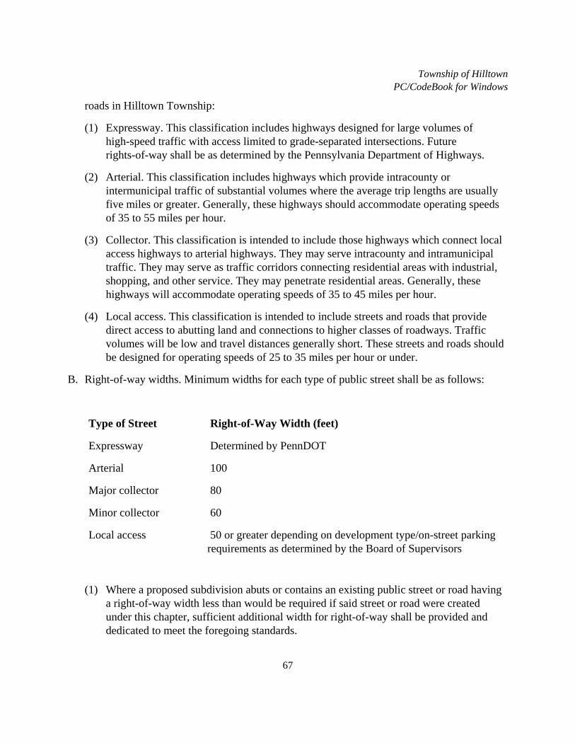
Township of HilltownPC/CodeBook for Windows
67
roads in Hilltown Township:
(1) Expressway. This classification includes highways designed for large volumes ofhigh-speed traffic with access limited to grade-separated intersections. Futurerights-of-way shall be as determined by the Pennsylvania Department of Highways.
(2) Arterial. This classification includes highways which provide intracounty orintermunicipal traffic of substantial volumes where the average trip lengths are usuallyfive miles or greater. Generally, these highways should accommodate operating speedsof 35 to 55 miles per hour.
(3) Collector. This classification is intended to include those highways which connect localaccess highways to arterial highways. They may serve intracounty and intramunicipaltraffic. They may serve as traffic corridors connecting residential areas with industrial,shopping, and other service. They may penetrate residential areas. Generally, thesehighways will accommodate operating speeds of 35 to 45 miles per hour.
(4) Local access. This classification is intended to include streets and roads that providedirect access to abutting land and connections to higher classes of roadways. Trafficvolumes will be low and travel distances generally short. These streets and roads shouldbe designed for operating speeds of 25 to 35 miles per hour or under.
B. Right-of-way widths. Minimum widths for each type of public street shall be as follows:
Type of Street Right-of-Way Width (feet)
Expressway Determined by PennDOT
Arterial 100
Major collector 80
Minor collector 60
Local access 50 or greater depending on development type/on-street parkingrequirements as determined by the Board of Supervisors
(1) Where a proposed subdivision abuts or contains an existing public street or road havinga right-of-way width less than would be required if said street or road were createdunder this chapter, sufficient additional width for right-of-way shall be provided anddedicated to meet the foregoing standards.

Township of HilltownPC/CodeBook for Windows
68
(2) Additional right-of-way and cartway widths may be required by the Board ofSupervisors to promote public safety and convenience when required by specialconditions and to provide parking space in areas of intensive use.
C. Street classification. Streets within Hilltown Township are classified as follows:
(1) Expressway: Route 309.
(2) Arterial: Bethlehem Pike, Route 113, and Route 313.
(3) Major collector: Callowhill Road, Route 152, Diamond Street, Hilltown Pike, andStump Road.
(4) Minor collector: Blooming Glen Road, Minsi Trail, Rickert Road, and Fairhill Road.[Amended 5-10-1999 by Ord. No. 99-4]
(5) Local access: all other roads not classified above as arterial, major collector, or minorcollector.
D. Cartway width.
(1) Minimum width of paving on existing streets shall not be less than the following:[Amended 5-23-2005 by Ord. No. 2005-1]
Type Cartway Width (feet)
Arterial 34 (or as required by PennDOT)
Major/minor collector 28 (or as required by PennDOT)
Local access 26 (28 if curb required)
(2) Residential streets. Proposed residential streets shall be constructed in accordance withthe following requirements:
Minimum Requirements1
Minimum Lot Size (square feet)
Row (feet)
Cartway (feet)
50,000 or greater 50 26 (28 when curb required)

Township of HilltownPC/CodeBook for Windows
69
Minimum Requirements1
Minimum Lot Size (square feet)
Row (feet)
Cartway (feet)
50,000 or less (parking permitted one side)2
56 32
50,000 or less (parking permitted both sides)2
60 36
NOTES: 1 The Township reserves the right to require additional cartway width.
2 On-street parking requirements determined by Board of Supervisors.
(3) Nonresidential streets. Nonresidential streets shall have a minimum right-of-way widthof 56 feet. Minimum cartway width shall be 34 feet.
E. Design standards. Design of streets shall conform with PennDOT Design Manual, Part 2,Highway Design (PDT Pub. 13), and all applicable PennDOT RC standards, unlessspecifically modified by this chapter.
F. Pavement design.
(1) All components of the pavement structure shall be designed and constructed inaccordance with Pennsylvania Department of Transportation Specifications, Form 408,and shall be noted as such on the plan.
(2) Minimum requirements. The following shall be considered to be minimum standards forlocal access street construction:
Section Type
Minimum Depth (Compacted)
(inches)
(1) Surface ID-2 Wearing Course 1 1/2
Base BCBC 4 1/2

Township of HilltownPC/CodeBook for Windows
70
Section Type
Minimum Depth (Compacted)
(inches)
Subbase 3A Modified Stone 6
Or
(2) Surface ID-2 Wearing Course 1
Base ID-2 Binder Course 2
Subbase AASHTO No. 1 Stone w/2-inchScreenings
8
Note: AASHTO No. 1 stone subbase required on new streets constructed withoutcurb. Subgrade shall be compacted and crowned with the required street crown andshall be prepared to PennDOT Specifications, Form 408. Structural fabric will berequired in locations deemed necessary by the Township Engineer.
(3) Pavement design for nonresidential streets shall be subject to approval of the TownshipEngineer dependent upon anticipated traffic type and volume.
(4) Minimum requirements for cartway widening cross sections along existing roadwaysshall be in accordance with Item (1) in the table under Subsection F(2).
(5) Minimum requirements for storm sewer and utility trench pavement restoration withinexisting roadways shall be in accordance with standards as contained in AppendixA.EN(14)
G. Roadside barriers. Roadside barriers and guide rail shall be required in accordance withPennDOT Design Manual, Part 2, Highway Design, Chapter 12. (PDT Pub. 13) Constructionand materials shall be in accordance with applicable PennDOT RC standards.
H. Traffic control. Vehicular traffic control in work zone areas on and along streets open to thepublic shall be in strict accordance to requirements of PennDOT Publication 203, Work Zone

Township of HilltownPC/CodeBook for Windows
71
Traffic Control (67 Pa. Code, Chapter 203).
I. Speed limit, no parking, and advisory signs shall be installed along new development streetsin accordance with PennDOT regulations, and as required by the Township. Street namesigns shall have six-inch high white lettering with green background conforming to designutilized by the Township Road Department. [Added 2-25-2002 by Ord. No. 2002-3; amended5-23-2005 by Ord. No. 2005-1]
J. Stop line markings shall be installed at all intersections of proposed public streets witharterial and major/minor collector streets and with other existing local streets wheredetermined necessary by the Township. Stop line markings shall be thermomastic white lines12 inches wide extending across the approach lane(s). Lines shall be placed four feet inadvance of and parallel to the nearest crosswalk line. Where marked crosswalks do not exist,the stop line shall be placed at the desired stopping point, but no more than 30 feet or lessthan four feet from the nearest edge of the intersection travelway. [Added 5-23-2005 by Ord.No. 2005-1]
K. Crosswalk marking shall be installed (where sidewalk exists or is proposed) at allintersections of proposed public streets with arterial and major/minor collector streets andwith other existing local streets where determined necessary by the Township, and wheremidblock pedestrian crossings are appropriate to connect trails, open space, communityfacilities, schools, and parking. Crosswalk markings shall consist of six-feet-long whitethermomastic longitudinal lines 24 inches wide, spaced 24 inches apart. Warning signs,flashing lights, advance stop lines (Stop Here For Crosswalk), and refuge islands must beevaluated with consideration given to site-specific issues such as roadway width, number oflanes and traffic volumes, and are required to be installed where deemed necessary by theTownship. [Added 5-23-2005 by Ord. No. 2005-1]
L. Patterned concrete crosswalks shall be installed on major pedestrian routes and internally onnew residential streets where determined necessary by the Township due to anticipatedpedestrian traffic volume and for traffic calming. Patterned concrete crosswalks shallconform to requirements of Appendix G and general concrete specifications of AppendixH.EN(15) [Added 5-23-2005 by Ord. No. 2005-1]
M. Traffic calming techniques shall be incorporated into design of all new residential streetsunless, upon review of the design plan and proposed calming, it is determined by the Boardof Supervisors that traffic calming is not warranted. Traffic calming measures and designguidelines shall be in accordance with Pennsylvania Department of TransportationPublication 383, dated January 2001, as amended. In particular, consideration should begiven to the following traffic calming techniques:
(1) Textured crosswalk.

Township of HilltownPC/CodeBook for Windows
72
(2) Raised crosswalk.
(3) Speed humps.
(4) Gateways.
(5) Curb extension/bulb outs.
§ 140-30. Cul-de-sac streets.
A. Cul-de-sac streets shall not be permitted unless the applicant can demonstrate to thesatisfaction of the Township that construction of a through street is not feasible. Applicantshall submit for review by the Township aerial mapping with tax map parcels identifiedwhich indicate the viability of potential future street construction to establish the throughstreet. [Amended 5-23-2005 by Ord. No. 2005-1]
B. Cul-de-sac streets shall be designed to permit future extension into adjacent undevelopedproperty. Unless future extension is clearly impractical or undesirable, the turnaroundright-of-way shall be placed adjacent to a property line and contained within an easementarea. A right-of-way of the same width as the street shall be carried to the property line insuch a way as to permit future extension of the street into the adjoining tract. At such time assuch a street is extended, the overage created by the turnaround outside the boundaries of theextended street shall revert in ownership to the property owners fronting on the cul-de-sacturnaround.
C. Permanent cul-de-sac streets shall be kept to a minimum and shall not exceed 500 feet inlength or serve as access to more than 12 dwelling units, whichever is more restrictive,unless specifically authorized by the Board of Supervisors. The minimum length of acul-de-sac shall be 250 feet. For the purpose of this chapter, cul-de-sac streets shall bemeasured from the intersection of the right-of-way line with the future right-of-way line ofthe existing street to the center of the turnaround area.
D. Cul-de-sac streets shall be provided with a turnaround at the closed end designed with alandscaped island in accordance with Appendix I and J.EN(16) The landscaping/planting planfor the island area is subject to approval by the Township but shall consist of deciduousand/or evergreen trees and shrubs; and berms/boulders and/or walls/planting beds. Theoutside three feet shall be planted as lawn with four inches of topsoil placed on eight inchesof 3A stone base. [Amended 5-23-2005 by Ord. No. 2005-1]
E. Commercial and industrial cul-de-sacs shall be reviewed for adequacy by the TownshipEngineer. When deemed necessary by the Township, additional cartway and/or right-of-wayradius may be required.

Township of HilltownPC/CodeBook for Windows
73
F. A snow storage area shall be provided along the right-of-way of the turnaround. The snowstorage area shall be contained within an easement not less than 15 feet measured from theright-of-way line, and of sufficient length as deemed necessary by the Township to provideadequate snow storage area.
G. P-loops (loop streets from a single access point) shall have an entrance leg not exceeding 500feet. The loop of a P-loop shall have a street length not exceeding 3,000 feet.
§ 140-31. Street alignment.
A. Whenever street lines are deflected in excess of 1 1/2°, connection shall be made byhorizontal curves. Long radial curves shall be used rather than a series of short curves andtangents.
B. The minimum radius at the center line for horizontal curves on collector and arterial streetsshall be 300 feet, and for local streets the minimum radius shall be 150 feet.
C. On local access streets, the minimum tangent between reverse curves shall be at least 100feet; on collector and arterial streets, the minimum tangent shall be at least 250 feet.
§ 140-32. Street grades.
A. The minimum center line grade on all streets shall be 0.75% on streets with curbs, 1% onstreets without curbs.
B. The maximum grade on collector or arterial streets shall be 7% and on local access streets10%.
C. Vertical curves shall be used in changes of grade exceeding 1% and shall provide propersight distance.
D. Minimum vertical sight distance shall be in accordance with PennDOT Chapter 441, asamended.
E. Maximum grade of proposed street within 50 feet of the ultimate right-of-way of an existingor proposed street shall not exceed 3%.
§ 140-33. Street intersections.
A. Local streets shall not intersect with collector or arterial streets on the same side at intervalsof less than 800 feet as measured from center line to center line.

Township of HilltownPC/CodeBook for Windows
74
B. The distance between center lines of streets opening onto the opposite side of a proposed orexisting street shall be not less than 150 feet unless the streets are directly opposite eachother.
C. Multiple intersections involving the junction of more than two streets shall not be permitted.
D. Proposed street intersections shall be designed at right angles. The intersection of a newstreet with an existing street shall not be at an angle of less than 75°, except that allintersections with an arterial or collector street shall be at 90°.
E. Horizontal curves will not be permitted on a proposed street within 50 feet of the ultimateright-of-way of an existing or proposed street.
F. Minimum curb radius at the intersection of two local streets shall be at least 20 feet; andminimum curb radius at an intersection of a local street and a collector or arterial street shallbe at least 25 feet. [Amended 5-10-1999 by Ord. No. 99-4]
G. A clear sight triangle of 75 feet in all directions shall be provided and maintained at allintersections measured along the center line from the point of intersection. Nothing whichobstructs the vision of a motorist shall be permitted in this area.
H. Minimum horizontal and vertical sight distances shall be established in accordance withPennDOT Chapter 441, as amended.
§ 140-34. Driveways.
A. General.
(1) Driveways on corner lots shall be located no less than 60 feet from any streetintersection (measured from the intersection of the ultimate right-of-way lines). Sightdistance requirements for all residential and nonresidential driveways shall be inaccordance with PennDOT Chapter 441. [Amended 5-23-2005 by Ord. No. 2005-1]
(2) Driveways to corner lots shall gain access from the street of lower classification when acorner lot is bounded by streets of two different classifications as described herein. Acorner lot created by a proposed street and an existing street shall gain access to theproposed street.
(3) All driveways serving single-family dwellings, except shared driveways, shall be at leastfive feet from any side or rear lot line.
(4) All driveways serving single-family dwellings shall be a minimum of eight feet in widthwith a grade not to exceed 15%. Maximum change in grade at any location on the

Township of HilltownPC/CodeBook for Windows
75
driveway shall not exceed 8%.
(5) All single-family residential driveways shall be paved from the edge of cartway to theultimate right-of-way, or for a length of 15 feet, whichever is greater using the followingminimum standards:
(a) A crushed aggregate base course with a compacted depth of six inches.
(b) A bituminous binder course (ID-2) with a compacted depth of 1 1/2 inches.
(c) A bituminous wearing course (ID-2) with a compacted depth of one inch.
(d) In the case where sidewalks are provided, a concrete driveway apron shall berequired.
(6) Where an existing roadside drainage swale is too shallow to permit installation of adriveway pipe, a paved swale may be installed conforming to requirements of PennDOTChapter 441 unless the anticipated depth of flow across the driveway exceeds 1/2 inchduring the ten-year return storm. Where the anticipated depth of flow across thedriveway exceeds 1/2 inch during the ten-year return storm, a concrete trench box withsteel grate must be installed. Grates must be recessed below edge of cartway to establisha minimum 2% slope from the cartway to the grate. Trench boxes must extend beyondedge of driveway paving a minimum five feet. [Amended 5-23-2005 by Ord. No.2005-1]
(7) Driveway pipes.
(a) Driveway pipes must include flared end sections.
(b) End of pipes must extend a minimum of five feet beyond edge of paving.
(c) Minimum pipe length is 20 feet.
(d) Minimum pipe size shall be 12 inch round or 14 inches by nine inches arch.
(e) Pipe must be corrugated metal except when reinforced concrete pipe is required bythe Township.
(f) Minimum nine inches of cover must be maintained between top of pipe and finishedpaving elevation.
(8) Intersection of single-family driveways with cartways shall be installed with minimumpaving radii of five feet at both sides.
(9) Where curb and sidewalk are required, concrete aprons shall be poured with a minimumthickness of six inches on a minimum four-inch-thick bedding of PennDOT 2B stone.
Township of HilltownPC/CodeBook for Windows
76
All concrete shall be PennDOT Class "AA" 3750 psi mix. One-half-inch expansion shallbe placed between apron and curb. One-fourth-inch score contraction joints shall beinstalled at 1/3 intervals.
B. Shared residential driveways.
(1) Minimum driveway width shall be 18 feet within the street ultimate right-of-way.
(2) Entrance must be paved in accordance with Subsection A(5) within the ultimateright-of-way or for a minimum length of 20 feet (whichever is greater).
(3) Intersection of driveways with cartways shall be installed with minimum paving radii of10 feet at both sides.
(4) Driveways must be centered on property lines.
C. Nonresidential driveways.
(1) Design requirements shall be in accordance with PennDOT Chapter 441.
(2) Driveways shall be paved. Design of paving section shall be in accordance withexpected loading and frequency of loading. Minimum paving specification shall be inaccordance with Subsection A(5), except that minimum compacted depth of the coarseaggregate base course must be eight inches.
§ 140-35. Curbs.
A. Curbs shall be installed on all streets and parking areas located within multifamily andapartment building developments. Curbs shall also be required on new residential streets insubdivisions or land developments in which the minimum lot size is less than 50,000 squarefeet, where on-street parking is required by the Township, and all new nonresidential streets.Curbs may also be required on all streets in any subdivision in which the lot areas exceed theabove minimum, when the center line street grade of any street exceeds 6%; and along allexisting streets where deemed necessary by the Township. In such cases curbs or otherdrainage controls shall be installed to properly control surface drainage and protect thestreets from erosion. The requirement of the curbs may be waived at the discretion of theBoard of Supervisors.
B. All curbs shall be depressed at intersections to sufficient width to accommodate wheelchairsand shall be in accordance with the latest PennDOT and Americans with Disabilities Act(ADA) standards.
C. Curbing shall be plain cement concrete curb, 18 inches in depth, placed and finished inaccordance with requirements set forth in the latest edition of PennDOT Specifications, Form
Township of HilltownPC/CodeBook for Windows
77
408. Concrete shall conform to specifications contained in Appendix H. After completion ofthe bituminous paving, Class BM-1 asphalt shall be applied to the joint between the curb andbituminous paving for a distance of one foot from the curb toward the center of the road toseal the joint between the curb and bituminous paving. [Amended 5-23-2005 by Ord. No.2005-1]
D. As an alternate to concrete curb, Belgian block curb may be used where authorized by theTownship. Belgian block curb must be installed in accordance with the construction detailincluded in Appendix A.
E. Curb cuts (driveway depression) shall be a maximum of 1 1/2 inches above roadway surface,a minimum of one inch above the roadway surface, and a minimum of 14 feet in width.
F. Profile of curb design along existing streets shall be shown on the plan. Profiles shall besmooth and designed with vertical curves where there is a change in grade. Breaks in gradeshall not be permitted. Existing edge of road and bottom of curb elevations shall be identifiedevery 50 feet and at locations specified by the Township Engineer. Minimum cross-slope forcartway widening sections shall be 3/8 inch per foot to establish positive drainage from theexisting edge of road to the curbline.
§ 140-36. Sidewalks.
A. Sidewalks are required along both sides of all existing streets unless waived by the Board ofSupervisors. Sidewalks are also required on all new residential streets where curbing isrequired.
B. Sidewalks shall be located within a public right-of-way, public easement, or common openspace area. Any such system shall be interconnected and not disjointed.
C. All sidewalks located within the street right-of-way shall be located in such a manner as toprovide sufficient area for street trees.
D. The minimum width of all sidewalk and pedestrian paths shall be four feet wide forresidential developments and six feet wide for commercial/industrial areas. [Amended2-25-2002 by Ord. No. 2002-3]
E. Sidewalks shall have a minimum depth of four inches and shall be placed on afour-inch-thick bed of PennDOT 2B stone base. Concrete driveways, driveway aprons, andsidewalks that will provide access for vehicles shall have a minimum concrete depth of sixinches reinforced with wire mesh, and placed on a six-inch-thick bed of PennDOT 2B stonebase. Concrete shall conform to specifications contained in Appendix H.EN(17) [Amended5-23-2005 by Ord. No. 2005-1]

Township of HilltownPC/CodeBook for Windows
78
F. Sidewalks shall not exceed a ten-percent grade. All sidewalks shall be finished usingmethods that will provide a skid-resistant surface.
G. Curb depressions designed to accommodate wheelchairs shall be provided at street and othercrossings and shall be in accordance with the latest PennDOT and Americans withDisabilities Act (ADA) standards. Detectable warnings, 24 inches in width (in the directionof travel) shall extend the full width of the curb ramp and be located so that the edge nearestthe curbline is between six and eight inches from the curbline. Detectable warnings shallconsist of raised truncated domes with a diameter of nominal 0.9 inches, a height of nominal0.2 inches and a center to center spacing of nominal 2.35 inches, and shall contrast visuallywith adjoining surfaces. (Refer to ADA Guidelines Section 4.29) [Amended 5-23-2005 byOrd. No. 2005-1]
H. Sidewalks shall be laterally pitched at a slope of 1/4 inch per foot to provide for adequatesurface drainage.
I. Pedestrian and bike paths within open space and recreational facilities shall be concrete,asphalt, wood chips or stone, subject to approval by the Board of Supervisors. Width anddesign of cross sections shall be subject to approval by the Township Engineer. Maximumcenter line grade of pedestrian paths shall be 7%. Design center line profile of pedestrianpaths shall be shown on the plan. Vertical curves must be designed for changes in grade.Breaks in grade are not permitted. Horizontal curves must be designed for changes indirection. Location of the pedestrian path center line must be defined by detailed bearing anddistance information. Where pedestrian paths are designed for combined use with bicycles,center line grades and curves shall be designed as specified by the Township Engineer.
§ 140-37. Landscaping and street trees.
A. Street trees and landscaping.
(1) Street trees shall be planted along all existing and proposed streets within any landdevelopment or major subdivision where suitable street trees do not exist.
(2) Large deciduous street trees selected from § 140-37A shall be planted at intervals of notmore than 40 feet. Small deciduous street trees selected from § 140-37A shall be plantedat intervals of not more than 25 feet. All trees must be selected and coordinated toprovide adequate separation from overhead and underground utilities. [Amended5-23-2005 by Ord. No. 2005-1]
(3) Street trees shall not be planted opposite each other, but shall alternate.
(4) Street trees shall be planted within the street right-of-way unless otherwise approved by
Township of HilltownPC/CodeBook for Windows
79
the Township.
(5) At the time of installation, the minimum trunk diameter of canopy trees measured at aheight of six inches above finished grade shall be 2 1/2 inches.
(6) Any plant material which does not survive shall be replaced by the developer. Financialsecurity shall be posted with the Township in an amount equal to the estimated cost oftrees and plantings, to be released 18 months from Township acceptance of theinstallation and satisfactory replacement of all dead plantings.
(7) The following plant material is permitted for use as tree plantings when placement iswithin four feet of curb, sidewalk, or asphalt surface: [Amended 2-25-2002 by Ord. No.2002-3; 5-23-2005 by Ord. No. 2005-1]
Large Deciduous Trees
Acer rubrum - Red Maple
Acer x freemanii "Armstrong" - Armstrong Freeman Maple
Cercidiphyllum japonicum tree form - Katsura Tree
Fraxinus americana - White Ash
Fraxinus pennsylvanica - Green Ash
Ginko biloba - Maidenhair Tree (male only)
Gleditsia triacanthos - Honeylocust (thornless only)
Liquidambar styraciflua - Sweet-Gum
Tilia cordata - Littleleaf Linden
Zelkova serrata - Japanese Zelkova
Small Deciduous Trees
Acer campestre - Hedge Maple
Acer ginnala (tree form) - Amur Maple

Township of HilltownPC/CodeBook for Windows
80
Small Deciduous Trees
Acer tataricum (tree form) - Tatarian Maple
Amelanchier laevis (tree form) – Serviceberry
Carpinus caroliniana (tree form) - American Hornbeam
Crataegus - Hawthorn (thornless only)
Syringa reticulata (tree form) - Japanese Tree Lilac
Note: Additional tree species may be utilized if approved by the Township.
(8) The following plant material is permitted for use as tree plantings when placement isgreater than four feet from curb, sidewalk, or asphalt surface.
Acer rubrum - Red Maple (all cultivars)
Acer saccharum - Sugar maple (all cultivars)
Fraxinus americana - White Ash (all cultivars)
Fraxinus pennsylvania - Green Ash
Ginko biloba - Ginko (male only)
Platanus x acerifolia - London Planetree
Quercus acutissima - Sawtooth Oak
Quercus imbricaria - Shingle Oak
(9) In addition to plant material included in Subsection A(7) and (8) above, the followingmay be utilized where required for buffer yards, detention basins, parking areas, openspace planting, etc.:
(a) Small trees.

Township of HilltownPC/CodeBook for Windows
81
Acer buergeranum tree form - Trident Maple
Acer ginnala tree form - Amur Maple
Acer griseum tree form - Paperback Maple
Acer tataricum tree form - Tatarian Maple
Amelanchier laevis tree form - Serviceberry (all cultivars)
Carpinus betulus -- European Hornbeam
Cercis canadensis tree form -- Eastern Redbud
Cornus kousa tree form -- Kousa Dogwood
Crataegus (many species) -- Hawthorn (thornless only)
Magnolia x loebneri "Merrill" -- Merrill Magnolia
Malus "Centzam" tree form -- Centurion Crabapple
Malus "Hargozam" tree form -- Harvest Gold Crabapple
Malus "Snowdrift" tree form -- Snowdrift Crabapple
Malus "Spring Snow" tree form -- Springsnow Crabapple
Malus x zumi "Calocarpa" tree form -- Redbud Crabapple
Prunus serrulata tree form -- Kwanzan oriental cherry
Pyrus betulifolia -- Birchleaf Pear
Sorbus (many species/hybrids) -- Mountain Ash
Syringa reticulata "Ivory Silk" -- Ivory Silk Japanese Tree Lilac
(b) Large trees.
Acer nigrum - Black Maple
Acer saccharum - Sugar Maple (all cultivars)

Township of HilltownPC/CodeBook for Windows
82
Aesculus hippocastanum "Baumannii" - Bauman Horse Chestnut
Aesculus x carnea "Briotii" - Ruby Red Horse Chestnut
Betula nigra - River Birch
Liquidambar styraciflua - Sweetgum
Liriodendron tuliptree - Tuliptree
Magnolia acuminata - Cucumbertree
Ostrya virginiana tree form - American Hophornbeam
Quercus macrocarpa - Bur Oak
Quercus palustris - Pin Oak
Quercus phellos - Willow Oak
Quercus rubra - Northern Red Oak
Tillia americana - American Linden
Tillia tomentosa - Silver Linden
(c) Evergreens (four feet high minimum).
Ilex opaca -- American Holly
Picea abies -- Norway Spruce
Picea omorika -- Serbian Spruce
Picea pungens -- Colorado Spruce
Pinus nigra -- Austrian Pine
Pinus strobus -- White Pine
Pseudotsuga menziesli -- Douglas Fir
Tsuga canadensis -- Canada Hemlock

Township of HilltownPC/CodeBook for Windows
83
(d) Hedge (four feet high minimum).
Crataegus intricata -- Thicket Hawthorn
Forsythia intermedia -- Border Forsythia
Rhamnus frazula columnaris -- Tallhedge Buckthorn
Syringa chinensis -- Chinese Lilac
Syringa vulgaris -- Common Lilac
Viburnum alatus -- Viburnum
(e) Hedgerow (four feet high minimum).
Crataegus crus-galli -- Cockspur Thorn
Crataegus phaenopyrum -- Washington Hawthorn
Elaeagnus angustifolia -- Russian Olive
Viburnum sieboldii -- Siebold Viburnum
Viburnum tomentosum -- Doublefile Viburnum
(f) Shrubs (three feet high minimum).
Juniperus virginiana -- Upright Juniper
Phracantha lalandi -- Laland Firethorn
Taxus capitita -- Upright Yew
Taxus hicksi -- Hicks Yew
Thuja occidentalis -- American Arborvitae

Township of HilltownPC/CodeBook for Windows
84
(g) Shrubs (four feet high minimum).
Hamamelis vernalia - Vernal Witch Hazel
Hamamelis virginiana - Common Witch Hazel
Ilex verticillata - Winterberry
Rhamnus frangula - Glossy Buckthorn
Viburnum dentatum - Arrowwood Viburnum
Viburnum lantana - Wayfaring tree Viburnum
(h) Note: Additional trees and other plant material and cultivars may be utilized whenapproved by the Township.
(10) Plant material specifications:
(a) Name of plants shall agree with the nomenclature of "Standard Plant Names" asadopted by American Joint Committee on Horticulture Nomenclature, 1942 editionas amended; size and grading standards shall conform to those specified by theAmerican Association of Nurserymen in the latest edition of the "U.S.D.A.Standards for Nursery Stock." No substitutions shall be permitted except by writtenpermission of the Township.
(b) Quality. All plants shall be typical of their species or variety; and shall have normal,well-developed branches and vigorous fibrous root systems. All plants shall benursery-grown unless otherwise stated; they shall have been growing under the sameclimate conditions as the municipality for at least two years prior to date of planting.All plants which are found unsuitable in growth or condition or which are not true toname shall be removed and replaced with acceptable plants.
(c) Preparation of plants. All precautions customary in good trade practice shall betaken in preparing plants for moving. All balled and burlapped plants shall be dug tomeet or exceed the "U.S.D.A. Standards for Nursery Stock."
(d) Delivery. Plants shall be packed, transported and handled with utmost care to insureadequate protection against injury.
B. Landscaping of off-street parking areas:
(1) Within the parking facility there shall be planted at least one tree of 2 1/2 inches caliper

Township of HilltownPC/CodeBook for Windows
85
minimum for every five parking spaces in single bays and one tree of 2 1/2 inchescaliper minimum for every 10 parking spaces in double bays. Trees shall be planted insuch a manner to afford maximum protection from the sun for parked vehicles.
(2) A minimum of 10% of any parking lot facility over 2,000 square feet in gross area shallbe devoted to landscaping, inclusive of required trees.
(3) The perimeter of all parking facilities shall be landscaped with one or any combinationof the following buffers in order to visually screen the vehicles:
(a) One eighteen-inch- to twenty-four-inch-tall shrub per each three feet of buffer;
(b) One four- to four-and-one-half-foot-high berm;
(c) One five-foot-high wooden or stockade type fence.
(4) All plantings shall be able to survive soot, gas fumes and salt. Trees which have lowgrowing branches, gum or moisture which may drop on vehicles, blossoms, thorns,seeds or pods which may clog drainage facilities shall be avoided. The plantings chosenshould be of sufficient size to be effective the first year they are planted.
(5) All landscape planting areas shall be raised in order to prevent road salts from seepinginto the planting area.
C. Detention basin landscaping:
(1) Within any detention basin, one of the following seed mixtures shall be used:
(a) Crownvetch establishment (legume).
Crownvetch, plus 20 pounds/acre
Tall fescue, plus nurse grass (use one) 25 pounds/acre
Annual ryegrass, or 30 pounds/acre
Perennial ryegrass 30 pounds/acre
(b) Birdsfoot trefoil establishment (legume).
Birdsfoot trefoil, plus 8 pounds/acre

Township of HilltownPC/CodeBook for Windows
86
Tall fescue, plus nurse grass (use one) 25 pounds/acre
Annual ryegrass, or 30 pounds/acre
Perennial ryegrass 30 pounds/acre
(c) Deertongue grass establishment (legume).
Deertongue grass, plus Companion (use one) 10 pounds/acre
Tall fescue, or 25 pounds/acre
Birdsfoot trefoil, plus nurse grass (use one) 6 pounds/acre
Annual ryegrass or 30 pounds/acre
NOTE: Deertongue grass establishment may be maintained as turf grass andused for recreational purposes. Crownvetch shall be permitted for use innonresidential developments only.
(2) Preferred varieties.
Deertongue grass -- Tioga
Tall fescue -- Ky. 31
Perennial Ryegrass - Pennfine or Manhattan
Crownvetch -- Penngift
Birdsfoot trefoil - 50-50 mixture of Empire and either Maitland or Viking
Since other seed varieties may be equally suited to perform the purpose of themixture stated in this chapter, or the preferred seeds may not always be readilyavailable, other seed varieties of equal quality will be acceptable upon approval by theTownship.

Township of HilltownPC/CodeBook for Windows
87
(3) On the perimeter of any detention basin, one tree shall be planted per each 40 lineal feetof perimeter arranged in an informal manner. Trees shall not be installed on fillembankment areas of the berm.
(4) Existing vegetation. In cases where natural features existing on the site duplicate oressentially duplicate the requirements of the street tree, buffering, or landscapingprovisions of this chapter, these requirements may be waived by the Board ofSupervisors.
D. Protection of existing plant material.
(1) All subdivisions and land developments shall be laid out in such a manner so as topreserve healthy trees and shrubs on the site.
(2) During the construction of any site, trees and shrubs to be preserved shall be protectedby snow fencing, safety fencing, or silt fencing, to insure that there is no encroachmentwithin the area of their dripline by changing grade, trenching, stockpiling of buildingmaterials or topsoil, or the compaction of the soil and roots by any motor vehicle unlessthe following regulations are met:
(a) The grade of land within the entire area of dripline shall not be raised more than sixinches unless tree wells are constructed around each trunk or group of trunks andaeration pipes are extended out to the edge of the dripline.
(b) Tree wells are to be constructed of uncemented stone, or any other suitable material.Such walls shall be a minimum of three feet in diameter or one foot in diameter foreach inch in caliper measured 12 inches above natural ground level, whichever isgreater; and shall be a maximum of three feet deep.
(c) Retaining walls are to be constructed around each tree or group of trees immediatelyafter any grade is lowered within the area of the dripline. This retaining wall is to beconstructed of eight-inch-by-eight-inch pressure treated landscape ties or any othersuitable material. Retaining walls must be designed and constructed to withstandoverturning and frost heave.
(3) If any plant material is to be moved, it must be done in accordance with specificationsset forth by the American Association of Nurserymen.
(4) All diseased or dead trees shall be promptly removed from the site. All trees to bepreserved shall be pruned when necessary to remove dead limbs.
(5) Any grading within 10 feet of tree trunks must be done by hand. No equipment is to bedriven over this area and no building materials are to be stacked against the trees or

Township of HilltownPC/CodeBook for Windows
88
within the area of this barrier.
(6) No tree is to support any scaffolding, signs, temporary utilities, surveying spikes, or anyother device.
(7) If topsoil is to be stockpiled, it shall be located in an area at least 10 feet from any treedesignated to remain, and shall in no case be removed from the site.
(8) Those trees whose removal will damage other trees which are to remain must beremoved by hand. The resulting stumps must be carefully removed to minimize damageto roots and trunks of other trees.
(9) Trees damaged during construction.
(a) Tree trunks and exposed roots damaged during construction shall be protected fromfurther damage. Damaged branches shall be pruned according to National ArboristAssociation standards. All cuts shall be made sufficiently close to the trunk or parentlimb but without cutting into the branch collar of leaving a protruding stub. Allnecessary pruning cuts must be made to prevent bark from being torn from the treeand to facilitate rapid healing.
(b) All trees which have been disturbed or have experienced damage to their roots orbranches shall be fertilized in early fall or mid-spring. Fertilizer grade shall haveapproximately three parts nitrogen to one part phosphorus and potassium (3-1-1ratio). Fertilizer shall be broadcast over the soil surface in an area twice the size ofthe tree protection zone at a rate of one pound of nitrogen per 1,000 square feet.
(10) Stumps, branches and other wood debris shall not be buried on site. Where trees areremoved outside of an area to be excavated, it is preferred that stumps be removed bygrinding to a point six inches below existing grade.
(11) Cut trees shall not be pushed or pulled into an area where trees are to be retained.
§ 140-38. Stormwater management. [Amended 5-10-1999 by Ord. No. 99-4; 5-22-2000 byOrd. No. 2000-6]
All subdivisions and land developments shall comply with Chapter 134, StormwaterManagement, as amended. Requirements of Chapter 134, Stormwater Management, shall be inaddition to, and not in lieu of, requirements set forth within § 140-38 of this chapter.
A. General requirements.
(1) Lots shall be laid out and graded with a minimum slope of 2% to provide positivedrainage away from buildings. The Township may require a grading and drainage plan

Township of HilltownPC/CodeBook for Windows
89
for individual lots indicating a buildable area within each lot, complying with thesetback requirements, for which positive drainage is assured.
(2) On-lot drainage swales shall be designed to provide positive conveyance of surfacewater from the individual lot. Each swale lot shall convey stormwater from the lot to astorm sewer system, street, open space area, or stormwater management easementwithout crossing or combining with stormwater from more than the adjacent lot.
(3) Drainage swales necessary to control surface drainage between lots shall be centeredabout the common property line.
(4) No person, corporation, or other entity shall block, impede the flow, alter, construct anystructure, or deposit any material or thing, or commit any act which will affect normal orflood flow in any stream or watercourse without having obtained prior approval from theTownship and/or Department of Environmental Protection, whichever is applicable.
(5) Whenever a watercourse, perennial stream or intermittent stream is located within adevelopment site, it shall remain open in its natural state and location, and shall not bepiped (except for road crossings). It is the responsibility of the developer to stabilizeexisting eroded stream/channel banks.
(6) Where a subdivision or land development is traversed by a natural watercourse, thereshall be provided a drainage easement or right-of-way conforming substantially with theline of such watercourse. The width of the easement shall be adequate to provide forunimpeded flow of stormwater runoff from the one-hundred-year return storm eventbased upon existing topography. Terms of the easement shall prohibit excavation, theplacing of fill or structures, and any alterations which may adversely affect the flow ofstormwater runoff within any portion of the easement. Periodic maintenance of theeasement to ensure proper runoff conveyance shall be required by the landowner.[Amended 2-25-2002 by Ord. No. 2002-3]
(7) Existing points of concentrated drainage discharge onto adjacent property shall not bealtered without written approval of the affected property owner(s).
(8) Areas of existing diffused drainage discharge onto adjacent property shall be managedsuch that, at a minimum, the peak diffused flow does not increase in the generaldirection of discharge, except as otherwise provided in this section. If diffused flow isproposed to be concentrated and discharged onto adjacent property, the developer mustdocument that there are adequate downstream conveyance facilities to safely transportthe concentrated discharge or otherwise prove that no harm will result from theconcentrated discharge.
(9) Any drainage facilities required by this section that are located on, or discharge to, astate highway rights-of-way shall be subject to approval by the Pennsylvania

Township of HilltownPC/CodeBook for Windows
90
Department of Transportation.
(10) Storm drainage facilities and appurtenances shall be so designed and provided as tominimize erosion in swales, watercourse channels and at all points of discharge.
(11) Minimization of impervious surfaces and infiltration of runoff through seepage beds,infiltration trenches, etc., are encouraged, where soil conditions permit, to reduce thesize or eliminate the need for retention/detention facilities.
(12) Roof drains and sump pumps shall be discharged to a natural watercourse, drainageswale, or stormwater easement. Roof drains and sump pumps shall not be connected to astorm sewer or street unless designed as part of a stormwater management facility withina proposed development. In no case shall roof drains or sump pumps be connected to asanitary sewer.
B. Storm drainage system requirements.
(1) Any proposed storm drainage plans which affect the drainage basin in any stream orwatercourse shall be approved by the Division of Dams and Waterway Management ofthe Pennsylvania Department of Environmental Protection in accordance with the Title72, Chapter 105, as amended.
(2) Easements.
(a) Easements shall be dedicated to the Township along all natural or man-made streamsand watercourses and/or stormwater management facility areas within a subdivisionor land development. These easements shall be of sufficient width to convey aone-hundred-year design storm. Easements shall be provided where storm drainageswales, culverts, or other structures traverse, enter or discharge onto privateproperty. On private property, the entire easement area and fencing and landscaping(if any) shall be maintained by the property owner. The Township shall not maintainand/or repair any improvements within that easement unless stormwater runoff frompublic roads or public land crosses through the easement. If stormwater runoff frompublic roads or public lands cross through the easement, the Township shall, uponsatisfactory installation of improvements as specified in a developer's improvementagreement and maintenance agreement, maintain and repair only the structuralstormwater management improvements within the easement such as:
[1] Piping.
[2] Inlets.
[3] Outlet, headwalls.
Township of HilltownPC/CodeBook for Windows
91
[4] Energy dissipation structures or facilities.
[5] Stormwater management facility control structures.
(b) The landowner shall be responsible for all other maintenance and repairs within thiseasement. For example, the landowner must:
[1] Mow the lawn.
[2] Repair or replace fencing.
[3] Repair or replace landscaping.
[4] Control vermin and repair damage from animals.
[5] Keep the area free of obstructions, structures, vegetation, or accumulatedsediment that may block or hinder the function and purpose of the easement.
[6] Keep the area free of litter or garbage.
[7] Repair erosion and restore vegetation as necessary to keep the easement in goodrepair.
(3) Storm sewers, culverts, and related installations shall be provided to permit the flow ofnatural watercourses, to ensure the drainage of all low points (except in protected"wetlands") on the subdivided lots or developed land areas and along the line of streets,and to intercept stormwater runoff along the streets at intervals related to the extent andgrade of the area drained. The system shall also be designed to accommodate or receiveand discharge all runoff from adjacent upstream properties. Where adequate existingstorm sewers are readily accessible, the developer must connect new stormwaterfacilities to the existing system.
(4) Flood protection. No stormwater runoff or natural drainage water shall be so diverted asto overload existing drainage systems, or create flooding or the need for additionaldrainage structures on other private properties or public lands, without proper andapproved provisions being made to address these conditions.
(5) Whenever the location of concentrated runoff from a site is changed due todevelopment, the developer must secure written approval from any adjacent downstreamproperty owners. The developer shall indemnify and/or hold harmless the Townshipagainst any claim of damage from any downstream property owners that may result fromthe proposed development.
(6) Scour and erosion prevention. In areas in which the street curbs are not required byeither this chapter or by the Township, drainage may be accomplished by natural orartificial swales and culverts. Special structures such as check dams, drop-outlets,

Township of HilltownPC/CodeBook for Windows
92
concrete flow channels, or other energy dissipating structures, rip-rap or nondegradablegeotextile linings, may be required to prevent scour or erosion in locations with largerunoff quantities or steep slopes. Bituminous paved swales will not be permitted.
(7) All proposed streets shall be designed so as to discharge surface water from theirrights-of-way. Storm drainage improvements as deemed necessary by the Townshipshall be required along all existing streets on which a subdivision or land developmentabuts.
(8) Design criteria. Unless a more conservative design is required by another regulation, oris required because of conditions particular to an individual development, the followingstorm criteria shall be used to design storm collection and conveyance systems:
Design Storm Return (years)
Fixed pipe 10
Total conveyance 100
(9) Design preparation. Designs of storm drainage systems shall be prepared by a licensedprofessional engineer. Complete detail calculations shall be submitted to the Townshipfor review. Calculations shall cover the entire drainage basin involved, includingconsideration of areas outside the proposed subdivision or developed land areas.
(10) Setback to boundaries. No piped storm sewer system outlet, detention basin, or energydissipation structure shall discharge closer than 20 feet from the boundary of anydrainage easement under the control of the developer or which may be utilized by thedeveloper, so as to allow for adequate space for stormwater dissipation in vegetated landareas controlled by or available to the developer and/or to allow adequate space forequipment access for future maintenance.
C. Collection system design.
(1) The collection system shall be designed by the Rational Method of Design in accordancewith American Society of Civil Engineers Manual No. 37 except where noted, using theformula Q = CiA, unless otherwise approved by the Township.
(a) Capacity: "Q" is the required capacity in cubic feet per second for the collectionsystem at the point of design.
(b) Runoff coefficient: "C" is the runoff coefficient applicable to the entire drainage

Township of HilltownPC/CodeBook for Windows
93
area. It shall be based on consideration of soil conditions, average slope of thedrainage area and the ultimate development of the entire drainage area according tocomprehensive plans. For the various types of ultimate development, the runoffcoefficient shall be taken from the table in Appendix CEN(18) unless sufficientengineering data has been presented to the Township Engineer by the developerwhich information in the judgment of the Township Engineer is sufficient to warrantthe use of an alternate runoff coefficient.
(c) Rainfall intensity formula: "i" is the rainfall intensity in inches per hour and shall bedetermined from rainfall intensity charts for this area, based on time ofconcentrations, including Overland Flow Time, Manning's Formulae for channelizedflow time and pipe flow time. The design rainfall frequency shall be taken from thePennDOT Intensity-Duration-Frequency Field Manual, Region 4 as presented inAppendix C.
[1] A five-minute storm duration shall be used if the duration does not result in amaximum expected discharge that exceeds the capacity of a thirty-inch pipe.
[2] If a five-minute storm duration results in a pipe size exceeding 30 inches, thetime of concentration approach shall be used in determining storm duration.
[3] If a five-minute storm duration results in a pipe size exceeding 30 inches, withinany run of pipe, the time of concentration approach may be used for sizing ofpipes from that point on by adjusting the time of concentration.
(d) Drainage area: "A" is the drainage area, in acres, tributary to the point of design, andshall include areas tributary from outside sources as well as from within thesubdivision or developed land area itself.
(2) Collection system standards.
(a) Curb inlets. Curb inlets shall be located at curb tangents on the uphill side of streetintersection, and at intervals along the curbline to control the maximum amount ofencroachment of runoff on the roadway pavement so that same does not exceed 1/2of the traveled lane width during the design storm event. Design and location of curbinlets shall be approved by the Township.
(b) State approvals. Drainage structures that are located on state highway rights-of-wayshall be approved by the Pennsylvania Department of Transportation, and a copy ofthe highway occupancy permit shall be submitted to the Township.
(c) Pipe materials. All storm piping shall be Class III reinforced concrete pipe, exceptwhen pipe class and strength is required to be increased in accordance withPennDOT Specifications. Piping shall be saw-cut at ends, as needed, and not

Township of HilltownPC/CodeBook for Windows
94
hammered or broken. All pipe joints and lift holes must be mortared.
(d) Minimum pipe size. Minimum pipe size shall be 18 inches.
(e) Inlet and manhole construction. Inlet and manhole castings and concreteconstruction shall be equivalent to Pennsylvania Department of TransportationDesign Standards.
(f) Roof drainage. Stormwater roof drains and pipes shall not discharge water oversidewalks or walkways.
(g) Open end pipes must be fitted with concrete endwalls or wing walls in accordancewith PennDOT Standards.
(h) Open culvert endwalls or wing walls for pipes larger than 18 inches in diameter andlonger than 60 feet in length shall be fitted with durable protective grates. Design ofprotective grates is subject to approval by the Township.
(i) Flow velocity. Storm drains shall be designed to produce a minimum velocity of 3.0feet per second when flowing full. The maximum permissible velocity shall be 15.0feet per second. However, in no case shall the pipe slope be less than 0.5%.
(j) Inlets and manholes shall be spaced at intervals not exceeding 300 feet, and shall belocated wherever branches are connected or sizes are changed, and wherever there isa change in alignment or grade. For drainage lines of at least 36 inches diameter,inlets and manholes may be spaced at intervals of 400 feet. Manholes shall beequipped with open grate lids.
(k) Storm sewer bedding/backfill requirements shall conform to the construction detailsincluded in Appendix A.EN(19)
(l) Inlets shall be located to intercept concentrated runoff prior to discharge overpublic/private rights-of-way, sidewalks, streets, and driveways.
(m) The capacity of all inlets shall be based on a maximum surface flow to the inlet of4.0 cfs, calculated based on the design storm event. The maximum flow to inletslocated in low points (such as sag vertical curves) shall include the overland flowdirected to the inlet as well as all bypass runoff from upstream inlets. The bypassflow from upstream inlets shall be calculated using inlet efficiency curves includedin PennDOT Design Manual Part 2, latest edition. If the surface flow to in inletexceeds 4.0 cfs, additional inlets shall be provided upstream of the inlet to interceptthe excessive surface flow.
(n) A minimum drop of two inches shall be provided between the inlet and outlet pipeinvert elevations within all inlets and manholes. When varying pipe sizes enter an

Township of HilltownPC/CodeBook for Windows
95
inlet or manhole, the elevation of the crown of all pipes shall be matched.
(o) Storm sewer pipes shall have a minimum of 12 inches of cover over the bell of thepipe, and in no case shall any part of the pipe project into the road subbase or curb.Where cover is restricted, equivalent pipe arches may be specified in lieu of circularpipe.
(p) The capacity of all storm sewer pipes shall be calculated utilizing the ManningEquation for open channel flow as applied to closed conduit flow. The Manning'sroughness coefficient shall be 0.13 for all concrete pipe. In cases where pressureflow may occur, the hydraulic grade line shall be calculated throughout the stormsewer system to verify that at least one foot of freeboard will be provided in all inletsand manholes for the design storm event.
(q) Culverts shall be designed based on procedures contained in Hydraulic Design ofHighway Culverts, HDS No. 5, U.S. Department of Transportation, FederalHighway Administration.
(r) Storm sewer structures (i.e., endwalls, inlets, end sections, etc.) may not be locatedon top of or within 10 feet of electric, water, sanitary sewer, and gas services and/ormains, unless approval is received from the Township, and from the authority orutility having jurisdiction over same.
(s) Storm sewer pipes must be oriented at right angles to electric, water, sanitary sewer,and gas utilities when crossing above or beneath same. Crossing angles of less than90° will only be permitted at discretion of the Township Engineer. When skewedcrossings are permitted, interior angles between alignment of the storm sewer pipeand utility may not be less than 45°. Vertical and horizontal design of storm sewermust be linear.
(t) Where a public storm sewer system is not located within a right-of-way, or dedicatedpublic property, a twenty-foot-wide easement shall be established to encompass thestorm sewer system. For multiple pipes or utilities, the width of the easement shallbe a minimum of 30 feet.
(3) Open swales and gutters. Open swales shall be designed on the basis of Manning'sFormula as indicated for collection systems with the following considerations:
(a) Roughness coefficient. The roughness coefficient shall be 0.040 for earth swales.
(b) Bank slopes. Slopes for swale banks shall not be steeper than one vertical for threehorizontal.
(c) Flow velocity. Design velocity in grass or vegetated swales shall not exceed four

Township of HilltownPC/CodeBook for Windows
96
feet per second.
(d) To minimize sheet flow of stormwater across lots located on the lower side of roadsor streets, and to divert flow away from building areas, the cross section of the streetas constructed shall provide for parallel ditches or swales or curbing on the lowerside which shall discharge only at drainage easements, unless otherwise approved bythe Township.
(e) Gutters and swales adjacent to road paving shall be permitted to carry a maximumflow of five cubic feet per second prior to discharge away from the street surface,unless it is proven to the satisfaction of the Township by engineering calculationsthat the road slopes or other factors would allow higher gutter or swale capacity.
(f) Flows larger than those permitted in gutters and roadside swales may be carried inswales outside the required road right-of-way in separate drainage easements, ormay be carried in pipes or culverts inside or outside the required road right-of-way.
(g) Swales shall be stabilized with vegetation or other materials, approved by theTownship, to prevent erosion.
(h) Swales shall be provided with underdrains as deemed necessary by the Townshipshould overland seepage result in potential maintenance problems for same.Underdrains must discharge into a natural drainage channel or storm sewer system.
(4) Bridges and culverts. Bridges and culverts shall be designed in accordance withPennsylvania Department of Transportation Construction Standards. Separate designplans and specifications shall be required for each bridge and culvert which plans andspecifications shall be subject to review and approval of the Township.
(5) HEC I and HEC II study shall be performed where it is necessary to determine the limitsof the one-hundred-year floodplain. Technical Paper No. 40, U.S. Department ofCommerce, "Rainfall Frequency Atlas of the United States," and NOAA TechnicalMemorandum NWS Hydro-35 shall be used to establish rainfall intensities for HECprograms. [Added 2-25-2002 by Ord. No. 2002-3]
§ 140-39. Excavation and grading. [Amended 5-22-2000 by Ord. No. 2000-6]
All construction wherein excavation, placement of fill, and/or grading activities are performedshall conform with the following general requirements:
A. No excavation or fill shall be made with a face steeper than three horizontal to one vertical,except under one or both of the following conditions:
(1) The material is sufficiently stable to sustain a steeper slope. A written statement to that

Township of HilltownPC/CodeBook for Windows
97
effect from a professional engineer licensed in the Commonwealth of Pennsylvania andexperienced in erosion control shall be submitted to the Township. The statement shallaffirm that the site has been inspected and the deviation from the slope restriction shallnot result in injury to persons or damage to property. A detail of the treatment of theslope (proposed grade, seeding, erosion protection, etc.), shall be submitted with theapplication.
(2) A concrete, masonry, or other approved retaining wall is designed by a registeredprofessional engineer licensed in the Commonwealth of Pennsylvania constructed tosupport the face of the excavation or fill.
B. If the vertical drop of an excavation or fill slope is greater than five feet, then the maximumslope shall not exceed four horizontal to one vertical.
C. The top or bottom edges of slopes shall be a minimum of five feet from property lines orright-of-way lines of streets in order to permit the normal rounding of the edge withoutencroachment on abutting property.
D. Adequate provision shall be made to prevent surface water from damaging the cut face ofexcavation and the sloping surfaces of fills.
E. No person, corporation, or other such entity shall block, impede the flow of, alter, constructany structure, or deposit any material or thing or perform any work that will affect the normalor flood flow in any stream or watercourse without having obtained prior approval from theTownship and/or Department of Environmental Protection, whichever is applicable.
F. All lots, tracts, or parcels shall be graded to provide positive drainage away from buildingsand dispose of it without ponding, except where ponding (detention/retention facilities,swales, etc.) is part of the stormwater management plan for the site.
G. Concentration of surface water runoff shall be permitted only in swales, watercourses, orstormwater management facilities.
H. In no case shall grading be done in such a manner as to divert water onto the property ofanother landowner unless part of a stormwater management plan.
I. Earth disturbance/staging shall be in strict accordance with the approved grading anderosion/sedimentation control plan.
J. Areas of the site to remain undisturbed shall be protected from encroachment by constructionequipment/vehicles to maintain the existing infiltration characteristics of the soil.
K. The minimum depth of topsoil to be replaced shall be eight inches, or the existing depth oftopsoil encountered on the site, whichever is greater.

Township of HilltownPC/CodeBook for Windows
98
L. Topsoil shall not be removed from the development site. Topsoil shall be stripped,stockpiled, and redistributed on the site. Prior to plan approval, the applicant/designee shallprovide the Township with calculations to determine the volume of topsoil anticipated to bestripped, stockpiled, and replaced on the site to verify that excess topsoil will not begenerated as a result of construction activity.
M. During grading operations, necessary measures for dust control must be exercised.
N. No grading equipment shall be permitted to be loaded and/or unloaded on a paved publicstreet, and no grading equipment shall be permitted to travel on or across a public streetunless licensed for operation on public thoroughfares.
O. Grading equipment shall not be permitted to cross streams. Temporary crossings shall onlybe permitted where application is made to, and approval received from, PADEP (whereapplicable), Bucks Conservation District, and the Township.
P. No area designated as open space shall be used for storage of construction materials,construction trailers, sales trailers, or parking; or to stockpile fill or topsoil material uponoccupancy of 50% of the dwelling units within the development phase. Removal of suchmaterials/construction items shall be designated within the construction staging plan. [Added2-25-2002 by Ord. No. 2002-3]
§ 140-40. Erosion and sedimentation control.
A. An erosion and sedimentation control plan shall be submitted with all applications whereinexcavation, placement of fill, and/or grading activities are proposed. The plan shall include aconstruction staging narrative indicating the sequence of earthmoving activities, andproposed erosion and sedimentation control procedures. Measures used to control erosionand reduce sedimentation during construction activities shall strictly conform to thestandards and specifications of the Bucks Conservation District and sequence of earthmovingactivities. At a minimum, the following measures shall be included where applicable:
(1) Stripping of vegetation, regrading, or other activities shall be done in a way that willminimize erosion and resulting sedimentation.
(2) Cut and fill operations shall be kept to a minimum. Wherever feasible, naturalvegetation shall be retained, protected and supplemented.
(3) All erosion and sedimentation control measures shall be installed per the approved planprior to any earthmoving activities. Where a stormwater management basin is involved,the basin shall be constructed, functional, and stabilized prior to any additional siteactivity. An as-built plan of the facility prepared by a registered professional landsurveyor or engineer, licensed in the Commonwealth of Pennsylvania, shall be

Township of HilltownPC/CodeBook for Windows
99
submitted to the Township for review to verify adequate stage/storage capacity prior tocommencement of other site activity. Plan must include note stating the same.
(4) Disturbed earthen areas and duration of exposure shall be kept to a practical minimum,but shall not exceed 20 days. All disturbed soils and topsoil stockpile areas shall bestabilized as quickly as possible and, if necessary, seeded with temporary vegetation andmulched. If stockpile areas are located on sloping ground or near waters of thecommonwealth, same shall be enclosed with silt fencing.
(5) Permanent vegetation shall be installed as soon as practical on all sites.
(6) All runoff from project areas shall be collected and diverted to facilities for removal ofsediment.
(7) Runoff from a project area shall not be discharged into the waters of the commonwealthwithout means to prevent sedimentation.
(8) Sedimentation in the runoff water shall be trapped and filtered until the disturbed area isstabilized by the use of debris basins, sediment basins, silt traps, or similar measures.
(9) Sediment barriers shall be properly installed with silt fencing trenched and haybalesstaked.
(10) Tire cleaning areas constructed of AASHTO No. 1 stone and at least 50 feet in lengthshall be provided at each point of access to the site and individual lots (once internalstreets are constructed).
(11) During construction activities, necessary measures for dust control must be exercised.
(12) It shall be the responsibility of each person, corporation or other entity performinggrading and/or building activities to install and maintain erosion and sedimentationcontrols until the site is stabilized. In the event any mud and/or debris is transportedfrom the site onto a public roadway, the debris shall be removed and the roadway sweptand/or washed as deemed necessary by the Township at the owner's expense.
B. Design of energy dissipation for high volume and/or high velocity discharge from stormsewer pipes and channels shall be in accordance with Hydraulic Engineering Circular No. 14,"Hydraulic Design of Energy Dissipaters for Culverts and Channels" as published byDepartment of Transportation, FHA, when deemed necessary by the Township Engineer, andas approved by the Bucks Conservation District.
C. Design of Reno mattress and gabions shall be in accordance with any of the followingpublications:
(1) "Flexible Linings In Reno Mattress and Gabions for Canals and Canalized Water

Township of HilltownPC/CodeBook for Windows
100
Courses" (as amended) published by Maccaferri.
(2) "Flexible Gabion Structures In Earth Retaining Works" (as amended) published byMaccaferri.
(3) Any other similar technical publication as prepared by a manufacturer or which has beenprepared based on engineering study.
D. Improvements shall be made to drainage channels, roadside swales, and areas of shallowconcentrated or sheet flow to eliminate existing erosion.
§ 140-41. Water supply, distribution systems and fire protection.
A. Water supply. All lots and leased units in a subdivision or land development shall beprovided with adequate water supply by means of one of the following methods:
(1) Connection to a centralized or public water supply.
(2) On-lot water supply.
B. Public and centralized water supply and distribution systems:
(1) All buildings requiring water service located within 150 feet of the right-of-way of apublic water main shall be required to make connection to said public water main andpay applicable connection fees and rental rates to the authority having ownership of thepublic water main, in the following instances:
(a) All new construction requiring water supply.
(b) All new building lots.
(c) All existing structures wherein the structure is enlarged or changed in use to requireincreased water capacity. This does not include residential additions which do notincrease the number of dwelling units.
(d) All conversions of buildings from a principal residential use to a principalnonresidential use.
(2) All residential subdivisions of 15 lots or more; and all residential subdivisions of fivelots or more with a density greater than 0.75 dwelling units per acre, shall be required tobe provided with public or centralized water supply and distribution systems, designedand constructed in accordance with specifications of the Hilltown Township Water andSewer Authority. [Amended 2-9-1998 by Ord. No. 98-8; 5-10-1999 by Ord. No. 99-4]
(3) All centralized water supply and distribution systems shall be offered for dedication to

Township of HilltownPC/CodeBook for Windows
101
the Township and/or appropriate water authority having jurisdiction in the area ofsubdivision. In the event Township and authority refuse acceptance, ownership andoperation shall be maintained by a homeowners' association in a manner acceptable tothe Township.
(4) Water quality requirements for a proposed centralized water system shall conform toapplicable standards of the Pennsylvania Department of Environmental Protection andBucks County Department of Health.
(5) Water mains shall be constructed by the developer in such a manner as to make adequatewater service available to each lot, building or dwelling unit within the subdivision. Aminimum pressure of 35 pounds per square inch shall be provided at each house or otherbuilding to be connected to the water supply main. The water supply must comply withregulations and standards of the Pennsylvania Department of Environmental Protection,and, when applicable, the Delaware River Basin Commission.
(6) The system shall also be designed with adequate capacity and appropriately spaced firehydrants for fire-fighting purposes as determined by the Township. Hydrant locationsshall be reviewed by the Fire Marshal and Fire Company servicing the area, andapproved by the Township.
(7) Water impact study. A water impact study pursuant to § 140-22 shall be required for allcentralized water supply and distribution systems wherein a new water supply source isproposed to be developed.
C. Individual on-lot wells.
(1) Where individual on-lot wells are proposed within a new subdivision or landdevelopment, wells shall be drilled, installed, and tested for adequate water supply toserve the proposed use prior to issuance of occupancy permits in accordance withSubsection C(2) through (4). Where existing wells are proposed to be abandoned, wellclosure must be in accordance with DEP well abandonment procedures.
(2) Well certification.
(a) The well yield shall be determined by a pumping test of not less than four hours'duration conducted at a rate of not less than 150% of the intended long-termwithdrawal from the well. The four-hour test shall be conducted at a constantpumping rate that shall not deviate greater than plus 5% during the test.
(b) In the event the well does not yield a minimum of six gpm, the proposed watersystem shall be designed to be able to provide sufficient storage via oversize tanksand/or storage in the well bore for the length of time it would take for the expectedpeak demand to empty a standard pressure tank being supplied by a well pumping

Township of HilltownPC/CodeBook for Windows
102
six gpm.
(c) All well drillers shall, upon completion of the well, provide the Township with acopy of the report submitted to the Commonwealth of Pennsylvania and sufficientdata and documentation to verify compliance with Subsection C(1).
(d) A minimum of one water sample shall be collected for the following tests inSubsection C(2)(d)[1] through [9] (except as noted). Samples must be collected 10minutes prior to the end of the pump test. All test results must meet establishedmaximum contaminant levels (MCLs) for Pennsylvania. Water samples must betested by a state certified water laboratory.
[1] Coliforms. A minimum of three water samples shall be collected during thepump test for analysis of coliform bacteria. The first sample shall be collected15 minutes prior to the end of the test with the remaining two samples collectedat five-minute intervals.
[2] pH.
[3] Iron.
[4] Nitrates.
[5] Total dissolved solids.
[6] TCE, PCE, and 1-1-1 trichlorethane.
[7] Detergents.
[8] Benzene, toluene, xylene.
[9] Total petroleum hydrocarbons.
(3) Well construction. Each well shall be provided with a watertight casing. The minimumlength of the casing to be 40 feet or 10 feet into bedrock, whichever is greater. Thematerial of the casing shall be steel with a weight of 18.97 pounds per linear foot. Alljoints between sections of casing shall be made by continuous welding. Where a pumpsection or discharge pipes enter or leave a well through the side of the casing, the circleof contact shall be watertight. All casing shall extend at least 18 inches above finalgrade. The annular space between the earth and outside of the casing shall be filled withcement grout or Bentonite to a distance of at least six feet below the ground surface.Unconsolidated or carbonate water bearing formations will require specialconsideration.
(4) Permit required.

Township of HilltownPC/CodeBook for Windows
103
(a) Prior to commencement of well drilling operation, owner shall be required to makeapplication to, and receive approval from, Hilltown Township.
(b) Issuance of a permit to drill well shall not be made until payment of a permit fee inthe amount established by resolution of the Board of Supervisors.
§ 140-42. Sanitary sewage disposal.
A. The developer shall install the most effective type of sanitary disposal consistent with theTownship's official plan for sewage facilities prepared in accordance with the PennsylvaniaSewage Facilities Act (Act 537), the Township Sewage Facilities Plan, and Chapter 71 of thePennsylvania Department of Environmental Protection Regulations, for the subdivision ordevelopment.
B. Connection to public sanitary sewer system shall be required where such a system isproposed by the Township's official plan for sewage facilities, and where such a system canfeasibly be provided to the proposed subdivision.
C. When connection to public sewer is proposed, the applicant shall insure that sufficientcapacity is legally available to the Township and Sewer Authority to serve all of theproposed lots or units of occupancy within the site. If the Township and/or the SewerAuthority does not have sufficient capacity contractually with the Pennridge WastewaterTreatment Authority or other treatment facility, the Township shall not be required toapprove a final subdivision or land development plan. If the applicant is unwilling to grant anextension of time within which the Township may consider the application, the Townshipshall deny approval of the final plan due to unavailability of sewage disposal service.
D. In subdivision/land developments where connection to public sewage system is not proposed,on-lot sewage disposal systems shall be installed by the property owner in accordance withthe Pennsylvania Sewage Facilities Act, Chapter 73 of DEP Regulations and therequirements of applicable Township regulations.
E. Sanitary sewer systems shall be located and/or designed to prevent flood damage and toeliminate infiltration of floodwaters into the system, or discharges from the system intofloodwaters.
F. On-lot sewage disposal systems. [Amended 5-23-2005 by Ord. No. 2005-1]
(1) The owner shall provide for sewage disposal on an individual lot basis according to therules, regulations, terms, and definitions, and conditions of the individual sewagedisposal system application and certification procedure for Bucks County, Pennsylvania,adopted by the Bucks County Board of Commissioners on March 24, 1971, and any

Township of HilltownPC/CodeBook for Windows
104
amendments made thereto.
(2) On-lot sewage disposal facilities must comply with the provisions of Chapters 71 and73, Administration of Sewage Facilities Program, Pennsylvania Sewage Facilities Act,(Act of January 24, 1966), P.L. 1535, No. 537 as amended (35 P.S. § 750). Theproposed facilities must be deemed satisfactory by the Bucks County Department ofHealth and a permit for on-lot disposal be issued. A soil testing plan/report andstatement of site suitability prepared by a licensed professional engineer or soil scientistmust be submitted with the preliminary plan.
(3) The developer shall provide the type of sanitary sewage disposal facility consistent withexisting physical, geographical and geological conditions. All lots shall be providedwith an on-site sanitary sewage disposal system of the type and design which shall, as aminimum requirement, meet the design standards of the Pennsylvania Department ofEnvironmental Protection and/or the Bucks County Department of Health, whichsystems shall be approved by the Pennsylvania Department of Environmental Protectionand/or the Bucks County Department of Health.
(4) Each owner or occupant of a dwelling unit with on-lot facilities shall be provided by thedeveloper with a plan of the system and an instruction manual for the use and propermaintenance of the system.
(5) The dimensioned location of the on-lot wastewater treatment system (includes thefootprint of the proposed system and all system components) as well as any isolationdistances required by the Pennsylvania Department of Environmental Protection shall beshown on the preliminary and final plan submission. The on-lot wastewater treatmentsystem must be installed where shown on the plan.
(6) On-site wastewater system shall not be located within a floodplain as defined by theTownship Zoning Ordinance.
(7) The area reserved for the on-lot wastewater system must be fenced and protected fromany disturbance during all phases of construction.
(8) All test sites for on-lot wastewater disposal shall be shown on the grading plan whetherused or not used for the final wastewater disposal design. A soils report shall beprovided to the Township for all wastewater test sites.
G. The developer shall be responsible for the completion of the appropriate planning module forland development components as required by the Department of Environmental Protection,including alternatives analysis and feasibility studies. (Refer § 140-21 of this chapter.)
H. All final plans shall contain a notice regarding sewage disposal systems (refer sample in

Township of HilltownPC/CodeBook for Windows
105
Appendix BEN(20)).
(1) On-lot sewage disposal. All subdivision and land development plans shall contain a plannote specifying that approval of the plan does not guarantee permit issuance for sewagedisposal.
(2) Public or centralized sewers. All subdivision and land development plans shall contain aplan note specifying that connection to public sewer is required.
I. Design standards and specifications for public and centralized sanitary sewer systems shallconform to requirements of the applicable servicing municipal authority.
§ 140-43. Utilities.
A. Easements for utilities shall have a minimum width of 20 feet.
B. To the fullest extent possible, easements for public utilities shall be centered on or adjacentto rear or side lot lines.
C. Telephone, electric, television, cable, and such other utilities shall be installed undergroundand shall be provided within right-of-way easements to be dedicated for such utilities, and inaccordance with plans approved by the Board of Supervisors and the applicable utilitycompany. Underground installation of the utility distribution and service lines shall becompleted prior to street paving, curb and sidewalk installation.
§ 140-44. Monuments and markers.
A. Any existing monument, iron pipe, pin, or marker determined and identified to be existing orfound on property corners are to remain undisturbed. [Amended 5-24-2004 by Ord. No.2004-4]
B. Permanent stone or concrete monuments shall be accurately placed by a registered surveyorat the intersection of all lines forming angles and at changes in directions of lines in theboundary (perimeter) of the property subdivided; and at all corners of lots within thesubdivision. Monuments shall be premanufactured and not field constructed.
(1) Monuments shall be a minimum 24 inches in length.
(2) Monuments less than 24 inches in length may only be utilized when obstructions areencountered and use is approved by the Township.
C. All streets shall be monumented on the ultimate right-of-way lines, at the following

Township of HilltownPC/CodeBook for Windows
106
locations:
(1) At least two monuments at each intersection.
(2) At changes in direction of street lines, excluding curb arcs at intersection.
(3) At each end of each curved street line, excluding curb arcs at intersection.
(4) Where one of the above locations along the street line is a point common to a propertycorner, the concrete monument shall be installed in lieu of an iron pin.
(5) At intermediate points, wherever topographical or conditions make it impossible to sightbetween two otherwise required monuments.
(6) At such other places along the lines of streets as may be determined by the TownshipEngineer to be necessary so that any street may be readily defined in the future.
D. All monuments shall be placed so that the scored point shall coincide exactly with the pointof intersection of the line being monumented.
E. Monuments shall be set with their top level at the finished grade of the surrounding ground,except as follows:
(1) Monuments which are placed within the lines of existing or proposed sidewalks shall beso located that their tops will not be affected by lateral movement of the sidewalks.
(2) Where sidewalks are existing, a stone point (a four inch square chisel cut in the sidewalkwith a drill hole in the center) may be substituted for a monument. Where bituminouspaving is existing, a railroad spike may be substituted for a monument or iron pin whererequired.
F. Permanent reference marker pins of 1/2 inch O.D. solid iron rod, at least 24 inches long, shallbe set at the following points:
(1) At all points where lot lines intersect curves, either front or rear.
(2) At all angles in property lines of lots.
(3) At all points where easements intersect property lines.
(4) At all other changes in direction of easement boundaries not located within future lawns.
G. All outboundary monuments shall be installed and certified as to their accuracy andconformance to plan information by the responsible surveyor prior to plan recordation.
H. All property pins and monuments shall be installed and certified as to their accuracy andconformance to plan information by the responsible surveyor prior to issuance of a building

Township of HilltownPC/CodeBook for Windows
107
permit for the subject lot. In the event it is determined by the Township that installation priorto construction start is not practical due to future grading operations, temporary wood stakecorners shall be set by a licensed surveyor to permit stakeout inspection of proposedconstruction activities relative to required setbacks. Permanent property pins and monumentsshall then be required to be installed prior to issuance of a use and occupancy permit for theparcel.
I. All monuments along right-of-way being dedicated to the Township, and pins delineatingeasements being granted to the Township, shall be installed and certified as to their accuracyand conformance to plan information by the responsible surveyor. Installation andcertification shall be provided prior to execution and acceptance of public improvements.
J. Any preexisting or new property markers/monuments of a property under construction, orproperties surrounding the subject property under construction, which are disturbed byconstruction activity are required to be reset and recertified by a licensed surveyor. Propertyowner and/or developer of the property under construction resulting in the disturbance shallbe held responsible for proper replacement and recertification of disturbed propertymarkers/monuments.
§ 140-45. Parking facilities.
A. Off-street parking facilities shall be provided in compliance with the parking requirements ofChapter 160, Zoning, and the regulations contained herein.
B. Angled or perpendicular parking shall not be permitted along public streets.
C. General parking lot standards.
(1) Parking shall not be permitted along driveways which serve as the entrance(s) or exit(s)to parking areas.
(2) Parking areas shall be set back from boundary lines and ultimate right-of-way lines incompliance with the requirements of Chapter 160, Zoning. In any case not regulated byzoning, parking areas shall not be located closer than 15 feet from any tract boundaryline or ultimate right-of-way line. These setback areas shall be landscaped in accordancewith the requirements of § 140-37 of this chapter.
(3) Where the edge of an existing parking area is located close to a street, driveway, or otherparking area and the property is proposed for subdivision and/or land development, aminimum separation of 10 feet shall be provided between these features where feasible.This spacing shall consist of a raised landscape area, preferably curbed, with planting inconformance with § 140-37 herein.

Township of HilltownPC/CodeBook for Windows
108
(4) Dead-ended parking areas shall be discouraged when the required parking capacity canbe accommodated in a layout that permits more convenient vehicular movements.However, extraneous through-traffic flow should be avoided.
(a) Up to 30 parking spaces may also be located in a dead-ended parking area if there isno more desirable alternative feasible, and sufficient backup areas are provided forthe end stalls.
(b) More than 30 parking spaces may be located in a dead-ended parking area only if aturnaround area is provided at the closed end, suitable for passenger car turning.
(5) Handicapped accessible parking stalls shall be installed in all parking lots as close andconvenient to building entrances as is reasonable. The specific number and location ofhandicapped stalls shall be determined by the Board of Supervisors in accordance withcurrent standards and with the advice of the Township Planning Commission andEngineer.
(6) All signage for parking facilities shall be as specified within § 140-28L.
(7) All parking lots shall be provided with adequate lighting to assure safe maneuverabilityof vehicles, and to promote safety for pedestrians. Lighting shall be so arranged that noglare affects abutting residences or streets.
(8) All nonresidential parking facilities, and all multifamily residential parking facilities andaccess driveways, shall be paved. Minimum requirements for residential andinstitutional parking facilities will be eight inches of 3A modified stone, 1 1/2 inches ofID-2 binder, and one inch of ID-2 wearing course. Commercial and industrial parkingfacility design requirements shall be subject to approval by the Township Engineerbased upon expected traffic loads. Driveway entrances will be paved in accordance withsame requirements.
(9) Outdoor garbage collection facilities must be screened from view by landscaping and/orfencing.
(10) Parking facilities must be screened in such a manner that vehicle headlights are notintrusive to adjacent residential properties. Grading to recess the parking facility, raisedberms, landscaping and fencing are acceptable methods to screen the parking facility.
D. Residential parking lots.
(1) Parallel rows of parking spaces, which are not separated by a driveway, shall beseparated by a raised and/or curbed planting strip, a minimum of 10 feet wide,landscaped in accordance with § 140-37 herein.
(2) A single row of parking spaces located parallel to and between two driveways shall be

Township of HilltownPC/CodeBook for Windows
109
separated from one of the driveways by a raised and/or curbed planting strip, a minimumof five feet wide, landscaped in accordance with § 140-37 herein.
(3) Parking lots shall be divided into sections of not more than 20 cars each, with thesections separated by raised and/or curbed planting strips, a minimum of 10 feet wide,landscaped in accordance with § 140-37 herein.
(4) The entire parking lot perimeter shall be landscaped in compliance with § 140-37 herein.
E. Nonresidential parking lots.
(1) Parking lots with a capacity of from 15 to 100 cars shall require a raised and/or curbedplanting strip, a minimum of 10 feet wide, landscaped in accordance with § 140-37herein, around the entire perimeter except where the buildings, driveways, andwalkways are located.
(2) Parking lots for more than 100 cars shall be divided into sections by raised and/orcurbed planting strips, a minimum of 10 feet wide, landscaped in accordance with§ 140-37 herein.
(a) These planting strips shall be located parallel to the rows of parking, to serve thefollowing purposes:
[1] To separate main access (entrance-exit) driveways from rows of parking spaces.
[2] To separate other major driveways from rows of parking spaces (service drives,general internal circulation).
[3] To separate large parking areas into smaller units at intervals of not more thanfour rows of parking stalls with each unit capacity not greater than 100 cars.
[4] Refer Appendix CEN(21) for an illustration of appropriate locations and use ofthese planting strips.
(b) The ends of rows of parking shall be marked as islands by means of painted lines orthe use of different paving materials such as paving blocks, bricks, or round stones.
[1] Each row of spaces shall contain a marked end island equal in size to oneparking space.
[2] Parking shall be prohibited on these islands.
[3] The first parking space abutting the end of each island shall be reserved andmarked for handicapped parking, at the end of the row closest to the buildingunless more convenient locations are possible and reasonable. Ramps shall beprovided at convenient intervals for access between parking surface and

Township of HilltownPC/CodeBook for Windows
110
sidewalks.
(c) For parking areas with an ultimate capacity greater than 500 cars, the requirementsof Subsection E(2)(a) may be modified by the Supervisors to provide separation intounits at intervals of six rows of parking stalls, with each unit capacity no greater than150 cars.
(d) The applicant may request the Township to permit an alternative design whichachieves the purposes of these parking area requirements as well or better than therequirements herein. The final decision to permit an alternative design shall be madeby the Board of Supervisors.
(3) The primary plant materials used shall be shade or canopy trees, chosen from the list ofplant materials in § 140-37. These trees shall be planted in the planting strips at aspacing equal to the minimum spacing recommended for the type of tree.
(4) Additional planting is encouraged and may include a variety of ornamental trees, shrubs,and ground covers, chosen from the list of plant materials in § 140-37, provided that:
(a) At the ends of planting strips at driveway intersections, drivers' visibility shall bemaintained by limiting planting for the end 35 feet.
(b) At the ends of planting strips between rows of parking spaces, visibility shall bemaintained by limiting planting for the end 20 feet.
(c) Limiting planting shall mean:
[1] Not more than one shade or canopy tree within the area.
[2] No shrubs or ground cover plants exceeding two feet in height.
[3] No evergreen trees.
(5) The specific purposes to be served by these requirements are:
(a) To add visual character and improve the appearance of large parking areas byreducing their massiveness into smaller units.
(b) To provide shade for parked cars.
(c) To reduce random vehicular flow across parking areas.
(d) To permit a high level of visibility for these uses (stores, offices) for which visibilityis an important factor.
(e) To facilitate snow removal and storm drainage, and to conserve energy inconstruction and resurfacing operations, by permitting relatively large units of

Township of HilltownPC/CodeBook for Windows
111
paving surface, not obstructed by numerous, small, barrier island areas.
(6) Nonresidential parking facilities must be located or designed in such a manner that theyare visibly secluded from eye level to adjacent residential properties.
F. Driveways/access aisles. The following requirements apply to all driveways/access aisleswithin all sites proposed for land development, as well as to other sites proposed fordevelopment which will provide parking capacity for 50 or more cars:
(1) A smooth transition shall be provided between the driveway section required for accessto a public street and the driveway(s) required for internal site circulation.
(2) The width of entrance and exit drives shall be:
(a) A minimum of 12 feet for one-way use only;
(b) A minimum of 24 feet for two-way use;
(c) A maximum of 35 feet at the street line and 54 feet at the curbline.
(3) Storefront driveways in shopping centers shall have a minimum paved width of 35 feet,to allow one lane in each direction and a dropoff/pickup lane along the sidewalks.
(4) Driveways along other nonresidential buildings shall have a minimum paved width of26 feet, except where a dropoff/pickup lane is proposed, the width shall be 35 feet.Wherever feasible, internal circulation driveways shall extend from access drives inlocations which permit and encourage entering traffic to turn and enter the parking aisleswithout first traveling along a building-front driveway. This feature is intended toreduce the volume of vehicular traffic along building front driveway to make it safer forpedestrian traffic. Refer Appendix C for illustration of this concept.
G. Parking space and driveway dimensions.
(1) Parking space and parking aisle driveway dimensions shall be in compliance with thefollowing standards:
Parking space Aisle Width
Angle ofParking
Depth (feet)
Width (feet)
One-Way (feet)
Two-Way (feet)
90° 19 9.5 20 24
60° 21 10 18 20

Township of HilltownPC/CodeBook for Windows
112
Parking space Aisle Width
Angle ofParking
Depth (feet)
Width (feet)
One-Way (feet)
Two-Way (feet)
45° 19 10 15 18
(2) Where appropriate, parallel parking may be provided utilizing a stall width of eight feetand a minimum length of 22 feet.
(3) Where vehicles may overhang a planting strip or other landscaped area provided incompliance with this chapter, the depth of the row of parking spaces may be reduced upto three feet, provided the planting strip or other landscaped area is increased an equalamount.
(4) A minimum of 20 feet of open space shall be provided between the outside wall of anymultiple-family dwelling or nonresidential building and any parking space to provideaccess for fire-fighting equipment, unless waived by the Township.
(5) All paved parking stalls must be delineated with four-inch-wide line striping along theirentire length. When curb is not installed along perimeter of parking areas and paving isnot required, parking stall locations must be delineated with concrete tire stops, bollards,or by other means acceptable to the Township.
§ 140-46. Alleys.
A. Alleys may be permitted upon approval of the Board of Supervisors in townhousedevelopments as a means of providing direct off-street parking and access for narrow lots.
B. Alleys are intended to provide access to the rear of residential lots for services and on-lotparking.
C. Frontage on an alley shall not be construed to satisfy the requirements of Chapter 160,Zoning, for frontage on a street.
D. No parking shall be provided for, or permitted within, the cartway of the alley.
E. Street systems which contain alleys shall be designed to discourage through traffic on thealleys.
F. Any portion of an alley located between two points of ingress and egress shall provide rearaccess to no more than 50 dwelling units.

Township of HilltownPC/CodeBook for Windows
113
G. Alleys may only intersect secondary or primary streets.
H. Alley length shall not exceed a distance of 660 feet as measured between two points ofingress and egress.
I. Alleys shall be centered on a rear or side lot line and shall be designed with atwenty-foot-wide easement and a paved cartway width of 12 feet. Except where specificallyapproved by the Board of Supervisors, all alleys shall be designed for one-way traffic. Wheretwo-way traffic is permitted by the Board of Supervisors, a cartway width of 20 feet shall beprovided.
J. Parking shall be limited to a distance not to exceed 30 feet from the alley center line.
K. Alley construction must be in accordance with street construction standards of § 140-29F.
L. Alleys not accepted for dedication to the Township shall provide permanent easement rightsof access to all properties served by the alley and adequate funds or financial guarantees toinsure snow plowing, maintenance, and repair by property owners served by the alley.
§ 140-47. Recreational facilities. [Amended 5-10-1999 by Ord. No. 99-4]
A. Hilltown Township requires the public dedication of land suitable for the use intended; andupon agreement with the applicant or developer, the construction of recreational facilities,payment of fees in lieu thereof, private reservation of land, or a combination, for park orrecreation purposes as a condition precedent to final plan approval; or as the governing bodyselects and prefers for developments of 25 lots or more.
B. General requirements.
(1) For all residential subdivisions of 25 or more dwelling units, recreational facilities shallbe provided by the developer.
(2) Recreation facilities shall be constructed on recreation land within detached clusteredsubdivisions and performance standard developments.
(3) Recreation facilities shall be readily accessible to all development residents; or in thecase of recreation facilities dedicated to the Township, shall be easily and safelyaccessible to the general public. At least one side of the recreation area shall abut astreet for a minimum distance of 50 feet for access of emergency and maintenancevehicles, and parking facilities where deemed necessary by the Township.
(4) The configuration of recreation areas must be able to accommodate recreation activitiesproposed by the development plans. Required minimum area shall not include narrow orirregular pieces of land which are remnants from plotting and/or street and parking

Township of HilltownPC/CodeBook for Windows
114
areas.
(5) Recreation areas shall not be traversed by utility easements unless said utilities areplaced underground and no part of them or their supportive equipment protrudes aboveground level.
(6) Active recreation areas shall be located such that the use of recreational facilities willnot be a nuisance to the residents of nearby dwelling units. Adequate buffering/fencingshall be constructed to separate recreational facilities from private properties.
(7) The developer shall be required to improve the recreation land so that it is usable for theintended activity, including necessary facilities and equipment. Proposed improvements,including facilities and equipment, shall be acceptable to Hilltown Township.
(8) A public water fountain shall be installed within active recreation areas.
(9) Hilltown Township may, but shall not be required to, accept any portion(s) of therecreational land/facilities provided. Recreational facilities not dedicated to or acceptedby Hilltown Township shall be owned and maintained by a homeowners' association orother method acceptable to the Township.
(10) Proposed recreation areas and facilities may be reviewed by the Hilltown TownshipPark and Recreation Board pursuant to § 140-12 of this chapter as deemed necessary byBoard of Supervisors.
C. Minimum recreation facility requirements.
(1) The following table lists facilities required by this section:
Total Number ofLots/Dwelling Units
Number ofPlay fields
Number ofTot Lots1
Number ofBasketballor Tennis
Courts
25 to 49 1 and 1 and
50 to 99 2 and 2 and
100 to 149 3 and 3 and 1
150 to 199 4 and 4 and 2
200 to 249 5 and 5 and 2

Township of HilltownPC/CodeBook for Windows
115
Total Number ofLots/Dwelling Units
Number ofPlay fields
Number ofTot Lots1
Number ofBasketballor Tennis
Courts
250 to 299 6 and 6 and 3
300 to 349 7 and 7 and 3
350 to 400 8 and 8 and 4
NOTES:
1 Where more than one tot lot is required, tot lots may be combined to provide alarger structure with additional play events, when approved by the Township.
(2) In addition, for over 300 lots/dwelling units, the applicant shall install one swimmingpool.
D. Tot lot requirements.
(1) Use of tot lots shall be limited to daylight hours only; no lighting shall be installed.
(2) Low maintenance play equipment and structures shall be included and confined by agated fence, a minimum of three feet high. The gate shall be self-closing andself-latching.
(3) Tot lot shall include a coordinated commercial "play structure" with a minimum of 10play events designed to serve a minimum of 20 children aged 12 and under. Allequipment shall be installed over a resilient safety surface and shall conform to safetyguidelines established by the International Play Equipment Manufacturers Association(IPEMA).
(4) Sitting areas, including benches, shall be provided for the convenience of personssupervising the children.
(5) Shade trees shall be provided for sitting and play areas; gazebo or picnic-type sheltersmay be used in addition to shade trees.
(6) Where a tot lot is placed adjacent to a playfield, practical measures, such as fencing andorientation of facilities, shall be used to reduce hazards, especially from balls, frisbees,

Township of HilltownPC/CodeBook for Windows
116
or other flying objects.
(7) Minimum dimensional standards shall be as follows:
(a) Minimum area: 2,500 square feet within the fenced area.
(b) Minimum horizontal dimension: 35 feet.
(c) Minimum setbacks:
[1] From lot lines: 10 feet.
[2] From the ultimate right-of-way of local streets: 25 feet.
[3] From the ultimate right-of-way of collector/arterial streets: 50 feet.
(d) A landscaped buffer shall be provided between the proposed tot lot and anyproposed or existing dwelling located within 100 feet of the tot lot.
(8) Locations: at convenient, centralized intervals, requiring not longer than a 1,000 feetwalk from any dwelling unit.
E. Playfield requirements.
(1) Playfields shall be used only during daylight hours; no lighting shall be installed.
(2) Playfields are intended for informal, neighborhood use. Playfields shall not be used forformalized programs such as Little League Baseball, Soccer, or Midget Football unlesslocated, designed, and intended for use by the entire community.
(3) Playfields shall consist of a lawn area, unobstructed by trees, shrubs, benches, and otherplayground equipment. Trees and shrubs shall be installed along the perimeter of aplayfield to define its limits, enhance its appearance, and filter noise generated byactivities.
(4) Playfields shall be gently sloped, not less than one-percent nor more than two-percentgrade, and shall be well-drained so that they are suitable for use in good weather.
(5) Playfields must be fenced unless waived by the Township.
(6) Sitting areas must be provided along the perimeter unless waived by the Township.
(7) Minimum dimensional standards shall be as follows:
(a) Minimum area: 25,000 square feet.
(b) Minimal horizontal dimension: 150 feet.

Township of HilltownPC/CodeBook for Windows
117
(c) Minimum setbacks to the edge of a playfield.
[1] From any dwelling unit: 100 feet.
[2] From any property line: 50 feet.
[3] From the ultimate right-of-way of local streets: 50 feet.
[4] From the ultimate right-of-way of collector/arterial streets: 100 feet.
(8) Locations: at convenient, centralized intervals.
F. Basketball and tennis court requirements.
(1) Courts shall be constructed in accordance with specifications approved by the TownshipEngineer, and shall be oriented in a north-south direction.
(2) Minimum dimensional standards shall be as follows:
(a) Court areas shall be of standard size. (Basketball courts shall be at least 50 feet by84 feet with a minimum of five feet clearance on all sides; tennis courts shall be atleast 36 feet by 78 feet with 12 feet clearance on both sides and 21 feet clearance onboth ends.)
(b) Minimum setbacks to the edge of paving:
[1] From any dwelling unit: 125 feet.
[2] From any property line: 50 feet.
[3] From the ultimate right-of-way of local streets: 50 feet.
[4] From the ultimate right-of-way of collector/arterial streets: 100 feet.
(3) Tennis courts shall be fenced around the entire perimeter with minimum ten-foot-highfencing.
(4) Basketball courts shall be fenced with a minimum six-foot-high fencing when the edgeof pavement is less than 30 feet from an area with a downward slope exceeding 8%.
(5) Lighting may be provided for nighttime use of courts, so arranged that no glare affectsabutting residences or streets, on a demand-activated basis until no later than 10:00 p.m.
(6) Locations: at convenient, centralized intervals.
G. Swimming pool requirements.
(1) Minimum pool surface area shall be 3,000 square feet (i.e., 40 feet by 75 feet).

Township of HilltownPC/CodeBook for Windows
118
(2) A toddler's pool shall be provided.
(3) The pool shall be surrounded by a paved, nonslip surface, a minimum of eight feet wide.
(4) Lawn area of not less than 4,000 square feet shall be provided around the pool, at a slopenot exceeding 6%.
(5) A permanent building shall be provided for bathrooms and lifeguard/supervisor room.
(6) The entire facility shall be surrounded by a minimum six-foot-high fence with a lockablegate.
(7) Minimum setback to edge of paving, pool building, and perimeter fencing shall be asfollows:
(a) From any dwelling unit: 200 feet.
(b) From any property line: 100 feet.
(c) From any street right-of-way: 100 feet
(8) Lighting may be provided for nighttime use, so arranged that no glare affects abuttingresidences or streets, until no later than 10:00 p.m.
H. Consolidation of facilities. Applicants are required to provide the numbers and types offacilities as required in this section, spaced for convenient access by the residents. However,applicants are encouraged to consolidate several facilities in fewer locations to better servethe residents' needs in the following possible ways:
(1) By locating all required tennis or basketball courts in one area, thereby restricting noiseand light to one area, and precluding the need to search the neighborhood for a freecourt.
(2) By combining two 25,000 square feet playfields into one fifty-thousand-square-foot areato permit larger fields for softball, football, soccer, or other fields sports, whilemaintaining the neighborhood use character.
(3) By creating one or more park-like facilities rather than simply several sets of scatteredfacilities.
(4) By locating some tot lots in combined areas while retaining others on individual sites toguarantee short walking distances to tot lots.
§ 140-48. Lighting.

Township of HilltownPC/CodeBook for Windows
119
A. Lighting shall be provided along public streets, within parking facilities and recreationalfacilities as required by the Township Board of Supervisors. Glare shall be controlled inaccordance with nuisance standards of Chapter 160, Zoning.
B. Lighting plan shall be prepared in accordance with § 140-17I.
C. Suggested values for average horizontal footcandles (HFC) of roadway illumination formidblock segments are:
(1) Commercial areas (high pedestrian activity): 2.0 HFC (22 lux).
(2) Intermediate areas (moderate pedestrian traffic): 1.4 HFC (15 lux).
(3) Residential areas (low pedestrian activity): 1.0 HFC (11 lux).
D. Typically 5,800 lumen lights spaced at 250 feet will establish an average illumination of 1.5HFC pending mounting height and obstructions such as street trees.
E. Illumination within intersection areas (considered all pavement within the inner crosswalklines) should be equal to the sum of the recommended levels of the two intersecting streets aslisted in the following table:
Predominant Land Use Arterial Route Collector Street Local Street
Single-family area 2.0 HFC 1.6 HFC 1.4 HFC
Multiple-family area 2.8 HFC 2.3 HFC 2.0 HFC
F. Intensity of illumination for parking facilities and recreational facilities shall be determinedby Hilltown Township on a case by case basis pending actual needs to accommodate thefacility.
G. Lighting shall be installed at developer's expense. The developer shall also be responsible forall costs involved in lighting public facilities/streets until such time that publicfacilities/streets are accepted or condemned as public facilities/streets by the Township.
H. Within major subdivisions, individual driveway lampposts shall be installed at the ultimateright-of-way line on all single-family dwelling lots.
§ 140-49. Easements.
A. Easements for storm sewer, sanitary sewer, utilities and drainage shall be a minimum 20 feet
Township of HilltownPC/CodeBook for Windows
120
wide.
B. Easements for site access and driveways shall be a minimum 25 feet wide.
C. To the fullest extent possible, easements shall be adjacent to or centered on rear and side lotlines.
D. Nothing shall be permitted to be constructed, placed, planted, set or put within the area ofany easement that will interfere with the intended use of the easement, the facilities for whichthe easement was established, or maintenance of the easement and/or facilities.
E. Driveways shall be centered within access easements unless topographic conditions do notpermit same.
F. No easement or right-of-way for any purpose whatsoever shall be recited or described in anydeed unless the same has been shown on an approved subdivision or land development plan.
ARTICLE VI, Required Improvements and General Standards
§ 140-50. Intent.
A. The required land improvements shall be designed, furnished, and installed by the developerin accordance with the provisions of these regulations, the "Improvements ConstructionStandards" of the Township as adopted by this chapter as Appendix A,EN(22) which shall beconsidered a part hereof, and other codes of the Township. They shall be installed before thefinal plan is approved, or in lieu thereof, financial security shall be posted and agreements toinstall improvements shall be approved concurrent with the approval of final plans.
B. The developer shall dedicate all land required for rights-of-way and easements within thesubdivision and land development, and furnish and install all improvements to provide acomplete and coordinated system of streets and utilities for the neighborhood, in accordancewith the Township Comprehensive Plan, the Township Official Map, Chapter 160, Zoning,this chapter and neighboring approved developments.
§ 140-51. Required improvements.
All improvements shall be dedicated without cost to the Township as required by this chapterand/or as stipulated in the improvements agreement and in a manner approved by the Townshipconsistent with sound construction methods. This includes:

Township of HilltownPC/CodeBook for Windows
121
A. Grading:
(1) Grading of roadways and street rights-of-way and grading of slopes adjacent toroadways and street rights-of-way.
(2) Grading of all drainage swales on public or private property and grading of individuallots, to establish positive drainage away from buildings and eliminate low spots.
(3) Implementation and maintenance of soil erosion control and sedimentation controlfacilities.
(4) Replacement of topsoil and vegetative restoration in disturbed areas not stabilized withbuilding, paving or other nonvegetative ground cover.
(5) Removal of temporary soil erosion and sedimentation control facilities when they are nolonger required.
B. Street or road subbase, base and paving.
C. Curbs and gutters.
D. Sidewalks, crosswalks, pathways and bike paths.
E. Underground facilities for electric, telephone and television cable lines.
F. Storm sewers and drainage facilities.
G. Public sanitary sewer system.
H. Public or centralized water supply and distribution system including but not limited to wells,pumping equipment, water laterals, submains, storage tanks and equipment systems (ifrequired).
I. Street name signs at all street intersections and official traffic control signs and markings.
J. Permanent monuments and lot pins.
K. Fire hydrants.
L. Street trees, landscaping.
M. Open space improvements and/or recreational facilities, buffer or screen plantings.
N. Street lights.
§ 140-52. Construction of facilities.

Township of HilltownPC/CodeBook for Windows
122
A. The developer shall construct and install, at no expense to the Township, the improvementsspecified in this chapter. Construction and installation of such facilities and utilities shall besubject to inspection by appropriate Township, public agency or public utility officialsduring the progress of the work and shall be in conformance with the ImprovementsConstruction Standards contained in Appendix A.
B. During the construction and installation of all facilities and utilities required by this chapter,the developer shall insure that access to the job site from a public road shall be kept clear andfree of all obstructions and otherwise in a passable condition to all areas of the job site foremergency, fire, and police vehicles. In the event of a dispute, passable access for theforegoing purposes shall be determined by the Township Engineer.
C. No utility trench including but not limited to trenches for sanitary sewer, storm sewer,waterlines, electric service, or gas shall be left open at the end of the work day unless thetrench is covered with steel plate or enclosed by an eight-foot-high chain link fence.[Amended 5-10-1999 by Ord. No. 99-4]
§ 140-53. General standards.
The following principles of subdivision and land development, general requirements and theminimum standards of design, shall be observed by the developer in all instances:
A. It is the developer's responsibility to comply with all applicable plans, ordinances, statutes,regulations, etc., of Hilltown Township, Bucks County, Commonwealth of Pennsylvania, andUnited States of America.
B. Proposed subdivisions and land development shall be coordinated with existing nearbydevelopment so that the area as a whole may develop harmoniously. Provision shall be madeto assure that the street patterns included in a proposed subdivision shall complementexisting or proposed streets shown on the current official Township Street and Road Map,and on nearby approved developments.
C. Standards incorporated in this chapter. In those cases where precise design standards are notspecified in this chapter, or other ordinance adopted by Hilltown Township, design standardsof the following organizations shall govern where applicable.
(1) Roads and streets. Pennsylvania Department of Transportation, American Association ofState Highway and Transportation Officials, Institute of Transportation Engineers,Transportation Research Board, U.S. Department of Transportation, Federal HighwayAdministration, and Hilltown Township.
(2) Sanitary sewer. Pennsylvania Department of Environmental Protection, Bucks County

Township of HilltownPC/CodeBook for Windows
123
Department of Health, and servicing municipal authority.
(3) Water. Pennsylvania Department of Environmental Protection, Bucks CountyDepartment of Health, Delaware River Basin Commission, and servicing municipalauthority.
(4) Soil and erosion control. Bucks County Soil Conservation District and Department ofEnvironmental Protection, U.S. Department of Agriculture Soil Conservation Service,and Hilltown Township
(5) General engineering. American Society of Civil Engineers, Army Corps of Engineers,Federal Emergency Management Association, and Hilltown Township Engineer.
§ 140-54. Completion of improvements.
No plat shall be finally approved unless the streets shown on such plat have been improved asrequired by this chapter, and any walkways, curbs, gutters, street lights, fire hydrants, trees,water mains, sanitary sewers, storm sewers and other improvements as may be required by thischapter have been installed in accordance with this chapter.
§ 140-55. Guaranties to complete improvements and financial security.
A. In lieu of the completion of any improvements required as a condition for the final approvalof a plat, including improvements or fees required pursuant to Section 509(i) of theMunicipalities Planning Code,EN(23) this chapter shall provide for the deposit with themunicipality of financial security in an amount sufficient to cover the costs of suchimprovements or common amenities including, but not limited to, roads, stormwaterdetention and/or retention basins and other related drainage facilities, recreational facilities,open space improvements, or buffer or screen plantings which may be required.
B. When requested by the developer, the governing body shall furnish the developer with asigned copy of a resolution or letter of contingent approval indicating approval of the finalplat contingent upon the developer obtaining satisfactory financial security, which must bepresented to the Township within 90 days. The resolution or letter of contingent approvalshall expire and be deemed to be revoked if the financial security agreement is not executedwithin 90 days unless a written extension is granted by the governing body.
C. Without limitation as to the types of financial security which the Township may approve,which approval shall not be unreasonably withheld, federal or commonwealth charteredlending institution irrevocable letters of credit and restrictive or escrow accounts in suchlending institutions shall be deemed acceptable financial security for the purposes of thissection. Such financial security shall be posted with a bonding company or federal or

Township of HilltownPC/CodeBook for Windows
124
commonwealth chartered lending institution chosen by the party posting the financialsecurity, provided that said bonding company or lending institution is authorized to conductsuch business within the commonwealth. Such security shall provide for, and secure to thepublic, the completion of any improvements fixed in the formal action or accompanyingagreement for completion of such improvements.
D. Amount of financial security. The amount of financial security shall be equal to 110% of theestimated cost of the required improvements for which financial security is to be posted. Thecost of the required improvements shall be estimated as of 90 days following the datescheduled for the completion of said improvements. Annually, the municipality may adjustthe amount of the financial security by comparing the actual cost of the improvements whichhave been completed and the estimated cost for the completion of the remainingimprovements as of the expiration of the 90th day after either the original date scheduled forcompletion or rescheduled date of completion. Subsequent to such said adjustment, themunicipality may require the developer to post additional security in order to assure that thefinancial security equals 110%.
E. Basis for establishing amount of security.
(1) The amount of financial security required shall be based upon an estimate of the cost ofcompletion of the required improvements, submitted by an applicant or developer andprepared by a professional engineer licensed as such in this commonwealth and certifiedby such engineer to be a fair and reasonable estimate of such cost. The municipality,upon the recommendation of the municipal engineer, may refuse to accept such estimatefor good cause shown. If the applicant or developer and the municipality are unable toagree upon an estimate, then the estimate shall be recalculated and recertified by anotherprofessional engineer licensed as such in this commonwealth and chosen mutually bythe municipality and the applicant or developer. The estimate certified by the thirdengineer shall be presumed fair and reasonable and shall be the final estimate. In theevent that a third engineer is so chosen, fees for the services of said engineer shall bepaid equally by the municipality and the applicant or developer.
(2) If the party posting the financial security requires more than one year from the date ofposting of the financial security to complete the required improvements, the amount offinancial security may be increased by an additional 10% for each one-year periodbeyond the first anniversary date from posting of financial security or to an amount notexceeding 110% of the cost of completing the required improvements as reestablishedon or about the expiration of the preceding one-year period by using the above biddingprocedure or as established by the Township Engineer. In the case where development isprojected over a period of years, the Supervisors (or the planning agency) may authorizesubmission of final plans by section or stages of development, subject to suchrequirements or guaranties as to improvements in future sections or stages of

Township of HilltownPC/CodeBook for Windows
125
development as it finds essential for the protection of any finally approved section of thesubdivision or land development.
F. Dispute over amount of financial security. Whenever a dispute may arise between anapplicant or developer and the Township in that neither party can reach an accord or theamount of financial security to be posted, the procedures set forth in Section 509(g) of thePennsylvania Municipalities Planning CodeEN(24) shall be employed.
G. Contracts. As a condition of final plan approval for all subdivisions or land developments,the applicant or developer shall enter into a written agreement with the Township in amanner and form approved by the Township Solicitor, where they shall agree to:
(1) Construct or cause to be constructed, at their own expense, all streets, curbs, sidewalks,fire hydrants, street lights, drainage facilities, street signs, monuments, capped sewers,parks and other improvements shown on said final plan when required to do so by theBoard of Supervisors in accordance with the final plans, as finally approved, and instrict accordance with the standards and specifications of the Township.
(2) Maintain, at their own cost, said streets, curbs, sidewalks, drainage facilities, streetsigns, parks, monuments, fire hydrants, street lighting, capped sewers and otherimprovements, until the same are accepted or condemned by the Township for publicuse, and for a period of 18 months thereafter, to repair and reconstruct the same or anypart of one of them when such repair or reconstruction shall be specified by the Board ofSupervisors as necessary by reason of faulty construction, workmanship or materials andat or before acceptance of such improvements by the Township.
(3) Install or cause to be installed, at their own expense and without any cost to theTownship for any part of such installation, street lighting facilities on all streets withinand abutting the subdivision or land development if proposed to be dedicated to theTownship, as required by this section.
(4) Obtain the easements and releases required when any street, drainage facility or otherimprovement wherein a subdivision abuts or traverses lands of persons other than theperson holding legal title to the lands of the subdivision, at his own cost, and obtainfrom the owner of lands so abutted or traversed full releases from all damages whichmay change in grade, construction or otherwise of the street, drainage facility or otherimprovement, and such releases shall inure to the benefit not only of the owner of thesubdivision, but to the Township as well.
(5) Promptly reimburse to the Township reasonable attorneys' and engineers' fees inaccordance with this chapter.
(6) Construct or cause to be constructed, at their expense, road improvements along the

Township of HilltownPC/CodeBook for Windows
126
frontage of the tract in accordance with this chapter.
(7) Additional conditions as may be determined to be necessary by the Township Solicitor.
§ 140-56. Completion of improvements.
A. A partial completion and release of financial security.
(1) As the work of installing the required improvements proceeds, the party posting thefinancial security may request the Township Supervisors to release or authorize therelease, from time to time, of such portions of the financial security necessary forpayment to the contractor or contractors performing the work.
(2) Any such request shall be in writing, addressed to the Supervisors, and the Supervisorsshall have 45 days from receipt of such request within which to allow the TownshipEngineer to certify, in writing, to the Supervisors that such portion of the work upon theimprovements has been completed in accordance with the approved plans.
(3) Upon such certification, the Supervisors shall authorize release by the bonding companyor lending institution of an amount as estimated by the Township Engineer fairlyrepresenting the value of the improvements completed, or, if the Supervisors fail to actwithin said forty-five-day period, the governing body shall be deemed to have approvedthe release of funds as requested.
(4) The Supervisors shall, prior to final release at the time of completion and certification byits engineer, require retention of 10% of the estimated cost of the aforesaidimprovements for purposes of securing the maintenance bond on said improvements.
(5) If the required financial security of 100 plus 10% is secured in separate accounts and thespecified 10% remains secured for the life of the security agreement and theconstruction period or until dedication, then the 10% specified above shall not beretained from the requested partial release.
B. Completion of improvements and release from financial security.
(1) When the developer has completed all of the necessary and appropriate improvements,the developer shall notify the Township, in writing, by certified or registered mail, of thecompletion of the aforesaid improvements and shall send a copy thereof to the TownshipEngineer.
(2) The Township Supervisors shall, within 10 days after receipt of such notice, direct andauthorize the Township Engineer to inspect all of the aforesaid improvements. TheTownship Engineer shall, thereupon, file a report, in writing, with the Supervisors andshall promptly mail a copy of the same to the developer by certified or registered mail.

Township of HilltownPC/CodeBook for Windows
127
The report shall be made and mailed within 30 days after receipt by the TownshipEngineer of the aforesaid authorization from the Supervisors. The report shall bedetailed and shall indicate approval or rejection of said improvements, either in whole orin part, and if said improvements or any portion thereof shall not be approved or shall berejected by the Township Engineer, said report shall contain a statement of reasons forsuch nonapproval or rejection.
(3) The Township Supervisors shall notify the developer, within 15 days of receipt of theTownship Engineer's report, in writing, by certified or registered mail, of the action ofsaid Township Supervisors with relation thereto.
(4) If the Township Supervisors or Township Engineer fail to comply with the timelimitation provisions contained herein, all improvements will be deemed to have beenapproved and the developer shall be released from all liability, pursuant to theperformance guaranty bond or other security agreement.
(5) If any portion of said improvements shall not be approved, or shall be rejected by theTownship Supervisors, the developer shall proceed to complete the same and, uponcompletion, the same procedure or notification, as outlined herein, shall be followed.
(6) Upon satisfactory completion of all the necessary and appropriate improvements asapproved by the Township Engineer and receipt by the Supervisors of the appropriateletter of certification of completion of said improvements, the Supervisors shall releaseor authorize to be released the balance of the financial security, minus the 10% asspecified above. The 10% shall be retained until such time as the developer establishesadditional financial security to ensure the structural integrity and functioning of thespecified improvements as specified in § 140-57 herein.
§ 140-57. Maintenance guarantees and financial security.
A. Where the Supervisors accept dedication of all or some of the required improvementsfollowing completion, the Supervisors shall require the posting of financial security as amaintenance guaranty to secure the structural integrity of said improvements, as well as thefunctioning of said improvements, in accordance with the design and specifications asdepicted on the final plan for a term not to exceed 18 months from the date of acceptance ofdedication. Said financial security shall be of the same type as otherwise required in thissection with regard to installation of such improvements, and the amount of the financialsecurity shall not exceed 15% of the actual cost of installation of said improvements.
B. To secure release from the maintenance guaranty and financial security, the developer shallnotify the Township Supervisors by certified or registered mail 90 days or as otherwisespecified in the guaranty prior to the expiration date of said maintenance guaranty and

Township of HilltownPC/CodeBook for Windows
128
request an inspection and written report by the Township Engineer as to the structuralintegrity and functioning of the specified improvements.
C. Upon receipt of said report and approval of the Engineer of the structural integrity andfunctioning of said improvements, the Township Supervisors shall release or authorizerelease of the maintenance guaranty financial security.
D. If the specified improvements are not found acceptable to the Township Engineer, thedeveloper shall correct the same to the satisfaction of the Township Engineer andSupervisors before the maintenance guaranty financial security is released.
§ 140-58. Remedies to effect completion of improvements.
In the event that any improvements which may be required have not been installed as provided inthis section or in accord with the approved final plan, the Supervisors are hereby granted thepower to enforce any corporate bond or other security by appropriate legal and equitableremedies. If proceeds of such bond or other security are insufficient to pay the cost of installingor making repairs or corrections to all the improvements covered by said security, the repairs orcorrections to all the improvements covered by said security, the Supervisors may, at theiroption, install part of such improvements in all or part of the subdivision or land developmentand may institute appropriate legal or equitable action to recover the monies necessary tocomplete the remainder of improvements. All of the proceeds, whether resulting from thesecurity or from any legal or equitable action brought against the developer, or both, shall beused solely for the installation of the improvements covered by such security and not for anyother purpose.
ARTICLE VII, Mandatory Dedication of Recreation Land [Amended 5-10-1999 byOrd. No. 99-4]
§ 140-59. Purposes; fee requirements.
Recreation land shall be defined as usable area that can be developed for playgrounds or tot lots,neighborhood parks, or community parks for active outdoor recreation. All residentialsubdivision or land development plans shall provide for suitable and adequate recreation landand/or fees as set forth in this chapter in order to fulfill the following purposes:
A. Insure adequate recreational areas and facilities to serve future residents of the Township.
B. Maintain compliance with recreation standards as recommended by the Hilltown TownshipPark and Recreation Comprehensive Plan as adopted by the Hilltown Township Board of

Township of HilltownPC/CodeBook for Windows
129
Supervisors.
C. Minimize overuse of, and excessive demand for, existing recreational areas and facilities byfuture residents.
D. Allow for orderly acquisition and development of recreational areas to serve new residents.
E. Ensure that dedicated recreation land is suitable for the intended use.
§ 140-60. Dedication requirements.
A. All residential subdivision or land development plan submissions to the Township shall berequired to provide for public dedication of land suitable for park and/or recreation use inaccordance with the provisions of this chapter.
B. A minimum of 0.0327 acres or 1,422 square feet of suitable recreation land shall be providedper dwelling unit within all residential subdivision or land developments, and in accordancewith provisions of § 140-47 of this chapter, unless the applicant agrees to a fee-in-lieu-of asoutlined in § 140-63. This requirement is based on the following: a goal of providing 10.5acres of recreation land per 1,000 population in accordance with the standards of theNational Park and Recreation Association as reflected by the Township Comprehensive Parkand Recreation Plan; and an average household size of 3.11 persons per household asdetermined by the U.S. Census of 1990.
C. This recreation land requirement shall in no way diminish the requirement for open spacewhere an open space requirement is set by Chapter 160, Zoning.
§ 140-61. Criteria for determining location and suitability.
A. Site(s) must be easily and safely accessible, have good ingress and egress and have access toa public road.
B. Site(s) must have suitable topography for the development as a particular type of recreationarea.
C. Size and shape of the site(s) must be suitable for the development as a recreation area.
D. Site(s) must meet the minimum size with respect to usable acreage as recommended by thePark and Recreation Comprehensive Plan for Hilltown Township.
E. Sites designated for recreation land shall not contain lands with natural resources, land that isto be permanently protected and undeveloped in accordance with § 160-28, Environmentalperformance standards, of Chapter 160, Zoning, stormwater detention facilities, or lands

Township of HilltownPC/CodeBook for Windows
130
designated for any other purpose.
F. The recreational activities and/or facilities for which the area is intended must be specifiedon the development plans and recorded on the Mylars.
G. Recreation areas shall not be traversed by utility easements unless said utilities are placedunderground and no part of them or their supportive equipment protrudes above groundlevel.
H. The configuration of the recreation area must be able to accommodate recreation activitiesproposed by the development plans. The required areas shall not include narrow or irregularpieces which are remnants from lotting and/or street and parking areas.
I. On-site improvements shall be commensurate with the adjacent on-site developmentimprovements, including but not limited to grading, curb, sidewalks, and utilities.
J. Open space which is required to be set aside as part of a cluster development, performancesubdivision, or other use which requires open space shall be provided in addition to therecreation land required by this article. Where both open space and recreational land arerequired, the requirements for mandatory dedication of recreation land shall be met inaddition to the requirements for open space.
§ 140-62. Ownership/dedication to Township.
A. The Hilltown Township Planning Commission and Park and Recreation Board will providerecommendations on any proposed recreation land dedication and any proposed assessmentof recreation fees-in-lieu of land dedication.
B. If the Board of Supervisors determines that recreation land dedication would be in the publicinterest, such recreation land shall be owned and maintained by an entity that the Board ofSupervisors determines is acceptable to ensure proper long-term oversight and maintenanceof the land. This may be any of, but not limited to, the following, providing such entityagrees to accept such land for permanent recreation purposes:
(1) Retention by the owner of the development if such dwelling units are to be rented,subject to restrictions acceptable to the Township Solicitor which shall ensure theperpetual dedication of the land for recreational use.
(2) Dedication to a formal homeowner or condominium association, with such agreementsubject to approval of the Board of Supervisors, after review by the Township. If anyentity responsible for such recreation land should dissolve or become inactive or decidethat it no longer wishes to be responsible for such land, it shall offer such land at no costto the Township or to another entity that the Township so designates for continued use

Township of HilltownPC/CodeBook for Windows
131
as recreation land.
(3) Dedication to an established state, county or regional organization acceptable to theBoard of Supervisors.
(4) Dedication to Hilltown Township.
C. If the Board of Supervisors deems it to be in the public interest to accept dedication of landfor recreational purposes, such acceptance shall be by adoption of a resolution of the Boardof Supervisors and acceptance of a deed of dedication from the developer. Acceptance ofdedication of recreational land by the Township shall occur following a formal offer by thedeveloper with title insurance and other information and conditions as required by theTownship.
D. Recreation land shall include deed restrictions to permanently restrict its use for recreationand to prohibit the construction of buildings on the land, except building for noncommercialrecreation or to support maintenance of the land.
§ 140-63. Fee in lieu of dedication.
Where (upon agreement with the applicant or developer) it is determined that the dedication ofall or any portion of land area required for recreational purposes is not feasible under the criteriaset forth in the section, the Township shall require the applicant or developer to pay a fee in lieuof dedication of any such land or to construct recreational facilities in lieu of recreation landdedication to the Township as follows:
A. The fee shall be equal to the fair market value of the land otherwise required to be dedicatedand improved for recreational use as established by separate resolution of the Board ofSupervisors.
B. Limitations on use of fees:
(1) Any recreation fees collected under this section shall be placed within aninterest-bearing "Recreation Fee Account" which shall function as a capital reserve fundand shall be accounted for separately from other Township funds.
(2) To ensure that the lands and facilities are accessible to the residents of the developmentthat paid fees toward their costs, the "Recreation Fee District Map" (see Appendix)designates service areas for neighborhood parks and one Township-wide service area forthe Township community park. Any such fees collected under this subsection shall onlybe expended within the same "Recreation Fee District" as the subdivision and landdevelopment that contributed the fee if the fee is used for neighborhood parks. Feescollected from any district may be expended for the Township-wide community park.

Township of HilltownPC/CodeBook for Windows
132
(3) All fees and interest within the Recreation Fee Account shall only be used foracquisition of recreation land, development of, and capital improvement to, publicrecreational facilities, landscaping of recreation land, engineering, legal, planning,architecture, landscape architecture and the payment of debt directly resulting from suchexpenditures. Such fees specifically shall not be used for maintenance, routine repairs,operating expenses or recreational programs.
C. Fees required under this section shall be paid prior to the recording of the applicable finalplan or as building permits are issued with appropriate guarantee given, as determined by theBoard of Supervisors.
D. If such fees are paid in installments or prior to the issuance of each building permit, then, forthe purpose of determining limits for the time within such funds are required to be expendedunder state law, such time limit shall begin when the total fees related to the final approvalare paid in full, and not from the date of payment of any portion of such fees. Upon request,the Township shall refund such fee, plus interest accumulated thereon from the date ofpayment, if the Township has failed to utilize the fee paid for the purposes set forth in thissection within three years.
ARTICLE VIII, Amendments; Enforcement
§ 140-64. Enactment of amendments.
A. Proposals for amendment, supplement, change, modification or repeal may be initiated by thegoverning body or by the Planning Commission.
B. In case of an amendment other than that prepared by the Planning Commission, thegoverning body shall submit each such amendment to the Planning Commission forrecommendations at least 30 days prior to the date fixed for the public hearing on suchproposed amendment. At least 30 days prior to the hearing on the amendment, themunicipality shall also submit the proposed amendment to the Bucks County PlanningCommission for recommendations.
C. Within 30 days after adoption, the governing body shall forward a certified copy of anyamendment to this chapter to the Bucks County Planning Commission.
§ 140-65. Amendment hearings.
A. Before voting on the enactment of an amendment, the governing body shall hold a public
Township of HilltownPC/CodeBook for Windows
133
hearing. No amendment shall become effective until after such hearing at which parties ininterest and citizens shall have an opportunity to be heard.
B. Notice shall be given once each week for two successive weeks, the first notice being notmore than 30 days, and the second notice not less than seven days in advance of suchhearings and shall be published in a newspaper of general circulation in the municipality.Such notice shall state the time and place of the hearing and shall include either the full textof the proposed amendment, or the title and a brief summary, prepared by the MunicipalSolicitor and setting forth all the provisions in reasonable detail. If the full text is notincluded:
(1) A copy shall be supplied to a newspaper of general circulation in the municipality at thetime the public notice is published.
(2) An attested copy of the proposed ordinance shall be filed in the County Law Library orother county office designated by the County Commissioners.
§ 140-66. Remedies; violations and penalties.
A. Preventative remedies. In addition to the right of the Township to enforce a violation of thischapter by means of an action in equity in the Court of Common Pleas of Bucks County, andother rights the Township may have at law, including actions to recover damages and toprevent illegal occupancy of a building, structure, or premises, the Township may:
(1) Refuse to issue any permit or grant any approval necessary to further improve ordevelop any real property which has been developed or which has resulted from asubdivision of real property in violation of this chapter. This authority to deny such apermit or approval shall apply to any of the following applicants:
(a) The owner of record at the time of such violation.
(b) The vendee or lessee of the owner of record at the time of such violation withoutregard as to whether such vendee or lessee had actual or constructive knowledge ofthe violation.
(c) The current owner of record who acquired the property subsequent to the time ofviolation without regard as to whether such current owner had actual or constructiveknowledge of the violations.
(d) The vendee or lessee of the current owner of record who acquired the propertysubsequent to the time of violation without regard as to whether such vendee orlessee had actual or constructive knowledge of the violation.
(2) As an additional condition for issuance of a permit or the granting of approval to any

Township of HilltownPC/CodeBook for Windows
134
such owner, current owner, vendee, or lessee for the development of real property whichwas subdivided in violation of this chapter, the Township may require compliance withthe conditions that would have been applicable to the property at the time the applicantacquired an interest in such property.
(3) Any person, partnership or corporation, or the members of such partnership or theofficers of such corporation, who or which, being the owner or agent of the owner of anylot, tract or parcel of land, shall:
(a) Lay out, construct, open and/or dedicate any street, sanitary sewer, storm sewer,water main or other improvement for public use, travel or other purposes or for thecommon use of occupants of buildings abutting thereon; or
(b) Sell, transfer or agree or enter into an agreement to sell or transfer any land in asubdivision or land development, whether by reference to or by use of a plan of suchsubdivision or land development or otherwise; or
(c) Erect any building or buildings which constitute a land development thereon; or
(d) Commence site grading or construction of improvements prior to recording of a finalplan unless such grading or construction is for the sole purpose of installingimprovements as prescribed in § 140-51 herein unless and until a final plan has beenprepared in full compliance with the provisions of this chapter and has been recordedas provided herein, or who or which in any way is in violation of or violates any ofthe provisions of this chapter, shall be subject to the penalties and remedies set forthin Subsection B hereof.
B. Enforcement remedies. Any person, partnership or corporation who or which has violated theprovisions of this chapter, upon being found liable therefore in a civil enforcementproceeding commenced by the municipality in District Justice Court, shall pay a judgment of$500, plus all court costs, including reasonable attorney fees incurred by the municipality asa result thereof. Each day that a violation continues shall constitute a separate violation,unless the District Justice determining that there has been a violation further determines thatthere was a good faith basis for the person, partnership or corporation violating the ordinanceto have believed that there was no such violation, in which event there shall be deemed tohave been only one such violation until the fifth day following the date of the determinationof a violation by the District Justice and thereafter each day that a violation continues shallconstitute a separate violation.
Appendix AConstruction Details

Township of HilltownPC/CodeBook for Windows
135
Residential Disclosure Statement

Township of HilltownPC/CodeBook for Windows
136

Township of HilltownPC/CodeBook for Windows
137

Township of HilltownPC/CodeBook for Windows
138

Township of HilltownPC/CodeBook for Windows
139

Township of HilltownPC/CodeBook for Windows
140

Township of HilltownPC/CodeBook for Windows
141
Appendix BPlan Notification
Where applicable, the following notices shall be included on the subdivision and/or landdevelopment plan:
1. Notice of Pennsylvania Department of Transportation (PennDOT) state highway accesspermit requirements.

Township of HilltownPC/CodeBook for Windows
142
Driveway access to a state highway shall be authorized only by highway occupancy permitissued by the Pennsylvania Department of Transportation as required pursuant to Section 420
of the Act of June 1, 1945 (P.L. 1242, No. 428), known as the “State Highway Law.”1(25)
Building permits shall not be issued until said highway occupancy permit has been issued.
Approval of this plan does not represent any guarantee or assurance by Hilltown Townshipthat a highway occupancy permit will be issued by the Pennsylvania Department ofTransportation.
2. Notice for on-lot sewage permits.
The planning module for land development has been approved by the PennsylvaniaDepartment of Environmental Protection and the Bucks County Department of Health as tothe subdivision plan. However, the septic system permit has not been issued for the lot(s)upon which new building(s) are proposed. Prior to issuance of a building permit, a septicsystem permit shall be obtained and presented to the Zoning Officer for each new building.
3. Notice for on-lot water supplies.
The lots or building(s) in this development are planned to be served with water by means ofindividual wells constructed, owned and operated by the owner of the lot. No well watersupply or quality testing has been conducted to verify suitability of individual wells for thispurpose. It is possible that any or all of these lots do not have adequate soils or geology toprovide an adequate volume or quality of on-site water. The lot well must be drilled andwater supplies tested for volume and quality in accordance with Township requirements priorto occupancy of any building.

Township of HilltownPC/CodeBook for Windows
143
4. Notice for floodplain identification.
The grant of a permit or approval of a subdivision and/or land development plan in theidentified floodplain area shall not constitute a representation, guarantee, or warranty of anykind by the Township or by any official, consultant, or employee thereof of the practicabilityor safety of the proposed use, and the owners hereby agree and acknowledge that suchpermits or approvals shall not create any liability upon the Township, its officials,employees, or consultants.
5. Notice of use of floodplain soils for floodplain delineation.
Floodplain delineation is based on floodplain soils and not a detailed engineering study. Noconstruction is permitted within areas mapped as floodplain soils, nor within 50 feet of top ofbank unless a detailed study as prepared by a licensed engineer is submitted to the Townshipfor review to verify extent of floodplain boundary.
6. Notice of potential wetlands based on hydric soils.
No disturbance to hydric soils including construction, regrading, and filling activity ispermitted unless a wetland study and delineation is conducted to verify existence ornonexistence of wetlands, and not until applicable permits have been received from theTownship, Bucks Conservation District, Army Corps of Engineers, and DEP.
7. Notices for drainage facilities and easements.
A. All drainage easements shown on this plan shall be maintained in a grassed orotherwise improved condition, in accordance with the grades and designs shown on theapproved development plans for this project. All these easements shall be kept free ofall obstruction, including but not limited to such obstructions as fill, temporary orpermanent structures, and plants (other than grass). The maintenance of all sucheasements shall be the responsibility of the lot owner on which the easement exists.
B. Drainage easements shall allow passage of stormwater in underground storm sewerpiping and associated structures, and/or allow passage of stormwater over the surface ofthe ground and shall allow access across the area for purposes of maintenance of thestorm conveyance systems.
C. Existing roadside gutters or swales shall not be obstructed by driveways or other fill orstructures.

Township of HilltownPC/CodeBook for Windows
144
8. Notice regarding maintenance of public streets during construction activity.
Mud sediment and/or debris tracked from the site onto public cartway shall be immediatelyremoved by brooming and/or mechanical means to the satisfaction of the Township. Use of abackhoe bucket to scrape roadway surface is prohibited. Where mud and/or sediment iscausing slick and/or hazardous conditions, roadway surface shall be immediately pressurewashed to remove condition. All sediment laden water must be filtered in a mannersatisfactory to the Bucks Conservation District before entering storm sewers and/or drainagechannels.
9. Notice for minor subdivision plans.
Pursuant to § 140-10 of the Hilltown Township Subdivision Ordinance, any additionalsubdivision of this tract submitted within five years of the date of approval of this plan shallbe deemed to be a major subdivision for the purposes of the Subdivision Ordinance and shallfollow the procedure applying thereto.
Appendix CNonresidential Parking Lots Detail

Township of HilltownPC/CodeBook for Windows
145
Appendix DAs-Built Drawing Requirements
1. General.

Township of HilltownPC/CodeBook for Windows
146
A. The following requirements listed within 1 through 6 shall be considered minimumstandards. Additional detail and information may be required by the Townshipdepending on amount of detail needed.
B. All individual sheets of as-built plans shall be signed and sealed by the responsiblelicensed professional land surveyor.
C. Storm sewer, sanitary sewer, and utility as-built information shall all be included onsame plan and profile views. Independent plan sets for each shall not be permittedunless specifically requested by the Township.
D. Proof set of plans shall be submitted to the Township for review of completeness priorto preparation of final drawings. “Proof plan” shall be titled as such. Final drawingsshall consist of two sets of reproducible Mylars and two sets of opaque blue line printsof all plan sheets.
E. Final as-built plan set shall include a reproducible Mylar sheet of the detention basinas-built.
F. All plan sheets shall include a standard Act 38 notification requirement for location ofunderground utilities prior to excavation.
2. Detention basins.
A. As-built plan for detention basins shall be prepared on standard 24 inches by 36 inchesplan sheets.
B. Plan shall be prepared at a scale of one inch equals 50 feet or at design plan scale (iflarger).
C. As-built plan shall include but not be limited to the following:
(1) Contours at one-foot intervals.
(2) Spot elevations on the top of berm along interior and exterior edges attwenty-five-foot intervals.
(3) Spot elevations on the top of berm and spillway crest at all four corners of thespillway; and spot elevations centrally on interior and exterior edge of thespillway.
(4) Stage/storage calculations must be included on the plan.
(5) Size, type, length, inverts and slope of outfall pipe.
(6) Top of structure elevation and all associated inverts/sizes of weirs and orifices onsame.
(7) Inverts of all storm sewer pipes discharging into the basin.
(8) As-built information on constructed swales which discharge into the basin shall

Township of HilltownPC/CodeBook for Windows
147
be furnished upon request, as required by the Township.
3. Storm sewer.
A. Drafting standards.
(1) Plan size must be standard 24 inch by 36 inch plan sheets.
(2) Plan shall be prepared utilizing standard plan and profile paper.
(3) Horizontal scale must be one inch equals 50 feet and vertical scale must be oneinch equals five feet, or at design plan scales (if larger).
(4) Plan view:
a. Plan view shall delineate all right-of-way and easement boundaries and allproperty corners that intersect same.
b. Center line stationing shall be included along all streets.
c. All roadways, curbing, and sidewalk shall be shown and dimensioned.
d. All lot numbers shall be labeled.
B. Storm sewer as-built information shall include but not be limited to the following:
(1) Grate and manhole rim elevations.
(2) Pipe sizes, types, lengths, and slopes.
(3) Inverts of all inlets, manholes, and endwalls.
(4) Types of endwalls shall be identified (i.e., “FES,” “DW,” “D,” etc.).
(5) Location of all sump pump/roof drain tie-ins.
(6) Invert of storm sewer at sanitary sewer and utility crossings.
4. Sanitary sewer.
A. Drafting standards shall be the same as listed for storm sewer above.
B. Sanitary sewer as-built information shall include but not be limited to:
(1) Manhole rim elevations and inverts (including drop inverts).
(2) Pipes, sizes, lengths, slopes and types.
(3) Location and stationing of all laterals.
(4) Location and inverts of all lateral connections. (Inverts may be interpolated fromas-built manhole invert information. Lateral location shall be determined fromvideo inspection log.)
(5) Location and as-built inverts of all cleanouts located at the right-of-way

Township of HilltownPC/CodeBook for Windows
148
boundary.
(6) Invert of sanitary sewer at storm sewer and utility crossings.
5. Water system.
A. As-built information shall be prepared in accordance with prevailing standards andrequirements of the applicable authority.
B. At a minimum, Township as-built drawings shall include the following on plan andprofile views: location, size, and type of water mains, fire hydrants, water valve boxes,laterals, tees, bends, etc.
6. Streets.
A. Spot elevations shall be shown at each 0+50 station increment and at intersections ofstreet center lines.
B. Offset distances from the design center line to the constructed curbline or edge of roadshall be indicated at each 0+50 station for both sides of the street.
7. Miscellaneous.
A. Location of all conduit crossings for underground utilities through easements andright-of-way must be shown.
B Set of design plans for gas service installation shall be submitted to the Township withas-built plans. Design plans shall be used for general reference only and shall not bereferred to for purpose of as-built information.
Appendix EBasin Berm Construction Requirements
[Amended 5-22-2000 by Ord. No. 2000-6]
1. Site preparation. Areas under the embankment and any structural works shall be cleared,grubbed, and the topsoil stripped to remove the trees, vegetation, roots or other objectionablematerial. In order to facilitate clean-out and restoration, the pool area will be cleared of allbrush and excess trees.
2. Cut-off trench. A cut-off trench will be excavated along the center line dam on earth fillembankments. The minimum depth shall be two feet. The cut-off trench shall extend up bothabutments to the riser crest elevation. The minimum bottom width shall be eight feet butwide enough to permit operation of compaction equipment. The side slopes shall be nosteeper than 1:1. Compaction requirements shall be the same as those for the embankment.

Township of HilltownPC/CodeBook for Windows
149
The trench shall be kept free from standing water during the backfilling operations.
3. Embankment. The fill material shall be taken from selected borrow areas. It shall be free ofroots, woody vegetation, oversized stones, rocks or other objectionable material. Areas onwhich fill is to be placed shall be scarified prior to placement of fill.
The fill material should contain sufficient moisture so that it can be formed by hand into aball without crumbling. If water can be squeezed out of the ball, it is too wet for propercompaction.
Fill material will be placed in six- to eight-inch layers and shall be continuous over the entirelength of the fill. Fill material must be compacted to a minimum of 95% of Modified ProctorDensity as established by ASTM D-1557. Compaction testing by a certified soilsengineer/geologist must be completed as directed by the Township Engineer to verifyadequate compaction has been achieved.
Appendix F1
(26)Bucks County Wetland Plant List
The following plant list represents common wetland species found in Bucks County. Thesespecies are reliable indicators of wetlands when found dominating a site (e.g., comprising morethan 50% of the vegetation).
This list was derived from a larger regional list of wetland plants located in the northeasternUnited States compiled by the U.S. Fish and Wildlife Service. The selections for this BucksCounty list were made with the assistance of several regional experts: Dr. Ann Rhoads, Directorof Botany, Morris Arboretum; Dr. Ernest Schuyler, Associate Curator, Academy of NaturalSciences; Dr. David Benner, Professor of Botany, Delaware Valley College; and Edward Perry,Assistant Supervisor, U.S. Fish and Wildlife Service at State College.
(See next page for list)

Township of HilltownPC/CodeBook for Windows
150

Township of HilltownPC/CodeBook for Windows
151

Township of HilltownPC/CodeBook for Windows
152
APPENDIX G

Township of HilltownPC/CodeBook for Windows
153

Township of HilltownPC/CodeBook for Windows
154
APPENDIX H
Concrete Specifications
1. Concrete must be class AA, 4,000 PSI (28-day strength), except as otherwise identified in thisOrdinance.
2. Public sidewalk and driveway aprons (located within the right-of-way) must be installed inaccordance with American Concrete Institute (ACI) 306R-88 specifications for cold weatherconcrete installation. Cold weather is defined as a period of mare than three consecutive dayswhere average daily temperature is forecast to be less than 40 degrees (F) and where airtemperature is forecast to be less than 50 degrees (F) for more than 12 hours.
3. Mixing water is not permitted to be added to the batch after concrete is dispatched from the plant.Concrete batch ticket must be submitted to the inspector at time of pour and must identifyconcrete strength and slump. Concrete that has been supplemented with additional mixing waterwill be rejected.
4. No additives are permitted after the concrete is dispatched from the plant.
5. Air-entrained admixtures are not permitted for concrete placed during non “cold weather”conditions and where freezing temperature [32 degrees (F) or less] are not expected during thecuring period.
6. Water reducing admixtures are not permitted for concrete placed during ”cold weather”conditions, as they also act as retarding admixtures. Use of water reducing admixtures must beapproved by the Township Engineer.
7. Superplasticizing admixtures are not permitted for concrete placed during “cold weather”conditions, as they also act as retarding admixtures. Use of superplasticizing admixtures must beapproved by the Township Engineer.
8. Set-retarding admixtures are not permitted for concrete placed during “cold weather” conditions.Use of set-retarding admixtures must be approved by the Township Engineer. Set-retardingadmixtures must be added to the mixing water at the batch plant Set-retarding admixture content

Township of HilltownPC/CodeBook for Windows
155
may never exceed 0.10% by weight of cement (1.5 ounces per 100 pounds of cementitiousmaterial) in the concrete mix and may only be utilized during hot weather conditions. [greaterthan 85 degrees (F)].
9. Set-accelerating admixtures (such as calcium chloride) must be approved by the TownshipEngineer; and shall only be used with 5,000 PSI (28-day strength) concrete (in lieu of 4,000 PSI).Set-accelerating admixtures are only permitted for use during “cold weather” conditions. Ifapproved by the Township Engineer, accelerator may not exceed 2% by weight of cement in thebatch and must be added to the mixing water at the plant. Addition of accelerator to the batchafter dispatch from the plant is not permitted. Use of accelerators with sulfate-resistant cement isprohibited. Calcium chloride (or other “chloride” additives) may not be used in reinforcedconcrete.
10. Cold weather concrete installation:
A. Concrete installed during cold-weather conditions must be 51000 PSI (28-day strength).
B. Concrete may not be installed when air temperature is less than 35 degrees (F).
C. Concrete may not be set on frozen ground, snow or ice. Ground temperature must be atleast 35 degrees (F) and stone subbase and embedded reinforcement (welded wire fabric,reinforcing bars, etc.) must be protected from freezing for at least 24 hours prior toplacement.
D. All concrete must be air-entrained for “cold weather” placement. Air entrainment shall be4% to 7% of the concrete volume,
E. Concrete must be protected from freezing with insulating blankets, enclosure, or heaters.Concrete must be sufficiently protected to maintain a temperature of at least 50 degrees(F) for the entire protection period. Concrete protection (insulating blankets, etc.) mustremain in place for a minimum of three (3) days after placement (protection period).Maximum permitted drop in concrete temperature over the 24-hour period following theend of the protection period shall be 50 degrees (F).
F. Concrete must be placed and properly finished in sufficient time to maintain a minimumsurface temperature of 55 degrees (F) at time of placement of temperature protection(insulating blankets).

Township of HilltownPC/CodeBook for Windows
156
G. Mixing temperature of concrete (at the plant) must be at least 60 degrees (F).Temperature of concrete at time of placement will be measured by the TownshipInspector and must be at least 55 degrees (F), otherwise concrete will be rejected.
H. Mixing water is not permitted to be added to the batch to improve workability afterconcrete is dispatched from the plant.
APPENDIX I

Township of HilltownPC/CodeBook for Windows
157
APPENDIX J

Township of HilltownPC/CodeBook for Windows
158

Township of HilltownPC/CodeBook for Windows
159
Endnotes
1 (Popup - Popup)
Editor's Note: See 53 P.S. § 10101 et seq.
2 (Popup - Popup)
Editor's Note: Amended at time of adoption of Code (see Ch. 1, General Provisions, Art. I).
3 (Popup - Popup)
Editor's Note: See 53 P.S. § 65101 et seq.
4 (Popup - Popup)
Editor's Note: See 53 P.S. § 10101 et seq.
5 (Popup - Popup)
Editor's Note: Amended at time of adoption of Code (see Ch. 1, General Provisions, Art. I).
6 (Popup - Popup)
Editor's Note: This ordinance also renumbered former Subsections B and C as C and D,respectively.
7 (Popup - Popup)
Editor's Note: Appendix B is included at the end of this chapter.
8 (Popup - Popup)
Editor's Note: See 53 P.S. § 10101 et seq.
9 (Popup - Popup)
Editor's Note: See 35 P.S. § 750.1 et seq.
10 (Popup - Popup)
Editor's Note: Former Subsection G(5), Township Planning Commission notations, was repealed5-23-2005 by Ord. No. 2005-1.
11 (Popup - Popup)
Editor's Note: Appendix D is included at the end of this chapter.
12 (Popup - Popup)
Editor's Note: Appendix F is included at the end of this chapter.
13 (Popup - Popup)
Editor's Note: Appendix B is included at the end of this chapter.

Township of HilltownPC/CodeBook for Windows
160
14 (Popup - Popup)
Editor's Note: Appendix A is included at the end of this chapter.
15 (Popup - Popup)
Editor's Note: Appendixes G and H are included at the end of this chapter.
16 (Popup - Popup)
Editor's Note: Appendixes I and J are included at the end of this chapter.
17 (Popup - Popup)
Editor's Note: Appendix H is included at the end of this chapter.
18 (Popup - Popup)
Editor's Note: Appendix C is included at the end of this chapter.
19 (Popup - Popup)
Editor's Note: Appendix A is included at the end of this chapter.
20 (Popup - Popup)
Editor's Note: Appendix B is included at the end of this chapter.
21 (Popup - Popup)
Editor's Note: Appendix C is included at the end of this chapter.
22 (Popup - Popup)
Editor's Note: Appendix A is included at the end of this chapter.
23 (Popup - Popup)
Editor's Note: See 53 P.S. § 10101 et seq.
24 (Popup - Popup)
Editor's Note: See 53 P.S. § 10101 et seq.
25 (Popup - Popup)1Editor’s Note: See 36 P.S. § 670-101 et seq.
26 (Popup - Popup)1Editor’s Note: Appendixes G and H, which originally accompanied this ordinance, are on file in the Townshipoffices.