Land Development and Subdivision Regulations that … Land Development... · Land Development and...
63
Transcript of Land Development and Subdivision Regulations that … Land Development... · Land Development and...

Land Development and Subdivision Regulations that SupportAccess Management
Overview
Effective local access management requires planning as well as regulatory solutions. Communities shouldestablish a policy framework that supports access management in the local comprehensive plan, prepare corridor oraccess management plans for specific problem areas, and encourage good site planning techniques. Land developmentand subdivision regulations should be amended accordingly and communities may also consider a separate accessmanagement ordinance. Access management programs should address commercial development along thoroughfares,as well as flag lots, residential strips, and other issues related to the division and subdivision of land. Comprehensiveand subarea plans provide the rationale for access management programs and can serve as the legal basis for publicpolicy decisions.
1-1
Communities are increasingly concerned about theeffects of development on service costs, communitycharacter, and overall quality of life. Yet conventionalregulatory practice has played a role in perpetuating landdevelopment problems. Nowhere is this more apparentthan the cycle of functional obsolescence created by stripcommercial development along major arterials. Thepractice of strip zoning major corridors for commercial useis widespread. The primary reasons are accessibility andthe expedience of rezoning highway frontage forcommercial use as additional land is needed. Extension ofutilities along highway rights-of-way promotes this linearland use pattern, and commercial businesses favorcorridor locations because of the ready supply ofcustomers.
Yet as development intensifies, the growing numberof curb cuts and turning movements conflict with theintended function of arterials—to move people and goodssafely, quickly, and efficiently. Unlike urban downtownsor activity centers, commercial strips are rarely designedfor pedestrians or transit. Commercial corridors, residen-tial areas, and office parks are frequently sealed off fromeach other with walls, ditches, loading docks and a hostof other barriers—including the heavily traveled arterialsthat serve them.
Poorly coordinated access systems force more tripsonto the arterial, traffic conflicts multiply, and congestionincreases. As the level of service declines, additionallanes, controlled medians, and other expensive retrofittingmeasures are needed to maintain the capacity of thecorridor for regional traffic. Businesses also suffer asaccessibility deteriorates. Heavy traffic, difficult leftturns, and poor sight clearance at corners deter custom-ers. Businesses may relocate to areas where accessibilityis less impaired, vacancies increase, and property valuesdecline. Eventually the corridor is transformed into an
unattractive and confusing jumble of signs, curb cuts,utility lines, and asphalt.
These are not inevitable results of development andgrowth. Rather, they relate to the lack of adequate landdivision and access controls and problems inherent incurrent planning and regulatory practice. This reportexamines the role of the comprehensive plan in develop-ing an access management program, aspects of currentregulatory practice that contribute to access problems,and regulatory techniques that support access manage-ment principles.
The Comprehensive Plan
The local comprehensive plan is the policy anddecision making guide for future development and capitalimprovements in the municipality. It analyzes develop-ment trends; identifies key planning issues; provides thepolicy framework; and specifies strategies for carrying outthe plan. Purposes of the plan are to:
• promote orderly and efficient development;• protect property values;• preserve community character, natural resources, and
the environment;• promote economic development; and• increase public awareness of the forces of community
change.
Local comprehensive plans should establish how thecommunity will balance mobility with access, identify thedesired access management approach, and designatecorridors that will receive special treatment. This may besupplemented through functional plans, such as anaccess management or thoroughfare plan, or throughsubarea plans, such as an interchange or corridor plan.

adequate space for emergency access and utilities;adequate water, drainage, and sanitary sewer facilities;and appropriate site design. The subdivision ordinanceestablishes: the administrative review and evaluationprocedure for processing conceptual, preliminary, andfinal plats; information that must be included on the plat;design principles and standards for lots, blocks, streets,public places, pedestrian ways, and utilities; requiredimprovements, including streets, sidewalks, water, sewer,and curbs and gutters; and financing and maintenanceresponsibilities.
The subdivision review process should address avariety of issues, including:
• Is the road system designed to meet theprojected traffic demand and does the roadnetwork consist of hierarchy of roads designedaccording to function?
• Is access properly placed in relation to sightdistance, driveway spacing, and other relatedconsiderations?
• Do units front on residential access streets ratherthan major roadways?
• Does the project avoid areas unsuitable for develop-ment?
• Does the pedestrian path system link buildings withparking areas, entrances to the development, openspace, and recreational and other community facili-ties?
• Have utilities been properly placed? (Listokin andWalker, 1989)
State subdivision statutes grant local governmentsauthority to regulate subdivision of land and establishminimum requirements for subdividing and platting. NewJersey’s statutory framework is among the most stringent,defining subdivision as the division of land into two ormore parcels and provides exceptions only in specialcircumstances (i.e., a new street will not be required andthe lot will be 5 acres or more, but only if the planningofficial determines it will be used for agricultural pur-poses). The New Jersey legislature recently took anunprecedented step in strengthening its subdivisionrequirements. The New Jersey Site Improvement Stan-dards Act of 1993 provides for updating technicalprovisions of the State's model subdivision and site planordinance (1987) and adoption of the ordinance by thestate. The requirements will automatically repeal andreplace all local subdivision and site plan provisions. Thenew regulations will also consist of standardized applica-tion forms and administrative procedures, and should becompleted by 1995.
Yet many subdivision statutes exempt division ofland into larger parcels or creation of a small number oflots from review and conformance with subdivision
These plans evaluate long term trends; provide data ontraffic accidents and related considerations; and establishthe relationship between access management and othercommunity objectives, such as congestion managementand transportation level of service. By establishing therelationship between regulatory strategies and publichealth, safety, and welfare, these plans can serve as thelegal basis for access controls.
The comprehensive planning process is an opportu-nity to increase community awareness of the forces ofchange and determine a strategic course of action. Whatlevel of growth can the community expect? What are thefuture land use and capital improvement needs? Andwhat type of land development patterns do citizensprefer? Public opinion surveys, town meetings, andvisioning workshops may be used to identify citizenconcerns and build political support for regulatorychange. Citizen dissatisfaction with commercial strips, forexample, can be translated into policies for joint access,shared parking, and sign regulation.
When evaluating future land use needs, communitiesshould account for vacancies and surplus land alreadyavailable for that use (Chapin and Kaiser, 1985). Manycommunities set aside far more land than required toaccommodate reasonable estimates of growth, therebyencouraging scattered development patterns and stripdevelopment. It is not uncommon for communities tostrip zone the majority of their highway frontage forcommercial use. Additional highway frontage should notbe planned or rezoned for commercial use where vacant orsurplus commercial space is already available. Thisencourages reuse of existing commercial sites, increasesproperty values in those areas, and is a long termeconomic development strategy.
The City of Orlando has incorporated these planningand access management principles throughout itscomprehensive plan. Orlando's planning and regulatoryframework includes mixed-use corridors, rather thancommercial strips, and mandatory mixed use with transitaccess in activity centers. The City limited the supply ofcommercial areas to encourage reuse, designated crossaccess corridors with joint access requirements, andadopted a comprehensive access classification anddriveway spacing program modelled after Florida Depart-ment of Transportation standards. The City also hasstrong policies and standards relating to bicycle andpedestrian access, including standards for pedestrianstreets.
Subdivision Regulations
Subdivision regulations help ensure: proper streetlayout in relation to existing or planned roadways;
1-2
standards. Michigan has one of the more lenientstatutes—exempting creation of parcels larger than 10acres from local review and allowing successiveredivision into four more parcels of 10 acres or less after aten year period.
Florida's Subdivision Statute
Florida's Plat Act, Chapter 177, F.S. provides localgovernments in Florida with the authorityto regulate the subdivision of land and establishesminimum regulatory requirements. Chapter177, F.S. defines subdivision as the division or platting ofreal property into three or more lots or parcels andincludes resubdivision or establishment of streets oralleys. Under these requirements, division of land intotwo lots or parcels is exempt from review.
Although some state subdivision statutes precludemore restrictive requirements at the local level, Chapter177 establishes minimum requirements "and does notexclude additional provisions or regulations by localordinance, laws or regulations." (Section 177.011, F.S.) Inturn, state growth management requirements mandatelocal adoption of subdivision regulations and the FloridaModel Land Development Code provides a modelframework for local subdivision regulation that goesbeyond statutory requirements to encourage local reviewof minor subdivision activity (see Lot Split Requirements).
The practice of allowing unregulated division of landproduces results that are contrary to access managementand other important public goals. Lots may be createdthat are unbuildable because they lack sufficient width ordepth to meet lot dimension or setback requirements, arein a wetland or floodplain, or have inadequate access topublic roads. Buyers may be unaware that the lot hasbeen divided in a manner that is inconsistent with state orlocal regulations until they are denied a building ordriveway permit. At that point the community is oftencompelled to issue a variance due to the risk of a regula-tory takings suit. A streamlined review process forsmaller subdivisions and lot splits helps assure that newlots are buildable under the regulatory framework andaccess is appropriate, without placing an unnecessaryreview burden on the property owner.
Lot Split Requirements
Lot split regulations provide for local review ofdivisions of land that would otherwise be exempted fromsubdivision review. Types of lots that pose specialaccess concerns are flag lots, through lots, and cornerlots. A review process for lot splits is intended to prevent
creation of unbuildable lots, excessive flag lots, or otherland division patterns that can lead to access problems. Itfurther prevents creation of lots with inadequate orinappropriate access to a public road.
Florida's Model Land Development Code establishesa process for reviewing lot splits, called minor replats.Minor replat is defined as:
“The subdivision of a single lot or parcel of landinto two (2) lots or parcels, or the subdivision of aparcel into two or more lots solely for the purposeof increasing the area of two or more adjacent lotsor parcels of land, where there are no roadways,drainage, or other required improvements, andwhere the resultant lots comply with the standardsof this Code.”
The Florida Model Land Development Code providesfor review by the local Planning Department (and anyother local departments); requires information regardingwater or sewer service; requires a scaled drawing of theintended division and any principal or accessorystructures by a registered surveyor; provides forrecording the replat in the official county records; andrequires conformance with the following standards:
1. Each proposed lot must conform to therequirements of this Code.
2. Each lot shall abut a public or private street(except as hereinafter provided) for therequired minimum lot width for the zoningdistrict/category where the lots are located.
3. If any lots abuts a street right-of-way that doesnot conform to the design specification pro-vided in this Code, the owner may be requiredto dedicate one-half the right-of-way widthnecessary to meet the minimum designrequirements.
Once a Minor Replat has been approved, the Coderestricts further division unless a development plan (orplat) is prepared and submitted for review. Localregulations should also require proof of lot split approvalby the planning commission or zoning administratorbefore a building permit may be issued.
Residences scattered along state and county roadscan be more damaging to the regional transportationnetwork than commercial strips because they may occupyhundreds of miles of highway frontage. Over time suchdevelopment patterns landlock interior land, school busesmust make longer trips, emergency services must cover awider area, and the cost of extending utilities becomes
1-3

prohibitive. As the number of driveways increase, thehighway is gradually transformed into a high speedversion of a local road. The safety implications areobvious, as vehicles travelling 55 mph are mixed withresidents entering and exiting their driveway.
Yet this development pattern is virtually prescribedby the combination of conventional zoning and unregu-lated land division. Despite authority to monitor creationof new lots, many communities continue to exempt lotsplits. Sarasota County, Florida, for example, goesbeyond the exemptions prescribed in statute to exemptlots of 5 acres or larger from review or division of landinto two parcels. The division of agricultural land into 5acre parcels effectively converts it for residential use.Over time the land is subdivided, creating residentialstrips along rural roadways rather than shared accesssubdivisions.
Lot split review provides an opportunity to discour-age residential stripping of rural highways. Yet flexiblezoning can be even more effective in achieving accessmanagement and resource management objectives. Aninnovative approach is the combination of subdivisionreview with site planning and cluster zoning techniques,proposed by rural landscape planner Randall Arendt.Arendt recommends the following access standard forsmall rural subdivisions:
“Subdivisions with frontage on state-numberedhighways shall be designed into shared accesspoints to and from the highway. Normally amaximum of two accesses shall be allowedregardless of the number of lots or businessesserved (Yaro, Arendt, et al. 1990).
In the absence of flexible zoning, a sliding scale orquarter/quarter zoning approach to land division in ruralareas is preferable. The former might permit division ofone two acre lot per 10 acre parcel, and the latter maypermit one nonfarm residential lot per 40 acres of farmland(Misseldine and Wyckoff, 1987).
See Section 18 of the Model Regulations for sharedaccess standards and Section 20 for lot split require-ments.
Flag Lots
Local plat maps often reveal lots shaped like flagswith long narrow access poles . Flag lots are especiallyprevalent along lakes, rivers, cul-de-sacs, and ruralhighways. They are useful as a land division technique inareas where natural features or land division patternscreate access problems, but flag lots proliferate in someareas where interior lots should instead be served by aprivate road. Landowners may stack flag lots when
1-4
Figure 1: Flag Lots on a State Highway
This area in northern Florida was divided into 3 acre lots to avoid subdivision review. The resulting flag lot "plat" creates long termaccess problems on a state highway and county road. Problems such as this can be prevented with flag lot restrictions and a reviewprocess for minor subdivisions and lot splits.
dividing a parcel to provide interior lots with directaccess to a state or county road, thereby avoiding theexpense of providing a public or private road. Thenarrow frontages afford inadequate spacing betweendriveways and increase safety hazards from vehiclesturning on and off the high speed roadway (See Figure1).
Local land development or subdivision regulationsshould discourage creation of flag lots, except in uniquecircumstances. Exceptions could be provided where asite has unique physical constraints, such as wetlands orother natural features, that prevent access via a localstreet or where frontage requirements create accessproblems. Moskowitz and Lindbloom (1993) suggest thefollowing flag lot standards:
• a minimum lot area (often at least twice the area allowed in that zone, not including the access right- of-way);
• minimum front, side, and rear yard requirements forprimary lot;
• a minimum of 20 feet and maximum of 50 feet for theaccess right-of-way;
• not more than one flag lot per private right-of-way;and
• a minimum separation distance of at least the mini-mum frontage requirement of thatzoning district. [Note: Some communities also restrictthe length of the access pole.]
The City of Orlando, Florida, provides for flag lotswhen deemed necessary to achieve creative planning, toeliminate access to collector or thoroughfare streets,preservation of natural amenities or important historical orarchaeological values...but only in residential develop-ments approved in accordance with [site plan reviewrequirements] and provided the following conditions aresatisfied:
• no flag lot shall abut more than one other flag lot, norshall flag lots be double stacked across a commonstreet;
• in no instances shall flag lots constitute more than10% of the total number of building sites in a givendevelopment, or 3 lots (whichever is more);
• the lot area occupied by the flag driveway shall notbe counted as part of the required minimum lot area;
• flag lots shall not be permitted whenever their effectwould be to increase the number of building sitestaking driveway access to a Collector or arterialStreet; and
• no flag driveway shall be longer than 150 feet[Section 60.128].
Access requirements in Hillsborough County,Florida's Land Development Code require all lots to haveaccess to a public street through a portion of the lot,through an approved private street, or through commonlyowned property [Section 2.5.9.10]. If through commonlyowned property and serving more than one lot, the accessmust be at least fifty feet wide. Additional flag lotstandards are provided for rural or semi-rural areas.These allow a single parcel to have a minimum twentyfoot access provided it is separated from any other suchaccess by at least the minimum lot width for the districtand the access pole is not longer than 800 feet. If aneasement access is required, it is subject to a minimumwidth of 20 feet and can serve no more than one parcel.
See Section 16 of the Model Regulations for flag lotstandards.
Private Road Ordinances
Private roads offer an alternative means of access tosmall subdivisions in rural areas and to lots that are notsubject to subdivision review. In the absence ofprovisions for private roads, common practice is thecreation of multiple lots served by a common lot,easement, or multiple easements as in the example ofstacked flag lots. The easement then becomes a privateunpaved road serving several properties.
Unregulated private roads raise several problems.They may be inaccessible to emergency vehicles or largedelivery trucks, placing public safety and private propertyat risk. Substandard roads deteriorate quickly andwithout a maintenance agreement, the local governmentmay be called upon to maintain it. Buyers may not beaware of the maintenance issues associated with the road.Narrow rights-of-way may impede placement of utilitiesand private roads can exacerbate inefficient landdevelopment patterns.
These problems can be avoided through private roadregulations that address design, construction, jointmaintenance agreements, signage, and review. Privateroads should be permitted for residential uses only andstandards should be tied to lot split (minor replat) orsubdivision regulations. Limitations should be placedupon the number of residences that may be served by asingle access to a public road. Most communities requirea minimum 66 foot right-of-way. Many rural areas do notrequire paving if the roadway conforms to gravel roadspecifications, whereas others require paving after thenumber of dwelling units served exceeds a certainnumber. Some ordinances provide a sliding scaleapproach, allowing gravel roads of about 12 feet to 18 feetwide for 2-4 parcels and requiring county roadspecifications for larger developments (Bloom, 1990).
1-5

Figure 2: Reverse Frontage
Minimum lot frontage requirements are tied to zoningrequirements for a district and set the minimum lot widthor frontage on a public road. Minimum lot frontagestandards should be higher on arterials and collectors toallow for greater spacing between commercial or residen-tial driveways. The frontage requirement will varydepending upon the minimum lot size in that zoningdistrict and other dimensional requirements, such as thewidth-to-depth ratio. Although driveway spacingstandards may be used to limit residential drivewaysalong rural highways, land division controls and higherminimum lot frontage requirements can be more effectivein controlling residential strips.
Minimum lot frontage and maximum lot width-to-depth ratios prevent the creation of long and narrow orirregularly shaped lots. Width-to-depth ratios may beincluded in the local land development code or subdivi-sion regulations. Rural areas may adopt a maximumwidth-to-depth ratio of 1:4, meaning that parcels with 100feet of frontage may not be longer than 400 feet. Urban orsuburban areas may use maximum ratios of 1:2.5 or 1:3.Width-to-depth ratios should be set higher in coastalareas to account for erosion (Williams, McCauley,Wyckoff, 1990).
See Section 15 of the Model Regulations for reversefrontage requirements; Section 14(1) for lot frontagerequirements; and Section 17 for width-to-depth ratios.
Driveway Spacing Requirements
Spacing standards limit the number of driveways on aroadway by mandating a minimum separation distancebetween driveways. These standards help reduce thepotential for collisions as travellers enter or exit the
1-6
See Section 21 of the Model Regulations for privateroad standards.
Single Access Subdivisions
Linear subdivisions served by a single access driveending in a cul-de-sac may inhibit emergency access andincrease traffic congestion during peak hours by provid-ing only one point of ingress and egress. Single accessproblems may also result in phased subdivisions whereadditional access is proposed for future phases. If futurephases are not built, the remaining subdivision may haveinsufficient access. Although this is not a problem whereonly a few dwelling units are served, how many lots is toomany?
Average daily trips for residential streets provide abaseline for access and cul-de-sac standards. Listokinand Walker (1989) recommend that when a subdivision ona single access rural road exceeds 20 lots (or 20 dwellingunits), it should have at least two access points. Themaximum number of dwelling units permitted forresidential access streets would be about 50 per loop. Aminimum turning radius that accommodates emergencyvehicles should be required for cul-de-sacs.
See Section 18(3) of the Model Regulations relatedto single access subdivisions.
Lot Frontage and Dimensional Requirements
Through lots, also known as double frontage lots, arelots with frontage on two streets. Through lots should berequired to obtain access on the street with the lowerfunctional classification. When a residential subdivisionis proposed that would abut an arterial, it should bedesigned to provide through lots along the arterial withaccess from a local road. These requirements are knownas reverse frontage (Figure 2). In either case, thecommunity could require that access rights to the arterialor collector be dedicated to the local government and thisrestriction recorded with the deed.
Sarasota County, Florida provides that when a newsubdivision is created, lots abutting an arterial areprohibited from having direct access to that arterial.Instead, access to these lots must be from an interior localstreet or frontage street and access rights to the arterialmust be dedicated to the County and run with the land(Sarasota County Land Development Regulations,Section B3.3(j)).
roadway, encourage sharing of access for smallerparcels, and can improve community character bydiscouraging haphazard placement of driveways alongcorridors. Driveway spacing at intersections and cornersshould provide adequate sight distance and responsetimes and permit adequate stacking space.
Driveway spacing standards should be tied to the stateDOT access classification and driveway permittingstandards for the state highway system. Drivewayspacing standards on other roadways may be tied to theposted speed limit or functional classification of theroadway, with the minimum distance between drivewaysgreater as speed limits increase. Some communities alsoprovide variable spacing depending upon the land useintensity of the site served and that of adjacent sites.
See Sections 5 and 6 of the Model Regulations forrecommended driveway spacing standards.
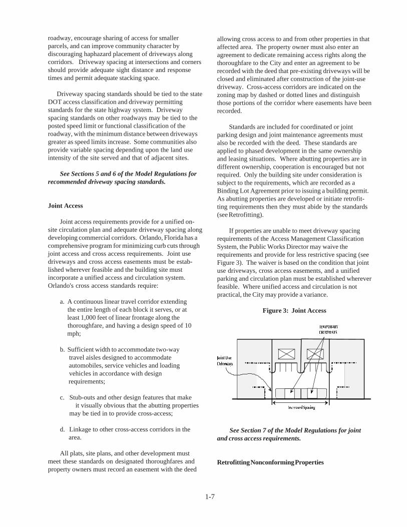
Joint Access
Joint access requirements provide for a unified on-site circulation plan and adequate driveway spacing alongdeveloping commercial corridors. Orlando, Florida has acomprehensive program for minimizing curb cuts throughjoint access and cross access requirements. Joint usedriveways and cross access easements must be estab-lished wherever feasible and the building site mustincorporate a unified access and circulation system.Orlando's cross access standards require:
a. A continuous linear travel corridor extending the entire length of each block it serves, or at least 1,000 feet of linear frontage along the thoroughfare, and having a design speed of 10 mph;
b. Sufficient width to accommodate two-way travel aisles designed to accommodate automobiles, service vehicles and loading vehicles in accordance with design requirements;
c. Stub-outs and other design features that make it visually obvious that the abutting properties
may be tied in to provide cross-access;
d. Linkage to other cross-access corridors in the area.
All plats, site plans, and other development mustmeet these standards on designated thoroughfares andproperty owners must record an easement with the deed
allowing cross access to and from other properties in thataffected area. The property owner must also enter anagreement to dedicate remaining access rights along thethoroughfare to the City and enter an agreement to berecorded with the deed that pre-existing driveways will beclosed and eliminated after construction of the joint-usedriveway. Cross-access corridors are indicated on thezoning map by dashed or dotted lines and distinguishthose portions of the corridor where easements have beenrecorded.
Standards are included for coordinated or jointparking design and joint maintenance agreements mustalso be recorded with the deed. These standards areapplied to phased development in the same ownershipand leasing situations. Where abutting properties are indifferent ownership, cooperation is encouraged but notrequired. Only the building site under consideration issubject to the requirements, which are recorded as aBinding Lot Agreement prior to issuing a building permit.As abutting properties are developed or initiate retrofit-ting requirements then they must abide by the standards(see Retrofitting).
If properties are unable to meet driveway spacingrequirements of the Access Management ClassificationSystem, the Public Works Director may waive therequirements and provide for less restrictive spacing (seeFigure 3). The waiver is based on the condition that jointuse driveways, cross access easements, and a unifiedparking and circulation plan must be established whereverfeasible. Where unified access and circulation is notpractical, the City may provide a variance.
Figure 3: Joint Access
See Section 7 of the Model Regulations for jointand cross access requirements.
Retrofitting Nonconforming Properties
1-7

future division and subdivision of parcels could occur,but each newly created lot would obtain access via theconnection permitted by the ordinance. Because of thisconstraint, property owners would be obliged to sharedriveways, use service drives, cross access, and evenrear access drives in some instances to maintainappropriate access. Limitations on new driveways may beestablished using a corridor overlay approach.
See Section 14 of the Model Regulations forcorridor overlay standards based on this technique.
Outparcel Requirements
Outparcels are lots on the perimeter of a larger parcelthat abut a roadway. Outparcel regulations are adoptedfor commercial corridors to foster coordinated on-sitecirculation systems that serve outparcels as well asinterior development, thereby reducing the need fordriveways on an arterial. Outparcel regulations mayinclude standards governing: the number of outparcels;minimum lot frontage; access; unified parking andcirculation; landscaping and pedestrian amenities;building height, coverage, and setback requirements; andsignage.
The City of Pembroke Pines, Florida limits the numberof outparcels to one per ten acres of site area, with aminimum frontage requirement of 500 lineal feet peroutparcel. Standards also call for a minimum of 300 linealfeet of open space between outparcels. Roadwaysseparating adjacent parcels may be included with openspace in meeting this requirement. The ordinanceprohibits more than one building per outparcel. Eachparcel must provide all required parking on site andconform to all landscaping and setback requirements ofthat zoning district. Access requirements are as follows:
"Access to the outparcel shall be as direct aspossible avoiding excessive movement acrossparking aisles and queuing across surroundingparking and driving aisles. All access to theoutparcel must be internalized utilizing the mainaccess drive of the principal retail center... Drive-in facilities shall be provided on the outparcelsite exclusively. In no instance shall thecirculation and access of the principal commer-cial facilty and its parking and service beimpaired."
In addition, covenants imposed by the Planning andZoning Board and Architectural Review Board must beadded to the deed if title to the outparcel is transferredafter the site plan is approved. The seller must notify thebuyer, who is bound by the restrictions.
Land development regulations are not retroactive.Existing properties that do not meet land developmentrequirements must be designated as nonconforming—aprocess commonly known as grandfathering .Nonconformities may relate to land use or dimensionalrequirements, as in a nonconforming lot of record.Nonconforming properties may continue in the samemanner as they existed before land developmentregulations were adopted. These requirements protectthe substantial investment of property owners andrecognize the expense of bringing those properties intoconformance.
Yet the negative impacts of nonconforming proper-ties may be substantial. Nonconforming properties maypose significant safety hazards, increase traffic conges-tion, reduce property values, degrade the environment, orundermine community character. To address the publicinterest in these matters, land development regulationsinclude conditions or circumstances where nonconform-ing access features may be brought into conformance.Such conditions may include:
• when new driveway permits are requested;• an increase in land use intensity;• substantial enlargements or improvements;• significant change in trip generation; and• as changes to roadway design allow.
Opportunities to bring nonconforming features intocompliance typically occur after a change of ownershipwhen the costs of required improvements may be amor-tized in the business loan or mortgage.
See Section 13 of the Model Regulations forretrofitting requirements.
Limiting New Driveways Along Major Roads
An effective method of managing curb cuts in newlyemerging commercial corridors is to restrict the permittednumber of future driveways to one driveway per existinglot or parcel. This may be accomplished as follows:
1. Identify and map the emerging commercialcorridor.
2. Verify the boundaries of all existing lots.
3. Assign one driveway to each mapped parcel.
The assigned driveway would be permitted by righteffective upon adoption of the ordinance and map.Parcels with larger frontages could be permitted more thanone driveway and additional driveways could bepermitted by special use permit. Under this approach,
1-8

plan has been drafted. The preliminary plan is thenchecked to determine if additional conditions are required
Table 1:Regulatory Techniques that Support
Access Management
• Regulate driveway spacing, sight distance, andcorner clearance.
• Restrict number of driveways per existing parcel ondeveloping corridors.
• Increase minimum lot frontage along thoroughfares.• Encourage joint access and parking lot cross
access.• Review lot splits to prevent access problems.• Regulate flag lots and lot width-to-depth.• Minimize commercial strip zoning and promote
mixed use and flexible zoning.• Regulate private roads and require maintenance
agreements.• Establish reverse frontage requirements for
subdivision and residential lots.• Require measurement of building setbacks from
future right-of-way line.• Promote unified circulation and parking plan.
for approval and the final plan should require onlyadministrative review. A parallel review process shouldbe established in coordination with the state DOT districtoffice where an application involves access to the statehighway system, as is done in Oregon (Falconi 1991) andin many Florida DOT Districts.
To ensure conformance with land division andaccess requirements, the building permit should beestablished as the lead permit during development review.Property owners may then be required to submit thenecessary permits or certificates of approval fromregulatory agencies involved in subdivision or site planreview before issuing a building permit. In Florida, thisshould include a "notice of intent to permit" an accessconnection from the Florida Department of Transportationwhere the state highway system is involved, to assureconformance with state access management and drivewaypermitting requirements. In turn, FDOT will not issue theactual access permit until the local government gives finaldevelopment approval.
Upon adoption of new access managementrequirements, planners should also initiate a trainingprogram to educate planning commissioners, the zoningadministrator, and the zoning board of adjustment on the
1-9
See Section 10 of the Model Regulations foroutparcel standards.
Corridor Overlay Zones
Overlay zones are a growing method for managingaccess along commercial corridors. The technique is usedto overlay a special set of requirements onto an existingzoning district, while retaining the underlying zoning andits associated requirements. Text that specifies standardsfor the access management overlay district is included inthe land development (or zoning) code and then corridorsare designated on the zoning map. Overlay requirementsmay address any issues of concern, such as joint access,parking lot cross access, reverse frontage, drivewayspacing, and limitations on new driveways.
Sample regulations for the Grand Traverse BayRegion in Michigan apply to the area 300 feet on eitherside of the designated corridor, establish minimum lotfrontage of 400 feet, and permit only one access per 400foot lot (Wyckoff, M., Sept. 1992). Service drive provi-sions freeze the number of driveways on a designatedcorridor to one per existing parcel having a single tax codenumber at the date of the amendment. When subse-quently subdivided, all parcels must provide access viasubdivision roads, other private or public roads, or byservice drives in conformance with specified designrequirements.
Commercial driveway location and spacing standardsare provided for regional arterials and other types ofroads. Parcels with less than 100 feet of frontage may bepermitted a driveway, but in certain cases a shareddriveway or alternative means of access may be required.Requirements for minimum intersection or corner sightdistance are tied to AASHTO guidelines and somewhatlower standards tied to the posted speed limit are pro-vided for special circumstances, such as inadequatefrontage.
See Section 14 of the Model Regulations forcorridor overlay standards.
Improving Coordination
An effective method of coordinating review andapproval is through a tiered review process that beginswith an informal meeting and concept review. Theinformal review allows officials to advise the developerregarding information needed to process the application.This may include state and local permit requirements andspecial considerations of the development site. Theconcept review provides the developer with earlyfeedback on a proposal, before the preliminary plat or site

purpose and administration of the new standards. It isessential that the regulations be applied consistently—especially when opportunities arise for retrofittingnonconforming features. Variance requests should bejudiciously evaluated according to specified reviewprocedures and discretionary standards to avoidinconsistency.
See Section 23 of the Model Regulations forprocedures on coordinating access review with theFlorida Department of Transportation on the StateHighway System.
Conclusion
Access management addresses a broad array ofquality of life issues fundamental to promoting livable,prospering communities. Land division and accesscontrols:
• foster well designed circulation systems that improvethe safety and character of commercial corridors;
• discourage subdivision practices that destroy therural character of the landscape or essential naturalresources;
• advance economic development goals by promotingmore efficient use of land and transportation systems;and
• help control public service costs and the substantialpublic investment in infrastructure and services.
Effective local access management requires bothplanning and regulatory solutions. Communities shouldestablish a policy framework that supports accessmanage-ment in the local comprehensive plan, preparecorridor or access management plans for specific problemareas, and encourage good site planning techniques.Zoning and subdivision regulations should be amendedaccordingly and communities could consider a separateaccess management ordinance. Comprehensive andsubarea plans provide the rationale for access manage-ment programs and can serve as the legal basis for publicpolicy decisions.
Because land division and access controls arepolitically charged, planning officials are advised todevelop strategies for diffusing opposition beforeadvancing recommendations. Be aware of the practicalconcerns of those most affected by proposed amend-ments and devise strategies for ameliorating hardship.Town meetings, attitude surveys, and other techniquesshould be used to educate stakeholders and generatepolitical support.
1-10
References
Bloom, Clifford H. Regulating Private Roads . Planningand Zoning News, Vol. 8, No.3, January 1990: 7-10.
Brough, Michael B. A Unified Development Ordinance.Washington, D.C.: Planners Press American PlanningAssociation, 1985.
Chapin, F., Kaiser E. Urban Land Use Planning. Chicago:University of Illinois Press, 1985.
Falconi, Xavier R. “Access Management: RelationshipBetween Developers, Local Government and StateGovernment.” ITE 1991 Compendium of TechnicalPapers, 1991.
Koepke, F.J., Levinson H.S. Access ManagementGuidelines for Activity Centers. NCHRP Report 348,Washington, D.C.: National Academy Press, 1992.
Listokin, D. and Walker, C. The Subdivision and Site PlanHandbook. New Jersey: The State University of NewJersey 1989.
McPherson, J.K., Coffey D., Easley, G. Land Develop-ment Regulations, Technical Assistance Manual forFlorida Cities and Counties. Prepared for the Departmentof Community Affairs. August 28, 1989.
McPherson, J.K., Coffey D., Easley, G. Model LandDevelopment Code for Florida Cities and Counties.Prepared for the Department of Community Affairs.December 1989.
Misseldine, C., Wyckoff M. Planning and Zoning forFarmland Protection: A Community Based Approach.American Farmland Trust, 1987.
Moskowitz, H., Lindbloom C. The New Illustrated Bookof Development Definitions. New Brunswick, New Jersey:Center for Urban Policy Research, 1993.
Stover, V.G. and F.J. Koepke. Transportation and LandDevelopment. Prentice Hall, Englewood Cliffs, NewJersey, 1988.
Williams, Kristine M. “Reserving Right-of-Way withOfficial Maps”. Planning and Zoning News. July 1991:14-18.

1-11
Williams, K.M., McCauley, T.J., Wyckoff, M.A. LandDivision and Access Controls. Lansing: Planning andZoning Center Inc., April 1990.
Wyckoff M, Williams K., Armstrong M, et al. CommunityPlanning Handbook: Tools and Techniques for GuidingCommunity Change. Planning & Zoning Center, Inc. ,March 1992.
Wyckoff M., Grand Traverse Bay Region DevelopmentGuidebook. Planning & Zoning Center, Inc., September1992.
Wyckoff M., Grand Traverse Bay Region SampleRegulations. Planning & Zoning Center, Inc., September1992.
Yaro, R., Arendt, R. Dodson, H., Brabec, E. Dealing withChange in the Connecticut River Valley: A DesignManual for Conservation and Development. Amherst:Lincoln Institute of Land Policy and the EnvironmentalLaw Foundation, 1988.

2-1
Model Land Development and Subdivision RegulationsThat Support Access Management
Section 1. Intent and Purpose . . . . . . . . . . . . . . . . . . . . . . . . . . . . . . . . . . . . . . . . . . . . . 2-2
Section 2. Applicability . . . . . . . . . . . . . . . . . . . . . . . . . . . . . . . . . . . . . . . . . . . . . . . . . 2-2
Section 3. Conformance with Plans, Regulations, and Statutes . . . . . . . . . . . . . . . . . . . 2-2
Section 4. Definitions . . . . . . . . . . . . . . . . . . . . . . . . . . . . . . . . . . . . . . . . . . . . . . . . . . . 2-3
Section 5. Access Management Classification System and Standards . . . . . . . . . . . . . . 2-9
Section 6. Corner Clearance . . . . . . . . . . . . . . . . . . . . . . . . . . . . . . . . . . . . . . . . . . . . . 2-12
Section 7. Joint and Cross Access . . . . . . . . . . . . . . . . . . . . . . . . . . . . . . . . . . . . . . . . 2-13
Section 8. Interchange Areas . . . . . . . . . . . . . . . . . . . . . . . . . . . . . . . . . . . . . . . . . . . . 2-16
Section 9. Access Connection and Driveway Design . . . . . . . . . . . . . . . . . . . . . . . . . . 2-17
Section 10. Requirements for Outparcels and Phased Development Plans . . . . . . . . . . 2-20
Section 11. Emergency Access . . . . . . . . . . . . . . . . . . . . . . . . . . . . . . . . . . . . . . . . . . . . 2-21
Section 12. Transit Access . . . . . . . . . . . . . . . . . . . . . . . . . . . . . . . . . . . . . . . . . . . . . . 2-21
Section 13. Nonconforming Access Features . . . . . . . . . . . . . . . . . . . . . . . . . . . . . . . . . 2-22
Section 14. Corridor Access Management Overlay . . . . . . . . . . . . . . . . . . . . . . . . . . . . 2-23
Section 15. Reverse Frontage . . . . . . . . . . . . . . . . . . . . . . . . . . . . . . . . . . . . . . . . . . . . . 2-27
Section 16. Flag Lot Standards . . . . . . . . . . . . . . . . . . . . . . . . . . . . . . . . . . . . . . . . . . . . 2-28
Section 17. Lot Width-to-Depth Ratios . . . . . . . . . . . . . . . . . . . . . . . . . . . . . . . . . . . . . 2-29
Section 18. Shared Access . . . . . . . . . . . . . . . . . . . . . . . . . . . . . . . . . . . . . . . . . . . . . . . 2-30
Section 19. Connectivity . . . . . . . . . . . . . . . . . . . . . . . . . . . . . . . . . . . . . . . . . . . . . . . . . 2-31
Section 20. Minor Subdivisions . . . . . . . . . . . . . . . . . . . . . . . . . . . . . . . . . . . . . . . . . . 2-31
Section 21. Private Roads . . . . . . . . . . . . . . . . . . . . . . . . . . . . . . . . . . . . . . . . . . . . . . . . 2-33
Section 22. Regulatory Flexibility . . . . . . . . . . . . . . . . . . . . . . . . . . . . . . . . . . . . . . . . . 2-37
Section 23. Site Plan Review Procedures . . . . . . . . . . . . . . . . . . . . . . . . . . . . . . . . . . . . 2-37
Section 24. Variance Standards . . . . . . . . . . . . . . . . . . . . . . . . . . . . . . . . . . . . . . . . . . . 2-40

2-2
The following model ordinance language is provided for adoption into the local land developmentcode. Local governments should obtain professional planning and legal assistance when adaptingthis model language to fit local needs. Although a regulatory program is essential, it is furtherrecommended that local governments prepare subarea plans for high priority corridors that areexperiencing development pressure.
Section 1. Intent and Purpose
The intent of this ordinance is to provide and manage access to land development, while preservingthe regional flow of traffic in terms of safety, capacity, and speed. Major thoroughfares, includinghighways and other arterials, serve as the primary network for moving people and goods. Thesetransportation corridors also provide access to businesses and homes and have served as the focus forcommercial and residential development. If access systems are not properly designed, thesethoroughfares will be unable to accommodate the access needs of development and retain theirprimary transportation function. This ordinance balances the right of reasonable access to privateproperty, with the right of the citizens of the (city/county) and the State of Florida to safe and efficienttravel.
To achieve this policy intent, state and local thoroughfares have been categorized by function andclassified for access purposes based upon their level of importance, with highest priority on theFlorida Intrastate Highway System and secondary priority on the primary network of regionalarterials. Regulations have been applied to these thoroughfares for the purpose of reducing trafficaccidents, personal injury, and property damage attributable to poorly designed access systems, andto thereby improve the safety and operation of the roadway network. This will protect the substantialpublic investment in the existing transportation system and reduce the need for expensive remedialmeasures. These regulations also further the orderly layout and use of land, protect communitycharacter, and conserve natural resources by promoting well-designed road and access systems anddiscouraging the unplanned subdivision of land.
Section 2. Applicability
This ordinance shall apply to all arterials and selected collectors within (city/county), as identified inTable 1, and to all properties that abut these roadways. The access classification system and standardsof the Florida Department of Transportation shall apply to all roadways on the State Highway System.
Section 3. Conformance with Plans, Regulations, and Statutes
This ordinance is adopted to implement (cite specific policies) of the (city/county) as set forth in the(name local comprehensive plan). In addition, this ordinance conforms with (cite specific policies)of the Metropolitan Planning Organization (MPO) as specified in the (name of long rangetransportation plan), and the planning policies of the Florida Department of Transportation set forthin the Florida Transportation Plan. The ordinance also conforms with the access classification systemand standards of the Florida Department of Transportation, the access management requirements ofthe Florida Intrastate Highway System Program, and policy and planning directives of the federalIntermodal Surface Transportation Efficiency Act of 1991.

2-3
Commentary: The link between regulations and public policy has undergoneintense legal scrutiny in recent years. To establish this link, local governmentsshould clearly identify the intent and purpose of the regulatory program, andspecify any plans, state and federal regulations, or statutes that will be carried outthrough the regulatory standards. It is also important to cite specific planningpolicies that are being advanced through these regulations. Local governmentsin designated transportation management areas may also cite access managementas a congestion management measure in accordance with the federal IntermodalSurface Transportation Efficiency Act of 1991. Communities that do not lie withinthe planning area boundaries of a Metropolitan Planning Organization (MPO)would simply leave out the reference to MPOs in this section. Demonstratingconformance with state and federal law, and with the local comprehensive plan,is important in strengthening the legal basis for any local regulatory program.
Section 4. Definitions
Access - A way or means of approach to provide vehicular or pedestrian entrance or exit to a property.
Access Classification - A ranking system for roadways used to determine the appropriate degree ofaccess management. Factors considered include functional classification, the appropriate localgovernment's adopted plan for the roadway, subdivision of abutting properties, and existing level ofaccess control.
Access Connection - Any driveway, street, turnout or other means of providing for the movementof vehicles to or from the public roadway system.
Access Management - The process of providing and managing access to land development whilepreserving the regional flow of traffic in terms of safety, capacity, and speed.
Access Management Plan (Corridor) - A plan illustrating the design of access for lots on a highwaysegment or an interchange area that is developed jointly by the state, the metropolitan planningorganization, and the affected jurisdiction(s).
Cartway - That area of road surface from curb line to curb line or between the edges of the pavedor hard surface of the roadway, which may include travel lanes, parking lanes, and deceleration oracceleration lanes.
Connection Spacing - The distance between connections, measured from the closest edge ofpavement of the first connection to the closest edge of pavement of the second connection along theedge of the traveled way.
Corner Clearance - The distance from an intersection of a public or private road to the nearest accessconnection, measured from the closest edge of the pavement of the intersecting road to the closestedge of the pavement of the connection along the traveled way. (see Figure 1)

2-4
Figure 1: Corner Clearance and Connection Spacing
Corridor Overlay Zone - Special requirements added onto existing land development requirementsalong designated portions of a public thoroughfare.
Cross Access - A service drive providing vehicular access between two or more contiguous sites sothe driver need not enter the public street system. (see Figure 4)
Deed - A legal document conveying ownership of real property.
Directional Median Opening - An opening in a restrictive median which provides for specificmovements and physically restricts other movements. Directional median openings for two opposingleft or "U-turn" movements along a road segment are considered one directional median opening.
Easement - A grant of one or more property rights by a property owner to or for use by the public,or another person or entity.
Florida Intrastate Highway System - The specially designated statewide system of limited accessand controlled access facilities, as designated by FDOT and adopted by the legislature, that allowsfor high-speed and high-volume traffic movement within the state.
Frontage Road - A public or private drive which generally parallels a public street between the right-of-way and the front building setback line. The frontage road provides access to private propertieswhile separating them from the arterial street. (see also Service Roads)
Full Median Opening - An opening in a restrictive median that allows all turning movements fromthe roadway and the intersecting road or access connection.

2-5
Functional Area (Intersection) - That area beyond the physical intersection of two controlled accessfacilities that comprises decision and maneuver distance, plus any required vehicle storage length, andis protected through corner clearance standards and driveway connection spacing standards (seeFigure 2).
Figure 2: Functional Area of Intersection
Functional Classification - A system used to group public roadways into classes according to theirpurpose in moving vehicles and providing access.
Green Book, The Florida (Manual of Uniform Minimum Standard for Design, Construction,and Maintenance) - A manual produced by the Florida Department of Transportation which providesfor uniform standards and criteria for transportation facilities for both state and local roads.
Intrastate Highway System - (see Florida Intrastate Highway System)
Joint Access (or Shared Access) - A driveway connecting two or more contiguous sites to the publicstreet system.
Lot - A parcel, tract, or area of land whose boundaries have been established by some legalinstrument, which is recognized as a separate legal entity for purposes of transfer of title, has frontageupon a public or private street, and complies with the dimensional requirements of this code.

2-6
Figure 3: Types of Lots
Reprinted with permission from H. Moskowitz and C. Lindbloom. The New Illustrated Book ofDevelopment Definitions. New Brunswick, NJ: The Center for Urban Policy Research, RutgersUniversity. © 1993.
Lot, Corner - Any lot having at least two (2) contiguous sides abutting upon one or more streets,provided that the interior angle at the intersection of such two sides is less than one hundred thirty-five (135) degrees.
Commentary: Corner lots can create confusion in relation to dimensionalrequirements. The recommended approach is to designate one frontage as the"front" and the rear lot line would be that opposite the designated frontage. Bothportions of the lot with street frontage should still be required to meet the requiredfrontyard setback to ensure adequate sight distance and consistency of setbackwith abutting properties. A lot abutting a curved street(s) is typically considereda corner lot if the arc has a radius less than one hundred and fifty (150) feet.
Lot Depth - The average distance measured from the front lot line to the rear lot line.
Lot, Flag - A large lot not meeting minimum frontage requirements and where access to the publicroad is by a narrow, private right-of-way or driveway.
Lot, Nonconforming - A lot that does not meet the dimensional requirements of the district in whichit is located and that existed before these requirements became effective.
Lot, Through (also called a double frontage lot) - A lot that fronts upon two parallel streets or thatfronts upon two streets that do not intersect at the boundaries of the lot.
Lot Frontage - That portion of a lot extending along a street right-of-way line.
2-7
Lot of Record - A lot or parcel that exists as shown or described on a plat or deed in the records ofthe Clerk of the Circuit Court.
Lot Width - The horizontal distance between side lot lines measured parallel to the front lot line atthe minimum required front setback line.
Manual of Uniform Traffic Control Devices (MUTCD) - A Federal document adopted by theFlorida Department of Transportation that provides standards for traffic control devices. FloridaAdministrative Rule 14-110 establishes the MUTCD to be Florida's Standard for traffic controldevices.
Minor Subdivision - A subdivision of land into not more than two (2) lots where there are noroadways, drainage, or other required improvements.
Nonconforming Access Features - Features of the access system of a property that existed prior tothe date of ordinance adoption and do not conform with the requirements of this code or requirementsof the Administrative Rule 14-97 of the Florida Department of Transportation.
Nonrestrictive Median - A median or painted centerline that does not provide a physical barrierbetween traffic traveling in opposite directions or turning left, including continuous center turn lanesand undivided roads.
Outparcel - A parcel of land abutting and external to the larger, main parcel, which is under separateownership and has roadway frontage.
Parcel - A division of land comprised of one or more lots in contiguous ownership.
Plat - An exact and detailed map of the subdivision of land.
Private Road - Any road or thoroughfare for vehicular travel which is privately owned andmaintained and which provides the principal means of access to abutting properties.
Public Road - A road under the jurisdiction of a public body that provides the principal means ofaccess to an abutting property.
Reasonable Access: The minimum number of access connections, direct or indirect, necessary toprovide safe access to and from the thoroughfare, as consistent with the purpose and intent of thiscode and any applicable plans and policies of the (city/county).
Restrictive Median - A physical barrier in the roadway that separates traffic traveling in oppositedirections, such as a concrete barrier or landscaped island.
Right-of-Way - Land reserved, used, or to be used for a highway, street, alley, walkway, drainagefacility, or other public purpose.
Service Road - A public or private street or road, auxiliary to and normally located parallel to acontrolled access facility, that maintains local road continuity and provides access to parcels adjacentto the controlled access facility.
2-8
Significant Change in Trip Generation - A change in the use of the property, including land,structures or facilities, or an expansion of the size of the structures or facilities causing an increasein the trip generation of the property exceeding 10 percent more trip generation (either peak or daily)and 100 vehicles per day more than the existing use for all roads under local jurisdiction; or exceeding25 percent more trip generation (either peak or daily) and 100 vehicles per day more than the existinguse for all roads under state jurisdiction, as defined in 335.18, F.S.
Commentary: In 1992, the legislature amended the State Highway System AccessManagement Act to reduce the definition of "substantial change" from a 10%threshold to 25%, as shown above. This diminished the ability of the State torequire properties with nonconforming access to the State Highway System tomitigate their nonconformity. However, local governments may adoptrequirements that are more restrictive than State standards for roadways underlocal jurisdiction. The 10% threshold is recommended for non-state thoroughfares(see also, Nonconforming Access Features).
Standard Index (Roadway and Traffic Design Standards) - A Florida Department ofTransportation document with detailed standards for the construction of connections.
State Highway System (SHS) - The network of limited access and controlled access highways thathave been functionally classified and are under the jurisdiction of the State of Florida.
Stub-out (Stub-street) - A portion of a street or cross access drive used as an extension to anabutting property that may be developed in the future.
Subdivision - Is the process and the result of any of the following:
a. The platting of land into lots, building sites, blocks, open space, public areas,or any other division of land;b. Establishment or dedication of a road, highway, street or alley through a tractof land, by the owner thereof, regardless of area;c. The re-subdivision of land heretofore subdivided (however, the sale or exchangeof small parcels of land to or between adjoining property owners, where such saleor exchange does not create additional lots and does not result in a nonconforminglot, building, structure or landscape area, shall not be considered a subdivision ofland); d. The platting of the boundaries of a previously unplatted parcel or parcels.
Substantial Enlargements or Improvements - A 10% increase in existing square footage or 50%increase in assessed valuation of the structure.
Commentary: This standard is typical of many standards used to addressnonconforming situations. Check these standards related to nonconformingsituations against those of your code to assure consistency.
Temporary Access - Provision of direct access to the controlled access facility until that time whenadjacent properties develop, in accordance with a joint access agreement or frontage road plan.

2-9
Section 5. Access Management Classification System and Standards
1. The following access classifications have been assigned to major thoroughfares under stateand local jurisdiction as provided in Table 1 in accordance with Chapter 14-97,Administrative Rules of the Department of Transportation, and the requirements of thisCode. These access classes are defined as follows:
Access Class 1 - Limited Access Highways, designed for high-speed, high volume trafficmovements. Access is permitted only via interchanges.
Access Class 2 - Highly controlled access facilities distinguished by their ability to carryhigh speed, high volume traffic over long distances in a safe and efficient manner. Thesehighways are distinguished by a system of existing or planned service roads, a highlycontrolled limited number of connections, median openings and infrequent traffic signals.
Access Class 3 - These facilities are controlled access facilities where direct access toabutting land will be controlled to maximize the through movement of traffic. This classwill be used where existing land use and roadway sections have not been built out to themaximum land use or roadway capacity or where the probability of significant land usechange in the near future is high. These highways are distinguished by existing or plannedrestrictive medians and maximum distance between signals and driveway connections.Local land use planning, zoning and subdivision regulations should be such to support therestrictive spacings of this designation.
Access Class 4 - These facilities are controlled access highways where direct access toabutting land will be controlled to maximize the through movement of traffic. This classwill be used where existing land use and roadway sections have not been built out to themaximum land use or roadway capacity or where the probability of significant land usechange in the near future is high. These highways are distinguished by existing or plannednon-restrictive median treatments.
Access Class 5 - This class will be used where existing land use and roadway sections havebeen built out to a greater extent than those roadway segments classified as Access Classes3 and 4 and where the probability of a major land use change is not as high as those roadwaysegments classified Access Classes 3 and 4. These highways will be distinguished byexisting or planned restrictive medians.
Access Class 6 - This class will be used where existing land use and roadway sections havebeen built out to a greater extent than those roadway segments classified as Access Classes3 and 4, and where the probability of a major land use change is not as high as thoseroadway segments classified Access Classes 3 and 4. These highways will be distinguishedby existing or planned non-restrictive medians or centers.
Access Class 7 - This class shall only be used in urbanized areas where existing land useand roadway sections are built out and where significant land use changes or roadwaywidening will be limited. This class shall be assigned only to roadway segments wherethere is little intended purpose to provide high speed travel. Access needs, though generallyhigh in those roadway segments, will not compromise the public health, welfare or safety.Exceptions to standards in this class will be considered if the applicant's design changessubstantially reduce the number of connections compared to existing conditions. Thesehighways can have either restrictive or non-restrictive medians.
2-10
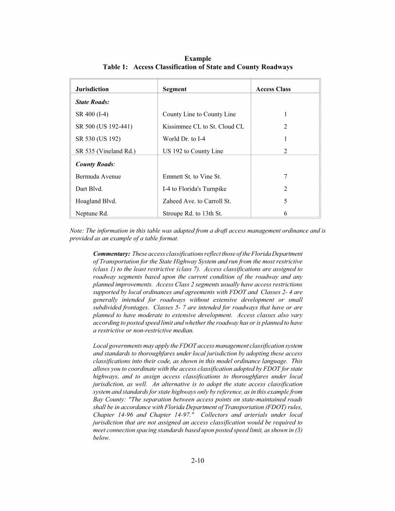
ExampleTable 1: Access Classification of State and County Roadways
Jurisdiction Segment Access Class
State Roads:
SR 400 (I-4) County Line to County Line 1
SR 500 (US 192-441) Kissimmee CL to St. Cloud CL 2
SR 530 (US 192) World Dr. to I-4 1
SR 535 (Vineland Rd.) US 192 to County Line 2
County Roads:
Bermuda Avenue Emmett St. to Vine St. 7
Dart Blvd. I-4 to Florida's Turnpike 2
Hoagland Blvd. Zaheed Ave. to Carroll St. 5
Neptune Rd. Stroupe Rd. to 13th St. 6
Note: The information in this table was adapted from a draft access management ordinance and isprovided as an example of a table format.
Commentary: These access classifications reflect those of the Florida Departmentof Transportation for the State Highway System and run from the most restrictive(class 1) to the least restrictive (class 7). Access classifications are assigned toroadway segments based upon the current condition of the roadway and anyplanned improvements. Access Class 2 segments usually have access restrictionssupported by local ordinances and agreements with FDOT and Classes 2- 4 aregenerally intended for roadways without extensive development or smallsubdivided frontages. Classes 5- 7 are intended for roadways that have or areplanned to have moderate to extensive development. Access classes also varyaccording to posted speed limit and whether the roadway has or is planned to havea restrictive or non-restrictive median.
Local governments may apply the FDOT access management classification systemand standards to thoroughfares under local jurisdiction by adopting these accessclassifications into their code, as shown in this model ordinance language. Thisallows you to coordinate with the access classification adopted by FDOT for statehighways, and to assign access classifications to thoroughfares under localjurisdiction, as well. An alternative is to adopt the state access classificationsystem and standards for state highways only by reference, as in this example fromBay County: "The separation between access points on state-maintained roadsshall be in accordance with Florida Department of Transportation (FDOT) rules,Chapter 14-96 and Chapter 14-97." Collectors and arterials under localjurisdiction that are not assigned an access classification would be required tomeet connection spacing standards based upon posted speed limit, as shown in (3)below.

2-11
2. All connections on facility segments that have been assigned an access classification shallmeet or exceed the minimum connection spacing requirements of that access classification,as specified in Table 2. [Note: These standards are consistent with those of the FloridaDepartment of Transportation, Chapter 14-97, Administrative Rules. If the rules areamended at a future date then these standards should be amended accordingly.]
Table 2: Access Classification System & Standards
Functional Class
AccessClass
Medians** ConnectionSpacing
(feet)
MedianOpeningSpacing
SignalSpacing
>45 mph
<45 mph
Direct-ional
Full
Arterials
2 Restrictivew/ ServiceRoads
1320 660 1320 2640 2640
3 Restrictive 660 440 1320 2640 2640
4 Non-Restrictive
660 440 2640
Collectors 5 Restrictive 440 245 660 2640/1320
2640/1320
6 Non-Restrictive
440 245 1320
Arterials, Collectors,ResidentialCollectors
7 Both MedianTypes
125 330 660 1320
* For roads with posted speed limits > 45mph.** A "Restrictive" median physically prevents vehicle crossing. A "Non-Restrictive" median allows turns across any point.
3. Separation between access connections on all collectors and arterials under local jurisdictionthat have not been assigned an access classification shall be based upon the posted speedlimit in accordance with Table 3:
Table 3: Driveway Spacing for Nonclassified Roadways
Posted Speed Limit(MPH)
Driveway Spacing(Feet)
< 35 125
36-45 245
> 45 440*
*Ideally any road having a speed limit over 45 mph should be given anaccess management classification.

2-12
4. Driveway spacing shall be measured from the closest edge of the pavement to the nextclosest edge of the pavement (see Definition section and Figure 1). The projected futureedge of the pavement of the intersecting road shall be used in measuring corner clearance,where widening, relocation, or other improvement is indicated in an adopted localthoroughfare plan or five year transportation plan of the metropolitan planning organization.
5. The (permitting department) may reduce the connection spacing requirements in situationswhere they prove impractical, but in no case shall the permitted spacing be less than 80%of the applicable standard, except as provided in Section 24.
6. If the connection spacing of this code cannot be achieved, then a system of joint usedriveways and cross access easements may be required in accordance with Section 7.
7. Variation from these standards shall be permitted at the discretion of the PlanningCommission where the effect would be to enhance the safety or operation of the roadway.Examples might include a pair of one-way driveways in lieu of a two-way driveway, oralignment of median openings with existing access connections. Applicants may berequired to submit a study prepared by a registered engineer to assist the (city/county) indetermining whether the proposed change would exceed roadway safety or operationalbenefits of the prescribed standard.
Commentary: Driveway spacing standards limit the number of driveways on aroadway by mandating a minimum separation distance between driveways. Thisreduces the potential for collisions as travellers enter or exit the roadway andencourages sharing of access, where appropriate. Driveway spacing atintersections and corners should provide adequate sight distance and responsetimes and permit adequate stacking space. Driveway spacing on nonclassifiedarterials and collectors may be tied to posted speed limit, as shown here, with theminimum distance between driveways greater as speed limits increase. Themethod used to regulate driveway spacing does, however, vary widely across localgovernments. Some jurisdictions tie driveway spacing to functional classificationrather than speed limit, and others provide variable spacing depending upon theland use intensity of the site served and that of adjacent sites. The standards abovefall within the recommended range and are compatible with connection spacingstandards in Table 2.
Section 6. Corner Clearance
1. Corner clearance for connections shall meet or exceed the minimum connection spacingrequirements for that roadway.
2. New connections shall not be permitted within the functional area of an intersection orinterchange as defined by the connection spacing standards of this code, unless:
a) No other reasonable access to the property is available, and
2-13
b) The (permitting department) determines that the connection does notcreate a safety or operational problem upon review of a site specific studyof the proposed connection prepared by a registered engineer andsubmitted by the applicant.
3. Where no other alternatives exist, the (permitting department) may allow construction ofan access connection along the property line farthest from the intersection. In such cases,directional connections (i.e. right in/out, right in only, or right out only) may be required.
4. In addition to the required minimum lot size, all corner lots shall be of adequate size toprovide for required frontyard setbacks and corner clearance on street frontage.
Section 7. Joint and Cross Access
1. Adjacent commercial or office properties classified as major traffic generators (i.e. shoppingplazas, office parks), shall provide a cross access drive and pedestrian access to allowcirculation between sites.
Commentary: Adjacent shopping centers or office parks are often not connectedby a service drive and sidewalk. As a result, customers who wish to shop in bothcenters, or visit both sites, must exit the parking lot of one, travel a short distanceon a major thoroughfare, and then access the next site. A cross access drivereduces traffic on the major thoroughfare and reduces safety hazards. This inturn, can have positive business benefits by providing easy access to one site fromanother.
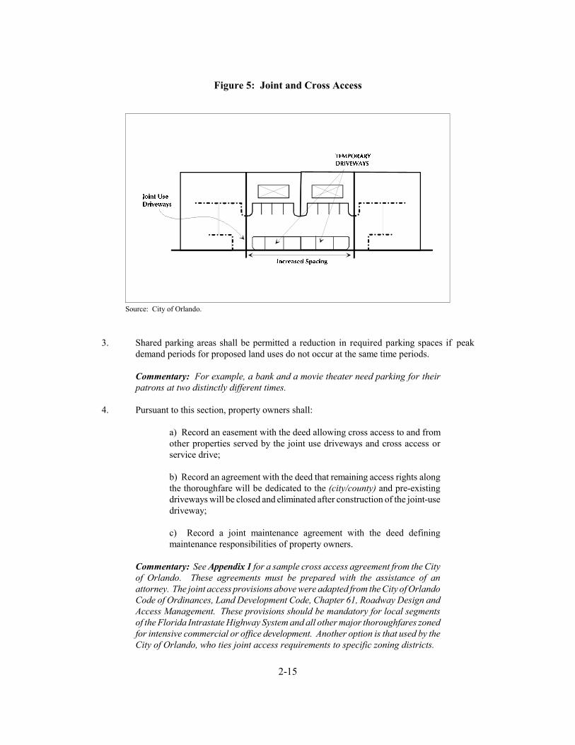
2. A system of joint use driveways and cross access easements as shown in Figure 4 shall beestablished wherever feasible along (name affected corridors, including FIHS, or refer toa list) and the building site shall incorporate the following:
a) A continuous service drive or cross access corridor extending theentire length of each block served to provide for driveway separationconsistent with the access management classification system andstandards.
b) A design speed of 10 mph and sufficient width to accommodatetwo-way travel aisles designed to accommodate automobiles, servicevehicles, and loading vehicles;
c) Stub-outs and other design features to make it visually obvious that theabutting properties may be tied in to provide cross-access via a servicedrive;
d) A unified access and circulation system plan that includes coordinatedor shared parking areas is encouraged wherever feasible.
2-14
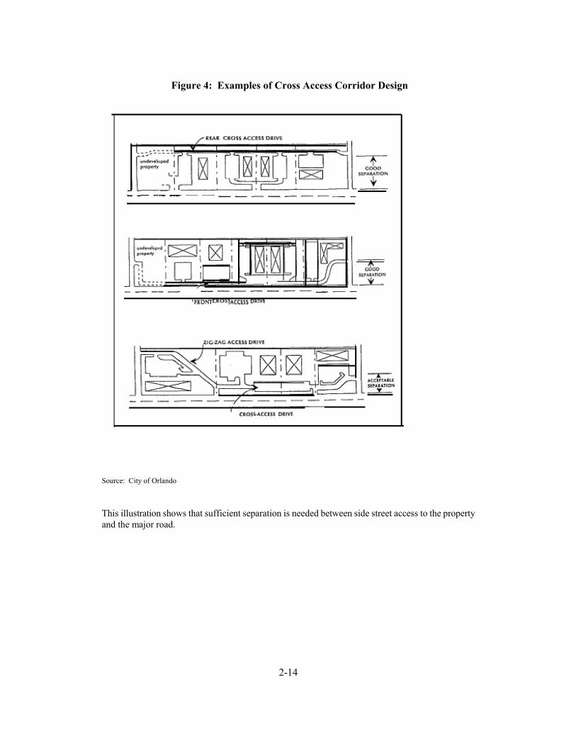
Figure 4: Examples of Cross Access Corridor Design
Source: City of Orlando
This illustration shows that sufficient separation is needed between side street access to the propertyand the major road.
2-15
Source: City of Orlando.
Figure 5: Joint and Cross Access
3. Shared parking areas shall be permitted a reduction in required parking spaces if peakdemand periods for proposed land uses do not occur at the same time periods.
Commentary: For example, a bank and a movie theater need parking for theirpatrons at two distinctly different times.
4. Pursuant to this section, property owners shall:
a) Record an easement with the deed allowing cross access to and fromother properties served by the joint use driveways and cross access orservice drive;
b) Record an agreement with the deed that remaining access rights alongthe thoroughfare will be dedicated to the (city/county) and pre-existingdriveways will be closed and eliminated after construction of the joint-usedriveway;
c) Record a joint maintenance agreement with the deed definingmaintenance responsibilities of property owners.
Commentary: See Appendix 1 for a sample cross access agreement from the Cityof Orlando. These agreements must be prepared with the assistance of anattorney. The joint access provisions above were adapted from the City of OrlandoCode of Ordinances, Land Development Code, Chapter 61, Roadway Design andAccess Management. These provisions should be mandatory for local segmentsof the Florida Intrastate Highway System and all other major thoroughfares zonedfor intensive commercial or office development. Another option is that used by theCity of Orlando, who ties joint access requirements to specific zoning districts.
2-16
5. The (permitting department) may reduce required separation distance of access points wherethey prove impractical, provided all of the following requirements are met:
a) Joint access driveways and cross access easements are providedwherever feasible in accordance with this section.
b) The site plan incorporates a unified access and circulation system inaccordance with this section.
c) The property owner shall enter a written agreement with the(city/county), recorded with the deed, that pre-existing connections on thesite will be closed and eliminated after construction of each side of thejoint use driveway.
6. The (permitting department) may modify or waive the requirements of this section wherethe characteristics or layout of abutting properties would make development of a unified orshared access and circulation system impractical.
Commentary: This model provides that where properties are unable to meetdriveway spacing requirements, then the planning or pubic works official mayprovide for less restrictive spacing, based on the conditions that joint usedriveways and cross access easements must be established wherever feasible. Avariance is provided only where joint and cross access is not practical. Variancesand other remedial actions such as those described above are necessary to preventunusual hardship on property owners and other situations that could incur aregulatory taking. (Note: Variances and special conditions, like standards fornonconforming features, must be consistently and rigorously applied.) Thesestandards are also applied to phased development in the same ownership andleasing situations. Where abutting properties are in different ownership,cooperation is encouraged but not required. But the building site underconsideration is subject to the requirements, which are recorded as a BindingAgreement prior to issuing a building permit. Abutting properties will be broughtinto compliance as they are developed or initiate retrofitting requirements, asprovided in Section 13. In the meantime, the property owner will be permitted atemporary curb cut and driveway that will be closed upon development of the jointuse driveway.
Section 8. Interchange Areas
1. New interchanges or significant modification of an existing interchange will be subject tospecial access management requirements to protect the safety and operational efficiency ofthe limited access facility and the interchange area, pursuant to the preparation and adoptionof an access management plan. The plan shall address current and future connections andmedian openings within 1/4 mile of an interchange area (measured from the end of the taperof the ramp furthest from the interchange) or up to the first intersection with an arterial road,whichever is less.
2. The distance to the first connection shall be at least 660 feet where the posted speed limitis greater than 45 mph or 440 feet where the posted speed limit is 45 mph or less. Thisdistance shall be measured from the end of the taper for that quadrant of the interchange.

2-17
3. The minimum distance to the first median opening shall be at least 1320 feet as measuredfrom the end of the taper of the egress ramp.
Commentary: New highway interchanges can have substantial impacts on landdevelopment patterns around the interchange area. In turn, if land developmentis not properly planned it can create safety hazards and interfere with the flow oftraffic onto and off of the interchange. An access management plan would identifythe appropriate access system around the interchange area, in accordance with adesired land development plan. Such a plan would also incorporate minimumspacing requirements for new interchanges required by the Florida Departmentof Transportation. These standards are provided above for incorporation into thelocal code.
Section 9. Access Connection and Driveway Design
1. Driveway grades shall conform to the requirements of FDOT Standard Index, Roadways andTraffic Design Standard Indices, latest edition.
2. Driveway approaches must be designed and located to provide an exiting vehicle with anunobstructed view.
3. Construction of driveways along acceleration or deceleration lanes and tapers is discouraged dueto the potential for vehicular weaving conflicts (see Figure 6).
4. Driveways with more than one entry and one exit lane shall incorporate channelization featuresto separate the entry and exit sides of the driveway. Double yellow lines may be consideredinstead of medians where truck off-tracking is a problem.
5. Driveways across from median openings shall be consolidated wherever feasible to coordinateaccess at the median opening.
6. Driveway width and flair shall be adequate to serve the volume of traffic and provide for rapidmovement of vehicles off of the major thoroughfare, but standards shall not be so excessive asto pose safety hazards for pedestrians, bicycles, or other vehicles. (Suggested standards appearin Table 4).

2-18
Figure 6: Driveway Location
Table 4: Suggested Access Connection Design From FDOT Standard Index*
Trips/Day 1-20 21-600 601-4000
Trips/Hour or 1-5 or 6-60 or 61-400
URBANSECTION
RURALSECTION
URBANSECTION
RURALSECTION
URBANSECTION
RURALSECTION
Connection Width(2-way) 12' min24' max
12' min24' max
24' min36' max
24' min36' max
24' min36' max
24' min36' max
Flare (Drop Curb) 10' min N/A 10' min N/A N/A N/A
Returns (Radius)N/A
15' min25' std
50' max
small radiimay be used
25' min50' std
75' max
25' min50' std
75' max
25' min50' std
(or 3 curves)
Angle of Drive 60'-90' 60'-90' 60'-90' 60'-90'
Divisional Island 4'-22' wide 4'-22' wide 4'-22' wide 4'-22' wide
Source: Florida Department of Transportation Standard Index, Roadway and Traffic Design Standards. 1992.
* Note: These standards are not intended for major access connections carrying over 4000 vehicles per day.

2-19
Commentary: The Florida Department of Transportation requires localgovernments to adhere to certain minimum design standards in the design andlocation of access connections or other traffic control features. These standardsare contained in three separate but related technical documents: the StandardIndex (Roadway and Traffic Design Standards); the "Florida Green Book"(Manual of Uniform Minimum Standard for Design, Construction, andMaintenance); and the MUTCD (Manual of Uniform Traffic Control Devices. The standards shown in Table 4 were adapted from the latest edition of theStandard Index.
4. The length of driveways or "Throat Length" (see Figure 7) shall be designed in accordancewith the anticipated storage length for entering and exiting vehicles to prevent vehicles frombacking into the flow of traffic on the public street or causing unsafe conflicts with on-sitecirculation. General standards appear in Table 5 but these requirements will vary accordingto the projected volume of the individual driveway. These measures generally are acceptablefor the principle access to a property and are not intended for minor driveways. Variationfrom these shall be permitted for good cause upon approval of the (city/county TrafficEngineer or Public Works Official).
Table 5: Generally Adequate Driveway Throat Lengths
Shopping Centers > 200,000 GLA
200'
Smaller Developments < 200,000 GLA
75'-95'
Unsignalized driveways 40'-60'
Source: Vergil G. Stover.
Commentary: The throat lengths in Table 5 are provided to assure adequatestacking space within driveways for general land use intensities. This helpsprevent vehicles from stacking into the thoroughfare as they attempt to access thesite. High traffic generators, such as large shopping plazas, need much greaterthroat length than smaller developments or those with unsignalized driveways.The guidelines here for larger developments refer to the primary access drive.Lesser throat lengths may be permitted for secondary access drives serving largedevelopments.

2-20
Figure 7: Driveway Throat Length
Section 10. Requirements for Outparcels and Phased Development Plans
1. In the interest of promoting unified access and circulation systems, development sites underthe same ownership or consolidated for the purposes of development and comprised of morethan one building site shall not be considered separate properties in relation to the accessstandards of this code. The number of connections permitted shall be the minimum numbernecessary to provide reasonable access to these properties, not the maximum available forthat frontage. All necessary easements, agreements, and stipulations required under Section7 shall be met. This shall also apply to phased development plans. The owner and alllessees within the affected area are responsible for compliance with the requirements of thiscode and both shall be cited for any violation.
2. All access to the outparcel must be internalized using the shared circulation system of theprinciple development or retail center. Access to outparcels shall be designed to avoidexcessive movement across parking aisles and queuing across surrounding parking anddriving aisles.
3. The number of outparcels shall not exceed one per ten acres of site area, with a minimumlineal frontage of 300 feet per outparcel or greater where access spacing standards for thatroadway require. This frontage requirement may be waived where access is internalizedusing the shared circulation system of the principle development or retail center. In suchcases the right of direct access to the roadway shall be dedicated to the (city/county) andrecorded with the deed.

2-21
Commentary: The Florida Department of Transportation in its administrative ruleon Access Management Standards (14-97.003(1)(g)) has attempted to manage theproliferation of individual access connection requests by separate properties underthe same ownership. Essentially, this section states that adjacent properties undersingle ownership will be treated as one property unless the applicant can show theDepartment that the two properties should have separate access due to safetyconcerns (for example, a concrete plant next to a child care center). Marketing ofthe two properties is not a valid reason to have them treated as separateproperties. The rule also states that leasehold interests in existence beforeFebruary 12, 1991 (the effective date of Rule 14-97) may be considered separateproperties.
Section 11. Emergency Access
1. In addition to minimum side, front, and rear yard setback and building spacing requirementsspecified in this code, all buildings and other development activities such as landscaping,shall be arranged on site so as to provide safe and convenient access for emergency vehicles.
Section 12. Transit Access
1. In commercial or office zoning districts where transit service is available or is planned to beavailable within five years, provisions shall be made for adequate transit access, in the formof turn around loops or turnout bays. At a minimum, in the case of a loop or cul-de-sac,entrance curves shall have a 35 foot radius, and the internal circle shall have an inside radiusof 30 feet and an outside radius of 52.5 feet. In the case of turnout bays, the curve radiusshall be 35', the distance from the roadside edge to the inside edge of the the outside radiusshall be 52.5 feet (see Figure 8).
2-22
Figure 8: Transit Bus Turning Radii
Source: Maryland Department of Transportation, Mass Transit Administration. Access by Design: Transit's Role in LandDevelopment, A Developer's Manual. September 1988.
Commentary: The bus turnaround standards in Figure 8 are provided for transitaccess along major commercial and office corridors to assure safe and convenienttransit access. Bus turnarounds are also useful in circumstances where circulationvia the internal street system of a development would be impractical based on cost,design constraints, or the need to maintain timely service. These bus turnaroundsare based upon the turning radius of a standard 40 foot bus.
Section 13. Nonconforming Access Features
1. Permitted access connections in place as of (date of adoption) that do not conform with thestandards herein shall be designated as nonconforming features and shall be brought intocompliance with applicable standards under the following conditions:
a) When new access connection permits are requested;
b) Substantial enlargements or improvements;
c) Significant change in trip generation; or
d) As roadway improvements allow.
2-23
Commentary: Nonconforming access features may continue in the same mannerafter adoption of land development regulations--a process known as"grandfathering." This protects the substantial investment of property owners andrecognizes the expense of bringing those properties into conformance. Yet thenegative impacts of nonconforming properties may be substantial, depending uponthe degree of nonconformity. Nonconforming properties may pose safety hazards,increase traffic congestion, reduce property values, degrade the environment, andundermine community character. To address the public interest in these matters,land development regulations include conditions or circumstances wherenonconforming features must be brought into conformance. Opportunities to bringnonconforming features into compliance typically occur after a change ofownership when the costs of required improvements may be amortized in thebusiness loan or mortgage, thereby minimizing financial hardship. It is essentialthat these standards be consistently and rigorously applied and enforced and thatdata and other information supporting these decisions be well documented, or thecommunity could be open to legal challenges regarding due processconsiderations.
2. If the principal activity on a property with nonconforming access features is discontinuedfor a consecutive period of (180 or 365) days, or discontinued for any period of time withouta present intention of resuming that activity, then that property must thereafter be broughtinto conformity with all applicable connection spacing and design requirements, unlessotherwise exempted by the permitting authority. For uses that are vacant or discontinuedupon the effective date of this code, the (180 or 365) day period begins on the effective dateof this code.
Commentary: The Access Management Act (335.182(3)(b) F.S.) defines in lawthat any property that expands its tripmaking potential by 25% and at least 100trips per day needs to be evaluated as a possible new permit. However, thisdefinition does not provide guidance on when a property that has been out ofservice for a long period of time should be required to undergo reevaluation andobtain a new permit. The Florida Department of Transportation is currently tryingto further clarify when a vacant or abandoned property must obtain a new permitdue to a Significant Change in property use. What is being proposed for the newAdministrative Rule 14-96 (Access Permit Procedures) is a definition that requiresa new permit if the intended use of property is stopped for one year. Localgovernments may choose to do the same for consistency or be more restrictive andprovide only a 180 day grace period.
2-24
Section 14. Corridor Access Management Overlay
1. The minimum lot frontage for all parcels with frontage on (name affected segments ofthoroughfares here or refer to a list) shall not be less than the minimum connection spacingstandards of that thoroughfare, except as otherwise provided in this Section. Flag lots shallnot be permitted direct access to the thoroughfare and interior parcels shall be required toobtain access via a public or private access road in accordance with the requirements of thisCode.
Commentary: Overlay zones are an effective method for managing access alongcommercial corridors. The technique is used to add a special set of requirementsto those of an existing zoning district or districts. Section 14(1) is for those majorthoroughfares or portions of major thoroughfares under state or local jurisdictionthat are not already extensively subdivided and are not planned for commercial orintensive development in the near future. This approach requires that any lotfronting designated thoroughfares (usually those with an assigned accessclassification) have a minimum lot frontage that meets or exceeds the minimumconnection spacing standard for those thoroughfares. This may be as high as 660feet on Access Class 3 thoroughfares with a speed limit greater than 45 mph, oras low as 245 feet for Access Class 6 thoroughfares with a speed limit less than 45mph. Existing lots with less frontage would continue as nonconforming lots.Section 14(1) standards impose large minimum lot frontage requirements tocoordinate with desired connection spacing. Such requirements could dispersedevelopment and should not be applied in areas intended for intensivedevelopment. They are designed for rural and semi-rural stretches of the state (orcounty) highway system.
2. The following requirements shall apply to segments of designated thoroughfares that areplanned for commercial or intensive development. All land in a parcel having a single taxcode number, as of (date of adoption), fronting on (define segment of affected thoroughfareor refer to a Table defining affected segments), shall be entitled one (1) driveway/connectionper parcel as of right on said public thoroughfare(s). When subsequently subdivided, eitheras metes and bounds parcels or as a recorded plat, parcels designated herein shall provideaccess to all newly created lots via the permitted access connection. This may be achievedthrough subdivision roads, joint and cross access, service drives, and other reasonable meansof ingress and egress in accordance with the requirements of this Code. The followingstandards shall also apply:
a) Parcels with large frontages may be permitted additional driveways atthe time of adoption of these requirements provided they are consistentwith the applicable driveway spacing standards.
b) Existing parcels with frontage less than the minimum connection spacing for thatcorridor may not be permitted a direct connection to the thoroughfare under thisSection where the Planning Commission determines alternative reasonable accessis available to the site. [Note: The Planning Commission could allow for atemporary driveway as provided in Section 7 with the stipulation that joint andcross access be established as adjacent properties develop.]

2-25
c) Additional access connections may be allowed where the propertyowner demonstrates that safety and efficiency of travel on thethoroughfare will be improved by providing more than one access to thesite.
d) No parking or structure other than signs shall be permitted within (10-50) feet of the roadway right-of-way. The (10-50) foot buffer shall belandscaped with plants suitable to the soil and in a manner that providesadequate sight visibility for vehicles exiting the site. Property ownersshall be permitted to landscape the right-of-way, pursuant to an approvedlandscaping plan.
e) Permitted connections shall be identified on a map that shall be adoptedby reference and that portion of a corridor affected by these overlayrequirements shall be delineated on the (city/county) zoning map withhatch marks.
Commentary: The regulations in Section 14(2) are intended for corridors that areplanned for commercial or intensive development and have not already beenextensively subdivided into small lot frontages. Such corridors may or may notbe currently zoned for commercial or mixed use development, but may already beexperiencing development pressure. This approach focuses, rather than disperses,development along corridors while maintaining regional mobility through accessmanagement. The Section 14(2) overlay "freezes" allowable access to oneconnection by right per existing lot or parcel at the time of adoption. Lots orparcels may be extensively subdivided, but all future lots must obtain access via theaccess connections permitted at the time of overlay adoption.
This overlay approach allows for continued subdivision and development of landwhile stimulating joint access, local roads, and other alternatives to directthoroughfare access in the site design process (see Figure 9). These permittedconnections must be designated on a map and adopted with the overlayrequirements. For flexibility, additional driveways may be permitted for largeparcels that meet or exceed the minimum access spacing standards for thatthoroughfare, or where safety would be increased. Parcels with small frontagesat the time of adoption are not permitted a driveway on the thoroughfare wherethis would create a safety hazard or where alternative reasonable access isavailable. In such cases a temporary driveway could be permitted under jointaccess requirements.

2-26
Figure 9: Corridor Access Management Overlay
Local governments are also encouraged to apply design guidelines that enhance communitycharacter, including standards for pedestrian access and landscaping. Section 14(2)(d) above is onepotential standard for improving the visual quality of commercial corridors through landscaping andsetbacks. The setback between the right-of-way and the parking area or structure should at aminimum be 10 feet. Some communities require as much as 50 feet. The appropriate standard willvary according to local preferences and existing right-of-way. If the existing right-of-way is verysmall, for example, then the buffer should be increased and vice versa. Some communities are alsopromoting side and rear parking, or shared parking areas, to reduce the appearance of asphalt fromthe street and provide for a more pleasing site design.
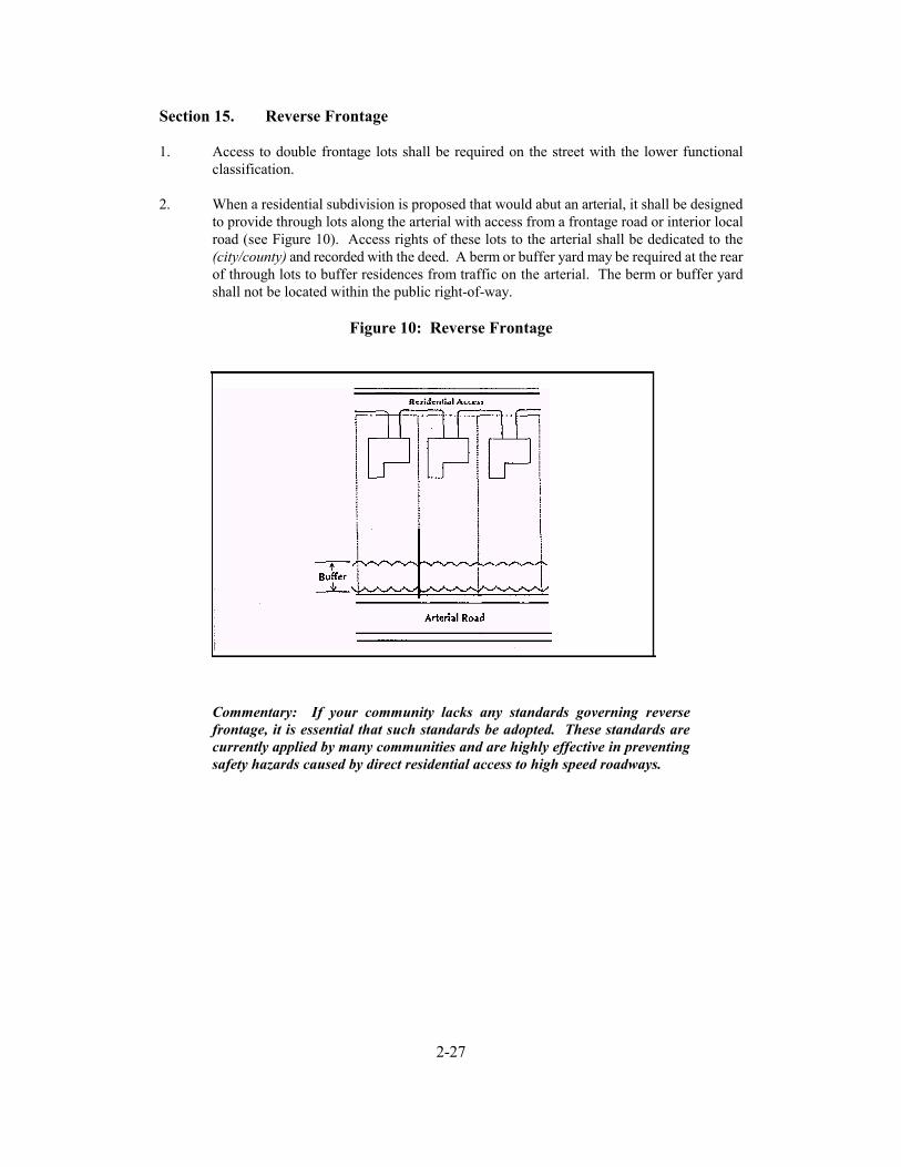
2-27
Section 15. Reverse Frontage
1. Access to double frontage lots shall be required on the street with the lower functionalclassification.
2. When a residential subdivision is proposed that would abut an arterial, it shall be designedto provide through lots along the arterial with access from a frontage road or interior localroad (see Figure 10). Access rights of these lots to the arterial shall be dedicated to the(city/county) and recorded with the deed. A berm or buffer yard may be required at the rearof through lots to buffer residences from traffic on the arterial. The berm or buffer yardshall not be located within the public right-of-way.
Figure 10: Reverse Frontage
Commentary: If your community lacks any standards governing reversefrontage, it is essential that such standards be adopted. These standards arecurrently applied by many communities and are highly effective in preventingsafety hazards caused by direct residential access to high speed roadways.
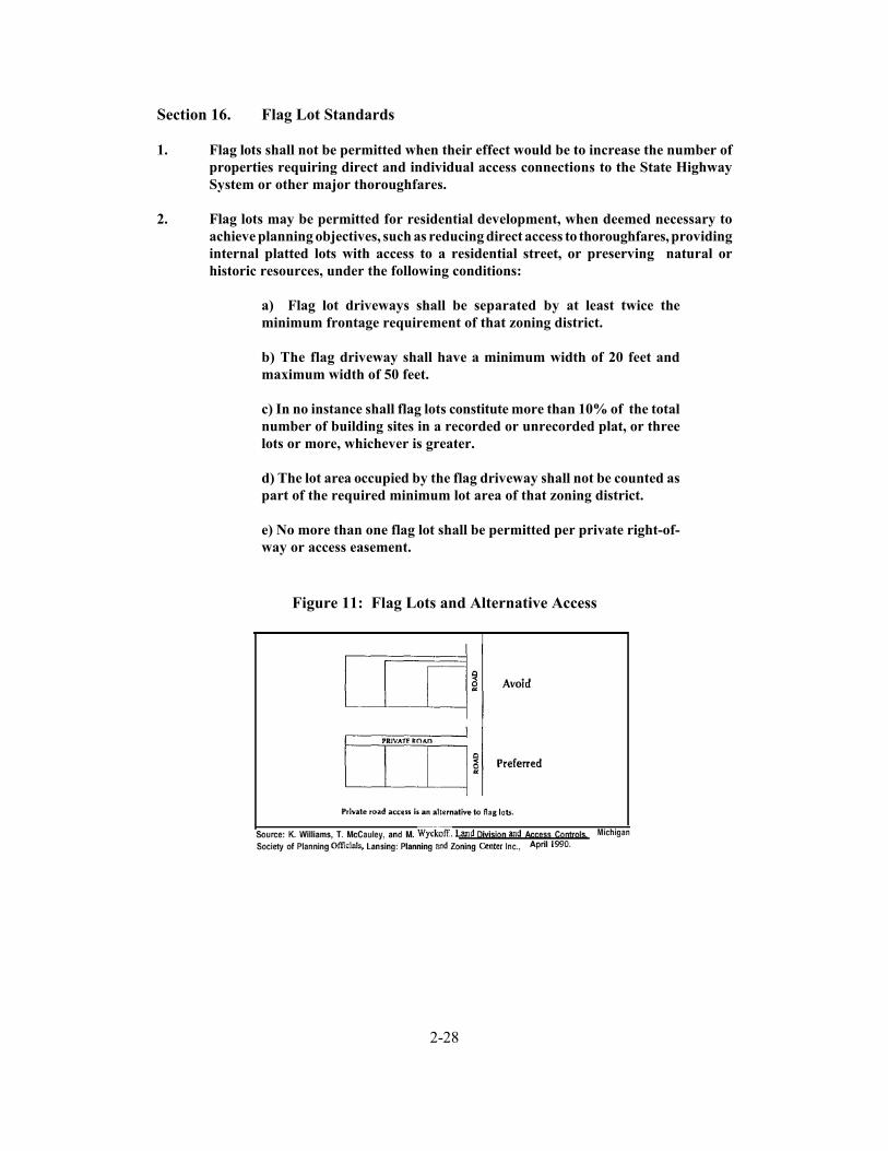
2-28
Section 16. Flag Lot Standards
1. Flag lots shall not be permitted when their effect would be to increase the number ofproperties requiring direct and individual access connections to the State HighwaySystem or other major thoroughfares.
2. Flag lots may be permitted for residential development, when deemed necessary toachieve planning objectives, such as reducing direct access to thoroughfares, providinginternal platted lots with access to a residential street, or preserving natural orhistoric resources, under the following conditions:
a) Flag lot driveways shall be separated by at least twice theminimum frontage requirement of that zoning district.
b) The flag driveway shall have a minimum width of 20 feet andmaximum width of 50 feet.
c) In no instance shall flag lots constitute more than 10% of the totalnumber of building sites in a recorded or unrecorded plat, or threelots or more, whichever is greater.
d) The lot area occupied by the flag driveway shall not be counted aspart of the required minimum lot area of that zoning district.
e) No more than one flag lot shall be permitted per private right-of-way or access easement.
Figure 11: Flag Lots and Alternative Access

2-29
Commentary: Local plat maps often reveal lots shaped like flags with longnarrow access "poles". Flag lots are especially prevalent along lakes, rivers,cul-de-sacs, and rural highways. Although they can be useful where naturalfeatures or land division patterns create access problems, they are subject toabuses. Flag lots proliferate in some areas where property owners use thetechnique to avoid plat review and further subdivide land. The result is asubdivision that lacks adequate access and creates long term problems for thecommunity and those who purchase the lots. Where the narrow frontages abuta thoroughfare, they afford inadequate spacing between driveways and increasesafety hazards from vehicles turning on and off the high speed roadway.Because flag lots often violate driveway spacing standards on the state highwaysystem, they also create problems for the buyer who later attempts to build on theproperty and obtain a driveway permit. Under these standards existing flag lotswould be nonconforming and allowed to continue. In areas where flag lotsproliferate on a state or county thoroughfare, property owners should becontacted and strongly encouraged to consolidate access with adjacentproperties--especially in the case of abutting flag lots.
Section 17. Lot Width-to-Depth Ratios
1. To provide for proper site design and prevent the creation of irregularly shapedparcels, the depth of any lot or parcel shall not exceed 3 times its width (or 4 times itwidth in rural areas). The permitted depth shall be higher in coastal areas subject toerosion.
Commentary: Minimum lot frontage and maximum lot width-to-depth ratiosprevent the creation of long and narrow or irregularly shaped lots that can leadto access and circulation problems. This standard is especially useful in ruralareas, to govern the dimensions of newly created lots and parcels. Note: Ruralareas may adopt a maximum width-to-depth ratio of 1:4, meaning that parcelswith 100 feet of frontage may not be deeper than 400 feet. Urban or suburbanareas may use maximum ratios of 1:2.5 or 1:3. Width-to-depth ratios could beset as high as 1:7 in coastal areas that have a high risk of erosion and somewhatdeeper lots may be permitted along arterials to provide for berms or buffer yardsin reverse frontage situations.
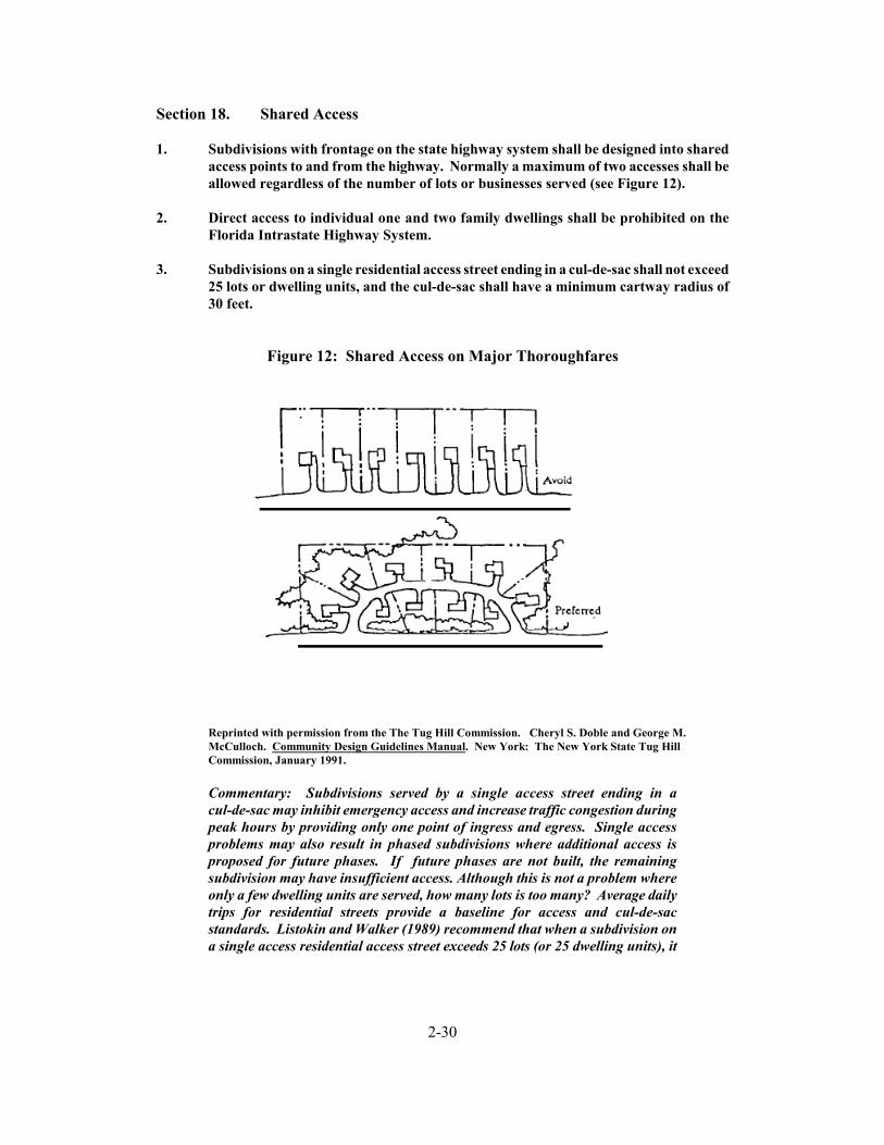
2-30
Section 18. Shared Access
1. Subdivisions with frontage on the state highway system shall be designed into sharedaccess points to and from the highway. Normally a maximum of two accesses shall beallowed regardless of the number of lots or businesses served (see Figure 12).
2. Direct access to individual one and two family dwellings shall be prohibited on theFlorida Intrastate Highway System.
3. Subdivisions on a single residential access street ending in a cul-de-sac shall not exceed25 lots or dwelling units, and the cul-de-sac shall have a minimum cartway radius of30 feet.
Figure 12: Shared Access on Major Thoroughfares
Reprinted with permission from the The Tug Hill Commission. Cheryl S. Doble and George M.McCulloch. Community Design Guidelines Manual. New York: The New York State Tug HillCommission, January 1991.
Commentary: Subdivisions served by a single access street ending in acul-de-sac may inhibit emergency access and increase traffic congestion duringpeak hours by providing only one point of ingress and egress. Single accessproblems may also result in phased subdivisions where additional access isproposed for future phases. If future phases are not built, the remainingsubdivision may have insufficient access. Although this is not a problem whereonly a few dwelling units are served, how many lots is too many? Average dailytrips for residential streets provide a baseline for access and cul-de-sacstandards. Listokin and Walker (1989) recommend that when a subdivision ona single access residential access street exceeds 25 lots (or 25 dwelling units), it
2-31
should have at least two access points. A minimum turning radius thataccommodates emergency vehicles should be required for cul-de-sacs.
The above provisions for shared access are intended to prevent a proliferationof driveways on the state highway system--a common problem in some semi-rural and rural areas. Provisions for shared access also promote landdevelopment patterns that are more compatible with the rural character of thelandscape. The shared access standard in Section 18(12) was taken from thelandmark guidebook Dealing with Change in the Connecticut River Valley, andcan be used together with conservation easements and clustering provisions topreserve natural resources. (see Yaro, Arendt, et al., Dealing with Change in theConnecticut River Valley: A Design Manual for Conservation and Development.Amherst: Lincoln Institute of Land Policy, 1988.)
Section 19. Connectivity
1. The street system of a proposed subdivision shall be designed to coordinate withexisting, proposed, and planned streets outside of the subdivision as provided in thisSection.
2. Wherever a proposed development abuts unplatted land or a future developmentphase of the same development, street stubs shall be provided as deemed necessary bythe (city/county) to provide access to abutting properties or to logically extend thestreet system into the surrounding area. All street stubs shall be provided withtemporary turn-around or cul-de-sacs unless specifically exempted by the PublicWorks Director, and the restoration and extension of the street shall be theresponsibility of any future developer of the abutting land.
3. Collector streets shall intersect with collector or arterial streets at safe and convenientlocations.
4. Subcollector and local residential access streets shall connect with surrounding streetsto permit the convenient movement of traffic between residential neighborhoods orfacilitate emergency access and evacuation, but such connections shall not bepermitted where the effect would be to encourage the use of such streets by substantialthrough traffic.
Commentary: Local governments must maintain a tenuous balance betweenenhancing accessibility and limiting excessive through traffic in residentialareas. These standards strive to address both considerations.
2-32
Section 20. Minor Subdivisions
1. The (approving Department) may approve a Minor Subdivision that conforms to thefollowing standards:
a) Each proposed lot must be buildable in conformance with therequirements of this Code and all other applicable regulations.
b) Each lot shall abut a public or private street for the requiredminimum lot frontage for the zoning district where the lots arelocated.
c) If any lot abuts a street right-of-way that does not conform to thedesign specifications of this Code, the owner may be required todedicate one-half the right-of-way width necessary to meet minimumdesign requirements.
2. Further subdivision of the property shall be prohibited unless applicants submit a plator development plan in accordance with requirements for major subdivisions in thisCode.
Commentary: This standard prohibits property owners from incrementallysubdividing land to avoid review.
3. The (approving Department) shall consider a proposed Minor Subdivision upon thesubmittal of the following materials:
a) An application form provided by the (city/county);
b) ( ) copies of the proposed Minor Subdivision plat; [Note: Thenumber of copies required should be based on number of entities thatwill review the plan under adopted procedures.]
c) A statement indicating whether water and/or sanitary sewerservice is available to the property; and
d) Land descriptions and acreage or square footage of the originaland proposed lots and a scaled drawing showing the intendeddivisions shall be prepared by a professional land surveyor registeredin the State of Florida. In the event a lot contains any principal oraccessory structures, a survey showing the structures on the lot shallaccompany the application.
4. Review Procedure
2-33
a) The (approving official) shall transmit a copy of the proposedMinor Subdivision to the appropriate (departments or officials) forreview and comment.
b) If the proposed Minor Subdivision meets the conditions of thissection and otherwise complies with all applicable laws andordinances, the (approving official) shall approve the MinorSubdivision by signing the application form.
c) Upon approval of the Minor Subdivision, the (approving official)shall record the plat on the appropriate maps and documents, andshall, at the applicant's expense, record the plat in the official countyrecords.
Commentary: These requirements for minor subdivisions are adapted fromFlorida's Model Land Development Code and provided here to emphasize theimportance of adequate land division controls in access management. Theyprovide for local review of divisions of land or "lot splits" that would otherwisebe exempted from subdivision review and platting requirements. A reviewprocess for lot splits prevents creation of lots that are not in conformance withland development regulations and thus could be rendered unbuildable. Itfurther prevents creation of lots with inadequate or inappropriate access to apublic road. This allows local governments to prevent access problemsattributable to flag lots, through lots, and corner lots. This review process isstreamlined and platting requirements are less costly than those of a majorsubdivision, so as not to create a hardship for property owners engaged in onlyminor subdivision activity. Local governments are strongly advised not to provideexemptions from public review of land division activity based on lot size ornumber of lots, because this creates long term problems that can seriouslyundermine the local planning and regulatory program.
Section 21. Private Roads
1. Private roads may be permitted in accordance with the requirements of this Sectionand the following general standards shall apply:
a) All (city/county) roads shall be constructed to public specificationsand have an easement of a minimum of sixty-six feet in width, exceptas otherwise provided in Section 21 (2).
b) Private roads that by their existence invite the public in shall haveall traffic control features, such as striping or markers, inconformance with the Manual of Uniform Traffic Control Devices.
c) The minimum distance between private road outlets on a singleside of a public road shall be 660 feet, or less where provided byaccess classification and standards for state roads and localthoroughfares.
2-34
d) All properties served by the private road shall provide adequateaccess for emergency vehicles and shall conform to the approvedlocal street numbering system.
e) All private roads shall be designated as such and will be requiredto have adequate signage indicating the road is a private road andnot publicly maintained.
f) All private roads shall have a posted speed limit not to exceedtwenty miles an hour.
g) All private roads shall have adequate provisions for drainage andstormwater runoff as provided in Section (refer to appropriate sectionof the local subdivision regulations).
h) A second access connection to a public road shall be required forprivate roads greater than 2000 feet in length.
2. Private roads in rural and semi-rural areas may be permitted reductions in easementand roadway width and pavement standards to provide for adequate access whileretaining the rural character of the landscape and design flexibility. At a minimum,the private road shall meet the (city/county) specifications for gravel roadwayconstruction. Other standards shall apply in accordance with the following schedule:
a) A private road serving up to two lots shall have a minimum right-of-way easement of 30 feet and a roadbed of at least 12 feet.
b) A private road intended to serve no more than three to six lotsshall have a minimum right-of-way easement of 30 feet and aroadbed of at least 16 feet.
c) A private road intended to serve no more than seven to twelve lotsshall have a minimum right-of-way easement of 66 feet and aroadbed of at least 20 feet. Paving shall be required for all areas withgrades of greater than three (3%) percent. Such pavement shall bea minimum of 18 feet in width.
d) A private road intended to serve no more than 13 to 24 lots shallhave a minimum right-of-way easement of 66 feet, a roadbed of atleast 24 feet and shall be paved.
e) A private road intended to serve 25 or more lots or parcels shallprovide at least two access connections to a public road and shallmeet the minimum design requirements for public roads.
Commentary: This section provides a sliding scale approach, allowing gravelroads of about 12 feet to 18 feet wide for 2-4 parcels and requiring higher designspecifications for larger developments. The standards are intended to provideflexibility and to preserve the character of rural areas. Communities considering

2-35
a sliding scale approach to private roads should also adopt a site plan reviewprocess aimed at encouraging creative site design and landscape preservation.
3. Applications for subdivision approval that include private roads shall include adrainage plan and road construction plan, prepared by a registered engineer. The(city/county) Public Works Official shall review private road plans for conformancewith this Code.
4. Construction permits are required for connection to public roads. Application forroad construction shall be made concurrent with the creation of a lot that does nothave frontage on a public road. A road construction permit shall be issued afterapproval of the private road plan and the entire length of the road shall be inspectedduring construction and upon completion. If found in conformance, a final use permitshall be issued.
5. No building permit shall be issued for any lot served by a private road until the privateroad has been constructed and approved, so that all lots to be served by the privateroad have access to a public road.
6. A road maintenance agreement, prepared by the (city/county) attorney shall berecorded with the deed of each property to be served by a common private road. Theagreement shall provide for:
a) A method to initiate and finance a private road and maintain thatroad in good condition;
b) A method of apportioning maintenance costs to current and futureusers;
c) A provision that the (city/county) may inspect, and if necessary,require that repairs be made to the private road to ensure that safeaccess is maintained for emergency vehicles. If required repairs arenot made within six months of date of notice, the (city/county) maymake the necessary repairs and assess owners of parcels on the roadfor the cost of all improvements plus an administrative fee, not toexceed 25% of total costs;
d) A provision that the majority vote of all property owners on theroad shall determine how the road is maintained except in the caseof emergency repairs as outlined above;
e) A statement that no public funds shall be used to construct repairor maintain the road;
f) A provision requiring mandatory upgrading of the roadway ifadditional parcels are added to reach the specified thresholds; and
g) A provision that property owners along that road are prohibitedfrom restricting or in any manner interfering with normal ingress

2-36
and egress by any other owners or persons needing to accessproperties with frontage on that road.
7. No private road shall be incorporated into the public road system unless it is built topublic road specifications of the (city/county). The property owners shall beresponsible for bringing the road into conformance.
8. All private roads shall have a sign and name meeting (city/county) standards and shallinclude the following notice: "Private Road" "Not maintained by the (city/county)".
9. An application fee will be established by the Director of Public Works to coveradministrative, processing, and inspection costs.
10. All purchasers of property served by a private road shall, prior to final sale, benotified that the property receives access from a private road that shall be maintainedcollectively by all property owners along that road; that the (city/county) shall not beheld responsible for maintaining or improving the private road; and that a right-ofway easement to provide the only access to that property has been recorded in thedeed for that property.
11. The United States postal service and the local school (board/district) is not required touse the private road for access to the parcels abutting the private road and mayrequire that service be provided only at the closest public access point.
Commentary: These private road standards were adapted from sampleregulations prepared for the Grand Traverse Bay Region (Planning & ZoningCenter, Inc., Lansing, Michigan, September 1992). Some communities prohibitprivate roads altogether or require all private roads serving more than onedwelling unit to be built to public specifications and paved. This is because ofproblems associated with private roads, such as pressure to adopt the privateroad into the public road system in the future. Yet if properly regulated, privateroads can offer an effective means of access to small subdivisions in rural areas.In the absence of private road regulations, common practice is the creation ofmultiple lots served by a common lot, easement, or multiple easements as in theexample of stacked flag lots. The easement then becomes a private unpaved roadserving several properties.
Unregulated private roads raise several problems. They may be inaccessible toemergency vehicles or large delivery trucks, placing public safety and privateproperty at risk. Substandard roads deteriorate quickly and without amaintenance agreement, the local government may be called upon to maintainit. Buyers may not be aware of the maintenance issues associated with the roaduntil after purchasing the property. Narrow rights-of-way may impedeplacement of utilities, and private roads can exacerbate inefficient landdevelopment patterns. These problems can be avoided through private roadregulations that address design, construction, joint maintenance agreements,signage, and review. Private roads should be permitted for residential uses onlyand standards should be tied to lot split (minor replat) or subdivision regulations.Limitations should be placed upon the number of residences that may be servedby a single access to a public road.
2-37
As in other land development regulations, private road provisions must be madefor grandfathering existing nonconforming situations. Some ordinances addressthe situation by providing a different set of standards for nonconforming privateaccess or by providing for expansion of existing substandard private roads oreasements pursuant to the special use permit process.
Section 22. Regulatory Flexibility
1. The Planning Commission may permit departure from dimensional lot, yard, and bulkrequirements of the zoning district where a subdivision or other development plan isproposed to encourage creativity in site design, protect natural resources, and advancethe access objectives of this Code. Such regulatory modifications under this sectionare not subject to variance approval by the Board of Adjustment.
Section 23. Site Plan Review Procedures
1. Applicants shall submit a preliminary site plan for review by (name of departmentresponsible for conducting review). At a minimum, the site plan shall show:
a) Location of access point(s) on both sides of the road whereapplicable;
b) Distances to neighboring constructed access points, medianopenings, traffic signals, intersections, and other transportationfeatures on both sides of the property;
c) Number and direction of lanes to be constructed on the drivewayplus striping plans;
d) All planned transportation features (such as auxiliary lanes,signals, etc.);
e) Trip generation data or appropriate traffic studies;
f) Parking and internal circulation plans;
g) Plat map showing property lines, right-of-way, and ownership ofabutting properties; and
h) A detailed description of any requested variance and the reasonthe variance is requested.
2. Subdivision and site plan review shall address the following access considerations:
a) Is the road system designed to meet the projected traffic demandand does the road network consist of hierarchy of roads designedaccording to function?

2-38
b) Does the road network follow the natural topography andpreserve natural features of the site as much as possible? Havealignments been planned so that grading requirements areminimized?
c) Is access properly placed in relation to sight distance, drivewayspacing, and other related considerations, including opportunities forjoint and cross access? Are entry roads clearly visible from the majorarterials?
d) Do units front on residential access streets rather than majorroadways?
e) Is automobile movement within the site provided without havingto use the peripheral road network?
f) Does the road system provide adequate access to buildings forresidents, visitors, deliveries, emergency vehicles, and garbagecollection?
g) Have the edges of the roadways been landscaped? If sidewalksare provided alongside the road, have they been set back sufficientlyfrom the road, and has a landscaped planting strip between the roadand the sidewalk been provided?
h) Does the pedestrian path system link buildings with parkingareas, entrances to the development, open space, and recreationaland other community facilities?
Commentary: The subdivision and site plan review process provides localgovernments with the most effective opportunity for addressing accessconsiderations and preventing access problems before they occur. This shouldbe done as early as possible in the process. Developers will be far less amenableto revising the access plan later in the process or after the site plan or plat hasbeen approved. The above checklist of access review considerations in Section23(2) was adapted from David Listokin and Carole Walker. The Subdivision andSite Plan Handbook. New Brunswick, NJ: Center for Urban Policy Research,Rutgers University. 1989.
3. The (city/county) reserves the right to require traffic and safety analysis where safetyis an issue or where significant problems already exist.
4. After 30 days from filing the application, applicants must be notified by the (permittingdepartment) if any additional information is needed to complete the application.
5. Upon review of the access application, the (permitting department) may approve theaccess application, approve with conditions, or deny the application. This must bedone within 90 days of receiving the complete application.
2-39
6. Any application that involves access to the State Highway System shall be reviewed bythe Florida Department of Transportation for conformance with state accessmanagement standards. Where the applicant requires access to the State HighwaySystem, and a zoning change, or subdivision or site plan review is also required,development review shall be coordinated with the Florida Department ofTransportation, as follows:
a) An access management/site plan review committee that includesrepresentatives of FDOT traffic operations, access permitting, andthe local government shall review the application. The committeeshall inform the developer what information will be required foraccess review. Information required of the applicant may varydepending upon the size and timing of the development, but shall ata minimum meet the requirements of this section.
b) Upon review of the application, the access management reviewcommittee shall advise the (permitting department) whether toapprove the access application, approve with conditions, or deny theapplication.
7. If the application is approved with conditions, the applicant shall resubmit the planwith the conditional changes made. The plan, with submitted changes, will bereviewed within 10 working days and approved or rejected. Second applications mayonly be rejected if conditional changes are not made.
8. If the access permit is denied, the (city/county) shall provide an itemized letter detailingwhy the application has been rejected.
9. All applicants whose application is approved, or approved with conditions, have thirtydays to accept the permit. Applicants whose permits are rejected or approved withconditions have 60 days to appeal.
Commentary: Effective coordination with the Florida Department ofTransportation, the local traffic engineer, transportation planner, and/or publicworks official is essential to ensure conformance with land division and accessrequirements. One method of improving coordination is to establish the buildingpermit as the lead permit during development review. In this way, propertyowners would be required to submit the necessary permits or certificates ofapproval from regulatory agencies involved in development review before issuinga building permit. This should include a notice of intent to approve the proposedaccess connection from the Florida Department of Transportation where thestate highway system is involved to assure conformance with the State HighwaySystem Access Management Act and administrative rules. The above reviewprocess would be incorporated into the community's overall subdivision and siteplan review process. A conceptual review, before submission of the preliminarysite plan or plat, is highly recommended. Communities should also set fees anddevelop the necessary forms to carry out the provisions of this code.
2-40
Section 24. Variance Standards
1. The granting of the variation shall be in harmony with the purpose and intent of theseregulations and shall not be considered until every feasible option for meeting accessstandards is explored.
2. Applicants for a variance from these standards must provide proof of unique orspecial conditions that make strict application of the provisions impractical. This shallinclude proof that:
a) indirect or restricted access cannot be obtained;
b) no engineering or construction solutions can be applied tomitigate the condition; and
c) no alternative access is available from a street with a lowerfunctional classification than the primary roadway.
3. Under no circumstances shall a variance be granted, unless not granting the variancewould deny all reasonable access, endanger public health, welfare or safety, or causean exceptional and undue hardship on the applicant. No variance shall be grantedwhere such hardship is self-created.
Commentary: Each local government has its own process for handling appealsand variances. The standards above should be incorporated to this process. Providing for variances and other remedial measures is crucial to avoiding atakings claim by providing due process to the property owner and avoidingunreasonable hardship that may arise in relation to the regulatory framework.Federal case law has established that property owners should first exhaustavailable administrative remedies, including appeals to the local board ofadjustment, before the case may be heard in a court of law. If local appealprocedures exist and the property owner sues before first pursuing a variance orother remedial action, the case may be invalidated on this basis.

Part 3: Model Corridor Agreement for the
Florida Intrastate Highway System


MODEL CORRIDOR AGREEMENT FOR THE F‘LORlDAINTRASTATE HIGHWAY SYSTEM
This Corridor Agreement, hereinafter called the Agreement, is made and entered into this~ day of _ _ ILby and between the STATE OF FLORIDA DEPARTMENT OFTRANSPORTATION, an agency of the State of Florida, hereinafter called the “Department”,AND a body corporate and a political subdivision of the State ofFlorida, its successors and assigns, hereinafter referred to as the (“CITY” or “COUNTY”).
WHEREAS, the Florida Intrastate Highway System, hereinafter called the “FIHS”, is thestatewide system of limited access and controlled access facilities that allow for high-speed, high-volume traffic movement within the State that has been designated by the Department andadopted by the Legislature;
WHEREAS, the State Highway System has been classified for access purposes, withhighest priority given to preserving mobility on the FIHS.
WHEREAS, the FIHS program requires strict access management standards for allportions of the FIHS and requires all segments to be brought into compliance with system criteriaand standards within a 20 year period;
WHEREAS, the FIHS Plan emphasizes the need for coordination between the Departmentand local governments on managing access to those portions of the FIHS that are not limitedaccess facilities;
WHEREAS, the FIHS Plan calls for the Department to enter agreements with localgovernments for coordinating land use planning and regulation with state access standards forcontrolled access facilities;
WHEREAS, managing access to land development enhances mobility by preserving theregional flow of traffic in terms of safety, capacity, and speed end enhances developmentpatterns.
WHEREAS, access management balances the right of reasonable access to privateproperty, with the right of the citizens of the (“CITY” or “COUNTY”) and the State of Floridato safe and efficient travel.
WHEREAS, the functional integrity of the FIHS relies on local land development andsubdivision regulations that support state access standards for controlled access facilities;
WHEREAS, land development and subdivision regulations that support accessmanagement can be applied to the FIHS to achieve the following state and local objectives.:

a) lcducc Lraffic accidents, personal injury, and property damage attributable to poorlydesigned access systems;
b) protect the substantial public investment in the existing transportation system andreduce the need for expensive remedial measures;
c) further the orderly layout and use of land; and
d) promote well-designed road and access systems that help protect conununity characterand conserve natural resources.
NOW, THEREFORE, in consideration of the mutual terms and conditions, promised andcovenants hereinafter set forth, the Department and the (“CITY” or “COUNTY”) agree asfollows:
1. Attached hereto and made a part of this Agreement is Exhibit A which denotes thoseportions of the FIHS affected by this agreements, hereinafter called the “DesignatedCorridors”;
2. On behalf of the Department, the (“CITY” or “COUNTY”) agrees to implement thefollowing protective planning and regulatory measures within (sp@ fime frame), inaccordance with the terms and conditions of this Agraement as provided in Attachment1. &st all regulatory measures including corridor overlay standards to be applied inAttachment 1]
3. The responsibilities of each party for the development of an access management plan tomanage current and future access to the “Designated Corridors” are specified inAttachment 2; [include this stipulation only where all affectedparties agree to preparean access management plan.]
4. This Agreement is made in accordance with the Florida Intrastate Highway Systempr0gran-b Section 338.001, Florida Statutes; the State Highway System AccessManagement Act, Chapter 335.18, Florida Statutes, as amended; Chapter 14-96 and 14-97,Rules of the Department of Transportation; and policy and planning directives of thefederal Intermodal Surface Transportation Efficiency Act of 199 1.
5. This Agreement shall become effective upon execution by all parties hereto and filingwith the Clerk of the Circuit Court in each county where the parties to this agreement arelocated.
To be signed and approved by authorized agents of each party

Appendix 1: Sample Cross Access Agreement


APPENDIX 1: SAMPLE CROSS ACCESS AGREEMENT
Background: Thefollowing is an example of a cross access agreementfrom the City of Orlando.It is provided as an example only. Local governments should consult their attorney for advicein preparing these agreements.
THIS AGREEMENT is made and entered into on this (dare) by (owner’r name), a corporation authorizedto transact business in the State of Florida (“OWNER”) and the City of Orlando, a municipal corporation organizedunder the laws of the State of Florida “CITY”.
RECITALS1. OWNER owns certain real property (“Parcel A”) located (legal description ofpropertyl.2. As a part of its land use approvals from the CITY, the OWNER has been requested by CITY to provide crossaccess to adjaccut pqxrties to (locarion of aburrlngproperties), subpt to the terms and condltmns set forth below.3. The CITY has a health, safety and welfare interest in providing for the cross access easement.4. The OWNER acknowledges the CITY’s health, safety and welfare interest and agrees to provide said crossaccess subject to the terms and conditions set forth in this Agreement.
NOW, THEREFORE, in consideration of the obligations contained herein, and in good and valuable consideration,the receipt and sufficiency of which is hereby acknowledged, th? OWNER and the CITY hereby agree as follows:
Section 1. The recitals are acknowledged by both parties and incorporated herein and have been reliedRecitals.upon by both parties in the execution of this Agreement.
Section 2. Grant of Easement in Escrow. Subject to the terms set forth in this agreement, the OWNER herebygrants a cross access easement to the CITY to be held in escrow for the benefit of the owner of that parcel locatedflocurion OJ aburrtng propeny #I). The cross access easement is described in (Exhibit #) attached to andincorporated in this Agreement. Said cross access easement shall be freely assignable to said Owner; provided,however, that the CITY shall not assign said easement until the Owner of (aburtingproperfy #I) applies for or isissued any of the following land development approvals as defuul in the City Cude.(1) conditional use permit;(2) rezoning;(3) master plan approval:(4) plat approval;(5) variance;(6) building permit for a substantial enlargement or substantial improvement:(7) building permit which generates automobile traffic trips in excess of current improvements;(8) driveway permit; or(9) paving and/or drainage permit.
Likewise, the OWNER hereby grants a cross access easement to the CITY to be held in escrow for the benefit Ofthe owner of that parcel located (location of abuttingpropeny #z). This cross access easement area shall be of asize siuillilar to that of the one granted for use by the Owner of [adjacentproperly #I) and said location shall be laterdetermined by the CITY and OWNER. Said cross access easement shall be freely assignable to said Owner.Notwithstanding anything to the contrary contained herein, however, the CITY shall not assign a cross accesseasement to either Owner unless the land use proposed for that Owner’s parcel is consistcnt and compatible withthe land use cm the OWNER’s property.
Section 3. Conditions of the Use of the Cross Access Easemeat Agreement. The use of two cross accesseasements to be granted to the CITY and held in escrow pursuant to Section 2 hereof is subject to the followingterms and conditions:
(1) The. Owner of (adjacentproperty #I) shall equally share with OWNER in the maintenance and repairof the cross access easement area as designated in the attached (&h$it #);
(2) The Owner of (adjacent property #2J shall equally share with OWNER in the maintenance and repairof the cross access easement area to be designated by CITY and OWNER;
(3) The Owners of (both adjacenfproperties) to receive such cross access agree to pay the cost of two (2)signs placed on their respective parcels at each side of the pavement of the easement area and the common boundaryline of their respective parcel with Parcel A (facing those parcels) which signs shall state that the parking in ParcelA is limited to the guests of the OWNER and the vehicles of unauthorized persons (guests, licensees, invitees,patrons, etc. of the other parcel) shall be towed away at the vehicle owner’s expense;
(4) The owners of (both adjacentproperties) agree to install and maintain on the common boundary linewith Parcel A, or other location agreed to by the parties (a) a speed bump and stop sign within the cross accesseasement leading into (adjacent property #I), @) a speed bump and stop sign within the cross access easementleading into (mfjacent pmpeny $2). and ( )c one speed bump c& uu (torh udju.em pro~rrrir>J.
(5) The use of the cross access easements shall also be subject to (a) a weight limit on the vehicles whichutilize the cross access easement (to be established or modified by the CITY’s transportation engineer from timeto time), (b) a limit on the number of daily trips of no more than 1,000 trips, and (c) a limit on the time of access.
(6) The Owners of (both adjacent properlies) shall pay the cost of installation of said gates and any otherimprovements to the cross access easement beyond what has been previously constructed by the OWNER:
(7) Tractor trailer vehicles shall not use the cross access easement for access to or from (both a¢properties).
(8) Buses seating 30 passengers or more may use the cross access easements so long as the buses stackor queue on (both adjacent properties) and not in the cross access easement areas;
(9) The Owners of @oth ad~acenrproperties) shall not use the cross access eaSemeat in any manner suchas to result in congestion within the cross access easements or the blocking of the cross access easement or drivingaisles of Parcel A; and
(10) The cross access easements shall bc subject to the joinder and consent of the lender(s) Of the OWNERand the Owners of (both adjacent propenies).
Section 4. Delegation to CITY Tranroortation Engineer. The parties agree that the CITY transportation engineerhas the power and authority to adjust the conditions set forth in Subsection 3(5) hereof in order to preserve theintegrity, character, safety of the (type of land use on OWNER’s property).
Section 5. Covenant Running with the Land. All rights and obligations arising or described hereunder areintended to be appurtenances and covenants running with the title of the OWNER’s property and shall be bindingupon and inure to the benefit of the panics and their respective successors in title.
Section 6. Dedication. Nothing contained herein shall constitute any rights in the general public.
Section 7. Caotionr. Number and Gender. The captions and headmgs are tor ~o~v~IuU~C~ OdY and are notintended to be used in construing any provision of this easement. The singular and plural shall each include theother were appropriate, or if any genders shall include other genders when the contract so permits.
Section 8. Govemine Law and Venue. The laws of the State of Florida shall govern this agreement. tiY legalaction instituted herein shall be brought in Orange County, Florida.
Section 9. Modification or Termination. The terms tid provisions of this Agreement may be modified,supplemented or terminated only by a written instrument executed by the OWNER and CITY, their successors orassigns.
References
Bay County. Bay County Land Development Regukztions. November 1990.
Bloom, C. Rewlatinq Private Roads PIarming and Zoning News, Vol. 8, No.3, January 1990: 7-10.
Brouzh. M. A Unified Development Ordinance. Washington, DC.: Plmncrs l’rcss Amclican Pluuiq Awxia&m,1985.
Chapin, F. and E. Kaiser. Urban Land Use Planni~& Chicago: University nf Illinois Press, 1985
Doble, S. and G. McCulloch. Community Desizn Guidelines Manual. New York: The New York State Tug HillCommission, January 1991.
Falconi, X. “Access Management: Relationship Between Developers, Local Government and State Government.”p1 9 9 1 .
Hillsborough County. Hillsborough County Land Development Regulations. March 1992
Koepke. F. and H 1 winson Access Manaqemsnt Guidclincs for Activity CentcIs. NCHRP Repurt 348,Washington, D.C.: National Academy Press, 1992.
Listokin, D. and C. Walker. The Subdivision and Site Plan Handbook New Jersey: The State University of NewJersey 1989.
McPherson, J., D. Coffey and G. E.&y. Land Development Regulations. Teclmical Assistance Manual for FloridaCities and Counties. Prepared for the Department of Community Affairs. August 28, 1989.
McPherson, .I., D. Coffey and G. Easley. Model Land Development Code for Florida Cities and Counties. Preparedfor the Department of Community Affain. December 1989.
Misseldine, C. and M. Wyckoff. Plan&% and Zonin% for Farmland Protection: A Communitv Based Approach.American Farmland Trust, 1987.
Moskowitz, H. and C. Lindbloom. The New Illustrated Book of Development Definitions. New Brunswick, NewJersey: Center for Urban Policy Research, 1993.
Orlando, City of. Orlando Code of Ordinances, LandDevelopment Code, Chapter 60, Subdivision andLandscaping.1991
Orlando, City of. Orlando Code of Ordinances, Land Development Code, Chapter 61, Roadwq Design andAccessManagement. 1991
Pembroke Pines, City of. City of Pembroke Pines Land Development Regulations. 1986
Sarasota County. Sarasota County Land Development Rrgrrbtions. October 1989.
Stover, V. and F. Koepke. Transuortation and Land Development. Prentice Hall, Englewood Cliffs, New Jersey,1988.
Williams, K., T. McCauley and M. Wyckoff. Land Division and Access Controls. Lansing: Planning and ZoningCenter Inc., April 1990.

Wyckott M., K. Williams, M. Armstrong, et al. Community Planning Handbook: Tools and Techniques for GuidingCommunitv Chanw Planning & Zoning Center, Inc. , March 1992.
WyckofF, M., Qrand Traverse Bay Reaion Develooment Guidebook. Planning & Zoning Center, Inc., September1992.
Wyckoff, M., Grand Traverse Bav Rwion &mole Reoulaliuns. Planning & Zoning Center, Inc., September 1992.
Yaro, R., R. Arendt, H. Dodson and E. Brabec. Dealing with Change in the Connecticut River Vallev: A DesignManual for Conservation and Develooment. Amherst: Lincoln Institute of Land Policy and the IInviromncntal LawFoundation, 1988.
Section 10. Recording, This Agreement shall bc recorded by the OWNER at its sole expense in the pubkrecords of Orange County, Florida.
Section 11. Joinder and Consent. The OWNER hereby agrees to obtain tbc Joinder and Consent to thisAgreement from any superior interest, right, title, lien, encumbrance to Parcel A. The Joinder and Consent shallSubordinate the particular interest to this Agreement.
Section 12. Obligation of the CITY. The CITY agrees that it will condition the issuance of any of the permitslisted in Section 2, above, to the Owner of parcel adjacent to Parcel A upon the condition that said owner enter intothe Cross Access Easement Agreement.
Section 13. No Easement Rights or Other Rights. Notwithstanding anything to the contrary herein, @ofh adjacentproperries) shall have no rights to, on, in or over the Easement Area until the Cross Access Easement Agreementis agreed upon between the partics, cxccutcd by the appropriate entities and recorded m the pubhc records Ot UraqeCounty, Florida.
Seem Severability. If any term. provision, clause, sentence or other portion of this Agrccmcnt shall bccomcor be determined to be illegal, null or void for any reason, or shall be held by any court of competent jurisdictionto be so, the remaining portions thereof shall remain in full force and effect.
Section 15. Entire Agreement. This Agreement constitutes the entire agreement between the parties andsupersedes any previous discussions, understandings, and agreements.
IN WITNESS WHEKLUP, the parttes have caused this Agreement to be executed on the date first stated above.