CHAPTER 19 SUBDIVISION AND LAND DEVELOPMENTelibrary.pacounties.org/Documents/Butler_County/545;...
108
CHAPTER 19 SUBDIVISION AND LAND DEVELOPMENT Part 1 - Subdivision and Land Development Ordinance (Ord. No. - repealing Ord. No. 3-1960) 5lill.. b & /I f34
Transcript of CHAPTER 19 SUBDIVISION AND LAND DEVELOPMENTelibrary.pacounties.org/Documents/Butler_County/545;...
CHAPTER 19
SUBDIVISION AND LAND DEVELOPMENT
Part 1 - Subdivision and Land Development Ordinance (Ord. No. - repealing Ord. No. 3-1960)
5lill..
b& / I f34
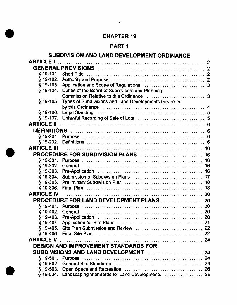
CHAPTER 19
PART 1
SUBDIVISION AND LAND DEVELOPMENT ORDINANCE ARTICLE I . . . . . . . . . . . . . . . . . . . . . . . . . . . . . . . . . . . . . . . . . . . . . . . . . . . . . . . . . . . . . . . . . . 2
GENERAL PROVISIONS . . . . . . . . . . . . . . . . . . . . . . . . . . . . . . . . . . . . . . . . . . . . . . . . 2 $ 19-101 . Short Title . . . . . . . . . . . . . . . . . . . . . . . . . . . . . . . . . . . . . . . . . . . . . . . . . . . . . 2 $ 19-102 . Authority and Purpose .......................................... 2 $ 19.103 . Application and Scope of Regulations ............................ 3 § 19.104 . Duties of the Board of Supervisors and Planning
Commission Relative to this Ordinance .......................... 3 $19.105 . Types of Subdivisions and Land Developments Governed
by this Ordinance . . . . . . . . . . . . . . . . . . . . . . . . . . . . . . . . . . . . . . . . . . . . . . 4 $ 19.106 . Legal Standing . . . . . . . . . . . . . . . . . . . . . . . . . . . . . . . . . . . . . . . . . . . . . . . . 5 $ 19.107 . Unlawful Recording of Sale of Lots .............................. 5
ARTICLE I I ................................................................. 6 DEFINITIONS . . . . . . . . . . . . . . . . . . . . . . . . . . . . . . . . . . . . . . . . . . . . . . . . . . . . . . . . . . . . 6
$ 19.201 . Purpose . . . . . . . . . . . . . . . . . . . . . . . . . . . . . . . . . . . . . . . . . . . . . . . . . . . . . . . 6 $ 19.202 . Definitions . . . . . . . . . . . . . . . . . . . . . . . . . . . . . . . . . . . . . . . . . . . . . . . . . . . . . 6
ARTICLE 111 ............................................................. 16 PROCEDURE FOR SUBDIVISION PLANS . . . . . . . . . . . . . . . . . . . . . . . . . . . . 16
$ 19.301 . Purpose . . . . . . . . . . . . . . . . . . . . . . . . . . . . . . . . . . . . . . . . . . . . . . . . . . . . . . 16 $ 19.302 . General . . . . . . . . . . . . . . . . . . . . . . . . . . . . . . . . . . . . . . . . . . . . . . . . . . . . . . 16
0 $ 19.303 . Pre-Application . . . . . . . . . . . . . . . . . . . . . . . . . . . . . . . . . . . . . . . . . . . . . . . 16 $ 19.304 . Submission of Subdivision Plans ............................... 17 § 19.305 . Preliminary Subdivision Plan . . . . . . . . . . . . . . . . . . . . . . . . . . . . . . . . . . . 18 $ 19.306 . Final Plan . . . . . . . . . . . . . . . . . . . . . . . . . . . . . . . . . . . . . . . . . . . . . . . . . . . . 18
ARTICLE IV . . . . . . . . . . . . . . . . . . . . . . . . . . . . . . . . . . . . . . . . . . . . . . . . . . . . . . . . . . . . . . . 20 PROCEDURE FOR LAND DEVELOPMENT PLANS . . . . . . . . . . . . . . . . . . 20
$ 19401 . Purpose . . . . . . . . . . . . . . . . . . . . . . . . . . . . . . . . . . . . . . . . . . . . . . . . . . . . . . 20 $ 19402 . General . . . . . . . . . . . . . . . . . . . . . . . . . . . . . . . . . . . . . . . . . . . . . . . . . . . . . . 20 $ 19403 . Pre-Application . . . . . . . . . . . . . . . . . . . . . . . . . . . . . . . . . . . . . . . . . . . . . . . 20 $ 19404 . Application for Site Plans . . . . . . . . . . . . . . . . . . . . . . . . . . . . . . . . . . . . . . 21 $ 19405 . Site Plan Submission and Review .............................. 22 $ 19406 . Final Site Plan . . . . . . . . . . . . . . . . . . . . . . . . . . . . . . . . . . . . . . . . . . . . . . . . 22
ARTICLE V . . . . . . . . . . . . . . . . . . . . . . . . . . . . . . . . . . . . . . . . . . . . . . . . . . . . . . . . . . . . . . . . 24 DESIGN AND IMPROVEMENT STANDARDS FOR SUBDIVISIONS AND LAND DEVELOPMENT ......................... 24
5 19-501 . Purpose . . . . . . . . . . . . . . . . . . . . . . . . . . . . . . . . . . . . . . . . . . . . . . . . . . . . . . 24 $ 19-502 . General Site Standards . . . . . . . . . . . . . . . . . . . . . . . . . . . . . . . . . . . . . . . . 24
§ 19.504 . Landscaping Standards for Land Developments . . . . . . . . . . . . . . . . . 28 $ 19-503 . Open Space and Recreation ................................... 26 e

§ 19.505 . Streets . . . . . . . . . . . . . . . . . . . . . . . . . . . . . . . . . . . . . . . . . . . . . . . . . . . . . . . 32 § 19.506 . Construction Standards for Opening of New Streets . . . . . . . . . . . . . . 37
19.507 . Alleys, Driveways and Easements .............................. 40 § 19.508 . Lighting . . . . . . . . . . . . . . . . . . . . . . . . . . . . . . . . . . . . . . . . . . . . . . . . . . . . . . 41 § 19.509 . Underground Wiring . . . . . . . . . . . . . . . . . . . . . . . . . . . . . . . . . . . . . . . . . . . 42
19.510 . Signs . . . . . . . . . . . . . . . . . . . . . . . . . . . . . . . . . . . . . . . . . . . . . . . . . . . . . . . . 42 19-51 1 . Off-street Parking . . . . . . . . . . . . . . . . . . . . . . . . . . . . . . . . . . . . . . . . . . . . . 43
§ 19.512 . Lot Size and Layout . . . . . . . . . . . . . . . . . . . . . . . . . . . . . . . . . . . . . . . . . . . 45 19.513 . Water Supply . . . . . . . . . . . . . . . . . . . . . . . . . . . . . . . . . . . . . . . . . . . . . . . . . 47
§ 19.514 . Sanitary Sewers . . . . . . . . . . . . . . . . . . . . . . . . . . . . . . . . . . . . . . . . . . . . . . 49 $j 19.515 . Water andlor Sewer Facilities Plan Approval .................... 50 § 19.516 . Stormwater Management . . . . . . . . . . . . . . . . . . . . . . . . . . . . . . . . . . . . . . 51
19.517 . Improvement Sureties . . . . . . . . . . . . . . . . . . . . . . . . . . . . . . . . . . . . . . . . . 53 ARTICLEVI . . . . . . . . . . . . . . . . . . . . . . . . . . . . . . . . . . . . . . . . . . . . . . . . . . . . . . . . . . . . . . . 57 PLAN REQUIREMENTS FOR SUBDIVISIONS AND LAND DEVELOPMENT . . . . . . . . . . . . . . . . . . . . . . . . . . . . . . . . . . . . . . . . . . . . . . . . . . . . . . . . . . 57
. . . . . . . . . . . . . . 57 § 19.602 . Major/Minor Subdivision Final Plan Requirements . . . . . . . . . . . . . . . . 59
19.603 . Modification of Requirements .................................. 62 § 19.604 . Land Development Plan Requirements .......................... 62
19.605 . Modification of Requirements . . . . . . . . . . . . . . . . . . . . . . . . . . . . . . . . . . 65 ARTICLE VI1 . . . . . . . . . . . . . . . . . . . . . . . . . . . . . . . . . . . . . . . . . . . . . . . . . . . . . . . . . . . . . . 66 MOBILE HOME PARK REGULATIONS ................................. 66
19-701 . Applicability . . . . . . . . . . . . . . . . . . . . . . . . . . . . . . . . . . . . . . . . . . . . . . . . . . 66 19-702 . Department of Environmental Protection Review . . . . . . . . . . . . . . . . . 66
§ 19.703 . Plan Requirements . . . . . . . . . . . . . . . . . . . . . . . . . . . . . . . . . . . . . . . . . . . . 66 § 19.704 . Design Requirements . . . . . . . . . . . . . . . . . . . . . . . . . . . . . . . . . . . . . . . . . 69 § 19.705 . Utility and Fire Requirements .................................. 71
ARTICLE Vlll . . . . . . . . . . . . . . . . . . . . . . . . . . . . . . . . . . . . . . . . . . . . . . . . . . . . . . . . . . . . . . 74 RECREATIONAL VEHICLE PARK REGULATIONS .................... 74
19-801 . Applicability . . . . . . . . . . . . . . . . . . . . . . . . . . . . . . . . . . . . . . . . . . . . . . . . . . 74 § 19.802 . Permits . . . . . . . . . . . . . . . . . . . . . . . . . . . . . . . . . . . . . . . . . . . . . . . . . . . . . . 74
19.803 . Plan Requirements . . . . . . . . . . . . . . . . . . . . . . . . . . . . . . . . . . . . . . . . . . . . 74 § 19-804 . Design Requirements . . . . . . . . . . . . . . . . . . . . . . . . . . . . . . . . . . . . . . . . . 77
ARTICLE IX . . . . . . . . . . . . . . . . . . . . . . . . . . . . . . . . . . . . . . . . . . . . . . . . . . . . . . . . . . . . . . . 82 ADMINISTRATION . . . . . . . . . . . . . . . . . . . . . . . . . . . . . . . . . . . . . . . . . . . . . . . . . . . . . . . . 82
§ 19.901 . Administrative Officer . . . . . . . . . . . . . . . . . . . . . . . . . . . . . . . . . . . . . . . . . . 82 § 19.902 . Jurisdiction . . . . . . . . . . . . . . . . . . . . . . . . . . . . . . . . . . . . . . . . . . . . . . . . . . . 82 § 19-903 . Waiver and Modification . . . . . . . . . . . . . . . . . . . . . . . . . . . . . . . . . . . . . . . 82 § 19-904 . Preventative Remedies . . . . . . . . . . . . . . . . . . . . . . . . . . . . . . . . . . . . . . . . 83 § 19-905 . Enforcement Remedies . . . . . . . . . . . . . . . . . . . . . . . . . . . . . . . . . . . . . . . . 83 § 19.906 . Revision and Amendment . . . . . . . . . . . . . . . . . . . . . . . . . . . . . . . . . . . . . . 84 § 19.907 . Mediation Option . . . . . . . . . . . . . . . . . . . . . . . . . . . . . . . . . . . . . . . . . . . . . . 85
19.908 . Township Records . . . . . . . . . . . . . . . . . . . . . . . . . . . . . . . . . . . . . . . . . . . . 85
§ 19.601 . Major Subdivision . Preliminary Plan Requirements

5 19-909. Adoption of Exhibits by Reference . . . . . . . . . . . . . . . . . . . . . . . . . . . . . . 85 5 19-910. Validity . . . . . . . . . . . . . . . . . . . . . . . . . . . . . . . . . . . . . . . . . . . . . . . . . . . . . . . 85

Chapter 19, Part 1 Subdivision and Land Development
CHAPTER 19
PART 1
SUBDIVISION AND LAND DEVELOPMENT ORDINANCE
AN ORDINANCE OF OAKLAND TOWNSHIP, COUNTY OF BUTLER,
COMMONWEALTH OF PENNSYLVANIA, WHICH ESTABLISHES MINIMUM
STANDARDS FOR THE SUBDIVISION AND DEVELOPMENT OF LAND,
PROVIDING FOR ADDITIONAL DESIGN STANDARDS BY WHICH ROADS
SHALL BE OPENED, GRADED, IMPROVED AND DEDICATED, AND BY
WHICH ANY PUBLIC OR PRIVATE IMPROVEMENTS, INCLUDING
STORMWATER MANAGEMENT FACILITIES, SHALL BE INSTALLED IN
CONNECTION WITH THE SUBDIVISION OR DEVELOPMENT OF LAND.
THIS ORDINANCE OUTLINES REVIEW PROCEDURES, REQUIRES THE
POSTING OF FINANCIAL SECURITY FOR IMPROVEMENTS NOT
COMPLETED, ESTABLISHES A SCHEDULE OF FEES FOR
ADMINISTRATION, PLAT REVIEW, LAND DEVELOPMENT REVIEW AND
INSPECTION OF IMPROVEMENTS, AND REQUIRES THE SUBMITTAL OF
AS-BUILT DRAWINGS FOLLOWING INSTALLATION AND ACCEPTANCE
OF IMPROVEMENTS BY THE TOWNSHIP. THIS ORDINANCE PROVIDES
FOR MODIFICATIONS WHERE APPROPRIATE, REGULATES MOBILE
HOME PARKS AND RECREATIONAL VEHICLE PARKS AND OUTLINES
PENALTIES FOR NONCOMPLIANCE.
19-1

Chapter 19, Part 1 Subdivision and Land Development
ARTICLE I
GENERAL PROVISIONS
5 19-101. Short Title
This Ordinance shall be known and may be cited as The Oakland Township Subdivision and Land Development Ordinance.
5 19-102. Authority and Purpose
This Ordinance is adopted:
A.
B.
C.
0 D.
E.
F.
G.
H.
1.
To promote the public health, safety, morals and general welfare;
To assure that the arrangement of each subdivision or land development furthers the safe, harmonious and orderly development of Oakland Township;
To guarantee that the streets in and bordering each subdivision or land development are coordinated with the municipal circulation system and are of such widths, grades, locations and construction as to accommodate anticipated traffic and facilitate emergency service access;
To insure that the sewage disposal and water supply systems are efficiently designed and have adequate capacity, and that on-lot sewage disposal and water supply systems are safely separated from each other;
To provide easements of adequate size and location for storm drainage and other utilities;
To safeguard land subject to flooding, periodic high water table or high incidence of erosion from the development practices that would aggravate these circumstances;
To curtail unnecessary destruction of natural plant materials or excessive earth disturbance, minimize the impact of stormwater runoff on drainage ways and downstream properties, and to prevent destruction of valuable wetland areas and farmland;
To encourage the fitting of development naturally into its environment; and
To establish a precise, simple, uniform, and objective procedure for review and disposition of subdivisions and land development plan proposals; and to ease the process of conveyance of title to property.
19-2
Chapter 19, Part 1 Subdivision and Land Development
5 19-103. Application and Scope of Regulations
A. On and after the effective date of this Ordinance, no lot in a subdivision may be sold or leased, no permit to erect or move any building upon land in a subdivision or development plan may be issued, and no building, permanent or temporary, may be erected in a subdivision or development plan unless and until a subdivision plan has been approved in accordance with the requirements of this Ordinance and recorded in the office of the Butler County Recorder of Deeds, and until the improvements required by this Ordinance, if part of the approved plan, have either been constructed or guaranteed by bond.
In their interpretation and application, the provisions of this Ordinance are held to be the minimum requirements adopted for the protection of the public health, safety, morals and general welfare.
This Ordinance shall not apply to any lot or lots, subdivision or land development plan created and lawfully recorded prior to enactment of this Ordinance except that the enactment of this Ordinance shall be in accordance with the regulations of this Ordinance. However, any lot, subdivision or development plan illegally recorded or not lawfully recorded prior to enactment, shall not be given legal status by enactment of this Ordinance.
Any redivision or combining of lots or adjustment of lot lines within a plan previously approved and/or recorded, or any rearrangement of structures, parking areas, access points, graded land surfaces or other elements within an already approved land development plan, shall be subject to the provisions of this Ordinance.
Duties of the Board of Supervisors and Planning Commission Relative to this Ordinance
The Board of Supervisors reserves the right for final approval authority on all subdivision and land development plans. The Board shall not act until it has received recommendations from the Planning Commission, and until it has allowed the Butler County Planning Commission thirty (30) days to review and comment upon each such subdivision and land development plan. All formal actions shall take place within the ninety (90) day review period unless an extension of time has been granted by the Board. The Board shall call and hold a public hearing on each amendment proposed for this Ordinance after soliciting both the Township and County Planning Commissions for recommendations, and before voting to adopt or reject the amendment. The Board shall also appoint an Administrative Officer to enforce the Ordinance according to its literal terms and to assist the Planning Commission in its review of plans.
B.
C.
D.
3 19-104.
A.
19-3
Chapter 19, Pari 1 Subdivision and Land Development
B. The Administrative Officer shall first receive all subdivision and land development plans. The Planning Commission shall make timely recommendations to the Board of Supervisors regarding final adoption, rejection or adoption with certain specific changes on adoption of amendments, to the Ordinance proposed by either body or by a landowner.
Appeals from decisions of the Board of Supervisors shall be to the Butler County Court of Common Pleas.
§19-105. Types of Subdivisions and Land Developments Governed by this
C.
A.
B.
C.
D.
E.
Ordinance
Minor Subdivision: The division of any lot, parcel or tract of land or parts thereof into less than five (5) lots, parcels or tracts which includes no extension of public sewer and water lines, streets or other public improvements and shall not, by intent on the part of later division of the original lot, parcel or residual tract create a total of more than eight (8) lots, parcels or tracts except under provisions of a Major Subdivision.
Major Subdivision: The division of any lot, parcel or tract of land or parts thereof into six (6) or more lots, parcels or tracts which includes extension of public sewer or water service, or streets or other public improvements.
Mobile Home Park: Shall be considered a parcel of land which contains four (4) or more mobile homes or a parcel or contiguous parcels which has been so designated and improved that it can accommodate two (2) or more mobile home lots for the placement thereon of mobile homes.
Recreational Vehicle Park: Shall be considered a plot of land upon which two (2) or more recreational vehicle sites are located, established or maintained for occupancy by recreational vehicles of the general public as temporary living quarters for recreation or vacation purposes.
Land Development Plan: As defined by the MPC subsection 107 is any of the following activities:
1. the improvement of one lot or two or more contiguous lots, tracts or parcels of land for any purpose involving:
a. a group of two or more residential or nonresidential buildings, whether proposed initially or cumulatively, or a single nonresidential building on a lot or lots regardless of the number of occupapts or tenure; or
b. the division or allocation of land or space, whether initially or cumulatively, between or among two or more existing or prospective occupants by means of, or for the purpose of streets, common areas, leaseholds, condominiums, building groups or other features:
19-4
Chapter 19, Part 1 Subdivision and Land Development
2. a subdivision of land; or
3. development in accordance with Section 503 (1.1) of the MPC.
5 19-106. Legal Standing
A.
B.
C.
D.
If any section, clause, paragraph, regulation or provision of this Ordinance is found invalid by a court of law, such judgment shall not affect, impair, invalidate or nullify the remaining sections, clauses, paragraph, regulation or provision not found to be invalid by the court.
All ordinances or parts of ordinances or regulations in conflict with this Ordinance or inconsistent with its provisions are hereby repealed to the extent necessary to give this Ordinance full force and effect. However, where another ordinance, law or restrictive covenant imposes a higher standard in a particular regulation, that standard shall supersede this Ordinance in the particular instance.
The adoption of this Ordinance does not make legitimate development activity in the Township illegal under provisions of prior regulations, nor does it annul any litigation currently being pursued against such illegal activity.
The approval of any subdivision or land development plan shall not constitute a representation, guarantee or warranty of any kind by the Township or by any official or employee of the practicality or safety of the arrangement of lots and improvements or other elements within the development covered by the approval and shall create no liability upon the Township, its officials or employees.
3 19-107. Unlawful Recording of Sale of Lots
A. No plan of a subdivision or land development proposed for Oakland Township shall be recorded in any public offtce unless or until that plan has been reviewed by the Butler County Planning Commission and Oakland Township Planning Commission, and shall bear the certified review of the Planning Commission and the approval of the Township Board of Supervisors.
It shall be unlawful for any person to sell, trade or otherwise convey or offer to sell, trade or otherwise convey any lot, parcel or tract of land as part of or in conformity with any plan, plat or replat of any subdivision or land development unless and until said plan, plat or replat shall have been first recorded in the office of the Butler County Recorder of Deeds.
B.
19-5
Chapter 19. Part 2 Subdivision and Land Development
ARTICLE II
DEFINITIONS
9 19-201. Purpose
The following words or phrases when used in this Ordinance shall have the meanings given to them in this Ordinance unless the context or Pennsylvania Municipalities Planning Code, Act 247, as amended, indicates otherwise.
5 19-202. Definitions
1.
2.
3.
4.
5.
6.
7.
8.
9. 10.
11.
12.
Administrative Officer: The governmental officer charged with administering the regulations of this Ordinance.
ADT (Average Daily Trips): The average number of trips generated by a land use over a twenty-four (24) hour period during the week.
Aisle: The traveled way by which cars enter and depart parking spaces (areas).
Alley: A public or private street primarily designed to serve as secondary access to the side or rear of those properties whose principal frontage is on some other street.
Applicant: A landowner or developer, as hereinafter defined, who has filed an application for development including his heirs, successors and assigns.
Application for Development: Every application, whether preliminary, tentative or final, required to be filed and approved prior to start of construction or development, including but not limited to an application for a building permit, for the approval of a subdivision or land development plan.
Approving Authority: The Oakland Township Board of Supervisors, unless otherwise specified.
Arterial: A road designed to include highways which provide connections between boroughs and other traffic generators which develop substantial volumes of traffic on an intercounty or intertownship-borough-city basis where the average trip lengths are usually five (5) miles or greater.
ASCE: American Society of Civil Engineers.
Berm: A mound of soil, either natural or manmade, used to obstruct views.
Bikeway. A pathway designed to be used by un-motorized bicycles.
Buffer: An area within a properly or site, generally adjacent to and parallel with the properly line, either consisting of natural existing vegetation or created by the use of trees, shrubs, fences, and/or berms, designed to limit
19-6
Chapter 19. Part 2 Subdivision and Land Development
continuously the view of andlor sound from the site to adjacent sites or properties.
13. Building, Accessory: A detached, subordinate building, the use of which is customarily incidental and subordinate to that of the principal building, and which is located on the same lot as that occupied by the principal building.
14. Building, Principal: A building in which is conducted the principal use of the lot on which it is located.
15. Capped System: A completed water supply andlor sewerage system put in place for future use (contingent upon expansion), rather than to meet immediate development needs.
16. Cartway: The actual road surface area from curbline to curbline, which may include travel lanes, parking lanes, and deceleration and acceleration lanes. Where there are no curbs, the cartway is that portion between the edges of the paved, or hard surface, width.
17. Channel: The bed and banks of a natural stream which convey the constant or intermittent flow of the stream.
18. Channelization: The straightening and deepening of channels andlor the constant or intermittent flow of the stream.
19. Cluster Development: A development approach in which building lots may be reduced in size and buildings sited closer together, usually in groups or clusters, provided that the total development density does not exceed that which could be constructed on the site according to these regulations. The additional land that remains undeveloped is then preserved as open space and recreational land.
20. Collector Street: Those streets which in addition to giving access to abutting properties, intercept local streets and provide routes, carrying considerable volumes of traftic, to community facilities and to arterials and State highways.
21. Commission: The words Commission or Planning Commission shall mean the Oakland Township Planning Commission.
22. Common Open Space: Land within or related to a development, not individually owned or dedicated for public use, which is designed and intended for the common use or enjoyment of the residents of the development. It may include complementary structures and improvements.
23. Concept Plan: A preliminary presentation and attendant documentation of a proposed subdivision or site plan of sufficient accuracy to be used for the purpose of discussion and classification.
24. Contour: An imaginary line on the surface of the earth connecting all points that are of equal height above some reference plane, usually sea level.
19-7
Chapter 19. Part 2 Subdivision and Land Development
25. Conventional Development: Development other than a planned or cluster.
26. CuldeSac: A local street with only one outlet and having the other end for the reversal of traffic movement. See Street.
27. Culvert: A structure designed to convey a water course not incorporated in a closed drainage system under a road or pedestrian walk.
28. Curb: A vertical or sloping edge of a roadway.
29. Dedication: An act transmitting property or interest thereto.
30. Design Standards: Standards that set forth specific improvement requirements.
31. Detention Basin: A man-made or natural water collector facility designed to collect surface and subsurface water in order to impede its flow and to release the same gradually at a rate not greater than that prior to the development of the property, into natural or man-made outlets.
32. Developer: Any landowner, agent of such landowner, or tenant with permission of such landowner, who makes or causes to be made a subdivision of land or a land development.
33.
34.
35.
36. 37.
38.
39.
40.
41.
Development: A planning or construction project involving substantial property improvement and, usually, a change of land-use character within the site; the act of using land for building or extractive purposes.
Divided Street: A street having an island or other barrier separating moving lanes.
Drainage: The removal of surface water or groundwater from land by drains, grading, or other means.
Drainage Facility: Any component of the drainage system.
Drainage System: The system through which water flows from the land, including all watercourses, waterbodies and wetlands.
Driveway: A paved or unpaved area used for ingress or egress of vehicles, and allowing access from a street to a building or other structure or facility.
Dry Lines: See Capped System.
Easement: A right-of-way granted, but not dedicated, for limited use of private land for a public or quasi-public purpose and within which the owner of the properly shall not erect any permanent structures.
Environmental Constraints: Features, natural resources, or land characteristics that are sensitive to improvements and may require conservation measures to the application of creative development techniques to prevent degradation of the environment, or may require limited development, or in certain instances may preclude development.
19-8
Chapter 19. Part 2 Subdivision and Land Development
Equivalent Dwelling Unit: In commercial, industrial, institutional, or other nonresidential uses the sanitary sewer flow equal to four hundred (400) gallons per day.
Erosion: The detachment and movement of soil or rock fragments, or the wearing away of the land surface by water, wind, ice, or gravity.
Fence: An artificially constructed barrier of wood, masonry, stone, wire, metal, or any other manufactured material or combination of materials.
Final Approval: The official action of the Township Board of Supervisors taken on a minor subdivision or preliminary approved major subdivision or land development plan, after all conditions, engineering plans, and other requirements have been completed or fulfilled and the required improvements have been installed, or guarantees properly posted for their completion, or approval conditioned upon the posting of such guarantee.
Final Plan: The final map of all or a portion of a subdivision which IS presented for final approval, and official recording as required by statute.
Floor Area: Area of all floors of buildings or structures.
Frontage: See Lot Frontage.
Governing Body: The chief legislative body of the municipality, the Township Board of Supervisors.
Grade: The slope of a street, or other public way, specified in percentage (%) terms.
Ground Cover: A planting of low-growing plants or sod that in time forms a dense mat covering the area, preventing soil from being blown or washed away and the growth of unwanted plants.
Historic Site: A structure or place of historical significance. May be designated as such by local, state, or federal government.
Impervious Surface: A surface that has been compacted or covered mth a layer of material so that it is highly resistant to infiltration by water.
Impoundment: A body of water, such as pond, confined by a' dam, dike. floodgate or other barrier.
Improvement: Any man-made, immovable item which becomes part of, placed upon, or is affixed to, real estate.
Individual On-lot Sewage Disposal System: A septic tank, seepage tile sewage disposal system, or any other approved sewage treatment device sewing a single unit.
42.
43.
44.
45.
46.
47.
48.
49.
50.
51.
52.
53.
54.
55.
56.
19-9
Chapter 19, Pact 2 Subdivision and Land Development
57. Industrial Street: A street designed to provide access from a collector or arterial street to an industrial facility of 20,000 square feet or larger with one (1) or more loading docks.
58. Island: In street design, a raised area, usually curbed, placed to guide traffic and separate lanes, or used for landscaping, signing or lighting.
59. Land Development: As defined by the MPC subsection 107 is any of the following activities:
1. The improvement of one lot or two or more contiguous lots, tracts or parcels of land for any purpose involving:
a. a group of two or more residential or non residential buildings, whether proposed initially or cumulatively, or a single nonresidential building on a lot or lots regardless of the number of occupants or tenure; or
b. the division or allocation of land or space, whether initially or cumulatively, between or among two or more existing or prospective occupants by means of, or for the purpose of streets, common areas, leaseholds, condominiums, building groups or other features.
2. A subdivision of land.
3. Development in accordance with Section 503 (1.1) of the MPC.
60. Local Street: Those streets used primarily to provide access to abutting properties, to provide frontage for access to private lots, and to carry traftic having destination or origin on the street itself.
61. Lot: A designated parcel, tract or area of land established by a plat or othewise as permitted by law and to be used, developed or built upon as a unit.
62. Lot Area: The area contained within the lot lines of the individual parcels of land as shown on a subdivision plan, excluding the area within the street right-of-way, but including any easements, expressed in terms of acres or square feet.
63. Lot Frontage: That portion of a lot extending along a street line.
64. Maintenance Surety: Any security which may be required and accepted by the Township Board of Supervisors to ensure that necessary improvements will function as required for a specific period of time.
65. Major Subdivision: The division of any lot, parcel or tract of land or parts thereof into six (6) or more lots, parcels or tracts which includes extension of public sewer or water service, or streets or other public improvements. a
19-1 0

Chapter 19. Part 2 Subdivision and Land DeveloDment
66. Manufactured Housing (Mobile and Modular Homes): Factory built, single-family structures that meet the National Manufactured Home Construction and Safety Standards Act (42 USC Sec. 5401), also known as the U. S. Department of Housing and Urban Development Code.
67. Marginal Access Street: A service street that runs parallel to a higher-order street which, for purposes of safety, provides access to abutting properties and separation from through traffic. May be designed as a local street or collector as anticipated daily traffic dictates.
68. Master Plan: A comprehensive long-range plan intended to guide the growth and development of a community or region. Includes analysis, recommendations, and proposals for the community’s population, economy, housing, transportation, community facilities, and land use.
69. Median: That portion of a divided highway separating lanes of traffic proceeding in opposite direction.
70. Mediation: A voluntary negotiating process in which parties in a dispute mutually select a neutral mediator to assist them in jointly exploring and settling their differences, culminating in a written agreement which the parties themselves create and consider acceptable.
71. Minor Subdivision: The division of any lot, parcel or tract of land or parts thereof into less than five (5) lots, parcels or tracts which includes no extension of public sewer and water lines, streets or other public improvements and shall not, by intent on the part of later division of the original lot, parcel or tract create a total of more than eight (8) lots, parcels or tracts except under provisions of a Major Subdivision.
72. Mobile Home Lot: A parcel of land in a mobile home park, improved with the necessary utility connections and other appurtenances necessary for the erection thereon of a single mobile home.
73. Mobile Home Park: Shall be considered a parcel of land which contains four (4) or more mobile homes or a parcel or contiguous parcels of land which has been so designated and improved that it can accommodate two (2) or more mobile home lots for the placement thereon of mobile homes.
74. MPC: The Pennsylvania Municipalities Planning Code, Act 247. as amended.
75. Mulch: A layer of wood chips, dry leaves, straw, hay, plastic, or other materials placed on the surface of the soil around plants to retain moisture, prevent weeds from growing, hold the soil in place, or aid plant growth.
76. Municipal Engineer: A professional licensed as such in the Commonwealth of Pennsylvania, duly appointed as the Engineer for Oakland Township.
19-11

Chapter 19, Part 2 Subdivision and Land Development
77. Offsite: Located outside the lot lines of the lot in question but within the ; ! ' -- property (of which the lot is a part) that is the subject of a #ewbpmM
application, or on a contiguous portion of a street or right-of-way.
78. OnSite: Located on the lot in question.
79. OnStreet Parking Space: A parking space that is located on a dedicated street right-of-way.
80. On-Tract: Located on the property that is the subject of a development application or on a contiguous portion of a street or right-of-way.
81. Open Space: Any parcel or area of land or water essentially unimproved and set aside, dedicated, designated, or reserved for the public or private use and enjoyment or for the use and enjoyment of owners and occupants of land adjoining or neighboring such open space.
82. Parking Lane: A lane usually located on the sides of streets, designed to provide on-street parking for vehicular traffic.
83. Parking Space: An area provided for the parking of a motor vehicle
84. Pavement: See Cartway.
85. Perc Test (Percolation Test): A test designed to determine the ability of ground to absorb water, and used to determine the suitability of a soil for drainage or for the use of a septic system.
86. Performance Surety: Any security that may be accepted by the Township as a guarantee that the improvements required as part of an application for development are satisfactorily completed.
87. Pervious Surface: A surface that permits full or partial absorption of stormwater.
88. Planning Commission: The duly designated planning agency of Oakland Township, Butler County or Southwestern Pennsylvania, as specified.
89. Plat: A map or maps of a subdivision or land development plan.
90. Potable Water Supply: Water suitable for drinking or cooking purposes.
91. Pre-Application Conference: An initial meeting between developers and municipal representatives which affords developers the opportunity to present their proposals informally.
92. Preliminary Approval: The conferral of certain rights prior to final approval after specific elements of a development plan or subdivision have been agreed upon by the Township and the applicant.
93. Preliminary Plan: A drawing indicating the proposed layout of a development or subdivision and related information that is submitted for preliminary approval.
19-12
Chapter 19, Part 2 Subdivision and Land Development
94. Private Street: (1) A residential street designed and constructed to the private street specifications of this Ordinance which serves no more than four (4) residential lots. (2) A private street is maintained by the owner of the street or road or through a properly owners' agreement. (3) A privately-owned and maintained street serving five (5) or more lots or a commercial or industrial lot which must meet the construction standards of a local street.
95. Public Hearing: A formal meeting held pursuant to public notice by the governing body or planning agency, intended to inform and obtain public comment, prior to taking action in accordance with this act.
96. Public Meeting: A forum held pursuant to notice under the act of July 3, 1986 (P.L. 388), No. 84, known as the "Sunshine Act."
97. Public Notice: Notice published once each week for two successive weeks in a newspaper of general circulation in the municipality. Such notice shall state the time and place of the hearing and the particular nature of the matter to be considered at the hearing. The first publication shall not be more than thirty (30) days and the second publication shall not be less than seven (7) days prior to the date of the hearing.
98. Public Open Space: An open space area conveyed or otherwise dedicated to the municipality, municipal agency, board of education, state or county agency, or other public body for recreational or conservational uses.
Recreational Vehicle: A vehicular type unit primarily designed as temporaly living quarters for recreational, camping or travel uses, which either has its own motive power or is mounted or drawn by another vehicle. The basic entities are: travel trailer, camping trailer, truck camper and motor home.
100. Recreational Vehicle Park: A plot of land upon which two or more recreational vehicle sites are located, established or maintained for occupancy by recreational vehicles of the general public as temporary living quarters for recreation or vacation purposes.
101. Restricted Access Highway (Freeway): A divided highway for through traffic that has full access control and grade separations at all intersections.
102. Retaining Wall: A structure erected between lands of different elevation to protect structures andlor to prevent the washing down or erosion of earth from the upper slope level.
103. Retention Basin: A pond, pool or basin used for the permanent storage of water runoff.
104. Rightaf-Way: A strip of land occupied or intended to be occupied by a street, crosswalk, railroad, road, electric transmission line, gas pipeline, water main, sanitary or storm sewer main, shade trees, or for another special use.
99.
19-13

Chapter 19, Part 2 Subdivision and Land Development
105. Screen: A structure or planting consisting of fencing, berms, andlor evergreen trees or shrubs providing a continuous view obstruction within a site or property.
106. Sedimentation: A deposit of soil that has been transported from its site of origin by water, ice, wind, gravity, or other natural means as a product of erosion.
107. Septic System: An underground system with a septic tank used for the decomposition of domestic wastes.
108. Septic Tank: A watertight receptacle that receives the discharge consisting of sewage.
109. Setback. The distance between the street right-of-way line and the front line of a building or any projection thereof, excluding uncovered steps.
110.Sewer: Any pipe conduit used to collect and carry away sanitary sewage or stormwater runoff from the generating source to treatment plants or receiving streams.
11 1. Shoulder: The graded part of the right-of-way that lies between the edge of the main pavement (main traveled way) and the curbline.
112. Sidewalk (area): A paved path provided for pedestrian use and usually located at the side of a road within the right-of-way.
113. Sight Triangle: A triangular-shaped portion of land established at street intersections in which nothing may be erected, placed, planted, or allowed to grow in such a manner as to limit or obstruct the sight distance of motorists entering or leaving the intersection.
114. Site Plan: An accurately scaled land development plan that illustrates the existing conditions on a land parcel as well as depicting details of a proposed land development.
115. Sketch Plan: A rough plan of a proposed subdivision or other development.
116. Storm Water Detention: A provision for storage of stormwater runoff and the controlled release of such runoff during and after a flood or storm.
117. Street: Any street, avenue, boulevard, road, highway, freeway, parkway, lane, alley, viaduct and any other ways used or intended to be used by vehicular traffic or pedestrians, whether public or private. See, also: Cul-de-sac; Divided Street; Marginal Access Street; Local Street; Collector Street; Industrial Street; Arterial Street; Stub Street.
118. Street Hardware: The mechanical and utility systems within a street right-of-way, such as hydrants, manhole covers, traffic lights and signs, utility poles and lines, and parking meters.
19-14
Chapter 19, Part 2 Subdivision and Land Development
119. Stub Street: A portion of a street for which an extension has been proposed and approved. May be permitted when development is phased over a period of time, but only if the street in its entirety has been approved in the preliminary plan.
120. Subdivision: The division or redivision of a lot, tract or parcel of land by any means into two (2) or more lots, tracts, parcels or other divisions of land including changes in existing lot lines for the purpose, whether immediate or future, of lease, partition by the court for distribution to heirs or devisees, transfer of ownership or building or lot development. Provided however, that the subdivision by lease of land for agricultural purposes into parcels of more than ten (10) acres, not involving any new street or easement of access or any residential dwelling shall be exempted.
121. Subgrade: The natural ground lying beneath a road.
122.Surety: A deed, a bond, money, or a piece of property delivered to a third person to be delivered by him to the grantee only upon fulfillment of a condition.
123. Topsoil: The original upper layer of soil material to a depth of six inches which is usually darker and richer than the subsoil.
124. Township Engineer: See Municipal Engineer.
125.Township Fire Chief: Chief Officer of the fire department serving the area to be developed.
126. Traffic impact Analysis: An analysis prepared by a Professional Engineer of traffic generated by a new or expanded development plan on all roads that provide access to the development.
127. Trip: A single or one-way vehicle movement to or from a property or study area. "Trips" can be added together to calculate the total number of vehicles expected to enter and leave a specific land use or site over a designated period of time.
128. USGS: United States Geological Survey.
19-15
Chapter 19, Part 3 Subdivision and Land Development
ARTICLE 111
PROCEDURE FOR SUBDIVISION PLANS
9 19-301. Purpose
The purpose of this Article is to establish the procedure for Township and County review and action on applications for subdivision plans. The procedure is intended to provide orderly and consistent processing of such applications.
§ 19-302. General
In order to make the most of the opportunities related to the subdivision and to conserve time, effort and expense, the owner or subdivider should consult with the Administrative Officer and other relevant Township officials prior to the preparation of the preliminary plan of the subdivision; this informal review should prevent unnecessary and costly revisions. Requirements for thoroughfares, school and recreational sites, shopping centers, community facilities, sanitation water supply and drainage, and relationship to other developments existing and proposed in the vicinity should be determined in advance of the preparation of the subdivision plan. A thorough estimate of the situation will result in sound decisions with respect to the form, character and intent of the proposed subdivision.
0 5 19-303. PreApplication
For the purpose of expediting applications and reducing subdivision design and development costs, the subdivider or Township may request a pre-application conference where the subdivider shall submit a concept plan in accordance with the following requirements:
A. Advisory Meetings: A subdivider may appear before the Township to discuss his proposal. The purpose of this step is to afford the subdivider advice and assistance in order to save time and money, suggest professional assistance if needed, and to answer any questions the subdivider may have in regard to filing an application or other items required.
General Information: The subdivider shall be prepared to discuss the details of the proposed subdivision including a description of existing covenants, land characteristics, community facilities and utilities, the number of lots and sizes, business area, playgrounds and proposed protective covenants, utilities and street improvements.
C. Location Map: This map shall show relationship of the proposed subdivision to existing community facilities which serve or influence it and shall include development name, location, existing facilities, title, scale, north arrow and date.
B.
19-16

Chapter 19, Part 3 Subdivision and Land Development
D.
E.
F.
G.
H.
Topographic Map: The location of the proposed subdivision shall be shown on the U.S. Geological Survey Map or a comparable substitute for purposes of relating the subdivision to the existing topography, slope, gradient and other physical features.
Sketch Plan: The sketch plan prepared on a topographic map shall show in simple sketch form the proposed layout of streets, lots and other features in relation to existing conditions and may be drawn free hand. The plan shall include the topographic data the Township deems necessary for its consideration of the plan.
Hazards: Land subject to hazards to life, health and safety shall not be subdivided until such hazards have been removed. These hazards shall be interpreted to mean land subject to flooding, slides due to excessive slope or excavation, land of excessive or improper fill material, or land improperly drained.
After review and discussion with the subdivider, the Township shall indicate the suitability of the plan for further consideration and submission of preliminary plans.
If the subdivider's conceot Dlan shows that he intends to subdivide in several phases, a master concept' plan showing the master site plan of the entire proposed development including all proposed phases shall be submitted with the preliminary plan.
§ 19304. Submission of Subdivision Plans
A.
B.
C.
D.
Preliminary and final plans for all proposed subdivisions of land lying within the Township shall be filed with the Township.
The Township Board of Supervisors shall render its decision no later than ninety (90) days following the date of the regular meeting of the Township Planning Commission next following the date the application is filed, provided that should the said next regular meeting occur more than thirty (30) days following the filing of the application, the said ninety (90) day period shall be measured from the thirtieth (30th) day following the day the application has been filed.
The plan shall be filed with Oakland Township. The Township shall forward the original and one (1) copy to the Butler County Planning Commission for appropriate review, in accordance with Act 247, as amended, of the Pennsylvania Municipalities Planning Code.
The Board of Supervisors may table until its next meeting any plan (Preliminary or Final) which was not filed with Oakland Township prior to the preparation of the agenda for the scheduled monthly meeting. Such action and subsequent delay shall not be counted against the ninety (90) day period of review.
19-17
Chapter 19, Part 3 Subdivision and Land Development
E. Subdivisions other than those defined as major subdivisions shall be in accordance with Article VI1 - Section 19-602, Final Plan Requirements.
5 19-305. Preliminary Subdivision Plan
A.
B.
C.
D.
E.
F. a
G.
H.
Preliminary plans and supporting data shall comply with the provisions of Article VI, Plan Requirements, of these regulations. Preliminary plans shall be required for all major subdivisions.
Two (2) copies of the preliminary plan shall be submitted to Oakland Township by the subdivider or his agent prior to the preparation of the agenda for the scheduled monthly meeting of the Planning Commission.
In the case of major subdivision plans, the subdivider shall submit two (2) copies of the preliminary plan to the Township for approval and review. Evidence of such preliminary approval shall be forwarded to the Butler County Planning Commission prior to its preliminary review procedure.
For major subdivision plans involving many lots and requiring on-site sewage disposal systems, it is recommended that feasibility for on-site sewage disposal be determined at the preliminary design stage.
The owner, his engineer or agent shall be present at the meetings of the Township where the preliminary plan is to be considered.
At a scheduled public meeting, the Township Planning Commission shall review, within the ninety (90) day review period, the preliminary subdivision plan to determine its conformance to this Ordinance. Within fifteen (15) days after the meeting at which the preliminary plan was reviewed by the Planning Commission and action taken to recommend approval, approval with conditions or denial, the Township Secretary shall notify the Board of Supervisors of the changes and modifications, if any, which are required or recommended prior to the approval of the preliminary plan.
Approval of the preliminary plan, subject to conditions, revisions and modifications as stipulated by the Township, shall constitute conditional Township approval of the subdivision as to the character and intensity of development and the general layout and approximate dimensions of streets. lots and other proposed features.
The decision of the Township shall be in writing and be transmitted to the applicant personally or mailed to him at his last known address not later than fifteen (15) days following the decision.
§ 19-306. Final Plan
A. The final plan shall conform in all important respects with the preliminary plan as previously reviewed by the Township, and shall incorporate modifications and revisions specified by the Township in its conditional approval of the preliminary plan. The final plan and supporting data shall comply with the provisions of Article VI, Plan Requirements, of these
19-18

Chapter 19, Part 3 Subdivision and Land Development
regulations. Failure to do so shall be cause for tabling the plan. Three (3) copies of the final plan and one (1) copy of required supporting data shall be submitted to the Township to be retained in its files.
If the final plan has not been submitted for approval within one (1) year after the Township acted on the preliminary plan, then the plan, when submitted, shall be considered as a new preliminary plan. However, an extension of time may be granted by the Township upon written request.
The Township shall review the final plan at a scheduled meeting.
The owner, his engineer or agent shall be present at the meetings of the Township where the Final Plan is to be considered.
The Township Supervisors' action shall be taken within ninety (90) days after the meeting at which the final plan is first reviewed, and the Township shall notify the subdivider of the Township's action. Whenever a plan is not approved by the Township, or it is recommended not to be approved by the Butler County Planning Commission, reasons for such action or recommendation shall be explicitly stated.
The decision of the Township shall be in writing and shall be transmitted to the applicant personally or mailed to him at his last known address not later than fifteen (15) days following the decision.
Where a subdivision is proposed to occur over a period of years. the Township may permit submission of the final plan in sections each covering no less than twenty-five percent (25%) of the total number of dwelling units of the entire proposed subdivision as shown on the preliminary plan, except for the last phase which may contain the residual lots not included in any previously approved section.
Within ninety (90) days after the Oakland Township Board of Supervisors final approval, the plan must be filed for recording with the Butler County Recorder of Deeds. Should the plan not be recorded within such period. the action of the Township shall become null and void, unless an extension of time is granted by the Township upon written request.
B.
C.
D.
E.
F.
G.
H.
19-19
Chapter 19. Part 4 Subdivision and Land Development
ARTICLE IV
PROCEDURE FOR LAND DEVELOPMENT PLANS
Q 19401. Purpose
The purpose of this Article is to establish the procedure for Township and County review and action on applications for land development plans. The procedure is intended to provide orderly and consistent processing of such applications.
5 19402. General
In order to make the most of the opportunities related to the development and to conserve time, effort and expense, the owner or developer should consult with the Administrative Officer, and appropriate Township officials prior to the preparation of the preliminary plan of the development; this informal review should prevent unnecessary and costly revisions. Requirements for thoroughfares, school and recreational sites, shopping centers, community facilities, sanitary sewers, water supply and drainage, and the relationship to other developments, existing and proposed, in the vicinity should be identified in advance of the preparation of the site plan. A thorough estimate of the situation will result in sound decisions with respect to the form, character and intent of the proposed development.
0 Q 19403. PreApplication
For the purpose of expediting applications and reducing site development design and development costs, the land developer or Township may request a pre-application conference where the developer shall submit a concept plan in accordance with the following requirements:
A. Advisory Meetings: A developer shall appear before the Township to discuss his proposal. The purpose of this step it to afford the developer advice and assistance in order to save time and money, suggest professional assistance if needed, and to answer any questions the developer may have in regard to filing an application or other items required.
General Information: The developer shall be prepared to discuss the details of the proposed site including a description of existing covenants, land characteristics, community facilities and utilities, the business area, the residential area, the industrial area, playgrounds and proposed protective covenants, utilities and street improvements.
Location Map: This map shall show the relationship of the proposed development to existing community facilities which serve or influence it and shall include development name, location, existing facilities, title, scale, north arrow and date.
6.
C.
19-20

Chapter 19. Part 4 Subdivision and Land Development
Topographic Map: The location of the proposed development shall be shown on the U.S. Geological Survey Map or a comparable substitute for purposes of relating the development to the existing topography, slope, gradient and other physical features.
Sketch Plan: The sketch plan prepared on a topographic map shall show in simple sketch form the proposed layout of streets, lots and other features in relation to existing conditions and may be drawn free hand. The plan shall include the topographic data the Township deems necessary for its consideration of the plan.
Hazards: Land subject to hazards to life, health and safety shall not be developed until such hazards have been removed. These hazards shall be interpreted to mean land subject to flooding, slides due to excessive slope or excavation, land of excessive or improper fill material, or land improperly drained.
After review and discussion with the developer, the Township shall indicate the suitability of the plan for further consideration and submission of preliminary plans.
If the developer's concept plan shows that he intends to subdivide in several phases, a master concept plan showing the master site plan of the entire proposed development including all proposed phases shall be submitted with the final plan.
D.
E.
F.
G.
H.
5 19404. Application for Site Plans
Any proposal to develop land or to prepare land for development other than the act of subdivision shall be subject to the requirements of this section with the following exceptions:
A. The conversion of an existing single-family detached dwelling or single-family semidetached dwelling into not more than three residential units, unless such units are intended to be a condominium;
The addition of an accessory building, including farm buildings, on a lot or lots subordinate to an existing principal building; or
The addition or conversion of buildings or rides within the confines of an enterprise which would be considered an amusement park. For purposes of this subclause, an amusement park is defined as a tract or area used principally as a location for permanent amusement structures or rides. This exclusion shall not apply to newly acquired acreage by an amusement park until initial plans for the expanded area have been approved by proper authorities.
B.
C.
19-21

Chapter 19, Part 4 Subdivision and Land Development
5 19405. Site Plan Submission and Review
A.
B.
Final site plans for all proposed developments of land lying within the Township shall be filed with Oakland Township.
The Township Board of Supervisors shall render its decision no later than ninety (90) days following the date of the regular meeting of the Township Planning Commission next following the date the application is filed, provided that should the said next regular meeting occur more than thirty (30) days following the filing of the application, the said ninety (90) day period shall be measured from the thirtieth (30th) day following the day the application has been filed.
The Township shall forward the original and one (1) copy to the Butler County Planning Commission for appropriate review, in accordance with Act 247, as amended, of the Pennsylvania Municipalities Planning Code.
The Board of Supervisors may table until its next meeting any plan which was not filed with the Township prior to the preparation of the agenda for the scheduled monthly meetings. Such action and subsequent delay shall not be counted against the ninety (90) day period of review.
C.
D.
5 19406. Final Site Plan
A. The final plan shall conform in all important respects with the concept plan as previously reviewed by the Township, and shall incorporate modifications and revisions specified by the Township in its review of the concept plan. The final plan and supporting data shall comply with the provisions of Article VI, Plan Requirements, of this Ordinance. Failure to do so shall be cause for tabling the plan. Three (3) copies of the final plan and one (1) copy of required supporting data shall be submitted to the Township to be retained in its files.
The Township shall review the final plan at a scheduled public meeting.
The owner, his engineer or agent shall be present at the meetings of the Township where the Final Plan is to be considered.
The Township Supervisors' action shall be taken within ninety (90) days after the meeting at which the final plan is first reviewed, and the Township shall notify the developer of the Township's action. Whenever a plan is not approved by Oakland Township or it is recommended not to be approved by the Butler County Planning Commission, reasons for such action or recommendation shall be explicitly stated.
The decision of the Township shall be in writing and shall be transmitted to the applicant personally or mailed to him at his last known address not later than fifteen (15) days following the decision.
8
B.
C.
D.
E.
19-22

Chapter 19, Part 4 Subdivision and Land Development
The Township may permit submission of the final plan in sections, each covering a portion of the entire proposed development as shown on the concept plan.
Within ninety (90) days after the Oakland Township Board of Supervisors' final approval, the plan must be filed for recording with the Butler County Recorder of Deeds. Should the plan not be recorded within such period, the action of the Township shall become null and void, unless an extension of time is granted by the Township upon written request.
F.
G.
19-23

Chapter 19, Part 5 Subdivision and Land Development
ARTICLE V
DESIGN AND IMPROVEMENT STANDARDS FOR SUBDIVISIONS e AND LAND DEVELOPMENTS
e
5 19-501. Purpose
The purpose of good subdivision and site design is to create a functional and attractive development, to minimize adverse impacts, and to ensure that a project will be an asset to the Township. To promote this purpose, the subdivision andlor site plan shall conform to the following standards which are designed to result in a well-planned Township without adding unnecessarily to development costs.
5 19-502. General Site Standards
A. Site Analysis: An analysis shall be made of characteristics of the development site, such as site context; geology and soil; topography; climate; ecology; existing vegetation, structures, and road networks; visual features; and past and present use of the site.
B. Subdivision and Site Design:
1. Design of the development shall take into consideration all existing local and regional plans for development in the surrounding community.
2. Development of the site shall be based on the site analysis. To the maximum extent practicable, development shall be located to preserve the natural features of the site, to avoid areas of environmental sensitivity, and to minimize negative impacts and alteration of natural features.
3. Development of the site or subdivision shall take into consideration, and be in accordance with applicable federal, state or local environmental regulations regarding:
a. Unique andlor environmentally sensitive areas, including wetlands as defined in Sec. 404, Federal Water Pollution Control Act Amendments of 1972, as amended, and delineated on wetlands maps prepared by the U.S. Fish and Wildlife Service, or as determined by on-site inspection;
b. Mature trees or stands of trees, defined as the largest known individual trees of each species in the state, large trees approaching the diameter of the known largest tree, or species or clumps of trees that are rare to the area or of particular horticultural or landscape value;
c. Lands in the floodplain, as defined by federal, state or local regulations;
19-24
Chapter 19. Part 5 Subdivision and Land Development
d. Steep slopes in excess of twenty percent (20%) as measured over a ten foot (10') interval unless appropriate engineering measures concerning slope stability, erosion and residential safety are taken;
e. Habitats of endangered wildlife, as identified on federal or state lists; and
f. Historically significant structures and sites, as listed on federal or state lists of historic places.
4. The development shall be laid out to avoid adversely affecting ground water and aquifer recharge; to reduce cut and fill; to avoid unnecessary impervious cover; to prevent flooding; to provide adequate access to lots and sites; and to mitigate adverse effects of shadow, noise, odor, traffic, drainage, and utilities on neighboring properties.
C. Residential Development Design
1. In conventional developments, the Township may vary lot areas and dimensions, yards, and setbacks for the purpose of encouraging and promoting flexibility, economy, and environmental soundness in layout and design, provided that the average lots' areas and dimensions, yards, and setbacks within the subdivision conform to the minimum requirements of the Township development regulations, and provided that such standards shall be appropriate to the type of development permitted.
2. Every lot shall have sufficient access to it for emergency vehicles as well as for those needing access to the property in its intended use.
3. The placement of units in residential developments shall take into consideration topography, privacy, building height, orientation, drainage, and aesthetics.
D. Commercial and Industrial Development Design: Commercial and industrial developments shall be designed according to the same principles governing the design of residential developments; namely, buildings shall be located according to topography, with environmentally sensitive areas avoided to the maximum extent practicable; factors such as drainage, noise, odor, and surrounding land uses considered in siting buildings; sufficient access shall be provided and adverse impacts buffered.
E. Transportation System Design:
1. The road system shall be designed to permit the safe, efficient, and orderly movement of traffic; to meet, but not exceed the needs of the present and future population served; to have a simple and logical pattern; to respect natural features and topography; and to meet all applicable requirements of this Ordinance.
19-25
Chapter 19, Part 5 Subdivision and Land Development
2. Where a subdivision or site development abuts or contains an existing or proposed arterial street, the Township may require marginal access streets, rear Service alleys, reverse frontage lots or such other treatment as will provide protection for abutting properties, reduction in the number of intersections with the arterial street, and separation of local and through traffic.
3. In residential subdivisions, the road system shall be designed to serve the access needs of the neighborhood and to discourage use by through traftic.
4. The preferred type of traffic control signals in the Township shall be the mast mounted signal.
5. The pedestrian system shall be located as required for safety. In conventional developments, sidewalks, if used, shall be placed parallel to the street, with exceptions permitted to preserve natural features or to provide visual interest. In planned unit developments, sidewalks may be placed away from the road system, but they may also be required parallel to the street for safety reasons.
6. Bikeways shall be approved when specifically indicated on the master plan and are located so as to minimize conflicts with pedestrian and vehicular traffic.
F. Landscape Design
1. Reasonable landscaping should be provided at site entrances, in public areas adjacent to buildings and at intervals within parking areas. The type and amount of landscaping proposed may vary with the type of development and intensity of use on site.
2. The plant or other landscaping material that best serves the intended function shall be selected. Landscaping materials shall be appropriate for the Township's soil conditions and availability of water. The impact of the proposed landscaping plan at various time intervals shall also be considered.
5 19-503. Open Space and Recreation
A. Purpose: A developer or subdivider may provide open space. Developed open space may be designed to provide active recreational facilities to serve the residents of the development. Undeveloped open space should be designed to preserve important site amenities and environmentally sensitive areas. (See Section 19-502, Subsection 6.3, for areas to be preserved as undeveloped open space.) In either case, the land so designated shall be usable for the purpose intended.
19-26
Chapter 19. Part 5 Subdivision and Land Development
B. Recommended Amount of Open Space
1. Amount of open space recommended. At least ten (IO) percent of the tract proposed for development should be set aside for developed andlor undeveloped open space, adjusted, as appropriate, for conditions such as population density, existing municipal facilities, topography, socio-economic characteristics of the prospective population, proximity to floodplains and electro-magnetic fields and other appropriate site and development-specific factors.
2. Size of open space parcels. The area of each parcel of open space designed for active recreational purposes should be of such minimum dimensions as to be functionally usable.
3. Location of open space parcel. Open space parcels should be convenient to the dwelling units they are intended to serve. However, because of noise generation, they should be sited with sensitivity to surrounding residential uses.
Improvement of Open Space Parcels C. 1. Developed open space. The developer may provide for the installation
of recreational facilities, taking into consideration:
a. The character of the open space land; b. The estimated age and the recreation needs of persons likely to
reside in the development; c. Proximity, nature, and excess capacity of existing municipal
recreation facilities; and d. The cost of the recreational facilities.
2. Undeveloped open space. As a general principle, undeveloped open space should be lefl in its natural state. A developer may make certain improvements such as the cutting of trails for walking or jogging, or the provision of picnic areas, etc. In addition, the developer may make other improvements, such as removing dead or diseased trees, thinning trees or other vegetation to encourage more desirable growth, and grading and seeding.
Deed Restrictions: If any lands are dedicated for open space purposes they shall contain appropriate covenants and deed restrictions approved by the Township Solicitor ensuring that:
D.
1. The open space area will not be further subdivided in the future;
2. The use of the open space will continue in perpetuity for the purpose
3. Appropriate provisions will be made for the maintenance of the open
specified;
space; and
19-27
Chapter 19, Part 5 Subdivision and Land Deve'opment
4. Common undeveloped open space shall not be turned into a
Open Space Ownership: The type of ownership of land dedicated for open space purposes shall be selected by the owner, developer or subdivider. Type of ownership may include, but is not necessarily limited to, the following:
1. The Township, subject to acceptance by the Township Board of Supervisors;
2. Other public jurisdictions or agencies, subject to their acceptance;
3. Quasi-public organizations, subject to their acceptance;
4. Homeowner, condominium, or cooperative associations or
5. Shared, undivided interest by all property owners in the subdivision
Maintenance of Open Space Areas: The person or entity identified as having the right of ownership or control over the open space shall be responsible for its continuing upkeep and proper maintenance.
commercial enterprise admitting the general public at a fee.
E.
F.
5 19-504. Landscaping Standards for Land Developments
A. Purpose
1. Landscaping shall be provided as part of site plan design. It shall be conceived in a total pattern throughout the site, integrating the various elements of the site design, preserving and enhancing the particular identity of the site, and creating a pleasing site character.
2. Landscaping may include plant materials such as trees, shrubs, ground covers, perennials, and annuals, and other materials such as rocks. water, sculpture, art, walls, fences, paving materials, and street furniture.
Landscape Plan: A landscape plan shall be submitted with each site plan application, unless a modification is granted pursuant to Article IX. Administration, of this Ordinance. The plan shall identify existing and proposed trees, shrubs, and ground covers; natural features such as rock outcroppings; and other landscaping elements. The plan shall show where they are or will be located and planting andlor construction details. Where existing plantings are to be retained, the applicant shall include in the plans proposed methods of protecting them during constrUction.
Site Protection and General Planting Requirements
B.
C.
1. Topsoil preservation. Topsoil moved during the course of construction shall be redistributed as needed on all regraded surfaces so as to
19-28

Chapter 19, Part 5 Subdivision and Land Development
provide at least four inches (4 ) of even cover to all disturbed areas of the development and shall be stabilized by seeding or planting.
2. Removal of debris. All stumps and other tree parts, litter, brush, weeds, excess or scrap building materials or other debris shall be removed from the site and disposed of in accordance with the law. No tree stumps, or portions of tree trunks or limbs shall be buried anywhere in the development. AI1 dead or dying trees, standing or fallen, shall be removed from the site. If trees and limbs are reduced to chips, they may be used as mulch in landscaped areas, subject to approval by the Township Engineer.
3. Protection of existing plantings. Maximum effort should be made to save mature and healthy specimens. No material or temporary soil deposits shall be placed within four feet (4’) of shrubs or ten feet (10) of trees designated on the landscape plan to be retained. Protective barriers or tree wells shall be installed around each plant andlor group of plants that are to remain on the site. Barriers shall not be supported by the plants they are protecting, but shall be self-supporting. They shall be a minimum of four feet (4‘) high and constructed of a durable material that will last until construction is completed. Snow fences and silt fences are examples of acceptable barriers.
4. Slope plantings. Landscaping of all cuts and fills and/or terraces shall be sufficient to prevent erosion, and all roadway slopes steeper than one foot (1’) vertically to three feet (3’) horizontally shall be planted wrth ground cover appropriate for the purpose and for soil conditions, water availability, and environment.
5. Additional landscaping. In residential developments, besides the screening and street trees required, additional plantings or landscaping elements may be required throughout the site where necessary for climate control, privacy, or other reasons in accordance with the landscape plan approved by the Township and taking into consideration cost constraints. In nonresidential developments, all areas of the site not occupied by buildings and required improvements shall be landscaped by the planting of grass or other ground cover, shrubs, and trees as part of the landscape plan approved by the Township.
6. Planting specifications. Deciduous trees shall have at least a two-inch caliper at planting. Size of evergreens and shrubs shall be allowed to vary depending on setting and type of shrub. All plant materials such as trees, shrubs, and ground covers shall be planted according to accepted horticultural standards. Dead and dying plants shall be replaced by the developer during the following planting season.
19-29
Chapter 19. Part 5 Subdivision and Land Development
7. Plant species. The plant species selected should be hardy for the particular climatic zone in which the development is located and appropriate in terms of function and size.
D. Buffering
1. Function and materials. Buffering shall provide a year-round visual screen in order to minimize adverse impacts. It may consist of fencing, a mix of evergreens and deciduous trees, berms, rocks, boulders, mounds, or combinations thereof to achieve the same objectives.
2. When required. Every development shall provide sufficient buffering when topographical or other barriers do not provide reasonable screening and when the Township determines that there is a need:
a. to shield neighboring properties from any adverse external effects of a development; or
b. to shield the development from negative impacts of adjacent uses such as streets. In high-density developments, when building design and siting do not provide privacy, the Township may require landscaping, fences or walls to screen dwelling units for privacy. Buffers shall be measured from side and rear property lines, excluding driveways.
a. Where more-intensive land uses abut less-intensive uses, a buffer strip twenty-five feet (25’) in width shall be required.
b. Parking lots, garbage collection and utility areas, and loading and unloading areas should be screened around their perimeters by a buffer strip a minimum of five feet (5’) wide.
c. Where residential subdivisions or developments abut higher-order streets (collectors or arterials), adjacent lots shall front on lower-order streets, and a landscaped buffer area may be required by the Township along the property line abutting the road. If required, the buffer strip shall be a minimum of twenty-five feet (25) wide or wider where necessary for the health and safety of the residents. It shall include both trees and shrubs.
4. Design. Arrangement of plantings in buffers shall provide maximum protection to adjacent properties and avoid damage to existing plant material. Possible arrangements include planting in parallel, serpentine, or broken rows. If planted berms are used, the minimum top width shall be four feet (4), and the maximum side slope shall be 2: l .
5. Planting specifications. Plant materials shall be sufficiently large and planted in such a fashion that a year-round screen at least eight (8) feet in height shall be produced within three (3) growing seasons. All
3. Amount required.
19-30
Chapter 19. Part 5 Subdivision and Land Development
plantings shall be installed according to accepted horticultural standards.
6. Maintenance. Plantings shall be watered regularly and in a manner appropriate for the specific plant species through the first growing season, and dead and dying plants shall be replaced by the applicant during the next planting season. No buildings, structures, storage of materials or parking shall be permitted within the buffer area; buffer areas shall be maintained and kept free of all debris, rubbish, weeds and tall grass.
E. Parking Lot Landscaping
1. Amount required. In parking lots, at least five percent (5%) of the interior parking area shall be landscaped with plantings, and one (1) tree for each ten ( I O ) spaces shall be installed. Parking lot street frontage screening and perimeter screening shall be a minimum of five feet (5’) wide. Planting required within the parking lot is exclusive of other planting requirements.
2. Location. The landscaping should be located in protected areas, such as along walkways, in center islands, at the ends of bays, or between parking stalls. All landscaping in parking areas and on the street frontage shall be placed so that it will not obstruct sight distance. At least fifty percent (50%) of all planting shall occur between the front face of the structure and the right-of-way line.
3. Plant type. A mixture of hardy flowering andlor decorative evergreen and deciduous trees may be planted. The evergreens should be used along the perimeter of the lot for screening, and the deciduous trees for shade within the lot. The area between trees shall be mulched, planted with shrubs or ground cover, or covered with paving material. Any area that will be under the overhang of vehicles shall be mulched or covered with paving material.
F. Paving Materials
1. Design and choice of paving materials used in pedestrian areas shall consider such factors as function, climate, characteristics of users, availability, cost, maintenance, glare, drainage, noise, appearance and compatibility with surroundings.
2. Acceptable materials shall include, but are not limited to. concrete, brick, cement pavers, asphalt and stone.
G. Walls and Fences
1. Walls and fences may be erected where required for privacy, screening, separation, security, erosion control or to serve other applicable functions.
19-31
Chapter 19. Part 5 Subdivision and Land Development
Cartway with curbs
H.
Cartway wlth Right-of-way Shoulders no Curbs
2. The design and materials used shall be functional and compatible with existing and proposed site architecture.
3. No fence or wall shall be so constructed or installed as to constitute a hazard to traffic or safety.
Street Furniture
1. Street furniture, such as, but not limited to, trash receptacles, benches and decorative fences shall be located and sized in accordance with function.
2. The different street furniture components shall be compatible in form, material and finish. Design and materials shall be coordinated with existing and proposed site architecture. Selection of street furniture shall take into consideration function, durability, use of recyclables in manufacturing, maintenance and long-term cost.
Private 20 n. 16 n. 50 n. =* - 4'
19-32
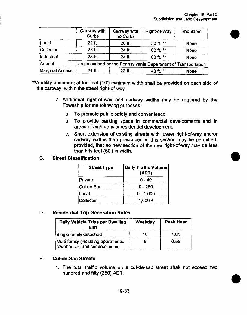
Local Collector Industrial Arterial Marginal Access
C.
D.
E.
Cartway with Cartway with Right-of-way Shoulders curbs no Curbs 22 ft. 20 n. 50 n. *= None 28 n. 24 n. 60 n. ** None 28 n. 24 ft, 60 ft. ** None
as prescribed by the Pennsylvania Department of Transportation 24 n. 22 n. 40 n. ** None
2. Additional right-of-way and cartway widths may be required by the Township for the following purposes.
a. To promote public safety and convenience. b. To provide parking space in commercial developments and in
areas of high density residential development. c. Short extension of existing streets with lesser right-of-way andlor
cartway widths than prescribed in this section may be permitted, provided, that no new section of the new right-of-way may be less than fifty feet (50) in width.
Street Classification
Street Type Daily Traffic Volume (ADTI
Private Cul-de-sac 0 - 250
0 - 1,000 Collector 1,000 +
Multi-family (including apartments. 6 townhouses and condominiums ,
Residential Trip Generation Rates
0.55 I Daily Vehicle Trips per Dwelling
unit Weekday I Peak Hour I
\Sinale-familv detached I 10 I 1.01 I
1. The total traffic volume on a culde-sac street shall not exceed two hundred and fifty (250) ADT.
19-33
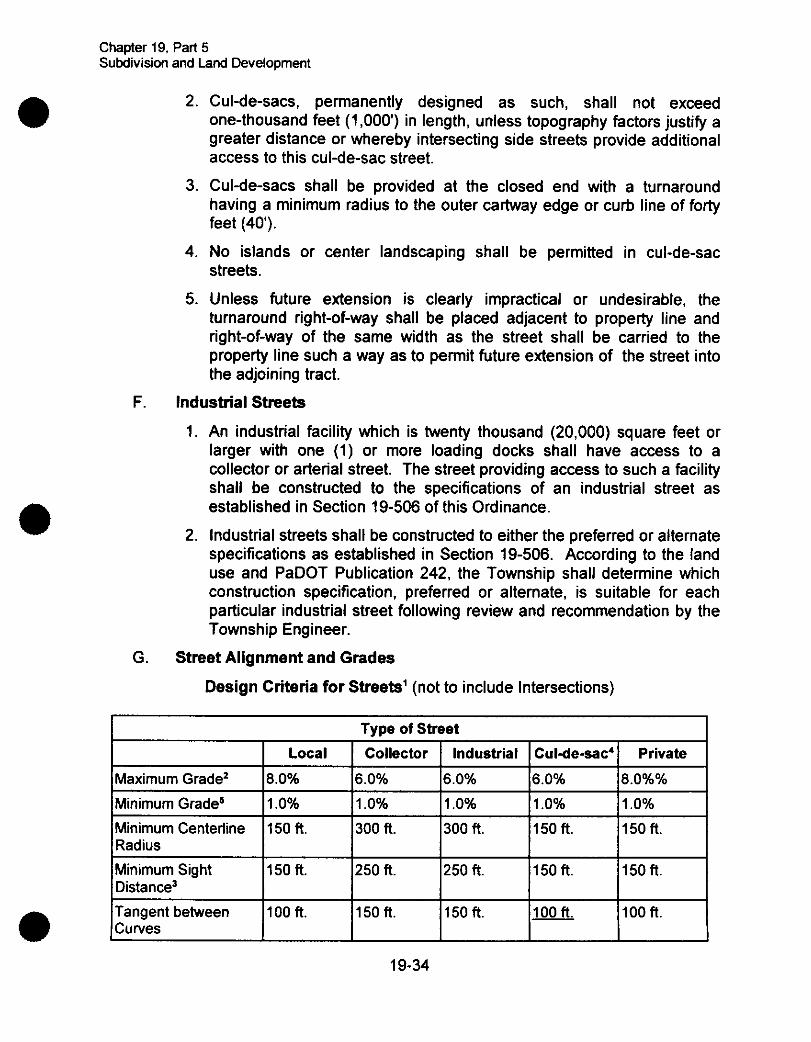
Chapter 19. Part 5 Subdivision and Land Development
Minimum Centerline Radius Minimum Sight Distance3 Tangent between Curves
2. Cul-de-sacs, permanently designed as such, shall not exceed one-thousand feet (1,000') in length, unless topography factors justify a greater distance or whereby intersecting side streets provide additional access to this cul-de-sac street.
3. Cul-de-sacs shall be provided at the closed end with a turnaround having a minimum radius to the outer cartway edge or curb line of forty feet (40).
4. No islands or center landscaping shall be permitted in cul-de-sac streets.
5. Unless future extension is clearly impractical or undesirable, the turnaround right-of-way shall be placed adjacent to property line and right-of-way of the same width as the street shall be carried to the property line such a way as to permit future extension of the street into the adjoining tract.
F. Industrial Streets
1. An industrial facility which is twenty thousand (20,000) square feet or larger with one (1) or more loading docks shall have access to a collector or arterial street. The street providing access to such a facility shall be constructed to the specifications of an industrial street as established in Section 19-506 of this Ordinance.
2. Industrial streets shall be constructed to either the preferred or alternate specifications as established in Section 19-506. According to the land use and PaDOT Publication 242, the Township shall determine which construction specification, preferred or alternate, is suitable for each particular industrial street following review and recommendation by the Township Engineer.
G. Street Alignment and Grades
Design Criteria for Streets' (not to include Intersections)
150 ft. 300 ft. 300 ft. 150 ft. 150 R.
150 ft. 250 ft. 250 ft. 150 ft. 150 ft.
100 ft. 150 ft. 150 ft. 100 ft.
I TvDe of Street I I I Local I Collector 1 Industrial 1Cul-de-sac4] Private I Maximum Grade' 18.0% 16.0% 16.0% 16.0% 18.0%% Minimum Grade' I1 .O% 11.0% I1 .O% I1 .O% 11.0%
Chapter 19. Part 5 Subdivision and Land Development
'For Arterial Roads, PaDOT standards will apply.
'Grades in excess of the allowable percentage may be approved by the Township Engineer where it is clear that it is necessary and that no traffic hazard is or will be created thereby.
'Sight distance shall be measured along the centerline of the street between points where a driver's eyes at 3'6 in height can see an object 6 high.
'Cul-de-sac is the entire street not merely the vehicular turn-around.
5Modifications to the minimum grade must be approved by the Township Engineer.
1. Horizontal curves shall be laid on all deflecting angles along the centerline of streets, and the degree of curvature shall be set at least to assure the required sight distance.
2. Vertical curves shall be used in changes of grade exceeding one (1) percent and shall be designed for maximum visibility.
H. Street Intersections
1. Streets shall be laid out to intersect as nearly as possible at right angles. No street shall intersect another at an angle of less than sixty (60) degrees.
2. Multiple intersections involving the junction of more than two (2) streets shall be avoided. Where this proves impossible, a modification of this provision shall be sought.
3. Where the grade of any street, at the approach to an intersection exceeds seven percent (7%), a leveling area shall be provided having not greater than four percent (4%) grades for a distance of fifty feet (50) measured from the nearest right-of-way line of the intersecting street. The grade at actual intersection shall not exceed two percent (2%) in any direction.
4. Clear Sight Triangles of seventy-five (75) feet measured along street centerlines from their point of junction shall be provided at all intersections and no structures or vegetation higher than three feet (3') shall be permitted within such triangles. The three foot (3') measurement shall begin from the elevation of the road, where the topography 'within the triangle is higher than the road, the following standards shall be used for measurement:
19-35
Chapter 19. Part 5 Subdivision and Land Develoment
- 1
Topography Elevation
1 foot higher than the road 2 feet higher than the road
3 feet or more higher than the road
Allowable Structure or Vegetation Height 2 feet 1 foot
No vegetation or structure shall be permitted within the sight triangle
5. To the fullest extent possible, intersections with arterial streets shall be located not less than five hundred feet (500') apart, measured from the center line to center line.
6. Intersecting streets shall be separated by three hundred fifty (350) feet or more, measured between their center lines along the centerline of the intersected street
7. Residential driveways shall be at least thirty feet (30) from adjacent driveways on the same side of the street and at least fifty feet (50) from the centerline of an intersecting street. For Industrial development there shall be at least seventy feet (70') between driveways on the same side of the street, and a at least ninety feet (90') between the closest intersection and any industrial driveway. For Commercial development there shall be at least fifty feet (50) between driveways on the same side of the street and at least seventy feet (70') between the closest radius of the driveway and the intersecting street.
1. curbs
1. Curbing shall be required for the purposes of drainage, safety and delineation and protection of pavement edge in Planned Residential Developments.
2. Flexibility regarding curb type shall be permitted as long as the curb type accommodates the system of drainage proposed.
3. Curbing shall be designed to provide a ramp for bicycles andlor wheelchairs as required by applicable PaDOT standards.
4. Curbing shall be constructed of either Portland cement concrete with expansion joints every twenty feet ( 2 0 ) and shall follow PaDOT standards where applicable (See Curb Design Detail) or a bituminous concrete wedge curb which is eighteen inches (18) wide by six inches (6 ) high may be used.
5. All curbs at intersections shall be rounded by a minimum radius of:
a. Local Streets: Minimum curb radii at street intersections shall be twenty feet (20') .
19-36
Chapter 19. Part 5 Subdivision and Land Development
b. All other Streets: Minimum curb radii at street intersections shall be thirty feet (307, or such greater radius as is suitable to the specific intersection.
J. Sidewalks
1. Sidewalks shall be provided on all streets within cluster developments. The requirement of sidewalks may be modified in accordance with Section 19-903 of this Ordinance. In addition, wherever the Township shall determine, due to potential volume of pedestrian traffic, sidewalks may be required regardless of any other regulations of this Ordinance.
2. Minimum widths for sidewalks along each type of public street shall be four feet (4') and shall follow PaDOT specifications where applicable.
K. Right-of-way
1. The right-of-way shall be measured from lot line to opposing lot line and shall be sufficiently wide to contain the cartway, curbs, shoulders, sidewalks, graded areas and utilities, (if they are placed within the right-of-way).
2. The right-of-way width of a new street that is a continuation of an existing street shall in no case be continued at a width less than that of the existing street.
§ 19406. Construction Standards for Opening of New Streets
The following specifications for new streets are required in all areas of the Township.
A. Responsibility for Inspection: Responsibility for inspection and supervision of said improvements shall rest with the developer and a certified Professional Engineer retained by the developer. A sealed certified report prepared by a certified engineer, retained by the developer shall be submitted with the final plan to Oakland Township. The report shall certify that the installation of the new streets meets the minimum requirements of this Ordinance for new streets and any additional specifications that the Township may require.
This does not preclude the Township from retaining the right to inspect and supervise the installation of new streets if so desired. Notification of the intent to install the improvement shall be given to the Township by the developer or agent fortyeight (48) hours prior to starting work on the improvement so the Township can exercise its option. The cost of inspections conducted by Oakland Township shall be borne by the developer or owner of the property.
Plans and Compliance: No person shall construct, open or dedicate any road, or any drainage facilities in connection therewith, for public use or travel in Oakland Township, without first submitting plans thereof to the
B.
19-37
Chapter 19. Part 5 Subdivision and Land Development
e C.
D.
E.
Township for approval. Such plans shall be prepared in duplicate in accordance with such rules or regulations as may be prescribed by this Ordinance and any additional requirements of the Township. Plans submitted for review and approval by the Township shall be accompanied by a certified report as prescribed in Section 19-506 A.
1 .
2.
3.
Said Plans shall show the profiles, course, structure of such roads, the capacity of any drainage facilities and the method of drainage of the adjacent or contiguous territory. Also, said plans shall show any other details that may be required by the Township. Construction shall be in strict accordance with the preliminary plans so approved.
Prior to final plan approval where new streets are to be constructed the streets shall be installed and a certified report, prepared by a registered Professional Engineer as outlined in Section 19-506 A shall be submitted.
Nature of Approval: Approval of a preliminary plan by the Township shall not constitute approval of the final plan or of roads or other improvements therein, but it is rather an expression of approval of layout submitted on the preliminary plan as a guide to the preparation of the final plan, which final plan shall be submitted for the approval of the Township, in that order upon fulfillment of the requirements of this Ordinance.
Excavation and Grading: Streets shall be excavated and graded as indicated on the approved plans. This shall include excavation of the street to the lines, grades and limits indicated on the drawings or as may be revised by the Township to meet conditions encountered during construction, the excavation for intersecting roadways, stream channels and culverts within the approved right-of-way limits; and shall also include the widening of cuts, flattening and rounding of slopes outside the right-of-way as called for on approved plans, removal of top soil and excavating of ditches and the construction of fill. Inspection shall be performed and approval granted by the Township prior to further work.
Drainage Structures: All drainage structures shown on the approved plans shall be installed to PaDOT standards and to the satisfaction of the Township. Culverts may be corrugated metal pipe, polyethelene pipe, plain concrete or reinforced concrete pipe as specified on the approved plan and shall be prepared according to PaDOT standards. Headwalls shall be installed properly and inspected by the Township.
Backfilling: After the pipe is laid and inspected, the trench shall be backfilled to a height not exceeding the outside diameter of the pipe with a suitable material installed in four inch ( 4 ) layers and thoroughly compacted to the satisfaction of the Township Engineer.
19-38
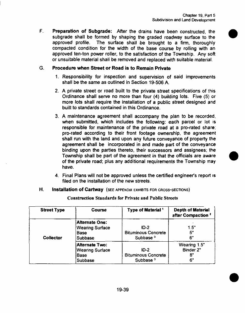
Chapter 19, Part 5 Subdivision and Land DeveloDment
Collector
F.
G.
H.
Subbase
Preparation of Subgrade: After the drains have been constructed, the subgrade shall be formed by shaping the graded roadway surface to the approved profile. The surface shall be brought to a firm, thoroughly compacted condition for the width of the base course by rolling with an approved ten-ton power roller, to the satisfaction of the Township. Any sol? or unsuitable material shall be removed and replaced with suitable material.
Procedure when Street or Road is to Remain Private
1. Responsibility for inspection and supervision of said improvements shall be the same as outlined in Section 19-506 A.
2. A private street or road built to the private street specifications of this Ordinance shall serve no more than four (4) building lots. Five (5) or more lots shall require the installation of a public street designed and built to standards contained in this Ordinance.
3. A maintenance agreement shall accompany the plan to be recorded, when submitted, which includes the following: each parcel or lot IS
responsible for maintenance of the private road at a pro-rated share; pro-rated according to their front footage ownership, the agreement shall run with the land and upon any future conveyance of property the agreement shall be incorporated in and made part of the conveyance binding upon the parties thereto, their successors and assignees; the Township shall be part of the agreement in that the officials are aware of the private road; plus any additional requirements the Township may have.
4. Final Plans will not be approved unless the certified engineer's report IS
filed on the installation of the new streets.
Installation of Cartway (SEE APPENDIX EXHIBITS FOR CROSS-SECTIONS)
Construction Standards for Private and Public Streets
course I Street Type
Alternate One: Wearing Surface Base
Alternate Two: Wearing Surface Base Subbase
Type of Material ' Depth of Material I after Compaction 2
ID-2 Bituminous Concrete
Subbase
ID-2 Bituminous Concrete
Subbase
1.5" 5 6
Wearing 1.5" Binder 2"
8 6
19-39

Chapter 19. Part 5 Subdivision and Land Development
Street Type Course I Type of Material l I Depth of Material
Industrial
a& Compaction 2
Preferred: Wearing Surface Cement Concrete 8 Subbase Subbase 8 Alternate: Wearing Surface ID-2A 1.5" Base Bituminous Concrete 4 Subbase 2A Course Aggregate 1 2
Local 8 Cul-de-sac
Footnotes:
' All components of pavement structure shall be in accordance with PaDOT
Preferred: Wearing Surface ID-= 1.5" Base Bituminous Concrete 4 Subbase Subbase 6"
Alternate: Wearing Surface Prime Coat 8 Seal Coat - Base 2 RC 4' Subbase Subbase3 6"
specifications, Form 408.
Compaction shall be by a ten ( I O ) ton roller or equivalent.
Subbase shall extend twelve (12) inches beyond finished width of cartway on each side to provide necessary support for wearing surface.
Privately-owned and maintained streets serving five (5) or more lots shall be constructed to standards for local streets.
Must be approved by the Township Engineer.
Q 19-507. Alleys, Driveways and Easements
A. Alleys are prohibited in developments of single-family detached residences except where employed to avoid direct driveway access to major traffic streets. Alleys may be permitted in other types of developments.
Where permitted, alleys in residential developments shall have a minimum width of twenty feet (20') and a minimum surface of fifteen feet (IS) .
B.
Private'
19-40
Wearing Surface - -- Base - -- Subbase Subbase3 6
Chaptar 19, Part 5 Subdivision and Land Development
Alleys shall be required in commercial and industrial developments except where other adequate provision is made for off-street loading and parking consistent with the proposed use. Where required, alleys in commercial or industrial developments shall have a minimum paved width of twenty-two feet (22') and conform to specifications set forth in Section 19-505, Streets.
Dead-end alleys shall be avoided, but where this proves impossible, shall be terminated with a paved circular turnaround or a paved "Y" turnaround of adequate dimensions.
Alley intersections and sharp changes in alignment shall be avoided, but where necessary, corners shall be rounded or cut back sufficiently to permit safe vehicular circulation.
Private driveways, where provided, shall be located not less than forty (40) feet from the intersection corner of corner lots and shall have such grades as to furnish a safe and convenient parking space.
Easements with a minimum width of ten ( I O ) feet shall be provided as necessary for utilities.
To the fullest extent possible, easements shall be centered on or adjacent to rear or side lot lines.
Where a subdivision or site development is transversed by a watercourse, there shall be provided a drainage easement or right-of-way conforming substantially with the line of such watercourse and of such width as will be adequate to preserve natural drainage.
There shall be a minimum distance of twenty-five (25) feet, measured in the shortest distance, between each proposed dwelling unit and any petroleum products or natural gas transmission line which may transverse the subdivision or site development.
C.
D.
E.
F.
G.
H.
1.
J.
5 19-508. Lighting
A.
B.
C.
D.
Lighting shall be provided by the developer in all subdivisions, land developments, mobile home parks and recreational vehicle parks where the density of development and lot design warrants them in the opinion of the Township after recommendation of the Township Engineer.
Lighting shall be provided in accordance with a plan designed by the utility company or using as a guideline the standards set forth by the ICES Lighting Handbook.
Lighting for safety shall be provided at intersections, along walkways, at entryways, between buildings and in parking areas.
Lighting shall be provided where the Township determines that lighting will improve a dangerous traffic situation, and in other locations at the discretion of the developer.
19-41

Chapter 19. Part 5 Subdivision and Land Development
E. The height and shielding of lighting standards shall provide proper lighting without hazard to drivers or nuisance to residents and the design of lighting standards shall be of a type appropriate to the development and the Township. Sharp cut-off luminaries shall be used when possible on parcels adjacent to residential uses.
Spotlights, if used, shall be placed on standards pointing toward the building and positioned so as not to be hazard to passing motorists or nuisance to neighboring residents, rather than on the buildings and directed outward which creates dark shadows adjacent to the buildings.
F.
5 19-509. Underground Wiring
A. All electric, telephone, television and other communication lines, both main and service connections, servicing new developments shall be provided by underground wiring within easements or dedicated public rights-of-way and installed in accordance with the prevailing standards and practices of the utility or other companies providing such services.
Lots that abut existing easements or public rights-of-way where overhead electric or telephone distribution supply lines and service connections have previously been installed may be supplied with electric and telephone service from those overhead lines, but the service connections from the utilities' overhead lines shall be installed underground. In the case of existing overhead utilities, should either a road widening, extension of service or other such condition occur as a result of the subdivision and necessitate the replacement or relocation of such utilities such replacement or relocation shall be underground.
Where overhead lines are permitted as the exception, the placement and alignment of poles shall be designed to lessen the visual impact of overhead lines. Alignments and pole locations along horizons which clear swaths through treed areas shall be avoided by selective cutting and a staggered alignment. Trees shall be planted in open areas and at key locations to minimize the view of the poles and the alignments. Alignments shall follow rear lot lines and other alignments.
Year-round screening of any utility apparatus appearing above the surface of the ground, other than utility poles, shall be required.
B.
C.
D.
5 19-510. Signs
All signs shall be permitted, constructed, placed and maintained in accordance with the current Township regulations for signage.
1942

Chapter 19, Part 5 Subdivision and Land Development
5 19411. Off-Street Parking
A. Number of Spaces
1. An adequate number of off-street parking spaces shall be required in all developments to accommodate residents and visitors.
2. For residential developments, off-street parking shall be provided as follows:
a. Single-family residential dwelling units shall be provided with two (2) parking spaces per unit;
b. Multiple-family dwelling units shall be provided with one and a half (1.5) parking spaces per unit;
3. For nonresidential developments, the parking standards shall be provided as follows:
a. Commercial developments:
i)
ii)
iii)
iv)
v)
Retail, personal service, dental or medical office or clinic: one (1) parking space for each 200 square feet of floor area or fraction thereof; Restaurant, fast-food outlet or tavern: one (1) parking space for each two (2) persons who can be seated at one time, but not less than twenty (20) spaces; Professional offices other than medical or dental: one (1) space for each four hundred (400) square feet of floor area or fraction thereof; Motels, hotels and Bed and Breakfast homes: one (1) parking space for each guest room; Commercial recreation, theaters, bowling alley, etc.: one (1) parking space for each four (4) persons who can be seated or attend at one time, but not less than twenty (20) spaces.
b. Industrial or manufacturing operation: one (1) parking space for each employee on the largest shift at peak production or one (1) space for each one thousand (1000) square feet of floor area or fraction thereof, whichever results the greater number of spaces;
4. Alternate off-street parking standards to those shown shall be considered if the applicant demonstrates that such standards better reflect local conditions.
5. A one-car garage and driveway combination shall count as 1.75 off-street parking spaces, provided the driveway measures a minimum of twenty-five feet (25’) in length between the face of the garage door and the sidewalk; or 30 feet to the curbline. A two-car garage and driveway combination shall count as 3.5 off-street parking spaces,
19-43
Chapter 19, Part 5 Subdivision and Land DeveloDment
C.
provided the minimum width of the driveway is twenty feet (20) and its minimum length is as specified above for a one-car garage.
6. For mixed-use developments, a shared parking approach to the provision of off-street parking shall be permitted where the participants generating the need for the parking enter into a formal reciprocal ingress and egress agreement.
7. Where the total number of off-street parking spaces required are not immediately required for a particular use, a staged development plan may be permitted requiring that only a portion of the parking area, but not less than sixty-five percent (65%) of the required spaces, be completed initially, subject to the following requirements:
a. The site plan shall clearly indicate both that portion of the parking area to be paved initially and the total parking needed to provide the number of spaces required.
b. The site plan shall provide for adequate drainage of both the partial and total parking areas.
c. The portion of the parking area not to be paved initially shall be landscaped with a ground cover that shall be appropriate for soil conditions, water availability and the environment.
Size of Spaces: Each off-street parking space shall measure nine (9) feet in width by eighteen feet (18') in length. Parking spaces for the physically handicapped shall meet the Americans with Disabilities Act requirements.
Parking Areas
1. Off-street parking areas shall be oriented to and within a reasonable walking distance of the buildings they are designed to serve.
2. Access to parking areas shall be designed so as not to obstruct free flow of traffic. There shall be adequate provision for ingress to and egress from all parking spaces to ensure ease of mobility, ample clearance and safety of vehicles and pedestrians.
3. Special considerations for nonresidential parking areas:
a. Where truck loading and unloading will occur, it shall not interfere or impinge on required parking areas. Service vehicles shall enter and leave the property moving in a forward direction.
b. A fire lane free of all parking, which must be at least eight feet (8') wide, shall be established along the edge of a parking area where it abuts a commercial or industrial building.
4. The width of all aisles providing direct access to individual parking stalls shall be in accordance with the requirements specified below.
19-44

Chapter 19, Part 5 Subdivision and Land Development
Only one-way traffic shall be permitted in aisles serving single-row parking spaces placed at an angle other than ninety degrees (90'). 1 Parkiy0Angle 1 Aisle Width 1
(degrees) (feet)
I 45 I 13 I I 60 I 18 I I 90 I 24 I
5. Where sidewalks occur in parking areas, parked vehicles shall not overhang the sidewalk unless an additional one (1) foot is provided in order to accommodate such overhang.
6. Parking areas shall be suitably landscaped to minimize noise, glare and other nuisance characteristics as well as to improve the environment of the site and surrounding area. Large parking lots shall be broken down into sections as appropriate for the type and size of the development. Sections shall be separated by landscaped dividing strips, berms, and similar elements.
9 19512. Lot Size and Layout
A.
B.
Lot Access: Every lot in a subdivision shall abut an existing road, or a road created in the plan containing the lot, or an access strip abutting an existing road, or an access provided over another parcel through an easement agreement or an approved private road or street as provided for in Section
Lot Size:
19-505.
1. If a lot is to be served by an on-lot septic system and a private well, such system shall contain at least forty-three thousand five hundred and sixty (43,560) square feet (one acre) of lot area and have at least one hundred and fifty feet (150') of lot width at the right-of-way line for interior lots and one hundred and fifty feet (150') for corner lots.
2. If a lot is to be served by both a public or community sewage system and a public or community water supply system, such lot shall contain at least fourteen thousand five hundred and twenty (14,520) square feet (1/3 acre) of lot area and have at least eighty feet (80') of lot width for interior lots and one hundred feet (100') for comer lots.
3. If a lot is to be served by a public or community sewage system and a private well water supply, such lot shall contain at least twenty-one thousand seven hundred and eighty (21,780) square feet (112 acre) of
19-45
Chapter 19, Part 5 Subdivision and Land Development
lot area and at least one hundred feet (100) of lot width for interior lots and one hundred and twenty feet (120') for corner lots.
4. Lot area, for purposes of determining if a lot has sufficient area, shall not include the road right-of-way abutting the lot.
5. Lot width shall be measured along the setback line parallel to the property line abutting the road right-of-way.
6. The Township Sewage Enforcement Officer may require a lot or group of lots to be increased in area, or as a last resort an alternate sewage disposal system installed, consistent with any agreements or Ordinance provisions in place at the time of application, if percolation tests indicate that the subsurface soils have insufficient absorption capacity to allow lots of minimum permitted size.
7. The depth of a lot shall not exceed four (4) times the width (4:l). These provisions shall be strictly applied in relation to lots restricted to use for single family residents. Lots too shallow for building shall likewise be avoided.
However, when the width of a lot exceeds four hundred and fifty feet (450'), there shall be no further regulation on depth and width ratio.
8. Lots which abut cul-de-sac streets shall have a minimum frontage of fifty feet (50') at the right-of-way line measured along the arc.
C. Building Setback from the Property Line
1. There shall be a minimum building front yard setback line in residential areas of thirty-five feet (35') from the right-of-way of the local existing or proposed streets and fifty feet (50') on arterial streets, applicable in the case of corner lots to both intersecting streets. The building setback line for lots used for commercial or industrial purposes shall be at least sixty feet (60) from the right-of-way of the local existing or proposed streets.
2. Double frontage lots or reverse frontage lots shall be discouraged except where lots abut along their rear line a restricted access highway, in which case the rear building line of the lots shall be seventy-five feet (75') from the highway right-of-way line.
3. Side lines of lots shall be at right angles or radial to street lines.
4. Lot lines within a subdivision shall be arranged to minimize the amount of drainage passing from one lot directly on to a neighboring lot. The Township may direct the developer to provide drainage easements or grade swales along lot lines to control drainage across lots.
19-46

Chapter 19, Part 5 Subdivision and Land Development
5. Depth and width of parcels laid out or reserved for nonresidential use shall be adequate for the proposed use and sufficient to provide satisfactory space for off-street parking and unloading.
6. A plan may contain "flag" or "pipe stem" lots, defined herein, under the following circumstances:
a. A "flag" or "pipe stem" lot is a lot which has frontage to a public street by the way of an access strip.
b. An access strip must be fifty feet (50') wide if it serves two (2) or more lots or if there is adequate acreage within the rear lot for further subdivision. If there is only one lot or if there is not adequate acreage for resubdivision then the access strip may be less than fifty feet (50) but not less than twenty feet (20) in width.
c. If there are at least five (5) or more lots served by the access strip then a private or public street must be constructed to the local street specification in Section 19-507 of this Article.
d. Where four (4) lots or less are served by the access strip, a private driveway shall be provided with a minimum ten foot (10') cartway with a mud-free surface. A maintenance agreement among property owners utilizing the private driveway shall be recorded with the final plat.
e. The area of the access strip shall not be included in the area of the rear lot for calculating minimum lot size. Buildings constructed on the rear lots shall be set back forty feet (40) from the rear line of the front lot. If a lot(s) created through subdivision will not front on a private or public street then such lot or lots shall have an access agreement through an identified easement or right-of-way recorded with the subdivision.
f.
§ 19-513. Water Supply
A. General
1. Every dwelling unit and each commercial business and every public or semi-public building shall be provided with a potable water supply of sufficient quality, quantity and pressure to meet the minimum standards of the Pennsylvania Department of Environmental Protection.
2. Depending on the number of housing units or equivalent dwelling units (EDU's), residential subdivisions shall be connected to an existing public water supply system if public service is available within the following distances:
19-47

Chapter 19, Part 5 Subdivision and Land Development
I Size of Development Distance Housina units or EDU's
1 unit 2 4 units
5-15 units
150 feet 500 feet
1.000 feet
For developments with more than fifteen (15) units and located within one mile of an existing public water system, adequate justification shall be provided as to why they shall not provide a connection to the existing public water supply system. For developments with more than fifteen (15) units and located more than one mile from an existing system, the water supply system strategy shall be determined on a case-by-case basis taking into consideration density of the development, costs and ground water availability and quality.
3. All proposals for new public community water supplies or extensions to existing public water systems, or the installation of dry lines, or use of wells and other water sources, shall be approved by the Department of Environmental Protection, prior to approval by the Oakland Township Supervisors.
B. Capacity
1. The water supply system shall be adequate to handle the necessary volumes and residual pressures based on completed development. including the necessary fire flows.
2. The demand rates for all uses shall be considered in computing the total system demand. Where fire protection is provided, the system shall be capable of providing the required fire demand plus the required domestic demand.
3. Fire protection shall be furnished for any new development connected to a public or community water supply system, and minimum fire flows shall be approved by the Township Fire Chief, according to nationally accepted standards (NFPA, National Fire Protection Association).
C. System
1. Water lines shall be installed in accordance with the regulations of the public utility corporation, or private treatment plants, approved by the Department of Environmental Protection, that will assume maintenance of the lines.
19-48

Chapter 19. Part 5 Subdivision and Land Development
2. Water distribution lines shall not be less than eight inches (8") in inside diameter where the lines may be extended to other areas or where a fire hydrant is to be served by the line.
3. Water wells shall be isolated from the sanitary sewage absorption fields and protected from surface run-off in accordance with requirements of PA State Act 208, as amended.
D. Fire Hydrants
1. Hydrants shall be spaced to provide necessary fire flow. In commercial and industrial developments the average area per hydrant shall not exceed 120,000 square feet. In addition, hydrants shall be spaced so that each residence shall be within six hundred (600) linear roadway feet of a hydrant.
2. A hydrant shall be located at all low points and at all high points with adequate means of drainage provided.
3. Hydrants shall be located within one hundred feet (100') of the ends of lines, and valves of full line size shall be provided after hydrant tees at the ends of all dead lines that may be extended in the future. The end of line shall have a 2.5 inch blow-off valve.
4. Size, type and installation of hydrants shall be designed by the Township Fire Chief, according to nationally accepted standards.
5. All fire hydrants shall have National Standard Threading (NST).
5 19-514. Sanitary Sewers
A. General
1. All installations in any subdivision, development plan, mobile home park or recreational vehicle park shall be properly connected to an approved and functioning sanitary sewer system approved by the Township Sewage Enforcement Officer and the Pennsylvania Department of Environmental Protection prior to the issuance of a certificate of occupancy.
2. Depending on the number of housing units or equivalent dwelling units (EDU's), residential or nonresidential subdivision and developments shall be connected to an existing public or community sewage disposal system if public service is available within the following distances:
Size of Development Distance Housina units or EDU's
I unit 2 4 units 5-15 units
150 feet
500 feet 1.000 feet
19-49

Chapter 19, Part 5 Subdivision and Land Develooment
For developments with more than fifteen (15) units and located within one (1) miles of an existing public sanitary sewer system, adequate justification shall be provided as to why they should not provide a connection to the existing sanitary sewer system. For developments with more than fifteen (15) units and located more than one (1) mile from an existing system, the sanitary sewer system strategy shall be determined on a case-by-case basis taking into consideration the density of development and cost.
3. All proposal for new public or community sanitary sewer systems, or extensions to existing public sewer systems or the installation of "dry lines" or the use of individual subsurface disposal systems, shall be approved by the officially designated agency of local, state or other unit of government.
4. If a public system is not in place or cannot be extended, the developer must provide individual subsurface disposal system where appropriate given site density, soil, slope and other conditions and subject to applicable state and other prevailing regulations. Such system shall be an individual on-lot sewage system in compliance with the Department of Environmental Protection "Standards for Sewage Disposal Facilities" and shall be approved by the Township Sewage Enforcement Officer. The system shall not be backfilled until inspected by the Sewage Enforcement Officer and he authorizes cover.
B. System Design and Placement
1. The sanitary sewer system shall be adequate to handle the necessary flow based on complete development.
2. No storm sewers, footer drains or downspouts shall be connected to any sanitary sewage disposal system.
3. When a developer installs sewer lines to connect with those of a sewer authority he shall do so in accordance with the authority's rules and regulations or, if developing a new system, he shall follow the standards of the Department of Environmental Protection.
4. No sewer collector line shall be less than eight inches ( 8 ) inside diameter and no building lateral less than four inches (4") inside diameter.
Q 19515. Water andlor Sewer Facilities Plan Approval
1. Preliminary Plan Approval: Where public or community water andlor public or community sewage treatment facilities are required or intended by the developer, such facilities shall be properly shown on the preliminary plans.
19-50

Chapter 19, Part 5 Subdivision and Land Development
In addition to showing all related facilities on the plans, the developer shall indicate by letter, his anticipated schedule for installation of such facilities.
2. Final Plan Approval: Prior to the approval of the final plan where such water andlor sewage facilities are intended or required, the facilities shall have been installed and given final approval by the Pennsylvania Department of Environmental Protection.
Certification of the installation shall be made by a certified Professional Engineer and submitted with the final plan.
5 19-516. Stormwater Management
A. Purpose: In accordance with the intent and requirements of the Pennsylvania Stormwater Management Act 167, as amended, the stormwater management regulations contained in this section are intended to provide protection against uncontrolled stormwater runoff, and to insure that downstream property owners and water courses are not adversely affected by increases in runoff resulting from subdivision and land development.
General: Prior to final approval of a subdivision plat consisting of five (5) or more lots, or a land development plan on a parcel of two (2) acres or more in area, the subdivider or site developer shall prepare and submit for review and approval to the Township a stormwater management plan. Such plan shall indicate the proposed stormwater handling system, proposed water retention and release schedule to eliminate the effects of uncontrolled water runoff on to adjacent properties. The plan shall be referred to the Butler County Conservation District for review and comment prior to plan approval.
B.
C. Plan Requirements:
1. The stormwater management plan for the proposed subdivision or land development shall include a brief description of the following:
a. Existing drainage patterns and stormwater runoff characteristics of the site, including any existing drainage or stormwater runoff problems and facilities;
b. The anticipated impact that future development of the property will have on existing stormwater runoff and drainage patterns; and
c. The type of structural and nonstructural improvements planned to control post development stormwater runoff.
2. In preparing the stormwater management plan, the subdivider or site developer shall consider the potential for accelerated soil erosion resulting from the construction of improvements, high density development or steep slopes. In such instances, the Township may
19-51
Chapter 19. Part 5 Subdivision and Land Development
require the developer to incorporate into the plan, soil erosion and sedimentation control measures. Such conservation measures shall be designed to protect existing vegetation, and minimize the area and time of soil exposure, and may include structural improvements to the site such as diversion terraces, grassed waterways and sedimentation basins.
3. The proposed location of both structural and nonstructural improvements shall be shown on the subdivision or site plan. The Township may also require the developer to include on the subdivision or site plan topographic contours at five foot (5’) intervals in order to better evaluate the proposed stormwater control techniques.
4. Separate detailed specifications, including cross-sections, profiles, etc., shall be Submitted for all structural stormwater control improvements, such as swales, seepage pits, retention and detention basins and controlled release structures.
5. The subdivider or site developer shall submit with the stormwater management plan a proposal for ownership and maintenance of all stormwater control improvements within the subdivision or site development, in accordance with the following:
a. Where the developer proposes to dedicate such improvements to the Township, a deed which dedicates the land to be used for stormwater control improvements to the Township shall be recorded with the final plan. A copy of the deed and a letter from the Township stating their intent to accept ownership and maintenance responsibility for the improvements shall be submitted with the subdivision or site plan.
b. Alternatively, an Ownership and Maintenance Agreement, which specifies ownership and assigns maintenance responsibility for the proposed improvements to either the developer or among the property owners within a subdivision, shall be recorded with the final plan and referenced in the deeds to each property within the Subdivision.
c. Detention basins shall be located on commonly owned land within the subdivision and maintained through the provisions of the ownership and maintenance agreement.
D. System Design:
1. Stormwater management controls shall be designed so that the rate of runoff from any development or subdivision, during and afler construction, shall be no greater than the rate of runoff from the site prior to such development for all storms up to the 100 year frequency. Analysis shall be made for the 1, 2, 10, and 100 year storms. Either the Rational Method, USDA Soil Conservation Service Technical Release
19-52
Chapter 19, Part 5 Subdivision and Land Development
55 Method or the Penn State Method shall be used to calculate stormwater detention volumes, time en route and release rates.
2. Design of the stormwater management system shall be consistent with general and specific concerns, values and standards of the Township master plan and applicable county, regional and state storm drainage control programs. Design shall be based on environmentally sound site planning and engineering techniques.
3. The best available technology shall be used to minimize off-site stormwater runoff, increase on-site infiltration, encourage natural filtration function, simulate natural drainage systems and minimize off-site discharge of pollutants to ground and surface water. Best available technology may include measures such as retention basins, recharge trenches, porous paving and piping, contour terraces and swales.
5 19-517. Improvement Sureties
A. Purpose: Improvement sureties may be provided by the developer or subdivider to ensure the proper installation and maintenance of streets, utilities, parking lots, lighting, landscaping and other public or private improvements required by this Ordinance. The nature and duration of the surety shall be structured to achieve this goal without adding unnecessary costs to the developer.
B. Completion of Improvements:
1. Before the recording of final subdivision plans, or as a condition of final site plan approval, the Township may require and shall accept in accordance with the standards adopted by ordinance the following sureties:
a. The furnishing of a performance surety in an amount not to exceed one hundred and ten percent (110%) of the cost of installation for improvements.
b. Provision for a maintenance surety in the form of financial security for a period not to exceed eighteen (18) months after final acceptance of the improvement, in an amount not to exceed fifteen percent (15%) of the cost of the improvement. In the event that other governmental agencies or public utilities automatically will own the utilities to be installed, or the improvements are covered by a performance or maintenance surety to another governmental agency, no performance or maintenance surety, as the case may be, shall be required by the Township for such utilities or improvements.
19-53

Chapter 19. Part 5 Subdivision and Land DeveloDment
2. The time allowed for installation of the improvements for which the performance surety has been provided may be extended one (1) time for not more than one (1) year by the Township by resolution.
C. Release from Improvement Surety
1. When the developer has completed all of the necessary and appropriate improvements, the developer shall notify the Township, in writing, by certified or registered mail, of the completion of the aforesaid improvements and shall send a copy thereof to the Township Engineer. The Township shall, within ten ( I O ) days after receipt of such notice, direct and authorize the Township Engineer to inspect all of the aforesaid improvements. The Township Engineer shall, thereupon, file a report, in writing, with the Township, and shall promptly mail a copy of the same to the developer by certified or registered mail. The report shall be made and mailed within thidy (30) days after receipt by the Township Engineer of the aforesaid authorization from the Township; said report shall be detailed and shall indicate approval or rejection of said improvements, either in whole or in part, and if said improvements, or any portion thereof, shall not be approved or shall be rejected by the Township Engineer, said report shall contain a statement of reasons for such nonapproval or rejection.
2. The Township shall notify the developer, within fifteen (15) days of receipt of the Engineer's report, in writing by certified or registered mail of the action of said Township with relation thereto.
3. If the Township or the Township Engineer fails to comply with the time limitation provisions contained herein, all improvements will be deemed to have been approved and the developer shall be released from all liability, pursuant to its performance surety bond or other surety agreement.
4. If any portion of the said improvements shall not be approved or shall be rejected by the Township, the developer shall proceed to complete the same and, upon completion, the same procedure of notification, as outlined herein, shall be followed. Upon acceptance of the public or private improvements, one set of as-built construction drawings shall be delivered to the Township Secretary.
5. Nothing herein, however, shall be construed in limitation of the developer's right to contest or question by legal proceedings or otherwise, 'any determination of the Township or the Township Engineer.
6. Where herein reference is made to the Township Engineer, he shall be a duly registered Professional Engineer employed by the Township or engaged as a consultant thereto.
19-54

Chapter 19. Part 5 Subdivision and Land Development
7. The Township may prescribe that the applicant shall reimburse the Township for the reasonable and necessary expense incurred for the inspection of improvements. Such reimbursement shall be based upon a schedule established by ordinance or resolution. Such expense shall be reasonable and in accordance with the ordinary and customary fees charged by the Township Engineer or consultant for work performed for similar services in the community, but in no event shall the fees exceed the rate or cost charged by the engineer or consultant to the Township when fees are not reimbursed or otherwise imposed on applicants.
a. In the event the applicant disputes the amount of any such expense in connection with the inspection of improvements, the applicant shall, within ten (10) working days of the date of billing, notify the Township that such expenses are disputed as unreasonable or unnecessary, in which case the Township shall not delay or disapprove a subdivision or land development application of any approval or permit related to development due to the applicant's request over disputed engineer expenses.
b. If, within twenty (20) days from the date of billing, the Township and the applicant cannot agree on the amount of expenses which are reasonable and necessary, then the applicant and the Township shall jointly, by mutual agreement, appoint another Professional Engineer licensed as such in the Commonwealth of Pennsylvania to review the said expenses and make a determination as to the amount thereof which is reasonable and necessary.
c. The Professional Engineer so appointed shall hear evidence and review such documentation as the Professional Engineer in his or her sole opinion deems necessary and render a decision within fifty (50) days of the billing date. The applicant shall be required to pay the entire amount determined in the decision immediately.
d. In the event that the Township and applicant cannot agree upon the Professional Engineer to be appointed within twenty (20) days of the billing date, then, upon application of either party, the President Judge of the Court of Common Pleas of the judicial district in which the Township is located (or if at the time there be no President Judge, then the senior active judge then sitting) shall appoint such engineer, who, in that case, shall be neither the Township Engineer nor any Professional Engineer who has been retained by, or performed services for, the Township or the applicant within the preceding five (5) years.
e. The fee of the appointed Professional Engineer for determining the reasonable and necessary expenses shall be paid by the applicant if the amount of payment required in the decision is equal to or greater than the original bill. If the amount of payment
19-55
Chapter 19. Part 5 Subdivision and Land Development
required in the decision is less than the original bill by one thousand dollars ($1,000) or more, the Township shall pay the fee of the Professional Engineer, but otherwise the Township and the applicant shall each pay one-half of the fee of the appointed Professional Engineer.
Remedies to Effect Completion of Improvements: In the event that any improvements which may be required have not been installed as provided in the subdivision and land development ordinance or in accordance with the approved final plat, the Township is hereby granted the power to enforce any corporation bond, or other security by appropriate legal and equitable remedies. If proceeds of such bond, or other security are insufficient to pay the cost of installing or making repairs or corrections to all the improvements covered by said security, the Township may, at its option. install part of such improvements in all or part of the subdivision or land development and may institute appropriate legal or equitable action to recover the moneys necessary to complete the remainder of the improvements. All of the proceeds, whether resulting from the security or from any legal or equitable action brought against the developer, or both, shall be used solely for the installation of the improvements covered by such security, and not for any other municipal purpose.
E. Performance and Maintenance Mechanisms: Acceptable forms of performance and maintenance sureties include, but are not limited to, the following:
1. Security Bond, Performance Bond and Labor & Materials Bond:
D.
The applicant may obtain a bond from a surety bonding company authorized to do business in the state.
2. Letter of Credit: The applicant may provide an irrevocable letter of credit from a bank of other reputable institution.
3. Escrow Account: The applicant shall deposit cash, or other instruments readily convertible into cash at face value, either with the Township, or in escrow with a bank.
4. Property: The applicant may provide as a guarantee, land or other property.
5. Subdivision Improvement Guarantee: An applicant may provide as a guarantee a subdivision improvement agreement between the applicant, lender and Township.
6. Cash Deposit: The applicant may establish a CD account opened in the name of the Township.
19-56

Chapter 19. Part 6 Subdivision and Land Development
ARTICLE VI
PLAN REQUIREMENTS FOR SUBDIVISIONS
AND LAND DEVELOPMENTS
5 19-601.
A.
6.
Major Subdivision - Preliminary Plan Requirements
The preliminary plan shall be at a scale of fifty feet to the inch, and may be done in pencil on tracing paper or its equivalent.
The preliminary plan shall show or be accompanied by the following information:
1. Vicinity sketch, at a scale of not less than one inch equals one thousand feet (1" = 1,000'), showing the relationship of the plat to its general surroundings and showing the following details:
a. Existing or mapped streets within one thousand feet (1,000) of the subdivision.
b. Proposed streets with connections to existing or mapped streets. c. Municipal boundaries within one thousand feet (1,000) of the
tract. d. Public sewer and water lines within one thousand feet (1,000) of
tract, plus any power, gas or other public utility easements which may go through or over the property. If connection to site IS
proposed, only those proposed for access need to be shown. e. Entire tract must be shown including any previous lots sold from
the tract with dates of transfer from the original tract and the names of present owners.
2. Proposed subdivision name or identifying title.
3. The name of the municipality.
4. North point, graphic scale and date.
5. Name and address of the property owner or of his authorized agent
6. Name of the registered engineer or surveyor responsible for the plan.
7. Tract boundaries with bearings and distances at an appropriate scale. The traverse of the exterior boundaries of the tract when computed from the field measurements of the ground shall come within a limit of error of one foot (1') to ten thousand feet (10,000) of the perimeter before balancing the survey.
19-57

Chapter 19. Pari 6 Subdivision and Land Development
8. Contours at vertical interval of two feet (2’) are necessary when new streets are proposed and must be drawn to the same scale as the plan. In cases of no new streets, contours may be waived.
9. Datum to which contour elevations refer. Where reasonably practicable, data shall refer to known, established elevations.
I O . All existing water courses and other significant natural features.
11. All existing buildings, sewers, water mains, culverts, petroleum or petroleum products lines, fire hydrants, cable television, telephone, and other significant man-made features.
12. All existing streets on and abutting the tract, including name, right-of-way and cartway width.
13.Location and width of all existing private lanes and access driveways.
14.All existing property lines, easements and rights-of-way, and the purpose for which the easements or rights-of-way have been established.
15. Location and width of all proposed streets, alleys, rights-of-way, and easements; proposed lot lines with dimensions and bearings; proposed minimum building line for each street; playgrounds, and public buildings; public areas and parcels of land proposed to be dedicated or reserved for public use, if any.
16. Wherever practicable, the preliminary plan shall show the names of owners of all abutting unplotted land and the names of all abutting subdivisions and their lot numbers.
17. Where the preliminary plan covers only a part of the subdivider’s entire holding, a sketch shall be submitted of the prospective street layout for the remainder, at a scale of one hundred feet (100) to the inch.
18. If recommended by the Township, a study prepared by an engineer demonstrating the traffic impact of the proposed development on all roads in the vicinity of the site, and a traffic impact analysis plan.
19.A stormwater management plan shall be shown for the entire parcel when specified and submitted for preliminary approval.
20. If a subdivider plans to complete public improvements between the preliminary plan approval and final plan approval the subdivider shall meet all the requirements for the final plan for preliminary plan approval.
21. Signature block for preliminary review by the Oakland Tomshlp Planning Commission.
19-58

Chapter 19. Part 6 Subdivision and Land Development
22. Signature block for preliminary approval of the Oakland Township Board of Supervisors.
23. Signature block for preliminary review by the Butler County Planning Commission.
5 19-602.
If the plan is submitted for preliminary and final approval at the same time, all requirements of the preliminary plan shall be met.
MajorlMinor Subdivision Final Plan Requirements
A.
6.
C.
The subdivision plan submitted for final approval shall be drawn on mylar or its equivalent with permanent, indelible ink.
Final Plans shall be on sheets no smaller than eighteen by twenty-four inches (18" x 24") nor larger than twenty-four by thirty-six inches (24" x 3 6 ) overall, as prescribed by the Township. The minimum size lettering shall be 3/16 in height.
The final plan shall be at a scale of fifty feet (50) to the inch and shall include the following information:
a.
b. C.
d.
e.
1. Vicinity sketch, at a scale of not less than one inch equals one thousand feet (1" = 1,000), showing the relationship of the plat to its general surroundings and showing the following details:
Existing or mapped streets within one thousand feet (1,000'), of the subdivision. Proposed streets with connections to existing or mapped streets. Municipal boundaries within one thousand feet (1,000') of the tract. Public sewer and water lines within one thousand feet (1,000') of tract plus any power, gas or other public utility easements, which may go through or over the property. If connection to site is proposed, only those proposed for access need to be shown. Entire tract must be shown including any previous lots sold from the tract with dates of transfer from the original tract and the names of the present owners.
2. Subdivision name or identifying title. (A Replat shall carry the name of the original subdivision of record.)
3. The name of the municipality.
4. North point, graphic scale and date.
5. Name and address of the property owner of his authorized agent.
6. Name and seal of the registered Professional Engineer or surveyor responsible for the plan plus accuracy statement.
19-59

Chapter 19, Part 6 Subdivision and Land Development
7. Tract boundaries with bearings and distances at an appropriate scale. Each lot shall close within a limit of error of one foot (1') to ten thousand feet (10,000) of the perimeter before balancing the survey.
8. Street lines, lot lines, rights-of-way, easements and areas dedicated or proposed to be dedicated to public use.
9. Sufficient data to determine readily the location, bearing and length of every street, lot and boundary line and to reproduce such lines upon the ground.
10. The length of all straight lines, radii, lengths or curves and tangent bearings for each street.
11. Each area proposed to be dedicated to public use shall be designated
12. The proposed front yard setback line for each street with dimensions plus all existing buildings shall be shown.
13. Location, size and invert elevation of all sanitary, storm and combined sewers and location of all manholes, inlets and culverts existing and proposed. Water facilities shall be shown in all cases as well.
14. All dimensions shall be shown in feet and hundredths of a foot.
15. Lots within a subdivision shall be numbered and the number identified in the title block.
16. Names of existing and proposed streets within and abutting the subdivision shall be shown including right-of-way and cartway widths.
17. All corner markers shall be designated as "I.P."
a. Installation and Specifications: All monuments shown on the Final Plan shall be located and installed under the direction of a registered surveyor or engineer.
b. Iron Pins: All corner markers shall be firmly located and shall be at least 3/4" metal pin with a minimum length of thirty-six inches (36) located in the ground to finished grade.
18. Wherever practicable, names of the owners or name of plan of any adjoining subdivision shall be shown.
19. Wherever practicable, names of the owners of any adjoining unplotted land shall be shown.
20. If a lot is to be conveyed to an adjoining land owner the following note shall be placed on the plan. "Lot #- is not a separate building lot and is to be conveyed and become part of adjoining land of (name of land owner) and County Recorder of Deeds parcel number."
19-60
Chapter 19. Part 6 Subdivision and Land Development
21. Signature block for review by the Oakland Township Planning Commission.
22. Signature block for approval of the Oakland Township Board of Supervisors.
23. Signature block for review by the Butler County Planning Commission,
D. The final plan shall include:
1. An affidavit that the applicant is the owner or equitable owner of the land proposed to be subdivided.
2. A statement duly acknowledged before a notary public authorized to take acknowledgment of deeds and signed by the owner or owners of the property, to the effect that the subdivision as shown on the final plan is made with his or their free consent and that it is desired to record the same.
E. The final plan shall be accompanied by:
1. Typical cross sections and street profiles for all streets. Such profiles shall show at least the following: existing (natural) grade along the proposed street centerline; existing (natural) grade along each side of the proposed street right-of-way; proposed finished centerline grade.
2. Evidence of a highway occupancy permit approval from PaDOT if the site is to have access to a State Highway.
3. Certification by all appropriate authorities that all sewage facilities and/or water facilities have been properly installed and approved. If the developer intends to install improvements by guarantee, such guarantee shall be submitted in accordance with Section 19-517 of these regulations.
4. Evidence of application for approval of the proposed sewage disposal system on the lot:
a. Evidence of application for approval of the percolation test rate for an on-lot septic system.
b. Evidence of application for approval of a proposed alternative system, if applicable. The approval for the proposed on-lot system will be given by the Department of Environmental Protection, and written evidence of application for approval thereof shall accompany any plan submitted for review and final approval of Oakland Township Board of Supervisors. Final Plan approval will not be given by the Board of Supervisors until the Department of Environmental Protection gives written notice of approval.
5. Evidence of application for approval of proposed connection to an existing sanitary sewer system. If the proposed lot or lots are to be
19-61

Chapter 19. Pari 6 Subdivision and Land Development
served by an existing sanitary sewer system, the location and size of the existing sanitary sewer system shall be shown on the plan. Also, written notice shall accompany the plan stating that the lot is served by sanitary sewers, tap-in is permitted, and that the existing system functions as per Department of Environmental Protection standards.
6. Sealed Certified Report prepared by a certified Professional Engineer certifying that the installation of the new streets meets the minimum requirements of the Oakland Township Subdivision and Land Development Ordinance.
Q 19-603. Modification of Requirements
A. The above requirements for preliminary and final plans and for supporting data may be modified in accordance with Section 19-903 B by the Township as warranted by special circumstances.
In subdivisions requiring no new streets, the requirements for contours may be waived at the discretion of the Township.
Land Development Plan Requirements
6.
Q 19-604.
A. Final Plans shall be on sheets no smaller than eighteen by twenty-four inches (18" x 24") overall, as prescribed by the Township. The plan is to be drawn with permanent, indelible ink on reproducible black line mylar. The plan shall be at a scale of one inch equals fifty feet (1"=50'). The minimum size lettering shall be 3/16 in height.
The site plan shall show or be accompanied by the following information: 6. 1. Vicinity sketch, at a scale of not less than one inch equals one
thousand feet (1" = 1,000'), showing the relationship of the development to its general surroundings and showing the following details:
a. Existing or mapped streets within one thousand feet (1,000') of the development.
b. Proposed streets with connections to existing or mapped streets. c. Municipal boundaries within one thousand feet (1,000') of the
tract. d. Public sewer and water lines within one thousand feet (1,000) of
tract, plus any power, gas or other public utility easements which may go through or over the property. If connection to site is proposed, only those proposed for access need be shown.
2. Development name or identifying title.
3. The name of the municipality.
4. North point, graphic scale and date.
19-62
Chapter 19. Part 6 Subdivision and Land Development
5. Name and address of the owner of the property or of his authorized
6. Name and seal of the registered engineer or surveyor responsible for
7. Tract boundaries with bearings and distances at an appropriate scale.
8. Contours at vertical interval of two feet (2') are necessary for new streets, and for all areas of the site where any grading or placement of driveways, parking areas, buildings or utility lines are to occur. Contour lines must be drawn to the same scale as the plan.
9. Datum to which contour elevations refer. Where reasonably practicable, data shall refer to known, established elevations.
I O . All existing water courses, steep slopes, wooded area, flood prone or wetland areas of the site and other significant natural features.
11. All existing buildings, sewers and water lines with pipe size and manholes noted, culverts, storm drains, edges of pavement and pavement width, location of petroleum or petroleum products lines, tire hydrants, cable television, telephone, electric lines and other significant man-made features.
12. All existing streets on and abutting the tract, including name, right-of-way width and cartway width.
13. Location and width of all existing private lanes.
14. All existing property lines, easements and rights-of-way, and the purpose for which the easements or rights-of-way have been established.
15. Location and width of all proposed streets, alleys, rights-of-way, and easements with dimensions and bearings; proposed minimum building line for each street; playgrounds and public buildings; public areas and parcels of land proposed to be dedicated or reserved for public use, if any.
16.lmprovement.s to be installed on the site or connecting to off-site services, including but not limited to, buildings with the number of floors, dwelling units indicating number of bedrooms in each; leasable commercial floor area; points of access from adjacent road or streets: internal vehicular driveways; parking areas with each parking space shown; walkways if any; grading and drainage revisions needed to accomplish the project; a landscaping plan; and connection of development to off-site utility lines or means to provide sewer and/or water service on the property.
agent.
the plan plus accuracy statement.
19-63

Chapter 19, Part 6 Subdivision and Land Development
17. Wherever practicable, the site plan shall show the names of owners of all abutting unplotted land.
18. Where the site plan covers only a part of the developer's entire holding, a sketch shall be submitted of the prospective street layout for the remainder, at a scale of one hundred feet (100) to the inch.
19. If recommended by the Township, a study prepared by an engineer demonstrating the traffic impact of the proposed development on all roads in the vicinity of the site and a traffic impact analysis.
20. Sufficient data to determine readily the location, bearing and length of every street, lot and boundary line and to reproduce such lines upon the ground.
21. The length of all straight lines, radii, lengths or curves and tangent bearings for each street.
22. Location, size and invert elevation of all proposed sanitary, storm and combined sewers and location of all proposed manholes, inlets and culverts. All proposed water facilities shall be shown in all cases as well.
23. All dimensions shall be shown in feet and hundredths of a foot.
24. A drainage plan shall be shown for the entire property and submitted for approval.
25. Signature block for review by the Oakland Township Planning Commission.
26. Signature block for approval of the Oakland Township Board of Supervisors.
27. Signature block for review by the Butler County Planning Commission
The final plan shall be accompanied by:
1. Typical cross sections and street profiles for all streets. Such profiles shall show at least the following: existing (natural) grade along the proposed street centerline; existing (natural) grade along each side of the proposed street right-of-way; proposed finished centerline grade.
2. Evidence of a highway occupancy permit approval from PaDOT if the site is to have access to a State Highway.
3. Certification by all appropriate authorities that all sewage facilities andlor water facilities have been properly installed and approved. If the developer intends to install improvements by guarantee, such guarantee shall be submitted in accordance with Section 19-517 of these regulations.
C.
19-64
Chapter 19. Part 6 Subdivision and Land Development
4. Evidence of application for approval of the proposed sewage disposal system on the lot:
a. Evidence of application for approval of the percolation test rate for an on-lot septic system.
b. Evidence of application for approval of a proposed alternative system, if applicable. The approval for the proposed on-lot system will be given by the Department of Environmental Protection, and written evidence of application for approval thereof shall accompany any plan submitted for review and final approval of Oakland Township Board of Supervisors. Final Plan approval will not be given by the Board of Supervisors until the Department of Environmental Protection gives written notice of approval.
5. Evidence of application for approval of proposed connection to an existing sanitary sewer system. If the proposed lot or lots are to be served by an existing sanitary sewer system, the location and size of the existing sanitary sewer system shall be shown on the plan. Also, written notice shall accompany the plan stating that the lot is served by sanitary sewers, tap-in is permitted, and that the existing system functions as per Department of Environmental Protection standards.
6. Sealed Certified Report prepared by a certified Professional Engineer certifying that the installation of the new streets meets the minimum requirements of this Ordinance.
5 19-605. Modification of Requirements A. The above requirements for final plans and for supporting data may be
modified in accordance with Section 19-903 B by the Township as warranted by special circumstances.
B. In developments proposed where no new streets are proposed, the requirements for contours may be waived at the discretion of the Township.
19-65
Chapter 19, Part 7 Subdivision and Land Development
ARTICLE VI1
MOBILE HOME PARK REGULATIONS
9 19-701. Applicability
Mobile Home Parks shall meet all standards contained in this Ordinance.
A.
B.
The standards set forth under this section are intended for those mobile home parks where lots within the park are for rental or lease only.
Where it is intended by the owner or developer to offer mobile home lots for sale, standards set forth under Article V, Design Standards, shall be applicable.
Department of Environmental Protection Review 5 19-702.
Plans for all proposed mobile home parks must be submitted to and approved by the Pennsylvania Department of Environmental Protection, or its successor, in accordance with the rules and regulations established by the Department of Environmental Protection. A copy of the Department of Environmental Protection approval must be filed with the Township.
5 19-703. Plan Requirements
A. No person, firm, or corporation proposing to operate a mobile home park in Oakland Township, shall proceed with any construction work on the proposed park until they have obtained from the Township written approval of the preliminary plan of the proposed park, according to procedures outlines herein, and have received the necessary approval of the plans from the Pennsylvania Department of Environmental Protection.
Preliminary and final plans as required, shall comply in form and content to Sections 19-305 and 19-306 of these regulations in-so-far as applicable, and the standards set forth herein.
C. Pre-Application Procedure: The mobile home park developer shall meet with the Township, prior to formal application, to discuss his plans and shall prepare a suitable sketch and plans sufficient to give a general understanding of the proposal. The Township shall inform the developer as to the general suitability of the plans and of any modifications required by this Ordinance, if deemed advisable.
D. Preliminary Plan: The developer shall then prepare and submit a preliminary plan, together with improvement plans and other supplementary materials, as required.
Where a mobile home park is proposed for construction in a series of stages, a preliminary plan for the development of the entire tract of land
B.
19-66

Chapter 19. Part 7 Subdivision and Land Development
shall be submitted along with the detailed plans and specifications for the initial stage, as well as any subsequent stages.
Preliminary plans as required, shall comply in form and content as follows, in-so-far as applicable and the standards set forth herein.
E. Plan Preparation Requirements: All applications to Oakland Township shall contain the following:
1. Name, mailing address, legal address and telephone number of applicant.
2. Interest of the applicant in the proposed mobile home park.
3. Location, address and legal description of the entire proposed mobile home park site.
4. Complete engineering plans and specifications of the proposed mobile home park showing:
a. b. C.
d.
e.
f.
9. h.
1.
i.
The area and dimensions of the entire tract of land; The land uses occupying the adjacent properties; The number, size and location of the proposed mobile home sites and other parking areas; The location, right-of-way and surfaced roadway width, roadway design and walkways; The proposed interior vehicular and pedestrian circulation patterns; The location of service buildings, sanitary stations and any other existing or proposed structures; The location of water and sewer lines and riser pipes; Plans and specifications of the water supply, sewage disposal and refuse facilities; Plans and specifications of all buildings constructed or to be constructed within the mobile home park including specifications showing the required multi-purposelsevere weather building, which is to be centrally located, serviced by all utilities and be constructed of materials capable of withstanding severe weather. The size of the building shall be determined by constructing thirty (30) square feet of structure per every ten (10) mobile home lots; The locations and details of area lighting, electric and gas systems, as related to all applicable codes and sound engineering practice; and
5. Soil Erosion and Sedimentation Control Plan: The owner shall submit to the Butler County Conservation District a soil erosion and sedimentation control plan. Such plan shall be prepared by a
19-67
Chapter 19, Part 7 Subdivision and Land Development
registered Professional Engineer and shall be as per Conservation District guidelines as may be applicable. Such plan shall be approved prior to commencement of site preparation and construction.
6. Stormwater Management: The owner shall prepare and submit for review and approval to the Township a stormwater management plan, in accordance with Section 19-516 of these regulations. Such plan shall indicate the proposed stormwater handling system, proposed water retention and release schedule to eliminate the effects of uncontrolled water run-off on adjacent properties. The plan shall be referred to the Butler County Soil Conservation District for review and comment prior to plan approval.
Township Action: The Township Planning Commission and Board of Supervisors shall review the preliminary plan as submitted and within ninety (90) days of submission shall take formal action on the plan and in writing within fifteen (15) days of action by the Board of Supervisors give approval, conditional approval (giving conditions) or disapproval (citing deficiencies).
Nature of Approval: Approval of a preliminary plan by the Township shall not constitute approval of the final plan or of roads or other improvements therein but it is rather an expression of approval of layout submitted on the preliminary plan as a guide to the preparation of the final plan, which shall be Submitted for approval to the Township upon fulfillment of the requirements.
Final Plan: Upon completion of any modifications required by the Township andlor upon completion of required improvements or the alternate posting of acceptable surety, the developer may apply for approval of final plans.
Township Review: The Township Planning Commission and Board of Supervisors shall review the final plan for conformance with the approved preliminary plans and all requirements of these regulations. They shall require applicant to supply proof that appropriate surety has been posted or that required improvements have been installed, according to specifications. Within ninety (90) days of receipt of complete information. the Township Board of Supervisors shall approve or disapprove such plan. stating in writing its reasons for disapproval.
Filing: Following approval, the developer shall file one (1) copy of the approved plan with the Butler County Recorder's Ofice within ninety (90) days. Should the developer fail to file such plan within said period, the approval shall be null and void.
F.
G.
H.
1.
J.
19-68
Chapter 19. Part 7 Subdivision and Land Development
Q 19-704. Design Requirements
Minimum Area of Tract or Park: The minimum area of the Tract or Park shall be five (5) acres. The site shall be designed so that soil conditions, groundwater level, drainage, and topography shall not create hazards to the property, health, or safety of the occupants or adjacent property owners.
Length of Residential Occupancy: Parks shall be designed to serve the long-term placement of mobile homes.
Individual Lots: The planning and location of individual lots shall be guided by the following requirements:
1. Access: Each lot shall be directly accessible from an approved internal
2. Size: Each mobile home lot shall have a minimum lot width of fifty feet
3. Yard Requirements:
A.
B.
C.
street without the necessity of crossing any other space.
(50') and a minimum of five thousand (5,000) square feet in area.
a. Mobile homes shall be parked on each lot so that there will be a minimum of ten feet (10') between the mobile home, appurtenant structures, and any adjacent side or rear lot line.
b. There shall be a minimum of twenty feet (20') between an individual mobile home, attached structure, and accessory structure, and the paved areas or cartway of a private interior park street or common parking area. The setback from the right-of-way of any public street or highway shall conform to Section 19-512 C.
c. Mobile homes shall be located at a minimum of twenty feet (20') from any structures on adjacent lots or common open space.
d. Secondary entranceways may utilize stoops, landings, patios, or awnings which may extend to a depth of five feet (5') within the ten foot (10') yard requirements.
4. Identification: Each lot shall have a number placed on the lot in the form of a sign or directly on the mobile home. It shall be arranged in such a way so that it is visible from the road on which the mobile home or lot is fronting.
5. Skirting: The plans shall specify that skirting shall be provided on all mobile homes.
6. Drainage: Drainage and stormwater management plans shall be submitted with the preliminary plan.
19-69

Chapter 19, Part 7 Subdivision and Land Development
D. Mobile Home Stands
1. The location of each mobile home stand shall be at such elevation, distance and angle in relation to the access street so that the removal of the mobile home is practical.
2. The size of each mobile home stand shall be suitable for the general market to be served by the individual park, be sufficient to fit the dimensions of mobile homes anticipated, and sufficient to handle any appurtenant structures and appendages, including prefabricated "Florida rooms", car ports and storage structures.
3. A one to five percent (1% - 5%) gradient longitudinal crown or cross gradient for surface drainage shall be provided.
4. Mobile home stands shall be either concrete pads or piers. The piers shall be set at least thirty-six inches (36) deep.
5. Each mobile home stand shall provide adequate tie downs, able to withstand a wind pressure of fifteen (15) pounds per square foot on an exposed vertical surface.
Internal Street System: The internal street system in privately owned mobile home parks shall be privately owned, constructed and maintained in accordance with the applicable sections set forth in Article V, Design Standards, of this Ordinance, excepting street widths, which shall be governed by the following minimum requirements:
Street widths for surfaced roadways shall be adequate to accommodate anticipated traffic, and in any case, shall meet the following minimum requirements:
E.
Surfaced Width ~~
One or two-way, with no parking ............... 22 feet One or two-way, with parking on one side only . . . . . . . . . . . . . . . . . . . . . . . . . . . . . . . . . . . . . . . 28feet One or two-way, with parking on both sides . . . . . . 34 feet
F. Street Widths at Access Points: At points where general traffic enters or leaves the park, pavement shall be thirty-five feet (35') in width to a distance of fifty feet (50) from the centerline of the abutting roadway to permit free movement from or to the stream of traffic on the public street, and no parking shall be permitted which in any way interferes with such free movement.
CuldeSac Streets: Shall be provided with a turn-around having an outside roadway diameter of at least eighty feet (80').
G.
19-70
Chapter 19, Part 7 Subdivision and Land Development
H. Parking Spaces: Car parking spaces, at a minimum size of ten feet by twenty feet (10' x 20), shall be provided in sufficient number to meet the needs of the occupants of the property and their guests, without interference with normal movement of traffic. Such facilities shall be provided at the rate of at least two (2) parking spaces for each mobile home lot, located in adjacent parking bays. If no on-street parking is permitted, then an additional parking space for each four (4) lots shall be provided for guest parking and for delivery and service vehicles. Required car parking spaces shall be located for convenient access to the mobile home.
Recreation: (not mandatory) For a proposed park of fifteen (15) acres or more, the developer should reserve at least five percent (5%) of the gross area for recreation purposes with appropriate location, dimensions and topographic characteristics which lend themselves to recreational use.
Utility and Fire Requirements
General: In accordance with the rules and regulations, Commonwealth of Pennsylvania, Department of Environmental Protection, provisions for all sewerage disposal and treatment of water supply, including plumbing, refuse disposal and such other information required by the Department of Environmental Protection shall be shown on plans and submitted to and approved by the Department of Environmental Protection.
Electric: All electrical facilities shall be installed and inspected according to the standards set forth in the latest edition of the National Electrical Code and the local power company regulations. All electrical facilities shall be inspected as required by the Commonwealth Electric Inspection, Middle Department Inspection Agency, Atlantic-Inland Inc., or other inspection companies acceptable and approved by the Commonwealth of Pennsylvania.
Exterior Lighting: Adequate lights shall be provided to illuminate streets, driveways, and walkways for the safe movement of vehicles and pedestrians at night. Lighting fixtures shall generate a minimum illumination of one half (5) foot candle power per pole.
1.
5 19-705.
A.
B.
C.
D. Fire Prevention:
1. General - For the safety and welfare of the residents and future residents of the mobile home park, the following fire prevention regulations shall be complied with. All fire safety plans shall be approved by the Fire Chief of the Township, according to nationally accepted standards (NFPA).
2. Fire hydrants shall hereafter be required in any new mobile home park of ten (10) lots or more, where the extension of control water lines,
19-71
Chapter 19. Part 7 Subdivision and Land Development
whether public or private, are proposed for the mobile home park development.
a. Hydrant size and type: All hydrants installed shall be of a standard size and type as specified by the Township and the Fire Chief of the Township.
b. Spacing: Hydrant spacing shall be adequate to serve all lots within the mobile home park. Hydrants shall be located not more than one thousand feet (1,000) apart from one another. Where an existing hydrant is less than one thousand feet (1,000) feet from the park, the existing hydrant shall be deemed satisfactory and spacing can be determined and shown, taking the existing hydrant into consideration.
c. Location: Hydrants shall be located within dedicated public utility rights-of-way or easements.
d. Design: The proposed locations of fire hydrants shall be shown on the submitted plans. Any existing fire hydrants less than one thousand feet (1,000) from the proposed park, shall be shown in the vicinity sketch with an exact distance in feet from the hydrant to the nearest lot line of the mobile home park.
3. In areas where there are no central water line extensions proposed, the following standards for fire prevention shall be incorporated into the park. The developer retains the option of installing either the tank or pond system.
a. The Tank System: Approved underground, static water tanks of not less than three thousand (3,000) gallons suitably arranged for fire depaitment drafting at a spacing of five hundred feet (500). In addition,
i) The tank shall be designed to permit a discharge of no less than five hundred (500) gallons per minute.
ii) Each tank shall have two (2) combination vent pipe and dump valve openings above ground. The openings shall be twenty-four inch (24 ) square covered by either a removable type lid or a hinged type lid. Each tank shall have an approved outlet above ground, no less than four and one half inches (4-112) in diameter. This outlet shall be encased in a hydrant for drafting, with at least two (2) two and one half inch (2-112") outlets.
b. The Pond System: A water pond shall be located in such a way as to service all park lots. The pond shall be utilized by a "Dry Hydrant" type of outlet. The volume of water within the pond shall be sufficient, as determined by the Fire Chief of the
iii)
19-72
Chapter 19, Part 7 Subdivision and Land Development
e Township, according to nationally accepted standards (NFPA), to adequately serve all park lots. In addition, a cyclone fence at a minimum height of six feet (6') with single strand barbed wire shall enclose the pond.
19-73
Chapter 19. Part 8 Subdivision and Land DeveloDment
ARTICLE Vlll
RECREATIONAL VEHICLE PARK REGULATIONS
Q 19-801. Applicability
For the purpose of this Ordinance, recreation vehicles and recreational vehicle parks shall be defined as follows:
A.
0.
C.
Recreation Vehicle: A vehicular type unit primarily designed as temporary living quarters for recreational, camping or travel uses, which either has its own mode of power or is mounted or drawn by another vehicle. The basic entities are: travel trailer, camping trailer, truck camper and motor home.
Recreational Vehicle Park: A plot of land upon which four (4) or more recreational vehicle sites are located, established or maintained for occupancy by recreational vehicles of the general public as temporary living quarters for recreation or vacation purposes.
The standards set forth under this section are intended for those recreational vehicle parks where lots within the park are for rental, or lease and are to serve the short term placement of recreational vehicles as outlined.
Q 19-802. Permits
In conjunction with the rules and regulations as herein specified, the recreational vehicle park developer shall submit properly prepared plans and specifications to the Pennsylvania Department of Environmental Protection. Such submission shall be in accordance with Title 25, Rules and Regulations Part I ; Department of Environmental Protection - Subpart D Environmental Health and Safety, as amended. Prior to final approval of development plans by the Township, the developer shall forward a copy of such permit or evidence of the same to the Township.
3 19-803. Plan Requirements
A.
0.
Persons, firms, or corporations proposing to open a recreational vehicle park in Oakland Township shall not proceed with any construction work on the proposed park unless and until they have obtained from the Township written approval of the preliminary plan of the proposed park, according to procedures herein outlined, and has received the necessary approval of the plans from the. Pennsylvania Department of Environmental resources as indicated in Section 19-802.
PreApplication Procedure: The recreational vehicle park developer shall meet with the Township, prior to formal application, to discuss his plans and shall prepare a suitable sketch and plans sufficient to give a general understanding of the proposal. The Township shall inform the developer as
19-74
Chapter 19. Part 8 Subdivision and Land Development
to the general suitability of the plans and of any modifications required by this Ordinance, if deemed advisable.
C. Preliminary Plan: The developer shall then prepare and submit a preliminary plan, together with improvement plans and other supplementary materials, as required.
Where a recreational vehicle park is proposed for construction in a series of stages, a preliminary plan for the development of the entire tract of land shall be submitted along with the detailed plans and specifications for the initial stage, as well as any subsequent stages.
Preliminary plans, as required, shall comply in form and content as follows, in so far as applicable and to the standards set forth herein.
D.
E. Plan Preparation Requirements: All applications to Oakland Township
1. Name, mailing address, legal address and telephone number of applicant.
2. Interest of the applicant in the proposed recreational vehicle park.
3. Location, address and legal description of the entire proposed recreational vehicle park site.
4. Complete engineering plans and specifications of the proposed recreational vehicle park showing:
shall contain the following:
a. b. C.
d.
e.
f.
9. h.
I.
The area and dimensions of the entire tract of land; The land uses occupying the adjacent properties; The number, size and location of the proposed vehicle sites and other parking areas; The location, right-of-way and surfaced roadway width, roadway design and walkways; The proposed interior vehicular and pedestrian circulation patterns; The location of service buildings, sanitary stations and any other existing or proposed structures; The location of water and sewer lines and riser pipes; Plans and specifications of the water supply, sewage disposal and refuse facilities; Plans and specifications of all buildings constructed or to be constructed within the travel park including specifications showing the required multi-pupose/severe weather building, which is to be centrally located, serviced by all utilities and be constructed of materials capable of withstanding severe weather. The size of the
19-75
Chapter 19. Part 8 Subdivision and Land Development
F.
G.
H.
1.
e
building shall be determined by constructing thirty (30) square feet of structure per every ten (1 0) recreational vehicle lots; The locations and details of area lighting, electric, natural or propane gas systems, cable T.V., and telephone, as related to all applicable codes and sound engineering practice; and
5. Soil Erosion and Sedimentation Control Plan: The owner shall submit to the Butler County Conservation District a soil erosion and sedimentation control plan. Such plan shall be prepared by a registered Professional Engineer and shall be as per Conservation District guidelines as may be applicable. Such plan shall be approved prior to commencement of site preparation and construction.
6. Stormwater Management: The owner shall prepare and submit for review and approval to the Township a stormwater management plan, in accordance with Section 19-516 of these regulations. Such plan shall indicate the proposed stormwater handling system, proposed water retention and release schedule to eliminate the effects of uncontrolled water run-off on adjacent properties. The plan shall be referred to the Butler County Soil Conservation District for review and comment prior to plan approval.
Township Action: The Township Planning Commission and Board of Supervisors shall review the preliminary plan as submitted and within ninety (90) days of submission shall take formal action on the plan and in writing within fifteen (15) days of action by the Board of Supervisors give approval, conditional approval (giving conditions) or disapproval (citing deficiencies).
Nature of Approval: Approval of a preliminary plan by the Township shall not constitute approval of the final plan or of roads or other improvements therein but it is rather an expression of approval of layout submitted on the preliminary plan as a guide to the preparation of the final plan, which shall be submitted for approval to the Township upon fulfillment of the requirements . Final Plan: Upon completion of any modifications required by the Township and/or upon completion of required improvements or the alternate posting of acceptable surety, the developer may apply for approval of final plans.
Township Review: The Township Planning Commission and Board of Supervisors shall review the final plan for conformance with the approved preliminary plans and all requirements of these regulations. They shall require the applicant to supply proof that appropriate surety has been posted or that required improvements have been installed, according to specifications. Within ninety (90) days of receipt of complete information, the Township Board of Supervisors shall approve or disapprove such plan, stating in writing its reasons for disapproval.
j.
19-76
Chapter 19, Part 8 Subdivision and Land Development
§ 19-804. Design Requirements
A. Lot Area Requirements: The planning and location of individual recreational vehicle lots shall be governed by the following minimum requirements:
1. Lot Area: Recreational vehicle lots shall be designed to accommodate a minimum with of thirty feet (30) and shall not be less than one thousand five hundred (1,500) square feet in total area, excluding rights-of-way and the environmental constraints stated in Section 19-502. Such size is considered to accommodate parking for one (1) recreation vehicle, one (1) automobile parking space, an accessory structure and related outdoor facilities (grill, picnic tables, benches, etc.)
2. Setback Requirements: Front setback for recreational vehicle units shall be fifteen feet (IS) along any road or street. However, structures. such as bathhouses, administration oftices, recreation centers and other ancillary facilities of a permanent nature shall be setback from adjacent or access streets seventy-five feet (75) as measured from the centerline of the street or roadway.
Additional Setbacks for Recreational Vehicles
Side Setback . . . 5’ minimum to closest point along edge of leased area
Rear Setback . . 5’ minimum to closest point along edge of leased area
6. Perimeter Requirements:
1. When abutting residential developed properties, a buffer strip shall be provided, a minimum of thirty feet (30’) in width, parallel to the park property line. When abutting nonresidential properties, the buffer stnp shall be twenty feet (20) from the park property line.
2. When abutting an existing dedicated right-of-way, the setback shall be seventy-five feet (75’) as measured from the street or roadway centerline, or twenty-five feet (25’) from the existing right-of-way whichever results in the greater setback distance.
C. Roadway Design Standards: Recreational vehicle park roads shall be designed for the safe and convenient movement of recreational vehicles minimizing disturbance of the natural environment. The internal street system shall be generally as outlined in Article V, Design Standards and specifically as follows:
1. Collector Street: Twenty-two feet (22’) as per Article V, Design Standards. All requirements for a public street shall be applicable. including a fifty foot (50’) right-of-way. Such street shall serve as
19-77

Chapter 19, Part 8 Subdivision and Land Development
collector internal to the development and provide access to park lots, administration and ancillary facilities. Such collector streets shall be improved as outlined in Section 19-506 of Article V.
2. Local Streets: One-way: 12'
Two-way: 22'
Local streets shall be constructed of select material surfacing as per current PaDOT Highway Specifications, as amended, or approved by the Township Engineer as equivalent. Materials used shall be No. 2 R.C. aggregate. The street shall be made from stone, slag or gravel and meet the following gradation:
Passing 1 112 sieve 100%
Passing # I 00 sieve 1-20% Passing #4 sieve 1540%
3. Construction Requirements:
a. The aggregate shall be uniformly spread upon the graded areas, without segregation of coarse and fine material, in loose layers a minimum of five inches ( 5 ) in depth, and compacted with a 10-ton roller meeting the requirements and specifications of the Commonwealth of Pennsylvania Department of Transportation.
b. The surfacing shall be crowned or sloped as indicated, and the final compacted depth shall comply with the depth shown on the drawings.
c. Satisfactory compaction and stability of the material under the specified compaction equipment, in accordance with Form 408 of the Department of Transportation, will be determined by the Township Engineer. The Township Engineer will specify in writing to the developer any additional needs for satisfactory compaction.
4. CuldeSac Streets: Shall be provided with a turn-around having an outside roadway diameter of at least eighty feet (80).
5. Parking Spaces: Car parking spaces, at a minimum size of ten feet by twenty feet (10' x 20), shall be provided in sufficient number to meet the needs of the occupants of the property and their guests. Such facilities shall be provided at the rate of at least one and one half (1 112) parking spaces for each recreational vehicle lot, and shall be on the recreational vehicle lot or in designated parking areas - no on-street parking shall be permitted for safety reasons.
6. Recreation (not mandatory): At least five percent (5%) of the park area should be reserved for active and passive recreation with appropriate location, dimensions and topographic characteristics which lend
19-78
Chapter 19, Part 8 Subdivision and Land Development
themselves to recreational use. Such area shall exclude required buffer and setbacks.
7. Ancillary Services: The developer may include certain ancillary services such as a laundromat, camp store, grocery store, office, bathhouse, caretakers' residence, etc., provided that such services shall be strictly for the use and convenience of those persons utilizing the recreational vehicle park.
8. Plans and Compliance:
a.
b.
C.
No persons shall construct, open or dedicate any road, or drainage facilities in connection therewith, for public use or travel in Oakland Township without submitting plans thereof to the Township for approval. Such plan shall be prepared in duplicate in accordance with these regulations. Plans for review and approval shall be accompanied by a certified report as prescribed in Section 19-506 A. Said plans shall show the profiles, course, and structure of such roads, the capacity of any drainage facilities and the method of drainage of the adjacent or contiguous territory. Construction shall be in accordance with street specifications and the final plan as approved. Subsequent to final plan approval where new streets are to be constructed, the streets shall be installed and a certified report, prepared by a registered Professional Engineer as outlined in Section 19-506 A, shall be submitted. Such street shall also be inspected by the Township Engineer and recommendation forwarded to the Township Secretary.
9. Excavation and Grading:
a. Streets shall be excavated and graded as indicated on the approved plans. This shall include excavation of the street to the lines, grades and limits indicated on the drawings or as may be revised by the Township to meet conditions encountered during construction, the excavation for intersecting roadways, stream channels and culverts within the approved right-of-way limits; and shall also include the widening of cuts, flattening and rounding of slopes outside the right-of-way as called for on approved plans, removal of top soil and excavating of ditches and the construction of fill. Inspection shall be performed and approval granted by the Township Board of Supervisors prior to further work.
b. All drainage structures shown on the approved plans shall be installed to current State standards. Culverts may be corrugated metal pipe, concrete, or reinforced concrete as specified and prepared according to Form 408 specifications.
19-79
Chapter 19, Part 8 Subdivision and Land Development
10. Fire Protection:
a. General - For the safety and welfare of the occupants of the recreational vehicle park, the following fire prevention regulations shall be complied with. All fire safety plans shall be approved by the Fire Chief of the Township, according to nationally accepted standards (NFPA).
b. Fire hydrants shall hereafter be required in any new recreational vehicle park of ten ( I O ) lots or more, where the extension of central water lines, whether public or private, are proposed for the recreational vehicle park development.
Hydrant size and type: All hydrants installed shall be of a standards size and type as specified by the Township and the Fire Chief of the Township.
ii) Spacing: Hydrant spacing shall be adequate to serve all lots within the recreational vehicle park. Hydrants shall be located not more than one thousand feet (1,000) apart from one another. Where an existing hydrant is less than one thousand feet (1,000) from the park, the existing hydrant shall be deemed satisfactory and spacing can be determined and shown, taking the existing hydrant into consideration.
iii) Location: Hydrants shall be located within dedicated public utility or right-of-way easements.
iv) Design: The proposed locations of fire hydrants shall be shown on the submitted plans. Any existing fire hydrants less than one thousand feet (1,000) from the proposed park, shall be shown in the vicinity sketch with an exact distance in feet from the hydrant to the nearest lot line of the recreational vehicle park.
c. In areas where there are not central water line extensions proposed, the following standards for fire prevention shall be incorporated into the park. The developer retains the option of installing either the tank or pond system.
i) The tank system: Approved underground, static water tanks of not less than three thousand (3,000) gallons suitably arranged for fire department drafting at a spacing of five hundred feet (500'). In addition: a] The tank shall be designed to permit a discharge of no
less than five hundred (500) gallons per minute. b] Each tank shall have two (2) combination vent pipe
and dump vale openings above ground. The openings
i)
19-80
Chapter 19. Part 8 Subdivision and Land Development
shall be twenty-four inches (24") square covered by either a removable type lid or a hinged type lid.
c] Each tank shall have an approved outlet above ground, no less than four and one half inches (4 112") in diameter. This outlet shall be encased in a hydrant for drafting, with at least two (2) two and one half inch (2 '112") outlets.
The Pond System: A water pond shall be located in such a way as to service all park lots. The pond shall be utilized by a "dry hydrant" type of outlet. The volume of water within the pond shall be sufficient, as determined by the Fire Chief of the Township and Township Engineer, according to nationally accepted standards (NFPA), to adequately serve all park lots. In addition, a cyclone fence at a minimum height of six feet (6) with single strand barbed wire shall enclose the pond.
ii)
19-81
Chapter 19. Part 9 Subdivision and Land Development
ARTICLE IX
ADMINISTRATION
5 19-901. Administrative Officer
The Township Board of Supervisors shall appoint an Administrative Officer whose tasks are specified herein. In addition, the Administrative Officer shall be given the responsibility for ensuring orderly and expeditious processing of subdivision and land development plan applications.
5 19-902. Jurisdiction
Pursuant to the Act 247, as amended, the MPC, approval of subdivision plans by the Oakland Township Board of Supervisors is hereby required as a condition for the recording of such plans with the Butler County Recorder of Deeds, and approval of site plans by the Board of Supervisors is hereby required as a condition for the issuance of a permit for any development, except those specified in Section 19-404 of these regulations shall be exempt from such site plan review and approval.
5 19-903. Waiver and Modification
A. Wavier of Site Plan Application: The Township may waive the requirement for site plan approval where there is a change in use or occupancy and no extensive construction or improvements (or de minimis construction or improvements) is sought. The waiver may be granted upon a finding that the use will not affect existing drainage, circulation, relationship of buildings to each other, landscaping, buffering, lighting, and other considerations of site plan approval, and that the existing facilities do not require upgraded or additional site improvements. The application for a waiver of site plan shall include a discussion of the prior use of the site, the proposed use and its impact.
B. Modification of Specific Subdivision and Land Development Plan Requirements
1. The Township, when acting upon applications for preliminary, final, major or minor subdivision approval, shall have the power to grant such modifications from the requirements for subdivision approval as may be reasonable and within the general purpose and intent of the provisions for subdivision review and approval of this Ordinance, if the literal enforcement of one or more provisions of the ordinance is impracticable or will exact undue hardship because of peculiar conditions pertaining to the land in question.
2. The Township, when acting upon applications for site plan approval, shall have the power to grant such modifications from the requirements
19-82

Chapter 19. Part 9 Subdivision and Land Development
for site plan approval as may be reasonable and within the general purpose and intent of the provisions for site plan review and approval of this Ordinance, if the literal enforcement of one or more provisions of the ordinance is impracticable or will exact undue hardship because of peculiar conditions pertaining to the land in question.
3. All requests for a modification shall be in writing and shall accompany and be a part of the application for development. The request shall state in full the grounds and facts of unreasonableness or hardship on which the request is based, the provision or provisions of the ordinance involved and the minimum modification necessary.
4. The Township shall keep a written record of all action on all requests for modifications.
9 19-904. Preventative Remedies
The Township may refuse to issue any permit or grant any approval necessary to further improve or develop any real property which has been developed or which has resulted from a subdivision of real property in violation of any ordinance adopted pursuant to this Ordinance. This authority to deny such a permit or approval shall apply to any of the following applicants:
A.
B.
The owner of record at the time of such violation.
The vendee or lessee of the owner of record at the time of such violation without regard as to whether such vendee or lessee had actual or constructive knowledge of the violation.
The current owner of record who acquired the property subsequent to the time of violation without regard as to whether such current owner had actual or constructive knowledge of the violation.
The vendee or lessee of the current owner of record who acquired the property subsequent to the time of violation without regard as to whether such vendee or lessee had actual or constructive knowledge of the violation.
As an additional condition for issuance of a permit or the granting of an approval to any such owner, current owner, vendee or lessee for the development of any such real property, the developer or subdivider must be in compliance with the conditions that would have been applicable to the property at the time the applicant acquired an interest in such real property.
5 19-905. Enforcement Remedies
C.
D.
A. Any person, partnership or corporation who or which has violated the provisions of this Ordinance, upon being found liable therefor in a civil enforcement proceeding commenced by the Township, shall pay a judgment of not more than five hundred dollars ($500.00) plus all court costs, including reasonable attorney fees incurred by the Township as a result
19-83
Chapter 19, Part 9 Subdivision and Land Develoment
thereof. No judgment shall commence or be improved, levied or payable under the date of the determination of a violation by the district magistrate. If the defendant neither pays nor timely appeals the judgment, the Township may enforce the judgment pursuant to the applicable rules of civil procedure. Each day that a violation continues shall constitute a separate violation, unless the district magistrate determining that there has been a violation further determines that there was a good faith basis for the person, partnership or corporation violating the ordinance to have believed that there was no such violation, in which event there shall be deemed to have been only one such violation until the fifth (5th) day following the date of the determination of a violation by the district magistrate and thereafter each day that a violation continues shall constitute a separate violation.
The court of common pleas, upon petition, may grant an order of stay, upon cause shown, tolling the per diem judgment pending a final adjudication of the violation and judgment.
Nothing contained in this section shall be construed or interpreted to grant to any person or entity other than the Township the right to commence any action for enforcement pursuant to this section
B.
C.
Q 19-906. Revision and Amendment
A. The Township Board of Supervisors may revise, modify and amend this Ordinance by appropriate action in accordance with the Municipalities Planning Code, Act 247, as amended.
1. When an amendment is prepared by other than the Planning Commission, the Board of Supervisors must submit the amendment to the Planning Commission at least thirty (30) days prior to the public hearing that is to be conducted by the Board of Supervisors to provide the Planning Commission an opportunity to submit recommendations. [See MPC, Section 505(a)]
2. At least thirty (30) days prior to the public hearing to be held by the Board of Supervisors, the municipality shall submit the proposed amendment to the Butler County Planning Commission for recommendations. [See MPC. Section 505(a)]
3. The Board of Supervisors must hold a public hearing pursuant to public notice prior to enactment. If notice of the hearing is published in compliance with MPC Section 506, notice of enactment per item 4 (below) may not be required provided that a vote to enact occurs within sixty (60) days of the last date of publication. [See MPC, Section
4. To be a legally enacted amendment, notice of proposed enactment must be published at least once in one (1) newspaper of general circulation not more than sixty (60) days nor less than seven (7) days
505(4l
19-84

Chapter 19, Part 9 Subdivision and Land Development
prior to passage. Publication of public notice of the hearing in accordance with item 3 (above) satisfies the requirement for legal enactment of the amendment. [See MPC, Section 505(a)]
5. If substantial changes are made to the proposed amendment before voting on the enactment, the Board of Supervisors shall readvertise once at least ten (10) days prior to the scheduled date of enactment, a brief summary of all the provisions in reasonable detail together with a summary of the changes. [See MPC, Section 505(b)]
6. Within thirty (30) days after enactment, a copy of the ordinance must be forwarded to the Butler County Planning Commission. [See MPC, Section 505(b)]
Q 19-907. Mediation Option
The Township and subdivider or developer may choose to complete the approval proceedings of this Ordinance by way of the mediating option. In exercising such an option, the Township and mediating parties shall meet the stipulations and follow the procedures set forth in Article IX, Section 908.1 of the MPC, Act 247, as amended.
Q 19-908. Township Records
A. The Township shall keep a record of its findings, decisions and recommendations relative to all subdivision and land development plans submitted filed with it for review.
All records of the Township relative to subdivision and land development plans shall be public records.
6.
Q 19-909. Adoption of Exhibits by Reference
The exhibits contained in the Appendix section of this Ordinance are hereby adopted by reference to be used in conjunction with the plan requirements and design standards of this Ordinance by the Township, developer or subdivider, Engineer, Administrator, or any other applicable person utilizing these requirements.
Q 19-910. Validity
Should any section, subsection or provision of this Ordinance be declared invalid by a court of competent jurisdiction, such decision shall not affect the validity of the Ordinance as a whole, or any part thereof.
19-85

TOWNSHIP OF OAKLAND
565 CHICORA ROAD, BUTLER, PA 16001
TELEPHONE (724) 287-8067
OWNERS ADOPTION
Know All Men By These Presents, that (I or We) (Name of Owner or Owners)
(City, Borough, Township) of , County of
Commonwealth of (or State) , for (myself, ourselves). (my, our) heirs, executors. administrators and assign, do hereby adopt this as (my, our) Plan of Subdivision of (my, our) property, situate in the Township of Oakland, County of Butler, Commonwealth of Pennsylvania, and for divers advantages accruing to (me. us) do hereby dedicate forever, for public use for highway, drainage, Sewage and utility purposes, all drives, roads, lands, rightsof-way. easements, ways and other public ways shown upon the plan, with the same force and effect as if the same had been opened through legal proceedings and in consideration of the approval of said plan and any future acceptance of said public highways, rightsof-way and easements by said County of Butler or Township of Oakland (I or We), -
of the
, hereby agree (Name of Owner or Owners)
to and by these presents do release and forever discharge said County of Butler or said Township of Oakland, their successors or assigns from any liability for damages arising and to arise from the appropriation of said ground for public highways, and other public uses and the physical grading thereof to any grades that may be established. This dedication and release shall be binding upon
, and assigns and purchasers of lots in this plan. (Name of Owner or Owners)
IN WITNESS WHEREOF, (I or We) hereunto set (my, our) hands@) and seal(s) this -day of
ATEST:
-,A.D.. 20-.
(Owner or Owners)
(Owner or Owners)
(Name of Individual) The foregoing adoption and dedication is made by
(Owner or Owners)
with the full understanding and agreement that the approval of the Board of Supervim of the Township of Oakland, if hereto attached. will become null and void unless this plan is recorded in the Recorder of Deeds Office of Butler County. County Courthouse, Butler. Pennsylvania within ninety (90) days of said approval.
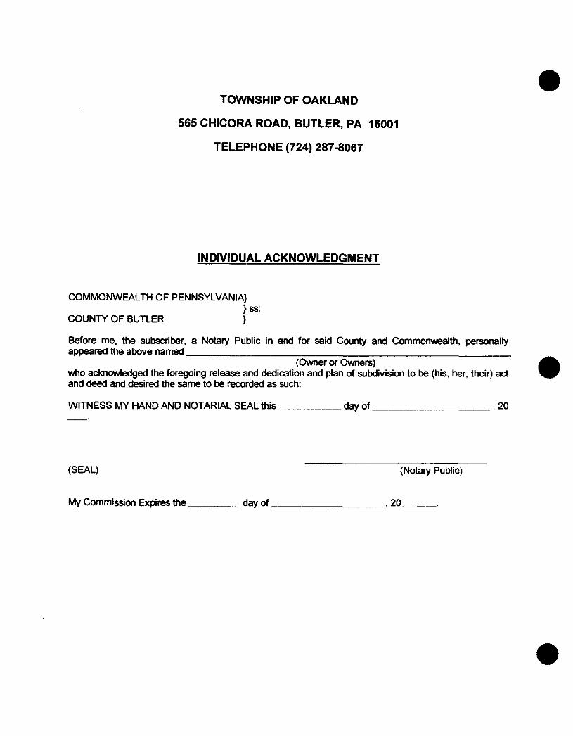
TOWNSHIP OF OAKLAND
565 CHICORA ROAD, BUTLER, PA 16001
TELEPHONE (724) 287-8067
INDIVIDUAL ACKNOWLEDGMENT
COMMONWEALTH OF PENNSYLVANIA] ] ss:
COUNTY OF BUTLER 1 Before me, the subscriber, a Notary Public in and for said County and Commonwealth, personally appeared the above named
who acknowledged the foregoing release and dedication and plan of subdivision to be (his, her, their) act and deed and desired the same to be recorded as such:
(Owner OT Owners)
WITNESS MY HAND AND NOTARIAL SEAL this day of 920 _.
(SEAL) (Notary Public)
My Commission Expires the day of I20

TOWNSHIP OF OAKLAND
565 CHICORA ROAD, BUTLER, PA 16001
TELEPHONE (724) 287-8067
CORPORATION ADOPTION
KNOW ALL MEN BY THESE PRESENTS:
That , by virtue of a Resolution
of the Board of Directors thereof, does hereby adopt this as its Plan of Subdivision of its Property situate in the Township of Oakland. County of Butler, Commonwealth of Pennsylvania, and for divers advantages accruing to it, does hereby dedicate forever, for public use for highway. drainage, sewage and utility purposes, all drives. roads, streets, lanes, rightsof-way, easements. ways and other public ways shown upon the plan, with the same force and effect as if the same had been opened through legal pmeedings and in consideration of the approval of said plan and any future acceptance of said public highways, rightsof-way and easements by said County of Butler or Township of Oakland.
release and forever discharge said County of Butler or said Township of Oakland, their SUCC~SSO(S or assigns from any liability for damages arising and to arise from the appropriation of said grwnd for public highways and other public uses and the physical grading thereof to any grades that may be established. This dedication and release shall be binding upon
its SUCC~SSO~S and assigns and purchasers of lots in this plan.
In Witness whereof. the said Corporation has caused its Corporate Seal to be affixed by the hand of its President and same to be attested by its secretary, this
(Name of Corporation)
, hereby carenants and agrees to and by these presents does ( Name of Corporation)
( Name of Corporation)
day of A.D. 20-
- (Name of Corporation)
ATEST:
(SEAL)
(President) (SEAL)
( Secretary)
The foregoing Adoption and Dedication is made by
with full understanding and agreement that the approval of the Board of Supewison of the Tomship d Oakland, if hereto attached, will become null and void unless this plan is recorded in the ReCOrder d Deeds of Butler County, Courthouse. Butler. Pennsylvania, within ninety (90) days of date d sad approval.
(Name of Corporation)
(SEAL) (Name of Corporation)
(President)
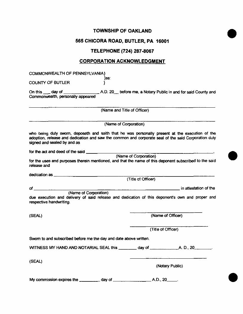
TOWNSHIP OF OAKLAND
565 CHICORA ROAD, BUTLER, PA 16001
TELEPHONE (724) 287-8067
CORPORATION ACKNOWLEDGMENT
COMMONWEALTH OF PENNSYLVANIA} 1s:
COUNTY OF BUTLER 1 On this - day of Commomlth. personally appeared
A.D. 20- before me, a Notary Public in and for sai County an
(Name and Title of Officer)
(Name of Corporation)
who being duly sworn, deposeth and saith that he was personally present at the execution of the adoption, release and dedication and saw the common and corporate seal of the said Corporation duly signed and sealed by and as
for the act and deed of the said
for the uses and purposes therein mentioned. and that the name of this deponent subscribed to the said release and
dedication as
(Name of Corporation)
(Title of officer)
of in attestation of the
due execution and delivery of said release and dedication of this deponent's M and proper and respective handwriting.
(Name of Corporation)
(Name of officer)
(Title of Officer)
Sworn to and subscribed More me the day and date above written
WITNESS MY HAND AND NOTARIAL SEAL this day of A. D., 20
(Notary Public)
My commission expires the day of A.D.. 20-.

e
TOWNSHIP OF OAKLAND
565 CHICORA ROAD, BUTLER, PA 16001
TELEPHONE (724) 287-8067
TOWNSHIP PLANNING COMMISSION APPROVAL
This plat of subdivision has been reviewed by the Planning Commission of the Township of Oakland, Butler County, Pennsylvania on this day of ,20-.
AlTEST:
(Chairman) (Secretary)
APPROVAL BY TOWNSHIP OF OAKLAND The Board of Supervisors of the Township of Oakland, Butler County. Pennsylvania, hereby gives public notice that it is approving this plan of subdivision for recording purposes only. The approval of this subdivision plat by the Township of Oakland does not constitute an acceptance of the roads, streets, alleys, stormwater and sanitary Sewage drainage facilities, easements or rights-of-way, water mains or any other services or improvements shown on this plan nor an assumption of maintenance responsibility, nor will the same be accepted or maintained until constructed in d a n c e with all Township Specifications and requirements and officially accepted by action of the Board of Supervisors.
This plat of subdivision approved by resolution of the Board of Supvisors of the Township of Oakland,
ATTEST:
Butler County. Pennsylvania on this - day of ,20-.
(Secretary of Board) (Chairman of Board)
SEAL
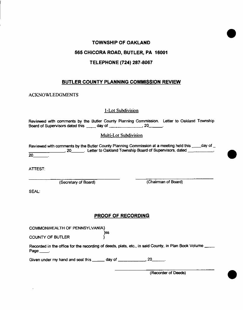
TOWNSHIP OF OAKLAND
565 CHICORA ROAD, BUTLER, PA 16001
TELEPHONE (724) 287-8067
BUTLER COUNTY PLANNING COMMISSION REVlRN
ACKNOWLEDGMENTS
I-Lot Subdivision
Reviewed with comments by the Butler County Planning Commission. Letter to Oakland Township Board of Supervisors dated this _. day of ,20-.
Multi-Lot Subdivision
Reviewed with comments by the Butler County Planning Commission at a meeting held this -day of -
20 I 20- . Letter to Oakland Township Board of Supervisors. dated
ATTEST
(Secretary of Board) (Chairman of Board)
SEAL:
PROOF OF RECORDING
COMMONWEALTH OF PENNSYLVANIA} 1s
COUNTY OF BUTLER 1
Recorded in the office for the recording of deeds, plats, etc.. in said County. in Plan Book Volume - Page -. Given under my hand and seal this - day of ,20-.
(Recorder of Deeds)

TOWNSHIP OF OAKLAND
565 CHICORA ROAD, BUTLER, PA 16001
TELEPHONE (724) 287-8067
SURVEYOR'S CERTIFICATE
1, , a Registered Professional Land Surveyor of the Commonwealth of Pennsylvania, do hereby certify that this plan correctly represents the lots, lands, streets, alleys rights-of-way and highways as surveyed and plotted by me for the Owners, developers or agents.
(SEAL) (Surveyor)
(Registration Number)
(Date)

PUBLISH ONCE NOTICE ONLY IN THE BUTLER EAGLE NOT MORE THAN SIXTY (60) DAYS NOR LESS THAN SEVEN (7) PRIOR TO ENACTMENT
LEGAL NOTICE
TO: ALL RESIDENTS OF OAKLAND TOWNSHIP, BUTLER COUNTY, PENNSYLVANIA, AND ALL OTHER INTERESTED PARTIES.
NOTICE IS HEREBY GIVEN that the Board of Supervisors of Oakland Township, Butler County, Pennsylvania, shall conduct a public hearing regarding the following amendments to the Oakland Township Subdivision Ordinance, at their regularly scheduled meeting to be held on Monday, June 7, 1993, at 7 : O O o'clock, p.m., prevailing time, at the Oakland Township Municipal Building at R.D. 3, Box 446, Chicora, Pennsylvania 16025, at which time all interested parties may attend and thereafter to vote upon the passage of the proposed amendments.
is as follows: The title of the Ordinance and a summary of the section titles
AN ORDINANCE OF THE TOWNSHIP OF OAKLAND, BUTLER COUNTY, PENNSYLVANIA, AMENDING OROINANCE NO. 1 OF 1976, "SUBDIVISION AND LAND DEVELOPMENT ORDINANCE OF OAKLAND TOWNSHIP, BUTLER COUNTY, PENNSYLVANIA", ADOPTED FEBRUARY 2, 1976, AND AMENDED APRIL 3, 1978, TO REFLECT REVISIONS TO THE STATE PLANNING CODE ADOPTED IN 1988.
I. DEFINITIONS 11. PROCEDURE FOR PLAN PROCESSING AND RECORDING
IV. VIOLATIONS , PENALTIES, REPEAL AND SEVERABILITY 111. MODIFICATIONS AND AMENDMENTS
The complete draft of the amendments will be available for inspection at the Oakland Township Municipal Building, Shearer Road, Chicora, Pennsylvania 16025, and at the Butler County Law Library at tlfe Butler County Courthouse in Butler, Pennsylvania, and at the Butler Eagle, West Diamond Street, Butler, Pennsylvania.
BOARD OF SUPERVISORS OF OAKLAND TOWNSHIP
James A . Taylor, Solicitor Murrin, Taylor, Flach & Horan 110 East Diamond Street Butler, PA 16001 Telephone (412) 282-3141
JATsam April 28. 1893 Oak12.10
ORDINANCE NO.
AN ORDINANCE OF THE TOWNSHIP OF OAKLAND, BUTLER COUNTY, PENNSYLVANIA, AMENDING ORDINANCE NO. 1 OF 1976, "SUBDIVISION AND LAND DEVELOPMENT ORDINANCE OF OAKLAND TOWNSHIP, BUTLER COUNTY, PENNSYLVANIA", ADOPTED FEBRUARY 2, 1976, AND AMENDED APRIL 3, 1978, TO REFLECT REVISIONS TO THE STATE PLANNING CODE ADOPTED IN 1988.
NOW, THEREFORE, BE IT ORDAINED AND ENACTED, and it is hereby ordained and enacted by the Board of Supervisors of the Township of Oakland, Butler County, Pennsylvania, as follows:
SECTION I - DEFINITIONS
Section 1 Paragraph C, is amended in its entirety to read as follows:
C. A I1subdivision8l shall be considered for the purposes of this Ordinance as the division or redivision of a lot, tract or parcel of land by any means into two or more lots, tracts, parcels or other divisions of land including changes in existing lot lines for the purpose, whether immediate or future, of lease, partition by the Court for distribution to heirs or devisees, transfer of ownership or building or lot development: Provided, however, that the subdivision by lease of land for agricultural purposes into parcels of more than ten (10) acres, not involving any new street or easement of access or any residential dwelling, shall be exempted.
Section 1, Paragraph F, Definitions, shall be revised by adding the following definitions in the appropriate alphabetical location:
DEVELOPMENT PLAN - the written and graphic materials that must be presented by the developer for review and action by the Township in accordance with the provisions of this Ordinance preceding land development.
LAND DEVELOPMENT - the subdivision of land or the improvement on one lot or two (2) or more contiguous lots, tracts or parcels of land for development of a group of two ( 2 ) or more residential or non-residential buildings, whether built at the same time or not, or for a single non-residential building.
LANDOWNER - the legal or beneficial owner or owners of land including the holder of an option or contract to purchase, a lessee if he is authorized under the lease to exercise the rights of the landowner, or ether persons having a proprietary interest in the land.
PUBLIC HEARING - a formal meeting held pursuant to public notice by the Board of Supervisors or Planning Commission, intended to inform and obtain public comment prior to taking action in accordance with this Ordinance.
PUBLIC NOTICE - notice published once each week for two successive weeks in a newspaper of general circulation in the Township. Such notice shall state the date, time and place of the hearing and the particular nature of the matter to be considered at the hearing. The first publication shall not be more than thirty (30) days and the second publication shall not be less than seven (7) days from the date of the hearing.
Section 1, Paragraph F, Definitions, Subparagraph j. "Developer", shall be amended in its entirety to read as follows: T
DEVELOPER - any landowner, agent of such landowner, or tenant with permission of such landowner, who makes or causes to be
developer may be an individual, group of individuals or a corporation.
made, a subdivision of land or a land development. A
2
SECTION I1 - PROCEDURE FOR PLAN PROClESSING AND RECORDING Section 3, Paragraph A, Procedure for Preliminary Plan Processing, Subparagraph 5, the first sentence of the first subparagraph shall be amended to read as follows:
5. The Board of Supervisors shall render a decision as to approval, disapproval or approval with specific conditions, and shall communicate it to the developer not later than ninety (90) days after the application was filed with the Planning Commission. The filing date shall be the same as a regular meeting date of the Planning Commission on which, or immediately after which, the application was filed.
Section 3, Paragraph A, Procedure for Preliminary Plan Processing, Subparagraph 5, the last sentence of the first subparagraph shall be amended to read as follows:
The official decision shall be transmitted in writing to the developer at his address of record not later than fifteen (15) days after the decision is reached, indicating specifically, if the approval is denied, the reasons for denial, citing the appropriate Ordinance section relied on. No part of the fifteen (15) day period shall extend beyond the ninety (90) day limit.
Section 3, Paragraph B, Procedure for Final Plan Processing, Subparagraph 6, shall be amended it its entirety to read as follows:
T
The Board of Supervisors shall review the recommendations of the Township Planning Commission and the comments of the County Planning Commission, which shall be given not less than thirty (30) days to respond. The Board may call and hold a public hearing on the final: plan application, properly noticed. The Board shall make its final decision, either approval or rejection of the final plan application, and shall communicate it to the applicant, not later than ninety (90)
3
days after the application was filed with the Planning Commission. The filing date shall be the same as a regular meeting date of the Planning Commission on which or immediately after which the application was filed. The official decision shall be transmitted in writing to the applicant at his address of record not later than fifteen (15) days after the decision is reached, but within the ninety ( 9 0 )
day limitation, indicating, specifically, if the approval is denied, the reasons for denial and citing the appropriate Ordinance section relied upon.
Section 3, Paragraph B, Procedure for Final Plan Processing, Subparagraph 8, Subsection d. iii, shall be amended in its entirety to read as follows:
iii. An improvement bond or escrow account, to the benefit of Oakland Township, in an amount equal to one hundred ten (110%) percent of the estimated costs for installation of public improvements agreed upon by the developer and the Board of Supervisors, such amount established by the developer‘s engineer, who shall submit a breakdown of unit costs for labor and materials for each improvement, and the total costs, which amount the Board may challenge before final approval if, in its judgment, based on its own engineer’s evaluation, the developer’s estimate does not adequately reflect the scope of the work;
Section 3, Paragraph B, Procedure for Final Plan Processing, Subparagraph 8, Subsection d. v. and Subsection d. vi., shall be amended to read as follows:
v. If access to the property is from a State maintained road, the final approval drawings shall bear a notice that a highway occupancy permit is required pursuant to Section 4 2 0 of the State Highway Law, before driveway access to the State road is permitted.
4

vi. If water is to be provided by a means other than private wells owned and maintained by the individual lot owners, the developer shall present evidence to the Board of Supervisors that his plan or development is to be supplied by a certificated public utility, a bona fide cooperative association of lot owners or by a municipal corporation, authority or utility. A copy of a Certificate of Public Convenience from the Pennsylvania Public Utility Commission, a completed application for such Certificate, a cooperative agreement or a commitment for such an agreement to serve the plan or development shall be acceptable evidence.
Section 3, Procedure for Final Plan Processing, shall have added to it a Paragraph D entitled @@Completion of Improvements'@ which shall read as follows:
D. Completion of Improvements
1. Having received final plan approval and posted an improvement bond or escrow account, the developer shall construct the agreed upon improvements within one (1) year of approval.
2. As work proceeds, the developer may request that the Board of Supervisors authorize the partial release of his indebtedness or an amount in the escrow account, in order to pay contractors performing the work. The Board shall have forty-five ( 4 5 ) days in which to authorize its engineer to reviewrthe work so far completed and to certify the amount of indebtedness to be excused or escrow account to be reduced. Upon receiving the engineer's report, the Board shall authorize release of the amount recommended by the engineer. If the Board fails to act within the forty-five ( 4 5 ) day period, the improvements shall be deemed to have been approved and the release authorized. At least ten (10) percent of the total value of the work shall remain encumbered until final approval of the entire project.
5

3 . The developer may request the Board of Supervisors to provide a signed copy of a resolution indicating approval of the final plan contingent upon obtaining satisfactory financial security. The final plan shall not be signed or recorded until written evidence of the security is provided to the Board. The resolution shall expire ninety (90) days from the date it was signed.
4 . The Township may not refuse to issue building permits or allow occupancy of any building in a plan that includes public improvements if such improvements are not yet completed as long as the roads are mud-free and permanently passable and utilities in place.
5. When the developer has completed all the improvements covered by the bond or other security, he shall so notify the Board of Supervisors in writing by certified m.ail, with a copy to the Board's engineer. The Board shall, within ten (10) days after receiving the notice, to file with the Board a written report of his findings, indicate approval or rejection of each improvement in whole or in part, with specific reasons for any rejection. Within fifteen (15) days of receipt of the report the Board shall inform the developer by certified mail of its approval or rejection. Failure of the Board or engineer to meet the time limitations shall result in the improvements being deemed approved and the deaeloper released from liability. Any improvements rejected shall be completed, repaired or rebuilt to the engineer's satisfaction, before the developer's liability may be released.
6. The Board of Supervisors may require the developer to reimburse the Township for the reasonable and necessary costs for inspection of improvements by the Board's engineer. such reimbursement shall be based on a schedule adopted by
6

resolution of the Board predicated upon the engineer's customary charges for such work. The Board and developer may negotiate the fee schedule.
7. If the developer is unable or refuses to complete the improvements covered by the bond or escrow account within the agreed upon time limitations, the Board of Supervisors shall exercise the bond or use the escrow account to complete the work still not furnished. If the financial security is not great enough to complete the work, the Board may start legal action to recover moneys to make up the difference. All proceeds, regardless of how raised, shall be used only for improvements covered by the security and for no other purposes.
Section 3, Paragraph C, Recording of Approved Final Plan, shall have added to it a Subparagraph 4 , which shall read as follows:
4 . The recording of a plan shall not constitute grounds for assessment increases until such time as lots are sold or improvements are installed on the land included within the plan.
SECTION I11 - MODIFICATIONS AND AMENDMENTS Section 4, Paragraph A, shall be amended in its entirety to read as follows :
?
A . Modifications
1. The Board of Supervisors, after receiving the recommendations of the Planning Commission, may grant a modification of the requirements of one or more provisions of this Ordinance if the literal enforcement will exact undue hardship because of peculiar conditions pertaining to the land on which the plan or development
7
is proposed, provided that such modification will not be contrary to the public interest and that the purpose and intent of the Ordinance is maintained.
2. All requests for modifications shall be in writing to the Planning Commission Secretary and shall accompany the ap- plication for plan or development preliminary approval. The request shall state in full the grounds for the modification, the facts supporting the unreasonableness or hardship on which the request is based, the provision or provisions of this ordinance involved, and the minimum modification necessary.
3 . The Planning Commission shall review the request at its earliest convenience and submit recommendations to the Board of Supervisors to accept the request, deny it or accept it in part.
4 . The Board shall take action on the Planning Commission recommendations and shall inform the applicant immediately after its decision.
5. The Board shall keep a written record of all action taken on all request for modifications.
6. The modifications granted shall be noted on the recording drawings of the plan of subdivision or development."
Section 4 , Paragraph B, Amendments, shall be amended to read as follows :
B. Amendments
1. A proposal for an amendment may be initiated by the Board of Supervisors, the Planning Commission or by a petition signed by owners of five (5) properties
all in different ownerships or owners of four (4) such properties plus one (1) individual who has entered into an agreement to purchase property in the Township.
2. No amendment shall be adopted until after the Board of Supervisors has held a public hearing on it, pursuant to public notice.
3 . If the amendment is proposed by the Board of Supervisors or by Petition, the Board shall submit the amendment to both the Township Planning Commission and the County Planning Commissions for review and comment at least thirty ( 3 0 ) days before the hearing. In any case, the Board shall submit the proposal to the County Planning Commission at least thirty ( 3 0 ) days before the hearing.
4 . Not less than seven (7) days before the intended adoption of an amendment, nor more than sixty (60) days before, notice of the intent to adopt shall be published once in a newspaper of general circulation in the Township. The notice shall state the date, time and place of the meeting at which adoption will be considered, as well as a place within the Township where copies of the proposed amendment may be examined free of charge. The notice shall also contain either the full text prepared by the Township Solicitor, setting forth all of the provisions in reasonable detail. If the summary is published, the newspaper shall be provided the full text when the notice is run and an attested copy of the full text shall be filed in the County Law Library at the same time.
9

.
5 . If substantial changes are made to the proposed amendment after the hearing, the Board of Supervisors shall at least ten (10) days before the adoption, readvertise giving a brief summary of the proposed changes in the context of the overall amendment.
6. Within thirty (30) days after adoption, the Board shall forward a certified copy of the adopted amendment to the County Planning Commission.
7. Appeal from decisions of the Board on amendments shall be to the County Court of Common Pleas, taken not more than thirty (30) days after the decision.
SECTION IV - VIOLATIONS, PENALTIES, REPEAL AND SEVERABILITY
Section 6, Paragraph A, shall be amended to read as follows:
A . Remedies
1. Preventive remedies - The Township may refuse to issue any permit or grant approvals necessary to further improve or develop a property that is already in violation of this ordinance. Such authority to deny shall apply to the owner of record at the time of violation, a lease holder or renter at the time of violation whaher or not he knew of the violation, an owner who acquired an interest after the violation occurred, whether or not he knew of the violation or a lease holder or renter from such subsequent owner regardless of the renter or lease holder's knowledge of the violation.
10

2. Enforcement remedies - Any person, partnership or corporation, who or which has violated any provisions of this Ordinance shall, upon being found liable therefor in a civil enforcement proceeding commenced by the Township, pay a judgment of not more than five hundred ($500.00) dollars plus all Court costs, including reasonable attorney fees incurred by the Townships a result of the action. No judgment shall commence or be imposed until the date that the district justice who shall have the initial jurisdiction in such cases, determines the violation actually commenced. If the Defendant neither pays nor appeals the judgment, the Township may enforce the judgment, pursuant to the rules of civil procedure. Each day that a violation continues shall constitute a separate violation at the discretion of the district justice. Nothing herein contained shall be construed or interpreted to grant to any person or entity other than the Township the right to commence any action for enforcement. All judgments and attorney fees collected through the proceeding shall be paid to the Township.
BOARD OF SUPERVISORS OF OAKLAND TOWNSHIP
ATTEST:
Secretary
11