CH. 19 The Nile River: A Journey from Source to Mouth · Nile River. For that reason, the ancient...
12
CH. 19 The Nile River: A Journey from Source to Mouth Introduction The Nile River is home to one of the world’s earliest civilizations. Thousands of years ago, the Nile River gave rise to one of the world’s first civilizations. The ancient Egyptians built great cities, temples, and pyramids along the river. They grew crops on the river’s banks and sailed boats on its waters. The Egyptians also wrote songs and poems in praise of the river. The Nile gave life to ancient Egypt, and today it remains a key part of Egyptian life. However, the Nile is not just an Egyptian river. The river begins its long journey far to the south of Egypt in the highlands of East Africa. Along its way to the Mediterranean Sea, the Nile River crosses mountains, plateaus, plains, and deserts. The river basin of this great waterway encompasses an area of more than 1 million square miles, which is approximately one tenth of the African continent. A river basin is the area that is drained by a river and the smaller streams that flow into that river. The Nile River basin includes portions of 11 African countries. Forty percent of all Africans live in these 11 countries. In this lesson, you will follow the course of the Nile River and discover how the river changes during its lengthy journey from the highlands of East Africa to the Mediterranean Sea. You will read about the origins of the Nile and about the explorers who traced the great river to its sources. You will also learn about the impact of the river on the people and environment of the Nile River basin.
Transcript of CH. 19 The Nile River: A Journey from Source to Mouth · Nile River. For that reason, the ancient...

CH. 19 The Nile River: A Journey from Source to Mouth
Introduction The Nile River is home to one of the world’s earliest civilizations.
Thousands of years ago, the Nile River gave rise to one of the
world’s first civilizations. The ancient Egyptians built great cities,
temples, and pyramids along the river. They grew crops on the
river’s banks and sailed boats on its waters. The Egyptians also
wrote songs and poems in praise of the river. The Nile gave life to
ancient Egypt, and today it remains a key part of Egyptian life.
However, the Nile is not just an Egyptian river. The river begins
its long journey far to the south of Egypt in the highlands of East
Africa. Along its way to the Mediterranean Sea, the Nile River
crosses mountains, plateaus, plains, and deserts. The river basin of this great waterway
encompasses an area of more than 1 million square miles, which is approximately one
tenth of the African continent. A river basin is the area that is drained by a river and the
smaller streams that flow into that river. The Nile River basin includes portions of 11
African countries. Forty percent of all Africans live in these 11 countries.
In this lesson, you will follow the course of the Nile River and discover how the river
changes during its lengthy journey from the highlands of East Africa to the Mediterranean
Sea. You will read about the origins of the Nile and about the explorers who traced the
great river to its sources. You will also learn about the impact of the river on the people
and environment of the Nile River basin.

1. The Geographic Setting Two Views of the Nile
This satellite image shows the Nile River
valley. What patterns of vegetation and landforms do
you see? The diagram below shows the change in
the Nile’s elevation along its entire length. From its
sources to the Mediterranean Sea, the river drops
more than a mile in elevation.
Because most of Egypt is a barren, sandy
desert, the ancient Egyptians could not have
survived without the life-giving waters of the
Nile River. For that reason, the ancient Greek
scholar Herodotus referred to Egypt as the “gift
of the Nile.” Despite the river’s great
importance, the ancient Egyptians never knew
just where it came from. In fact, the sources of
the Nile would remain a mystery for thousands
of years.
The World’s Longest River The Nile River
has two main branches, the White Nile and the
Blue Nile. The White Nile is the river’s longest
branch, running north for about 4,160 miles from its most distant tributary in the highlands
of Burundi. This great length, which is more than twice the distance from Chicago to Los
Angeles, makes the Nile the world’s longest river.
Every year, the waters of the Nile rise and fall with the seasons. These changes in the
river level are tied to the water cycle that brings rain to the highlands of Africa. The water
cycle is the constant movement of water from Earth’s surface to the atmosphere and
back again. After the rainy season, the rising water often floods the land that lies along the
Nile’s banks.
The Gifts of Water, Transportation, and Power The Nile has long been essential to the
people who live and work along its banks. These people rely on the river water not only for
drinking, washing, and cooking, but also for raising crops. During ancient times, the
seasonal flooding of the Nile left large deposits of rich silt on farmland near the
river. Farmers planted their crops in this fine, dark soil, and they used the floodwaters to
help irrigate their fields. Later on, farmers developed perennial irrigation, which is a
system that distributes water to farm fields throughout the year.

The Nile is also useful for transportation
and energy.People living near the Nile have
long used the river as a water highway that
carries goods and people by boat from place to
place. Furthermore, the Nile has
great hydroelectric potential, which means
that the power of the flowing water can be
used to generate electrical power. Cities along
the Nile depend on hydroelectric power to
meet their energy needs.
▶Geoterms
hydroelectric potential the electrical power
that can be generated from flowing water
perennial irrigation a system that allows for
the year-round watering of crops
river basin the area drained by a river and its
tributaries.These tributaries are the smaller
streams that flow into the main river. Rain
falling anywhere in a river basin will eventually
flow into the main river.
water cycle the movement of water from the
surface of Earth to the atmosphere and back
again. During this cycle, water evaporates from
rivers, lakes, and oceans, rises and condenses
into clouds, and then falls back to Earth as
rain, hail, sleet, or snow. This process is also
known as the hydrologic cycle.

2. The Beginnings of the Nile
The ancient Egyptians believed that the Nile River sprang forth from an underground
lake in southern Egypt. The ancient Romans later tried to locate the source of the Nile but
were unsuccessful. It was only in more recent times, within the last 200 years, that
explorers finally located the origins of the Nile. Like all rivers, however, the Nile actually
begins with the water cycle.
From Rainwater to Rivers: The Water Cycle As you read earlier, the water cycle is the
process that recycles water from the surface of Earth to the atmosphere and back
again. This never-ending process moves water through the environment, with some of the
water ending up in rivers like the Nile.
The water cycle begins with the evaporation of water from oceans, lakes, and
rivers. This evaporation occurs when the sun heats the water. When water evaporates, it
becomes water vapor. Steam is a visible form of water vapor.
As water vapor rises into the atmosphere, it cools down. This cooling process then
causes the water vapor to condense into tiny water droplets, which then come together to
form clouds. Under certain conditions, the water droplets become too large and heavy to
remain in the atmosphere. At this point, the droplets fall to Earth as precipitation, which
can take a variety of forms, including rain, snow, sleet, and hail.
Several things can happen to precipitation after it hits the ground. Some precipitation
gets stored as snow and ice within glaciers. Some soaks into the ground in a process
known as infiltration. Some runs off the ground to form streams. In areas that have
extensive runoff, streams come together to form rivers. Most rivers eventually flow into
the sea, where the water cycle begins again.
The Water Cycle
This diagram shows how nature recycles water. The water cycle is a “closed system.” No water is
ever lost. However, some water may collect unseen under the ground. This water can be tapped for
human use.

Murchison Falls
North of Lake Victoria, the White Nile thunders over Murchison
Falls. This is one of the most dramatic spots on the Nile’s long
journey to the sea. Today, these falls are part of a national park in
Uganda. Park wildlife includes elephants and giraffes. Hippos and
crocodiles are often found in these waters.
Lake Tana: Source of the Blue Nile Both main branches of
the Nile, the Blue and the White, are fed by rainfall and runoff
in the East African highlands. In the lush, forested hills of
Ethiopia, this runoff flows into Lake Tana, which is
considered to be the main source of the Blue
Nile. The headwaters of the Blue Nile, however, are found
above Lake Tana. Headwaters are the stream or streams
that make up the beginnings of a river.
The Blue Nile is a fast and extremely powerful river. Fed by heavy summer rains, it
roars down from Lake Tana through deep canyons to the plains below. Along its route, the
river picks up lots of dark soil. Most of the silt that is deposited downstream on flooded
farmland comes from the Blue Nile.
The source of the Blue Nile remained a mystery to outsiders until the 1600s. Around
1615, a Spanish priest named Pedro Páez made his way to Lake Tana, finding the outlet
where the river leaves the lake. In the late 1700s, the Scottish explorer James Bruce also
reached the source of the Blue Nile. He later published a book about his travels and took
credit for the discovery.
Lake Victoria: Source of the White Nile The other main branch of the Nile starts farther
to the south. The White Nile’s headwaters consist of its most distant tributary, a stream
that flows out of the mountains of Burundi. However, the main source of the White Nile is
really Lake Victoria, a large, shallow lake that straddles the borders of Uganda, Kenya,
and Tanzania.
For years, however, the origins of the White Nile remained as mysterious as those of
the Blue Nile. Various explorers attempted to follow the river from Egypt to its source, but
they lost their way in swamps or were turned back by river rapids.
Then, in the 1850s, the English explorer John Hanning Speke reached Lake
Victoria. Convinced that this body of water was the White Nile’s source, he returned to the
lake a few years later. In 1862, he found a river flowing out of the lake’s northern
side. After following the river for a distance, he returned to England to announce that he
had discovered the source of the White Nile.
At first, many scholars doubted Speke’s claim, thinking that he had not explored the
area around Lake Victoria well enough. However, later expeditions confirmed that Lake

Victoria was indeed the main source of the White Nile. In 1937, a German explorer named
Burkhart Waldecker traced the White Nile’s headwaters farther south, into Burundi.
Just as the Blue Nile exits Lake Tana, the White Nile flows out of Lake Victoria as a
rushing torrent. It passes through two more lakes and over a large waterfall before
reaching the flat plains of South Sudan, where it slows down. Along the way, the White
Nile becomes a muddy gray color, from which the river gets its name.
3. Two Niles Meet: Confluence and Cataracts Confluence of the Blue
Nile and White Nile The Blue Nile and White Nile merge just north of
Tuti Island (top left), outside Khartoum. Note that the Blue Nile
appears as a separate slim stream on the eastern bank of the Nile
as the river flows north of the confluence.
After leaving Uganda, the White Nile crosses the plains of
South Sudan. Along the way, the river passes through a
huge swamp known as the al-Sudd, where it spreads out
into many small channels that are clogged
with vegetation and extremely difficult to navigate. In the
first century C.E., a Roman expedition that was sent to find
the source of the Nile got lost in this swamp.
The White and Blue Niles Meet at Khartoum Beyond the al- Sudd, the White Nile
continues its sluggish journey north, from South Sudan into Sudan. To the east, the Blue
Nile flows northward from the Ethiopian highlands. In north-central Sudan, the two
branches of the Nile finally meet. This confluence, or coming together, takes place at the
city of Khartoum, the capital of Sudan.
At the confluence of the White Nile and the Blue Nile, the Nile becomes a much larger
river, particularly during the summer rainy season. Although the flow of the White Nile
remains essentially the same throughout the year, the Blue Nile grows much larger as a
result of the summer rains. It is this rise in the level of the Blue Nile that causes most of
the flooding downstream.
At first, the waters of the White and Blue Niles do not mix. The gray flow of the White
Nile runs alongside the darker waters of the Blue Nile. After a few miles, however, the two
rivers do blend, and finally the Nile truly becomes one river.
Rough Waters Slow River Travel North of Khartoum, the Nile rolls on for another 800
miles before reaching the southern border of Egypt. During this stage of its long journey,
the river makes a wide turn to the south and west, a turn that is known as the “great
bend.” The Nile also passes over six cataracts, which are rapids or low waterfalls where
the water cascades over rock outcroppings.

The Nile cataracts have been famous throughout history as a barrier to river travel and
trade. Although boats can sail on stretches of water between the cataracts, the rapids are
far too dangerous for river travel. In ancient times, river traders had to unload their boats
and move their goods by land around these rough waters.
4. Through the Desert: Wadis and Dams
North of the city of Khartoum, the Nile flows through one of the harshest landscapes in
the world. Rain is scarce here, but when it does fall, it can cause a flash flood. During a
storm, rainwater rapidly fills the normally dry riverbeds, which are called wadis. If you are
in a wadi when a storm hits, you had better move fast, or you may find yourself swept
away by a wall of water.
An Arid Landscape In Sudan, the Nile enters a vast desert that continues northward
through Egypt. Here the land on both sides of the river is sunbaked and desolate. The
largest desert in the world, the Sahara, stretches to the west for thousands of miles across
northern Africa. To the east, between the Nile River and the Red Sea, lies the Nubian
Desert, a land full of rocky hills, sand dunes, and wadis. Few people live here.
The Nile provides relief from this arid landscape. Here and there, trees grow up along
the banks of the river, and in some places, people have settled and irrigated small plots of
land for farming. Farther to the north, in Egypt, there is more extensive farming and
settlement along the banks of the Nile. The land along the river as it winds its way through
Egypt looks like a ribbon of green stretched across the redbrown sands of the desert.
Controlling the Nile: The Aswan High Dam After winding for hundreds of miles through
Sudan, the Nile finally reaches Lake Nasser, which straddles the border between Sudan
and Egypt. Lake Nasser is areservoir, not a natural lake. Formed in 1970 by the
construction of the Aswan High Dam in Egypt, Lake Nasser is one of the largest reservoirs
in the world.
The Aswan High Dam
This photograph, taken from the International Space
Station, shows the Aswan High Dam and its reservoir,
Lake Nasser. The dam is enormous.Enough rock was
used in its construction to build 17 pyramids the size of
the Great Pyramid at Giza in Egypt. The lake is huge,
too. It stretches for 300 miles from Egypt into Sudan.
The Aswan High Dam was built for two main
reasons. One purpose was to develop the Nile’s
hydroelectric potential. The power plant at the
dam generates an enormous amount of
electricity, which has helped both Egypt and
Sudan to develop their cities and start new industry.

The second reason for building the dam was to control the river’s flow. As you know, in
the past the Nile flooded its banks nearly every year. Although Egyptian farmers benefited
from them, the floods also destroyed villages along the river. In the years when rainfall in
the mountains was light and floods did not occur, Egypt lacked water.
The Aswan High Dam holds back the floodwaters that once caused problems. Instead,
the dam releases water in a steadier flow from Lake Nasser, thereby providing a reliable,
year-round supply of water for Egyptian farms and cities. The steady flow of water also
makes navigating the river easier.
In addition to these benefits, the Aswan High Dam has brought some negative
effects. At the time that Lake Nasser was formed, thousands of people were forced to
relocate because their homes had been covered by water. In addition, the dam traps most
of the rich silt that had previously flowed down to Egyptian farmland. That silt now sits at
the bottom of the lake. As a result, farmland downstream has become less fertile, and
farmers must now buy artificial fertilizers to enrich the soil.
5. Across Egypt: Floodplains and Delta For most of its journey through Egypt, the Nile flows through a narrow valley. In this
Nile River valley, floodplains lie between the banks of the river and low cliffs on either
side. Near the river’s end, the Nile fans out to form a large delta. Together, the floodplains
and delta make up just 3 percent of Egypt’s land area, but these lands are home to most
of the country’s people. In fact, approximately 95 percent of all Egyptians live along the
Nile, and 60 percent of the cultivated land is in the delta.
A Narrow Strip of Farmland Lines the River The floodplains of the Nile River valley
have served as farmland for thousands of years. Although the floodplains are merely a
few miles wide in most places, the ancient Egyptians used them to produce bountiful
harvests of wheat, barley, and other crops. These harvests enabled the Egyptians to
create one of the greatest early civilizations.
Until recent times, farmers along the Nile depended on the annual floods to water and
add fertile soil to their fields. The farmers also used traditional irrigation techniques to
bring water from the river. They built canals and transported water with simple machines
like the shaduf, a pole with a bucket at one end and a weight at the other. The pole is
attached to a brace so that it can be moved up and down. The farmer dips the bucket into
the water and, once it is filled, allows the weight to pull it out again.
The construction of the Aswan High Dam brought major changes to farming along the
Nile River. Lake Nasser now supplies water for a large system of perennial irrigation. With
this water, farmers have been able to expand the amount of land under their
cultivation. As a result, Egyptian harvests have increased, with cotton in particular
becoming a major export crop.

Water for Cairo
In addition to the approximately 12 million people who live
in Cairo, the Cairo region is home to at least another 10
million people. In 2017 alone, the population was
expected to grow by half a million. As the city grows, more
pressure is placed on its water supply, and the urban
sprawl has started to move into farmland.
Water for Rapidly Growing Cairo About 600 miles from the Aswan High Dam, the Nile
reaches Cairo, the capital of Egypt. The river flows through the center of the city, with
broad, tree-lined avenues and modern skyscrapers lining its banks. In the evening, people
stroll along the Nile or relax with their friends in cafes overlooking the water.
With a population estimated to be around 12 million, Cairo is one of the largest cities in
the world. Like the rest of Egypt, Cairo gets most of its water from the Nile. This reliance
on river water has worked well in the past, but with the rapid growth of the city, water
needs are increasing as well. At the same time, Cairo is discharging sewage and
industrial waste into the river. These two factors—population growth and pollution— are
putting pressure on the water supply. Cairo will have to plan carefully to avoid water
problems in the future.
The River’s Final Gift: The Nile Delta North of Cairo, the Nile travels another 100 miles
before emptying into the Mediterranean Sea. In this area, the floodplains of the Nile
spread out into a broad, triangular-shaped delta. At its widest point, on the coast, this fan-
shaped delta measures about 155 miles across, creating a fertile area where much of
Egypt’s food is produced.
From Tributary to Mouth
The length of each of these six rivers is measured from its most distant tributary. It’s hard to measure
rivers, though, and experts sometimes disagree. For example, some geographers believe that the
Amazon is longer than the Nile. The red text in the graph shows some competing estimates for river
length that have emerged.

The Nile Delta began forming many thousands of years ago. When the river reached
the coastal plain, it slowed down and divided into several branches. As the Nile slowed, it
deposited the remainder of the load of silt it brought down from the highlands. Over time,
this silt built up into a thick layer of soil. The Nile Delta became the richest farmland in
Africa, and some of the richest in the world.
In ancient times, the Nile split into seven channels while crossing the delta. Over time,
silt has filled some of those channels so that today only two channels remain. At the end
of its long journey, the Nile pours from two mouths into the Mediterranean Sea.
Summary
In this lesson, you read about the long journey of the Nile River from its sources in the
highlands of East Africa to the Mediterranean Sea. You also read about the water cycle
and how this recycling of water between Earth’s surface and the atmosphere gives rise to
rivers such as the Nile. You learned where the Nile River basin is located and how the Nile
changes as it flows downstream. You also learned that hydroelectric potential and water
for perennial irrigation are major benefits that the Nile brings to the people who live along
its banks.
The Nile is one of many great rivers in the world. Another is the Amazon River, which
drains a larger area than even the Nile. Starting in the snowy Andes Mountains of South
America, the Amazon flows east through the world’s largest tropical rainforest to the
Atlantic Ocean. The Ohio, Missouri, and Mississippi rivers also form a mighty river system,
which stretches from the Appalachians west to the Rocky Mountains. This river system
drains a large part of the North American continent into the Gulf of Mexico.
All rivers change as they flow across the surface of Earth. Some changes are natural,
whereas others are the consequence of human activity. Think about this as you look at the
impact of hydroelectric dams on rivers around the world.
Global Connections
This map shows major rivers and hydroelectric dams throughout the world. The graph
compares the amounts of energy produced by the largest hydroelectric dams. A megawatt
(MW) is equal to 1 million watts, which is enough electricity to serve the needs of
approximately 1,000 people. A large hydroelectric dam can produce about 1,000 MW of
electrical energy. The diagram at the bottom of this page shows how a hydroelectric dam
works to generate all of this electrical power.
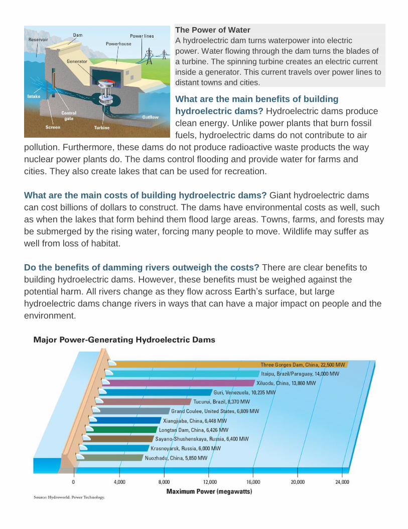
The Power of Water
A hydroelectric dam turns waterpower into electric
power. Water flowing through the dam turns the blades of
a turbine. The spinning turbine creates an electric current
inside a generator. This current travels over power lines to
distant towns and cities.
What are the main benefits of building
hydroelectric dams? Hydroelectric dams produce
clean energy. Unlike power plants that burn fossil
fuels, hydroelectric dams do not contribute to air
pollution. Furthermore, these dams do not produce radioactive waste products the way
nuclear power plants do. The dams control flooding and provide water for farms and
cities. They also create lakes that can be used for recreation.
What are the main costs of building hydroelectric dams? Giant hydroelectric dams
can cost billions of dollars to construct. The dams have environmental costs as well, such
as when the lakes that form behind them flood large areas. Towns, farms, and forests may
be submerged by the rising water, forcing many people to move. Wildlife may suffer as
well from loss of habitat.
Do the benefits of damming rivers outweigh the costs? There are clear benefits to
building hydroelectric dams. However, these benefits must be weighed against the
potential harm. All rivers change as they flow across Earth’s surface, but large
hydroelectric dams change rivers in ways that can have a major impact on people and the
environment.