Byron Shire Development Control Plan 2014 Chapter E2 Bangalow
18
Byron Shire Development Control Plan 2014 Chapter E2 Bangalow
Transcript of Byron Shire Development Control Plan 2014 Chapter E2 Bangalow

Byron Shire Development Control Plan 2014 Chapter E2 Bangalow

Byron Shire Development Control Plan 2014 Chapter E2 Bangalow
Adopted 4 November 2021 Effective 25 November 2021
Page 2
Contents
E2.1 Introduction ....................................................................................................................... 4
E2.1.1 Where this Chapter Applies ........................................................................................... 4
E2.1.2 Objectives of this Chapter ............................................................................................. 4
E2.2 Character .......................................................................................................................... 5
E2.2.1 Existing Village Character and Context ......................................................................... 5
E2.2.2 Existing Character ......................................................................................................... 6
E2.2.3 Place Character Statements .......................................................................................... 7
E2.3 General Provisions ......................................................................................................... 14
E2.3.1 Character, Bulk and Scale of Development ................................................................. 14
E2.3.2 Infill Development ........................................................................................................ 14
E2.4 Development within the Bangalow Heritage Conservation Area ...................................... 15
E2.4.1 General Urban Design ................................................................................................. 15
E2.4.2 Development in B2 Local Centre Zone ........................................................................ 15
E2.4.3 Active street frontages ................................................................................................. 16
E2.4.4 Connectivity and Permeability ..................................................................................... 17

Byron Shire Development Control Plan 2014 Chapter E2 Bangalow
Adopted 4 November 2021 Effective 25 November 2021
Page 3
Document History
Document Number Date Amended Details e.g.Resolution No
#E2014/3864 20 March 2014 Res 14-118 – Public exhibition version
#E2014/32377 Draft to 26 June 2014 Extraordinary Meeting for adoption
#E2014/43862 26 June 2014 Adopted Version – Res 14-315
#E2020/42680 22 June 2020 Res 20-218 – Draft Public exhibition version incorporating residential character narrative
#E2020/66604 24 August 2020 Post exhibition version
#E2020/66604 17 September 2020 Adopted version (no change) Res 20-473
#E2021/3759 July 2021 Draft – Public Exhibition version
#E2021/125364 November 2021 Post Exhibition pdf – attachment to Council report 4 November 2021
#E2021/137244 Adopted 4 November 2021 Effective 25 November 2021 (Res 21-479)
Byron Shire Development Control Plan 2014 Chapter E2 Bangalow
Adopted 4 November 2021 Effective 25 November 2021
Page 4
E2.1 Introduction E2.1.1 Where this Chapter Applies This Chapter applies to land within the Village of Bangalow, within the Bangalow Urban Area DCP Map, identified in Map E2.1.
Where there is an inconsistency between this Chapter and other Chapters, the provisions of this Chapter shall prevail.
E2.1.2 Objectives of this Chapter The primary purpose of this Chapter is to provide locally relevant planning provisions for the assessment of development within the Bangalow Urban Area.
The objectives of this Chapter are: 1. To set out a desired future character for Bangalow that respects and builds on the history of
the village, its rural context and the existing village character. 2. To provide guidelines for development within the village that will assist in achieving the
desired future character. 3. To provide for a variety of residential development forms and densities, including innovative
multi dwelling housing and other medium density forms, which best utilise the town’s

Byron Shire Development Control Plan 2014 Chapter E2 Bangalow
Adopted 4 November 2021 Effective 25 November 2021
Page 5
topography and maximise the use of services.
Map E2.1 Bangalow Urban Area DCP Map *NB Please refer to Byron Local Environmental Plan 2014 for most up-to-date information for zoning and heritage.
E2.2 Character E2.2.1 Existing Village Character and Context Bangalow is a rarity; a largely intact early twentieth century village that has transformed into a thriving 21st century village without losing its rural charm or its sense of close, cohesive community.
It is a low-rise village with a strong historic character. Reinforcing the connection with the past is a major aim of this Chapter.
A substantial part of the Bangalow Urban Area has significant heritage values and consequently is defined as a Heritage Conservation Area pursuant to Byron LEP 2014. Outside the Bangalow Heritage Conservation Area, the LEP also identifies many individual sites in Bangalow as heritage items.

Byron Shire Development Control Plan 2014 Chapter E2 Bangalow
Adopted 4 November 2021 Effective 25 November 2021
Page 6
Generally, there is an absence of inappropriate “intrusive” buildings; either in the commercial or residential areas. Consequently, there remains a pleasing architectural harmony about the buildings in scale, form, materials and colour.
The relationship of Bangalow’s buildings to its undulating topography contributes much to its character, particularly evident in the stepping of buildings down the steep main street.
New Development must compliment existing character as detailed in the Character Narratives in E2.3.
E2.2.2 Existing Character Located on traditional lands of the people of the Bundjalung nation, the Bundjalung of Byron Bay (Arakwal) people have occupied these lands for generations. They continue to live on, and care for Country today.
Bangalow sits in a valley of State significant farmland. The topography of the village is mixed, with mainly gentle slopes and some steep hills and low-lying flood prone land skirting Byron Creek. A wildlife corridor defines the northwest edge of the village. These features have and continue to influence the pattern of development.
Bangalow’s character derives from a range of elements, including topography and landscape, which create much of the charm and visual attraction of the village. From all approaches to the village, and from within, vistas end against green rolling hills.

Byron Shire Development Control Plan 2014 Chapter E2 Bangalow
Adopted 4 November 2021 Effective 25 November 2021
Page 7
E2.2.3 Place Character Statements This section provides the character context and principles for development within the residential areas of Bangalow. The narrative statements below draw on the unique qualities of this locality and provide an important direction for the development controls and built form guidelines.
The statements have been established via the Residential Strategy, through consultation with the community and other key stakeholders. They build on the existing structure and important elements contributing to the residential neighbourhood character of Bangalow.
The statements divide the residential areas into pockets based on context, including topography, setting, heritage, streetscape, land uses and built form.
Figure E2.2.1: Overview of Character Narrative ‘Pockets’ in Bangalow
Pocket A

Byron Shire Development Control Plan 2014 Chapter E2 Bangalow
Adopted 4 November 2021 Effective 25 November 2021
Page 8
Figure E2.2.2
Dating from around the First World War, Pocket A surrounds Bangalow’s heart - the village centre, and covers the Bangalow Heritage Conservation Area (for the exact area, refer to Byron Local Environmental Plan 2014). It is characterised by small lot sizes (400-500m2) on a traditional grid layout. The predominant building materials are locally-produced weatherboards and some red brick bungalows of North Coast Federation style that sit close to the street. The buildings feature an eclectic mix of late nineteenth and early twentieth century characterful features including gables and parapets, gable roof pitches, mixed fenestration styles, traditional building layouts, various architectural period and boundary fences.
This area, in particular along Byron Street and Granuaille Road, is currently undergoing significant land use transition. The area supports a mix of low-scale low-intensity residential dwellings, home businesses and businesses within the original shell of the residential building.
From this heritage centre additional residential areas have grown, yet the footprint of the village has remained contained, defined by an attractive curtilage that clearly identifies the edge between urban village and rural countryside. The retention of mature trees is encouraged, with both indigenous and exotic species contributing to the streetscape and heritage. Throughout the area Basalt retaining walls are a recurring heritage feature.

Byron Shire Development Control Plan 2014 Chapter E2 Bangalow
Adopted 4 November 2021 Effective 25 November 2021
Page 9
Pocket B
Figure E2.2.3
Pocket B,Raftons Road, was the second development wave. This is a suburban garden area where the streets are set out on a modified grid layout introducing cul-de-sac, battle-axe lots. The area generally has lots 800-1,000m2 sizes with free-standing, typically single storey brick and tile houses set well back from the street. Outdoor activity spaces are mostly oriented toward the backyard, with the front yard serving primarily an aesthetic landscape function and containing very few front fences. The area is also defined by wide roads that support its late 20th century suburban aesthetic.
Byron Shire Development Control Plan 2014 Chapter E2 Bangalow
Adopted 4 November 2021 Effective 25 November 2021
Page 10
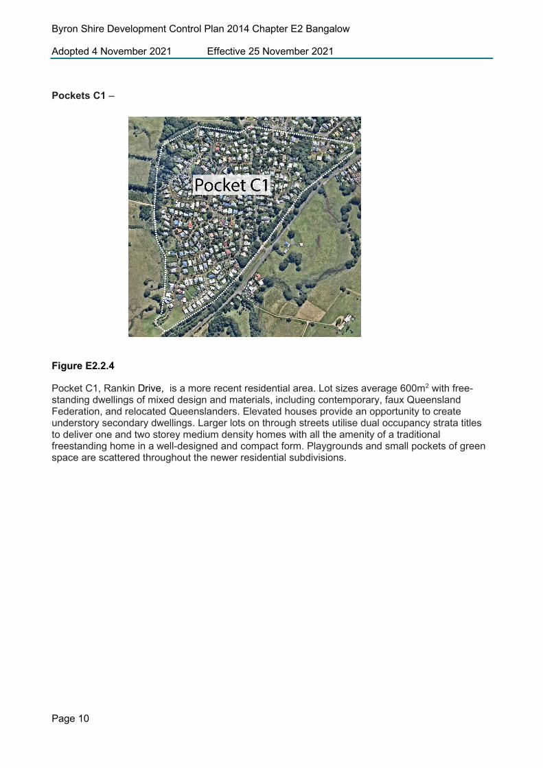
Pockets C1 –
Figure E2.2.4
Pocket C1, Rankin Drive, is a more recent residential area. Lot sizes average 600m2 with free-standing dwellings of mixed design and materials, including contemporary, faux Queensland Federation, and relocated Queenslanders. Elevated houses provide an opportunity to create understory secondary dwellings. Larger lots on through streets utilise dual occupancy strata titles to deliver one and two storey medium density homes with all the amenity of a traditional freestanding home in a well-designed and compact form. Playgrounds and small pockets of green space are scattered throughout the newer residential subdivisions.

Byron Shire Development Control Plan 2014 Chapter E2 Bangalow
Adopted 4 November 2021 Effective 25 November 2021
Page 11
Pocket C2
Figure E2.2.5
Pocket C2 is particularly elevated, with view out across the township. This topography dictates the street layout and means that development in this area can also be seen from further afield. Lot sizes average 600m2 with free-standing dwellings of mixed design and materials, including contemporary, faux Queensland Federation, and relocated Queenslanders. Elevated houses provide an opportunity to create understory secondary dwellings.
Pocket C3
Figure E2.2.6

Byron Shire Development Control Plan 2014 Chapter E2 Bangalow
Adopted 4 November 2021 Effective 25 November 2021
Page 12
Pocket C3, The Meadows estate, is one of the newer areas in Bangalow, characterised by relocated Queenslanders, generally two-storeys set high on sloping sites with many architectural features that have a commonality with the Heritage conservation area directly adjoining. These include the use of verandahs, a tin and timber material palette and hipped and gabled roofs. Landscaping is fairly sparse and of modern design, contrasting to the leafy and verdant landscapes of the older heritage areas, with much of the entertaining space for houses focussed at the rear of blocks. This area also delivers more medium density options, including dual occupancies and multi-dwelling housing with the amenity of private outdoor spaces and articulated street frontages.

Byron Shire Development Control Plan 2014 Chapter E2 Bangalow
Adopted 4 November 2021 Effective 25 November 2021
Page 13
Pocket D
Figure E2.2.7
Ballina Road and Clover Hill, is the most recent area undergoing development for housing. Containing smaller pockets of R3 Medium Density zoned land, this area has capacity to improve housing diversity in Bangalow. A number of low rise medium density residential developments are currently underway on land to the east of Ballina Road. The area also contains investigation areas identified for affordable housing contributions.
In all areas front fences and walls do not dominate the public domain instead they respond to and complement the context and character of the street or lane.

Byron Shire Development Control Plan 2014 Chapter E2 Bangalow
Adopted 4 November 2021 Effective 25 November 2021
Page 14
E2.3 General Provisions E2.3.1 Character, Bulk and Scale of Development Objectives
1. To ensure that development is consistent with and will enhance the low rise, heritage character and scale of Bangalow.
2. To ensure that development remains harmonious with existing architectural stylesand Heritage Items.
Performance Criteria
1. Proposed development is consistent with the low rise, heritage character and scale of Bangalow.
2. The character, bulk, scale, density and landscape treatment of proposed development will be compatible with and will enhance the low rise, historical character and scale of Bangalow, its built environment and its surrounds; and
3. Building materials, textures, finishes and colours will be compatible with and will enhance the low rise, historical character and scale of Bangalow.
4. Reflective colours or surfaces are to be avoided unless required for heritage reasons e.g use of galvanised steel for re-roofing.
Note: heritage Items identified on LEP 2014 heritage map relating to Bangalow must comply with the requirements listed in Chapter C1 Non-Indigenous Heritage.
E2.3.2 Infill Development Development in established urban areas of Bangalow must demonstrate consistency with Section E2.2 and E2.3. The design of new buildings must be compatible with adjacent and nearby buildings that contribute to the existing character of Bangalow.
Infill development refers to the densification of existing urban areas, often through the construction of dual occupancies, secondary dwellings and multi-dwelling housing.
The effective use of landscaping and tree planting in developments is required to improve the living and visual amenity of the locality and to assist in micro-climate control.
Performance Criteria
1. Faux Heritage or Heritage replicas are not considered appropriate. 2. Infill development should be low set, and fine grain, complementary to the older areas of
Bangalow. 3. Infill development should integrate with the existing scale and streetscape of the area,
minimising excessive bulk.

Byron Shire Development Control Plan 2014 Chapter E2 Bangalow
Adopted 4 November 2021 Effective 25 November 2021
Page 15
4. Landscaping must be designed to complement the leafy character of Bangalow and must comply with the requirements of Chapter B9 Landscaping.
E2.4 Development within the Bangalow Heritage Conservation Area
E2.4.1 General Urban Design Objectives
1. To promote design that reinforces the existing low-rise historical village feel of Bangalow. 2. To retain the fine grain pattern of development in Bangalow. 3. To reinforce the significance of Heritage Items in Bangalow.
Performance Criteria
1. New development within the Bangalow Heritage Conservation Area results in an environment of well balanced and harmonious buildings, that blend together through their form, scale and materials.
2. New development does not produce ‘fake’ copies of the earlier buildings, but recognises and reflects the individual historic worth of earlier buildings, drawing from their influences to create modern buildings that will ensure harmony.
Prescriptive Measures
1. Proposals within the Bangalow Heritage Conservation Area that include community significant development should be designed by an architect with experience in heritage conservation and be supported by a heritage impact statement prepared by an appropriately qualified professional.
2. Development applications seeking consent for development within the Bangalow Heritage Conservation Area defined by Byron LEP 2014 must demonstrate compliance with Chapter C1 Non-Indigenous Heritage.
E2.4.2 Development in B2 Local Centre Zone

Byron Shire Development Control Plan 2014 Chapter E2 Bangalow
Adopted 4 November 2021 Effective 25 November 2021
Page 16
Figure E2.4.1 – A map of the precincts in the Bangalow Village Centre
Objectives
1. To reinforce the character of the village centre including the two distinct precincts of Byron Street and Station Street.
2. To ensure proposed development is complimentary to the distinct style of each precinct. 3. To promote pedestrian connectivity in the village centre. 4. To foster a lively and vibrant village centre
Performance Criteria
1. Development must comply with Chapter C1 Non-indigenous Heritage 2. Development must show regard to the urban design principles:
a) Retain and protect Heritage b) Encourage Active Street frontages c) Keep the centre green and leafy d) Recognise and celebrate the distinct precinct
E2.4.3 Active street frontages This clause applies to land zoned B2 Local Centre under Byron LEP 2014.
Objectives
1. To foster a lively and vibrant village centre 2. To promote pedestrian connectivity in the village centre.

Byron Shire Development Control Plan 2014 Chapter E2 Bangalow
Adopted 4 November 2021 Effective 25 November 2021
Page 17
Performance criteria
1. Proposed development within the B2 Local Centre Zone must have a commercial ground floor use that attracts pedestrian traffic and movement.
2. Development must enhance the fine grain architectural scale of the village centre. 3. Development should avoid large expanses of blank walls. 4. Development supports a vibrant and safe street environment where commercial ground floor
uses positively engage with the public realm.
Prescriptive Criteria
1. There are to be no continuous frontages of a single premises beyond 20m 2. Ground floor land use is commercial in nature. 3. Street frontage must enable direct visual and physical connection between the street and the
interior of the building. 4. All above ground car parking, loading and unloading zones are behind buildings.
E2.4.4 Connectivity and Permeability This clause applies to areas identified as Byron Street Precinct and Stations Street Precinct in Figure E2.5.
Objectives
1. To promote pedestrian connectivity in the village centre. 2. To encourage wayfinding on foot 3. To enhance connections through private property 4. To retain the laneways of Bangalow 5. To facilitate mid-block connections
Performance Criteria
1. Development should ensure pedestrian connectivity through the site. 2. Sites should link pedestrian paths to adjacent development 3. The provision of ‘internal public spaces’ is encouraged 4. Clear and legible pedestrian paths should be provided within development sites, and should
promote connections to adjoining sites.
Prescriptive Criteria
1. Council will not grant consent to a development unless it is satisfied that: a) All existing pedestrian access ways are retained or an acceptable alternative is provided. b) The development allows pedestrians to move through, within and around the site in a safe
and convenient manner

Byron Shire Development Control Plan 2014 Chapter E2 Bangalow
Adopted 4 November 2021 Effective 25 November 2021
Page 18
c) Pedestrian access ways are suitable for wheelchairs and meet the needs of people with a disability.
d) Land that has frontage to any public space, will make provision to: i) Incorporate an active pedestrian frontage to the public space ii) Complement the character, public use, security and enjoyment of the public space,
and to provide an outlook to the space.