Because Information Matters
62
iMMAP Because Information Matters
Transcript of Because Information Matters

iMMAP
Because Information Matters

VisionFor iMMAP to be an international resource, for relief and host government agencies, that successfully integrates data into practical humanitarian plans through information management and supporting servicesinformation management and supporting services.

Mission
iMMAP’s mission is to alleviate the pain and suffering of those in need. iMMAP accomplishes this important mission by providing decision makers at all levels with reliable, relevant, and timely information upon which to act.
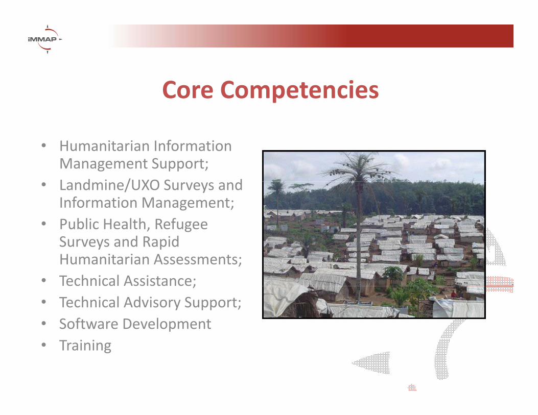
Core Competencies
• Humanitarian Information Management Support;L d i /UXO S d• Landmine/UXO Surveys and Information Management;
• Public Health, Refugee Surveys and Rapid Humanitarian Assessments;
• Technical Assistance;;• Technical Advisory Support;• Software Development• Training

Partnerships
• WFP Stand‐By Partner• IMSMA Global Implementing Partner• IMSMA Global Implementing Partner• Geographic Information Support Team (GIST)• InterAgency Standing Committee (IASC)InterAgency Standing Committee (IASC) Information Management Task Force• InterAction• Microsoft• GeoDecisions

Donors

The relief cycleThe relief cycle
RehabilitationIn-depth / sectoral assessmentRelief
Initial / rapid postReconstructionEconomic and social impact assessment
Initial / rapid post-disaster assessment
EmergencySearch, rescue, and evacuation
Mitigation and
WARNING
gPreparednessVulnerability / risk assessment
IMPACT

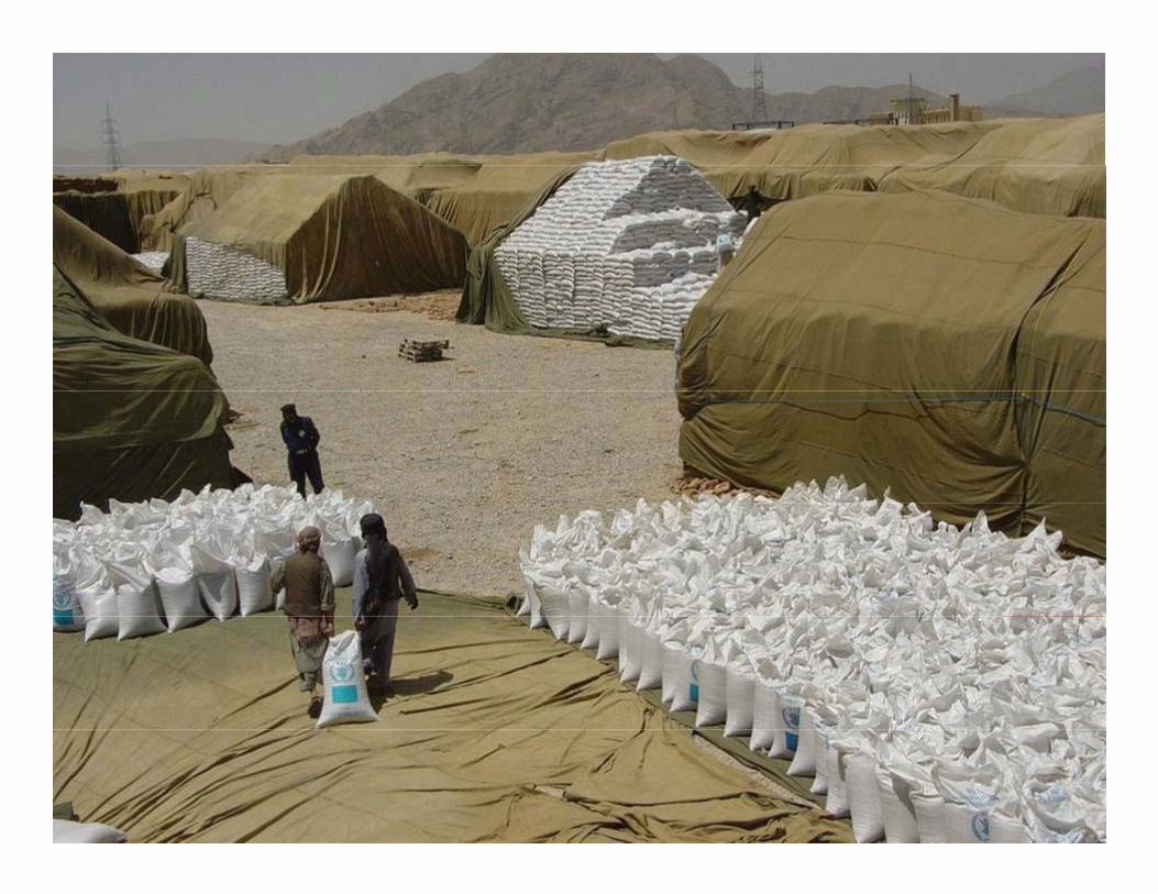
•• Need to set up distribution system quicklyNeed to set up distribution system quicklyN d t t k t f i ti t tN d t t k t f i ti t t•• Need to take account of existing structuresNeed to take account of existing structures
•• Wide variety of goods to transportWide variety of goods to transport•• Conflicting agendas within humanitarian Conflicting agendas within humanitarian
communitycommunitycommunitycommunity•• Poor/inaccurate informationPoor/inaccurate information•• Chaos/Political factors/securityChaos/Political factors/security•• TerrainTerrain•• TerrainTerrain•• ClimateClimate•• Damaged infrastructureDamaged infrastructure•• Dynamic theatre of operationsDynamic theatre of operationsDynamic theatre of operationsDynamic theatre of operations•• Storage availabilityStorage availability
Photo: WFP
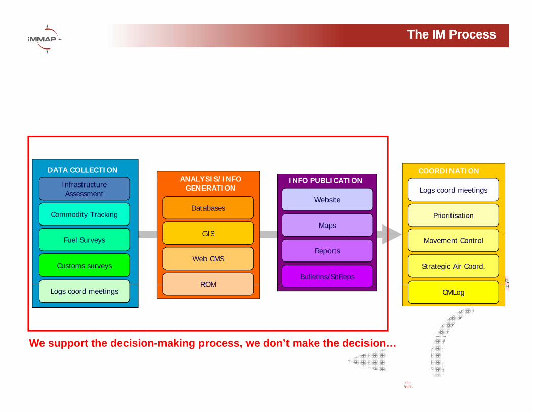
The IM ProcessThe IM Process
DATA COLLECTIONANALYSIS/INFO INFO PUBLICATION
COORDINATION
InfrastructureAssessment
Commodity TrackingDatabases
GIS
ANALYSIS/INFO GENERATION
Maps
Website
INFO PUBLICATIONLogs coord meetings
Prioritisation
Fuel Surveys
Customs surveys
GIS
Web CMS
ROMBulletins/SitReps
ReportsMovement Control
Strategic Air Coord.
Logs coord meetingsROM
CMLog
We support the decision-making process, we don’t make the decision…

The IdealThe Ideal
DATA COLLECTION
COORDINATION
INFO PUBLICATIONANALYSIS/INFO
GENERATION
COORDINATION
“Lets feed/Lets feed/shelter/cure
the cat”“The cat is on the mat”

The RealityThe Reality
DATA COLLECTION
COORDINATIONANALYSIS/INFO
GENERATIONINFO PUBLICATION
“Das chat is sotto
COORDINATION
“Das chat is sotto el tatami”

IM Product PyramidIM Product Pyramid
USER BASE
3 m
onth
s
Models(Route optimisation)
mon
th
Interactive maps(OASIS, GoogleEarth)
eek
1 m
1 w
e Static, situational maps (pdf/jpeg), graphs, reports

IM to support problems of…IM to support problems of…
• Poor/Incomplete information
• Chaos/Political factors/security
• Terrain
• Climate
• Damaged infrastructure
• Dynamic theatre of operationsDynamic theatre of operations
• Storage availability

GPS SurveysGPS Surveys
camp siteswater sources

StandardisationStandardisation

Compilation and archivingCompilation and archiving
Roads Sourced by UNJLC (generally 1:50,000)
Existing Global Roads Data (generally 1:1,000,000)

IM to support problems of…IM to support problems of…
• Poor/Incomplete information
• Chaos/Political factors/security
• TerrainTerrain
• Climate
• Damaged infrastructure
• Dynamic theatre of operations• Dynamic theatre of operations
• Storage availability


IM to support problems of…IM to support problems of…
• Poor/Incomplete information
• Chaos/Political factors/security
• Terrain
• Climate
• Damaged infrastructure
• Dynamic theatre of operationsy p
• Storage availability


VHF line of sight analysisVHF line of sight analysis


Landslide risk analysisLandslide risk analysis

IM to support problems of…IM to support problems of…
• Poor/Incomplete information
• Chaos/Political factors/security
• Terrain
• Climate
• Damaged infrastructure
• Dynamic theatre of operationsy p
• Storage availability


IM to support problems of…IM to support problems of…
• Poor/Incomplete information
• Chaos/Political factors/security
• Terrain
• Climate
• Damaged infrastructure
• Dynamic theatre of operationsy p
• Storage availability


IM to support problems of…IM to support problems of…
• Poor/Incomplete information
• Chaos/Political factors/security
T i• Terrain
• Climate
• Damaged infrastructure
• Dynamic theatre of operations
• Storage availability


IM to support problems of…IM to support problems of…
• Poor/Incomplete information
• Chaos/Political factors/security
• Terrain
• Climate
• Damaged infrastructure
• Dynamic theatre of operationsy p
• Storage availability


IM in support of operational planningIM in support of operational planning
• What is the optimal route between A and B?B?
• What is the next best alternative if this route is blocked?
• What is the level of accessibility of ypopulation X?
• What is the optimal configuration of pre-What is the optimal configuration of prepositioning warehouses?

OriginOrigin--Destination matrixDestination matrix
e ime
a ba ga e eu guza
Velha
bala
e.g: Origin-Destination matrix for Mozambique
Distan
ce
(Km)/
TravelT
imBeir
aBlan
tyre
Caia Charre
Chemba
Chiram
baChu
pang
aGuro Lil
ongw
eLu
abo
Manica
Maputo
Marrom
euMas
seng
uMop
eia V
Morrum
baMuta
ra
Beira 12h2' 4h28' 6h13' 7h43' 9h49' 6h26' 6h42' 15h18' 16h34' 4h12' 19h49' 8h42' 13h55' 13h13' 9h28' 5h54'Blantyre 567 7h41' 5h48' 8h14' 10h20' 10h50' 6h43' 5h10' 14h1' 10h36' 29h1' 13h6' 18h19' 10h40' 9h46' 6h12'Caia 268 307 1h53' 3h22' 5h29' 3h16' 10h7' 12h37' 12h13' 7h37' 23h14' 5h32' 10h45' 8h52' 5h7' 1h33'Ch 337 230 77 2h26' 4h32' 5h2' 11h53' 10h44' 11h3' 9h23' 24h59' 7h17' 12h30' 7h42' 3h57' 0h24'Charre 337 230 77 2h26' 4h32' 5h2' 11h53' 10h44' 11h3' 9h23' 24h59' 7h17' 12h30' 7h42' 3h57' 0h24'Chemba 358 288 97 58 2h6' 6h31' 10h51' 13h10' 12h46' 10h52' 26h29' 8h47' 14h0' 9h25' 5h40' 2h6'Chiramba 400 330 139 100 42 8h38' 8h46' 15h16' 14h52' 12h38' 28h35' 10h54' 16h6' 11h31' 7h46' 4h13'Chupanga 265 346 47 116 136 179 12h6' 15h46' 15h22' 9h35' 25h12' 2h15' 7h28' 12h1' 8h16' 4h42'Guro 403 369 608 677 232 190 604 8h36' 20h30' 3h52' 22h17' 14h21' 19h34' 17h9' 15h7' 11h34'Lilongwe 919 306 608 531 589 631 647 516 18h57' 12h28' 30h53' 18h2' 23h14' 15h36' 14h42' 11h8'Luabo 534 628 273 226 255 297 312 993 929 19h43' 35h20' 17h38' 22h51' 3h21' 7h54' 10h44'Manica 252 601 458 527 547 422 454 232 748 723 19h47' 11h51' 17h4' 16h22' 12h37' 9h3'Maputo 1189 1707 1395 1463 1484 1526 1391 1338 1854 1660 1188 27h28' 32h41' 31h59' 28h14' 24h40'Marromeu 310 391 92 161 182 224 45 650 692 358 499 1436 5h12' 14h17' 10h32' 6h58'Massenguza 364 445 146 215 236 278 99 704 746 412 554 1490 54 19h30' 15h45' 12h11'Mopeia Velha 467 561 206 159 188 230 245 926 862 67 656 1593 291 345 4h33' 7h23'Mopeia Velha 467 561 206 159 188 230 245 926 862 67 656 1593 291 345 4h33 7h23Morrumbala 392 314 131 84 113 155 171 732 615 158 581 1518 216 270 91 3h38'Mutarara 324 245 63 15 44 87 102 663 546 212 513 1450 148 202 145 70Nampula 1010 647 749 654 731 773 789 1011 948 684 1244 2349 834 888 617 634 688Quelimane 587 440 326 278 307 349 365 804 741 261 776 1713 410 464 194 211 265Sena 321 251 60 21 37 79 99 660 552 218 510 1447 145 199 151 76 7Tambara 811 456 757 681 739 554 797 408 480 1079 640 1746 842 896 1012 764 696Tambara 811 456 757 681 739 554 797 408 480 1079 640 1746 842 896 1012 764 696Tete 561 211 513 436 494 305 552 158 358 834 391 1496 597 651 767 520 451


Allocation of distributionAllocation of distributionAllocation of distribution Allocation of distribution points to warehouses by points to warehouses by
optimal routeoptimal route
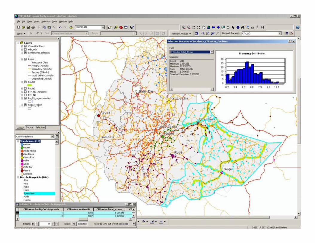

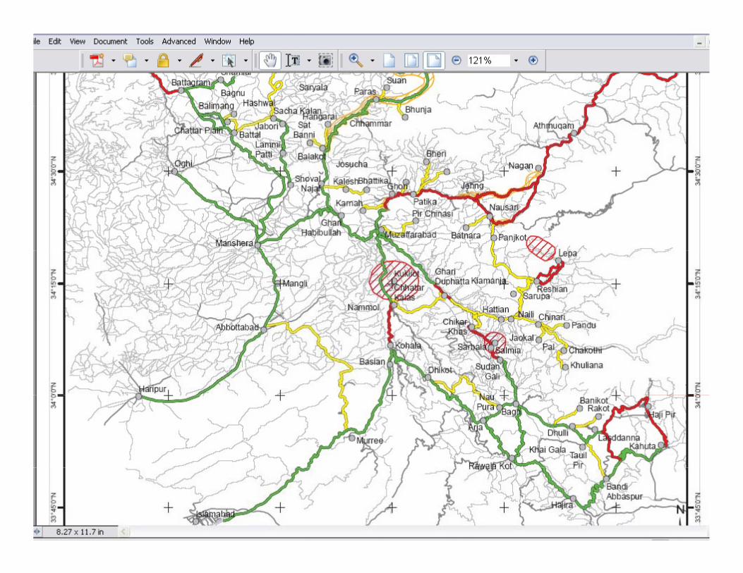
C ti l iC ti l iContingency planningContingency planning
Road blockages


Setting iMMAP IM processIDP Illi it C S t l St tIDPs Illicit Crops Sectoral Stats
OCHA: (Humanitarian Analysis)
Period: 2007 – 2008: ~7,000 records
OCHA:
4,000 Orgs registered
200 Orgs program/project
UNODC:
SIMCI project. Coca Census 2000 - 2007
PAICMA:
12,900 records (landmines & UXO)
35% with X Y
Without X,Y
UNDSS: (Security/Conflict Analysis)
Daily Security Report
p g p jregistered
ACCION SOCIAL:
Int’l. Coop. Map
Humanitarian Offer
Raster: TLM 100K, DEM 90m, TLM50K?, Ikonos?
35% with X,Y
7,200 Victims (65% Army, 35% civilians)
Other Sources:
Other sources: CINEP, CERAC, P.Obs.
Humanitarian Offer
ACCION SOCIAL:
Period: 1997 – 2008
Methodology: IDP Exp/Rec by Record
LandminesUXO
HumanitarianEvents
WhoWhat
Where
Vector: Admin, Hydrology, Roads, Ppl, infrastructure, iMMAP is vectorizing ppl and point of interest from TLM100
Colombian Campaign To Ban Landmines, Caritas Colombia, Field
Exp/Rec. by Record
CODHES:
Period: 1995 – 2007
Methodology: IDP Reception EstimatedOCHA:
Geographic Layers
Reception Estimated
Other sources: Caritas Colombia
More than 400 variables available.
Source: Colombian Government and State Organizations

ArubaArubaNetherlands Antilles
La Guajira
AtlánticoHWGHWG
Humanitarian ContextHumanitarian Context
Venezuela
PanamaPanamaCesar
BolívarCórdoba
Sucre
Magdalena
Norte de Santander
HWGHWG
HWGHWG
HWGHWG LandminesLandmines
IDP: ExpelledIDP: ExpelledHWGHWG: UNS, iNGO, nNGO, Gov
VenezuelaVenezuela
Chocó
Antioquia
Casanare
Arauca
Boyacá
Santander
Caldas
HWGHWG HWGHWG
HWGHWG
HWGHWG
Armed ConfrontationsArmed Confrontations
Homicides: Protected PersonHomicides: Protected Person
Meta
Vichada
Guainía
Tolima
Huila
Cundinamarca
Valle del Cauca
Caldas
Risaralda
QuindíoBogotá, D.C.
HWGHWG
HWGHWG
Homicides: Protected PersonHomicides: Protected Person
DemobilizationsDemobilizations
LegendLandmines
Caquetá
Guainía
Vaupés
Guaviare
Cauca
Nariño
Putumayo
HWGHWG
HWGHWG
Forced DisappearanceForced Disappearance
BrazilEcuador
BrazilEcuador
1 - 16
17 - 49
50 - 124
125 - 214Amazonas
PeruPeru

OASIS Colombia
Landmine:Landmine: PAICMA (Jan 1990 – Sep 2008)Infrastructure:Infrastructure:Hospitals: Health Ministry (Dec 2007)
Conflict:Conflict:Coca Crops: UNODC Census (2000 – 2007)Humanitarian Events: OCHA (Jan 2007 – Sep 2008)
Utilities Coverage: National Department of Statistics (Jan 2008)Road Network: National Institute or Roads (Dec 2007)
IDP: Agency for Social Action and Int. Coop. (1997-2008)Hum. Risk Index: OCHA-Santo Tomas Univ. (May 2008)Demography:Demography: by Ethnic Groups, Area – National Department of Statistics(2008)

Displaying Sectoral DataIDP: Agency for Social Action and International Cooperation, 1997 –June 2008
Aqueduct System Coverage:N ti l D t t f St ti tiNational Department of Statistics, January 2008
Humanitarian Risk Index: OCHA – Santo Tomas University, May 20082008

Landmine Events

Humanitarian EventsSource: OCHA Database (Jan 2007 – Sep 2008.
Primary Source: Ombudsman office, Human Rights Vice-Presidential Observatory, Military Forces, National SecurityPresidential Observatory, Military Forces, National Security Department, Media.
iMMAP is purging OCHA Hum. Events D t b t t tDatabase to get more accurate geographic position.

Data Fusion (Putumayo Department)
Landmine Events, Humanitarian Events, IDPs and Coca Crops

Data Analysis Sample: Antioquia
Victim Prediction Map (based on historic victims data: Jan 1990 – Sep 2008)
Municipality Qnty Accidents
Í
10 most Municipalities affected
ANORÍ 91
ARGELIA 73
COCORNÁ 72
DABEIBA 72
GRANADA 62
ITUANGO 118
SAN CARLOS 141
SAN FRANCISCO 107
SAN LUIS 75
SONSÓN 71

Victims by Age GroupVictims by Age Group
Data Analysis Sample: Antioquia
60%
80%
100%Cuenta de Type
Age
Victims by Age GroupVictims by Age Group
20%
40%
Under 18Over 18 Over 18
Age
0%
AN
OR
Í
AR
GE
LIA
CO
CO
RN
Á
DAB
EIB
A
GR
ANA
DA
ITU
AN
GO
SAN
CA
RLO
S
SAN
FR
ANC
ISC
O
SAN
LU
IS
SO
NS
ÓN
Municipality
80%
100%Cuenta de Type
Victims by OccupationVictims by OccupationMunicipality
80%
100%Cuenta de Type
Victims by SexVictims by Sex
20%
40%
60%
MilitaryIllegal Armed ActorCivil
Occupation
20%
40%
60%
Not ReportedMaleFemale
Sex
0%
AN
OR
Í
AR
GE
LIA
CO
CO
RN
Á
DA
BEIB
A
GR
AN
AD
A
ITU
ANG
O
SA
N C
AR
LOS
SA
N F
RA
NC
ISC
O
SA
N L
UIS
SO
NS
ÓN
0%
ANO
RÍ
ARG
ELI
A
CO
CO
RN
Á
DAB
EIB
A
GR
ANA
DA
ITU
AN
GO
SAN
CA
RLO
S
SAN
FR
AN
CIS
CO
SAN
LU
IS
SON
SÓ
N

Data Analysis: Ituango Municipality, Antioquia DepartmentAntioquia Department
There are not Primary, Secondary or Tertiary Road.
Victims Characteristics (Registered on IMSMA)
OccupationCivil 22.88%
1 Hospital: Level 1
OccupationMilitary 77.12%
SexMale 98.31%
Female 1.69%
C di iDead 24.58%
ConditionInjured 75.42%
AreaRural 100.00%
Urban 0.00%
Under 18 8.47%
Population Characteristics
Age GroupUnder 18 8.47%
Over 18 90.68%

CDC Projects in Mine Action
• KAP Survey– Survey to assess knowledge attitudes andSurvey to assess knowledge, attitudes and
practices (behaviors) related to landmines and UXO in affected areas of the country
– Multi-stage cluster design• Randomly select 30-40 household in 30-40
affected villages/townsaffected villages/towns• Interview one randomly selected person (≥15
years) in each household– Data collection to begin September, 2009

CDC Projects in Mine Action
• Injury Surveillance SupportProvided support to ICRC and CCCM for– Provided support to ICRC and CCCM for landmine/UXO injury surveillance
• Training on injury surveillanceTraining on injury surveillance• EpiInfo database and analysis tools