
ALABAMA STATE FIRE WEATHER ANNUAL OPERATING PLAN … · ALABAMA STATE FIRE WEATHER ANNUAL OPERATING...
28
1 ALABAMA STATE FIRE WEATHER ANNUAL OPERATING PLAN 2016 NATIONAL WEATHER SERVICE ALABAMA FORESTRY COMMISSION UNITED STATES FOREST SERVICE NATIONAL PARK SERVICE
Transcript of ALABAMA STATE FIRE WEATHER ANNUAL OPERATING PLAN … · ALABAMA STATE FIRE WEATHER ANNUAL OPERATING...
1
ALABAMA STATE FIRE WEATHER ANNUAL OPERATING PLAN
2016
NATIONAL WEATHER SERVICE
ALABAMA FORESTRY COMMISSION
UNITED STATES FOREST SERVICE
NATIONAL PARK SERVICE
2
TABLE OF CONTENTS
I. INTRODUCTION Page 3
II. FORECAST AREA Page 5
III. FIRE WEATHER FORECAST Page 5
A. ISSUANCE TIME B. CONTENT
IV. SPOT FORECAST Page 13
V. FIRE WEATHER WATCH/RED FLAG WARNING Page 13
VI. FIRE ALERT Page 15
VII. NATIONAL FIRE DANGER RATING STATIONS Page 15
FIGURE 1. Fire Weather Forecast Zones Page 16 FIGURE 2. Alabama Forestry Districts Page 17 FIGURE 3. U.S. National Forests Page 18 APPENDIX A. Fire Weather Products/Services Page 19 APPENDIX B. Product Examples Page 20 APPENDIX C. Spot Forecast Guidelines Page 26 Spot Forecast Form Page 29
3
I. INTRODUCTION The forests of Alabama are a vital part of the state's economy. Primary responsibility for providing meteorological support to Land Management Agencies resides with the National Weather Service (NWS). There are four NWS offices which provide support to such agencies in Alabama: Huntsville, Birmingham, Mobile, and Tallahassee, Florida. Each NWS office employs a Fire Weather Program Leader who acts as a liaison between the NWS and user agencies within their area of responsibility. The Fire Weather Program Leader in Birmingham is responsible for maintaining the Alabama Fire Weather Operating Plan. The purpose of this operating plan is to provide guidance for meteorological support to land management agencies within the state of Alabama. The Alabama Forestry Commission (AFC), the United States Forest Service (USFS) and the National Park Service are the primary user agencies in Alabama.
This Fire Weather Operating Plan serves as the official document governing interactions and relationships between the National Weather Service offices that serve the federal, state and local land management agencies that rely on weather support in Alabama. This Fire Weather Operating Plan is issued in lieu of a formal Memorandum of Understanding (MOU) between the National Weather Service, USDA Forest Service, Alabama Forestry Commission and other land management agencies that rely on fire weather support. This plan also outlines fire weather forecast operations and services available to customers. This includes products and formats, dissemination and coordination as well as customer input. The services will consist of fire weather products and support as outlined in the National Agreement for Meteorological Services, which was signed by the Departments of Commerce, Agriculture, and Interior. Objectives of the forestry program are: To provide weather forecasts and meteorological advice with
enough detail to guide fire control personnel in making operational decisions concerning: fire suppression, fire prevention, prescribed burning, smoke management, wildfire suppression and other land management activities. To keep abreast of the needs and problems of forestry interests as well as changing forecast and communication techniques, and to review this plan annually to assure the plans continued usefulness.
National Weather Service Headquarters NWS Headquarters, located in Silver Spring, Maryland, establishes policies and coordinates the National Fire Weather Program. The national program manager coordinates the program with the regional program managers. The national program manager also works with the national headquarters of the federal forestry and land management agencies and the Association of State Foresters in determining overall forestry and land management requirements for meteorological support. The national program manager coordinates national training in forestry and fire weather for NWS forecasters.
4
National Weather Service Regional Headquarters (Southern Region Headquarters, Fort Forth, Texas) Regional Headquarters manage the technical operational aspects of the fire weather program within each region. They also provide guidance and assistance to the Meteorologists-In-Charge (MIC) on program operations and problems through supplements to the National Directives System (NDS) and conferences. Regional Headquarters advise National Headquarters on matters pertaining to technical planning and operations. The regional program managers coordinate the regions’ fire weather programs and advises Regional Directors on the operational and administrative aspects of the regions’ programs.
National Weather Service Forecast Offices National Weather Service Forecast Offices are staffed 24 hours a day, 7 days a week and 365 days a year. This staffing fulfills the mission to provide timely and effective warnings, statements, and forecasts.
NWS Birmingham
465 Weathervane Road Calera, Al 35040 MIC: Jim Stefkovich [email protected] Program Leader: Mark Linhares [email protected]
NWS Mobile
8400 Airport Blvd Mobile, Al 36608 MIC: Jeff Medlin [email protected] Program Leader: John Purdy [email protected]
NWS SR Headquarters
Fort Worth, Tx Program Leader: Paul Witsaman [email protected]
NWS Huntsville
320A Sparkman Dr. Huntsville, AL 35805 MIC: Chris Darden [email protected] Program Leader: Steve Shumway [email protected]
NWS Tallahassee
Florida State University 116 Palmetto Drive Tallahassee, Fl 32306 MIC: Jane Hollingsworth [email protected] Program Leader: Timothy Barry [email protected]
5
II. FORECAST AREA
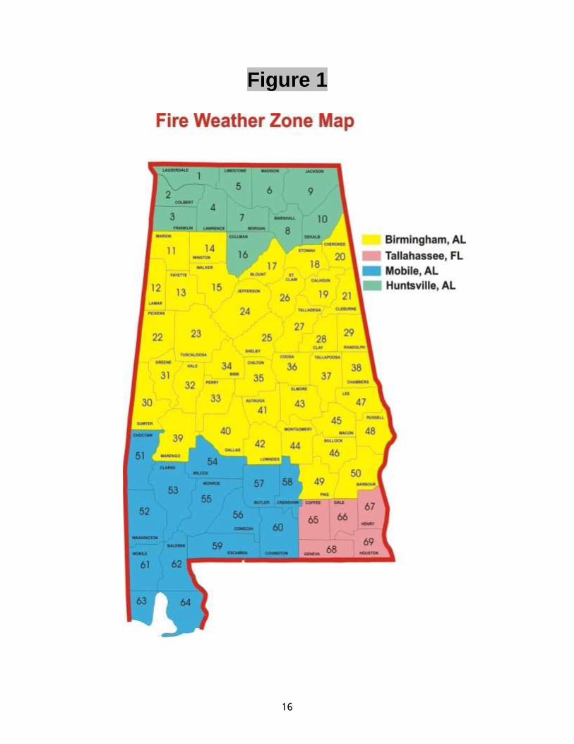
The state of Alabama is divided into 67 counties. Each county has its own unique zone number except Mobile and Baldwin Counties, which are divided into inland and coastal zones. Alabama’s forecast area is divided between four NWS offices (Fig. 1). Note: The forecast responsibility for Winston County will be transferred to the NWS Huntsville sometime in 2016.
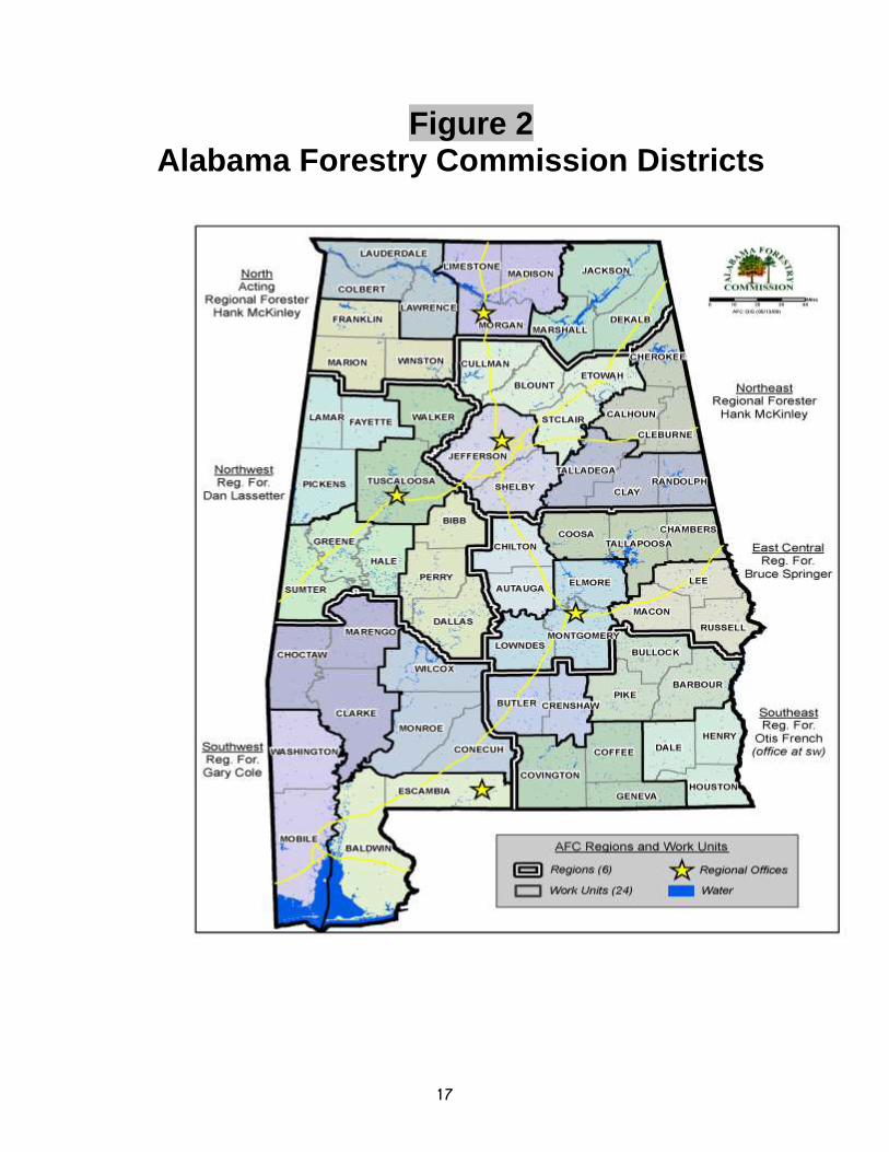
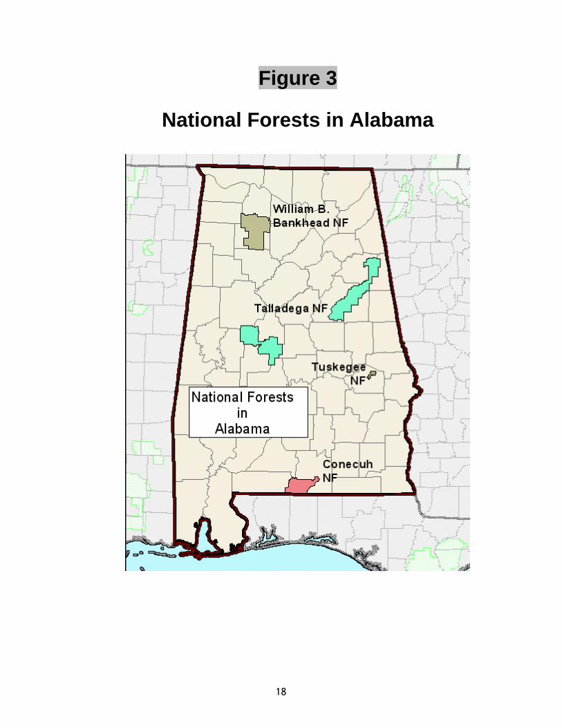
The Alabama Forestry Commission (AFC) has four main districts in Alabama (Fig. 2). Burn permits from the AFC are required for wood and field burns of more than 1/4 acre. The AFC has the authority to restrict or ban all outdoor burning. There are four national forests in Alabama (Fig. 3), comprising of over 660,000 acres. Both the AFC and U.S. Forest Service (USFS) are headquartered in the city of Montgomery. The normal fire danger season occurs from October through May, but ongoing site preparation and forest management continues throughout the entire year.
III. FIRE WEATHER FORECAST
Numerical data and weather maps showing atmospheric conditions such as pressure, temperature, moisture, wind, stability, and precipitation over the Northern Hemisphere are received continuously at the NWS. Doppler radars located throughout Alabama provide temporal and spatial information about precipitation and wind patterns within the atmosphere. Radio and land lines connect the NWS offices with Civil Defense, Emergency Management, Police, and Fire Agencies throughout the state. High resolution satellite imagery is received every 15 minutes or less showing cloud patterns across the state.
Forecasters use this information to prepare the Fire Weather Forecast (FWFBMX) (Appendix B) and other various fire related products. The format of the Fire Weather Forecast is tailored to meet the requirements of the AFC and USFS. Because the Mobile and Tallahassee NWS offices have forecast responsibility outside of Alabama, their fire weather forecasts include additional fire weather parameters, but all the offices are striving to meet a standardized format. The requirements and parameters detailed below are those established with Alabama user agencies. The Fire Weather Groupings are tailored to represent the geographical boundaries of the US Forest Service and the Alabama Forestry Commission. These Groupings should not be combined, but may be increased to separate out those zones which are under watches or warnings. Individual Fire Weather pages can be found here…Birmingham, Huntsville, Mobile, & Tallahassee.
6
A. ISSUANCE TIME Fire weather forecasts are issued twice daily by the NWS. The morning forecast is issued no later than 400 am local time and includes three periods: Today, Tonight, and Tomorrow. The afternoon forecast is issued no later than 300 pm local time and includes four periods: Tonight, Day One, Tomorrow Night, Day Two. The Fire Weather Forecast should be updated when a Fire Weather Watch or Red Flag Warning is issued. The product should be corrected when a typographical error is detected.
B. CONTENT
HEADLINE This section is required to highlight Red Flag Warnings and/or Fire Weather Watches in effect, which counties are involved, reason for issuance, and effective time period. DISCUSSION The discussion should be general weather pattern overview in a clear, brief and non-technical description. The emphasis should be on the first two days of the forecast and the parameters that most directly influence fire weather behavior and decision making. CLOUD COVER
SKY COVER (%) DAYTIME DESCRIPTOR NIGHTTIME DESCRIPTOR
1-10 Sunny Clear
11-20 Mostly Sunny Mostly Clear
21-60 Partly Cloudy Partly Cloudy
61-70 Partly Sunny Partly Cloudy
71-90 Mostly Cloudy Mostly Cloudy
91-100 Cloudy Cloudy
7
PRECIP (WEATHER) TYPE
Rain (RAIN) - liquid precipitation, not showery, and usually in a stable air
mass.
Freezing Rain (FRZG RAIN) - liquid precipitation that freezes upon
impact with solid objects or vegetation as opposed to ice forming on
already wet surfaces.
Sleet (SLEET) - precipitation in the form of almost clear grains or ice
pellets; often mixed with rain or freezing rain.
Snow (SNOW) - general or patchy flakes of crystalline precipitation.
Showers (SHOWERS) - medium to large water drops that usually vary in
intensity; and may begin or end abruptly; no thunder heard.
Thunderstorms (TSTMS) - heavy or violent downpour of large water
drops with gusty winds and possibly small hail.
CHANCE PRECIP (%) Chance of precipitation pertains to the expected occurrence of 0.01 inch or more of water equivalent precipitation at any point in a forecast zone, and has no relationship to the amount of precipitation that is expected to occur. These will be 12-hour period forecasts.
TEMP Temperature forecasts are single values in degrees Fahrenheit. The maximum/minimum temperatures are an average value over the entire forecast zone. Maximum temperatures are forecast for the daytime periods and the minimum temperatures are forecast for the nighttime period. The maximum temperature normally occurs during the afternoon. Because of terrain and types of ground cover, the high temperature can vary several degrees over a small area. The minimum temperature usually occurs around sunrise and can vary significantly between valleys and ridge tops, especially during inversions when the sky is clear and winds are light.

8
RH (%) Relative humidity is the ratio, in percent, of the amount of moisture in the air compared to the amount of moisture the air could hold if saturated (100%). Therefore, temperature must be considered when using relative humidity as a measure of moisture in the air. The daytime humidity forecast will be the minimum expected during that 12-hour period. The nighttime humidity forecast will be the maximum expected. Usually, the minimum relative humidity occurs at the time of maximum temperature, and the maximum relative humidity occurs at the time of minimum temperature.
20FT WIND For fire weather purposes, it is defined as a ten-minute averaged wind speed and direction at 20 feet above open ground, or twenty feet above the vegetation surface. The units are miles per hour (MPH). Six hour wind forecasts (AM/PM) are required. During the forecast process, a 20% reduction in the forecasted surface wind speeds is automatically calculated for the 20ft winds. PRECIP AMOUNT Precipitation amounts (inches) pertain to average liquid precipitation totals expected over the forecast zone. While general widespread precipitation tends to be more uniform over a forecast zone, shower activity will vary considerably. Ranges (0.10-0.20) are preferred for each of the 12-hour periods. The 12-hour amounts are for the periods 7am-7pm (Today), 7pm-7am (Tonight), and 7am-7pm (Tomorrow) when on Central Daylight Time (CDT). For Central Standard Time (CST), these time frames will move to 6am-6pm (Today), 6pm-6am (Tonight) and 6am-6pm (Tomorrow). PRECIP BEGINS The time period the precipitation chances begin in local time. PRECIP ENDS The time period the precipitation chances end in local time.
MIXING HGT (FT-AGL) The mixing height is defined as the vertical mixing of suspended particles above the ground. The mixing height is given in units of feet. Mixing height forecasts are for the maximum height expected during the afternoon, usually during the time of maximum heating. Mixing height forecasts for the nighttime period are optional.

9
TRANSPORT WIND The transport wind is the average wind speed in the mixed layer, and is given in miles per hour. The transport wind is a good indication of horizontal dispersion of suspended particles. A transport wind less than 7 mph restricts U.S. Forest Service from burning.
DISPERSION INDEX The dispersion index is computed from forecast variables that include 20 foot wind speed, mixing height, transport wind, and cloud cover. The index is used by fire managers as a guide for smoke management. Forest managers are cognizant of the need to occasionally restrict open burning to reduce atmospheric contaminants. When considered as a part of the whole pollution picture, prescribed burning is not one of the main contributing factors. It can become the dominant local factor, however, under certain atmospheric conditions. A dispersion index of less than 21 limits the state and federal forestry services controlled burning program. There is no upper bound for the scale below. The following are guidelines for the Dispersion Index:
SCALE INTERPRETATION
1-6 Very poor dispersion
7-12 Poor dispersion
13-20 Generally poor dispersion
21-40 Fair dispersion
41-60 Generally good dispersion
61-100 Good dispersion
100+ Very good dispersion
10
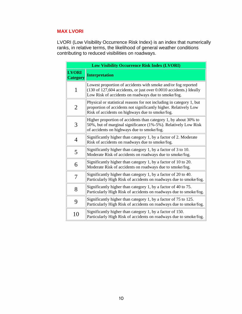
MAX LVORI LVORI (Low Visibility Occurrence Risk Index) is an index that numerically ranks, in relative terms, the likelihood of general weather conditions contributing to reduced visibilities on roadways.
Low Visibility Occurrence Risk Index (LVORI)
LVORI
Category Interpretation
1 Lowest proportion of accidents with smoke and/or fog reported
(130 of 127,604 accidents, or just over 0.0010 accidents.) Ideally
Low Risk of accidents on roadways due to smoke/fog.
2 Physical or statistical reasons for not including in category 1, but
proportion of accidents not significantly higher. Relatively Low
Risk of accidents on highways due to smoke/fog.
3 Higher proportion of accidents than category 1, by about 30% to
50%, but of marginal significance (1%-5%). Relatively Low Risk
of accidents on highways due to smoke/fog.
4 Significantly higher than category 1, by a factor of 2. Moderate
Risk of accidents on roadways due to smoke/fog.
5 Significantly higher than category 1, by a factor of 3 to 10.
Moderate Risk of accidents on roadways due to smoke/fog.
6 Significantly higher than category 1, by a factor of 10 to 20.
Moderate Risk of accidents on roadways due to smoke/fog.
7 Significantly higher than category 1, by a factor of 20 to 40.
Particularly High Risk of accidents on roadways due to smoke/fog.
8 Significantly higher than category 1, by a factor of 40 to 75.
Particularly High Risk of accidents on roadways due to smoke/fog.
9 Significantly higher than category 1, by a factor of 75 to 125.
Particularly High Risk of accidents on roadways due to smoke/fog.
10 Significantly higher than category 1, by a factor of 150.
Particularly High Risk of accidents on roadways due to smoke/fog.

11
LAL (LIGHTNING ACTIVITY LEVEL) The lightning activity level is a number developed in order to help land management and fire protection agencies prepare for the possibility of lightning caused wildland fires. The LAL extends from 1 to 6.
LAL Cloud & Storm Development Lightning Strikes/15 minutes
1 No thunderstorms. None
2
Cumulus clouds are common but only a few reach the towering cumulus stage. A single thunderstorm must be confirmed in the observation area. The clouds produce mainly virga, but light rain will occasionally reach the ground. Lightning is very infrequent.
1-8
3
Towering cumulus covers less than two-tenths of the sky. Thunderstorms are few, but two to three must occur within the observation area. Light to moderate rain will reach the ground, and lightning is infrequent.
9-15
4
Towering cumulus covers two to three-tenths of the sky. Thunderstorms are scattered and more than three must occur within the observation area. Moderate rain is common and lightning is frequent.
16-25
5
Towering cumulus and thunderstorms are numerous. They cover more than three-tenths and occasionally obscure the sky. Rain is moderate to heavy and lightning is frequent and intense.
>25
6 Similar to LAL 3 except thunderstorms are dry.
12
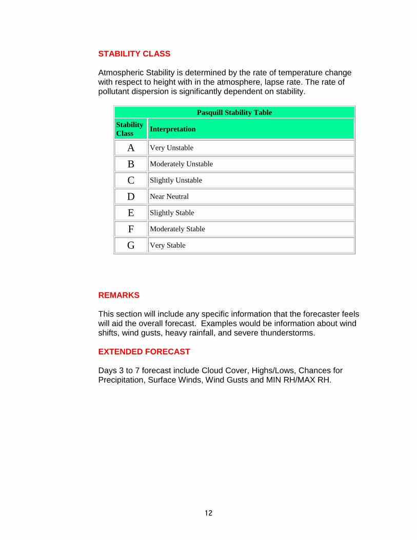
STABILITY CLASS Atmospheric Stability is determined by the rate of temperature change with respect to height with in the atmosphere, lapse rate. The rate of pollutant dispersion is significantly dependent on stability.
Pasquill Stability Table
Stability
Class Interpretation
A Very Unstable
B Moderately Unstable
C Slightly Unstable
D Near Neutral
E Slightly Stable
F Moderately Stable
G Very Stable
REMARKS This section will include any specific information that the forecaster feels will aid the overall forecast. Examples would be information about wind shifts, wind gusts, heavy rainfall, and severe thunderstorms.
EXTENDED FORECAST Days 3 to 7 forecast include Cloud Cover, Highs/Lows, Chances for Precipitation, Surface Winds, Wind Gusts and MIN RH/MAX RH.
13
IV. SPOT FORECAST
Spot Forecasts (FWSxxx) are weather forecasts that fit the time, topography and weather of a specific location. These forecasts are more detailed, timely and specific than the Fire Weather Forecast and are issued only when requested by Land Management Agencies or any Public Service Official. Refer to Appendix E to determine who can request a Spot Forecast. Federal Agencies are required to file a Spot Forecast with their paperwork when performing a prescribed burn.
For a small or contained burn, it may be easier to call the NWS and get a forecast over the telephone. For a larger or uncontrolled burn, the requesting agency should use NWS Spot (Appendix A) available on the Internet. Based on the county where the burn or fire is located, the requesting agency will need to access the Internet site of the appropriate NWS office (Fig. 1). If the Internet is not available or down, the user will need to fax a Spot Forecast Form (Appendix A) to the appropriate NWS office. To ensure that the spot request was received and possibly answer any questions the forecaster may have, the requesting agency should call the NWS office shortly after the request. The Hysplit model output can be requested through the Spot Forecast when requested in the remarks section.
V. FIRE WEATHER WATCH/RED FLAG WARNING
A Red Flag Event occurs when ongoing or forecast critical weather conditions lead to or aggravate existing wildfires. Red flag events require the combination of extreme fire danger and critical weather conditions. Extreme fire danger is a slowly evolving situation that comes about from prolonged periods of little or no rainfall. Critical weather conditions may include unusually warm temperatures, moderate surface winds, or significantly decreased humidity.
A Fire Weather Watch will be issued when the above mentioned conditions are expected to occur within the next 24 to 48 hours. A Red Flag Warning is issued when the above conditions are occurring or expected within 24 hours. In order to help the forecaster determine the onset of a Red Flag Event in Alabama, the following criteria must occur concurrently.
14
Alabama Red Flag Criteria:
1) January 1- December 31 (No more split season)
2) KBDI greater than 300
3) And Minimum Relative Humidity values less than 25%
4) And 20 Foot Winds 15 mph or greater
5) And these conditions lasting for a 4 hour or more duration
**If a particular county is under a Fire Alert, the Keetch-Byram Drought
Index (KBDI) criterion is suspended.
The KBDI criterion values may be found here…
KBDI
or
http://www.fs.fed.us/land/wfas/kbdi.png
The KBDI is a soil moisture index based on daily high temperatures and rainfall. This index has also been found to be a good indicator of fuel moisture in the warm season, but can be unrepresentative in the cool season when dead fine fuels can ignite and burn rapidly during times of low relative humidity and moderate winds.
VI. FIRE ALERT
The Alabama Forestry Commission has the authority to restrict or completely ban outdoor burning. When fuel conditions reach critical levels, the AFC may issue a Fire Alert for all or portions of Alabama. If the conditions extend over a prolonged period, the alert could be elevated to a Drought Emergency. The AFC will fax a copy of the initial fire alert to each of the NWS offices that serve Alabama. A map of the alert area can be found at http://www.forestry.alabama.gov/
The Fire Alert can be used to ascertain which counties may need to be included in a Fire Weather Watch or Red Flag Warning.

15
VII. NATIONAL FIRE DANGER RATING STATIONS (NFDRS)
The USFS operates remote automated weather stations (RAWS) in each of the National Forests which measure temperature, dew point, wind speed and direction, precipitation, and fuel moisture. The observational data is available on the Internet. NFDRS observations are posted on the Internet at http://raws.wrh.noaa.gov/roman/. At 1300 LST, NFDRS will send a coded weather observation. The NWS will use that observation to create a forecast valid at 1300 LST the following day. NFDRS software will use the NWS forecast to create a fire danger index for the following day. There are several NFDRS sites in Alabama where a forecast is created. The forecasts can be found at Southwest Alabama, Northern Alabama and Southeast Alabama.
Station Name (ID) Forest County Latitude Longitude Bankhead (10702) Bankhead Lawrence 34 08 24 87 21 44 Open Pond (15902) Conecuh Covington 31 05 40 86 32 55 Centreville (13201) Oakmulgee Bibb 32 57 26 87 10 14 Talladega (12701) Talladega Talladega 33 26 28 86 04 52 Tuskegee (14201) Tuskegee Macon 32 26 57 85 38 29 Shoal Creek (12902) Talladega Cleburne 33 38 50 85 38 04 Little River Canyon (010990) NPS Dekalb 34 29 52 85 37 45 Bon Secour (16703) FWS Baldwin 30 25 17 87 49 15 Mount Longleaf (12201 ) FWS Calhoun 33 43 07 85 45 42
16
Figure 1
17
Figure 2 Alabama Forestry Commission Districts
18
Figure 3
National Forests in Alabama
19
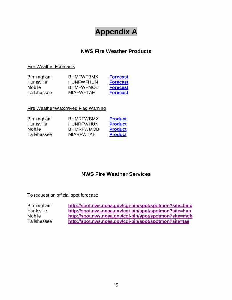
Appendix A
NWS Fire Weather Products
Fire Weather Forecasts Birmingham BHMFWFBMX Forecast Huntsville HUNFWFHUN Forecast Mobile BHMFWFMOB Forecast Tallahassee MIAFWFTAE Forecast Fire Weather Watch/Red Flag Warning Birmingham BHMRFWBMX Product Huntsville HUNRFWHUN Product Mobile BHMRFWMOB Product Tallahassee MIARFWTAE Product
NWS Fire Weather Services
To request an official spot forecast: Birmingham http://spot.nws.noaa.gov/cgi-bin/spot/spotmon?site=bmx Huntsville http://spot.nws.noaa.gov/cgi-bin/spot/spotmon?site=hun Mobile http://spot.nws.noaa.gov/cgi-bin/spot/spotmon?site=mob Tallahassee http://spot.nws.noaa.gov/cgi-bin/spot/spotmon?site=tae

20
Appendix B
Product Examples
FIRE WEATHER PLANNING FORECAST FOR INLAND SOUTHEAST MISSISSIPPI...
SOUTHWEST ALABAMA AND THE EXTREME WESTERN FLORIDA PANHANDLE
NATIONAL WEATHER SERVICE MOBILE AL
245 PM CDT TUE APR 30 2013
.DISCUSSION...AN UPPER LEVEL DISTURBANCE WILL PERSIST ACROSS THE
AREA THROUGH THE END OF THE WEEK...RESULTING IN SEVERAL ROUNDS
OF SHOWERS AND THUNDERSTORMS. CLOUDS AND SLIGHTLY COOLER TEMPERATURES
WILL RESULT IN LOWER MIXING HEIGHTS. HOWEVER...STRENGTHENING EASTERLY
TRANSPORT WINDS WILL STILL KEEP DISPERSIONS FAIR TO GENERALLY GOOD
DURING THE AFTERNOON HOURS.
FOG POTENTIAL AND OTHER REMARKS...PATCHY FOG IS POSSIBLE DURING
THE EARLY MORNING HOURS.
ALZ051>053-010745-
CHOCTAW-WASHINGTON-CLARKE-
245 PM CDT TUE APR 30 2013
TONIGHT WED WED NIGHT THU
CLOUD COVER MCLDY MCLDY MCLDY MCLDY
CHANCE PRECIP (%) 50 80 60 60
PRECIP TYPE TSTMS TSTMS TSTMS TSTMS
TEMP 62 77 61 75
RH % 94 70 94 63
20FT WND MPH(AM) E 5-9 E 8-12
20FT WND MPH(PM) SE 3-7 E 10-14 E 6-10 E 10-14
PRECIP AMOUNTS 0.20 0.36 0.37 0.33
PRECIP BEGINS 7 PM CONTINUING CONTINUING CONTINUING
PRECIP ENDS CONTINUING CONTINUING CONTINUING CONTINUING
PRECIP DURATION 2 6 9 9
MIXING HGT (FT-AGL) 400 2900 400 3300
TRANSPORT WND (MPH) SE 8 E 16 E 15 E 18
DISPERSION INDEX 4 42 12 47
MAX LVORI 6 5
STABILITY CLASS F C D C
LAL 3 5 4 4
.EXTENDED...
.THURSDAY NIGHT...MOSTLY CLOUDY. CHANCE OF SHOWERS AND
THUNDERSTORMS. LOWS IN THE LOWER 60S. EAST WINDS 5 TO 10 MPH.
MAXIMUM RH 99 PERCENT.
.FRIDAY...MOSTLY CLOUDY. SHOWERS AND THUNDERSTORMS LIKELY. HIGHS
IN THE LOWER 70S. EAST WINDS 5 TO 10 MPH. MINIMUM RH 70 PERCENT.
.FRIDAY NIGHT...MOSTLY CLOUDY. CHANCE OF SHOWERS AND
21
THUNDERSTORMS. LOWS IN THE LOWER 50S. SOUTHEAST WINDS 5 TO 10 MPH
SHIFTING TO THE SOUTHWEST AFTER MIDNIGHT. MAXIMUM RH 91 PERCENT.
.SATURDAY...PARTLY SUNNY. CHANCE OF SHOWERS AND THUNDERSTORMS.
HIGHS AROUND 70. WEST WINDS 5 TO 10 MPH. MINIMUM RH 48 PERCENT.
.SATURDAY NIGHT...PARTLY CLOUDY. SLIGHT CHANCE OF SHOWERS AND
THUNDERSTORMS THROUGH THE NIGHT. LOWS AROUND 50. WEST WINDS
AROUND 5 MPH. MAXIMUM RH 96 PERCENT.
.SUNDAY...MOSTLY SUNNY. SLIGHT CHANCE OF SHOWERS AND
THUNDERSTORMS. HIGHS IN THE UPPER 70S. WEST WINDS 5 TO 10 MPH.
MINIMUM RH 37 PERCENT.
.SUNDAY NIGHT...PARTLY CLOUDY. LOWS IN THE MID 50S. NORTHWEST
WINDS AROUND 5 MPH. MAXIMUM RH 89 PERCENT.
.MONDAY...MOSTLY SUNNY. HIGHS IN THE UPPER 70S. WEST WINDS 5 TO
10 MPH. MINIMUM RH 37 PERCENT.
.MONDAY NIGHT...PARTLY CLOUDY. LOWS IN THE LOWER 50S. NORTHWEST
WINDS 5 TO 10 MPH. MAXIMUM RH 96 PERCENT.
.TUESDAY...MOSTLY SUNNY. HIGHS IN THE UPPER 70S. NORTHWEST WINDS
AROUND 5 MPH. MINIMUM RH 38 PERCENT.
$$
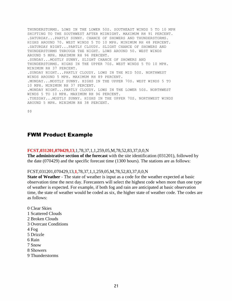
FWM Product Example
FCST,031201,070429,13,1,78,37,1,1,259,05,M,78,52,83,37,0,0,N
The administrative section of the forecast with the site identification (031201), followed by
the date (070429) and the specific forecast time (1300 hours). The stations are as follows:
FCST,031201,070429,13,1,78,37,1,1,259,05,M,78,52,83,37,0,0,N
State of Weather - The state of weather is input as a code for the weather expected at basic
observation time the next day. Forecasters will select the highest code when more than one type
of weather is expected. For example, if both fog and rain are anticipated at basic observation
time, the state of weather would be coded as six, the higher state of weather code. The codes are
as follows:
0 Clear Skies
1 Scattered Clouds
2 Broken Clouds
3 Overcast Conditions
4 Fog
5 Drizzle
6 Rain
7 Snow
8 Showers
9 Thunderstorms

22
FCST,031201,070429,13,1,78,37,1,1,259,05,M,78,52,83,37,0,0,N
Temperature and humidity - The forecaster will enter the temperature in degrees Fahrenheit,
and the relative humidity in whole percent expected at observation time.
FCST,031201,070429,13,1,78,37,1,1,259,05,M,78,52,83,37,0,0,N
Lightning activity level - Currently these values default to 1 as dry lightning is a very rare event
in Alabama.
FCST,031201,070429,13,1,78,37,1,1,259,05,M,78,52,83,37,0,0,N
Wind direction and speed - The forecaster will enter the expected wind direction in degrees and
the expected wind speed at the observation site in mph. The wind speed at a fire weather station
is the average of the speed measured over a 10 minute period. Wind speeds measured at a fire
weather station usually do not compare with the ASOS 10 meter winds measured at airports.
Wind speeds are observed to be lower over the rougher terrain of a forest as compared to the
observation site at an airport. The 10- minute average wind at the 20 foot level will produce
lower wind speeds than the 2- minute ASOS winds. The forecast wind speed will reflect the
lower wind speeds at fire weather stations by reducing the forecast wind speed by 70%.
FCST,031201,070429,13,1,78,37,1,1,259,05,M,78,52,83,37,0,0,N
24 hour forecasts - The forecaster will follow the basic observation time forecasts with the
maximum temperature expected during the 24 hour period from basic observation time the day
the forecast is being prepared to the basic observation time the following day. This is followed
by a forecast of minimum temperature, maximum humidity and minimum humidity expected in
the same 24-hour time frame.
FCST,031201,070429,13,1,78,37,1,1,259,05,M,78,52,83,37,0,0,N
Precipitation time duration - The forecaster will enter the expected duration of precipitation in
whole hours that will fall at the site for the first 16 hours of the forecast between basic
observation times. This sixteen hour forecast will be followed by a forecast of the expected
duration of precipitation in whole hours that will fall at the site for the final eight hours of the
forecast between basic observation times.
FCST,031201,070429,13,1,78,37,1,1,259,05,M,78,52,83,37,0,0,N
Wet Fuels Condition - A wet fuels condition anticipated at the next basic observation time is
entered next. If the forecaster expects fuels to be wet, a Y for yes will be entered. If the
forecaster feels fuels will not be wet, an N for no will be entered. Basically, this parameter will
be yes when liquid water, ice or snow, will be sitting on the fuels at observation time, i.e., really
soaked! Use yes with caution as all indices in the NFDRS are set to zero when wet fuels are
forecast.
23
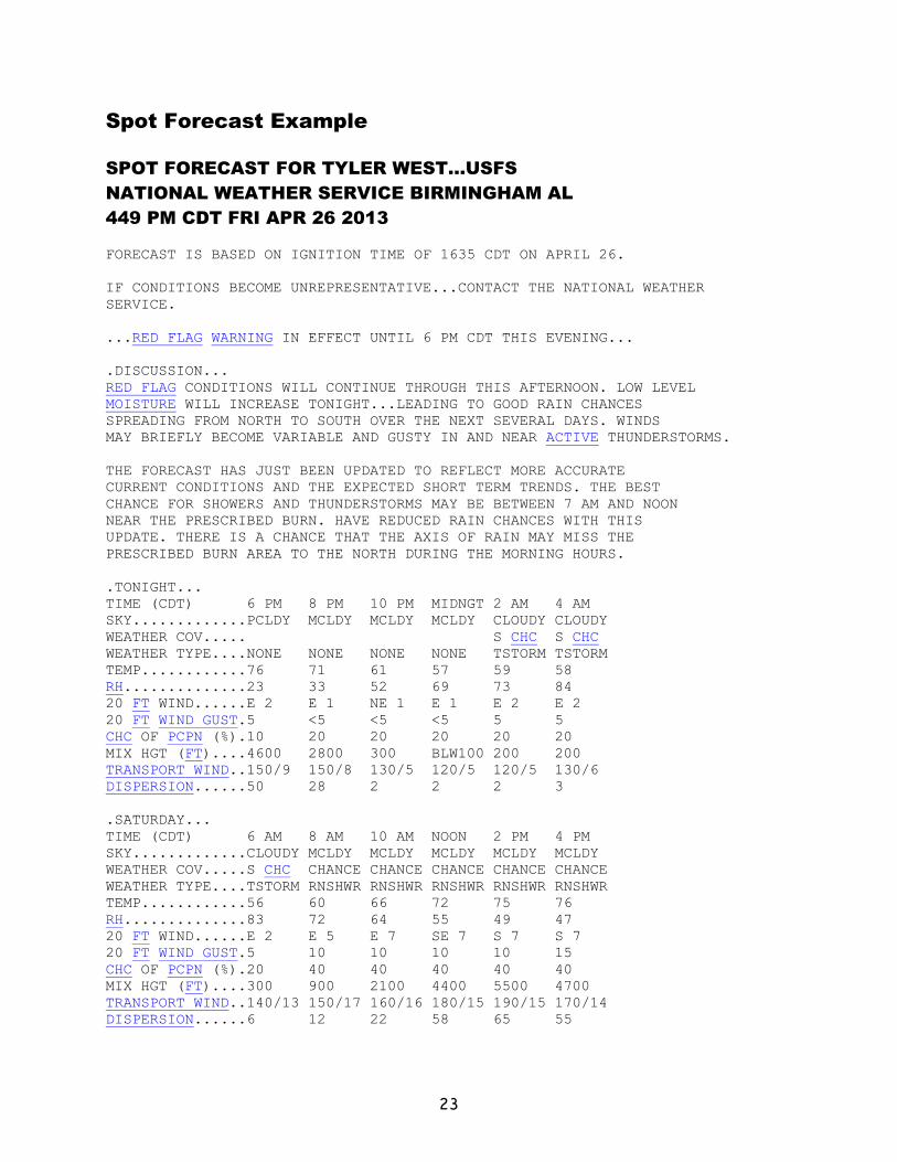
Spot Forecast Example
SPOT FORECAST FOR TYLER WEST...USFS
NATIONAL WEATHER SERVICE BIRMINGHAM AL
449 PM CDT FRI APR 26 2013
FORECAST IS BASED ON IGNITION TIME OF 1635 CDT ON APRIL 26.
IF CONDITIONS BECOME UNREPRESENTATIVE...CONTACT THE NATIONAL WEATHER
SERVICE.
...RED FLAG WARNING IN EFFECT UNTIL 6 PM CDT THIS EVENING...
.DISCUSSION...
RED FLAG CONDITIONS WILL CONTINUE THROUGH THIS AFTERNOON. LOW LEVEL
MOISTURE WILL INCREASE TONIGHT...LEADING TO GOOD RAIN CHANCES
SPREADING FROM NORTH TO SOUTH OVER THE NEXT SEVERAL DAYS. WINDS
MAY BRIEFLY BECOME VARIABLE AND GUSTY IN AND NEAR ACTIVE THUNDERSTORMS.
THE FORECAST HAS JUST BEEN UPDATED TO REFLECT MORE ACCURATE
CURRENT CONDITIONS AND THE EXPECTED SHORT TERM TRENDS. THE BEST
CHANCE FOR SHOWERS AND THUNDERSTORMS MAY BE BETWEEN 7 AM AND NOON
NEAR THE PRESCRIBED BURN. HAVE REDUCED RAIN CHANCES WITH THIS
UPDATE. THERE IS A CHANCE THAT THE AXIS OF RAIN MAY MISS THE
PRESCRIBED BURN AREA TO THE NORTH DURING THE MORNING HOURS.
.TONIGHT...
TIME (CDT) 6 PM 8 PM 10 PM MIDNGT 2 AM 4 AM
SKY.............PCLDY MCLDY MCLDY MCLDY CLOUDY CLOUDY
WEATHER COV..... S CHC S CHC
WEATHER TYPE....NONE NONE NONE NONE TSTORM TSTORM
TEMP............76 71 61 57 59 58
RH..............23 33 52 69 73 84
20 FT WIND......E 2 E 1 NE 1 E 1 E 2 E 2
20 FT WIND GUST.5 <5 <5 <5 5 5
CHC OF PCPN (%).10 20 20 20 20 20
MIX HGT (FT)....4600 2800 300 BLW100 200 200
TRANSPORT WIND..150/9 150/8 130/5 120/5 120/5 130/6
DISPERSION......50 28 2 2 2 3
.SATURDAY...
TIME (CDT) 6 AM 8 AM 10 AM NOON 2 PM 4 PM
SKY.............CLOUDY MCLDY MCLDY MCLDY MCLDY MCLDY
WEATHER COV.....S CHC CHANCE CHANCE CHANCE CHANCE CHANCE
WEATHER TYPE....TSTORM RNSHWR RNSHWR RNSHWR RNSHWR RNSHWR
TEMP............56 60 66 72 75 76
RH..............83 72 64 55 49 47
20 FT WIND......E 2 E 5 E 7 SE 7 S 7 S 7
20 FT WIND GUST.5 10 10 10 10 15
CHC OF PCPN (%).20 40 40 40 40 40
MIX HGT (FT)....300 900 2100 4400 5500 4700
TRANSPORT WIND..140/13 150/17 160/16 180/15 190/15 170/14
DISPERSION......6 12 22 58 65 55
24
$$
FORECASTER...GRANTHAM
REQUESTED BY...SCOTT LAYFIELD
TYPE OF REQUEST...PRESCRIBED
.TAG 20130426.TYLER.02/BMX
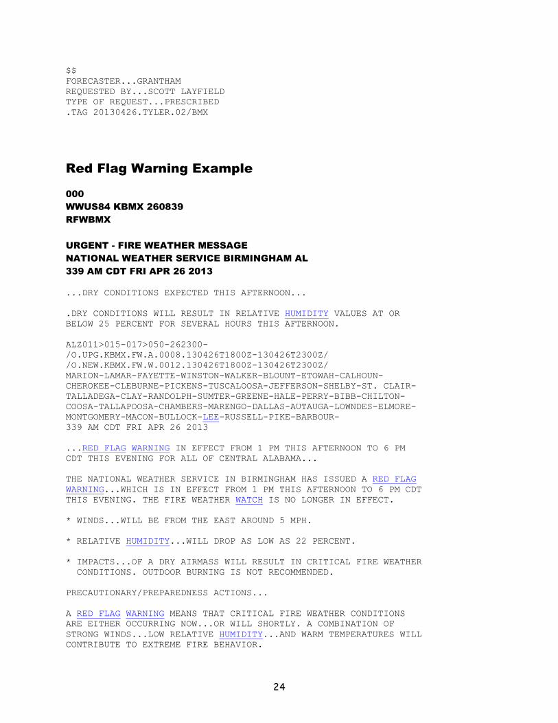
Red Flag Warning Example
000
WWUS84 KBMX 260839
RFWBMX
URGENT - FIRE WEATHER MESSAGE
NATIONAL WEATHER SERVICE BIRMINGHAM AL
339 AM CDT FRI APR 26 2013
...DRY CONDITIONS EXPECTED THIS AFTERNOON...
.DRY CONDITIONS WILL RESULT IN RELATIVE HUMIDITY VALUES AT OR
BELOW 25 PERCENT FOR SEVERAL HOURS THIS AFTERNOON.
ALZ011>015-017>050-262300-
/O.UPG.KBMX.FW.A.0008.130426T1800Z-130426T2300Z/
/O.NEW.KBMX.FW.W.0012.130426T1800Z-130426T2300Z/
MARION-LAMAR-FAYETTE-WINSTON-WALKER-BLOUNT-ETOWAH-CALHOUN-
CHEROKEE-CLEBURNE-PICKENS-TUSCALOOSA-JEFFERSON-SHELBY-ST. CLAIR-
TALLADEGA-CLAY-RANDOLPH-SUMTER-GREENE-HALE-PERRY-BIBB-CHILTON-
COOSA-TALLAPOOSA-CHAMBERS-MARENGO-DALLAS-AUTAUGA-LOWNDES-ELMORE-
MONTGOMERY-MACON-BULLOCK-LEE-RUSSELL-PIKE-BARBOUR-
339 AM CDT FRI APR 26 2013
...RED FLAG WARNING IN EFFECT FROM 1 PM THIS AFTERNOON TO 6 PM
CDT THIS EVENING FOR ALL OF CENTRAL ALABAMA...
THE NATIONAL WEATHER SERVICE IN BIRMINGHAM HAS ISSUED A RED FLAG
WARNING...WHICH IS IN EFFECT FROM 1 PM THIS AFTERNOON TO 6 PM CDT
THIS EVENING. THE FIRE WEATHER WATCH IS NO LONGER IN EFFECT.
* WINDS...WILL BE FROM THE EAST AROUND 5 MPH.
* RELATIVE HUMIDITY...WILL DROP AS LOW AS 22 PERCENT.
* IMPACTS...OF A DRY AIRMASS WILL RESULT IN CRITICAL FIRE WEATHER
CONDITIONS. OUTDOOR BURNING IS NOT RECOMMENDED.
PRECAUTIONARY/PREPAREDNESS ACTIONS...
A RED FLAG WARNING MEANS THAT CRITICAL FIRE WEATHER CONDITIONS
ARE EITHER OCCURRING NOW...OR WILL SHORTLY. A COMBINATION OF
STRONG WINDS...LOW RELATIVE HUMIDITY...AND WARM TEMPERATURES WILL
CONTRIBUTE TO EXTREME FIRE BEHAVIOR.

25
FOR ADDITIONAL INFORMATION ON THE FIRE CONDITIONS...PLEASE
CONTACT THE ALABAMA FORESTRY COMMISSION AT
WWW.FORESTRY.ALABAMA.GOV.
&&
$$
26
Appendix C
Spot Forecast Request Guidelines
Spot forecasts will be issued on request to any governmental or private agency for a wildfire. Requests for spot forecasts for non-wildfire purposes will only be honored from federal agencies, from non-federal agencies operating with a federal agency on an interagency agreement or from any non-federal government agency when public safety is at risk. For non-wildfire purposes, resources permitting, WFOs will provide spot forecast service under the following circumstances and conditions:
A. Upon request of any federal official who represents that the spot forecast is required under the terms of the Interagency Agreement for Meteorological Services.
B. Upon request of any state, tribal, or local official who represents that the spot forecast is required to carry out their wildland fire management responsibilities in coordination with any federal land management agency participating in the Interagency Agreement for Meteorological Services.
C. Upon request of any public safety official who represents the spot forecast is
essential to public safety, e.g. due to the proximity of population centers or critical infrastructure. A “public safety official” is an employee or contract agent of a government agency at any level (federal, state, local, tribal, etc.) charged with protecting the public from hazards in including wildland fires of whatever origin and/or other hazards influenced by weather conditions such as hazardous material releases.
WFOs will not provide spot forecasts to private citizens or commercial entities not acting as a contract agent of a government agency at any level.

27
WS FORM D-1 U.S. Department of Commerce
(1-2005) SPOT REQUEST NOAA
(Supersedes Previous Editions) (See reverse for instructions) National Weather Service
Please call the NWS Weather Forecast Office (WFO) when submitting a request and also after you receive a forecast to ensure
request and forecast were received.
Please provide feedback to WFO on forecast.
1. Time† 2. Date 3. Name of Incident or Project 4. Requesting Agency
5. Requesting Official 6. Phone Number 7. Fax Number 8. Contact Person
9. Ignition/Incident Time and Date 12. Reason for Spot Request (choose one
only)
o Wildfire
o Non-Wildfire Under the Interagency
Agreement for Meteorological Services
(USFS, BLM, NPS, USFWS, BIA)
o Non-Wildfire State, tribal or local fire
agency working in coordination with a
federal participant in the Interagency
Agreement for Meteorological Services
o Non-Wildfire Essential to public safety,
e.g. due to the proximity of population
centers or critical infrastructure.
13. Latitude/Longitude:
10. Size (Acres) 14. Elevation (ft,
Mean Sea Level)
Top: Bottom:
11. Type of Incident
o Wildfire
o Prescribed Fire
o Wildland Fire Use (WFU)
o HAZMAT
o Search And Rescue (SAR)
15. Drainage
1
6
.
A
s
p
e
c
t
17. Sheltering
o Full
o Partial
o Unsheltered
18. Fuel Type: Grass Brush Timber Slash Grass/Timber Understory Other___________________
Fuel Model: 1,2,3 4,5,6,7 8,9,10 11,12,13 2,5,8
19. Location and name of nearest weather observing station (distance & direction from project):
20. Weather Observations from project or nearby station(s): (Winds should be in compass direction e.g. N, NW, etc.)
Place Elevation †Ob Time 20 ft. Wind
Dir Speed
Eye Level Wind.
Dir Speed
Temp.
Dry Wet
Moisture
RH DP
Remarks
(Relevant
Weather, etc)
21. Requested Forecast Period Date
Start ____________
End ____________ Forecast needed for:
o Today
o Tonight
o Day 2
o Extended
22. Primary Forecast Elements (Check all that are
needed) (for management ignited wildland fires,
provide prescription parameters):
Needed:
Sky/Weather __
Temperature __
Humidity __
20 ft Wind __
Valley __
Ridge Top __
Other (Specify in #23) __
23. Remarks (other needed forecast
elements, forecast needed for specific
time, etc.)
24. Send Forecast to:
ATTN:
25. Location: 26. Phone Number:
Fax Number:
27. Remarks (Special requests, incident details, Smoke Dispersion elements needed, etc.): EXPLANATION OF SYMBOLS: † Use 24-hour clock to indicate time. Example: 10:15 p.m. = 2215; 10:15 a.m. = 1015
Indicate local standard time or local daylight time

28


