Admiralty Annual Summary of Notices to Mariners - Updates ... · admiralty annual summary of...
288
NP247(2) ADMIRALTY ANNUAL SUMMARY OF NOTICES TO MARINERS -- UPDATES TO SAILING DIRECTIONS AND MISCELLANEOUS NAUTICAL PUBLICATIONS CORRECT TO 31 DECEMBER 2018 (Week 52/18) CONTENTS PART 1 CURRENT EDITIONS OF ADMIRALTY SAILING DIRECTIONS PART 2 SAILING DIRECTIONS UPDATES IN FORCE PART 3 CURRENT EDITIONS OF ADMIRALTY MISCELLANEOUS NAUTICAL PUBLICATIONS PART 4 MISCELLANEOUS NAUTICAL PUBLICATIONS UPDATES IN FORCE
Transcript of Admiralty Annual Summary of Notices to Mariners - Updates ... · admiralty annual summary of...

NP247(2)
ADMIRALTY ANNUAL SUMMARY OF NOTICES TO MARINERS --UPDATES TO SAILING DIRECTIONS AND
MISCELLANEOUS NAUTICAL PUBLICATIONS
CORRECT TO 31 DECEMBER 2018 (Week 52/18)
CONTENTS
PART 1
CURRENT EDITIONS OF ADMIRALTY SAILING DIRECTIONS
PART 2
SAILING DIRECTIONS UPDATES IN FORCE
PART 3
CURRENT EDITIONS OF ADMIRALTY MISCELLANEOUS NAUTICAL PUBLICATIONS
PART 4
MISCELLANEOUS NAUTICAL PUBLICATIONS UPDATES IN FORCE
ii

iii
INTRODUCTION
NP247(2), ADMIRALTY of Notices to Mariners -- Updates to Sailing Directions and MiscellaneousNautical Publications, contains the text of all updates to current editions of ADMIRALTY SailingDirections and Miscellaneous Nautical Publications which have been published in Sections IV andVII of ADMIRALTY of Notices to Mariners, and which remain in force on 31 December 2018(Week 52/18).
HOW TO USE THIS PUBLICATION
Current editions of Sailing Directions and Miscellaneous Nautical Publications
Updates to ADMIRALTY Sailing Directions and Miscellaneous Nautical Publications are alwaysapplied to the most recent edition of the volume in use. Details of the most recent edition of anyparticular volume can be established by consulting:
NP131 ADMIRALTY Chart Catalogue, published annually in December.
Part 1 and Part 3 of this publication, published annually in January.
NP234Cumulative List of ADMIRALTYNotices toMariners, published6--monthly in Januaryand July.
New editions of ADMIRALTY Sailing Directions and Miscellaneous Nautical Publications areannounced in Section I of ADMIRALTY Notices to Mariners. A complete listing of current editions isupdated and published quarterly in Part IB of ADMIRALTY Notices to Mariners. It is also availableon the UKHO website at admiralty.co.uk.
Sailing Directions in Continuous Revision
Most volumes ofADMIRALTYSailing Directions are kept up to date in a “Continuous Revision” cycle.This means that once anew edition is published it will be continuously revised by its Editor for a periodof approximately 3 years using information received in the UKHO, and then republished. During thelife of the book, it is updated as necessary by notices published weekly at Section IV of ADMIRALTYNotices to Mariners. These updates will normally be restricted to those critical to the safety ofnavigation, and information required to be published as a result of changes to national legislationaffecting shipping, and to port regulations.
It is recommended that updates are kept in a file with the latest list of updates in force on top. Thelist should then be consulted when using the parent book to see if any changes, affecting the areaunder consideration, are in force. Marinersmay also annotate the parent book with the relevant weeknumber at affected paragraphs to indicate the presence of an update. It is not recommended thatchanges be pasted into the parent book.
Promulgation of Section IV and VII Notices to Mariners
Section IV and VII Notices to Mariners are published weekly in ADMIRALTY Notices to Mariners.
A check--list of all extant Notices, but not the text, is published quarterly at the end of Sections IV andVII respectively of ADMIRALTY Notices to Mariners.
This volume, published annually, contains the full text of all extant Section IV and VII Notices.
iv
Action on receipt of a volume of ADMIRALTY Sailing Directions or Miscellaneous NauticalPublication
(1) Check that the most recent Edition of the volume is held.
(2) Check that the updates at Part 2 or Part 4 of this volume have been applied.
(3) Check that all updates published at either Sections IV and VII of ADMIRALTY Notices toMariners subsequent to the publication of this volume have been applied, using the most recentquarterly check--list at Section IV or VII of the Weekly Edition.
For further information, please refer to ‘How to Keep Your ADMIRALTY Products Up--to--Date’,NP294.
Where it is found that the most up to date information is not held, the most recent editions of allADMIRALTY publications can be obtained from ADMIRALTY Distributors, and back copies ofADMIRALTY Notices to Mariners can also be downloaded from the UKHO website.

UPDATES TO ADMIRALTY SAILING DIRECTIONS
PART 1CURRENT EDITIONS OF ADMIRALTY SAILING DIRECTIONS
(Corrected to Week 52/18)
NP No Title Edition Published /correct fromWeekly EditionNumber
1 Africa Pilot Vol 1 18th (2017) 47/17
2 Africa Pilot Vol 2 18th (2017) 39/17
3 Africa Pilot Vol 3 17th (2016) 16/16
4 South--East Alaska Pilot 8th (2015) 16/15
5 South America Pilot Vol 1 19th (2017) 22/17
6 South America Pilot Vol 2 18th (2011) 50/11
7 South America Pilot Vol 3 13th (2018) 49/18
7A South America Pilot Vol 4 8th (2018) 51/18
8 Pacific Coasts of Central America and USA Pilot 14th (2016) 46/16
9 Antarctic Pilot 8th (2014) 38/14
10 Arctic Pilot Vol 1 9th (2016) 07/16
11 Arctic Pilot Vol 2 12th (2018) 19/18
12 Arctic Pilot Vol 3 10th (2018) 19/18
13 Australia Pilot Vol 1 5th (2017) 17/17
14 Australia Pilot Vol 2 13th (2016) 28/16
15 Australia Pilot Vol 3 14th (2018) 24/18
18 Baltic Pilot Vol 1 18th (2018) 43/18
19 Baltic Pilot Vol 2 17th (2018) 06/18
20 Baltic Pilot Vol 3 13th (2016) 26/16
21 Bay of Bengal Pilot 12th (2013) 05/14
22 Bay of Biscay Pilot 13th (2016) 43/16
23 Bering Sea and Strait Pilot 8th (2013) 07/14
24 Black Sea and Sea of Azov Pilot 5th (2017) 07/17
25 British Columbia Pilot Vol 1 16th (2017) 04/17
26 British Columbia Pilot Vol 2 11th (2017) 11/17
27 Channel Pilot 12th (2018) 45/18
28 Dover Strait Pilot 12th (2017) 34/17
30 China Sea Pilot Vol 1 11th (2018) 29/18
31 China Sea Pilot Vol 2 13th (2018) 07/18
32A China Sea Pilot Vol 3 1st (2018) 01/18
32B China Sea Pilot Vol 4 1st (2018) 01/18
33 Philippine Islands Pilot 6th (2017) 49/17
34 Indonesia Pilot Vol 2 8th (2017) 12/17
35 Indonesia Pilot Vol 3 7th (2017) 43/17
36 Indonesia Pilot Vol 1 9th (2017) 20/17
37 West Coasts of England and Wales Pilot 20th (2017) 26/17
38 West Coast of India Pilot 18th (2016) 39/16
39 South Indian Ocean Pilot 15th (2017) 14/17
40 Irish Coast Pilot 20th (2016) 36/16
1 -- 1

NP No Published /correct fromWeekly EditionNumber
EditionTitle
41 Japan Pilot Vol 1 12th (2018) 08/18
42A Japan Pilot Vol 2 6th (2017) 36/17
42B Japan Pilot Vol 3 11th (2016) 10/16
42C Japan Pilot Vol 4 5th (2015) 18/15
43 S and E Coasts of Korea, E Coast of Siberia andSea of Okhotsk Pilot
11th (2018) 02/18
44 Malacca Strait and W Coast Sumatera Pilot 13th (2017) 42/17
45 Mediterranean Pilot Vol 1 16th (2018) 14/18
46 Mediterranean Pilot Vol 2 16th (2018) 41/18
47 Mediterranean Pilot Vol 3 16th (2017) 32/17
48 Mediterranean Pilot Vol 4 17th (2017) 30/17
49 Mediterranean Pilot Vol 5 14th (2018) 23/18
50 Newfoundland and Labrador Pilot 14th (2016) 34/16
51 New Zealand Pilot 19th (2015) 51/15
52 North Coast of Scotland Pilot 10th (2018) 32/18
54 North Sea (West) Pilot 11th (2018) 18/18
55 North Sea (East) Pilot 11th (2018) 37/18
56 Norway Pilot Vol 1 17th (2018) 39/18
57A Norway Pilot Vol 2A 12th (2016) 50/16
57B Norway Pilot Vol 2B 10th (2017) 45/17
58A Norway Pilot Vol 3A 8th (2015) 20/15
58B Norway Pilot Vol 3B 8th (2018) 40/18
59 Nova Scotia and Bay of Fundy Pilot 15th (2013) 04/14
60 Pacific Islands Pilot Vol 1 13th (2018) 04/18
61 Pacific Islands Pilot Vol 2 13th (2017) 10/17
62 Pacific Islands Pilot Vol 3 14th (2016) 51/16
63 Persian Gulf Pilot 18th (2018) 27/18
64 Red Sea and Gulf of Aden Pilot 19th (2018) 30/18
65 St Lawrence Pilot 18th (2016) 03/16
66A SW Coast of Scotland Pilot 1st (2014) 13/15
66B NW Coast of Scotland Pilot 1st (2014) 13/15
67 W Coasts of Spain and Portugal Pilot 13th (2018) 09/18
68 E Coast of USA Pilot Vol 1 16th (2018) 16/18
69 E Coast of USA Pilot Vol 2 14th (2017) 38/17
69A E Coasts of Central America and Gulf of Mexico Pilot 7th (2015) 22/15
70 West Indies Pilot Vol 1 7th (2018) 46/18
71 West Indies Pilot Vol 2 18th (2017) 18/17
72 S Barents Sea and Beloye More Pilot 3rd (2014) 38/14
1 -- 2

UPDATES TO ADMIRALTY SAILING DIRECTIONS
PART 2
INDEX OF UPDATES IN FORCE ON 31st December 2018 (Week 52/18)
NP Pilot Page1 Africa Pilot Volume 1 2 -- 3. . . . . . . . . . . . . . . . . . . . . . . . . . . . . . . . . . . . . . . . . . . . . . . . . . . . . . . . . . . . .2 Africa Pilot Volume 2 2 -- 7. . . . . . . . . . . . . . . . . . . . . . . . . . . . . . . . . . . . . . . . . . . . . . . . . . . . . . . . . . . . .3 Africa Pilot Volume 3 2 -- 9. . . . . . . . . . . . . . . . . . . . . . . . . . . . . . . . . . . . . . . . . . . . . . . . . . . . . . . . . . . . .4 South--East Alaska Pilot 2 -- 12. . . . . . . . . . . . . . . . . . . . . . . . . . . . . . . . . . . . . . . . . . . . . . . . . . . . . . . . .5 South America Pilot Volume 1 2 -- 13. . . . . . . . . . . . . . . . . . . . . . . . . . . . . . . . . . . . . . . . . . . . . . . . . . . .6 South America Pilot Volume 2 2 -- 22. . . . . . . . . . . . . . . . . . . . . . . . . . . . . . . . . . . . . . . . . . . . . . . . . . . .7 South America Pilot Volume 3 2 -- 25. . . . . . . . . . . . . . . . . . . . . . . . . . . . . . . . . . . . . . . . . . . . . . . . . . . .7A South America Pilot Volume 4 2 -- 28. . . . . . . . . . . . . . . . . . . . . . . . . . . . . . . . . . . . . . . . . . . . . . . . . . .8 Pacific Coasts of Central America and United States Pilot 2 -- 30. . . . . . . . . . . . . . . . . . . . . . . . . . .9 Antarctic Pilot 2 -- 38. . . . . . . . . . . . . . . . . . . . . . . . . . . . . . . . . . . . . . . . . . . . . . . . . . . . . . . . . . . . . . . . . .
10 Arctic Pilot Volume 1 2 -- 42. . . . . . . . . . . . . . . . . . . . . . . . . . . . . . . . . . . . . . . . . . . . . . . . . . . . . . . . . . . .11 Arctic Pilot Volume 2 2 -- 46. . . . . . . . . . . . . . . . . . . . . . . . . . . . . . . . . . . . . . . . . . . . . . . . . . . . . . . . . . . .12 Arctic Pilot Volume 3 2 -- 46. . . . . . . . . . . . . . . . . . . . . . . . . . . . . . . . . . . . . . . . . . . . . . . . . . . . . . . . . . . .13 Australia Pilot Volume 1 2 -- 47. . . . . . . . . . . . . . . . . . . . . . . . . . . . . . . . . . . . . . . . . . . . . . . . . . . . . . . . .14 Australia Pilot Volume 2 2 -- 50. . . . . . . . . . . . . . . . . . . . . . . . . . . . . . . . . . . . . . . . . . . . . . . . . . . . . . . . .15 Australia Pilot Volume 3 2 -- 57. . . . . . . . . . . . . . . . . . . . . . . . . . . . . . . . . . . . . . . . . . . . . . . . . . . . . . . . .18 Baltic Pilot Volume 1 2 -- 58. . . . . . . . . . . . . . . . . . . . . . . . . . . . . . . . . . . . . . . . . . . . . . . . . . . . . . . . . . . .19 Baltic Pilot Volume 2 2 -- 58. . . . . . . . . . . . . . . . . . . . . . . . . . . . . . . . . . . . . . . . . . . . . . . . . . . . . . . . . . . .20 Baltic Pilot Volume 3 2 -- 64. . . . . . . . . . . . . . . . . . . . . . . . . . . . . . . . . . . . . . . . . . . . . . . . . . . . . . . . . . . .21 Bay of Bengal Pilot 2 -- 79. . . . . . . . . . . . . . . . . . . . . . . . . . . . . . . . . . . . . . . . . . . . . . . . . . . . . . . . . . . . .22 Bay of Biscay Pilot 2 -- 93. . . . . . . . . . . . . . . . . . . . . . . . . . . . . . . . . . . . . . . . . . . . . . . . . . . . . . . . . . . . . .23 Bering Sea and Strait Pilot 2 -- 95. . . . . . . . . . . . . . . . . . . . . . . . . . . . . . . . . . . . . . . . . . . . . . . . . . . . . . .24 Black Sea and Sea of Azov Pilot 2 -- 97. . . . . . . . . . . . . . . . . . . . . . . . . . . . . . . . . . . . . . . . . . . . . . . . . .25 British Columbia Pilot Volume 1 2 -- 104. . . . . . . . . . . . . . . . . . . . . . . . . . . . . . . . . . . . . . . . . . . . . . . .26 British Columbia Pilot Volume 2 2 -- 106. . . . . . . . . . . . . . . . . . . . . . . . . . . . . . . . . . . . . . . . . . . . . . . .27 Channel Pilot 2 -- 107. . . . . . . . . . . . . . . . . . . . . . . . . . . . . . . . . . . . . . . . . . . . . . . . . . . . . . . . . . . . . . . .28 Dover Strait Pilot 2 -- 108. . . . . . . . . . . . . . . . . . . . . . . . . . . . . . . . . . . . . . . . . . . . . . . . . . . . . . . . . . . . .30 China Sea Pilot Volume 1 2 -- 111. . . . . . . . . . . . . . . . . . . . . . . . . . . . . . . . . . . . . . . . . . . . . . . . . . . . . . .31 China Sea Pilot Volume 2 2 -- 116. . . . . . . . . . . . . . . . . . . . . . . . . . . . . . . . . . . . . . . . . . . . . . . . . . . . . . .32A China Sea Pilot Volume 3 2 -- 118. . . . . . . . . . . . . . . . . . . . . . . . . . . . . . . . . . . . . . . . . . . . . . . . . . . . .32B China Sea Pilot Volume 4 2 -- 130. . . . . . . . . . . . . . . . . . . . . . . . . . . . . . . . . . . . . . . . . . . . . . . . . . . .33 Philippine Islands Pilot 2 -- 140. . . . . . . . . . . . . . . . . . . . . . . . . . . . . . . . . . . . . . . . . . . . . . . . . . . . . . . .34 Indonesia Pilot Volume 2 2 -- 144. . . . . . . . . . . . . . . . . . . . . . . . . . . . . . . . . . . . . . . . . . . . . . . . . . . . . .35 Indonesia Pilot Volume 3 2 -- 152. . . . . . . . . . . . . . . . . . . . . . . . . . . . . . . . . . . . . . . . . . . . . . . . . . . . . .36 Indonesia Pilot Volume 1 2 -- 152. . . . . . . . . . . . . . . . . . . . . . . . . . . . . . . . . . . . . . . . . . . . . . . . . . . . . .37 West Coasts of England and Wales Pilot 2 -- 157. . . . . . . . . . . . . . . . . . . . . . . . . . . . . . . . . . . . . . . .38 West Coast of India Pilot 2 -- 160. . . . . . . . . . . . . . . . . . . . . . . . . . . . . . . . . . . . . . . . . . . . . . . . . . . . . .39 South Indian Ocean Pilot 2 -- 169. . . . . . . . . . . . . . . . . . . . . . . . . . . . . . . . . . . . . . . . . . . . . . . . . . . . . .40 Irish Coast Pilot 2 -- 171. . . . . . . . . . . . . . . . . . . . . . . . . . . . . . . . . . . . . . . . . . . . . . . . . . . . . . . . . . . . . .41 Japan Pilot Volume 1 2 -- 175. . . . . . . . . . . . . . . . . . . . . . . . . . . . . . . . . . . . . . . . . . . . . . . . . . . . . . . . .42A Japan Pilot Volume 2 2 -- 176. . . . . . . . . . . . . . . . . . . . . . . . . . . . . . . . . . . . . . . . . . . . . . . . . . . . . . .42B Japan Pilot Volume 3 2 -- 178. . . . . . . . . . . . . . . . . . . . . . . . . . . . . . . . . . . . . . . . . . . . . . . . . . . . . . .42C Japan Pilot Volume 4 2 -- 181. . . . . . . . . . . . . . . . . . . . . . . . . . . . . . . . . . . . . . . . . . . . . . . . . . . . . . .43 South and East Coasts of Korea, East Coast of Siberia and Sea of Okhotsk Pilot 2 -- 182. . . . .44 Malacca Strait and West Coast of Sumatera Pilot 2 -- 187. . . . . . . . . . . . . . . . . . . . . . . . . . . . . . . . .45 Mediterranean Pilot Volume 1 2 -- 191. . . . . . . . . . . . . . . . . . . . . . . . . . . . . . . . . . . . . . . . . . . . . . . . . .46 Mediterranean Pilot Volume 2 2 -- 194. . . . . . . . . . . . . . . . . . . . . . . . . . . . . . . . . . . . . . . . . . . . . . . . . .47 Mediterranean Pilot Volume 3 2 -- 196. . . . . . . . . . . . . . . . . . . . . . . . . . . . . . . . . . . . . . . . . . . . . . . . . .48 Mediterranean Pilot Volume 4 2 -- 201. . . . . . . . . . . . . . . . . . . . . . . . . . . . . . . . . . . . . . . . . . . . . . . . . .49 Mediterranean Pilot Volume 5 2 -- 204. . . . . . . . . . . . . . . . . . . . . . . . . . . . . . . . . . . . . . . . . . . . . . . . . .50 Newfoundland and Labrador Pilot 2 -- 205. . . . . . . . . . . . . . . . . . . . . . . . . . . . . . . . . . . . . . . . . . . . . .51 New Zealand Pilot 2 -- 207. . . . . . . . . . . . . . . . . . . . . . . . . . . . . . . . . . . . . . . . . . . . . . . . . . . . . . . . . . . .
2 -- 1

52 . . . North Coa st of Scotl and Pilot . . . . . . . . . . . . . . . . . . . . . . . . . . . . . . . . . . . . . . . . . . . . . . . . . 2 - - 215 54 . . . North S ea (Wes t) P ilot . . . . . . . . . . . . . . . . . . . . . . . . . . . . . . . . . . . . . . . . . . . . . . . . . . . . . . . 2 - - 215 55 . . . North S ea (E ast) Pilot . . . . . . . . . . . . . . . . . . . . . . . . . . . . . . . . . . . . . . . . . . . . . . . . . . . . . . . . 2 - - 2175 6 . . . Norw ay Pilot Volum e 1 . . . . . . . . . . . . . . . . . . . . . . . . . . . . . . . . . . . . . . . . . . . . . . . . . . . . . . . 2 - - 218 57A . Norwa y P ilot Volum e 2 A . . . . . . . . . . . . . . . . . . . . . . . . . . . . . . . . . . . . . . . . . . . . . . . . . . . . . . 2 - - 218 57B . Norwa y P ilot Volum e 2 B . . . . . . . . . . . . . . . . . . . . . . . . . . . . . . . . . . . . . . . . . . . . . . . . . . . . . . 2 - - 221 58A . Norwa y P ilot Volum e 3 A . . . . . . . . . . . . . . . . . . . . . . . . . . . . . . . . . . . . . . . . . . . . . . . . . . . . . . 2 - - 222 58B . Norwa y P ilot Volum e 3 B . . . . . . . . . . . . . . . . . . . . . . . . . . . . . . . . . . . . . . . . . . . . . . . . . . . . . . 2 - - 230 59 . . . Nova Scoti a an d Ba y of Fund y Pilot . . . . . . . . . . . . . . . . . . . . . . . . . . . . . . . . . . . . . . . . . . . . 2 - - 230 60 . . . Paci fic Island s Pilot Volum e 1 . . . . . . . . . . . . . . . . . . . . . . . . . . . . . . . . . . . . . . . . . . . . . . . . . 2 - - 231 61 . . . Paci fic Island s Pilot Volum e 2 . . . . . . . . . . . . . . . . . . . . . . . . . . . . . . . . . . . . . . . . . . . . . . . . . 2 - - 233 62 . . . Paci fic Island s Pilot Volum e 3 . . . . . . . . . . . . . . . . . . . . . . . . . . . . . . . . . . . . . . . . . . . . . . . . . 2 - - 235 63 . . . Pe rsian G ulf Pil ot . . . . . . . . . . . . . . . . . . . . . . . . . . . . . . . . . . . . . . . . . . . . . . . . . . . . . . . . . . . . 2 - - 238 64 . . . Red S ea an d G ulf of Ade n Pil ot . . . . . . . . . . . . . . . . . . . . . . . . . . . . . . . . . . . . . . . . . . . . . . . 2 - - 242 65 . . . St Lawr ence Pilot . . . . . . . . . . . . . . . . . . . . . . . . . . . . . . . . . . . . . . . . . . . . . . . . . . . . . . . . . . . . 2 - - 242 66A . So uth w est coa st of Scotlan d Pilot . . . . . . . . . . . . . . . . . . . . . . . . . . . . . . . . . . . . . . . . . . . . . 2 - - 247 66B . North wes t c oast of Scotlan d Pil ot . . . . . . . . . . . . . . . . . . . . . . . . . . . . . . . . . . . . . . . . . . . . . 2 - - 252 67 . . . We st Co asts of Sp ain and Portu gal Pilot . . . . . . . . . . . . . . . . . . . . . . . . . . . . . . . . . . . . . . . . 2 - - 2556 8 . . . Eas t Coas t of t he Un ited State s Pilo t Volum e 1 . . . . . . . . . . . . . . . . . . . . . . . . . . . . . . . . . . 2 - - 2556 9 . . . Eas t Coas t of t he Un ited State s Pilo t Volum e 2 . . . . . . . . . . . . . . . . . . . . . . . . . . . . . . . . . . 2 - - 256 69A . Ea st coasts of Central Ameri ca an d Gulf of M exico Pilot . . . . . . . . . . . . . . . . . . . . . . . . . . 2 - - 257 70 . . . We st Indi es Pi lot Vol ume 1 . . . . . . . . . . . . . . . . . . . . . . . . . . . . . . . . . . . . . . . . . . . . . . . . . . . 2 - - 263 71 . . . We st Indi es Pi lot Vol ume 2 . . . . . . . . . . . . . . . . . . . . . . . . . . . . . . . . . . . . . . . . . . . . . . . . . . . 2 - - 264 72 . . . Souther n Barent s Se a an d Be loye Mo re P ilot . . . . . . . . . . . . . . . . . . . . . . . . . . . . . . . . . . . 2 - - 267
NP Pilot Page
2 -- 2

NP1
2 -- 3
NP1 Africa Pilot Volume 1 (2017 Edition)
Africa Pilot Volume 1 — Closure Date
v
Preface page last line For 4th September 2017 Read 24thAugust 2017
UKHO [NP1/No.1/Wk 47/17]
Spain -- Islas Canarias -- Isla de la Gomera —Wreck
114
Paragraph 3.151 1 line 5 Replace by:
...in depths of 5 m to 11 m, sand. A dangerous wreck(280463N 171956W) lies about 3½ cables ESE ofPuerto Vueltas outer molehead.
Spanish Notice 38/317/18 [NP1--No 28--Wk 42/18]
Arquipélago de Cabo Verde —Regulations; anchorage
121
After Paragraph 4.2 1 line 10 Insert:
Regulations4.2a
1 Anchorages in many areas of the Arquipélago deCabo Verde require contact with the local maritime orport authority prior to use.
Portuguese Chart 66401 [NP1--No 8--Wk 18/18]
Cabo Verde -- Ilha do Sal — Directions; shoal
122
Paragraph 4.10 6 line 3 Replace by:
...225425W) (4.17), noting an isolated shoal(163443N 225286W), with a depth of 131 m,lying 1¼ miles SSE of Ponta do Leme Velho,thence:
BA Chart 367 [NP1--No 21--Wk 34/18]
Arquipélago de Cabo Verde -- Ilha de São Vicente-- Baía de San Pedro — Anchorage
130
Paragraph 4.59 2 line 2 Replace by:
...Pedro bay in a depth of 10 to 15 m, remaining clear ofsubmarine cables. The holding ground is...
BA Chart 367 [NP1--No 9--Wk 18/18]
Arquipélago de Cabo Verde -- Ilha de São Vicente-- Porto Grande — Depths
132
Paragraph 4.72 Replace by:
1 Berth No 1, on the seaward side of Molhe No 2(Ponta do Cais), is exposed to sea and swell andvessels are berthed there if weather permits.
Berth Nos 1 and 2 are 315 m in length, depths.alongside 103 to 107 m.
Berth Nos 3 and 4 are 235 m in length, least depthsalongside 86 to 116 m.
2 Containers are stored N of Berth Nos 5 (100 min length, depth alongside 84 m) and 6(122 m in length, depth alongside 65 m).
Berth No 7 is 60 m in length, depth alongside 49 m.BerthNo 8 is 107 m in length, depth alongside 32 m.
Passenger vessels and ferries are usually berthedat Cais de Cabotagem Berths A, B and C.
Portuguese Chart 66402 [NP1--No 13--Wk 18/18]
Arquipélago de Cabo Verde --Ilha de Santo Antão -- Porto Novo — Anchorage
133
Paragraph 4.83 1 lines 2--3 Replace by:
...of the berth in a depth of 13 m, rock, sand, chalk andbroken shells, remaining clear of a submarine cable area.
Portuguese ENC PT56601A[NP1--No 10--Wk 18/18]
Arquipélago de Cabo Verde -- Ilha de Santiago --Baía do Tarrafal — Anchorage
137
Paragraph 4.103 3 lines 1--4 Replace by:
3 Anchorage, is prohibited in most of the bay due tothe presence of submarine cables. The local maritimeor port authority should be contacted for moreinformation. See also 4.2a.
Portuguese ENC PT56602C[NP1--No 11--Wk 18/18]
Arquipélago de Cabo Verde -- Ilha Brava --Porto de Furna — Anchorages
141
Paragraph 4.138 2 lines 1--4 Replace by:
2 Anchorage is prohibited in the bay and approachesdue to the presence of submarine cables.
Portuguese ENC PT56602A[NP1--No 12--Wk 18/18]
Morocco -- West coast -- Larache — Pilotage
147
Paragraph 5.20 4 lines 1--3 Replace by:
4 Pilotage is not available. On request, assistancecan be provided.
French 32/C4 2015/2018 [NP1--No 24--Wk 36/18]
NP1
2 -- 4
Morocco -- Mohammadia —Directions; oil terminal
152
After Paragraph 5.68 1 line 8 Insert:
Oil Terminal5.68a
1 From the outer pilot boarding point (5.63) or thetanker anchorage, the access channel leads SE forabout 1¼ miles passing:
NW of a wreck (334545N 72290W) with a depthof 17 m, thence:
NW of the entry--prohibited area (5.64), and:Clear of an obstruction (334538N 72219W),reported (2006), with a depth of 12 m, thence:
Clear of a wreck (334502N 72208W) with adepth of 160 m.
2 The track then leads SW towards the oil terminalpassing:
SE of two wrecks (334477N 72226W and334480N 72225W), with depths of 16 and17 m, thence:
NW of M2 Light Buoy (334430N 72200W)(special), and:
SE of the entry--prohibited area (5.64), thence:NW of M3 Light Buoy (334401N 72229W)(special), thence:
Between the head of the breakwater and M4 LightBuoy (334365N 72261W) (special).
French Notice 31/P--03/18 [NP1--No 22--Wk 36/18]
Morocco -- Mohammadia —Directions; inner port
152--153
Paragraph 5.69 1--6 including heading Replace by:
Inner port5.69
1 Leading lights:Front light (black and white chequered post, 3 m inheight) (334368N 72057W).
Rear light (white rectangular hut on house, 8 m inheight) (1¼ cables from front light).
2 The alignment (130) of these lights leads throughthe approach channel towards the inner portanchorage and the inner pilot boarding point (5.63). Itwas reported (1988) that the marks were notconspicuous by day. The track passes:
SW of Mohammadia Approach Light Buoy M1 (safewater) (334637N 72303W), thence:
SW of a wreck (334545N 72290W) with a depthof 170 m, thence:
3 NE of ODAS Light Buoy MD (334490N72320W), marking the centre of anentry--prohibited area (5.64), thence:
SE of a wreck (334502N 72208W) with a depthof 160 m, thence:
NE of two wrecks (334480N 72225W), withdepths of 160 and 170 m, and across the tankerchannel, thence:
NE of M2 Light Buoy (special) (334430N72200W).
4 Thence, from the SE limit of the inner portanchorage or the inner pilot boarding point, the innerport channel leads 9 cables SW, passing:
SE of the restricted area surrounding the pipelines(5.64).
Leading lights:Front light (white post, black bands, 13 m in height)(334281N 72396W).
Rear light (similar structure) (110 m from front light).The alignment (265) of these lights leads W into
the harbour basin, passing:5 S of the head of Jetée Nord (334289N
72351W), from which a light (white tower,green bands, 5 m in height) is exhibited,thence:
N of the head of Jetée Sud (334280N 72359W),from which a light (white tower, red bands, 6 m inheight) is exhibited.
Useful marks:Water tower (334153N 72328W).Minaret (334209N 72212W).
French Notice 31/P--03/18 [NP1--No 23--Wk 36/18]
Morocco -- Casablanca — Directions; buoyage
154
Paragraph 5.80 1 line 2 ForCA1 Light BuoyReadCA LightBuoy (safe water)
Paragraph 5.88 4 lines 2--3 For CA1 Light Buoy Read CALight Buoy (safe water)
French Notice 29/C4 2015/18 [NP1--No 18--Wk 34/18]
Morocco -- Casablanca —Outer anchorages; wrecks
154
After Paragraph 5.88 3 line 8 Insert:
Caution. Two wrecks (334114N 73807W and333948N 73520W) lie within the W anchorage. Athird wreck (334043N 73215W), posit ionapproximate, lies within the E anchorage.
French Chart 7701 [NP1--No 16--Wk 33/18]
Morocco -- Casablanca — Pilotage
154--155
Paragraph 5.89 1 Replace by:
1 Pilotage is compulsory for vessels over 50 gt and isavailable day and night (under special arrangementbetween 0000 and 0600). Pilotage is optional for navalvessels, but is recommended if they are unfamiliarwith the port.The compulsory pilotage area is bounded to the E by themeridian of 73200W, to the N by the parallel of334000Nand to theWby themeridianof the root of JetéeMoulay Youssef. Pilots board in the vicinity of CA 1 LightBuoy (333789N 73460W). For further information, seeADMIRALTY List of Radio Signals Volume 6(3).
French Notice 29/C4 2015/18 [NP1--No 19--Wk 34/18]
NP1
2 -- 5
Morocco -- Casablanca — Buoyage
155
Paragraph 5.90 3 line 4 For CA5 Read CA3
Paragraph 5.90 3 line 7 For CA5 Read CA3
French Notice 34/135/18 [NP1--No 25--Wk 38/18]
Morocco -- Casablanca — Directions; buoyage
156
Paragraph 5.98 2 line 1 For CA1 Read CA
Paragraph 5.98 2 line 8 For CA3 Read CA1
Paragraph 5.98 3 line 6 For CA5 Read CA3
French Notice 29/C4 2015/18 [NP1--No 20--Wk 34/18]
Morocco -- Casablanca — Berths
156
Paragraph 5.100 Replace by:
1 East Container Terminal (333659N 73578W)comprises Berths 70 to 74. Total quay length 600 mwith a reported depth of 120 m.
Berth A5 (333649N 73578W) is a RoRo berthwith a length of 200 m and a depth of 80 m.
Container Terminal TC3 (333646N 73588W)comprises Berths 81 to 83. Total quay length of 530 mwith a depth of 125 m.
2 Phosphate Terminal (333652N 73627W) hasfour berths. Berth T7, which lies at the head of thepier, is 120 m in length with a depth of 100 m.Berths 64 to 66, which lie on the W of the pier, havea total length of 575 m and depths from 100 to120 m.
3 Berths 60 to 63 (333626N 73610W), which lieS of the Phosphate Terminal, have a total length of480 m and a depth of 100 m.
Berths R4 and R5 (333614N 73608W) have atotal length of 200 m and a depth of 75 m.
Container Terminal Somaport (333630N73624W) comprises Berths 50 to 55 and has a totallength of 700 m and a depth of 92 m. RoRo Berth RHlies at the base of the Terminal.
4 Berths T5 and T6 (333645N 73642W) are220 m in length with depths of 92 m.
Cruise Terminal (333626N 73640W) comprisesBerths 40 to 44 and has a total length of 570 m witha depth of 85 m.
Berths R2 and R3 (333614N 73638W) are200 m in length with a depth of 75 m.
5 Multi--purpose Terminal (333639N 73659W)comprises Berths 30 to 36 and Berths T3 and T4.Berths 30 to 36 has a total length of 820 m anddepths from 92 to 98 m. Berths T3 and T4 lie at thehead of Terminal and have a length of 200 m and adepth of 102 m.
6 Berths 20 to 24 (333631N 73672W) have atotal length of 570 m and depths of 92 m.
Berths A2 and A3 (333622N 73669W) areRoRo berths with a length of 350 m and a depth of82 m.
Multi--purpose Terminal Somaport (333627N73679W) has five berths. Berths 10 to 13 have atotal length of 380 m and a depth of 82 m. Berths T1and T2 are 170 m in length with a depth of 75 m.
7 Quai de la Marine Royale (333675N 73646W),situated on Jetée Moulay Youssef, has three berthsfor use by military vessels. Berth D is 600 m in length,depths from 10 to 60 m. Berth E is 160 m in length,depths from 40 to 60 m. Berth F is 200 m in lengthwith a depth of 100 m.
Les ports du Maroc en chiffres/2016[NP1--No 14--Wk 18/18]
Morocco – Jorf Lasfar — Anchorages
159
Paragraph 5.126 1 lines 1--3 Replace by:
1 Designated anchorage areas exist W of Cap Blancdu Nord, centred on 331026N 84315W for deepdraught vessels and vessels carrying dangerouscargoes, and on 331026N 84067W for smallervessels.
Vessels may also anchor 1½ miles W of the lighton Digue Principale head, in depths of about 34 m.
French Notice 8/139/18 [NP1--No 6--Wk 12/18]
Morocco – Jorf Lasfar — Directions; buoyage
160
Paragraph 5.133 1 lines 2--4 Replace by:
...Nord, the route leads E, passing:Clear of a light buoy (safe water) (330716N83994W), thence:
S of JL4 Light Buoy (port hand) (330729N83925W), thence:
Then the track leads NE passing NW of JL3 LightBuoy (starboard hand) (330689N 83883W) to theharbour entrance.
French Notice 50/138/17 [NP1--No 3--Wk 02/18]
Morocco -- Cap Hadid — Major light
163
Paragraph 5.164 1 lines 2--3 Delete
French Notice 48/145/18 [NP1--No 32--Wk 52/18]
Morocco -- Cap Hadid — Directions; major light
163
Paragraph 5.165 4 lines 6--7 Replace by:
...given a berth of at least 3 miles.
French Notice 48/145/18 [NP1--No 33--Wk 52/18]

NP1
2 -- 6
Morocco -- West coast -- Laâyoune — Pilotage
175
Paragraph 5.250 1 Replace by:
1 Pilotage is compulsory for all vessels and availableduring daylight only. The Pilot boards in the vicinity ofthe landfall light buoy (270500N 132700W) for thecommercial port and about 1 mile WSW of the Sextremity of Muelle de Fosbucraa for the PhosphateLoading Berth. For further information, seeADMIRALTY List of Radio Signals Volume 6(3).
French Notice 44/C4/18 [NP1--No 29--Wk 47/18]
Morocco -- West coast -- Laâyoune —Directions; leading marks
175
Paragraph 5.254 1 line 1 Replace by:
1 The alignment (0515) of the Old Lighhouse andthe white beacon close SW, leads to the entrance,passing NW of a buoy (starboard hand) (not charted)marking the SE limit of the channel.
French Notice 44/C2B/18 [NP1--No 30--Wk 47/18]
Morocco -- Ad Dakhla —Arrival information; outer anchorages
183
Paragraph 6.17 1 lines 1--4 Replace by:
1 Outer anchorages. Anchorage outside the bar maybe obtained in an area about 3 miles W of PuntaGalera Light (6.12), centred on 233752N160337W. Depths range from 116 to 250 m. Adangerous wreck (233620N 160201W), lies in theSE part of the anchorage, with a second dangerouswreck (233840N 160140W) on the NE limit.
Notice 47/03(P)/17 and BA Chart 1690[NP1--No 2--Wk 51/17]
Mauritania -- Nouadhibou -- Point Central toPointe de Cansado — Directions
189
Paragraph 6.67 1 lines 4--5 Delete
Paragraph 6.67 2 lines 1--4 Delete
Paragraph 6.67 3 lines 8--9 Replace by:
W of a dangerous wreck (205164N 165956W),thence:
Paragraph 6.67 4 line 8 For NE Read E
BA Chart 1699 [NP1--No 4--Wk 05/18]
Mauritania -- Nouadhibou -- Baie de Cansado —Directions; wrecks, buoy
189
Paragraph 6.68 2 lines 7--8 Delete
Paragraph 6.68 3 lines 1--3 Delete
Paragraph 6.68 4 lines 6--7 Delete
Paragraph 6.68 5 lines 1--2 Replace by:
5 Thence to a position S of No 9 Buoy (starboardhand) (205376N 170276W), from where the jetty(205386N 170305W) or quay at Pointe Chacal canbe approached directly.
MV Maersk Regensburg; BA Chart 1699[NP1--No 5--Wk 05/18]
Mauritania -- Port de l’Amitié — Anchorage
194
Paragraph 6.103 1 lines 1--3 Replace by:
1 The anchorage, semicircular in shape, is centredaround 175897N 160510W, about 2¾ miles WSWof Port de l’Amitié Light. Depths from 12 to 14 m.
French Notice 36/146/18 [NP1--No 26--Wk 40/18]
Mauritania -- Port de l’Amitié — Directions;leading lights
194
Paragraph 6.109 2 line 6 For 087 Read 085
BA Chart 1688 [NP1--No 27--Wk 40/18]
Africa -- Ivory Coast -- Abidjan —Limiting conditions; depth
296
Paragraph 9.121 1 line 3 Replace by:
...has a least charted depth of 12 m.
French Notice 47/145/18 [NP1--No 31--Wk 50/18]
Togo -- Port de Lomé — Directions; wreck
323
After Paragraph 11.43 1 line 9 Insert:
ENE of a dangerous wreck (6_0648N 1_1853E),thence:
French Notice 14--18--T--02 [NP1--No 7--Wk 18/18]
Republic of Benin -- Cotonou —Outer anchorages; obstruction
326
Paragraph 11.73 2 line 2 Replace by:
...2_3280E. An obstruction (61669N23315E) lies within the anchorage.
BA Chart 1384 [NP1--No 17--Wk 33/18]

NP1
2 -- 7
Nigeria -- Bight of Biafra — Offshore terminals
357
Paragraph 12.140 1 including headings Replace by:
OFFSHORE TERMINALS
General information
Solitons12.140
1 See 1.200.
Local weather12.140a
1 Dry season is from November to May, and wetseason from June to October. Intense line squallsusually prevalent between March and November.Visibility is good except during heavy rain and duringthe harmattan season (December to February), whenit occasionally drops below 5 cables.
Current12.140b
1 Current usually sets E, however, the direction andrate have been known to change suddenly.
Egina Terminal
General information12.140c
1 Position and function. Egina Terminal (30309N64187E), which exports crude oil, consists of theultra--deep water moored FPSO Egina. The terminalexports through a SBM (30417N 64220E) mooredNNE of the FPSO.
Terminal Authority. Total Upstream Nigeria(TUPNI), Eko Towers -- Office 7S 20, P1415Adetokunbo Ademola Street.
Website.
Limiting conditions12.140d
1 See 12.140, 12.140a, 12.140b.
Arrival information12.140e
1 Port operations. The terminal is open throughout24 hours, except in adverse weather conditions, forwhich the Mooring Master will be the final authority.
Waiting anchorage. None due to the depth ofwater.
Restricted area. There is a safety exclusion zonecentred on the FPSO.
2 Regulations. All export tankers shall fly theNigerian National flag during daylight hours while inthe vicinity of the terminal.
Directions12.140f
1 The chart is sufficient guide.
Akpo TerminalGeneral information12.140g
1 Position and function. Akpo Terminal (30846N64935E), which exports crude oil, consists of theultra--deep water moored FPSO Akpo. The terminalexports through a SBM moored NNE of the FPSO.
Terminal Authority. Total Upstream Nigeria(TUPNI), Eko Towers -- Office 7S 20, P1415Adetokunbo Ademola Street.
Website.
Limiting conditions12.140h
1 See 12.140, 12.140a, 12.140b.
Arrival information12.140i
1 Port operations. The terminal is open throughout24 hours except in adverse weather conditions, forwhich the Mooring Master will be the final authority.
Waiting area. There are waiting areas to the N andS of the restricted area.
Restricted area. There is a safety exclusion zonecentered on the FPSO.
2 Regulations. All export tankers shall fly theNigerian National flag during daylight hours while inthe vicinity of the terminal.
Directions12.140j
1 The chart is sufficient guide.
Paragraph 12.142 1 lines 3--10 Replace by:
See 12.140, 12.140a, 12.140b.
GTM/NIMASA Correspondence 05/18[NP1--No 15--Wk 23/18]
NP2 Africa Pilot Volume 2 (2017 Edition)
Republic of South Africa — Regulations; PSSA
6
Paragraph 1.50 1 line 8 Replace by:
2 PSSA. The waters between a point on the coast at311400S 175000E and Cape Agulhas (344982S200071E) and generally incorporating the continentalshelf and Agulhas Bank, have been designated as aPSSA which has been adopted by the IMO. See 1.47and South African Annual Notices to Mariners.
The PSSA extends E to the vicinity of Great FishPoint. See Africa Pilot Volume 3.
Other regulations. See Appendix II.
South African Notice 5/45/18 [NP2--No 9--Wk 28/18]
Isla de Bioko -- Puerto de Malabo —Berths; depths
99
Paragraph 3.56 1 line 2 Replace by:
...terminal, 350 m in length with depths alongside from 7 mto 9 m.
French Notice 3/145/18 [NP2--No 7--Wk 07/18]
http://nigeria.total.com/en/total--nigeria/total
http://nigeria.total.com/en/total--nigeria/total
NP2
2 -- 8
Gabon -- South--south--west of Pointe Tishibobo— Terminal
159
After Paragraph 5.185 1 line 6 Insert:
Dussafu Terminal
General information5.185a
1 Position and function. Dussafu Terminal(41482S 104912E) is an offshore oil loadingterminal comprising FPSO BW Adolo and four subseaproduction wells.
Port Authority. BW Energy Gabon
1
Website.www.bwoffshore.com/business/fleet--map/az urite/
Limiting conditions5.185b
Controlling depths. There are depths of 110 m in the vicinity of the FPSO.
Arrival information5.185c
1 Port operations. Daylight mooring.Waiting anchorage. There is no designated
anchorage for the terminal. In the event of a berthingdelay, the decision to drift or to anchor is at thediscretion of the Master. It should be noted that inareas of offshore oil and gas activity some submergedobstructions and wellheads may not be charted. Seealso 1.18.
2 Pilotage is compulsory and the pilot (along with theLoading Master, surveyor, government representativeand Customs Official) boards three miles NE of theFPSO.
Tugs are available and its use is compulsory.Restricted area. Dussafu Terminal lies in a
restricted area which encloses the FPSO and wells.Vessels must not enter the restricted area without thepermission of the Port Authority.
Regulations. Main engines must be kept onstandby throughout the loading operation.
Berth5.185d
1 The FPSO is a 230 000 dwt tanker, moored by12 anchors. Export tanker size limitation is150 000 dwt.
Correspondence -- Alliance Marine Services[NP2--No 10--Wk 34/18]
Angola -- Malongo Terminal — Pilotage
171
Paragraph 6.27 3 line 3 For 52800S 115800E Read52950S 115860E
Cabinda Gulf Oil Company [NP2--No 5--Wk 48/17]
Angola -- Futila Terminal — Directions; buoyage
173
Paragraph 6.46 1 line 2 For 52981S 121003E Read53004S 121012E
Paragraph6.46 1 lines 3--4For52956S121003ERead52976S 121008E
Paragraph 6.46 1 line 6 For 4½ cables Read 2 cables
Cabinda Gulf Oil Company [NP2/No.1/Wk.39/17]
Angola -- River Congo -- Ponta Kimongoa —Directions; caution
185
After Paragraph 6.150 1 line 10 Insert:
2 Caution. Dangerous rocks have been reported(2018) in the vicinity of Ponta Kimongoa Beacon.
Österreichischer Lloyd Seereederei (Cyprus) Ltd[NP2--No 8--Wk 21/18]
Angola -- Kaombo Field — Restricted areas
193
Paragraph 7.36 2 Replace by:
2 Restricted areas. A restricted area with a radius of8 miles is centred on the FPSO. Kaombo Field(71604S 111664E) is enclosed within a restrictedarea, radius 8 miles. A restricted area centred on72454S 111972E, radius 10 miles, lies 15 miles Wof CLOV Terminal. Vessels are prohibited from fishingor entering the restricted area without the permissionof the terminal operator. Further mooring exclusionand safety zones of radius 500 m are establishedaround both the SPM and FPSO.
3 Prohibited area. An entry prohibited area, radius1½ miles, centred on 72467S 111447E lies withinthe above restricted area, marked by a light buoy(special).
BA Chart 307 [NP2--No 6--Wk 01/18]
Angola -- Palanca Terminal — Pilotage
196
Paragraph 7.73 2 lines 1--2 Replace by:
2 Pilotage is compulsory. Pilots board about 2¼ milesNW or 9½ miles SE of the....
Total E&P Angola [NP2/No.2/Wk.39/17]
Republic of South Africa -- Saldanha Bay —Prohibited area
263
After Paragraph 9.130 2 line 8 Insert:
3 An area extending 2¼ cables E, 3 cables W and2½ cables S from a submarine pipeline and Multi

NP2
2 -- 9
Buoy Mooring (MBM) (9.132). Anchoring, trawling andunauthorised navigation within 500 metres isprohibited.
4 Fishing is prohibited within much of the harbourarea and its approaches.
South African Notice 9/62/17 [NP2/No.3/Wk.47/17]
Republic of South Africa -- Saldanha Bay —MBM; submarine gas pipeline
263
Paragraph 9.132 1 lines 1--5 including heading. Replaceby:
Hazards9.132
1 Crayfish trap fishing. See 9.9.Submarine and military exercise areas. See 9.3.Aquaculture areas and shellfish beds.
Aquaculture areas and mussel beds lie in largeconcentrations on the E side of the harbour and onthe NE side of Spending Beach (330200S175820E). Mariners should keep well clear of rafts,buoys, floats or lines associated with shellfishbreeding.
A submarine pipeline, carrying liquid petroleumgas, extending 1½ miles SSW from the shore(330050S 180055E), connecting to a MBM withina prohibited area (9.130).
South African Notices 9/60 and 62/17[NP2/No.4/Wk.47/17]
NP3 Africa Pilot Volume 3 (2016 Edition)
South Africa — Regulations; PSSA
6
After Paragraph 1.43 3 line 8 Insert:
PSSA. The waters between Cape Agulhas andStalwart Point (3.28), about 6 miles NE of Great FishPoint and generally incorporating the continental shelfand Agulhas Bank, have been designated as a PSSAwhich has been adopted by the IMO. See 1.42 andSouth African Annual Notices to Mariners.
The PSSA extends W to the vicinity ofAdditio311400S 175000E See Africa PilotVolume 2.
Notice 5/45/18 [NP3--No 18--Wk 28/18]
Mozambique -- Ponta do Ouro to Baía de Maputo-- Cabo Inhaca — Anchorage
158
Paragraph 5.13 including heading Replace by:
Spare5.13
BA Chart 644 [NP3/No.1/Wk.24/17]
Mozambique – Baia de Maputo —General information; depths;
vessel traffic service; directions; anchorages
158
Paragraph 5.16 1 lines 1--4 Replace by:
1 The passage from 1N Light Buoy to PontaVermelha (5.44) follows a recommended route. Theroute is a channel, 150 m wide which becomes 100 min the S, with dredged depths of 130 m to 144 m(2017). Contact Maputo Port Authority for latestinformation.
Vessel traffic service5.16a
1 Mandatory vessel reporting points for theapproaches to Maputo are charted. See ADMIRALTYList of Radio Signals Volume 6(8) for details.
159
Paragraph 5.24 1 lines 3--9 Replace by:
...to shoal areas (5.59), until Lacerda Light bears 295,before altering course W to 1N Light Buoy (N cardinal)(253849S 325300E), noting a 12 m coral patch(253930S 330016E) and a 147 m depth (253829S325696E).
From a position in the vicinity of 1N Light Buoy, therecommended route leads generally SSW for 8½ milesto Barra Norte, then SSE about 10 miles to No 5 LightBuoy (starboard hand) (255589S 325193E),passing:
Paragraph 5.24 3 lines 1--3 Replace by:
3 W of shoal ground (255560S 325300E)which forms the SW extremity of Baixos daInhaca, thence:
Paragraph 5.24 4 line 1 Replace by:
N of a 95 m shoal area (255610S 325060E)lying close S of the recommended route, thence:
4 S of Baixo Ribeiro (255400S 324900E); a...
Paragraph 5.24 5 lines 9--10 Replace by:
Water tower (260053S 323378E)
Approach via Southern Channel5.24a
1 Southern Channel leads from Cabo Inhacaanchorage (5.13) across Barra Sul, between Baixo doMeio (255242S 325515E) and Baixos da Inhaca(5.24) to join the main approach channel betweenBaixo Fawn and the NW extent of Baixo da Inhaca.Least charted depth along the SW edge of thechannel is 38 m. The channel is unmarked and notmaintained; local knowledge is essential.
(Directions continue for Maputo at 5.40)
Paragraph 5.27 1 line 3 Replace by:
In the vicinity of 1N Light Buoy (253849S325300E);
Within Canal do Norte, in depths from 12 to...
Paragraph 5.27 1 lines 6--10 Replace by:
South of the entrance channel between the SWextent of Baixos da Inhaca (5.24) and Baixo Serra(5.43).
BA Charts 644, 646 & ENC GB400644[NP3/No.2/Wk.17/17]

NP3
2 -- 10
Mozambique – Maputo — Port information
160
Paragraph 5.31 1 line 1 Replace by:
1 Canal da Polana, Rio Espirito Santo, and Canal daMatola are dredged to depths of 13 m or more (2017).
BA Chart 646 [NP3/No.3a/Wk.17/17]
Mozambique -- Maputo — Vertical clearances
160
After Paragraph 5.31 1 including existing Section IV Week17/17 Insert:
Vertical clearance5.31a
1 Maputo--Catembe Bridge (255832S 323346E)has a vertical clearance of 625 m at HAT in thecentre of the channel and 610 m at berth No 5.Vessels with an air draught of 59 m or more arerequired to contact the port authority prior toapproach.
Porto de Maputo Harbour Master[NP3--No 11--Wk 52/17]
Mozambique -- Maputo — Vertical clearances
160
Paragraph 5.31a including existing Section IV NoticeWeek 52/17 Replace by:
1 Maputo--Catembe Bridge (255832S 323346E)has a vertical clearance of 625 m at HAT in thecentre of the channel and 615 m at berth No 5. Seealso 5.37.
Maputo Harbour Master [NP3--No 19--Wk 40/18]
Mozambique -- Maputo — Vertical clearances
160
Paragraph 5.31a including existing Section IV NoticeWeek 40/18 Replace by:
1 Maputo--Catembe Bridge (255832S 323346E)has a vertical clearance of 640 m at HAT in thecentre of the channel and 628 m at Berth No 5. Seealso 5.37.
Correspondence Porto de Maputo/18[NP3--No 21--Wk 43/18]
Mozambique – Maputo — Port information
160
Paragraph 5.35 1 lines 3--8 Replace by:
Prohibited anchorage. Anchoring is prohibited inRio Espirito Santo NW of Cais Maputo, except asinstructed by pilot.
Paragraph 5.36 1 line 2For 255590S324480EatRead255551S 324695E near
BA Chart 646 [NP3/No.3c/Wk.17/17]
Mozambique -- Maputo — Pilotage
160
After Paragraph 5.36 1 line 5 Insert:
For vessels with a draught of 125 m or more,inbound or outbound, pilotage is compulsory in Canaldo Norte. Vessels should enter the channel and thepilot will board in the vicinity of 254500S 325100E.
Maputo Harbour Master [NP3--No 15--Wk 12/18]
Mozambique -- Maputo — Pilotage
160
Paragraph 5.36 1 including existing Section IV NoticesWeeks 17/17 and 12/18 Replace by:
1 Pilotage is compulsory and available 24 hours. Thepilot boards in position 255551S 324695E near theE entrance to Canal da Xefina.
For vessels with a draught of 125 m or more,inbound or outbound, pilotage is compulsory in Canaldo Norte. Vessels should enter the channel and thepilot will board in the vicinity of 254150S 325150E.
For further details, see ADMIRALTY List of RadioSignals Volume 6(8).
Tugs are compulsory for all vessels exceptcoasters and fishing boats.
Maputo Harbour Master [NP3--No 16--Wk 16/18]
Mozambique – Maputo — Port information
160
Paragraph 5.37 1 lines 1--3 including heading Replace by:
Spare5.37
BA Chart 646 [NP3/No.3b/Wk.17/17]
Mozambique -- Maputo — Regulations
160
Paragraph 5.37 1 lines 1--3 including heading and existingSection IV Week 17/17 Replace by:
Regulations concerning entry5.37
1 Vessels with an air draught of 59 m or more arerequired to contact the port authority prior toapproach.
Porto de Maputo Harbour Master[NP3--No 12--Wk 52/17]

NP3
2 -- 11
Mozambique -- Maputo — Regulations
160
Paragraph 5.37 including existing Section IV Notice Week52/17 Replace by:
1 Vessels with an air draught of 55 m or more arerequired to contact the port authority prior toapproach.
Vessels with an air draught of 55 m or more havepriority passage under the Maputo--Catembe Bridge, atwhich time only one way traffic will apply.
Maputo Harbour Master [NP3--No 20--Wk 40/18]
Mozambique -- Maputo —Directions; leading lights
160
After Paragraph 5.42 1 line 4 Insert:
Caution. Channels, depths and aids to navigationare subject to frequent change. Leading lights may notcorrespond to changes in the channel. The HarbourMaster should be consulted for the latest information.
Harbour Master Port of Maputo [NP3/No.4/Wk.02/17]
Mozambique – Maputo — Port information
160
Paragraph 5.43 2 line 4 Replace by:
...to depths of 134 to 136 m (2017), passing:
161
Paragraph 5.44 1 line 1 Replace by:
1 Caution. Leading lights may not correspond tochannel alignment, see 5.42.
Leading lights:
Paragraph 5.44 2 line 5 Replace by:
...to depths of 131 to 133 m (2017), passing:
162
Paragraph 5.44 3 lines 9--10 Replace by:
Thence the track leads NW to the berths at Maputoand Matola.
Paragraph 5.46 1 line 4 Replace by:
Caution. Leading lights and marks may notcorrespond to channel alignment, see 5.42.
Leading lights:
Paragraph 5.47 1 line 4 For 1--16 Read 1--12
Paragraph 5.47 1 lines 6--7 Replace by:
...vessels. Declared berth depths in 2017 range generallyfrom 90 m at berth No 3 and No 4 to 120 m at berth No 5,95 m at berth No 6 and 120 m at berth No 7 through
No 12. Contact Maputo Port Authority for latestinformation.
BA Chart 646 [NP3/No.5a/Wk.17/17]
Mozambique -- Maputo —Berths; vertical clearance
162
Paragraph 5.47 1 including existing Section IVs Week17/17 Replace by:
1 There are 3 km of continuous wharfage on the NEside of Rio Espirito Santo, adjacent to the city ofMaputo. From seaward, the berths are numbered1--12 and handle general, reefer, bulk and bulk sugarcargoes as well as container, RoRo and cruisevessels. Declared berth depths in 2017 rangegenerally from 90 m at berth No 3 and No 4 to 120 mat berth No 5, 95 m at berth No 6 and 120 m at berthNo 7 through No 12. Contact Maputo Port Authority forlatest information.
Caution. See 5.31a for vertical clearance at berthNo 5.
Porto de Maputo Harbour Master[NP3--No 13--Wk 52/17]
Mozambique – Maputo — Port information
162
Paragraph 5.48 1 lines 3--4 Replace by:
Coal Terminal, quay length 220 m, depth alongside154 m (2017).
Paragraph 5.49 1 lines 1--4 including heading Replace by:
Spare5.49
BA Chart 646 [NP3/No.5b/Wk.17/17]
Mozambique – Beira approaches —General information; directions; Racon; buoy
169
Paragraph 5.107 1 lines 3--4 Replace by:
...82 miles to the vicinity of 200888S 351970E, in theouter approaches to...
Paragraph 5.111 1 lines 1--4 including headingReplace by:
Spare5.111
Paragraph 5.112 5 lines 4--5 Replace by:
To the vicinity of 200888S 351970E SE of theport of Beira.
170
Paragraph 5.129 1 lines 2--3 Delete
171
Paragraph 5.131 1 lines 1--2 Replace by:
1 Approaching from the vicinity of 200888S351970E, the...

NP3
2 -- 12
173
Paragraph 5.144 1 lines 1--2 Replace by:
1 From the vicinity of 200888S 351970E SE ofthe port of Beira...
Paragraph 5.149 1 lines 2--3 Delete
Paragraph 5.150 1 lines 1--2 Replace by:
1 From the vicinity of 200888S 351970E SE ofthe port of Beira...
BANM 34/4276/16 [NP3/No.6/Wk.37/16]
Mozambique – Quelimane approaches —Directions; wreck
176
Paragraph 5.171 1 line 10 Replace by:
...WNW, passing:Clear of a dangerous wreck (180492S365953E), thence:
Mozambique Notice 5/39(T)/17 [NP3/No.7/Wk.26/17]
Mozambique -- Nacala — Alongside berths
189
After Paragraph 6.41 1 line 9 Insert:
2 Coal terminal. An L--shaped jetty extends about7 cables ESE from Ponta Namuáxi (6.38), with a berthface of 400 m in length on a N/S axis. The jetty isequipped with a conveyor belt and two unloaders forthe discharge of coal in bulk.
UKHO [NP3--No 17--Wk 25/18]
Tanzania -- Mtwara — Depth
204
Paragraph 7.34 1 line 1 Replace by:
1 Least depth in the entrance channel is 168 m.
BA Chart 664/18 [NP3--No 22--Wk 46/18]
Tanzania -- Mtwara — Directions; depth
205
Paragraph 7.44 3 line 3 Replace by:
...hand), noting an 87 m isolated shoal (101559S401143E) in the fairway. Due allowance must be madefor the tidal...
BA Chart 664/18 [NP3--No 23--Wk 46/18]
Kenya -- Mombasa — Maritime security zone
262
After Paragraph 10.21 3 line 7 Insert:
Maritime security zone10.21a
1 A security zone has been established to provideextra security for vessels awaiting berthing at the portof Mombasa. The zone is a rectangular area that liesbetween 3 and 19 miles offshore and is locatedbetween Ras Mwachema (10.9) and Mtwapa Creek(10.48). The zone is subject to enhanced patrols bythe Kenyan Navy.
Kenya Maritime Authority [NP3/No.10/Wk.28/17]
Kenya -- Mombasa — Anchorage berths
267
Paragraph 10.34 1 lines 4--16 Replace by:
...Kilindini and provide berths for vessels up to110 000 dwt.
Mombasa Harbour Master [NP3/No.8/Wk.12/17]
Kenya -- Mombasa -- Port Reitz — LPG Terminal
267
After Paragraph 10.34 2 line 5 Insert:
Mombasa (AGOL) LPG Terminal (40353S393602E) is moored in Port Reitz, 1½ miles WSWof Kipevu Oil Terminal (10.36). It consists of a LPGvessel between two mooring dolphins, with twoberthing dolphins alongside.
Kenya Ports Authority; correspondence 2017[NP3--No 14--Wk 08/18]
Kenya -- Mombasa -- Port Reitz — Berths
269
Paragraph 10.36 2 lines 1--5 Replace by:
2 Kipevu Oil Terminal at Ras Mkadini is for crude oiland refined oil products and can accommodatevessels up to 85 000 dwt, length 259 m and draught1325 m.
Kipevu Container Terminal (40300S 393700E)comprises:
Berth 20 on the E side of the terminal orientated N toS; 210 m in length, draught 99 m.
Berth 21, the main berth, orientated E toW, 350 m inlength, draught 140 m.
Correspondence [NP3/No.9/Wk.26/17]
NP4 South--East Alaska Pilot (2015 Edition)
Kake -- Security Bay — Patch
169
After Paragraph 6.22 6 line 5 Insert:
A 12 m (4 ft) patch (565048N 1342033W) liesSSE of this patch.
US Notice 35/17368/17 [NP4/No.2/Wk.41/17]

NP4
2 -- 13
Cook Inlet – Approaches to Anchorage —Directions; V--AIS
365
After Paragraph 12.212 1 line 3 Insert:
V--AIS:The channel, in places, is marked by V--AIS.For information see The Mariner’s Handbook and
ADMIRALTY List of Radio Signals Volume 2.
US Notice 45/16660/15 [NP4/No.1/Wk.47/15]
NP5 South America Pilot Volume 1 (2017 Edition)
Brazil — Regulations; Extractive Reserves
6
After Paragraph 1.49 Insert:
Extractive Reserves1.49a
1 Extractive Reserves have been established byBrazilian Federal Decree at many places along thecoast. Exploitation of mineral resources and amateuror professional hunting are prohibited. Predatoryfishing is prohibited and sport fishing is only permittedwith authorisation by the responsible authority withinthe Extractive Reserve. The chart is the best guide tolocations.
Brazilian Notice 9/N46/18 [NP5--No 47--Wk 24/18]
Brazil -- South Coast -- Porto de Santos —Marine exploration
71
After Paragraph 2.3 1 line 9 Insert:
2 A large ship to ship transfer area is establishedoffshore, about 65 miles S of Porto de Santos (8.18).Mariners should be aware that vessels engaged intransfer operations will be unable to manoeuvre.
Brazilian Notice 20/144/18 [NP5--No 67--Wk 48/18]
Brazil -- Rio Amazonas — Regulations
81
Paragraph 3.40 1 lines 1--2 Replace by:
1 Ship reporting systems. The SISTRAM reportingsystem is mandatory within Brazilian territorial waters;see 1.36.
Ballast water management. Special regulationsapply to ports of the Amazon basin; see 1.48.
Correspondence [NP5--No 14--Wk 48/17]
Brazil -- Porto de Santana — Berths; anchorage
88
Paragraph 3.75 1 line 4 Replace by:
...510656W. An anchorage in vicinity of 00550S510670W is designated for vessels carrying ortransferring inflammable cargoes. These areas maychange due to shifting...
Brazil Notice 16/107/17 [NP5/No.8/Wk.41/17]
Brazil -- North coast -- East of Ilha Do Oiapoque— Directions
88
Paragraph 3.81 2 line 4 Replace by:
NW extremity of Ilha do Pará, and;SE of a shoal patch with a least depth of 25 m lying5 cables E of Ilha Do Oiapoque, thence:
Brazil Notice 21/120(P)/17 [NP5--No 21--Wk 50/17]
Brazil -- North coast -- Rio Pará -- Ilha dos Guarás— Directions; light
93
Paragraph 3.127 2 lines 1--3 Delete
Brazilian Notice 12/87(P)/18 [NP5--No 55--Wk 31/18]
Brazil -- Rio Pará -- Canal do Espadarte —Directions; depths
93
Paragraph 3.130 1 line 13 Replace by:
...over it. Thence:SE of a patch (02973S 480113W), with a least
reported depth of 61 m and marked by a light buoy(lateral).
Brazilian Notice 20/143(P)/17, 20/146(P)/17[NP5--No 15--Wk 48/17]
Brazil -- North coast -- Rio Pará -- Salinópolis toChapéu Virado — Directions
94
Paragraph 3.136 1 line 8 Replace by:
...extending towards the NE.
Paragraph 3.136 2 lines 1--6 Replace by:
2 The track then continues WSW, passing:NNW of No 4 Light Buoy (port hand) (02300S480650W),moored off theN edgeof BancoSãoJoão (02505S 480630W), thence:
NNWof a dangerouswreck (02300S480800W).The track then continues WSW for about 4½ miles
to a position NNW of No 6 Light Buoy (port hand)(02550S 481152W).
Brazil Notice 24/169/17 [NP5--No 35--Wk 05/18]

NP5
2 -- 14
Brazil -- Belém -- Ilha do Mosqueiro —Directions; shoal depth
97
Paragraph 3.163 2 line 11 Replace by:
...exhibited, and:WNW of a shoal (11329S 482864W), depth48 m, thence:
Brazilian Notice 5/25(P)/18 [NP5--No 46--Wk 22/18]
Brazil -- Rio Pará -- Baía de Marajó — Directions;wreck
99
After Paragraph 3.180 3 line 8 Insert:
NW of a dangerous wreck (12469S 484195W),thence;
Brazil Notice 22/161/17 [NP5--No 28--Wk 01/18]
Brazil -- Rio Pará -- Porto de Vila do Conde —Directions; wreck
101
After Paragraph 3.193 1 line 7 Insert:
Clear of a dangerous wreck (12469S484195W), thence:
Brazil Notice 22/161/17 [NP5--No 29--Wk 01/18]
Brazil -- River Amazon -- Ilha das Garças —Directions; depths
109--110
Paragraph 3.239 3 line 9 and 4 lines 1--9 Replace by:
...573120W, thence the track favours the N bankof the river, passing:
4 NW of Ilha das Garças (23541S 573808W);a shoal area extends NNW from the island.Thence:
SE of Capela Light (white diamond on white metalpost, 10 m in height) (23537S 574002W),clear of the shoal area extending SSE from Ilhadas Garças, in mid--stream, thence the trackcrosses to the S bank of the river, passing:
NW of Porto Equador Light (white diamond on metalframework tower, 10 m in height) (24300S574241W)
Thence to a position off Vila de Urucurituba (3.250).
Brazilian Notice 20/144(P)/17 [NP5--No 16--Wk 48/17]
Brazil -- Rio Negro -- Porto de Manaus —Vertical clearance
115
After Paragraph 3.263 1 line 2 Insert:
Vertical clearance3.263a
1 A fixed bridge (30716S 600472W) with avertical clearance of 55 m spans Rio NegroNE from Camarao Island (30852S600509W).
ENC BR54023A [NP5--No 17--Wk 48/17]
Brazil -- Rio Negro -- Porto de Manaus —Anchorages
115
Paragraph 3.265 1 lines 1--8 Replace by:
1 The anchorage areas are SW and SE of the city,clear of the mooring buoys, in depths from 143 to34 m, mud and sand. The current in this vicinityaverages 2 kn.
Anchorage No 1 (30757S 600342W); generalcargo ships waiting to berth.
Anchorage No 2 (30813S 600406W); outerquarantine, customs and maritime police inspectionanchorage.
2 Anchorage No 3 (30874S 600222W); generalcargo vessels waiting to dock.
Anchorage No 4 (31052S 595957W); generalcargo vessels waiting to dock.
Anchorage No 5 (30954S 595634W); vesselswaiting to berth at the oil terminal (3.273)
Brazilian Notice 20/148/17 [NP5--No 18--Wk 48/17]
Brazil -- Rio Negro -- Porto de Manaus — Bridge
116
Paragraph 3.268 1 lines 9--12 Delete
ENC BR54023A [NP5--No 19--Wk 48/17]
Brazil – North coast – Cabo Gurupi to Ilhas deSão João — Directions; wreck
125
After Paragraph 4.28 2 line 5 Insert:
Clear of a dangerouswreck (10230S452320W),thence:
ENC BR321500 [NP5--No 54--Wk 30/18]
Brazil – North coast – Ilha Mangunça —Directions; light
126
Paragraph 4.36 1 lines 3--4 Delete
Brazilian Notice 11/76(P)/18 [NP5--No 53--Wk 29/18]
Brazil -- Baía de São Marcos --Terminal da Ponta da Madeira — Berth
129
Paragraph 4.61 1 line 7 Replace by:
...is 500 m with a minimum depth of 23 m.

NP5
2 -- 15
Paragraph 4.61 2 line 3 For 508 m Read 980 m
Paragraph 4.61 2 line 4 For 23 m Read 21 m
Brazilian Notice 8/65/17 [NP5/No.1/Wk.23/17]
Brazil -- Pecém Terminal — Anchorages; berths
137
Paragraph 4.143 1 line 3 For 32850N 384650W Read32850S 384650W
Paragraph 4.143 1 line 4 For 32950N 384650W Read32950S 384650W
Paragraph 4.143 1 line 5 For 33180N 384680W Read33180S 384680W
Paragraph 4.146 1 lines 6--12 Replace by:
Pier 2 projects about 400 m NW; POL is handledon each side; LNG transhipment. Vessels up to 310 mand 175 000 dwt are handled.
Pier 3 projects about 1580 m NW alongside theinner side of the NW arm of the breakwater; generaland solid cargo. Vessels up to 330 m and 140 000dwt are handled.
Brazilian Chart 705/17 [NP5--No 20--Wk 50/17]
Brazil -- East coast -- South of Recife —Directions; wreck
162
After Paragraph 5.101 2 line 7 Insert:
Clear of a dangerouswreck (81337S345193W),thence:
Brazilian Notice 10/E66/18 [NP5--No 51--Wk 27/18]
Brazil -- Aracaju -- Sergipe Terminal —Anchorage
171
Paragraph 5.157 2 lines 11--12 Replace by:
Anchorage area is centred on 105350S365475W, with depths from 15 to 22 m.
Brazilian Notice 16/E111/18 [NP5--No 62--Wk 39/18]
Brazil -- East coast -- Salvador —Anchorages; pilotage
175
Paragraph 5.186 1 lines 3--17 Replace by:
No Position Remarks
1 125600S383200W
Draught less than 10 m; awaitingrefuelling, inspection, embarkationor disembarkation of crew.
2 125790S383266W
Draught less than 10 m.
3 125753S383440W
Draught greater than 10 m;awaiting refuelling, inspection,embarkation or disembarkation ofcrew.
4 125503S383582W
Quarantine anchorage.
5 130217S383676W
Anchorage for vessels awaitingvacancy within Baía de Todos osSantos.
Paragraph 5.187 1 line 4 For 125901S 383299WRead130077S 383374W
Brazilian Notice 14/E 103/18 [NP5--No 58--Wk 36/18]
Brazil -- East coast -- Porto de Salvador —Anchorages
175
Paragraph 5.186 1 lines 3--17 including existing Section IVWeek 36/18 Replace by:
No Position Remarks
1 125600S383200W
Draught less than 10 m; awaitingrefuelling, inspection, embarkationor disembarkation of crew.
2 125790S383266W
Draught less than 10 m.
3 125753S383440W
Draught greater than 10 m;awaiting refuelling, inspection,embarkation or disembarkation ofcrew.
4 125503S383582W
Quarantine anchorage.
5 130217S383676W
Anchorage for vessels awaitingvacancy within Baía de Todos osSantos.
6 125447S
383632W
Anchorage for vessels awaitingberthing at Bahia RegasificationTerminal (TRBA)
7 125866S
383204W
Anchorage for recreational vesselsover 60 m.
Brazilian Notice 15/107/18 [NP5--No 59--Wk 38/18]
Brazil -- East coast -- Porto de Ilhéus —Controlling depths
188
Paragraph 6.27 1 lines 1--3 Replace by:
1 Controlling depth. In Porto de Ilhéus the leastdepth in the turning basin is 93 m, and alongside the
NP5
2 -- 16
quay 90 m. The use of the turning basin is restrictedto vessels with a draught less than 85 m.
BA Chart 551/18; www.codeba.com.br[NP5--No 57--Wk 31/18]
Brazil -- Barra do Riacho — Anchorage
199
After Paragraph 6.105 2 line 4 Insert:
No 4 anchorage area, centred on position195306S 395888W, for vessels berthing atJurong Aracruz Shipyard.
Brazil Notice 7/36/18 [NP5--No 44--Wk 20/18]
Brazil – Terminal de Barra do Riacho —Prohibited anchorage; harbour
199
Paragraph 6.105 2 lines 5--7 Replace by:
Prohibited anchorage area, in which anchoringand fishing are prohibited extends 1 mile N, E and Sfrom the elbow of the S mole. It covers twosubmarine pipelines, the port approach and theentrance to the harbour close S.
Paragraph 6.106 1 lines 6--9 Replace by:
A jetty for gas carriers lies in the NW part.
Paragraph 6.106 2 lines 3--6 Replace by:
...by two breakwaters (lit). The entrance, about 290 mwideis open to the NE. A quay, orientated NE/SW...
Brazilian Chart 1420/17 [NP5--No 33--Wk 01/18]
Brazil – Terminal de Barra do Riacho — Berths
200
After Paragraph 6.108 1 line 6 Insert:
A jetty extends about 300 m ESE from the NWshore, with a berth on each side for gas carriers. Thebasin in the N of the harbour, with a depth of 60 m,is used by barges.
Brazilian Chart 1420/17 [NP5--No 34--Wk 01/18]
Brazil -- Porto de Vitória — Vessel traffic service
201
Paragraph 6.119 1 lines 1--4 Replace by:
1 Vitória VTS, consisting of an outer zone and aninternal zone is in operation. Vessels in theVitória--Tubarão area are required to report to VitóriaVTS at the following times and positions:
One hour before arrival at the VTS area;When entering the Vitória VTS area;When passing any of the reporting waypointsestablished in the VTS area;
2 On arrival and departure from a berth oranchorage, or when shifting berth;
Any incidents or accidents.Portuguese or English must be used in VHF
communications.
Porto de Vitoria--Procedure to Mariners 06/2017[NP5--No 26--Wk 01/18]
Brazil -- Porto de Vitória —Vessel traffic service
202
After Paragraph 6.127 1 line 8 Insert:
Vessel traffic service. Vitória VTS is in operation;see 6.119.
Porto de Vitoria--Procedure to Mariners 06/2017[NP5--No 27--Wk 01/18]
Brazil -- East coast -- Guaxindiba —Directions; lights
209
Paragraph 6.174 2 lines 1--3 Delete
Brazilian Notice 19/E138/17 [NP5/No.12/Wk.46/17]
Brazil -- East coast --Approaches to Porto do Açu — Danger area
210
After Paragraph 6.180 1 line 9 Insert:
A danger area, centred on 215267S 404990W,exists in the approaches to Açu, where depths areless than charted.
Brazilian Notice 12/E90(P)/18 [NP5--No 56--Wk 31/18]
Brazil -- Porto do Açu —Directions; light beacons; buoys
211
Paragraph 6.183 1 line 8 Replace by:
...the track leadsW, thenWNW, towards the Terminal T1...
Paragraph 6.183 1 lines 10--12 Replace by:
Between T1 Light Beacon No 1 (starboard hand)(215013S 404778W) and T1 Light BeaconNo 2 (port hand) (215028S 404780W).
Paragraph 6.183 2 lines 6--9 Replace by:
...the track leads WSW, passing:SSE of T1 Light Beacon No 2 (port hand)(215028S 404780W).
Paragraph 6.183 3 line 1 For NW Read WNW
After Paragraph 6.183 3 line 2 Insert:
Through the Terminal T2 pilot boarding position(6.181), thence:
Paragraph 6.183 3 lines 3--4 Replace by:
Between T2 Light Beacon No 1 (starboard hand)(214908W 405660W) and T2 Light Beacon...

NP5
2 -- 17
Paragraph 6.183 4 lines 1--2 Replace by:
4 The track then leads through a channel marked bylight buoys (lateral) to the berths and facilities that lieon the...
Brazilian Notice 9/E52/18 [NP5--No 48--Wk 24/18]
Brazil -- Cabo Búzios -- Enseada de Búzios —Anchorage
214
After Paragraph 6.202 6 line 5 Insert:
Anchorage may also be obtained in a depth ofabout 15 m as follows:
A. 224460S 415340W.B. 224453S 415395W.
Brazilian Notice 18/126/17 [NP5/No.13/Wk.46/17]
Brazil -- Porto de Rio de Janerio — Directions
227
Paragraph 7.65 2 line 8 Replace by:
...9 m in height) stands, thence:S of a dangerous wreck (225327S 431005W)with a depth of 105 m lying close to the buoyedchannel.
Brazil Notice 21/151/17 [NP5--No 22--Wk 50/17]
Brazil -- Porto de Rio de Janeiro — Anchorages
228
Paragraph 7.66 1 Replace by:
1 Anchorages. There are several designatedanchorage areas:
No 1 Anchorage (225305S 430885W) (7.58);Quarantine and Customs.
No 1A Anchorage (225401S 430863W);platforms.
No 2 Anchorages (three areas); naval vessels:Area 1 (225449S 430919W); severalobstructions and a wreck (225447S430899W) lie within the anchorage;
Area 2 (225357S 430943W); a dangerouswreck (225358S 430948W) and anobstruction (225363S 430946W) lie within thearea.
Area 3 (225167S 430864W); a mooring buoylies in the NE part of the area. An obstruction(225143S 430865W) and a dangerous wreck(225179S 430861W) lie within the area.
Paragraph 7.66 3 lines 1--2 Replace by:
3 No 6A Anchorage (224997S 430821W);vessels under repair. A wreck (225154S431038W), marked by a buoy (isolateddanger), and a rocky patch (225122S431018W), marked by a buoy (starboardhand), lie in the E part of the area.
Brazil Notice 22/157/17; ENC BR501511[NP5--No 30--Wk 01/18]
Brazil -- East coast -- Ponta de Castelhanos —Directions; Pilot
234
Paragraph 7.120 4 line 1 For (230868S 440459W)Read (230838S 440240W)
Brazil Notice 24/171/17 [NP5--No 36--Wk 05/18]
Brazil -- Baía de Sepetiba -- Porto de Itaguaí —Directions; channels
236
Paragraph 7.150 1 lines 1--6 Replace by:
1 From a position S of Ilha da Pedra Branca (7.148),the channel divides into two.
Brazilian Chart 1623 [NP5--No 23--Wk 52/17]
Brazil -- Baía de Sepetiba -- Porto de Itaguaí —Directions; channels; depths
236
Paragraph 7.151 1 lines 1--12 Replace by:
1 East channel. From a position S of Ilha da PedraBranca (7.148) the East channel, dredged to 174 m(2004), leads through a channel marked by lightbuoys (lateral) to Porto de Itaguaí. The track leadsgenerally ENE passing:
SSE of Ilha Socó do Martins (225749S435239W), thence:
SSE of Ilha do Martins (225715S 435155W).2 The track then continues ENE in the dredged
channel to the turning basin, from where the terminals(7.158) can be approached directly. A light (yellowsupport on white metal structure) (225621S435038W) is exhibited from the W end of theTECAR jetty.
3 West channel. From a position S of Ilha da PedraBranca (7.148), the West channel, dredged to 196 m(2015), leads generally NNE through a channelmarked by light buoys (lateral) to Porto Sudeste(225607S 435142W), passing:
ESE of Ilha de Itacuruçá (225635S 435350W),thence:
WNW of Ilha das Cabras (225672S 435193W).4 The track then continues NNE to the turning basin
located SW of the port. A light (225603S435155W) is exhibited from the end of the W--mostbreakwater.
Brazilian Chart 1623 [NP5--No 24--Wk 52/17]
Brazil -- East coast -- Baía de Sepetiba —Directions; wreck
237
Paragraph 7.151 4 including existing Section IV Week52/17 Replace by:
4 The track then continues NNE to the turning basinlocated SW of the port. A light (225603S435155W) is exhibited from the end of the W--most
NP5
2 -- 18
breakwater. A dangerous wreck (225595S435166W) lies in the channel W of the breakwater.
Brazilian Notice 3/S15/18 [NP5--No 39--Wk 12/18]
Brazil -- South coast -- Porto de Itaguaí — Depths
237
Paragraph 7.154 1 lines 5--7 Replace by:
Caution. Depths in the SE part of the turning basinare reported (2018) to be less than the approachchannel; least charted depth is 151 m.
Tidal levels. Mean spring range about 13 m; meanneap range about 04 m. See information inADMIRALTY Tide Tables.
BA Chart 431 [NP5--No 49--Wk 25/18]
Brazil -- Porto de Itaguaí — Anchorages
237
Paragraph 7.158 1 lines 1--13 and 2 lines 1--7 Replace by:
1 Anchorage may be obtained S of Ilha Jurubaíba(225760S 435695W), from the W end of which alight (white square concrete tower, 5 m in height)(225760S 435705W) is exhibited, as follows:
Anchorage Maximumdraught (m)
Maximum length(m)
A1 90
up to 310
A2 128
B1 113
B2 89
B3 118
B4 115
2 B5 109
C1, C2 71
E1 105
E2 104
D 65 up to 300
F1 112 up to 270
F2 112 up to 210
Areas G and H, situated S of Ilha de Itacuruçá(7.151) are exclusively for warships.
Brazilian Chart 1623 [NP5--No 25--Wk 52/17]
Brazil -- Approaches to Porto de Santos —Directions; wreck
254
After Paragraph 8.38 1 line 7 Insert:
Clear of a dangerous wreck (240814S462134W), thence:
HYDROLANT 1043/18 [NP5--No 43--Wk 17/18]
Brazil -- East coast -- Barra de Icapara —Directions; light
256
Paragraph 8.56 2 lines 1--3 Delete
Brazil Notice 22/159(P)/17 [NP5--No 31--Wk 01/18]
Brazil -- East coast -- Barra da Icapara —Directions; light
257
Paragraph 8.59 3 line 2--3 Replace by:
...(244124S 472472W), the N entrance to MarPequeno...
Brazil Notice 22/159(P)/17 [NP5--No 32--Wk 01/18]
Brazil -- East Coast -- Porto de Antonina —Position; limiting conditions; berths
260
Paragraph 8.96 1 lines 1--2 For (252582S 484154W)Read (252660S 484155W)
After Paragraph 8.96 1 line 5 Insert:
Terminal da Ponta do Félix (252742S484046W), a modern facility, is situated about 1 mileSE of Porto Barão de Tefé.
Paragraph 8.97 1 line 2 Replace by:
...58 m and with a maximum LOA of 188 m. Contact theport authority for maximum operational draughtrequirements.
Paragraph 8.99 1 lines 1--4 Replace by:
1 Porto Barão de Tefé. Two concrete piers; thelargest, privately owned but sometimes used by theport administration, is 200 m long, the other pier is90 m long with depths of about 58 m.
Terminal da Ponta do Félix. General cargo, bulkand refrigerated cargoes; quay length 360 m; depthalongside about 57 m; greater depths reported (2013).
BA Chart 587/15;[NP5--No 45--Wk 22/18]
Brazil -- South coast -- Itajaí — Terminals;alongside berths
266
Paragraph 8.141 1--2 Replace by:
1 Navegantes Container Terminal (265386S483978W) lies on the N bank, and is about 900 min length. Least charted depth alongside is 114 m.
Itajaí Container Terminal (265406S 483981W)lies on the S bank and is about 1000 m in length.Least charted depth alongside is 84 m.
2 Passenger Terminal Guilherme Asseburg(265427S 483925W) is situated on the south bankand consists of a 78 m pier and mooring dolphins.Maximum draught is around 10 m.
Other berths. Various other smaller facilitiesincluding shipyards and an oil terminal are situated in
www.portosdoparana.pr.gov.brwww.pontadofelix.com.br;
NP5
2 -- 19
shoaler depths farther upriver. Contact the portauthority for further information.
BA Chart 547/2018;www.portonave.com.br/en/portonave/infrastructure;www.portoitajai.com.br/novo/c/terminal--cruzeiros
[NP5--No 50--Wk 26/18]
Brazil -- South coast -- Barra do Rio GrandeApproaches — Directions; wrecks
273
Paragraph 8.174 3 lines 3--9 Replace by:
...(8.171), and:Clear of a dangerous wreck (320320S511380W), thence:
SE of Estreito Light (8.170); Banco Minuano(320233S 514115W) lies SSE of the light.Dangerous wrecks lie 2¼ miles WSW, 7 miles Wand 3 miles ENE, positions approximate, of thebank. Thence:
Brazilian Notice 10/S61/18; 10/S69/18[NP5--No 52--Wk 27/18]
Brazil -- Porto Do Rio Grande — Berths
276
After Paragraph 8.206 3 line 6 Insert:
4 The following berth lies on the E side of the mainchannel:
Cocuruto Quay (320233S 520239W), located1¾ miles E of Porto Novo; length 560 m; alongsidedepth 90 m.
Brazilian Notice 17/119/17 [NP5/No.10/Wk.43/17]
Uruguay -- Isla de Flores — ESSA
290
After Paragraph 9.67 1 line 10 Insert:
Anchoring and fishing are prohibited within theabove area.
An ESSA has been established extending 2 milesfrom the coastline of Isla de Flores (9.72). For furtherinformation see Uruguay decree number 43/018.
Uruguay Chart 40/18 [NP5--No 60--Wk 39/18]
Uruguay – Río de La Plata — Directions; wreck
290
Paragraph 9.71 2 line 7 Replace by:
...farther N. A dangerous wreck (345711S551730W) lies SSW of Punta Negra. And:
Uruguay Notice 5/40/17 [NP5/No.5/Wk.27/17]
Uruguay -- Montevideo -- Antepuerto — Depth
294
Paragraph 9.98 1 line 4 For 12 m Read 11 m
ENC UY500041 [NP5--No 37--Wk 11/18]
Uruguay -- Puerto de Montevideo —Prohibited area
295
Paragraph 9.106 1 line 1 Replace by:
1 Prohibited area. An area, marked by light buoys(cardinal), is established and extends about 1¼ milesS of Punta Yeguas (345431S 561874W) (9.211).Navigation within this area is prohibited.
Uruguayan Notice 9/0617/17 [NP5/No.11/Wk.45/17]
Uruguay -- Montevideo -- Antepuerto — Depth
298
Paragraph 9.121 1 line 2 For 12 m Read 11 m
ENC UY500041 [NP5--No 38--Wk 11/18]
Uruguay -- Puerto de Montevideo —Alongside berths; Muelle C
298
Paragraph 9.122 2 lines 1--3 Replace by:
2 Muelle C (345387S 561198W) is 370 m inlength with a depth alongside of 105 m.
Uruguay Notice 4/36/17 [NP5/No.2/Wk.23/17]
Uruguay -- Río de La Plata —Under keel clearance
300
Paragraph 9.143 4 lines 7--13 Replace by:
Under keel clearance. Vessels sailing in the mainchannels are required to ensure the following UKC atall times:
Draught less than or equal to 1036 m: 06 m;Draught between 1037 and 1067 m: 06 m, adding15 cm per additional cm of draught;
Draught greater than or equal to 1068 m: 10% ofstatic draught.
Vessels sailing with limited UKC will, as their speedincreases, have even narrower margins (sinkage) andsignificant changes to trim (squat) which will affecttheir manoeuvrability.
Uruguay Chart 50 [NP5--No 63--Wk 46/18]
Argentina – Río de La Plata —Directions; Canal Punta Indio Sudeste
303
Paragraph 9.163 1 lines 1--4 including headingReplace by:
Spare9.163
Argentine Notice 1/26/15 [NP5/No.3/Wk.22/17]

NP5
2 -- 20
Argentina -- Puerto La Plata — Anchorages
304
Paragraph 9.177 Replace by:
1 There are five designated anchorages:Naval anchorage (344735S 574881W),reserved for Argentine Navy vessels;
West Zone 1 (ZW1) (344397S 575211W), forlarge cargo vessels;
West Zone 2 (ZW2) (344560S 575256W), forsmall cargo vessels;
2 East Zone 1 (ZE1) (344470S 574785W), forlarge cargo vessels coming from Argentinianports;
East Zone 2 (ZE2) (344595S 574755W), forlarge cargo vessels inbound for Argentinian ports.
Cautions. A number of obstructions lie within theabove anchorages.
3 Vessels frequently drag anchor during strong windsassociated with sudestadas and pamperos (see 1.118).
During bad weather high speed craft may operatein this area, crossing the anchorages.
BA Chart 1751 [NP5--No 64--Wk 46/18]
Uruguay -- West--north--west of Montevideo —ESSA
307
After Paragraph 9.206 1 line 8 Insert:
2 Restricted Area. An ESSA has been establishedfrom Punta del Canario (345209S 562104W) toPunta del Tigre (9.211). The ESSA extends 5 milesfrom the shoreline. For further information seeUruguay decree number 55/015.
Uruguay Chart 40/18 [NP5--No 61--Wk 39/18]
Uruguay – Río de La Plata – Paso de San Juanand Pozos de San Juan — Directions;emergency anchorage; passing areas
319
Paragraph 10.24 1 line 4 Replace by:
...stands on a spit on the S shore of the river. Anemergency anchorage area (10.33) lies in thevicinity of km 85. Thence:
After Paragraph 10.24 2 line 5 Insert:
Passing area. A designated passing area, markedby light buoys (special), lies adjacent to Pozos de SanJuan between km 876 and km 93.
After Paragraph 10.33 1 line 6 Insert:
2 Emergency anchorage. An emergency anchorage(341817S 580136W) lies to the E of the mainchannel in Paso de San Juan. Its E limits are markedby light buoys (special) at km 847 and km 857. Twovessels, maximum LOA 255 m, can beaccommodated.
Uruguay Notice 12/96/2016 [NP5/No.4/Wk.22/17]
Uruguay -- Río Uruguay --Puerto de Nueva Palmira — Light; berths
326
Paragraph 10.88 2 lines 4--9 Replace by:
...moored 1 cable SW of Muelle Sur Light (white tower, redbands) (335310S 582546W). The bottom in theroadstead W of this danger is rocky. A 135 m wreck(335265S 582592W) lies 4 cables W of Muelle Norte.
Paragraph 10.91 1 lines 2--3 Replace by:
Muelle Sur: total berthing face 530 m; depths of73 m...
Uruguay Notice 8/61/2017 [NP5/No.9/Wk.41/17]
Argentina -- Puerto Bunge Ramallo —Directions; name change; new route
335
Paragraph 10.166 3 line 1 Replace by:
3 NE of Puerto Bunge Ramallo (10.170).The track then divides in to Paso Tonelero passing
NE of an unnamed island (332263S 600510W),and Paso Isla Nueva, passing SW of the aboveisland; both channels are marked by light buoys(lateral). Vessels intending to use Paso Isla Nueva,should contact the local port authorities for the latestinformation. The track then continues to lead generallyNW, passing:
Correspondance -- Pandi Liquidadores[NP5/No.6/Wk.41/17]
Argentina -- Puerto Bunge Ramallo —Name change
336
For the heading above 10.170 Puerto Ramallo ReadPuerto Bunge Ramallo
Paragraph 10.170 1 line 1ForPuertoRamalloReadPuertoBunge Ramallo
BA Chart 1327 [NP5/No.7/Wk.41/17]
Argentina -- Río Parana --Puerto San Nicolás — Anchorages
336
Paragraph 10.171 3 lines 1--2 Replace by:
3 Anchorages. An anchorage is situated in RíoParaná, about 3 miles down--river from Puerto Nuevo.
Rada San Nicolás Norte (332007S 601006W),depths from 10 to 21 m. Obstructions lie within theanchorage area at 331988S 601017W and332070S 600995W, both positions approximate.
Rada San Nicolás Sur (332197S 600714W),depths from 7 to 21 m. Obstructions lie within theanchorage area at 332200S 600706W, 332202S600703W and 332196S 600731W, all positionsapproximate.
Argentinian Notice 3/43/01--03/18[NP5--No 40--Wk 13/18]

NP5
2 -- 21
Argentina -- Río Paraná --Punta Alvear — Terminals
337
After Paragraph 10.173 1 Insert:
Punta Alvear10.173a
1 Description. Two terminals are located in thevicinity of Punta Alvear (330289S 603446W) onthe W bank of Río Paraná. Both terminals compriseT--shaped jetties extending from the shore.
Berths:Muelle Punta Alvear (330284S 603440W)consists of interconnected dolphins with a totallength of about 315 m. Dry cargo handled.
2 Muelles Villa Gobernador Gálvez (330227S603477W) consists of interconnecteddolphins with a total length of about 340 m.Chemicals and vegetable oils handled.
BA Chart 1329 [NP5--No 65--Wk 47/18]
Argentina -- Río Paraná --Puerto Rosario — Berths
337
Paragraph 10.174 3 lines 1--13 Replace by:
3 Berths. The majority of wharves in the port arestate owned; tugs are available.
Terminal Granelera (325908S 603700W); twoberths, 250 and 267 m in length. Cereals handled.
Terminal 1 (Muelle Nuevo) (325867S603707W); multipurpose; three berths and570 m of continuous berthing space.
Terminal 2 Sur (325809S 603710W);multipurpose; three berths and over 650 m ofberthing space.
Terminal 2 Norte (325776S 603717W);multipurpose; two berths and 350 m of berthingspace.
SorrentoWharf (325586S 603886W); 216 m inlength with dolphins; discharge of fuel for thepower station.
BA Chart 1329 [NP5--No 66--Wk 47/18]
Argentina -- Bahía Blanca --Puerto Galván — Berths
352
Paragraph 11.96 1 lines 12--14 Replace by:
2 Muelle de Inflamables, for LPG, chemicals andPOLs. Berth No 1 has a length of 372 m,berth No 2 has a length of 368 m and berthNo 3 has a length of 290 m. All three berthshave a depth of 122 m alongside.
BA Chart 3755 [NP5--No 41--Wk 16/18]
Argentina -- Bahía Blanca — Anchorages
353
Paragraph 11.98 Replace by:
1 Five designated anchorages have been establishedas follows:
Anchorage ‘A’ (390517S 614767W); situatedadjacent to the pilot boarding area (11.61), hasdepths from 6 to 17 m. Areas of foul ground lie inthis anchorage. This anchorage is reserved forvessels over 10 m draught waiting to depart fromBahía Blanca.
2 Anchorage ‘B’ (390385S 615000W), closeNW of Anchorage ‘A’ has depths from4 to 18 m. An obstruction (390437S614974W) lies in the SE section of thisanchorage. This anchorage is reserved forvessels over 10 m draught waiting to departfrom Bahía Blanca.
3 Anchorage ‘C’ (385982S 615274W) hasdepths from 10 to 21 m. The N limits of thisanchorage, and the limits of a manoeuvringarea extending from its S side, are marked bylight buoys (special). A dangerous wreck,marked by No 11.7 Light Buoy (isolateddanger) lies between Anchorages ‘C’ and ‘D’.An area of foul ground, position approximate,lies in position 385958S 615355W.
4 Anchorage ‘D’ (385905S 615493W); depthsfrom 11 to 16 m. This anchorage is reservedfor loaded oil tankers over 10 m draughtwaiting to berth at the Punta Ancla or PuntaCigüeña terminals (11.78) and for departingvessels over 10 m draught unable to crossCanal del Toro in bad weather. Areas of foulground, lie in the anchorage.
5 Anchorage ‘E’ (385860S 615650W); depthsfrom 12 to 19 m. Areas of foul ground, lie inthe anchorage.
An anchorage (385719S 620165W), depth18 m, exists midway between the Punta Ancla orPunta Cigüeña terminals (11.78).
An anchorage exists midway between PuertoGalván and Puerto Cuatreros (384502S622253W), depths from 2 to 6 m.
6 Naval anchorage. Rada de Puerto Belgrano(385640S 620470W) is reserved for use of theArgentine Navy, but vessels proceeding only to PuertoBelgrano or Puerto Rosales, or in cases ofemergency, may anchor in a position 1½ miles SSE ofPunta Cigüeña (11.63), provided notice is given byradio and flag signals of vessel’s name, nationality,destination and port of departure.
7 Outer anchorage has been established centred on391796S 613322W bordering the NE side of ElRincón entrance channel between No 2 and No 4Light Buoys. The anchorage has depths from 12 to15 m. An area of foul ground lies in position391749S 313452W.
Argentinian Chart 249 [NP5--No 42--Wk 16/18]
NP6
2 -- 22
NP6SouthAmerica Pilot Volume 2 (2011 Edition)
Falkland Islands -- Choiseul Sound — Pilotage
108
Paragraph 2.356 2 line 7 Replace by:
...Master. From the E the pilot boards at 515660S582600W and from the W at 515600S 583130W.
H102 (4) & (5) HMS Protector [NP6--No 8--Wk 14/18]
Falkland Islands -- East Falkland --Hecate Channel -- East Cove — Buoy
113
Paragraph 2.360 3 lines 1--4 Delete
H102 (6) HMS Protector [NP6--No 9--Wk 14/18]
Chile -- Canal Beagle – West Part –Canal Thomson —
General information; directions
220--221
Paragraph 5.276 to 5.280 including heading Replace by:
CANAL THOMSON
General information
Chart 1373 (undetermined datum), Chilean Chart 12750(WGS84 datum), 12720 (yendegaia datum) (see 1.10)Route5.276
1 From the head of Bahía Cook (551000S701000W) (5.371) the route leads NNW, NNE, thenN, for about 17 miles, to a position ENE of Isla TimbalChico (545420S 701460W) in the W entrance toPaso Darwin (5.264) and the junction of CanalThomson with Brazo Noroeste del Canal Beagle(5.257) and Canal O’Brien (5.283).Depths5.277
1 The fairway has depths of more than 100 m over aleast width of 1 mile.Pilotage5.278
1 See ADMIRALTY List of Radio Signals Volume 6 (7)and 5.54.Traffic regulations5.279
1 See 5.285.
Chilean Chart 12750 [NP6/No.1a/Wk.25/12]
Chile – Canal Thomson — Directions; AIS
221
After Paragraph 5.279 1 line 1 Insert:
Other aids to navigation5.279a
1 AIS:Islotes Pollera Light (550430S 701290W).Isla Maruja Light (545600S 701410W).
For information see The Mariner’s Handbook andADMIRALTY List of Radio Signals Volume 2.
Chilean Notice 3/43/14 [NP6/No.2/Wk.14/14]
Chile -- Canal Beagle – West Part –Canal Thomson —
General information; directions
220--221
Paragraph 5.276 to 5.280 including heading Replace by:
Directions(continued from 5.375)
Track5.280
1 From a position ESE of Islotes Salientes(550803S 701516W) the track leads NNW,passing:
ENE of Islotes Salientes; Islotes Salientes Light(white GRP tower, red band; 3 m in height)(550803S 701516W) is exhibited from the Eislet of the group. Thence:
2 ENE of Islotes Miño (550725S 701420W),thence:
WSW of Islote Goddard (550600S 700980W),thence:
ENE of the islets lying off the E side of Isla Herrera(550630S 701580W), thence:
WSW of Islote Redondo (550520S 701100W),thence:
3 WSW of Islotes Pollera (550435S 701290W);Islotes Pollera Light (red GRP tower, lateral;3 m in height), is exhibited from the W islet.Thence:
ENE of the dangers (550410S 701720W) lyingE, and NE, of Punta Mariana, thence:
ENEof the dangers (550320S701760W) lyingNof Punta González, and:
4 WSW of Bajo Ana Maria (550234S701400W), a shoal, covered by kelp, lyingW of the W end of Isla Dos Cumbres; a lightbuoy (lateral) marks the shoal.
The track then leads NNE, passing:ESE of the rocks, islets and other dangers(550100S 701600W) fronting Isla Kelvin(550040S 701780W), thence:
5 WNW of a dangerous rock (550090S701260W) lying close off the SW side ofIsla Thomson, thence:
WNW of Islote Uribe (545910S 701180W ) thelargest of the islets and rocks lying off the NWcorner of Isla Thomson, thence:
ESE of the E extremity of Isla Cook (545780S701380W).
6 The track then leads N, passing:W of Punta Howard (545645S 701220W), apoint of sheer cliffs, thence:

NP6
2 -- 23
E of Isla Maruja Light (white GRP tower, red band,4 m in height) (545603S 701410W) exhibitedfrom the E extremity of Isla Maruja (545610S701460W) the largest island of the Islas Ferrer.Thence:
Eof IslaTimbalChico (545420S701460W) theEislet of the Grupo Timbales (5.283).
7 The track continues a short distance N to a positionENE of Isla Timbal Chico.
Useful mark:Pico Huemul (545560S 708080W) (5.263).
(Directions for Canal O’Brien continue at 5.287,Directions for Brazo Noroeste del Canal Beagle
are given at 5.263, and forCanal Pomar at 5.292)
Chilean Chart 12750 [NP6/No.1b/Wk.25/12]
Chile – Bahía Cook — Pilot boarding position
235
After Paragraph 5.372 1 line 2 Insert:
Pilotage5.372a
1 A pilot boarding area for vessels entering Chileanchannels from S is shown on the chart, about1¾ miles SE of Islotes Salientes Light (55076S70136W). See 5.54.
Chilean Notices 101/09/11; 145/11/11(SDD 2011000 192402; 234905)
[NP6--No.3a--Wk.10/12]
Chile – Bahia Cook —General information; directions
235--236
Paragraph 5.371 to 5.375 including heading and existingsection IV Notice Week 10/12 Replace by:
BAHÍA COOK
General information
Charts 1373, 554 (undetermined datums), Chilean Chart12750 (WGS84 datum) (see 1.10)Description5.371
1 Bahía Cook (551000S 701000W), bounded SEby Islas Christmas and Isla Hoste, and NW by IslaLondonderry, is an extensive arm of the sea formingprobably the best approach from SW to the W part ofCanal Beagle (5.243) and Canal O’Brien (5.283).Though the bay has not been fully surveyed it is freeof dangers in the fairway.
2 From a position SW of Islotes (Rocas)Cabrestantes (552380S 701300W) the route leadsNNE for about 25 miles to a position at the junction ofthe route with Brazo Sudoeste del Canal Beagle(5.245) and Canal Thomson (5.276), ESE of IslotesSalientes (550803S 701516W).
Depths5.372
1 There is a least depth (551580S 701852W) of29 m close to track.Pilotage5.373
1 A pilot boarding area for vessels entering Chileanchannels from S is situated, as shown on the chart,about about 2½ miles SE of Islotes Salientes Light(550803S 701516W). See 5.54.
Directions
Other aids to navigation5.374
1 Racon:Rocas Sandwich Light (551255S 702580W).
See ADMIRALTY List of Radio Signals Volume 2.Automatic Identification System:
Rocas Sandwich Light (551255S 702580W).See Mariner’s Handbook and ADMIRALTY List of
Radio Signals Volume 2.Track5.375
1 From a position SW of Islotes (Rocas)Cabrestantes (552380S 701300W) the track leadsNNE, passing:
WNW of Islotes (Rocas) Cabrestantes (5.355),thence:
WNW of Islotes Ripita (552020S 701240W), agroup of islets and rocks, thence:
WNW of Cabo Carfort (551670S 701280W) theW extremity of Isla Hamond; see 5.372. Thence:
2 WNW of a shoal (551530S 701670W) with adepth of 26m, thence:
ESEof Islotes Sandwich (551255S702580W), alarge group of islets and rocks; Islotes SandwichLight is exhibited from the group. Thence:
ESEof a shoal (551260S701880W)with adepthof 16 m lying ESE of the Islotes Exterior, thence:
3 WNW of Islote Niño (551140S 700910W),thence:
ESE of Islotes Salientes (550803S 701516W)(5.280); Islotes Salientes Light is exhibited fromthe E islet of the group.
Useful marks:Islote Redondo (550520S 701100W).Islotes Pollera Light (550435S 701290W)(5.280).
(Directions continue for Canal Thomson at 5.280;directions for Brazo Sudoeste del Canal Beagle
are given at 5.250)
Chilean Chart 12750 [NP6/No.3b/Wk.25/12]
Chile – Bahía Cook — Directions; AIS
235
Existing Section IV Notice Week 25/12 Paragraph 5.374 1lines 4--7 Replace by:
AIS:Rocas Sandwich Light (551255S 702580W).Islotes Pollera Light (550430S 701290W).
For further information see The Mariner’s Handbookand ADMIRALTY List of Radio Signals Volume 2.
Chilean Notice 3/43/14 [NP6/No.4/Wk.14/14]

NP6
2 -- 24
Chile – Canal Cockburn — Directions; light
243
Paragraph 6.24 1 lines 1--3 Replace by:
1 From a position NW of Islote Negro (54312S72028W) the track leads NE, passing (with positionsrelative to the SE islet (54253S 71592W) of IslasClavel):
Paragraph 6.24 2 lines 3--6 Replace by:
SE of Islas Clavel, a small group of islets, thence:
244
Paragraph 6.28 1 lines 6--7 Delete
252
Paragraph 6.92 1 line 1--6 Replace by:
1 From a position in Canal Cockburn, SSW of IslasClavel (6.24), Paso Sur (54250S 72030W) leadsN, between Isla Henry and Islas Clavel, to a positionNE of Isla Ballena (54207S 72073W), passing(with positions relative to the SE islet (54253S71592W) of Islas Clavel):
Paragraph 6.93 1 line 1--7 Replace by:
1 From a position in Canal Cockburn, ENE of IslasClavel (6.24), Paso Aguila (54240S 71590W)leads NW, between Islas Clavel and Isla VidalGormáz, to a position NE of Isla Ballena (54207S72073W), passing (with positions relative to the SEislet (54253S 71592W) of Islas Clavel):
NE of Islas Clavel, thence:
Chilean Notice 141/11/11 [NP6/No.5/Wk.10/12]
Chile – Primera Angostura — Directions; AIS
273
After Paragraph 7.61 1 line 5 Insert:
AIS:Bajo Satélite Light Beacon — as above.
For information see The Mariner’s Handbook andADMIRALTY List of Radio Signals Volume 2.
275
After Paragraph 7.74 1 line 6 Insert:
AIS:Bajo Satélite Light Beacon — as above.
For information see The Mariner’s Handbook andADMIRALTY List of Radio Signals Volume 2.
Chilean Notice 3/42/14 [NP6/No.6/Wk.14/14]
Chile – Estrecho de Magallanes – Puerto Sara —General information; directions; leading lights
275--276
Paragraph 7.76 to 7.82 including headings Replace by:
Puerto SaraChilean Chart 11512 (WGS84)
General information7.76
1 Position and function. Puerto Sara (523750S701180W), an oil terminal on the W shore of BahíaGregorio (7.84), comprises an offshore mooringterminal for use by tankers loading crude oil and oilproducts, and a jetty for loading and discharge ofclean oil products.
Port Authority. Puerto Sara is a satellite port ofPunta Arenas, see 7.162.
Limiting conditions7.77
1 Density of water is 1025 g/cm3.Maximum size of vessel handled:
Offshore terminal; length 250 m, draught 149 m,75 000 dwt.
Clean oil quay; length 120m draught 70 m,6500 dwt.
2 Local weather. Winds from E create a swell whichaffects both the offshore terminal and the clean oilquay. The prevailing winds are from W and WNW withthe most frequent gales from NW and N; see 7.12.
Arrival information7.78
1 Port operations. Berthing and unberthing from theoffshore terminal are undertaken in daylight only atHW slack which usually occurs about 33 minutesbefore HW Puerto Montt (412891S 725704W).Mariners are advised to anchor off the terminal about1 hour before the predicted time of slack water;observation of the small buoys marking the flexiblepipelines will give a good indication of the time ofcommencement of slack water, a time which may beadvanced or delayed by the prevailing wind.
2 Maximum permitted wind speed during berthing andunberthing operations is 10 m/second (19 kn); duringperiods of winds with an E component the maximumpermitted wind speed is reduced to 5 m/second(10 kn).
3 Berthing is undertaken with the assistance of two tugswhich take ship’s lines to mooring buoys and provide twowires, one on each quarter, laid from permanent moorings.On close approach to the berth the port anchor is let go,good holding ground of mud and shell; the starboardanchor is then let go, over poorer holding ground of rockand pebbles taking care to avoid dragging, and the stern isswung to starboard to make secure at the berth on aheading of 230. As prevailing winds are fromWextra linesshould be passed to the appropriate buoys.
4 Berthing at San Gregorio Clean Oil Quay is carriedout during daylight at slack water; maximum permittedwind 10 m/second (19 kn), with an E component then5 m/second (10 kn). Departure undertaken day or nightat slack water; similar maximum permitted windspeeds. The exact time of slack water in the vicinity

NP6
2 -- 25
of San Gregorio Clean Oil Quay has not been fullyascertained and, given it is of short duration, then allmanoeuvres are undertaken when some stream isflowing, however there is no set on, or off, the quay.Vessels berth on heading 013.
5 Notice of ETA required. See 7.171.Outer anchorage. Anchorage may be obtained, as
shown on the chart, about 3 miles NE of CaboGregorio in depths between 23 and 24 m.
Pilotage is compulsory; if not embarked, pilotboards in the pilot and waiting area 1½ miles ENE ofCabo Gregorio (523905S 701275W) (7.92), asshown on the chart.
Tugs are available.Quarantine. See 7.175.
Harbour7.79
1 General layout. The offshore oil terminal lies SE ofPuerto Sara Quay (523757S 701175W) (ruins2008) in depths between 25 and 28 m. San GregorioClean Oil Quay is situated close NNE of CaboGregorio.
Tidal streams set S with the in--going stream andN with the out--going; see ADMIRALTY Tide TablesVolume 4.
Directions for entering harbour7.80
1 Offshore Oil Terminal Leading Light Beacons:Front light beacon (white triangle with orange bandson white post with red bands, 11 m in height)(523739S 701183W).
Rear light beacon (white metal framework tower, redbands, 5 m in height) (523721S 701198W).
2 From a position in the pilot and waiting area (7.78)the alignment (334) of these light beacons leadsNNW towards the offshore terminal berth.
Anchor positioning beacons:Beacon (523817S 701242W) (common).Beacon (523818S 701258W).
3 The alignment (2655) of these beacons indicatethe position to drop the port anchor.
Beacon (523817S 701242W) (common).Beacon (523819S 701257W).
The alignment (256) of these beacons indicate theposition to drop the starboard anchor.
4 Useful marks:Oil storage tanks (523728S 701200W).Radio masts (523825S 701260W).
Berths7.81
1 Offshore terminal. The berth (523807S701143W) consists of a submarine pipeline laid fromshore to the vicinity of four mooring buoys and twopermanent ground moorings.
San Gregorio Clean Oil Quay (523890S701249W) is connected to the shore by afootbridge. The berth consists of a T--shaped headwith a berthing face of 30 m and two mooringdolphins. Vessels over 70 m in length must notexceed a forward draught of 60 m. The quay is fairlywell protected from the prevailing winds.
Port services7.82
1 Facilities. Dirty ballast accepted at Clean Oil Quay.Supplies. Fuel oil, diesel oil and fresh water
available from Clean Oil Quay.
Chilean Chart 11512; Chilean Notice 65--2012[NP6/No.7/Wk.42/12]
NP7South America Pilot Volume 3 (2018 Edition)
Chile -- Puerto San Antonio — Berth draught
204
Paragraph 6.348 1 lines 1--4 Replace by:
1 See 6.360.
Chilean Notice 9/79/18 [NP7--No 1--Wk 49/18]
Chile -- Puerto San Antonio — Prohibited areas;outer anchorage; pilotage
204--205
Paragraph 6.351 1 Replace by:
1 Vessels awaiting entry anchor in 28 m, sand andmud, in a circular area centred 1¼ miles W of thehead of Molo Sur (333517S 713744W).
Paragraph 6.352 1 Replace by:
1 Pilotage. Compulsory and available 24 hours. Thepilot boarding area is about 1¼ miles WNW of MoloSur Light (333517S 713744W). Vessels mustapproach the Pilot Waiting Area at a speed notexceeding 4 kn. Vessels more than 300 m in lengthmust wait for the pilot 1½ miles W of the breakwater.If the state of the weather prevents the pilot leavingharbour, vessels of less than 100 m in length mayenter harbour for embarkation. See ADMIRALTY Listof Radio Signals Volume 6(7).
After Paragraph 6.352 Insert:
Prohibited areas6.352a
1 Anchoring and fishing are prohibited within an arealying W of the entrance, bounded by the parallels333450S and 333517S and the meridian713900W.
Chilean Notice 9/79/18 [NP7--No 2--Wk 49/18]
Chile -- Puerto San Antonio — Moorings; berths
205--206
Paragraph 6.359 Replace by:
Spare
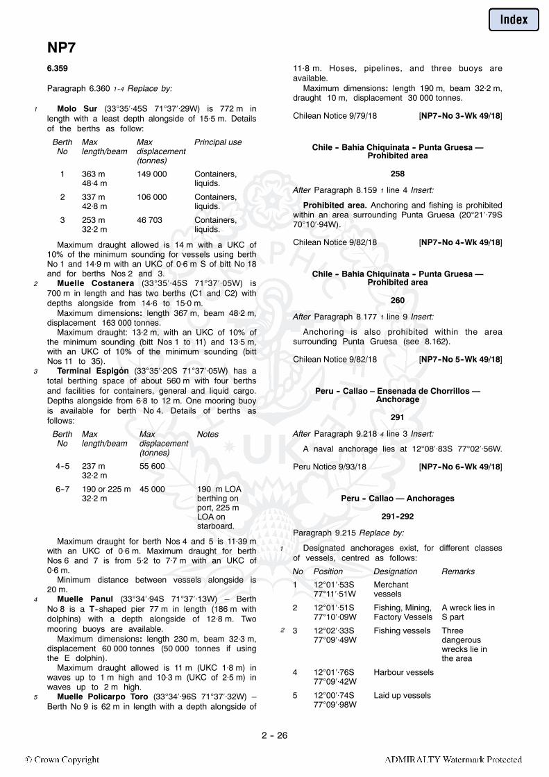
NP7
2 -- 26
6.359
Paragraph 6.360 1--4 Replace by:
1 Molo Sur (333545S 713729W) is 772 m inlength with a least depth alongside of 155 m. Detailsof the berths as follow:
BerthNo
Maxlength/beam
Maxdisplacement(tonnes)
Principal use
1 363 m484 m
149 000 Containers,liquids.
2 337 m428 m
106 000 Containers,liquids.
3 253 m322 m
46 703 Containers,liquids.
Maximum draught allowed is 14 m with a UKC of10% of the minimum sounding for vessels using berthNo 1 and 149 m with an UKC of 06 m S of bitt No 18and for berths Nos 2 and 3.
2 Muelle Costanera (333545S 713705W) is700 m in length and has two berths (C1 and C2) withdepths alongside from 146 to 150 m.
Maximum dimensions: length 367 m, beam 482 m,displacement 163 000 tonnes.
Maximum draught: 132 m, with an UKC of 10% ofthe minimum sounding (bitt Nos 1 to 11) and 135 m,with an UKC of 10% of the minimum sounding (bittNos 11 to 35).
3 Terminal Espigón (333520S 713705W) has atotal berthing space of about 560 m with four berthsand facilities for containers, general and liquid cargo.Depths alongside from 68 to 12 m. One mooring buoyis available for berth No 4. Details of berths asfollows:
BerthNo
Maxlength/beam
Maxdisplacement(tonnes)
Notes
4--5 237 m322 m
55 600
6--7 190 or 225 m322 m
45 000 190 m LOAberthing onport, 225 mLOA onstarboard.
Maximum draught for berth Nos 4 and 5 is 1139 mwith an UKC of 06 m. Maximum draught for berthNos 6 and 7 is from 52 to 77 m with an UKC of06 m.
Minimum distance between vessels alongside is20 m.
4 Muelle Panul (333494S 713713W) – BerthNo 8 is a T--shaped pier 77 m in length (186 m withdolphins) with a depth alongside of 128 m. Twomooring buoys are available.
Maximum dimensions: length 230 m, beam 323 m,displacement 60 000 tonnes (50 000 tonnes if usingthe E dolphin).
Maximum draught allowed is 11 m (UKC 18 m) inwaves up to 1 m high and 103 m (UKC of 25 m) inwaves up to 2 m high.
5 Muelle Policarpo Toro (333496S 713732W) –Berth No 9 is 62 m in length with a depth alongside of
118 m. Hoses, pipelines, and three buoys areavailable.
Maximum dimensions: length 190 m, beam 322 m,draught 10 m, displacement 30 000 tonnes.
Chilean Notice 9/79/18 [NP7--No 3--Wk 49/18]
Chile -- Bahia Chiquinata -- Punta Gruesa —Prohibited area
258
After Paragraph 8.159 1 line 4 Insert:
Prohibited area. Anchoring and fishing is prohibitedwithin an area surrounding Punta Gruesa (202179S701094W).
Chilean Notice 9/82/18 [NP7--No 4--Wk 49/18]
Chile -- Bahia Chiquinata -- Punta Gruesa —Prohibited area
260
After Paragraph 8.177 1 line 9 Insert:
Anchoring is also prohibited within the areasurrounding Punta Gruesa (see 8.162).
Chilean Notice 9/82/18 [NP7--No 5--Wk 49/18]
Peru -- Callao – Ensenada de Chorrillos —Anchorage
291
After Paragraph 9.218 4 line 3 Insert:
A naval anchorage lies at 120883S 770256W.
Peru Notice 9/93/18 [NP7--No 6--Wk 49/18]
Peru -- Callao — Anchorages
291--292
Paragraph 9.215 Replace by:
1 Designated anchorages exist, for different classesof vessels, centred as follows:
No Position Designation Remarks
1 120153S771151W
Merchantvessels
2 120151S771009W
Fishing, Mining,Factory Vessels
A wreck lies inS part
2 3 120233S770949W
Fishing vessels Threedangerouswrecks lie inthe area
4 120176S770942W
Harbour vessels
5 120074S770998W
Laid up vessels

NP7
2 -- 27
No Position Designation Remarks3 6A 115949S
770867WFishing vessels A submarine
pipleine is laidon the Sborder
6B 120018S770912W
Fishing vessels
4 7 115948S771060W
Nuclearpoweredvessels and anyvessel carryingor holdingradioactivematerial
5 8 120057S771132W
Tankers Oil andGas andhazardouscargoes
A strandedwreck,surrounded bya restrictedarea radius165 m markedby an isolateddanger buoy,and adangerouswreck lie in theE part
6 9 120210S771090W
Pilot waitingarea
10 120100S770890W
Vesselsawaitingdisposal
11 115948S771207W
Security,Provisioningand Quarantine
7 12 120124S771292W
Fuel loading/unloading andlightening
A dangerouswreck lies nearthe centre ofthe area
A 120391S770995W
Yacht Club
B 120375S770996W
RecreationalVessels
8 C 120384S770982W
La Punta YachtClub
A 120373S770973W
Marine School
B 120365S770950W
HydrographicVessels
Three wrecksand twomooring buoyslie in the area
9 A 120328S770929W
Fishing Vessels
B 120340S770922W
HarbourVessels
C 120349S770918W
Tour Vessels
D 120377S770927W
Small Craft
Peru Notice 9/82/18 [NP7--No 7--Wk 49/18]
Peru – Puerto Chancay — Anchorages
299
After Paragraph 10.28 1 line 4 Insert:
Outer Anchorages exist for different classes ofvessel in designated anchorages as follows:
Merchant vessels (113437S 771737W) indepths of about 20 m,
2 Vessels awaiting a Pilot (113445S 771696W)in depths of about 16 m,
Small craft and fishing vessels over 30 gt(113430S 771689W) in depths of 12 to 15 m,
Small craft and fishing vessels under 30 gt(113500S 771642W) in depths of about 5 m.
3 The merchant vessel and the vessels awaiting aPilot anchorages lie close to the prohibited anchoragearea below.
Peru Notice 9/77/18 [NP7--No 8--Wk 49/18]
Peru – Puerto Chancay — Berths
300
Paragraph 10.31 1 line 9 Replace by:
The pier is damaged and is no longer in use.
Peru Notice 9/76/18 [NP7--No 9--Wk 49/18]
Peru -- Puerto Huacho — Outer anchorage
300
Paragraph 10.35 1 lines 1--6 Replace by:
1 Outer anchorage may be obtained, in an areacentred on 110651S 773775W, in depths of 16 to18 m. Vessels awaiting a pilot may anchor in an areacentred on 110691S 773719W.
Peruvian Notice 8/59/18 and 8/60/18[NP7--No 10--Wk 51/18]
Ecuador – Manta — Directions; light
341
After Paragraph 11.151 3 line 3 Insert:
Punta Jome Light (white round concrete tower, blackdiagonal stripes, 7 m in height) (05745S804973W).
ENC EC300104/18 [NP7--No 11--Wk 51/18]
Ecuador – Manta — Directions; Light
342
Paragraph 11.152 6 lines 4--5 Replace by:
...Punta Jome Light (11.151) is...
ENC EC300104/18 [NP7--No 12--Wk 51/18]
Ecuador – Manta — Directions; Light
343
After Paragraph 11.168 1 line 8 Insert:
Punta Jome Light (05745S 804973W) (11.151).
ENC EC300104/18 [NP7--No 13--Wk 51/18]

NP7
2 -- 28
Ecuador – Manta — Directions; Light
343
After Paragraph 11.179 1 line 3 Insert:
Punta Jome Light (05745S 804973W) (11.151).
ENC EC300104/18 [NP7--No 14--Wk 51/18]
NP7A South America Pilot Volume 4(2018 Edition)
Venezuela -- Boca Grande -- South Channel —Light buoy
93
Paragraph 3.3 1 line 4 Replace by:
...New Barima Channel, starting within the precautionaryarea (85565N 601200W); the pilot boards byhelicopter.
Paragraph 3.3 2 line 9 Replace by:
...least 1 mile seaward of the precautionary area or ‘EO’Light...
Paragraph 3.3 3 lines 4--5 Replace by:
...(3.19), on VHF Channel 16 of the time of entering theprecautionary area and of the ETA off the pilot station,giving...
ENC VE400701/18 [NP7A--No 1--Wk 51/18]
Venezuela -- Boca Grande -- South Channel —Light buoy
94
Paragraph 3.10 1 lines 1--3 Replace by:
1 Punta Barima (83566N 602546W) 52 27
ENC VE400701/18 [NP7A--No 2--Wk 51/18]
Venezuela -- Boca Grande -- South Channel —Light buoy; precautionary area
94
Paragraph 3.11 1 lines 4--5 Replace by:
...to the vicinity of the precautionary area (85565N601200W), thence through a dredged channel,...
ENC VE400701/18 [NP7A--No 3--Wk 51/18]
Venezuela -- Boca Grande -- South Channel —Controlling depths
95
Paragraph 3.14 1--2 Replace by:
1 The South Channel is maintained at a depth of98 m (2018). The daily bulletin of authorised draughts,published in Spanish and English by Puerto Ordaz
Port Authority, should be consulted for navigation inRío Orinoco. This maximum draught is subject to thedraught assigned to a vessel on its maximum freshwater loadline. Low river season is December to May.
ENC VE400701/18 [NP7A--No 4--Wk 51/18]
Venezuela -- Boca Grande -- South Channel —Directions; wreck; light buoy
95
Paragraph 3.19 1 lines 1--10 Replace by:
1 From the vicinity of 90600N 600000W, the trackleads SW, passing:
NW of a dangerous wreck (85689N 600791W),position approximate, thence:
NW of Delta del Orinoco Light Buoy (safe water)(85677N 600946W), thence:
Paragraph 3.19 2 line 1 Replace by:
2 The track then leads to the precautionary area andthrough the dredged channel,...
ENC VE400701/18 [NP7A--No 5--Wk 51/18]
Venezuela -- Río Grande -- San Felix —Directions; leading lights
98
Paragraph 3.31 1 lines 3--8 Replace by:
...Puerto de Palúa (3.39) and Puerto Ordaz (3.45).
ENC VE400701/18 [NP7A--No 6--Wk 51/18]
Venezuela -- Río Orinoco — Anchorages
98
Paragraph 3.33 1 including heading Replace by:
Punta Ibacuajarina3.33
1 Anchorage can be obtained within an area centredon 83635N 604557W, 2¼ miles W of PuntaIbacuajarina (3.27).
Isla Pagayos3.33a
1 Anchorage may be obtained within a designatedarea centred on 82982N 610496W, 4½ milesWSW of Isla Pagayos (3.27). Depths from 17 to 21 m.
Isla Portuguesa3.33b
1 Anchorage may be obtained within a designatedarea centred on 83626N 614460W, 3 miles E ofIsla Portuguesa (3.28). Depths from 21 to 27 m.
ENC VE400707;VE400710;VE400715;VE400718/18[NP7A--No 7--Wk 51/18]
Venezuela -- Río Orinoco -- Punta de Piedra —Anchorage
98
Paragraph 3.34 1 Replace by:
1 Anchorage can be obtained within an area(83578N 621494W) near the NW bank of the river,

NP7A
2 -- 29
1 mile NNE of Punta Cabrian (83480N 621548W),in depths of 10 to 30 m.
ENC VE400719/18 [NP7A--No 8--Wk 51/18]
Venezuela -- Río Orinoco -- Los Castillos —Anchorage
98
Paragraph 3.35 1 Replace by:
1 Anchorage can be obtained within an area(83160N 622305W) near the SE bank of the river1½ miles NE of Los Castillos (3.29) in depths of 12 to26 m.
ENC VE400720/18 [NP7A--No 9--Wk 51/18]
Venezuela -- Río Orinoco -- San Félix —Anchorages
98
Paragraph 3.36 1 Replace by:
1 Anchorage can be obtained within two areascentred on 82435N 623860W and 82343N623935W, about 5 miles SW of Punta Aramaya(3.29). Vessels anchor here if waiting to berthalongside at San Félix (3.38), Puerto de Palúa (3.39)or Puerto Ordaz (3.45).
ENC VE400723/18 [NP7A--No 10--Wk 51/18]
Venezuela -- Río Orinoco -- San Félix —Directions; leading light
98
Paragraph 3.39 2 Replace by:
2 Directions for entering harbour. The terminal isaccessed via the channel described at 3.31. Anapproach channel then leads S off the main channelto the berth; a light (green post) (82190N624160W) is exhibited from the loading wharf.
ENC VE400723/18 [NP7A--No 11--Wk 51/18]
Venezuela -- Río Orinoco -- Puerto Matanzas —Anchorage
99
Paragraph 3.51 1 lines 1--3 Replace by:
1 Anchorage. Vessels awaiting a berth may anchorin a designated area (81995N 624842W) N ofPunta Cuchillo (3.30), or in a designated area(81695N 625166W) W of the berth.
ENC VE400724/18 [NP7A--No 12--Wk 51/18]
Venezuela – Bahía de Amuay — Anchorage
221
Paragraph 8.32 2 lines 1--4 Replace by:
2 Stores anchorage. Anchorage D (114320N701535W), SW of Punta Adaro, is available forvessels taking on provisions, lubricating oils and freshwater.
Caution. Submarine cables lie within Anchorage Dand the adjacent area.
Venezuelan Notice 49/18 [NP7A--No 13--Wk 51/18]
Colombia -- North coast -- Puerto Barranquilla --Terminal Maritimo — Directions; leading lights
252
Paragraph 9.91 1--3 Replace by:
1 From the position 2¾ cables NNW of E6 front light(9.90), the track leads SE for 1¼ miles, on the line ofbearing (3222), astern, of E4 Directional Light(orange framework tower with white bands)(110422N 745081W), and in the white sector(1415--1425), ahead, of E18 Light (white frameworktower with red bands) (110259N 744953W).
2 Thence the channel continues in the white sector(3020--3025), astern, of E14 Light (white rectangle,red stripe, on white framework tower) (110337N745044W) and in the white sector (1215--1225),ahead, of E7 Light (metal framework tower)(110061N 744601W), to a posit ionabout 4¼ cables WNW of E7 Light, passing:
SSW of anchorages 1, 2 and 3 (9.92), and:SSW of Isla 1972 (110190N 744750W).
The track then leads SE, SSE and S, for a farther3 miles, through a channel, marked by light buoys(lateral), to Terminal Maritimo on the W bank of theriver.
Colombian Notice 225/18; ENC CO500253[NP7A--No 14--Wk 51/18]
Panama – Bahía de San Cristobal toBahía de Portobelo — Marine reserve
277
After Paragraph 10.49 3 line 5 Insert:
Marine nature reserve10.49a
1 A marine nature reserve is established (2018)between the W side of Bahía de San Cristobal(93683N 792980W) and 1½ miles SSW of Bahíade Portobelo (10.52), extending 2½ miles seawardfrom the shoreline. Large vessels are forbidden fromanchoring anywhere within the charted marine naturereserve. The following activities are also prohibited:
2 Fishing, including by trawls, trammel nets orspear fishing;
Anchoring of small vessels and pleasure craft in thevicinity of coral reefs;
Discharge of waste in any form.The removal of any natural material from the
marine nature reserve is strictly forbidden.
Panamanian Maritime Authority[NP7A--No 15--Wk 51/18]
NP7A
2 -- 30
Panama – Bahía de Portobelo — Marine reserve
278
Paragraph 10.52 1 lines 4--7 Replace by:
...is a minor harbour. Anchoring in the bay is prohibited forlarger vessels due to themarine nature reserve restrictions(see 10.49a), however it will afford sheltered anchorage forvessels of any draught in an emergency. The port is of littlecommercial importance.
Panamanian Maritime Authority[NP7A--No 16--Wk 51/18]
Panama -- Panama Canal -- Gatún Lake —Anchorage
297
Paragraph 11.93 1 lines 12--17 Replace by:
Peña Blanca Anchorage (91258N 795598W),the limits of which are marked by light buoys (special),lies to the W of Gatun Reach (11.86) and SSW ofPeña Blanca Reach (11.88). Depths are from 18 to24 m. An obstruction (91422N 795588W) lies inthe NW of the anchorage.
Panama Chart CP--02 [NP7A--No 17--Wk 52/18]
NP8 Pacific Coasts of Central America andUnited States Pilot (2016 Edition)
Mexico — Regulations; protected areas
6
Paragraph 1.42 1--2 Replace by:
1 Extensive areas of coastline, including manyoffshore islands and sea areas, lie within protectedareas. These areas may include national parks,marine reserves, nature and ecological reserves andEnvironmentally Sensitive Sea Areas (ESSA). Many ofthe islands and coastal areas within the Golfo deCalifornia (6.1) are included in the UNESCO Islandsand Protected Areas of the Gulf of California WorldHeritage Site. Within any of these areas some or allof the following may be restricted or prohibited:
2 Navigation or entry;Anchoring;Fishing or trawling;Diving;Collection or disturbance of flora and fauna, on bothland and sea;
The discharge or dumping of hydrocarbons, oilderivatives and refuse;
Construction, industrial or mineral exploration ordevelopment.
Mexican ENC MX208083 [NP8--No 38--Wk 33/18]
Mexico — National regulations
6
After Paragraph 1.42 2 line 10 Insert:
Marine exploitation safety zones1.42a
1 Entry is prohibited within 500 m from the outer rim,around wells, platforms and other facilities for theexploitation of hydrocarbons.
Anchoring of vessels carrying out activities notrelated to the exploitation of hydrocarbons isprohibited within 2500 m from the above installations.
ENC MX408323 [NP8--No 60--Wk 42/18]
Mexico -- Islas Revillagigedo — Regulations
75
Paragraph 2.24 1 lines 1--5 Replace by:
1 The islands and surrounding area are a ProtectedNatural Area and National Park. All vessels require apermit to visit the islands.
The area is bounded by the following positions:200052N 1152829W;200052N 1100469W;173931N 1100469W;173931N 1152829W.
Mexican Notice 12/63/17 [NP8--No 25--Wk 05/18]
Mexico -- West coast -- Islas Revillagigedo —Protected area
75
Paragraph 2.24 1 lines 1--5 including existing Section IVNotice Week 05/18 Replace by:
1 The islands and surrounding area are a ProtectedNatural Area and National Park. All vessels require apermit to visit the islands.
The area is bounded by the following positions:200052N 1152829W;200052N 1100469W;173931N 1100469W;173931N 1152829W.
2 In addition, an ecological reserve in whichdischarge is prohibited further extends beyond theProtected Natural Area boundary.
Mexican ENC MX208084; MX208085[NP8--No 39--Wk 33/18]
Mexico -- West coast -- Rocas Alijos —Protected area
77
After Paragraph 2.37 2 line 3 Insert:
Protected area. Rocas Alijos lie within a naturereserve where fishing and discharging are prohibited.
Mexican ENC MX208082 [NP8--No 40--Wk 33/18]

NP8
2 -- 31
Mexico -- West coast -- Isla de Guadalupe —Protected area
77
After Paragraph 2.38 3 line 9 Insert:
Protected area. The island and adjacent waters liewithin a nature reserve where fishing is prohibited.
Mexican ENC MX208082 [NP8--No 41--Wk 33/18]
Panama -- South--west coast -- Isla de Coiba —Traffic regulations
85
Paragraph 3.5 including heading Replace by:
Traffic regulations3.5
1 Traffic separation scheme. A TSS is establishedS of Isla Jicarita (3.10). The scheme comprises onepair of traffic lanes running E/W for about 5 miles. AnITZ exists from the N edge of the TSS to the coast,encompassing Isla Jicarita, Isla Jicaron (3.10), Isla deCoiba (3.16) and Islas Secas (3.39).
This TSS is IMO--adopted and Rule 10 of theInternational Regulations for Preventing Collisions atSea (1972) applies.
2 Marine Protected Area. Coiba National Park andMarine Protected Area includes the islands and watersof Isla de Coiba (3.16), Islas Jicarita and Jicaron(3.10), Isla Montuosa (3.10), the islands and islets ofCanal de Afuera (3.18) and Islas Contreras (3.38).The park is identified as a UNESCO World heritageSite and is accessible by permit only.
BA Chart 1020 [NP8--No 29--Wk 23/18]
Panama -- Canal de Jicaron — Anchorages
86
Paragraph 3.14 including heading Replace by:
Anchorages and harbours
Anchorages3.14
1 Anchorage, with good holding, can be obtained in18 to 22 m, mud, 1 mile NW of Punta David (3.13).
Anchorage has been obtained 5 cables N of IslaMontuosa (3.10); see also 3.5.
BA Chart 1020 [NP8--No 30--Wk 23/18]
Panama -- South--west coast --Isla de Coiba — Caution
89
Paragraph 3.32 1 Replace by:
1 Isla de Coiba (3.16) anchorages are situated withina national park and Marine Protected Area. See 3.5for details and restrictions.
BA Chart 1020 [NP8--No 31--Wk 23/18]
Costa Rica -- South--west coast -- Golfo Dulce —Traffic regulations
96
After Paragraph 3.78 1 line 5 Insert:
Traffic regulations3.78a
1 Restricted areas. An ATBA is established on the Eside of the entrance to Golfo Dulce for all vesselscarrying dangerous or toxic cargoes, or any othervessel exceeding 500 gt. The ATBA lies betweenPunta Platanal (3.74) and Punta Coto (3.81),enclosing Bahía Pavón (3.88).
2 A second ATBA is situated on the W side of theentrance to Golfo Dulce for all vessels carryingdangerous or toxic cargoes, or any other vesselexceeding 900 gt. This ATBA lies between PuntaArenitas (3.80) and Cabo Matapalo (3.74), andcontinues along the coast of Peninsula de Osa. See3.93a.
3 The purpose of the ATBAs is to avoid risk ofpollution and damage to the environment and toreduce possible collisions with Humpback Whales.
A corridor, 2 miles wide, leads between these twoATBA into Golfo Dulce.
BA Chart 1020 [NP8--No 32--Wk 23/18]
Costa Rica -- Puerto Golfito — Anchorages
97
Paragraph 3.88 1 line 4 Replace by:
...SW Winds. See regulations at 3.78a.
Paragraph 3.89 1 line 7 Replace by:
...less than 27 m. The anchorage SE of the point is subjectto regulations; see 3.78a.
BA Chart 1020 [NP8--No 33--Wk 23/18]
Costa Rica – Peninsula de Osa —Traffic regulations; ATBA
98
After Paragraph 3.93 2 line 6 Insert:
Traffic regulations3.93a
1 Restricted area. An ATBA, for all vessels of900 grt and greater, is established around Peninsulade Osa (3.93). The area extends up to 10 miles fromthe coast, from Punta Arenitas (3.80), around thepeninsula to Punta Violin (3.100) and encompassesIsla del Caño (3.99).
IMO [NP8--No 22--Wk 01/18]
Costa Rica -- Isla del Caño — Anchorage
99
Paragraph 3.101 1 line 2 Replace by:
...(3.99) in not less than 27 m. See regulations at 3.78a.
BA Chart 1020 [NP8--No 34--Wk 23/18]

NP8
2 -- 32
Costa Rica -- Golfo de Nicoya — TSS
100
After Paragraph 3.112 1 line 7 Insert:
Traffic separation scheme3.112a
1 A TSS has been established at the entrance toGolfo de Nicoya (3.109). The scheme applies tomerchant vessels of 900 gt and over. The TSS beginsW of Punta Conejo (3.115) and ends E of Sail Rock(3.115).
2 The TSS is not IMO--adopted but is implementedby Costa Rican decree and the principles for the useof the routeing system defined in Rule 10 of theInternational Regulations for Preventing Collisions atSea (1972) apply.
Coastal navigation areas lie to the E and W of theTSS.
Costa Rican Decree/2018 [NP8--No 36--Wk 27/18]
Costa Rica -- Puerto Caldera — Berths; depths
103
Paragraph 3.125 1 Replace by:
1 Alongside. The berths from W to E are:No 1: length 210 m, depth alongside 101 m.No 2: length 150 m, depth alongside 96 m.No 3: length 190 m, depth alongside 7.1 m.No 4: length 220 m, depth alongside 124 m.
BA Chart 2497 Ed 2/18 [NP8--No 35--Wk 27/18]
El Salvador -- Acajutla —Outer anchorage; wreck
130
Paragraph 4.138 1 line 6For 133538N 875083WRead133538N 895083W
MV Paz Navigator [NP8--No 24--Wk 05/18]
Guatemala -- Puerto Quetzal — Berths; depths
134
Paragraph 4.161 1 lines 3--5 Replace by:
...there are 16 berths designated A--O, in 22 m to31 m. Although exposed to a considerable swell theholding is reported to be moderately good.
A disused cable passes through anchorages A andE.
US Chart 21483 [NP8--No 21--Wk 01/18]
Guatemala -- Puerto Quetzal —Directions; berths
135
After Paragraph 4.164 1 line 15 Insert:
From a position close N of Recalada Light Buoy(135442N 904586W) the alignment (295) of theselights on the W entrance point of the harbour leadsmidway between the breakwaters to the entrance,passing:
SSW of a dangerous wreck (135500N904670W), position approximate, lying ESE oftheE breakwater head andmarked by a light buoy(isolated danger) moored close W, thence:
SSW of an obstruction (135506N 904708W),depth 115 m, SSW of the E breakwater head.
Paragraph 4.166 3 line 11 Replace by:
...basin, least charted depth alongside 48 m. A number ofobstructions lie in the SW corner of the W basin, depthsfrom 43 to 51 m.
Correspondence IALA WWA; Fleet Survey Team14GTM01 [NP8--No 16--Wk 49/17]
Mexico -- West coast -- Puerto Chiapas — Depths
141
Paragraph5.24 1 line 3For (2009) of 103 mRead (2017) of95 m
After Paragraph 5.24 1 line 4 Insert:
Shoaling due to swell and currents may occur nearthe entrance to the access channel.
Paragraph 5.24 1 line 6 For 69 m (2009) Read 64 m(2017)
ENC MX506341 [NP8--No 19--Wk 52/17]
Mexico -- West coast-- Puerto Chiapas — Berths
142
Paragraph 5.28 Replace by:
1 Muelle Turistico (144244N 922412W); lengthabout 150 m; charted depth alongside 83 m (2017).
Muelle Fiscal (144263N 922410W); length400 m; least charted depth alongside 93 m (2017);vessels usually berth port side--to using the starboardanchor.
Muelle de Pesca (144222N 922383W); threejetties with six berths for vessels up to 85 m in length;depths alongside from 29 to 67 m. A stranded wrecklies alongside the E side of the W jetty.
2 SUMICOL Wharf (close W of Muelle de Pesca);length 50 m; depth alongside 48 m.
Navy Pier (144205N 922387W); length 85 m;depths alongside from 4 to 5 m.
ENC MX606342 [NP8--No 20--Wk 52/17]
Mexico -- Pacific coast -- Salina Cruz --Directions; Leading lights
144
Paragraph 5.49 1 line 2 For 3465 Read 3455
Mexican Notice 03/33/17 [NP8/No.1/Wk.17/17]

NP8
2 -- 33
Mexico -- West Coast -- Lázaro Cárdenas —Directions; TSS
155
Paragraph 5.114 4 lines 7--8 Replace by:
To a position about 3 miles SSE of the entrance toLázaro Cárdenas (5.125) at the start of the port TSS.
Mexican Notice 15/206/18 [NP8--No 56--Wk 38/18]
Mexico -- West Coast -- Lázaro Cárdenas —Anchorage; pilotage; regulations
156--157
Paragraph 5.129 Replace by:
1 Outer anchorage. Depths off the delta are veryirregular, the bottom being of shifting sand and mudfrom the river. Breakers have been reported about2 miles SE and 2½ miles S of Punta Mangrove(5.126).
The designated anchorage area lies S of PuntaMangrove, centred on 175350N 1021150W. Indepths of about 14 to 30 m. In the SW corner of theanchorage area, depths rapidly increase to more than100 m.
2 Pilotage is compulsory for vessels over 500 gt andall foreign vessels, and is available 24 hours; the pilotboards 2 miles SSE of the port entrance, in position175344N 1020904W, or at the anchorage, orfarther offshore on request. See ADMIRALTY List ofRadio Signals Volume 6(7).
Tugs are available and their use is compulsory.3 Traffic regulations. Vessels of more than 230 m
LOA are restricted to daylight movements only.Traffic separation scheme is established in the
approaches to Lázaro Cárdenas. The TSS is notIMO--adopted, but the principles defined in Rule 10 ofthe International Regulations for Preventing Collisionsat Sea (1972) should apply.
Danger area. A triangular area to the E of theentrance, centred on 175549N 1020923W, isconsidered to be dangerous and should be avoided.
Mexican Notice 15/206/18 [NP8--No 57--Wk 38/18]
Mexico -- Lázaro Cárdenas —Harbour; development
158
After Paragraph 5.130 1 line 19 Insert:
Development. Works are in progress (2017) toextend the N and S breakwaters ESE.
Mexican Notice 10/253(P)/2017[NP8--No 15--Wk 48/17]
Mexico -- Lázaro Cárdenas — Port layout
157--158
Paragraph 5.130 including heading and existing Section IVNotice Week 48/17. Replace by:
General layout5.130
1 A channel, about 9 cables in length and dredged toa depth in excess of 16 m, leads NW between twobreakwaters from the port entrance to DarsenaPrincipal. A branch of Río Balsas, which shoalsrapidly, leads NNW from Darsena Principal, and isspanned at its S end by a bascule bridge.
The harbour is formed by basins which lead NEand SW from the Darsena Principal. DarsenaComercial, about 1¼ miles NE of Darsena Principal,leads into the Darsena Norte and Darsena Oriente.
2 Grain and oil cargoes are handled in the NE basin,and steel, general cargo, fertiliser and containercargoes are handled in the SW basin. A coal terminallies on the N side of the entrance channel. Containerterminals have been established in Darsena Norte andits approach channel.
Development5.130a
1 Works are in progress (2017) to extend the N andS breakwaters ESE.
Construction works are in progress (2018) inDarsena Norte and Darsena Oriente.
Hazards5.130b
1 Local traffic. Fishing vessels transit between themouth of Río Balsas NW of the turning basin and theharbour entrance, with peak times early in the morningand late in the evening.
Natural conditions5.130c
1 Local weather. During the rainy season (June toOctober) there are occasional squalls. The prevailingwinds are WNW.
ENC MX551110 [NP8--No 62--Wk 45/18]
Mexico -- West Coast-- Lázaro Cárdenas —Directions; TSS
158
Paragraph 5.132 1--2 Replace by:
1 From a position 3 miles SSE of the entrance toLázaro Cárdenas, the track leads 2¼ miles NNWthrough a TSS (5.129), passing W of the pilotboarding station (5.129).
Entry leading lights:Front light (daymark on metal truncated pyramidaltower, 13 m in height) (175626N 1021114W).
Rear light (similar structure, 18 m in height) (1 cablefrom front light).
The alignment (3024) of these lights, exhibitedfrom the W bank of Río Balsas, leads through theentrance channel, marked by light buoys and lightbeacons (lateral), into the turning basin.
Caution. A cross--current may be experienced atthe harbour entrance.

NP8
2 -- 34
2 Inner leading lights:Front light (metal truncated pyramidal tower)(175716N 1021006W).
Rear light (aluminium truncated pyramidal tower)(1 cable from front light).
The alignment (0329) of these lights, standing onthe shore about 1¼ miles NNE of the turning basin,leads into the NE part of the harbour to the grainterminal and Pemex tanker berths. The channel ismarked by light buoys (lateral).
Mexican Notice 15/206/18 [NP8--No 58--Wk 38/18]
Mexico -- Lázaro Cárdenas —Directions; basins and berths
158
Paragraph 5.132 including existing Section IV NoticeWeek 38/18. Replace by:
1 From a position 3 miles SSE of the entrance toLázaro Cárdenas the track leads 2¼ miles NNWthrough a TSS (5.129), passing W of the pilotboarding station (5.129).
Entry leading lights:Front light (daymark on metal truncated pyramidaltower, 13 m in height) (175626N 1021114W).
2 Rear light (similar structure, 18 m in height)(1 cable from front light).
The alignment (302) of these lights, exhibited fromthe W bank of Río Balsas, leads through the entrancechannel, marked by light buoys (lateral), into DarsenaPrincipal.
Caution. A cross--current may be experienced atthe harbour entrance.
3 Inner leading lights:Front light (metal truncated pyramidal tower, 13 m inheight) (175726N 1020999W).
Rear light (blue metal mast, 6 m in height) (1 cablefrom the front light).
The alignment (033) of the leading lights aboveleads into the NE part of the harbour to DarsenaComercial. The track is also marked by the whitesector (032--034), ahead, of Commercial ChannelLight (blue metal mast, 24 m in height) (175781N1020962W). The channel is marked by light buoys(lateral).
4 Darsena Norte Leading Lights:Front light (grey framework tower, 13 m in height)(175869N 1021025W).
Rear light (white framework tower, 18 m in height)(2 cables from front light).
The alignment (358) of the above leading lightsexhibited from the N bank of Darsena Norte, leadsthrough the approach channel marked by light buoys(lateral).
5 Darsena Oriente. The white sector (071--075) ofthe light (metal pyramidal tower, 15 m in height)(175713N 1020888W) exhibited from the E bankof Darsena Oriente leads into the basin. The channelis marked by light buoys (lateral).
6 Useful marks:Breakwater lights (red (N) and green (S) metaltruncated pyramidal towers) (175557N1020979W and 175535N 1020985W).
Paragraph 5.133 including heading Replace by:
Basins and berths
Alongside berths5.133
1 Coal berth (175583N 1021017W): length411 m, depth alongside 165 m.
Fertiliser Terminal (175575N1021066W): length497 m, depth alongside from 138 to 142 m.
Multipurpose Terminal I and II (175548N1021109W): length 539 m in total, depthalongside 119 to 137 m.
MultipurposeTerminal III (175570N1021087W):length 286 m, depth alongside 123 to 138 m.
2 Metal and Minerals Wharf (175589N1021106W): length 650 m, depths alongsidefrom 155 m.
Grain Terminal (175642N 1021066W): length250 m, depth alongside 137 to 142 m.
Pemex Tanker Berth (175653N 1021037W):length 200 m, depth alongside 117 to 129 m.
Container Terminal I (175731N 1021030W):length 575 m, depth alongside 157 m.
Container Terminal II (175846N 1021035W):length 750 m, depth alongside 179 m.
Bulk Mineral Terminal (175688N 1020946W):length 180 m, depth alongside 16 m.
LPG facilities are available at the Fertiliser Terminaland Pemex berths.
ENC MX551110 [NP8--No 63--Wk 45/18]
Mexico -- Puerto de Láguna de Cuyutlán —Directions; general information
160
Paragraph 5.142 1 Replace by:
1 General information. Puerto de Láguna deCuyutlán (185975N 1041561W), situated ESE ofManzanillo at the W end of Láguna de Cuyutlán,comprises a CBM terminal offshore and a pier fortankers within the lagoon. The terminals are operatedunder the authority of the Administración PortuariaIntegral de Manzanillo (5.158). The terminals supplylocal power plants and neighbouring cities.
2 Directions. From the pilot boarding position in thevicinity of Puerto de Láguna de Cuyutlán LandfallLight Buoy (safe water) (185835N 1041623W), thewhite sector (0225--0235) of Laguna de CuyutlanApproach Directional Light (red metal frameworktower, white bands) (190108N 1041501W) leadsbetween two breakwaters (lit) and continues in thechannel marked by light buoys (lateral) to the harbour.
3 By the day the alignment (023) of an unlit beaconof similar construction with this light structure leadsinto the harbour.
Berths. A CBM berth is centred at 190005N1041672W, WNW of the W breakwater. A tankerberth, 435 m in length with dolphins, is situated withinthe lagoon, for vessels up to 300 m in length andmaximum draught of 12 m.
ENC MX505115 [NP8--No 27--Wk 13/18]

NP8
2 -- 35
Mexico -- Bahía de Manzanillo toCabo Corrientes — Directions; light
165
Paragraph 5.175 4 lines 8--10 Delete
166
Paragraph 5.178 2 line 6 For (5.175) Read (194615N1052086W)
MV UBC Salaverry [NP8/No.2/Wk.46/16]
Mexico -- West coast -- Golfo de California —General information; Protected areas
179
After Paragraph 6.2 3 line 6 Insert:
Protected areas6.2a
1 Numerous national parks, nature reserves, ESSA,and other areas with special restrictions orprohibitions, exist in the waters covered by thischapter. See also 1.42.
Mexican ENC MX208083 [NP8--No 42--Wk 33/18]
Mexico -- West coast -- Golfo de CaliforniaSouthern part -- Offshore route —
Protected areas
180
After Paragraph 6.6 1 line 7 Insert:
Protected areas6.6a
1 An offshore nature reserve in which anchoring,fishing and discharge are prohibited is centred on270200N 1112450W. See also 1.42.
Mexican ENC MX208083 [NP8--No 43--Wk 33/18]
Mexico -- West coast -- Golfo de California --Cabo Falso to Punta Arena — Protected areas
189
After Paragraph 6.68 2 line 4 Insert:
Protected areas6.68a
1 Cabo Pulmo National Park and nature reserve nearLos Frailes (6.69) in which entry and fishing arerestricted, and dredging and discharge prohibited,extends E from the shore to about 1092304Wbetween 232253N and 233003N.
An ESSA is situated in Bahía San Lucas; see 6.73.
Mexican ENC MX208083 [NP8--No 44--Wk 33/18]
Mexico -- West coast -- Golfo de California --Bahía San Lucas — Protected areas
190
After Paragraph 6.73 2 line 4 Insert:
Protected areas. Some of the waters of Bahía SanLucas and its approaches have been designated anEnvironmentally Sensitive Sea Area (ESSA). Fishing isrestricted.
Mexican ENC MX405321 [NP8--No 45--Wk 33/18]
Mexico -- West coast -- Golfo de California --Bahía Frailes — Protected areas
191
Paragraph 6.76 1 line 10For the bay.Read the bay. Entry isrestricted, see 6.68a.
Mexican ENC MX208083 [NP8--No 46--Wk 33/18]
Mexico -- West coast -- Golfo de California --Punta Arena to Bahía de la Paz —
Protected areas
191
After Paragraph 6.79 2 line 12 Insert:
Protected areas6.79a
1 Isla Jacques Cousteau (formerly Isla Cerralvo) is anature reserve, development is restricted.
Isla del Espíritu Santo and Isla la Partida, togetherwith the nearby islets and waters surrounding them,and including a portion of a bank 8 miles NE of Isla laPartida, comprise a nature reserve in which anchoring,fishing, discharging and certain other activities areprohibited.
Mexican ENC MX208083 [NP8--No 47--Wk 33/18]
Mexico -- West coast -- Golfo de California --La Paz — Anchorages
197
Paragraph 6.110 including heading Replace by:
Spare6.110
Paragraph 6.111 including heading Replace by:
Spare6.111
Paragraph 6.112 including heading Replace by:
Spare6.112
Mexican ENC MX208083 [NP8--No 48--Wk 33/18]
Mexico -- West coast -- Golfo de California --Bahía de la Paz to Isla Coronados —
Protected areas
197--198
After Paragraph 6.115 3 line 8 Insert:
Protected areas6.115a
1 The coastal waters from Punta Candeleros to IslaCoronados, including Isla Santa Catalina, Isla

NP8
2 -- 36
Monserrat, Isla Danzante Primero, Isla Carmen andthe S part of Isla Coronados, together with the isletsin the vicinity of these islands, comprise ParqueNacional Bahía de Loreto and a nature reserve wheretrawling, dredging and discharging are prohibited, andfishing and diving are restricted. Other restrictions andprohibitions may apply within certain parts of thereserve.
Mexican ENC MX208083 [NP8--No 49--Wk 33/18]
Mexico -- West coast -- Golfo de California --Isla San Pedro Mátir — Protected areas
207
After Paragraph 6.172 1 line 2 Insert:
Protected areas6.172a
1 Isla San Pedro Mártir (6.173) and the waterssurrounding it lie within a nature reserve in whichfishing and trawling, discharging and construction areprohibited and mineral exploration is restricted.
Mexican ENC MX208081 [NP8--No 50--Wk 33/18]
Mexico -- West coast -- Golfo de California --Northern part -- West side — Protected areas
212
After Paragraph 6.204 1 line 9 Insert:
Protected areas6.204a
1 The waters surrounding Isla San Lorenzo, Isla LasAnimas, Isla Salsipuedes, Isla Raza and Isla Partida,together with the nearby islets, reefs and rocks, liewithin a nature reserve in which fishing, trawling,dredging, mineral exploration and discharging areprohibited.
2 A nature reserve in which anchoring and fishing arerestricted includes the waters of Canal Salsipuedes,Canal de Ballenas, together with Isla Ángel de laGuarda and also the islands and bays off the E coastof Baja California between Punta San Gabriel (6.209)and an unnamed point about 11 miles SE of PuntaBluff (6.232). Anchoring on reefs is prohibited.
3 Fishing is prohibited in a nature reserve situated inthe waters NNW of a line between Punto San Felipe(6.243) and Roca del Toro (6.199).
Mexican ENC MX208081 [NP8--No 51--Wk 33/18]
Mexico -- Golfo de California --Isla Ángel de la Guarda and Puerto Refugio —
Restrictions
215
After Paragraph 6.224 1 line 9 Insert:
Restrictions6.224a
1 Restrictions apply to the anchorages at Isla Ángelde la Guarda and Puerto Refugio. See (6.204a).
Mexican ENC MX208081 [NP8--No 52--Wk 33/18]
Mexico -- Golfo de California --Canal Salsipuedes and Canal de Ballenas —
Protected areas
215
After Paragraph 6.228 2 line 5 Insert:
Restrictions6.228a
1 See 6.204a.
Mexican ENC MX208081 [NP8--No 53--Wk 33/18]
Mexico -- West coast -- Baja California —General Information; protected areas
221
After Paragraph 7.2 2 line 7 Insert:
Protected areas7.2a
1 Extensive areas of the W coast of Baja Californiaare designated as nature reserves where certainrestrictions and prohibitions apply.
Fishing and discharging are prohibited in a reservecomprising the barrier islands of Bahía Almejas (7.20)and Bahía Magdalena Bay (7.19) and extending N toBoca Las Animas (7.44).
2 Fishing is prohibited in a nature reserve extendingalong the coast between an inlet about 9 miles NW ofPunta Santo Domingo (7.52) to Punta Eugenia andcontinuing E to Laguna Guerrero Negro (7.104).
Fishing and discharging are prohibited in a naturereserve surrounding Isla Cedros and Islas San Benito(7.79). This nature reserve also includes fishingprohibition for the following coastal islands andassociated islets and rocks:
3 Isla Adelaida, close W of Punta Santa Rosaliíta(7.101).
Isla San Jerónimo (7.111).Isla San Martín (7.123).Islas de Todos Santos (7.137).Islas Coronados (7.159).
Mexican ENC MX208082; MX208080[NP8--No 54--Wk 33/18]
Mexico -- Bahía de Todos Santos --Ensenada — Pilotage
242
Paragraph 7.149 1 line 3 For 1½ miles Read 2¾ miles
Mexican Charts 111.5 and 111.6[NP8--No 28--Wk 15/18]
Mexico – Bahía De Todos Santos –Ensenada — Development
242
After Paragraph 7.150 1 line 13 Insert:
Development. The W breakwater is being extended(2017) to the SSW by 400 m; light buoys mark theextent of the construction.

NP8
2 -- 37
243
Paragraph 7.151 2 lines 5--7 Delete
Mexican Notice 12/399/16 [NP8/No.3/Wk.06/17]
Mexico -- Energia Costa Azul LNG Terminal —Directions; light alignment
245
Paragraph 7.167 1 line 4 For 330 Read 334
Paragraph 7.167 1 line 5 For 103 Read 102
ENC MX501118 [NP8--No 26--Wk 11/18]
Mexico -- West Coast -- Rosarito —Directions; wreck
246
Paragraph 7.172 1 line 5 Replace by:
...to 072 for about 6 miles to the offshore berths, keepingclear of a stranded wreck (322040N 1170970W). A...
BA Chart 1049 [NP8--No 55--Wk 37/18]
United States – San Diego Bay –Entrance channel —
Directions; dangerous wreck
254
After Paragraph 8.32 1 line 7 Insert:
Caution. A dangerous wreck (323962N1171365W), position approximate, has been reportedwithin the entrance channel, close W of the 353 lead.
US NOAA notice 06/18765/2017 [NP8/No.4/Wk.10/17]
USA -- California -- Long Beach Harbor --Back Channel — Vertical clearance; bridges
268
Paragraph 8.120 1 lines 3--4 Replace by:
...457 m (150 ft), which spans Back Channel betweenMiddle Harbor and Inner Harbor.
Two additional bridges are under construction(2018) close N.
American ENC US5CA62M [NP8--No 37--Wk 31/18]
United States of America -- California --Long Beach Harbor -- Back Channel —
Vertical clearance; bridges
268
Paragraph 8.120 1 line 1--4 including existing Section IVNotice Week 31/18 Replace by:
1 Gerald Desmond Bridge (334587N 1181327W)is a fixed span bridge with a vertical clearance of
472 m (155 ft), which spans Back Channel betweenMiddle Harbor and Inner Harbor.
Two additional bridges are under construction(2018) close N.
Correspondence NOAA [NP8--No 61--Wk 45/18]
United States -- Port Hueneme —Controlling depths
287
Paragraph 8.238 2 lines 1--4 Replace by:
2 Controlling depths:Entrance channel 42 m (14 ft) (2017);Entrance basin 39 m (13 ft) (2017);Inner basin 30 m (10 ft) (2015).
The national chart should be consulted for thelatest controlling depths.
US Notice 41/18725/17 [NP8/No.12/Wk.45/17]
United States of America -- California --Channel Islands Harbor — Depths
287
Paragraph 8.238 2 lines 1--4, including existing Section IVNotice Week 45 Replace by:
2 Controlling depths:Entrance channel 48 m (16 ft) (2017);Entrance basin 39 m (13 ft) (2017);Inner basin 27 m (9 ft) (2017).
The national chart should be consulted for thelatest controlling depths.
United States Notice 46/18724/2017[NP8--No 18--Wk 50/17]
United States of America -- California --Channel Islands Harbor — Depths
287
Paragraph 8.238 2 lines 1--4, including existing Section IVNotice Week 50/17 Replace by:
2 Controlling depths:Entrance channel 32 m (10½ ft) (2018);Entrance basin 35 m (11½ ft) (2018);Inner basin 27 m (9 ft) (2017).
The national chart should be consulted for thelatest controlling depths.
United States Notice 36/18724/18[NP8--No 59--Wk 40/18]
United States of America – San Francisco Bay –Yerba Buena Island — Wreck
331
Paragraph 10.88 1 line 9 Replace by:
...is located on the E side of the island. A dangerous wreck(374850N 1222120W), position approximate, lies E ofthe island.
US Notice 16/18650/17 [NP8/No.11/Wk.29/17]
NP8
2 -- 38
United States of America – San Francisco Bay –Hunters Point to Coyote Creek — Directions;San Bruno Shoal Channel depth and width.
335
Paragraph 10.122 1 lines 4--5 Replace by:
...dredged to a depth of 82 m (27 ft) over a widthof 152 m (500 ft) (2016). The channel, which isentered...
US Notice 41/18651/16 [NP8/No.5/Wk.46/16]
United States of America -- San Francisco --San Pablo Bay — Directions; submerged piles
342
After Paragraph 10.176 4 line 2 Insert:
NNW of submerged piles which lie about 5 cablesNW of Davis Point, thence:
Paragraph 10.176 4 lines 3--4 Replace by:
NNW of the oil terminal (10.182) which lies 3 cablesN of...
US Notice 51/18654/17 [NP8--No 23--Wk 04/18]
United States of America – Pacific Coast –Suisun Bay — Anchorages; wrecks
346
Paragraph 10.215 1 lines 3--7 Replace by:
No 26 (general and Reserve Fleet Anchorage); onthe W side of the bay. Mariners should note thewrecks lying within the anchorage in positions380283N 1220732W and 380378N1220640W.
United States U1 Notice 38/18652/16[NP8/No.6/Wk.46/16]
United States -- California -- Suisun Bay --Antioch — Vertical clearance
347
Paragraph 10.222 1 lines 9--10 Replace by:
...vertical clearance in the main channel is 372 m(122 ft).
US Notice 43/18660/17 [NP8/No.13/Wk.47/17]
United States of America – Port of Sacramento— Vertical clearances
349
Paragraph 10.238 3 lines 9--10 Replace by:
...to Sacramento, is 367 m (1207 ft) in position380399N 1214719W. The minimum clearance overthe river itself is 335 m (110 ft) in position 381757N1213375W.
NOAA Notice 48/18652/16 [NP8/No.7/Wk.51/16]
United States -- California -- Port of Sacramento --Sacramento River — Vertical clearance
349
Paragraph 10.238 3 lines 9--12 including existing SectionIV Notice Week 51/16. Replace by:
...to Sacramento, is 363 m (119 ft) in position380399N 1214719W. The minimum clearance overthe river itself is 335 m (110 ft) in position 381757N1213375W.
US Notice 43/18660/17 [NP8/No.14/Wk.47/17]
United States of America – Coos Bay toYaquina Bay — Directions; major light
386
Paragraph 12.66 1 lines 6--7 Replace by:
...visible from N.
U1 53/18580/16 [NP8/No.8/Wk.05/17]
United States of America – Oregon –Columbia River — Pilotage
400
Paragraph 13.11 1 line 9 Replace by:
...area about 4 to 10 miles NW to SW of CR Light Buoy(13.23) and not...
Columbia River Bar Pilots information dated 21/04/17[NP8/No.9/Wk.21/17]
United States -- Washington -- Columbia River --Chinook — Controlling depth
403
Paragraph 13.27 2 lines 5--6 Replace by:
In 2017 the controlling depth in the channel andbasin was 06 m (2 ft).
US Notice 45/18521/17 [NP8--No 17--Wk 49/17]
United States of America – Washington –Grays Harbor — Berths
421
Paragraph 14.39 2 line 7 For 1235427W Read1235472W
US Chart 18502 [NP8/No.10/Wk.21/17]
NP9 Antarctic Pilot (2014 Edition)
Îles Kerguelen – Baie Norvégienne —Directions; channel
139
Paragraph 2.171 2 lines 1--6 Replace by:
2 Directions. From the vicinity of 492246S703197E a recommended channel leads into the
NP9
2 -- 39
bay. The channel leads generally WSW for about4 miles before opening into the bay and is about130 metres wide, with depths from 148 to 260 m.Unsurveyed areas lie either side of the channel. Localknowledge is recommended.
French Chart 7358/17 [NP9--No 9--Wk 01/18]
British Antarctic Territory –South Orkney Islands – Signy Island —
Directions; light
221
Paragraph 4.42 9 lines 1--7 Replace by:
9 NNE of Berntsen Point (604235S 453550W),the S entrance point to Borge Bay (4.41), thence:
RRS Ernest Shackleton [NP9/No.1/Wk.21/17]
British Antarctic Territory –South Shetland Islands – Clarence Island toLow Island through Bransfield Strait —
Directions
229
Paragraph 4.80 1 lines 4--7 Replace by:
...which rises to a rounded peak off whichoverfallsoccur, thence:
HYDROPAC 4102/15 [NP9/No.2/Wk.01/16]
Antarctica – Hope Bay — Grunden Rock Light
289
Paragraph 5.44 4 lines 7--8 Delete
Navarea VI warning 24/15 [NP9/No.3/Wk.09/15]
Antarctic -- Trinity Peninsula -- Antarctic Soundto Montravel Rock — Directions; shoal
291
After Paragraph 5.60 2 line 3 Insert:
N of a shoal (631098S 573131W), depthunknown and position approximate, over whichbreakers have been reported (2017), thence:
UKHO [NP9/No.4/Wk.13/17]
Orleans Strait -- Mikkelsen Harbour —Directions; shoal
297
After Paragraph 5.89 1 line 9 Insert:
SSE of a 67 m (22 ft) shoal (635570S604547W), position approximate, thence:
Colombian Hydrographic Office 04/17[NP9--No 21--Wk 14/18]
Antarctic Peninsula -- Gerlache Strait --North North West of Useful Island —
Directions; shoal
310
Paragraph 5.147 4 lines 1--3 Replace by:
4 Thence the track continues to lead SW to aposition NW of the NW extremity of foul ground with aleast depth of 11 m (36 ft) (644060S 625490W),...
Argentinian Notice 11/184/2017 [NP9--No 8--Wk 52/17]
Antarctica – Port Lockroy — Bills Island Light
320
Paragraph 5.168 3 lines 1--2 Delete
Navarea VI warning 24/15 [NP9/No.5/Wk.09/15]
Antarctic Peninsula -- Lavoisier Island --Cape Leblond — Directions; position
335
Paragraph 6.14 1 line 6 For 660420S 663500W Read660410S 663420W
BA Chart 450/2017 & ENC GB400450[NP9--No 10--Wk 05/18]
Antarctic Peninsula -- Biscoe Islands --Pendleton Strait — Directions; positions
336
Paragraph 6.18 4 lines 1--8 Replace by:
4 NW of Garde Islands (655145S 662005W),lying 4 miles WNW of Lively Point, the SWextremity of Renaud Island (6.15), thence:
NW of two islets (655400S 663910W), chartedas existence doubtful.
Thence the track continues to lead SW to aposit ion NW of Cape Leblond (660410S663420W), off the W approaches to PendletonStrait.
BA Chart 450 & ENC GB400450[NP9--No 11--Wk 05/18]
Antarctic Peninsula -- Biscoe Islands --Pendleton Strait — Directions; positions
351
Paragraph 6.65 4 line 1 For 655270S 660950W Read655232S 661090W
Paragraph 6.65 4 lines 7--8 For 655270S 660950WRead 655232S 661090W
Paragraph 6.65 5 line 8 For 660300S 661500W Read660210S 661150W
Paragraph 6.65 6 line 2 For 660420S 663500W Read660410S 663420W
BA Chart 450 & ENC GB400450[NP9--No 12--Wk 05/18]
NP9
2 -- 40
Antarctic Peninsula -- Biscoe Islands --Pendleton Strait — Directions; positions
353
Paragraph 6.76 1 lines 1--2 For 660420S 663500WRead 660410S 663420W
Paragraph 6.76 1 lines 4--5 For 660300S 661500WRead 660210S 661150W
Paragraph 6.77 1 lines 2--3 For 655270S 660950WRead 655232S 661090W
Paragraph 6.80 1 lines 1--2 For 660420S 663500WRead 660410S 663420W
Paragraph 6.80 1 line 5 For 660250S 603300W Read660290S 663266W
Paragraph 6.80 1 lines 8--9 Replace by:
SSW of two islets (655400S 663910W) (6.18),existence doubtful, thence:
Clear of an 186 m patch (655731S 663650W),existence doubtful, thence:
Paragraph 6.80 1 lines 12--13 For 660250S 663300WRead 660290S 663266W
Paragraph 6.80 2 line 1 For 660100S 662800W Read660102S 662735W
Paragraph 6.80 2 line 5 For 660300S 661500W Read660210S 661150W
BA Chart 450/2017 & ENC GB400450[NP9--No 13--Wk 05/18]
Antarctic Peninsula -- Biscoe Islands --Lavoisier Island — Directions; positions
355
Paragraph 6.86 1 lines 1--2 For 660420S 663500WRead 660410S 663420W
Paragraph 6.88 1 line 2--3 For 660550S 864650WRead 660535S 664470W
BA Chart 450/2017 [NP9--No 14--Wk 05/18]
Antarctic Peninsula -- Biscoe Islands --Pendleton Strait to Matha Strait —
Directions; positions
356
Paragraph 6.90 2 lines 1--7 Replace by:
2 Track. From a position NW of Cape Leblond(660410S 663420W), off the W entrance toPendleton Strait, the track leads SW, passing:
NW of Newburgh Point (660535S 664470W);rocks and islets extend from 1 to 3 miles W fromthe W coast of Lavoisier Island (6.82). Thence:
Clear of an area centred on (655395S671655W), about 2½ miles in diameter andcharted as shoal water, probable, thence:
Paragraph 6.90 3 lines 1--2 Replace by:
3 NW of Talbott Point, the N point of Dubois Island(661600S 670970W), from which islets,rocks and...
Paragraph 6.90 4 line 2 For 662000S 671200W Read661915S 671100W
Paragraph 6.92 2 line 3 For 663130S 671150W Read663081S 671218W
BA Chart 450/2017 [NP9--No 15--Wk 05/18]
Antarctic Peninsula -- Crystal Sound —Directions; positions
357
Paragraph 6.93 1 line 2 For 660255S 661120W Read660210S 661150W
Paragraph 6.96 3 line 7 For 660420S 663500W Read660410S 663420W
Paragraph 6.98 2 line 1 For 661200S 661150W Read661176S 661038W
Paragraph 6.98 3 line 1 For 660900S 663500W Read660954S 663532W
Paragraph 6.98 4 lines 1--3 Replace by:
4 Clear of a pinnacle (661518S 662882W),with a depth of 58 m (charted as 33 fm onsome charts), position approximate, thence:
Paragraph 6.98 4 line 4 For 661990S 663550W Read661915S 663398W
Paragraph 6.98 5 line 1 For 662250S 663250W Read662210S 663110W
BA Chart 450/2017 [NP9--No 16--Wk 05/18]
Antarctic Peninsula -- Crystal Sound —Directions; positions; depth
358
Paragraph 6.98 6 lines 1--10 Replace by:
6 Clear of a shoal (662090S 664520W), with adepth of 20 m (11 fm). It was reported (2004)that depths less than those charted havebeen found on a shallow ridge with rockpinnacles in the area. Thence:
NW of Wollan Island (662386S 663733W), withice cliffs except off the NW side, where there is alarge rock outcrop, thence:
7 NW of a shoal (662230S 664270W), with adepth of 36 m (19 fm).
Thence the track continues to lead SW to aposition SE of Gagge Point (661983S 665295W),the S extremity of Lavoisier island.

NP9
2 -- 41
Paragraph 6.99 1, 2 and 3 Replace by:
1 From a position SE of Gagge Point (661983S665295W) (6.98), the track continues to lead SW,through Crystal Sound, passing:
2 NW of an obstruction (662404S 664302W),reported (1986), with no identified depth, lying3 miles WNW of Davidson Island (662525S663610W). An island and a small rock lieoff the W end of Davidson Island. Thence:
NW of a rock (662605S 664005W), positionapproximate, lying close NNW of Shull Rocks,comprising a rock and a group of snow--coveredislets forming a chain on the W side of the mainisland, thence:
3 SE of Scholander Island, (662186S665715W) and underwater rocks, lying1¼ mile E of Watkins Island, in the Sentrance to Lewis Sound (6.100), thence:
NW of Dennison Reef (662836S 664964W),reported to be awash, thence:
Paragraph 6.99 4 line 5 For 662570S 670730W Read662480S 670440W
Paragraph 6.99 4 lines 6--7 For 662840S 670830WRead 662800S 670970W
Paragraph 6.99 5 line 5 Replace by:
...mostly on the W and S sides of it. An isolatedislet lies 5½ cables N. The main...
Paragraph 6.99 6 lines 1--2 Replace by:
6 SE of a shoal (663081S 671218W), with adepth of 32 m (18 fm), thence:
Paragraph 6.100 1 line 2 For 662040S 665350WRead661983S 665295W
Paragraph 6.100 1 line 3 For 662250S 665800WRead662186S 665715W
Paragraph 6.101 1 and 2 Replace by:
1 Landings can be effected in the following locations:Foote Islands (661176S 661038W), at the N endof the main island.
Levy Island (661915S663398W), opposite a lowrock on the NE side.
Bernal Islands (662162S 662627W), on the Npoint of the SE--most island.
2 Wollan Island (662386S 663733W), on smalloutcrops of rocks at the N extremity.
Barcroft Islands (662700S 670600W), on the Nside of most of the group.
Pauling Islands (663162S 665654W), on the NEpoint of the main island.
BA Chart 450/2017 & ENC GB400450[NP9--No 17--Wk 05/18]
Antarctic Peninsula -- Crystal Sound —Directions; positions
359
Paragraph 6.108 4 line 1 For 662250S 662650WRead662162S 662627W
Paragraph 6.108 4 lines 3--6 Replace by:
WNW of dangerous rocks (662550S 661275W)(662580S 661450W on chart 3570), thence:
WNW of Nakaya Islands (662666S 661280W)(662720S 661450W on chart 3570).Numerous dangerous rocks lie within 1 mile of theislands. Thence:
Paragraph 6.108 5 line 1 Replace by:
5 ESE of Fowler Islands (662430S 662440W)(662480S 662600W on chart 3570),...
BA Chart 450/2017 & ENC GB400450[NP9--No 18--Wk 05/18]
Antarctic Peninsula -- Crystal Sound --Bragg Islands — Directions; positions
360
Paragraph 6.108 6 lines 1--2 Replace by:
6 ESE of a low rock and an islet (662634S662690W) (662680S 662850W on chart 3570),lying about 1¾ miles NNW of...
Paragraph 6.108 7 line 1 Replace by:
7 ESE of Bragg Islands (662830S 662560W)(662850S 662750W on chart 3570), a...
BA Chart 450/2017 & ENC GB400450[NP9--No 19--Wk 05/18]
Antarctic Peninsula -- Crystal Sound --Bragg Islands — Positions
361
Paragraph 6.114 1 lines 1--2 Replace by:
1 Description. On the N side of Rambler Island(662830S 662560W) (662850S 662750W onchart 3570), the largest of the Bragg...
Paragraph 6.115 2 lines 5--6 Replace by:
Fowler Islands (662430S 662440W)(662480S 662600W on chart 3570), on theNW spur of the main snow--domed island.
BA Chart 450/2017 & ENC GB400450[NP9--No 20--Wk 05/18]
Antarctic Peninsula W coast – Liard Island —Directions; rock
371
Paragraph 6.143 4 line 4 Replace by:
...NE entrance point to Langmuir Cove, thence:SE of a rock (665285S 671817W), reported(2017), thence:
MY Hanse Explorer [NP9/No.6/Wk.06/17]
Ross Sea – Scott Island — Position
424
Paragraph 9.24 1 line 1 For (672300S 1795375W)Read (672275S 1795472W)

NP9
2 -- 42
Paragraph 9.25 1 line 2 For (672300S 1795375W)Read (672275S 1795472W)
NGA Chart 29282 [NP9/No.7/Wk.11/17]
NP10 Arctic Pilot Volume 1 (2016 Edition)
Navigation and Regulations -- Russian pilotage— Icebreaker pilotage
8
Paragraph 1.36 1 lines 1--10 Replace by:
1 Icebreaker pilotage is available, on request, for thewhole of the NSR and is obtained through theNorthern Sea Route Administration (NSRA). Forfurther information see ADMIRALTY List of RadioSignals Volume 6(2) and www.nsra.ru.
Russian Notice 28/3752/16 [NP10/No.1/Wk.32/16]
Russia -- Kara Sea -- Ostrov Belyy —Directions; recommended routes
86
Paragraph 2.28 1 lines 4--10 Replace by:
...the recommended track 032.1, as shown on theRussian charts, leads NNE, for about 260 miles, to thevicinity of 733012N 674633E, WNW of Mys Rogozina(732294N 700115E) (9.93), the NW extremity ofOstrov Belyy.
(Directions continue forthe recommended track at 2.32)
Paragraph 2.30 1 lines 4--10 Replace by:
...Karskiye Vorota TSS, the recommended track 0448, asshown on the Russian charts, leads NE, for about233 miles, to the vicinity of 732423N 665933E, W ofMys Rogozina (732294N 700115E) (9.93), the NWextremity of Ostrov Belyy.
(Directions continue forthe recommended track at 2.32)
Paragraph 2.32 1 lines 1--10 Replace by:
1 From the vicinity of 732423N 665933E, W ofMys Rogozina (732294N 700115E) (9.93), the NWextremity of Ostrov Belyy, the recommended deepwater route with a least depth of 165 m as shown onthe Russian charts, leads to position 733637N723565E ENE of Mys Belyy (732867N705043E), from 1½ miles ESE of which BelyySevernyy Light (10.20) is exhibited.
Here the recommended track heads S into ObskayaGuba or N for about 14 miles to position 735000N723318E then E towards Dikson.
Russian Notice 45/5782/2018 [NP10--No 13--Wk 48/18]
Obskaya Guba – Mys Belyy to Mys Drovyanov —Directions; anchorages and harbours
275
Paragraph 10.20 1--7 Replace by:
1 From a position about 24 miles NNE of Mys Belyy(732866N 705052E) (10.45), the recommendedtrack leads SSE, passing:
ENE of Belyy Severnyy Light Beacon (blackframework tower with platform, 21 m in height)(732817N 705582E); a stranded wreck lies2¾ miles farther ESE. Thence:
WSW of an extensive shoal bank (733053N735347E) with a least depth of 40 m.
2 ENE of Mys Shuberta (730941N 714014E)(9.94), the SE extremity of Ostrov Belyy.Shuberta Light (black tetrahedral truncatedpyramid, white band, 13 m in height) standsclose N of this point. Thence:
ENE of Mys Khesalya (725333N 713641E)(9.95), the S entrance point to Proliv Malygina(9.94), thence:
3 WSW of Ostrov Shokal’skogo (730000N742640E), from which Shokal’skogo Light(black vertical rectangle, red bands, mountedon red and black horizontal striped tetrahedraltruncated pyramid, 14 m in height) (730054N740715E) is exhibited; a bank, with a leastcharted depth of 18 m, extends 6 miles WSWfrom the W extremity of the island. Thence:
4 ENE of Mys Poyelovo (10.18). Mys PoyelovoLight (tetrahedral truncated frameworkpyramid, black upper, 15 m in height)(724399N 723808E) is exhibited from NWof the headland and a remarkable hummocklies on the low sandspit which extends E fromit.
5 Thence the track continues SSE following arecommended DW route, to a position 7 miles NE ofMys Drovyanoy (723969N 725750E), the Eextremity of an island separated from PoluostrovYamal by a narrow channel with low ground on eachside. The island is low, with a few small hummocksup to 45 m high and is covered with scanty grass andmoss. Mys Drovyanoy Light (tetrahedral truncatedframework pyramid, black upper and platform, 23 m inheight) (723920N 725663E) is exhibited from SWof the point.
Paragraph 10.22 including heading Replace by:
Spare10.22
Russian Charts 12312, 13329; POLAR L8048[NP10/No.2/Wk.52/16]
Russia -- Kara Sea -- Mys Belyy toMys Drovyanoy —
Directions; recommended route
275
Paragraph 10.20 1--7 including existing Section IV NoticeWeek 52/16. Replace by:
1 From a position about 31 miles ENE of Mys Belyy(732866N 705052E) (10.45), the recommendedtrack leads S, passing:
NP10
2 -- 43
ENE of Belyy Severnyy Light Beacon (blackframework tower with platform, 21 m in height)(732817N 705582E); a stranded wreck lies2¾ miles farther ESE. Thence:
W of an extensive shoal bank (733053N735347E) with a least depth of 40 m.
2 E of Mys Shuberta (730941N 714014E)(9.94), the SE extremity of Ostrov Belyy.Shuberta Light (black tetrahedral truncatedpyramid, white band, 13 m in height) standsclose N of this point. Thence:
ENE of Mys Khesalya (725333N 713641E)(9.95), the S entrance point to Proliv Malygina(9.94), thence:
3 WSW of Ostrov Shokal’skogo (730000N742640E), from which Shokal’skogo Light(black vertical rectangle, red bands, mountedon red and black horizontal striped tetrahedraltruncated pyramid, 14 m in height) (730054N740715E) is exhibited; a bank, with a leastcharted depth of 18 m, extends 6 miles WSWfrom the W extremity of the island. Thence:
4 ENE of Mys Poyelovo (10.18). Mys PoyelovoLight (tetrahedral truncated frameworkpyramid, black upper, 15 m in height)(724399N 723808E) is exhibited from NWof the headland and a remarkable hummocklies on the low sandspit which extends E fromit.
5 Thence the track continues SSE following arecommended DW route, to a position 7 miles NE ofMys Drovyanoy (723969N 725750E), the Eextremity of an island separated from PoluostrovYamal by a narrow channel with low ground on eachside. The island is low, with a few small hummocksup to 45 m high and is covered with scanty grass andmoss. Mys Drovyanoy Light (tetrahedral truncatedframework pyramid, black upper and platform, 23 m inheight) (723920N 725663E) is exhibited from SWof the point.
Russian Notice 45/5782/2018; Russian Charts 12312,13329, POLAR L8048 [NP10--No 14--Wk 48/18]
Mys Drovyanov to Mys Shtormovoy —General information; directions
275
Paragraph 10.23 1 Replace by:
1 From a position E of Mys Drovyanoy (723969N725750E), the route leads along the recommendedtracks and DW route for about 52 miles, to a positionWSW of Mys Shtormovoy (714545N 732726E).
Russian Charts 13329, 13330 [NP10/No.3/Wk.52/16]
276
Paragraph 10.29 1--10 Replace by:
1 From a position 7 miles NE of Mys Drovyanoy(723969N 725750E) (10.20), the DW route leadsinitially SE to a position about 20 miles E of MysYuzhnyy (723298N 725907E), passing:
NE of South No 1 Light (black tetrahedral truncatedframework pyramid, 18 m in height) (723471N725694E), thence:
2 NE of Mys Yuzhnyy the S extremity (723298N725907E) of an island, in the form of anarrow sandspit which dries in places andwhich extends 7 miles S from Mys Drovyanoy.
Thence, from a position about 20 miles E of MysYuzhnyy, the DW route leads about 30 miles SW to aposition 8¾ miles SW of Peschanka Light (721529N725006E), passing:
3 SE of Mys Yuzhnyy, thence:SE of Mys Tye--sale (722923N 725003E), theNE entrance point of Reka Khabey--yaga, thence:
SE of the NE extremity of a bank (722800N734350E), with charted depths of less than10 m.
4 Between shoal patches with depths less than10 m, which are part of a bar which extendsacross the gulf from Mys Drovyanoy to MysShtormovoy.
SE of Drovyanoy trading post and meteorologicalstation (722479N 724591E), reported asstanding on the cliff top; themain building is visiblefrom 10 miles seaward. Thence:
5 SE of Reka Yarra--yaga, the mouth of which ismarked by Peschanka (Yarra--yaga) Light(black tetrahedral framework tower, 15 m inheight) (721529N 725006E); a sandbankobstructs the mouth of the river, extending1½ miles E then 3½ miles N.
Thence the DW route and recommended track leadSSW for about 7 miles, to position 14 miles S ofPeschanka Light. The track then leads S, passing:
6 WNW of Mys Shtormovoy (714545N732726E), which rises to three steep andconspicuous sandy hills; from N it appears asa steep bluff with a low spit extending S fromit. Shtormovoy Light (black trihedral truncatedmetal pyramid, 8 m in height) (714798N733081E) is exhibited from a position NNEof the point. Thence:
7 WNW of a light buoy (W cardinal) (714987N731065E), moored 2 miles W of theshoalest part of a coastal bank, with a leastcharted depth of 64 m, extending N from MysShtormovoy (714545N 732726E), whichcontinues to extend N forming the bar acrossthe gulf.
Thence the recommended track continues S, to aposition WSW of Mys Shtormovoy.
(Directions continue at 10.32)
RussianNotice 50/6764/16, RussianCharts 13329, 13330[NP10/No.3/Wk.52/16]
Mys Shtormovoy to Mys Khonarasalya —Directions
277
Paragraph 10.33 1--6 Replace by:
1 From a position WSW of Mys Shtormovoy(714545N 732726E), the DW route leads SSW,passing:
ESE of the E extremity of a spit (714488N723032E), with an obstruction, with a depth of20 m,marked by a light buoy (E cardinal), thence:

NP10
2 -- 44
ESE of Mys Poludennyy (714203N 721877E)which is low and conspicuous fromS, though fromN or E it merges with the coast, thence:
2 ESE of a shallow flat which fronts the mouth ofReka Tambey delta (713305N 715847E)and extends 2 miles offshore. Reka Tambey,one of the largest rivers in Poluostrov Yamal,has an extensive delta with four branchesextending from 3½ to 14 miles SW of MysPoludennyy, between which are low islandscomposed of swampy tundra. Thence:
WNWof the shoal ground, with a least charted depthof 28 m, extending 3 miles WNW of Mys Taran(10.32), marked by buoys (W cardinal), thence:
3 ESE of Tambey, the administrative centre for theN part of Poluostrov Yamal, from where alight (black vertical rectangle on tetrahedralmetal framework tower with platform, 15 m inheight) (712886N 714887E) is exhibited.The village has a trading post, the buildings ofwhich are visible from the centre of the gulf.
4 Thence the recommended track continues to leadSSW, to a position W of Mys Khonarasalya (10.32),which lies S of the mouth of the broad valley of RekaNgarkakhorteyakha; Mys Khonara--sale Light (trihedraltruncated metal pyramid, 14 m in height) (712270N730243E) is exhibited from a position SSE of thepoint.
(Directions continue at 10.40)
Russian Notice 50/6764/16, Russian Chart 13330[NP10/No.4/Wk.52/16]
Kara Sea -- Obskaya Guba --Port Sabetta — Development
278
Paragraph 10.43 including heading Replace by:
Russian Chart 18331 (datum Pulkovo 1942) (see 1.25)Port Sabetta10.43
1 General information. Port Sabetta (711674N720454E), is situated in the mouth of theSabettayakha River, on the W side of Obskaya Gubaand is the port facility for the Yamal LNG terminals.
Limiting conditions. The least charted depths(2017) in the approach channel is 121 m and in theharbour basin is 98 m.
Arrival information. The port is operational allyear. A tug is available.
2 Harbour. The port consists of a harbour basin(711676N 720520E) with a concrete quayside inthe NW part and a concrete pier lying to the SE.
Development. Work is in progress (2017) to dredgethe approach channel to a reported depth of 151 m.Reclamation work and the construction of the mainLNG terminal berths in the vicinity of 711654N720555E are ongoing, with the first LNG shipmentscheduled for the end of 2017 and full operationalcapacity achieved by 2021.
3 Directions for entering harbour. From a positionW of Mys Khonarasalya (712395N 730034E)(10.32), the track leads SW following a two--way DWroute (2266) to the harbour basin.
Basins and berths. Berths 1--4, with charteddepths ranging from 77 to 106 m, are located on theNW quayside.
Berths 5--6 are located on the concrete pier(711660N 720491E), with charted depths rangingfrom 84 to 116 m. All of the berths are being utilisedfor the construction of the LNG Terminal.
Russian Chart 18331 [NP10/No.5/Wk.12/17]
Kara Sea -- Obskaya Guba — Directions;DW route; landmarks; depths
278--279
Paragraph 10.45 1--7 line Replace by:
1 From a position W of Khaltsyney Light (705020N735623E) (10.40), the DW route leads S, passing(positions relative to Mys Kharse (7007N 7341E)):
E of a shoal patch (43 miles NNW), with a depth of12 m, thence:
E of a shoal patch (22 miles NW), with a depth of44 m, lying on a coastal bank extending 4 miles Eof Mys Belyy (702290N 724236E), which canbe identified by the bright colour of its steep sides.
W of an obstruction area (9¾ miles NNW), with aradius of 1 mile, centred on 701607N733112E.
2 Thence a vessel may either continue S to aposition W of Mys Nalivnoy (694440N 733193E),passing over a shoal bank with a least depth of about10 m, or, for vessels with a deeper draught the trackleads SSE, passing:
WSW of a shallow bank extending 7 miles N of MysKharse, marked on its W side by a buoy (Wcardinal) (5 miles NNW), thence:
3 WSW of the W extremity of a spit extendingfrom Mys Kharse, marked by a buoy (Wcardinal) (2½ miles WNW). A beacon (blacktetrahedral truncated pyramid, white bandsand gallery, 16 m in height) stands on thepoint. Thence:
WSW of Ngabkeyyakha (7½ miles S).Thence the track leads S to a position in the
vicinity of 695100N 733358E. The DW track thenleads SW to a position W of Mys Nalivnoy(694440N 733193E) the W extremity of a lowmarshy plain. A shoal spit, marked by a buoy (Wcardinal) extends 3¼ miles W of the point.
Russian Charts 13332, 13333 [NP10/No.11/Wk.29/17]
Kara Sea -- Obskaya Guba —Directions; DW route; wreck; landmarks
279--280
Paragraph 10.52 1 lines 1--6 Replace by:
1 From a position W of a shoal spit, marked by abuoy (W cardinal), extending 3¼ miles W of MysNalivnoy (694440N 733193E) (10.45), the DWroute leads S, passing (positions relative to MysTryokhbugornyy (690526N 735248E)):
Paragraph 10.52 3 lines 4--7 Replace by:
E of a wreck (692549N 732275E), with a leastdepth of 74 m, marked by a buoy (isolateddanger), thence:
NP10
2 -- 45
Paragraph 10.52 4 lines 1--2 Delete
Paragraph 10.52 6--7 Replace by:
6 The DW route then leads SSE, passing:WSWof a shoal patch (7¼ milesWSW),with a depthof 84 m, thence:
WSWof theSWextremity of a shoal spit, with depthsless than 8 m, extending 7 miles SW from MysTryokhbugornyy, marked a buoy (W cardinal)(5½ miles SW), moored close to its extremity.
7 Thence the recommended track continues to leadSSW, to a position 16¾ miles E of Nurma Light(tetrahedral framework pyramid, black upper, 6 m inheight) (684312N 730516E), exhibited from the Nentrance to Reka Nurma--yaga.
Paragraph 10.53 Replace by:
Spare10.53
RussianNotice 25/3083/17; RussianCharts 13334, 13335[NP10/No.12/Wk.29/17]
Kara Sea – South Part —Aids to navigation; lights
289
After Paragraph 11.2 1 line 4 Insert:
Caution. Many lights and leading lights in this areahave been reported destroyed or unreliable. Localauthorities should be consulted for the latestinformation.
UKHO [NP10/No.6/Wk.04/17]
Reka Yenisey – Mouth of river to Igarka —General information; navigation; lights
311
After Paragraph 12.5 3 line 7 Insert:
Caution. Many lights and leading lights in this areahave been reported destroyed or unreliable. Localauthorities should be consulted for the latestinformation.
UKHO [NP10/No.7/Wk.04/17]
Kara Sea -- Reka Yenisey -- Mys Krestovskiy toDudinka — Pilot boarding positions; anchorages
319
After Paragraph 12.41 1 line 7 Insert:
Pilotage12.41a
1 Pilot boarding positions for S--bound vessels toDudinka are as follows:
1) Approximately 9 cables WNW ofVerkhe--Novoselenskiy Front Leading Light(692839N 860512E).
2) Approximately 7 cables E of the N point of OstrovKabatskiy (692560N 860563E).
2 The pilot boarding position for northbound vesselsto Dudinka is approximately 16 miles NNE ofKabatskiy Front Leading Light (691969N860381E).
322
Paragraph 12.51 1 lines 3--4 Replace by:
Tankers and vessels carrying dangerous cargoes,abreast Verkhne--Novoselenskiy Leading Lights(12.45).
After Paragraph 12.51 1 line 4 Insert:
Quarantine area, abreast Nizhne--DudinskiyLeading Lights (12.45).
Russian Notice 14/1690/16 [NP10/No.8/Wk.16/16]
Kara Sea -- Reka Yenisey -- Dudinka to Igarka —Pilot boarding position
322
After Paragraph 12.54 3 line 5 Insert:
Pilotage12.55a
1 For pilotage of N--bound vessels to Dudinka see12.41a.
Russian Notice 14/1690/16 [NP10/No.9/Wk.16/16]
Reka Kolyma – Protoka Kamennaya —Depths; directions
473
Paragraph 17.104 2 lines 1--2 Replace by:
2 Protoka Kamennaya Bar. There is a least depth of39 m over the bar, but the fairway across it is subjectto periodic changes due to alluviation.
474
Paragraph 17.112 3--8 Replace by:
3 From the vicinity of 6954N 16223E, on thealignment (1815) of the above light beacons, in theapproaches to Protoka Kamennaya, the alignment(1815) of the above light beacons, leads S throughthe outer anchorage and pilot station to a position Eof No 3 Light Buoy (starboard hand) (694113N1622182E).
4 Thence the track alters to starboard and fromposition 694108N 1622175E, close SSW of No 3Light Buoy, follows a recommended course of 2155to position 693921N 1621792E, NE of No 4 LightBuoy (port hand) (693917N 1621806E). There areminimum depths at a distance of 1 cable to port andstarboard of the course line of 41 and 34 mrespectively.
5 The track then alters slightly to starboard and, fromthe position NE of No 4 Light Buoy, follows arecommended course of 2249 to position 693878N1621670E, SE of No 5 Light Buoy (starboard hand)(693887N 1621640E). There are minimum depthsat a distance of 06 cables to port and starboard ofthe course line of 47 and 36 m respectively.

NP10
2 -- 46
6 Thence the track leads WSW from the position SEof No 5 Light Buoy on a recommended course of2609 to position 693870N 1621520E, 2 cablesESE of No 1 Buoy (starboard hand) (693880N1621468E). There are minimum depths at a distanceof 1 cable to port and starboard of the course line of46 and 37 m respectively.
7 The track then leads WNW from the position ESEof No 1 Light Buoy on a recommended course of2875 across the Protoka Kamennaya Bar, proceedingat slow speed, to position 693910N 1621163E,NNE of No 6A Light Buoy (port hand) (693903N1621157E). There are minimum depths at a distanceof 1 cable to port and starboard of the course line of40 and 36 m respectively.
8 Thence the track alters to port and follows arecommended course of 2569 to position 693899N1621033E, SW of No 5B Light Buoy (starboardhand) (693907N 1621060E), and at the beginningof the Sukharnyy leading line. There are minimumdepths at a distance of 1 cable to port and 08 cablesto starboard of the course line of 23 and 45 mrespectively. For further information on depths andlevels over the bar see 17.104 and 17.105.
Paragraph 17.112 10 lines 1--4 Replace by:
10 Thence from a position SW of No 5 B Light Buoy(693907N 1621060E) (starboard hand) thealignment (2385) of the above light beacons leadsWSW, to a position...
After Paragraph 17.112 11 line 6 Insert:
12 Useful marks:Stolbovoy Leading Light Beacons (black rectangularboards with white triangles, point up, mounted ontetrahedral truncated pyramids, 11 m in height,radar reflector) (693771N 1621448E).
13 Ambarchik Leading Light Beacons (black andwhite vertical striped rectangular boardmounted on tetrahedral truncated pyramid,10 m in height, radar reflector) (693832N1622207E).
Russian Notice 02/28/16 and Russian Sailing DirectionsVolume 1119 [NP10/No.10/Wk.07/16]
NP11 Arctic Pilot Volume 2 (2018 Edition)
Iceland -- Akranes — Directions; lights
126--127
Paragraph 3.113 2--7 Replace by:
2 Krossvik Leading Beacons:Front beacon (triangle, point up, on yellow tower, 7 min height) (641894N 220324W).
Rear beacon (triangle, point down, on frameworktower) (146 m NE from front beacon).
From the pilot position close to No 11 Light Buoy(641758N 220749W), the alignment (0495) of theabove beacons leads NE, for about 1¾ miles, passing:
3 SE of BræÉrapartsboÉi (641812N 220642W),a shoal, thence:
NWofÞjótur (641766N220504W), a rocky shoalwith two rocks awash, thence:
SE of SuÉurflös (641827N 220614W).At night the track leads along the line of bearing
0495 of a directional light exhibited from the frontbeacon.
4 Thence the track leads NNW, and at night alongthe line of bearing 345 of a second directional light(mast, 28 m in height) (641921N 220472W), to aposition E of the harbour entrance.
Caution. The bearing (345) of the seconddirectional light passes close to the E extension of thejetty from where a light (post, 4 m in height)(641878N 220456W) is exhibited.
5 Useful mark:Light (post, 4 m in height) (641885N 220473W)exhibited from thepierheadof a jetty extendingSEfrom a cement factory.
Icelandic Notices 5/22; 23/18 [NP11--No 2--Wk 45/18]
Svalbard -- Spitsbergen -- Adventfjorden —Anchorage
247
After Paragraph 9.74 4 line 5 Insert:
Prohibitedanchorage. Anchorage is prohibited in anareabounded by the following points:
781475N 153332E.781551N 153832E.781714N 153070E.781497N 153096E.
Norwegian Notice 11/58939/18 [NP11--No 1--Wk 34/18]
Greenland -- Kong Christian IX Land --Kap Gustav Holm — Directions; shoal
322
Paragraph 12.176 4 line 5 Replace by:
...Karra, thence:Clear of a shoal (663508N 335866W), reported(2018), with a depth of 10 m.
Danish Notice 45/871/18 [NP11--No 3--Wk 49/18]
NP12 Arctic Pilot Volume 3 (2018 Edition)
Greenland -- West coast -- Sarfartoq --Kangerlussuaq — Berth
181
After Paragraph 3.53 1 line 10 Insert:
Berth. A quay (663353N 520380W) consistingof a permanently moored barge has been establishedon the W side of Kangerlussuaq, 1 mile N ofSarfartoq. The berth is 90 m in length and has adepth alongside of 25 m.
Danish Notice 38/749/18 [NP12--No 1--Wk 42/18]

NP13
2 -- 47
NP13 Australia Pilot Volume 1 (2017 Edition)
Australian Regulations —Protection of historic features and areas
10
After Paragraph 1.74 2 line 8 Insert:
Australian Whale Sanctuary1.74a
1 Marine mammals in Commonwealth waters havebeen protected under Australian legislation since 1980.The EPBC Act established the Australian WhaleSanctuary that comprises the waters of the AustralianEEZ.
It is an offense to kill, interfere with, injure, take,trade, keep or move a cetacean. Interference with acetacean includes harassing, chasing, herding,tagging, marking or branding.
2 Activities for which permits may be granted underthe EPBC Act include whale watching, interference,take, keep or move, export and import. For furtherdetails see Seafarers Handbook for Australian Waters.
AHP20 Ed. 2017. Ch 6.4. [NP13--No 25--Wk 36/18]
Queensland -- Gulf of Carpentaria --Albatross Bay -- Amrun Port — Port
97
After Paragraph 2.58 2 line 6 Insert:
Amrun Port2.58a
1 Description. Amrun Port (125555S 1413688E)consists of a pier which extends about 900 m from theshore. The port exports bauxite.
Pilotage. The pilot boards in position 124890S1413480E.
Directions. From N, the berth is approached on theline of bearing of 163 of Amrun Wharf DirectionalLight (125555S 1413688E) and from S, on the lineof bearing of 073 of the same light.
2 Berths. One berth on S side of the jetty,approximately 350 m in length. Dredged depthalongside 159 m.
Australian Notice 24/1070/18[NP13--No 31--Wk 52/18]
Melville Bay -- Gove Harbour —Outer anchorages
114
Paragraph 2.197 1 Replace by:
1 Anchorage berths as follows:G1 Anchorage (121004S 1363816E); depth ofabout 16 m; mud and shingle;
G2 Anchorage (120862S 1363858E); depth ofabout 20 m; the anchorage is suitable for use byloaded tankers awaiting a berth;
G3 Anchorage (120726S 1363907E); depth ofabout 21 m.
Australian Notice 2/57/2018 [NP13--No 14--Wk 08/18]
Arnhem Land -- North and north--east ofManingrida — Outlying dangers; wrecks
129
Paragraph 3.29 7 lines 3--4 Replace by:
...Point.Three wrecks lie off the coast in the following
positions:113766S 1342034E;112242S 1343648E; historic wreck withProtected Zone;
114146S 1343675E; historic wreck withProtected Zone.
Australian Notice 2/56/2018 [NP13--No 15--Wk 08/18]
Northern Territory -- Arafura Sea --South Goulburn Island — Depths
130
Paragraph 3.38 2 lines 3--6 Replace by:
...shoals with depths of approximately 8 m in thefairway. A least known depth of 53 m lies 5½ cablesSSE of Sand Point, the SW extremity of NorthGoulburn. A shoal with a depth of 57 m is charted2½ miles SW of Sand Point.
Australian Notice 21/857/17 [NP13/No.11/Wk.45/17]
Western Australia -- Ashmore Reef —Prohibited area
146
After Paragraph 4.8 4 line 10 Insert:
Prohibited area. An ESSA is establishedsurrounding Ashmore Reef. See 1.74.
Australian Notice 15/622/18 [NP13--No 23--Wk 35/18]
Western Australia -- North Coast --Browse Island — FLNG Terminal
147
After Paragraph 4.20 1 line 2 Insert:
Prelude FLNG Terminal
General information4.20a
1 Position and function. Prelude FLNG Terminal(134720S 1231900E) is situated 133 miles off theNW coast of Australia, and 23 miles NW of BrowseIsland (4.50). It is a turret --moored floatinghydrocarbon production, storage and offtake facilityexporting LNG, LPG and condensate.
Operator. Shell Australia, Shell House, 562Wellington Street, Perth WA 6000.

NP13
2 -- 48
Arrival information4.20b
1 Prohibited area. The Prelude FLNG facility issurrounded by a safety zone, of 1500 m radius, intowhich entry without permission is prohibited.
Pilotage. Pilotage is compulsory. Vessels must stayat least 6 miles from the Prelude until they arerequested to proceed to the pilot boarding position.Pilots normally embark 3 miles astern of the FLNG.
Regulations concerning entry. For regulations andprocedures contact the terminal operator.
Shell Australia Prelude FLNG Terminal Information Book --LNG/2018 [NP13--No 19--Wk 19/18]
Northern Territory -- Port Darwin —Regulations; restricted areas
156
After Paragraph 4.97 3 line 8 Insert:
4 Restricted areas. Entry by unauthorised vesselsand boats into the restricted areas surrounding theLNG berths at Wickham Point and Bladin Point is notpermitted.
Australian Notice 3/348/18 [NP13--No 20--Wk 21/18]
Northern Territory -- Port Darwin --Wickham Shoal — Wreck
159
Paragraph 4.115 1 line 4 Replace by:
...lies 2½ miles NW of Wickham Point (4.100).Caution. An historic wreck (122898S1305034E) lies within Anchorage C7.
Australian Notice 11/440/18 [NP13--No 21--Wk 26/18]
Australia -- North coast --Cambridge Gulf — Pilotage
166
Paragraph 4.157 1 lines 6--10 Replace by:
Pilot boarding. Pilot boards at Wyndham pilotstation (Nicholls Point) (145810S 1281070E), NEof Black Cliff Point.
Australian Notice 2/61/2018 [NP13--No 16--Wk 08/18]
Western Australia -- Cambridge Gulf --Cawston Bay — Directions; depth
168
Paragraph 4.170 2 line 6 For 94 m Read 60 m
Australian Notice 24/1015/17[NP13--No 13--Wk 01/18]
Western Australia -- Cambridge Gulf --Wyndham Wharf — Directions; light buoys
168
Paragraph 4.171 1 Replace by:
1 From a position E of Pender Point, the track leadsgenerally S through Main Channel between Roe Bankand the E side of Middle Ground. The track thencontinues SE between an unnamed bank (152031S1280655E), the SE extremity of which is marked byMangrove Light Buoy (E cardinal), and the dryingbank which lies up to 4½ cables off the E shoreline.
Australian Notice 23/1023/18[NP13--No 30--Wk 49/18]
Western Australia -- Brunswick Bay --Hanover Bay — Anchorage
183
Paragraph 4.302 3 lines 4--5 Replace by:
Anchorage. Good anchorage is afforded in position151695S 1244591E, which is protected to the E,S and W by the mainland with a bottom of sticky greymud.
Australian Hydrographic Office [NP13/No.1/Wk.17/17]
Western Australia -- Broome —Directions; controlling depth
213
Paragraph 5.203 1 line 1 For 91 m Read 85 m
ENC AU5050P0 [NP13--No 29--Wk 46/18]
Western Australia -- Port Hedland —Traffic Regulations
221
After Paragraph 5.270 1 line 5 Insert:
Registration. All arriving vessels, including vesselsanchoring outside VTS limits, must pass within a2½ mile radius of the First Reporting Point (195721S1182850E) to ensure that automatic registration (viaAIS) of having arrived at Port Hedland takes place.
Port Hedland Handbook [NP13/No.6/Wk.38/17]
Western Australia -- Port Hedland --Goldsworthy Front — Directions; light
223
Paragraph 5.285 2 line 3 Delete
Australian Notice 15/619/18 [NP13--No 24--Wk 35/18]
Western Australia -- Port Hedland — Berths
223
Paragraph 5.289 2 lines 1--5 Replace by:
2 Finucane Island Berths C and D (201863S1183416E). Double berth for loading iron ore.

NP13
2 -- 49
Combined length 680 m and 65 m wide withmaintained depths of 184 m (Berth C) and 192 m(Berth D). Maximum vessel LOA 325 m. Mooringdolphins are located at either end.
Paragraph 5.290 1 line 2 Replace by:
Berth PH 1, with a length of 213 m and a...
Port Hedland Handbook [NP13/No.7/Wk.38/17]
Western Australia -- Port Hedland — Tug haven
224
After Paragraph 5.294 1 line 3 Insert:
Hunt Point Tug Haven5.294a
1 A basin (201823S 1183417E) lies between HuntPoint and Island Wharf. There are eight berths fortugs. The basin and the access channel havemaintained depths of 72 m.
Australian Notice 22/901/17 [NP13--No 12--Wk 48/17]
Western Australia -- Port Walcott —Pilot boarding place
235
Paragraph 6.74 1 line 4 For 203215S 1171765E Read203240S 1171500E
Australian Notice 05/164/2017 [NP13/No.2/Wk.17/17]
Port Walcott -- Outer North Channel —Emergency waiting areas
236
After Paragraph 6.77 1 line 5 Insert:
2 Emergency Waiting Areas, have been establishedalong the Outer North Channel as follows:
Emergency Waiting Area 2 centred on 203061S1171573E.
Emergency Waiting Area 3 centred on 202821S1171804E.
Emergency Waiting Area 4 centred on 202890S1172053E.
Australian Notice 18/734/17 [NP13/No.8/Wk.42/17]
Western Australia -- Dampier --East Intercourse Island -- Radome
241
Paragraph 6.122 1 lines 7--10 Delete
Australian Notice 05/163/2017 [NP13/No.3/Wk.17/17]
Western Australia -- Shark Bay --Denham Sound — Directions; wreck
279
Paragraph 7.80 2 lines 1--3 Replace by:
2 Close NE of No 9 Light Beacon (lateral)(255591S 1131898E), thence:
Between two 95 m patches, the first at 255635S1131995Eand thesecond6 cablesSW, thence:
Between a 92 m patch (255721S 1132004E)and No 10 Light Beacon (lateral) 7½ cables E,noting a dangerous wreck in position 255755S1132014E, thence:
Australian Notice 12/483/18; AU426113[NP13--No 22--Wk 28/18]
Geelvink Channel -- Shoal Point —Directions; Racon
281
Paragraph 7.92 1 lines 1--2 Replace by:
1 Racon:
Australian Notice 19/782/17 [NP13/No.9/Wk.44/17]
Geelvink Channel -- Shoal Point —Directions; Racon
284
Paragraph 7.129 1 lines 1--3 Replace by:
1 Racon:
Australian Notice 19/782/17 [NP13/No.10/Wk.44/17]
Western Australia -- Port Denison —Directions; leading lights
291
Paragraph 7.184 5 line 6 For 1743 Read 1759
Australian Notice 16/650/17 [NP13/No.5/Wk.37/17]
South Australia -- Great Australian Bight --Cape Adieu — Environmentally
sensitive sea area
347
After Paragraph 10.25 1 line 5 Insert:
Environmentally Sensitive Sea Area10.25a
1 An ESSA has been established from a positionabout 4 miles NW of Cape Adieu (315980S1320900E) extending SE to Point Dillon (323035S1335079E), encompassing the off--lying islands,reefs and Nuyts Archipelago. Areas within this marineprotected area have restrictions on access andactivities. See Seafarers Handbook for AustralianWaters AHP 20.
Australian Notice 16/677/18 [NP13--No 26--Wk 37/18]
NP13
2 -- 50
South Australia -- Streaky Bay --Blanche Port — Directions
356
Paragraph 10.94 3 lines 4--8 Replace by:
From a position W of Eba Island the track leads S,passing E of Point Gibson Light Beacon (starboardhand) (324420S 1341405E), marking the Eextremity of the drying banks extending E from PointGibson (324383S 1341289E).
Paragraph 10.94 4 lines 3--7 Replace by:
Between Perforated Rocks, two rocks, each 15 m inheight and full of holes, and a beacon (lateral)marking Fairway Rock (324486S 1341350E).
Paragraph 10.94 5 Replace by:
5 From a position W of Crawfords Landing(324572S 1341401E), the track continues SSWwith Flinders Jetty Head Light (white metal column)(324754S 1341266E) bearing no less than 184,as required for the anchorage or jetty, noting SpongeRocks North and South, lying close W of the track.
Australian Chart 121 [NP13--No 18--Wk 11/18]
South Australia -- Great Australian Bight --Venus Bay — Directions
359
Paragraph 10.112 2--3 Replace by:
2 Leading lights:Front light (triangle point up on beacon) (331358S1343949E).
Rear light (triangle point down on beacon) (147 mfrom front light).
The alignment (0273) of these lights leads throughthe best water on the outer part of the bar.
3 From a position about 1½ cables SSW of the frontlight, the track leads E to follow a channel marked bylight buoys (lateral).
A shallow channel, marked by beacons (lateral),leads towards Port Kenny.
Paragraph 10.113 1--2 Replace by:
1 Jetties:Port Kenny (331038S 1344105E). Extendsabout 32 m S from the shore.
Venus Bay (331380S 1344038E). Extendsabout 37 m N from the shore, with a small crane.
Australian Chart 121 [NP13--No 18--Wk 11/18]
South Australia -- Germein Bay — ESSA
383
After Paragraph 11.176 2 line 15 Insert:
Environmentally Sensitive Sea Area (ESSA)11.176a
1 The area surrounding the approach to Germein Bayhas been designated as an ESSA. Restrictions on
access and activity apply. See 1.74 and SeafarersHandbook for Australian Waters.
Australian Chart 136/18 [NP13--No 27--Wk 40/18]
South Australia -- Germein Bay --Port Pirie — ESSA
383
After Paragraph 11.191 1 line 5 Insert:
Environmentally Sensitive Sea Area (ESSA). Thearea surrounding the approach to Port Pirie has beendesignated as an ESSA. Restrictions on access andactivity apply. See 1.74 and Seafarers Handbook forAustralian Waters.
Austalian Chart 136/18 [NP13--No 28--Wk 40/18]
South Australia -- Kangaroo Island --Hog Bay — Anchorage
398
Paragraph 12.89 2 lines 1--2 Replace by:
2 Anchorage. Two designated anchor berths arelocated at 354272S 1375758E (radius 3 cables)and 354278S 1375740E (radius 23 cables) withdepths from 11 to 18 m.
Australian Notice 13/509/2017 [NP13/No.4/Wk.35/17]
NP14 Australia Pilot Volume 2 (2016 Edition)
Australia — Regulations; Australian Quarantineand Inspection Service; website
5
Paragraph 1.45 2 lines 3--6 Replace by:
...Territorial Sea. Full details may be found at:www.agriculture.gov.au/biosecurity.
See also Seafarers Handbook for Australian Watersand ADMIRALTY List of Radio Signals Volume 1(2).
Australian Notice 24/1005/17[NP14--No 28--Wk 52/17]
Australian Regulations —Protection of historic features and areas
9
After Paragraph 1.70 2 line 8 Insert:
Australian Whale Sanctuary1.70a
1 Marine mammals in Commonwealth waters havebeen protected under Australian legislation since 1980.The EPBC Act established the Australian WhaleSanctuary that comprises the waters of the AustralianEEZ.
It is an offense to kill, interfere with, injure, take,trade, keep or move a cetacean. Interference with acetacean includes harassing, chasing, herding,tagging, marking or branding.

NP14
2 -- 51
2 Activities for which permits may be granted underthe EPBC Act include whale watching, interference,take, keep or move, export and import. For furtherdetails see Seafarers Handbook for Australian Waters.
AHP20 Ed. 2017. Ch 6.4. [NP14--No 39--Wk 36/18]
Distress and Rescue --Ship reporting systems — MASTREP
10
Paragraph 1.77 including title Replace by:
Modernised Australian Ship Tracking and ReportingSystem (MASTREP)1.77
1 MASTREP is an integral part of the maritime SARsystem in Australia, which was launched on 1st July2013. MASTREP is operated by AMSA (1.42) throughRCC Australia. The objective of MASTREP is tocontribute to safety of life at sea through limiting thetime between the loss of a ship and the initiation ofSAR, limiting the SAR area, and providing up to dateinformation on shipping resources in the area. TheMASTREP area is the same as the Australian SRR.
2 Participation in MASTREP is mandatory for certainvessels under The Commonwealth of AustraliaNavigation Act 2012 and Marine Order Part 63.Vessels which must report to MASTREP are:
A) Foreign vessels from the arrival at its first port inAustralia until its departure from its final port inAustralia; and:
B) All regulated Australian vessels whilst in theMASTREP area.
3 The entire area covered by this volume falls withinthe MASTREP area.
Full details of the MASTREP system are given inADMIRALTY List of Radio Signals Volume 6(4) andAustralian Seafarers Handbook.
Australian Marine Order 63 (MASTREP) 2013[NP14/No.1/Wk.08/17]
Bass Strait — Regulations; restricted area
68
After Paragraph 2.15 1 line 6 Insert:
Traffic regulations2.15a
1 Restricted area. The Kent Group (2.22), CurtisGroup (2.20), Judgment Rocks (2.20), and DevilsTower (392258S 1464456E) (6.13) each lie withinan ESSA. Entry into these areas is restricted andspecial dispensation is required to land or conductactivities and/or operations in this area.
Australian Chart 802 [NP14/No.25/Wk.33/17]
Chappell Islands -- East side —Directions; Minnie Carmichael
87
Paragraph 2.101 5 lines 1--7 Delete
Australian Notice 21/1119/16 [NP14/No.2/Wk.46/16]
Point Grey to Port Phillip Heads —Anchorages and harbours
111 -- 112
Paragraph 3.91 including heading Replace by:
Spare3.91
Aus Chart 143 [NP14/No.3/Wk.52/16]
Victoria -- Approaches to Port Philip --South--south--west of Point Lonsdale — Pilotage
115
Paragraph 4.4 1 lines 3--4 Replace by:
Pilots board vessels from fast launches, 5 miles SWof Point Lonsdale, in position 382120S 1443260E.
A helicopter pilot boarding place lies at 382650S1443160E.
Australian Notice 5/206/18 [NP14--No 29--Wk 14/18]
Victoria -- Port Philip -- Geelong —Directions for Point Henry Pier; leading beacons
133
Paragraph 4.100 1 line 1--5 Replace by:
1 Leading beacons:Front beacon (triangular topmark, apex down)
(380773S 1442616E)Rear beacon (similar structure, apex up) (5 cables
from front beacon)
Paragraph 4.100 1 line 9 For lights Read beacons
Paragraph 4.100 2 line 4--9 Replace by:
A pair of beacons (green and white bands, fronttopmark triangular point up, rear topmark triangularpoint down) in line bearing 2463, mark the limit ofthe berth area.
Australian Notice 10/553/16 [NP14/No.4/Wk.28/16]
Victoria -- Melbourne -- Port Phillip —Anchorages
137
Paragraph 4.122 Replace by:
1 Anchorage, over a bottom of mud and shells, maybe obtained only at designated anchorages listed inHarbour Master’s Directions (4.91).
NP14
2 -- 52
Outer Anchorage comprises the followingdesignated berths:
Berth Centred on Maximum draught
S1 375821S 1445430E 138 m
S2 375756S 1445325E 131 m
S3 375690S 1445220E 144 m
S4 375624S 1445117E 116 m
S5 375717S 1445032E 112 m
S6 375780S 1445139E 141 m
S7 375842S 1445245E 147 m
S8 375881S 1445088E 140 m
S9 375810S 1444967E 122 m
S10 375903S 1444901E 132 m
S11 375974S 1445023E 147 m
S12 380067S 1444958E 147 m
S13 375996S 1444836E 132 m
G1 380160S 1444893E 138 m
G2 380182S 1444706E 138 m
G3 380253S 1444827E 147 m
G4 380274S 1444640E 138 m
2 Designated outer anchorages have a radius of5 cables. A light beacon (special) stands betweenberths S3 and S5. Attention is drawn to a wreck(380119S 1445041E), with a depth of 159 m,lying between S12 and the area of spoil ground(4.121).
3 Inner Anchorage comprises the followingdesignated berths, which lie immediately W of theWestern By--pass Channel (4.150):
Berth Centred on Maximum draught
A1 375336S 1445456E 83 m
A2 375425S 1445450E 90 m
A3 375513S 1445464E 90 m
Designated inner anchorage berths have a radius of4 cables and can be used by vessels up to amaximum of 240 m LOA.
Harbour Master’s Directions Melbourne 10th Edt/2017[NP14--No 36--Wk 26/18]
Port Phillip -- Werribee River —Directions; leading lights
138
Paragraph 4.127 2 lines 1--8 Replace by:
2 Directions. From a position 1 cable SE of a pair oflight beacons (lateral) (375867S 1444167E) and(375870S 1444164E), the track leads NW betweenthe above beacons, over the bar and into the riverthrough a channel marked by light beacons (lateral).Depths of less than 1 m may be found in the channel.
Australian Notice 16/656/17 [NP14/No.27/Wk.37/17]
Victoria -- Philip Island --Cape Woolamai — Depth
150
Paragraph 5.12 4 line 8 For 203 m Read 9 m, reported(2018),
Australian Notice 5/205/18 [NP14--No 30--Wk 14/18]
Western Port -- Hastings -- West Head — Pilotage
152
Paragraph 5.19 1 lines 5--6 Replace by:
By day; 3½ miles S of West Head, in the vicinity of383270S 1450180E.
Paragraph 5.19 2 lines 3--4 Replace by:
...Light, in the vicinity of 382830S 1450460E.Vessels...
Hastings HM Directions Correspondence[NP14--No 34--Wk 25/18]
Western Port -- Hastings to Sandy Point —Directions; under keel clearance; speed
156
After Paragraph 5.37 2 line 4 Insert:
3 Under--keel clearance. While in the Port ofHastings, the Master of a vessel is at no time to allowthe under--keel clearance of the vessel to fall below06 m or 10% of the vessels maximum draught,whichever is greater. Masters of vessels transiting thechannels N of Sandy Point, using the maximumallowable depths above, are required to reduce theirvessels speed to minimise the effects of squat.Masters of vessels transiting the Steel WharvesChannel, using the maximum allowable depths above,should keep their speed to a minimum to eliminate theeffects of squat.
After Paragraph 5.38 3 line 3 Insert:
Maximum speed. The maximum speed permitted inthe main shipping channel, irrespective of draught isas below:
FWB to Buoy 20 16 knBuoy 20 to Buoy 30 12 knBuoy 30 to Buoy 35 8 kn
Hastings HM Directions Correspondence[NP14--No 35--Wk 25/18]
Bass Strait -- Cape Woolamai to Cape Liptrap --Anderson Inlet — Prohibited anchorage
165
Paragraph 5.84 4 line 7 Replace by:
Submarine cable. Anchorage is prohibited within acharted area one mile either side of a submarinecable (5.72).
Australian Notice 3/104/2017 [NP14/No.5/Wk.10/17]

NP14
2 -- 53
Bass Strait — Regulations; restricted area
169--170
Paragraph 6.9 1 including heading Replace by:
Traffic regulations6.9
1 Restricted area. The Hogan Group (6.16) andDevils Tower (6.13) each lie within an ESSA. Entryinto these areas is restricted and special dispensationis required to land or conduct activities and/oroperations in this area.
Area to be Avoided. An ATBA by unauthorizedvessels of more than 200 gt lies S of Lakes Entrance(375343S 1475840E). The area contains oil wellsand oil and gas production platforms most of whichare marked by lights, light buoys and buoys.
Australian Hydrographic Office [NP14/No.26/Wk.33/17]
Victoria -- Gabo Island — Racon
171
Paragraph 6.12 1 line 4 Delete
Australian Notice 05/168/2017 [NP14/No.6/Wk.14/17]
Victoria – Port Albert — Directions; buoy
182
Paragraph 6.68 1 lines 2--4 Replace by:
...Buoy (safe water) (384558S 1464218E) the trackleads WNW across the bar. The inner section of the bar ismarked by light buoys (lateral); an historic...
Australian Notice 14/569/18 [NP14--No 38--Wk 32/18]
Victoria -- Gabo Island — Racon
191
Paragraph 6.120 including heading Replace by:
Spare6.120
Australian Notice 05/168/2017 [NP14/No.6/Wk.14/17]
North coast of Tasmania -- Circular Head --Stanley Harbour — Prohibited anchorage
197
Paragraph 7.14 6 lines 1--10 Replace by:
6 NE of Circular Head (404593S 1451837E)(7.11) on the S side of which lies Stanley Harbour(7.27). Between Highfield Point and Circular Head liesa small sandy bight with depths of 46 to 73 m in it.The bight is the landing site for a submarine cablelaid across Bass Strait to Venus Bay (384015S1454320E) (5.84). Anchorage within a charted areaabout one mile either side of the cable is prohibited.
This part of the peninsula is covered with grasslandand rises to 82 m about 1 mile SW of Highfield Point.Thence:
200
After Paragraph 7.29 1 line 5 Insert:
Caution. Anchorage is prohibited in a area E andN of the port, within one mile of a submarine cable(7.14) that is laid NE then NNE across the BassStrait.
Australian Notice 3/104/2017 [NP14/No.7/Wk.10/17]
Tasmania – Port Latta — Anchorage
201
Paragraph 7.34 1 lines 3--7 Delete
Australian Notice 12/460/17 [NP14/No.23/Wk.20/17]
Tasmania North coast – Burnie — Arrivalinformation; pilotage; directions
205
Paragraph 7.54 1 lines 5--7 Replace by:
...normal international pilot signals. The pilot boards inposition 410000S 1455870E. Vessels requiring a pilotshould not...
Paragraph 7.58 1 lines 3--5 Replace by:
...towards the pilot boarding position (7.54), payingattention to the clearing marks...
206
Paragraph 7.59 1 line 8 For 410163S 1455719E Read7.54
Australian Notice 06/193/2017 [NP14/No.8/Wk.17/17]
Tasmania -- Devonport —Limiting conditions; berths
209
Paragraph 7.75 1 Replace by:
1 A dredged channel with a least width of 79 m anda depth of 92 m (2016) leads through the entrance toMersey River and to a swinging basin abreast WestWharf; the basin has a maximum width of 300 m anda maintained depth of 84 m (2016).
212
Paragraph 7.89 1 line 4 For 67 m Read 57 m
Paragraph 7.89 2 line 3 For 86 m Read 76 m
Paragraph 7.90 1 line 3 For 90 m Read 89 m
Paragraph 7.90 2 line 4 For 103 m Read 85 m
Australian Notice 18/964/16 [NP14/No.9/Wk.39/16]
Tasmania -- North Coast -- Port Dalrymple —Directions; radio masts
215
Paragraph 7.111 1 lines 2--3 Delete

NP14
2 -- 54
Paragraph 7.112 1--3 Replace by:
1 Main approach. The shoals at the entrance to theport are mostly covered at half tide, so that half--flood,or even shortly before, is the best time to enter foralmost all the dangers are then visible.
2 From the pilot boarding position, the approach trackleads SSE to a position onto the alignment (1277) ofMiddle Channel Leading Lights (7.113).
3 This approach leads between Hebe Reef(410299S 1464429E), to the SW, and the 15 mdepth contour to the NE.
Australian Notice 19/824/18 [NP14--No 40--Wk 42/18]
Tasmania West coast – Cape Grim —Directions; shoal
231
Paragraph 8.9 3 lines 1--3 Replace by:
3 Clear of a shoal (404839S 1442306E) whereno bottom has been found at a depth of20 m, thence:
Australian Notice 10/368/17 [NP14/No.24/Wk.30/17]
Port Arthur — Restricted area; anchorage
265
After Paragraph 9.77 1 line 4 Insert:
2 Restricted area. A Cruise Ship area has beenestablished in Port Arthur, centred on 430845S1475250E, radius 648 m. Vessels must not anchoror impede access to this area without clearance. Forfurther information see ADMIRALTY List of RadioSignals Volume 6(4).
Australian Notice 11/416/17 [NP14/No.17/Wk.27/17]
Port Arthur — Restricted area; anchorage
266
Paragraph 9.80 1 lines 1--8 Replace by:
1 Cruise Ship Anchorage (430845S 1475250E),with a swinging radius of 648 m, and depths from 16to 36 m, sand and stone.
Safety Cove (431080S 1475140E), a small bay,lies between Briggs Point (431097S 1475189E), asteep point, and a precipitous point, 30 m high,8 cables N. A sandy beach at the head of the cove isbacked by swampy ground. Anchorage may beobtained in the middle of the cove, in depths of 10 to15 m, but there is always some swell.
Australian Notice 11/416/17 [NP14/No.18/Wk.27/17]
Hobart — Arrival information; outer anchorages
269
Paragraph 9.99 1 lines 1--6 Replace by:
Outer anchorages9.99
1 Three designated anchorages with swinging radii of556 m and charted depths from 22 to 27 m, mud,have been established in the following positions:
Anchorage 1 (425610S 1472330E)Anchorage 2 (425690S 1472310E)Anchorage 3 (425770S 1472290E)
Australian Notice 11/416/17 [NP14/No.19/Wk.27/17]
Hobart — Arrival information; restricted area
270
After Paragraph 9.103 6 line 6 Insert:
Restricted area9.103a
1 A Cruise Ship Area has been established on theRiver Derwent in the vicinity of 425730S1472360E. Vessels must not anchor or impedeaccess to this area without clearance. For furtherinformation see ADMIRALTY List of Radio SignalsVolume 6(4).
Australian Notice 11/416/17 [NP14/No.20/Wk.27/17]
West coast of Tasmania -- Wineglass Bay —Anchorage
290
Paragraph 10.26 4 lines 1--5 Replace by:
4 E of Thouin Bay (420900S 1482000E) withWineglass Bay (421000S 1481850E)(10.41a) at its head, thence:
Australian Notice 11/416/17 [NP14/No.21/Wk.27/17]
Tasmania -- Spring Bay -- Paddys Point —Leading lights
292
Paragraph 10.34 3 lines 3--8 Delete
Australian Notice 05/174/2017 [NP14/No.10/Wk.14/17]
West coast of Tasmania -- Wineglass Bay —Anchorage
293
After Paragraph 10.41 3 line 9 Insert:
Anchorage
Wineglass Bay10.41a
1 Wineglass Bay (421000S 1481850E), with awhite sandy beach, is situated at the head of Thouin

NP14
2 -- 55
Bay (420900S 1482000E). A Cruise Shipanchorage area, radius 2 cables, has been establishedin Wineglass Bay, in depths from 132 to 200 m,sand. Vessels are required to not anchor or impedeaccess to this area without permission.
Australian Notice 11/416/2017 [NP14/No.22/Wk.27/17]
Cape Tourville to Eddystone Point —Anchorages and harbours
294
Paragraph 10.49 4 line 2 Replace by:
...1481780E). Bayley Hummock...
296
Paragraph 10.56 including heading Replace by:
Spare10.56
UKHO [NP14/No.11/Wk.52/16]
New South Wales -- Eden — UKC
301
After Paragraph 11.20 1 line 2 Insert:
UKC. Vessels navigating within the port mustmaintain an UKC of 10% of the vessel’s deepestdraught. At the Eden Breakwater berth, a UKC of06 m must be maintained.
Port Authority of New South Wales website[NP14--No 31--Wk 24/18]
New South Wales -- Eden — Anchorages
301
Paragraph 11.22 1--3 including heading Replace by:
Outer anchorages11.22
1 Vessels awaiting a berth or pilot may anchoroutside of port limits, in the vicinity of the pilotboarding position. This location has depths of about38 m, of moderate holding ground, sand. However,anchoring is not recommended due to the exposednature of the anchorage.
Port Authority of New South Wales website[NP14--No 32--Wk 24/18]
New South Wales -- Eden — Berths; depths
303
Paragraph 11.32 1 line 8 For 125 m Read 126 m
Paragraph 11.32 1 line 9 For 230 m Read 235 m
Paragraph 11.32 1 line 9 For 110 m Read 113 m
Australian Chart 192 (18), Port Authority of New SouthWales website [NP14--No 33a--Wk 24/18]
New South Wales -- Eden -- Munganno Point —Caution; obstructions
303
After Paragraph 11.32 1 line 12 Insert:
Caution. It has been reported (2018) that the berthhas been damaged and a number of submergedstructures may be present.
ENC AU5192P0 [NP14--No 37--Wk 30/18]
New South Wales -- Eden — Berths; depths
303--304
Paragraph 11.32 2 line 1 For Navy Wharf ReadMulti--purpose (Navy) Wharf
Paragraph 11.32 2 line 7 For 12 m Read 11 m
Paragraph 11.32 2 line 7 For 180 m Read 185 m
Paragraph 11.32 4 lines 1--4 Delete
Australian Chart 192 (18), Port Authority of New SouthWales website [NP14--No 33b--Wk 24/18]
New South Wales – Port Botany —Limiting conditions; controlling depths; berths
338
Paragraph 12.73 1 lines 1--5 Replace by:
1 The channel leading from seaward to Port Botany(335830S 1511250E), on the NE side of BotanyBay, is 213 m wide with a minimum depth of 156 m.The Port Botany swinging basin (335856S1511235E) has a minimum depth of 159 m.
Paragraph 12.73 1 line 9 For 112 m Read 128 m.
NSW Port Authority Guide [NP14/No.12a/Wk.01/17]
New South Wales – Botany Bay — Berths
341
Paragraph 12.92 2 Replace by:
2 Bulk Liquids Berths (335850S 1511265E), forthe handling of bulk liquid chemicals and LPG lieclose S of the entrance to Brotherson Dock. Thefacility comprises two T--shaped jetties:
No 1 with berthing dolphins, depth alongside is183 m. Maximum size of vessel handled LOA230 m, draught 140 m, 90 000 tonnes dwt.
No 2 with berthing dolphins, depth alongside is190 m. Maximum size of vessel handled LOA270 m, 120 000 tonnes dwt.
Australian Notice 13/693/16 [NP14/No.13/Wk.30/16]
NP14
2 -- 56
New South Wales – Port Botany —Limiting conditions; controlling depths; berths
341
Paragraph12.92 1and2 Including existingSection IVNoticeWeek 30/16 Replace by:
1 Brotherson Dock (335907S 1511277E) with amaintained depth of 15 m, contains two containerterminals, one on each side of the dock as follows:
North Quay: total wharf length 1556 m; five berths;RoRo ramp at the E end; depths of 139 to 164 malongside.
South Quay: total wharf length 937 m; four berths;depths of 137 to 148 m alongside.
2 Bulk Liquids Berths (335850S 1511265E), forthe handling of bulk liquid chemicals and LPG lieclose S of the entrance to Brotherson Dock. Thefacility comprises two T--shaped jetties:
No 1 with berthing dolphins, depth alongside is183 m. Maximum size of vessel handled LOA230 m, draught 140 m, 90 000 tonnes dwt.
3 No 2 with berthing dolphins, depth alongside is190 m. Maximum size of vessel handled LOA270 m, 120 000 tonnes dwt.
Hayes Dock (335792S 1511205E) is acontainer terminal with a total wharf length of 1300 m.Four berths have depths ranging from 160 to 163 malongside.
NSW Port Authority Guide [NP14/No.12b/Wk.01/17]
New South Wales – Sydney Harbour —Arrival information; anchorages
347
Paragraph 12.126 1 lines 1--9 Replace by:
1 For anchoring outside Sydney Harbour (335130S1511315E) see 12.111. The following anchoragesare available for vessels within Sydney Harbour:
Anchorage Position LOA Draught
B1
(Bank 1)
335081S1511565E
150 to190 m
Less than134 m
B2
(Bank 2)
335073S1511557E
210 to340 m
Less than131 m
T1
(Triangle)
335066S1511593E
Lessthan150 m
Less than12 m
W1
(Watsons Bay)
335068S1511647E
150 to200 m
Less than99 m
NSW Port Authority Guide [NP14/No.14/Wk.01/17]
New South Wales – Sydney Harbour –Glebe Island – White Bay – Gore Cove —
Directions; naval berths;commercial basins and berths
360
Paragraph 12.155 1 lines 3--4 Replace by:
... Royal Australian Navy; there is a reported (2016) depthof 12 m alongside.
361
Paragraph 12.160 1 lines 6--7 and 2 lines 1--3 Replace by:
No 1 Berth; length 232 m; depth alongside 119 m.2 No 2 Berth; total length 234 m; depth alongside
118 m.No 7 Berth; length 229 m; depth alongside 107 m.No 8 Berth; length 115 m; minimum depth alongside81 m.
Paragraph 12.161 1 lines 4--7 and 2 lines 1--6 Replace by:
No 2 Berth; length 141 m; depth alongside 106 m.No 3 Berth; length 260 m, depth alongside 107 m.
2 No 4 Berth; length 254 m; depth alongside111 m.
No 5 Berth, the White Bay Cruise Terminal; length333 m; depth alongside 110 m.
364
Paragraph 12.163 2 line 2 For 137 m Read 126 m.
Paragraph 12.163 2 line 4 For 97 m Read 98 m.
NSW Port Authority Guide [NP14/No.15/Wk.01/17]
New South Wales -- Port Jackson —Vertical clearances
366
Paragraph 12.184 2 lines 3--6 Replace by:
...395 m, forGladesville Bridge (335052S1510887E),to 52 m for the bridges in the upper reaches of the river.
Australian Chart 203/18 [NP14--No 41--Wk 44/18]
Sydney -- Paramatta River — Wreck
366
After Paragraph 12.185 2 line 10 Insert:
S of a wreck (335065S 1510997E) with a depthof 62 m, thence:
Australian Notice 19/1018/16 [NP14/No.16/Wk.41/16]
New South Wales -- Port Jackson —Directions; vertical clearances
366
Paragraph 12.186 1 line 11 Replace by:
...with a vertical clearance of 86 m and horizontalclearance of 274 m.
Paragraph 12.186 3 line 4 Replace by:
...and a vertical clearance of 118 m, reduced to 99 m...
Australian Chart 203/18 [NP14--No 42--Wk 44/18]

NP15
2 -- 57
NP15 Australia Pilot Volume 3 (2018 Edition)
Australia -- New South Wales -- Newcastle --Stockton Bight — Pilotage
112
Paragraph 3.82 1 line 4 Replace by:
...(ALPHA), 325887S 1515269E (BRAVO) and325600S 1515265E (CHARLIE) by...
Australian Notice 18/765/18 [NP15--No 8--Wk 40/18]
Australia -- New South Wales --Perpendicular Point — Directions; ESSA
124
Paragraph 3.145 5 line 6 Replace by:
...And:Clear of light buoy (314082S 1525462E)(special) marking the centre of an ESSA.Restrictions on access and activities apply (see1.80). Thence:
Australian Notice 19/807/18 [NP15--No 11--Wk 42/18]
Australia -- East Coast -- Coffs Harbour toEvans Head — Environmentally Sensitive
Sea Area
129
After Paragraph 3.178 1 line 5 Insert:
Environmentally Sensitive Sea Area3.178a
1 The inshore routes described in this section passthrough an ESSA which has restrictions on accessand activities. For details see Seafarers Handbook forAustralian Waters.
Australian Chart AUS 812/18 [NP15--No 9--Wk 41/18]
Australia -- Queensland -- Moreton Bay --St Helena Island — Directions; wreck
156
After Paragraph 4.73 2 line 7 Insert:
Clear of a dangerous wreck (272277S1531678E), thence:
Australian Notice 3/345/18 [NP15--No 6--Wk 24/18]
Australia -- Queensland –Port Bundaberg — Directions; lights
178
Paragraph 5.126 4 lines 1--9 Replace by:
4 Sea Reach Leading Lights:Front light (beacon) (244526S 1522387E).Rear light (3½ cables from front light).
The alignment (270) of these lights leads into theentrance channel and through Sea Reach, passing:
Paragraph 5.127 2 lines 5--7, and 3 lines 1--3 Replace by:
Middle Reach Approach Leading Lights:Front light (beacon) (244550S 1522316E).Rear light (beacon) (1½ cables from front light).
Middle Reach Departure Leading Lights:Front light (beacon) (244524S 1522403E).Rear light (beacon) (110 m from front light).
3 The alignment (252), ahead, of the approach lightsand (072), astern, of the departure lights, leadsthrough Middle Reach, passing...
Paragraph 5.127 3 lines 7--9, and 4 lines 1--3 Replace by:
Inner Reach Approach Leading Lights:Front light (beacon) (244585S 1522281E).Rear light (beacon) (150 m from front light).
Inner Reach Departure Leading Lights:Front light (beacon) (244539S 1522339E).Rear light (beacon) (1 cable from front light).
4 The alignment (229), ahead, of the approach lightsand (049), astern, of the departure lights, leadsthrough Inner Reach, passing between...
Australian Notice 21/903/18 [NP15--No 12--Wk 47/18]
Australia -- East Coast -- Whitsunday Passage —Tidal streams
241
Paragraph 7.80 2 line 6 For S--going Read N--going
Correspondence Australian Hydrographic Office[NP15--No 7--Wk 27/18]
Australia -- Queensland -- Whitsunday Passage --Grassy Island — Anchorage
251
Paragraph 7.122 2 lines 1--4 Replace by:
2 Anchorage may be obtained in sand 1 mile S ofGrassy Island. This anchorage is the only one on thisstretch of coast with shelter from N winds.
Caution. Depths greater than charted have beenreported (2018) in the anchorage.
Correspondence Australian Hydrographic Office[NP15--No 10--Wk 42/18]
Australia -- Queensland – Lucinda —Directions; lights
266--267
Paragraph 8.53 1, 2 and 3 Replace by:
1 From the vicinity of the pilot boarding position(182991S 1462398E), the track leads WSW in thewhite sector (2449--2479) of the directional lightlocated 3½ cables NE of Lucinda Point (183161S1462039E), across the S part of the bar in a leastcharted depth of 10 m, passing:
NNW of a light buoy (safe water) (183062S1462322E), marking the outer end of thefairway, thence:
NNW of the head of the offshore berth (183127S1462317E).

NP15
2 -- 58
2 Leading mark. When the directional light is distant1 cable, the track leads W with the head of theinshore berth (183130S 1461990E) bearing 270;a light is exhibited from each end of the berth. Thetrack leads direct to the berth.
Caution. The shoal, with a small drying patch(183124S 1462005E) NE of Lucinda inshore berth,has extended S over a long period into the channel;its S edge is marked by No 24 Light Buoy (183130S1462000E) (port hand).
Australian Notice 10/389/18 [NP15--No 1--Wk 24/18]
Australia -- East coast -- Queensland --Hinchinbrook Channel —Directions; leading lights
268
Paragraph 8.58 4 lines 5--7 Delete
Paragraph 8.59 1 lines 1--3 Replace by:
1 The track then leads S for 1¼ miles, passing:
Paragraph 8.59 4 lines 6--8 Delete
Paragraph 8.59 5 lines 1--6 Replace by:
5 Thence the track leads E from the vicinity of No 9Light Buoy, passing:
Paragraph 8.60 1 lines 2--4 Delete
Australian Notice 24/1066/18 [NP15--No 13--Wk 52/18]
Papua New Guinea – Port Moresby —Directions; lights
369
Paragraph 12.101 2 lines 4--6 Delete
Paragraph 12.104 2 lines 4--6 Delete
Australian Hydrographic Office[NP15--No 2--Wk 24/18]
Papua New Guinea – Port Moresby —Directions; lights
374
Paragraph 12.135 4 lines 1--8 Delete
Paragraph 12.137 2 lines 1--10 Replace by:
2 Vabukori Leading Lights:Front light (two white rectangles with a centre blackrectangle) (92994S 1471112E).
Middle beacon (two right--angled triangles, apexdown, with a centre black rectangle) (not charted).
Rear light (white concrete tower, 7 m in height)(2½ cables from front light).
When Basilisk Light Beacon is identified, courseshould be adjusted to gain the recommended track onthe alignment (0543) of Vabukori leading line.
The track then leads NE through Basilisk Passage,passing:
Australian Hydrographic Office[NP15--No 3--Wk 24/18]
Papua New Guinea – Port Moresby —Directions; lights
375
After Paragraph 12.137 7 line 5 Insert:
Onamorning approachVabukori leading linemaybemore difficult to identify than Basilisk LightBeacon, owing to the sun. It has also beenreported (2018) that Vabukori front light is notreadily visible and may have a lesser range thancharted.
Australian Hydrographic Office[NP15--No 4--Wk 24/18]
Papua New Guinea – Port Moresby —Directions; lights
378
Paragraph 12.158 2 lines 1--3 Delete
Australian Hydrographic Office[NP15--No 5--Wk 24/18]
NP18 Baltic Pilot Volume 1 (2018 Edition)
Denmark -- Egernsund -- Egernsundbroen —Vertical clearance
386
Paragraph 12.201 2 line 6 For 25 m Read 12 m
Danish Notice 29/387/18 [NP18--No 1--Wk 43/18]
NP19 Baltic Pilot Volume 2 (2018 Edition)
Poland -- Baltic Sea -- North of Rozewie —Submarine pipeline
86
Paragraph 2.9 2 lines 1--4 Replace by:
2 A submarine pipeline is laid between Baltic BetaPlatform and WÞadysÞawowo (544783N 182522E).A second submarine pipeline is laid between LotosPetrobaltic Platform (552400N 184330E) andW Þadys Þawowo. A safety zone 150 m wide isestablished along the pipelines.
Polish Notice 46/607/17 [NP19--No 30--Wk 36/18]

NP19
2 -- 59
Denmark -- Bornholm -- Rønne —Directions; buoy
92
Paragraph 2.44 1 lines 7--9 Replace by:
...arrival at the pilot station. Pilots board in position550500N 143850E, 1½ miles SW of the harbourentrance.
Danish Chart Correction Notice 82/6/18[NP19--No 8a--Wk 15/18]
Denmark -- Bornholm -- Rønne — Prohibited area
92
After Paragraph 2.44 2 line 5 Insert:
Prohibited area. Entry to a semi--circular areacentred around 550533N 144143E, extendingabout 3¼ cables NW to Rønne Havn South JettyHead (550561N 144089E), and thence to a shoreposition (550523N 144216E) about 4¼ cablesESE, is prohibited.
Danish Notice 05/81/18 [NP19--No 2--Wk 10/18]
Denmark -- Bornholm -- Rønne — Directions;buoy
92
Paragraph 2.47 1 lines 2--3 Replace by:
...pilot boarding position (550500N 143850E), keeping2½ miles off the coast until clear...
Paragraph 2.47 1 line 6 Replace by:
...pilot boarding position, keeping W of the shoals which...
Danish Chart Correction Notice 82/6/18[NP19--No 8b--Wk 15/18]
Denmark -- Bornholm -- Gudhjem — Pilotage
96
Paragraph 2.83 2 line 3 Replace by:
Pilots are available. The pilot boards at 551600N145500E.
Paragraph 2.84 1 line 14 Replace by:
Pilots are available. The pilot boards at 551600N145500E.
Danish Notice 21/246/18 [NP19--No 16--Wk 26/18]
Denmark -- Bornholm -- Rønne — Prohibited area
97
After Paragraph 2.90 1 line 2 Insert:
An area within which anchoring, fishing and seabedoperations are prohibited, is centred on 550286N143982E.
Danish Chart 189/18 [NP19--No 13--Wk 23/18]
Denmark -- Bornholm -- Rønne —Directions; wreck, shoal, pilotage
97
Paragraph 2.92 1--3 Replace by:
1 From the vicinity of Rønne pilot boarding position(550500N 143850E) the track leads SSE for about8 miles, passing:
WSW of Møllebakke (550369N 144057E), ashoal, with a least depth of 72 m, thence:
2 WSW of Klintegrund (550288N 144160E),marked by a buoy (W cardinal). Lying SE ofKlintegrund are a number of detached shoalswhich extend approximately 4 miles SE.Thence:
WSW of a 91 m shoal patch (545932N144153E).
3 The track then continues to lead SSE to a positionSW of Bakkegrund (545881N 144456E), a reefwith dangerous underwater rocks, marked by a buoy(S cardinal). Bakkebrædt (545876N 144371E),3 cables W of Bakkegrund, is a rock with a depth of68 m. The track then leads E for 12 miles, passing:
Clear of a wreck (545632N 145016E) with adepth of 106 m.
Thence the track leads to a position S of Dueodde(545951N 150446E) (2.93).
(Directions continue at 2.98)
Paragraph 2.93 1 lines 1--3 Replace by:
1 From the vicinity of Rønne pilot boarding position(550500N 143850E) the track leads generally SEfor about 8 miles, passing:
Danish Chart 189/18 [NP19--No 14--Wk 23/18]
Denmark -- Bornholm -- Bakkegrund —Directions; dangerous wreck
97
Paragraph 2.92 1--3 including existing Section IV NoticeWeek 23/18 Replace by:
1 From the vicinity of Rønne pilot boarding position(550500N 143850E) the track leads SSE for about8 miles, passing:
WSW of Møllebakke (550369N 144057E), ashoal, with a least depth of 72 m, thence:
2 WSW of Klintegrund (550288N 144160E),marked by a buoy (W cardinal). Lying SE ofKlintegrund are a number of detached shoalswhich extend approximately 4 miles SE.Thence:
WSW of a 91 m shoal patch (545932N144153E), thence:
3 WSW of Bakkegrund (545881N 144456E), areef with dangerous underwater rocks, markedby a buoy (S cardinal). Bakkebrædt(545876N 144371E), 3 cables W ofBakkegrund, is a rock with a depth of 68 m.Thence:
Clear of a dangerous wreck (545457N143878E).
4 The track then leads E for about 12 miles, passing:Clear of a dangerous wreck (545632N145016E).

NP19
2 -- 60
Thence the track leads to a position S of Dueodde(545951N 150446E) (2.93).
Danish Notice 46/514/18 [NP19--No 44--Wk 50/18]
Sweden -- Gotland -- Visby — Development; pier
105
Paragraph 2.141 2 lines 1--3 Delete
Paragraph 2.143 1 line 3 Replace by:
...alongside of 80 m. A jetty with dolphins, intended forcruise ships of up to 340 m, extends from the root of the Sbreakwater and has an alongside depth of 111 m. ThreeRoRo berths, situated on...
Swedish Notice 698/12877/2018[NP19--No 9--Wk 19/18]
Sweden -- Åhus — Photograph
126
Photograph of Åhus fromW (3.51) at top of page includingcaption, date and attribution Delete
Correspondence 08/03/2018 [NP19--No 6--Wk 13/18]
Sweden -- Approaches to Ronneby —Directions; lights; beacons; alignment
140
Paragraph 3.172 1--4 Replace by:
1 Eastern channel. A channel, suitable for vesselswith a draught up to 3 m, runs through Danziger Gatt,about 3 miles S of Ronnebyhamn.
Gökalv Leading Beacons:Front beacon (560829N 151687E) standing onNorra Kråken, an islet.
Rear beacon (1½ cables from front light) atMulaholmen.
2 From a position close E of the buoy (W cardinal),moored 1½ miles SW of Göudde (560762N151851E), the S point of the Gö peninsula, the trackinitially leads N on the alignment (3571) of thesebeacons, thence NNW on the alignment (3298) ofHögaskär Beacons (560875N 151611E) and thenNNE to join the main channel 7 cables W of Aspanfront light (3.171), passing:
3 W of Rafflorna (560722N 151710E), thence:Through the channel, marked by buoys (lateral), inDanziger Gatt (560778N 151700E), thence:
W of Gökalv (560857N 151678E), theW point ofthe peninsula, and:
4 SE of Högaskär (560875N 151611E), anislet.
The track then leads NNE for 1 mile to join themain channel as described above.
Swedish Notice 679/12547/17[NP19--No 28--Wk 31/18]
Sweden -- Approaches to Karlskrona -- Hasslö --Hasslöbron — Horizontal clearance; lights
144
Paragraph 3.205 1 Replace by:
1 Description. Hasslöbron is a swing bridge whichspans the channel between the S end of Almö(560915N 152640E) and Västra Hästholmen(560744N 152730E), an islet 3 cables S. It has ahorizontal clearance of 16 m and a vertical clearanceof 40 m under the span when closed. The bridge isfloodlit.
Swedish Notice 724/13388/18[NP19--No 43--Wk 44/18]
Sweden -- Kalmarsund -- Kristianopel —Directions; alignment
155
Paragraph 4.36 2 line 4 For 312 Read 311
Swedish Notice 698/12943/2018[NP19--No 10--Wk 19/18]
Sweden -- North Kalmarsund -- Jättersön —Directions; buoys
167
After Paragraph 4.109 1 line 2 Insert:
Caution. The direction of buoyage is from SE ofJättersön, through the port area, continuing generallyN and NNE into Norra Kalmarsund SE ofRunnö--Rödskär where these directions begin. Thebuoyage on entry from the NE will therefore appearreversed.
Paragraph 4.109 3 lines 1--9 Replace by:
3 SE of Lillgrund (3½ miles NNE), marked by abuoy (E cardinal), thence:
SE of Inre Runnögrund (3 miles NNE), noting a rock2 cables S, marked by a light buoy (port hand).
Once clear of the rock, the recommended track isadjusted about 1 cable NW of the leading lightalignment for about 1¼ miles, passing:
NW of Sandögrundet Västra Light Buoy (starboardhand) (2¼ miles NNE), thence:
NW of Örskärsgrund Västra Light Buoy (starboardhand) (1¾ miles NNE).
When clear of Örskärsgrund Västra Light Buoy, therecommended route then rejoins the alignment (212)of the leading lights.
Swedish Notice 706/13155/18 [NP19--No 17--Wk 27/18]
Sweden -- Stockholms Skärgård --Söderarm — Draught
257
Paragraph 7.2 3 line 2 For 80 m Read 90 m
Swedish Maritime Administration[NP19--No 19--Wk 30/18]

NP19
2 -- 61
Sweden -- Stockholms Skärgård --Landsort entrance — Traffic regulations
262
After Paragraph 7.27 1 Insert:
Traffic regulations7.27a
1 Size limitations. The Landsort fairway isauthorised, in daylight and good visibility, for a draughtof 100 m, beam of 3231 m and LOA of 200 m. Forfurther information, and for the maximum dimensionsin darkness, restricted visibility and for tankers,contact the local authority.
Swedish Maritime Administration[NP19--No 20--Wk 30/18]
Sweden -- Nynäshamn -- Furholmen —Restricted area
265
After Paragraph 7.61 1 line 5 Insert:
A restricted area also exists in the channel W ofFurholmen (585571N 175852E) and Sundsholmen(7.71), N of Brunnsviksholmen. Entry is prohibited fornon--authorised vessels.
Swedish Notice 702/12989/18[NP19--No 12--Wk 22/18]
Sweden -- Stockholms Skärgård --Approaches to Sandhamn — Traffic regulations
274
Paragraph 7.123 1 line 3 Replace by:
...channel, authorised for a draught of 110 m (see 7.126),leads...
Swedish Maritime Administration[NP19--No 21--Wk 30/18]
Sweden -- Stockholms Skärgård --Approaches to Sandhamn — Traffic regulations
275
Paragraph 7.126 1 Replace by:
1 Size limitations. The Sandhamn fairway isauthorised, in daylight and good visibility, for a draughtof 110 m, beam of 3231 m and LOA of 245 m. Forfurther information, and for maximum dimensions indarkness, restricted visibility and for tankers, contactthe local authority.
Vessels over 300 gt are prohibited from usingSandhamnssundet, the channel between Sandön andTelegrafholmen (591747N 185499E).
Vessels exceeding 800 gt are not allowed to meetin the following channel sections:
Skötkobben — Tviskäret on the W side of Sandön,between latitudes 591700N and 591760N.
Swedish Maritime Administration[NP19--No 22--Wk 30/18]
Sweden -- Stockholms Skärgård --Oxdjupet — Directions; wreck
281
After Paragraph 7.155 6 line 11 Insert:
A wreck (592390N 182658E), lies on the 10 mdepth contour on the N side of the channel.
Swedish Notice 709/13221/18[NP19--No 26--Wk 30/18]
Sweden -- Stockholm -- Karl Johansslussen —Restricted area
287
After Paragraph 7.187 4 line 10 Insert:
Restricted area. Due to construction works inprogress (2017), entry is prohibited to an area centredon the lock.
Swedish Notice 676/12627/17 [NP19--No 29--Wk 31/18]
Sweden -- Stockholm — Regulations
287
Paragraph 7.194 1 including heading Replace by:
Traffic regulations7.194
1 Speed restrictions are in force in various sectionsof Stockholm harbour. Details are shown on boards inthe applicable areas.
Restricted areas exist in the areas aroundLoudden (7.206), Frihamnen (7.207) and Värtahamnen(7.208). Entry is prohibited for recreational craft andpermission from Port of Stockholm should be obtainedprior to entry.
Prohibited area is located on the berths atSödrahamnen (7.208). See 7.195a.
BA Chart 811 [NP19--No 4--Wk 12/18]
Sweden -- Stockholm -- Södrahamnen —Development
288
After Paragraph 7.195 6 line 6 Insert:
Development7.195a
1 Works are in progress (2017) on the quay atSödrahamnen (7.208). Entry is prohibited from theknuckle about ¼ cable N of Berth 524, to Berth 611.
BA Chart 811 [NP19--No 5--Wk 12/18]
Sweden -- Stockholm -- Ulvsundasjön —Directions; vertical clearance
289
Paragraph 7.205 3 line 2 For 252 m Read 258 m
Paragraph 7.205 3 line 3 For 45 m Read 383 m
Swedish Chart 6141 [NP19--No 1--Wk 06/18]

NP19
2 -- 62
Sweden -- Port of Stockholm —Basins and berths; alongside depth
290
Paragraph 7.208 1 line 8 For 80 m Read 70 m
Swedish Notice 698/12974/2018[NP19--No 11--Wk 19/18]
Sweden -- Stockholms Skärgård --Söderarm entrance — Traffic regulations
296
Paragraph 7.250 2 line 3 Replace by:
...of 90 m (see 7.252a). It is entered E of TjärvenLighthouse...
Swedish Maritime Administration[NP19--No 23--Wk 30/18]
Sweden -- Stockholms Skärgård --Tjärven fairway — Traffic regulations
296
After Paragraph 7.252 2 Insert:
Traffic Regulations7.252a
1 Size limitations. The Tjärven fairway (Furusundroute) is authorised, in daylight and good visibility, fora draught of 90 m and up to 160 000 gt. For furtherinformation, and for the maximum dimensions indarkness, restricted visibility and for tankers, contactthe local authority
Swedish Maritime Administration[NP19--No 24--Wk 30/18]
Sweden -- East Coast -- Kapellskär — Berths
299
Paragraph 7.270 1 lines 5--7 Replace by:
Berth 5, depth alongside 85 m, with a 14 m wideRoRo ramp.
Berth 4, depth alongside 83 m.
Paragraph 7.270 2 lines 1--6 Replace by:
2 The central section of the harbour consists of twopiers close together. The N pier has one berth(Berth 3) on its N side, where works are in progresswith completion expected by May 2019. The S pierextends ENE from the shore and consists of twoberths; Berth 1 with an alongside depth of 87 m andBerth 2 with an alongside depth of 83 m.
Swedish Notice 716/13337(P)/18[NP19--No 38--Wk 37/18]
Sweden -- Stockholms Skärgård --Simpnäs fairway — Traffic regulations
304
After Paragraph 7.297 1 Insert:
Traffic Regulations7.297a
1 Size limitations. The Simpnäs fairway isauthorised, in daylight and good visibility, for a draughtof 70 m, beam of 19 m and LOA of 145 m. Forfurther information, and for the maximum dimensionsin darkness, restricted visibility, and for tankers,contact the local authority.
Swedish Maritime Administration[NP19--No 25--Wk 30/18]
Germany -- Approaches to Wolgast —Speed limit
323
Paragraph 8.114 2 lines 1--4 Replace by:
2 Speed limit. From Light Buoy PN1 (lateral)(541105N 134580E) to Wolgast Road Bridge(8.118) the maximum speed is 10 kn.
German Notice 37/20031 -- S. 154/18[NP19--No 41--Wk 42/18]
Germany -- Wolgast Hafen — Speed limit
325
Paragraph 8.126 3 line 2 For 43 kn Read 65 kn
German Notice 37/20031 -- S. 154/18[NP19--No 42--Wk 42/18]
Germany -- Baltic South Shore --Zatoka Pomorska — Prohibited area
328
After Paragraph 8.162 1 Insert:
Prohibited area8.162a
1 Anchoring and fishing are prohibited within an areacentred on 540393N 140622E, due to unexplodedordnance.
German Notice 47/151/18 [NP19--No 45--Wk 51/18]
Poland -- Szczecin -- Parnica — Berths; depths
340
Paragraph 8.250 5 lines 1--6 Replace by:
5 Parnica (1¾ miles S), which includes KanaÞWrocÞawski, Dumczyca and Basin Cichy,contains 12 berths. The deepest is Naftowe(532465N 143624E) with a depth of about79 m, and the longest being NabrzeÿeParnickie with a length of 320 m and depthsof 60 to 67 m.
Polish Notice 47/620/17 [NP19--No 31--Wk 36/18]

NP19
2 -- 63
Poland -- West and north--north--west ofMrzeÿyno — Directions; wrecks
341
After Paragraph 8.263 1 line 6 Insert:
Clear of a dangerous wreck (541045N150195E), thence:
After Paragraph 8.263 2 line 3 Insert:
NNW of a dangerous wreck (541206N151434E), thence:
ENC PL3C0000/2018 [NP19--No 3--Wk 10/18]
Poland -- Rowy to Łeba — Nature reserve
345
After Paragraph 8.285 2 line 11 Insert:
Traffic regulations8.285a
1 Restricted area. Entry is prohibited within a naturereserve that extends 1¾ miles from the coast betweenRowy (8.302) and Łeba (8.298).
ENC PL3G0030 [NP19--No 15--Wk 24/18]
Poland -- Gdynia — Pilotage
355
Paragraph 9.50 Replace by:
1 Requests for pilots should be made as early aspossible but not later than 6 hours prior to arrival atthe pilot boarding position, with confirmation 2 hoursbefore arrival. Pilotage is compulsory for the following:
Vessels over 90 m LOA or, regardless of length,requiring the assistance of tugs.
Vessels over 300 m LOA other than passengervessels must use two pilots.
Vessels over 60 m LOA entering or leaving thedocks.
Vessels entering or leaving docks over 200 m LOAmust use two pilots.
Barge trains or similar, with the assistance of at leasttwo tugs.
2 Pilot boards as follows:Vessels with a draught greater than 9 m or withhazardous cargoes close to GD Light Buoy(9.18), about 3½ miles E of the harbour entrance.
Vessels with a draught less than 9 m, before G1--G2Light Buoys about 1 mile E of the harbourentrance.
For details see ADMIRALTY List of Radio SignalsVolume 6(2).
Polish Notice 31/9024/18 [NP19--No 34--Wk 36/18]
Poland -- Gdynia — Tugs
355
Paragraph 9.51 Replace by:
1 Use of tugs is compulsory as follows:One tug:
Vessels 90 to 130 m in length.Vessels carrying dangerous cargoes 70 to 110 m inlength.
Two tugs:Vessels 130 to 170 m in length.Vessels carrying dangerous cargoes 110 to 150 m inlength.
2 Three tugs:Vessels over 170 m in length.Vessels carrying dangerous cargoes over 150 m inlength.
SeaWeb PO2422 [NP19--No 35--Wk 36/18]
Poland -- Gdynia — Restricted area
355
After Paragraph 9.51 2 line 4 Insert:
Restricted area9.51a
1 A restricted area surrounding a minefield is centredat 543120N 183383E.
ENC PL5GDYNA [NP19--No 39--Wk 40/18]
Poland -- Gdynia — Obstructions
357
Paragraph 9.61 2 line 6 Replace by:
...draught 79 m. Two obstructions, 83 and 87 m, lie inBasen No VI and VII respectively.
Polish Notice 49/663/17 [NP19--No 32--Wk 36/18]
Poland -- Gdynia — Berths; obstructions
357
Paragraph 9.61 2 line 6 including existing Section IVNoticeWeek 36/18. Replace by:
...draught 79 m. Two obstructions, with depths 83 and87 m, lie inBasenNo VI andVII, respectively. A further twoobstructions, with depths 82 and 92 m, lie at the E end ofthe quay between the basins.
ENC PL5GDYNA [NP19--No 40--Wk 40/18]
Poland -- Gdamsk — Anchorage; wreck
358
Paragraph 9.75 2 line 7 Replace by:
...lies in its N part and a 108 mwreck lies on it’s Sborder surrounded by a prohibited zone.
Polish Notice 24/328(T)/18 [NP19--No 18--Wk 29/18]
NP19
2 -- 64
Poland -- Gdamsk — Pilotage
359
Paragraph 9.76 1 lines 1--9 Replace by:
1 Pilotage, which should be ordered 2 hours inadvance and is available 24 hours, is compulsory forthe following:
Vessels of 80 m LOA and over in Nowy Port, exceptin the waters of SmiaÞa WisÞa and Martwa WisÞawhere it is mandatory for all vessels of 50 m LOAand over.
Vessels of 40 m LOA and over in the waters ofMotÞawa.
Tankers with 200 mLOAand over or draught greaterthan 13 m transporting dangerous cargoes arerequired to use the services of two pilots.
For details see ADMIRALTY List of Radio SignalsVolume 6(2).
Polish Notice 31/9020/18 [NP19--No 36--Wk 36/18]
Poland -- PóÞnocny — Pilotage
361
Paragraph 9.98 Replace by:
1 Pilotage is compulsory for vessels over 100 m LOAexcept in the waters of Basen WewnÎtrzny where it ismandatory for all vessels over 50 m LOA.
Tankers with 200 m LOA and over or draughtgreater than 13 m transporting dangerous cargoes arerequired to use the services of two pilots.
Pilot service is available 24 hours. Vessels awaitingpilots should use anchorages No 4 or No 5. Pilotsboard 4 cables W of PP Light Buoy (safe water)(542582N 185388E) or at the anchorage.
For details see ADMIRALTY List of Radio SignalsVolume 6(2).
2 Tugs. Vessels are required to use tugs. Thenumber required is laid down in the Port Regulations.
Polish Notice 31/9020/18 [NP19--No 37--Wk 36/18]
Poland -- Port PóÞnocny --Basen Paliw PÞynnych — Draughts
361--362
Paragraph 9.107 1 lines 6--10 Replace by:
...the S side. Both berths can accommodate vessels up to300 m in length with a maximum draught of 150 m. On theN side of the spur PIRS T is 550 m in length and canaccommodate vessels up to 350 m LOA with a maximumdraught of 150 m.
ENC PL5GDANS 2017; Gdansk Port Authority[NP19--No 7--Wk 13/18]
Latvia -- SalacgrØva — Controlling depths
398
Paragraph 11.76 2 lines 6--7 Replace by:
...depth of 58 m and alongside the piers there are depthsof 24 to 57 m.
Latvian Chart 3505/2017 [NP19--No 33--Wk 36/18]
Estonia -- Saaremaa -- Suur Katel —Directions; wrecks
404
Paragraph 11.115 2--3 Replace by:
2 ESE of a shoal patch (580029N 221648E),with a depth of 30 m, marked by a light buoy(E cardinal), thence:
WNWofVeiserahu (575931N222624E), a rockyridgewith a least depth of 18 m,marked by a lightbuoy (S cardinal), thence:
WNW of a dangerous wreck (580268N223038E), and:
ESE of Leeltserahu (580389N 221972E), agroup of rocks, marked by a buoy (E cardinal),noting a shallow patch, 2 miles E, with a depth of9 m, thence:
3 WNW of Kirjurahu madal (580460N223019E), a shoal with a least depth of29 m, thence:
Clear of a dangerous wreck (580580N222472E), thence:
ESE of Merise madal (580601N 221782E), ashoal with a least depth of 15 m, and:
WNW of the shoal ground extending about 1½ milesSSW of Vahase saar (580853N 222825E),marked at its extremity by a buoy (W cardinal)(580664N 222482E), and:
Estonian Notice 7/79;80/18 [NP19--No 27--Wk 31/18]
NP20 Baltic Pilot Volume 3 (2016 Edition)
Estonia -- Paldiski —Anchorage; prohibited areas
101--102
Paragraph 3.20 2 lines 1--4 Replace by:
2 Prohibited areas. Within Anchorage Area A, (3.23),anchoring is prohibited within 1 cable of 592016N240238E due to the presence of an underwaterobstruction, and within 2 cables of 592048N240213E due to the presence of a sunken mine.
Paragraph 3.23 1 line 7 For anchorage Read areas
Estonian Notice 11/162/2017 [NP20--No 62--Wk 48/17]
Estonia -- Väike--Pakri — Obstruction
102
Paragraph 3.22 2 line 7 Replace by:
...standing at the NE end of the island, thence:NE of an obstruction (592176N 235982E),thence:
Estonian Notice 9/130/17 [NP20/No.55/Wk.41/17]

NP20
2 -- 65
Estonia – Muuga Sadam and Approaches —Arrival information; anchorages
109 --110
Paragraph 3.80 1--3 Replace by:
1 Anchorage may be obtained in the following areas:Area I, situated E of Agena saar (3.31), centred onposition 593520N 244900E, with depths of 26to 60 m, sand, gravel and mud.
Area J, situated S of Karbimadal (3.92), centred onposition 593220N 245860E, with depths of 18to 45 m, sand and mud.
2 Area K, centred on (593545N 250155E),1½ miles SSW of Prangli SE Light (3.89), indepths from 20 to 60 m, sand, is designatedfor vessels carrying dangerous cargoes.
Area L, situated ESE of Karbimadal, centred onposition 593250N 250300E, with depths of 39to 62 m, mud.
3 Area M, situated 1¼ miles NE of Zernovoy GrainPier (592960N 245740E) (3.95) and lyingon the E side of the entrance leading line,with depths of 14 to 35 m, sand and clay.
Area N, 2 miles SW of Ihasaluneem (593250N250880E) (3.88), in depths from 19 to 37 m,sand and clay, provides shelter from windsbetween ENE and S.
Estonian Chart 608 [NP20/No.1/Wk.05/17]
Estonia -- Gulf of Finland --East of Agena saar — Obstruction
109--110
Paragraph 3.80 1 including existing Section IV NoticeWeek 05/17 Replace by:
1 Anchorage may be obtained in the following areas:Area I, situated E of Agena saar (3.31), centred onposition 593520N 244900E, with depths from26 to 60 m, sand, gravel and mud. Note. Anobstruction (593450N 244880E) lies in theSW corner of the anchorage.
Area J, situated S of Karbimadal (3.90), centred onposition 593220N 245860E, with depths from18 to 45 m, sand and mud.
Estonian Notice 10/145/17 [NP20/No.59/Wk.46/17]
Estonia – Muuga Sadam to Letipea Neem —Directions; AIS
112
After Paragraph 3.102 Insert:
Other aids to navigation3.102a
1 AIS:Soolamadal N Light Buoy (N cardinal) (594262N253760E).
For details see ADMIRALTY List of Radio SignalsVolume 2.
Estonian Chart 606 [NP20/No.2/Wk.05/17]
Estonia – Narva Bay and Approaches —General information; hazards
117
Paragraph 3.126 1 Replace by:
1 Several dangerous wrecks and obstructions aresituated in the SE part of Narva Bay.
Sunken mines have also been located in NarvaBay, with positions relative to Narva--Jõesuu Light(3.129):
8½ miles NW;6 miles W;2¼ miles SW.
See also 3.127 below.
Estonian Chart 601 [NP20/No.3/Wk.05/17]
Estonia -- Narva Bay -- Directions; buoy
118
Paragraph 3.131 4 Replace by:
4 The track then leads to a position about 1 mile NWof Narva--Jõesuu Light (3.129).
Paragraph 3.132 4 lines 3--5 Replace by:
The track then leads to a position about 1 mile NWof Narva--Jõesuu Light (3.129).
Estonian Notice 6/54/18 [NP20--No 93--Wk 26/18]
Estonia -- Narva Bay -- Directions; buoy
119
Paragraph 3.133 5 lines 3--5 Replace by:
The track then leads to a position about 1 mile NWof Narva--Jõesuu Light (3.129).
Paragraph 3.141 1 lines 1--3 Replace by:
1 From a position about 1 mile NW of Narva--JõesuuLight (592809N 280242E) (3.129), the track leadsESE for 8½ cables to a position 3 cables NNW of theentrance.
Outer leading lights. The alignment (1053) ofthese lights leads to the river entrance, thence ontothe entrance leading lights.
Estonian Notice 6/54/18 [NP20--No 94--Wk 26/18]
Russia -- Sankt Peterburg approaches --North of Krasnava Gorka —Anchorage; obstructions
126
Paragraph 3.206 1 lines 1--3 Replace by:
1 Anchorage Area No 4A is centred 2½ miles WSWof Sankt Peterburgskiy No 1 Light Buoy (600159N292588E) on Fairway No 1. Obstructions lie withinand along the boundary of this anchorage.
Russian Notice 05/495/18 [NP20--No 70--Wk 09/18]
Russia -- Sankt Peterburg approaches --North of Krasnaya Gorka — Anchorage
126
Paragraph 3.206 1 including Existing Section IV NoticeWeek 09/18 Replace by:
1 Anchorage Area No 4A is centred 2½ miles WSWof Sankt Peterburgskiy No 1 Light Buoy (600159N

NP20
2 -- 66
292588E) on Fairway No 1. Obstructions lie withinand along the boundary of this anchorage.
Waiting Area No 1, close N of Anchorage AreaNo 4A, may be used by foreign vessels for anchoring.A number of obstructions lie within this area.
Anchorage Area No 4, centred 1 mile NW of SanktPeterburgskiy No 1 Light Buoy has depths from 20 to25 m, mud and sand, with good holding ground.Obstructions lie within and close W of the W border ofAnchorage Area No 4.
Russian Chart 25004/18 [NP20--No 103--Wk 30/18]
Russia -- Sankt Peterburg approaches --Kronshtadtskiy Korabel’nyy Farvater — Depth
128
Paragraph 3.211 1 Replace by:
1 Kronshtadtskiy Korabel’nyy Farvater (3.221) has aleast depth of 139 m.
Russian Chart 25004/18 [NP20--No 104--Wk 30/18]
Russia – Sankt Peterburg – Outer Approaches —General information; traffic regulations
128
Paragraph 3.215 1 lines 8--10 Replace by:
...buoys No 11 and 12 as far as buoy No 23 in the SanktPeterburgskiy Morskoy Kanal of 6 kn.
BA2395 [NP20/No.4/Wk.07/17]
Russia -- Approaches to Sankt Peterburg —Speed restrictions
128
Paragraph 3.215 1 including existing Section IV NoticeWeek 07/17 Replace by:
1 Speed restrictions. Maximum speed restrictionsapply as follows:
Kronshtadtskiy Korabel’nyy Farvater. From the midchannel buoy (3.221) to buoys No 9 and 10 --12 kn, and in the remaining section 10 kn. Forvessels whose length exceeds 260 mamaximumspeed is in force from buoys No 11 and 12 as faras buoy No 23 in the Sankt PeterburgskiyMorskoy Kanal of 6 kn. HSC are allowed tonavigate in non--water--displacing mode withoutspeed restriction in the Korabel’nyy Farvater andin the inner waters of Bol’shaya Neva and MalayaNeva.
Paragraph 3.215 2 line 4 Replace by:
...Sankt Peterburg, the maximum speed is 6 knwith the exception of HSC.
Paragraph 3.215 2 line 8 Replace by:
...is 10 kn with the exception of HSC.
Notice 43/5649/2017 [NP20/No.61/Wk.47/17]
Russia -- Sankt Peterburg and approaches --Port Bronka — Depths; directions
131
Paragraph 3.238 1 lines 1--3 Replace by:
1 Controlling depth. The approach canal leading tothe terminal is dredged to a depth of between 107 mand 134 m.
Paragraph 3.240 1 lines 1--6 Replace by:
1 Port Bronka is approached from WNW throughKronshtadtskiy Korabel’nyy Farvater until a position isreached about 35 cables NW of Ostrov Kronshlot(595876N 294484E), at the beginning of thefollowing leading line:
Bronka 2 Front light (beacon, red and white verticalstripes) (595750N 294519E).
Bronka 2 Rear light (similar structure) (595740N294525E).
2 The alignment (1617) of these lights then leads1 mile SSE through a channel marked by light buoys(lateral) to the beginning of a second leading line:
Bronka 3 Front light (beacon, red and white verticalstripes) (595835N 294521E).
Bronka 3 Rear light (similar structure) (595849N294536E).
3 Thence the alignment (0276), astern, of theselights leads 17 m SSW through the channel to aposition 07 cables SE of Fort 1 South (595698N294221E). The track then leads WSW to the berths.
ENC’s RU5NTKT2 and RU4NTKS9[NP20/No.5/Wk.28/16]
Russia -- Sankt Peterburg — Vertical clearance
135
After Paragraph 3.266 1 Insert:
Vertical clearance3.266a
1 Western High Speed Diameter road bridges spanthe Petrovskiy Kanal (595798N 301298E) with avertical clearance of 27 m, the Korabel’nyy Kanal(595517N 301265E) with a vertical clearance of36 m and the Sankt Peterburgskiy Morskoy Kanal(595405N 301326E) with a vertical clearance of53 m.
BA Chart 2364 [NP20--No 68--Wk 02/18]
Finland – Hanko approaches —Directions; draught; beacons
147
Paragraph 4.37 1 line 2 Replace by:
...channel authorised for a draught of 90 m leads fromthe...
Paragraph 4.37 2 lines 1--5 Delete
Paragraph 4.39 1 line 9 For 73 Read 90
Finnish Notice 20/225/17 [NP20/No.50/Wk.33/17]
NP20
2 -- 67
Finland – Hanko approaches — Directions; light
148
Paragraph 4.42 8 lines 8--11 Replace by:
...Tistron group. The route then leads 6 cables N betweenSaaristomeri and Hanko.
Paragraph 4.43 4 lines 2--4 Replace by:
...N of Tullisaari (594830N 225450E) (4.37).
Finnish Notice 20/225/17 [NP20/No.51/Wk.33/17]
Finland -- Gulf of Finland -- Hanko —Limiting conditions; draught
149
Paragraph 4.52 1 line 2 For 73 m Read 9.0 m
Finnish Chart 136/2017 [NP20/No.56/Wk.44/17]
Finland -- Tammisaari Approaches —Directions; beacon
152
Paragraph 4.81 1 lines 5--8 Delete
Paragraph 4.83 1 lines 4--6 Replace by:
Vessels approaching Raseborg from the Gulf ofFinland through route (2.36) should depart from theTSS and proceed on a line of bearing 006 ofLängden Light (594665N 231487E) unti lSegelskär...
Paragraph 4.83 3 line 3 Replace by:
...leads 9 miles NNE in a channel marked by buoys(lateral) to the entrance of the fjord,...
Finnish Notice 24/250/2017 [NP20/No.53/Wk.40/17]
Finland -- Tammisaari Approaches —Directions; beacon
153
Paragraph 4.83 5 lines 1--4 Replace by:
5 WNW of Storgadden (594689N 231790E), agroup of rocks and islets. A shoal,Gaddgrund, extends 1 mile SW from theislets, and a foul area extends 1 mile NWfrom the islets;...
Finnish Notice 24/250/2017 [NP20/No.54/Wk.40/17]
Finland -- Tammisaari Approaches --Odensö — Directions; beacons
153
Paragraph 4.85 1 line 4 For 3 cables Read 1 cable
Paragraph 4.85 2 line 8 Replace by:
...231701E), for 7 cables, thence NE for3 cables.
Paragraph 4.85 3 lines 1--2 Delete
Finnish Notice 7/60/18 [NP20--No 74--Wk 16/18]
Finland -- Gulf of Finland -- Julö —Directions; light
156
Paragraph 4.111 3 line 2 For 086 Read 087
Finnish Notice 32/343/17 [NP20--No 64--Wk 50/17]
Finland -- Porkkalanselkä — Pilotage
158
Paragraph 4.128 4 lines 1--5 Replace by:
1 Pilotage is provided by Helsinki pilot station.The pilot boarding positions for the principal
approach channels to Inkoo and Kantvik are at595360N 241168E and 595566N 241420E.
Finnish Notice 7/61/18 [NP20--No 75--Wk 16/18]
Finland -- Helsinki Approaches — Pilotage
167
Paragraph 4.183 1 lines 2--4 Replace by:
...available. Pilots board vessels from S at either595900N 245690E or 600431N 245774E.
Finnish Notice 7/61/18 [NP20--No 76--Wk 16/18]
Finland -- Helsinki Approaches — Pilotage
167
Paragraph 4.183 1 lines 2--4 including existing Section IVNotice Week 16/18 Replace by:
...available. Pilots board vessels from S at either595900N 245690E or 600400N 245820E.
Finnish Notice 7/61/18 [NP20--No 84--Wk 20/18]
Finland -- Loviisa Approaches --Orrengrund — Pilotage
195
Paragraph 5.37 1 line 3 For 1½ miles Read 2¼ miles
Finnish Notice 7/61/18 [NP20--No 77--Wk 16/18]
Finland – Approaches to Kotka —Outer anchorage
202
Paragraph 5.82 1 line 2 For 22 to 30 m Read 20 to 31 m
BA3814 [NP20/No.6/Wk.47/16]

NP20
2 -- 68
Finland – Kotka — Anchorages
203
Paragraph 5.96 1 lines 1--4 Replace by:
1 Waiting anchorage. See 5.82.
BA3814 [NP20/No.7/Wk.47/16]
Finland – Kotka — Anchorages
203--204
Paragraph 5.96 1 lines 5--9 Replace by:
Good anchorage can be obtained in Norskansalmi,the E roadstead, 2½ cables WNW of Pirköyri(602780N 265878E), in depths of 12 to 15 m;local knowledge is required.
Finnish Notice 30/310(P)/16 [NP20/No.8/Wk.47/16]
Finland -- Gulf of Finland -- Kotka — Directionsfor western harbours; authorised draughts
204
Paragraph 5.100 2 line 1 Replace by:
2 Thence the route, authorised for a draught of 30 m,leads 3 cables N on...
Paragraph 5.101 2 line 4 For 73 m Read 30 m
Paragraph 5.101 3 line 2 For 54 m Read 30 m
Finnish Notice 15/142/16 [NP20/No.9/Wk.26/16]
Finland -- South coast -- Kotka — Basins andberths; depths and maximum draughts
205
Paragraph 5.105 1 lines 1--3 Replace by:
1 Mussalo Deep--water Terminal (602570N265530E) is situated in the SE corner of Mussalo.The port area consists of bulk, container and liquidbulk terminals.
Paragraph 5.105 2 line 2 For 100 m Read 105 m
Paragraph 5.106 1 line 4 For 117 m Read 115 m
Finish NM 19/187/16 [NP20/No.10/Wk.31/16]
Finland – Approaches to Hamina -- Haminabypass channel — Directions; maximum draught
208
Paragraph 5.134 2 lines 1--5 Replace by:
2 The alignment astern (1391) of these lights leads1¼ miles NW between shoal areas SW of Houtere,within the Hamina bypass channel, which has amaximum permitted draught of 73 m. The SW side ofthe channel is marked by Rapuniemi and Itä--Kotka
Light Beacons (port hand); the NW side by a buoyand a light buoy (starboard hand).
Finnish Notice 09/99/17 [NP20/No.11/Wk.19/17]
Finland – Hamina -- Eastern entrance;Pieni--Musta to Haminanlahti — Directions
211
Paragraph 5.159 1--4 Replace by:
1 From a position NE of Pieni--Musta (603049N271064E), the track leads N in the white sector(0055--0094) of Suviluoto Light (yellow rectangle,red stripe on mast) (603229N 271164E). The trackthen passes E of Ulkokari Light (603147N271107E), to a position NE of Norskari, a shoal onwhich stands a light (white mast, red band)(603177N 271136E).
The channel is marked by buoys and authorised toa position ENE of Ulkokari Light for a draught of83 m.
2 From a position ENE of Norskari Light, the berthsat Hiirenkari and Lakulahti are approached in sweptchannels, the limits of which are marked by buoys.
Finnish Notice 30/311(P)/16 [NP20/No.12/Wk.47/16]
Finland – Hamina —Directions; draught restriction; leading lights
212
Paragraph 5.167 1--3 Replace by:
1 General information. Jetties in the SW part of thetown (603400N 271200E) are used by pleasurecraft.
Directions. From a position SE of Hailikari(603268N 271055E) the route, authorised for aleast draught of 35 m, is marked by buoys and leadsgenerally N for 1 mile.
Finland Notice 3/30/2017 [NP20/No.13/Wk.09/17]
Finland -- North of Harvajanniemi --Klamilanlahti — Directions; draught
214
Paragraph 5.185 2 lines 2--4 Replace by:
Directions. From a position S of Harvajanniemi(602800N 272899E), the recommended route withan authorised draught of 42 m, leads about 9 cablesE to the alignment of the following:
Paragraph 5.185 3 line 3 For 50 m Read 42 m
Finnish Notice 6/70/2017 [NP20/No.14/Wk.13/17]
Finland -- Malyy Tranzundskiy Reyd --Banka Yalkamatala to Banka Khallikivi —
Directions; obstructions
218
Paragraph 5.204 3 Replace by:
3 Two obstructions (603616N 283098E and603623N 283088E) lie in the vicinity of Banka

NP20
2 -- 69
Yalkamatala, least depths of 81 m and 83 m,respectively.
Paragraph 5.205 2 line 8 Replace by:
...283206E). An obstruction (603639N283191E) with a depth of 88 m lies close NNWof Khallikivi Light Buoy (starboard hand).
Russian Notice 3/192/18 [NP20--No 69--Wk 07/18]
Russia -- Malyy Tranzundskiy Reyd --West of Ostrov Krepysh —
Anchorages; wrecks and obstruction
219
Paragraph 5.210 2 lines 1--7 Replace by:
2 Area 18B -- Malyy Tranzundskiy Reyd. Anchorageis available in Area 18B, 8 cables NNE of Igrivyy ELight (603540N 282766E) (5.205), in depths from12 to 15 m, mud.
Area 18C -- Malyy Tranzundskiy Reyd. Anchorageis available 5 cables NW of Hallikivi Front LeadingLight (603652N 283156E), in depths from 11 to14 m, mud and sand. A wreck lies in the N part of thearea and an obstruction in the W part. A further wrecklies on the SE limit of the area.
BA Chart 2569 [NP20/No.60/Wk.46/17]
Finland -- South west coast -- Saaristomeri —Pilotage
229
Paragraph 6.3 1 line 5 For 595700N 195880E Read595630N 195630E
Finnish Chart 160/18 [NP20--No 111--Wk 41/18]
Finland -- Hanko Approaches — Pilotage
229
Paragraph 6.3 2 line 2 For 594218N 230490E Read594250N 230580E
Finnish Notice 7/61/18 [NP20--No 78--Wk 16/18]
Finland -- Saaristomeri —Directions; other aids to navigation
231
After Paragraph 6.17 2 line 5 Insert:
3 AIS:Suomen Leijona (592836N 204879E).
For details see ADMIRALTY List of Radio SignalsVolume 2.
Finnish Notice 12/120/16 [NP20/No.15/Wk.26/16]
Finland – Hanko to Salo -- Route East of Kemiö— Bridge clearances
239
Paragraph 6.58 including heading Replace by:
Limiting Conditions
Vertical clearance6.58
1 Overhead power cables, with a vertical clearance of38 m, span the fairways in three places above Förby(600587N 225206E).
A bascule bridge with a vertical clearance of 35 mspans the Strömma Kanava (601126N 225210E).
Horizontal clearance6.58a
1 The bascule bridge spanning Strömma Kanava hasa horizontal clearance of 26 m.
Paragraph 6.60 1 lines 5--7 Replace by:
...Teijo, about 5 miles farther NE; a bascule bridge (6.58a)spans the fairway at Strömma. Arrangements should bemade in...
Finnish Notice 32/331/16 [NP20/No.16/Wk.50/16]
Finland -- Saaristomeri -- Isokari--Lövskärchannel — Directions; light
244
Paragraph 6.92 7 line 3 For 0035 Read 005
Finnish Notice 32/347/17 [NP20--No 65--Wk 50/17]
Finland -- Lövskär to Purha — Directions; light
252
Paragraph 6.138 10 line 7 For 0245 Read 0201
Finnish Notice 35--36/357/16 [NP20/No.17/Wk.13/17]
Finland -- Kråkholm to Kyrkfjärden —Directions; link channel; leading beacons
253
Paragraph 6.143 1 lines 7--8 Replace by:
...particularly in the narrows S of Korvet, 1 mile WSW.
Paragraph 6.143 2, 3 and 4 Delete
Finnish Notice 30/319/2017 [NP20--No 63--Wk 48/17]
Finland -- South--west coast -- Maarianhamina —Pilotage
255
Paragraph 6.163 1 lines 5--7 Replace by:
...about 1¼ miles WSW of Marhällan Light (600185N195230E), or 1½ miles SSW of Nyhamn Tower (6.168).
Finnish Notice 7/64/18 [NP20--No 92--Wk 25/18]

NP20
2 -- 70
Finland – Rödhamnsfjärden — Anchorage257
Paragraph 6.177 1 line 5 For 37 m Read 32 m
Finnish Notice 30/312/16 [NP20/No.18/Wk.47/16]
Finland -- Isokari and approaches —Directions; depth
264
Paragraph 6.224 3 lines 4--6 Replace by:
...rock. A shoal with a least depth of 67 mextends1¼ miles NW of the light. Etela Sandbäck, anabove--water...
Paragraph 6.224 5 lines 1--2 Replace by:
5 SW of a shoal (7 cables WSW) with a depth of67 m, thence:
BA Chart 3803 [NP20/No.19/Wk.13/17]
Finland -- South--west -- Laupunen to Rajakari —Directions; light
267
Paragraph 6.238 3 line 2 For (317--339) Read(3105--3235)
Finnish Notice 15/143/16 [NP20/No.20/Wk.26/16]
Finland -- Naantali — Anchorage position
272
Paragraph 6.280 1 line 2 For 222690N Read 602690N
Correspondence H102 03/18[NP20--No 83--Wk 17/18]
Finland -- Maarianhamina -- Granöklubb —Directions; caution; leading lights
275
Paragraph 6.303 2 line 6 Replace by:
...it is joined by the W approach channel.Caution. Vessels should not remain on this
alignment beyond the position NNW of Granöklubbbecause it leads very close to the rocks and bankSSE of Lagneskär, marked by light buoys (cardinal).
Paragraph 6.303 3 lines 1--10 Replace by:
3 The recommended track then leads NE for5½ cables to a position 2 cables NNW of HackornaBeacon (600399N 195571E) to join therecommended track authorized for a draught of 64 m(6.307), which lies within the white sector (182--185),astern, of Granö Light (orange concrete tower, whitetop) (600345N 195551E).
Finland Notice 6/53/18; BA Chart 2614[NP20--No 71a--Wk 13/18]
Finland -- Maarianhamina Approach -- Hackorna— Directions; track; draught
275
Paragraph 6.303 3 including existing Section IV NoticeWk13/18 Replace by:
3 The recommended track then leads NE for 7 cablesto a position 4 cables N of Hackorna Beacon(600399N 195571E) to join the recommendedN--bound track, which lies within the white sector(182--185), astern, of Granö Light (orange concretetower, white top) (600345N 195551E).
Paragraph 6.303 4 lines 1--5 Replace by:
4 Side channel. From NE of Tvibenan Light (6.302)a channel, authorised for a draught of 64 m, branchesENE from the main channel, passing NNW of Korsöand then E, passing N of Inre Korsö, to meet the64 m SE approach channel off Styrsö (600320N195680E).
Notice 13/132/18 [NP20--No 90--Wk 23/18]
Finland -- Maarianhamina -- Granöklubb —Directions; caution; leading lights
275
Paragraph 6.304 1 lines 1--6 and 2 lines 1--2 Replace by:
1 Hackorna Beacon to Möckelö Leading Lights(continued from 6.303 and 6.307). From a position2 cables NNW of Hackorna Beacon (600399N195571E), the track authorized for a draught of82 m leads N in the white sector (182--185), astern,of Granö Light (6.303), for about 1 mile passing:
2 W of Korrviksten Light Buoy (W cardinal), about3½ cables SSW of Lotsberget Front Light,thence:
E of Gregersö södra Light Buoy (E cardinal)(600476N 195548E).
Thence, when a position is reached about 1 cableESE of Lotsberget södra Light Buoy (E cardinal)(600519N 195552E), the track leads NNW for9 cables through a channel marked by buoys(cardinal) to the beginning of the Möckelö leading line.
3 Möckelö Leading Lights:Front light (red triangle point up, yellow stripe)(600650N 195515E) on Möckelö.
Rear light (red triangle point down, yellow stripe)(close N of front light).
The alignment (3506) of these lights leads into theN part of Västerhamn through a fairway authorised fora draught of 73 m.
Finland Notice 6/53/18; BA Chart 2614[NP20--No 71b--Wk 13/18]
Finland -- Maarianhamina -- Granö to HackornaBeacon — Directions
276
Paragraph 6.307 10 lines 1--2 Replace by:
10 The track then leads N in the white sector(182--185), astern, of Granö Light (6.303) for about

NP20
2 -- 71
4 cables to join the recommended track authorized fora draught of 82 m, 2 cables NNW of HackornaBeacon (600399N 195571E).
Finland Notice 6/53/18; BA Chart 2614[NP20--No 72--Wk 13/18]
Finland -- Maarianhamina Approach --Stora Skivgrund — Directions; buoys
276
Paragraph 6.309 1 line 1 Replace by:
1 The fairway, marked by buoys (lateral), passes S ofStora...
Paragraph 6.309 1 line 5 Replace by:
...73 m, and marked by buoys (lateral), leads...
Notice 13/132/18 [NP20--No 91--Wk 23/18]
Finland -- Ahvenanmaa -- Berghamn —Light sector
278
Paragraph 6.328 6 line 4 For 050 Read 0535
Finland Notice 6/52/18 [NP20--No 73--Wk 13/18]
Finland -- Åland Hav -- Signilskär —Directions; lights; beacons
278
Paragraph 6.329 2--4 Replace by:
2 Local knowledge is required.Directions. From a position W of Kappalgrynnorna
(601207N 191914E), a fairway, marked by buoys(N and S cardinal) and authorised for a draught of49 m, leads ENE to a position N of Kappalgrynnorna.
Thence the track leads NE, to a position NW ofMjölkarskatan (601224N 191968E), passing:
Between buoys (N and S cardinal) (601233N191959E) thence:
3 The track then leads generally E to a position NNEof Österhamnsskatan (601215N 192060E); a buoy(N cardinal) is moored N of the headland.
The track then leads ESE to a position NW ofTödding (601124N 192571E).
Finnish Notice 23/244/17 [NP20/No.52/Wk.39/17]
Finland – Avenanmaa — General information;draught regulations
279
Paragraph 6.331 1--2 Replace by:
1 Through route. From the vicinity of Långnäsudd(600696N 201812E) a route, authorised for adraught of 55 m, leads generally N along the E sideof Lumparland, thence W of Mickelsö (601100N201600E) and into Prästösund, close NNE.
2 From N of Prästö, the route leads about 5 miles Nto Bergökubb (601815N 201886E), thence turnssharply WNW and leads close inshore, between theoff--lying islands and Ahvenanmaa, for about 11 milesto Hundklubb (602412N 200118E).
Finnish Notice 23/237/16 [NP20/No.21/Wk.42/16]
Finland – Ahvenanmaa – 25 m route toMaarianhamina — Directions
280
Paragraph 6.343 2 lines 4--5 Replace by:
...12 m in width.
Finnish Notice 30/313/16 [NP20/No.22/Wk.47/16]
Finland -- Rauma Approaches — Pilotage
292
Paragraph 7.67 1 line 4 Replace by:
...610725N 211075E (Rauma S).
Finnish Notice 7/65/18 [NP20--No 79--Wk 16/18]
Finland -- Rauma to Porin Majakka —Directions; other aids to navigation
297
Paragraph 7.93 1 line 5 Delete
Finnish Notice 16/160/16 [NP20/No.23/Wk.27/16]
Finland -- Rauma to Porin Majakka —Directions; buoys
297
Paragraph 7.94 3 lines 1--7 Replace by:
3 W of Lännennaulat shoal (16½ miles NNE),thence:
W of numerous shoals, including Lindgreninmatala,which extends 3½ miles W of Säppi Light(612864N 212086E) (7.92), thence:
Paragraph 7.94 4 lines 2--3 Replace by:
...shoals extending 4 miles NW of Hylkiriutta(613884N 211973E), thence:
Finnish Notice 6/71/2017 [NP20/No.24/Wk.13/17]
Finland -- Pori Approaches — Pilotage
299
Paragraph 7.107 1 Replace by:
1 Pilots are available from Kallo (7.109) and board atPori S (613400N 212210E) or Pori N (613680N211700E). Radar assistance is available from thepilot station.
Finnish Notice 7/65/18 [NP20--No 80--Wk 16/18]
NP20
2 -- 72
Finland -- Pori and Approaches —Directions; other aids to navigation
299
Paragraph 7.112 1 line 4 Delete
300
Paragraph 7.117 1 line 4 Delete
301
Paragraph 7.122 1 line 4 Delete
Finnish Notice 16/160/16 [NP20/No.25/Wk.27/16]
Finland -- Porin Majakka to Kristiinankaupunki —Directions; other aids to navigation
302
Paragraph 7.135 1 line 2 Delete
Finnish Notice 16/160/16 [NP20/No.26/Wk.27/16]
Finland -- Porin Majakka to Kristiinankaupunki —Directions; rock awash
303
Paragraph 7.136 2 lines 1--8 Replace by:
2 W of a 91 m shoal (10½ miles NNW) lying2 miles WSW of Hiidensilta, an extensivegroup of dangerous offshore shoals, thence:
Finnish Notice 6/71/2017 [NP20/No.27/Wk.13/17]
Finland -- Porin Majakka to Kristiinankaupunki —Directions; shoals
303
Paragraph 7.136 3 line 1 For Rockaboll Read Rakaren
Finnish Chart 43 [NP20/No.28/Wk.13/17]
Finland -- Gulf of Bothnia -- Kristiinankaupunki —Directions; buoyage
303
Paragraph 7.136 including existing Section IV NoticeWeek 13/17 Replace by:
1 From a position W of Porin Majakka (614240N211364E) the coastal route leads N, passing:
W of Karviankivi (614868N 211494E) an isolatedrocky patch marked by a buoy (isolated danger),thence:
W of a 91 m shoal (615247N 210566E) lying2 milesWSWof Hiidensilta, an extensive group ofdangerous offshore shoals, thence:
2 W of Rakaren (620218N 210839E), a groupof shoals with least depth 07 m, thence:
W of Höijers södra (6206.37N 210756E), andHöijers (620766N 210787E), another shoalwith least depth 38 m.
The track then leads to a position in the vicinity of620900N 210000E.
(Directions continue for the coastalpassage at 7.174)
(Directions are given forKristiinankaupunki at 7.158)
Finnish Notice 16/183/18 [NP20--No 99--Wk 28/18]
Finland -- Porin Majakka to Kristiinankaupunki —Directions; other aids to navigation
303
Paragraph 7.138 1 line 2 Delete
Finnish Notice 16/160/16 [NP20/No.29/Wk.27/16]
Finland -- Tahkoluoto — Wind farm
303
Paragraph 7.139 1 lines 4--5 Replace by:
...section of buoyed channel, which leads through awind farm, to cross the Tahkoluoto approach fairways.
Finnish Notice 25/263/17 [NP20/No.58/Wk.45/17]
Finland -- Gulf of Bothnia -- Kristiinankaupunki —Directions; buoyage
309
Paragraph 7.176 2--3 Replace by:
2 WSW of a 72 m patch (8¾ miles NNW) lyingabout 1¾ miles WNW of Storgrund (7½ milesNNW); thence:
3 WSW of Yttergrund (13 miles NNW), a stonypatch, thence:
WSW of Skomakarsgrund (17¼ miles NNW) andRosengrund (18½ miles NNW), two isolatedshoals, thence:
Finnish Notice 16/184/18 [NP20--No 100--Wk 28/18]
Finland -- Gulf of Bothnia -- Kristiinankaupunki —Directions; buoyage
309
Paragraph 7.180 2 line 9 Replace by:
...Strömmingsbrotten (1½ miles W), a rockyshoal, marked on its SW extent by a buoy (Wcardinal).
Finnish Notice 16/184/18 [NP20--No 101--Wk 28/18]
Finland -- Gulf of Bothnia -- Norra Kvarken --Helsingkallan — Directions; Buoys
315
Paragraph 7.204 2 lines 1--3 Replace by:
NNW of Helsingkallan (23 miles NE), a group ofrocky shoals, marked on the NW end by a light

NP20
2 -- 73
buoy (N cardinal) and on the SE end by a buoy(S cardinal).
Finnish Notice 16/187/18 [NP20--No 102--Wk 28/18]
Finland -- South approaches to Vaasa --Gåshällan to Bergö — Directions; lights
316
Paragraph 7.214 4 lines 4--6 and 5 lines 1--3 Replace by:
ESEofNorraSälhuvudet (625449N210624E), agroup of above--water rocks, thence:
5 ESE of Tredjedelsstenarna (625523N210680E), a group of islets andabove--water rocks, to a position 4 cablesNNW of Remmargrynnan (625594N210955E)
Finnish NM 17/168/16 [NP20/No.30/Wk.28/16]
Finland -- North approaches to Vaasa —Vertical clearance
322
Paragraph 7.254 1 line 7 For 24 m Read 26 m
BA Chart 2612 [NP20/No.31/Wk.27/16]
Finland – North approaches to Vaasa —Vertical clearances
322
Paragraph 7.254 1 line 7 including existing sect IV noticeweek 27/16. For 26 m Read 24 m
Finnish Notice 27/285/16 [NP20/No.32/Wk.44/16]
Finland -- Gulf of Bothnia -- Kokkola —Firing practise areas
329
After Paragraph 8.7 2 line 2 Insert:
Firing practice areas8.7a
1 Firing practice areas, extending up to 12 milesseaward, are established between Kokkola Majakka(635982N 225182E) and Ulkokalla islet(641988N 232675E).
Swedish Notice 680/12598/17[NP20--No 67--Wk 02/18]
Finland – Stubben to Raahe – Pietarsaari —Directions; general information; light
331
Paragraph 8.9 3 lines 4--7 Delete
Paragraph 8.10 1 line 2 Delete
Finnish Notice 23/241/16 [NP20/No.33/Wk.39/16]
Finland -- Stubben to Kokkola Majakka —Other aids to navigation; racon
331
After Paragraph 8.10 1 line 2 Insert:
Kallan Light — as above.
Finnish Notice 1/11/17 [NP20/No.34/Wk.13/17]
Finland – Stubben to Raahe – Pietarsaari —Directions; general information; light
331
Paragraph 8.12 3 lines 3--4 Replace by:
Secondary west approach (8.17), passing S ofNygrundet rock.
331--332
Paragraph 8.16 3 lines 1--5 Replace by:
3 The alignment (089) of these lights leads E for2½ miles through a partly buoyed channel, passingbetween Kallan Lighthouse and a lit beacon (lateral)(634459N 223179E) to the Ådöskatan leading line.
Paragraph 8.17 3 lines 1--12 Replace by:
3 The alignment (0898) of these marks leads2¾ miles E, passing:
N of Storgrundet shoal (634275N 222725E),marked to its N and S by buoys (cardinal), thence:
N of Gammalgrundet, a rocky coastal bank markedat its N end by a buoy (N cardinal) (634367N223135E), thence:
S of Nygrundet, one of several rocks awash(634437N 223187E), marked on its S side bya buoy (S cardinal) (634381N 223262E), tothe Gräsgrund/Rönnskär leading line.
Finnish Notice 23/241/16 [NP20/No.35/Wk.39/16]
Finland – Kokkola — Anchorage
335
Paragraph 8.44 1 line 2 For 1 mile Read 1¾ miles
Paragraph 8.44 1 lines 5--6 Delete
Paragraph 8.44 2 and 3 Delete
Finnish Notice 17/194/17 [NP20/No.49/Wk.30/17]
Finland -- Rahja Approaches — Pilotage
336
Paragraph 8.57 2 lines 4--5 Replace by:
...641550N 233000E, SSE of Ulkokalla Light (8.52).
Finnish Notice 7/66/18 [NP20--No 81--Wk 16/18]

NP20
2 -- 74
Finland -- Raahe and approaches -- Roska Roadsto Lapaluote — Directions; maximum draught
340
Paragraph 8.87 1 line 2 Replace by:
...an inner channel, authorised for a maximum draught of21 m...
Paragraph 8.87 4 line 4 Replace by:
...short distance WSW. From this leading line themaximum authorised draught increases to 24 m.This alignment is also...
Finnish Notice 6/66/2017 [NP20/No.36/Wk.13/17]
Finland -- Oulu Approaches — Pilotage
343
Paragraph 8.102 1 line 3 For 651095N 242070E Read651095N 241800E
Paragraph 8.102 1 line 4 For 650714N 241657E Read650700N 241694E
Finnish Notice 7/66/18 [NP20--No 82--Wk 16/18]
Finland -- Gulf of Bothnia -- Hailuoto --Merikallat — Directions; draught
344
Paragraph 8.111 1 line 4 For 80 m Read 95 m
Finnish Notice 15/166/18 [NP20--No 95--Wk 26/18]
Finland -- Oulu -- Toppila —Toppilansalmi Leading lights
346
Paragraph 8.127 2 lines 1--2 Replace by:
2 This channel is subject to frequent change andmarked as follows:
Paragraph 8.127 3 lines 1--6 Replace by:
3 The track leads ESE for 3½ cables into theharbour, passing close NNE of ToppilansalmiLight (grey pile) (650252N 252486E),standing on the...
Finnish Notice 28/300/17 [NP20/No.57/Wk.45/17]
Approaches to Oulu -- Kropsu —Directions; light
348
Paragraph 8.147 6 lines 2--3 Replace by:
...2¾ miles N,...
Finnish Notice 10/119/17 [NP20/No.37/Wk.26/17]
Approaches to Oulu -- Kropsu —Directions; light
349
Paragraph 8.152 1 lines 1--3 Replace by:
1 From a position about 5 cables NNE of Kropsu(650892N 251160E) a fairway, authorised for adraught of 2.1 m, leads off NNE from...
Paragraph 8.152 2--3 Replace by:
2 The first part of the channel, marked by buoys(lateral) leads 3 miles NNE until a position is reached3 ¾ ENE of Simppumatala (651248N 251226E), ashoal with a depth of 51 m. Thence the track leads Nand NE along the following alignments:
Finnish Notice 10/119/17 [NP20/No.38/Wk.26/17]
Sweden – Gulf of Bothnia – Singösund —Vertical clearance
363
Paragraph 9.46 1 line 13 For 80 Read 74
Swedish Notice 624/11667/16 [NP20/No.39/Wk.48/16]
Sweden – Väddö Kanal — Bridge clearances
368
Paragraph 9.96 3--4 Replace by:
3 Controlling depth. The canal has a least depth of20 m and can be navigated by vessels drawing up to18 m.
Vertical clearances:Overhead power cable, with a vertical clearance of17 m, spans the canal 3 cables NNW ofStorfjärden.
Overhead power cable, with a vertical clearance of26 m, spans the canal 4 cables S of Storfjärden.
4 Fixed bridge, with a vertical clearance of 17 m,spans the canal at Trästa (600328N184610E).
Swing bridge at Bagghus (595638N 185088E),with a horizontal clearance of 126 m and avertical clearance when closed of 62 m.
Bascule bridge at Älmsta, 2¼ miles NNW, with ahorizontal clearance of 120 m and a verticalclearance when closed of 45 m.
Swedish Notice 627/11730/16 [NP20/No.40/Wk.52/16]
Sweden -- Gulf of Bothnia -- Slada Hamn —Anchorage; shoal
373
After Paragraph 9.128 1 line 8 Insert:
A rocky patch (603281N 180198E), with depthless than 3 m, lies 1½ cables ESE of the anchorage.
Swedish Notice 720/13296/18[NP20--No 112--Wk 41/18]
NP20
2 -- 75
Sweden -- Gulf of Bothnia -- Örnsköldsvik --Råskärsön — Anchorages
435
Paragraph 10.247 1 lines 1--5 Replace by:
1 Anchorage may be obtained within the followingdesignated areas:
Area A (631030N 185550E), radius 2½ cables.Area B (630820N 185800E), radius 2½ cables.
Anchorage (631450N 185500E) may also beobtained N of Malmön, in a depth of 25 m, mud.
Swedish Notice 730/13571/18[NP20--No 116--Wk 50/18]
Sweden -- Norra Kvarken -- Hörnefors --Lögaren — Directions; light
442
Paragraph 10.303 2 lines 2--3 Replace by:
...made from seaward, passing NE of Gråskälhällan(633285N 200051E), and then through a dredged...
Swedish Notice 705/13096/18[NP20--No 96--Wk 26/18]
Sweden -- Norra Kvarken -- Hörnefors --Lögaren — Directions; light
443
Paragraph 10.307 1 lines 6--7 Replace by:
...leads NW, passing (with positions from Gråskälhällan(633285N 200051E));
Paragraph 10.307 2 lines 5--7 Replace by:
...9 cables SE of Vapplan, and Gråskälhällan, thence:
Paragraph 10.307 4 line 9 For Lögaren Light ReadGråskälhällan
Swedish Notice 705/13096/18[NP20--No 97--Wk 26/18]
Sweden -- Norra Kvarken -- Hörnefors --Lögaren — Directions; light
444
Paragraph 10.312 1 lines 2--3 Replace by:
...position about 2¼ miles NW of Gråskälhällan(633285N 200051E), in the approaches...
Paragraph 10.317 2 line 2 Replace by:
...Gråskälhällan (633285N 200051E) head N...
Swedish Notice 705/13096/18[NP20--No 98--Wk 26/18]
Sweden -- Gulf of Bothnia -- Bjurön —Directions; light position
457
Paragraph 11.12 4 lines 4--6 Replace by:
Bjuröklubb Light (yellow stone tower near house,7 m in height) (642885N 213450E) situatedclose to a house near the N extremity ofBjuröklubb (11.38).
Paragraph 11.14 4 line 8 For 642894N 213478E Read642885N 213450E
Swedish Notice 710/13202/18[NP20--No 105--Wk 31/18]
Sweden -- Gulf of Bothnia -- Lövsele —Directions; leading lights
459
Paragraph 11.21 Replace by:
1 Directions from south. From a position about6¼ miles NNE of Vännskär Light (640968N210780E) (11.14), follow the recommended track N,passing:
W of Kallen (641559N 211637E), a rock awash,thence:
W of Hällgrundsstenen (11.20), a rock awash,thence:
To a position about 5 cables E of Storklubben(11.23). The recommended track then leads NNW intothe entrance of Lövselefjärden.
Paragraph 11.22 1 Replace by:
1 Directions from south--south--east. From aposition about 5¾ miles ENE of Vännskär Light(11.14), follow the recommended track NNW, passing:
Paragraph 11.22 2 lines 4--5 Replace by:
Close ENE of Knävringen (641508N 211695E),a shoal with a depth of 79 m, thence:
Paragraph 11.22 3 lines 1--6 Replace by:
3 Between Synan (641595N 211730E), with adepth of 39 m, and Hällgrundsstenen (11.20).
The track then continues NNW into the entrance ofLövselefjärden.
Paragraph 11.23 1 lines 3--7 Replace by:
...212261E) (11.25) follow the recommended trackWNWwithStorklubben (641688N211477E), an islet on theEside of the entrance to the fjord, bearing 301, passing:
Paragraph 11.23 2 lines 1--4 Replace by:
2 Between Synan (11.22) and Toppgrund(641625N 211795E), a shoal with a depthof 59 m, to join the route from SSE, 3 cablesN of Hällgrundsstenen.
Thence the recommended track leads NNW into theentrance of Lövselefjärden.
Swedish Notice 679/12676/17[NP20--No 66--Wk 52/17]

NP20
2 -- 76
Sweden -- Gulf of Bothnia -- Bjurön —Light position
460
Paragraph 11.32 1 line 2 For 642894N 213478E Read642885N 213450E
Swedish Notice 710/13202/18[NP20--No 106--Wk 31/18]
Sweden -- Gulf of Bothnia -- Bjurön —Directions; light position
460
Paragraph 11.35 3 line 2 For 642894N 213478E Read642885N 213450E
Swedish Notice 710/13202/18[NP20--No 107--Wk 31/18]
Sweden -- Gulf of Bothnia -- Bjurön —Directions; light position
461
Paragraph 11.37 1 line 2 For 642894N 213478E Read642885N 213450E
Paragraph 11.39 1 line 5 For 642894N 213478E Read642885N 213450E
Paragraph 11.39 2 line 3 For 642894N 213478E Read642885N 213450E
Paragraph 11.39 4 lines 3--9 Replace by:
Thence round Bjuröklubb at a distance of 2 cablespassing between Bjuröklubb NÖ Beacon, close NE ofBjuröklubb main light, and Bjuröklack (642925N213590E), a shoal with a depth of 46 m.
Paragraph 11.39 5 lines 2--3 For 642894N 213478ERead 642885N 213450E
Swedish Notice 710/13202/18[NP20--No 108--Wk 31/18]
Sweden -- Gulf of Bothnia -- Bjurön —Light position
461
Paragraph 11.40 1 lines 3--4 For 642894N 213478ERead 642885N 213450E
Swedish Notice 710/13202/18[NP20--No 109--Wk 31/18]
Sweden – Gulf of Bothnia –Skelleftehamn — Draught
462
After Paragraph 11.46 1 line 4 Insert:
Maximum draught11.46a
1 The maximum draught allowed in Skelleftehamninner harbour (11.63) is 82 m (2017).
Swedish Notice 643/11969/17 [NP20/No.41/Wk.17/17]
Sweden -- East approach to Gåsören--Skötgrönnan — Directions; shoals, wreck;
buoy; depths
463
Paragraph 11.54 2 lines 3--7 Replace by:
...track leads WNW, passing:NNE of the shoals of Skötbådan (643626N213207E), Stenhösen (643681N213270E), Finnen (643708N213207E) andDräcken (643770N 213007E), with adangerous wreck lying close E. A buoy (N...
Paragraph 11.54 3 lines 1--2 Replace by:
3 SSW of Anchorage area A (11.62); a buoy (Scardinal) marks the S limit of the area.
Paragraph 11.54 4 line 4 For 87 m Read 81 m
Swedish Chart SE421/18 [NP20--No 85a--Wk 21/18]
Sweden -- Gulf of Bothnia -- Bjurön —Directions; light position
463
Paragraph 11.55 1 line 2 For 642894N 213478E Read642885N 213450E
Swedish Notice 710/13202/18[NP20--No 110--Wk 31/18]
Sweden -- East approach to Gåsören --Skötgrönnan — Directions; shoals,
wreck; buoy; depths
463
Paragraph 11.56 3 line 2 For 295 m Read 1½ cables
Paragraph 11.56 3 line 6 For 78 m Read 73 m
Swedish Chart SE421/18 [NP20--No 85b--Wk 21/18]
Sweden – Skelleftehamn –Gåsören to Sörfjärden — Directions
464
Paragraph 11.59 2 lines 6--8 Replace by:
...on to a recommended track of 318 towards the S side ofRönnskär.
Paragraph 11.59 3 lines 1--4 Replace by:
3 Thence, when entering the green sector ofKopparudden Light (062), the track leads WNW to

NP20
2 -- 77
pass through the narrow strait keeping NNE of thebuoy (port hand) (643968N 211627E) marking theshoals NNE of Nörd--Olsgrundet. Keep Örviken Rear...
Swedish Notice 634/11818/16 [NP20/No.42/Wk.07/17]
Sweden – Gulf of Bothnia –Skelleftehamn — Draught
465
Paragraph 11.63 2 lines 12--13 Replace by:
... (MSL 2010). See 11.46a for draught restriction.
Swedish Notice 643/11969/17 [NP20/No.43/Wk.17/17]
Sweden -- Approaches to Kågehamn —Directions; depths
466--467
Paragraph 11.82 3 line 2 For 65 m Read 60 m
Paragraph 11.82 3 line 4 For 60 m Read 55 m
Paragraph 11.82 6 lines 7--8 Replace by:
...Bergskäret Light, astern, which leads over a 73 m patch(644891N 210567E) and an 82 m patch (644913N210487E).
Paragraph 11.83 2 Replace by:
2 Clear of an 80 m patch (645029N 211647E),thence:
Between Karmasgrundet (644989N 211396E),a 30 m shoal, and the shoals of Norra and SödraNygrundet (644918N 211548E), thence:
Paragraph 11.83 3 lines 1--3 Replace by:
3 Between a 65 m patch (644837N 211068E)and the foul ground extending 4 cables SE ofOstnäsudden (644900N 210884E), the Sside of...
Swedish Chart SE421/18 [NP20--No 86--Wk 21/18]
Sweden -- Furuögrund — Directions; depths
467
Paragraph 11.88 5 Replace by:
5 SSW of Svartgrund (645459N 211627E), agroup of rocks, thence:
SSW of Headsgrundet (645470N 211519E),with a depth of 47 m.
Paragraph 11.89 1 lines 5--6 Replace by:
Over the N edge of Sjösänkan (645312N212344E) (11.78), thence:
Paragraph 11.89 2 lines 1--3 Replace by:
2 Between Stacken (645372N 212134E), ashoal with a depth of 70 m, and Kullran(645341N 212051E), with a depth of85 m.
Swedish Chart SE421/18 [NP20--No 87--Wk 21/18]
Sweden -- Åbyfjärden —Directions; shoal; positions
468
Paragraph 11.90 3 lines 3--5 Replace by:
Between the shoals of Bromsgrundet (645800N212914E) and Flaggrundet (645847N213107E), following the recommended track318, thence:
Paragraph 11.90 4 lines 1--6 Replace by:
4 NE of Avagrundet (645873N 212807E),marked by a buoy (E cardinal), thence:
Between Lindgrensgrund (645980N 212577E),marked by a buoy (port hand), and an underwaterrock (650010N 212610E) lying W ofTimmarksgrund.
Swedish Chart SE421/18 [NP20--No 88--Wk 21/18]
Sweden -- Kinnbäcksfjärden -- South--west ofRönnskär — Directions; shoal; positions
468
Paragraph 11.91 6 line 3 Replace by:
...a 69 m patch lying 5 cables W.
Swedish Chart SE421/18 [NP20--No 89--Wk 21/18]
Sweden -- Piteå and approaches — Depths
469
After Paragraph 11.96 1 line 8 Insert:
The least depth in the channel to Sandholmen(11.118a) from Skuthamn (11.118) is 50 m.
Swedish Notice 638/11810/17 [NP20/No.44/Wk.11/17]
Sweden -- Gulf of Bothnia -- Bondöfjärden —Directions; leading lights
470
Paragraph 11.109 3 line 1 For 0465 Read 0461
Paragraph 11.109 3 line 2 For 2265 Read 2261
Paragraph 11.109 6 line 1 For 320 Read 3185
BA Chart 1135 [NP20/No.45a/Wk.19/17]
Sweden -- Gulf of Bothnia -- Bondöfjärden —Leading lights; alignment; position; distance
470
Paragraph 11.109 1--6 including existing Section IV NoticeWeek 19/17 Replace by:
1 Hamviken to Hällskär (continued from 11.107).When abreast of Hamviken Front Light (651057N213409E) the track alters NE round the 69 m patch(651086N 213629E) (11.107) on to the alignmentof the following lights (all white triangle, black border,on tower):

NP20
2 -- 78
2 Bondön Leading Lights:Front light (651300N 214006E).Rear light (3¾ cables from front light).
Hamviken Leading Lights:Front light (651057N 213409E).Rear light (4½ cables from front light).
3 The alignment (0465) of Bondön Leading Lights,ahead, and the alignment (2265) of HamvikenLeading Lights, astern, leads through a narrowpassage, passing:
4 SE of a shoal (651183N 213637E), with adepth of 96 m, marked by a buoy (port hand),thence:
Between Eriksgrundet (651187N 213812E),marked by a buoy (starboard hand), and NorraEriksgrundet Light Buoy (S cardinal) marking theSE side of a patch with a least depth of 13 m.
5 When clear of this passage the track graduallyalters NW on to the alignment of the following lights.
Bondöfjärden Leading Lights:Front light (white triangle, point up, black border, ontower) (651444N 213420E).
Rear light (similar structure, point down) (5¼ cablesfrom front light).
6 The alignment (3201) of these lights leadsbetween buoys (lateral) marking shoals on either sideof this stretch. When Hällskär (651361N 213747E)is abeam the track alters NE for the approach to thejetties as described below.
Swedish Notice 721/13167/18[NP20--No 113--Wk 41/18]
Sweden -- Gulf of Bothnia -- Bondöfjärden —Directions; leading lights
470
Paragraph 11.110 3 line 6 For 022 Read 0199
Paragraph 11.110 5 line 1 For 145 Read 1466
Paragraph 11.110 5 line 2 For 3195 Read 320
BA Chart 1135 [NP20/No.45b/Wk.19/17]
Sweden -- Gulf of Bothnia -- Bondöfjärden —Leading lights; position; distance; rock
470
Paragraph 11.110 3--5 including existing Section IV NoticeWeek 19/17 Replace by:
3 Storstensudden Leading Lights:Front light (white triangle, point up, red border, onpole) (651325N 213980E).
Rear light (similar structure, point down) (123 m fromfront light).
The alignment (0231) of these lights leads to thechannel which passes between Hällskär and theberths at Haraholmen. This channel is marked by thefollowing leading lights:
4 Norra Sandängen Leading Lights:Front light (white triangle, point up, red border, onpost) (651488N 213583E).
Rear light (similar structure, point down) (1¾ cablesfrom front light).
Medgrundet Leading Lights:Front light (red triangle, point up, on post)(651249N 214037E).
Rear light (similar structure, point down) (131 m fromfront light).
5 The alignment (1466) of Medgrundet LeadingLights, astern, and then the alignment (3193) ofNorra Sandängen Leading Lights, ahead, lead fromBondön to the Haraholmen jetties passing NE of anunderwater rock marked by Hällskär Light Buoy (porthand).
Swedish Notice 721/13167/18[NP20--No 114--Wk 41/18]
Sweden -- Piteå and approaches — Directions
471
Heading above Paragraph 11.112 For Munksundet ReadSkuthamn
Paragraph 11.112 10 Delete
Paragraph 11.112 11 lines 1--2 Delete
Swedish Notice 638/11810/17 [NP20/No.46/Wk.11/17]
Sweden -- Piteå and approaches -- Skuthamn toPiteå Södra Hamn — Directions
471
Paragraph 11.113 including heading Replace by:
Skuthamn to Piteå Södra Hamn11.113
1 From a position in the vicinity of a buoy (lateral)(651592N 212981E) moored in the approaches toSkuthamn (11.118), the track leads NNW for about9½ cables to a position between two buoys (lateral)(651673N 212856E).
Fingermanholmen Leading Lights:Front light (651718N 212820E).Rear light (85 m from front light).
2 Thence the alignment of these lights leads NNWthrough a channel marked by buoys (lateral) for about1 cable. The limits of the channel are marked byleading lights either side of Fingermanholmen LeadingLights.
Munksundet Södra Leading Lights:Front light (651621N 212833E).Rear light (1 cable from front light).
3 Thence the alignment of these lights, astern, leadsN for about 3 cables to the entrance of Munksundet(651720N 212870E).
Munksundet Norra Leading Line:Front beacon (wooden triangle) (651812N212879E).
Rear beacon (wooden triangle on post) (1½ cablesfrom front light).
4 The alignment of these lights continues N until clearof the channel. The recommended route then leadsNNW through Inrefjärden, passing ENE ofStadsrännan (651810N 212766E), to a turn in the
NP20
2 -- 79
channel, marked by a buoy (starboard hand)(651833N 212761E), W of Lövholmen (651840N212825E), whence the track leads NE intoSörfjärden.
Swedish Notice 638/11810/17; Swedish Chart 4151[NP20/No.47/Wk.11/17]
Sweden -- Piteå and approaches — Berths
472
After Paragraph 11.118 2 line 3 Insert:
Sandholmen11.118a
1 Sandholmen (651716N 212794E), a 54 m longquay located in the channel between Sandholmen andFingermanholmen. The berth is approached through achannel marked by buoys (lateral), on the alignment ofTungen Leading Lights (651725N 212763E), froma position S of the entrance to Munksundet on theSkuthamn to Piteå Södra Hamn route (11.113).
Paragraph 11.119 2 lines 4--8 Delete
Paragraph 11.119 3 lines 1--4 Delete
Swedish Notice 638/11810/17; Swedish Chart 4151[NP20/No.48/Wk.11/17]
Sweden -- Approaches to Luleå -- Sandön —Directions; sector light
478
Paragraph 11.155 3 line 1 Replace by:
3 The alignment (3085) of these lights and the whitesector (3082–3087) of Björnöhällan sector light(653118N 221960E) leads through...
Swedish Notice 729/13580/18[NP20--No 115--Wk 49/18]
NP21 Bay of Bengal Pilot (2013 Edition)
India – Coromandel Coast —Directions; major light
73
After Paragraph 2.36 2 line 4 Insert:
†lam Pºrai Fort (white masonry tower, red bands,30 m in height) (121653N 800066E).
Indian Notice 11/109/14 [NP21/No.1/Wk.31/14]
India – East coast – Coleroon Point toPalºr River — Directions; wreck
73
After Paragraph 2.38 2 line 9 Insert:
Clear of a dangerous wreck (115595N795692E), position approximate, thence:
Indian Notice 17/155/14 [NP21/No.2/Wk.42/14]
India – East coast – Kamarajar (Ennore) Port —Depths; harbour; directions
80
Paragraph 2.100 1 lines 2--3 Replace by:
Entrance channel dredged depth 19 m (2016).PLEM 15 m.
Dredged depths may be affected by siltation; portauthorities should be consulted for the latest depths.
Indian Notice 3/44/18; Indian Chart 3028/17[NP21--No 48a--Wk 09/18]
India -- Ennore Port — Arrival information;fairway buoy
80
Paragraph 2.101 2 lines 3--7 Replace by:
...usual anchorage lies 2 miles N of Fairway Light Buoy(safe water) (131210N 802360E) in depths of 25 m,mud and sand. Waiting areas for Main Port and Minor Portare centred on 131500N 802326E and 131308N802194E, respectively.
Paragraph 2.101 2 line 13 For (131292N 802240E)Read (131210N 802360E)
H102 MTAgility [NP21/No.3/Wk.31/16]
India -- Ennore Port —Arrival information; pilotage
80
Paragraph 2.101 2 including existing Section IV Notice31/16 Replace by:
2 Outer anchorages. Port Control will normallyallocate an anchorage for vessels waiting to enter; theusual anchorage lies 2 miles N of Fairway Light Buoy(2.103) in depths of 25 m, mud and sand. Waitingareas for Main Port and Minor Port are centred on131500N 802326E and 131308N 802194E,respectively.Anchoring is prohibited within the area enclosing theammonia discharge berth (131277N 802062E) andpipeline.
3 Pilotage is compulsory and available 24 hours aday. Pilots board in the waiting area in position131308N 802194E. For further details, seeADMIRALTY List of Radio Signals Volume 6(4).
Indian ENC IN43001A [NP21/No.4/Wk.04/17]

NP21
2 -- 80
India -- East coast -- Kamarajar (Ennore) Port —Designated waiting area and pilotage
80
Paragraph 2.101 1, 2 and 3 including existing Section IVWeek 04/17 Replace by:
1 Port operations. The port operates 24 hours a day.Mooring and unmooring at the ammonia dischargeberth during daylight only.
Outer anchorages. Port Control will normallyallocate an anchorage for vessels waiting to enter; theusual anchorage lies 2 miles N of Fairway Light Buoy(2.103) in depths of 25 m, mud and sand. Waitingarea for Main Port and Minor Port is centred on131500N 802326E.
2 Pilotage is compulsory and available 24 hours aday. Pilots board in position 131220N 802310E.
For further details, see ADMIRALTY List of RadioSignals Volume 6(4).
Indian Chart 3028/2017 [NP21--No 51--Wk 10/18]
India – East coast – Kamarajar (Ennore) Port —Depths; harbour; directions
80
Paragraph 2.102 1 lines 1--5 Replace by:
1 General layout. Kamarajar Major Port comprises aharbour protected by breakwaters, which containsjetties and berths for handling RoRo, general,container, bulk and liquid cargoes. The N part of theharbour is dredged to 160 m (2017) and the S part,including the turning circle, to 185 m (2016). Fingerjetties extending from the root of the S...
Paragraph 2.102 1 lines 8--10 Replace by:
Ennore Minor Port consists of a PLEM (131275N802065E) located 2¾ miles S of the main harbour. Itis used to discharge ammonia directly into aprocessing plant.
Indian Notice 3/44/18; Indian Chart 3028/17[NP21--No 48b--Wk 09/18]
India -- Ennore Port — Directions; fairway buoy
80
Paragraph 2.103 1 lines 9--10 For (131291N 802240E)Read (131210N 802360E)
Paragraph 2.104 1 line 3 For (131291N 802240E)Read (131210N 802360E)
Paragraph 2.104 1 line 6 For (131291N 802240E)Read (131210N 802360E)
H102 MT Agility [NP21/No.5/Wk.31/16]
India – East coast – Kamarajar (Ennore) Port —Depths; harbour; directions
80
Paragraph 2.104 2 lines 1--12 Replace by:
2 Outer leading lights:Front light (TL 2) (131539N 802037E).Rear light (TL 1) (5 cables from front light).
The alignment (3244) of these lights leads throughthe outer entrance channel, dredged to 20 m (2016)and marked by light buoys (lateral), passing:
Between Light Buoys Nos 1 and 2 (lateral), thence:To a position E of the entrance to Ennore Creek
(131412N 801993E).
Indian Notice 3/44/18; Indian Chart 3028/17[NP21--No 48c--Wk 09/18]
India – East coast – Kamarajar (Ennore) Port —Directions
80--81
Paragraph 2.104 3 lines 1--10 Replace by:
3 Inner leading lights:Front light (131667N 802061E).Rear light (5 cables from front light).
The alignment (3445) of these lights leads throughthe inner entrance channel, dredged to 19 m (2016)and marked by light buoys (lateral), passing:
Between Light Buoys Nos 5 and 6 (lateral), thence:4 WSW of North Breakwater Head (131527N
802116E), from which a light is exhibited. Alight buoy (port hand) marks the W edge ofthe channel, 1 cable W of the N BreakwaterHead. Thence:
ENE of South Breakwater Head (131551N802077E), from which a light is exhibited,thence:
Into the harbour basin. The berths may then beapproached directly.
Indian Notice 3/44/18; Indian Chart 3028/17[NP21--No 49--Wk 09/18]
India – East coast – Kamarajar (Ennore) Port —Basins and berths
81
Paragraph 2.106 2 lines 1--2 Replace by:
2 Alongside berths. Multi Liquid Terminal berth,360 m in length with a dredged depth of 150 m(2017) lies on the inner side of North Breakwater; anoverhead pipeline leads from the terminal to the rootof North Breakwater.
Navyug Jetty, about 280 m in length, dredged depth120 m, lies at the head of the harbour; used forRoRo and general cargo.
A berth, about 750 m in length, dredged depth160 m (2017), on the W side of the harbour,comprises the container and multi--cargo terminals.
A jetty, for the export of iron ore, about 345 m inlength, extends E into the harbour close S of theabove berth; depth alongside 150 m (2017).
3 The S part of the harbour comprises coal handlingjetties and berths; the longest is Finger Jetty, about
NP21
2 -- 81
600 m in length and the deepest are Coal BerthsNos 3 and 4, with a dredged depth of 185 m (2017).
Indian Notice 3/44/18; Indian Chart 3028/17[NP21--No 50--Wk 09/18]
India -- East Coast -- Krishnapatnam —Anchorages
82
After Paragraph 2.117 1 line 1 Insert:
Outer anchorages. Designated areas as follows:Anchorage A (141300N 801288E) for vessels ofLOA 180 m or less, depths from 134 to 167 m.
Anchorage B (141329N 801478E) for vessels ofLOA greater than 180 m, depths from 169 to209 m.
Anchorage B1 (141368N 801710E),unrestricted anchorage, depths from 215 to360 m.
Anchorage C (141661N 801117E), quarantineanchorage, depths from 94 to 109 m.
BA Chart 569 [NP21/No.43/Wk.43/17]
India -- Krishnapatnam Port —Arrival information; pilot station
82
Paragraph 2.117 1 lines 7--8 Replace by:
B141486N 801529E
Vessels of maximumdraught between 10 and16 m.
B1141520N 801770E
Vessels of maximumdraught greater than 16 m.
Indian Notice 05/70/16 [NP21/No.6/Wk.12/16]
India – East coast – Kºkinºda Bay toVishºkhapatnam — Directions; wreck; SPM
88
After Paragraph 2.160 4 line 2 Insert:
SE of a dangerous wreck, position approximate,(173970N 831820E), thence:
Clear of a SPM (173914N 831892E) (2.192),thence:
Indian Notice 18/162/14 [NP21/No.7/Wk.42/14]
India – East coast -- Kºkinºda Bay toVishºkhapatnam — Directions; dangerous wreck
88
Paragraph 2.160 4 lines 1--19 existing Section IV Week42/14. Replace by:
4 SE of Gangavaram Port Signal station(173705N 831393E), thence:
Clear of a SPM (173914N 831892E), thence:SE of a dangerous wreck (173969N 831818E);other dangerous wrecks lie to the W and N of thewreck. Thence:
5 To a position SE of Dolphin’s Nose, the steep facedextremity of the slope extending ENE from YºrºdaKonda. A light (2.158) is exhibited from the seawardslope of the headland; two masts, which exhibit redobstruction lights, stand close NW of the light.Although the headland is remarkable whenapproached from SW or NE along the coast it is noteasily discernible from a distance offshore.
(Directions continue for Vishºkhapatnamat 2.200 and for Vishºkhapatnam to
Vamsadhºra River at 2.218)
ENC IN63012P [NP21/No.8/Wk.04/16]
India -- Bay of Bengal -- Vishºkhapatnam --Leading lights; alignment
91
Paragraph 2.203 2 line 5 For (280) Read (2786)
BA Chart 244 [NP21/No.41/Wk.41/17]
India -- Bay of Bengal -- Vishºkhapatnam --Leading lights; alignment
92
Paragraph 2.207 2 line 2 For (280) Read (2786)
BA Chart 244 [NP21/No.42/Wk.41/17]
India -- East Coast -- Gopºlpur —Port information
98--99
Paragraph 3.15 1, 2 and 3 Replace by:
1 General information. Gopºlpur Port (191800N845800E) lies 4¼ miles NE of Gopºlpur; the portlimits, shown on the chart, extend 2¼ miles offshorebetween Gopºlpur Light (191535N 845441E) anda position close NE of Gopºlpur Port basin. The portcomprises of a small inland basin to the NE that isentered through a heavily silted channel, allowingpassage for small vessels only. A pier with an angledhead extends 2½ cables SE from the SW side of theentrance channel and a shorter pier extends SE fromthe NE side of the entrance. An outer harbour(191735N 845732E) is protected from the W andSW by a large breakwater extending 5 cables ESE,then 3 cables ENE, with its root in the SW of theharbour (191724N 845683E). A short breakwaterconstructed of boulders extends SE for 2 cables fromthe shore, 7 cables NE from the SW breakwater.
2 Pilotage is compulsory for all vessels of more than200 grt. The pilot boards in position 191770N850090E.
Development. Since 2008 Gopºlpur Port has beendeveloped into a large bulk handling port. Planscontinue for the construction of deep water berths, drycargo berths and an LNG terminal. Depths of 185 mare planned, allowing vessels of 120 000 dwt to behandled.
3 Anchorage may be obtained off Gopºlpur Port indepths of 14 m, coarse sand and, in places, mud as

NP21
2 -- 82
directed by Gopºlpur port control. The usual berthsare on the line of bearing 299 of Gopºlpur Light,6 cables from the lighthouse, or 2½ cables SW of thisposition. In strong winds, usually between April andJuly, vessels should be anchored in depths of 16 mwith a good scope of cable.
Berths. The basin to the NE contains quays,suitable for small vessels and lighters, which line theNW and SE sides of the basin and the NE side of theentrance channel; the latter is 240 m in length with analongside depth of 3 m.
A dry cargo berth (191737N 845697E), 225 min length and handling vessels with a maximumdraught of 125 m, is located in the SW corner of theharbour.
Correspondence Gopalpur Ports 08/17[NP21/No.44/Wk.47/17]
India -- East coast -- Gopºlpur — Port
98--99
Paragraph 3.15 including heading and existing Section IVWeek 47/17 Replace by:
GOPºLPUR PORT
General information
Position and function3.15
1 Gopºlpur Port (191735N 845750E) lies NE ofGopºlpur. The main harbour comprises deep waterand bulk berths. A small inland basin, 1¼ miles fartherNE, is entered through a heavily silted channel,allowing passage for small vessels only.
The port handles dry cargo, including iron ore andcoal.
Port authority3.15a
1 Gopºlpur Ports Ltd., Arjeepalli, Ganjam, Odisha,761020.
Website. www.gopalpurports.in/
Arrival information
Outer anchorages3.15b
1 Unrestricted anchorage may be obtained ENE ofthe terminal, in position 191797N 850009E, depthsfrom 16 to 18 m, sand and mud.
Unrestricted anchorage may also be obtained ESEof Gopºlpur Light, depths from 10 to 12 m, sand andmud.
In strong winds, usually between April and July,vessels should be anchored in depths of 16 m with agood scope of cable.
Pilotage3.15c
1 Pilotage is compulsory for all vessels greater than200 grt. Pilot boards in posit ion 191770N850090E, 1 mile E of the Fairway Light Buoy(3.15g).
Harbour
General layout3.15d
1 The main harbour is protected by a breakwaterextending 5 cables ESE from the coast, then3½ cables ENE. A jetty with a length of 260 m islocated in the NW part of the harbour. A shortbreakwater constructed of boulders extends SE for1½ cables from the shore, 4 cables NNW of the mainbreakwater head.
2 The inland basin comprises a heavily siltedentrance channel protected by two pairs ofbreakwaters extending SE from the coast.
Development3.15e
1 Development continues (2018) to construct furtherdeep water and bulk berths, and a LNG terminal.
There are plans to develop three separate harbourswith 15 to 20 berths and alongside depth 185 m,allowing vessels of 120 000 dwt to be handled.
Directions for entering harbour
Principal marks3.15f
1 Major lights:Gopºlpur Light (191535N 845441E) (3.7).
Approaches3.15g
1 From a position SE of Gopºlpur, the track leads NEto the vicinity of the Fairway Light Buoy (safe water)(191769N 845986E).
Gopºlpur Port Leading Lights:Front light (191728N 845678E).Rear light (1¼ cables from front light).
The alignment (262) of these lights leads generallyW through a channel, marked by light buoys (lateral),between the breakwaters and into the harbour.
Basins and berths
Basins3.15h
1 The port consists of the main outer harbour and aninland basin, farther NE, containing quays for smallvessels and lighters. The inland basin is dredged to3 m (1988).
Alongside berths3.15j
1 One dry cargo berth (191738N 845698E),225 m in length, handling vessels with a maximumdraught of 125 m.
Two further berths, 300 m in length, were plannedto be operational by 2016.
See development (3.15e).
Port services
Repairs3.15k
1 A slipway, only suitable for small boats, lies withinthe port basin.
Other facilities3.15m
1 Hospital at Gopºlpur.

NP21
2 -- 83
Supplies3.15n
1 Small quantities of provisions.
Indian Notice 05/065/18 and ENC IN53005B[NP21--No 54--Wk 14/18]
India -- East coast -- Gopºlpur Port — Anchorage
99
Paragraph 3.15b 1 Existing Section IV NoticeWeek 14/18.Replace by:
1 Anchorage may be obtained in an anchorage areacentred on 191595N 845960E. Depths from 20 to28 m, mud, sand and shells.
Unrestricted anchorage may be obtained ENE ofthe terminal, in position 191797N 850009E, depthsfrom 16 to 18 m, sand and mud.
Unrestricted anchorage may also be obtained ESEof Gopºlpur Light (191535N 845441E), depthsfrom 10 to 12 m, sand and mud.
In strong winds, usually between April and July,vessels should be anchored in depths of 16 m with agood scope of cable.
Indian Notice 11/102/18 [NP21--No 57--Wk 27/18]
India -- Bay of Bengal -- South of Pºrºdip —Directions; shoal
101
Paragraph 3.30 1 line 3 Replace by:
...(3.26). And:Clear of a depth of 82 m (195610N 865210E),reported (1963), thence:
Indian Chart 31 [NP21/No.38/Wk.31/17]
India -- Bay of Bengal -- Pºrºdip — Directions;depth
101
Paragraph 3.30 1 line 3 including existingSection IVNotice31/17 Replace by:
...(3.26). Thence:
BA Chart 321 [NP21/No.40/Wk.40/17]
India -- East coast -- Pºrºdip — Anchorages
101
Paragraph 3.37 1 Replace by:
1 Designated anchorages lie SE of Pºrºdip Light(201533N 863938E) as follows:
Examination 201300N 864100E
General No 1 201160N 864273E
General No 2 201040N 864500E
Tanker 201000N 864780E
VLCC No 2 201040N 864500E
VLCC No 1 200185N 863850E
Indian Notice 10/97/18 [NP21--No 56--Wk 24/18]
India – East coast – Pºrºdip — Berth
101
Paragraph 3.40 1 lines 2--3 For a tanker berth Read twotanker berths
102
Paragraph 3.41 2 lines 4--5 Replace by:
...development of new container berths and new berthshandling...
Indian Notice 39/174/16 [NP21/No.9/Wk.43/16]
India -- Pºrºdip —Directions for entering harbour
102
Paragraph 3.45 including heading Replace by:
Spare3.45
Paragraph 3.46 2 lines 1--9 Replace by:
2 From the vicinity of Pºrºdip Fairway Light Buoy(safe water) (201237N 864684E), the alignment(3003) of Pºrºdip Port Leading Lights leads throughthe dredged approach channel, marked by light buoys(lateral), into the harbour, passing:
Indian Notice 2/43/16 [NP21/No.10/Wk.06/16]
India – East coast – Pºrºdip — Berth
102
Paragraph 3.48 1 lines 3--4 Replace by:
...E and S, respectively, from the shore. The outer harbourcontains two deep--water dolphin berths for...
103
Paragraph 3.50 1 lines 5--6 Replace by:
Outer harbour 2 South Oil Jetty,355 m (with dolphins),171 m
Indian Notice 39/174/16 [NP21/No.11/Wk.43/16]
India -- Pºrºdip — Directions; wreck
104
After Paragraph 3.60 1 line 2 Insert:
Clear of a dangerous wreck (201775N864792E), position approximate, thence:
Indian Notice 12/97/17 [NP21/No.39/Wk.34/17]

NP21
2 -- 84
India -- East coast -- Dhºmra Port — Depths
105
After Paragraph 3.74 1 line 2 Insert:
DPCT Jetty has two berths; length overall 700 m;depth alongside 19 m (2011). However, depths of lessthan 17 m have been reported (2018).
H102 MV Belgravia [NP21--No 55--Wk 14/18]
India – Hugli River — Directions
112
Continuity legend above the heading Tigris Sand to HaldiaPort paragraph 3.111 For Rºngºfala Crossing ReadGhorºmºra Island
112--113
Paragraph 3.111 including heading Replace by:
Tigris Sand to Haldia Port(continued from 3.110)3.111
1 From the vicinity of AD Light Buoy (port hand)(214340N 875876E), the track leads NNW,passing:
ENE of AD Light Buoy, thence:To a position ENE of AS Light Buoy (port hand)
(214715N 875758E), NE of Groyne No 26, whichextends SE from the NW bank.
2 The channel marked by light buoys (lateral) thenleads NNE between the shoals and dangers extendingfrom the NW bank of Hugli River and Auckland Bar(214650N 875900E). The E extent of the channelis indicated by ABB Light Buoy (starboard hand)(214983N 875957E), moored off the SW extremityof Haldia Sand (3.104)
3 The track then leads into Jellingham Channel,which passes WNW of Haldia Sand and AgnimºriChar. A submerged dike lies in the channel, extendingabout 1 mile NNE from its SSW extremity (215819N880292E).
The track then leads NE into Haldia Channel, whichpasses NW of Agnimºri Char (215800N 880500E).The S part of the island is marshy; the N part iswooded. Haldia Lattice Tower (215998N 880267E)stands on the NW bank of the channel.
4 From a position E of Haldia Lattice Tower, the trackthen leads ENE, passing:
SSE of Haldi River (220075N 880350E) (3.120),thence:
SSE of Jawahar Tower (220107N 880404E), awhite concrete office block, 12 storeys high,surmounted by an enclosed observation platformand a framework mast. The tower is part of theport administration building. Thence:
5 To a position SSE of Haldia Dock entrance lock(220146N 880518E). An unmarked channel leadsfrom the NE end of Haldia Channel, passing N of
Agnimºri Char, to the N end of Rºngºfala Channel, offthe NW part of Rºngºfala Island (3.115).
(Directions for Haldi River and Haldia Portare given at 3.124
and for Rºngºfala Channel at 3.115)
Indian Chart 3013; ENCs IN53011H, IN53013K[NP21/No.12a/Wk.23/17]
India -- Sºgar Roads to Haldia Port — Directions
112--113
Paragraph 3.110 1, 2 and 3 including heading and existingSection IV Week 23/17 Replace by:
Sºgar Roads to Tigris Sand(continued from 3.101)3.110
1 Caution. Due to the regular shifting and movementof banks and buoyage in the channel (3.90), marinersshould navigate with caution. Detailed directions arenot given and conspicuous landmarks are used forgeneral navigation. The local authorities should becontacted for the latest information.
Track. From a position W of Sºgar Island Light(213948N 880279E) the track leads NNW,passing:
2 SSW of Centre Beacon (special) (214066N880265E) and clear of a dangerous wrecklying 1½ miles W, thence:
Clear of a wreck (214027N 875967E) NE ofMizen Sand, thence:
SSW of Upper Beacon (special) (214166N880297E).
3 The track then leads to a position W of Black’sPoint Column (214347N 880400E), close E of theSE extremity of a detatched groyne (214343N875816E).
(Directions continue forTigris Sand to Haldia Port at 3.111
and Tigris Sand to Ghorºmºra Island at 3.112;the latter is the usual route to Kolkata)
Paragraph 3.111 including heading and existing Section IVWeek 23/17 Replace by:
Tigris Sand to Haldia Port(continued from 3.110)3.111
1 From a position W of Black’s Point Column(214347N 880400E), close E of the SE extremityof a detached groyne, the track leads NNW, followinga channel marked by light buoys (lateral), to a positionNE of Groyne No 26 (214731N 875644E), whichextends SE from the NW bank.
The channel marked by light buoys (lateral) thenleads NNE between the shoals and dangers extendingfrom the NW bank of Hugli River and Auckland Bar(214650N 875900E), passing:
2 ESE of Khejuri Column (215181N 875850E),located 2 cables NE of the root of a groyneextending 6¾ cables ESE into the channel,thence:
ESE of the mouth of Tºlpºti Creek (215435N880014E).
The track then leads into Jellingham Channel,which passes WNW of Haldia Sand and Agnimºri

NP21
2 -- 85
Char. A submerged dyke lies in the channel,extending about 1 mile NNE from its SSW extremity(215819N 880292E).
3 The track then leads NE into Haldia Channel, whichpasses NW of Agnimºri Char (215800N 880500E).The S part of the island is marshy; the N part iswooded. Haldia Lattice Tower (215998N 880267E)stands on the NW bank of the channel.
From a position E of Haldia Lattice Tower, the trackthen leads ENE, passing:
4 SSE of Haldi River (220075N 880350E)(3.120), thence:
SSE of Jawahar Tower (220107N 880404E), awhite concrete office block, 12 storeys high,surmounted by an enclosed observation platformand a framework mast. The tower is part of theport administration building.
5 Thence the track leads to a position SSE of HaldiaDock entrance lock (220146N 880518E). Anunmarked channel leads from the NE end of HaldiaChannel, passing N of Agnimºri Char, to the N end ofRºngºfala Channel, off the NW part of RºngºfalaIsland (3.115).
(Directions for Haldi River and Haldia Portare given at 3.124
and for Ghorºmºra Island to Kulpi Roads at 3.115)
Indian Chart 301/2017 [NP21--No 52--Wk 10/18]
India – Hugli River — Directions
113
Paragraph 3.112 including heading Replace by:
Tigris Sand to Ghorºmºra Island(continued from 3.101 and 3.110)3.112
1 From the vicinity of AD Light Buoy (port hand)(214340N 875876E), the track leads N across anarea of shifting shoals, marked at the S end byMaragoalia Light Buoy (starboard hand) (214317N880100E), and into a channel marked by light buoys(lateral), which then leads generally NNE across the Epart of Auckland Bar (3.111).
2 The buoyed channel then leads NNE to the S endof Rºngºfala Crossing, passing between Haldia Sandand a drying shoal extending SSW from GhorºmºraIsland (215486N 880773E).
3 From a position at the S end of RºngºfalaCrossing, the track leads NNE through RºngºfalaCrossing, then NE to a position W of GhorºmºraIsland, where the channel divides. The unmarked Wchannel passes between Agnimºri Char and a dryingshoal 6 cables ESE of the island and is not in generaluse.
(Directions continue for Ghorºmºra Islandto Kulpi Roads at 3.115)
Indian Chart 3013; ENCs IN53011H, IN53013K[NP21/No.12b/Wk.23/17]
India -- Tigris Sand to Ghorºmºra Island —Directions
113
Paragraph 3.112 including heading and existing Section IVWeek 23/17 Replace by:
Tigris Sand to Ghorºmºra Island(continued from 3.101 and 3.110)3.112
1 From a position W of Black’s Point Column(214347N 880400E), close E of the SE extremityof a detatched groyne (3.110), the track leads Nacross an area of shifting shoals and into a channelmarked by light buoys (lateral), which then leadsgenerally NNE across the E part of Auckland Bar(3.111).
2 The buoyed channel then leads NNE to the S endof Rºngºfala Crossing, passing between Haldia Sandand a drying shoal extending SSW from GhorºmºraIsland (215486N 880773E).
3 From a position at the S end of RºngºfalaCrossing, the track leads NNE through RºngºfalaCrossing, then NE to a position W of GhorºmºraIsland, where the channel divides. The unmarked Wchannel passes between Agnimºri Char and a dryingshoal 6 cables ESE of the island and is not in generaluse.(Directions continue for Ghorºmºra Island to Kulpi
Roads at 3.115)
Indian Chart 301/2017 [NP21--No 53--Wk 10/18]
India – Hugli River — Directions
113
Paragraph 3.113 1 and 2 including heading Replace by:
Spare3.113
Paragraph 3.114 1 lines 1--15 including heading Replaceby:
Spare3.114
Paragraph 3.115 1 and 2 including heading Replace by:
Ghorºmºra Island to Kulpi Roads(continued from 3.112)3.115
1 From a position W of Ghorºmºra Island(215486N 880773E) (3.112) the main buoyedchannel leads generally NE towards RºngºfalaChannel, passing:
NW of Mud Point (215506N 880705E), thence:NW of Silver Tree Point (215752N 880926E).New Silver Tree Column (pillar) stands 3 cablesNE of the point.
2 The track then enters Rºngºfala Channel N ofSilver Tree Point. The channel then leads NNE, closeoff the E bank of Hugli River. Light buoys (lateral)mark the drying banks of Balari Bar (220370N881080E), W of the channel.
The channel leads to a position W of RºngºfalaIsland (220200N 881300E).
NP21
2 -- 86
113--114
Paragraph 3.116 1 to 3 including heading Replace by:
Kulpi Roads to Hugli Point(continued from 3.115)3.116
1 From a position W of Rºngºfala Island (220200N881300E), the track leads N through Kulpi Roads(220570N 881250E). The E bank of Kulpi Roadsis lined with brick kiln chimneys.
The buoyed channel leads to a position W ofKºntºbºria Obelisk (220816N 881267E), passingclear of the dangerous wreck 1¾ cables WSW of theobelisk.
2 Kºntºbºria Reach is entered W of KºntºbºriaObelisk. A buoyed channel leads generally NNW,passing ENE of Diamond Sand. The channel throughKºntºbºria Reach leads to the S end of DiamondReach (221000N 881200E).
Diamond Reach leads generally NW from the Nend of Kºntºbaria Reach. The channel passes NE ofDiamond Sand, the extent of the shoals and banks onthe SW side of the channel are indicated by lightbuoys. A radio tower (221035N 881226E) stands3 cables NE of the NE bank.
3 The channel then leads to a position S of DiamondHarbour Creek (221156N 881086E); the creek,spanned by a bridge 1 cable within its mouth, is onlynavigable by boat. Diamond Harbour, a scatteredtown, lies SE of the creek. A light is exhibited fromthe shore SE of the town. Large vessels may anchorW of Diamond Harbour (3.119); explosives may beunloaded here.
114
Paragraph 3.117 1 to 3 Replace by:
1 From a position S of Diamond Harbour Creek thetrack leads WNW, passing:
SSW of Dalrymple Lump (221146N 881066E), awreck, thence:
NNE of an anchorage area (221120N 880900E)for vessels carrying explosives, thence:
To a position 6¾ cables N of Buffalo Point Column(221106N 880805E).
2 Kukrºhºtti Crossing. The track leads WNWthrough Kukrºhºtti Crossing and onto the alignmentKukrºhºtti Reach and Hugli Bight Leading Beacons.
Caution. A dangerous wreck (221172N880591E) lies on the alignment, 1½ miles from HugliBight front beacon.
3 Hugli Bight Leading Beacons (E pair):Front beacon (221121N 880455E).Rear beacon (2 cables from front beacon). Thisbeacon is also the rear beacon of Hugli BightLeading Beacons (W pair) (3.118).
Kukrºhºtti Crossing Leading Beacons:Front beacon (221236N 880758E).Rear beacon (2¼ cables from front beacon).
The alignment (2478) ahead and (0678) asternof these beacons leads through Kukrºhºtti Reach,passing beneath overhead power cables suspended
from two pylons, one on the S bank and one in theriver at 221232N 880634E.
Indian Chart 3013; ENCs IN53011H, IN53013K[NP21/No.12c/Wk.23/17]
India – Haldia Port — Directions; landmark
115
Paragraph 3.124 1 lines 2--3 Replace by:
Haldia Lattice Tower (215998N 880267E).
Indian Chart 3013; ENCs IN53011H, IN53013K[NP21/No.13/Wk.23/17]
India -- East coast -- Haldia Port —Directions; marks
115
Paragraph 3.124 2 lines 1--8 Replace by:
Directions. From a position 1 mile ENE of HaldiaLattice Tower the line of bearing (3375) of a steelstructure (220169N 880313E) leads into the river.A wreck lies within the navigable part of the river,1 mile NNE of Haldia Lattice Tower.
Indian Notice 11/102/18 [NP21--No 58--Wk 27/18]
India -- Hugli River -- Brul Reach — Directions;beacon alignment
116
Paragraph 3.131 1 line 4 For 2228 Read 2248
Indian Notice 12/113/18 [NP21--No 59--Wk 29/18]
Bangladesh -- Pussur River to Sandwip Channel— Directions; stranded wreck
127
Paragraph 4.45 1 line 9 Delete
Bangladesh Chart 7510 [NP21/No.14/Wk.12/16]
Bangladesh -- Chittagong -- Patenga Point —Directions; light
127
After Paragraph 4.45 1 line 15 Insert:
Patenga Point Light (white metal framework tower,black bands, 24 m in height) (221362N914803E).
Bangladesh Notice 16/18 [NP21--No 62--Wk 37/18]
Bangladesh -- Pussur River to Sandwip Channel— Directions; stranded wreck
128
After Paragraph 4.47 2 line 7 Insert:
E of a stranded wreck (214385N 912817E),thence:
Indian Notice 24/197/15 [NP21/No.15/Wk.01/16]

NP21
2 -- 87
Bangladesh -- Pussur River to Sandwip Channel— Directions; stranded wreck
128
Paragraph 4.47 3 lines 7--9 Delete
Paragraph 4.47 4 lines 1--5 Replace by:
4 The track continues N, then NNE, passing:Clear of a dangerous wreck (220881N913800E), thence:
Paragraph 4.47 4 lines 14--16 Delete
Bangladesh Chart 7510 [NP21/No.16/Wk.12/16]
Bangladesh -- Chittagong Coast —General information; stranded wreck
129
Paragraph 4.58 1 lines 8--10 Replace by:
...15 miles NW to the vicinity of a dangerous wreck(220812N913800E), thenNE toapproachChittagong.
Bangladesh Chart 7510 [NP21/No.17/Wk.12/16]
Bangladesh -- Chittagong Coast -- MaiskhaliIsland — Directions; restricted areas; wreck
130
After Paragraph 4.60 2 line 8 Insert:
Restricted areas4.60a
1 Entry is prohibited within an area of 3½ cablesradius surrounding the FSRU (Floating StorageRegasification Unit) centred on 213207N 914910E.
Anchoring is prohibited within 3 cables of thesubmarine pipeline running between the FSRU andMaiskhali Island.
After Paragraph 4.64 2 line 13 Insert:
E of a dangerous wreck (213200N 914715E),and:
W of a prohibited area centred on the FSRU(213207N 914910E) (4.60a), thence:
BNHOC Notice 14/2018 [NP21--No 61--Wk 36/18]
Bangladesh – Chittagong Coast –Kutubdia Island — Directions; well
130
After Paragraph 4.64 3 line 8 Insert:
Clear of a well (215141N 914829E), thence:
BA Chart 90 [NP21/No.18/Wk.25/17]
Bangladesh -- Chittagong Coast —Directions; stranded wreck
130
Paragraph 4.66 1 lines 3--7 Replace by:
SW of a dangerous wreck (220763N 914528E),position approximate, thence:
To a position SE of a dangerous wreck (220881N913800E).
Bangladesh Chart 7510 [NP21/No.19/Wk.12/16]
Bangladesh -- Chittagong -- Patenga Point —Directions; light
133
After Paragraph 4.91 2 line 6 Insert:
Patenga Point Light (221362N 914803E) (4.45)
Bangladesh Notice 16/18; Bangladesh Chart 7510[NP21--No 63a--Wk 37/18]
Bangladesh -- Chittagong — Directions forentering harbour; stranded wreck
133
Paragraph 4.94 1 lines 1--5 Replace by:
1 Passage. From a position SE of a dangerouswreck (220881N 913800E), the track leads NE,passing:
Bangladesh Chart 7510 [NP21/No.20/Wk.12/16]
Bangladesh -- Chittagong -- Patenga Point —Directions; light
133
Paragraph 4.94 1 including existing Section IVWeek 12/16Replace by:
1 Passage. From a position SE of a dangerouswreck (220881N 913800E), the track leads NEthrough the prohibited anchorage passage lyingbetween Anchorages B and C, to the pilot boardingposition (221186N 914669E).
Bangladesh Notice 16/18; Bangladesh Chart 7510[NP21--No 63b--Wk 37/18]
Burma -- Sittwe — Directions; stranded wrecks
141
After Paragraph 5.25 1 line 7 Insert:
E of a stranded wreck (200821N 925417E); afurther stranded wreck lies close W. Thence:
Indian Notice 62/15 [NP21/No.21/Wk.39/15]
Burma – Combermere Bay – Kyauk PhyuHarbour – Gadechy Harbour —
General information; arrival information; limitingconditions; directions; berths and basins
142
Paragraph 5.35 1 line 1 For SW Read clear
Paragraph 5.35 1 line 3 For SW Read WNW

NP21
2 -- 88
143
Paragraph 5.41 1 lines 1--9 including centred headingReplace by:
Kyauk Phyu Harbour
General information5.41
1 Position and function. Kyauk Phyu Harbour(192700N 933400E), entered S of CombermereBay, is a small anchorage port of local importance butis developing into a major national port (see 5.44).The town of Kyauk Phyu is a local administrativecentre and lies on the S shore of the harbour,5½ miles within the entrance, fronted by a whitepebble beach; the name of the town means whiteshore. Low sandstone hills lie SW of the town.
Paragraph 5.41 3 line 7 For Sinbaikchaing Read Sin BaukChaing
Paragraph 5.41 4 line 9 For Pyu Read Seik
144
Paragraph 5.41 4 line 13 For Kyaukpyu Read Kyauk Phyu
Paragraph 5.42 1 lines 1--5 Replace by:
1 Controlling depth. The approaches from W and Sall have a least charted depth of 143 m.
The entrance channel has a maintained depth of228 m (2014).
Tidal levels. Mean spring range 28 m; mean neaprange 10 m. For further information see theADMIRALTY Tide Tables Volume 3.
Paragraph 5.43 1--2 Replace by:
1 Outer anchorage. Anchorage, for vessels awaitinga pilot, may be obtained in an area centred on193200N 931630E.
Pilotage. Pilots board in position 193000N932000E.
2 Local knowledge is essential when approachingfrom S.
Paragraph 5.44 1--2 Replace by:
1 General layout. The main anchorage lies NE ofKyauk Phyu within the natural harbour created by thesurrounding islands. An alongside berth is available forsmall vessels at Dalhousie Pier (5.48). There arenumerous berths for small craft at jetties and piersfronting the town and within Nga La pwe Chaung(192508N 933432E).
2 Development. Major development of Kyauk Phyu incollaboration with China is underway (2013) at KyaukPhyu and Gadechy Harbour (5.48a) and will providean important link between Burma and China,Bangladesh and India. When complete the new portwill be capable of handling 4000 TEU containervessels and tankers with access through dredgedchannels.
3 Fishing nets. Large groups of fishing nets may beencountered throughout the harbour, including in andnear the channel.
Current. In the approaches to Kyauk Phyu theeffects of NE and SW monsoons will be experienced.
Tidal stream. Within Kyuak Phyu Harbour thein--going tidal stream sets N, the out--going streamsets S; rates are from 1 to 3 kn. Between the islandsthe streams follow the direction of the channel.
Paragraph 5.45 1--3 Replace by:
1 Caution. This area is subject to mud volcanoes,which form islets and become submerged, creatingdangerous shoals. Navigation should be conductedwith great caution.
Approaching from west or north--west. From aposition WNW of The Terribles (5.35) the track leadsESE, passing:
2 SSW of a dangerous wreck (193726N930530E), thence:
NNE of a shoal with a depth of 180 m (192928N931232E), thence:
NNE of a shoal with a depth of 162 m (192884N931501E), thence:
3 Clear of ODAS M4 Buoy (193021N931757E), thence:
NNE of a rock (awash) (192817N 931845E), theN–most hazard of North Terrible; a bank extends1¼ miles WNW of the rock.
The track then leads to a position in the vicinity ofthe pilot boarding position (5.43).
Paragraph 5.46 1 lines 1--12 Replace by:
1 Approaching the pilotage position from south.From a position S of Thanta Light (192663N931813E), the harbour can be approached bypassing between The Terribles (5.35) and IrrawaddyRock (192553N 932261E), or through DickensonChannel, which lies between Irrawaddy Rock and foulground extending W from Seik Kyun (5.41). Theentrance channel can then be joined in the vicinity ofNos 11 and 12 Light Buoys (lateral).
Local knowledge is essential for these routes.
144--145
Paragraph 5.47 1--8 Replace by:
1 Entrance channel. From a position in the vicinity ofthe pilot boarding position (5.43), the track leads ESEthrough a channel marked by light buoys (lateral),passing:
NNE of Irrawaddy Rock (192553N 932261E),which dries but is not easily distinguished in acalm sea. The rock lies at the SW end of a shoal;another shoal, over which the sea breaks, lies4 cables E of Irrawaddy Rock. Thence:
2 Between Nos 11 and 12 Light Buoys (lateral),thence:
SSW of a rock (192879N 932717E) with a depthof 99 m, and:
NNE of Dicey Shoal (192668N 932672E), onwhich the sea breaks heavily, lying at the N end offoul ground extending N of Seik Kyun (5.41);numerous submerged reefs and irregular depthssurround the islet. Thence:
3 SSW of several submerged rocks and shoals inclose proximity of Pyi Taw Thar Rock(192790N 933055E), which dries 10 m,thence:

NP21
2 -- 89
SSW of Let Nyo Ngon Kyun (192833N933186E), wedge shaped from seaward. Thebank around the S extremity of the island issteep--to, with depths of 73 m 3 cables S of thepoint. Thence:
NNE of R3 Light Buoy (192696N 933217E)(isolated danger), moored 3 cables NE of anunderwater rock with a depth of 84 m, thence:
4 To a position N of Dalhousie Point (not named onthe chart) (192619N 933287E). The point is low,sandy and wooded with the remains of a fort. A metalpier stands 1¼ cables SSE of the point. A sandybeach fronted by a muddy foreshore, which driesabout 2 cables seaward of the HW mark, extendsfrom Dalhousie Point to Nga La pwe Chaung (5.44),1¾ miles SE. A dangerous wreck (192606N933325E) lies ESE of Dalhousie Point.
5 Useful mark:Mount Peter (192340N 933042E).
(Directions for Gadechy Harbour continue at 5.48e)
145
Paragraph 5.48 1--3 including heading Replace by:
Basins and berths5.48
1 Anchorage:Southampton Road. Temporary anchorage may beobtained in depths from 5 to 20 m, broken shelland stones, poor holding ground, E of DiceyShoal(192668N 932672E), noting a pipeline lying inthe area.
Alongside berths:2 Dalhousie Pier lies 1½ cables SSE of Dalhousie
Point. The metal pier extends 60 m NE fromthe shore, has a T--shaped head length 78 mand an alongside depth of 37 m. A smallerjetty lies close SE.
Kyauk Phyu (192570N 933350E). Two coveredjetties for small craft or shallow draught bargesfront the town.
3 Nga La pwe Chaung (5.44). Several small craftjetties extend from the N bank 5 cables withinthe mouth.
Gadechy Harbour
General information5.48a
1 Position and function. Gadechy Harbour(192250N 934120E) is part of a deep sea portdevelopment (2017), including the Maday Island OilTerminal (5.48f), about 95 miles SE of Kyauk Phyu.
Limiting conditions5.48b
1 Controlling depth. Maintained depth in theapproach channel is 228 m (2014).
Arrival information5.48c
1 Outer anchorage. See 5.43 and 5.48.
Harbour5.48d
1 General layout. The harbour consists of a deepwater tanker berth at Maday Island Oil Terminal and aquay for smaller vessels.
Development. Construction of additional facilitiescontinues (2017) along the NE shoreline of MadeKyun (5.48e).Directions for entering harbour(continued from 5.47)5.48e
1 Route. From a position N of Dalhousie Point(192619N 933287E) the route to Gadechy Harbourleads ESE and SE along the maintained channelmarked by light buoys (lateral), passing:
NNE of Pyin Phyu Maw (192514N 933405E), alow point on the NW entrance to Nga La pweChaung (5.44), thence:
2 SW of Paung Net Kyee Kyun (192603N933645E), which is covered with vegetation,thence:
NE of Nagar Maw (Careening Point) (192489N933602E). T--shaped piers stand 2½ cablesand 7 cables SE of the point. Thence:
3 To a position SW of the S--most extremity of PaungNet She (192530N 933815E). The track thencontinues ESE and SE along the channel marked bylight buoys (lateral and cardinal), passing:
SSW of Than Taing Rock (192358N 933861E),which dries 03 m, thence:
NNE of a shoal (192315N 933904E) close S ofthe channel, parts of which dry, lying NW of GonnKyun (192277N 933948E), thence:
4 Between Gadechy Island (192385N934075E) and Made Kyun (192190N933960E), thence:
SW of Dana (192319N 934120E), a small islandSE of Gadechy. A shoal, which is marked byNo 43 Light Buoy (S cardinal), extends SE fromthe island along the channel edge to Pha YarTaung (192200N 934205E).
5 Thence the berths may be approached directly. TheSE--most extent of the maintained channel is markedby No 44 Light Buoy (W cardinal) and No 45 LightBuoy (N cardinal).
Basins and berths5.48f
1 Alongside berths:Maday Island Oil Terminal (192213N 934117E).T--shaped pier, extended bymooring dolphins to alength of 465 m. The quay is designed for vesselsup to 300 000 dwt.
Quay. Length 150 m, for smaller vessels, close SSEof the oil terminal pier.
Myanmar Notice 2/2015; Myanmar Charts MM24, MM24A& MM24B/14 [NP21/No.22/Wk.21/17]
Burma -- Gulf of Martaban -- Yadana Gas Field —Restricted area
159
After Paragraph 6.38 Insert:
Yadana Gasfield6.38a
1 The Yadana Gasfield (150749N 944676E), lies50 miles SSE of Purian Point (155015N 942375E)

NP21
2 -- 90
and is enclosed by a Permanent Marine ExclusionZone within which unauthorised entry is prohibited.Unauthorised navigation, anchoring, fishing andtrawling are prohibited within 5 miles of the exclusionzone.
After Paragraph 6.38a Insert:
Restricted area6.38b
1 A 5 mile wide restricted area, in which anchoringand trawling are prohibited, surrounds a gas pipelinerunning ESE for 170 miles from a position on the SEcorner of Yadana Gasfield Marine Exclusion Zone(6.38a), to a position (143064N 974725E) N of theHeinzÏ Islands.
Mayanmar Naval Hydrographic Centre Notice 43/2017[NP21--No 46--Wk 03/18]
Burma -- Baragua Point to Yangon River —Directions; dangerous wreck
159
After Paragraph 6.41 4 line 4 Insert:
W of a dangerous wreck (161190N 961957E),marked by a spar light buoy, thence:
Myanmar Naval Hydrographic Centre Notice 07/16[NP21/No.23/Wk.08/16]
Burma – Yangon River – Approach toYangon River — Directions; Western channel
161
Paragraph 6.53 Replace by:
1 Caution. Sounding does not provide a reliableindication of position in the approaches to YangonRiver. Mariners should not attempt to enter theWestern Channel unless they are confident of theirposition.
Western channel. From a position E of LanthayaLight Buoy (161267N 961667E) (6.40), in thevicinity of the pilot boarding position, the track leadsN, then NNE, passing:
2 ESE of Dedaye Flats (161866N 961110E),an extensive drying bank which fronts the Wbank of the river for up to 4 miles from theshore, thence:
WNW of Lower Float Light Buoy (starboard hand)(161813N 961781E), thence:
WNW of Upper Float Light Buoy (starboard hand)(162179N 961966E).
3 The track then leads NE passing:NWof a frequently shifting drying bank,marked to itsNW by Intermediate Light Buoy (starboard hand)(162351N 962117E), thence:
SE of Additional Lower Western Light Buoy (porthand) (162417N 962112E) which marks thecentre of a small 2 mshoal; a larger shoal lies to itsW. Thence:
4 To a position close SW of Lower Spit Light Buoy(starboard hand) (162443N 962195E). The trackthen leads NNW in the channel marked by light buoys
(lateral), to a position between Upper Spit Light Buoy(starboard hand) (162664N 962165E), ESE of SinMin Point (6.43).
Myanmar Chart 09A/16 [NP21/No.24/Wk.45/16]
Burma -- Yangon River — Directions; light buoys
161
Paragraph 6.53 2--3 existing Section IV Notice Week 45/16Replace by:
2 ESE of Dedaye Flats (161866N 961110E),an extensive drying bank which fronts the Wbank of the river for up to 4 miles from theshore, thence:
WNW of Lower Float Light Buoy (starboard hand)(161813N 961781E), thence:
WNW of Upper Float Light Buoy (starboard hand)(162050N 962010E).
3 The track then leads NE passing:NWof a frequently shifting drying bank,marked to itsNW by Intermediate Light Buoy (starboard hand)(162232N 962193E), thence:
SE of Additional Lower Western Light Buoy (porthand) (162287N 962165E) which marks thecentre of a small 2 mshoal; a larger shoal lies to itsW. Thence:
Indian Notice 24/209/16 [NP21/No.25/Wk.03/17]
Burma -- Yangon River and Approaches —Buoyed passage
161
Paragraph 6.53 1--4 including Existing Section IV NoticesWeek 45/16 and 03/17 Replace by:
1 Caution. Sounding does not provide a reliableindication of position in the approaches to YangonRiver. Mariners should not attempt to enter theWestern Channel unless they are confident of theirposition.
Due to silting, buoys and channels are subject toregular movement. The port authority should becontacted for the most up to date information.
Western channel. From a position E of LanthayaLight Buoy (161267N 961667E) (6.40), in thevicinity of the pilot boarding position, the track leadsN, then NNE, passing:
2 ESE of Dedaye Flats (161866N 961110E),an extensive drying bank which fronts the Wbank of the river for up to 4 miles from theshore, thence:
WNW of Lower Float Light Buoy (starboard hand)(161714N 961780E), thence:
WNW of Upper Float Light Buoy (starboard hand)(162050N 962010E).
3 The track then leads NE passing clear of a largedrying bank (162317N 962139E) and dangerouswrecks. Numerous shoal patches and drying banksexist E and SE of the drying bank and in the vicinityof the dangerous wrecks.
4 Thence the track leads to a position close W ofLower Spit Light Buoy (starboard hand) (162445N962195E). The track then leads NNW in the channelmarked by light buoys (lateral), to a position between

NP21
2 -- 91
Upper Spit Light Buoy (starboard hand) (162663N962165E), and Sin Min Point (6.43).
Mayanmar Naval Hydrographic Centre Notice 39/17[NP21--No 45--Wk 49/17]
Burma -- Yangon River and Approaches —Directions; light buoy
161
Paragraph 6.54 3 lines 1--2 For (163821N 961549E)Read (163804N 961534E)
Myanmar Naval Hydrographic Centre Notice 03/16[NP21/No.26/Wk.06/16]
Burma – Yangon River – Sin Min Point to Port ofYangon — Directions; caution; route
161
Paragraph 6.54 Including existing Section IV Notice Week06/16 Replace by:
1 Caution. Aids to navigation within Yangon River arereported to be unreliable. The following directions donot include the latest information about aids tonavigation within Yangon River, which must beobtained from local authorities.
2 Route. From a position ESE of Sin Min Point(162744N 961956E) (6.43), the track leads NW,then NNW, through Middle Bank Channel, marked bylight buoys (lateral), remaining between 1 and 5 cablesfrom the W bank of the river, passing:
SW of Middle Bank (163063N 961728E) whichdries, thence:
The track leads NNW, passing:3 WSW of Myet Sein Kyun Island (163253N
961630E), thence:To a position WSW of Hmawun Wreck Light Buoy
(starboard hand) (163473N 961490E). The trackthen leads NNE, passing:
ESE of a shoal patch which extends up to 9 cables Efrom Danot Point (163654N 961397E),thence:
4 Close WNW of South Beacon (163679N961556E), which marks the entrance to theMEC Ship Breaking Yard.
The track then continues NNE, remaining between2 and 5 cables from the E bank of the river, for18 miles, to a position 5 cables NNE of D’silver LightBuoy (port hand) (163818N 961540E), in thevicinity of the NEA Anchorage Areas (6.70).
Myanmar Chart 09A/16 [NP21/No.27/Wk.45/16]
Burma – Yangon River – Port of Yangon —Limiting conditions; controlling depth;
vertical clearance
161
Paragraph 6.60 Replace by:
1 Thanlyetsoon Point Channel over the inner bar, SEof Thanlyetsoon Point (Monkey Point) (164596N961174E), has a least charted depth of 48 m.
162
Paragraph 6.61 Replace by:
1 Two fixed road bridges and an overhead cablespan Pazundaung Creek (6.75):
Mahabandoola Bridge (164662N 961100E);Thaketa Bridge (164711N 961074E);Overhead cable (164666N 961092E).
Vertical clearances are unknown.
Myanmar Chart 09A/16 [NP21/No.28/Wk.45/16]
Burma – Yangon River – Port of Yangon —Arrival information; prohibited anchorages
162
Paragraph 6.63 Replace by:
1 Anchoring is prohibited in an area containingsubmarine pipelines close within the entrance to BagoRiver (164633N 961250E).
Myanmar Chart 09A/16 [NP21/No.29/Wk.45/16]
Burma – Yangon River – Port of Yangon —Directions for entering harbour; D’Silva Shoal to
Hastings Sand; Hastings Sand toThanlyetsoon Point Channel
162
Paragraph 6.67 including heading Replace by:
D’Silva Shoal to Hastings Sand6.67
1 Caution. Charted depths and the depiction of thechannel should not be relied upon.
Local knowledge is recommended.Route. From a position 5 cables NNE of D’silver
Light Buoy (port hand) (163818N 961540E) thetrack leads NW passing:
Through NEA Area anchorages 1, 2 and 3 (6.70),thence:
2 SW of MITT Jetties (6.71) which can beapproached directly, thence:
SW of two wrecks with depths of 38 m (164011N961426E) and 67 m (164021N 961407E),thence:
To a position 5 cables NE of Yakaing GyaungCreek (164038N 961272E). The track then leadsN, remaining between 1 and 4 cables from the E bankof the river, passing:
3 Through the Explosives anchorage (6.70),thence:
Through the Petroleum anchorage (6.70), thence:E of Liffey Reach (164348N 961213E), a shoalextending from theWbank of the river, which driesin places. The shoal is marked to its SE by lightbuoys (port hand). Thence:
4 To a position close E of Hasting Light Buoy (porthand) (164419N 961314E), which marks the Eedge of Hastings Sand, a shoal bank lying in thecentre of the river.
Hastings Sand to Thanlyetsoon Point Channel6.67a
1 From a position close E of Hasting Light Buoy thetrack leads NNW, remaining between 1 and 3 cablesfrom the E bank of the river, passing:
NP21
2 -- 92
ENE of Kavatia Light Buoy (port hand) (164485N961276E), thence:
ENEof a dangerouswreck (164490N961256E),thence:
2 To a position in the vicinity of 164572N961238E, between Assama and Lower MonkeyPoint Light Buoys (lateral). From here, Bago River(6.74) can be entered to the N, Pazundaung Creek tothe NW and Thanlyetsoon Point Channel and themain berths in Yangon to the WNW.
162--163
Paragraph 6.68 including heading Replace by:
Thanlyetsoon Point Channel to Yangon inner harbour6.68
Thilawa Leading Beacons:1 Front beacon (164553N 961309E).
Rear beacon (150 m from front beacon).The alignment (106), astern, of these beacons
leads in the channel for about 4½ cables, passing:NNE of a shoal (164562N 961207E) with a leastdepth of 1 m, thence:
2 To a position close NNE of Upper Monkey PointLight Buoy (port hand) (164575N 961182E),marking the NW point of the shoal. ThanlyetsoonPoint Channel then leads W, passing:
S of Thanlyetsoon Point (164596N 961174E),thence:
N of the Cargo Boat and CCA anchorages (6.70),thence:
3 Through the RTA anchorage.The track then continues along the centre of the
channel and berths on both sides of the river can beapproached directly.
Myanmar Chart 09A/16 [NP21/No.30/Wk.45/16]
Burma – Yangon River – Port of Yangon —Berths; anchorages and moorings; alongside
berths
163
Paragraph 6.70 Replace by:
1 Anchorages.
Anchoragename/type of vessel
Position
NEA Area 3 Off MITT Jetties163869N 961553E
NEA Area 2 Off MITT Jetties163907N 961525E
NEA Area 1 Off MITT Jetties163952N 961482E
Explosives Off Chokey Point164120N 961350E
Petroleum Off Liffey Reach164262N 961325E
Cargo Boat S of Thanlyetsoon Point164546N 961138E
CCA SW of Thanlyetsoon Point164555N 961090E
Anchoragename/type of vessel
Position
RTA WSW of Thanlyetsoon Point164573N 961046E
Unrestricted Off S Yangon harbour front164610N 960906E
Ahlone Reach Off W Yangon harbour front164723N 960694E
West Bagayar Off W Yangon harbour front164775N 960700E
2 Moorings:Multiple mooring buoys lie in the river fromN ofMITTJetties.
Paragraph 6.71 Replace by:
1 The table below provides some details of theprincipal berthing areas. There are a number of otherberths available to smaller vessels.
Complex or area,position
No ofberths
Largest berth,length, alongsidedepth
Myanmar InternationalTerminals Thilawa(MITT) Port,164000N 961500E
5 1 000 m (combined),80 to 107 m
Botataung PagodaWharf,164590N 961040E
4 No 3183 m, 41 m to45 m
BSW Wharves164598N 960992E
3 400 m (combined),98 to 145 m
Sule Wharves,164620N 960930E
7 Nos 5 and 6 both160 m, 137 to144 m
Myanmar IndustrialPort (MIP) Wharves,164641N 960790E
3 310 m (combined),76 m
Ahlone Wharves,164741N 960715E
3 No 3,260 m.
Myanmar Chart 09A/16 [NP21/No.31/Wk.45/16]
Burma -- Gulf of Mataban -- HeinzÏ Islands —Restricted area
171
After Paragraph 6.131 Insert:
Restricted area6.131a
1 A restricted area (6.38b) surrounding a gas pipelineexists close N of the HeinzÏ (North Moscos) Islands(6.130).
Mayanmar Naval Hydrographic Centre Notice 43/2017[NP21--No 47--Wk 03/18]
Burma -- Myauk Taw Win Island toChong Pak Phra — Directions; shoal
177
Paragraph 7.23 3 lines 1--2 Replace by:
3 ENE of Heckford Bank (102020N 971100E); ashoal with a depth of 14 m, reported (2016), lies

NP21
2 -- 93
6½ miles WNW of the bank. Tide rips form SE of thebank. Thence:
H102 CS Asean Restorer [NP21/No.32/Wk.32/16]
Burma -- Inshore route--North Part -- Dawei Pointto Myeik — General information; charts
185
Paragraph 7.73 above heading ‘Description’ Replace by:
Charts 824, 216
188
Paragraph 7.83 above heading ‘General information’Replace by:
Chart 216
BANM 22/2797/16 [NP21/No.33/Wk.32/16]
Burma -- Inshore route--North Part -- Fell Passage— General information; charts; directions
189
Paragraph 7.95 above heading ‘Description’ Replace by:
Chart 216
190
Paragraph 7.100 3 line 11 For 2 cables Read 1¼ cables
BANM 22/2797/16 [NP21/No.34/Wk.32/16]
Burma -- Inshore route--North Part --Mermaid Passage to Pinbwa Island —
General information; charts
190
Paragraph 7.102 above heading ‘Description’ Replace by:
Chart 216
BANM 22/2797/16 [NP21/No.35/Wk.32/16]
Andaman Islands – Long Island –Raman Point — Berth
221
Paragraph 8.81 4 lines 1--6 Replace by:
4 Berth. A T--shaped concrete jetty (122215N925506E), the head of which is 30 m in length,extends 57 m offshore 2½ cables N of Raman Point.The N side and NE part of the jetty head dries; theremainder of the jetty head and S side of the jetty hasdepths greater than 5 m.
A second concrete jetty (122211N 925506E) liesclose S. Depths on the N side and head of the jetty
are greater than 5 m. The S side of the jetty hasdepths of less than 5 m.
Indian Chart 4014 and ENC IN64046R[NP21/No.36/Wk.16/17]
Andaman Islands – Diligent Strait –Charka Juru — Depths; distances
222
Paragraph 8.87 1 line 4 For 255 m Read 225 m
Paragraph 8.87 2 line 3 For 7¾ cables Read 9 cables
Paragraph 8.87 2 line 5 Replace by:
...depth of 103 m, 3½ cables farther SSE must be...
Indian Chart 4014 and ENC IN64046R[NP21/No.37/Wk.16/17]
India -- Andaman Islands --South Andaman Island -- Port Blair —
Directions; floating dock
229
After Paragraph 8.124 3 line 5 Insert:
SSW of FDN--2 (114156N 924398E), a floatingdock, thence:
Indian Notice 15/139/18 [NP21--No 60--Wk 36/18]
NP22 Bay of Biscay Pilot (2016 Edition)
Spain -- Pasaia (Pasajes) -- Directions —Other aids to navigation; AIS
54
Paragraph 2.28 2 line 4 For 432119N 15612W Read432132N 15629W
Spanish NM 50/365/16 [NP22/No.1/Wk.01/17]
France -- L’Odet river -- Bénodet —Fairway; directions; depth
67
Paragraph 3.88 1 lines 5--7 Replace by:
A shoal patch, with a least depth of 1 m, extendsacross the fairway in the vicinity of 475238N40693W.
French Notice 16/61/17 [NP22/No.2/Wk.20/17]
France -- Pointe de Trévignon —Directions; wreck
69
Paragraph 3.107 2 lines 10--11 Delete
French Chart 7031 [NP22/No.11/Wk.34/17]
NP22
2 -- 94
France – Approaches to Lorient --Les Coureaux de Groix — anchorages
82
Paragraph 4.36 1--2 Replace by:
1 An anchorage area centred on 473958N32480W is located in Les Coureaux de Groix indepths of 10 to 27 m, gravel, sand and clay. Multiplecables, wrecks and obstructions lie within theanchorage area.
Paragraph 4.37 1 line 4 For 25 m Read 23 m
Paragraph 4.37 1 line 5 Replace by:
...weather, closer to Île de Groix on the alignment...
Paragraph 4.37 1 lines 7--9 Replace by:
Two anchorages for small vessels are situatedclose to the N coast of Île de Groix, off Port Lay andPort Mélite.
French Chart 7139 [NP22/No.3/Wk.11/17]
France -- La Loire – Chenal du Sud — Pilotage
133
Paragraph 6.42 1 lines 1--3 Replace by:
1 Compulsory pilotage: for all vessels over 75 m inlength and vessels over 500 nt carrying hydrocarbonsor dangerous substances, between the...
French Notice 43/63/18 [NP22--No 17--Wk 47/18]
France -- La Loire Approaches and Estuary --Chenal du Sud, Chenal de Bonne--Anse and
Grande Rade de Saint--Nazaire — Directions; AIS
133
After Paragraph 6.47 1 line 5 Insert:
Île du Pilier Light — as above.Portcé Leading Lights — as above.
French Notice 50/60/16 [NP22/No.4/Wk.02/17]
France -- Saint--Nazaire -- Passage du Ronfle —Prohibited anchorage
137
After Paragraph 6.79 2 line 6 Insert:
Anchoring and trawling are also prohibited in acircular area with a radius of 100 m, centred on471359N 21693W and marked by a light buoy(special).
French Notice 39/17 [NP22/No.13/Wk.43/17]
France – Saint--Nazaire —General information; vertical clearance
143
Paragraph 6.119 1 line 2 For 614 m Read 54 m
BA2985 [NP22/No.5/Wk.05/17]
France – West coast – Loire River estuary –Montoir — Berths
144
Paragraph 6.125 1 lines 3--5 Replace by:
RoRo berths (from 0--4 cables): for vessels with amaximumdraught of 9 mwith bowor stern ramps.
French Notice 36/63/16 [NP22/No.6/Wk.43/16]
France -- West coast -- La Rochelle--Pallice —Arrival information; Prohibited areas
174
After Paragraph 7.136 1 line 4 Insert:
2 Entry is prohibited to an area (461004N11406W), radius 100 m, centred on a light buoy(special) moored 1 cable N of Viaduc du PrésidentChristian Morch (7.141).
French Notice 40/60/18 [NP22--No 16--Wk 43/18]
France -- The Garonne -- Bordeaux — Wreck;buoy
201
After Paragraph 8.96 3 line 2 Insert:
W of a wreck (445187N 03243W), markedclose N by a light buoy (isolated danger), thence:
French Notice 48/65/17 [NP22--No 14--Wk 52/17]
France – Bayonne — Outer anchorage
214
Paragraph 8.225 1 line 1 For 46 Read 43
BA1292 [NP22/No.7/Wk.49/16]
France – Bayonne — Traffic regulations
214
Paragraph 8.227 1 line 3 For 300 Read 330
French Notice 46/6786/16 [NP22/No.8/Wk.49/16]
France -- Bayonne — Traffic regulations
214
Paragraph 8.227 2 line 1 For 3000 Read 1600
BA Chart 1175 [NP22/No.10/Wk.30/17]

NP22
2 -- 95
Spain -- Pasaia (Pasajes) -- Directions —Other aids to navigation; AIS
224
Paragraph 9.14 1 lines 4--5 Replace by:
Pasaia Landfall Light Buoy (432132N 15629W).
Spanish NM 50/365/16 [NP22/No.9/Wk.01/17]
Spain -- Bilbao -- El Abra — Wreck
242
After Paragraph 9.173 3 line 8 Insert:
Clear of a dangerous wreck (432118N 30215W)lying in the fairway, thence:
Spanish Notice 35/330/17 [NP22/No.12/Wk.41/17]
Spain -- Avilés — Directions; light
276
Paragraph 11.36 1 lines 4--6 Replace by:
Thence it continues S within the white sector(3556--3566), astern, of the direction light (whitetruncated conical tower) (433551N 055536W) at SanJuan de Nieva for about 5 cables through Fondeadero delMonumento, parallel to Muelle de Raices on the W bank.
Spanish Notice 17/132/18 [NP22--No 15--Wk 21/18]
NP23 Bering Sea and Strait Pilot (2013 Edition)
United States of America – Aleutian Islands —General information; areas to be avoided
137
After Paragraph 5.5 2 line 11 Insert:
Area to be avoided5.5a
1 In order to reduce the risk of marine casualties andresultant pollution and damage to the environment,ATBAs have been established around the AleutianIsland Archipelago. All ships of 400 gt and upwards,solely in transit, should avoid the following ATBAs:
East Area ATBA. Kupreanof Point (5.75) to UnimakPass (6.23) including Shumagin Islands (5.111),Sanak Islands (5.241), Unimak Island (6.14) andthe NW coast of the Alaska Peninsula to PortMoller (8.66).
149
After Paragraph 5.75 3 line 6 Insert:
Area to be avoided5.75a
1 See 5.5a.
155
After Paragraph 5.114 1 line 8 Insert:
Area to be avoided5.114a
1 See 5.5a.
163
After Paragraph 5.165 4 line 6 Insert:
Area to be avoided5.165a
1 See 5.5a.
International Maritime Organization SN.1/Circ.331[NP23/No.1a/Wk.49/15]
United States of America -- Alaska --Pavlof Islands — Rock awash
165
Paragraph 5.183 1 lines 9--11 Replace by:
...and E coasts of Ukolnoi Island, which should be given aberth of at least 1 mile. Unsurveyed areas NE of the island,including a rock awash (551614N 1613016W), shouldbe avoided. A foul area surrounds...
US Notice 33/16551/2017 [NP23/No.9/Wk.39/17]
United States of America -- Aleutian Islands --Ikatan Peninsula -- Pankof Breaker — Depth
172
Paragraph 5.230 2 lines 5--6 Replace by:
...should note a shoal patch (544207N 1630202W),depth 5 m (16½ ft), WSW of Pankof Breaker (5.225), andan abandoned fish trap close inside the SE entrance point.
US Notice 28/16535/18 [NP23--No 13--Wk 32/18]
United States of America – Aleutian Islands —General information; areas to be avoided
178
After Paragraph 6.8 1 line 13 Insert:
Area to be avoided6.8a
1 In order to reduce the risk of marine casualties andresultant pollution and damage to the environment,ATBAs have been established around the AleutianIsland Archipelago. All ships of 400 gt and upwards,solely in transit, should avoid the following ATBAs:
2 East Area ATBA. Kupreanof Point (5.75) toUnimak Pass (6.23) including ShumaginIslands (5.111), Sanak Islands (5.241), UnimakIsland (6.14) and the NW coast of the AlaskaPeninsula to Port Moller (8.66).
Unalaska Area ATBA. From Unimak Pass (6.23) toAmutka Pass (6.219) including Krenitzin Islands(6.34), Unalaska Island (6.76) and Umnak Island(6.170).

NP23
2 -- 96
179
After Paragraph 6.11 1 line 13 Insert:
Area to be avoided6.11a
1 See 6.8a.
190
After Paragraph 6.77 1 line 5 Insert:
Area to be avoided6.77a
1 See 6.8a.
206
After Paragraph 6.161 1 line 8 Insert:
Area to be avoided6.161a
1 See 6.8a.
212
After Paragraph 6.192 2 line 8 Insert:
Area to be avoided6.192a
1 See 6.8a.
219
After Paragraph 7.4 1 line 9 Insert:
Area to be avoided7.4a
1 In order to reduce the risk of marine casualties andresultant pollution and damage to the environment,ATBAs have been established around the AleutianIsland Archipelago. All ships of 400 gt and upwards,solely in transit, should avoid the following ATBAs:
Atka Area ATBA. From Amutka Pass (6.219) toAmchitkaPass (7.145) including all theAndreanofIslands (7.6).
2 Amchitka Area ATBA. From Amchitka Pass toBuldir Island (7.180) including SemisopochnoiIsland (7.150) and the Rat Islands (7.147).
West Area ATBA. From Ingenstrem Rocks (7.185)to Stalemate Bank (7.182) including all the NearIslands (7.181).
After Paragraph 7.6 2 line 6 Insert:
Area to be avoided7.6a
1 See 7.4a.
244
After Paragraph 7.146 1 line 3 Insert:
Area to be avoided7.146a
1 See 7.4a.
251
After Paragraph 7.183 1 line 4 Insert:
Area to be avoided7.183a
1 See 7.4a.
260
After Paragraph 8.6 4 line 5 Insert:
Area to be avoided8.6a
1 In order to reduce the risk of marine casualties andresultant pollution and damage to the environment,ATBAs have been established around the AleutianIsland Archipelago. All ships of 400 gt and upwards,solely in transit, should avoid the following ATBAs:
East Area ATBA. The NW coast of the AlaskaPeninsula from Unimak Pass (6.23) to Port Moller(8.66).
267
After Paragraph 8.48 1 line 1 Insert:
Area to be avoided8.48a
1 See 8.6a.
International Maritime Organization SN.1/Circ.331[NP23/No.1b/Wk.49/15]
United States of America – Kushkokwim Bay —General information; Pilotage
283
Paragraph 8.156 1 lines 1--8 Replace by:
1 Pilotage, except for certain exempted vessels, iscompulsory. The Kuskokwim Bay pilot boards inposition 585200N 1623200W. There is an innerpilot station for Kuskokwim River. See 8.170.
For more detail see 8.6 and ADMIRALTY List ofRadio Signals Volume 6(5).
US Notice 07/16300/16 [NP23/No.2/Wk.09/16]
United States of America –Goodnews Bay — Pilotage
284
Paragraph 8.164 1 line 14 Replace by:
Pilotage. Pilots meet vessels at the pilot station10 miles SSW of the entrance to Goodnews Bay, in

NP23
2 -- 97
position 585500N 1620000W; and usually proceedahead in a launch.
US Notice 07/16300/16 [NP23/No.3/Wk.09/16]
United States of America – Nome —Arrival information; Pilotage
299
Paragraph 9.68 2 lines 1--3 Replace by:
2 Pilotage, except for certain exempted vessels, iscompulsory for Nome. The pilot boards in position642700N 1652800W. For further details see 9.4and ADMIRALTY List of Radio Signals Volume 6(5).
US Notice 07/16006/16 [NP23/No.4/Wk.09/16]
United States of America – Port Clarence —Arrival information; Pilotage
301
Paragraph 9.75 1 lines 1--3 Replace by:
1 Pilotage. Port Clarence is a compulsory pilotagearea. The pilot boards in position 651900N1665100W. For details see 9.4 and ADMIRALTY Listof Radio Signals Volume 6(5).
US Notice 07/16003/16 [NP23/No.5/Wk.09/16]
United States of America – East part ofChukchi Sea — General information; Pilotage
303
Paragraph 9.93 1 line 7 Replace by:
... 672700N 1643500W. Kotzebue pilot boarding placelies at the entrance to Kotzebue sound in position664400N 1632900W.
US Notice 07/16003/16 [NP23/No.6/Wk.09/16]
United States of America –Kotzebue Sound — Pilotage
305
Paragraph 9.108 2 lines 1--6 Replace by:
2 Pilotage. Kotzebue is located within a compulsorypilotage area. The pilot boards in position 664400N1632900W. It is advisable for exempted vessels,small craft and boats proceeding into Kotzebue totake a pilot as the channel shifts continually. Forfurther information see 9.4 and ADMIRALTY List ofRadio Signals Volume 6(5).
US Notice 07/16003/16 [NP23/No.7/Wk.09/16]
United States of America – Barrow — Pilotage
311
Paragraph 9.143 2 lines 1--2 Replace by:
2 Pilotage is compulsory. The pilot boards in position712000N 1565300W. See 9.4 and ADMIRALTYList of Radio Signals Volume 6(5).
US Notice 07/16003/16 [NP23/No.8/Wk.09/16]
Russia -- Bering Sea -- Poluostrov Kamchatka --Mys Afrika — Directions; light
339
Paragraph 10.110 1 lines 9--10 Delete
ENC RU2NIXR0/2017 [NP23--No 10--Wk 52/17]
Russia -- Bering Sea -- Poluostrov Kamchatka --Mys Afrika — Directions; light
342
Paragraph 10.128 1 lines 1--4 Replace by:
1 Cautions. Over an area extending about 5 miles...
ENC RU2NIXR0/2017 [NP23--No 11--Wk 52/17]
Russia -- Bering Sea -- Poluostrov Kamchatka --Mys Afrika — Directions; light
350
Paragraph 11.12 1 lines 9--11 Delete
ENC RU2NIXR0/2017 [NP23--No 12--Wk 52/17]
NP24 Black Sea and Sea of Azov Pilot(2017 Edition)
Turkey -- YiÔitler Geçidi -- Büyükliman Burnu —Directions; light buoy
90
Paragraph 2.108 5 lines 1--2 Replace by:
5 Caution. A line of rocks, marked by a light buoy (Ncardinal), extends 3 cables NE of Büyükliman Burnu.Depths of less than 90 m...
Turkish Notice 17/114/17 [NP24/No.1/Wk.24/17]
Turkey -- Ambarli LimanÝ—Arrival information; pilotage
103
Paragraph 2.220 1 lines 1--5 Replace by:
1 Pilots board in position 405600N 284065E,close W of the recommended track (2.224). Pilotage iscompulsory and available 24 hours, although tankersare not normally berthed at night but can sail at anytime.
Turkish Chart 2926 [NP24/No.2/Wk.09/17]

NP24
2 -- 98
Turkey -- ™zmit Körfezi -- Osmangazi Bridge —Vertical clearance
105
Paragraph 2.241 1 line 4 For 64 m Read 60 m
Paragraph 2.242 1 line 1 For 64 m Read 60 m
Paragraph 2.242 1 line 3 For 60 to 64 m Read 56 to 60 m
Turkish Notice 8/046/2017 [NP24/No.3/Wk.15/17]
Turkey -- YarÝmca—Tütünçiftlikindustrial complex — Berths; depths; light
108
Paragraph 2.265 3 lines 6--10 Replace by:
...18 m; used for loading bulk urea. Vessels of70 000 dwt can be accommodated. A light isexhibited at the end of the pier. A submarinepipeline, marked by a dolphin (404507N294534E), extends 1½ cables WSW from theshore.
Turkish Notice 2/007/18; ENC TR502911[NP24--No 32--Wk 08/18]
Turkey -- Marmara Denizi -- Approaches toIstanbul BoÔazÝ— Traffic regulations; restricted
area
110
After Paragraph 2.300 2 line 5 Insert:
Anchoring and fishing are prohibited within arectangular area centred on 405680N 284946E,SW of Yeîilköy Burnu Light (2.302).
Turkish Notice 17/113/17 [NP24/No.4/Wk.24/17]
Turkey -- Marmara Denizi -- Fenerbahçe BankÝ —Prohibited entry
111
After Paragraph 2.300 3 line 6 Insert:
Entry is prohibited within an area, extending up to1 cable from the shore, surrounding thepeninsular 4½ cables ESE of Fenerbahçe Light(2.302).
Turkish Notice 23/101/18 [NP24--No 37--Wk 29/18]
Turkey -- Istanbul -- Kumkapi — Directions; light
111
Paragraph 2.302 3 lines 7--8 Delete
Turkish Notice 12/52/18 [NP24--No 35--Wk 18/18]
Turkey – Tuzla Koyu — Pilotage
114
Paragraph 2.319 2 line 7 Add: Pilots board in position404500N 291900E.
Turkish Notice 49/289/17 [NP24--No 28--Wk 03/18]
Turkey -- Marmara Denizi -- AydÝnlÝ Koyu — Shoal
114
After Paragraph 2.321 2 line 3 Insert:
A 25 m shoal (405050N 291544E), reported(2018), lies 1 cable off the E limit of the anchorage.
Turkish Notice 35/168/18 [NP24--No 44--Wk 40/18]
Turkey -- ™stanbul BoÔazÝ (Bosporus) — Bridges
118
Paragraph 2.354 Replace by:
1 15 July Martyrs Bridge spans ™stanbul BoÔazÝbetween Ortaköy (410320N 290150E) on theEuropean shore and Beylerbeyi on the Asiatic shore.This suspension bridge has a vertical clearance of58 m at each end and 64 m over a central width of600 m (safe passage height 58 m). Lights areexhibited to indicate the centre and limits of the trafficlanes passing under the central width. The trafficlanes both have a navigable width of 300 m.
2 Fatih Sultan Mehmet Bridge spans ™stanbulBoÔazÝ between RumelihisarÝ (410546N 290340E)on the European shore and a point close S of KanlÝcaKoyu on the Asiatic shore. This suspension bridge hasa vertical clearance of 64 m over a central width of500 m. Lights are exhibited to indicate the centre andlimits of the traffic lanes passing under the centralwidth. The N--bound lane has a navigable width of300 m and the S--bound lane has a navigable width of200 m.
3 Yavuz Sultan Selim Bridge spans the waterwaybetween Garipçe (411285N 290654E) on the Wside and Poyraz on the E side. This suspensionbridge carries four motorway lanes and two railwaylines. Bridge lights indicate the centre and limits of thetraffic lanes passing under central width. Each lanehas a navigable width of 368 m. Vertical clearance is66 m. Lights are exhibited to indicate the centre andlimits of the traffic lanes passing under the centralwidth.
Vertical clearance. See 2.6.
BA Chart 1198 [NP24--No 33--Wk 16/18]
Turkey – Istanbul — Overhead power cables;air draught limit
118
Paragraph 2.355 1 lines 1--5 Replace by:
1 Overhead power cables span ™stanbul BoÔazÝbetween Arnavutköy (410420N 290250E) andKandilli, and between Tellitabya Burnu (411050N

NP24
2 -- 99
290435E) and the Asiatic shore opposite. Vesselswith an air draught of 58 m or more are not permittedto pass through ™stanbul BoÔazÝ. Vessels with an airdraft from 54 m to 58 m may pass through ™stanbulBoÔaz Ý provided that they satisfy conditionsdetermined by the local authorities. For details on airdraught see The Mariner’s Handbook.
ENC TR402921 [NP24/No.5/Wk.11/17]
Turkey – Istanbul BoÔazÝ (Bosporus) —Directions; AIS
120
After Paragraph 2.359 1 line 5 Insert:
AIS:Yeniköy Light Beacon (E cardinal; 6 m in height)(410749N 290443E).
Turkish Notice 5/28/17 [NP24/No.6/Wk.11/17]
Turkey -- Istanbul BoÔazÝ (Bosporus) — Bridges
120
Paragraph 2.360 2 line 1 ForBoÔaziçi BridgeRead 15 JulyMartyrs Bridge
BA Chart 1198 [NP24--No 34--Wk 16/18]
Turkey -- EreÔli -- Kuzey Mendirek —Regulations; restricted areas
130
Paragraph 3.40 1 line 3 Replace by:
...of KuzeyMendirek, and also to the S area of the harbour,as charted.
BA Chart 1275; Turkish Chart 1131[NP24--No 36--Wk 24/18]
Turkey -- EreÔli — Berths; depths
131
Paragraph 3.46 1 lines 1--6 Replace by:
1 EreÔli LimanÝ. Passenger and cargo berths total335 m in length with depths alongside of 34 to 46 m.
Demir Çelik Steel Works:E basin: Maximum vessel size 60 000 dwt, depthsalongside of 59 to 116 m.
W basin: Maximum vessel size 200 000 dwt, depthsalongside of 131 to 183 m.
Turkish Chart 1131 [NP24/No.7/Wk.09/17]
Turkey -- Black Sea -- Gerze —Anchorages; wreck
140
Paragraph 3.133 2 lines 4--7 Replace by:
Anchorages. Two designated anchorages lie2 miles E and 5 miles SE of Köîk Burnu. Anchorage 1
(414790N 351480E) is for naval vessels andvessels carrying non--dangerous cargoes. Anchorage 2(414550N 351740E) is the explosives andquarantine anchorage and for vessels awaitinggas--free status. A wreck lies in the S corner ofAnchorage 2.
Turkish Notice 30/140/18 [NP24--No 42--Wk 36/18]
Turkey -- Ünye Körfezi — Anchorages
143
Paragraph 3.170 1 line 1 For three Read two
Paragraph 3.170 1 lines 3--4 Delete
Paragraph 3.170 2 line 1 For No 3 Read No 2
Turkish Notice 22/145/2017 [NP24/No.13/Wk.31/17]
Turkey -- Giresun — Prohibited anchorage
145
Paragraph 3.192 1 lines 3--4 Delete
Turkish Notice 40/234/17 [NP24/No.19/Wk.45/17]
Turkey – Giresun to Kale Burnu --Tirebolu — Directions; light
146
Paragraph 3.202 1 lines 4--6 Delete
Turkish Notice 17/109/17 [NP24/No.8a/Wk.24/17]
Turkey -- Black Sea -- Karadeniz LPG Terminal —Waiting anchorage
147
Paragraph 3.210 1 lines 1--2 Delete
ENC TR300141 [NP24--No 56--Wk 50/18]
Turkey – Giresun to Kale Burnu -- Tirebolu —Directions; light
147
Paragraph 3.212 5 lines 1--3 Replace by:
5 Useful mark:Tirebolu Light (white framework pylon on concretebase) (410048N 384926E).
Turkish Notice 17/109/17 [NP24/No.8b/Wk.24/17]
Georgia -- Turkish border – Sarp —Restricted area; vessel activity
153
Paragraph 3.261 1 lines 1--5 Replace by:
1 Restricted area:Sarp area, extending WNW for about 6 miles toseaward from a position 2 cables SW of the

NP24
2 -- 100
Turkish--Georgian frontier at Sarp. Vessels areprohibited fromstoppingor conductingany formofunderwater activity.
154
Paragraph 3.276 1 lines 1--2 Replace by:
1 Restricted area: Sarp area (3.261).
Paragraph 3.279 2 lines 1--4 Delete
Correspondence [NP24/No.9/Wk.19/17]
Georgia -- P’ot’i — Maximum draught
158
Paragraph 3.315 1 lines 1--2 Replace by:
1 Entrance channel least depth 10 m (2009) and amaximum draught of 98 m (2017). See 3.326.
Georgian Notice 01/29/18 [NP24--No 30--Wk 06/18]
Georgia -- Black Sea -- P’ot’i — Regulated areas
158
Paragraph 3.319 1 lines 1--4 Delete
Paragraph 3.319 2 line 1 Replace by:
1 Dumping Ground: Area No 42 lies close SW ofYuzhnaya Gavan’,...
ENC GE410325 [NP24--No 43--Wk 38/18]
Turkey -- Black Sea -- West of Istanbul —Port installation
162
After Paragraph 4.17 1 line 7 Insert:
Istanbul Airport (New) Fuel Supply Terminal
General information4.17a
1 Position and function. Istanbul Airport (New) FuelSupply Terminal (411880N 284733E) is a harbouron the N coast of Turkey, 12 miles WNW of DalyanBurnu. The terminal allows direct delivery of fuel bysea to the airport.
Port limits. The facility lies within Istanbul PortAuthority jurisdiction (2.287).
Directions4.17b
1 Entry. The harbour is entered from the NWbetween the N and E breakwaters, with lit beacons(lateral) at their seaward ends. The terminal lies insidethe E breakwater.
Basins and berths4.17c
1 Alongside berths. There are two berths; thelargest 320 m long with a depth of 175 m canaccommodate vessels up to 100 000 dwt.
Turkish Notice 44/214/18 [NP24--No 55--Wk 49/18]
Turkey -- Dalyan Burnu — Wrecks
162
Paragraph 4.18 1 lines 3--4 Replace by:
...shown on Chart 3930, noting charted dangerouswrecks in position 411578N 290146E and411555N 290406E, and foul area in position411594N 290097E. Caution. For dangerssee 2.384.
Turkish Notice 36/213/17 [NP24/No.14/Wk.43/17]
Turkey -- Karataî Burnu — Anchorage
162
Paragraph 4.19 1 lines 1--2 Replace by:
1 Anchorage may be obtained by vessels carryingdangerous cargo off Karataî Burnu (411510N285897E), in Zone D.
Turkish Notice 36/213/17 [NP24/No.15/Wk.43/17]
Turkey -- Black Sea -- KÝyÝköy —Prohibited anchorage
163
After Paragraph 4.22 1 line 15 Insert:
Prohibited anchorage. The Turkstream gaspipeline lands 1½ miles N of the harbour. Anchoring,fishing, dredging and all other seabed activities areprohibited within 500 m of the pipeline.
Turkish Notice 28/127/18 [NP24--No 38--Wk 34/18]
Ukraine -- Lymans’kyi Kanal --Dnistrovs’ko--Tsarehrads’ke Hyrlo — Light
203
Paragraph 6.19 3 lines 6--7 Delete
Ukrainian Notice 32/347/2017 [NP24/No.17/Wk.44/17]
Ukraine -- Lymans’kyi Kanal --Dnistrovs’ko--Tsarehrads’ke Hyrlo — Light
205
Paragraph 6.28 1 lines 3--8 Replace by:
First leg direction light:Kosa Bugaz Light (white diamond on whiterectangle, black stripe, 18 m in height)(460447N 302806E).
Paragraph 6.28 2 lines 1--2 Replace by:
2 The narrow white sector (1688--1692), astern, ofthe above light, leads N for 2½ miles along...
Ukrainian Notice 32/347/2017 [NP24/No.18/Wk.44/17]

NP24
2 -- 101
Ukraine -- Approaches to Port Yuzhnyy —Outer anchorage; change of designation
213
Paragraph 6.91 1 lines 2--3 Replace by:
Area No 356 (463100N 305800E), depths 14 to21 m,...
Ukrainian Notice 7/52--53/13 [NP24--No 29--Wk 05/18]
Ukraine -- Port Yuzhnyy — Anchorages
216
After Paragraph 6.104 1 line 2 Insert:
Four anchorages have been established close N ofarea No 359 as follows:
No 1 -- 463440N 311500E (Area RPP--1);No 2 -- 463440N 311600E (Area RPP--1);No 1 -- 463440N 311320E;No 2 -- 463440N 311420E.
2 Four anchorages have been established N ofRecommended Route No 1 as follows:
No 1 -- 463525N 312025E;No 2 -- 463520N 311910E;No 3 -- 463525N 3118’10E;No 4 -- 463525N 311700E.
Ukrainian Notice 42/17 [NP24--No 20--Wk 50/17]
Ukraine -- Black Sea -- Odes’ka Banka —Obstruction
216
Paragraph 6.108 4 line 2 Replace by:
...311500E), thence:S of an obstruction (463499N 311783E) with adepth of 124 m.
Ukrainian Notice 02/18/18 [NP24--No 31--Wk 07/18]
Ukraine -- Black Sea -- Mykolaiv —Speed restriction
227
After Paragraph 6.219 Insert:
Port operations6.219a
1 Within the port, vessels must not exceed a speedof 6 kn or reduce below a speed sufficient to maintaincourse.
Ukrainian Notice 45/17 [NP24--No 27--Wk 01/18]
Ukraine -- Mykolaiv — Anchorages
227
After Paragraph 6.220 1 line 3 Insert:
Four anchorages have been established E and N ofArea No 364 as follows:
No 1 -- 465625N 320103E;No 2 -- 465647N 320089E;No 3 -- 465652N 320059E (within No 364);No 4 -- 465667N 320042E.
An unnamed anchorage area lies close W of AreaNo 364, in position 465647N 315994E, with depthsfrom 45 to 7 m.
Ukrainian Notice 42/17 [NP24--No 21--Wk 50/17]
Ukraine -- Approaches to Kherson --West of Ostrov Malyi Pot’omkin —
Submarine cable
232
After Paragraph 6.281 4 line 8 Insert:
Anchorage is prohibited within 1 cable of asubmarine cable centred on 463589N323338E.
Ukrainian Notice 44/485/2017[NP24--No 22--Wk 52/17]
Approaches to Yalta -- Hurzuf -- Mys Ayudah —Prohibited area
251
After Paragraph 7.18 1 line 4 Insert:
Area No 134 lies W of Mys Ayudah (443294N342079E). See Appendix 3.
ENC UA4DC009 [NP24--No 39--Wk 35/18]
Approaches to Yalta -- Hurzuf -- Mys Ayudah —Prohibited area
252
Paragraph 7.27 1 lines 1--3 Replace by:
1 Anchorage, sheltered from SW, through N, to NE,may be found by authorised vessels within aprohibited area (7.18) lying in the bight betweenSkelya Bili Kameni (7.24) and Mys Ayudah. The bestberth is in a depth...
ENC UA4DC009 [NP24--No 40--Wk 35/18]
Russia -- Black Sea -- Novorossiysk —Caution; unexploded ordnance
264
Paragraph 7.127 2 line 2 Replace by:
...the N section of Anchorage Area No 416. An area ofunexploded ordnance lies in the NW part of Area 648 S ofMyskhako. Three foul...
Russian Notice 38/4945/17 [NP24--No 23--Wk 52/17]
NP24
2 -- 102
Georgia – Kulevi Terminal —Limiting conditions; depth and width
277
Paragraph 7.245 1 Replace by:
1 Controlling depths. The approach channel isdredged to a depth of 144 m (2010).
The maximum size of vessel handled is115 000 dwt; 244 m LOA; 15 m draught.
Navigable width. The approach channel has anavigable width of 150 m.
ENC GE510420; BA Chart 3317 [NP24/No.10/Wk.24/17]
Georgia – Kulevi Terminal — Directions forentering harbour; buoyed channel
277--278
Paragraph 7.248 1--3 Replace by:
1 From the vicinity of a light buoy (safe water)(421751N 413579E), the track leads ESE througha dredged channel, marked by buoys (lateral),passing:
Through a turning circle (421680N 413738E)with a radius of 250 m, thence:
SSW of a stranded wreck (421671N 413780E),marked by two light buoys (special), and:
2 NNE of multiple hulks, a stranded wreck and adangerous wreck, lying on a shoal extending2½ cables WNW of Kulevi Radar Tower(421647N 413812E).
The track then continues ESE to the berths.Useful marks:
Light exhibited from Kulevi Radar Tower (redfour--sidedmetal framework tower, 45 m inheight)(421647N 413812E).
ENC GE510420; BA Chart 3317 [NP24/No.11/Wk.24/17]
Black Sea – Kerch Strait — Pilotage
282
Paragraph 8.19 Replace by:
1 Kerch--Yenikal Channel:No 1 (451194N 362799E) for north--boundvessels with a draught greater than 45 m;
No 2 (452765N 364119E) for south--boundvessels with a draught greater than 45 m;
No 3 (451509N 362771E) for north--boundvessels with a draught less than 45 m;
No 4 (452259N 364011E) for south--boundvessels with a draught less than 45 m.
2 Tamanskiy Sudokhodnyy Put’ (Taman’ fairwayintersection between fairways Nos 50 and 52):
No 1 (452192N 364051E) for south--boundvessels;
No 2 (451713N 362897E) for north--boundvessels.
Port Kavkaz:No 3 (450549N 363343E);No 4 (445999N 363191E).
UKHO [NP24--No 50--Wk 46/18]
Russia -- Black Sea -- Port Taman’ —Speed limit
284
After Paragraph 8.35 Insert:
Port operations8.35a
1 The speed limit is 10 kn along the approach trackand 8 kn along the leading lines to the berths.
Russian Notice 48/6313/17 [NP24--No 24--Wk 01/18]
Russia -- Black Sea -- Port Taman’ —Pilotage; tugs
284
Paragraph 8.37 1 lines 1--2 Replace by:
1 The pilot boards in position 450534N 363668E,3¼ miles S of Mys Panagiya for TTC berths No 2 andNo 3 (8.42). The pilot boards in position 450534N363822E for TTC berth No 1 (8.42).
After Paragraph 8.37 Insert:
Tugs8.37a
1 Tug assistance is mandatory for vessels proceedingto the TTC berths.
Russian Notice 48/6313/17 [NP24--No 25--Wk 01/18]
Russia -- Black Sea -- Port Taman’ — Berths
284
Paragraph 8.42 1 lines 1--5 Replace by:
1 The Taman’ Transhipment Complex (TTC)comprises two jetties, 45 and 10 m wide, and 1¼ and1 mile long, respectively, extending SW from a position1½ to 2 miles ESE from Mys Panagiya. Two berthsare available on each jetty. A further dog--legged jettylies close ESE of the second (oil) jetty.
Russian Notice 48/6313/17 [NP24--No 26--Wk 01/18]
Black Sea -- Kerch Strait — Pilotage
285
Paragraph 8.46 1 Replace by:
1 See 8.7 and 8.19.
UKHO [NP24--No 51--Wk 47/18]
Black Sea -- Kerch Strait — Anchorages
285
Paragraph 8.48 3 line 4 Replace by:
...Route No 12. Anchorage area A is for vessels with adraught up to 8 m waiting to enter the ports lying to the N,replenishment of supplies, and for bunkering. Areas B to Eare for transhipment operations.
Russian Notice 15/1800/2017 [NP24/No.12/Wk.19/17]

NP24
2 -- 103
Russia -- Sea of Azov -- Kerch Strait —Wrecks; fouls; anchorage
285
Paragraph 8.48 3 lines 7--9 Replace by:
...corner of the anchorage (451155N 363164E)with a depth of 35 m lies close ENE of AnchorageBerth 4 within Anchorage area 471 A.
Several charted obstructions and foul grounds liewithin the Anchorage areas No 471 A to D.
A dangerous wreck (450624N 363098E) lies2 cables NW of Anchorage Berth 4 within Anchoragearea 471 D.
Outer anchorage. Berths 1 to 4 are established inan area about 4 miles SE of Mys Takyl’ (450598N362722E). The vessel maximum swinging radius is100 m.
Russian Chart 35131/17 [NP24/No.16/Wk.44/17]
Russia – Kerch Strait — Anchorages
285
Paragraph 8.48 3 lines 7--9 including existing Section IVWeek 44/17 Replace by:
...corner of the anchorage and a light buoy (W cardinal)(451159N 363170E) is moored close NW of a wreck(451155N 363176E) with a depth of 35 m which liesclose E of Anchorage Berth 4 within Anchoragearea 471 A.
Several charted obstructions and foul grounds liewithin the Anchorage areas No 471 A to D.
A dangerous wreck (450624N 363098E) lies2 cables NW of Anchorage Berth 4 within Anchoragearea 471 D.
Outer anchorage. Berths 1 to 8 are established inan area about 6 miles SE of Mys Takyl’ (450598N362722E). The vessel maximum swinging radius is100 m.
Russian Notice 38/5036/18 [NP24--No 45--Wk 41/18]
Black Sea -- Kerch Strait — Pilotage
286
Paragraph 8.58 1 Replace by:
1 See 8.7 and 8.19.
UKHO [NP24--No 52--Wk 47/18]
Black Sea -- Kerch Strait — Pilotage
289
Paragraph 8.72 6 lines 6--7 Replace by:
No 3 (450549N 363343E);No 4 (445999N 363191E).
UKHO [NP24--No 53--Wk 47/18]
Ukraine -- Sea of Azov -- Berdyans’k — Depths
293
Paragraph 8.97 1 lines 1--3 Replace by:
1 Entrance channel: least depths of 75 m along theaxis, 70 m near the left edge and 66 m near the rightedge (2017).
Ukrainian Notice 40/18 [NP24--No 54--Wk 47/18]
Ukraine – Port Mariupol’ — Limiting conditionsmaximum draught; maximum size of vessel
295
Paragraph 8.127 1 lines 1--4 and 2 lines 1--4 Replace by:
1 Maximum draught allowed as follows:Ugol’naya Havan’ (Vuhilna Harbour) approachchannel: 80 m.
Port Azovstal’ approach channel: 35 m.Recommended Track No 32: 35 m.
For the latest information, mariners should consultthe local harbour and pilotage authorities.
Maximum size of vessel handled8.127a
1 Maximum length of vessels handled as follows:Ugol’naya Havan’ (Vuhilna Harbour) approachchannel: 240m.
Port Azovstal’ approach channel: 140 m.Recommended Track No 32: 120 m.
Ukraine Notice 33/415.Book 101_Annex 2/18[NP24--No 46--Wk 41/18]
Ukraine – Port Mariupol’ —Arrival information; vessel traffic service
295
Paragraph 8.130 1 lines 1--5 Replace by:
1 Mariupol Vessel Traffic Regulation Post (VTRP)(470211N 372868E), which operates 24 hours,regulates the movement of vessels within a 12 mileradius of the station.
2 Radar assistance, regardless of visibility, iscompulsory:
For all passenger vessels, oil and chemical tankers,vessels carrying dangerous cargoes, containerand RoRo vessels.
For all vessels more than 200 m in length.For all vessels anchoring in AreaNo 457 and leavingArea No 458.
For further details see ADMIRALTY List of RadioSignals Volume 6(3).
Ukraine Notice 33/415.Book 101/18[NP24--No 47--Wk 41/18]
Ukraine – Port Mariupol’ —Arrival information; anchorages
296
Paragraph 8.131 1 line 3 Replace by:
...for vessels with a draught over 5 m. Vessels carryingdangerous cargoes must use Area No 457.
Ukraine Notice 33/415.Book 101/18[NP24--No 48--Wk 41/18]

NP24
2 -- 104
Ukraine – Port Mariupol’ —Arrival information; regulations
296
Paragraph 8.134 2 lines 2--6 Replace by:
Traffic. The approach channel has one--way traffic.
Ukraine Notice 33/415.Book 101/18[NP24--No 49--Wk 41/18]
Appendix 3 -- Hurzuf -- Mys Ayudah —Prohibited area
314
Left hand column Areas prohibited for navigation
After Paragraph Gelendzhikskaya Bukhta. Area No 133(4430N 3759E) as shown on chart 3311. Insert:
Mys AyudahArea No 134 lies W of Mys Ayudah (443294N
342079E).
ENC UA4DC009 [NP24--No 41--Wk 35/18]
NP25 British Columbia Pilot Volume 1(2017 Edition)
United States of America -- West coast --Washington — ATBA
8
Paragraph 1.61 2 line 6For 475170N 1241550WRead475170N 1251550W
Correspondence 11/18 [NP25--No 18--Wk 50/18]
Canada -- Esquimalt Harbour — Anchorage
75
Paragraph 2.119 1 lines 1--3 Delete
Paragraph 2.119 2 Replace by:
2 Anchoring is prohibited S of a line joining the Nedge of Smart Island (482687N 1232695W) andthe S edge of Richards Island (482690N1232609W).
Canadian Western Notice 3/3440/18[NP25--No 13--Wk 18/18]
Canada – Vancouver Island – Mayor Channel —Directions; buoy
79
Paragraph 2.150 3 lines 3--5 Replace by:
...and 1½ cables S from the island; a buoy (Ncardinal) (482551N 1231739W) is moored Nof the reef.
Canadian Notice 03/3313/17 [NP25/No.1/Wk.19/17]
United States of America – Juan de Fuca Strait –Minor Island — Directions; light
83
Paragraph 2.170 3 lines 10--11 Replace by:
...ENE to Minor Island (2.173). A bank with...
Paragraph 2.173 1 lines 1--6 Replace by:
1 ESE of Minor Island (481945N 1224916W),low and rocky and connected to Smith Island(2.170) by a gravel and boulder spit extending1 mile WSW, thence:
US Notice 15/18400/2017 [NP25/No.2/Wk.20/17]
United States of America -- Seattle --Lake Union — Seaplane area
104
Paragraph 3.124 3 lines 1--5 Replace by:
3 Seaplane area. Seaplanes frequently operate inLake Union. Seasonal advisory buoys (non--IALA),situated N--S along the length of the lake, show aquick flashing yellow light when seaplanes arepresent.
4 Lake Washington Ship Canal continues E fromthe head of the NE arm of Lake Union, where it isspanned by a fixed road bridge, and 1 cable farther E,by University Bridge (473916N 1221923W), abascule railway bridge.
US Notice 35/18 [NP25--No 15--Wk 39/18]
United States of America -- Seattle --Lake Washington — Bridge clearance
104
Paragraph 3.127 1 lines 5--9 Replace by:
...Washington. The fixed spanof thebridge close inshoreatits W end has a horizontal clearance of 433 m (142 ft) andvertical clearance of 143 m (47 ft). The fixed span closeinshore at the E end has a horizontal clearance of 689 m(226 ft) and vertical clearance of 213 m (70 ft).
US Notice 21/18447/18 [NP25--No 14--Wk 25/18]
United States of America -- Seattle --Lake Washington — Bridge clearance
104
Paragraph 3.127 1 including existing Section IV NoticeWeek 25/18 Replace by:
1 A pontoon bridge (473845N 1221556W) extendsfrom the S side of the entrance to Union Bay,1½ miles ESE to a position 4 cables S of EvergreenPoint (473874N 1221440W) on the E side of LakeWashington. The fixed span of the bridge closeinshore at its W end has a horizontal clearance of433 m (142 ft) and vertical clearance of 125 m (41 ft).The fixed span close inshore at the E end has ahorizontal clearance of 689 m (226 ft) and verticalclearance of 204 m (67 ft).
US Notice 37/18447/2018 [NP25--No 16--Wk 42/18]

NP25
2 -- 105
Canada -- Strait of Georgia -- Roberts Bank —Under--keel clearance
191
Paragraph 6.29 1 lines 1--3 Replace by:
1 Limiting conditions. UKC requirements are asfollows:
Area UKC risingtide
UKC fallingtide
UKC slacktide
RobertsBank 5% 10% 10%
Alongside aberth 5% 5% 5%
Vancouver Port Information Guide 2016[NP25/No.3/Wk.25/17]
Canada -- Fraser River —Under--keel clearance; pilotage
195
Paragraph 6.57 1 lines 1--6 Replace by:
1 Under--keel clearance. UKC requirements are asfollows:
Area UKC risingtide
UKC fallingtide
UKC slacktide
Sand Heads(< 250 m LOA) 14 m 14 m 14 m
Sand Heads(> 250 m LOA) 19 m 19 m 19 m
Fraser River(< 250 m LOA) 09 m 09 m 09 m
Fraser River(> 250 m LOA) 14 m 14 m 14 m
Alongside aberth 5% 5% 5%
Cautions. The dredged channels are narrow andthe buoys do not indicate the width of the channel;merely staying within the buoyed area may result ingrounding. Vessels waiting for pilots at the riverentrance must ensure that they do not drift outside thedredged channel and run aground.
Paragraph 6.59 1 line 1 Replace by:
1 Pilotage is compulsory. See 1.33. Pilots board atthe entrance to Fraser River in position 490468N1232111W.
Vancouver Port Information Guide 2016[NP25/No.4/Wk.25/17]
Canada -- Vancouver — Under--keel clearance
200
Paragraph 6.102 1 lines 1--4 including headingReplace by:
Depths6.102
1 Under--keel clearance. UKC requirements are asfollows:
Area UKC risingtide
UKC fallingtide
UKC slacktide
Burrard Inlet(manoeuvring) 5% 10% 10%
Burrard Inlet(transiting) 10% 10% 10%
Vancouver Port Information Guide 2016[NP25/No.5/Wk.25/17]
Canada -- Vancouver — Under--keel clearance;depths; regulations
202
Paragraph 6.115 1 line 1 Replace by:
1 The channel in First Narrows is dredged to a depthof 15 m. The Harbour Master should be consulted forthe latest depths.
After Paragraph 6.115 1 Insert:
Under--keel clearance6.115a
1 UKC requirements are as follows:
Area UKC risingtide
UKC fallingtide
UKC slacktide
First Narrows 10% 10% 10%
SecondNarrows 10% 10% 10%
Alongside aberth 5% 5% 5%
Vancouver Port Information Guide 2016[NP25/No.6a/Wk.25/17]
Canada -- Vancouver -- Deadman Island —Prohibited anchorage
202
Paragraph 6.120 1 including heading Replace by:
Spare6.120
Canadian West Notice 10/3493/18[NP25--No 17--Wk 47/18]
Canada -- Vancouver — Under--keel clearance;depths; regulations
202
After Paragraph 6.121 2 line 7 Insert:
3 Overtaking. Vessels are not permitted to meet orovertake each other between First Narrows Light(6.109) and Calamity Point Light (6.127).

NP25
2 -- 106
Vessels are not permitted to overtake other vesselstransporting dangerous goods between First NarrowsLight and Brockton Point (6.128).
Vancouver Port Information Guide 2016[NP25/No.6b/Wk.25/17]
Canada -- Vancouver -- Burrard Inlet —Under--keel clearance; depths; regulations
207
After Paragraph 6.140 1 line 2 Insert:
Under--keel clearance. UKC requirements are asfollows:
Area UKC risingtide
UKC fallingtide
UKC slacktide
SecondNarrows 10% 10% 10%
2 SecondNarrows(loadedtankers)
135 m 135 m 135 m
Alongside aberth 5% 5% 5%
Vancouver Port Information Guide 2016[NP25/No.7/Wk.25/17]
Canada -- Vancouver -- Second Narrows —Navigable width; horizontal clearance
208
Paragraph 6.144 1 lines 1--2 Replace by:
1 The maximum width between the Second NarrowRailway Bridge piers is 137 m.
After Paragraph 6.144a 1 line 2 Insert:
Horizontal clearance6.144a
1 The minimum channel width required for transitingthe Second Narrows is 285 times the vessel beam.
The maximum beam allowed for transiting theSecond Narrows is 48 m.
Vancouver Port Information Guide 2016[NP25/No.8/Wk.25/17]
Canada – Port Moody — Berths; anchorage
210
Paragraph 6.155 1 lines 1--2 Replace by:
1 Anchorage. Small vessels may obtain anchorage indepths of 3--4 m at the head of the inlet, in an areacentred on 491730N 1225125W, marked by lightbuoys (special).
Alongside berths. Details of only the largest berthin each complex are given:
Canadian Notice 9/3495/16 [NP25/No.9/Wk.04/17]
Canada -- Sechelt Inlet — Directions; depth
248
After Paragraph 7.153 2 line 4 Insert:
SW of a shoaler patch (494381N 1235280W)extending 1½ cables into thechannel, with depthsfrom 01 to 70 m.
Western Canadian Notice 10/3312/17[NP25/No.12/Wk.47/17]
Canada -- Vancouver Island -- Thurlow Islands --Mayne Passage — Offshore platform
268
Paragraph 7.337 1 line 14 Replace by:
...the strong tidal streams. Thence:E of a platform (lit) (502504N 1252992W)marking an underwater turbine.
Canadian Notice 08/3543/2017 [NP25/No.10/Wk.40/17]
Canada -- Clayoquot Sound --Calmus Passage — Buoy
363
Paragraph 10.245 2 line 5 For W Read SW
Paragraph 10.245 2 line 7 For 491336N 1260050WRead 491329N 1260014W
Canadian West Notice 9/3673/17[NP25/No.11/Wk.46/17]
NP26 British Columbia Pilot Volume 2(2017 Edition)
Douglas Channel -- Gertrude Point —Directions; light
112
Paragraph 3.153 2 lines 4--6 Replace by:
E of Gertrude Point (533792N 1291393W),thence:
Canadian Western Notice 2/3977/17[NP26/No.1/Wk.22/17]
Queen Charlotte Sound – Calvert Island —General information; traffic regulations
158
After Paragraph 5.16 1 line 1 Insert:
Traffic regulations5.16a
1 Restricted area. Anchoring and fishing areprohibited within an ESSA centred on 511900N1285064W, located about 35 miles WSW of CalvertIsland.
Canadian Western Notice 4/3000/17[NP26/No.2/Wk.22/17]

NP26
2 -- 107
Hecate Sound – Price Island —General information; traffic regulations
176
After Paragraph 6.13 1 line 6 Insert:
Traffic regulations6.13a
1 Restricted area. Anchoring and fishing areprohibited within an ESSA centred on 521326N1293421W, located about 29 miles SW of PriceIsland (522400N 1284100W).
Canadian Western Notice 4/3000/17[NP26/No.3/Wk.22/17]
Hecate Strait – Bonilla Island —General information; traffic regulations
180
After Paragraph 6.38 2 line 11 Insert:
Traffic regulations6.38a
1 Restricted area. Anchoring and fishing areprohibited within an ESSA centred on 531274N1303908W, located 16 miles S of Bonilla Island(6.43).
Canadian Western Notice 4/3000/17[NP26/No.4/Wk.22/17]
British Columbia -- Pitt Island --Otter Channel — Light
188
Paragraph 6.95 2 lines 1--12 Replace by:
2 WSW of Fleishman Point (531271N1293519W), which forms the E entrancepoint to Principe Channel (532200N1295000W) and is lower and lessconspicuous than Ring Point (531331N1293618W), the SW extremity of Pitt Island,which is high, bold and conspicuous, thence:
WSW of Ring Point. Nepean Rock (531289N1293681W), covered by the green sector(113--129) of Paige Point Light (white squareframework tower) (531109N 1293212W), is adrying, steep--to rock, lying 5 cables SW of RingPoint; further shoal rocks lie up to 5 cables SSEand EM Light Buoy (S cardinal) is moored6¾ cables SSE of Nepean Rock. Thence:
BA Chart 4929 [NP26/No.6/Wk.44/17]
British Columbia -- Pitt Island --Otter Channel — Lights
190
Paragraph 6.105 2 lines 4--9 Replace by:
...SSE), awhite rock coveredby the red sector (050--072)of Paige Point Light (531109N 1293212W) (6.95). The
white sector (083--085) of Blackrock Point Light(531251N 1292066W) (6.77) leads through the centreof Otter Channel, which has a least width of 1 mile and hasdepths that are generally in excess of 145 m (80 fm).
From the E the channel is entered S of McCreightPoint Light (white square framework tower, green top)(531252N 1293005W) and N of Fanny Point(531142N 1292918W) (6.77), 1¼ miles SE. Thewhite sector (263--265) of Banks Island SE Light(white square framework tower) (531102N1294577W) leads through the centre of the channel.
BA Chart 4929 [NP26/No.7/Wk.44/17]
Canada -- Hecate Strait -- Browning Entrance toDundas Island — Directions; shoal; buoyage
197
Paragraph 6.150 2 line 4 Replace by:
...other shoals. EF2 Light Buoy (starboard hand)(540254N 1305436W) is moored 5½ cables NNWof Grenville Rock. Warrior Rocks lie 2½ miles NE...
After Paragraph 6.150 3 line 4 Insert:
E of a shoal with least depth of 71 m, marked by alight buoy (port hand) (541600N 1310540W),thence:
Canadian Notice 4/3002/17 [NP26/No.5/Wk.23/17]
British Columbia -- Moresby Island --Juan Perez Sound -- Matheson Inlet — Depth
213
Paragraph 7.71 1 line 8 For 18 m Read 05 m
Canadian Notice 6/3808/18 [NP26--No 8--Wk 30/18]
British Columbia -- West coast of Graham Island— Caution; depths
242
After Paragraph 8.106 1 line 11 Insert:
2 Caution. Recent surveys have determined thepresence of depths shoaler than charted and indicatethat position discrepancies in the order of 200 m mayexist.
Canadian Western Notice 6/3868/18[NP26--No 9--Wk 30/18]
NP27 Channel Pilot (2018 Edition)
Preface page
iii
Line 33 For Seventeenth Edition (2015)Read Eleventh Edition (2017)
UKHO [NP27--No 1--Wk 45/18]

NP27
2 -- 108
France -- Avant--Goulet de Brest --Waiting area to Brest — Buoyage
255
Paragraph 8.77 3 lines 1--2 Delete
Paragraph 8.78 1 lines 1--9 Replace by:
1 Passe Sud. From a position in Avant--Goulet deBrest, about 7¼ cables NNW of Pointe du Toulinguet(481681N 43772W), the line of bearing 045 ofSaint Martin Church (pointed spire) (482370N42880W) at Brest just open W of Pointe du PortzicLight (8.72), or at night in the centre of the intensifiedwhite sector (045–050) of Pointe du Portzic DirectionLight, leads through Passe Sud, passing:
French Notice 37/56/18 [NP27--No 2--Wk 45/18]
France -- West coast -- Douarnenez — Pilotage
265
Paragraph 8.139 2 lines 1--3 Replace by:
2 Pilotage is provided by the Brest station and iscompulsory for vessels more than 50 m in length or6000 gt. The pilot boards in position 480719N42034W.
French Notice 40/54/18 [NP27--No 3--Wk 45/18]
Channel Islands -- Jersey -- Saint Catherine’s Bay— Anchorage
375
Paragraph 11.236 5 lines 1--9 Replace by:
5 Anchorage for small craft may be obtained closeinside Saint Catherine Breakwater, clear of theprohibited area and avoiding a 19 m patch lying2 cables SW of the light, in a depth of 8 m, sand andmud. The anchorage area is marked by small buoys(special).Caution. Anchoring is prohibited, as charted, within alarge area of Saint Catherine’s Bay. A submarinecable (disused) extends 6 cables SE from the root ofthe breakwater.
BA Chart 1138 [NP27--No 5--Wk 51/18]
Last page
After Channel Pilot
Tenth Edition.....................................................2014
Insert:
Eleventh Edition................................................2017
UKHO [NP27--No 4--Wk 45/18]
NP28 Dover Strait Pilot (2017 Edition)
England -- Dover Strait -- North--west ofSandettié Bank — Unexploded ordinance
60
After Paragraph 2.42 2 line 4 Insert:
Clear of unexploded ordinance (511931N15612E), reported (2018), thence:
Correspondence 09/06/18 [NP28--No 21--Wk 28/18]
Belgium -- Westhinder — Obstructions
61
Paragraph 2.52 1 lines 4--5 Replace by:
...an ATBA (2.47). A wreck (512553N 23634E) with anobstruction ½ cable ENE, a second obstruction(512530N 23819E) andmultiple foul grounds lie withinthe anchorage.
Belgian Notices 23/631/17; 23/651/17[NP28--No 14--Wk 49/17]
England -- Dover Strait -- North--west of SandettiéBank — Directions; unexploded ordinance
66
Paragraph 2.82 1 line 1 Replace by:
1 Caution. Unexploded ordinance (511931N15612E), reported (2018), lies close to the route.
Track. The route selected by the Netherlandsauthorities...
Correspondence 09/06/18 [NP28--No 22--Wk 28/18]
England – Littlehampton — Directions; caution
73
After Paragraph 3.18 5 line 11 Insert:
6 It has been reported (2018) that shore lights areinterfering with the identification of leading lights andentrance beacons. Mariners are advised to usecaution when identifying aids to navigation.
Littlehampton Harbour Notice 14/18[NP28--No 29--Wk 45/18]
England -- South Coast -- Beachy Head —Directions; light
83
After Paragraph 3.83 2 line 9 Insert:
Major lights:Beachy Head Light — as above.
Trinity House Notice 14/18 [NP28--No 24--Wk 37/18]
NP28
2 -- 109
England -- South Coast -- Beachy Head —Directions; light
86
Paragraph 3.92 4 lines 5--8 Replace by:
Major lights:Beachy Head Light — as above.Dungeness Light — as above. The light is partiallyobscured between the bearing 078 and theshore.
Trinity House Notice 14/18 [NP28--No 25--Wk 37/18]
England -- South--east coast --Dover — Regulations
94
Paragraph 4.34 1 line 2 Replace by:
...Eastern Docks and Western Docks Exclusion Zones issubject to specific permission from...
Dover Harbour Board [NP28--No 16--Wk 14/18]
France -- Calais — Basins and berths; depths
139
Paragraph 6.39 1 line 5 For 125 m Read 115 m
Paragraph 6.41 1 line 5 For 95 m Read 85 m
Paragraph 6.42 1 line 8 For 77 m Read 58 m
French Notice 43/47/2017 [NP28/No.9/Wk.47/17]
Belgium -- Thornton Bank — Buoyage
161--162
Paragraph 7.5 4 lines 2--4 Replace by:
...SW end 2½ miles SE of Bligh Bank and extends13½ miles NE.
Belgian Notice 11/163/17 [NP28/No.1/Wk.35/17]
Belgium -- North Sea -- Thornton Bank andLodewijbank — Wind farms
162
After Paragraph 7.6 3 line 5 Insert:
Norther Wind Farm (513171N 30049E) isunder construction. Vessels are prohibited fromentering the wind farm area, which is marked by lightbuoys (cardinal).
Rentel Wind Farm (513544N 25645E) liesbetween Thornton Bank and Lodewijkbank and isunder construction. Vessels are prohibited fromentering the wind farm area, which is marked by lightbuoys (cardinal).
Netherlands Notice 13/128(T)/18 and Belgian Notice06/097(P)/17 [NP28--No 17--Wk 17/18]
Belgium -- North Sea --North west of Oostende — Pilotage
162
Paragraph 7.9 1 lines 7--12 Replace by:
...E of a line drawn between A--S Light Buoy (starboardhand) (512115N 23692E) and A--N Light Buoy (porthand) (512345N23692E).Pilots for small LNG tankers(vessel length less than 200 m) board at the WandelaarPilot Station. For further details on LNG tanker regulations,including pilotage regulations, see 7.27.
Belgium Notice 10/126/2018 [NP28--No 19--Wk 23/18]
Netherlands -- North Sea --Schouwenbank Junction -- Steenbank —
Pilot station
162
Paragraph 7.10 1 line 1 For 514460N 31536E Read514496N 31432E
Netherlands Notice 40/300/2017 [NP28/No.8/Wk.46/17]
The Netherlands -- Westerschelde --Westkapelle — Pilotage
163
After Paragraph 7.11 2 line 9 Insert:
For Westpit channel the Traffic Centre Steenbankwill refer the entering ship to the vicinity ofAkkaert--NE Light Buoy but shore based pilotage willbe provided by Zeebrugge Station not before the WP1and WP2 Light Buoys (512990N 30345E).
Paragraph 7.11 4 Replace by:
4 When pilotage is suspended at Steenbank PilotStation, shore based pilotage is available from theSchouwenbank Junction (7.90) to the entrance ofOostgat off Westkapelle. The pilot vessel will be in theimmediate vicinity of the vessel to be piloted before itpasses OG9 Light Buoy (513112N 32550E). Noshore based pilotage is provided on the Westpit shipchannel from Schouwenbank Junction to the vicinity ofWP1 and WP2 Light Buoys (512990N 30345E).
Belgium Notice 21/239/18 [NP28--No 27--Wk 45/18]
Belgium -- Thornton Bank — Buoyage
166
Paragraph 7.25 1 lines 10--11 Replace by:
...Thornton Bank Route. Also encountered in the...
Belgian Notice 11/163/17 [NP28/No.2/Wk.35/17]
Belgium -- Approaches to Zeebrugge —LNG tanker regulations
167
Paragraph 7.27 2--8 Replace by:
2 The pilot assigned to a large LNG tanker willprepare a Sailing Plan one hour prior to her arrival at

NP28
2 -- 110
the A--S Light Buoy (512115N 23692E). At thesame time, Zeebrugge Traffic Centre (VCZB) willbroadcast details of the plan to all vessels. Thisbroadcast will be updated once the LNG tanker hasarrived at A--S Light Buoy.
3 The pilot assigned to a small LNG tanker willprepare a Sailing Plan one hour prior to her arrival atthe KBk Light Buoy (512104N 24222E). At thesame time, VCZB will broadcast details of the plan toall vessels. This broadcast will be updated once theLNG tanker has arrived at KBk Light Buoy.
4 During the pilot boarding operation other vessels inthe vicinity will be requested by Wandelaar trafficcentre to keep a minimum distance of 5 cables clearof the LNG vessel. During her passage to Zeebrugge,VCZB will continue to report her position to othervessels in the vicinity. For details on pilot boardingpositions for LNG tankers see 7.9.
Waiting anchorage, if required, will be assigned byVCZB in consultation with the pilot. If there is no pilotonboard VCZB will direct the vessel to the WesthinderAnchorage (2.52).
5 Inbound LNG tankers will proceed along thefollowing route: the Wandelaar precautionary area,Akkaert--SW, A1, S3/S4, Scheur West, Pas van hetZand. If necessitated by a traffic situation analternative route can be chosen following consultationwith VCZB.
Any deviations to the initial voyage plan exceeding15 minutes must be reported to the VCZB.
6 The initial approach of a large LNG tanker musttake place during daylight. The wind strength must beless than 14 m/s (12 m/s in the case of Q--maxseries), the visibility greater than 1 cable and the tidalstream less than 1½ kn (2 kn for small LNG tankers)at the harbour entrance.
A minimum underkeel clearance of 15% of thedraught is required along the entire route.
7 Maritime police will undertake regular patrols inorder to monitor the inward and outward passage of aLNG tanker.
The large LNG tanker must be equipped to securefour tugs to its deck. Three tugs must be able toeffectively assist prior to SZ (Scheur--Zand) Light Buoy(E cardinal) (512330N 30865E) Two additionaltugs must be able to assist by the Zeebruggebreakwaters. The small LNG tanker may order tugs atany time.
For reporting and other details see ADMIRALTY Listof Radio Signals Vol 6(1).
Belgium Notice 10/126/2018 [NP28--No 20--Wk 23/18]
Netherlands -- North Hinder Junction —Directions; buoyage
176
Paragraph 7.88 1 line 6 For SNW 4 Read SNW 2
Paragraph 7.88 2 line 2 For MW 1--SNW 2 ReadMW 1--SNW 4
Netherlands Notice 22/181/17 [NP28/No.3/Wk.35/17]
Belgium -- Antwerp — Overhead power cables
195
After Paragraph 7.241 1 line 4 Insert:
Overhead power cables (511772N 41800E) witha safe vertical clearance of 100 m span the river W ofthe entrance to Boudewijnsluis and VanCauwelaertsluis.
Netherlands Notice 47/399/18 [NP28--No 30--Wk 51/18]
Belgium -- Antwerp -- Kieldrechtsluis —Lock dimensions
195--196
Paragraph 7.249 1 line 2 Replace by:
...except Kallosluis and Kieldrechtsluis, give access to thewet docks and...
After Paragraph 7.249 1 line 24 Insert:
Kieldrechtsluis(511674N41487E)
500 68 165
H102 MT Stolt Strength 03/03/2018[NP28--No 15--Wk 13/18]
The following notice is to be implemented at 0000UTC on 1st October 2017
Netherlands -- Schouwendiep —Directions; buoyage
203
Paragraph 8.16 3 lines 1--3 Delete
ENC NL400110 [NP28/No.11/Wk.47/17]
England -- Thames Estuary — Pilotage
243
Paragraph 10.7 1 line 3 For 2010 Read 2017
Port of London Authority Notice 19/2017[NP28/No.4/Wk.35/17]
The following notice is to be implemented at 0000UTC on 1st October 2017
England -- Thames Estuary — Pilotage
244
Paragraph 10.9 2 line 4 For 4 m Read 5 m
Paragraph 10.9 4 line 4 For 4 m Read 5 m
After Paragraph 10.9 4 line 10 Insert:
To the W of the Margaret Ness Limit for vessels withan operating draught greater than 4 m.
Port of London Authority Notice 19/2017[NP28/No.5/Wk.35/17]

NP28
2 -- 111
England -- Thames Estuary — Draught, pilotage
244
Paragraph 10.9 4 line 4 including existingSection IVNoticeWeek 35/17. Replace by:
...an operating draught greater than 4 m when...
Paragraph 10.10 Replace by:
1 Requests for a pilot should be sent to Port ControlCentre London (10.14) 24 hours in advance.Confirmation of ETA is required as follows:
From the Sunk Pilot Station -- 8 hours.From the North East Spit and Warp Pilot stations --6 hours.
By vessels which are inward bound from any Eastcoast port within the range of Great Yarmouth toDover -- 6 hours.
2 Thereafter VHF contact should be made with theappropriate boarding station.
Confirmation of ETD is required as follows:If the vessel is proceeding beyond Sea Reach 1 --6 hours.
If the vessels only requires the services of a RiverPilot as far as Gravesend or Sea Reach 1 --4 hours.
3 Notice may be given by vessels at anchor in theThames Estuary as follows:
By vessels at anchor in general vicinity of the Sunk orinbound from any port adjacent to the N and NElimits of the London Pilotage District -- 8 hours.
By vessels which anchor in general vicinity of theOuter Tongue or Margate Roads -- 6 hours.
By vessels proceeding from the inner Londonanchorages -- 4 hours.
4 Thames pilots can be embarked at European ports;notice should be given not later than 3 days beforethe service is required. Pilots may also beembarked/disembarked at other United Kingdom portssubject to availability and adequate notice.
PLA Pilotage Directions 2017 [NP28--No 28--Wk 45/18]
England -- Felixstowe -- Sledway — Anchorage
273
Paragraph 12.28 1 including heading Replace by:
Spare12.28
BA Chart 2052 Ed 25 [NP28--No 26--Wk 42/18]
England -- River Colne -- Brightlingsea —Directions; buoy
294
Paragraph 13.27 2 lines 1--3 Replace by:
2 The wreck of SS Lowlands (514814N 10011E)lies on the W side of the river, marked by a beacon(post, E cardinal).
Correspondence Brightlingsea HM 05/18[NP28--No 18--Wk 22/18]
River Thames -- Sea Reach --Canvey Island — Berths
307
Paragraph 14.37 1 lines 2--6 Replace by:Canvey Island -- three berths: Calor Gas (LPG)Terminal (513039N 03410E) and OikosJetties (petroleum products). Vessels up to 300 mcan be handled with a depth alongside of 122 mat the Calor Gas Terminal. Oikos Jetty 1 canaccept vessels up to 55 000 dwt with a draught of12 m. Oikos Jetty 2 can handle vessels up to125 000 dwt with a draught of 14 m.
Correspondence PLA; BA Chart 1186[NP28--No 23--Wk 32/18]
England -- River Thames -- Tilbury — Chimney
309
Paragraph 14.50 1 lines 2--3 Delete
Port of London Authority [NP28/No.7/Wk.43/17]
England -- River Thames --Tilbury Power Station — Depths
310
Paragraph 14.54 2 line 4 For 144 m Read 134 m
BA Chart 1186 [NP28/No.12/Wk.47/17]
England -- River Thames --Long Reach Esso Terminal — Depths
315
Paragraph 14.77 3 line 9 For 112 m Read 105 m
BA Chart 2151 [NP28/No.13/Wk.47/17]
England -- River Medway --Isle of Grain — Berths
327
Paragraph 15.37 2 lines 5--6 Replace by:...container park by approach bridges.
UKHO [NP28/No.6/Wk.42/17]
England -- The Swale -- Kingsferry Bridge —Vertical clearance
335
Paragraph 15.84 1 line 6 For 28 m Read 285 m
Peel Ports London Medway Notice 14/2017[NP28/No.10/Wk.47/17]
NP30 China Sea Pilot Volume 1 (2018 Edition)The following notice is to be implemented at 0000
UTC on 1st December 2018
China -- Approaches to Hong Kong —Traffic Separation Scheme
6
After Paragraph 1.43 1 line 4 Insert:
Traffic Separation Schemes1.43a
1 IMO adopted TSSs in the area covered by thisvolume include:
In Dangan Channel (220760N 1141350E);

NP30
2 -- 112
In the East Lamma and Tathong Channels(220940N 1141260E and 221315N1142015W, respectively).
2 See IMO publication Ships’ Routeing for generalprovisions on ships’ routeing measures. Regulationsfor IMO adopted schemes are contained in Rule 10 ofthe International Regulations for Preventing Collisionsat Sea (1972).
IMO COLREG.2 Circ.71 25/05/18[NP30--No 24--Wk 44/18]
Malaysia — Regulations; National HeritageZones
7
After Paragraph 1.46 1 line 10 Insert:
2 National Heritage Zones are protected fromunauthorised interference.
BA Chart 3446/18 [NP30--No 1--Wk 29/18]
Malaysia -- East coast -- Kuantan Port —Anchorages; pilotage
96
Paragraph 3.61 1 line 6 Replace by:
...mud, is good. Deep water, special activity, and ISPSholding anchorages lie to the N of the outer fairway lightbuoy. However, the anchorages are exposed...
Paragraph 3.62 1 lines 2--4 Replace by:
...of the outer Fairway Light Buoy (35573N 1033305E)and in the approach channel in position 35630N1032865E. In bad weather, pilots may board smallvessels inside the harbour.
Malaysian Notice 10/230/18 [NP30--No 33--Wk 49/18]
Malaysia -- East coast -- Pulau Bidung Laut —Directions; National Heritage Zone
103
Paragraph 3.134 11 line 6 Replace by:
...1030386E), steep--to. A National HeritageZone is situated up to 1¾ miles W of the island;see 1.46. Thence:
BA Chart 3446/18 [NP30--No 2--Wk 29/18]
Malaysia -- Pulau Redang — Marine park
105
After Paragraph 3.150 4 line 6 Insert:
Marine park. Pulau Redang and surroundingislands are part of a marine park. See 1.46 forrestrictions.
BA Chart 3446/18; ENC MY3C0654[NP30--No 3--Wk 29/18]
Vietnam -- South coast -- Can Tho — Depths
159
Paragraph 5.47 3 lines 3--5 Replace by:
Between Nos 0 and 8 Light Buoys 21 m (2018)
Between Nos 8 and 10 Light Buoys 12 m (2018)
Between Nos 10 and 16 Light Buoys 24 m (2018)
Vietnamese Notice 222/2018 [NP30--No 34--Wk 49/18]
Vietnam – Song Sai Gon -- Cua Soirap — Depths
161
Paragraph 5.56 2 lines 4--12 Replace by:
Section of channel Reported depth
From No 0 Light Buoy (101712N1065868E) to No 15 Light Buoy(102178N 1065082E)
75 m
3 From No 15 Light Buoy to HiepPhuoc Terminal (103887N1064467E)
71 m
From Hiep Phuoc Terminal to No 74Light Buoy (103991N 1064602E)
78 m
Vietnamese Notice 95/18 [NP30--No 4--Wk 29/18]
Vietnam -- Song Cai Mep — Berth; depth
166
Paragraph 5.82 1 lines 12--13 Replace by:
Berth. A continuous quay of 600 m in length with aminimum depth of 11 m.
Vietnamese Notice 70/18 [NP30--No 5--Wk 29/18]
Vietnam – Quy--Nhon — Depths
186
Paragraph 5.265 1 lines 1--5 Replace by:
1 Controlling depth. The entrance channel and mainchannel within the harbour are dredged to a depth of110 m, however, less water has been reported (2018).
The local authority should be contacted for thelatest depth information.
Vietnamese Notice 90/18 [NP30--No 6--Wk 29/18]
Vietnam – Haiphong — Depth
207
Paragraph 6.98 1 line 2 For 70 Read 63
Vietnamese Notice 75/18 [NP30--No 7--Wk 29/18]
Vietnam -- Haiphong -- Luong Hai Phong —Vertical clearance
207
Paragraph 6.102 1 line 4 For 58 m Read 50 m
Vietnamese Notice 152/18 [NP30--No 18--Wk 37/18]

NP30
2 -- 113
Vietnam -- Haiphong — Vertical clearance
207
After Paragraph 6.102 1 line 8 Insert:
A bridge (204837N 1065041E) spans Cua NamTrieu (6.90) with a vertical clearance of 12 m.
Vietnamese Notice 120/18 [NP30--No 13--Wk 31/18]
Vietnam -- Haiphong -- Luong Hai Phong —Anchorages
210
Paragraph 6.120 1 lines 5--6 Replace by:
...1¾ miles NW. A further anchorage area lies on the Wside of the fairway, centered on 204800N 1065450E.
Two additional anchorage berths lie up to 5 cablesN of BG2 Light Buoy.
Vietnam Notice 141/18 [NP30--No 14--Wk 34/18]
Vietnam -- Outer Approaches to Haiphong --Cat Hai — Directions; development
210
After Paragraph 6.120 3 line 3 Insert:
Haiphong International Gateway Port6.120a
1 Haiphong International Gateway Port, also knownas Haiphong International Container Terminal or LachHuyen Gateway Port, is built on reclaimed land to theS of Ben Pha Got (6.117). The approach channel isdredged to 14 m with an alongside depth of 16 m.Current berth length is 750 m with plans to extend inthe future. A turning circle lies off the berths, alsodredged to 14 m, marked by buoys (cardinal).
2 Port Authority. Haiphong International ContainerTerminal
Website. www.lachhuyen.com
Vietnamese Notice 152/18 [NP30--No 19--Wk 37/18]
Vietnam -- Gulf of Tonkin -- Approaches toQuang Ninh — Directions; wreck
212
After Paragraph 6.142 1 line 2 Insert:
Clear of a wreck (203825N 1071751E), depth14 m, thence:
Vietnamese Notice 162/18 [NP30--No 20--Wk 38/18]
Vietnam -- Gulf of Tonkin -- Quang Ninh — Depth
213
Paragraph 6.151 4 line 6 For 84 m Read 69 m
Vietnam Notice 111/18 [NP30--No 15--Wk 34/18]
Vietnam – Quang Ninh Port — Berths
213
After Paragraph 6.151 4 line 6 Insert:
5 Ha Long Cruise Terminal (205688N 1070380E),located on the W side of the entrance channel,serving the Ha Long Sun World resort. The jettyextends ESE, then SSE, from the coast. There aretwo berths with a total berthing length of 1200 m.Vessels with LOA up to 330 m can be accommodated,depth alongside about 14 m.
Caution. An isolated depth of 8 m (205686N1070385E) (2018) lies in the approach to the Eberth.
Vietnamese Notice 208/18 [NP30--No 32--Wk 47/18]
Vietnam -- Gulf of Tonkin --Archipel des Fai Tsi Long — Directions; light
216
After Paragraph 6.180 1 line 3 Insert:
Den Co To Light (205996N 1074545E) (yellow4--sided concrete tower on a building, 16 m inheight).
Vietnamese Notice 224/2018 [NP30--No 35--Wk 49/18]
Vietnam -- Gulf of Tonkin --Archipel des Fai Tsi Long — Directions; light
218
After Paragraph 6.196 1 line 7 Insert:
Den Co To Light (205996N 1074545E) (6.180)
Vietnamese Notice 224/2018 [NP30--No 36--Wk 49/18]
China -- Gulf of Tonkin -- Fangcheng Gang —Anchorages; wreck
219
Paragraph 6.208 1 line 6 Replace by:
...tonnages; depths from 18 to 20 m. A wreck(212267N 1082584E) lies on the W edge ofthe anchorage.
Chinese Notice 13/506/18 [NP30--No 8--Wk 29/18]
China – Gulf of Tonkin –Tieshan Gang — Anchorage
229
Paragraph 7.64 1 lines 1--9 Delete
Chinese Notice 30/1252/18 [NP30--No 16--Wk 35/18]
China -- Hainan Dao -- Macun Gang — Pilotage
235
Paragraph 7.95 1 lines 21--22 Replace by:
Pilotage is compulsory. The pilot boarding placesare No 1 (200227N 1100173E), located within the

NP30
2 -- 114
No 1 and Quarantine Anchorage, and No 2(195940N 1100260E).
Chinese Chart 15852 [NP30--No 31--Wk 45/18]
China -- Yulin Jiao -- Basuo Gang andapproaches — Directions; wreck
241
Paragraph 7.132 3 lines 1--3 Replace by:
3 WNW of two wrecks in positions 190599N1083364E and 190700N 1083200E,fronting Yulin Jiao (190600N 1083677E),thence:
Chinese Notice 13/507/18 [NP30--No 9--Wk 29/18]
China -- South coast -- Yangpu to Lingao Ji`o —Directions; wreck
246
Paragraph 7.185 1 line 4 Delete
Chinese Notice 24/1026/18 [NP30--No 12--Wk 29/18]
China -- Gulf of Tonkin -- Hainan Dao --Sanya Wan — Anchorage
248
Paragraph 7.197 1 Replace by:
1 A jetty, belonging to the Hongtang Ridge PacificPetroleum Company, in posit ion 181794N1091589E, lies on the W side of Sanya Wan. TheT--shaped jetty is 275 m in length with a depthalongside of 91 m. The berth accepts tankers up to20 000 tonnes. An anchorage is centred about1½ miles S of the jetty, depth 12 to 20 m, mud andsand.
Chinese Chart 16310/18 [NP30--No 21--Wk 41/18]
China – Hainan Dao – Sanya — Directions; lights
248--249
Paragraph 7.208 3 to 5 Replace by:
3 To a position NW of Xiaoqing Zhou (181367N1092910E).
The line of bearing 0715 of Sanya Gang DirectionLight (red triangle, point up, on 8--sided concretetower, black stripe, 18 m in height) (181429N1092991E), leads through the entrance channel,marked with light buoys (lateral), to a position about6½ cables from the light, where a branch of thefairway leads ESE towards Sanya Salvage Pier(181399N 1092955E).
4 The main fairway continues ENE, to a positionabout 3½ cables from the light, where a branch of thefairway leads ESE to Turning Basin No 2 (181408N1092985E).
The main fairway then continues ENE to TurningBasin No 3 (181426N 1092979E).
Chinese Notice 19/818/18 [NP30--No 10--Wk 29/18]
China -- Hainan Dao -- Lingshui Jiao —Directions; platform
249
Paragraph 7.219 2 lines 4--9 Replace by:
SE of a platform (181982N 1100103E) fromwhich a light is exhibited, and:
NW of an extensive area of explosives obstructions(181520N 1100463E), thence:
Chinese Notice 38/1578/18 [NP30--No 23--Wk 42/18]
China -- Huangmao Hai -- T’an Chiang --Yamen Daqiao Bridge —
Vertical clearance; anchorages
266
After Paragraph 7.360 2 line 5 Insert:
Vertical clearance. Yamen Daqiao Bridge(221315N 1130520E), charted clearance 48 mabove MSL, and two sets of overhead cables, the firstof unknown clearance and the second of 59 mclearance, span the river near its south end. Otherbridges and overhead cables span the river fartherupstream.
Paragraph 7.360 3 lines 2--3 Replace by:
Anchorages:Waiting and Typhoon Anchorage lies E of Dajin(215223N 1130128E).
Anchorage 1 (221420N 1130475E), about1 mile NNW of Yamen Daqiao Bridge.
Anchorage 2 (221624N 1130447E), about3 miles NNW of Yamen Daqiao Bridge.
Chinese Chart 15492/18 [NP30--No 22--Wk 41/18]
China – Jiuzhou Gang — Controlling depths;vertical clearance; horizontal clearance
275
Paragraph 8.39 1 line 2 Replace by:
...has depths from 15 to 32 m below the main span of theHong Kong to Zhuhai--Macao Bridge and a least depth of21 m NW of the bridge.
Paragraph 8.40 lines 1--3 Replace by:
1 Jiuzhougang Hangdao (8.39) has a verticalclearance of 40 m below the main span of the HongKong to Zhuhai--Macao Bridge (HZMB) (8.72).
Jianghai Hangdao (221490N 1133890E) has avertical clearance of 245 m below the Hong Kong toZhuhai--Macao Bridge.
Qingzhou Hangdao (221700N 1134390E) has avertical clearance of 42 m below the Hong Kong toZhuhai--Macao Bridge.
After Paragraph 8.41 1 line 3 Insert:
Horizontal clearance8.41a
1 The Hong Kong to Zhuhai--Macao Bridge (HZMB)(8.72), has a horizontal clearance of 170 m (designed210 m) below the main span in Jiuzhougang Hangdao.

NP30
2 -- 115
Jianghai Hangdao and Qingzhou Hangdao have ahorizontal clearance of 173 and 318 m, respectively.
Chinese Notice 30/18 Section 1 Marine informationpages 5--6 [NP30--No 17--Wk 35/18]
The following notice is to be implemented at 0000UTC on 1st December 2018
China -- Approaches to Hong Kong —Traffic Separation Scheme
281
Paragraph 8.112 1 Replace by:
1 Dangan Channel and Lantau Channel TrafficSeparation Schemes. Dangan Channel TSS isIMO--adopted (1.43a); Rule 10 of the InternationalRegulations for Preventing Collisions at Sea (1972)applies.
Lantau Channel is not IMO--adopted. TheGovernment of Hong Kong SAR, China, advise thatthe principles for the use of the routeing systemdefined in Rule 10 of the International Regulations forPreventing Collisions at Sea (1972) apply.
IMO COLREG.2 Circ.71 25/05/18[NP30--No 25--Wk 44/18]
The following notice is to be implemented at 0000UTC on 1st December 2018
China -- Approaches to Hong Kong —Directions; Traffic Separation Scheme
284
Paragraph 8.139 3 line 3 For Dangan Shuidao TSS ReadDangan Channel TSS
IMO COLREG.2 Circ.71 25/05/18[NP30--No 26--Wk 44/18]
The following notice is to be implemented at 0000UTC on 1st December 2018
China -- Approaches to Hong Kong —Traffic Separation Scheme
285
Paragraph 8.154 Replace by:
1 From the vicinity of Precautionary Area No 1(220710N 1142160E), the route leads W throughDangan Channel TSS (8.112) for 14½ miles to its Wend, SSE of a light beacon (220920N 1140596E).The track then continues WSW, through DanganShuidao for 13 miles, to a position within theGuangzhou and Huangpu Large Vessels Anchorageand Typhoon Shelter No 13ZH, in the vicinity of thepilot boarding place (220485N 1135350E), about4 miles ESE of Dayapai Dao (220479N1134819E).
2 From the vicinity of Precautionary Area No 1(220710N 1142160E), the route leads W through
Dangan Channel TSS Zone 1 for 7 miles, into No 2Precautionary Area (220790N 1141350E), where alight buoy (safe water) (220761N 1141354E) hasbeen established. From No 2 Precautionary Area, aroute leads NW into the East Lamma Channel TSS(8.203).
3 From No 2 Precautionary Area, the track continuesin the Dangan Channel TSS Zone 2 in a W directionfor 5 miles. On leaving the TSS, S of a light beacon(220920N 1140597E), the track leads throughDangan Shuidao in a WSW direction for a further12 miles, passing WNW of Wailingding Dao, beforeentering No 13ZH pilotage, quarantine and typhoonanchorage for large vessels (220485N 1135350E).
Dangan Channel TSS leads through DanganShuidao and is IMO--adopted.
IMO COLREG.2 Circ.71 25/05/18[NP30--No 27--Wk 44/18]
The following notice is to be implemented at 0000UTC on 1st December 2018
China -- Approaches to Hong Kong —Directions; Traffic Separation Scheme
285--286
Paragraph 8.161 1 line 3 For Dangan Shuidao TSS ReadDangan Channel TSS
Paragraph 8.161 1 lines 13--16 Replace by:
The track continues, passing S of a light beacon(220920N 1140597E) (special) near the W end ofDangan Channel TSS.
IMO COLREG.2 Circ.71 25/05/18[NP30--No 28--Wk 44/18]
China – Hong Kong – East Lamma Channel —Traffic regulations
292
Paragraph 8.209 2 lines 1--6 Delete
Hong Kong Notice 10/35/18 [NP30--No 11--Wk 29/18]
The following notice is to be implemented at 0000UTC on 1st December 2018
China -- Approaches to Hong Kong —Traffic Separation Scheme
323
Paragraph 9.9 1 line 2 For Shuidao Read Channel
Paragraph 9.13 1 line 2 For Shuidao Read Channel
IMO COLREG.2 Circ.71 25/05/18[NP30--No 29--Wk 44/18]
The following notice is to be implemented at 0000UTC on 1st December 2018
China -- Approaches to Hong Kong —Traffic Separation Scheme
324
Paragraph 9.14 1 line 2 For Shuidao Read Channel
Paragraph 9.19 1 line 2 For Shuidao Read Channel
IMO COLREG.2 Circ.71 25/05/18[NP30--No 30--Wk 44/18]
NP31
2 -- 116
NP31 China Sea Pilot Volume 2 (2018 Edition)
South China Sea -- Scarborough Reef — Caution
81
Paragraph 2.122 2--3 Replace by:
2 Currents. In the vicinity of Scarborough Reef thecurrent varies with the monsoon. During the NEmonsoon (1.125) the predominant direction is NW orW, whilst during the SW monsoon it is NE.
Caution. Entry into the lagoon is notrecommended, as the entrance is narrow andrestricted by a drying reef outcrop. Depths are shallowthroughout.
BA Chart 3489/18 [NP31--No 5--Wk 20/18]
Malaysia -- Sarawak -- Kuala Santubong —Directions; wreck; light
97
Paragraph 4.19 5 lines 1--9 Replace by:
5 ENE of a 05 m wreck and a stranded wreck(14533N 1101676E), and:
WSW of two stranded wrecks (14530N1101744E), one of which exhibits a light. Thewrecks are marked by a light buoy (isolateddanger). And:
ENE of a stranded wreck (14508N 1101633E),thence:
Malaysian Notice 05/109/18 [NP31--No 8--Wk 28/18]
Malaysia -- Sarawak -- Kuala Rajang — Buoy
105
Paragraph 4.81 1 line 2 For 20758N 1110450E Read20779N 1110369E
Malaysian Notice M3/58/18 [NP31--No 9--Wk 28/18]
Malaysia -- Sarawak -- Kuala Rajang —Directions; wreck; buoy
106
Paragraph 4.82 3 line 6 Replace by:
Clear of a dangerous wreck (20750N1110656E), marked by a light buoy (isolateddanger), thence:
Clear of a wreck (20809N 1110754E), thence:
Malaysian Notice M3/59/18 [NP31--No 10--Wk 28/18]
Malaysia -- Sarawak -- Batang Rajang —Directions; depths
106
Paragraph 4.86 4 lines 1--3 Replace by:
4 Depths. The least charted depth in the describedchannel between Rajang and Tanjung Manis is under6 m. See 4.75.
Paragraph 4.87 2 lines 3--4 Replace by:
...3 cables, avoiding the dangerous wreck(20640N 1111910E), marked by...
Malaysian Chart 7257 [NP31--No 15--Wk 52/18]
Malaysia -- Sarawak -- Kuala Similajau toTanjung Similajau —
Development; tidal streams; port
118
Paragraph 4.171 3 lines 1--6 Delete
After Paragraph 4.172 2 line 6 Insert:
PORT OF SAMALAJU
General informationPosition and function4.172a
1 Samalaju Port (33300N 1131600E) has beenbuilt to support the Samalaju Industrial Park and theenergy--intensive industries therein.
Topography4.172b
1 Tanjung Similajau (33228N 1131790E) (4.169),is fringed by rocky ledges which extend 2½ cablesoffshore, otherwise the coast is low with inland hills.
Port Authority4.172c
1 Samalaju Industrial Port Sdn Bhd, Lot 82 SamalajuIndustrial Park, Block 1, Kemena Land District, 97300Bintulu, Sarawah.
Website. www.samalajuport.gov.my
Controlling depths4.172d
1 The port has a deepest alongside depth of 135 m.
Tidal level4.172e
1 The mean tidal range between MHHW and MLLWis 10 m. For details see ADMIRALTY Tide TablesVolume 5.
Arrival informationOuter anchorages4.172f
1 Samalaju has four anchorage areas:Waiting anchorage centred on 33600N1130700E;
General anchorage centred on 33100N1131200E;
Special anchorage centred on 34000N1132000E;
Dangerous goods anchorage centred on 34528N1131400E.
Pilotage and tugs4.172g
1 Pilotage is available for day--time operation only.The pilot boards at 33702N 1131643E.
Tugs are available for Samalju Port.
HarbourGeneral layout4.172h
1 Samalaju Port lies to the NE of Tanjung Similajau.It lies between two breakwaters with a reclaimed areafor the berths.

NP31
2 -- 117
Development4.172i
1 The port opened in 2015 as part of the Interim PortFacility Package. This development is in the NEsection of the port, the SW area is available for futuredevelopment as the port grows.
Natural conditions4.172j
1 Flow and weather. See 4.5.Climate information. See 1.169 and 1.175.
Directions for entering harbour
Approaches4.172k
1 Approach to Samalaju from the NW. From aposition off the outer anchorage the track leads SE tothe Fairway light buoy (safe water) (33801N1131526E), thence to the pilot station (4.172g).
The track then continues SE though a channel litby buoys (lateral) until the breakwaters are reached.
The outer anchorages are arranged to allow accessto channels from the SW and NE.
Basins and berths
Alongside berths4.172l
1 A wharf with five berths lies to the NE. One berthis for Handysize Vessels, with an alongside depth of110m, whilst the other four can accommodateHandymax Vessels, with an alongside depth of135 m. There is also a barge berth with a depth of70 m.
Malaysian Notice 01/33/18 [NP31--No 4--Wk 10/18]
Philippines – Palawan – North--west coast –Malampaya Gas Field — Pilotage
156
Paragraph 7.7 5 lines 8--10 Replace by:
...112210N 1191700E; berthing in daylight,unberthing at any time. See ADMIRALTY List ofRadio Signals Volume 6(4).
Philippine Navwarning 160/18 [NP31--No 14--Wk 48/18]
Philippines – Luzon – Manila —Directions; buoyage
186
Paragraph 8.124 1 lines 4--8 Replace by:
Between the light buoys and beacons marking thechannel, thence:
Philippines Notice 11/65/17 [NP31--No 1--Wk 07/18]
Philippines – Luzon – Manila —Directions; buoyage
186
Paragraph 8.125 2 lines 2--5 Replace by:
...of the TSS, marked by light buoys (lateral), to a positionabout 4¼ cables...
Philippines Notice 11/65/17 [NP31--No 2--Wk 07/18]
Philippines – Luzon – Manila —Directions; buoyage
187
Paragraph 8.126 1 lines 2--5 Replace by:
...position (143325N 1205602E), the track, marked bylight buoys (lateral) leads NE for 1½ miles, passing:
Paragraph 8.126 1 line 6 For NW Read Clear
Philippines Notice 11/65/17 [NP31--No 3--Wk 07/18]
Philippines -- Luzon -- Subic Bay — Speed limit
192
After Paragraph 9.18 1 line 4 Insert:
Speed limit in the inner harbour is reported (2018)to be 5 kn.
NYK Joanna [NP31--No 6--Wk 22/18]
Philippines -- Luzon -- West coast -- Subic Bay —Traffic Separation Scheme
193
Paragraph 9.19 1 Replace by:
1 A TSS is established in Subic Bay (9.14). Thescheme comprises a pair of traffic lanes leadingNE/SW for about 3¼ miles from the entrance to thevicinity of the Inner Harbour pilot boarding position(9.39). The scheme is not IMO--adopted (see 1.55).
Philippine Notice 6/29/18 [NP31--No 11--Wk 31/18]
Philippines -- Luzon -- West coast --Port Olongapo — Directions; buoyage
194--195
Paragraph 9.43 1 lines 1--5 Replace by:
1 From a position in the NE--bound lane of the TSS(9.19), the track leads NE through the TSS for3¼ miles before turning E to enter Port Olongapo,passing:
Philippine Notice 6/29/18 [NP31--No 12--Wk 31/18]
Philippines -- Luzon -- Subic Bay — Speed limit
195
After Paragraph 9.53 1 line 4 Insert:
Speed limit in the inner harbour is reported (2018)to be 5 kn.
NYK Joanna [NP31--No 7--Wk 22/18]

NP31
2 -- 118
Philippines -- Luzon -- West coast --San Fernando — Nature reserve
206
After Paragraph 10.32 2 line 7 Insert:
Restricted area10.32a
1 A nature reserve is established off the E side of theharbour entrance, centred on 163860N 1201823E.
ENC PH5SFDH0 [NP31--No 13--Wk 40/18]
NP32A China Sea Pilot Volume 3 (2018 Edition)
China -- Taiwan Strait -- North--west ofTaiwan Banks — Directions; wreck
63
After Paragraph 2.19 6 line 6 Insert:
Clear of a dangerous wreck (233895N1180222E), thence:
Chinese Notice 13/497/18[NP32A--No 52--Wk 18/18]
Taiwan Strait -- Dongxiang Dao —Directions; obstruction; depth
63
After Paragraph 2.19 11 line 5 Insert:
Clear of an obstruction, (253532N 1200938E),position approximate, reported (2017), and:
Clear of a shoal (254928N 1200708E), reported(2017).
BA Chart 2412/18 [NP32A--No 44--Wk 11/18]
Taiwan -- Kao--Hsiung — Controlling depths
66
Paragraph 2.46 1 lines 2--3 Replace by:
...125 m (2018); in Second Entrance the controllingdepth is 170 m (2018),...
Taiwanese Notice 7/18 [NP32A--No 35--Wk 08/18]
Taiwan -- Kao--Hsiung — Harbour development
68
Paragraph 2.57 1 Replace by:
1 Significant development is planned, particularly to Sof Second Entrance S breakwater, with theconstruction of Third Harbour. Ongoing development ofFirst and Second harbour will continue in phases.
Construction of an outer breakwater is in progress(2017) centred on 223313N 1201641E, whichextends into the outbound lane of Kao--hsiung KangSecond (South) Entrance TSS (2.62). Mariners are
advised to navigate with caution in this area. See PortAuthority website (2.45) for the latest information.
Taiwan Notice 90(T)/2017 [NP32A--No 1--Wk 01/18]
Taiwan -- West Coast -- Kao--Hsiung --Second Entrance — Directions; light
70
Paragraph 2.62 4 lines 3--5 Replace by:
Between Second Entrance N and S breakwaterheads. A light is exhibited from the N breakwaterhead (2.60).
Paragraph 2.62 7 lines 2--4 Replace by:
Second Entrance South Breakwater Light (redconical concrete tower, 20 m in height)(223262N 1201717E).
Taiwan Notice 43/18 [NP32A--No 73--Wk 34/18]
Taiwan -- West coast -- An--p’ing Kang — Berths
75
Paragraph 2.89 1 Replace by:
1 The port currently has 18 berths. Berths No 1 toNo 10 have depths from 5 to 11 m and are for bulkand general cargo. Berths No 13 to No 17 havedepths from 75 to 11 m and are for bulk and generalcargo. Berths No 18 to No 20 have a depth alongsideof 11 m and are chemical berths.
Taiwan Notice 78/17 [NP32A--No 3--Wk 01/18]
Taiwan -- West coast -- T’ai--Chung Kang —Outer anchorages; foul ground; depths
82
Paragraph 2.150 1 Replace by:
1 There are three designated anchorages lying W ofthe harbour:
Anchorage L centred on 241503N 1202680E,with depths from 12 to 20 m.
Anchorage M centred on 241509N 1202792E,with depths from 12 to 17 m. Two areas of foulground (241530N 1202786E and 241535N1202762E) lie within the anchorage.
Anchorage S centred on 241612N 1202892E,with depths from 9 to 15 m.
Taiwan Notice 23/18; BA Chart 2618[NP32A--No 59--Wk 25/18]
Taiwan – T’ai--chung — Pilotage
83
After Paragraph 2.152 1 line 8 Insert:
LNG carriers embark pilots at a boarding place2 miles WSW of the South Breakwater Light(241741N 1203004E).
Guide to T’ai--chung Port Entry[NP32A--No 8--Wk 01/18]
NP32A
2 -- 119
Taiwan -- Approaches to T’aipei — Obstructions
91
Paragraph 2.200 1 lines 10--11 Replace by:
...not good holding ground in bad weather.Obstructions lie in positions 251000N 1212100Eand 251050N 1212130E.
Taiwan Notice 51/18 [NP32A--No 79--Wk 41/18]
China -- South coast -- Yuedong LNG Terminal —Pilotage; directions
127
Paragraph 4.26 1--2 Replace by:
1 Description. Yuedong LNG Terminal (225576N1162229E), owned by CNOOC, consists of twoberths, protected by a breakwater projecting 8 cablesSW from the shoreline.
2 Anchorage. Anchorage for LNG vessels between80 000 and 267 000 m3 can be obtained S of YuedongLNG Terminal (225000N 1162220E) in 25 m mud.
Caution. The anchorage provides no shelter fromtyphoons, and vessels should seek alternateanchorages in the event of a typhoon warning.
Pilotage is compulsory. Pilots for Yue Dong LNGTerminal board in position 225087N 1162171E.
Paragraph 4.26 3 line 6 Replace by:
...(225535N 1162162E) serving the berths. Thealignment has been reported as 358 (2018).
Paragraph 4.26 4 line 4 Replace by:
...tankers both conventional and Qatarmax and has areported depth alongside of 139 m.
H102 MV Asia Vision [NP32A--No 61--Wk 26/18]
China -- South--east coast --Guang’ao Wan — Development
128
Paragraph 4.31 5 lines 1--9 Replace by:
5 Development. Two breakwaters are underconstruction (2016) on the E side of the bay toenclose Guang’ao Gangqu, as follows:
A breakwater projects about 2 miles S from the Eentrance point (231456N 1164476E) of thecreek connectingGuangaoWan toShantouGangand continues ESE then E, enclosing Guang’aoGangqu.
A breakwater projects 8 cables SW from position231284N 1164695E.
Paragraph 4.33 1 lines 1--3 Replace by:
1 Track for Guang’ao Gangqu harbour. From thevicinity of 230062N 1164622E on the coastal route(4.20), the track leads N for about 10 miles to achannel marked by light buoys (laterals) (231074N1164608E).
Chinese Chart 15112 [NP32A--No 24--Wk 05/18]
China -- South--east coast --Guang’ao Wan — Directions
129
Paragraph 4.33 1 line 10 Replace by:
...lights, for 2¼ miles, passing:
Paragraph 4.33 2 lines 1--7 Replace by:
2 W of Guang’ao Gangqu No 1 Light Buoy(231074N 1164613E), thence:
W of a shoal patch (231163N 1164613E) with aleast depth of 96 m, thence:
Between the heads of two breakwaters currentlyunder construction (4.31).
Thence the track continues for 7 cables to aposition between No 8 light buoy and the W end ofthe inner breakwater, from which a light is exhibited(GRP post, 10 m in height) (231295N 1164623E).
The track then leads NNE for 5 cables into theharbour basin and a swinging area. From this position,the berths may be approached directly.
Chinese Chart 15112 [NP32A--No 25--Wk 05/18]
China -- Shantou -- East--north--east of Biao Jiao— Pilot boarding position
130
Paragraph 4.47 1 lines 3--4 Replace by:
...(231700N 1165400E), No 2 Pilot boardingposition (231527N 1165084E) and within No 1Anchorage (4.46).
BA Chart 1760/18 [NP32A--No 43--Wk 11/18]
China – Shantou Gang —Arrival information; pilotage
130
Paragraph 4.47 1 lines 3--4 including existing Section IVWeek 11/18 Replace by:
...(231700N 1165400E), No 2 Pilot boarding position(231527N 1165084E) and within No 1 and No 2Anchorages (4.46).
BA Chart 1793/18 [NP32A--No 86--Wk 49/18]
China -- Taiwan Strait -- Xiongdi Yu —Directions; wreck
133
Paragraph 4.75 4 line 6 Replace by:
...(232910N 1173465E), and:Clear of a dangerous wreck (232800N1173800E), reported (2018).
Chinese Notice 29/1212/18[NP32A--No 71--Wk 34/18]
China -- Approaches to Xiamen Gang --Qingyu Shuidao — Directions; depth
143
Paragraph 4.123 5 line 2 For 6.1 m Read 46 m
BA Chart 3449/18 [NP32A--No 54--Wk 21/18]

NP32A
2 -- 120
China -- Taiwan Strait -- Jinmen Dao --Jinmen Gang — Bridge
151
After Paragraph 4.161 5 line 6 Insert:
Kinmen Bridge, connecting Jinmen Dao andXiaojinmen Dao, is under construction in the vicinity of242697N 1181713E. Works are expected to last to2021, and the safe channel, 172 m wide, is marked bylight buoys (lateral).
Taiwan Notice 14(T)/18 [NP32A--No 51--Wk 18/18]
China -- South east coast -- Quanzhou Wan —Restricted area
154
After Paragraph 4.175 1 line 7 Insert:
Restricted area4.175a
1 A restricted area, marked by light buoys (special),exists either side of the navigable channel under abridge (244990N 1184222E), extending about2½ cables each side of the structure.
Chinese Chart 14182 [NP32A--No 34--Wk 09/18]
China -- South--east coast -- Quanzhou Gang —Directions; buoyage
156
Paragraph 4.183 4 lines 1--4 Replace by:
4 From a position ESE of No 4 Light Buoy (porthand), the alignment (3425) of these lights leads forabout 1¼ miles, passing:
Paragraph 4.184 1 lines 1--4 Delete
Chinese Chart 14182 [NP32A--No 35a--Wk 09/18]
China -- East coast – Quanzhou Wan —Directions; shoal
156
Paragraph 4.185 5 lines 4--5 Delete
BA Chart 1737 [NP32A--No 13--Wk 01/18]
China -- South--east coast -- Quanzhou Gang —Directions; buoyage
156--157
Paragraph 4.186 1--4 Replace by:
1 From a position NW of Shihu Wharf (244906N1184320E), the track leads NW in a channel markedby light buoys (lateral), passing:
NE of Nanwu Jiao (244959N 1184237E), adrying reef from where Nanwu Jiao Light (whiteconcrete tower, 18 m in height) is exhibited. Arocky shoal with a depth of 39 m lies 1 cable ESE
and an isolated rocky shoal with a depth of 33 mlies 1¼ cables NNW. Thence:
2 Through a channel 1¾ cables in width under afixed bridge. Areas to the NE and SW of thechannel are restricted areas (4.175a). Thence:
To a position about 4½ cables S of Beiwu Jiao LightBeacon (black stone masonry square, 5 m inheight) (245094N 1184187E).
The channel then continues NNW and N through adredged channel, 80 m wide, with a least depth of42 m, passing:
SSW of Beiwu Jiao (245094N 1184187E),marked by a light beacon, thence:
Clear of three mooring buoys in the centre of thechannel. Lightering operations frequently takeplace in the area and speed should bemoderatedaccordingly.
3 From a position NW of Beiwu Jiao Light Beacon,the track leads N through the dredged channel. Thechannel then widens and leads NNW to Houzhu(245300N 1184100E).
4 Note. For vessels making for the inner port atQuanzhou the track leads generally W from thevicinity of Neigang Light Buoy No 1 (port hand) tomake for Jin Jiang (245130N 1183873E); lightbeacons are positioned on the drying flats ofNanlichuang Tan. Local knowledge is required.
Chinese Chart 14182 [NP32A--No 35b--Wk 09/18]
China -- South east coast -- Quanzhou Wan —Anchorages
157
Paragraph 4.188 1--3 including heading Replace by:
Spare4.188
Chinese Chart 14182 [NP32A--No 36--Wk 09/18]
China -- Meizhou Wan — Limiting conditions;Controlling depths
158
Paragraph 4.203 1 lines 1--6 Replace by:
1 Meizhou Wan Channel. The 250 000 tonnes shipchannel has a designed depth of 210 m over a widthof 500 m between Jianyu Anchorage and position250201N 1190297E in the vicinity of No 2Anchorage.
Designed depth is 210 m over a width of 300 mbetween the vicinity of No 2 Anchorage and theturning point (250288N 1190278E) abreast No 1Anchorage.
Thence the channel continues to a position abreastof Hui Yu Light (251138N 1190001E) (4.219) witha designed depth of 183 m over a width of 300 m.
Chinese Notice 39/18 [NP32A--No 83--Wk 43/18]
China -- Meizhou Wan —Arrival information; Outer anchorages
158
Paragraph 4.205 3 line 4 For (250133N ) Read(250133N 1190258E)
UKHO [NP32A--No 81--Wk 43/18]

NP32A
2 -- 121
China -- Meizhou Wan — Arrival information;Traffic regulations
159
Paragraph 4.208 1 lines 1--3 Replace by:
1 The deep water channel (4.214) to QinglanshanCrude Oil Terminal (4.224) is for one way traffic onlyfor vessels up to 300 000 tonnes proceeding with thetide.
From a position N of Qinglanshan Crude OilTerminal, the Meizhou Wan Channel to Xiuyu andFujian is for one way traffic only for vessels up to250 000 tonnes proceeding with the tide.
Chinese Notice 39/18 [NP32A--No 82--Wk 43/18]
China -- Taiwan Strait -- Xinghua WanApproaches — Wind Farm
162
After Paragraph 4.229 1 line 1 Insert:
Wind Farm4.229a
1 Putian Pinghaiwan Wind Farm (250928N1192322E), marked by light buoys (special), lies2¼ miles NNE of Luci Dao (4.235).
Chinese Notice 3/103/18 [NP32A--No 46--Wk 15/18]
China -- Taiwan Strait -- Xinghua WanApproaches — Directions; wind farm
163
Paragraph 4.235 4 lines 4--5 Replace by:
SSE of Luci Dao (250735N 1192200E), alsoknown as Lusi Yu. Putian Pinghaiwan Wind Farmlies 2¼ miles NNE of the island.
Chinese Notice 3/103/18 [NP32A--No 47--Wk 15/18]
China -- Taiwan Strait -- Shitang Yang toDala Jiao — Directions; inshore route
163
Paragraph 4.235 7 lines 1--3 Replace by:
7 The track then continues to a position S of ShitangYan (251515N 1194502E) (4.233). The inshoreroute continues NNE for 27 miles to a position E ofDala Jiao (253672N 1195563E), or alternatively,the coastal route (4.233) may be joined.
BA Chart 1761/18 & BA Chart 2419/2018[NP32A--No 39--Wk 10/18]
China -- Taiwan Strait -- Xinghua WanApproaches — Directions; Wind Farm
165
Paragraph 4.240 3 line 10 Replace by:
SSE of the W end of Nanri Dao, and:E of Putian PinghaiwanWind Farm (4.229a), thence:
Chinese Notice 3/103/18 [NP32A--No 48--Wk 15/18]
China -- Niushan Dao to Dongquan Dao —Directions; offshore route
168
After Paragraph 4.259 4 line 9 Insert:
Alternative offshore route. An alternative two--wayroute for larger vessels leads about 20 miles NE, froma position about 14 miles SE of Niushan Dao to aposition SE of Dongquan Dao.
Chinese Notice 1/3/2018 [NP32A--No 26--Wk 06/18]
China -- Dala Jiao to Dongquan Dao —Directions; alternative routes
168
Paragraph 4.259 4 lines 1--11 including existing Section IVWeek 06/18 Replace by:
4 The track then continues to a position SE ofDongquan Dao (255764N 1195842E), the E islandof Baiquan Liedao (255800N 1195700E). Thegroup consists of two islands and several islets androcks; see 4.256 for navigation restrictions. DongquanDao is precipitous; a light (4.257) is exhibited from theNE end of the island. Ning Ao Dao (255663N1195777E) lies close S. Between NE and NW ofDangquan Dao are a number of islets and dangers.
5 Alternative offshore route. An alternative two--wayroute for larger vessels leads about 20 miles NE, froma position about 14 miles SE of Niushan Dao(252606N 1195622E) to a position SE ofDongquan Dao.
Alternative inshore route. An alternative inshoreroute leads NNW for 22 miles from a position E ofDala Jiao (253672N 1195563E), to pass W ofXiquan Dao (255850N 1195600E) (4.270).
(Directions continue at 4.319,and for entering Minjiang Kou at 4.278)
BA Chart 1761/18 & BA Chart 2419/2018[NP32A--No 40--Wk 10/18]
China -- Donquan Dao to Dongyin Dao —Directions
175
Paragraph 4.312 1 lines 1--4 Replace by:
1 From a position SE of Dongquan Dao (255750N1195850E), the route leads NNE for about 35 milesto a position WSW of Dongyin Dao (262207N1202956E).
Chinese Notice 1/3/2018 [NP32A--No 27--Wk 06/18]

NP32A
2 -- 122
China -- Donquan Dao to Dongyin Dao —Directions; offshore route
176
Paragraph 4.321 1 lines 1--3 Replace by:
1 From a position about 12 miles SE of DongquanDao (255750N 1195850E), the track leads NNE,passing:
ESE of Yinggang Jiao (260724N 1200167E),...
Paragraph 4.321 1 lines 10--11 Delete
Paragraph 4.321 2 line 1 For SE Read ESE
Paragraph 4.321 2 line 7 For SE Read ESE
Chinese Notice 1/3/2018 [NP32A--No 28a--Wk 06/18]
China -- East China Sea -- Dongyin Dao —Directions; route
176
Paragraph 4.321 3 line 1 For ESE Read WSW
Chinese Notice 51/2046/17 [NP32A--No 21--Wk 05/18]
China -- Donquan Dao to Dongyin Dao —Directions; offshore route
176
Paragraph 4.321 3 including existing Section IV Week05/18 Replace by:
3 The track then continues NNE to a position WSWof Dongyin Dao (262207N 1202956E), the mostseaward island on the route. Dongxiao Dao, the largerof the two islands has steep cliffs and a village on itsW side; Dongyin Dao light (4.319) is exhibited fromthe E end of the island. Anchorage (4.323) may beobtained off the islands. Discoloured water has beenreported 4 miles NE of the islands. An ODAS buoy(261732N 1204287E) is moored ESE of the island.
4 Alternative offshore route. An alternative two--wayroute for larger vessels leads about 41 miles NE, froma position about 30 miles SE of Dongquan Dao to aposition SE of Dongyin Dao (262207N 1202956E).
(Directions continue at 5.17 and 5.41)
Chinese Notice 1/3/2018 [NP32A--No 28b--Wk 06/18]
China -- Dongquan Dao to Kuishan Dao —Directions; alternative routes
176
Paragraph4.321 3and4 includingexistingSection IVWeek06/18 Replace by:
3 The track then continues NNE to a position WSWof Dongyin Dao (262207N 1202956E), the mostseaward island on the route. Dongxiao Dao, the larger
of the two islands has steep cliffs and a village on itsW side; Dongyin Dao light (4.319) is exhibited fromthe E end of the island. Anchorage (4.323) may beobtained off the islands. Discoloured water has beenreported 4 miles NE of the islands. An ODAS buoy(261732N 1204287E) is moored ESE of the island.
4 Alternative offshore route. An alternative two--wayroute for larger vessels leads about 41 miles NE, froma position about 30 miles SE of Dongquan Dao to aposition SE of Dongyin Dao (262207N 1202956E).
Alternative inshore route. An alternative inshoreroute leads N for 13 miles from a position W ofXiquan Dao (255850N 1195600E) (4.270), thengenerally NE for 24 miles to a position NW of KuishanDao Light (5.17).
(Directions continue at 5.17 and 5.41)
BA Chart 1761/18 & BA Chart 2419/2018[NP32A--No 41--Wk 10/18]
China -- East China Sea -- Sansha Wan —Vessel Traffic Service
179
After Paragraph 5.11 2 line 7 Insert:
Vessel Traffic Service5.11a
1 The use of Ningde VTS, on trial (2018), iscompulsory for most vessels in Sansha Wan and itsapproaches. For further information see ADMIRALTYList of Radio Signals Volume 6(6).
Chinese Notice 29/18 [NP32A--No 72--Wk 34/18]
China -- East China Sea -- Dongyin Dao —Directions; route
180
Paragraph 5.19 1 line 1 For SE Read WSW
Paragraph 5.19 1 lines 4--5 Delete
Chinese Notice 51/2046/17 [NP32A--No 22--Wk 05/18]
China -- East China Sea -- Luoyuan Wan —Outer anchorages; pilotage
181
Paragraph 5.22 1--2 Replace by:
1 Vessel Traffic Service. The use of Fuzhou VTS iscompulsory for most vessels in Luoyuan andapproaches; for details see 4.294.
Outer anchorages. Anchorages are as follows:
Name Position Comments
Kemenkou OuterAnchorage No 1
262468N1195689E
4¼ cables in radius
2 KemenkouSouthAnchorage
262567N1195165E
3½ cables in radius
NP32A
2 -- 123
Name Position Comments
KemenkouSouthAnchorage
262738N1195119E
3 cables in radius.Multiple fishing stakeswithin anchoragearea.
Pilot andquarantineanchorage
262868N1195001E
5 cables in radius.Multiple fishing stakeslie within theanchorage area.
3 Pilotage. There are three pilot boarding positions:No 1 (262660N 1195247E), about 3 miles off theentrance to Kemen Shuidao.
No 2 (262588N 1194902E), in the entrance, SEof Dahuang Jiao Beacon (isolated danger).
Pilot and quarantine anchorage.
Chinese Notice 18/768/18; ENC C1513981[NP32A--No 56--Wk 22/18]
China -- East China Sea -- Luoyuan Wan —Anchorage
181
Paragraph 5.25 1 lines 1--4 Replace by:
1 Anchorages. Gangyu Nanmaodi Anchorage(262361N 1194558E), with a radius of 2¼ cables,l ies 6 cables SSE of Gang Yu (262413N1194528E), from which a light (white 6--sidedconcrete tower, 10 m in height) is exhibited. Theanchorage has depths from 12 to 28 m, stone andmud.
A second anchorage (262318N 1194486E) lies1 mile SSW of Gang Yu in a depth of 11 m, mud.
Chinese Notice 18/768/18; ENC C1513981[NP32A--No 57--Wk 22/18]
China -- East China Sea -- Luoyuan Wan --Gang Yu — Anchorages
181
Paragraph 5.25 1 including existing Section IV NoticeWeek 22/18 Replace by:
1 Anchorages. Gangyu Nanmaodi Anchorage(262361N 1194558E), with a radius of 2¼ cables,l ies 6 cables SSE of Gang Yu (262413N1194528E), from which a light (white 6--sidedconcrete tower, 10 m in height) is exhibited. Theanchorage has depths from 12 to 28 m, stone andmud.
An anchorage for 5000 tonne chemical vessels,centred on 262334N 1194509E, lies 8 cables SSWof Gang Yu, in a depth of 12 m, mud.
An anchorage for 3000 tonne chemical vessels,centred on 262312N 1194474E, lies 1 mile SSWof Gang Yu, in a depth of 9 m, mud.
Chinese Notice 20/853/2018 and Marine Information pg 5[NP32A--No 60--Wk 25/18]
China -- East coast – Sacheng Gang —Directions; light
184
After Paragraph 5.41 2 line 5 Insert:
Fujian Tou Light (white 8--sided concrete column,14 m in height) (270914N 1202630E).
Chinese Notice 36/1480/17 [NP32A--No 14--Wk 01/18]
China -- East China Sea -- Dongyin Dao —Directions; route
184
Paragraph 5.43 1 lines 1--4 Replace by:
1 From a position WSW of Dongyin Dao (262207N1202956E) (4.321), noting the wreck in position262617N 1203241E, the track leads NE, passing:
Paragraph 5.43 1 line 5 For ESE Read SE
Paragraph 5.43 2 line 1 For ESE Read SE
Paragraph 5.43 2 line 3 For 6 miles SSE Read 6¼ milesSSW
Paragraph 5.43 2 line 5 For ESE Read SE
Paragraph 5.43 3 line 1 For ESE Read SE
Paragraph 5.43 4 line 1 For ESE Read SE
Paragraph 5.43 5 line 1 For ESE Read SE
Paragraph 5.43 5 line 3 For ESE Read SE
Paragraph 5.43 6 line 1 For NNE Read NE
Chinese Notice 51/2046/17 [NP32A--No 23--Wk 05/18]
China -- Dongyin Dao —Directions; offshore route
184
Paragraph 5.43 6 including existing Section IVWeek 05/18Replace by:
6 The track then continues NE to a position SE ofDaoitao Shan Light (272800N 1210780E) (5.41)lying close SE of Houji Shan, the E island of NanjiLiedao (272800N 1210400E) (5.71).
Alternative offshore route. An alternative two--wayroute for larger vessels leads about 59 miles NE, froma position about 20 miles SE of Dongyin Dao (4.321)to the vicinity of 265700N 1212200E.
(Directions continue at 5.66)
Chinese Notice 1/3/2018 [NP32A--No 29--Wk 06/18]
China -- Kuishan Dao to Qixing Dao —Directions; alternative routes
184
Paragraph 5.43 6 lines 1--5 including existing Section IVWeek 06/18 Replace by:
6 The track then continues NE to a position SE ofDaoitao Shan Light (272800N 1210780E) (5.41)
NP32A
2 -- 124
lying close SE of Houji Shan, the E island of NanjiLiedao (272800N 1210400E) (5.71).
Alternative offshore route. An alternative two--wayroute for larger vessels leads about 59 miles NE, froma position about 20 miles SE of Dongyin Dao(262207N 1202956E) (4.321) to the vicinity of265700N 1212200E.
Alternative inshore route. An alternative inshoreroute leads generally NE for 44 miles from a positionNW of Kuishan Dao Light (262931N 1200805E)(5.17). The route passes amongst the coastal islandsand rejoins the coastal route when clear of QixingDao (270330N 1205040E).
(Directions continue at 5.66)
ENC C1513949 & ENC C1413910[NP32A--No 42--Wk 10/18]
China -- East coast – Sacheng Gang —Directions; light
186
Paragraph 5.51 3 lines 7--8 Replace by:
...steep--to promontory, from where a light (5.41)is...
Chinese Notice 36/1480/17 [NP32A--No 15--Wk 01/18]
China -- Approaches to Wenzhou Wan —Directions; buoyed channel
192
Paragraph 5.80 1--5 Replace by:
1 From a position E of Hutou Yu (275014N1211486E), from where a light (5.66) is exhibited,the track leads NW through a channel marked by lightbuoys (lateral), passing:
SW of an obstruction (floating dock) (275070N1211925E)andadangerouswreck (275093N1211943E) marked close E by a light buoy(isolated danger), thence:
2 NE of Hutou Yu, the E--most island of DongtouLiedao; with several islets extending 7 cablesW and NW from it. This group resemblesDazhu Yu and its surrounding islets, 1½ milesSW, and they may be confused in badweather. A light (5.66) is exhibited from thesummit of Hutou Yu and a light from Chi Yu(5.69), an islet 3¾ cables WNW of Dazhu Yu.Dazhu Yu has foul ground on which there areseveral islets and rocks extending 5 cables Sfrom its SW end. A fish haven lies 7 cablesSE. Thence:
3 NE of the NE point of Dongtou Dao (275020N1210905E) (5.75); Guanchao Shan Light(white concrete tower, red bands, 8 m inheight), is exhibited from the point. A numberof dangers lie within 7½ cables of the E endof the island. Thence:
4 NE of Baiwatou Light (275239N 1211051E)(white four--sided concrete pyramid, 4 m in
height), exhibited from an islet close E ofDasanpan Dao, which lies off the N end ofDongtou Dao, thence:
5 SW of Beiyuan Yu (275594N 1211345E), theSE--most of a group of islets lying on the NEside of the approach to Ou Jiang; a light(5.66) is exhibited from the summit. Adangerous wreck lies 1¼ miles ENE.Dashan Yu, the largest islet of the group,each with fringing drying banks, lies 4 cablesNW of Beiyuan Yu and from it a chain ofislets and rocks extends 7½ cables NE.Thence:
Clear of Z1 Light Buoy (safe water) (275566N1211143E).
Chinese Notice 18/1493/18 [NP32A--No 80--Wk 41/18]
China -- Wenzhou Wan to Sheshan Dao —Directions; wreck
200
After Paragraph 5.136 4 line 6 Insert:
Clear of a dangerous wreck (281370N1214850E), thence:
Chinese Notice 11/407/18 [NP32A--No 49--Wk 16/18]
China -- Wenzhou Wan to Sheshan Dao --Inshore route — Directions; rock
201
Paragraph 5.137 4 line 12 Replace by:
...Dalu Shan and a rock, depth 07 m, lies about2 cables S. A beacon (isolated danger) lies E ofthe rock. Thence:
Chinese Chart 13711/17 [NP32A--No 65--Wk 31/18]
China -- East coast -- Xuanmen Wan — Wreck
203
Paragraph 5.142 4 line 5 Replace by:
...Dalu Shan in 5 to 7 m, clear of a dangerous wreck(280490N 1212190E).
Chinese Notice 38/1561/17 [NP32A--No 4--Wk 01/18]
China – Zhoushan Qundao -- North of Hai Jiao —Directions; wrecks
217
Paragraph 6.26 10 line 3 Replace by:
E of a dangerous wreck (305185N 1225807E),thence:
Clear of a dangerous wreck (305400N1231000E), thence:
Chinese Notice 17/722/18 [NP32A--No 55--Wk 21/18]
China -- East coast -- Southern approaches toZhoushan and Ningbo — Outer anchorages
223
Paragraph 6.53 2 lines 5--6 Replace by:
Tide anchorage (293770N 1221765E), depthsfrom 15 to 20 m, mud.
Chinese Notice 30/1241/18; ENC C1513519[NP32A--No 75--Wk 35/18]

NP32A
2 -- 125
China -- Zhoushan Qundao -- Shuangyu Men --Liuheng Dao NW side — Directions; wreck
227
Paragraph 6.68 7 line 6 Replace by:
...(294587N 1220239E), thence:Clear of a dangerous wreck (294610N1220370E), thence:
Chinese Notice 4/141/18 [NP32A--No 36--Wk 08/18]
China -- East coast -- Zhitou Yang --Fodu Shuidao — Directions; buoy
227
Paragraph 6.70 3 line 5 Replace by:
...1220047E), is exhibited, thence:NW of a shoal patch (294605N 1220232E),marked by a light buoy (N cardinal), close N ofNiu--Shan (294587N 1220239E).
Chinese Notice 26/1096/18 [NP32A--No 69--Wk 33/18]
China -- Ningbo Gang — Restricted area
229
Paragraph 6.87 1 including heading Replace by:
Traffic regulations6.87
1 Restricted area. An area, marked by light buoys(special and lateral), exists under Jintang Great Bridge(6.107), outside the TSS (6.92) and extends about8 cables N and 8½ cables S of the bridge.
Prohibited areas. Anchoring and fishing areprohibited in a number of charted corridors.
Chinese Chart 13359/17 [NP32A--No 38--Wk 10/18]
China -- Xima’anshan Dao to Yuxingnao Dao —Directions; wreck
230
Paragraph 6.90 2 lines 3--5 Delete
Chinese Notice 24/1020/18 [NP32A--No 63--Wk 29/18]
China -- East coast -- Daxie Dao --Chuanshangang Xikou — Vertical clearances
233
Paragraph 6.107 5 lines 1--5 Replace by:
5 A bridge (295392N 1215614E) spanningChuanshangang Xikou (6.127), verticalclearance 21 m.
A bridge (295465N 1215557E) spanningChuanshangangXikou (6.127), vertical clearanceunknown.
Chinese Chart 13381/18 [NP32A--No 77--Wk 39/18]
China -- East coast -- Ningbo — Anchorages
233
After Paragraph 6.113 1 line 6 Insert:
Huibie Yang. Four unrestricted anchorages havebeen established as follows:
Name Position Remarks
No 1 301194N1214532E
Depths 112 to 12 m
No 2 301031N1214594E
Depths of 11 m
No 3 301279N1214852E
Depths 107 to126 m
No 4 301116N1214892E
Depths 124 to138 m
Chinese Notice 44/1742/2017[NP32A--No 2--Wk 01/18]
China -- East Coast -- Ningbo --Chuanshan Gangqu — Alongside berths
237
After Paragraph 6.129 1 line 9 Insert:
CNOOC Zhejiang LNG Terminal (295386N1220538E) on the N of the Chuanshan peninsula,consists of a pier with ten dolphins linked by bridges.It can accept vessels with a LOA from 239 to 345 m,maximum beam 55 m, draught 125 m, UKC 20 m.
CNOOC Zhejiang LNG Terminal Port Information andTerminal Regulations Manual
[NP32A--No 62--Wk 27/18]
China -- East coast -- Damao Dao to Waizhi Dao --— Overhead power cable; vertical clearance
238
After Paragraph 6.138 3 line 9 Insert:
Damao Dao (295598N 1220213E) to WaizhiDao (295351N 1220080E), clearanceunknown.
Chinese Chart 13381/18 [NP32A--No 78--Wk 39/18]
China -- East coast -- Zhoushan Dao —Directions; depth
241
Paragraph 6.163 4 lines 4--7 Replace by:
...1221774E). Nita Jiao, marked by a lightbeacon,...
H102 MV Asia Integrity [NP32A--No 85--Wk 47/18]
China – East China Sea – Zhoushan Qundao —Side channels
246
Paragraph 6.185 1 line 10 For Shanxing Shan ReadQushan Dao
Chinese Notice 39/1596/17[NP32A--No 12--Wk 01/18]

NP32A
2 -- 126
China – East China Sea – Zhoushan Qundao —Anchorages
246
After Paragraph 6.187 2 line 4 Insert:
Anchorage may also be obtained in Sanxing ShanS anchorage, centred on 302464N 1223260E indepths of 19 to 30 m.
Chinese Notice 42/1695/2017[NP32A--No 9--Wk 01/18]
China – East China Sea – Zhoushan Qundao —Anchorages
246
Paragraph 6.190 2 line 10 Replace by:
...ENE from the promontory, see also 1.45. Emergencyanchorage may be obtained in a circular area, 3½ cablesradius, centred on 302758N 1222605E, in depths 287to 340 m.
Chinese Notice 42/1695/2017[NP32A--No 10--Wk 01/18]
China – East China Sea – Zhoushan Qundao —Anchorages
249
Paragraph 6.208 1 lines 7--8 Replace by:
Extended N Anchorage (302644N 1224393E).No 2 Anchorage (303667N 1223443E).No 3 Anchorage (303834N 1222350E).
Chinese Notice 42/1695/2017[NP32A--No 11--Wk 01/18]
China -- Yangshan — Container terminal
253
Paragraph 6.237 1 lines 1--9 Replace by:
1 Yangshan Deep Water Port (303700N1220308E) is a deep--water facility on the SW sideof Xiaoyang Shan (6.14) and adjacent islands. It ispart of the port of Shanghai (7.48) and is the largestcontainer complex in the world, built to alleviatecontainer traffic from the Yangtse Kiang ports. It isbuilt on land reclaimed around the Yangshan Islandsand is linked to the mainland by Donghai Bridge(6.227), which has wind farms to the E.
After Paragraph 6.239 1 line 1 Insert:
Port operator. Shanghai International Port (Group)Co. Ltd, 358 East Daming Road, Shanghai, China200080.
Website. www.portshanghai.com.cn/en/
Paragraph 6.246 1 lines 2--7 Replace by:
...on the S side of Xiaoyang Shan (6.14). The portcomprises container, oil and automotive terminals.
After Paragraph 6.246 1 line 7 Insert:
Development6.246a
1 Further reclamation work to extend the port is inprogress (2017).
H.102 [NP32A--No 30--Wk 06/18]
China -- Yangshan — Container terminal;alongside berths
254
Paragraph 6.252 including heading Replace by:
Alongside berths6.252
1 Principal berths are as follows:Yangshen Ferry Terminal (303605N 1220793E).Berth length 200 m; maximum size of vessel1000 dwt.
Yangshen Shen Gang Oil Terminal (303588N1220721E). Consists of seven berths; thelargest is No 1 Berth, length 360 mwith a depth of17 m alongside; maximum size of vessel, 265 mLOA, beam 42 m, with a maximum draught of16 m at HW.
2 LNG berth (303606N 1220623E). Length135 m, with a depth of 1760 m; maximumLOA 323 m and beam 50 m; maximumdraught 1200 m.
Shanghai Guandong International ContainerTerminal (303668N 1220467E) has sevenberths with an overall length of 2600 m. Depthalongside of 15 m at LW. Vessels up to150 000 dwt handled.
3 Shanghai Shendong International Terminal(303760N 1220333E) has nine berths withan overall length of 3000 m. Depth alongsideof 16 m at LW.
HaitongYangshanAutomotive Terminal (303836N1220236E) a RoRo berth, length 320 m with adepth alongside of 14 m.
4 Shangdong Container Terminal (303910N1220161E) features automated containerhandling equipment serving seven berths, witha quay length of 2350 m. Depth alongside of15 m.
Paragraph 6.253 including heading Replace by:
Spare6.253
H.102 [NP32A--No 31--Wk 06/18]
China -- Xima’anshan Dao to Caojing LANBY —Directions; wreck
256
Paragraph 6.268 2 lines 3--4 Delete
Chinese Notice 24/1020/18 [NP32A--No 64--Wk 29/18]

NP32A
2 -- 127
China -- Hangzhou Wan -- Jinshan —Anchorage; depth
258
Paragraph 6.283 1 line 3 For 85 m Read 79 m
Paragraph 6.283 2 line 7For 104 to 123 mRead 9 to 10 m
BA Chart 1666 [NP32A--No 19--Wk 01/18]
China -- Hangzhou Wan -- Jinshan — Anchorages
258
Paragraph 6.283 3 lines 1--4 Replace by:
3 Caiqishan Dangerous Cargoes (303420N1210984E), depths from 9 to 12 m.
Baitashan Unrestricted Anchorage (303205N1210025E), depths from 5 to 6 m.
Chinese Chart 13333 [NP32A--No 5--Wk 01/18]
China -- Hangzhou Wan -- Hangzhou Bay Bridge— Restricted area
259
Paragraph 6.292 including heading Replace by:
Traffic regulations6.292
1 Traffic Routeing Scheme: See 6.257.Restricted area exists 6½ cables either side of
Hangzhou Bay Bridge, marked by light buoys(special). Fairways (6.293) passing beneath the bridgeare not included in the restricted area.
UKHO Chart 1665 [NP32A--No 16--Wk 01/18]
China -- Hangzhou Wan -- Zhapu — Anchorages
259
Paragraph 6.296 4 line 2 For (303485N 1210740E)Read (6.294)
Paragraph 6.296 4 lines 6--7 Replace by:
...(303504N 1210511E). The Waiting and QuarantineAnchorage (6.300) lies SSW of Caiji Shan (6.294).
Chinese Chart 13333 [NP32A--No 6--Wk 01/18]
China -- Hangzhou Wan -- Dushan Gangqu —Directions; fairway
259
After Paragraph 6.296 4 line 8 Insert:
Jinshan to Zhapu (Jiaxing Berths)6.296a
1 From the vicinity of Wangpan Shan N Light Buoy(safe water) (303371N 1212155E) (6.270), thefairway, marked by light buoys (lateral), leads NNW for5 miles, passing:
WNW of Jinshan Pilot and Quarantine anchorage(6.283).
2 The fairway continues WNW for 4 miles and entersDushan Gangqu fairway heading WSW, thence theberths (6.303) can be approached directly. A shoalarea with a least depth of 77 m extends 3 miles ENEfrom the SW end of Dushan Gangqu.
Caution. Numerous fishing nets are reported at theSW end of the fairway.
BA Charts 1666 & 1665 [NP32A--No 20--Wk 01/18]
China – Hangzhou Wan – Zhapu —Outer anchorages
260
Paragraph 6.300 1 lines 6--13 Replace by:
Anchorage Position Remarks
TangshanQuarantineAnchorage
centred on303249N1210661E
Depths 8 to 13 m, mud.The corners of the areaare marked by lightbuoys (special).
CaiqishanDangerousCargoAnchorage
centred on303419N
1210986E
Depths 9 to 12 m
Chenshan centred on303460N1211404E
Depths 9 to 11 m.
BA Chart 1143 [NP32A--No 18--Wk 01/18]
China -- Hangzhou Wan -- Zhapu — Depth
260
Paragraph 6.302 1 line 8 For 8.7 m Read 62 m
Chinese Chart 13333 [NP32A--No 7--Wk 01/18]
China -- Shanghai -- Changjiang Kou —Obstruction
268
Paragraph 7.27 2 lines 1--4 Replace by:
2 ChangjiangKou No 1
311065N1223730E
For vessels usingMain Channel throughBeicao Shuidao.Depths 19 to 32 m.An obstruction lies in theE part of the anchorage.
Chinese Notice 16/662/18 [NP32A--No 53--Wk 20/18]
China -- Outer approaches to Shanghai --Nancao Shuidao — Directions; wreck
272
After Paragraph 7.39 6 line 5 Insert:
Caution. A dangerous wreck (310580N1215939E), reported (2018), lies within theJiuduansha Precautionary Area.

NP32A
2 -- 128
After Paragraph 7.40 5 line 5 Insert:
Caution. A dangerous wreck (310580N1215939E), reported (2018), lies within theJiuduansha Precautionary Area.
Chinese Notice 26/1103/18 [NP32A--No 70--Wk 33/18]
China -- Outer approaches to Shanghai --Nancao Shuidao — Directions; obstruction
272
After Paragraph 7.42 2 line 11 Insert:
Clear of a 38 m obstruction (310017N1220879E), marked close ESE by Chen 7 LightBuoy (isolated danger), thence:
Chinese Chart 13177 [NP32A--No 37--Wk 09/18]
China -- Shanghai -- Nanzhi Hangdao —Directions; obstruction
272
Paragraph 7.42 2 lines 12--13 including existing Section IVNotice Week 09/18 Replace by:
Clear of a 38 m obstruction (310017N1220879E), marked close ESE by Chen 7 LightBuoy (isolated danger), thence:
Clear of a 36 m obstruction (310218N1220530E), in mid--channel, between A14 andA15 Light Buoys (safe water), thence:
Close SSW of Jiuduan Light Float (310520N1215987E) (7.33).
Chinese Notice 50/1993/17 [NP32A--No 50--Wk 16/18]
China -- Shanghai -- Nangang Shuidao —Directions; wreck
272
Paragraph 7.43 3 line 2 Replace by:
...are prohibited, and clear of a dangerous wreck(312033N 1214102E) lying within the KouDeep Water Channel, thence:
Chinese Notice 10/372/18 [NP32A--No 45--Wk 14/18]
China -- Approaches to Shanghai --Beicao Shuidao — Anchorages
273
Paragraph 7.45 2--3 Replace by:
2 Beicao Shuidao
Anchorage Position Remarks
3 BeicaoAnchorage
311486N1220255E
6 to 12 m.Unrestricted.
HengshaTanker andDangerousCargoAnchorage
311700N1215100E
8 to 10 m.Vessels carryingdangerous goods orexplosives.
Anchorage Position Remarks
Hengsha East 311780N1214880E
5 to 11 m.Unrestricted.
HenghsaWest
311840N1214660E
8 to 15 m.Unrestricted.
YuanyuanshaEmergencyAnchorage
311830N1214400E
11 to 13 m.Bounded by D42, Q35,A51 and A53 LightBuoys (lateral).
Chinese Notice C1 25/1053;1054/18[NP32A--No 66--Wk 31/18]
China -- Approaches to Shanghai --Beicao Shuidao — Anchorages
273
Paragraph 7.45 2--3 including existing Section IV NoticeWeek 31/18 Replace by:
2 Beicao Shuidao
Anchorage Position Remarks
HengshaTanker andDangerousCargoAnchorage
311700N1215100E
8 to 10 m.Vessels carryingdangerous goods orexplosives.
Hengsha East 311780N1214880E
5 to 11 m.Unrestricted.
3 HenghsaWest
311840N1214660E
8 to 15 m.Unrestricted.
YuanyuanshaEmergencyAnchorage
311830N1214400E
11 to 13 m.Bounded by D42, Q35,A51 and A53 LightBuoys (lateral).
Chinese Chart 13179/18 [NP32A--No 76--Wk 39/18]
China -- Shanghai — Anchorage; obstruction
273
Paragraph 7.45 4 lines 25--30 Replace by:
No 9 312430N1213400E
4 to 15 m.Only anchoragesavailable for ships ininternational trade.Maximum stay72 hours. Obstruction,position approximate, inNE part of anchorage.
Chinese Notice 37/1522/17 [NP32A--No 17--Wk 01/18]
China -- Chang Jiang -- Inner approaches toShanghai — Anchorages
273
Paragraph 7.45 4 including existing Section IV NoticeWeek 01/18 Replace by:
4 Nangang Shuidao
Anchorage Position Remarks
No 1 312121N1214100E
3 to 11 m.Attention should be paidto shallow points 59,26 and 40 m in the
central and NE parts ofanchorage.

NP32A
2 -- 129
Anchorage Position Remarks
No 2 312160N1214020E
8 to 11 m.
No 3 312200N1213940E
8 to 12 m.
No 4 312240N1213850E
7 to 12 m.An obstruction (92 m)lies in the SW corner.
No 5 312290N1213760E
7 to 13 m.
No 6 312330N1213670E
6 to 14 m.
No 7 312370N1213580E
4 to 16 m.
No 8 312400N1213490E
2 to 16 m.Only anchoragesavailable for ships ininternational trade.Maximum stay72 hours.
No 9 312435N1213400E
2 to 15 m.Only anchoragesavailable for ships ininternational trade.Maximum stay72 hours. Obstruction,position approximate, inNE part of anchorage.An isolated 17 m depthlies in the NW part ofthe anchorage.
No 10 312475N1213295E
1 to 15 m.
No 11 312530N1213170E
1 to 11 m.
Chinese Chinese Chart 13121/18[NP32A--No 74--Wk 35/18]
China -- Chang Jiang -- Inner approaches toShanghai — Anchorages
273
Paragraph 7.45 4 including existing Section IV NoticeWeek 35/18 Replace by:
4 Nangang Shuidao
Anchorage Position Remarks
No 1 312121N1214100E
3 to 11 m.Attention should be paidto shallow points 59,26 and 40 m in the
central and NE parts ofanchorage.
No 2 312160N1214020E
8 to 11 m.
No 3 312200N1213940E
8 to 12 m.
Anchorage Position Remarks
No 4 312240N1213850E
7 to 12 m.An obstruction (92 m)lies in the SW corner.
No 5 312290N1213760E
7 to 13 m.
No 6 312330N1213670E
6 to 14 m.
No 7 312370N1213580E
4 to 16 m.
No 8 312400N1213490E
2 to 16 m.Only anchoragesavailable for ships ininternational trade.Maximum stay72 hours. A dangerouswreck (312384N1213449E), positionapproximate, reported(2018), lies in the SWpart of the area.
No 9 312435N1213400E
2 to 15 m.Only anchoragesavailable for ships ininternational trade.Maximum stay72 hours. Obstruction,position approximate, inNE part of anchorage.An isolated 17 m depthlies in the NW part ofthe anchorage.
No 10 312475N1213295E
1 to 15 m.
No 11 312530N1213170E
1 to 11 m.
Chinese Notice C1 20/847/18[NP32A--No 87--Wk 51/18]
China -- Approaches to Shanghai --Xinqiao Shuidao — Anchorages
273
After Paragraph 7.45 6 line 8 Insert:
Xinqiao Shuidao
Anchorage Position Remarks
Baozhen Maodi 313190N1213230E
Unrestricted,temporary.
Nanmen Maodi 313422N1212865E
Unrestricted,temporary.
Chinese Notice C1 25/1049/18[NP32A--No 67--Wk 31/18]
China -- Shanghai -- Chuansha — Obstruction
273
Paragraph 7.45 7 Replace by:
7 Chuansha
Position Remarks
BaoshanBeimaodi
313160N1212340E
Unrestricted

NP32A
2 -- 130
Position Remarks
BaoshanBeimaodi
313230N1212210E
Emergency
BaoshanTemporary
TideAnchorage
312977N1212452E
Large vessels awaitingthe tide. An obstruction
(312980N1212495E) lies withinthe anchorage area.
BaoshanNanmaodi
313070N1212290E
Unrestricted
Chinese Notice 18/762/18[NP32A--No 58--Wk 22/18]
China -- Approaches to Shanghai --Chuansha — Anchorages
273
Paragraph 7.45 7 including existing Section IV NoticeWeek 22/18 Replace by:
7 Chuansha
Anchorage Position Remarks
BaoshanBeimaodi
313160N1212340E
Unrestricted.
BaoshanBeimaodi
313230N1212210E
Emergency.
BaoshanNanmaodi
313020N1212365E
Unrestricted.An obstruction(312980N
1212495E) lies withinthe anchorage area.
Chinese Notice C1 25/1050/18[NP32A--No 68--Wk 31/18]
China -- Shanghai -- South--south--west ofNan Pu Bridge — Directions; wreck
278
Paragraph 7.75 1 lines 5--7 Delete
Chinese Notice 41/1817/18 [NP32A--No 84--Wk 45/18]
NP32B China Sea Pilot Volume 4 (2018 Edition)
China -- Yellow Sea -- Dafeng Gang — Light
54
Paragraph 2.18 1 lines 4--5 For 333557N 1204771ERead 334365N 1204911E
Chinese Notice 2/49/18 [NP32B--No 35--Wk 08/18]
China -- Yellow Sea -- Dafeng Gang — Light
55
Paragraph 2.22 2 line 6 For 333557N 1204771E Read334365N 1204911E
Chinese Notice 2/49/18 [NP32A--No 33--Wk 08/18]
China -- North--east coast --Dafeng Gang — Directions
56
Paragraph 2.25 2 lines 1--4 Replace by:
2 Directions. From a position about 4½ cables NNWof Dafenggang Hangdo No 2 Light Buoy (333285N1204589E), Dafenggang Hangdo channel, markedby light buoys (lateral), leads SSE to a position off theberths.
A second channel, marked by light buoys (lateral),commences at Light Buoy No 28 (port hand)(333592N 1204860E) and leads S for 8½ miles,before converging with Dafenggang Hangdo channelat Light Buoy No 40 (port hand) (332747N1204795E).
Chinese Notice 51/2042/17 [NP32B--No 31--Wk 05/18]
China -- Yellow Sea -- Dafeng Gang —Obstruction
56
Paragraph 2.25 4 line 3 Replace by:
...with a minimum depth of 123 m. An obstruction(331370N 1205420E), reported (2017), lies inthe S part of the anchorage.
Chinese Notice 45/1773/2017[NP32B--No 9--Wk 01/18]
China -- North--east coast --Lianyungang — Anchorage
57
Paragraph 2.32 3 lines 3--9 Replace by:
No 2 345150N1194250E
Depths about 14 to 16 m;a dangerous wreck,reported (2006), lies offthe NW corner.
Chinese Notice 51/2039/17 [NP32B--No 32--Wk 05/18]
China -- Northeast coast -- Lianyungang —Anchorage; wreck
57
Paragraph 2.32 3 including existing Section IV NoticeWeek 05/18 Replace by:
3 No 3 345340N1194680E
Depths about 18 m.
No 2 345150N1194250E
Depths about 14 to 16 m.

NP32B
2 -- 131
No 1 344900N1193730E
Depths 10 to 15 m,a dangerous wreck lies inthe NE corner andobstructions, positionapproximate, lie to S andSW. Pilot boardingposition in S.
DangerousGoods
344920N1194700E
Depth 16 to 18 m, mudand sand.
Chinese Notice 18/761/18 [NP32B--No 56--Wk 22/18]
China – Lianyungang — Pilotage
57
Paragraph 2.33 1 lines 9--10 Delete
BA Chart 1253/18 [NP32B--No 55--Wk 21/18]
China – Lianyungang — Pilotage
57
Paragraph 2.33 1 lines 9--10 including existing Section IVNotice Wk 21/18 Replace by:
Additionally in No 1 Anchorage area (344947N1193778E).
Chinese Chart 12500/18 [NP32B--No 67--Wk 39/18]
China -- Yellow Sea -- Lianyungang --Laogangqu Hangdao —
Directions; leading beacons
60
Paragraph 2.46 1--2 Replace by:
Spare2.46
Chinese Notice 22/936/18 [NP32B--No 60--Wk 27/18]
China -- Yellow Sea -- Qingdao Gang —Prohibited area
61
Paragraph 2.64 1 lines 4--5 Replace by:
...Hujiashan Zui (353687N 1195243E),generally SSE for 5½ miles, thence NNE to ashoal patch off...
Chinese Notice 38/1572/18 [NP32B--No 71--Wk 42/18]
China -- Yellow Sea -- Qingdao —Directions; wreck
62
Paragraph 2.69 3 Replace by:
3 Clear of a dangerous wreck (352844N1210252E), and:
ENE of the prohibited area and to the position353300N 1205800E at the beginning of the Sapproach to the defined route to Qingdao.
(Directions continue for Qingdao Gang at 2.119)
Chinese Notice 39/1674/18 [NP32B--No 72--Wk 43/18]
China -- Yellow Sea -- Lanshan — Pilotage
63
Paragraph 2.75 3 Replace by:
3 Pilotage is compulsory and pilots are stationed atRizhao (2.80). There are five pilot boarding positionsas follows:
No 1 -- 350225N 1193000ENo 2 -- 350280N 1193777ENo 1 -- 350450N 1200250ENo 2 -- 350750N 1194600ENo 3 -- 350600N 1193400E
See ADMIRALTY List of Radio Signals Volume 6(6).
Chinese Notice 44/1740/2017 [NP32B--No 8--Wk 01/18]
China -- Yellow Sea -- Rizhao Gang — Pilotage
65
After Paragraph 2.83 2 line 2 Insert:
No 4 Pilot boarding position -- 351550N1193500E.
Chinese Notice 44/1739/17 [NP32B--No 6--Wk 01/18]
China -- Yellow Sea -- Rizhao Gang —Directions; Berths
65
Paragraph 2.85 2--6 Replace by:
2 Main harbour. From a position about 3 miles ENEof Ping Dao (350840N 1195470E) (2.70) the trackleads WNW for about 19 miles to the pilot boardingpositions passing:
Through the corridor between the anchorage areas(2.82), and:
SSW of No 3 Pilot boarding position (2.83), thence:SSW of a dangerous wreck (351857N1193867E), reported (2013).
3 The track then leads WNW through DongxigangquChannel, marked by light buoys (lateral), to theentrance.
Coal Pier. From a position on the above trackclose E of No 107 and No 108 Light Buoys (lateral),a channel marked by light buoys (lateral) leadsNNW to the Coal Pier.
Rizhao Coal Pier Leading Lights:4 Front light (diamond topmark on metal
framework tower, 21 m in height) (352260N1193381E).

NP32B
2 -- 132
Rear light (similar construction, 28 m in height)(1¾ cables from front light).
The alignment (3458) of these lights leads throughthe Coal Channel to the berth.
A 78 m shoal lies W of Coal Pier marked by a lightbuoy (isolated danger) (352195N 1193390E).
5 South Port. From No 4 pilot boarding position(2.83), the track leads WNW for 1¾ miles to achannel, marked by light buoys (lateral), that isentered on passing between Nos 101 and 102 buoyson a NW heading.
Useful mark:Kuishan Zui Light (triangular wooden frameworkstructure) (352031N 1193080E).
Chinese Chart C1 12571/18 [NP32B--No 68a--Wk 40/18]
China -- Yellow Sea -- Rizhao Gang —Berths; depths
65
Paragraph 2.86 1 lines 4--7 Replace by:
...reported depth of 56 m alongside, handlinggeneral cargo. Berth 2 is reported to have depthsalongside of 81 to 104 m and is 247 m in length.Berth 3 has an alongside depth of 62 m and is 160 min length. Both handle liquid cargoes in bulk. Shoalpatches lie at the root of the pier and a patch with adepth of 49 m lies ¼ cable W of the S dolphin(352240N 1193281E).
Chinese Charts 12539/17, 12572/16[NP32B--No 12--Wk 01/18]
China -- Yellow Sea -- Rizhao Gang —Directions; Berths
65
Paragraph 2.86 4 line 1 For Terminal Wharf Read Pier
Paragraph 2.86 5 lines 1--4 Replace by:
5 South Port (351846N 1193095E) is undergoingfurther expansion (2017) and is accessed through itsown buoyed (lit) channel. The Coke Wharf is 1760 min length and has eight berths with depths alongsideof 135 to 155 m.
Chinese Chart C1 12571/18 [NP32B--No 68b--Wk 40/18]
China -- Yellow Sea -- Dongjiakou — Pilotage
66
After Paragraph 2.94 1 line 5 Insert:
2 Pilotage. Pilot boarding positions are as follows:No 1 -- 351893N 1195988ENo 2 -- 352593N 1195247ENo 3 -- 352973N 1194858E.
Chinese Notice 44/1738/17 [NP32B--No 2--Wk 01/18]
China -- Yellow Sea -- Dongjiakou —Berths; depths
66
Paragraph 2.97 2 lines 6--7 Replace by:
...454 m, with depths alongside of 87 to 125 m.
Chinese Charts 12539/17 & 12533/17[NP32B--No 13--Wk 01/18]
China – Yellow Sea – Dongjiakou — Berths
66
After Paragraph 2.97 2 line 16 Insert:
North Jetty No 3 (353632N 1194770E), length500 m and depths alongside from 158 to 179 m.
BA Chart 809 [NP32B--No 18--Wk 01/18]
China -- Qingdao Gang -- Huangdao Qianwan —Directions; light buoy
71
Paragraph 2.124 4--5 Replace by:
4 Alternatively from the position NNW of No 301Super Light Buoy (port hand), a track leads WSW intoHuangdao Qianwan through a channel passing:
NNW of Anhu Shi (above), thence:SSE of No 33A Light Buoy (port hand) (360176N1201474E), thence:
5 SSE of No 321 Light Buoy (preferred channel tostarboard) (360173N 1201446E), thence:
SSE of No 322 Light Buoy (safe water) (360169N1201420E), moored off the end of a pier on Sside of the N basin, thence:
SSE of the Ore Pier (360171N 1201400E).The track then leads into Huangdao Qianwan and
the berths to the N of the channel can be approacheddirectly.
Chinese Notice 36/1489/18 [NP32B--No 69--Wk 41/18]
China -- Yellow Sea -- Haiyang Gangqu —Pilotage
76
Paragraph 2.154 2 lines 9--10 Replace by:
Pilotage. Pilot boarding positions are as follows:No 1 -- 363900N 1211260ENo 2 -- 363740N 1211350ENo 2 Anchorage -- 363260N 1211600E.
Chinese Notice 44/1737/17 [NP32B--No 3--Wk 01/18]
China -- Yantai Gang -- Zhifu Wan — Pilotage
96
Paragraph 3.108 1 lines 6--7 For 380400N 121 1700ERead 373470N 1212650E
Chinese Notice 44/1736/17 [NP32B--No 4--Wk 01/18]

NP32B
2 -- 133
China -- Bohai Haixa -- Yantai —Directions; buoyage; basins
97
Paragraph 3.118 1 line 10 Replace by:
...light buoys (lateral), to a position close N of No 26 LightBuoy (port hand) (373459N 1212509E).
After Paragraph 3.118 6 line 7 Insert:
Basins S of No 3 Pier. From a position close N ofNo 26 Light Buoy (port hand) (373459N1212509E), the track leads SW to No 1 Basin andWest Basin.
BA Chart 1318 [NP32B--No 43--Wk 18/18]
China -- Yantai — Leading lights
97
Paragraph 3.118 2 lines 1--3 Replace by:
2 The N and S sides of the channel are marked bylights on a similar bearing.
North light (black and white triangle, point...
Paragraph 3.118 2 lines 6--8 Delete
Paragraph 3.118 3 line 1 Replace by:
South light (black and white triangle, point...
Paragraph 3.118 3 lines 4--6 Delete
ENC C1611965 [NP32B--No 40--Wk 10/18]
China -- Yantai Gang Xigangqu — Pilotage
99
After Paragraph 3.137 4 line 4 Insert:
No 4 -- 375730N 1211800E.
Chinese Notice 44/1735/17 [NP32B--No 5--Wk 01/18]
China -- Yellow Sea -- Approaches to Dalian Gang— Outer anchorages; wreck
105
Paragraph 3.182 4 Replace by:
4 Oil TankersQuarantineAnchorage
385850N1214144
E
Tankers for quarantine,waiting and pilot boarding,in depths 70 to 90 m.Provides shelter withwinds between N and E. Adangerous wreck(385860N 1214250E)lies to the E of theanchorage.
Chinese Notice 15/611/2018 [NP32B--No 48--Wk 19/18]
China -- Changshan Qundao -- Dahama Jiao —Directions; depths
113
Paragraph 3.240 7 lines 7--13 Replace by:
...and Xiaochangshan Dao, (391350N 1224300E). Avessel proceeding through the passage should passbetween Dahama Jiao and a shoal, with a depth of 22 m,marked by No 11 Light Buoy (W cardinal), lying 3¼ cablesNE of the light exhibited from Dahama Jiao. A rock,4 cables NW, which dries 24 m, is the E--most of severaldangers lying off the E side of Saili Dao.
Chinese Chart 11338/2017 [NP32B--No 34--Wk 05/18]
China -- Bohai Wan — Directions; racon
122
Paragraph 4.24 1 lines 5--6 Delete
Chinese Notice 31/1245/17 [NP32B--No 50--Wk 20/18]
China -- Bo Hai -- Bohai Wan Oilfield —Directions; wrecks; obstructions
123
Paragraph 4.25 2 line 7 Replace by:
Clear of an obstruction (382370N 1194315E),thence:
S of a 32 m obstruction (382997N 1193595E).
Paragraph 4.25 3 lines 1--4 Replace by:
3 The track then continues NW to the vicinity of383000N 1193000E, from where it leads W to aposition in the vicinity of 383000N 1184000E.
After Paragraph 4.27 2 line 7 Insert:
Clear of a 32 m obstruction (382997N1193595E), thence:
Chinese Notice 47/2039/18; BA Chart 1250[NP32B--No 79--Wk 51/18]
China -- Laizhou Wan -- Longkou --Shengli Matou — Depth
125
Paragraph 4.41 1 line 6 For 65 m Read 51 m
Chinese Notice 48/1912/17[NP32B--No 26--Wk 01/18]
China -- Bo Hai -- Longkou —Directions; obstruction
126
Paragraph 4.52 2 line 5 Replace by:
The track then curves to the SE, passing:SW of an obstruction (373861N 1201475E),depth 67 m, lying close W of No 110 Light Buoy(port hand).
Thence the track leads to a position close...

NP32B
2 -- 134
Paragraph 4.53 2 lines 1--2 Replace by:
2 From a position close S of No 112 Light Buoy (porthand) (373857N 1201520E), in the...
Chinese Notice 38/1558/17[NP32B--No 17--Wk 01/18]
China -- Bo Hai -- Laizhou Wan —Directions; platform
129
Paragraph 4.84 1 lines 4--5 Replace by
...route leads generally NW for about 24 miles, remainingclear of KL10--1CEP Platform (lit) (374875N1193755E), to the vicinity of 375060N 1192700E.
Paragraph 4.84 2 lines 6 Replace by:
Clear of KL10--1CEP Platform (lit), thence:SSW of an obstruction (375041N 1193749E),thence:
Clear of KL10--1WHPA Platform (lit) (374851N1193287E).
Chinese Notice 2/48/18 [NP32A--No 34--Wk 08/18]
China – Bo Hai — Directions; platform; wreck
129
Paragraph 4.84 4 lines 4--8 Replace by:
Clear of KL3--2CEPA Platform (lit) (375759N1192782E), thence:
W of a well (375974N 1193340E), marked by alight beacon (isolated danger), thence:
W of a well (380551N 1193055E), marked by alight beacon (special), at the SW end of BZ34Oilfield, thence:
Clear of a dangerous wreck (381002N1192115E), thence:
Chinese Notice 43/1711/2017; BA Chart 1294[NP32B--No 16--Wk 01/18]
China -- Bo Hai -- Laizhou Wan — Port
129
After Paragraph 4.84 7 line 8 Insert:
Zhuwang Gang
General information4.84a
1 Position and function. Zhuwang Gang (371536N1195167E), a small port, lies at the head of TaipingWan, on the SE side of Laizhou Wan.
Limiting conditions4.84b
1 Controlling depth. Zhuwanggang Hangdao, thebuoyed fairway has a minimum depth of 60 m.
Arrival information4.84c
1 Outer anchorage. Vessels may anchor in an areacentred on 371780N 1194850E, in depths of 4 to6 m, S of Furong Dao. The function and limits of thisanchorage are subject to change; port authoritiesshould be consulted for further information.
Directions4.84d
1 Track. The port is approached from a position inLaizhou Wan about 6 miles NW of Furong Dao(371881N 1194887E) and leads SE for about6 miles, passing:
NE of a rock (372141N 1194132E) with a depthof 50 m, thence:
NE of a 49 m shoal (371819N 1194612E), and:SW of a shoal (371844N 1194800E) with a leastdepth of 39 m, thence:
2 The track then leads SE for 3½ miles through adredged channel, marked by buoys (lateral) to aposition close WSW of the breakwater. Thence thetrack leads to the turning circle S of the main berthingarea. A light buoy (W cardinal) (371506N1195197E) is moored on the coastal bank adjacentto the turning circle.
Berths4.84e
1 A single wharf with a 300 m long S facing berthand a 275 m long E facing berth. Depths alongsiderange between 56 m and 63 m.
ENC 1511881 [NP32B--No 28--Wk 01/18]
China -- Bo Hai -- Laizhou Wan — Anchorage
129
Paragraph 4.87 2 line 1 Replace by:
2 There is anchorage for vessels up to 5 000 dwtcentred on position 372658N 1191994E.
A temporary lightering anchorage is centred on...
Chinese Notice 45/1968/18 [NP32B--No 76--Wk 49/18]
China -- Bohai Wan -- Dongying Gang —Pilotage positions
130
Paragraph 4.90 5 line 4 Replace by:
No 2 -- 381267N 1191400E.No 3 -- 381083N 1190650E.
Chinese Notice 44/1733/17 [NP32B--No 1--Wk 01/18]
China -- Bo Hai -- Dongying Gang --South Basin — Directions; buoys
130
Paragraph 4.91 5 lines 2--4 Replace by:
...between D1 and D2 Light Buoys (380815N1190575E), the channel, marked by light buoys (lateral),leads SW then W around a number of...
BA Chart 2654 [NP32B--No 70--Wk 41/18]
NP32B
2 -- 135
China -- Bo Hai -- Dongying Gang —Directions; channels
130
Paragraph 4.91 3--5 including existing Section IV NoticeWeek 41/18. Replace by:
3 N Breakwater entrance channel. From a positionbetween Nos 1 and 2 Light Buoys (lateral), thechannel, marked by light buoys (lateral), leads SW,passing:
Between the unrestricted and No 2 anchorages(above), thence:
SE of the outer breakwater head (380928N1190388E), thence:
SE of the old breakwater head berths (380827N1190270E).
4 The track then continues to the berths on the SEside of the N breakwater.
South Basin entrance channel. From a positionbetween D1 and D2 Light Buoys (380815N1190575E), the channel, marked by light buoys(lateral), leads SW then W to a position between thegroynes passing around a number of special marks.
South Basin Leading Lights:5 Front light (tr iangle, apex up, on metal
framework tower, red and white bands, 32 min height) (380454N 1185651E).
Rear light (triangle, apex down, on similar structure,44 m in height) (3¾ cables from front light).
The alignment (2438) of these lights leads SWinto the basin. The basin entrance is marked by lightbeacons (grey and red concrete towers, 8 m inheight).
6 New Chemical Berth Channel. From a position inthe vicinity of Y2 Light Buoy (E cardinal) (380560N1185900E), a channel, marked by light buoys (lateraland cardinal), leads W, then SW to the chemicalberths (380552N 1185767E). Depths alongsidefrom 75 to 87 m.
Chart C1 11862 [NP32B--No 75--Wk 46/18]
China -- Bohai Wan -- Dagang Gangqu —Berths; depths
130
Paragraph 4.92 1--2 Replace by:
1 Description. Dagang Gangqu (384360N1173700E) is a port on the W side of Bohai Wanwhich is currently under development.
Limiting conditions. The approach channel isdredged to a depth of 124 m (2018) and has anavigable width of 280 m.
Directions. The berths are approached via abuoyed channel, which is entered between DagangNos 145 and 146 Buoys, in position 384590N1175255E.
2 Berths 1--4 (384558N 1173567E) are bulkberths with a total length of 670 m and depthsalongside of about 115 m.
Berths 5--8 (384552N 1173606E) are bulk berthswith a total length of 620 m.
Berths 10--12 (384535N 1173657E) are tankerberths, maximum depth alongside 117 m, are capableof handling liquid chemical tankers of up to 20 000 t,with plans to accept vessels of up to 50 000 t inprogress.
3 Berths 13 and 14 (384507N 1173673E) aretanker berths which lie each side of a pier. Each berthhas a length of 65 m and can handle vessels up to141 m LOA and 20 000 dwt.
Berths 15 and 16 (384497N 1173658E) aretanker berths which are 65 m in length and canhandle vessels up to 141 m LOA and 10 000 dwt.
Sinopec LNG Pier (384530N 1174290E) is402 m in length with a depth of 149 m. A workingberth lies close W and is 115 m in length with a depthof 61 m.
Chinese Notice 18/Marine Information/18[NP32B--No 57--Wk 22/18]
China -- Bohai Wan -- Dagang Gangqu —Depth; bouyage
130
Paragraph 4.92 1 lines 1--10 Existing Section IV NoticeWeek 22/18 Replace by:
1 Description. Dagang Gangqu (384360N1173700E) is a port on the W side of Bohai Wanwhich is currently under development.
Limiting conditions. The approach channel has aminimum charted depth of about 7 m and a navigablewidth of about 280 m.
Directions. The berths are approached through abuoyed channel, which is entered 1 mile W of thefairway light buoy (384566N 1180798E).
BA Chart 2645 [NP32B--No 62--Wk 30/18]
China -- Huanghua Gang —Anchorage; obstruction
131
Paragraph 4.100 2 lines 3--5 Replace by:
...12 m. An obstruction (382868N 1181728E)lies in the W of the anchorage.
After Paragraph 4.100 2 line 7 Insert:
Caution. A pipeline, in the vicinity of whichanchoring is prohibited, runs close to the Wboundary.
Chinese Chart 11784/17 [NP32B--No 38--Wk 10/18]
China -- Bohai Wan — Directions; racon
137
Paragraph 4.149 1 lines 8--9 Delete
Chinese Notice 31/1245/17 [NP32B--No 51--Wk 20/18]

NP32B
2 -- 136
China -- Bohai Wan — Directions; racon
137
Paragraph 4.149 1 lines 8--9 Delete (correcting existingSection IV Notice No 51--Wk 20/18)
Chinese Notice 31/1245/17;UKHO [NP32B--No 58--Wk23/18]
China -- Bohai Wan — Directions; SPM
138
Paragraph 4.151 3 lines 2--5 Replace by:
...to a position 2¾ miles ENE of Bohai Wan SPM platform(lit) (384572N 1184208E), one of five platforms (lit) inBohai Wan Oilfield and four further platforms (lit) lying 7 to10 miles E and ESE, all within a...
Chinese Notice 31/1245/17 [NP32B--No 53--Wk 20/18]
China -- Caofeidian to Jingtang —Directions; wreck
138
Paragraph 4.151 4 lines 2--3 Delete
Chinese Notice 24/1011/18 [NP32B--No 61--Wk 29/18]
China -- Bo Hai -- Approaches to Jingtang —Directions; wreck
138
Paragraph 4.151 5 line 12 Replace by:
...1191224E) (4.179). A dangerous wreck(385230N 1191364E), marked by a light buoy(isolated danger), lies close S of the anchorage.
Paragraph 4.151 6 lines 1--3 Delete
Chinese Chart 11661/2017 [NP32B--No 33--Wk 05/18]
China -- Bo Hai -- Caofeidian —Anchorages; obstruction
139
Paragraph 4.158 1 line 10 Replace by:
...anchorage. Several obstructions lie within theanchorage.
Paragraph 4.158 2 lines 2--3 Replace by:
Unrestricted anchorage (385390N 1182150E) indepths from 12 to 25 m. Several obstructions liewithin the anchorage.
BA Charts 1249 & 2657 [NP32B--No 20--Wk 01/18]
China -- Bo Hai -- Caofeidian — Wrecks
139
Paragraph 4.158 1 including existing Section IV NoticeWeek 01/18 Replace by:
1 There are two designated anchorages for large oiltankers:
W anchorage (385280N 1182552E) in depthsfrom 23 to 29 m.
E anchorage (385320N 1183800E) in depthsfrom22 to32 m.Several obstructions liewithin theanchorage.
Chinese Notice 16/661/2018[NP32B--No 54--Wk 20/18]
China -- Bohai Wan — Directions; racon
139
Paragraph 4.164 1 lines 2--3 Delete
Chinese Notice 31/1245/17 [NP32B--No 52--Wk 20/18]
China -- Bo Hai -- Jintang approaches —Direction; wreck
142
After Paragraph 4.198 2 line 8 Insert:
NWofa dangerouswreck (385810N1193780E),thence:
Chinese Notice 19/807/18 [NP32B--No 59--Wk 23/18]
China -- Qinhuangdao Gang —Limiting conditions; depths
144
Paragraph 4.207 1 lines 1--7 Replace by:
1 Xi Hangdao (4.220) has a least charted depth of133 m, Dong Hangdao (4.221) 129 m, and CoalChannel Stage 3 (4.222) 112 m. Shiwandunji Hangdaofor 100 000 dwt (4.223) has a least charted depth of a150 m.
Chinese Chart 11712/18 [NP32B--No 45--Wk 19/18]
China -- Bo Hai -- Qinhuangdao —Channel depths
144
Paragraph 4.207 1 lines 1--7 including existing Section IVNotice Week 19/18 Replace by:
1 The Main Channel and Xi Hangdao (4.220) have adesign depth of 135 m (2018) and can be used bycontainer vessels up to 70 000 gt and bulk cargovessels up to 100 000 gt with an UKC not less than10% of maximum draught. Dong Hangdao (4.221) andCoal Channel Stage 3 (4.222) have a least charteddepth of 129 m and 112 m respectively. ShiwandunjiHangdao can be used by vessels of 100 000 dwt(4.223) and has a least charted depth of 150 m.
Chinese Notice C1/29/18 [NP32B--No 64--Wk 34/18]

NP32B
2 -- 137
China -- Bo Hai -- Qinhuangdao —Outer anchorages
144
Paragraph 4.212 1 lines 4--24 Replace by:
Name Position Designation Remarks
Tanker 395270N1194790E
Pilot andquarantineanchoragefor tankers
Depths12 to 17 m;area of spoilground,least depth32 m lieadjacent toN boundary.
East 395020N1194750E
Pilot andquarantineanchorage
Depths12 to 17 m.
West 394690N1193750E
Pilot andquarantineanchorage
Depths 9 to13 m; anobstructionlies on theN boundary.A secondobstructionlies in theSW corner.
Vessels upto100 000 dwt
394385N1195165E
Vessels upto100 000 dwt
Depthsabout 20 m
Largevessels
393490N1195106E
Largevesselslighterage
Depthsabout 21 m.A wreck liesclose insidetheN boundary.
BA Chart 1249 [NP32B--No 21--Wk 01/18]
China -- Approaches to Qinhuangdao Gang —Directions
145
Paragraph 4.219 1 line 3 For E Read W
Paragraph 4.219 5 lines 7--8 Replace by:
(Directions continue, for Xi Hangdao at 4.220, and forDong Hangdao at 4.221)
Chinese Chart 11712/18; BA Chart 3378/18[NP32B--No 46--Wk 19/18]
China -- Qinhuangdao — Leading light
146
Paragraph 4.223 2 line 6 Replace by:
Qinhuangdao Dong Hangdao Middle Front light(4.221) also...
Chinese Chart 11712/18; BA Chart 3378/18[NP32B--No 47--Wk 19/18]
China -- Liaodong Wan -- Daolong Zui —Directions; wreck
148
Paragraph 4.243 4 lines 3--4 Replace by:
...1202724E) (4.241). A dangerous wreck (401131N1203216E) lies 4 miles ESE and a stranded wreck lies3¾ miles E of the light.
Chinese Notice 46/1812/2017[NP32B--No 10--Wk 01/18]
China – Bo Hai – Shanhaiguan — Depth
149
Paragraph 4.247 1 line 5 Replace by:
...of 6 to 16 m, sand and mud. A spit extends 5¾ cablesWSW from the outer breakwater head (395698N1195098E), least depth 45 m.
BA Chart 3379 [NP32B--No 15--Wk 01/18]
China -- Liaodong Wan -- Huludao Gang —Pilotage
150
After Paragraph 4.266 1 line 5 Insert:
No 3 -- 402599N 1210601E.
Chinese Chart 11500/17 [NP32B--No 11--Wk 01/18]
China -- Bo Hai -- Liaodong Wan --Baisha Wan — Restricted area
152
After Paragraph 4.283 2 line 8 Insert:
Anchoring and fishing are prohibited within acorridor, 5 cables wide, around a submarine pipelinelaid between Baisha Wan (400968N 1215883E)and the production platforms in Liaodong Wan.
Chinese Chart 11519/18 [NP32B--No 65--Wk 35/18]
China -- Liaodong Wan -- Changxing Dao —Directions; obstructions
153
Paragraph 4.288 1 Replace by:
1 From a position W of Majia Zui (393272N1211346E), the track continues NNE, passing:
WNWof Gaonaozi Jiao (393610N 1211795E), arounded headland with precipitous cliffs. A reefextends ¾ mile NE of the headland. And:
Clear of obstructions (393589N 1210879E)marked by a light buoy (isolated danger), thence:
Clear of Changxing Qiantan (394245N1211367E), a shoal. A dangerous wreck,marked by a light buoy (isolated danger), lies atthe SW end. Thence:
Chinese Notice 39/1668/18 [NP32B--No 73--Wk 43/18]
China -- Bo Hai -- Liaodong Wan —Directions; wreck
156
After Paragraph 4.311 2 line 3 Insert:
W of a dangerous wreck (400415N 1213131E)marked by a light buoy (isolated danger), thence:
Chinese Notice 14/538/18 [NP32B--No 44--Wk 19/18]

NP32B
2 -- 138
China -- Bo Hai -- Jinzhou Gang —Berths; depths
157
Paragraph 4.312 2 line 12 For 75 Read 54
Paragraph 4.312 4 line 2 For 154 Read 141
Paragraph 4.312 4 line 3 For 154 Read 136
Paragraph 4.312 5 line 9For 772 mRead from49 to 88 m
Paragraph 4.312 5 line 12 Replace by:
...30 000 dwt and LOA 179 m; depth alongside143 m.
Paragraph 4.312 6 line 3 Replace by:
...depth alongside 193 m.
Chinese Chart 11551/17 and ENC C1511552[NP32B--No 19--Wk 01/18]
China -- Bo Hai -- Liaodong Wan -- Bayuquan —Controlling depth
157
Paragraph 4.318 2 lines 4--6 Replace by:
Within the fairways to Xianrendao and Angangthere are least charted depths of 214 m (401290N1215506E) and 67 m (402204N 1220418E),respectively.
Chinese Chart 11519/18 [NP32B--No 66--Wk 35/18]
China -- Yingkou Gang -- Bayuquan —Outer anchorages; obstructions
157
Paragraph 4.321 1 lines 6--7 Replace by:
...the NW part. Several other charted wrecks andobstructions are situated close to or within theanchorage limits.
Chinese Notice 13/479/2018[NP32B--No 42--Wk 18/18]
China -- Liaodong Wan -- West--north--west ofTaiping Jiao — Directions; wreck
158
Paragraph 4.326 1 line 7 Replace by:
...(port hand), thence:NE of a dangerous wreck (400550N 1213462E),thence:
Chinese Notice 15/608/2018 [NP32B--No 49--Wk 19/18]
China -- Liaodong Wan --Yingkou Gangqu — Pilotage
161
Paragraph 4.347 1 line 8 For 403146N 1215847ERead 403212N 1215907E
Chinese Chart 11534/17 [NP32B--No 39--Wk 10/18]
Korea -- West coast -- Jikdo Island —Restricted area
165
After Paragraph 5.6 3 line 9 Insert:
A military restricted area has been establishedaround Jikdo Island (355328N 1260452E).
Republic of Korea Notice 45/812--813/2017[NP32B--No 7--Wk 01/18]
South Korea -- Maemul Sudo --Maemulto — Depths
166
Paragraph 5.12 1 lines 4--6 Replace by:
...first (342805N 1253922E) with a depth of 195 m;and the second, depth 173 m (343002N 1253983E)lie SSW of Maemulto.
Korean Chart 3114/18 [NP32B--No 78--Wk 51/18]
South Korea – Toch’o Sudo — Bridge
174
Paragraph 5.60 3 line 8 Replace by:
...traverse the channel, vertical clearance 30 m. SamdoBridge (343400N 1260310E), vertical clearance 23 m,crosses the channel.
ENC KR646A82 [NP32B--No 25--Wk 01/18]
Korea -- West coast -- Maro Hae —Directions; fisheries
175
Paragraph 5.74 2 lines 1--7 Replace by:
2 WSW of Galdo (342287N 1262822E),thence:
WSW of a rocky patch (342522N 1262528E)with a least depth of 47 m, thence:
WSW of a rock (342583N 1262521E) with adepth of 45 m. Hamado (342600N1262630E) lies close E. Thence:
WSWof a number of fisheries lyingWSWof the isletsof Samma Do (342700N 1262540E).
Korean Notice 47/330/18 [NP32B--No 77--Wk 50/18]
South Korea -- Myändo Sudo —Directions; obstructions; wreck
183
After Paragraph 5.100 6 line 2 Insert:
NE of an obstruction (344984N 1261132E) witha depth of 96 m, thence:

NP32B
2 -- 139
NE of an obstruction (344933N 1261182E) witha depth of 88 m, and:
Clear of an obstruction (344974N 1261311E)with a depth of 106 m, thence:
Clear of a wreck (344905N 1261350E) with adepth of 114 m, thence:
Korean Chart 3162/17 [NP32B--No 22--Wk 01/18]
South Korea -- Mokpo -- Vertical clearances
184
Paragraph 5.110 2 line 2 For 5 m Read 3 m
Paragraph 5.110 2 line 5 For 22 m Read 20 m
Paragraph 5.110 2 line 6 For 50 m Read 48 m
Korean Chart 1007 [NP32B--No 14--Wk 01/18]
South Korea -- Mokpo — Anchorages
184
Paragraph 5.113 1 line 9 Replace by:
...depths 25 to 34 m. Two obstructions, least depth156 m lie on the W edge of the area.
Paragraph 5.113 1 lines 17--18 Replace by:
...depths from 5 to 22 m, with two obstructions,least depth 45 m, on NW edge of area. A thirdobstruction (344755N 1261638E), with a depth of47 m, lies within the N part of the anchorage.
Paragraph 5.113 2 lines 1--6 Delete
Korean Chart 3162/17 [NP32B--No 23--Wk 01/18]
South Korea -- Mokpo —Directions; anchorage; shoal
186
Paragraph 5.122 2 lines 1--2 Delete
Paragraph 5.122 2 line 3 For 93 m Read 88 m
Korean Chart 3162/17 [NP32B--No 24--Wk 01/18]
South Korea – Inshore approach to Gunsan —Restricted area
190
After Paragraph 5.148 2 line 9 Insert:
Traffic regulations5.148a
1 Restricted area to which entry is prohibited, iscentred on 352890N 1261910E and marked bylight buoys (special).
Korean Chart 3411/18 [NP32B--No 74--Wk 46/18]
South Korea – Boryeong — Directions; lights
199
Paragraph 6.26 3 lines 7--8 Replace by:
4 The track then continues NNE through the channelmarked by light buoys (lateral), passing:
WNW of Shin Boryeong Power Station quay (6.27),thence:
ESE of Mokdo (362435N 1262854E), a rockyshoal on which stands a light beacon (port hand).
The track then leads to a position WNW ofBoryeong Thermoelectric Dolphin (362439N1262915E), from where the berths can beapproached directly.
Paragraph 6.26 4 lines 1--12 Delete
Korean Notice 09/165/18 [NP32B--No 41--Wk 13/18]
South Korea -- West coast --Pyeongtaek Hang — Anchorage
211
Paragraph 6.124 1--2 Replace by:
1 Inner anchorages:Bangdo Anchorage (370030N 1264463E), mudand sand, depths 11 to 14 m. A shoal patch with aleast depth of 47 m lies in the W corner of theanchorage.
Yeongam (Preliminary) Anchorage (365787N1264865E), mud and sand, depths 25 to123 m.
Indonesian Notice 29/314/18 [NP35--No 2--Wk 33/18]
South Korea -- Incheon Hang — Directions; light
216
Paragraph 6.161 3 lines 4--5 Delete
South Korean Notice 51/962/17[NP32B--No 29--Wk 04/18]
South Korea -- Incheon Hang — Directions; light
217
Paragraph 6.163 5 lines 8--9 Replace by:
...places in the vicinity. Jagyakdo Light (white eight sidedconcrete tower, 20 m in height) is exhibited from the island.
South Korean Notice 51/962/17[NP32B--No 30--Wk 04/18]
South Korea -- Incheon Hang — Obstructions
218
After Paragraph 6.169 4 line 6 Insert:
Caution. Several obstructions, least depth 56 m(373350N 1263493E), lie in the fairway.
Korean Notice 48/877/17 [NP32B--No 27--Wk 01/18]

NP33
2 -- 140
NP33 Philippine Islands Pilot (2017 Edition)
Philippines -- Sulu Archipelago — Regulations
2
Paragraph 1.8 3 lines 1--6 Replace by:
3 Recommended Transit Corridors (RTC). TheRepublic of the Philippines, Federation of Malaysiaand Indonesia have taken certain measures tomitigate the threat to shipping, including theestablishment of Transit Corridors for Basilan Strait(7.11 and 10.10), Moro Gulf (7.36), Alice Strait andSibutu Passage (6.14).
Correspondence [NP33--No 5--Wk 02/18]
Philippines — Regulations
61
After Paragraph 2.2 2 line 4 Insert:
Regulations2.2a
1 Some routes within this chapter fall within theMaritime Area of Common Concern (1.8). All vesselstransiting the area are required to pass through theRecommended Transit Corridors (RTC).
BA Chart 1868/18 [NP33--No 24--Wk 19/18]
Philippines -- Sulu Sea -- Pangutaran Group Bank— Directions; route
63
Paragraph 2.13 2 and 3 Replace by:
2 ESE of Tubbataha Reefs (85083N1195551E) (2.22), thence:
WNW of Doc Can Island (055269N 1195618E),and:
ENE of Pearl Bank Light (54975N 1194428E)(6.25).
From this position the track leads SSE, followingthe Recommended Transit Corridor (RTC), to aposition about 8 miles WNW of Sanga Sanga Island(50472N 1194667E) (6.15).
(Directions continue for Sibutu Passage at 6.14.For routes through Celebes Sea see
Indonesia Pilot Volume 2)
BA Chart 1868/18 [NP33--No 25--Wk 19/18]
Philippines -- Mindanao -- Teinga Island —Directions; RTC
63
Paragraph 2.16 1 lines 6--8 Replace by:
...position W of Balatacan Point (73583N 1220637E)(10.10).
The track then continues S within theRecommended Transit Corridor (RTC) to a position
ENE of Teinga Island (65383N 1213543E) (6.132),whence the track leads ESE into Basilan Strait.
BA Chart 3811/18 [NP33--No 26--Wk 19/18]
Philippines -- Sulu Sea -- Tubbataha Reef —Regulations
64
Paragraph 2.19 heading ForMarine Reserve Read Trafficregulations
Paragraph 2.19 1 line 5 Replace by:
...Office. An area extending about 10 miles from the limitsof the Natural Park is a designated PSSA and ATBA.Vessels exceeding 150 gt or vessels carrying dangerousor toxic cargoes should avoid the area.
BA Chart 3809 [NP33--No 22--Wk 04/18]
Philippines -- Sulu Archipelago — Regulations
141
Paragraph 6.4 1 line 4 Replace by:
...Recommended Transit Corridors (RTC).
Correspondence [NP33--No 6--Wk 02/18]
Philippines -- Sulu Archipelago — Directions
143
Paragraph 6.26 1 line 2 For ENE Read NE
Paragraph 6.26 4 line 1 For ENE Read NE
Paragraph 6.27 1 line 2 For ENE Read NE
Paragraph 6.27 1 line 3 For NNW Read NW
Paragraph 6.27 1 line 5 For NNW Read NW
Correspondence [NP33--No 7--Wk 02/18]
Philippines -- Sulu Archipelago — Directions
144
Paragraph 6.27 2 line 1 For NNW Read NW
Paragraph 6.27 3 line 1 For NNW Read NW
Paragraph 6.27 3 lines 6--8 Replace by:
The track then continues NE for 18 miles to aposition N of Favorite Bank (64000N 1210400E).
4 The RTC continues for a farther 55 miles NE andsplits S for W Mindanao or continues NE as detailedbelow.
Paragraph 6.27 3 line 11 Replace by:
Pilas Group W side at 6.124W Mindanao (in reverse following RTC) at 10.10
and continuation NE of RTC at 10.10)
Correspondence [NP33--No 8--Wk 02/18]

NP33
2 -- 141
Philippines -- Sulu Archipelago — Directions
152
Paragraph 6.76 1 line 3 Replace by:
...the track leads NE following the Recommended TransitCorridor (RTC) (1.8), passing:
Paragraph 6.76 1 line 4 For SSE Read SE
Paragraph 6.76 1 line 6 For SSE Read SE
Paragraph 6.76 2 line 1 For SSE Read SE
Paragraph 6.76 2 line 6 For SSE Read SE
Paragraph 6.76 3 line 1 For SSE Read SE
Paragraph 6.76 4 line 1 For SSE Read SE
Paragraph 6.76 4 line 2 For ENE Read NE
Paragraph 6.76 4 line 2 For SSE Read SE
Paragraph 6.77 1 lines 1--3 Replace by:
1 From a position SE of Mantabuan Island (50172N1201280E) the track and RTC continues NE,passing:
Paragraph 6.77 1 line 4 For SSE Read SE
Paragraph 6.77 2 line 1 For SSE Read SE
Paragraph 6.77 2 line 8 For SSE Read SE
Paragraph 6.77 3 line 1 For SSE Read SE
Paragraph 6.77 4 line 1 For SSE Read SE
Paragraph 6.77 5 line 1 For SSE Read SE
Correspondence [NP33--No 9--Wk 02/18]
Philippines -- Sulu Archipelago — Directions
153
Paragraph 6.77 5 line 9 For ENE Read NE
Paragraph 6.77 5 line 10 For SSE Read SE
Correspondence [NP33--No 10--Wk 02/18]
Philippines -- Sulu Archipelago — Directions
153
Paragraph 6.80 1 line 1 For SSE Read SE
Paragraph 6.80 1 line 2 For ENE Read NE
Paragraph 6.80 1 line 3 For SSE Read SE
Correspondence [NP33--No 11--Wk 02/18]
Philippines -- Sulu Archipelago— Directions
153
Paragraph 6.83 1 lines 1--3 Replace by:
1 From a position SE of Kinapusan Island (51378N1203838E) the track and RTC lead NE, passing:
Paragraph 6.83 1 line 4 For SSE Read SE
Paragraph 6.83 2 line 1 For SSE Read SE
Paragraph 6.83 3 line 1 For SSE Read SE
Paragraph 6.83 4 line 1 For SSE Read SE
Paragraph 6.83 5 line 1 For SSE Read SE
Paragraph 6.83 6 line 1 For SSE Read SE
Paragraph 6.83 6 line 3 For SSE Read SE
Paragraph 6.83 6 lines 5--7 Replace by:
The track then continues NE for 3 miles to aposition 18 miles SSE of Kamawi Island (54863N1211348E).
Paragraph 6.83 6 line 9 Replace by:
Jolo NE and E sides at 6.129 and following theRTC NE at 6.170)
Correspondence [NP33--No 12--Wk 02/18]
Philippines -- Sulu Archipelago — Directions
157
Paragraph 6.124 1 lines 1--2 Replace by:
1 From a position N and NNE of Favorite Bank(64000N 1210400E), the track leads S, leaving theRTC (1.8), passing:
Correspondence [NP33--No 13--Wk 02/18]
Philippines -- Sulu Archipelago — Directions
158
Paragraph 6.130 1 lines 1--3 Replace by:
1 From a position N of Favorite Bank (64000N1210400E), the route leads E for 43 miles to aposition ENE of Teinga Island (65383N1213543E).
Paragraph 6.132 1 line 1 For NNE Read N
Paragraph 6.132 1 line 2ForENEReadE, leaving theRTC
Paragraph 6.132 1 line 3 For NNW Read N
Paragraph 6.132 1 line 5 For NNW Read N
Paragraph 6.132 1 line 7 For NNW Read N
Correspondence [NP33--No 14--Wk 02/18]
NP33
2 -- 142
Philippines -- Sulu Archipelago — Directions
159
Paragraph 6.132 2 line 1 For NNW Read N
Paragraph 6.132 3 line 1 For NNW Read N
Paragraph 6.132 4 line 1 For NNW Read N
Paragraph 6.132 4 lines 6--8 Replace by:
The track then continues E for 11 miles to aposition ENE of Teinga Island (65383N 1213543E)at the W entrance to Basilan Strait, within the RTC.
Paragraph 6.133 1 line 1 For NE Read ENE
Correspondence [NP33--No 15--Wk 02/18]
Philippines -- Sulu Archipelago — Directions
164
Paragraph 6.170 heading Replace by:
Directions(continued from 6.129 and 6.83)
Paragraph 6.170 1 line 1 For 20 Read 18
Paragraph 6.170 3 lines 3--5 Replace by:
The track then continues NE for 10 miles to aposition 9 miles E of Eguet Point (60323N1215680E). The RTC continues a farther 20 milesNE and terminates 16 miles SE from Kauluan Island(62768N 1221286E).
Paragraph 6.175 2 line 3 For NNE for 7 miles Read N for6 miles
Paragraph 6.175 2 line 4 For SE Read S
Paragraph 6.175 2 line 8 Replace by:
Basilan Island North side (inshore route) a 6.208and in reverse for Teinga Island (following the
RTC) at 7.11)
Correspondence [NP33--No 16--Wk 02/18]
Philippines -- Mindanao — Regulations
169
After Paragraph 7.3 1 line 5 Insert:
Regulations7.3a
1 The routes within this chapter fall within theMaritime Area of Common Concern (1.8). All vesselstransiting the area are required to pass through theRecommended Transit Corridors (RTC).
Correspondence [NP33--No 17--Wk 02/18]
Philippines -- Mindanao — Directions
170
Paragraph 7.10 centre heading Replace by:
Directions(continued from 6.132 and 6.175)
Paragraph 7.11 1 line 1 For 7 Read 11
Paragraph 7.11 1 line 1 For NE Read ENE
Correspondence [NP33--No 18--Wk 02/18]
Philippines -- Mindanao -- Pakiputan Strait —Directions; shoal
199
Paragraph 7.258 4 line 6 Replace by:
...danger), and:Wof a shoalwith a charted depth of 82 m (70898N1254078E), marked by a light buoy (isolateddanger), thence:
Philippine Notice 3/007/2018[NP33--No 23--Wk 18/18]
Philippines -- Luzon -- Tayabas Bay -- Castañas— Anchorages and harbours; berths
268
Paragraph 9.14 3 lines 1--3 Delete
After Paragraph 9.14 3 line 4 Insert:
Liquigaz Castañas Jetty9.14a
1 Liquigaz Castañas Jetty (135221N 1213381E),consists of a T--shaped jetty 820 m long extendingSSE from the coast. The jetty has a least depth of15 m, and can berth vessels of 200 m to seaward and145 m on the W inshore leg. The onshore tankagehas a capacity of 5 600 metric tonnes of LPG. Pilotsreportedly board a mile off the berth.
Terminal operator. Liquigaz Phillipines Corporation.Website. www.liquigaz.com
World Grannary Castañas Jetty9.14b
1 World Grannary Castañas Jetty (135245N1213450E), consists of an L--shaped jetty 980 mlong extending SSE from the coast. The jetty canaccept cape size vessels up to 120 000 dwt and isused for the import of grain.
Terminal operator. World Grannary Incorporated.Website.
H102; BA Chart 4489/04 [NP33--No 29--Wk 33/18]
Luzon -- San Bernardino Strait --Santa Magdalena — Directions; light
284
Paragraph 9.125 2 lines 4--6 Replace by:
Santa Magdalena Light (white GRP tower, 10 m inheight) (123892N 1240639E).
Philippine Notice 08/048/17 [NP33--No 1--Wk 52/17]
http://nationgranary.com/home
NP33
2 -- 143
Luzon -- San Bernardino Strait -- SantaMagdalena — Directions; light
290
Paragraph 9.175 2 lines 5--6 Replace by:
Santa Magdalena Light (123892N 1240639E)(9.125).
Philippine Notice 08/048/17 [NP33--No 2--Wk 52/17]
Luzon -- San Bernardino Strait --San Bernardino Island — Directions; light
290
Paragraph 9.176 2 line 10 Replace by:
...1241707E).
Philippine Notice 08/048/17 [NP33--No 3--Wk 52/17]
Luzon -- San Bernardino Strait --Santa Magdalena — Directions; light
300
Paragraph 9.244 1 lines 2--3 Replace by:
Santa Magdalena Light (123892N 1240639E)(9.125).
Philippine Notice 08/048/17 [NP33--No 4--Wk 52/17]
Philippines -- Mindanao — Regulations
321
After Paragraph 10.2 1 line 7 Insert:
Regulations10.2a
1 Routes within this chapter fall within the MaritimeArea of Common Concern (1.8). All vessels transitingthe area are required to pass through theRecommended Transit Corridors (RTC).
Correspondence [NP33--No 19--Wk 02/18]
Philippines -- Mindanao — Directions
322
Paragraph 10.10 1 lines 1--2 Replace by:
1 From a position ENE of Teinga Island (65383N1213543E) (6.132) the track leads N, following theRecommended Transit Corridor (RTC) (1.8), passing:
Paragraph 10.10 1 line 3 For WNW Read W
Paragraph 10.10 2 line 1 For WNW Read W
Paragraph 10.10 3 line 1 For WNW Read W
Paragraph 10.10 3 line 4 Delete
Paragraph 10.10 3 line 5 For WNW Read W
Paragraph 10.10 4 line 1 For WNW Read W
Paragraph 10.10 5 line 1 For WNW Read W
Paragraph 10.10 5 line 3 For WNW Read W
Paragraph 10.10 6 line 1 For WNW Read W
After Paragraph 10.10 6 line 8 Insert:
The track then continues NE, passing:
Paragraph 10.10 7 line 1 For WNW Read NW
Paragraph 10.10 8 line 1 For WNW Read NW
Paragraph 10.10 8 line 5 For WNW Read NW
Paragraph 10.10 8 line 8 For WNW Read NW
Paragraph 10.10 9 line 1 For NNE Read NE
Correspondence [NP33--No 20--Wk 02/18]
Philippines -- Mindanao — Directions
323
Paragraph 10.21 1 line 3 Replace by:
...following the RTC (1.8), passing:
Correspondence [NP33--No 21--Wk 02/18]
Philippines -- Mindanao — Directions
324
Paragraph 10.21 5 line 4 Replace by:
...a sail fromNEorSW.TheRTC terminates 16 milesNNWof Diwait Point. Thence:
Correspondence [NP33--No 21--Wk 02/18]
Philippines -- Negros -- Tañon Strait west side --San Carlos City — Pipeline
332
After Paragraph 10.92 1 line 4 Insert:
A submarine pipeline is reported (2018) to existbetween the following positions:
102865N 1232512E;102778N 1232597E.
Philippine Notice 7/040(P)/18 [NP33--No 30--Wk 36/18]
Philippines -- Mindanao -- Butuan Bay --Nasipit Harbour — Pilotage
375
Paragraph 10.427 2 lines 3--7 Replace by:
...boarding positions are as follows:For Nasipit at 85965N 1252031E.
Philippines Notice 5/19/18 [NP33--No 28--Wk 27/18]

NP33
2 -- 144
Luzon -- Luzon Plateau -- Benham Bank —Marine Protected Area
379
After Paragraph 11.3 1 line 4 Insert:
Marine Protected Area11.3a
1 The Philippine Rise Marine Resource Reserve(PRMRR) surrounding Benham Bank has beenestablished by the Philippine Government, centred on154750N 1241600E. A smaller strict protectionzone exists within this PRMRR.
Philippine Notice 058/489/18 [NP33--No 27--Wk 26/18]
NP34 Indonesia Pilot Volume 2 (2017 Edition)
Malaysia -- Celebes and Sulu Seas —Regulations
3
After Paragraph 1.8 2 line 10 Insert:
3 Maritime Areas of Common Concern. Aco--operative between Indonesia, Malaysia and thePhilippines has established Maritime Areas ofCommon Concern and associated ship reportingsystem in the vicinity of the NW Celebes Sea.
For further information on the Maritime Areas ofCommon Concern and associated ship reportingsystem, see ADMIRALTY List of Radio SignalsVolume 6(4).
4 Transit Corridors. The Republic of the Philippines,Federation of Malaysia, and Indonesia have takencertain measures to mitigate the threat to shipping,including the establishment of Transit Corridors in theNW Celebes Sea.
Malaysia Notice 14/17 [NP34/No.12/Wk.40/17]
Indonesia -- Jawa -- North coast -- Tuban —Trans--Pacific Indotama Port Terminal
93
Paragraph 4.66 1 lines 7--9 Delete
Paragraph 4.66 2--5 Replace by:
2 Tidal levels. Mean spring range about 17 m; meanneap range about 08 m.
Terminal operation. Berthing and unberthing isavailable 24 hours, subject to weather. A port VTS isreported to be in operation.
Anchorage may be obtained W (No 1) and E(No 2) of the fairway light buoy (safe water) (63841S1115569E), reported missing (2018), in 32 m ofwater. No 1 anchorage is for export vessels less than20 000 dwt. No 2 anchorage is the VLCC anchorage.
3 Submarine pipeline is laid from the SPMs to theshore at position 64580S 1115800E. A prohibitedarea exists within 1200 m of the SPMs and 200 meither side of the pipeline.
Pilotage is compulsory and available 24 hours. Theharbour pilot boards in position 64085S 1115660E;the mooring master boards within the anchorage.
4 Directions for entering harbour. The port isapproached from the N, passing the fairway light buoy(safe water) (63841S 1115569E), reported missing(2018), thence S through a channel marked by lightbuoys (lateral). Light buoys reported missing (2018).
The SPMs lie E of the buoyed channel; they arealso approached from N using the buoyed channeldescribed above, or an alternative cleared channel2½ miles to the E.
5 Berths. The berths can accommodate vesselsbetween 10 000 and 40 000 dwt. The maximumallowable draught for the berths is 85 m as thechannel is liable to silting in some areas.
SPM’s.SPM I (64400S 1115690E); tankers from12 000 dwt to 35 000 dwt.
SPM II (64279S 1115635E); tankers from35 000 dwt to 150 000 dwt.
SPM III (64282S 1115773E); tankers from50 000 dwt to 185 000 dwt.
6 Other facilities. Medical assistance.Supplies: limited supply of provisions; fresh water
available at the alongside berths and by barge.
H102/2018 and Pertamina Tuban Terminal InformationBooklet 2017 [NP34--No 34--Wk 24/18]
Jawa North Coast -- Selat Surabaya andapproaches — Port information
94
Paragraph 4.75 1 lines 1--4 Replace by:
1 North entrance. The two channels leading acrossthe bar at the N entrance to Selat Surabaya passclose to a 38 m depth near No 4 Light Buoy (porthand) (65333S 1124418E); see caution below.
95
Paragraph 4.80 2 line 2 For 65183S 1124675E Read65118S 1124518E
96
Paragraph 4.88 2 lines 1--6 Replace by:
E of No 1 Light Buoy (starboard hand) (64650S1124438E), thence:
E of No 3 Light Buoy (starboard hand) (64950S1124457E).
2 On passing No 3 Light Buoy the track splits intodeep and shallow water channels which pass eitherside of No 7 Light Buoy (starboard hand) (65247S1124474E) (see 4.88a and 4.88b).
Caution. Light buoys (special) moored W of thechannel mark a submarine gas pipeline and shouldnot be confused with the channel marking buoys.
Deep water channel to No 4 Light Buoy4.88a
1 From the vicinity of No 3 Light Buoy (starboardhand), the recommended track leads S for 2¼ miles,passing:
W of an obstruction (65101S 1124487E),thence:

NP34
2 -- 145
W of the pilot boarding position (4.80), thence:W of No 2 Light Buoy (port hand) (65143S1124486E), thence:
2 E of No 5 Light Buoy (starboard hand)(65171S 1124456E).
The recommended track then leads SSW on thealignment of the leading lights, to a position in thevicinity of No 4 Light Buoy (port hand) (65333S1124418E).
(Directions for Tanjungperak continue at 4.89)
Shallow water Channel to No 4 Light Buoy4.88b
1 From the vicinity of No 3 Light Buoy (starboardhand) the recommended track leads generally SSE for2½ miles, passing:
Clear of an obstruction (65101S 1124487E),thence:
WSW of the pilot boarding position (4.80), thence:ENE of No 2 Light Buoy (port hand), thence:
2 To the vicinity of 65206S 1124506E. Therecommended track then leads SW for about1½ miles, passing:
NW of a dangerous wreck (65210S 1124520E),thence:
SE of No 7 Light Buoy (starboard hand) (65247S1124474E), thence:
To a position on the alignment of the leading lightsin the vicinity of No 4 Light Buoy (port hand).
96--97
Paragraph 4.89 1 to 6 including heading Replace by:
No 4 Light Buoy to Tanjungperak4.89
1 Leading lights:Front light: Mapia Light Beacon (white squareconcrete tower, red bands, on platform, 14 m inheight) (65938S 1124199E).
Rear light: UjungPiring Light (whitemetal frameworktower, 14 m in height) (27 miles from front light).
2 The alignment (200) of these lights leads along therecommended track marked by light buoys (lateral),passing:
Close ESE of No 9 Light Buoy (starboard hand)(65414S 1124377E) and clear ofobstructions, existence doubtful, which lie on bothsides of the track, thence:
ESE of a stranded wreck (65450S 1124339E),thence:
3 WNW of Pulau Karangjamuang (65560S1124362E), a reef on which stands the pilotstation (4.85) and a retaining wall. Three radiomasts, with a height of 20 m stand on theisland and a light (4.85) is exhibited from itsW part. Thence:
ESE of Lereng Tengah (65690S 1124240E), anarrow ridge of hard sand, extending over 6 mileswith depths of less than 5 m, which lies on the Wside of the channel, thence:
4 Between No 11 Light Buoy (starboard hand)(65781S 1124267E) and No 10 Light Buoy(port hand). A dangerous wreck, (65771S
1124238E), lies 1 cable NNW of No 11 LightBuoy. Thence:
ESE of a dangerous wreck (65811S 1124224E).
Paragraph 4.90 1 to 3 Replace by:
1 Thence the recommended track leads SW, passing:SE of a dangerous wreck (65848S 1124188E),lyingWSW of No 13 Light Buoy (starboard hand),thence:
NW of Mapia Light Beacon (4.89), thence:Close NW of No 14 Light Buoy (port hand), thence:SE of No 15 Light Buoy (starboard hand).
2 Thence the recommended track leads generallySSW, passing:
WNW of an obstruction (70161S 1124034E),existence doubtful.
WNW of Ujung Slempit Light (4.85), thence:ESE of a jetty (under development) (2016)(70517S 1123921E).
3 Thence the track leads S, passing:E of Siam Maspion Terminal (4.100), thence:Between a dangerous wreck (70755S1123939E) and a shoal with a depth of 47 m(70755S 1123985E), which is the least depthof a bank whose western extent is marked byNo 20 Light Buoy (port hand) (70761S1123962E).
Thence the recommended track leads SSE toTanjungperak (4.102). Numerous dangerous wrecksexist.
(Directions for Tanjungperak continue at 4.111)
Indonesian Charts 96, 96A and ENC ID4000096[NP34/No.1/Wk.16/17]
Indonesia -- Selat Madura — Production platform
97
Paragraph 4.92 1 lines 7--8 Replace by:
WHP Platform BD (72234S 1131661E).
ENC Cell ID300082 [NP34--No 25--Wk 52/17]
Indonesia – Jawa – Tanjungperak — Wreck
100
Paragraph 4.114 1, lines 6--7 Delete
Indonesian notice 8/95/17 [NP34/No.2/Wk.14/17]
Indonesia -- Selat Madura —Prohibited anchorage
102
After Paragraph 4.138 1 line 3 Insert:
Anchoring is prohibited within restricted areas(4.141a) surrounding production platforms andpipelines.
Indonesian Notice 48/780/2017[NP34--No 26--Wk 52/17]

NP34
2 -- 146
Indonesia -- Selat Madura — Traffic regulations;restricted and prohibited areas
103
After Paragraph 4.141 2 line 13 Insert:
Traffic regulations4.141a
1 Restricted areas enclose WHP Platform BD (4.92)and production platforms E of Pulau Kambing(71857S 1131284E), in the N of Selat Madura.Two pipelines leading SW from the platforms to theshore are also enclosed by restricted areas.
Prohibited area. WHP Platform BD is alsoenclosed in a prohibited area extending 2¾ cablesfrom the platform.
Indonesian Notice 48/780/2017[NP34--No 27--Wk 52/17]
Indonesia -- Madura south--east coast --Kailanget — Directions; wrecks
107
Paragraph 4.180 3 line 10 Replace by:
...Puteran. Two dangerous wrecks (reported 2018) lieclose to this alignment at 70385S 1135584E and70388S 1135583E, NW of the buoy.
Indonesian Notice 36/399/18 [NP34--No 45--Wk 39/18]
Indonesia -- Madura south--east coast --Kailanget — Directions; wrecks
108
Paragraph 4.181 2 lines 3--6 Replace by:
Caution. A dangerous wreck (70303S1135758E) lies in the N approach, 8 cables ENE ofthe channel entrance. A second wreck lies in thechannel at 70332S 1135677E. The N approachalso passes through a former mined area, seeAppendix I.
Indonesian Notice 36/399/18 [NP34--No 46--Wk 39/18]
Indonesia -- Bali -- Bukitbadung —Directions; light
114
After Paragraph 5.12 4 line 8 Insert:
Pandawa Coast Light (white beacon, 20 m in height)(85067S 1151125E).
Indonesian Notice 08/072/18 [NP34--No 29--Wk 11/18]
Indonesia -- Bali -- Celukanbawang —Directions; light
119
Paragraph 5.44 1 line 1 Replace by:
1 Major light:GEB Port Light (white beacon, 20 m in height)(81174S 1145131E).
From a position at least 2 miles off the coast and...
Indonesian Notices 14/142; 150/18[NP34--No 31--Wk 18/18]
Indonesia -- Bali -- Celukanbawang — Berth
119
After Paragraph 5.47 2 Insert:
3 Celukan Bawang Steam Power Plant (81164S1145133E) lies E of Celukanbawang harbour. It isserved by an L--shaped jetty 190 m long equippedwith two ship unloaders. The approach from seawardis marked by light buoys (lateral), whilst light buoys(special) indicate the intake and outlet of the station.
UKHO [NP34--No 32--Wk 18/18]
Indonesia -- Bali -- Pelabuhan Benoa —Directions; buoyage
125
Paragraph 5.89 1 line 8 For (84535S 1151385E)Read(84528S 1151398E)
Paragraph 5.98 2 line 2 For (84517S 1151447E) Read(84528S 1151476E)
ENC ID60262B [NP34--No 47--Wk 47/18]
Indonesia -- Bali -- Pelabuhan Benoa —Directions; buoyage
126
Paragraph 5.89 3 lines 1--8 Replace by:
3 On the alignment (255) of the lights, the trackinitially leads WSW, passing between No 1 Light Buoy(starboard hand) and No 2 Light Buoy (port hand).When abeam No 3 Light Buoy (starboard hand)(84528S 1151398E), the track leads W for about2½ cables, then generally WNW, through a markedchannel to the turning basing and the berths alongsidePelabuhan Benoa.
ENC ID60262B [NP34--No 48--Wk 47/18]
Indonesia -- Selat Linta -- Labuan Bajo —Directions; reefs; buoyage
161
Paragraph 6.150 3 lines 5--8 Replace by:
NNE of a reef (82968S 1194965E) with a depthof 14 m (4½ ft), thence:
NP34
2 -- 147
NNE of two reefs: the first (83032S 1194991E)has a depth of 26 m (8½ ft); the second reef, witha depth of 35 m (11½ ft) and marked by a lightbuoy (safe water), lies 5 cables farther ESE. And:
Indonesian Notice 20/306/2017; ENC ID50296A[NP34/No.3/Wk.25/17]
Flores Island -- Teluk Aimere — Directions; light
177
Paragraph 7.70 1 lines 6--7 Replace by:
Teluk Aimere Light (S cardinal beacon, 30 m inheight) (85035S 1204738E).
Tanjung Lawawolo Light (white beacon) (83657S1225340E).
Indonesian Notice 19/287/17 [NP34/No.6/Wk.30/17]
Flores Island -- Teluk Aimere — Light
180
After Paragraph 7.88 1 line 6 Insert:
A light (85035S 1204738E) (7.70) is exhibitedfrom the NW shore of the bay.
Indonesian Notice 19/287/17 [NP34/No.7/Wk.30/17]
Selat Boling -- Teluk Leba--Leba —Directions; light
202
After Paragraph 8.67 2 line 5 Insert:
Major lightTeluk Leba--Leba Light (W cardinal beacon, 25 m inheight) (82223S 1232424E).
After Paragraph 8.71 1 line 12 Insert:
A light (82223S 1232424E) (8.75) is exhibitedfrom the S shore of the bay.
Indonesian Notice 19/290/17 [NP34/No.8/Wk.30/17]
Indonesia -- Kalimantan -- Selat Laut --Tarjun — Depth
237
Paragraph 10.62 1 line 6 Replace by:
...refinery terminal includes a T--head jetty; a 59 m shoal(31686S 1160726E) is reported (2018) to lie in theapproach to the refinery terminal.
Indonesian Notice 29/315/18 [NP34--No 43--Wk 33/18]
Indonesia -- Kalimantan -- Pulau Laut —Directions; rock
238
Paragraph 10.71 1 line 9 Replace by:
...(10.37) lies 7 miles E, and clear of a rock(40797S 1160690E). Thence:
Indonesian Notice 10/99/2018[NP34--No 30--Wk 16/18]
Indonesia -- Kalimantan -- Selat Makassar —Directions; restricted area
242
After Paragraph 10.106 3 line 10 Insert:
Clear of the Jangkrik Project (11570S1174050E), which lies within a restricted area,comprising production platforms (lit) andassociated mid--water arches marked by a lightbeacon and light buoys (special), thence:
Indonesian Notice 32/346/18 [NP34--No 44--Wk 36/18]
Borneo -- Kalimantan -- Balikpapan —Directions; light
245
After Paragraph 10.133 2 line 11 Insert:
Kariangau Balikpapan Light (30 m in height)(10941S 1164722E).
Indonesian Notice 19/214/18 [NP34--No 33--Wk 22/18]
Indonesia -- Kalimantan – Balikpapan —Anchorages; pilotage
246
Paragraph 10.139 1 lines 3--5 Replace by:
Outer anchorages. Vessels awaiting a berth orpilot should anchor in Zone B, centred on 12070S1165715E in depths from 12 to 30 m.
Transhipment area. An anchorage for lighterageand ship to ship transfer lies in Zone A, centred on12115S 1165940E, in depths greater than 30 m.
Paragraph 10.139 1 line 8 Replace by:
...least 4 hours in advance. Pilots board at 12123S1165615E. See ADMIRALTY List of...
Indonesian Notice 28/301/18 [NP34--No 38--Wk 32/18]
Indonesia -- Kalimantan –Balikpapan — Anchorages
247
After Paragraph 10.141 2 line 11 Insert:
Inner anchorages at Balikpapan10.141a
1 The following anchorages have been established inTeluk Balikpapan:
Area Position
Zone C; coal vessels andtankers > 10 000 gt;depths 15--26 m
11750S 1164850E

NP34
2 -- 148
Zone D1; coal vesselsawaiting tide; depths7--13 m
11765S 1164755E
2 Zone D2; coal vesselsawaiting tide; depths8--20 m
11565S 1164705E
Zone E; all vessels< 10 000 gt, depths6--16 m
11560S 1164785E
Zone F; for container,cargo and supply vessels< 10 000 gt; depths7--22 m
11350S 1164725E
3 Zone G; vessels< 5 000 gt; depths 5--11 m
11340S 1164625E
Zone H; vessels waitingfor berthing at Kariangau;depths 11--17 m
11110S 1164650E
Indonesian Notice 28/301/18 [NP34--No 39--Wk 32/18]
Indonesia -- Kalimantan – Balikpapan —Offshore supply base
247
After Paragraph 10.143 1 line 7 Insert:
Tanjung Batu offshore supply base10.143a
1 An offshore supply base (11270S 1164695E) islocated at Tanjung Batu. There is a 200 m long outerquay with a reported depth alongside of 8 m. Thereare two inner quays of 90 and 60 m length withdepths alongside of 4 to 5 m. An additional 90 m longouter quay has depths alongside of 5 m.
The base is owned and operated by:PT Petrosea Tbk, Kariangu, Tanjung Batu, WestBalikpapan 76134, Indonesia.
Website. www.petrosea.com
ENC ID400157, UKHO [NP34--No 40--Wk 32/18]
Indonesia -- Kalimantan – Balikpapan —Container terminal
247
After Paragraph 10.144 1 line 13 Insert:
Kariangau container terminal10.144a
1 Kariangau container terminal (10975S1164675E) is located farther upriver. It comprises aD--shaped jetty with one berth, 270 m in length,extending SW from the coast.
Website.
ENC ID300130, UKHO [NP34--No 41--Wk 32/18]
Indonesia -- Kalimantan – Balikpapan — Terminal
247
Paragraph 10.147 1 lines 1--9 including heading Replaceby:
PT Pelabuhan Penajam Banua Taka10.147
1 PT Pelabuhan Penajam Banua Taka (Eastkal Port)lies on Sungai Riko at 11301S 1164417E,21 miles NW of Tanjung Penajam (11474S1164676E) (10.141). The berth is 198 m long andcan accommodate vessels up to 10 000 dwt. It alsoserves as an offshore support bases and can receiveproject cargo.
Website.
Indonesian Notice 28/302/18 [NP34--No 42--Wk 32/18]
Indonesia – Borneo – Kalimantan -- Muara Pegah— Directions; leading lights
249
Paragraph 10.168 3 lines 7--10 Replace by:
Pegah Estuary Leading Lights:Front light (white triangle, point up, on a whitebeacon, 12 m in height) (05213S 1171780E).
Paragraph 10.168 4 lines 1--4 Replace by:
4 Rear light (white triangle, point down, on whitebeacon, 14 m in height) (05193S1171776E). 8 cables from front light.
On the alignment (3503), of these lights...
Indonesian Notices 14/207 & 208/17[NP34/No.4/Wk.19/17]
Indonesia -- South--west coast of South Sulawesi-- Teluk Liakang — Directions; major light
267
After Paragraph 11.45 2 line 3 Insert:
Bosowa Energy Terminal Light (white beacon)(53705S 1193279E).
Indonesian Notice 6/60/18 [NP34--No 28--Wk 10/18]
Indonesia – Sulawesi – Makassar — Directions;LPG terminal; wrecks; anchorage; depths
274
Paragraph 11.81 7 line 1 Replace by:
7 The track then leads generally SSW, passing:ESE of a LPG terminal (50400S 1192523E),thence;
BA Charts 1293 and 2638; Indonesian ENC ID500176[NP34/No.5a/Wk.14/17]
Sulawesi -- Makassar — Outer anchorages
275
Paragraph 11.90 1--3 Replace by:
1 Outer anchorages are located W and NW of thebreakwaters, either side of the main navigationchannel, in depths from 21 to 33 m, mud and sand:
www.astrainfra.co.id/eastkal/eng
www.kariangauterminal.co.id

NP34
2 -- 149
Tanker and LPG vessels (50640S 1192165E).Dangerous cargo (50820S 1192180E).
Cautions:Taka Bako (50794S 1192168E), a 22 m shoal,lies N of the dangerous cargo anchorage.
2 A 09 m shoal (50826S 1192142E) lie W ofthe dangerous cargo anchorage.
The embarking or disembarking of passengers orloading and unloading of cargo is prohibited in theanchorages.
Indonesian Notice 15/232/17 [NP34/No.9/Wk.30/17]
South Sulawesi -- South--west coast --Makassar — Wreck
275
Paragraph11.90 including existingSection IVNoticeWeek30/17. Replace by:
1 Outer anchorages are located W and NW of thebreakwaters, either side of the main navigationchannel, in depths from 21 to 33 m, mud and sand:
Tanker and LPG vessels (50640S 1192165E).Dangerous cargo (50820S 1192180E).
Cautions:Taka Bako (50794S 1192168E), a 22 m shoal,marked by a light buoy (isolated danger), lies N ofthe dangerous cargo anchorage.
2 A 09 m shoal (50826S 1192142E) lies W ofthe dangerous cargo anchorage.
A dangerous historical wreck (50854S1192176E), comprising the wreckage of anaircraft, lies close S of the dangerous cargoanchorage. Anchoring, diving and fishing areprohibited.
The embarking or disembarking of passengers orloading and unloading of cargo is prohibited in theanchorages.
Indonesian Notice 21/228/18 [NP34--No 35--Wk 25/18]
Indonesia – Sulawesi – Makassar — Directions;LPG terminal; wrecks; anchorage; depths
276
After Paragraph 11.100 1 line 5 Insert:
WNW of a dangerous wreck (50616S1192496E) lying closeoutside the10 mcontour,thence;
Paragraph 11.100 1 line 8 Replace by:
...sand cay situated on its E side.
Paragraph 11.100 1 lines 9--12 Delete
After Paragraph 11.102 1 line 3 Insert:
An anchorage for local vessels is located ESE ofGosong Panyoao (11.100).
Paragraph 11.103 1 line 6 For 94 Read 87
Paragraph 11.103 1 line 7 For 102 Read 98
Paragraph 11.103 2 line 6 For 98 Read 94
Paragraph 11.104 1 line 3 For of between 8 and 9 m Readfrom 87 to 99 m
BA Charts 1293 and 2638; Indonesian ENC ID500176[NP34/No.5b/Wk.14/17]
Malaysia -- Celebes Sea — Directions; routes
290
After Paragraph 12.9 7 line 6 Insert:
(Directions continue for the S approach to Alur Aliceat 12.15a)
Paragraph 12.10 4 line 11 Replace by:
...Sungai Sesayap at 12.124and for the S approach to Alur Alice at 12.15a)
Malaysia Notice 14/17 [NP34/No.13/Wk.40/17]
Indonesia -- Celebes Sea — Offshore routes
291
After Paragraph 12.15 4 line 13 Insert:
Sungai Bulungan to Alur Alice
Route12.15a
1 From a position in the vicinity of Sungai Bulungan(31452N 1175403E) the track leads NE to theentrance of Alur Alice (Alice Channel) (43400N1190000E).
Traffic Regulations12.15b
1 The routes within this section fall within theMaritime Area of Common Concern (1.8). All vesselstransiting the area are required to pass through thedesignated Transit Corridor.
Directions(continued from 12.9 or 12.10)12.15c
1 From a position in the vicinity of Sungai Bulungan(31452N 1175403E) the track leads NE, passing:
Clear of a 70 m shoal (32394N 1180987E),reported (1962), and:
NW of a 150 m shoal (31490N 1181469E),thence:
SE of a 60 m shoal (32908N 1181275E),position approximate.
2 The track then continues to lead NE to a positionSSE of Pulau Ligitan (40984N 1185285E), coveredwith bushes and scrub. A light (white metal frameworktower, red bands) is exhibited from the islet.
For a description of Alur Alice and the surroundingislands see the Philippine Islands Pilot.
UKHO [NP34/No.14/Wk.40/17]
Indonesia -- Sulawesi -- Pulau Buton --Baubau Oil Terminal — Pilotage; anchorage
338
Paragraph 13.194 1 line 5 For berth Read terminal

NP34
2 -- 150
Paragraph 13.194 3 Replace by:
3 Authority for the oil terminal SW of the town:Pertamina PKK UPPDN, Jalan Dayanu IkhsanuddinKm 8, Sulaa, Baubau. Communication can also bemade direct through Pertamina Makasar.
Paragraph 13.195 Replace by:
1 Port operations. Berthing is carried out by thepilots with tug assistance, dependent on vessel size,weather and tidal conditions.
Pilotage is compulsory. For vessels approachingfrom the S or SW the pilot boards at 53440S1223291E, and from the W or N at 52800S1223170E.
Paragraph 13.196 1 line 8 For berth Read terminal
After Paragraph 13.196 1 line 13 Insert:
Anchorage. An anchorage for larger vessels hasbeen established in Teluk Nambo, centred on52660S 1223404E.
H102; Pertamina Terminal Information Booklet[NP34--No 36--Wk 30/18]
Indonesia -- Sulawesi -- Pulau Buton --Baubau Oil Terminal —
UKC; berths; port services
339
After Paragraph 13.196 2 line 12 Insert:
Under keel clearance. For vessels approaching theoil berths the UKC is 15% of water depth, and whenalongside, 10% of water depth.
Paragraph 13.198 1 lines 7--9 Replace by:
2 Oil terminal. The two T--head jetties are operatedby Pertamina.
Jetty 1 has a least depth of 17 m alongside and canaccommodate tankers from 15 to 35 000 dwt,LOA 185 m.
Jetty 2 has a least depth of 10 m alongside and canaccommodate coastal tankers of up to 6 500 dwt,LOA 122 m.
Paragraph 13.199 1 line 1 Replace by:
1 Supplies: fuel oil, fresh water; provisions.
H102; Pertamina Terminal Information Booklet[NP34--No 37--Wk 30/18]
Indonesia -- Sulawesi -- Selat Peleng — Route
360
Paragraph 14.90 1 lines 1--5 Replace by:
1 The two--way recommended track through SelatPeleng lies between Pulau Peleng and mainlandSulawesi. Vessels should follow this track, which isfree of known dangers; there are a...
Indonesian Notice 25/374/2017 [NP34/No.10/Wk.35/17]
Indonesia -- Sulawesi -- Selat Peleng —Directions; track
360--361
Paragraph 14.96 1 lines 3--4 Replace by:
...Karang Thames (13335S 1223867E), therecommended track through Selat Peleng leads generallyNE, thence E, passing:
Paragraph 14.96 2 line 4 For E Read W
Paragraph 14.96 2 lines 6--7 Replace by:
...be identified by light--green patches. Thence:
Paragraph 14.96 3 line 1 For N Read N and NNE
Paragraph 14.96 3 line 6 Replace by:
NNE of a restricted area enclosing an obstruction(10779S 1230894E), thence:
NNE of Tanjung Bakalinga (10971S1231075E),...
Paragraph 14.96 5 lines 1--7 Delete
Indonesian Notice 25/374/2017 [NP34/No.11/Wk.35/17]
Indonesia -- Sulawesi -- Pulau Lembeh — Lights
389
Paragraph 15.135 3 lines 8--9 Replace by:
Batukapal Island Light (white beacon) (13316N1251766E), situated on an islet close NNE ofPulau Lembeh.
Batukapal Cape Light (white beacon) (13280N1251754E), reported missing (2017), situatedon the main island of Pulau Lembeh.
Indonesian Notice 34/505/17; 34/511T/17[NP34/No.15/Wk.45/17]
Indonesia -- Sulawesi -- Selat Lembeh — Pilotage
391
Paragraph 15.147 1 lines 6--9 Replace by:
The inner route, which passes through SelatLembeh, comprises the S channel, waters of the Portof Bitung, and N channel. This inner route may onlybe undertaken with a pilot (15.149); the navigablechannel...
Indonesian Notice 34/505/17[NP34/No.16/Wk.45/17]
Indonesia -- Sulawesi -- Selat Lembeh — Depths
391
After Paragraph 15.148 2 line 12 Insert:
Depths15.148a
1 Although minimum depths in both the S channeland N channel are 120 m, vessels using the S
NP34
2 -- 151
channel are limited to a draught of 102 m and vesselsusing the N channel are limited to a draught of 82 m.
Indonesian Notice 34/505/17[NP34/No.17/Wk.45/17]
Indonesia -- Sulawesi -- Selat Lembeh --Bitung — Pilotage
391
Paragraph 15.149 1 Replace by:
1 Pilotage is compulsory for vessels transiting throughSelat Lembeh. Vessels transiting may not exceed100 m LOA, 10 000 dwt or draught 82 m.
Pilot boarding positions:Approaching from the S; 12483N 1250893E,WSW of Tanjung Labuankompeni (15.153).
Approaching from the N; 13073N 1251540E,ENE of Tanjung Batuangus (15.154).
2 For details see ADMIRALTY List of Radio SignalsVolume 6(4).
Vessels required to anchor prior to transiting, see15.158.
Indonesian Notice 34/505/17[NP34/No.18/Wk.45/17]
Indonesia -- Sulawesi -- Palau Lembeh — Lights
391
Paragraph 15.151 2 lines 4--5 Replace by:
Batukapal Island Light (13316N 1251766E)(15.135).
Batukapal Cape Light (13280N 1251754E),reported missing (2017) (15.135).
Indonesian Notices 34/505/17; 34/511T/17[NP34/No.19/Wk.45/17]
Indonesia -- Sulawesi -- Selat Lembeh —Directions; caution
392
Paragraph 15.154 1--3 Replace by:
1 Noting the limitations detailed at 15.148a, vesselscontinuing through the strait generally follow thefairway, which lies near the mainland shore and thenjoins the N channel, passing:
SSE of the container terminal (12634N1251170E), thence:
2 SSE of Aertembaga Dok Surya (12670N1251235E), and S of the light buoy(starboard hand) 3½ cables E. The light buoymarks the edge of the bank extending fromthe mainland. A dangerous wreck (12685N1251270E) lies on the NE side of the bankand another dangerous wreck lies 2½ cablesNE.
3 Caution. Mariners proceeding N should note thatthe direction of buoyage is reversed on passingAertembaga Dok Surya.
The track then continues NE in the N channelfairway, passing:
SSE of a 47 m shoal (12725N 1251302E)markedby a light buoy (isolateddanger). An86 mdepth lies close SSW. Thence:
4 To a point SW of Pulau Serena Kecil (12735N1251345E), which consists of several islets on areef.15.154a
1 The channel then divides, passing either side ofPulau Serena Kecil and Pulau Serena Besar(12764N 1251397E) and adjacent islets and reefs.The N track of the channel leads N and NE, passing:
W of a 17 m patch (12717N 1251335E); a lightbuoy (port hand) is moored close NNW. Thence:
SE of a reef (12743N 1251315E) situated S ofKampung Tandura, thence:
2 NW of Pulau Serena Kecil (12735N1251345E), thence:
NWofPulauSerenaBesar (12764N1251397E);a light (red and white beacon, 15 m in height)(12777N 1251396E) is exhibited from PulauSatu, close N of Pulau Serena Besar. Thence:
3 To a point NE of Pulau Serena Besar and S of abank extending E from the mainland shore, marked bya light buoy (starboard hand), where the S trackrejoins the N channel.
The S track of the channel leads NE, passing SEof Pulau Serena Kecil and Pulau Serena Besar, thenleads N, between Pulau Serena Besar and PulauLembeh, to rejoin the N channel.
4 The channel then leads NNE through the strait,passing:
Between the fringing reefs on each side of thechannel, thence:
ESE of Tanjung Batuangus (13049N1251480E), the N entrance point to the strait,covered with lava, from which a light (whitebeacon, 15 m in height) is exhibited.
The track then continues NE towards the Npilot--boarding area (15.149), and the open sea.
Indonesian Notices 34/500&502/17; 35/534/17[NP34/No.20/Wk.45/17]
Indonesia -- Sulawesi -- Bitung -- Selat Lembeh —Outer anchorage
393
Paragraph 15.158 1--2 Replace by:
1 Port operations. The port operates 24 hours a day.Outer anchorages. Anchorage areas at the
entrance to the S channel are established as follows:For vessels less than 3000 dwt, centred at 12520N1250854E.
For tankers and vessels carrying dangerouscargoes, centred at 12476N 1250830E.
2 For vessels awaiting transit through the N channel,anchorage may be obtained N of Tanjung Batuangus(13049N 1251480E) (15.154a).
An anchorage area within Lembeh Strait, adjacentto the N channel, is located at 12688N 1251364E;

NP34
2 -- 152
a dangerous wreck (12679N 1251354E) lies withinthe area.
Pilotage is compulsory; see 15.149. Vesselsdeparting should request a pilot at least 3 hours priorto departure.
For further information see ADMIRALTY List ofRadio Signals Volume 6(4).
Indonesian Notice 35/535/2017 [NP34/No.21/Wk.45/17]
Sulawesi -- Bitung -- Selat Lembeh —Anchorages
393
Paragraph 15.158 1--2 including existing Section IV NoticeWeek 45/17 Replace by:
Arrival information15.158
1 Port operations. The port operates 24 hours a day.Outer anchorages. Anchorage areas at the
entrance to the S channel are established as follows:For vessels less than 3000 dwt, centred at 12520N1250854E.
For tankers and vessels carrying dangerouscargoes, centred at 12476N 1250830E.
Unrestricted anchorages centred at 12537N1251014E and 12475N 1250963E.
2 For vessels awaiting transit through the N channel,anchorage may be obtained N of Tanjung Batuangus(13049N 1251480E) (5.154a).
An anchorage area within Selat Lembeh, adjacentto the N channel, is located at 12688N 1251364E;a dangerous wreck (12679N 1251354E) lies withinthe area.
3 Pilotage is compulsory; see 15.149. Vesselsdeparting should request a pilot at least 3 hours priorto departure.
For further information see ADMIRALTY List ofRadio Signals Volume 6(4).
Indonesian Notices 35/534/17; 35/535/17; 46/737/17[NP34--No 24--Wk 49/17]
Indonesia -- Sulawesi -- Bitung --Selat Lembeh — Anchorage
393
Paragraph 15.160 1 line 3 For 15.149 Read 15.158
Indonesian Notice 35/535/17 [NP34/No.22/Wk.45/17]
Indonesia -- Sulawesi -- Bitung --Selat Lembeh — Anchorages
393
Paragraph 15.161 1 lines 1--3 Replace by:
1 Anchorage. For outer and designated anchorages,see 15.158.
Indonesian Notice 35/534/17 [NP34/No.23/Wk.45/17]
NP35 Indonesia Pilot Volume 3 (2017 Edition)
Indonesia -- Banda Sea -- Pulau--Pulau Tanimbar-- Selat Egron — Directions; wreck
127
Paragraph 4.136 1 line 9 Replace by:
...Saumlaki (4.137) stands, thence:Clear of a dangerous wreck (80600S1311275E), thence:
Indonesian Notice 29/314/18 [NP35--No 2--Wk 33/18]
Indonesia -- Banda Sea -- Pulau--Pulau Tanimbar-- Saumlaki approaches — Directions; wreck
128
Paragraph 4.141 1 line 4 Replace by:
Track. From a position about 3 miles ESE ofTanjung Adaut Tubun (80719S 1310990E) thetrack leads NNE, passing:
Clear of a dangerous wreck (80600S1311275E), thence:
Indonesian Notice 29/314/18 [NP35--No 3--Wk 33/18]
Indonesia -- Halmahera -- Tobelo —Directions for entering harbour; light beacon
316
Paragraph 11.103 7 line 3 For (conical topmark) Read (Scardinal, 10 m in height)
Notice 50/796/2017 [NP35--No 1--Wk 02/18]
NP36 Indonesia Pilot Volume 1 (2017 Edition)
Jawa -- Selat Sunda -- Pulau Sangiang —Restricted area
53
After Paragraph 3.5 1 line 7 Insert:
Restricted area3.5a
1 The island of Pulau Sangiang (55700S1055100E) (3.16) and coastal waters extending upto about 1½ miles from the island are a designatednature reserve, where entry is restricted.
Indonesian Chart 78/16 & ENC ID300078[NP36--No 14--Wk 06/18]
Indonesia -- Jawa -- Selat Sunda —Restricted area; nature reserves
53
Paragraph 3.5a 1 Existing Section IV Notice Week 06/18Replace by:
1 The islands of Pulau Sangiang (55700S1055100E) (3.16) and Pulau Panaitan (63440S

NP36
2 -- 153
1051283E) (3.24), and coastal waters extending upto about 1½ miles from each of these, are designatednature reserves where entry is restricted.
The peninsula of Ujung Kulon (064575S1052010E), and the coastal waters surrounding it, isalso a designated nature reserve into which entry isrestricted.
Indonesian Chart 447; BA Chart 2056[NP36--No 28--Wk 28/18]
Jawa -- Selat Sunda -- Pulau Sangiang —Restricted area
55
After Paragraph 3.12 1 line 6 Insert:
Restricted area3.12a
1 The island of Pulau Sangiang and surroundingwaters. See 3.5a for details.
Indonesian Chart 78/16 & ENC ID300078[NP36--No 15--Wk 06/18]
Indonesia -- Jawa -- Selat Sunda —Restricted area; nature reserves
55
Paragraph 3.12a 1 Existing Section IV Notice Week 06/18Replace by:
1 The islands of Pulau Sangiang and Palau Panaitan,the peninsula of Ujung Kulon, and the surroundingwaters of each. See 3.5a for details.
Indonesian Chart 447; BA Chart 2056[NP36--No 29--Wk 28/18]
Jawa -- Selat Sunda -- Pulau Sangiang —Anchorage
56
Paragraph 3.19 and heading Replace by:
Spare3.19
Indonesian Chart 78/16 & ENC ID300078[NP36--No 16--Wk 06/18]
Jawa -- Selat Sunda -- Pulau Sangiang —Restricted area
56
After Paragraph 3.22 1 line 1 Insert:
Restricted area3.22a
1 The island of Pulau Sangiang and surroundingwaters. See 3.5a for details.
Indonesian Chart 78/16 & ENC ID300078[NP36--No 17--Wk 06/18]
Indonesia -- Jawa -- Selat Sunda —Restricted area; nature reserves
56
Paragraph 3.22a 1 Existing Section IV Notice Week 06/18Replace by:
1 The islands of Pulau Sangiang and Palau Panaitan,the peninsula of Ujung Kulon, and the surroundingwaters of each. See 3.5a for details.
Indonesian Chart 447; BA Chart 2056[NP36--No 30--Wk 28/18]
Indonesia -- Jawa -- Pulau Panaitan —Anchorages
57
Paragraph 3.29 including headings Replace by:
Spare3.29
Paragraph 3.30 Including heading Replace by:
Spare3.30
Indonesian Chart 447; BA Chart 2056[NP36--No 31--Wk 28/18]
Jawa -- Cigading -- Anyer Terminal —Pilot boarding positions
58
Paragraph 3.40 2 lines 5--6 Replace by:
...boards in position;
Pilot Cigading 60050S 1055667E
Pilot Cigading (Cape size) 60150S 1055500E
Pilot Boarding A 55999S 1055699E
Pilot Boarding B 55399S 1055900E
55947S 1055558E
55844S 1055863E
BA Chart 918 [NP36/No.7/Wk.47/17]
Jawa -- Selat Sunda -- Suralaya —Anchorage; wreck
63
Paragraph 3.69 1 line 1 Replace by:
1 Anchorage can be found 1½ miles W of the port,centred on position 55321S 1060022E. A wrecklies in position 55313S 1060042E. A secondwreck, reported (2017), is in position 55322S1060070E.
Pilotage. See 3.40.
Indonesian Notice 41/654/17, BA Chart 918[NP36/No.8/Wk.47/17]
NP36
2 -- 154
Jawa -- Selat Sunda -- Pulau Sangiang —Restricted area
64--65
After Paragraph 3.81 1 line 5 Insert:
Restricted area3.81a
1 The island of Pulau Sangiang and surroundingwaters. See 3.5a for details.
Indonesian Chart 78/16 & ENC ID300078[NP36--No 18--Wk 06/18]
Jawa -- North Coast -- Guna Nusa — Wrecks
87
After Paragraph 4.83 1 line 8 Insert:
Prohibited anchorages. Anchoring, fishing anddiving is prohibited at the sites of two historic wrecksat 55158S 1060750E (HMS Perth) and 55410S1060868E (USS Houston).
Indonesian Notice 11/110/18[NP36--No 19--Wk 16/18]
Jawa North Coast – Tanjungpriok approaches —Directions; wreck; light beacons
89
Paragraph 4.93 2 line 4 Replace by:
...A dangerous wreck (55815S 1064870E)lies 7½ cables ENE of the terminal. Thence:
Indonesian Notice 21/324/17 [NP36/No.1/Wk.26/17]
Paragraph 4.93 3 lines 2--4 Replace by:
...a wooded islet marked by a light beacon (Scardinal), and Pulau Talak (60038S1064992E), marked by a light beacon (Ncardinal). A...
Indonesian Notices 21/322 and 323/17[NP36/No.1/Wk.26/17]
Indonesia -- North coast of Jawa --Pelabuhan Tanjungpriok — Limiting conditions
91
Paragraph 4.106 1 including heading Replace by:
Controlling depths4.106
1 The least depth within the approach channel is138 m. From a position 1 mile from the breakwaterheads, depths of less than 100 m can be found at theextremities of the approach channel.
Within the Outer Harbour channel depths generallyexceed 120 m, however shoaler depths are foundwithin the basins. A depth of 49 m exists close W ofthe leading line in the vicinity of 60526S1065283E.
ENC ID500085 [NP36--No 20--Wk 19/18]
Jawa – Pelabuhan Tanjungpriok —Arrival information; outer anchorages
92
Paragraph 4.109 3 line 4 Replace by:
...and mud. A stranded wreck (60407S1065386E) marked by a light buoy lies in the Spart of this anchorage.
Indonesian Notice 13/192--193/17 [NP36/No.2/Wk.24/17]
Jawa -- Pelabuhan Tanjungpriok — Anchorages
91--92
Paragraph 4.109 including existing Section IV NoticeWeek 24/17 Replace by:
1 Permitted anchorage areas for various types ofvessels lie E and W of the approach channel, andclear of the prohibited anchorage areas off theentrance to Outer Harbour. On arrival, vessels usuallyproceed directly into the harbour under pilotage. Ifrequested to anchor to await a berth, vessels shouldproceed to one of the following designated areas:
2 East side:Zone A (60305S 1065406E); small tankers;depths from 129 to 156 m; mud and sand.
Zone B (60295S 1065520E); tug and bargeanchorage; depths from 124 to 145 m.
Zone C (60228S 1065458E); general cargovessels with LOA 140 m or less; depths from 148to 167 m.
3 Zone D (60156S 1065458E); containervessels with LOA 140 m or less; depths from157 to 180 m; mud.
Zone E (60072S 1065458E); general cargovesselswith LOAgreater than140 m; depths from172 to 196 m; mud.
Zone F (55995S 1065461E); container vesselswith LOA greater than 140 m; depths from 188 to202 m; mud.
4 Zone G (55965S 1065466E); large tankers;depths from 168 to 206 m. A dangerouswreck (55980S 1065578E), marked by alight buoy (W cardinal), lies E of the SEcorner of the anchorage.
Zone K (55741S 1065574E); repair anchorage;depths from about 195 to 210 m.
Zone L (55900S 1065505E); transhipment area;depths from 192 to 210 m.
5 Zone M (55742S 1065832E); sea trial area;about 1½ miles SW of Tanjung Karawang;depths from 137 to 176 m, mud and sand.
ACrossing Zone extendsN/S along theWside of theanchorage areas and E of the approach channel,from Zone L to Zone A.
West side:Zone H (60267S 1065234E); quarantineanchorage; depths from 158 to 172 m.
6 Zone I (60328S 1065226E); dangerouscargo; depths from 130 to 148 m. Adangerous wreck (60320S 1065234E) liesin the anchorage; a light buoy (isolateddanger) lies ½ cable W of the wreck.
Zone J (60371S 1065223E); state vesselanchorage; depths from 110 to 125 m, mud.
NP36
2 -- 155
7 Lighterage area (60515S 1065184E); radiusof 5 cables; depths from 50 to 95 m; mud. Adangerous wreck (60557S 1065173E) liesin the S part of the anchorage, 1½ cables Eof a light buoy (port hand).
Prohibited anchorages extend 1½ miles N fromthe W entrance to Outer Harbour, and within an areasituated 1¼ miles E of Tanjungpriok up to 3 miles fromthe shore.
8 Anchoring is prohibited within the new and existingbreakwaters at Tanjungpriok.
For details of prohibited areas which lie in partwithin the harbour limits and part outside, see 4.89.
Indonesian Notice 24/369/2017 [NP36/No.5/Wk.38/17]
Indonesia -- North coast of Jawa --Pelabuhan Tanjungpriok — Arrival information
91--92
Paragraph 4.109 including existing Section IV NoticeWeek 38/17 Replace by:
1 Permitted anchorage areas for various types ofvessels lie E and W of the approach channel, andclear of the prohibited anchorage areas off theentrance to Outer Harbour. On arrival, vessels usuallyproceed directly into the harbour under pilotage. Ifrequested to anchor to await a berth, vessels shouldproceed to one of the following designated areas:
2 East side:Zone A (60305S 1065406E); small tankers;depths from 129 to 156 m; mud and sand.
Zone B (60295S 1065520E); tug and bargeanchorage; depths from 124 to 145 m.
Zone C (60228S 1065458E); general cargovessels with LOA 140 m or less; depths from 148to 167 m.
3 Zone D (60156S 1065458E); containervessels with LOA 140 m or less; depths from157 to 180 m; mud.
Zone E (60072S 1065458E); general cargovesselswith LOAgreater than140 m; depths from172 to 196 m; mud.
Zone F (55995S 1065461E); container vesselswith LOA greater than 140 m; depths from 188 to202 m; mud.
4 Zone G (55965S 1065466E); large tankers;depths from 168 to 206 m. A dangerouswreck (55980S 1065578E), marked by alight buoy (W cardinal), lies E of the SEcorner of the anchorage.
Zone K (55741S 1065574E); repair anchorage;depths from about 195 to 210 m.
Zone L (55900S 1065505E); transhipment area;depths from 192 to 210 m.
5 Zone M (55742S 1065832E); sea trial area;about 1½ miles SW of Tanjung Karawang;depths from 137 to 176 m, mud and sand.
ACrossing Zone extendsN/S along theWside of theanchorage areas and E of the approach channel,from Zone L to Zone A.
West side:Zone H (60267S 1065234E); quarantineanchorage; depths from 158 to 172 m.
6 Zone I (60328S 1065226E); dangerouscargo; depths from 130 to 148 m. Adangerous wreck (60320S 1065234E) liesin the anchorage; a light buoy (isolateddanger) lies ½ cable W of the wreck.
Zone J (60371S 1065223E); state vesselanchorage; depths from 110 to 125 m, mud.
Prohibited anchorages extend 1½ miles N fromthe W entrance to Outer Harbour, and within an areasituated 1¼ miles E of Tanjungpriok up to 3 miles fromthe shore.
7 Anchoring is prohibited within the new and existingbreakwaters at Tanjungpriok.
For details of prohibited areas which lie in partwithin the harbour limits and part outside, see 4.89.
Indonesian Chart 86/17 [NP36--No 21--Wk 19/18]
Jawa -- North Coast -- Pulau--pulau Karimunjawa— Restricted areas; historic wrecks
98
After Paragraph 5.12 1 Insert:
Traffic regulations5.12a
1 Restricted area. See 5.20a.Historic wrecks. Sites of historic wrecks are
protected from unauthorised interference.
BA Chart 2796 Ed 2; BA Chart 2797 Ed 2/2018; ENCID3083R1 [NP36--No 32--Wk 29/18]
Jawa -- North Coast -- Karang Rakit Utara toKarang Kapal — Directions; wrecks
98
Paragraph 5.15 4 lines 3--5 Replace by:
...approximately 258 miles, passing:Clear of a dangerous wreck (55020S1090084E), thence:
NNEof a dangerouswreck (60352S1090749E),thence:
Clear of a dangerous wreck (60798S1094400E), thence:
BA Chart 2797 Ed 2/2018 [NP36--No 33--Wk 29/18]
Jawa -- North Coast -- Pulau Mandalika toPulau Bawean — Directions; platforms; wrecks
99
Paragraph 5.15 5 line 8 Replace by:
...1105436E), position approximate.Thence the track continues E, passing:
Paragraph 5.15 6 line 4 Replace by:
N of a dangerous wreck (61814S 1114112E),thence:
S of two platforms (55895S 1114341E), markedby a light buoy (special), thence:
N of Tanjung Awarawar (64629S 1115708E),thence:
Clear of two historic dangerous wrecks (60546S1120250E and 60183S 1120213E), thence:

NP36
2 -- 156
N of a dangerous wreck (62010S 1122420E).The track then continues E to a position S of Pulau
Bawean (54753S 1123888E) (Indonesia PilotVolume 2).
BA Chart 2796 Ed 2/2018 [NP36--No 34--Wk 29/18]
Jawa -- North Coast -- Pulau--pulau Karimunjawa— Restricted areas; historic wrecks
99
After Paragraph 5.20 4 Insert:
Traffic regulations5.20a
1 Restricted area. The area surrounding Pulau--pulauKarimunjawa (5.16) is reserved for the conservation offlora and fauna. Entry into this area is restricted.
BA Chart 2797 Ed 2/2018; ENC ID3083R1[NP36--No 35--Wk 29/18]
Indonesia -- Jawa North Coast --Cirebon — Depths
104
Paragraph 5.53 1 Replace by:
1 Channel depths. The least depth in the approachchannel is 45 m, reducing to 42 m in the harbourentrance. The maximum draught in Anchorage A (5.58)is 10 m at MLWS.
BA Chart 918 [NP36--No 22--Wk 20/18]
Indonesia -- Jawa North Coast --Cirebon — Wreck
105
Paragraph 5.58 1 line 8 Replace by:
...vessels carrying dangerous goods; adangerous wreck (64011S 1083582E) lies inthe N of the area.
BA Chart 918 [NP36--No 23--Wk 20/18]
Sumatera -- Selat Bangka -- Karang Haji —Directions; storage tanker
118
After Paragraph 6.34 6 line 10 Insert:
Clear of theCorridor StorageTanker (6.39a), thence:
Indonesian Notice 20/225(T)/18[NP36--No 24--Wk 23/18]
Sumatera -- Selat Bangka -- Karang Haji —Offshore Terminal
119
After Paragraph 6.39 1 line 4 Insert:
Offshore TerminalsCorridor Storage Tanker6.39a
1 General information. A Corridor Storage Tanker(CST) Termijnal Facilirt (20223S 1050382E) ismoored 5 miles NW of Tanjung Kelian (6.35). Itconsists of the 96 000 dwt tanker Success PioneerXXXV and is used for storage and transhipment of oil.
Port Authority. Conoco Phillips (Grissik) Ltd.
Indonesian Notice 20/225(T)/18[NP36--No 25--Wk 23/18]
Sumatera -- Palembang --Sungaigerong — Wreck
122
After Paragraph 6.63 1 line 15 Insert:
2 Caution. A dangerous wreck (25898S1045040E) is reported (2017) to lie in theanchorage area on the NNW side of thechannel, opposite the Sungaigerong berths(6.64).
Indonesian Notice 38/592/17 [NP36/No.6/Wk.43/17]
Pulau Belitung -- Selat Baur -- Karang Selatan —Directions; Light buoy
133
After Paragraph 7.32 1 line 5 Insert:
Clear of a light buoy (safe water), about 1½ milesSSE of Karang Selatan (30693S 1072459E)(7.26), thence:
Indonesian Notice 44/705/17 [NP36--No 9--Wk 48/17]
Pulau Belitung -- Selat Baur -- Karang Balan —Directions; Light buoy
133
Paragraph 7.32 1 line 7 Replace by:
...Balan (30432S 1072561E), marked by a lightbuoy (port hand), thence:
Indonesian Notice 44/707/17 [NP36--No 10--Wk 48/17]
Indonesia -- Selat Gelasa -- Pulau Belitung --Tanjungpandan — Directions; wrecks
134
Paragraph 7.38 2 Replace by:
2 NNE of a buoy (starboard hand) which ismoored 5 cables NNW of Karang Tengah(24348S 1073330E), thence:
Clear of a dangerous wreck (24340S1073419E), reported (2018), lying close SW ofa buoy (port hand), thence:

NP36
2 -- 157
Between the reefs marked by light beacons and lightbuoys (lateral) into the inner anchorage area forsmall vessels (7.39), keeping clear of adangerous wreck (24404S 1073539E).
Indonesian Notices 22/241/18 and 23/254/18[NP36--No 26--Wk 26/18]
Indonesia – Selat Gelasa -- Selat Leplia —Directions; dangers
135
Paragraph 7.47 3 lines 7--8 Replace by:
Eof Karang Klippige (25684S 1065593E), and Eof a 9 m patch lying 1½ miles farther E, thence:
W of a dangerous wreck (25364S 1065915E),thence:
Paragraph 7.47 5 line 2 For dangerous rocks Read rockawash
Indonesian Notice 50/802/17; ENC ID300063[NP36--No 13--Wk 02/18]
Indonesia -- Selat Gelasa -- Pulau Bangka —Directions; wreck
138
After Paragraph 7.57 3 line 2 Insert:
E of a dangerous wreck (20215S 1064418E),reported (2018), thence:
Indonesian Notice 23/254/18 [NP36--No 27--Wk 26/18]
Selat Karimata — Depths; light
146
Paragraph 8.20 2 lines 4--6 Replace by:
Karang Florence Adelaide (20426S 1080476E).
Paragraph 8.20 3 lines 1--6 Replace by:
3 Shoals with a charted depth of:109 m (20328S 1080524E);72 m (20053S 1080776E);73 m (15584S 1080867E), and an 8 m shoalclose N;
10 m (15604S 1075486E), reported 1979.A dangerous wreck (14456S 1075799E).
Indonesian Notice 23/358/17 [NP36/No.4/Wk.37/17]
Kalimantan -- Tangjung Puting to TanjungSambar — Directions; light
149
After Paragraph 8.39 1 line 5 Insert:
Tanjung Selaka, Matua Light (white structure, 40 min height) (30291S 1105605E).
Indonesian Notice 12/171/17 [NP36/No.3/Wk.24/17]
Indonesia -- Batam -- Selat Bulan --Tanjung Uncang — Directions
202
After Paragraph 11.102 1 line 5 Insert:
Clear of a shoal patch (10852N 1035464E), witha least depth of 62 m. A dangerous wreck(10840N 1035470E), lies close S of the shoalpatch. Thence:
Indonesian Chart 44/16 [NP36--No 11--Wk 50/17]
Indonesia -- Pulau Batam --Teluk Senimba — Anchorage
202
Paragraph 11.105 2 lines 8--10 Delete
Indonesian Chart 106 [NP36--No 12--Wk 51/17]
NP37 West Coasts of England and Wales Pilot(2017 Edition)
United Kingdom — Distress and Rescue;coastguard stations
8
Paragraph 1.66 2 lines 1--10 Replace by:
2 The United Kingdom maritime radio infrastructure isa single network of operations centres, all data andcommunications being available to every officer onduty. The National Maritime Operations Centre(NMOC) and the 10 Coastguard Operations Centres(CGOCs) carry out a range of coast guard duties. Allcentres carry out the function of an MRCC. For furtherdetails see ADMIRALTY List of Radio SignalsVolume 5.
Maritime and Coastguard Agency [NP37/No.5/Wk.29/17]
Wales – Swansea Bay — Directions; buoy
94
Paragraph 3.95 1 lines 4--5 Replace by:
...(512875N 34790W). There is a...
Trinity House Notice 13/17 [NP37/No.1/Wk.27/17]
Wales -- Port of Neath — Depths
97
Paragraph 3.125 1 lines 1--2 Replace by:
1 The entrance channel is dredged to 20 m abovechart datum (1998). Depths shoaler than charted havebeen found at the entrance to the channel during asurvey (2018). Berthing is determined...
H102 MV Titan Discovery [NP37--No 17--Wk 24/18]
Wales -- Port of Neath — Training wall
98
Paragraph 3.136 1 line 5 Replace by:
...NE and lies between two rock training walls 76 m apart,that dry from 2 to 5 m.
UKHO [NP37--No 25--Wk 51/18]

NP37
2 -- 158
Wales -- Porthcawl -- Tusker Rock —Directions; obstruction
103
After Paragraph 3.173 2 line 8 Insert:
Clear of an obstruction (512651N 34025W)
H102, Gardline Surveys [NP37--No 18--Wk 24/18]
Wales -- Cardiff -- Lavernock Point —Directions; obstructions
116
Paragraph 4.69 2 lines 1--4 Replace by:
2 Caution. An outfall, marked by a light buoy(special), extends 6 cables SE from Lavernock Point(4.41). An obstruction lies close E of the buoy and asecond obstruction lies E of Ranny Point at(512465N 30933W). Strong currents can beexperienced in this area, particularly on spring tides.
H102 [NP37--No 19--Wk 24/18]
England -- Bristol Channel --Bridgwater Bay — Light buoy
126
Paragraph 4.141 2 line 5 Replace by:
...from the vicinity of 511400N 30980W to...
Paragraph 4.141 3 lines 1--4 Replace by:
3 Regulations concerning entry. Vessels bound forberths within the River Parrett should pass the vicinityof 511400N 30980W no earlier than 2¼ hours andno later than 2 hours before HW.
Trinity House Notice 11/2018 [NP37--No 23--Wk 29/18]
England -- Bristol Channel -- Bridgwater Bay —Directions; light buoy; shoal
126
Paragraph 4.143 2 line 2 Replace by:
...(511102N 31972W), the...
Paragraph 4.143 3 lines 4--8 Replace by:
N of a shoal area (511376N 30996W), leastdepth 19 m, lying on Cobbler Patch.
Trinity House Notice 11/2018 [NP37--No 24--Wk 29/18]
England -- Bridgwater Bay -- Burnham--on--Sea —Leading lights
126
Paragraph 4.143 4 lines 10--13 Replace by:
Burnham Seafront Leading Lights:Front light (red light on pole, 6 m in height)(511439N 25995W). Daymark (red stripe onwhite square daymark on sea wall).
Rear light (red light on church tower) (75 m from frontlight).
Alignment 117.
Port of Bridgwater Notice 10/17[NP37--No 10--Wk 48/17]
England -- River Severn -- Chepstow —Vessels handled
140
Paragraph 4.226 1 lines 3--4 Delete
Gloucester Harbour Trustees [NP37/No.2/Wk.28/17]
England -- River Severn --Sharpness Dock — Pilotage
142
Paragraph 4.247 2 lines 1--10 Replace by:
2 All vessels of 30 m LOA and over.
Paragraph 4.247 4 lines 1--5 Replace by:
Dock pilots, if required, board in the lock forberthing in Sharpness.
Gloucester Harbour Trustees [NP37/No.3/Wk.28/17]
Wales -- Milford Haven — Depths
154
Paragraph 5.53 Replace by:
1 Channel Depth
West Channel 157 m (2017)
East Channel 99 m (2017)
Main Channel 161 m (2017)
South Channel 96 m (2017)
Milford Shelf swingingground (Vessels > 275 mLOA)
93 m (2018)
2 Milford Shelf swingingground (Vessels < 275 mLOA)
110 m (2018)
Milford Haven Port Authority[NP37--No 22--Wk 28/18]
Wales -- Milford Haven -- Milford Docks — Depth
164
Paragraph 5.94 2 lines 1--3 Replace by:
2 The sea lock has a length of 1676 m and a leastdepth over the sill of 32 m. The maximum allowablebeam is 189 m.
Correspondence Milford Haven Port Authority[NP37--No 14--Wk 22/18]

NP37
2 -- 159
Wales – Menai Strait to South Stack —General information; traffic regulations
206
After Paragraph 7.49 1 line 5 Insert:
Traffic regulations7.49a
1 Restricted area. Entry is prohibited within an area,radius 500 m, around a Micro Grid System (MGS)light buoy (special) (531780N 44776W), marking aseabed structure.
AWJ Marine correspondence [NP37--No 20--Wk 25/18]
Wales – Menai Strait to South Stack —Directions
207
After Paragraph 7.53 4 line 9 Insert:
Clear of a restricted area (7.49a), thence:
AWJ Marine correspondence [NP37--No 21--Wk 25/18]
England -- Liverpool Bay — Wind farm
231
Paragraph 8.3 1 line 5 Replace by:
Wind Farm. The Burbo Bank Wind Farm and theBurbo Bank Wind Farm Extension lie S of...
Dong Energy [NP37/No.6/Wk.30/17]
England -- River Dee -- Hilbre Island —Directions; wreck
236
After Paragraph 8.39 2 line 7 Insert:
W of a stranded wreck (532326N 31347W),thence:
BA Chart 1953 [NP37--No 15--Wk 23/18]
River Dee -- Mostyn Channel —Directions; light; channels
237
Paragraph 8.43 2 lines 9--11 Replace by:
The track then leads S through Mostyn Channel orcontinues to lead SE to Mostyn Fairway Light Buoy(safe water) (532098N 31564W), from whereSalisbury Channel can be followed into the harbour.
Mostyn Channel, marked by light buoys (lateral)leads S, then SE into the turning basin.
Paragraph 8.43 3 line 7 Replace by:
...SalisburyChannels and alongside berths. The buoys aremoved and Inner...
Port of Mostyn Notice 10/18 [NP37--No 13--Wk 19/18]
Wales -- Mostyn Docks —Directions; directional light
237
Paragraph 8.43 3 lines 1--2 Replace by:
3 Inner Directional Light (yellow framework tower)(531955N 31569W), located on the breakwaterhead,...
Correspondence Port of Mostyn 04/18[NP37--No 12--Wk 19/18]
Wales -- Mostyn Docks —Directions; buoys; light sector
237
Paragraph 8.43 including existing Section IV Notice Week19/18. Replace by:
1 Approaches. From Dee Light Buoy (532190N31820W) to the entrance to Mostyn Docks, the trackleads SE through Wild Road (8.48) and Mostyn Deep,passing:
NE of North East Mostyn Light Buoy (starboardhand) (532150N 31780W), moored at the NEedge of Mostyn Bank, thence:
NE of an obstruction (532121N 31712W), with adepth of 33 m, thence:
2 SW of Salisbury Middle Light Buoy (port hand)(532137N 31653W), moored at the WSWextremity of Salisbury Middle, a bank whichdries 55 m, thence:
NE of M1 Light Buoy (starboard hand) (532093N31655W).
The track then leads S through Mostyn Channel orcontinues to lead SE to Mostyn Fairway Light Buoy(safe water) (532098N 31564W), from whereSalisbury Channel can be followed into the harbour.
3 Mostyn Channel, marked by light buoys (lateral),leads S, then SE, into the turning basin.
Salisbury Channel leads S from Mostyn FairwayLight Buoy (safe water) (532098N 31564W) and ismarked by light buoys (lateral).
Inner Directional Light (yellow framework tower)(531955N 31569W), located on the breakwaterhead, indicates the centre line of the initial S leg ofSalisbury Channel and leads close E of S1 Light Buoy.
4 Caution. The Harbour Master should be consultedfor the latest depth information in Mostyn andSalisbury Channels and alongside berths. The buoysare moved and Inner Directional Light sectors adjustedto best mark the channel.
(Directions continue at 8.50)
Port of Mostyn Notice 11/18 [NP37--No 16--Wk 23/18]
England -- Liverpool Bay — Wind farm extension
239
Paragraph 8.54 4 line 1 Replace by:
4 Burbo Wind Farm Extension (32 turbines) stands onThree and Four Fathom Tongue, between South outeranchorage (8.68) and Burbo Wind Farm. Burbo WindFarm (25 turbines) stands on...
Dong Energy [NP37/No.7/Wk.30/17]

NP37
2 -- 160
England -- Liverpool — Berths
244
Paragraph 8.87 1 line 4 For 396 m Read 570 m
Port of Liverpool Notice 28/17 [NP37/No.4/Wk.28/17]
England -- Liverpool Bay —Directions; wind farm extension
248
Paragraph 8.98 3 line 1 Replace by:
3 S of Burbo Wind Farm Extension (32 turbines)(532918N 31651W) and S of a dangerouswreck (532747N 31158W), thence:
N of a light buoy (special) (532700N...
Dong Energy [NP37/No.8/Wk.30/17]
England – Port of Lancaster –Glasson Dock — Times
272--273
Paragraph 9.58 2 lines 3--9 Replace by:
The dock gate is manned on one tide per daythroughout the year, this being the tide with HWnearest to noon using local time. A vessel wishing toenter or leave the dock on another tide must give atleast 48 hours notice to the Harbour Master
LPC Notice 6/18 [NP37--No 11--Wk 16/18]
Scotland -- Kirkcudbright Bay —Outer anchorages
300
Paragraph 10.87 1 and 2 Replace by:
1 Outer anchorages. Anchorage with good holdingground can be found between the 5 and 10 m depthcontours in the entrance to Kirkcudbright Bay (10.82),inward of the firing range limit (10.3). South windscause an uneasy swell during which time it would beunwise to anchor.
2 A gas pipeline passes close N and E of Little Ross(10.80). An outfall extends 1½ cables SSW from theshore from a position 1 cable SE of Torrs Point(10.78).
H.102 Kirkcudbright Harbour for Dumfries and GallowayCouncil 28/08/2017 [NP37/No.9/Wk.40/17]
NP38 West Coast of India Pilot (2016 Edition)
India -- Approaches to Mumbai —Traffic Separation Scheme
6
Paragraph 1.44 1 line 5 For 7.183 Read 7.4
ENC IN2255MU [NP38--No 48--Wk 25/18]
Maldives -- Addoo Atoll --Kuda Kandu — Depths
78
Paragraph 2.31 1 line 3 For 24 m Read 37 m
After Paragraph 2.31 1 line 6 Insert:
Caution. Shoaler depths than charted have beenreported (2018).
H102 25/02/2018 [NP38--No 40--Wk 13/18]
Maldives -- Huvadhoo Atoll — Depths
80
Paragraph 2.55 3 line 5 Replace by:
...least charted depth of 37 m. Caution. Shoaler depthsthan charted have been reported (2018).
H102 25/02/2018 [NP38--No 41--Wk 13/18]
Sri Lanka -- East Coast -- Sangamankanda Point— Directions; wreck
125
Paragraph 3.55 4 line 7 Replace by:
...Sangama Kanda Point; a dangerous wreck (70175N815385E) lies at its N extremity. To seaward of the ridge,for...
BA Chart 1583 [NP38--No 46--Wk 23/18]
Sri Lanka -- Colombo Harbour and Approaches— Pilotage
148
Paragraph 4.67 1 lines 4--6 Replace by:
Pilot boards vessels at position A (65900N794850E) or at position B (70050N 794750E), asadvised by Port Control.
Sri Lanka Ports Authority [NP38/No.1/Wk.16/17]
Sri Lanka -- Colombo Harbour — Development
149
Paragraph 4.72 1 lines 1--7 Replace by:
1 In South Harbour, two additional container terminalsare under construction (2016), W of the harbour basin,in the vicinity of positions 65710N 794965E and65690N 795035E, respectively. The entire projectis expected to complete in 2020.
2 Works are in progress (2016) to construct ColomboPort City, a new city that will be built on reclaimedland, enclosed by breakwaters, lying to the S of SouthHarbour, in the vicinity of 65610N 795000E.
Sri Lanka Ports Authority [NP38/No.2/Wk.48/16]
Sri Lanka – Colombo — Directions; light
150
Paragraph 4.77 1 lines 1--2 Replace by:
1 From a position close SW of No 2 Light Buoy(70097N 794799E) the track leads SE in the white

NP38
2 -- 161
sector (1335--1345) of North East Breakwaterdirection light (65764N 795120E), through adredged...
BA Chart 1655 [NP38/No.3/Wk.17/17]
India -- Gulf of Mannºr -- Pºmban Island --Kundugºl Channel — Directions; beacons
155
Paragraph 4.122 1 lines 10--12 Replace by:
...scrub is situated on the reef.Thence keep to the deep--water channel, passing:
Paragraph 4.122 2 lines 4--5 Replace by:
Close S of Kundugºl Point...
Paragraph 4.122 2 lines 8--10 Replace by:
Close SW of a buoy (safe water) (91542N791231E), thence:
Paragraph 4.122 3 lines 4--6 Replace by:
SW of a drying bank extending SW from MundelPoint (91638N 791235E), thence:
Indian Notice 11/101/18 [NP38--No 62--Wk 26/18]
India -- South coast -- Pºmban Pass —Directions; light
156
Paragraph 4.124 1 lines 1--7 Replace by:
1 Puma Channel (91321N 791025E), lyingbetween Pulli Shoal and Manalli Reef, demandsnavigation by eye to negotiate the reefs describedbelow. Local knowledge is recommended.
Paragraph 4.124 2 lines 1--8 Replace by:
2 From the vicinity of 90900N 791200E the routeleads initially NNW before turning NE through PumaEast Channel to join Kundugºl Channel (4.122).Mandapam Light (white beacon) (91661N790880E) bearing 338 leads through PumaChannel, passing:
Indian Notice 20/161/18 [NP38--No 69--Wk 46/18]
India -- West coast -- Cape Comorin —Directions; obstruction
157
Paragraph 4.136 1 lines 8--9 Replace by:
...leads 33 miles ENE to a position S of Manappºd Point,passing clear of an obstruction (80230N 773366E)with a depth of 125 m. For this part of the coastal passagethe chart is...
Indian Notice 13/126/18 [NP38--No 65--Wk 31/18]
India – Tuticorin — Arrival information;anchorage; pilotage
158
Paragraph 4.149 1 lines 13--14 For 84340N 781516ERead 84036N 781708E
159
Paragraph 4.150 1 lines 4--6 Replace by:
The pilot boarding positions are 84350N781650E for vessels drawing 9 m or more and84360N 781593E for all other vessels.
Indian Chart 2075 [NP38/No.4/Wk.07/17]
India -- Port of Kochi -- Entrance Channel —Light alignment; buoy
176
Paragraph 5.101 1 line 3 For 95850N 761585E Read95852N 761582E
Paragraph 5.101 2 lines 1--2 Replace by:
2 The alignment (0765) of these lights leads fromthe vicinity of No 15 Light Buoy...
Correspondence Cochin Harbour Master 01/18[NP38--No 36--Wk 07/18]
India -- West--north--west of Kochi —Passage; wrecks
179
Paragraph 5.123 1 lines 4--8 Replace by:
Clear of the SPM (95981N 760245E) and clearof a lightering area (100359N 760444E),thence:
Clear of a dangerous wreck (100103N755777E), position approximate, thence:
Clear of a dangerouswreck (100817N760341E)marked by V--AIS, thence:
Indian Notice 13/102/17 [NP38/No.23/Wk.31/17]
India -- Badagara — Directions; wreck
181
After Paragraph 5.138 5 line 8 Insert:
Clear of a wreck (113293N 753362E), depth94 m; a dangerous wreck (position approximate)lies 2 cables ENE. Thence:
Indian Chart 2003/17 [NP38--No 29--Wk 04/18]
India -- Badagara — Anchorage; dangerouswreck
181
Paragraph 5.141 3 lines 4--6 Replace by:
...well clear of a dangerous wreck lying in position113595N 753185E.
Indian Chart 2003/17 [NP38--No 30--Wk 04/18]
NP38
2 -- 162
India -- Badagara — Directions; dangerous wreck
183
Paragraph 5.148 1 lines 4--5 Replace by:
Clear of a dangerous wreck (5.141), thence:
Indian Chart 2003/17 [NP38--No 31--Wk 04/18]
India -- West coast -- Mangalore — Directions;depth
189
Paragraph 6.21 2 line 5 Replace by:
WSW of a 37 m shoal patch (124798N744436E), thence:
Clear of an SPM (125400N 743900E) (lit)...
Indian Chart 2359 [NP38--No 28--Wk 01/18]
India -- West coast -- Mangalore — Directions;wrecks
188--189
Paragraph 6.21 2 including existing Section IV NoticeWeek 01/18 Replace by:
2 WSW of a 37 m shoal patch (124798N744436E), on which lies a dangerous wreck,thence:
Clear of an SPM (125400N 743900E) (lit),connected to the shore by a submarine pipeline,thence:
To a position WSW of New Mangalore FairwayLight Buoy (125475N 744437E).
Indian Notice 10/94/18 [NP38--No 47--Wk 24/18]
India -- West coast -- New Mangalore — Berths
191
Paragraph 6.49 Replace by:
1 Multi--purpose. Situated in the NE part of theharbour (125583N 744907E), berth Nos 1 to 7 canaccommodate vessels with maximum draughts rangingfrom 105 to 70 m.
Coal and bulk berths. Situated in NW part of theharbour (125576N 744876E) and at the berths Wof the multi--purpose berths.
2 Iron ore berth (125558N 744910E), 300 mlong, accommodates vessels up to 60 000 dwt and amaximum draught of 125 m. Situated on the SE sideof the harbour, the berth is exposed to swell duringthe SW monsoon.
Oil and chemical jetties. Situated in the S side ofthe harbour, the S arm of the harbour (125540N744875E) can accommodate LPG, crude andproduct tankers with a maximum draught of 105 m to140 m.
H102 MV Maersk Barry [NP38--No 42--Wk 14/18]
India -- West coast -- Malpe — Anchorage
193
Paragraph 6.68 1 Replace by:
1 Anchorage (132083N 743925E) may beobtained in an area W of North Island Lighthouse indepths from 77 to 130 m, sand and mud.
Small vessels may anchor about 4 cables WNW ofthe N breakwater light in depths from 54 to 65 m,sand and mud.
Indian Chart 2358/17, ENC IN62014A[NP38--No 26--Wk 50/17]
India -- West coast -- Malpe — Anchorage
193
Paragraph 6.68 1 including existing Section IV NoticeWeek 50/17 Replace by:
1 Anchorage (132080N 743860E) may beobtained in an area W of North Island Lighthouse, indepths from around 10 to 13 m, sand and mud.
Small vessels may anchor about 4 cables WNW ofthe N breakwater light in depths from 5 to 7 m, sandand mud.
Indian Notice 13/122/18 [NP38--No 66--Wk 31/18]
India -- Honºvar -- Basavarajadurg Island —Directions; shoal
197
Paragraph 6.112 2 line 6 Replace by:
WSWof a 29 mshoal (141905N 742276E) lying1 mile WNW of Basavarajadurg Island (6.109),thence:
ENC IN3216BA [NP38--No 68--Wk 35/18]
India -- Bhatkal to Kºrwºr -- Kºrwºr NavalHarbour — Directions; depths
199
Paragraph 6.126 1 line 1 including heading Replace by:
Kºrwºr Naval Harbour6.126
1 General information. Kºrwºr Naval Harbour(144600N...
Paragraph 6.126 3 lines 1--4 Replace by:
3 Directions. Entry to the naval harbour is through adredged channel marked by paired light buoys(lateral). Depths within the channel range from 138 mto 106 m, however the port authority should becontacted prior to arrival, as these depths are subjectto change.
Indian Chart 2010 [NP38/No.5/Wk.50/16]
India -- Approaches to Mumbai —Traffic Separation Scheme
211
Paragraph 7.4 1--2 including heading Replace by:
Traffic Separation Schemes7.4
1 A TSS has been established in the approaches toMumbai. This TSS is mandatory for all Indian and

NP38
2 -- 163
foreign flagged vessels entering and leaving Mumbaiharbour and Jawaharlal Nehru Port Trust (JNPT)/Nhava--Sheva harbour irrespective of size.
ENC IN2255MU & Indian Notice 07/075/18[NP38--No 49--Wk 25/18]
India -- Vengurla -- Vengurla Roads — Anchorage
215
Paragraph 7.35 1 lines 3--4 Replace by:
...Lighthouse (7.21) bearing 0287, distant about1½ miles, in depths of about 10 m, mud.
Paragraph 7.35 1 line 7 For 45 m Read 5 m
Indian Chart 2046/17 [NP38--No 27--Wk 51/17]
India -- Mºlvan Bay — Light sector
215
Paragraph 7.40 2 lines 4--6 Replace by:
...15th June when the weather permits.
Indian Notice 2/38/18 [NP38--No 37--Wk 07/18]
India -- Approaches to Mumbai —Traffic Separation Scheme
218
Paragraph 7.69 1 lines 6--7 For safety fairways Read TSS
ENC IN2255MU & IN2256MM [NP38--No 50--Wk 25/18]
India -- Approaches to Mumbai —Traffic Separation Scheme
220
Paragraph 7.91 1 lines 1--4 Replace by:
1 From a position W of Mirya Head (170200N731600E), the route leads about 34 miles NW to aposition WSW of Port Dºbhol (7.120).
ENC IN2256MM [NP38--No 51--Wk 25/18]
India -- Approaches to Mumbai —Traffic Separation Scheme
221
Paragraph 7.99 1 lines 1--4 Replace by:
1 From a position W of Mirya Head (170200N731600E), the route leads NW to a position WSW ofPort Dºbhol (7.120), passing:
Paragraph 7.99 3 lines 4--5 Replace by:
To a position WSW of Port Dºbhol (7.120).
ENC IN2256MM [NP38--No 52--Wk 25/18]
India – West coast -- JSW Jaigarth Port —Anchorages
222
Paragraph 7.103 1 lines 1--3 Replace by:
1 Outer anchorages. Designated anchorage areasexist as follows:
Anchorage Centred
LNG 171805N 730244E
Draught > 145 m 172000N 730390E
Unrestricted 171705N 730445E
Draught < 145 m 171850N 730900E
Emergency 171835N 730934E
Indian Notice 9/86/18 [NP38--No 45--Wk 21/18]
India – West coast – JSW Jaigarh Port —Arrival information; pilotage
222
Paragraph 7.103 1 line 6 Replace by:
...172004N 730497E for Capesize vessels and171855N 730804E for Panamax and below.
Indian Notice 39/175/16 [NP38/No.6/Wk.43/16]
India -- Mirya Head to Mumbai (Bombay) --Port Dºbhol — Pilotage
223
Paragraph 7.122 1 lines 1--3 Replace by:
1 Pilot may be obtained by giving 72 hours notice toPort Authorities. Pilot boards in position 173470N730400E. For further information see ADMIRALTYList of Radio Signals Volume 6(4).
Indian Notice 11/89/17 [NP38/No.7/Wk.26/17]
India -- Mirya Head to Mumbai (Bombay) --Port Dºbhol — Anchorage
224
Paragraph 7.125 1 lines 1--5 Replace by:
1 Anchorage may be obtained in the roadstead,2 miles WNW of Tolkeshwar Point Light, in depths ofabout 10 m, clay.
An anchorage area, centred on 173445N730354E, lies about 4¾ miles W of Tolkeshwar PointLight, in depths from 158 to 181 m, mud.
Indian Notice 11/89/17 [NP38/No.8/Wk.26/17]
India -- Approaches to Mumbai —Traffic Separation Scheme
224
Paragraph 7.132 1 lines 1--4 Replace by:
1 From a position WSW of Port Dºbhol (173454N730946E) the route leads generally NNW for about44 miles, to a position W of Kumbaru Point (7.151).

NP38
2 -- 164
Paragraph 7.135 heading For Safety Fairways ReadTraffic separation schemes
ENC IN2255MU & IN2256MM [NP38--No 53--Wk 25/18]
India -- Approaches to Mumbai —Traffic Separation Scheme
225
Paragraph 7.140 2 lines 1--5 Replace by:
2 Passage. From a position WSW of Port Dºbhol(173454N 730946E), the route leads generallyNNW for about 44 miles, to a position W of KumbaruPoint, passing:
ENC IN2256MM [NP38--No 54--Wk 25/18]
India -- Approaches to Mumbai —Traffic Separation Scheme
226
Paragraph 7.152 1 lines 1--4 Replace by:
1 From a position W of Kumbaru Point (181340N725590E), the route enters the TSS and leadsgenerally N for about 34 miles, to a position in thevicinity of the TSS roundabout, WSW of MumbaiHarbour (7.196).
Paragraph 7.156 heading For Safety Fairways ReadTraffic separation schemes
ENC IN2255MU & IN2256MM[NP38--No 55--Wk 25/18]
India -- Approaches to Mumbai —Traffic Separation Scheme
227
Paragraph 7.160 1 lines 1--5 Replace by:
1 From a position W of Kumbaru Point (181340N725590E), the route leads generally N through theTSS for about 34 miles, to a position in the vicinity ofthe TSS roundabout WSW of Mumbai Harbour(7.196), passing:
Paragraph 7.160 5 lines 3--4 Replace by:
To a position in the vicinity of the TSS roundaboutWSW of Mumbai Harbour.
ENC IN2255MU & IN2256MM [NP38--No 56--Wk 25/18]
India -- Approaches to Mumbai —Traffic Separation Scheme
229
Paragraph 7.177 1 lines 3--8 Replace by:
Approach from west. From the vicinity of181750N 711350E the TSS leads generally NEand then E, passing S of Bombay High (7.12), andMukta — Panna and Bassein (7.13) Oilf ield
Development Areas, and N of Neelam Heera andRatna Oilfield Development Area (7.14).
ENC IN2255MU [NP38--No 57--Wk 25/18]
India – Approaches to Mumbai —General information; depths; TSS
229
Paragraph 7.179 2 lines 1--6 Replace by:
2 The approach channel, from a position about6¼ miles WSW of Prongs Reef Lighthouse (7.189), isabout 4¼ cables wide with a maintained depth of139 m; reducing to a width of 2¼ cables, maintaineddepth 137 m, 1¾ miles SE of the same lighthouse.
Depths in the maintained channel are subject tochange due to siltation. Mariners are advised tocontact the Port Authority for the latest information.
230
Paragraph 7.183 1 lines 1--5 including headingReplace by:
Spare7.183
Indian Chart 2016/17 [NP38/No.14/Wk.27/17]
India -- Approaches to Mumbai —Traffic Separation Scheme
230
Paragraph 7.183 including heading and existing Section IVNotice Week 27/17 Replace by:
Traffic Separation Scheme7.183
1 See 7.4.
ENC IN2255MU [NP38--No 58--Wk 25/18]
India – Approaches to Mumbai —Directions; approach
231
Paragraph 7.192 1 lines 2--4 Replace by:
...(185050N 723350E), the route leads E, then ENE,through the safety fairway andmaintained depth approachchannel (7.179), marked by light buoys (lateral), passing:
Paragraph 7.192 2 line 4 Replace by:
...wreck lying close E of the latter, and:S of a dangerous wreck (185064N 724186E),noting three additional wrecks lying within7 cables ENE.
Paragraph 7.192 3 lines 3--5 Replace by:
SSE of N10 Light Buoy (port hand) (185085N724749E), noting SW Prongs Reef Light Buoy(port hand) (185132N 724737E) (not namedon chart), moored 4½ cables NNW, marking thedangers and coastal...
Paragraph 7.192 5 lines 1--6 Replace by:
5 To the pilot boarding ground (185155N724946E) (7.207), SW of N14 Light Buoy (port hand)(185200N 724987E).
Indian Chart 2016/17 [NP38/No.15/Wk.27/17]
NP38
2 -- 165
India -- Approaches to Mumbai —Traffic Separation Scheme
231
Paragraph 7.192 1 lines 1--4 including existing Section IVNotice Week 27/17 Paragraph 7.192 1 lines 2--4 Replaceby:
1 From a position in the vicinity of the TSSroundabout (185050N 723350E), the route leadsE, then ENE, through the E--bound lane of the TSSand maintained depth approach channel (7.179),marked by light buoys (lateral), passing:
Paragraph 7.194 1 line 5 For safety fairways Read TSS
ENC IN2255MU & IN2256MM [NP38--No 59--Wk 25/18]
India – Mumbai Harbour — Arrival information;traffic regulations
232
Paragraph 7.208 1 line 1 Replace by:
1 Precautionary areas have been established wherevessels entering or leaving the Naval Dockyard(7.229), Indira Dock (7.231), Jawahar Dweep Oil Jetty(7.235) and Jawahar Lal Nehru Port (7.240) are likelyto cross the main approach channel.
Indian Chart 2016/17 [NP38/No.16/Wk.27/17]
India – Mumbai Harbour — Anchorages; generalinformation; deep water anchorage;
emergency anchorage
234
Paragraph 7.221 1 line 3 For 100 m Read 162 m
After Paragraph 7.222 2 line 7 Insert:
Deep water anchorage7.222a
1 Three deep water anchorages are established inthe vicinity of 185415N 725200E.
Paragraph 7.227 1 lines 1--2 Replace by:
1 An emergency anchorage (185322N 725153E)is situated SE of the maintained channel and E ofSunk Rock (7.219); a second is located NE of ButcherLight Beacon (7.220).
Indian Chart 2016/17 [NP38/No.17/Wk.27/17]
India -- West Coast -- Mumbai (Bombay) Harbour-- Basins and berths — depths
235
Paragraph 7.232 1 line 4 Replace by:
...maintained to 80 m and depths alongside to 110 m.
Indian Notice 08/80/18 [NP38--No 44--Wk 19/18]
India – Jawahar Lal Nehru Port — Anchorage
237
Paragraph 7.254 1 lines 1--3 Replace by:
1 JNP anchorage (185855N 725711E), with amaintained depth of 128 m, is located NW of theONGC Jetty at the W end of Panvel Creek(185930N 725840E).
Indian Chart 2076; ENC IN62123U[NP38/No.9/Wk.22/17]
India -- Approaches to Mumbai —Traffic Separation Scheme
239
After Paragraph 8.11 2 line 7 Insert:
3 Traffic Separation Scheme. A TSS has beenestablished in the approaches to Mumbai. This TSS ismandatory for all Indian and foreign flagged vesselsentering and leaving Mumbai harbour and JawaharlalNehru Port Trust (JNPT)/ Nhava--Sheva harbourirrespective of size.
ENC IN2255MU & Indian Notice 07/18[NP38--No 60--Wk 25/18]
India -- Approaches to Mumbai —Traffic Separation Scheme
240
Paragraph 8.13 1 lines 1--4 Replace by:
1 From a position in the vicinity of the TSSroundabout, WSW of Mumbai Harbour, the route leadsgenerally N for about 60 miles through the TSS, to aposition SW of Tºrºpur Point (8.61).
Paragraph 8.20 1 line 1--5 Replace by:
1 From the vicinity of 185040N 723350E, in thevicinity of the TSS roundabout WSW of MumbaiHarbour, the route leads generally N for about60 miles, through the TSS to a position W of TºrºpurPoint (8.61), passing:
ENC IN3211SM [NP38--No 61--Wk 25/18]
India -- Outer approach to Gulf of Khambºt --Malacca Banks — Directions; TSS
242
Paragraph 8.32 1--3 Replace by:
1 Vessels proceeding to the N part of Gulf ofKhambhºt via Grant Channel (8.94) should initiallyfollow the TSS WNW, before proceeding N to pass Wof Tapti ODA (8.35), and thence NE towards GrantChannel.
It was reported (2012) that vessels with a draughtof more than 85 m use the buoyed channel betweenWestern and Narmada Banks (8.34); see also 8.104.
2 Caution. Vessels proceeding N, to the W of TaptiODA (8.35), should pass W of a dangerous wreck

NP38
2 -- 166
(203793N 713859E), depth 102 m and clear of an89 m shoal (204630N 713838E).
BA Chart 707 [NP38--No 63--Wk 27/18]
India -- Gulf of Khambhºt — Shoal
256
Paragraph 8.126 2 line 9 For 211800N 722300E Read211572N 722223E
Paragraph 8.126 2 line 10 Replace by:
The track then leads NNE, passing:ESE of a shoal with a least depth of 09 m(213000N 722045E), lying about 6 miles S ofPiram Island, thence:
Indian Notice 20/143/17 [NP38--No 25--Wk 51/17]
India -- Gulf of Khambºt -- Dahej —Anchorage; berths; exclusion zone
257
After Paragraph 8.134 1 line 10 Insert:
LNG vessels should avoid anchoring, but mayanchor W of 722850E in an area centred on213913N 722675E if necessary. Anchorage to theE of this area is prohibited.
Paragraph 8.136 1 Replace by:
1 Petronet LNG (South) Jetty (214014N723057E), is designed to accept LNG vessels up to270 000 m3 (Q--Max) 355 m LOA, with a maximumdraught of 127 m. The berth consists of a T--headedjetty with eight dolphins linked by bridges. Vesselsberth at slack water. A light is exhibited from eachend of the jetty.
Petronet LNG (North) Jetty (214043N723055E), which can accept LNG vessels up to220 000 m3 (Q--Flex), 320 m LOA, with a maximumdraught of 127 m. The berth consists of a T--headedjetty with four dolphins linked by bridges. Vesselsberth at slack water.
Both LNG jetties are surrounded by an exclusionzone.
Darhej LNG Terminal Information and Port RegulationsManual 10/15 [NP38--No 64--Wk 27/18]
India – Porbandar to Kachchigadh — Harbours
267
Paragraph 8.223 1 line 7 For 1000 m Read 1800 m
Indian Notice 01/31/17 [NP38/No.10/Wk.05/17]
India – Gulf of Kachchh –Salºya Harbour — Pilotage
277
After Paragraph 9.49 5 line 3 Insert:
Pilotage. Pilot boards in position 222997N693159E, in the vicinity of the fairway light buoy.
Indian Chart 2051/2017 [NP38--No 43--Wk 17/18]
India -- West coast -- Mundra Port — Anchorages
280
Paragraph 9.68 1 lines 9--10 Replace by:
...breakwater light.An LNG anchorage (223900N 693550E) is
situated E of General B anchorage.An SPM anchorage (223815N 693710E) is
situated 2¾ miles S of HMEL SPM--1 (9.71).
Indian Notice 13/119/18 [NP38--No 67--Wk 31/18]
India – Gulf of Kachchh – Tekra —Directions; buoyage; anchorage
281
Paragraph 9.76 1 line 5 For 225086N 700692E Read225135N 700691E
Paragraph 9.81 2 line 5 For 225086N 700692E Read225135N 700691E
282
Paragraph 9.84 1 lines 4--5 For 225086N 700692ERead 225135N 700691E
Indian Chart 2018 [NP38/No.11a/Wk.18/17]
India -- West coast -- Kandla — Directions; wreck
282
After Paragraph 9.84 4 line 6 Insert:
Clear of a dangerous wreck (225008N700655E), position approximate, thence:
Indian Notice 21/166/18 [NP38--No 70--Wk 47/18]
India -- Gulf of Kachchh -- Pathfinder Inlet —Directions; wreck
283
After Paragraph 9.89 2 line 6 Insert:
Caution. A dangerous wreck (223015N693900E), posit ion approximate, l ies about5½ cables WSW of SBM III.
Indian Notice 16/116/17 [NP38/No.24a/Wk.38/17]
India -- Gulf of Kachchh -- Pathfinder Inlet --VºdØnºr Offshore Oil Terminal — Wreck
283
Paragraph 9.89 2 including existing Section IV NoticeWeek 38/17 Replace by:
2 Approach from west. Deep--draught vessels boundfor the terminal should use the DW route (9.18).

NP38
2 -- 167
Berthing. Vessels normally berth during slack wateror on an out--going tidal stream, approaching theSBMs from W; due to insufficient sea room berthing isnot attempted from E.
Caution. A dangerous wreck (223023N693978E), position approximate, lies about1¾ cables E of SBM III.
Indian Notice 2/37/18 [NP38--No 38--Wk 07/18]
India -- Gulf of Kachchh -- Pathfinder Inlet —Directions; wreck
283
Paragraph 9.91 1 line 8ForDirections -- leadingbeaconsRead Directions
Paragraph 9.91 2 lines 1--2 Replace by:
2 Deep--draught vessels approaching from the Wshould use the DW route (9.18). From the vicinity ofthe E end of the DW route, the route to the inletleads SSE about 6½ miles to the pilot boardingposition for Essar VºdØnºr Terminal (9.93), passing:
Clear of a dangerous wreck (223015N693900E), position approximate, and:
Clear of VºdØnºr Offshore Oil Terminal SBM III(9.86), thence:
ENE of Tilburn Shoal (222863N 693881E),depth about 7 m.
Leading beacons:Front light beacon (red triangle on metal frameworktower) (222591N 694017E).
Indian Notice 16/116/17 [NP38/No.24b/Wk.38/17]
India – Gulf of Kachchh – Tekra —Directions; buoyage; anchorage
287
Paragraph 9.124 1 line 7 For 225086N 700692E Read225135N 700691E
Paragraph 9.124 2 line 3 Replace by:
Prohibited anchorage. Anchorage is prohibited ina rectangular area extending 9 cables E, 12 miles Wand 55 miles S of the terminal pier.
Website.
Indian Chart 2018 [NP38/No.11b/Wk.18/17]
India – Gulf of Kachchh – Approaches to Kandla— Anchorage; Pilotage; Directions;
288
Paragraph 9.133 1 lines 1--2 Replace by:
1 Vessels awaiting a pilot may anchor, noting theprohibited anchorage area, SW of Outer Tuna LightBuoy (225135N 700691E) (9.134) in depths...
Paragraph 9.134 1 line 2 Replace by:
...225343N 701009E. A pilot boarding position alsoexists SSW of Tuna Tekra Terminal, see 9.124. Requestsfor pilots should be...
Paragraph 9.134 1 line 4 Replace by:
Vessels should arrive at the Waiting Area(225230N 700787E) NE of Outer Tuna Light Buoyor outer anchorage to...
Paragraph 9.134 1 line 6 For this Read the
289
Paragraph 9.143 3 lines 1--2 Replace by:
3 From the vicinity of Outer Tuna Light Buoy (porthand) (225135N 700691E), the...
Paragraph 9.143 3 line 6 Replace by:
...701028E), passing:SE of unlit platform RTG (225500N 700993E),thence:
290
Paragraph 9.146 4 lines 1--3 Replace by:
4 There are numerous beacons, lit and unlit, standingon the E bank of the creek, some situated about1 cable to 3 cables E of the bank edge.
Indian Charts 2018 and 2059 [NP38/No.12/Wk.18/17]
India – Gulf of Kachchh – Hansthal Creek —Directions
291
Paragraph 9.164 1 lines 6--10 Replace by:
From a position SSE of Outer Tuna Light Buoy(9.143), the route leads about 11 miles ENE to aposition SSE of No 5 Light Buoy, passing:
Paragraph 9.164 2 lines 7--8 Replace by:
SSE of an unmarked 49 m shoal (225230N700915E), thence:
SSE of an unmarked 49 m shoal patch (225226N701208E), thence:
SSE of Kala Dara Shoal (9.143) (225313N701249E), thence:
Paragraph 9.164 3 lines 1--4 Replace by:
3 NNW of a 43 m shoal patch (225258N701390E); No 1 Light Buoy (starboard hand)is moored 5 cables E of the shoal patch.Thence:
Paragraph 9.164 3 lines 6--7 For 225310N 701588ERead 225315N 701635E
Paragraph 9.164 4 lines 1--2 Replace by:
4 SSE of a 38 m shoal (225379N 701540E),lying about 4 cables SE of No 3 Light Buoy(port hand), thence:
Paragraph 9.164 4 line 9 For 702413E Read 702410E
Indian Chart 2017; ENC IN52017A[NP38/No.13/Wk.22/17]

NP38
2 -- 168
India -- Gulf of Kachchh — Wreck
292
Paragraph 9.174 1 line 1 Replace by:
1 With the exception of Lushington Shoal (9.5) andthree...
BA Chart 39 [NP38/No.18/Wk.28/17]
India -- Gulf of Kachchh — Wrecks
293
After Paragraph 9.178 1 line 5 Insert:
NNEof a dangerouswreck (224012N683912E),position approximate, thence:
Paragraph 9.178 2 lines 1--3 Replace by:
2 SSW of two dangerous wrecks (230862N682900E and 230905N 682859E) both positionsapproximate thence:
Clear of two dangerous wrecks (225115N681111E and 225000N 675398E), bothposition approximate, thence:
BA Chart 39 [NP38/No.19/Wk.28/17]
India -- Jakhºu -- Godia Creek —Directions; lidar platform
293
Paragraph 9.178 2 lines 1--3 including existing Section IVNotice Week 28/17 Replace by:
2 SSW of two dangerous wrecks (230862N682900E and 230905N 682859E),thence:
SSWof a Lidar Platform (11 m in height) (230741N682780E), from which a light is exhibited,thence:
Clear of two dangerous wrecks (225115N681111E and 225000N 675398E), bothpositions of which are approximate, thence:
ENC Cells IN3202KD; IN2251CD[NP38--No 39--Wk 10/18]
Pakistan -- Karachi harbour —Directions; light buoy
302
Paragraph 10.57 1 lines 4--7 Replace by:
The best approach is with Manora Lighthousebearing about 040 until Fairway Light Buoy (safewater) (244314N 665586E), moored 5 miles SSWof Manora Point, is sighted and closed.
Paragraph 10.57 2 line 6 For Fairway K Read Fairway
Pakistan Notice 20/70/2017 [NP38/No.20/Wk.30/17]
Pakistan -- Karachi Harbour — Depths
303
Paragraph 10.64 1 line 7 For 130 Read 160
Paragraph 10.64 1 line 11 For 110 Read 120
After Paragraph 10.64 1 line 14 Insert:
Tipu Sultan Channel 160 m
PDWCP Basin 160 m
Pakistan Notice 51/194(T)/17 [NP38--No 32--Wk 05/18]
Pakistan -- Karachi harbour — Pilotage
304
Paragraph 10.70 1 line 4 Replace by:
...244470N 665726E.
Pakistan Notice 20/70/2017 [NP38/No.21/Wk.30/17]
Pakistan -- Karachi Harbour —Pilot boarding position; harbour layout
304
Paragraph 10.70 1 line 4 including existing Section IVNotice Week 30/17 Replace by:
...244341N 665578E.
Paragraph 10.74 1 Replace by:
1 Karachi Harbour is divided into three main parts,namely Lower Harbour, Upper Harbour and PakistanDeep Water Container Port (PDWCP). Most mooringsand all oil piers are located in Lower Harbour, whichis situated within the harbour entrance and extendsabout 1½ miles NNW; all other alongside berths are inUpper Harbour which extends generally NNE fromLower Harbour for about 2 miles. PDWCP lies E ofLower Harbour.
Paragraph 10.75 including heading Replace by:
Spare10.75
Pakistan Notice 51/194(T)/17 [NP38--No 33--Wk 05/18]
Pakistan -- Karachi harbour —Directions; light buoy
305
Paragraph 10.80 1 lines 1--4 Replace by:
1 From the vicinity of the Fairway Light Buoy(244314N 665586E), the line of bearing 040 of abeacon (framework tower) (244760N 665989E)leads 5 miles NE through a dredged channel marked...
Paragraph 10.82 2 line 5 For Fairway K Read Fairway
Pakistan Notice 20/70/2017 [NP38/No.22/Wk.30/17]

NP38
2 -- 169
Pakistan -- Karachi Harbour -- Oyster Islands —Directions; leading lights; breakwater
305
Paragraph 10.80 1 lines 1--6 including existing Section IVNotice Week 30/17 Replace by:
1 Leading lights:Front light (grey beacon) (244772N 670006E).Rear light (similar structure) (3 cables from frontlight).
From the vicinity of the Fairway Light Buoy(244314N 665586E), the alignment (040) of theselights leads 5 miles NE through a dredged channelmarked by light buoys (lateral) to the harbourentrance, passing:
SE of a wreck (244686N 665608E), swept depth01 m, which is marked by a light buoy (green,can); a second wreck, depth 8 m, lies 6¼ cablesSW. Thence:
After Paragraph 10.80 2 line 9 Insert:
SE of the head of Manora Breakwater (244674N665896E), from which a light is exhibited.
Paragraph 10.80 3 lines 1--3 Replace by:
3 Lower Harbour, Upper Harbour and PDWCP(10.86a) can then be approached through dredgedchannels, marked by light buoys (lateral),...
Pakistan Notice 51/194(T)/17 [NP38--No 34--Wk 05/18]
Pakistan -- Karachi Harbour --Oyster Islands — PDWCP
306
After Paragraph 10.86 Insert:
Pakistan Deep Water Container Port (PDWCP)10.86a
1 PDWCP (244837N 665937E) comprises fourcontainer berths on the W side of the basin,orientated SSE/NNW. Access to PDWCP is throughTipu Sultan Channel. The channel and basin aredredged to 16 m (2017).
Pakistan Notice 51/194(T)/17 [NP38--No 35--Wk 05/18]
NP39 South Indian Ocean Pilot (2017 Edition)
France -- Indian Ocean -- Île Amsterdam and ÎleSaint--Paul — Nature reserves; EEZs
6
Paragraph 1.53 2 lines 2--3 Replace by:
Protection of wildlife. Both islands, including theirterritorial waters and EEZs, have been declarednational nature reserves.
After Paragraph 1.53 2 line 5 Insert:
For further details contact the District Officer.
French Chart 7171/2017 [NP39--No 9--Wk 02/18]
Comores – Ndzuani – Mouillage d’Ouani —Leading beacons
87
Paragraph 3.66 1 lines 4--11 Replace by:
Approach. The berth (3.67) lies only 1 cable off asteep--to coastal bank with depths of less than 11 m,and should be approached with care.
Paragraph 3.67 1 lines 1--2 Replace by:
1 Anchorage may be obtained in a depth of 35 mwith Maison Wilson (red roof), on...
French Notice 10/153/17 [NP39/No.1/Wk.25/17]
Comores -- Ndzuani -- Mouillage d’Ouani —Berths; mooring buoys
87
Paragraph 3.67 1 and 2 including existing Section IVNoticeWeek 25/17 Replace by:
1 Anchorage may be obtained in a depth of 35 mwith Maison Wilson (red roof), on Pointe Patsy(120857S 442520E), bearing 081 and PointeOuani bearing 030.
Pier (120874S 442513E). There are twomooring buoys, capable of accommodating vessels upto 6 000 dwt, off the head of the pier and a group ofoil tanks near its root. An obstruction, depth 48 m,lies alongside the pierhead.
French Chart 7495/17 [NP39--No 6--Wk 48/17]
Comores Archipelago – Mayotte –Port de Longoni — Port information
95
Paragraph 3.110 1 lines 1--5 Replace by:
1 General information. Port de Longoni (124324S450980E) comprises an LPG berth, two quays, ajetty, and a floating pier within the harbour area.
Paragraph 3.111 2 and 3 Replace by:
2 Alongside berths. In the NW part of the port,Commercial Pier (QP), 130 m in length with depthsalongside between 85 and 118 m, is capable ofberthing vessels up to 185 m in length. Coaster Berth(QS), close SSE, is 47 m in length and 15 m widewith a depth alongside of 72 m. It is used bycoasters, barges, and other service boats up to 60 mlength.
3 On the S side of the port is a container berth,226 m in length, with a depth alongside of 14 m.
An LPG terminal lies on Pointe de Longoni. Itconsists of a T--headed jetty 94 m in length, flankedby dolphins, and has a depth alongside of 95 m.
French Notice 23/272/17 [NP39/No.4/Wk.28/17]
Madagascar -- Approaches to Mahajanga --Banc du Cavalier — Depths
131
Paragraph 5.42 2 lines 4--7 Replace by:
...10 miles with depths of 3 to 10 m (9¾ to 32 ft).

NP39
2 -- 170
Paragraph 5.45 1 lines 1--7 Replace by:
1 Depths within the area are reported (2008) to varyby several meters due to siltation.
Least charted depths:Chenal du Nord--Ouest: 53 m (17¼ ft) over severalshoals in the S part of the channel.
Chenal du Nord--Est: 91 m (29¾ ft) (154043S461756E); at this position the channel is...
French Chart 7684/17 [NP39--No 11--Wk 11/18]
Madagascar -- Mahajanga --Chenal du Nord--Ouest —
Directions; depths; lights; outfall
133
Paragraph 5.56 1 line 5 For 4 miles Read 2½ miles
Paragraph 5.56 1 line 6 For 9 miles Read 10 miles
Paragraph 5.56 2 line 1 For 161 Read 157
Paragraph 5.56 2 line 2 For 5½ miles Read 7½ miles
Paragraph 5.56 2 line 3 For 3½ miles Read 2½ miles
Paragraph 5.56 3 line 1 For 120 Read 111
Paragraph 5.56 3 lines 4--5 Replace by:
...461802E), leads 3¾ miles ESE through...
Paragraph 5.56 4 line 8 Replace by:
From a position 2¾ miles ENE of Katsépé Light,the...
Paragraph 5.56 4 line 9 For 4 miles Read 3¼ miles
Paragraph 5.56 5 lines 5--8 Replace by:
SW of Pointe Anorombato Light (154293S461802E), thence:
SW of Pointe de Sable Light (5.57).
Paragraph 5.58 1 lines 2--4 Replace by:
From a position (153025S 462180E), W ofPointe Maromanjo (153064S 462959E) (5.72), theline of bearing 196 of Pointe Anorombato Light...
Paragraph 5.58 1 line 7 Replace by:
...a bank with depths of about 9 m (29½ ft) or less thatfringes...
Paragraph 5.58 2 lines 1--2 Replace by:
2 Thence, from a position about 6¼ cables WNW ofan outfall (153827S 462008E), marked by buoys(special) and surrounded by mooring buoys, the lineof bearing 217 of Massif de Kandrany (154712S461238E) leads through the S...
French Chart 7684/17 [NP39--No 12--Wk 11/18]
Madagascar -- Cap Andavaka —Directions; depth
171
After Paragraph 7.14 3 line 6 Insert:
SSE of an 110 m patch (251463S 463232E),reported, thence:
French Chart 7489/17 [NP39--No 13--Wk 11/18]
Madagascar -- Port De La Nièvre --Port de Commerce and Port Militaire — Berths
214
Paragraph 8.132 1 line 9 Replace by:
Anchorages in Port de...
French Notice 43/152/17 [NP39/No.5/Wk.47/17]
Île de La Réunion -- Saint--Pierre —Directions; leading lights
263
Paragraph 11.74 4 lines 1--4 Delete
French Notice 6/154/17 [NP39/No.2/Wk.19/17]
Rodriguez Island -- Port Mathurin --Western Pass — Directions; light
280
Paragraph 11.207 1 lines 2--4 Replace by:
...just outside Western Pass on the white sector of PortMathurin Sector Light (11.216), mud and sand, goodholding ground.
Paragraph 11.216 1 lines 3--9 Replace by:
Port Mathurin Sector Light:From a position 2½ miles NNW of the harbourentrance, the white sector (163--167) ofMathurin Sector Light (194076S 632534E)leads into the harbour, passing:
Paragraph 11.216 2 Delete
Indian Notice 22/155/17 [NP39--No 7--Wk 50/17]
Rodriguez Island -- Port Mathurin --Inner entrance — Directions; light
281
Paragraph 11.217 1 lines 6--7 Replace by:
...the white sector of Port Mathurin Sector Light describedat 11.216, bearing 167. Thence the bearing 200 of thepower...
Indian Notice 22/155/17 [NP39--No 8--Wk 50/17]
British Indian Ocean Territory —General information; traffic regulations
289
Paragraph 12.7 1 lines 1--4 Replace by:
1 Prohibited entry. It is an offence to approach oranchor within 3 miles of Danger Island (62323S

NP39
2 -- 171
711435E), Cow Island (61407S 711770E), ThreeBrothers, including Resurgent Island (60925S713100E) and Nelson’s Island (54090S721880E).
2 It is an offence to approach, land or anchor within200 m of all islands to the E of a line drawn betweenthe E--most point of Moresby Island (51420S714955E) and the E--most point of Île Fouquet(52774S 714866E).
BIOT Correspondence dated 25/05/17[NP39/No.3/Wk.26/17]
France -- Indian Ocean -- Île Amsterdam andÎle Saint--Paul — Nature reserves; EEZs
301
Paragraph 13.4 including heading Replace by:
Marine nature reserve13.4
1 The areas surrounding Île Saint--Paul and ÎleAmsterdam, including their territorial waters and EEZs,have been declared national nature reserves. See1.53.
French Chart 7171/2017 [NP39--No 10--Wk 02/18]
NP40 Irish Coast Pilot (2016 Edition)
United Kingdom — Distress and rescue
8
Paragraph 1.59 1 lines 2--3 Replace by:
...(SAR) are explained in ADMIRALTY List of RadioSignals Volume 5.
ADMIRALTY List of Radio Signals Volume 5[NP40/No.14/Wk.30/17]
United Kingdom — Distress and rescue;SAR in Northern Ireland
9
Paragraph 1.71 1 lines 3--4 Replace by:
...SRR) will be found in ADMIRALTY List of Radio SignalsVolume 5.
ADMIRALTY List of Radio Signals Volume 5[NP40/No.15/Wk.30/17]
United Kingdom — Distress and rescue;SAR in Northern Ireland
10
Paragraph 1.72 1 lines 6--7 Replace by:
The UK SRR is covered by ten CoastguardOperations Centres (CGOCs) which carry out a rangeof coast guard duties. All centres carry out thefunction of an MRCC. For further details seeADMIRALTY List of Radio Signals Volume 5.
Paragraph 1.72 2 line 1 For MRCC Read CGOC
Paragraph 1.73 1 lines 1--3 Replace by:
1 All CGOCs keep a constant VHF radio, DigitalSelective Calling (DSC), telephone and telex watch.
Maritime and Coastguard Agency[NP40/No.16/Wk.30/17]
Ireland -- South--west Coast --Bantry Bay — Pilotage
70
Paragraph 3.35 3 line 8 For 94033W Read 93300W
BA Chart 1838 [NP40--No 26--Wk 29/18]
Ireland -- Bantry Bay -- Bear Island — Light buoy
71
Paragraph 3.39 3 lines 8--9 Replace by:
...the point. Carrigavaddra Light Buoy (E cardinal)(513876N 94599W) marks Carrigavaddra,a...
Commissioners of Irish Lights Notice 7/16[NP40/No.13/Wk.28/17]
Ireland -- South Coast -- Bantry Bay Oil Terminal— Restricted area
74
After Paragraph 3.61 1 line 7 Insert:
A 50 m restricted area surrounds the disusedterminal (514123N 93193W) due to the unsafenature of the jetty.
Bantry Bay Port Company [NP40/No.1/Wk.47/16]
Ireland -- South--west coast -- Bearhaven andCastletownbere Harbour — Development
76
After Paragraph 3.78 1 line 6 Insert:
Development3.78a
1 Work is in progress (2018) to developCastletownbere Harbour, including the construction oftwo breakwaters at the entrance. Work is planned tobe completed by early 2020.
Irish Notice 33/18 [NP40--No 32--Wk 37/18]
Ireland -- South--west Coast -- Sheep’s Head —Light sector
82
Paragraph 3.109 3 line 5 For 007--017 Read0113--0166
BA Chart 2552 [NP40--No 27--Wk 29/18]

NP40
2 -- 172
Ireland -- South Coast -- Glandore Harbour —Directions; light
102--103
Paragraph 3.257--3.261 Replace by:
Directions for entering harbour3.257
1 Landmarks:Adam’s Island (513244N 90605W), a grasscovered rocky isletwith rocky shelves extendingEand NW.
Eve Island (513296N 90661W), a rocky isletwhich has a rocky shelf extending ½ cable E andNE.
2 Entrance. From a position 8 cables ESE of Adam’sIsland, the entrance to Glandore Harbour lies in thewhite sector of Glandore Directional Beacon(513333N 090708W) (304--312), passing:
SWof Goat’s Head (513276N 90512W), thence:NE of Adam’s Island, thence:SW of Grohoge Point (513290N 90586W).
3 Thence vessels should shape a course to pass atleast 1 cable NE of Eve Island and continue to aposition NNW of Eve Island.
The track then leads NNW on the alignment (152),astern, of the E side of Eve Island and the W side ofAdam’s Island, passing:
4 Between Long Point, noting the spit with a depthof 15 m extending E from the point, and theSW extremity of The Dangers (513314N90666W), marked by a light beacon(starboard hand), thence:
WSW of the middle group of rocks (513328N90673W) of The Dangers, marked on their Nside by a perch (starboard hand), thence:
5 WSW of a perch (starboard hand) (513338N90683W) marking the N extremity of TheDangers, thence:
WSW of Sunk Rock Light Buoy (starboard hand)marking a rock (513345N 90694W) with adepth of 1 m.
6 Caution. If proceeding to anchorages in the W armof the harbour, it is advisable to pass at least1½ cables N of Coosaneigh (5 cables NW of LongPoint) in order to avoid a mud bank which extends1 cable from its S shore.
Spare3.258
Spare3.259
Spare3.260
Spare3.261
Commissioner of Irish Lights; BA Chart 2092[NP40/No.2/Wk.46/16]
Ireland -- Cork -- Cobh Road to abreastRingaskiddy — Directions; leading line
117
Paragraph 3.357 4 line 1 For Leading linesReadLeadingline
Paragraph 3.357 4 lines 5--8 Delete
BA Chart 1777 [NP40--No 33--Wk 41/18]
Ireland -- South Coast -- Kilmokea Point —Berth; depth
135
Paragraph 4.61 1 line 7 For 100 m Read 78 m
Port of Waterford [NP40/No.3/Wk.46/16]
Ireland – South coast – Dunmore East Harbour— Depths
136
Paragraph 4.65 1 lines 1--2 Replace by:
1 Controlling depth. The harbour is dredged to36 m (2016). Least depths of 22 m in the small craftmoorings and 29 m in the harbour have beenreported (2018).
H102 Geo Survey of Ireland [NP40--No 31--Wk 36/18]
Ireland – Dun Laoghaire Harbour — Berths
171
Paragraph 5.194 1 lines 7--13 Replace by:
Carlisle PierNo 2No 3
57 m57 m
CruiseshipsUnusable
St. Michael’s Pier
E side (No 4) 120 m 5.8 m Catamaran, navalandLighthouseAuthority vessels.
Dun Laoghaire Harbour Company[NP40/No.18/Wk.32/17]
Dublin Bay -- Port of Dublin — Development
173
After Paragraph 5.210 1 line 6 Insert:
Development5.210a
1 The port is being developed extensively, with workscontinuing until 2040. For details and progress ofworks, Notices to Mariners should be consulted on theDublin Port Company website (5.198).
Correspondence 09/17 [NP40/No.20/Wk.46/17]

NP40
2 -- 173
Dublin Bay -- Port of Dublin —Directions; buoyage
175
Paragraph 5.216 2 lines 7--10 Replace by:
BetweenNo 7 (starboard hand) andNo 8 (port hand)Light Buoys (532052N 60856W), thence:
N of Poolbeg Light Buoy (532057N 60906W)(port hand) and through the harbour entrance.
Paragraph 5.216 3 lines 1--11 Replace by:
3 The track then leads for a further 1½ miles W,passing:
Between No 9 (starboard hand) and No 10 (porthand) Light Buoys (532060N 60936W),thence:
S of No 5 Beacon (black) (532072N 61013W)standing close N of the dredged channel, thence:
Between No 11 (starboard hand) and No 12 (porthand) Light Buoys (532060N 61015W),thence:
Dublin Port Company Notice 39/2018[NP40--No 28--Wk 31/18]
Ireland -- East Coast -- Dundalk Bay —Directions; leading marks; landfall mark
191
Paragraph 6.74 5 lines 1--12 and 6 line 1 Replace by:
5 The channel is marked by Pile Light (white houseon green piles, 10 m in height) (535856N 61772W)and No 1 Light Beacon (starboard hand), thereafter bylight beacons and light buoys.
From the pilot boarding position (535730N61631W) the track leads NW towards the landfallmark, passing:
Clear of the landfall mark (yellow pile) (535800N61712W), thence:
6 Close SW of No 1 Light Beacon (starboardhand)...
Dublin Port Company [NP40--No 34--Wk 42/18]
Northern Ireland -- East Coast --Strangford Narrows — Underwater turbine
205
After Paragraph 6.171 1 Insert:
2 Works will be undertaken (2018) for the removal ofthis structure. Activities and vessels involved will bepromulgated by local notices to mariners.
DAERA NI Marine Licence ML146_16[NP40--No 24--Wk 16/18]
Northern Ireland -- East Coast -- North Channel— Directions; wrecks
216
Paragraph 7.15 1 line 6 Replace by:
...dangerous wreck, and:
SE of a dangerous wreck (542210N 52510W),position approximate, thence:
Paragraph 7.17 3 lines 3--5 Replace by:
...(542932N 52604W).
BA Chart 2093 [NP40/No.17/Wk.32/17]
Northern Ireland -- Burr Point to Belfast Lough --East--south--east of Ballywater —
Directions; buoy
218
Paragraph 7.34 2 lines 1--2 For safe water Read port hand
220
Paragraph 7.37 1 lines 4--7 Replace by:
ENE of Skullmartin Light Buoy (port hand)(543184N 52491W), thence:
Commissioners of Irish Lights Notice 05/2017[NP40/No.4/Wk.18/17]
Belfast Lough – Donaghadee Sound —Directions; buoy
221
Paragraph 7.41 4 line 9 For port hand Read N cardinal
224
Paragraph 7.65 1 line 4 For port hand Read N cardinal
Commissioners of Irish Lights Notice 6/2016[NP40/No.5/Wk.14/17]
Northern Ireland -- Belfast Lough --Kilroot Salt Jetty — Buoyage
226
Paragraph 7.76 1 lines 3--6 Replace by:
...(544362N 54479W); operational length is 140 m. Aholding off wire is attached to an anchor laid 1 cable E ofthe head of the jetty.
Form H.102 [NP40--No 22--Wk 52/17]
Northern Ireland -- East Coast --Port of Belfast — Regulations
229
After Paragraph 7.92 1 line 3 Insert:
2 Speed restriction. A 6 kn speed restriction is inforce from No 16 Light Beacon inwards into the innerharbour for all vessels with an LOA greater than200 m when arriving or departing from the port.
All vessels are requested to proceed at a safespeed and with caution in the vicinity of Oil Berth 4,particularly when there is a vessel alongside.
Belfast Harbour Notice 11/18[NP40--No 30--Wk 34/18]

NP40
2 -- 174
Northern Ireland – Port of Larne — Depth
235
Paragraph 7.138 1 lines 1--2 Replace by:
1 The minimum depth in the approach channel is75 m.
Larne Notice 16/17 [NP40/No.19/Wk.33/17]
Northern Ireland -- East coast -- Port of Larne —Controlling depth
235
Paragraph 7.138 1 lines 1--2 including existing Section IVNotice Week 33/17 Replace by:
1 The minimum depth in the approach channel is70 m.
Larne Port Notice 6/18 [NP40--No 29--Wk 33/18]
Ireland -- West coast -- River Shannon -- BealPoint — Directions; depths
275
Paragraph 9.72 1 line 10 For 177 m Read 184 m
Paragraph 9.72 2 line 2 For 174 m Read 164 m
BA Chart 1547 [NP40--No 25--Wk 23/18]
Ireland -- West Coast -- Kilcreduan Head toScattery Roads -- Carrigaholt Road —
Anchorage; clearing marks
276
Paragraph 9.78 1 line 8 Delete
Paragraph 9.78 2 lines 1--7 Delete
Shannon Foynes Port Company [NP40/No.6/Wk.01/17]
Ireland -- West Coast -- Kilrush — Depth
276
Paragraph 9.83 2 line 5 Replace by:
...which is reported to be 15 m (2016). The lock isable to...
Kilrush Marina [NP40/No.7/Wk.46/16]
Ireland -- West Coast -- Foynes Harbour —Berths; depths
284
Paragraph 9.135 1 line 2 For 117 m Read 105 m
Paragraph 9.135 2 line 2 For 117 m Read 105 m
Paragraph 9.135 2 line 6 For 92 m Read 65 m
Shannon Foynes Port Company [NP40/No.8/Wk.01/17]
Ireland -- west coast -- River Shannon —Directions; depths
285
Paragraph 9.143 1 line 6 For an 82 m Read a 69 m
288
After Paragraph 9.163 2 line 7 Insert:
Clear of a 16 m patch (524073N 84885W),thence:
After Paragraph 9.163 3 line 8 Insert:
Clear of a 15 m patch (524013N 84788W),thence:
289
After Paragraph 9.164 3 line 2 Insert:
Clear of a 15 m patch (524017N 84665W),thence:
Paragraph 9.164 3 line 10 Replace by:
SE of Graigue Island (524052N 84610W), andSE of a 08 m patch (524048N 84595W).
After Paragraph 9.168 3 line 8 Insert:
Clear of a 04 m patch (523946N 84222W),thence:
290
After Paragraph 9.168 5 line 10 Insert:
Clear of a 06 m drying patch (523928N84114W), thence
Paragraph 9.168 6 line 11 Replace by:
...on the S bank. Thence:Clear of a 09 m drying patch (523954N83904W).
BA1540 [NP40/No.9/Wk.08/17]
Galway Bay -- Spiddle -- Laghtnagliboge Point —Directions; light buoy
315
Paragraph 10.137 2 lines 2--7 Replace by:
...91633W). An obstruction marked by a lightbuoy (special) lies 1 mile SSE from the point. Thence:
Correspondence Marine Institute 09/17[NP40--No 21--Wk 52/17]
Ireland -- Sheep Haven -- Ards Bay —Light beacon; pier; tidal streams; directions;
building; leading lights; pilotage;berth; anchorage
393
Paragraph 12.297 1 line 7--11 Replace by:
The Atlantic swell breaks on Breaghy Head(551150N 75482W), from which a light beacon isexhibited, with great force and expends itself on thebroad strand of Tra More (551025N 74977W),which borders the SE shore of the haven, and coversthe mouth of Ards Bay (12.306) at its S end.

NP40
2 -- 175
Paragraph 12.297 2 lines 1--6 Replace by:
2 Small vessels, provided the swell is not too great,can find a temporary anchorage on either side of thehaven where there are piers alongside which a vesselmay berth at HW.
Paragraph 12.298 1 lines 5--11 Delete
Paragraph 12.300 1 lines 7--9 Replace by:
A course can be set as required for enteringDownies Bay (12.304).
Paragraph 12.301 2 lines 1--3 Replace by:
2 The recommended berth is...
394
Paragraph 12.302 2 lines 1--6 Replace by:
2 Leading lights:Front light (red concrete column, white band)(551079N 75564W).
Rear light (white concrete column, red band) (81 mfrom front light), exhibited from the SE corner ofthe bay.
The alignment (1252) of these lights leads NW ofa light beacon (starboard hand) and SW of thepierhead, to which a depth of 4 m can be carried atHW.
Paragraph 12.306, 12.307 and 12.308 Replace by:
Ards Bay12.306
1 Ards Bay. No vessel should attempt to enter ArdsBay without local knowledge, and even then, if theweather is bad, it is better to take shelter in DowniesBay. With onshore gales, there is such a heavy sea inthe vicinity of Horse Park Point, that a small vessel isquite unmanageable.
Spare12.307
Spare12.308
Corr. Todd Navigation [NP40/No.10/Wk.43/16]
Ireland -- River Bann -- Coleraine — Pilotage
421
Paragraph 13.122 3 lines 5--7 Replace by:
...in position 551087N 64582W, WSW of PortstewartPoint. During bad weather the practicality of embarking apilot will be reported on VHF.
Correspondence Coleraine Harbour Office[NP40--No 23--Wk 09/18]
Northern Ireland – The Skerries —Directions; beacon
423
Paragraph 13.129 4 lines 3--5 Replace by:
NWof TheStorks, onwhich the sea breaks heavily inany swell, thence:
Commissioners of Irish Lights [NP40/No.11/Wk.18/17]
Northern Ireland – North Coast – Portrush –Skerries Sound — Directions; beacon
423
Paragraph 13.129 6 lines 1--2 Replace by:
6 From a position 5 cables N of the outfall, markedby a light buoy (special) (551234N 64183W), thetrack leads E, passing:
Radio Navigation Warning 8/17 [NP40/No.12/Wk.07/17]
NP41 Japan Pilot Volume 1 (2018 Edition)
Japan -- North--west coast -- Hamada Ko —Vertical clearance
91
After Paragraph 3.48 1 line 5 Insert:
A bridge (345262N 1320352E), with a verticalclearance of 85 m, spans the E side of the S basin inShoko Ku.
Japanese Notice 23/393/18 [NP41--No 5--Wk 27/18]
Japan -- Honshu -- Tako Hana — Directions; light
94
Paragraph 3.70 2 lines 8--9 Delete
Japanese Notice 21/353/18 [NP41--No 4--Wk 25/18]
Japan -- Niigata — Arrival information;outer anchorages and pilotage
144
Paragraph 5.135 1 lines 2--7 Replace by:
...is situated WSW of Nishi Ku harbour entrance. Vesselswaiting for a berth should anchor in an area W of thebreakwaters, in 20 m or more, sand.
Attention is drawn to a dangerous wreck in position375852N 1390394E, NE of the quarantineanchorage.
Paragraph 5.135 3 and 4 Delete
Paragraph 5.136 1 lines 4--5 Replace by:
For Nishi Ku:375796N 1390192E;375835N 1390253E.For Higashi Ku:
ENC JP44RL0C/JP44S8HC [NP41--No 1--Wk 08/18]

NP41
2 -- 176
Japan -- Honshu -- Akita Funakawa Ko —Depth caution
153
After Paragraph 5.190 1 line 10 Insert:
Caution. Less water than charted has beenreported in various locations throughout Akita Ku; seechart for details.
Japanese Chart 148 [NP41--No 6--Wk 52/18]
Japan -- Honshu -- Akita Ku — Depth caution
155
After Paragraph 5.205 3 line 4 Insert:
Caution. Less water than charted has beenreported in various locations throughout Akita Ku; seechart for details.
Japanese Chart 148 [NP41--No 7--Wk 52/18]
Japan -- Honshu -- Kashima Ko —Vertical clearance
180
Paragraph 7.24 1 line 7 For 56 m Read 45 m
Japanese Notice 19/319/18 [NP41--No 3--Wk 22/18]
Japan -- Hokkaido -- Ishikariwan Ko —Directions; depths
226
After Paragraph 8.94 1 line 12 Insert:
Caution. Depths in the harbour are reported (2018)as less than charted.
Japanese Notice 18/5217(T)/18 [NP41--No 2--Wk 21/18]
NP42A Japan Pilot Volume 2 (2017 Edition)
Shikoku -- South coast -- South of Oki--no--Shima— Directions; superbuoy
62
Paragraph 2.9 2 lines 4--5 Replace by:
No 11 Superbuoy (special) (323450N1323222E).
Japanese Notice 16/267/18 [NP42A--No 8--Wk 20/18]
Shikoku -- South coast -- South of Oki--no--Shima— Direction; superbuoy
63
Paragraph 2.10 4 lines 8--9 Replace by:
...rocky bank, lie 6 cables NWof Kushi--ga--Hana.No 11 Superbuoy (2.9) is moored 7¾ miles S ofKushi--ga--Hana.
Japanese Notice 16/267/18 [NP42A--No 9--Wk 20/18]
Shikoku -- South Coast -- Tosa Wan —Directions; superbuoys
67
Paragraph 2.37 2 line 4 Replace by:
No 9 Superbuoy (325217N 1332125E)
Paragraph 2.37 2 line 8 Replace by:
No 8 Superbuoy (324740N 1333760E)
Japanese Notice 14/5176(P)/18[NP42A--No 6--Wk 18/18]
Shikoku -- South coast -- Tosa Wan andapproaches — Directions; superbuoy
68
Paragraph 2.38 4 line 17 Replace by:
...the river close NW of Ka Shima. And:Clear of No 9 Superbuoy (special) (2.37).
Japanese Notice 16/265/18 [NP42A--No 10--Wk 20/18]
Shikoku -- South Coast -- Tosa Wan —Directions; superbuoy
69
Paragraph 2.47 1 line 10 Replace by:
No 8 Superbuoy (324740N 1333760E)
Paragraph 2.48 1 line 3 Replace by:
NW of No 8 Superbuoy (324740N 1333760E)...
Japanese Notice 14/5176(P)/18[NP42A--No 7--Wk 18/18]
Shikoku -- Susaki Ko -- Daibo Quay — Depth
69
Paragraph 2.54 1 line 6 For 78 m Read 70 m
ENC JP54MEV5 [NP42A--No 1--Wk 49/17]
Ise Wan -- Yokkaichi Ko — Bridge
109
Paragraph 5.84 1 lines 1--5 Replace by:
1 Two pipeline bridges with vertical clearances of21 m span the channel between the SW corner ofKasumi (345863N 1363904E) and the NE cornerof Umaokoshi (345848N 1363903E).

NP42A
2 -- 177
After Paragraph 5.84 1 line 9 Insert:
2 A fixed bridge with vertical clearances of 20 m and18 m under the N and S spans of the bridge,respectively, spans the channel between KasumigauraNorth Wharf and Ama--ga--Suka (350020N1364022E).
Japanese Notice 5/72/18 [NP42A--No 4--Wk 09/18]
Sagami Nada -- West and north--west of O Shima— Directions; recommended route
The following notice is to be implemented at0000 UTC on 1st January 2018
150
Paragraph 7.20 4 lines 9--14 Replace by:
The track then continues to lead NE following therecommended route, passing:
NW of Senba Saki (344217N 1392156E) (7.10),thence:
SE of Kadowaki Saki (345343N 1390824E),where the recommended route ends. The coast7½ cables SSW of Kadowaki Saki is fringed withblack rocks and is very steep--to; depths in excessof 200 m lie within 3 cables of the shore. A light(7.18) is exhibited from the headland. Thence:
Paragraph 7.20 5 lines 1--2 Delete
Japanese Notice 46/5634(P)/17[NP42A--No 2--Wk 50/17]
Sagami Nada -- West and north--west of O Shima— Directions; recommended route
150
Paragraph 7.20 4 lines 8--14 including existing Section IVNotice Week 50/17 Replace by:
...Misaki.The track then continues to lead NE following an
IMO recommended route, 8 miles in length, thebeginning and end marked by V--AIS (safe water),passing:
NW of Senba Saki (344217N 1392156E) (7.10),thence:
SE of Kadowaki Saki (345343N 1390824E),where the recommended route ends. The coast7½ cables SSW of Kadowaki Saki is fringed withblack rocks and is very steep--to; depths in excessof 200 m lie within 3 cables of the shore. A light(7.18) is exhibited from the headland. Thence:
Paragraph 7.20 5 lines 1--2 Delete
Japanese Notice 1/1/18 [NP42A--No 5--Wk 17/18]
Honshu -- South Coast -- Shimoda Ko —Directions; line of bearing
152
Paragraph 7.23 2 lines 1--2 Replace by:
2 The line of bearing (039) of Shimodo Ko EBreakwater Head (343994N 1385730E) leadsthrough the outer breakwaters.
Thence the alignment (010) of the following marksleads through the outer harbour:
Japanese Notice 37/651/18 [NP42A--No 11--Wk 41/18]
Honshu -- South coast -- Uraga Suido --Kurihama Wan — Obstructions
168
Paragraph 8.20 1 line 3 Replace by:
...berths. Caution. There exist numerous reportedobstructions shoaler than the maintained depth within thedredged area, particularly in the approach to SE KurihamaQuay.
Japanese Chart 91/18 [NP42A--No 12--Wk 52/18]
Honshu -- South coast -- Uraga Suido --Kurihama Wan — Obstructions; pilotage
168
Paragraph 8.21 1 lines 6--7 Replace by:
Pilotage is compulsory for vessels over 300 gt andis provided by Yokosuka Pilots; pilot boards in position351320N 1394431E.
Japanese Chart 91/18 [NP42A--No 13--Wk 52/18]
Honshu -- South coast -- Approaches toUraga Ko — Directions; clearing bearing; light
170
Paragraph 8.32 4 Replace by:
4 Anchorage. Large vessels may obtain anchorage inabout 25 m, approximately 7½ cables E of TomyoSaki. However, holding ground here is moderate, sandshell and mud over rock, and Oki--no--Kayama Ne(351436N 1394461E) must be given sufficient searoom.
Vessels of less than 2000 tonnes may obtainanchorage in 13 m, sand and mud, about 2½ cablesNNE of Tomyo Saki but clear of the leading line.
Japanese Chart 91/18 [NP42A--No 14--Wk 52/18]
South of Honshu -- Nanpo Shoto --Nishi--no--Shima (Nishino Shima) — Shoal
213
After Paragraph 9.65 2 line 6 Insert:
In 2018 an 18 m shoal (271410N 1404600E)was reported, 6 miles W of the island.
Correspondence HYDROPAC 216/18[NP42A--No 3--Wk 07/18]

NP42B
2 -- 178
NP42B Japan Pilot Volume 3 (2016 Edition)
Kanmon Ko -- Mutsurejima Ku — Anchorage;obstruction
68
Paragraph 3.67 5 lines 9--10 Replace by:
...areas of the anchorage.Anobstruction lies in 335837N1305360E, two further obstructions lie 4 cables and5½ cables ESE. KoSeto (3.61) is approached passingSWof the anchorage.
Japanese Notice 38/614/2017 [NP42B/No.22/Wk.42/17]
Suo Nada – Main Route — Directions; racon
88
Paragraph 4.12 1 line 4 Delete
Japanese Notice 45/691/16 [NP42B/No.1/Wk.48/16]
Suo Nada – Ube Ko to Tazuno Hana —Directions; racon
94
Paragraph 4.61 1 line 4 Delete
Japanese Notice 45/691/16 [NP42B/No.2/Wk.48/16]
Suo Nada – Tazuno Hana to Tokuyama Wan —Directions; racon
95
Paragraph 4.72 including heading Replace by:
Spare4.72
Japanese Notice 45/691/16 [NP42B/No.3/Wk.48/16]
Suo Nada – Tokuyama--Kudamatsu —Directions; racon
99
Paragraph 4.104 including heading Replace by:
Spare4.104
100
Paragraph 4.108 including heading Replace by:
Spare4.108
Japanese Notice 45/691/16 [NP42B/No.4/Wk.48/16]
Suo Nada – Tokuyama Wan to Iwai Shima —Directions; racon
103
Paragraph 4.127 including heading Replace by:
Spare4.127
Japanese Notice 45/691/16 [NP42B/No.5/Wk.48/16]
Suo Nada – Nakatsu Ko —Directions; submerged jetty
111
After Paragraph 4.188 2 line 6 Insert:
SE of a submerged jetty, marked by buoys (special),lying close SSW of the detached breakwater.
Japanese Notice 40/601/16 [NP42B/No.6/Wk.42/16]
Bungo Suido -- Seto Naikai — Pilotage
115
Paragraph 5.9 1 line 1--4 Replace by:
1 Pilots for vessels bound for Seto Naikai board4¼ miles SE of Seki Saki Light (331601N1315414E); and very large vessels 10 miles distant...
Japanese Notice 33/535/17 [NP42B/No.21/Wk.37/17]
Bungo Suido – Mizunoko Shima —Directions; racon
118
Paragraph 5.12 including heading Replace by:
Spare5.12
Japanese Notice 44/670/16 [NP42B/No.7a/Wk.52/16]
Kyushu east coast -- Bungo Suido — Depth
118
Paragraph 5.13 1 lines 5--6 Replace by:
...isolated rock with a depth of about 105 m,thence:
Japanese Notice 44/5613(P)/17[NP42B/No.23/Wk.46/17]
Bungo Suido – Mizunoko Shima —Directions; racon
120
Paragraph 5.20 including heading Replace by:
Spare5.20
Paragraph 5.25 including heading Replace by:
Spare5.25

NP42B
2 -- 179
123
Paragraph 5.39 including heading Replace by:
Spare5.39
Paragraph 5.43 including heading Replace by:
Spare5.43
124
Paragraph 5.57 including heading Replace by:
Spare5.57
127
Paragraph 5.77 including heading Replace by:
Spare5.77
Japanese Notice 44/670/16 [NP42B/No.7b/Wk.52/16]
Hozeku Wan to Yawatahama —General information
132
Paragraph 5.113 1 lines 1--4 Replace by:
1 With the exception of Ueyoko Se (332556N1321874E), a nearby shoal patch (332545N1321883E), depth 19 m, and Minamikano Se(332689N 1322159E), depths along the route arein excess of 40 m.
Japanese Notice 12/5155(T)/16 [NP42B/No.8/Wk.14/16]
Iyo Nada – Sada Misaki to Tsurushima Suido —Directions; racon
148
Paragraph 6.92 1 line 4 Delete
Japanese Notice 45/690/16 [NP42B/No.9/Wk.48/16]
Iyo Nada – Matsuyama Ko —Directions for entering harbour; racon
152
Paragraph 6.128 including heading Replace by:
Spare6.128
Japanese Notice 45/690/16 [NP42B/No.10/Wk.48/16]
Iyo Nada – North side — Directions; racon
155
Paragraph 6.144 1 line 4 Delete
157
Paragraph 6.157 1 lines 4--5 Delete
162
Paragraph 6.193 including heading Replace by:
Spare6.193
172
Paragraph 6.221 including heading Replace by:
Spare6.221
Japanese Notice 45/690/16 [NP42B/No.11/Wk.48/16]
Japanese Inland Sea – Channel separating HosoShima and In--no--Shima — Vertical clearances
247
Paragraph 8.129 2 line 8 Replace by:
...point of In--no--Shima. A further overhead cable(342097N 1330842E) with a safe vertical clearance of31 m spans the channel between the southern point ofKoboso and In--no--Shima.
Japanese Notice 26/398/16 [NP42B/No.12/Wk.28/16]
Hiuchi Nada and Bingo Nada —Directions; aids to navigation; racons
255
Paragraph 9.8 1 lines 4--5 Delete
257
Paragraph 9.25 1 lines 4--5 Delete
261
Paragraph 9.55 1 including heading Replace by:
Spare9.55
264
Paragraph 9.85 1 including heading Replace by:
Spare9.85
266
Paragraph 9.99 1 lines 4--5 Delete
267
Paragraph 9.107 1 including heading Replace by:
Spare9.107

NP42B
2 -- 180
268
Paragraph 9.113 1 including heading Replace by:
Spare9.113
Japanese Notices 46/707/16 and 46/709/16[NP42B/No.13a/Wk.49/16]
Honshu -- Fukuyama Ko -- South Quay — Depths
273
Paragraph 9.148 1 lines 5--6 Replace by:
...length of 350 m with alongside depths from 105 to128 m; lesser depths lie off the berths.
Japanese Notice 45/715/17 [NP42B--No 24--Wk 48/17]
Hiuchi Nada and Bingo Nada —Directions; aids to navigation; racons
273
Paragraph 9.159 including heading Replace by:
Spare9.159
275
Paragraph 9.165 including heading Replace by:
Spare9.165
Japanese Notice 46/707/16 [NP42B/No.13b/Wk.49/16]
Bisan Seto — Directions; aids to navigation;racons
287
Paragraph 10.18 1 line 2 Delete
Paragraph 10.18 1 line 5 Delete
295
Paragraph 10.80 1 line 2 Delete
Paragraph 10.80 1 line 5 Delete
Japanese Notices 46/706/16 and 46/707/16[NP42B/No.14a//Wk.49/16]
297
Paragraph 10.95 1 including heading Replace by:
Spare10.95
Japanese Notice 46/706/16 [NP42B/No.14a//Wk.49/16]
300
Paragraph 10.109 1 including heading Replace by:
Spare10.109
301
Paragraph 10.115 1 lines 7--9 Delete
Japanese Notice 46/707/16 [NP42B/No.14a/Wk.49/16]
307
Paragraph 10.156 1 including heading Replace by:
Spare10.156
Japanese Notices 46/703/16 and 46/706/16[NP42B/No.14a/Wk.49/16]
Seto Naikai -- Bisan Seto --Okayama Suido — Depths
323
Paragraph 10.263 1 lines 7--8 Replace by:
Depths through the outer fairway to Okayama Koare over 5 m until the fairway turns W in the vicinity ofSaidaiji Ko (10.266) where the depths reduce tobetween 2 and 5 m.
Japanese Chart W155 [NP42B--No 27--Wk 45/18]
Bisan Seto — Directions; aids to navigation;racons
325
Paragraph 10.273 1 including heading Replace by:
Spare10.273
Japanese Notice 46/703/16 [NP42B/No.14b/Wk.49/16]
Harima Nada — Directions; aids to navigation;racons
330
Paragraph 11.17 1 line 2 Delete
332
Paragraph 11.32 1 line 2 Delete
333
Paragraph 11.45 1 line 2 Delete
Japanese Notice 46/703/16 [NP42B/No.15/Wk.49/16]
Honshu -- Himeji Ko --Hirohata Passage — Depth
346
Paragraph 11.135 1 line 5 Replace by:
...has a least depth of 14 m; Shikama Passage(344550N...
Japanese Notice 16/261/18 [NP42B--No 26--Wk 20/18]

NP42B
2 -- 181
Honshu – Harima Nada – Himeji Ko toHigashi--Harima Ko — Directions; sea berth
351
Paragraph 11.170 1 lines 4--5 Delete
Japanese Notice 41/623/16 [NP42B/No.16/Wk.46/16]
Tokushima -- Komatsushima Ko —Arrival information; pilotage
368
Paragraph 12.36 2 lines 1--5 Replace by:
2 Pilots for Tokushima Ku board in position340290N 1343850E and pilots for KomatsushimaKu board in position 340150N 1343850E.
Japanese Notice 46/701/16 [NP42B/No.17/Wk.49/16]
Shikoku -- Kii Suido -- Awazu Ko —Vertical clearance
376
After Paragraph 12.86 1 line 6 Insert:
Vertical clearance. An overhead cable (340895N1343598E) with a vertical clearance of 18 m spansAwazu Ko.
Japanese Notice 11/190/18 [NP42B--No 25--Wk 15/18]
Honshu -- Osaka Wan -- Kobe Ku — Foul ground
398
Paragraph 13.26 1 lines 3--4 Replace by:
...between about 13 and 156 m, mud; note two areas offoul ground centred on positions 343841N 1351036Eand 343840N 1351050E (position approximate).
Japanese Notice 47/818/18[NP42B--No 28--Wk 50/18]
Osaka Wan -- Kobe Ku -- East Passage —Directions; buoyage
401
Paragraph 13.40 1 lines 1--8 Replace by:
1 From the vicinity of Kobe Offing Light Buoy No 2(343565N 1351433E) the track leads NE for about4 miles to the vicinity of No 1 Light Buoy (safe water)(343776N 1351854E); the track then leads Nthrough a channel marked by buoys (lateral) andbetween breakwater heads into the outer part ofSection 3.
Japanese Notice 4/75/17 [NP42B/No.18/Wk.07/17]
Osaka Wan -- Kobe Ku —Directions; light beacon
401
Paragraph 13.40 2 lines 4--6 Replace by:
...Fukae--Hamamachi.
Japanese Notice 27/436/17 [NP42B/No.20/Wk.34/17]
Osaka Wan -- Amagasaki--Nishinomiya--Ashiya Ku — Directions; buoyage
403
Paragraph 13.67 1 line 2 For 343566N 1351433ERead 343565N 1351433E
Paragraph 13.67 1 line 4 For 343777N 1351869ERead 343776N 1351854E
Japanese Notice 4/75/17 [NP42B/No.19/Wk.07/17]
NP42C Japan Pilot Volume 4 (2015 Edition)
Okinawa -- Nakagusuku Shinko —Harbour; development
113
After Paragraph 3.200 2 line 3 Insert:
A new basin (261985N 1275151E) is underdevelopment (2017).
Japanese Notice 46/728/2017[NP42C--No 5--Wk 48/17]
Kyushu – Kagoshima Ko — Anchorage andpilotage positions
192
Paragraph 6.153 1 lines 1--3 Replace by:
1 The quarantine anchorage is in position 313352N1303540E, approximately 5 cables S of Kan Se, indepths of 11--30 m.
Paragraph 6.154 1 line 5 For 313341N 1303540ERead 313321N 1303536E.
After Paragraph 6.154 1 line 8 Insert:
LNG vessels embark the pilot at position 312900N1303387E.
Japanese Chart W221 [NP42C/No.1/Wk.24/15]
Kyushu -- South--West Coast --East of Koshikijima Retto -- Koshiki Kaikyo --Naka Se — Other aids to navigation; racon
199
Paragraph 6.210 including heading Replace by:
Spare6.210

NP42C
2 -- 182
Paragraph 6.214 including heading Replace by:
Spare6.214
206
Paragraph 6.256 including heading Replace by:
Spare6.256
209
Paragraph 6.280 including heading Replace by:
Spare6.280
214
Paragraph 7.9 including heading Replace by:
Spare7.9
Japanese Notice 2/37/17 [NP42C/No.2/Wk.10/17]
Kyushu -- Yatsushiro Kai --Yatsushiro Ko — Berths
244
Paragraph 8.139 1 lines 5--6 Replace by:
...reclaimed land. The berths and approaches are dredgedin sectors from 10 m to 14 m. Mariners should exercisecaution as shallower patches exist within the 10 m and14 m sectors. An obstruction (323209N 1303247E),with a depth of 129 m lies within the 14 m sector.Alongside depths in the 10 m sector are from 88 m to96 m.
Japanese Notice 37/591/2017 [NP42C/No.4/Wk.42/17]
Yatsushiro Ko — Basins and berths
246
Paragraph 8.144 2--3 Replace by:
2 Berths. The outer harbour has six berths (Gaiko 1to 6); the inner harbour entrance channel has fiveberths (Gaiko 11 to 13; Naiko 9 to 10); the innerharbour has eight berths (Naiko 1 to 8). The largestberths are:
Outer harbour (Gaiko Wharf):No G1 and No G2 berths: total length 290 m; depthsfrom 84 to 96 m.
No G3 and No G4 berths: total length 460 m; depth120 m.
No G5 berth: length 280 m; depth 140 m.No G6 berth: length 200 m; depth 120 m; capacity30 000 dwt.
3 Inner harbour entrance channel (Gaiko Wharf):No G11 toNo G13 berths: total length 400 m; depthsfrom 73 to 86 m; capacity 10 000 dwt.
Inner harbour (Naiko Wharf):No N9 and No N10 berths: length 260 m; depthsaround 75 m; capacity 2 x 5000 dwt.
No N1 to No N8 berths: length 720 m; depths from04 to 58 m; capacity 8 x 2000 dwt.
Japanese Notice 13/216/18 [NP42C--No 6--Wk 17/18]
Shimabara Wan – Misumi Ko —Bridge; vertical clearance
257
After Paragraph 9.55 1 line 11 Insert:
The Misumi--Ko Bridge (323673N 1302754E),with a vertical clearance of 39 m, lies between theoverhead cable and road bridge.
259
After Paragraph 9.69 2 line 11 Insert:
Under the Misumi--Ko Bridge (323673N1302754E) (9.55), thence:
Japanese Notice 15/257/2017 [NP42C/No.3/Wk.19/17]
Japan -- Approaches to Sasebo Ko --Terashima Suido — Marine farms
288
Paragraph 10.99 5 lines 1--6 Replace by:
5 Marine farms. Fish havens are situated within thisarea.
Japanese Chart W1232 [NP42C--No 7--Wk 21/18]
NP43 South and East Coasts of Korea, EastCoast of Siberia and Sea of Okhotsk Pilot(2018 Edition)
South Korea -- Cheju Do -- Seogwipo Hang —Pilotage
94
Paragraph 2.76 1 line 8 Replace by:
Pilotage is compulsory. Pilots board at 331200N1263100E.
Korean Notice 8/141/18 [NP43--No 7--Wk 12/18]
South Korea -- Jejudo -- Seogwipo Hang —Arrival information; VTS
94
Paragraph 2.76 1 lines 1--8 including existing Section IVWk 12/18 Replace by:
1 Vessel traffic service. A VTS is in operation forSeogwipo Hang and its approaches. See 2.35 andADMIRALTY List of Radio Signals Volume 6(6).
Outer anchorage. Temporary anchorage may beobtained outside the harbour according to draught, butthere is no protection from the S. The bottom is sandand mud.

NP43
2 -- 183
Quarantine anchorage. A quarantine anchorage2 cables in diameter, centred on 331400N1263475E, lies E of the harbour entrance.
Pilotage is compulsory. Pilots board at 331200N1263100E.
Korean Notice 27/163/18 [NP43--No 23--Wk 32/18]
South Korea -- South coast -- Geomundo —Vertical clearance
98
Paragraph 2.104 6 lines 1--3 Replace by:
6 Vertical clearance. The N entrance to Tonae Haeis spanned by overhead power cables with a leastvertical clearance of 26 m, and a bridge (340339N1271812E) with a vertical clearance of 22 m.
South Korean Notice 46/997/18[NP43--No 42--Wk 49/18]
South Korea -- Korea Strait --Geomundo — Directions; buoy
104--105
Paragraph 2.148 1 line 3 For E--going Read W--going
Paragraph 2.148 3 line 12 Replace by:
...extremity of Chodo. An ODAS buoy is mooredclose NNW of the exit from the W--going lane.Thence:
South Korean Notice 48/1062/18[NP43--No 45--Wk 51/18]
South Korea – South Coast –Jangjingno — Bridge
111
Paragraph 2.185 2 lines 8--9 Replace by:
...safe vertical clearance of 42 m. A bridge (lit)(342090N 1264698E), vertical clearance30 m, lies close W of...
Paragraph 2.185 4 lines 7--8 Replace by:
...which mark the track leading under the central span ofthe bridge (see above). The...
Korean Notices 48/888; 889/17 [NP43--No 1--Wk 02/18]
South Korea -- South coast -- Geogeum Sudo —Directions; marine farm
115
Paragraph 2.213 5 line 5 Replace by:
...by a light beacon (W cardinal). Thence:Clear of a marine farm lying over an isolated 84 mshoal (343045N 1270485E).
Korean Notice 30/203/18 [NP43--No 29--Wk 34/18]
South Korea -- South coast -- Geogeum Sudo —Directions; marine farm
116
Paragraph 2.220 1 lines 4--5 Replace by:
Clear of the marine farm lying over an isolated 84 mshoal (343045N 1270485E) which lies7 cables W of Sorokdo (343085N 1270705E)(2.213), thence:
Korean Notice 30/203/18 [NP43--No 30--Wk 34/18]
South Korea -- South coast -- Naro Yeoldo —Vertical clearances
118
Paragraph 2.235 5 lines 1--3 Replace by:
5 The channel between Sayangdo and Naenarodo,3 cables NE, is spanned by a bridge(342881N 1272694E) with a safe verticalclearance of 20 m; a power cable with a safevertical clearance of 40 m also spans thechannel. A...
Korean Notice 24/430/18 [NP43--No 20--Wk 28/18]
South Korea -- South Coast -- Yeoja Man —Vertical clearances
120
Paragraph 2.250 1 line 5 For 35 m Read 36 m
After Paragraph 2.250 1 line 8 Insert:
2 A bridge (343730N 1273267E) with a verticalclearance of 16 m spans the channel between the Nextremity of Nangdo (2.248) and Dunbyeongdo.
Korean Notice 24/428/18 [NP43--No 21--Wk 28/18]
South Korea -- South coast -- Gwangyang Hang— Vertical clearance
134
Paragraph 3.72 2 line 2 For 80 m Read 76 m
Korean Notice 16/271/18 [NP43--No 14--Wk 20/18]
South Korea -- South coast -- Gwangyang Hang— Directions; fish haven
135
Paragraph 3.87 1 lines 9--10 Replace by:
WNWof a fish haven (345254N 1274885E) witha depth of 34 m, thence:
South Korean Chart 2431 [NP43--No 43--Wk 51/18]
South Korea -- South coast -- Gwangyang Hang— Berths; anchorage
136
Paragraph 3.90 3 lines 3--5 Replace by:
...the channel NW of Myodo. K--12 (345390N1274185E) is the deepest, with depths from 105 to126 m.
South Korean Chart 2431 [NP43--No 44--Wk 51/18]

NP43
2 -- 184
South Korea – South coast – Samcheonpo Hang— Directions; leading lights
140
Paragraph 3.122 1 lines 6--8 Replace by:
Front light (4--sided metal tower, 31 m in height)(345468N 1280626E).
Rear light (8--sided metal tower, 39 m in height)...
Korean Notice 45/808/17 [NP43--No 2--Wk 03/18]
South Korea -- Gwangyang Hang --Noryang Sudo — Vertical clearance
141
Paragraph 3.126 5 line 9 Replace by:
...Noryang Sudo. Another bridge (345663N1275204E), with a vertical clearance of 35 mspans the W part of the strait.
South Korean Notice 29/539/18[NP43--No 24--Wk 33/18]
South Korea -- South coast -- Araetdaehoseom toNam Man — Directions; wreck; rock
143
Paragraph 3.140 1 lines 7--8 Replace by:
Clear of a dangerous wreck (345167N1281645E), and:
Clear of an isolated 98 m rock (345180N1281692E), thence:
Korean ENC KR5G3E12 [NP43--No 31--Wk 34/18]
South Korea -- South coast --Approaches to Tongyeong Hang — Wreck
143
After Paragraph 3.140 2 line 5 Insert:
Clear of a wreck (345094N 1281969E), thence:
After Paragraph 3.140 2 line 11 Insert:
Clear of a wreck (345093N 1282056E), thence:
Korean Notice 34/644/18 [NP43--No 33--Wk 38/18]
South Korea -- South coast -- Geojedo —Vertical clearance
153
After Paragraph 3.200 3 line 3 Insert:
A bridge with a vertical clearance of 22 m spansthe channel N of Sandaldo.
Korean Notice 44/950/18 [NP43--No 41--Wk 47/18]
South Korea -- Busan New Port --Todo — Prohibited area
159
After Paragraph 3.239 1 line 13 Insert:
A prohibited area surrounds the island of Todo(3.237), extending about 1½ cables from the islandand is marked by light buoys (special).
Korean Notice 51/958/2017 [NP43--No 5--Wk 04/18]
South Korea -- Jinhae Man --Hwangdeokdo — Directions; light
165
Paragraph 3.294 including heading Replace by:
Principal marks3.293a
1 Major lights:Hwangdeokdo Light (white round concrete tower,16 m in height) (350067N 1283724E).
Other aids to navigation3.294
1 Racons:Gadeok Sudo No 2 Light Buoy (350280N1284035E).
Baegam Light Beacon (350251N 1283770E).Anjeong Fairway No 1 Light Buoy (350030N1283478E).
For details see ADMIRALTY List of Radio SignalsVolume 2 (2).
Paragraph 3.295 4 line 3 For see below Read 3.293a
Paragraph 3.295 4 lines 5--7 Delete
Korean Notice 01/26/18 [NP43--No 6--Wk 05/18]
South Korea -- Busan Hang — Light
173
Paragraph 3.343 2 lines 8--9 Delete
Korean Notice 17/280/18 [NP43--No 15--Wk 21/18]
South Korea -- Ulsan Hang — Port authority
184
Paragraph 4.27 1 lines 1--4 Replace by:
1 Ulsan Port Authority, 271 Jangsaengpo gorae--ro,Nam--gu, Ulsan, South Korea.
Website. www.upa.or.kr
UPA Brochure --[NP43--No 16--Wk 22/18]
South Korea -- Ulsan Hang — Development
185
Paragraph 4.38 1 lines 1--5 Replace by:
1 Land reclamation works are in progress (2018) forthe North--East Asia Oil--hub second phase, in UlsanSin Hang.
Korean Notice 18/308/18 [NP43--No 17--Wk 22/18]
www.upa.or.kr

NP43
2 -- 185
South Korea -- Onsan Hang — Berths
187
After Paragraph 4.50 8 line 3 Insert:
9 North--East Asia Oil --hub (352796N1292267E). First phase in Onsan Hang consists ofsix berths for tankers, comprising three 60 000 tonberths, one 10 000 ton berth, one 30 000 ton berthand one 120 000 ton berth.
UPA Brochure --[NP43--No 18--Wk 22/18]
South Korea -- Ulsan Hang -- Outer basin berths— Berth information
187
After Paragraph 4.52 1 line 4 Insert:
Namhwa Wharf (352896N 1292313E). Consistsof a jetty 110 m in length; depths from 58 to 63 malongside.
South Korean Chart 1816 [NP43--No 25--Wk 33/18]
South Korea -- Ulsan Hang -- Inner basin —Alongside depths
187--188
Paragraph 4.54 1 lines 3--4 For 33 to 61 m Read 39 to49 m
Paragraph 4.54 2 line 5 For 103 Read 102
South Korean Chart 1816 [NP43--No 26--Wk 33/18]
South Korea -- East coast -- Mipo Hang — Wreck
190
Paragraph 4.71 2 line 6 Replace by:
...vessels less than 2000 gt. A wreck (353173N1292760E) lies in the NE part of the anchorage.
BA Chart 898 [NP43--No 40--Wk 47/18]
South Korea -- Pohang Hang --Yeongilman Hang — Development
193
After Paragraph 4.93 1 line 3 Insert:
Reclamation works and construction of new berthsare in progress (2017) in Yeongilman Hang.
South Korean Notice 37/643/17[NP43--No 27--Wk 33/18]
North Korea -- Amyong Kkut -- North--east Coast— Directions; major light
216
After Paragraph 5.11 2 line 8 Insert:
Amyong Kkut Light (390775N 1274470E).
Paragraph 5.12 4 lines 5--6 Replace by:
NE of Amyong Kkut (390784N 1274479E), ablack rocky point on which stands a light (5.11).From it a low sandy...
Chinese Notice 34/1395/2017 [NP43--No 8--Wk 18/18]
North Korea -- North--east Coast --Baegandan — Directions; major light
219
After Paragraph 5.37 1 line 2 Insert:
Baegandan Light (393572N 1273447E).
Paragraph 5.38 1 line 10 Replace by:
...4 miles ENE of Baegandan, on which stands alight (5.37). Seogeunam, a...
Chinese Notice 34/1392/2017 [NP43--No 9--Wk 18/18]
North Korea -- North--east Coast -- Ogar Am —Directions; major light
225
After Paragraph 5.72 3 line 8 Insert:
Major lights:Ogar Am Light (402399N 1285405E).
Paragraph 5.73 3 lines 6--9 Replace by:
SE of Ogar Am (402440N 1285472E), a rockwhich is prominent. A light (5.72) is exhibitedabout 6¾ cables SE of the rock. Thence:
Chinese Notice 23/942/2017 [NP43--No 10--Wk 18/18]
North Korea -- North--east Coast --Yujindan — Directions; major light
226
After Paragraph 5.83 2 line 7 Insert:
Yujindan Light (404090N 1291788E).
Chinese Notice 23/942/2017 [NP43--No 11--Wk 18/18]
North Korea -- North--east coast -- Yujindan —Directions; major light
227
Paragraph 5.84 3 lines 5 Replace by:
...(404063N 1291813E), on which stands a light. Adangerous wreck lies...
Chinese Notice 23/942/2017 [NP43--No 12--Wk 18/18]
North Korea -- North--east coast -- Sajindan —Directions; major light
233
After Paragraph 5.137 1 line 5 Insert:
Sajindan Light (415983N 1300187E).
www.upa.or.kr

NP43
2 -- 186
Paragraph 5.139 1 line 6 Replace by:
...in grass. A light stands on the point. A reef withabove--water rocks on it...
Chinese Notice 23/942/2017 [NP43--No 13--Wk 18/18]
Russia -- Vladivostok -- Bukhta Diomid —Submerged dock; buoy
259
Paragraph 6.120 1 lines 3--4 Replace by:
...depths of 11 to 134 m alongside. Four floating docksand a submerged floating dock (430527N 1315327E),marked at the SE point by a light buoy (isolated danger),are located within the base.
Russian Notice 24/3261/18 [NP43--No 19--Wk 27/18]
Russia -- Pacific Coast -- Vladivostock —Berths; obstruction
259
Paragraph 6.120 1 lines 1--4 including Section IV NoticeWeek 27/18 Replace by:
1 The Trawler Base (430544N 1315350E) inBukhta Diomid has 10 numbered berths. There aredepths of 11 to 134 m alongside. Four floating docksand a submerged floating dock (430527N1315327E), marked at the SE point by a light buoy(isolated danger), are located within the base.
2 A submerged pontoon lies at 430538N1315340E.
Russian Notice 32/4287/18 [NP43--No 32--Wk 36/18]
Russia -- Zaliv Nakhodka — Vessel TrafficService; speed restrictions; fairways
268
Paragraph 7.37 1 lines 6--7 Replace by:
...and one--way traffic, regulated by Zaliv Petra VelikogoVTS, in Fairways No 3, 5, 6 and 6A.
Paragraph 7.37 3 lines 1--9 Replace by:
3 Vessel Traffic Service. Zaliv Petra Velikogo VTS isin operation for Zaliv Nakhodka and its approaches.For further details, see ADMIRALTY List of RadioSignals Volume 6(6).
4 Speed restrictions:In Fairways No 1, No 7 and in the eastern part ofFairway No 6, the speed must not exceed 10 knfor vessels up to 150 m in length and 8 kn forvessels over 150 m in length.
In Fairways No 5, No 6A and in the western part ofNo 6 the speed must not exceed 6 kn.
In Bukhta Nakhodka and Bukhta Novitskogo, thespeed must be the minimum sufficient to maintainthe course for vessels with length greater than50 m and must not exceed 10 kn for vessels withlength of less than 50 m.
Russian Notice 40/5288/18 [NP43--No 37--Wk 43/18]
Russia -- Approaches to Zaliv Nakhodka —Outer anchorages; buoy
271
Paragraph 7.49 3 lines 7--9 Replace by:
Bukhta Popova Anchorage area (424452N1325358E) for STS operations.
Large vessel anchorage (424535N 1325791E).Tankers (424476N 1330016E).
The Nakhodka--1 Roadstead Transhipment area(424448N 1325468E), radius 458 m, lies SW ofAnchorage No 10; a mooring buoy has been mooredclose SE of the area.
After Paragraph 7.50 1 Insert:
Tugs7.50a
1 Tug assistance is mandatory for STS operations inBukhta Popova Anchorage area and the Nakhodka--1Roadstead Transhipment area. Within the port, allmovements of ships more than 50 m in length mustbe carried out with the use of tugs.
Russian Notice 40/5256; 5288/18[NP43--No 38--Wk 43/18]
Russia -- Pacific Coast -- Zaliv Nakhodka --Koz’mino — Restricted area
273
After Paragraph 7.71 1 line 6 Insert:
Restricted area. Navigation, anchoring and fishingare not recommended within an area, radius 50 m,centred on a submerged obstruction in position424322N 1330050E.
Russian Chart 68026 [NP43--No 39--Wk 44/18]
Russia -- Gulf of Tartary -- Zaliv Chikhacheva —Arrival information
304
After Paragraph 8.103 1 line 6 Insert:
Vessel Traffic Service. A VTS is in operation forthe control of shipping within the port waters and itsapproaches. For details see ADMIRALTY List of RadioSignals Volume 6(6).
Paragraph 8.103 2 lines 5--7 Replace by:
Anchorages. Russian Regulated Area No 174(Appendix II) is the quarantine anchorage and lies2 miles SE of De--Kastri pier. Russian regulated AreaNo 174D (Appendix II) is the anchorage for STSoperations.
Russian Notice 39/5148; 5173/18[NP43--No 34--Wk 42/18]
Russia -- Gulf of Tartary --Zaliv Chikhacheva — Pilotage
304
Paragraph 8.103 4 lines 5--8 Replace by:
Pilotage is compulsory and available 24 hours. Thepilot boards in Russian Regulated Area No 175.

NP43
2 -- 187
Special pilots for tankers board and disembark inposition 512715N 1405537E.
Russian Notice 39/5173/18 [NP43--No 35--Wk 42/18]
Russia – Proliv Nevel’skogo —Traffic regulations
328
After Paragraph 10.10 1 line 3 Insert:
No 324, WSW of Mys Uangi (10.13).
Russian Notice 43/5627/17 [NP43--No 3--Wk 04/18]
Russia -- Sea of Okhotsk -- Udskaya Guba --Guba Lebyazh’ya — Anchorage; depths
367
Paragraph 12.62 2 lines 1--7 Replace by:
2 Depths in the entrance to Guba Lebyazh’yaextending E from Ostrovok Arka to Ostrov Sukhotinaare from 11 to 24 m, but immediately within there is aridge, which stretches nearly across the bay, withdepths from 7 to 110 m and shoaling rapidly to the Wat the entrance to Bukhta Engel’ma. Depths N of thisridge increase to 10 to 16 m; the bottom throughout isooze.
Paragraph 12.62 5 line 8 For Reyd Engel’ma Read BukhtaEngel’ma
Paragraph 12.62 6 line 1 For Reyd Engel’ma ReadBukhta Engel’ma
Paragraph 12.62 7 lines 1--5 Replace by:
7 Depths in the entrance to Bukhta Engel’ma areabout 5 to 110 m. Banka Gaykovskogo, with a leastdepth of 16 m lies close inside the entrance. Achannel, in which there is a least depth of 38 m,leads along the N side of this shoal.
Paragraph 12.62 8 line 1 For 73 Read about 5 to 6 m
Russian Chart 68155/18 [NP43--No 22--Wk 30/18]
Appendix II – Areas prohibited for anchoring andfishing — Amurskiy Liman
410
Left hand column
AfterProliv Nevel’skogo -- north--east of Mys Ekaterinyline (8) 515400 1412689 Insert:
Proliv Nevel’skogo -- west--south--west of Mys UangiArea No 324:
Northern limit:(1) 520570 1412074(2) 520569 1412174(3) 520460 1413554(4) 520465 1413686(5) 520492 1413780
Southern limit:(1) 520462 1412045(2) 520460 1412065(3) 520387 1412980(4) 520350 1413415(5) 520347 1413550(6) 520370 1413692(7) 520408 1413812
Russian Notice 43/5627/17; ENC RU4N5W30[NP43--No 4--Wk 04/18]
Russia -- Gulf of Tartary -- Zaliv Chikhacheva —Appendix II; STS anchorage
428
Left hand column:
After Zaliv Chikhacheva -- Area No 174 line 9 ...of cargoships. Insert:
Zaliv Chikhacheva -- Area No 174DThe area bounded by the line joining the following
positions:(1) 512717 1404820(2) 512717 1404920(3) 512653 1404940(4) 512653 1404820
Note. The area is the anchorage for STSoperations.
Russian Notice 39/5149; 5173/18[NP43--No 36--Wk 42/18]
East coasts of Korea and Siberia and Sea ofOkhotsk — Index
432--449
Replace Index by:
NP 43 Index should be replaced with the new Indexavailable for downloading at:
http://bit.ly/2Ay55LE
UKHO [NP43--No 28--Wk 33/18]
NP44Malacca Strait andWest Coast of SumateraPilot (2017 Edition)
Sumatera -- Pasir Selatan —Directions; light buoy
74
Paragraph 2.54 2 line 7 For (24075N 1010649E)Read(24075N 1010700E)
Indonesian Notice 13/134/18 [NP44--No 21--Wk 17/18]
Indonesia -- East Coast of Sumatera --Pulau Rupat — Wreck
76
Paragraph 2.72 1 line 4 Replace by:
NE of a dangerous wreck (20279N 1020175E)reported in 2017, thence:
NE of Gosong Rob Roy (15480N 1020250E),...
Indonesian Notice 36/551/2017 [NP44/No.1/Wk.42/17]

NP44
2 -- 188
Indonesia -- East Coast of Sumatera --Pulau Rupat — Wreck
77
Paragraph 2.74 1 line 4 Replace by:
...SW of a dangerous wreck (2.72) and NNE of GosongRob Roy (2.72), to rejoin the track...
Indonesian Notice 36/551/2017 [NP44/No.2/Wk.42/17]
Indonesia -- Sumatera -- Pelabuhan Kualatanjung— Anchorages; pilot boarding position
107
Paragraph 4.102 1 Replace by:
1 Outer anchorages. Anchorage areas areestablished as follows:
Anchorage(centred)
Description Depth(m)
Zone A(32676N 992872E)
Container 25
Zone B(32639N 992872E)
General cargo 21
2 Zone C(32607N 992872E)
Dry bulk 13--20
Zone D(32580N 992872E)
Chemical and oiltankers
12--15
Zone E(32550N 992872E)
Emergency 12--22
Zone F(32676N 992962E)
Waiting 19--21
3 Zone G(32640N 992962E)
Transhipment 13--20
Zone H(32610N 992962E)
Quarantine 13--20
Zone I(32304N 993085E)
Repair 10
Zone J(32304N 993138E)
Lay up 10
4 Zone K(32460N 993325E)
Sea trials 27--32
Pilotage is compulsory and available 24 hours. Thepilot boards at 33094N 992769E.
Indonesian Notice 49/541; 542/18[NP44--No 29--Wk 52/18]
Malaysia -- Lumut — Anchorage
154
Paragraph 6.48 1 Replace by:
1 Outer anchorage area is established centred on40900N 1003075E, serving Lumut, Teluk Rubiaand Lekir Terminals.
Quarantine anchorage lies 8 cables SSW of TanjungTerengganu (6.40), ENE of the main anchorage, indepths of about 14 m.
Malaysian Notice 15/18 [NP44--No 13--Wk 10/18]
Malaysia -- Malacca Strait -- Pelabuhan Klang —Anchorage areas
159
Paragraph 6.95 2 lines 1--10 Replace by:
2 A ship to ship transfer area centred on24740N 1011790E, located near the SEpart of the lay--up anchorage.
A bunkering area centred on 24700N1011950E,ESE of the transfer area.
Malaysian Notice 7/149/18 [NP44--No 23--Wk 37/18]
Malaysia -- North approach to Pelabuhan Klang --Angsa Bank — Obstruction; light
161
Paragraph 6.108 2 lines 1--2 Replace by:
2 NE of an obstruction (32012N 1005891E),thence:
NE of Angsa Bank Light Beacon (N cardinal)(32000N 1005996E), thence:
Malaysian Notice 10/185/17 [NP44--No 5--Wk 50/17]
Malaysia -- Malacca Strait -- Tanjung Ru — Light
166
Paragraph 6.130 2 line 1 Replace by:
2 Tanjung Ru Light (25035N 1011705E) (whiteround tower on piled platform).
Bukit Jugra Light (25009N 1012502E) (6.111).
Paragraph 6.132 1 lines 5--6 Replace by:
...light beacon (6.130) stands 5 cables WNW ofthis point. ...
Malaysian Notice 8/149/17 [NP44/No.3/Wk.45/17]
Malaysia -- Malacca Strait --South of Tanjung Tohor — Directions; wreck
176
After Paragraph 6.219 1 line 7 Insert:
Clear of a dangerous wreck (14810N1024186E), position approximate, thence:
Malaysian Chart 5152/2017 [NP44--No 11--Wk 08/18]
Singapore -- Singapore Strait --Middle Channel — Directions
193
Paragraph 7.78 3 lines 1--4 Replace by:
3 The track then leads to the vicinity of 12500N1042700E.
MPA Singapore Notice 2A/21/18[NP44--No 14--Wk 10/18]
Singapore -- Singapore Strait --Middle Channel — Directions; wreck
194
Paragraph 7.79 2 lines 8--9 Replace by:
...1042700E.
MPA Singapore Notice 2A/21/18[NP44--No 28--Wk 44/18]
NP44
2 -- 189
Malaysia -- Johor -- Pengerang Terminal —Directions; jetty; berths
196
Paragraph 7.91 1 lines 1--6 Replace by:
1 Position and function. The terminal (11944N1040990E) is comprised of Phase 1 jetty whichextends 1 mile SSW from the Johor coast. It has aberthing arm that extends 6 cables W from its head. Itis capable of handling crude oil and petroleumproducts, and can accommodate vessels up to VLCCsize.
About 4 cables E of the root of Phase 1 jetty,Phase 2 of Pengerang Terminal is nearing completion(2017). It comprises of a mile long N--S orientatedjetty with two berthing arms and twelve berths. Inaddition to the cargoes handled at Phase 1 jetty, it willalso handle LNG with facilities to accommodate QMaxsize vessels.
Malaysian Notice 7/128,134/17[NP44--No 10a--Wk 01/18]
Malaysia -- East Johor Strait --Pengerang Terminal — Pilotage
196
Paragraph 7.91 3 lines 3--5 Replace by:
Pilotage. Pilots board at one of three pilot boardingplaces:
West Pilot (11735N 1040746E);East Pilot (11897N 1041690E);East Pilot A (11816N 1041220E).
Malaysian Notice 8/178/18 [NP44--No 27--Wk 40/18]
Malaysia -- Johor -- Pengerang Terminal —Directions; jetty; berths
196
Paragraph 7.91 4 lines 1--6 Replace by:
4 Directions. Phase 1 terminal, is approached on thealignment (028) of leading lights (red beacons)(12049N 1040993E), which lead close W of theberthing arm. The alignment (0945) of a second pairof leading lights (black posts) (11950N 1041011E)leads close N of the berthing arm.
Phase 2 of the terminal is approached on thealignment (022) of leading lights (front light 12003N1041055E, rear light about 4 cables from front),which lead close W of the berthing arms.
Paragraph 7.91 5 lines 1--5 Replace by:
5 Berths. The berthing arm has 6 berths with depthsranging from 167 to 240 m, which can accommodatevessels up to 230 m draught, 350 m LOA and325 000 dwt.
Malaysian Notice 7/128,134/17[NP44--No 10b--Wk 01/18]
Singapore -- South--west of Pulau Pawai —Anchorage
207
Paragraph 8.20 2 lines 1--12 Delete
Paragraph 8.20 3 line 2 For 11088N 1034220E Read11030N 1034280E
Paragraph 8.20 4 lines 6--12 Delete
Paragraph 8.20 5 lines 7--8 Delete
Paragraph 8.20 6 lines 1--11 Delete
Singaporean Notice 2/18(P)/18[NP44--No 12--Wk 09/18]
Singapore -- South--west of Pulau Sudong —Anchorage
207
Paragraph 8.20 4 lines 1--5 Replace by:
4 Sudong Special Purpose Anchorage (ASSPU):Centred on 11137N 1034157E. For:LNG vessels;LPG vessels;Non--gas free LNG vessels;Non--gas free LPG vessels;Non--gas free chemical tankers;Chemical tankers with safety A1--13 hazard cargoonboard, as listed in chapter 17 of IBC Code;
Oil tankers requiring immigration clearance;Other vessels as directed by the Port Master.Depths from 24 to 26 m.
MPA Singapore Notice 02/2018[NP44--No 15--Wk 11/18]
Singapore -- South--west of Pulau Sudong —Anchorages; depths
207
Paragraph 8.20 4 lines 1--5 including existing Section IVWeek 11/18 Replace by:
4 Sudong Special Purpose Anchorage (ASSPU):Centred on 11137N 1034157E. For:LNG vessels;LPG vessels;Non--gas free LNG vessels;Non--gas free LPG vessels;Non--gas free chemical tankers;Chemical tankers with safety A1--13 hazard cargoonboard, as listed in chapter 17 of IBC Code;
Oil tankers requiring immigration clearance;Other vessels as directed by the Port Master.Depths from 21 to 32 m.
MPA Singapore Notice 03/30/2018[NP44--No 18--Wk 14/18]
NP44
2 -- 190
Singapore -- South--west of Pulau Sudong —Anchorages; height restriction
207
Paragraph 8.20 4 lines 1--5 including existing Section IVWeek 14/18 Replace by:
4 Sudong Special Purpose Anchorage (ASSPU):Centred on 11137N 1034157E; entry into thisarea is prohibited to all vessels over 47 m high.The area is for:
LNG vessels;LPG vessels;Non--gas free LNG vessels;Non--gas free LPG vessels;Non--gas free chemical tankers;Chemical tankerswith safety A1--13 hazard cargo onboard, as listed in chapter 17 of IBC Code;
Oil tankers requiring immigration clearance;Other vessels as directed by the Port Master.Depths from 21 to 32 m.
Singapore Notice 2/18 [NP44--No 20--Wk 16/18]
Singapore -- South--west of Pulau Sudong —Depths
207
Paragraph 8.20 4 including existing Section IVWeek 16/18Replace by:
4 Sudong Special Purpose Anchorage (ASSPU):Centred on 11137N 1034157E; entry into thisarea is prohibited to all vessels over 47 m inheight. The area is for:
LNG vessels;LPG vessels;Non--gas free LNG vessels;Non--gas free LPG vessels;Non--gas free chemical tankers;Chemical tankerswith safety A1--13 hazard cargo onboard, as listed in chapter 17 of IBC Code;
Oil tankers requiring immigration clearance;Other vessels as directed by the Port Master.Depths from 18 to 32 m.
Singapore Notice 6/46/18 [NP44--No 22--Wk 26/18]
Singapore -- Jurong Island -- Sinki Fairway —Pilot boarding position
213
Paragraph 8.29 1 line 6 For ALGAS Read ASSPU
MPA Singapore Notice 03/30/2018[NP44--No 19--Wk 14/18]
Singapore -- Jurong Island --Ayer Merbau Basin — Directions
223
Paragraph 8.100 2 lines 7--8 Delete
Paragraph 8.103 1 and heading Replace by:
Spare8.103
MPA Singapore Notice 01/2018[NP44--No 16--Wk 12/18]
Singapore -- The Sisters —Marine nature reserve
229
After Paragraph 8.139 1 line 1 Insert:
Marine nature reserve8.139a
1 Sisters Islands Marine Park has been established inthe waters around Pulau Subar Darat (11290N1035000E) (8.143) and Pulau Subar Laut (8.143),and along the western reefs of Pulau SakijangBendera (8.137) and Pulau Tekukor (8.143).
For further information see www.nparks.gov.sg.
MPA Singapore Notice 21/2017[NP44--No 8--Wk 50/17]
Singapore -- The Sisters —Directions; Marine nature reserve
229
Paragraph 8.143 1 line 1 Replace by:
1 Cautions. See warnings about eddies at 8.61 andthe marine nature reserve at 8.139a.
MPA Singapore Notice 21/2017[NP44--No 9--Wk 50/17]
Singapore -- Jurong Island --Sakra Basin — Berths
235
After Paragraph 8.184 2 line 8 Insert:
No 6 142 m
Paragraph 8.184 3 lines 3--4 Replace by:
...Singapore (Pte) Ltd operates all the berths.Berths 1--5 are situated along the NNE side of thebasin and Berth No 6 lies outside the basin facing theSelat Pandan. From the...
Singapore Notice 15/4032/17 [NP44--No 4--Wk 48/17]
Singapore -- Jurong Island --Ayer Merbau Basin — Development
235
Paragraph 8.185 and heading Replace by:
Spare8.185
MPA Singapore Notice 01/2018[NP44--No 17--Wk 12/18]

NP44
2 -- 191
Malaysia -- Johor Strait --Tanjung Pelepas — Pilotage
249
Paragraph 9.22 1 lines 2--3 Replace by:
...over and is available 24 hours. Pilots board in position11393N 1033187E. Pilot boats have either a blue...
Malaysian Notice 108/18 [NP44--No 24--Wk 38/18]
Singapore -- Johor Strait — Pilotage
255
Paragraph 9.75 1 Replace by:
1 The pilotage boarding places for Pelabuhan Johorand other points within the Malaysian side of EastJohor Strait are as follows:
West Pilot BoardingGround
11755N 1040468E
East Pilot BoardingGround (A)
11958N 1041750E
2 East Pilot BoardingGround (B)
11822N 1041233E
Pilotage is available 24 hours and compulsory forall vessels over 45 m LOA or 30 m in height enteringor leaving the port water limits.
Singaporean Notice 7/31/18 [NP44--No 25--Wk 40/18]
Singapore -- Johor Strait — Directions; pilotage
257
Paragraph 9.90 1 lines 2--3 Replace by:
...vicinity of Johor West Port Boarding Ground (11755N1040775E), the track to the channel entrance of...
Singaporean Notice 7/31/18 [NP44--No 26--Wk 40/18]
Indonesia -- Sumatera -- Teluk Bayur —Directions; leading lights
345
After Paragraph 12.163 4 line 2 Insert:
Leading lights:Front light (white triangle, point up, on white singlepipe beacon) (05991S 1002284E) exhibitedfrom the head of the coal pier.
Rear light (white triangle, point down, on whitebeacon) (342 m from front light).
From the vicinity of the entrance, the alignment(014) of the above lights leads through the harbour tothe N berths.
Indonesian Chart 279/2017 [NP44--No 6--Wk 50/17]
Indonesia -- Sumatera -- Teluk Bayur — Berths
346
Paragraph 12.168 1 and 2 Replace by:
1 There are two Pertamina oil berths, one for blackoils and one for white, on either side of a single jetty(10401S 1002453E) situated in Teluk Kabungabout 4¼ miles SE of Teluk Bayur breakwater head.Both are 130 m in length. The black oil pier has analongside depth of 75m, the white 65 m.
2 The pier (05984S 1002280E) 2 cables NE ofPulau Terlena forms the coal terminal.
The cement terminal (05981S 1002268E), lies Nof Pulau Terlena, with berthing facilities on both sidesof the jetty. A third cement berth lies W of the root ofthe jetty.
Six berths handling containers, brek bulk andgeneral cargo lie W and NW of Pulau Terlena.
A new pier has been constructed, SW of PulauTerlena, just within and parallel to the outerbreakwater.
Indonesian Chart 279/2017 [NP44--No 7--Wk 50/17]
NP45 Mediterranean Pilot Volume 1(2018 Edition)
Spain -- Approaches to Cartagena — Approachand entry
112
Paragraph 2.173 1 lines 1--7 Replace by:
Spare2.173
Spanish Notice 26/231/18 [NP45--No 9--Wk 31/18]
Spain -- Approaches to Cartagena —Regulations; buoyage
112--113
Paragraph 2.178 1 lines 1--6 Replace by:
1 All vessels over 500 gt must head for the LandfallPoint (Punta de Recalada) in position 373200N10000W. This position, marked by SADA Light Buoy(ODAS), is considered as the End of Passage forreporting purposes.
For further details on reporting see ADMIRALTYList of Radio Signals Volume 6(3).
Tankers with a draught of more than 18 m canberth during daylight hours only.
Entry into Dársena de Cartagena is generallylimited to vessels of 300 m or less and maximumdraught of 1125 m. Larger vessels wishing to entershould contact the port authority before arrival.
Spanish Notice 26/231/18 [NP45--No 10--Wk 31/18]
Spain -- Approaches to Cartagena — Directions;buoyage
113
NP45
2 -- 192
Paragraph 2.184 1--2 Replace by:
1 Track. From a position SE of Cabo Tiñoso(373213N 10651W) (2.129), the track leads NE forabout 5½ miles, passing:
2 SE of a shoal spit, with a depth of 65 m,extending 1½ cable SW of Isla de LasPalomas (373424N 10250W), a rocky isletwith a wreck lying 1 cable off its WNW side; apatch, with a depth of 44 m, lies a similardistance off the SE side of the islet. Thence:
NW of SADA Light Buoy (373200N 10000W)(ODAS), thence:
Paragraph 2.184 3 lines 1--2 Replace by:
3 SE of La Terrosa (373439N 10108E), a rockconnected to the shore N by a spit of sand, thence:
Spanish Notice 26/231/18 [NP45--No 11--Wk 31/18]
Spain -- East coast -- Puerto de Blanes —Directions; buoy
165
Paragraph 3.243 2 line 1 Replace by:
2 SE of Puerto de Blanes (6¾ cables WSW).
Spanish Notice 19/150/18 [NP45--No6--Wk 23/18]
Spain -- Isla de Ibiza -- Ibiza --Isla Grossa — Pilotage
192
Paragraph 4.68 3 Replace by:
3 The pilot vessel is painted white with a black letterP on both sides.
Pilot boarding place “E” (385350N 12840E) issituated 1 mile SE of Isla Grossa. Pilot boarding place“S” (385280N 12680E) is situated 6½ cables SSWof Dado Grande. See also 1.28.
Tug. A tug is available.
Spanish Notice 48/398/18 [NP45--No 28--Wk 52/18]
Spain -- South--west coast of Isla de Mallorca --Freu de Cabrera — Buoy
196
Paragraph 4.93 3 line 1 Delete
Spanish Notice 18/143/18 [NP45--No5--Wk 22/18]
Spain – Isla de Menorca –East coast — Anchorage
224
Paragraph 4.249 2 lines 10--11 Replace by:
...extremity of the island.
Spanish Notice 42/352/18 [NP45--No 24--Wk 47/18]
Spain – Isla de Menorca –East coast — Anchorage
226
Paragraph 4.258 including heading Replace by:
Spare4.258
Spanish Notice 42/352/18 [NP45--No 25--Wk 47/18]
Spain – Isla de Menorca –South coast — Anchorage
227
Paragraph 4.266 including heading Replace by:
Spare4.266
Spanish Notice 42/352/18 [NP45--No 26--Wk 47/18]
Morocco -- Al Hoceïma — Pilotage
239
Paragraph 5.48 2 lines 5--6 Replace by:
...arrival andboards in position 351490N35460W.Seealso 1.28.
French Notice 42/18 [NP45--No 23--Wk 46/18]
Morocco -- Al Hoceïma — Directions; leadinglights
239
Paragraph 5.50 1 lines 1--10 Delete
Paragraph 5.50 3 lines 1--2 Replace by:
3 From the Pilot Station (351490N 35460W) theapproach heads SSW and then turns onto thealignment (330) of the above lights to lead into theharbour, passing:
Spanish Notice 46/384/18 [NP45--No 27--Wk 50/18]
Algeria -- Golfo d’Arzew to Cap Ténès --Pointe Rouge — Directions; obstruction
264
After Paragraph 6.106 2 line 10 Insert:
Clear of an obstruction (363280N 10749E),thence:
Algerian Notice 06/01/18 [NP45--No2--Wk 15/18]
Algeria -- Port de Ténès —Outer anchorage; direction; depths
265
Paragraph 6.109 1 lines 1--5 Replace by:
1 Notice of ETA required: 24 hours.Outer anchorage in summer can be obtained
about 5 cables WSW of the W end of the detached

NP45
2 -- 193
breakwater, in depths of 25 to 30 m, mud and sand,good holding, clear of the charted wrecks in the area.
French Notice 40/D6 4.6.4.3/18[NP45--No 18--Wk 43/18]
Algeria – Skikda and Port Méthanier —Anchorages
287
Paragraph 6.259 Replace by:
1 Golfe de Stora affords good protection from W butnot NW winds. In bad weather heavy seas set intothe bay.
An unspecified anchorage has been established,defined by the following positions:
365627N 65406E365627N 65682E365431N 65682E365431N 65406E.
2 Small vessels can obtain anchorage off thebreakwater at Stora, 1 mile NW of Skikda, clear of theprohibited anchorage area.
Prohibited anchorage. In order to protect asubmarine cable, a prohibited anchorage area extendsNE from Baie de Stora (365417N 65310E) (6.273).
Algerian Chart 1212/15 [NP45--No1--Wk 15/18]
Algeria -- Golfe de Stora --Skikda and Port Méthanier — Anchorages
287
Paragraph 6.259 1 & 2 including existing Section IV Noticeweek 15/18 Replace by:
1 Golfe de Stora affords good protection from W butnot NW winds. In bad weather heavy seas set intothe bay.
An anchorage area exists, centred on 365530N65545E, with depths from 35 to 76 m, sand andmud. The SE part of the anchorage is reserved fortankers. A wreck (365533N 65466E), positionapproximate, lies in the W part of the anchorage.
Small vessels can obtain anchorage off thebreakwater at Stora, about 9 cables NW of Skikda.
BA Chart 855 [NP45--No 15--Wk 34/18]
Algeria -- Golfe de Stora -- Stora —Prohibited anchorage
288
Paragraph 6.273 1 line 9 Replace by:
Anchorage. See 6.259.
BA Chart 855 [NP45--No 16--Wk 34/18]
Algeria -- Annaba —Outer anchorage; controlling depths
291
Paragraph 6.299 lines 1--2 Replace by:
1 Controlling depths. The approach channel isreported to be dredged to 150 m (2015) and theentrance, 245 m in width, to 145 m (2016).
Local weather. During NE gales, which are rare,heavy seas are experienced off the harbour entrance.
French Notice 40/D6 5.8.5/18 [NP45--No 19--Wk 43/18]
Tunisia -- Golfe de Tunis --Djamour el Kébir — Prohibited area
299
Paragraph 7.29 1 lines 4--7 Replace by:
An area within which fishing and anchoring areprohibited surrounds the islands of Djamour el Kébir(370775N 104809E) and Djamour es Srir (7.33).Landing on the islands is also prohibited.
Tunisian Notice 11/01/18 [NP45--No8--Wk 28/18]
Tunisia – Cap Bon to Cap Afrique –Sousse — Traffic regulations
312
After Paragraph 7.119 1 line 4 Insert:
2 Restricted area. Anchoring and fishing areprohibited on account of submarine pipelines withintwo areas centred on 355170N 103738E and355005N 103880E.
French Notice 31/130/18 [NP45--No 17--Wk 35/18]
Tunisia -- Gulf of Gabès — Directions; wreck
326
Paragraph 7.207 3 lines 5--6 Replace by:
Clear of a dangerous wreck (341900N102700E), position approximate, thence:
Correspondence Hydrolant 1823/18(52)[NP45--No 7--Wk 28/18]
Tunisia -- Gulf of Gabès --La Skhirra — Directions; light
326
After Paragraph 7.206 3 line 6 Insert:
La Skhirra Light (341730N 100560E) lies33 miles WSW of Oil Terminal Jetty.
French Notice 28/126/18 [NP45--No 12--Wk 32/18]
Sicilia -- North coast -- Porto Di Milazzo —Prohibited area
406
After Paragraph 10.139 2 line 8 Insert:
3 Entry is prohibited to an area centred on381324N 151935E.
Italian Notice 15/15.12/18 [NP45--No 13--Wk 34/18]
NP45
2 -- 194
Sicilia -- North coast -- Porto Di Milazzo —Directions; prohibited area
408
Paragraph 10.146 3 Replace by:
3 NNW of a prohibited area (about 3½ miles E)(10.139), thence:
Italian Notice 15/15.12/18 [NP45--No 14--Wk 34/18]
Italy – Porto di Augusta — Directions; wreck
460
Paragraph 13.65 3 line 5 Replace by:
...blocks. A dangerous wreck lies ¾ cable SSW from thehead of the N breakwater.
Italian Notice 3/9/18 [NP45--No3--Wk 17/18]
Italy -- South--east coast -- Golfo di Taranto —Prohibited areas
491
Paragraph 14.98 1--2 Replace by:
1 Entry is prohibited to an area (393738N164310E) centred on a marine farm.
Trawling is prohibited in a rectangular areacentred on 394950N 164160E, about 3 miles SWof Banco di Amendolara (14.103).
2 Entry is prohibited to an area, 5 cables radius,centred on 402572N 165765E.
ENC IT300026 & IT300027 [NP45--No 20--Wk 45/18]
Italy -- South--east coast -- Golfo di Taranto —Directions; prohibited area; obstructions
492
Paragraph 14.104 1--8 Replace by:
1 From a position about 5 miles NE of Capo Triontothe track leads W, passing:
N of the marine farm (393738N 164310E)marked by a light buoy (special) and theassociated prohibited area, thence:
2 N of artificial concrete structures (393738N164195E), placed inshore near Zolfara (notcharted), to discourage illegal fishing, thence:
N of Sant’Angelo di Rossano (14.109).3 The track then continues N, passing:
E of Porto di Corigliano Calabro (14.111). A numberof marine farms marked by light buoys (special)lies NE of the port. Thence:
4 E of Punta Coscio (394320N 163168E),where Fiume Crati flows into the sea. Theriver mouth, 30 m wide with depths of 18 to3 m, is divided into two channels by a smallisland. After heavy rain, the water off themouth of this river is discoloured for about1 mile seaward. The coast in the vicinity ofthe point is flat and covered with thickvegetation.
5 The track then continues NE, passing:SE of the Porto di Corigliano Calabro designatedouter anchorages (14.111), thence:
SE of an extensive area of obstructions (395570N163800E) lying between Capo Spulico andTorre Albidona. A fish farm marked by light buoys(special), lies within the obstruction area.
Thence the track leads to a position 6 miles ENE ofCapo Spulico and rejoins the coastal route.
Italian Notice 21/21.11/18 [NP45--No 21--Wk 45/18]
Italy -- Golfo di Taranto -- Capo Spulico —Anchorage; caution
495
Paragraph 14.115 3 lines 3--5 Replace by:
...Spulico. The bottom is mud.Caution. An extensive area of obstructions lies
between Capo Spulico and Torre Albidona (14.105). Afish farm marked by light buoys (special) is locatedwithin the area above, about 2 miles SSE of CapoSpulico.
Italian Notice 21/21.11/18 [NP45--No 22--Wk 45/18]
Italy -- Golfo di Taranto -- Gallipoli —Prohibited area
511
After Paragraph 14.199 8 line 11 Insert:
An entry prohibited area, radius 100 m, surrounds awreck in position 400367N 175858E.
Italian Chart 149/17 [NP45--No4--Wk 19/18]
NP46 Mediterranean Pilot Volume 2(2018 Edition)
France -- South coast -- Gulf of Lions --Golfe d’Aigues Mortes —Seaplane operating area
67
After Paragraph 2.96 1 line 3 Insert:
Seaplane operating area2.96a
1 Golfe d’Aigues Mortes (2.95) is used by seaplanesto draw water for fighting forest fires. The S limit ofthe seaplane operating area is approximately 4329N.
French Notice 46/81/18 [NP46--No 19--Wk 49/18]
France -- South coast -- Gulf of Lions -- Golfe deFos — Seaplane operating area
71
After Paragraph 2.130 3 Insert:
4 Caution. Golfe de Fos is used by seaplanes todraw water for fighting forest fires. The S limit of theseaplane operating area is approximately 4320N.
French Notice 46/81/18 [NP46--No 20--Wk 49/18]

NP46
2 -- 195
France -- South coast -- Golfe Juan —Prohibited area; seaplane area
119
After Paragraph 3.112 3 line 10 Insert:
Prohibited area. There is a prohibited area,centred on 433297N 70372E, on the W side ofGolfe Juan. It is marked by buoys (special).
After Paragraph 3.112 5 line 3 Insert:
Seaplane operating area. Seaplanes collectingseawater to fight forest fires may be encountered inGolfe Juan.
French Notice 36/83/18; BA Chart 2247[NP46--No 12--Wk 41/18]
Monaco -- Port de Monaco — Protected area
125
Paragraph 3.148 2 Replace by:
2 A marine reserve lies within Anse Larvotto(434470N 72620E). Spélugues protected area(434427N 72582E) lies NE of Jetée Lucciana.Anchoring, fishing and the navigation ofpropeller--driven vessels are prohibited within theseareas which are marked by buoys.
BA Chart 2244/18 [NP46--No 17--Wk 46/18]
Monaco -- Port de Monaco — Prohibited area
127
Paragraph 3.153 5 line 4 Replace by:
...Port de Fontvieille (3.154).Entry is prohibited to an irregular shaped area
(434455N 72628E) lying NE of the entrance toPort de Monaco and marked by buoys.
BA Chart 2244/18 [NP46--No 18--Wk 46/18]
Italy – Gulf of Genoa -- Arenzano —Restricted area
141
After Paragraph 4.66 3 line 5 Insert:
Anchoring, fishing and underwater activities areprohibited within an area, radius 100 m, centred on442330N 84141E, on account of unexplodedordnance on the seabed.
Italian Notice 15/15.3/18 [NP46--No 1--Wk 41/18]
Italy -- Genova — Regulations; speed limit
148
Paragraph 4.110 3 lines 7--8 Replace by:
Speed limit. There is a speed limit of 6 knthroughout the harbour reduced to 3 kn when in the
vicinity of the small craft moorings in Porto Vecchio,Porticciolo Duca degli Abruzzi and Sestri Ponente.
Italian Notice 21/21.19/18 [NP46--No 14--Wk 45/18]
Italy – La Spezia — Outer anchorages; wrecks
160
Paragraph 4.176 1 lines 1--5 Replace by:
1 There are numbered anchor berths in the OuterRoads of Golfo di La Spezia lying between Centreand East Routes, in depths of 12 to 17 m; anchorberths are allocated by the Harbour Master.Restrictions apply to some berths.
Caution. Three wrecks lie in the following positions:440206N 95537E440202N 95600E440360N 95390E.
Italian Notice 16/16.2/18; ENC IT400115[NP46--No 2--Wk 41/18]
France – Corse – North--west coast –Port de I’Île--Rousse — Pilotage
187
Paragraph 6.37 1 line 4 Replace by:
...in length. Pilots are provided from Bastia and board inposition 423980N 85740E.
French Notice 26/84/18 [NP46--No 3--Wk 41/18]
France – Corse – North--west coast –Port de Calvi — Pilotage
188
Paragraph 6.45 2 line 6 Replace by:
...in length. Pilots are provided from Bastia and board inposition 423680N 84450E.
French Notice 26/84/18 [NP46--No 4--Wk 41/18]
Italy – Portovecchio di Piombino —Berths; draught restrictions
241
Paragraph 8.100 2 lines 2--3 Replace by:
...155 m in length with a depth of 73 m. The S berth is105 m in length with a depth of 82 m. The maximumauthorised draughts for the N and S berths are 7 and 8 mrespectively.
Italian Notice 14/15/18 [NP46--No 5--Wk 41/18]
Italy – Golfo di Follonica -- Torre del Sale —Restricted area
241
After Paragraph 8.105 2 line 10 Insert:
Entry is prohibited within 100 m of the marine farmsituated 1 mile SE of the entrance to Torre del Sale.
Italian Chart 71/18 [NP46--No 6--Wk 41/18]

NP46
2 -- 196
Italy – West Coast -- Promontorio Argentario —Prohibited area
243
After Paragraph 8.114 1 line 6 Insert:
Entry is prohibited within an area, 100 m radius,centred on 422524N 110496E, close NNE ofScoglio Argentarola.
Italian Notice 16/16.5/18 [NP46--No 7--Wk 41/18]
Italy – Porto Santo Stefano —Basins and berths; depth
244
Paragraph 8.124 1 lines 1--7 Replace by:
1 Porto del Valle (422620N 110740E) isprotected by two moles. Molo Garibaldi extends ENEfrom the shore and has been recently extended(2014). Molo di Sottoflutto extends WNW; a light (redcolumn, 5 m in height) is exhibited from the head ofMolo di Sottoflutto. Banchina Toscana has a length of120 m.
BA Chart 131 [NP46--No 8--Wk 41/18]
Italy -- Sardegna -- Capo Teulada —Prohibited area
270
Paragraph 9.151 1 lines 1--4 Replace by:
1 Anchoring and fishing are prohibited within an areaenclosing Capo Teulada, the coast 6 miles NW andthe coast 4¾ miles NE, including Isola Rossa(401726N 82843E). The area contains explosivedevices.
Italian Notice 21/21.7/18 [NP46--No 15--Wk 45/18]
Italy – Sardegna – South Coast --Golfo di Teulada -- Porto Zafferano —
Directions; wreck
270
Paragraph 9.154 1 lines 7--10 Replace by:
SSE of Porto Zafferano (8½ milesW). Awreck with adepth of 123 m lies in the entrance to the bay.Thence:
Italian Notice 15/15.7/18 [NP46--No 9--Wk 41/18]
Italy -- Sardegna -- Golfo Spurlatta —Restricted area
299
After Paragraph 10.102 1 line 13 Insert:
Restricted area10.102a
1 A security zone (405295N 93870E), whichincludes the NATO pier (10.105), has been establishedbetween Porto San Paolo and Isola Piana. Speed islimited to 5 kn except for official vessels.
Italian Notice 21/21.25/18 [NP46--No 16--Wk 45/18]
Italy – Sardegna – North--west coast --Isola Tavolara — Anchorage
300
After Paragraph 10.107 3 line 8 Insert:
Anchorage10.107a
1 Spalmatore di terra. Anchorage can be obtainedwithin an area centred on 405322N 94095E, in 20to 36 m, mud and sand.
ENC IT400322 [NP46--No 13--Wk 41/18]
Italy – Porto di Procida — Prohibited anchorage
345
After Paragraph 12.130 3 line 4 Insert:
Anchoring is prohibited in an area defined by thefollowing postions:
404594N 140204E404638N 140233E404608N 140276E404587N 140222E.
Italian Notice 14/14.4/18 [NP46--No 10--Wk 41/18]
Italy – West Coast --Marina di Camerota — Anchorage
378
Paragraph 13.82 4 line 4 Replace by:
...Cala Bianca, 1 mile farther E, noting the pipelineextending 5 cables S from the vicinity of Torre del Poggio.
Italian Notice 15/15.10/18 [NP46--No 11--Wk 41/18]
NP47 Mediterranean Pilot Volume 3(2017 Edition)
Greece — Regulations; Historic wrecks
6
After Paragraph 1.52 1 line 7 Insert:
Historic wrecks1.52a
1 The sites of historic wrecks are protected.Unauthorised interference is prohibited within an area
NP47
2 -- 197
with a radius of 300 m, centred on the wreck. Onlyhistoric wrecks of navigational significance aredescribed in this volume.
Greek ENC GR3CFMAC [NP47--No 24--Wk 28/18]
Greece -- West coast -- Pelopónnisos --Stenó Prótis — Directions; historic wreck
77
After Paragraph 3.45 1 line 6 Insert:
A historic wreck (370269N 213354E) lies closeoff the E coast of Nisída Próti. For further informationsee 1.52a.
Greek ENC GR3CFMAC [NP47--No 25--Wk 28/18]
Greece -- West coast -- Pelopónnisos --Marathópolis — Anchorage
77
Paragraph 3.51 2 lines 1--4 Delete
Greek ENC GR3CFMAC [NP47--No 26--Wk 28/18]
Greece -- West coast -- Pelopónnisos --Stenó Prótis — Anchorage
78
Paragraph 3.52 1--2 Replace by:
1 It has been reported that vessels can find goodanchorage about 5 cables N or W of Nisída Próti,depending on weather.
Greek ENC GR3CFMAC [NP47--No 27--Wk 28/18]
Greece -- Nísos Zákynthos --Órmos Alykés — Wreck
85
Paragraph 3.103 1 line 13 Replace by:
...Ákra Katastári in depths of 18 to 26 m, good holding,keeping clear of a dangerous wreck (375143N204678E).
Greek Notice 3/53/2018 [NP47--No 16--Wk 21/18]
Greece -- West Coast – Kólpos Argostolíou —Restricted area
86
After Paragraph 3.112 2 line 10 Insert:
Restricted area to which entry is prohibited forvessels with an air draught greater than 10 m in thevicinity of the airport (380725N 202997E).
Greek Notice 9/177/18 [NP47--No 36--Wk 47/18]
Greece -- Préveza -- West--south--west ofFort Áktion — Directions; wreck
108
Paragraph 3.252 2 line 3 Replace by:
...lights leads 4 miles ENE over the bar, clear of adangerous wreck (385620N 204260E), throughDíavlos...
Greek Notice 3/56/2018 [NP47--No 17--Wk 21/18]
Greece -- Patraïkós Kólpos —Regulations; historic wrecks
113
After Paragraph 4.4 1 line 4 Insert:
Regulations4.4a
1 Anchoring, fishing, trawling, dredging, diving arerestricted and removal of historic artefacts prohibitedwithin 300 m of historic wrecks in the followingpositions:
381200N 211874E381712N 212319E381703N 212969E381708N 214509E381963N 215312E
For further information on historic wrecks, see1.52a.
Greek ENC GR4APP14 [NP47--No 28--Wk 28/18]
Greece -- West coast -- Patraïkós Kólpos —Seaplane landing area
115
Paragraph 4.19 including heading Replace by:
Spare4.19
Greek Notice 11/195/17 [NP47--No 9--Wk 04/18]
Greece -- West coast -- Pátrai Harbour —Seaplane operating areas
118
After Paragraph 4.49 Insert:
Seaplanes4.49a
1 Two seaplane landing and take off strips, 2½ cablesin length, are located within the harbour centred onpositions 381518N 214392E and 381553N214408E.
Greek Notice 11/196/17 [NP47--No 10--Wk 04/18]
Albania -- Stenó Kérkyras -- Northern part —Directions; historic wrecks
150
After Paragraph 5.95 3 line 8 Insert:
4 Clear of two historic wrecks (394910N 195880Eand 394903N 195876E) (positions approximate).

NP47
2 -- 198
The wrecks lie within a zone, radius 300 m, and areprotected from unauthorised interference.
Greek Notice 06/138/18 [NP47--No 31--Wk 37/18]
Croatia -- Splitski Kanal — Anchorage
263
Paragraph 7.600 2 lines 2--11 Replace by:
Vessels carrying dangerous substances and of lessthan 75 m draught anchor in an area centred on432860N 163032E, 3½ miles ESE ofGradska Luka E molehead light.
Croatian Notice 2--12/17 [NP47/No.2/Wk.32/17]
Croatia -- Split -- Kaðtelanski Zaljev —Prohibited anchorage; modification of area
264
Paragraph 7.602 1 lines 9--11 Delete
Croatian Notice 1/2/18 [NP47--No 13a--Wk 10/18]
Croatia -- Split -- Kaðtelanski Zaljev — Prohibitedanchorage
264
After Paragraph 7.604 1 line 6 Insert:
An area extending about 1½ cables offshorebetween Marjan Marina (433107N 162558E)and a jetty 2 cables NE of Rt Marjan (7.615).
Croatian Notice 8/4/2017 [NP47/No.5/Wk.40/17]
Croatia -- Split -- Kaðtelanski Zaljev —Prohibited anchorage; modification of area
264
Paragraph 7.604 1 including existing Section IV Week40/17 Replace by:
1 Prohibited anchorage areas exist in:Gradska Luka (433025N 162610E), N of theharbour entrance.
Sjeverna Luka.West andNof LukaLora (433160N162560E); fishing is also prohibited.
An area W and S of Rt Rat (433135N 162526E)extending through the N part of Luka Poljud toPoljud Marina (433127N 162560E).
An area extending about 1½ cables offshorebetween Marjan Marina (433107N 162558E)and a jetty 2 cables NE of Rt Marjan (7.615).
Croatian Notice 1/2/18 [NP47--No 13b--Wk 10/18]
Croatia -- SedmovraÆe — Pilotage
328
After Paragraph 8.446 2 line 4 Insert:
Pilotage8.446a
1 Pilot boarding positions are at 441260N145630E (E) and 441150N 145000E (W).
Croatian Notice 5/5/18 [NP47--No 20--Wk 26/18]
Croatia -- Tihi Kanal — Pilotage
419
After Paragraph 9.655 1 line 7 Insert:
Pilotage9.655a
1 Pilotage is compulsory for vessels over 500 gt. Pilotboarding positions are at 451500N 143100E (N)and 450990N 144080E (S).
Paragraph 9.656 1 line 3 Delete
Croatian Notice 5/3/18 [NP47--No 21--Wk 26/18]
Croatia -- Faýanski Kanal — Pilotage
423
After Paragraph 10.20 4 line 6 Insert:
Pilotage10.20a
1 The pilot boarding position is at 445670N134600E.
Croatian Notice 5/2/18 [NP47--No 22--Wk 26/18]
Slovenia -- Gulf of Trieste -- Koper — Anchorages
444
Paragraph 10.128 1--2 Replace by:
1 There are four designated anchorage areas, eachwith designated anchor berths as follows:
Anchorage No of berths Centred on
Area A 2 453435N134300E
Area B 4 453455N134205E
2 Area C 4 453455N134070E
Area E 3 453360N134100E
3 Anchorage in Koprski Zaliv is over a bottom of softyellow mud or sand, in depths from 15 to 21 m. Theholding is not good and is exposed to winds betweenW and N. Shelter from the bora (1.170) and S windsmay be found by anchoring under the lee of the sidesof the bay.
4 Vessels carrying flammable or dangerous cargoesmust anchor at least 5 cables W of the W extremity ofPier II.
NP47
2 -- 199
A restricted area in which anchorage is prohibited,surrounds an unmarked submarine pipeline(453292N 134259E) extending 2¼ cables NNEfrom the shore.
Slovenian Notice 5/3/18 [NP47--No 19--Wk 26/18]
Italy -- Trieste -- Porto Industriale —Directions; light
450
Paragraph 10.170 2 line 1 Replace by:
2 Thence the white sector (0633--0643) of thelight...
Italian Notice 5/5.9/18 [NP47--No 14--Wk 14/18]
Italy -- Otranto — Development
461
Paragraph 11.22 2 lines 1--4 Delete
Italian Notice 26/6/17 [NP47--No 11--Wk 05/18]
Italy -- Brindisi — Arrival information;regulations concerning entry
466
After Paragraph 11.63 2 line 9 Insert:
A speed limit of 10 kn is in force for all vesselstransiting Porto Medio and Porto Esterno.
Paragraph 11.63 3 lines 1--2 Replace by:
3 A speed limit of 6 kn is in force for all vesselstransiting Canale Pigonati and Porto Interno.
HMS ECHO [NP47/No.3/Wk.35/17]
Italy -- Brindisi — Directions; light sector
467
Paragraph 11.71 1 lines 7--8 Replace by:
NNW of a light beacon (E cardinal) (403975N180220E) within the white sector (2612--2618) ofIsola di Saint’ Andrea Light (11.69), thence:
HMS ECHO [NP47/No.4/Wk.35/17]
Italy -- Monopoli — Depths; berths
470
Paragraph 11.93 1 lines 1--3 Replace by:
1 Controlling depth. The centre of the entrancechannel to the harbour has a least depth of 75 mwhilst the centre of the basin has depths of 65 m.
Paragraph 11.97 1--2 Replace by:
1 In the S part of the harbour there is a total of295 m of berthing space on the commercial quays ofBanchina della Solfatara, the longest of which is110 m in length with depths alongside between 4 and7 m. Used by fishing vessels.
In Cala Batterie, close W, there is 60 m of berthingspace with depths alongside between 55 and 68m.
2 The W side of Molo Margherita has 100 m ofberthing space. For the use of fishing vessels.
Diga di Tramontana is 340 m in length with depthsalongside from 56 to 92 m. Used by commercialvessels.
A concrete jetty, 50 m in length with depths ofabout 45 m, lies 5 cables NW of the root of the Nmole. It serves an oil storage facility.
Italian Notice 23/23.9/17 [NP47--No 8--Wk 49/17]
Italy -- East of Bisceglia —Marine farm; restricted area
476
Paragraph 11.140 2 lines 8--12 Delete
Italian Notice 12/12.13/18 [NP47--No 23--Wk 28/18]
Italy -- Adriatic Sea -- Isola Pianosa —Prohibited areas
487--488
Paragraph 11.243 2 lines 1--2 Replace by:
2 Prohibited areas. A marine nature reserve hasbeen established in the area around the islet, thelimits...
After Paragraph 11.243 2 line 6 Insert:
Entry is prohibited into an area extending 500 mfrom the coast, due to the presence of unexplodedordnance on the seabed.
Italian Chart 204/2017 [NP47/No.6/Wk.45/17]
Italy -- Adriatic Sea -- Isole Tremiti —Restricted areas; overhead cables
488
Paragraph 11.245 5 lines 2--4 Replace by:
...100 m either side of the submarine pipelines betweenIsola San Domino and Isola San Nicola. Anchoring andtrawling are prohibited within this area.
A restricted area is established extending 100 meither side of the submarine pipeline lying NE ofPunta Secca (11.246). Anchoring and trawling areprohibited within this area.
After Paragraph 11.245 6 line 3 Insert:
Vertical clearance. Overhead power cables with avertical clearance of 15 m span the channels betweenthe islands of San Domino, Il Cretaccio and SanNicola.
Italian Chart 204/2017 [NP47/No.7/Wk.45/17]

NP47
2 -- 200
Italy -- South east coast -- South east of Vasto —Restricted area; marine farm
489
After Paragraph 11.251 3 line 12 Insert:
Restricted area11.251a
1 A firing practice area, centred on 420600N144545E, extends N from the coast SE of Vasto.
Paragraph 11.257 2 line 6 Replace by:
NNE of a marine farm (4 miles NW), and:Clear of an area of obstructions (420550N145770E) marked by a buoy (special), thence:
ENC IT300033 [NP47--No 29--Wk 35/18]
Italy -- South east coast -- Approaches to Ortona— Prohibited entry; directions; obstructions
492
After Paragraph 11.278 1 line 8 Insert:
2 Torre--Fattoria production platform (422799N141926E) is established 4 miles E of Pescara. Entryis prohibited within the limits of the gasfield.
Paragraph 11.279 Replace by:
1 Entry is prohibited within 200 m of the submarinepipelines centred on:
422230N 142448E;422500N 141968E;422740N 141595E.
Paragraph 11.286 2 lines 3--5 Delete
Paragraph 11.286 3 lines 3--7 Replace by:
...direction and noting a further area ofobstructions (421770N 143038E) lying9 cables SE, thence:
ENC IT300033 [NP47--No 30--Wk 35/18]
Italy – Pescara — Anchorages; pilotage
494
Paragraph 11.297 1 lines 1--8 Replace by:
1 Anchorages. Two designated anchorage areas,radius 5 cables, are established off the port, asfollows:
A -- Mixed cargoes (423006N 141591E).B -- Dangerous cargoes (422926N 141640E).
Pilots and tugs. Pilots are available andcompulsory for vessels over 1500 gt or vessels over500 gt carrying dangerous cargoes.
Italian Notices 21/21.41; 21.53/18[NP47--No 34--Wk 45/18]
Italy -- East Coast -- Pescara —Directions; obstruction
498
After Paragraph 12.18 1 line 4 Insert:
ENE of an obstruction (423170N 141810E),thence:
Italian Notice 6.8/2018 [NP47--No 15--Wk 16/18]
Italy -- East coast -- Approaches to Ancona andFalconara — Traffic regulations
501
Paragraph 12.41 1 line 2 For 15 Read 12
After Paragraph 12.41 3 line 3 Insert:
Entry is prohibited into an area, radius 500 m,surrounding a dangerous wreck (433009N134020E).
Italian Portolano P7; ENC IT300036[NP47--No 32--Wk 41/18]
Italy -- East Coast -- Falconara Marittima --API Refinery Pier — Obstruction
510
Paragraph 12.100 1 line 11 Replace by:
...operations apply; contact the Port Authority for details.Caution. An obstruction (433896N 132326E)
close SW of a mooring dolphin, with a depth of 29 mmarked by a light buoy (special), lies 2¾ cables WNWof the pierhead berth.
Italian Chart 210 [NP47/No.1/Wk.32/17]
Italy -- North Adriatic -- Rimini — Prohibited area
513
After Paragraph 12.124 6 line 9 Insert:
Prohibited area12.124a
1 A prohibited area, marked by a light buoy (special),exists with a radius of 3 cables centred approximatelyon 440859N 123426E.
Italian Notice 26/7/17 [NP47--No 12--Wk 05/18]
Italy -- East coast -- Approaches to Ravenna —Directions; wrecks
514
Paragraph 12.132 1--7 Replace by:
1 Pesaro to Cervia. From a position 6 miles NNE ofPesaro the track leads 16 miles WNW and 11 milesNNW to Cervia, passing:
SSW of production platform Brenda A--T (42 m inheight) (440704N 130263E), from which alight is exhibited, thence:
2 SSW of production platform Basil (35 m inheight) (440801N 130004E), from which alight is exhibited, thence:

NP47
2 -- 201
NNE of Cattolica Light (12.129), thence:SSW of production platforms Regina and Regina 1(440619N 125010E), from which lights areexhibited, thence:
3 NNE of Riccione (440000N 123955E) asmall harbour from which a light is exhibited,clear of shellfish beds, marked by light buoys(special), thence:
SSW of production platform Giulia 1 (440781N124519E), from which a light (platform, 15 m inheight) is exhibited, thence:
4 Clear of dangerous wrecks (440643N124303E and 440671N 124184E),thence:
SSWof production platforms Azalea B andAzalea A(441003N 124315E), from which lights(platforms) are exhibited, thence:
Clear of a dangerous wreck (440862N123817E), thence:
NNEofRimini (12.135), a small port fromwhich lightsare exhibited.
5 Thence the track leads NNW, passing:ENE of Bellaria (440895N 122765E), clear ofshellfish beds marked by light buoys (special),and:
Clear of dangerous wreck (440999N 123549E)and production platform Benedetta 1 (441073N123492E) from which a light is exhibited,thence:
6 WSW of production platform Anemone B(441370N 124234E), from which a light(platform) is exhibited, thence:
ENE of Cesenatico (12.142), a small port wherelights are exhibited, clear of a dangerous wreck(441460N 123247E), and shellfish beds,thence:
7 WSW of production platform Arianna A(441837N 123769E), from which a light(two platforms, 35 m in height) is exhibited.
The track then leads to a position 10 miles ENE ofCervia (441600N 122100E) (12.157), a smallharbour.
ENC IT300037 [NP47--No 33--Wk 41/18]
Italy -- Laguna Di Venezia —Vessel traffic service
528
After Paragraph 12.248 1 line 12 Insert:
Vessel traffic service12.248a
1 Venice VTS with full radar surveil lance ismaintained for the control of shipping. For details, andlist of reporting points, see ADMIRALTY List of RadioSignals Volume 6.
Venice VTS User Manual Sep 17[NP47--No 18--Wk 22/18]
Italy – Venezia — Depths
533
Paragraph 12.282 1 lines 1--4 Replace by:
1 Via Porto di Malamocco: 140 m to Darsena SanLeonardo; 120 m to Turning Basin No 3 PortoMarghera; 12 m in Canale Industriale Ovest reducingto 105 m and 9 m beyond the turning basin and inDarsena della Rana respectively; 110 m in CanaleIndustriale Sud; 7 m in Canale Industriale Brentella;105 m to Porto Commerciale.
Paragraph 12.282 1 line 7 Replace by:
...depths (2015). As the harbour and canals are subjectto...
Paragraph 12.282 1 lines 10--12 Replace by:
...been reported (2018) in the channels. Mariners shouldproceed with caution and...
Italian Notices 21/21.17; 21.18/18[NP47--No 35--Wk 45/18]
NP48 Mediterranean Pilot Volume 4(2017 Edition)
Greece -- National regulations — Historic wrecks
6
After Paragraph 1.48 1 line 7 Insert:
Historic wrecks1.48a
1 The sites of Greek historic wrecks are protected.Unauthorised interference is prohibited within an areawith a radius of 300 m, centred on the wreck. Onlyhistoric wrecks of navigational significance aredescribed in this volume.
Greek ENC GR3CFV6G (ed.2)[NP48--No 17--Wk 28/18]
Greece -- Nísos Kríti-- Órmos Soúdas —Regulations; historic wrecks
78
Paragraph 3.87 1 line 1 Replace by:
1 Military area. Órmos Soúdas is a Greek militaryarea (1.48). ...
After Paragraph 3.87 1 line 10 Insert:
2 Restricted area. Anchoring, fishing, trawling,dredging, diving are restricted and removal ofhistorical artefacts prohibited within 300 m of historicwrecks in the following positions:
352964N 240535E353003N 240616E353014N 240625E353009N 240628E352894N 240621E
For further information on historic wrecks, see1.48a.
Greek ENC GR4APP18 (ed.1)[NP48--No 18--Wk 28/18]

NP48
2 -- 202
Greece -- Nísos Salamína -- Peiraiás — Wreck
143
After Paragraph 5.77 2 line 4 Insert:
A wreck lies within the anchorage at 375172N233163E.
Greek Notice 8/160/18 [NP48--No 27--Wk 41/18]
Greece – Stenó Nafstáthmou —Directions; wreck
153
Paragraph 5.143 2 lines 1--3 Replace by:
2 W of Ákra Fylatoúri (375880N 233313E),the...
Greek Notice 5/92/17 [NP48/No.2/Wk.34/17]
Greece -- Kykládes Nísoi --Ermoúpolis — Anchorage
213
Paragraph 6.276 1 lines 1--3 Replace by:
1 Outer anchorages. There are two designatedanchorages S of Nísos Gáïdaros and Nisída Strongyló(6.273); depths from 23 to 58 m.
Prohibited anchorage. Anchoring is prohibited in asubmarine cable area E of the N part of the harbouras shown on the plan.
Greek Notice 6/110/17 [NP48/No.4/Wk.37/17]
Greece -- Aegean Sea -- Órmos Ágiou Nikoláou --Órmos Livádi — Anchorage
226
Paragraph 6.365 1 line 5 Replace by:
...NE of Ákra Ágiou Nikoláou Light. Anchoring is alsoprohibited in Órmos Livádi (373964N 241890E).
Paragraph 6.365 2 lines 4--8 Replace by:
...good.
Paragraph 6.366 1 lines 4--5 Replace by:
...W side of Órmos Livádi, which is a restricted area, see6.365. The harbour is protected from N by amole 100 m inlength; a light (metal...
Greek Notice 3/58/18 [NP48--No 16--Wk 27/18]
Greece -- South Aegean -- Órmos Vourkári —Anchorage
227
Paragraph 6.367 including heading Replace by:
Spare6.367
Greek Notice 03/58/18 [NP48--No 15--Wk 21/18]
Greece — Regulations; historic wrecks
232
After Paragraph 7.6 1 line 5 Insert:
Regulations7.6a
1 In addition to the regulations described in 1.48a,anchoring, fishing, trawling, dredging, diving arerestricted and removal of historical artefacts prohibitedwithin 300 m of historic wrecks.
Greek ENC GR4APP02 (2017)[NP48--No 19--Wk 28/18]
Greece -- East coast -- Stenó Makrónisou —Regulations; historic wrecks
299
After Paragraph 8.9 line 9 Insert:
Traffic regulations8.9a
1 Restricted area. Anchoring, fishing, trawling,dredging, diving are restricted and removal ofhistorical artefacts prohibited within 300 m of a historicwreck (374576N 240795E) which lies on μfalosTrypití (8.11). A second wreck, with the samerestrictions, lies in position 374367N 240727E.
For further details on historic wrecks, see 1.48a.
Greek ENC GR4APP23 (ed.1)[NP48--No 20--Wk 28/18]
Greece -- East coast -- Stenó Makrónisou —Directions; wrecks
300
Paragraph 8.11 5 lines 3--4 Replace by:
...lying 5 cables NW of Ákra Trypití (6.362). Threewrecks, one of which is historic, lie on the reef. Forclearing marks see below. Thence:
Greek ENC GR4APP23 (ed.1)[NP48--No 21--Wk 28/18]
Greece -- East coast -- Vóreios Evvoïkós Kólpos-- Órmos Ágiou Georgíou — Historic wreck
323
Paragraph 8.181 1 line 6 Replace by:
...bearing NNW, clear of a historic wreck at the head of thebay. For further information on historic wrecks see 1.48a.
Greek ENC GR3CFV6G (ed.2)[NP48--No 22--Wk 28/18]
NP48
2 -- 203
Greece -- Thermaïkós Kólpos --Néa Moudaniá — Anchorage
360
After Paragraph 9.239 2 line 5 Insert:
Anchorage9.239a
1 Anchorage may be obtained in an area centred on401295N 231600E.
Greek Notice 1/28/18 [NP48--No 14--Wk 11/18]
Greece -- Kólpos Thessaloníkis — Wreck
362
After Paragraph 9.266 6 line 3 Insert:
A wreck (403434N 225600E), the position ofwhich is approximate.
Greek Notice 4/75/2017 [NP48/No.1/Wk.30/17]
Turkey -- Çanakkale BoÔazÝ -- Kumkale Burnu —Restricted area
397
Paragraph 10.192 Replace by:
1 Due to the presence of unexploded ordnance,anchoring, fishing and underwater activities areprohibited between Gökçeada (10.3) and Bozcaada(10.3) E of longitude 254900E, to the entrance toÇanakkale BoÔazÝ, as charted.
Turkish Notice 26/115/18 [NP48--No 25--Wk 32/18]
Turkey -- North Aegean -- Karayer AdalarÝ —Directions; major lights
398
Paragraph 10.201 2 lines 5--6 Delete
Turkish Notice 33/202/17 [NP48/No.5/Wk.42/17]
Turkey -- Bozcaada — Directions; light sector
398
Paragraph 10.203 2 lines 6--8 Replace by:
...the NW part of ¬imal SÝÔlÝÔ (10.210).
Turkish Notice 22/147/17 [NP48/No.3/Wk.35/17]
Turkey -- North Aegean -- Karayer AdalarÝ —Directions; major lights
399
Paragraph 10.209 2 lines 5--6 Delete
Turkish Notice 33/202/17 [NP48/No.6/Wk.42/17]
Turkey -- West coast -- Bozcaada —Directions; unexploded ammunition
399
After Paragraph 10.210 4 line 7 Insert:
Caution. Unexploded ammunition lies in areas,5 cables in diameter, centred on 395168N260497E, 395166N 260465E, 395107N260588E.
Turkish Notice 23/102/18 [NP48--No 23--Wk 29/18]
Turkey -- North Aegean -- Karayer AdalarÝ—Directions; major lights
400
Paragraph 10.215 3 lines 5--6 Delete
Paragraph 10.221 2 lines 3--5 Delete
Turkish Notice 33/202/17 [NP48/No.7/Wk.42/17]
Turkey -- North Aegean -- Karayer AdalarÝ—Directions; major lights
403
Paragraph 10.241 2 lines 4--5 Delete
Paragraph 10.242 1 line 5 Replace by:
...old castle. BeîiÔe Burnu Light is...
Turkish Notice 33/202/17 [NP48/No.8/Wk.42/17]
Turkey -- West coast -- KuîadasÝ— Dolphins
408
Paragraph 11.29 1 line 1 including heading Replace by:
Basins and berths11.29
1 Detached oil terminal (374917N 271529E).
Paragraph 11.29 2 Replace by:
2 Main harbour. Deep--water jetties: two paralleljetties 140 m apart, joined by a quay, have berths onboth sides, extended by dolphins. Lengths 250 m and330 m, including dolphins; depths alongside fromabout 65 to 135 m; used by cruise ships and RoRovessels.
Turkish Notice 24/105/18 [NP48--No 24--Wk 30/18]
Turkey -- Nemrut LimanÝ— Pilotage
433
Paragraph 11.247 1 lines 9--10 Replace by:
...position 384725N 265250E. For further informationsee...
Turkish ENC TR502151 [NP48/No.11/Wk.45/17]
Turkey -- Nemrut LimanÝ— Directions; pilotage
434
Paragraph 11.249 1 lines 2--3 Replace by:
...two--way route from the pilot boarding position (11.247),passing:

NP48
2 -- 204
Paragraph 11.249 1 line 9 Replace by:
Thence the berths can be approached directly.
Turkish ENC TR502151 [NP48/No.12/Wk.45/17]
Turkey -- AliaÔa — Anchorages
436
Paragraph11.275 2 line 1For384537N265277ERead384618N 265309E
Turkish ENC TR502151 [NP48/No.13/Wk.45/17]
Turkey -- North Aegean -- AliaÔa — Anchorages
436
After Paragraph 11.275 2 line 8 Insert:
Area No 8 (385273N 270005E), for vesselscarrying dangerous cargoes.
Turkish Notice 35/171/18 [NP48--No 26--Wk 40/18]
Turkey -- North Aegean -- AliaÔa — Pilotage
437
Paragraph 11.289 1 lines 1--2 Replace by:
1 Pilotage is compulsory. The pilot boarding place isin position 385018N 265163E; an alternative pilotboarding place (385018N 265297E) lies 1 milecloser inshore.
Turkish Notice 37/183/18 [NP48--No 28--Wk 42/18]
Turkey -- Díavlos Lámna/Müsellim Geçidi --Müsellim KayasÝ— Position
447
Paragraph 11.357 1 line 8 For (392500N 261500E)Read (392513N 261468E)
Greek Notice 8/146/17 [NP48/No.9/Wk.42/17]
Turkey -- Díavlos Lámna/Müsellim Geçidi —Directions; shoals, depths
448
Paragraph 11.361 2 line 1 For (392532N 261495E)Read (392513N 261468E)
Paragraph 11.361 2 line 2 For 56 m Read 45 m
Paragraph 11.361 2 line 3 For WNW Read N
Paragraph 11.361 2 line 4 For 63 m Read 64 m
Paragraph 11.361 2 line 4 For 2 Read 5
Paragraph 11.361 2 line 5 For 56 m Read 45 m
Paragraph 11.361 3 line 10 For 62 m Read 59 m
Paragraph 11.362 1 lines 1--2 For (392500N 261500E)Read (392513N 261468E)
Paragraph 11.362 1 line 4 For 100 m Read 73 m
Paragraph 11.362 1 line 5 For 63 m Read 64 m
Paragraph 11.362 1 line 6 Delete
Greek Notice 8/146/17 [NP48/No.10/Wk.42/17]
NP49 Mediterranean Pilot Volume 5(2018 Edition)
Egypt – Port Said — Prohibited anchorage area
127
After Paragraph 3.194 1 line 4 Insert:
Anchoring and fishing are also prohibited in acircular area, radius about 1¼ miles, centred onproduction platform Zohr 1 (311884N 321753E).
Egyptian ENC 5EGM22 [NP49--No 1--Wk 23/18]
Egypt – Port Said — Prohibited anchorage area
127
Paragraph 3.194 1 including existing Section IV NoticeWeek 23/18 Replace by:
1 Anchoring is prohibited between the E limits of theanchorage areas and the approach channels.
Anchoring and fishing are also prohibited in theBight of Dibah, to the W of the anchorage areas.
BA Chart 241/18 [NP49--No 8--Wk 38/18]
Turkey -- Mersin Körfezi — Prohibited area
178
Paragraph 5.207 including heading Replace by:
Spare5.207
US Notice 31/54441/18 [NP49--No 6--Wk 35/18]
Turkey -- South--east coast --™skenderun Körfezi — Outer anchorages
183
Paragraph 5.250 1--2 Replace by:
1 There are seven anchorage areas at the head of™skenderun Körfezi, as follows:
Anchorage area No 1 (364900N 355875E);vessels carrying dangerous cargo, vesselsgas--freeing, nuclear powered naval vessels andquarantine vessels.
Anchorage area No 2 (364900N 355450E);unrestricted anchorage.
2 Anchorage area No 4 (364625N 360800E);vessels not carrying dangerous cargo andnaval vessels.

NP49
2 -- 205
Anchorage area No 5A (364940N 360740E);vessels carrying dangerous cargo and quarantinevessels.
Anchorage area No 5B (365130N 360530E);vessels carrying dangerous cargo.
3 Anchorage area No 6 (365260N 360090E);unrestricted anchorage.
Anchorage Area No 7 (355290N 355900E);vessels carrying dangerous cargo and quarantinevessels.
Turkish Notice 31/149/18 [NP49--No 7--Wk 37/18]
Turkey -- ™skenderun Körfezi --™sdemir — Berths; depths
186
Paragraph 5.275 2 Replace by:
2 The largest berth is the outer berth on the inside ofthe N breakwater; length 500 m; depth alongside 110to 179 m. The inner berth is 240 m long with a depthalongside of 98 to 110 m. The berths on the broadmole have depths alongside of 79 m to 120 m. Thetanker berth has depths alongside of 14 m; vesselsmoor stern--to with both anchors out.
ENC TR53344A [NP49--No 3--Wk 32/18]
Turkey -- ™skenderun Körfezi -- ™skenderun —Berths; depths
187--188
Paragraph 5.288 1 lines 11--14 Replace by:
...the head ofDeepwater Jetty. The depth in the entrance tothe harbour is between 142 and 151 m.
ENC TR53344B [NP49--No 4--Wk 32/18]
Turkey -- ™skenderun Körfezi -- ™skenderun —Berths; depths
188
Paragraph 5.291 Replace by:
1 The main harbour consists of the following quaysand jetty on the E side of the harbour, from S to N:
General purpose quay, length 370 m.Container quay, length 550 m, depths 74 to 138 m.Deepwater (TMO) Jetty, general purpose, length370 m, depths 76 to 97 m. There are RoRoberths on each side of the root of the jetty.
Development. Future dredging (reported 2012) isexpected to increase alongside depths in the port to155 m.
ENC TR53344B [NP49--No 5--Wk 32/18]
Lebanon -- Sel’ Ata -- Ra’s Kubbº— Shoal
229
Paragraph 7.104 3 lines 5--6 Replace by:
...which is steep--to and surmounted by a tower. Adepth 10 m shoaler than charted has beenreported (2018) 6½ cables W of the cape.Thence:
H102 [NP49--No 9--Wk 49/18]
Israel – Ashdod — Pilotage
245
Paragraph 7.246 1 line 2 For 315182N 343712E Read315113N 343725E
Israel ENC 400323 [NP49--No 2--Wk 23/18]
NP50 Newfoundland and Labrador Pilot(2016 Edition)
Canada -- Newfoundland --Placentia Bay — Depths
130
Paragraph 3.150 1 Replace by:
1 Between the dangers off--lying Jude Island andthose farther to seaward in Placentia Bay there is achannel about 3½ miles wide with depths of 37 m ormore, except for Joe Rock (471083N 544674W)which lies on a small bank, with a least depth of166 m, near the middle of the channel, and twopatches reported to be 274 m 6 cables SSW and2½ miles SW respectively from Joe Rock.
2 A depth of 161 m lies in position 470857N545126W. Spicer Rock (471470N 544145W) lieson another small bank, with a least depth of 149 m,at the N end of the channel, with another patch with aleast depth of 146 m, 1½ miles farther E.
Canadian Notice 6/4016/18 [NP50--No 5--Wk 30/18]
Canada -- Newfoundland -- South coast --Placentia Bay -- North Harbour — Fish haven
145
Paragraph 3.230 2 lines 4--5 Replace by:
...havens have been established 4 cables WSW and6 cables SSW of Charley Rock (475176N 540482W)respectively.
Canadian Eastern Notice 7/4839/18[NP50--No 6--Wk 35/18]
France -- Île Saint--Pierre and Miquelon —Directions; depth
149
Paragraph 4.17 1 line 9 For 22 m (12 fm)Read 157 m (51 ft)
French Notice 42/268/18 [NP50--No 11--Wk 47/18]

NP50
2 -- 206
Canada – Newfoundland -- Burin Peninsula —Directions; buoy
149
Paragraph 4.17 2 line 11 Replace by:
...And:Clear of a submerged buoy (ODAS) (465278N560162W) with a depth of 48 m, thence:
ENC CA376164 [NP50--No 12--Wk 47/18]
France -- Île Saint--Pierre and Miquelon –Port de Saint--Pierre — Speed limit
152
After Centre heading Arrival information Insert:
Port operations4.33a
1 The speed limit within the port is 5 kn.
French Notice 50/G4 (2009) 2.4.5/17[NP50--No 4--Wk 02/18]
France -- Île Saint--Pierre and Miquelon —Directions; buoy
155
Paragraph 4.52 1 line 5 Replace by:
...the S extremity of Miquelon, and:Clear of a submerged buoy (ODAS) (464545N562662W) with a depth of 48 m, thence:
After Paragraph 4.53 2 line 4 Insert:
ESE of an isolated shoal (465940N 561248W)with a depth of less than 10 m, thence:
French Notice 42/268/18 [NP50--No 13--Wk 47/18]
France -- Newfoundland -- Petite Miquelon —Directions; depth
155
Paragraph 4.53 1 line 12 For 104 m Read 90 m
French Chart 7640 [NP50--No 10--Wk 40/18]
France -- Île Saint--Pierre and Miquelon —Anchorage
156
After Paragraph 4.55 1 line 7 Insert:
2 An anchorage area for vessels carrying dangerouscargoes has been established, centred on 465755N563265W.
French Notice 42/268/18 [NP50--No 14--Wk 47/18]
France -- Newfoundland --Anse de Miquelon — Anchorage
156
Paragraph 4.56 3 lines 7--9 Replace by:
Anchorage is not recommended, however, because of thenumerous marine farms, and two submarine cables thathave been laid through the centre of the bay. Vesselsshould be ready to leave immediately when strong NE andE winds occur, sending a sea into the bay.
French Notice 34/267/18 [NP50--No 9--Wk 38/18]
Canada – Labrador -- East coast --Lake Melville — Dumping ground
428
Paragraph 12.185 1 lines 5--6 Replace by:
...anchor in this area.
Canadian Eastern Notice 7/4728/18[NP50--No 7--Wk 35/18]
Canada – Labrador -- East coast --Goose Bay — Dumping ground
432
Paragraph 12.209 including heading Replace by:
Spare12.209
Canadian Eastern Notice 7/4728/18[NP50--No 8--Wk 35/18]
Canada – Labrador – Goose Bay Narrows —Directions; buoyage; depths; controlling depths
433
Paragraph 12.214 1 lines 10--12 Replace by:
SSE of the W extremity of shoal water extending Wfrom Rabbit Island. H20 Light Buoy (starboardhand) (532307N 601130W) and H21 LightBuoy (port hand)mark the limits of the shoal waterto theNandSof the channel, respectively. A shoaldepth of 85 m is reported (2016) to lie close ESEof H21 Light Buoy. Thence:
Canadian Notices 8/4728 & 5052/16[NP50/No.1/Wk.39/16]
Canada – Labrador – Goose Bay Narrows toTerrington Basin — Directions; shoal
433
Paragraph 12.214 1 lines 10--12 including existing SectionIV Notice Week 39/16. Replace by:
SSE of the W extremity of shoal water extending Wfrom Rabbit Island. H20 Light Buoy (starboardhand) (532307N 601130W) and H21 LightBuoy (port hand)mark the limits of the shoal waterto theNandSof the channel, respectively. A shoaldepth of 73 m (24ft) lies close NNW of H21 LightBuoy. Thence:
Canadian Notice 3/4728/17 [NP50/No.2/Wk.18/17]

NP50
2 -- 207
Canada – Labrador – Goose Bay Narrows —Directions; buoyage; depths; controlling depths
454
Paragraph 13.111 1 lines 1--3 Replace by:
1 There is a least charted depth along the inshoreroute of 55 m (562720N 613393W) in The BridgesPassage (13.118).
Canadian Notices 8/4728 & 5052/16[NP50/No.3/Wk.39/16]
NP51 New Zealand Pilot (2015 Edition)
Navigation and regulations – Radio facilities —Radio navigational warnings
5
Paragraph 1.36 1 line 3 Replace by:
...New Zealand are responsible for navigation...
Paragraph 1.36 1 lines 6--12 Replace by:
Address: Maritime New Zealand,RCCNZ41 Percy Cameron StreetAvalon Studios Level 1,PO Box 30050,Lower Hutt 5040,New Zealand.E--mail: [email protected]
. www.maritimenz.govt.nzWebsite
Corr. Maritime NZ 4.6.17 [NP51/No.32/Wk.27/17]
North Island -- Cape Maria van Diemen —Directions; light sector
72
Paragraph 2.32 2 line 6 For 130 to 146 Read 141 and145
New Zealand Notice 10/81/18[NP51--No 42--Wk 23/18]
North Island -- West Coast -- Manukau Harbour —Regulations
81
Paragraph 2.127 1 lines 5--10 Replace by:
...Co--ordinator, Onehunga. In general, the Port Authoritystrongly advises against entry or departure by night.Specifically, vessels of 40 m LOA or more and vessels of500 gt or greater, may not cross the bar between the hoursof sunset and sunrise.
New Zealand Notice 14/108/18[NP51--No 49--Wk 32/18]
North Island -- West Coast -- Manukau Harbour —Prohibited anchorage
82
Paragraph 2.129 1 lines 2--3 Delete
New Zealand Notice 14/108/18[NP51--No 50--Wk 32/18]
North Island -- West Coast --Manukau Harbour — Signal station
82
Paragraph 2.136 1 lines 1--7 including headingReplace by:
Spare2.136
New Zealand Notice 14/108/18[NP51--No 51--Wk 32/18]
North Island – West coast –Port Taranaki — Pilotage
94
Paragraph 2.230 2 line 1 For 390054S Read 390000S
New Zealand Notice 26/209/17[NP51--No 41--Wk 03/18]
North Island -- Wanganui — Entry; light
104
Paragraph 3.49 2 lines 4--7 Replace by:
Close SSE of the head of North Mole (395692S1745880E), thence:
NZ Notice 18/186/16 [NP51/No.1/Wk.39/16]
South Island – Tory Channel — Pilotage
139
Paragraph 4.164 2 lines 1--4 Replace by:
2 Pilot boarding place. In view of the heavy ferrytraffic in Tory Channel, all foreign vessels...
New Zealand Notice 12/92/18 [NP51--No 43--Wk 29/18]
South Island – Tory Channel —Traffic regulations
140
Paragraph 4.165 2 line 4 For Controlled Read Critical
Paragraph 4.165 2 line 7 For 38 Read 35
Paragraph 4.165 2 line 8 For 41127S 174191ERead 411270S 1741910E
Paragraph 4.165 3 line 1 For ControlledRead Tory Channel Critical
New Zealand Notice 12/92/18 [NP51--No 44--Wk 29/18]

NP51
2 -- 208
South Island -- Queen Charlotte Sound --Perano Shoal — Directions; buoy; anchorage
142
Paragraph 4.182 2 line 2 Replace by:
...marked by a light buoy (isolated danger),around which anchoring is prohibited, thence:
New Zealand Chart 6153/18 [NP51--No 48--Wk 31/18]
South Island – West Cape to Windsor Point —Directions
177
Paragraph 5.184 Replace by:
1 From a position not less than 2 miles off WestCape (455427S 1662560E), the coastal routeleads S, then SE across the entrances to Chalky andPreservation Inlets, to a position SW of Windsor Point(5.182). The cautions given at 5.99 should beobserved, passing:
2 W of Cape Providence Light (white GRP tower,4 m in height) (455989S 1662703E),standing 1 mile NW of Cape Providence(460068S 1662828E), thence:
W of a dangerous rock (460149S 1662674E),which lies to the W of Providence Rocks(460120S 1662800E), extending 1¼ miles Sfrom Cape Providence, thence:
3 W of a 121 m depth (460210S 1662632E),upon which the sea may break; a 162 mdepth lies 4¼ cables SSW. Thence:
W of Chalky Island (460300S 1663130E), whichlies in the entrance to Chalky Inlet (5.186).
The track then leads SE, passing:4 SW of Table Rock (460569S 1663086E),
which is like a brown box and is conspicuousfrom all directions, thence:
SW of Balleny Reef (460635S 1663296E), lyingon the NW side of the entrance to PreservationInlet (5.196); the sea breaks heavily over the reefand is evident even in fair weather. Thence:
5 SW of Puysegur Point (460938S 1663659E),long and sloping, on which stands a light(5.183), thence:
SWofMarshallRocks (461052S1663657E), theabove--water part of which is flat--topped andeasily distinguished, thence:
To a position SW of Windsor Point (5.182).(Directions continue for the coastal route at 6.22)(Directions are given, for Chalky Inlet at 5.187
and for Preservation Inlet at 5.197)
NZ Notice 18/187(P)/16 [NP51/No.2/Wk.39/16]
North Island – North Cape to Karaui Point —Directions
210
Paragraph 7.11 1 line 9 For Island, Read Island.
Paragraph 7.11 1 line 10 Replace by:
Caution. There exists a rock (344673S1732378E) depth 3.7 m, in the channel betweenRocky Island and Cape Karikari. Thence:
NZ Notice 244(P)/24/15 [NP51/No.3/Wk.51/15]
North Island -- Parengarenga Harbour —Directions
211
After Paragraph 7.13 3 line 8 Insert:
S of an unnamed drying bank (343124S1725969E), thence:
S of a stranded wreck (343120S 1725944E) tothe N of a line of breakers, and:
N of a drying bank (343142S 1725945E). Twostranded wrecks lie on the S side of the bank.Thence:
Paragraph 7.13 4 lines 5--9 Replace by:
...Kokota (343151S 1725782E).
Paragraph 7.13 5 line 1 Replace by:
5 Once W of Parengarenga Harbour Light, theharbour opens out...
New Zealand Chart 5111 [NP51/No.4/Wk.05/17]
North Island – North Cape to Karaui Point —Directions
212
After Paragraph 7.19 2 line 10 Insert:
An 8 m shoal (345657S 1732962E).A rock (345663S 1732961E), depth 16 m.
NZ Notice 244(P)/24/15 [NP51/No.5/Wk.51/15]
North Island – Bay of Islands —Pilotage, anchorages
217
Paragraph 7.51 1 line 1 For 351290S 1740780E Read351255S 1740802E
NZ Notice 240/24/15 [NP51/No.6/Wk.51/15]
219
Paragraph 7.60 1 lines 7--9 Replace by:
...of the pilotage area (7.51).Caution. Attention is drawn to the following
detached dangers:2 An underwater rock (351484S 1740858E),
depth 64 m.An underwater rock (351490S 1740862E),depth 44 m.
Oturori Rock (351499S 1740868E), depth11 m, a dangerous rock lying to the S of theanchorage.
NP51
2 -- 209
An underwater rock (351505S 1740871E),depth 44 m.
An underwater rock (351517S 1740836E),depth 65 m.
NZ Notice 246(P)/24/15 [NP51/No.6/Wk.51/15]
North Island -- Whangarei Harbour —Anchorages
230
Paragraph 7.126 1 lines 1--9 Replace by:
1 Outer anchorage. The following anchorages havebeen established:
Area A(anchor berths A1 to A4)
355240S 1743450E
355240S 1743610E
355340S 1743610E
355340S 1743450E
Area B(anchor berths B1 to B3)
355580S 1743230E
355580S 1743390E
355780S 1743390E
New Zealand Notice15/136/2017 [NP51/No.35/Wk.39/17]
North Island -- East coast -- Mahurangi Harbour— Restricted area
243
After Paragraph 8.39 1 line 8 Insert:
Restricted area. Vessels greater than 500 gt or40 m LOA are required to seek permission from theRegional Harbour Master before entering the area.
Chart NZ 5321 [NP51--No 54--Wk 41/18]
Hauraki Gulf -- Auckland approaches —Traffic regulations; reporting
245
Paragraph 8.53 1 line 1 Replace by:
1 Reporting. All vessels over 40 m LOA and anyvessel of 500 grt or greater, entering the...
Correspondence NZ Hydrographic Office 10/17[NP51/No.36/Wk.46/17]
Auckland approaches --Motuihe Channel — Directions
249
Paragraph 8.58 3 line 2 For NW Read NE
Correspondence NZ Hydrographic Office 10/17[NP51/No.37/Wk.46/17]
North Island -- Auckland — Wreck
252
After Paragraph 8.83 1 line 5 Insert:
Caution. A wreck (364347S 1745256E),(reported 2016), with a least depth of 181 m, liesbetween outer anchorage No 4 and No 6.
NZ Notice 24/236P/16 [NP51/No.7/Wk.51/16]
Auckland approaches -- Tamkai Strait —Local knowledge
263
Paragraph 8.136 1 Replace by:
1 Approaching from NE through the main WaihekeChannel is possible at all times. Local knowledge isrequired at night for Sandspit Passage (8.147), RuthePassage (8.146), and between Pakatoa and RotoroaIslands (8.142).
Correspondence NZ Hydrographic Office 10/17[NP51/No.38/Wk.46/17]
North Island -- Auckland Approaches --Tamaki Strait — Directions; wreck
263
Paragraph 8.143 2 lines 3--4 Replace by:
NNE of a 52 m patch (365113S 1750160E),thence:
Clear of a wreck (365026S 1750122E), thence:
New Zealand Notice 24/148/18[NP51--No 56--Wk 51/18]
North Island – East Coast – Taurangaapproaches — Exclusion zones
274
After Paragraph 9.12 1 line 6 Insert:
Exclusion zone9.12a
1 An exclusion zone of 2 miles radius, applicable toall vessels of 500 gt and over, has been establishedat Volkner Rocks (372862S 1770801E).
276
After Paragraph 9.20 1 line 5 Insert:
Exclusion zone9.20a
1 An exclusion zone of 1 mile radius, applicable to allvessels of 500 gt and over, has been established atPenguin Shoal (372675S 1762016E).
NZ Notice 10/103(P)/16 [NP51/No.8/Wk.25/16]
North Island – East Coast –Tauranga — Anchorages
282
Paragraph 9.50 1 lines 10--11 Delete

NP51
2 -- 210
Paragraph 9.50 2 lines 1--6 Replace by:
2 Anchor berths:Quarantine anchorage -- 373680S 1761434E.No 1 -- 373749S 1761521E. (Note -- No 1anchorage lies in theE corner of Spoil Ground ’G’)
No 2 -- 373749S 1761521E.No 3 -- 373829S 1761621E.No 4 -- 373340S 1761000E.No 5 -- 373270S 1760900E.No 6 -- 373060S 1760820E.
New Zealand chart NZ 541 [NP51/No.9/Wk.03/16]
North Island -- Bay of Plenty --Tauranga — Anchorages
282
Paragraph 9.50 2 lines 1--6 including existing Section IVNotice Week 03/16 Replace by:
2 Anchor berths:Quarantine anchorage -- 373680S 1761434E.No 1 -- 373648S 1761371E. (This anchoragelies in the E corner of a spoil ground).
No 2 -- 373749S 1761521E.No 3 -- 373829S 1761691E.No 4 -- 373340S 1761000E.No 5 -- 373240S 1761000E.No 6 -- 373040S 1760920E.
New Zealand Notice 22/138/18[NP51--No 55--Wk 47/18]
North Island – Tauranga – Maunganui Roads andStella Passage — Directions; beacons
285
Paragraph 9.63 1 lines 1--9 Replace by:
1 From the vicinity of P7 Light Beacon the trackleads S through Maunganui Roads and StellaPassage, which are marked by light beacons, passingE of No 17 Light Beacon (starboard hand) (373931S1761060E), which stands at the N entrance point toOtumoetai Channel. Thence the track leads to aposition E of Town Reach Light Beacon (special)(373996S 1761059E), which marks the S limit ofthe dredged, deep--water channel.
NZ Notice 26/262(P)/16 [NP51/No.10/Wk.24/17]
North Island – Tauranga – Town Reach —Directions; beacons
285
Paragraph 9.65 2 lines 1--7 Replace by:
2 Directions (continued from 9.63). From E of TownReach Light Beacon (special) (373996S1761059E) the track leads SSW through TownReach, passing:
WNWofNo 10Light Beacon (port hand) (374012S1761060E), and:
WNWofNo 12Light Beacon (port hand) (374026S1761054E).
NZ Notice 26/262(P)/16 [NP51/No.11/Wk.24/17]
North Island – Tauranga – Town Reach —Directions; useful marks
286
Paragraph 9.65 4 lines 1--5 Delete
ENC NZ505412 [NP51/No.12/Wk.24/17]
North Island – Tauranga – Western Channel —Directions; buoyage
286
Paragraph 9.66 2 lines 1--12 Replace by:
2 Directions. From a position about 2½ cables SE ofPanepane Point (373812S 1760972E) the trackthrough Western Channel leads SW, passing:
Between No 1 Light Buoy (starboard hand)(373830S 1760982E) andNo 3 Light Buoy (Ncardinal) (373840S 1760999E), thence:
Over a 28 m patch (373845S 1760980E) lyingon a bar at the entrance of the channel, thence:
NW of WC2 Light Buoy (port hand) (373868S1760969E), thence:
Paragraph 9.66 3 lines 1--4 Replace by:
3 SE of WC3 Light Buoy (starboard hand)(373857S 1760951E), whence the track isgenerally W through the marked channel,passing:
S of the S point of Matakana Island. A small wharfextends SSW from the point. Thence:
NZ Notice 26/262(P)/16 [NP51/No.13/Wk.24/17]
North Island – Tauranga – Otumoetai Channel —Directions; beacons
286
Paragraph 9.67 1 lines 1--12 Replace by:
1 General information. Otumoetai Channel leads Wfrom Maunganui Roads in the vicinity of No 17 LightBeacon (starboard hand) (373931S 1761060E) toTauranga Marina (373966S 1760998E), andthence generally WNW to connect with WesternChannel NW of W Otumoetai Light Beacon (Wcardinal) (373907S 1760892E). A swashway,entered opposite the marina connects the twochannels. Otumoetai Channel has a least charteddepth of 56 m over a width of about ½ cable for thefirst 1½ miles, whence it shoals to 21 m towards itsjunction with Western Channel and the swashway hasa least charted depth of 18 m.
Paragraph 9.67 3 lines 1--12 Replace by:
3 Directions. From a position ¾ cable SSE of No 17Light Beacon the track through Otumoetai Channelleads generally W, passing:
S of Otumoetai A Light Beacon (starboard hand)(373938S 1761013E), thence:

NP51
2 -- 211
N of a breakwater at the seaward end of which a light(platform) is exhibited (373954S 1760992E),on the N side of the entrance to Tauranga Marina.
NZ Notice 26/262(P)/16 [NP51/No.14/Wk.24/17]
North Island – East Coast –Tauranga approaches — Exclusion zones
290
After Paragraph 9.81 2 line 7 Insert:
Exclusion zones9.81a
1 Exclusion zones, applicable to all vessels of 500 gtand over, have been established at:
Name Position Radius
Okaparu Reef 373491S1762167E 15 miles
Brewis Shoal 373414S1762283E 1.5 miles
Astrolabe Reef 373245S1762562E 20 miles
Volkner Rocks 372862S1770801E 20 miles
NZ Notice 10/103(P)/16 [NP51/No.15/Wk.25/16]
North Island – East Coast – Whakatane River —Description
291
Paragraph 9.89 1 line 3 For 21 m Read 11 m
NZ Notice 22/02/16 [NP51/No.16/Wk.06/16]
North Island -- East Coast – East Cape to MahiaPeninsula – Gisborne — Anchorages
298
Paragraph 9.133 Replace by:
Anchorages9.133
1 Outer Anchorages. The port of Gisborne has threedesignated anchorages, all in 17--20 m, fine sand, inthe following positions:
No 1: 384326S 1775860ENo 2: 384326S 1775930ENo 3: 384326S 1780000E
A spoil ground lies 3 cables NE of this position.2 Prohibited anchorage exists in the vicinity of a
submarine pipeline, which extends 6 cables SW froma position on the shore 1 mile ESE of S BreakwaterHead Light (384068S 1780112E).
Anchorage is also prohibited in the N part ofPoverty Bay within an area enclosed by the arc of acircle, radius 1½ miles, centred on the front harbourleading light (384049S 1775927E), and the shore.
3 Passenger vessels conducting tendering however,may anchor within the prohibited anchorage area atthe following position:
Inner Anchorage: 384100S 1780000EAnchorage obtained in this area must be such that
vessels remain 500 m clear of the channel entrancebuoy (port hand) (384101S 1780030E).
New Zealand Chart NZ505571 [NP51/No.17/Wk.02/16]
North Island – East coast –Gisborne — Anchorages
298
Paragraph 9.133 including heading and existing Section IVWeek 02/16 Replace by:
Anchorages9.133
1 Outer anchorages. The port of Gisborne has threedesignated anchorages, all in depths from 17--20 m,fine sand, in the following positions:
No 1: 384326S 1775860ENo 2: 384326S 1775930ENo 3: 384326S 1780000E
A spoil ground lies in the N sector of theseanchorages.
2 Prohibited anchorage exists in the vicinity of asubmarine pipeline, which extends 6 cables SW froma position on the shore 1 mile ESE of S BreakwaterHead Light (384068S 1780112E).
Anchorage is also prohibited in the N part ofPoverty Bay within an area enclosed by the arc of acircle, radius 1½ miles, centred on the front harbourleading light (384049S 1775927E), and the shore.
New Zealand Notice 14/133/17 [NP51/No.34/Wk.35/17]
North Island – East coast – Gisborne —Directions; lights
300
Paragraph 9.139 1 lines 5--12 Delete
Paragraph 9.139 2 lines 3--4 Replace by:
...entrance to Poverty Bay, the white sector (329--331) ofthe directional light leads through the bay to the vicinity ofthe...
New Zealand Chart 5571/16 [NP51/No.18/Wk.30/16]
North Island – Hawke Bay —Directions; pilotage; anchorages
303
Paragraph9.161 2 line 2For392508S1765857ERead392450S 1765940E
Paragraph 9.161 2 line 4 For 3¼ Read 4
Paragraph9.162 2 line 9For392508S1765857ERead392450S 1765940E
304
Paragraph 9.166 2 lines 1--4 Replace by:
NP51
2 -- 212
2 Prohibited anchorages exist at the seaward endof two submarine pipelines, both marked by two lightbuoys (special), in the following positions:
393464S 1765805E.393247S 1765620E.
New Zealand Chart 56 [NP51/No.19/Wk.12/17]
Napier – Breakwater Harbour — Directions; light
307
Paragraph 9.183 1 line 3 For (392847S 1765470E)Read (392846S 1765480E)
New Zealand Chart 5612 [NP51/No.20/Wk.16/16]
South Island -- East Coast – Cape Campbell toConway Flat — General information; depths
314
After Paragraph 10.8 1 line 11 Insert:
Depths10.8a
1 Due to seismic activity (2016), depths significantlyshoaler than charted have been reported betweenCape Campbell (414374S 1741656E) (4.211) andConway Flat (423722S 1732759E).
NZ Notice 9/96/17 [NP51/No.21/Wk.22/17]
South Island -- Cook Strait -- Cape Campbell —Directions; rocks
315
Paragraph 10.16 2 lines 4--6 Replace by:
ESE of a 87 m rocky patch (414594S1741720E) lying about 1 mile SSW ofShepherdess Reef, thence:
ESE of a 55 m rocky patch (414900S1741455E), position approximate, off LongPoint. A rock, with a depth of 35 m, lies 3 cablesWNW.
New Zealand Notice 15/113/18[NP51--No 52--Wk 34/18]
South Island – Lyttelton – Godley Head — Light
317
Above Paragraph 10.31 heading Insert:
Principal mark10.30a
1 Major light:Godley Head (grey steel pole, 4 m in height)(433522S 1724843E).
320
After Paragraph 10.58 3 line 1 Insert:
Godley Head (grey steel pole, 4 m in height)(433522S 1724843E).
NZ Notice 04/37/16 [NP51/No.22/Wk.10/16]
South Island – East Coast –Lyttelton Harbour — AIS
320
After Paragraph 10.58 3 line 9 Insert:
Other aids to navigation10.58a
1 AIS:Light buoy (special) (433438S 1725345E).
For details see ADMIRALTY List of Radio SignalsVolume 2.
NZ Notice 02/25/17 [NP51/No.23/Wk.07/17]
East coast of South Island – Banks Peninsula —General information; marine reserves; marine
mammal sanctuary
323
Paragraph 10.74 1 lines 1--4 Replace by:
1 Marine mammal sanctuary is established within12 miles of the coast around Banks Peninsulabetween Waipara River (430925S 1724790E) andRakaia River (435400S 1721255E); see the chart.Certain fishing and acoustic seismic survey activitiesare restricted.
New Zealand Chart 64 [NP51/No.24/Wk.52/16]
Akaroa Harbour — Arrival information
324
Paragraph 10.80 1 lines 1--7 Replace by:
1 Port Radio. After gaining permission from theHarbourmaster to enter or depart, all vessels musttransmit a message to “All Ships” on VHF 06 stating:vessel name, position and whether in/outbound. Therequirements for reporting are as follows:
On passing abeam of Akaroa Head.On passing abeam of Cape Three Points.On completion of anchorage manoeuvres (inboundvessels).
On commencement of weighing anchor (outboundvessels).
2 Submarine pipelines. A sewer outfall pipe extendsabout 1 mile S from the head of Duvauchelle Bay,marked at its outer end by a buoy (special). Asubmarine pipeline extends 3 cables SE from a pointclose NE of Otutereinga, (434880S 1725470E),the N entrance point of Wainui Bay; its outer end ismarked by a buoy (special).
New Zealand Chart 6324 [NP51/No.26a/Wk.22/16]
NP51
2 -- 213
South Island -- East Coast --Akaroa Harbour — Marine reserve
324
Paragraph 10.80 2 lines 1--3 Replace by:
2 Akaroa Marine Reserve. A marine reserve hasbeen established in the entrance to Akaroa Harbour,within which all marine life and habitats are totallyprotected. See 1.49
NZ Notice 10/107(P)/2016 [NP51/No.27a/Wk.25/16]
Akaroa Harbour — Arrival information
324
Paragraph 10.80 including existing Section IV NMs Wks22/16 and 25/16 Replace by:
Arrival information10.80
1 Port Radio. After gaining permission from theHarbourmaster to enter or depart, all vessels musttransmit a message to “All Ships” on VHF 06 stating:vessel name, position and whether in/outbound. Therequirements for reporting are as follows:
On passing abeam of Akaroa Head.2 Submarine pipelines. A sewer outfall pipe extends
about 1 mile S from the head of Duvauchelle Bay,marked at its outer end by a buoy (special). Asubmarine pipeline extends 3 cables SE from a pointclose NE of Otutereinga, (434880S 1725470E),the N entrance point of Wainui Bay; its outer end ismarked by a buoy (special).
3 Akaroa Marine Reserve. A marine reserve hasbeen established in the entrance to Akaroa Harbourwithin which all marine life and habitats are totallyprotected. See 1.49 for further details.
Regulations concerning entry. Access to AkaroaHarbour N of the existing harbour limit, betweenTimutimu Head and Akaroa Head, is restricted.
No vessel of 500 gt or greater or 40 m LOA orlonger may enter into or remain within the harbourwithout the prior permission of the harbourmaster.
4 Vessels granted permission to enter or remainwithin the area must operate in accordance with theAkaroa Harbour Navigation Safety OperatingRequirements.
NZ6324 [NP51/No.25/Wk.26/16]
Akaroa Harbour —Berths; anchorages and moorings
325
Paragraph 10.84 1 lines 1--5 Replace by:
1 Anchorages and moorings:There are five designated anchor berths in Akaroaharbour as follows:
No. Position Min. Depth
1 434930S 1725535E 105 m
2 434980S 1725568E 112 m
No. Position Min. Depth
3 434936S 1725612E 90 m
5 434830S 1725610E 77 m
6 434874S 1725585E 95 m
New Zealand Chart 6324 [NP51/No.26b/Wk.22/16]
South Island – East Coast –Canterbury Bight — Wreck
326
After Paragraph 10.97 2 line 7 Insert:
A wreck of unknown depth is located at 440432S1721396E.
NZ Notice 10/110(P)/16 [NP51/No.27b/Wk.25/16]
South Island -- East coast -- Timaru Harbour —Pilot boarding place
328
Paragraph 10.116 2 lines 1--3 Replace by:
2 Pilot boarding place (442288S 1712227E) is2 miles E of Fairway Light Beacon. Vessels shouldremain 4½ miles to seaward of...
New Zealand Notice 24/195/17[NP51--No 39--Wk 50/17]
South Island – East coast – Otago Harbour —Arrival information; pilotage
334
Paragraph 10.157 Replace by:
1 Pilotage is compulsory for merchant vessels over500 gt and 40 m LOA, unless the master is exemptedby law.
Pilot boards at one of two positions:Alpha. (454283S 1704482E). The preferredboarding place for vessels greater than 225 m.
Bravo. (454361S 1704371E).The notice required for a pilot is the same as that
for ETA.
New Zealand Chart NZ 661/16 [NP51/No.28/Wk.30/16]
South Island -- East coast -- Otago Harbour --Port Chalmers — Wharf development
337
After Paragraph 10.169 1 line 9 Insert:
Caution. Works are in progress (2017) in thevicinity of the multi--purpose wharf.
New Zealand Notice 24/197(P)/17[NP51--No 40--Wk 50/17]
Kermadec Islands — Directions
344
Paragraph 11.11 1 lines 7--8For (291489S 1775134W)Read (291390S 1775216W)
NP51
2 -- 214
Paragraph 11.11 2 lines 1--2For (291461S 1775261W)Read (291394S 1775250W)
New Zealand Chart 2225 [NP51/No.29a/Wk.16/16]
Raoul Island -- Denham Bay —Directions; obstruction
344
Paragraph 11.12 1 line 2 Replace by:
...the track leads SSE, passing:WSW of an obstruction (291585S 1775851W),thence:
New Zealand Notice 13/126/17 [NP51/No.33/Wk.30/17]
Kermadec Islands — Directions
344
Paragraph 11.15 Replace by:
1 Passage west of Meyer Islands. From the vicinityof Howard Rock (291640S 1775275W), the trackleads NNW through a channel with a least charteddepth of 76 m in the fairway, passing:
ENE of Lava Point (291626S 1775318W),thence:
ENEof Egeria Rock (291496S 1775370W), and:WSW of Meyer Islands (291470S 1775265W),thence:
WSW of Napier Island (291394S 1775250W).
New Zealand Chart 2225 [NP51/No.29b/Wk.16/16]
Kermadec Islands —Anchorages and landing places
344
Paragraph 11.16 1 lines 3--4 For (291470S 1775265E)Read (291470S 1775265W)
New Zealand Chart 2225 [NP51/No.30/Wk.16/16]
Chatham Island -- Hanson Bay — Restricted area
347
After Paragraph 11.35 2 line 10 Insert:
Traffic regulations11.35a
1 Entry is restricted within 6 cables of a wreck(435962S 1762258W) which lies in the S ofHanson Bay (11.44).
New Zealand Chart NZ268 [NP51--No 45--Wk 30/18]
Chatham Islands -- Port Waitangi —Directions; lights
349
Paragraph 11.43 3 lines 8--11 Delete
Paragraph 11.43 4 lines 1--4 Replace by:
4 The track then leads S in the white sector(1835--1955) of Waitangi Wharf Sector Light (post,15 m in height) (435720S 1763351W) to thevicinity of Hanson Point, passing clear of kelp bedswhich border the E and S shores of Waitangi Bay to adistance of up to 7 cables.
Leading lights:Front light (yellow triangle, apex up, on concretepost, 8 m in height) (435678S 1763360W).
Rear light (similar structure, apex down, 14 m inheight) (146 m from front light).
The alignment (2597) of these lights leads to thewharf; vessels berth bows N. Kelp, on a rocky 3 mshoal, extends 1¼ cables SE from the pierhead.
Useful mark:Waitangi Wharf Breakwater Trunk Light (woodenpost, 2 m in height) (435672S 1763358W).
New Zealand Notice 17/122/18; ENC NZ602685[NP51--No 53--Wk 38/18]
Chatham Island -- Kaingaroa Harbour —Directions; anchorages; depth
350
Paragraph 11.45 2--4 Replace by:
2 Directions. The harbour is approached from E ofThe Lure (434360S 1761610W) and entered fromN on the alignment of leading lights.
Leading lights:Front light (white triangle, orange stripe, on beacon4 m in height) (434419S 1761540W),standing on a hill, 12 m in elevation, at the head ofthe harbour.
Rear light (similar structure) (53 m from front light).3 The alignment (1701) of these lights leads into the
harbour, passing:W of a dangerous rock (434355S 1761536W),which breaks occasionally, thence:
E of a rock awash (434364S 1761564W). Asecond rock lies close SSW. Thence:
E of a reef (434382S 1761572W) which issurrounded by shoals and dangerous rocks,thence:
W of a 49 m patch (434381S 1761544W).Thence the track to the jetty leads W, in a least
depth of 20 m, passing S of rocks which extend Efrom the W entrance point of the harbour to themiddle of the entrance.
Caution. Craypot buoys which may present ahazard to small craft will be encountered in KaingaroaHarbour.
4 Anchorage. Small craft can anchor in the harbourin about 5 m, but space for manoeuvre in strongwinds is limited by rocks extending from both entrancepoints and by a foul area which extends about 1 cablefrom the E shore of the harbour.
Wharf. A wharf, about 120 m long, is situated1 cable S of the W entrance point of the harbour.
ENC NZ526851 [NP51--No 46--Wk 30/18]

NP51
2 -- 215
Pitt Island -- Motutapu Point — Directions
350--351
Paragraph 11.48 Replace by:
1 From a position on the recommended route throughPitt Strait NNW of Motutapu Point (441351S1761342W), the coastal passage around Pitt Islandleads initially SE, noting the cautions given at 11.32,passing:
NEof a shoal (441328S1760977W)with a depthof 60 m, thence:
2 SW of numerous dangers (441300S1760400W), including a small islet on whichthe sea breaks and a 91 m shoal, whichterminate in Star Keys (Motuhope), a group offive small islands of which the largest isRound Island, thence:
NEof a shoal (441508S1760705W)with a depthof 119 m, thence:
Clear of a shoal (441520S 1760511W) with adepth of 215 m.
3 The track then leads SSW around North--East Reef(Terangi-- taumaewa) (441600S 1760800W),passing:
Clear of a 90 m rocky patch (441815S1760404W), thence:
WNW of a dangerous rock (441994S1760032W) and Ahuru (11.29), 6 miles E of therock. A 91 m obstruction lies 1 mile SSE of therock.
4 The track then leads to a position ESE of SouthEast Island (Rangatira) (442100S 1761050W), onthe NE side of which is an old whaling station. Thetrack then leads SW, passing:
Clear of Fancy Rock (442275S 1760896W),over which the sea breaks heavily, thence:
Clear of Peter RuasReef (442416S 1761157W).5 The track then leads W, passing:
N of The Pyramid (442600S 1761450W),thence:
S of South Reef (442260S 1761600W), thence:S of an above--water rock (442270S1761762W), situated at the outer end of a foularea and above--water rocks which extend SWfrom Murumuru, the S extremity of Pitt Island.
6 The track then leads NW passing clear of RoundRock (Rangituka) (442218S 1761974W), whencethe track leads NNW, passing:
7 WSW of a 146 m shoal (441836S1761861W), the outermost of a chain ofshoals which extends SW from Pitt Island,thence:
WSWof a reef (441730S 1762070W), extending6 cables WSW from The Castle (11.36), and:
ENE of a shoal (441950S 1762910W), with adepth of 14 m, which breaks.
8 Thence the track passes either side of Sail Rock(441720S 1762360W) (11.36) and leads to aposition on the recommended route through Pitt Strait,as shown on the chart.
New Zealand Chart NZ268 [NP51--No 47--Wk 30/18]
Auckland Islands — General information;prohibited area
353
After Paragraph 11.68 3 line 8 Insert:
Traffic regulations11.68a
1 Prohibited area. The Auckland Islands are legallyprotected as nature reserves. Entry to the islands,including any landings, is strictly prohibited exceptunder permit.
NZ Chart 2862 [NP51/No.31/Wk.06/17]
NP52NorthCoast of ScotlandPilot (2018Edition)
United Kingdom -- North Sea — Statutory safetyzones
4
After Paragraph 1.23 1 line 6 Insert:
Statutory Safety Zones, with a radius of 500 m,have been established in the UK sector of the NorthSea. These are indicated on the appropriate charts.
Statutory Instruments Notice 807/2018[NP52--No 1--Wk 32/18]
Faroe Islands -- Tórshavn — Development
267
Paragraph 7.157 2 lines 6--7 Replace by:
3 Development. Port expansion works are inprogress (2017) to add an additional 900 m ofquayside in the area between, and surrounding, theOuter Breakwater and the East Breakwater.
Climate information for Tórshavn see 1.147 and1.160.
Danish Notice 30/392/18 [NP52--No 3--Wk 36/18]
Faroe Islands -- SkálafjørÉur --Runavík — Development
272
After Paragraph 7.186 1 line 7 Insert:
Development. Reclamation works are in progress(2018) in an area centred on 620715N 64357W,close N of the existing berth.
Danish Notice 27/549/18 [NP52--No 2--Wk 32/18]
NP54 North Sea (West) Pilot (2018 Edition)
United Kingdom -- North Sea —Statutory safety zones
3
After Paragraph 1.18 1 line 6 Insert:
Statutory Safety Zones, with a radius of 500 m,have been established in the UK sector of the NorthSea. These are indicated on the appropriate charts.
Statutory Instruments Notice 807/2018[NP54--No 13--Wk 31/18]

NP54
2 -- 216
United Kingdom -- North Sea --Marine exploitation — OREIs
3
After Paragraph 1.18 2 line 2 Insert:
Offshore Renewable Energy Installations (OREIs)1.18a
1 Wind farms are to be found in the area covered bythis book, both on and offshore. All wind farms arecharted, and general information may be found in TheMariner’s Handbook.
Correspondence KOWL 05/18 [NP54--No 8--Wk 25/18]
Scotland -- South--east of Aberdeen —Offshore wind farm
61
Paragraph 3.76 1 line 3 Replace by:
Development. The Kincardine Offshore Wind Farmis under construction in the region of 570040N15207W. Also see 3.58.
Correspondence KOWL 05/18 [NP54--No 9--Wk 25/18]
Scotland – Montrose — Pilotage
65
Paragraph 3.108 1 line 2 For 25 Read 40
Montrose Port Authority [NP54--No 15--Wk 45/18]
Scotland -- Methil — Under--keel clearance;navigable width
85
After Paragraph 4.18 2 line 2 Insert:
Under--keel clearance. The minimum UKC requiredis 10 m in the approaches and 05 m at the berths.
Navigable width. The entrance to No 2 Dock is152 m wide.
Correspondence Forth Ports Limited 05/17[NP54--No 1--Wk 23/18]
Scotland -- Leith —Under--keel clearance; navigable width
89
After Paragraph 4.46 1 line 3 Insert:
Under--keel clearance4.46a
1 An UKC of 10 m should be maintained in theapproach channel. An UKC of 05 m should bemaintained at the berths.
After Paragraph 4.47 1 line 2 Insert:
Imperial Passage has a width of 316 m.
Albert Passage has a width of 18.2 m.Edinburgh Cut has a width of 18.2 m.
Correspondence Forth Ports Limited 05/17[NP54--No 2--Wk 23/18]
Scotland -- Leith — Lock width
90
Paragraph 4.52 1 line 6 Replace by:
...lock is 259 m long and 316 m wide between fenders.
Correspondence Forth Ports Limited 05/17[NP54--No 3--Wk 23/18]
Scotland -- Burntisland —Under--keel clearance; navigable width
92
After Paragraph 4.74 1 line 7 Insert:
Under--keel clearance. The minimum required UKCis 05 m.
Navigable width. The width between thebreakwaters is 76 m.
Correspondence Forth Ports Limited 05/17[NP54--No 4--Wk 23/18]
Scotland -- Firth of Forth -- Hound Point MarineTerminal — Under--keel clearance
98
After Paragraph 4.119 2 line 2 Insert:
Under--keel clearance. Vessels must maintain aminimum UKC of 21 m.
Correspondence Forth Ports Limited 05/17[NP54--No 5--Wk 23/18]
Scotland -- Rosyth — Under--keel clearance
100
After Paragraph 4.133 1 line 7 Insert:
Under--keel clearance4.133a
1 The minimum required UKC is 05 m.
Correspondence Forth Ports Limited 05/17[NP54--No 6--Wk 23/18]
Scotland -- Grangemouth —Under--keel clearance
104
After Paragraph 4.166 1 line 4 Insert:
Under--keel clearance4.166a
1 Vessels should maintain a minimum UKC of 06 m(2018) in the approach channel and locks. In otherareas of the harbour the minimum UKC may be

NP54
2 -- 217
reduced. The port authority should be contacted for upto date information.
Correspondence Forth Ports Limited 05/17[NP54--No 7--Wk 23/18]
England -- River Humber --Skitter Channel — Light float
174
Paragraph 7.93 1 line 7 Replace by:
...(starboard hand) (534253N 02629W).
BA Chart 3497 [NP54--No 17--Wk 49/18]
England -- East Coast -- River Trent —Vertical clearance
182
Paragraph 7.150 2 line 3 For 39 m Read 35 m
BA Chart 3497 [NP54--No 16--Wk 48/18]
England – East coast – Great Yarmouthapproaches — Directions; obstruction
205
Paragraph 9.32 4 line 2 For 45 m Read 19 m
BA Chart 1534/17 [NP54--No 10--Wk 29/18]
England – East coast – Great Yarmouth andLowestoft approaches — Depth
206
Paragraph 9.37 1 line 3 Replace by:
...and 153 m S of Newarp Banks.
BA Chart 1504/17 [NP54--No 11--Wk 29/18]
England – East coast – Great Yarmouth andLowestoft approaches — Directions
206
Paragraph 9.41 5 lines 1--16 and 6 lines 1--10 Replace by:
5 Thence the track leads S, passing:E of the E extremity of Newarp Banks, where depthsof 87 m exist, thence:
Over or clear of a patch (524269N 20253E), witha least depth of 134 m, thence:
E of the S extremity of Newarp Banks, where thereare depths of about 16 m (523960N 20015E).The bank shoals N of this position.
The track then leads SW, passing:SE of the S extremity of Newarp Banks, thence:Over a bank (523822N 20037E) with a leastdepth of 153 m. Deeper water lies to the N of thisbank and S of Newarp Banks. Thence:
6 Clear of Cross Sand Light Buoy (safe water)(523706N 15913E), 4 miles ESE of the S
end of Middle Cross Sand (523950N15280E).
Thence the track leads to a position NE of HolmSand (523080N 14800E), marked on its E side byHolm Approach Light Buoy (E cardinal). The seabreaks over the shoal in all but the calmest weatherand it dries in places. Holm Channel (9.49), theprincipal approach channel to Great Yarmouth andLowestoft, is entered NE of Holm Sand.
After Paragraph 9.41 6 line 10 Insert:
Side channel9.41a
1 A channel leads SSE between Cross Sand andNewarp Banks. The channel passes over the N pointof Newarp Banks from Haisborough Gat (9.41), withdepths of about 12 m and leads SSE, passing:
2 ENE of Cross Sand, a series of banks extending12 miles S from Newarp Banks to merge withthe SE extremity of Corton Sand (9.32). It hasthree shallow areas, namely North CrossSand (524380N 15100E), marked on its Eside by NE Cross Sand Light Buoy (Ecardinal); Middle Cross Sand (523950N15280E), marked on its E side by E CrossSand Light Buoy (port hand), and at its S endby Barley Light Buoy (S cardinal); and SouthCross Sand (523540N 15060E), markedto its S by S Corton Light Buoy (S cardinal).These banks may be indicated by overfalls.They are continually altering and should notbe approached without local knowledge.
3 Thence the track leads S and joins the approachesto Holm Channel described at 9.41.
(Directions continue for the outer approach toGreat Yarmouth and Lowestoft at 9.47
and coastal passage S at 9.109)
BA Chart 1504/17 [NP54--No 12--Wk 29/18]
England – Great Yarmouth —Arrival information; pilotage
209
Paragraph 9.63 1 lines 1--7 Replace by:
1 Pilotage is compulsory within the port limits for allvessels of 40 m in length and over, except warshipsand vessels exempt by law.
Great Yarmouth Notice 24/2018[NP54--No 14--Wk 43/18]
NP55 North Sea (East) Pilot (2018 Edition)
Germany -- The Jade —Regulations; extraordinarily large vessels
151
Paragraph 6.17 3 lines 3--4 Replace by:
Length: 430 m; bulk carriers 350 m.Beam: 65 m; bulk carriers 60 m.
German Notice 35/20061/18 [NP55--No 1--Wk 39/18]

NP55
2 -- 218
Denmark -- North Coast -- Hanstholm —Directions; light
302
Paragraph 9.306 2 lines 2--3 Replace by:
...(safe water) (570824N 83609E), the whitesector (205--210) of a directional light (570753N83542E) leads to the...
Dansih Notice 42/492/18 [NP55--No 2--Wk 47/18]
NP56 Norway Pilot Volume 1 (2018 Edition)
Norway -- Approaches to Åna--Sira —Vertical clearance
77
Paragraph 2.77 4--5 Replace by:
4 Speed limit. There is a speed limit of 5 kn inÅna--Sira.
Vertical clearance:5 An overhead cable, with a vertical clearance of
13 m spans the channel W of Sletta(581746N 62654E).
Norwegian Notice 19/59430/18 [NP56--No 4--Wk 45/18]
Norway -- Oslofjorden -- Horten — Depth
189
Paragraph 6.60 1 lines 6--7 Replace by:
Inner harbour. The least charted depth in theentrance channel is 68 m.
Norwegian Notice 17/59337/18[NP56--No 2--Wk 42/18]
Norway -- Oslofjorden -- Horten —Directions; underwater rocks
190--191
Paragraph 6.72 3 lines 3--10 Replace by:
...extending 2 cables N from Vealøs and clear of anunderwater rock (592684N 102921E) with adepth of 125 m, thence:
Close E of a shoal patch (592679N 102913E)with a depth of 68 m and clear of an underwaterrock (592673N 102919E) with a depth of39 m, thence:
4 Between the breakwater (592665N 102916E)on the NW extremity of Vealøs, and the Eedge of foul ground (592668N 102903E),fringing the E side of Østøya, marked by aniron pole with a light, thence:
Close E of an underwater rock (592650N102902E) with a depth of 65 m.
Norwegian Notice 17/59337/18[NP56--No 3--Wk 42/18]
Norway -- Oslofjorden -- Løperen —Directions; light sector; positions
225
Paragraph 7.53 1--3 Replace by:
1 From a position 3 cables SE of Vidgrunnen LightBeacon (590155N 105763E) (7.22), clear ofDuken, an isolated shoal 5 cables SE of the light, withKvernskjærgrunnen Light (column, 15 m in height)(590228N 105835E) bearing 0095 the routeleads generally N for about 8 cables into Løperen(7.55), passing:
2 E of Vidgrunnen Light (590155N 105763E),which stands on a rock with a depth of 2 mor less, thence:
E of an underwater rock depth about 111 m(590175N 105803E), and:
3 W of Galtene (590173N 105905E), a groupof above and below--water rocks which lieclose off Rødshuet (7.52); they are marked attheir S end by an iron perch. Thence:
W of Kvernskjær (590203N 105850E), an islet inthe middle of the entrance that is foul to the S andE, thence:
Paragraph 7.53 4 line 1 Replace by:
4 E of Fugleskjær, a rock near the...
Norwegian Notice 21/59524/18 [NP56--No 5--Wk 50/18]
Norway -- Oslofjorden -- Løperen —Directions; leading lights
225
After Paragraph 7.55 4 line 7 Insert:
5 Useful marks:Russebukta Leading Lights:
Front light (tripod structure, 10 m in height)(590455N 105808E).
Rear light (similar structure, 6 m in height)(2¼ cables from front light).
The alignment (3585) of these lights leads throughthe centre of the channel.
Norwegian Notice 20/59505/18 [NP56--No 6--Wk 52/18]
Norway -- Oslofjorden --Svalerødkilen — Anchorage
235
Paragraph 7.125 including heading Replace by:
Spare7.125
Norwegian Notice 14/59134/18 [NP56--No 1--Wk 39/18]
NP57A Norway Pilot Volume 2A (2016 Edition)
Norway -- Boknafjorden -- Kvitsøy —Directions; lights
84
Paragraph 3.60 2 lines 1--7 Replace by:
2 From the north--west through Revingsundet.From the vicinity of 590395N 52220E the

NP57A
2 -- 219
alignment (1275) of Revingsundet Leading Lightsleads through a channel close N of Revingen(590350N 52310E); a beacon (cairn) (590362N52316E), reported missing (2017), stands on the Nside of Revingen.
Paragraph 3.60 3 lines 1--4 Replace by:
3 Front light (590344N 52369E) exhibited fromHegerholmen.
Rear light (½ cable from front light), exhibited fromGrøningen.
Norwegian Notice 10/58872/18[NP57A--No 18--Wk 26/18]
Norway – West coast –Skudeneshavn — Anchorage
87
Paragraph 3.74 4 lines 1--3 Delete
Norwegian Notice 18/56031/16 [NP57A/No.1/Wk.50/16]
Gandsfjorden – Sandnes —Basins and berths; depths
108
Paragraph 3.194 2 line 4 For 81 Read 86
Paragraph 3.194 4 line 5 Replace by:
...148 m long, with depths from 55 to 68 m...
Norwegian Notice 10/57279/17 [NP57A/No.2/Wk.26/17]
Ryfylkefjordene – Finnøyfjorden – Bokn –Tjørnasund — Anchorage
133
Paragraph 4.164 5 lines 7--11 Delete
Norway Notice 2/56681/17 [NP57A/No.3/Wk.09/17]
Norway – West coast – Sandfjorden —Vertical clearance; bridge
144
After Paragraph 4.227 1 line 2 Insert:
Sandsfjord Bridge (592453N 60742E), with avertical clearance of 65 m, spans the narrowsimmediately N of the overhead cable.
Paragraph 4.231 3 line 1 Replace by:
3 Beneath an overhead cable and SandsfjordBridge (4.227), and:
E of Åsarøyholmen (592453N 60736E), from...
Norwegian Notice 20/56184/16 [NP57A/No.4/Wk.50/16]
Haugesund approaches – KarmsundetSouth part — Directions; light beacon
154
Paragraph 5.19 1 line 9 Replace by:
...Kopervik.
Directions
(continued from 3.57 and 3.58)
UKHO [NP57A/No.5a/Wk.26/17]
Haugesund approaches – KarmsundetSouth part — Directions; light beacon
154
Paragraph 5.21 4 line 5 For a buoy Read TerneholmfluaLight Beacon
Norwegian Notice 10/57276/17[NP57A/No.5b/Wk.26/17]
Norway -- Karmøy -- Tømmervika — Anchorage
155
Paragraph 5.31 1 including heading and chart referencesReplace by:
Spare5.31
Norwegian Notice 9/58797/2018[NP57A--No 17--Wk 23/18]
Førresfjorden -- Austdjupet -- Directions; light
156
Paragraph 5.35 1 lines 5--7 Replace by:
...52338E). The track then leads NNE for 4 miles, and atnight, on the line of bearing (0125) of AustdjupholmaneLight (post, floodlit, 10 m in height)...
Paragraph 5.35 6 lines 1--4 Replace by:
6 Once N of Austdjupholmane, the track continues N,passing:
Norwegian Notice 11/58937/18[NP57A--No 19--Wk 28/18]
Hardangerfjorden -- Sørfjorden --Odda — Underwater rocks
222
After Paragraph 6.257 1 line 9 Insert:
Caution. Underwater rocks with a least depth of15 m, reported (2018), lie close N of berths 1 and 2at 600437N 063299E and 600436N 063294E.
Norwegian Notice 17/59336/18[NP57A--No 21--Wk 42/18]

NP57A
2 -- 220
Bømlo West Coast -- Melingsvågen —Directions; Leading Lights
235
Paragraph 7.48 1 lines 6--8 Replace by:
Directions. The approach leads NE through theentrance to Melingsvågen, between Kattholmen(594674N 50646E) and a shoal area, marked byan iron perch close SE.
Paragraph 7.48 2 lines 1--8 Replace by:
2 Useful mark:Light (post, 4 m in height) exhibited from the SWpoint of Litlenesholmen.
Norwegian Notice 6/58676/18[NP57A--No 16--Wk 17/18]
Huftarøy -- Hundvåkosen — Directions; light
275
Paragraph 8.51 2 lines 5--6 Replace by:
An iron pole (600765N 51237E).
Paragraph 8.51 4 lines 1--2 Delete
Norwegian Notice 20/56183/16 [NP57A/No.6/Wk.50/16]
Stora Sotra -- Golta -- Goltastraumen —Vertical clearances
282
Paragraph 8.91 2 lines 3--6 Replace by:
Vertical clearances. Goltastraumen is spanned bythree overhead cables, with a least vertical clearanceof 120 m, and by a bridge with a vertical clearance of115 m.
Norwegian Notice 04/58498/2018[NP57A--No 15--Wk 13/18]
Osterfjorden -- Mulsneset — Overhead cable
351
Paragraph 9.255 1 lines 2--4 Delete
353
Paragraph 9.272 1 lines 6--8 Replace by:
Vertical clearance. The inlet is spanned by anoverhead cable with a vertical clearance of 27 m.
Norwegian Notice 3/56714/17 [NP57A/No.7/Wk.10/17]
Fensfjorden -- Mongstad Oil Terminal —Berths; Depths
367
Paragraph 9.359 1 line 6 For 74 Read 81
Norwegian Notice 20/56175/16 [NP57A/No.8/Wk.50/16]
Norway -- Fensfjorden -- Rossnesvågen —Vertical clearance
371
Paragraph 9.373 2 lines 1--9 Replace by:
2 Vertical clearance:The inner part of Rossnesvågen, adjacent to Lauvås(604610N 50630E), is spanned by anoverhead cable, with a vertical clearance of 16 m.
Norwegian Notice 22/58141/17[NP57A--No 13--Wk 52/17]
Ånnelandssundet -- Sandøyna --Grytenes — Light
386
Paragraph 10.53 1 lines 1--7 Delete
Paragraph 10.53 2 line 1 Replace by:
1 At night, from a position E of Steinevikneset Lightat...
Norwegian Notice 20/57958/17[NP57A/No.12/Wk.47/17]
Folefotsundet — Overhead cable
389
After Paragraph 10.72 1 line 13 Insert:
Vertical Clearance10.72a
1 Folefotsundet is spanned by an overhead cable(605890N 50215E) with a vertical clearance of90 m.
Norwegian Notice 21/56337/16 [NP57A/No.9/Wk.50/16]
Norway -- Ytre Sula -- Kolgrov —Leading lights; alignment
426
Paragraph 11.25 3 line 2 For 116 Read 118
Norwegian Notice 1/58335/18[NP57A--No 14--Wk 07/18]
Norway -- Ospa -- Drivøyosen — Directions; light
433
Paragraph 11.63 4 line 6 Replace by:
...fairway, marked by Tjørnholmgrunnen Light(16 m in height),...
Norwegian Notice 12/57464/2017[NP57A/No.11/Wk.31/17]
Florø -- Håskjerfora — Directions; lights
478
Paragraph 11.348 2 lines 1--9 Replace by:
2 S of Grøneflua (613569N 45810E), awashand marked by Vomma 2 Beacon.

NP57A
2 -- 221
The track then leads ESE, passing:SSW of a chain of shoals lying between GrønefluaandStongaLight (post, 7 m in height) (613555N45899E), thence:
Paragraph 11.348 3 lines 1--3 Delete
Norwegian Notice 13/59046/18[NP57A--No 20--Wk 33/18]
Fåfjorden and Våsfjorden —Directions; racons; leading lights
513
Paragraph 12.151 1 line 3 Replace by:
Æneset Front Light (615540N 50101E).Raudalsegga Light (615424N 50294E).
For details see ADMIRALTY List of Radio SignalsVolume 2.
Paragraph 12.153 1 line 2 For initially SE Read generallyESE
Paragraph 12.153 1 line 3 For 615135N 51485E Read615136N 51343E
Paragraph 12.153 2 to 7 line 6 Replace by:
SSW of Nyflu (620110N 45176E), an isolatedshoal, thence:
2 SSW of Alsbåen (Alsboen on NorwegianChart 29) (620053N 45358E), a dangerousbelow--water rock, thence:
NNE of Fallet (615716N 44923E), a rocky shoal,thence:
Clear of Gauteskallen (615809N 45249E),thence:
3 NNE of a patch (615729N 45408E), with adepth of 150 m, lying NE of Hårfluene, ashoal on the SW side of the fairway, thence:
NNE of Nørdrefludene (615659N 45608E), anisolated shoal.
Thence the track, although continuing ESE, leavesthe line of bearing 124, passing:
4 NNE of Klovningskjeret (615634N 45679E),fronting the N side of Klovningen (12.152),thence:
Clear of Jokkefluda (615658N 45827E), a patchover which the sea sometimes breaks.
Æneset Leading Lights:Front light (615540N 50101E).Rear light (1¼ cables from front light).
5 The alignment (141) of these lights leads SE,passing:
NE of Skorningane (615590N 45868E), a chainof small islets, thence:
NE of Svarteskjera (615592N 45949E), anabove--water rockwith rocks awashon itsNWandSE sides, thence:
6 SW of Båtesundskjeret (615620N 50046E)(Båsundskjera on Norwegian Chart 29), agroup of above--water rocks from whichBåtesundskjæret Light (lantern on column,13 m in height) (615616N 50044E) isexhibited.
Paragraph 12.153 7 lines 7--9 Replace by:
The track then leads ESE to a position about2½ cables N of Hovdeneset Light (615557N50143E) (12.170).
Paragraph 12.153 8 lines 1--5 Delete
Paragraph 12.154 1 lines 1--10 Replace by:
Spare12.154
Norwegian Notice 04/56862/17 [NP57A/No.10/Wk.13/17]
NP57B Norway Pilot Volume 2B (2017 Edition)
Navigation and Regulations – Pilotage —Pilotage boarding places
9
After Paragraph 1.45 1 line 9 Insert:
Raudøyleia* 642400N 101400E
Norwegian Chart 309/15 [NP57B--No 1--Wk 02/18]
Raudøyholmen -- Ørstafjorden —Directions; light
81
Paragraph 3.131 2 lines 1--3 Replace by:
2 The track then leads SSE to a position SW of...
Norwegian Notice 8/58748/18[NP57B--No 4--Wk 22/18]
Norway -- Møre og Romsdal --Holmefjorden — Sector light
95
Paragraph 3.234 3 lines 7--8 Delete
Norwegian Notice 21/59559/18[NP57B--No 11--Wk 50/18]
Norway -- Møre og Romsdal --Holmefjorden — Directions; sector light
97
Paragraph 3.242 2 lines 2--4 Replace by:
...Grønnholmen Light, and thence SE, passing:
Norwegian Notice 21/59559/18[NP57B--No 12--Wk 50/18]
Storfjorden -- Velteneset —Overhead power cables
104
After Paragraph 3.307 2 line 4 Insert:
Vertical clearance3.307a
1 Two overhead power cables, with a least verticalclearance of 60 m, span Storfjorden betweenVelteneset (3.307) and Gausneset, 1 mile NE.
Norwegian Notice 8/58730/18[NP57B--No 5--Wk 22/18]

NP57B
2 -- 222
Norway -- Åsefjorden -- Veddevika —Submarine pipeline
116
Paragraph 3.392 1 line 9 Replace by:
...30 m, sand, taking care to avoid a submarine pipeline.
Norwegian Notice 14/59112/18[NP57B--No 7--Wk 35/18]
West coast -- Ellingsøya -- Taftasundet —Vertical clearance
133
Paragraph 4.77 1 line 4 Replace by:
...vertical clearance of 45 m, reported (2018), and has anavigable width...
Norwegian Notice 17/59298/18[NP57B--No 9--Wk 41/18]
Norway -- South of Molde --Tresfjorden — Directions; light
152
Paragraph 4.253 3 lines 1--7 Replace by:
3 Thence the track continues SSE to a position W ofDaugstad (623380N 70919E) and then S inmid--channel to the head of the fjord.
Norwegian Notice 2/58407/18; ENC NO4E1514[NP57B--No 8--Wk 35/18]
Nogvafjorden -- Flemsøya —Directions; light sector
158
Paragraph 4.334 1 line 3 For (1265--135) Read(1275--1355)
Norwegian Notice 12/58954/18[NP57B--No 6--Wk 31/18]
West coast -- Tustna -- Klakken —Directions; light sector
241
Paragraph 6.31 3 line 7 Replace by:
...lies within a green sector (2335--0065) of...
Norwegian Notice 17/59202/18[NP57B--No 10--Wk 41/18]
Halten and Kaura to Vikna –General information — Pilotage
331
Paragraph 8.4 1 lines 1--2 Replace by:
1 Pilots board, with prior agreement, at:Raudøyleia (642400N 101400E);Grinna (644400N 105800E).
Norwegian Chart 309/15 [NP57B--No 2--Wk 02/18]
Namsos – Arrival information — Pilotage
360
Paragraph 8.249 1 lines 1--2 For Grinna (644400N105800E) Read Raudøyleia (642400N 101400E)
Norwegian Chart 309/15 [NP57B--No 3--Wk 02/18]
NP58A Norway Pilot Volume 3A (2015 Edition)
Gjerdinga -- Korsholmen — Light
73
Paragraph 3.54 1 lines 5--8 Replace by:
NNWof a rock awashmarkedbyKorsholmenNLight(floodlit) (645656N 112862E), fronting the Nside of Korsholmen (645646N 112864E),thence:
Norwegian Notice 16/55896/16 [NP58A/No.1/Wk.38/16]
Bindalsfjorden -- Fiskarosen and Skjelsviksjøen— Anchorages
91
Paragraph 3.185 2 lines 1--2 Delete
Paragraph 3.186 2 lines 1--2 Delete
Norwegian Notice 23/54567/15 [NP58A/No.2/Wk.01/16]
Melsteinen – Helgelandsflesa —Directions; racon
96
After Paragraph 3.232 2 line 2 Insert:
Other aids to navigation3.232a
1 Racon:Helgelandsflesa Light (tower, 7 m in height)(651300N 115319E).
For details see ADMIRALTY List of Radio SignalsVolume 2.

NP58A
2 -- 223
99
Paragraph 3.251 heading Replace by:
Directions
Other aids to navigation3.250a
1 Racon:Helgelandsflesa Light (tower, 7 m in height)(651300N 115319E).
For details see ADMIRALTY List of Radio SignalsVolume 2.
Norway Coastal Administration [NP58A/No.3/Wk.07/17]
Ylvingsfjorden -- Rørøya — Anchorage
129
Paragraph 4.42 6 lines 4--6 Delete
Norwegian Notice 8/55276/16 [NP58A/No.4/Wk.21/16]
Mindværfjorden -- Trosundet — Directions; light
140
Paragraph 4.123 1 lines 1--4 Replace by:
1 From a position about 1 mile SW of Stokkaskjæret(654591N 123118E) the track leads N, passing:
Paragraph 4.123 5 lines 3--5 Replace by:
Thence the track continues N, passing:
Norwegian Notice 9/55336/16 [NP58A/No.5/Wk.23/16]
Vefsnfjorden -- Bjørga — Overhead cable
142
Paragraph 4.142 including heading Replace by:
Spare4.142
Norwegian Notice 12/53625/15 [NP58A/No.6/Wk.29/15]
Dønna -- Sørøyvågen — Overhead cable
170
Paragraph 4.320 1 lines 6--7 Replace by:
...harbour.Vertical clearance. The inner harbour is spanned
by an overhead power cable with a safe verticalclearance of 13 m.
Norwegian Notice 14/55784/16 [NP58A/No.7/Wk.33/16]
Tomma -- Alsøyvågen — Overhead cable
175
Paragraph 4.349 1 lines 3--5 Replace by:
Vertical clearance. The inlet is spanned by anoverhead power cable with a safe vertical clearance of17 m, 8 cables NNE of the entrance.
Norwegian Notice 14/55740/16 [NP58A/No.8/Wk.33/16]
Ternholmfjorden -- Ternholmen --Kalsholmen Light — Directions
194
Paragraph 5.10 lines 1--4 Replace by:
Spare5.10
Paragraph 5.11 5 lines 1--3 Replace by:
5 The track then leads to a position WNW ofTernholman (17 miles NE), from which KalsholmenLight (tower, 13 m in height) (665481N 130552E)is exhibited.
Norwegian NM 3/54949/16 [NP58A/No.9/Wk.09/16]
Træna -- Husøyhamn — Anchorage
201
Paragraph 5.26 2 lines 1--5 Delete
Norwegian Notice 5/55052/16 [NP58A/No.10/Wk.14/16]
Nordfjorden -- Hellarvika — Overhead cable
215
Paragraph 5.108 2 line 5 For 40 m Read 35 m
Norwegian Notice 14/53775/15 [NP58A/No.11/Wk.34/15]
North part of Kvarøyfjorden and Rødøfjorden toSkarsfjorden – Tjongsfjorden — Anchorage
219
Paragraph 5.133 1 lines 1--4 including headingReplace by:
Spare5.133
Norwegian Notice 5/56985/17 [NP58A/No.12/Wk.15/17]
Ternholmfjorden -- Ternholmen --Kalsholmen Light — Directions
224
Paragraph 5.162 1 lines 4--5 Delete
Norwegian NM 3/54949/16 [NP58A/No.13/Wk.09/16]

NP58A
2 -- 224
Meløyfjorden -- Jektvika —Directions; light; buoyage
229
Paragraph 5.191 2 lines 1--4 Replace by:
2 E of Grønøybåen (664780N 132694E) lying atthe end of a spit extending from the NW entrancepoint of Jektvika; it is marked by Grønøybåen Light(664780N 132695E) (floodlit). And:
Norwegian Notice 11/55509/16 [NP58A/No.14/Wk.27/16]
Ternholmfjorden -- Ternholmen --Kalsholmen Light — Directions
231
Paragraph 5.209 2 lines 1--2 Delete
Norwegian NM 3/54949/16 [NP58A/No.15/Wk.09/16]
Gåsværfjorden -- Gåsvær — Directions; light
231
After Paragraph 5.209 2 line 2 Insert:
Other aids to navigation5.209a
1 Racon:Gåsværbåen Light (665235N 132221E).
232
Paragraph 5.213 3 lines 4--5 Replace by:
W of Gåsværbåen Light (1 mile ENE), marked on itsW side by a buoy (W cardinal).
Norwegian NM 20/54356/15 [NP58A/No.16/Wk.48/15]
Gåsværfjorden -- Gåsvær — Directions; buoy
232
Paragraph 5.213 3 lines 4--5 including existing Section IVNotice Week 48/15 Replace by:
W of Gåsværbåen Light (665235N 132221E).
Norwegian Notice 11/55473/16 [NP58A/No.17/Wk.27/16]
Ternholmfjorden -- Ternholmen --Kalsholmen Light — Directions
234
Paragraph 5.229 1 lines 6--7 Delete
235
Paragraph 5.230 4 line 4 For 5.10 Read 5.11
238
Paragraph 6.9 2 line 1--2 Delete
241
Paragraph 7.7 2 lines 3--4 Delete
242
Paragraph 7.12 2 line 1 Delete
Norwegian NM 3/54949/16 [NP58A/No.18/Wk.09/16]
Støttvær -- Svenningen and Støtt — Light
248
Paragraph 7.38 3 line 7 Replace by:
...rock awash to the NW, from which BonetskjærNW Light (floodlit) (665613N 132706E) isexhibited. The...
Norwegian Notice 14/53858/15[NP58A/No.19/Wk.34/15]
Fugløyfjorden -- Røssøya — Light
249
Paragraph 7.43 1 lines 5--7 Replace by:
WNW of Røssøyskjæran (2¾ miles SSW), the NWskerry from which Røssøyskjæran Light (post)(670422N 135517E) is exhibited. A beacon(black tower) stands on the islet close SSE.Thence:
Norwegian Notice 15/53888/15 [NP58A/No.20/Wk.37/15]
Fugløyfjorden -- Haggeren — Light
249
Paragraph 7.43 2 line 3 Replace by:
...the E side of Fleina. Haggeren Light (670611N135589E) is exhibited from the above--water rock.Thence:
Norwegian Notice 14/53864/15 [NP58A/No.21/Wk.34/15]
Fleinsundet -- Stabben — Light
249
Paragraph 7.43 2 lines 7--9 Replace by:
ESE of Stabben (9 cables NW), from which a light(post) (670665N 135759E) is exhibited. Arock with a depth of 9 m, lies 4 cables NE ofStabben. And:
Norwegian Notice 15/53882/15[NP58A/No.22/Wk.37/15]
Fugløyfjorden -- Hestøya andStongholmgrunnen — Light
250
Paragraph 7.48 3 lines 4--6 Replace by:
ENE of a rock (670739N 135820E) with a depthof 18 m, lying off the N side of Gjellarholmen, and

NP58A
2 -- 225
Hestøya Light (post) (670743N 135789E)1 cable ENE, thence:
Norwegian Notice 15/53889/15[NP58A/No.23a/Wk.37/15]
Fugløyfjorden -- Hestøya andStongholmgrunnen — Light
250
Paragraph 7.48 4 lines 3--5 Replace by:
WSW of Stongholmgrunnen (670766N135844E) from which a light (post) is exhibited.
Norwegian Notice 14/53808/15[NP58A/No.23b/Wk.37/15]
Saltfjorden east part -- Sennvika —Directions; light
258
Paragraph 7.109 1 lines 8--10 Replace by:
...for a farther 4 miles, to a position off Vikan (67181N14423E) (7.121), near the head of the fjord.
Paragraph 7.114 4 lines 3--4 Replace by:
The track then leads to a position off Vikan(67181N 14423E) (7.121).
Norwegian NM 20/54296/15 [NP58A/No.24/Wk.48/15]
Bodø and approaches -- Alternative south--westapproach -- Hernesskagleia and Røssøyleia —
Directions; lights
272
Paragraph 7.212 3 lines 1--6 Replace by:
3 NW of Lyngholman (3½ cables NE), a small isletfrom which Nordre Lyngholmen Light (floodlit)(671556N 141730E) is exhibited, thence:
SE of Røssøya (5 cables NNE), an elongated islandfrom which Røsøyskjær Southwest Light (floodlit)(671572N 141717E) is exhibited, and:
NW of Nordskagskjæran (7½ cables NE), an isletand foul ground marked by Hernesskagen NorthLight (floodlit) (671576N 141820E).
Paragraph 7.212 6 lines 1--3 Replace by:
6 NW of Kvitrøskallen (8 cables NE), marked by alight beacon (floodlit) (671635N 141991E),thence:
Paragraph 7.213 1 lines 1--11 Replace by:
1 At night the track leads initially NE within thewhite sector (0165--0875) of HernesskagenLight (671528N 141676E) into theHernesskagleia channel; the track thencontinues to lead NE between LyngholmenLight (floodlit) and Røsøyskjær SouthwestLight (floodlit); thence between HernesskagenNorth Light (floodlit) and Røsøyskjær Light.Thence, when abreast of Røsøyskjær Light,
the track leads NE within the white sector(0448--0482) of Nyholmen Light (671718N142190E) to a position off the entrance tothe inner harbour, SW of the light.
Norwegian Notices 20/56165, 56166, 56169, 56170,56172/16 [NP58A/No.25/Wk.48/16]
Vågøyan -- Akseløya — Submarine pipeline
279
Paragraph 7.254 3 lines 6--7 Replace by:
Between Akseløya (1½ miles E) and Brattholmen, indepths from 14 to 17 m, sand and clay. Asubmarine pipeline lies close S of this anchorage.
Norwegian Notice 14/57550/17 [NP58A/No.54/Wk.34/17]
Karlsøyfjorden -- Helløya -- Helløyskjær —Directions; light sectors
282
Paragraph 7.270 4 lines 1--4 Replace by:
4 Thence, on passing clear of Helløyskjæret, thetrack leads NW, passing:
Norwegian Notice 13/57533/17 [NP58A/No.53/Wk.32/17]
Vestfjorden -- Grøtøya — Route; light
297
Paragraph 8.33 Replace by:
1 From a position close E of Sildeskjær (674838N144353E) the route leads initially NNW, for a shortdistance, and thence NE through Grøtøysundet(67500N 14460E), for 2½ miles, to a position1 cable E of Kattlorten Light (floodlit) (675058N144718E). The narrow and shallow channel throughGrøtøysundet connects the inner part ofAndholmfjorden with Breidsundet (67530N 14440E)and Vestfjorden; it forms a critical part of Indreleia(2.1), and is much used.
2 Thence from Kattlorten Light, the following twochannels lead out into Breidsundet, clear water beingreached about 1 mile NW of Kjuklingan (675138N144732E):
Kjuklingleia, the channel, passing betweenKjuklingflu Light (675121N 144733E) andKjuklingan Beacon.
3 Helligholmleia, the channel passing S ofKjuklingflu Light.
Thence from the position NW of Kjuklingan theroute leads NW through Breidsundet, for 4½ miles, outinto Vestfjorden, joining the coastal route (8.52) WNWof Flatøya (67553N 14461E).
Norwegian Notice 22/58202/2017[NP58A--No 57--Wk 02/18]
Måløy Skarholmen and Folda to Flatøya --Main Inshore Route -- Sildeskjær to Vestfjordenby way of Grøtøysundet and Breidsundet —
Depths
298
Paragraph 8.34 2 line 1 Delete
Paragraph 8.34 2 line 2 For 45 m Read 40 m
Norwegian Chart 67 [NP58A/No.26/Wk.10/17]

NP58A
2 -- 226
Vestfjorden -- Heligholmen — Depths
298
Paragraph 8.34 including existing Section IV Notice week10/17 Replace by:
1 Grøtøysundet, which is 30 m wide, has a dredgeddepth of 49 m. Controlling depths in the N entrancechannels to Grøtøysundet are as follows:
Kjuklingleia -- least depth 40 m, abreast KjuklingfluLight.
Helligholmleia -- least depth 70 m, abreastHelligholmøra Light (675102N 144786E).
Norwegian Notice 22/58202/2017[NP58A--No 58--Wk 02/18]
Måløy Skarholmen and Folda to Flatøya --Main Inshore Route -- Sildeskjær to Vestfjordenby way of Grøtøysundet and Breidsundet —
Directions; caution
298
After Paragraph 8.39 1 line 7 Insert:
Caution8.39a
1 Fairway deepening project is in progress (2017)from the vicinity of Sildeskjær (8.28) to Kjuklingan(8.43), planned to complete mid 2017. Temporarymarks will be deployed until permanent marks areestablished. Mariners are advised to navigate withcaution.
Norwegian Notice 23/56356(T)/16[NP58A/No.27/Wk.10/17]
Vestfjorden -- Grøtøysundet — Directions
298--299
Paragraph 8.40 Replace by:
1 From a position close E of Sildeskjær (674838N144353E) the track leads initially NNW, passingENE of rocks awash lying on the W side of thefairway, NNW of Sildeskjær. The track then leads N,passing:
W of Andersdraget (674874N 144351E), anabove--water rock marked by a beacon (blacktower), and:
2 E of Skipvollholmane (674882N 144297E),consisting of three small islets lying on dryingground. Skipvollholmen Light (post, 7 m inheight, floodlit) (674885N 144312E) isexhibited close ENE. And:
W of Andersdraget Light (post, 5 m in height, floodlit)(674881N 144350E).
3 The track then leads NE through the shallow partof Grøtøysundet, marked by floodlit posts, passing:
NW of Andersøya (674892N 144377E), an islet,thence:
SE of Langholmen Light (674904N 144367E),exhibited off the SE side of Langholmen.
SE of Astreaholmen Light (post, 5 m in height,floodlit) (674924N 144416E), thence:
4 NW of Løkskjær Light (cairn, 7 m in height,floodlit) (674960N 144512E), thence:
To a position 1½ cables SW of Lille ManshausenLight (floodlit) (674996N 144589E).
Paragraph 8.41 including heading Replace by:
Lille Manshausen to Kattlorten8.41
1 From a position 1½ cables SW of Lille Manshausen(674996N 144589E) the track leads ENE, passing:
SSE of Lille Manshausen Light, thence:NNW of Lille Manshausholmen Light (674998N144626E), thence:
SSE of the islet of Mannshausen (675009N144636E), thence:
2 NNW of Morøy Light (675005N 144676E),thence:
NNW of the mainland shore (675006N144693E), close W of the berths at Nordskot(8.47).
Thence the track leads N, passing:3 E of Manshaussnaget Light (metal column,
floodlit) (675016N 144684E), thence:E of Maltsekken (675033N 144679E), markedby two iron perches, thence:
W of a light (floodlit) (675041N 144703E),exhibited from a position on the 2 m contour line,close W of Nordskotskjæret, an area of foulground. A beacon stands on the NW side ofNordskotskjæret.
4 The track then leads NE, passing NW ofNordskotskjæret, the NE end of which is marked byan iron perch, to a position 1 cable E of KattlortenLight (8.33), from which point two channels lead outinto Breidsundet.
Paragraph 8.42 including heading Replace by:
Spare8.42
Paragraph 8.43 Replace by:
Kattlorten to Breidsundet8.43
1 Kjuklingleia -- caution. Depending on the seaconditions in Kjuklingleia, there is a risk of runningaground on light sand.
Track. From a position 1 cable E of Kattlorten Light(675058N 144718E) the track leads initially NNEfor about 3¾ cables to a position 1½ cables SSE ofSteigtinden (675113N 144790E). The track thenleads NW, passing:
2 SW of Nordskotflaket (675109N 144816E),marked by a buoy (port hand), thence:
NE of Helligholmøra Light (post, 14 m in height,floodlit) (675102N 144786E); a beaconstands at theNEend of Helligholmen, closeWSWof the light. Thence:
3 Between a rock (675126N 144759E) with adepth of 30 m, lying on the NE side of thefairway, and Kjuklingflua Light (tripod, 11 m inheight), to the SW, thence:
SW of Kjuklingan (675138N 144732E), markedby a beacon (post).

NP58A
2 -- 227
The track then leads to a position about 1 mile NWof Kjuklingan (675138N 144732E).
(Directions continue, for Breidsundet at 8.45and for Flagsundet at 8.61)
Paragraph 8.44 Replace by:
1 Helligholmleia, the W channel, is the safest exit inrough seas, but it is tortuous. From a position 1 cableE of Kattlorten Light (675058N 144718E) the trackleads initially NNE for about 4 cables to a position½ cable ESE of Helligholmøra light (8.43).
2 The track then leads NW, for about 2 cables.Thence Helligholmleia is entered by making a sharpalteration of course W, passing S and then W ofKjuklingflua Light (8.43).
The track then leads to a position about 1 mile NWof Kjuklingan.
(Directions continue, for Breidsundet at 8.45and for Flagsundet at 8.61)
Norwegian Notices 22/58137; 58143; 58199; 58182;58183; 58200; 58202; 58157/17 & ENC NO5D2529
[NP58A--No 59--Wk 02/18]
Vestfjorden -- Grøtøysundet — Anchorage
299
Paragraph 8.46 including heading Delete
Norwegian Notice 3/56761/17 [NP58A/No.28/Wk.10/17]
Grøtøysundet – Nordskot — Anchorage
299
Paragraph 8.47 1 line 4 Replace by:
...harbour.Anchorage can be obtained 1 cable N of the
harbour, in a depth of 17 m, shells.A second anchorage is located 1½ cables E of the
harbour, in a depth of 7 m, mud.
Norwegian Notice 10/57197/17[NP58A/No.29/Wk.26/17]
Tysfjorden -- Kjøpsviksundet —Vertical clearance
327
Paragraph 9.83 1 line 2 For 38 m Read 35 m
Norwegian NM 21/54443/15 [NP58A/No.30/Wk.49/15]
Tysfjorden -- Hellmofjorden --Musken — Anchorage
330
Paragraph 9.104 1 lines 1--3 Replace by:
1 Description. Musken (675346N 161315E), acove with an alongside berth, is situated on the Wside of the fjord. A marine farm is moored ENE of the
cove with ground tackle extending up to 3½ cablesfrom it.
Norwegian Notice 2/54822/16 [NP58A/No.31/Wk.07/16]
Tysfjorden -- Grunnfjorden — Directions
331
Paragraph 9.115 2 lines 4--6 Replace by:
WSW of Glettigrunnen (11 miles SSW), marked byan iron perch, thence:
Paragraph 9.115 3 lines 3--4 Delete
Norwegian Notice 16/53925/15 [NP58A/No.32/Wk.39/15]
Mannfjorden -- Verka — Overhead cable
331
Paragraph 9.118 1 line 8 For 65 m Read 48 m
Norwegian Notice 14/53795/15 [NP58A/No.33/Wk.34/15]
Tysfjorden -- Hulløysundet -- Hamnvika —Anchorage
331
Paragraph 9.123 including heading Replace by:
Spare9.123
Norwegian NM 3/54942/16 [NP58A/No.34/Wk.09/16]
Efjorden -- Straumøya and Hellarneset —Overhead cable
334
Paragraph 9.132 4 line 7 For 16 m Read 12 m
Norwegian Notice 13/53764/15 [NP58A/No.35/Wk.34/15]
Ofotfjorden -- Geiskevika — Anchorage
335
Paragraph 9.142, including heading Replace by:
Spare9.142
Norwegian Notice 7/55217/16 [NP58A/No.36/Wk.20/16]
Narvik -- Vidrek -- Herjangsfjorden — Anchorages
340
After Paragraph 9.174 2 line 9 Insert:
Vidrek9.174a
1 There is an outer anchorage for Narvik, with depthsfrom 50 to 70 m, in position 682440N 170990E,NNE of Vidrek. For further information and anchoragerestrictions see 9.188a and 9.190a.

NP58A
2 -- 228
341
After Paragraph 9.188 1 line 1 Insert:
Outer anchorages9.188a
1 Outer anchorages for Narvik are as follows:Vidrek (682440N 170990E) (9.174a).Framnes North (682652N 172150E).Framnes South (682606N 172160E).Herjangen One (682950N 172585E).Herjangen Two (682892N 172569E).Herjangen Three (682820N 172510E).
2 Permission is required from Narvik Port Authority touse the Vidrek, Framnes North and Framnes Southanchorages; the Herjangen anchorages are outsidethe Narvik Port Authority’s jurisdiction, but the pilotshould be consulted. For restrictions applying to theVidrek and Framnes North anchorages see 9.190a.
After Paragraph 9.190 1 line 4 Insert:
Regulations concerning entry9.190a
1 Wind and waves. The following restrictions applyto anchoring:
Anchoring is not permitted when the average windspeed is 18 m/s or when such wind has beenforecast within the next 24 hours.
When the average windspeed exceeds 18 m/s,vessels at anchor must have a tug available orleave their anchorage position.
2 At the Framnes North anchorage (682652N172150E), the above applies for an averagewindspeed of 19 m/s. At the Vidrek anchorage(682440N 170990E), the above applies for anaverage windspeed of 20 m/s.
343
Paragraph 9.196 1 lines 1--4 Replace by:
1 There is good anchorage for large vessels in thecentre of Narvikbukta, with depths from 22 to 25 m, inthe following positions:
Ytre Straumen (682552N 172381E).Kleiva (682527N 172495E).
Pilots will advise on the selection of berths. Seealso 9.190a for restrictions on anchoring.
344
After Paragraph 9.203 5 line 6 Insert:
Outer anchorages9.203a
1 Outer anchorages for Narvik, with depths from 20to 60 m, are available in the S part of Herjangsfjordenas follows:
Herjangen One (682950N 172585E).Herjangen Two (682892N 172560E).Herjangen Three (682820N 172510E).
The Herjangen anchorages are outside the NarvikPort Authority’s jurisdiction, but the pilot should beconsulted.
Norwegian Notice 03/52893/15 [NP58A/No.37/Wk.22/15]
Sørlandsvågen – Røssnesvågen —Directions; leading lights
357
Paragraph 10.67 1 Replace by:
1 Røssnesvågen. From a position about 1½ cables Eof Ytre Seiklakken Light (10.66) the track initially leadsNW passing (with positions relative to Ytre SeiklakkenLight):
Norwegian Notice 22/56348/16 [NP58A/No.38/Wk.01/17]
Værøy -- Sørlandsvågen -- Røssnesvågen —Directions; Leading Lights
357
Paragraph 10.67 1 lines 1--8 including existing Section IVNotice Week 01/17. Replace by:
1 Røssnesvågen. Værøy Molo Leading Lights:Front light (post, floodlit, 14 m in height) (673902N124322E).
Rear light (post, 8 m in height) (50 m from front light).From a position about 1½ cables E of Ytre
Seiklakken Light (10.66) the track initially leads NWon the alignment (317) of these lights, passing:
Norwegian Notice 18/57769/17[NP58A--No 56--Wk 48/17]
Lofoten -- Sørvagen and Moskenes — Beacon368
Paragraph 11.22 2 lines 4--5 Replace by:
...light (post) is exhibited. Kråkungan,...
Norwegian Notice 13/53698/15[NP58A/No.39/Wk.33/15]
Lofoten -- Moskenesøya -- Sørvågen —Directions; leading line
368
Paragraph 11.23 1 lines 3--5 Replace by:
...13031E). Thence the track leads SW, passing (withpositions...
Within Diagram Sørvågen and Moskenes, betweenParagraphs 11.24 and 11.25,Delete leading lights and linefor Sørvågen
Norwegian NM 20/54362/15 [NP58A/No.40/Wk.48/15]
Lofoten -- Sørvagen and Moskenes — Beacon368
Paragraph 11.23 1 lines 7--8 Replace by:
NW of Kråka, from which a light (11.22) is exhibited,thence:
Norwegian Notice 13/53698/15[NP58A/No.41/Wk.33/15]
Vestfjorden -- Brandsholmsfallan —Directions; light buoys
382
Paragraph 11.89 1 lines 5--10 Replace by:
SSE of Brandsholmsfallan (680315N 133998E)(2¼ miles SW), an area of foul ground marked by

NP58A
2 -- 229
a light buoy (S cardinal) and perches.Brandsholmbåen (680331N 134075E), adrying patch marked by a buoy (N cardinal) lies3 cables ENE and Grimsskallen, an isolatedpatch, lies 4½ cables farther ENE. Thence:
Norwegian Notices 14/57560/17; 14/57561/17[NP58A/No.55/Wk.34/17]
Lofoten -- Henningsvær — Directions; light
386
Paragraph 11.116 6 lines 4--5 Delete
Norwegian NM 20/54297/15 [NP58A/No.42A/Wk.48/15]
Lofoten -- Gimsøya -- Kristenskjæran — Buoy
394
Paragraph 11.152 1 lines 1--6 Replace by:
1 Description. There are several anchorages in thechannel W of Kristenskjæran (68191N 14157E),which is marked by iron perches.
Notice 11/58900/18 [NP58A--No 60--Wk 29/18]
Lofoten -- Henningsvær — Directions; light
398
Paragraph 12.11 5 lines 5--6 Delete
399
Paragraph 12.15 1 lines 2--3 Delete
Paragraph 12.20 4 lines 6--9 Replace by:
SE of the S end (1 cable S) of Hellandsøya.
Norwegian NM 20/54297/15 [NP58A/No.42B/Wk.48/15]
Skrova -- Skrova Havn — Overhead cable
408
Paragraph 12.66 2 lines 5--8 Delete
Norwegian Notice 11/55496/16 [NP58A/No.43/Wk.27/16]
North side of Vestfjorden --Svolvær — Anchorage
414
Paragraph 12.92 1 lines 4--8 Delete
Norwegian Notice 23/54551/15[NP58A/No.44/Wk.01/16]
Vestfjorden -- Austnesfjorden --Sildpollen — Anchorage
417
Paragraph 12.112 1 lines 6--8 Delete
Norwegian Notice 3/56716/17 [NP58A/No.45/Wk.10/17]
Vestfjorden -- Raftsundet — Vertical clearance
419
Paragraph 12.129 1 line 4 For 55 m Read 45 m
Norwegian Notice 2/54843/16 [NP58A/No.46/Wk.07/16]
North side of Vestfjorden -- South approach toRaftsundet — Directions; beacon
420
Paragraph 12.143 2 lines 4--6 Replace by:
WNWofVesthallen (68140N14575E) (1½ milesSSW), thence:
Norwegian Notice 20/54366/15 [NP58A/No.47/Wk.48/15]
Vesterålen -- Langøysundet -- Rå — Anchorage
471
Paragraph 14.122 1 lines 1--7 including heading Replaceby:
Spare14.122
Norwegian Notice 4/55022/16 [NP58A/No.48/Wk.11/16]
Vesterålen -- Malnesfjorden -- Hovden —Directions; leading lights
481
Paragraph 14.183 2 lines 1--5 and 3 lines 1--5 Replace by:
2 Directions. From a position about 5 cables ENE ofHovden Light (tripod, 7 m in height) (684905N143333E) the track leads WSW, and at night withinthe green sector (2288--2732) of Hovden Light,passing:
SSE of a patch (684917N 143359E), with adepth of 14 m, lying at the S end of a bank whichextends 1 cable N. An above--water rock, markedby an iron perch, lies on the N end of the bank.Thence:
3 SSE of the head of the N mole (684911N143343E).
Thence the track leads into the harbour, passingbetween the head of the S mole (684905N143333E), from which Hovden Light is exhibited,and two iron perches marking the N edge of theharbour entrance channel.
Norwegian NM 3/54928/16 [NP58A/No.49/Wk.09/16]

NP58A
2 -- 230
Vesterålen – Langøya – Hovden —Directions; light
481
Paragraph 14.183 2 lines 1--5 and 3 lines 1--5 includingexisting sect IV notice week 09/16 Replace by:
2 Directions. From a position about 5 cables ENE ofHovden Light (floodlit) (684911N 143341E) thetrack leads WSW within the green sector(2360--2695) of Hovden Light, to a position 1 cableENE of Hovden Light, passing:
SSE of a patch (684917N 143359E), with adepth of 14 m, lying at the S end of a bank whichextends 1 cable N. An above--water rock, markedby an iron perch, lies on the N end of the bank.
3 Thence the track leads WSW through the entrancechannel marked by iron perches, passing:
SSE of the head of the N mole (684911N143343E), on which stands Hovden Light,thence:
NNW of the head of the S mole (684905N143333E).
Norwegian Notice 18/56049/16[NP58A/No.50/Wk.44/16]
Prestfjorden -- Andvæbåan and Brusfluan —Directions; lights
487
Paragraph 14.223 6 line 3 Replace by:
...from which a light is exhibited.
Paragraph 14.224 3 lines 1--3 Replace by:
3 ENE of Brusflua Light (685654N 145768E)(1½ miles NW), thence:
Norwegian Notice 20/54264; 54266/15[NP58A/No.51a/Wk.48/15]
Prestfjorden -- Skjåneset — Directions; light
488
Paragraph 14.224 5 lines 1--5 Replace by:
Between Fjellgrimstadbåen (68544N 15003E)(8¾ cables S), marked by an iron perch, andSkjåneset (68545N 15023E) (1 mile SE), apoint fromwhich a light is exhibited. Amarine farmis moored off the N side of Skjåneset. Thence:
Norwegian Notice 19/54244/15[NP58A/No.52/Wk.46/15]
Prestfjorden -- Andvæbåan and Brusfluan —Directions; lights
488
Paragraph 14.225 4 line 3 Replace by:
...Geitholman Light, passing (with positions relativeto the same light):
Paragraph 14.225 4 lines 7--8 Replace by:
NNE of Brusflua Light (685654N 145768E)(6¾ cables WSW) (14.224).
Norwegian Notice 20/54264; 54266/15[NP58A/No.51b/Wk.48/15]
NP58B Norway Pilot Volume 3B (2018 Edition)
Grovfjorden -- Grov — Directions; light sector
87
Paragraph 3.146 1 line 3 For (135--159) Read(144--1595)
Norwegian Notice 18/59365/18[NP58B--No 1--Wk 43/18]
Vågsfjorden -- Sagfjorden —Directions; light sector
91
Paragraph 3.182 2 line 7 For 078½ Read 080
Paragraph 3.182 4 line 8 For 145 Read 144
Paragraph 3.183 1 line 9 For (320--327) Read(3205--326)
Norwegian Notice 20/59475/48[NP58B--No 2--Wk 48/18]
Norway -- Tanafjorden -- Skardholmen —Directions; sector light
361
Paragraph 11.195 1 lines 1--3 Replace by:
1 From a position 3¼ miles ESE of Segelneset(704733N 281354E) the track leads initially S, andat night in the white sector (168 --199) ofSkardholmen Light (703634N 282252E) passing:
Paragraph 11.196 1 lines 1--2 Replace by:
1 From the position ESE of Skjæret (703526N281133E) the track leads SW and at night in thewhite sector (2158--230) of Bergholmen Light (post)(703107N 280272E), passing:
Norwegian Notice 21/59531/18[NP58B--No 3--Wk 50/18]
NP59 Nova Scotia and Bay of Fundy Pilot(2013 Edition)
Canada – Sambro Harbour —Directions; light buoys
94
Paragraph 4.21 1 and 2 Replace by:
1 Preferred approach from south--westernquadrant. From a position about 2½ miles SSE of

NP59
2 -- 231
Pennant Point (4.19), the preferred approach from theSW quadrant leads NNE through a channel markedby light buoys (lateral), passing:
WNW of Smithson Rock (442447N 633634W),thence:
2 In mid--channel between Thrumcap Rock(442555N 633720W) and Mare Shoal(442509N 633573W), thence:
ESE of Paddle Rock (442607N 633680W), and:
Canadian Notice 8/4237/16; ENC CA476009[NP59/No.1/Wk.52/16]
Canada – Indian Harbour — Overhead cable
95
Paragraph 4.26 1 lines 1--8 Replace by:
1 Indian Harbour (442839N 633653W), almostlandlocked, is entered between Bull Point and CookHead (442822N 633620W). A public pier, 76 mlong with a depth of 03 m alongside the outer end, issituated on the N side of the entrance, 4 cables WSWof Bull Point.
Canadian Notice 8/4237/16; ENC CA476009[NP59/No.2/Wk.52/16]
Canada -- Halifax — Vertical clearances
97
Paragraph 4.37 1 line 8 For 52 m Read 49 m
Canadian Eastern Notice 2/4201/18[NP59--No 6--Wk 12/18]
Canada – Halifax — Arrival information; pilotage
97
Paragraph 4.43 1 lines 5--8 Replace by:
Outer position 442900N 632850W.Inner position 443040N 632950W.
Canadian Eastern Notice 8/4237/14[NP59/No.3/Wk.39/14]
Canada – Luneburg Harbour —Arrival information; pilotage
126
Paragraph 5.99 1 line 2 For coast Read maritime
Paragraph 5.99 1 lines 4--9 Replace by:
By arrangement, the pilot boards at 441950N641350W (local); 441500N 641900W (La HaveRiver) (6.5); 443040N 632950W (Halifax) (4.33).For further details see ADMIRALTY List of RadioSignals Volume 6(5).
Canadian Eastern Notices 8/4237/14 and 9/14[NP59/No.4/Wk.44/14]
Canada – Petit Passage — General information;overhead power cables
168
Paragraph 7.126 4 line 1 For 43 m Read 39 m
Canadian Eastern Notice 8/4118/14[NP59/No.5/Wk.39/14]
Canada -- Bay of Fundy -- Saint John Harbour —Berths; alongside depths
180
After Paragraph 8.50 2 line 32 Insert:
Caution. Depths alongside are subject to constantsilting and mariners are advised to obtain the latestinformation from the Port Authority.
After Paragraph 8.51 2 line 8 Insert:
Caution. Depths alongside are subject to constantsilting and mariners are advised to obtain the latestinformation from the Port Authority.
Canadian Eastern Notice 7/4117/18[NP59--No 7--Wk 35/18]
NP60 Pacific Islands Pilot Volume 1(2018 Edition)
Papua New Guinea -- Bougainville Island --Otua Island — Directions; light
134
Paragraph 3.98 3 lines 6--10 Replace by:
Thence the track continues WNW, across the Nentrance to Bougainville Strait, to a position NE ofOtua Island (62750S 1555830E).
Australian Notice 22/899/17 [NP60--No 1--Wk 04/18]
Papua New Guinea -- Bougainville Island --Otua Island — Directions; light
155
Paragraph 4.158 2 lines 5--7 Replace by:
The track then continues NW to a position NE ofOtua Island (62750S 1555830E).
Australian Notice 22/899/17 [NP60--No 2--Wk 04/18]
Papua New Guinea -- Bougainville Island --Otua Island — Directions; light
156
Paragraph 4.162 5 lines 4--5 Delete
Paragraph 4.163 2 line 2 Delete
Australian Notice 22/899/17 [NP60--No 3--Wk 04/18]
Papua New Guinea -- Bougainville Island --Otua Island — Directions; light
157
Paragraph 4.166 2 lines 1--2 Delete
Australian Notice 22/899/17 [NP60--No 4--Wk 04/18]

NP60
2 -- 232
Papua New Guinea -- Huon Gulf — FADs
262
After Paragraph 6.269 1 line 8 Insert:
2 Caution. A number of FADs, marked by buoys(special), lie in the area.
Australian Notice 13/520/2018[NP60--No 11--Wk 30/18]
Papua New Guinea -- Huon Gulf --North of Cape Roon — Directions; shoals
262
After Paragraph 6.273 1 line 9 Insert:
Clear of a 53 m shoal (71740S 1471248E),reported (2018), thence:
H102 MV BGP Explorer [NP60--No 14a--Wk 37/18]
Papua New Guinea -- Huon Gulf —Directions; FADs; buoys
262
Paragraph 6.273 2 line 8 Replace by:
E of a conspicuous cliff (71105S 1470623E),and:
W of a buoy (special) (71032S 1471284E)marking a FAD.
After Paragraph 6.273 3 line 7 Insert:
Clear of a buoy (special) (70332S 1470900E)marking a FAD, thence:
Australian Notice 13/520/2018[NP60--No 12--Wk 30/18]
Papua New Guinea -- Huon Gulf --North of Cape Roon — Directions; shoals
262
Paragraph 6.273 2 including existing Section IV NoticeWeek 30/18 Replace by:
2 E of Lababia Island (71457S 1470940E),conical and wooded, lying 1 mile E of GosslerPoint and possibly connected thereto by abelow--water reef on which there is a rockawash, thence:
E of a 01 m patch (71390S 1470920E) NNW ofLababia Island, thence:
E of a conspicuous cliff (71105S 1470623E),and:
W of a buoy (71032S 1471284E) (special)marking a FAD, thence:
Clear of a 75 m shoal (70974S 1470846E),reported (2018).
H102 MV BGP Explorer [NP60--No 14b--Wk 37/18]
Papua New Guinea -- Huon Gulf —Directions; FAD; buoy
263
Paragraph 6.276 2 lines 11--13 Replace by:
S of a rock (64489S 1472741E), which almostdries, the position of which is doubtful, and:
Clear of a buoy (special) (64828S 1472625E)marking a FAD, thence:
Australian Notice 13/520/2018[NP60--No 13--Wk 30/18]
Papua New Guinea -- New Britain --Thilenius Harbour — Depth
282
Paragraph 7.112 2 line 8 For 18 Read 09
Australian Notice 24/1073/18[NP60--No 15--Wk 52/18]
Papua New Guinea -- Bougainville Island --Otua Island — Directions; light
357
Paragraph 10.9 1 lines 1--3 Replace by:
1 From the vicinity of 62705S 1561000E, E ofOtua Island (62750S 1555830E), the track leadsNW, passing:
Australian Notice 22/899/17 [NP60--No 5--Wk 04/18]
Papua New Guinea -- Bougainville Island --Otua Island — Directions; light
364
Paragraph 10.63 1 lines 1--4 Replace by:
1 From a position NE of Otua Island (62750S1555830E), the track along the barrier reef leadsNW, passing:
Australian Notice 22/899/17 [NP60--No 6--Wk 04/18]
Papua New Guinea – Bougainville Island --Arawa Bay — Directions; light
367
Paragraph 10.86 1 line 7 Replace by:
...(60868S 1553417E) (10.95), on the...
Paragraph 10.95 3 lines 3--6 Replace by:
SE of Takanupei Island (60868S 1553417E),from which a reef extends 3 cables SE.
Australian Notice 22/899/17 [NP60--No 7--Wk 04/18]
Papua New Guinea – Bougainville Island --North--east coast — Directions; light
368
Paragraph 10.99 2 line 2 Replace by:
...Island, (60868S 1553417E) (10.95), the...
NP60
2 -- 233
Paragraph 10.103 1 lines 7--9 Delete
Paragraph 10.104 2 lines 10--11 Replace by:
...white chalk cliffs, densely wooded.
Paragraph 10.105 2 lines 1--5 Replace by:
2 From a position SE of Takanupei Island (10.95), thetrack leads WNW, inside the barrier reef, passing:
SSW of Takanupei Island, and:
Australian Notice 22/899/17 [NP60--No 8--Wk 04/18]
Papua New Guinea -- Bougainville Island --Cape Laverdy — Directions; light
369
Paragraph 10.105 6 lines 9--10 Replace by:
...NE of Cape Laverdy (53249S 1550388E) (10.104).
Australian Notice 22/899/17 [NP60--No 9--Wk 04/18]
Papua New Guinea -- Bougainville Island --Cape Laverdy — Directions; light
370
Paragraph 10.114 2 lines 1--4 Replace by:
2 Directions. From a position E of Cape Laverdy(53249S 1550388E) the track into the harbourleads SSW, passing:
Paragraph 10.117 1 lines 2--3 Replace by:
...1550388E) (10.104) the coastal passage, whichappears clear of...
Australian Notice 22/899/17 [NP60--No 10--Wk 04/18]
NP61 Pacific Islands Pilot Volume 2 (2017Edition)
Nouvelle--Calédonie -- South coast -- Nouméa —Limiting conditions; depths
87
Paragraph 2.138 1 line 4 Replace by:
...on the leading line at the inner end between the MineralTerminal and Grand Quai at Pointe Lambert (221583S1662557E), is 92 m.
French Chart 7644 (2017) [NP61/No.6/Wk.32/17]
Nouvelle--Calédonie -- Nouméa —Outer anchorage
87
Paragraph 2.140 1 Replace by:
1 Anchorage may be obtained in Grande Rade withindesignated areas, but keep clear of the prohibitedanchorage, see below. The NE part of Grande Radeis encumbered with numerous coral heads and the
bottom is foul with obstructions on the S side ofBanc des Japonais.
French Notice 22/206/18 [NP61--No 20--Wk 26/18]
Nouvelle Calédonie – Nouméa —Prohibited anchorages
87
After Paragraph 2.140 2 line 3 Insert:
Anchoring is prohibited in Baie de Numbo(221465S 1662478E), except for small craft,within an area located in theW part of the bay andmarked by buoys (special).
French Notice 42/206/18 [NP61--No 26--Wk 47/18]
Nouvelle--Calédonie -- Nouméa --Grande Rade — Leading Line
88
Paragraph 2.149 2 line 5 For 117 Read 1158
French Chart 7643 [NP61/No.1/Wk.11/17]
Nouvelle--Calédonie – West coast —Marine reserve
92
After Paragraph 3.13 1 line 4 Insert:
Marine nature reserve3.13a
1 The Zone Côtière Ouest marine reserveencompasses Réserve de Ouano (215180S1654625E) and extends about 5¼ miles SSW fromthe shore in the vicinity of 215210S 1655300E,continues 4¼ miles W and then about 53 milesgenerally WNW, finishing in Baie de Poya (3.63).
For details on marine reserves and the regulationsgoverning them, see Appendix III.
French ENC FR367680 [NP61--No 12--Wk 01/18]
Nouvelle Calédonie -- Baie de Saint Vincent —Anchorages
95--96
Paragraph 3.38 1 lines 4--7 Replace by:
...of Île Mathieu, in 12 m, sand and mud, goodholding.
Baie Centrale: 5½ cables NW of Île Page (3.35), in11 m, mud and shells.
French Chart 6540 [NP61/No.10/Wk.43/17]
Nouvelle--Calédonie – West coast —Marine reserve
98
After Paragraph 3.51 1 line 4 Insert:
Marine nature reserve3.51a
1 See 3.13a.
French ENC FR367680 [NP61--No 13--Wk 01/18]

NP61
2 -- 234
Nouvelle Caledonie -- Île Art --Baie de Waala — Anchorage
118
Paragraph 3.189 1 line 1 For 194303S Read 194287S
Paragraph 3.189 1 line 2 For 1633829E Read1633796E
Paragraph 3.189 1 line 4 Replace by:
Anchorage may be obtained in 12 m, sand, good...
Paragraph 3.189 1 line 5 For 58 Read 57
Paragraph 3.189 1 line 6 For 5 Read 5½
French Chart 7758/18 [NP61--No 21--Wk 27/18]
Nouvelle Caledonie -- Île Pott --Anse Ammoian — Anchorage
119
Paragraph 3.196 1 line 7 For 30 m Read 25 m
French Chart 7758/18 [NP61--No 22--Wk 27/18]
Nouvelle--Calédonie – East coast –Port Ounia — Anchorage; wreck
125
Paragraph 4.33 4 lines 6--7 Replace by:
A rock with a depth of 13 m lies 1¼ cables SSE ofthe anchorage and a wreck lies about ½ cable NW.
French Notice 8/204/18 [NP61--No 14--Wk 12/18]
Nouvelle--Calédonie –Baie de Ouinné — Anchorage
125
Paragraph 4.35 3 lines 1--2 Replace by:
3 A mooring buoy is moored 2¼ cables E of the frontleading beacon.
Anchor Berth U2, with a swinging circle of radius3 cables, can only be used by day.
French Notice 15/K10 2008 2.1.5.2/17[NP61/No.2/Wk.20/17]
Nouvelle--Calédonie – Port de Thio —Directions; leading lights
130
Paragraph 4.75 1 lines 10--12 Delete
French Notice 15/17 15 212/17 [NP61/No.3/Wk.20/17]
Nouvelle--Calédonie – Baie Laugier —Directions; leading lights
135
Paragraph 4.110 4 lines 1--2 Delete
French Notice 15/17 15 212/17 [NP61/No.4/Wk.20/17]
Nouvelle--Calédonie -- Baie de Poro —Leading beacons
138
Paragraph 4.137 2 line 1 For 1402 Read 1365
French Notice 44/204/17 Block F.577[NP61--No 11--Wk 48/17]
Fiji Islands -- Viti Levu -- Approaches to Suva —Anchorage; wreck
266
Paragraph 8.162 1 line 2 Replace by:
...Tamavua Light Beacon (8.153); a wreck, reported(2018), lies 1 cable NNW of the anchorage.
Fijian NAVWARN 22/18 [NP61--No 23--Wk 28/18]
Fiji Islands -- Viti Levu Bay — Directions; rocks
281
After Paragraph 8.307 2 line 6 Insert:
SSE of two dangerous rocks (172504S1781659E), thence:
BA Chart 387 [NP61/No.7/Wk.40/17]
Fiji Isands -- Levuka Wharf — Wreck
295
Paragraph 8.427 3 lines 10--12 Replace by:
...130 m ENE of the light near the knuckle ofLevuka Wharf, in position 174104S 1785028E. Adangerous wreck, depth 7 m, marked at its extremitiesby buoys (special), lies 90 m E of the light exhibitedfrom the head of Levuka Wharf.
BA Chart 1244 [NP61/No.8/Wk.41/17]
Fiji -- Viti Levu -- Rewa Roads — Submarine cable
300
Paragraph 8.462 1 line 10 Replace by:
...river. A submarine cable is laid throughRewaRoads anduncharted coral pinnacles may exist in the area.
BA Chart 1674 [NP61--No 19--Wk 16/18]
Fiji -- Exploring Isles -- Qilaqila Passage —Leading Beacons
346
Paragraph 10.36 1 lines 2--4 Replace by:
Front beacon (white pillar) (170969S1790223W).
Rear beacon (white pillar) (2 cables from frontbeacon).
MV Tenacious [NP61/No.9/Wk.43/17]
NP61
2 -- 235
Fiji Islands -- Balmoral Reef — Shoal
360
Paragraph 11.10 Replace by:
1 Depth/Position Description and remarks
(date reported)
107 m155700S 1753800E
Shoal (2001).
7 m153900S 1755200E
Balmoral Reef;2½ miles long, 1¾ mileswide. Reported (1991)to lie 5 miles NE of itscharted position.
136 m145653S 1745077E
Shoal (2018).
Fijian Notice 48/18 [NP61--No 24--Wk 42/18]
Île Futuna -- Ava Leava — Anchorage
365
Paragraph 11.40 3 line 3 Replace by:
...bearing (028). Caution. A submarine cable is laidthrough this anchorage.
BA Chart 968 [NP61--No 17--Wk 16/18]
Îles Wallis -- Mouilage de Mata Utu — Anchorage
368
Paragraph 11.59 1 line 4 For 34 m Read 20 m
Paragraph 11.59 1 line 5 For 22 m Read 13 m
After Paragraph 11.59 1 line 8 Insert:
Caution. A submarine cable lies close to theanchorage positions.
BA Chart 968 [NP61--No 18--Wk 16/18]
Oceania – Îles Wallis – Mata Utu — Anchorage
368
Paragraph 11.59 1 lines 1--8 including existing Section IVNotice Week 16/18 Replace by:
1 Anchoring is available in Mouillage de Mata Utu(131770S 1760960W), except within 250 m of asubmarine cable.
The swinging room is restricted by reefs and banks.
French Notice 43/207/18 [NP61--No 25--Wk 47/18]
Samoa -- Savai’i Island -- Salelologa Harbour —Directions; depths
410
Paragraph 13.32 2--4 Replace by:
2 Directions. Leading lights:Front light (white concrete column) (134513S1721281W) on the edge of the W reef.
Rear light (similar structure) (1¾ cables from frontlight) on a reef.
3 From a position 1½ miles from the front light thealignment (312) of these lights leads into the channel,passing:
SW of a shoal with a depth of 05 m (134527S1721260W).
4 The track then leads NNW, passing:WSW of a shoal with a depth of 01 m (134518S1721268W).
The track then continues generally NNW toSalelologa Wharf (134471S 1721303W), through achannel marked by light buoys, passing:
Clear of numerous reefs and shoals.The chart is the best guide.
New Zealand Chart 8645/18 [NP61--No 15--Wk 16/18]
Samoa -- Upolu Island -- Mulifanua Harbour —Directions; depths
410
Paragraph 13.34 3 line 4 For 58 m Read 5.4 m
Paragraph 13.34 3 line 6 For 29 m Read 31 m
Paragraph 13.34 3 line 8 For 64 m Read 5.5 m
Paragraph 13.34 5 lines 4--7 Replace by:
W of the front light (148 alignment), thence:Clear of a 28 m patch (134943S 1720265W).
New Zealand Chart 8645/18 [NP61--No 16--Wk 16/18]
Samoa -- Upolu Island -- Cape Tapaga —Shoal depth
411
Paragraph 13.42 1 Replace by:
1 A channel lies between Cape Tapaga (140285S1712611W) and Nu’utele Islet (13.36); it should notbe used by large vessels as a shoal depth of 14 m(140360S 1712649W) was reported (2017) to lie inthe approaches to the channel.
NZ Notice 6/66(P)/17 [NP61/No.5/Wk.15/17]
NP62 Pacific Islands Pilot Volume 3(2016 Edition)
French Polynesia -- Archipel des Tuamotu --Taenga — Directions; alignment
130
Paragraph 5.130 4 line 2 For 049 Read 052
French Notice 39/K11 1.5.2.1/18[NP62--No 17--Wk 43/18]
NP62
2 -- 236
French Polynesia -- Archipel des Tuamotu --Fakarava — Anchorages
134
Paragraph 5.142 1--2 Replace by:
1 Anchorages. Small vessels can anchor offRotoava, at anchorage A (160335S 1453752W).This anchorage is marked to the N by a beacon(reported missing 2008), on Récif Tatapiri, and to theS by a light beacon (lateral) standing on an unnamedreef with a depth of 47 m.
2 Larger vessels can anchor in 11 to 30 m atanchorage B (160353S 1453785W). RécifKopuapiro, lying 3½ cables S of the flagstaff ismarked by a light beacon (N cardinal). The mariner’sattention is drawn to the unmarked and unnamed reef(160389S 1453749W) with a depth of 09 m.
French Notice 41/210/2018 [NP62--No 18--Wk 44/18]
French Polynesia -- Îles de la Société -- Tahiti --Mouillage Vairao — Anchorage
150
Paragraph 6.54 1 lines 4--5 Replace by:
...regional administrative centre, stands on the Eshore. It is reported that French aircraft...
Paragraph 6.54 2 lines 1--6 Delete
French Chart 6717 [NP62/No.1/Wk.11/17]
French Polynesia -- Îles de la Société -- Tahiti --Port Phaéton — Directions; depth
151
Paragraph 6.59 3 lines 3--4 Delete
French Chart 6717 [NP62/No.2/Wk.11/17]
French Polynesia -- Tahiti -- Passe Aifa — Depth
154
Paragraph 6.74 3 line 2 For 47 m Read 38 m
French Notice 24/206/17 [NP62/No.11/Wk.35/17]
French Polynesia -- Tahiti --Mouillage d’Aifa — Depth
154
Paragraph 6.74 5 line 8 For 5 m Read 4 m
French Notice 50/208 (Block F767)/16[NP62/No.3/Wk.03/17]
French Polynesia -- Tahiti -- Lagon de Punaauia— Anchorages; wrecks; beacon
158
Paragraph 6.89 2 lines 1--11 Replace by:
2 Name Position Remarks
A Centred 173480S1493732W
Depths 42 to 201 m.Wreck, depth 134 mat 173467S1493737W; wreck,depth 33 m, 1 cable N
B Centred 173506S1493720W
Depth 10 m. A 95 mpatch lies in the S partwith a wreck, depth48 m, close SSW; adrying rock lies in theN part of theanchorage.
C Centred 173541S1493703W
Depths 10 to 18 m.
French Notice 27/206/17 [NP62/No.7/Wk.31/17]
French Polynesia -- Moorea — Regulations
176
Paragraph 6.210 2 lines 5--6 Replace by:
Anchorage regulations apply for Baie de Cook andBaie d’Opunohu. These regulations include requirednotice and limitation of stay at the designatedanchorage areas. Vessels less than 90 m are notauthorized to use the designated anchor berthswithout permission.
For further information, contact Port Autonome dePapeete (6.167) and consult large scale nationalcharts.
French SD Notice K11 2.1.3.0.37/17[NP62/No.8/Wk.31/17]
French Polynesia -- Moorea -- Baie de Cook —Anchorage berths
179
Paragraph 6.227 1--2 Replace by:
1 Anchorage berths. Baie de Cook affords excellentanchorage on a muddy bottom, except in certainplaces, where it is coral. Anchorage regulations apply,see 6.210. Small vessels may anchor as convenient,but with NW winds, it is necessary to proceed somedistance into the bay to avoid some heavy sea whichenters through Passe Avaroa.
2 Vessels of 90 m to 220 m in length may use anchorberth MO 2, situated about 3 cables ENE of PointeNuura (172926S 1494957W) in depths of 31 m to34 m.
Vessels over 90 m in length may use anchor berthMO 3 situated at the intersection of the alignment(191) of the inner leading lights and the alignment(259) of the anchoring beacons (white concrete withred bands) (172962S 1494956W) in depths ofabout 32 m, mud.
NP62
2 -- 237
Vessels less than 90 m in length may anchor in theS part of the bay, good holding, mainly mud.
Alongside berths:Pier on the E coast 3 cables SSW of Pointe Paveauwhich is usually occupied during the day by smallferries.
French SD Notice K11 2.1.3.2.36;37;41/17[NP62/No.9/Wk.31/17]
French Polynesia -- Moorea --Baie d’Opunohu — Anchorages
179
Paragraph 6.231 1 lines 1--5 Replace by:
1 Vessels over 90 m in length may use anchor berthMO 1 situated about 3 cables E of Pointe Taïri, on theline of bearing (2465) of the anchoring beacons(white) and the alignment (1568) of Passe TareuLeading Lights, in depth of 40 m, sand and mud.Regulations apply, see 6.210.
French SD Notice K11 2.1.3.2.71/17[NP62/No.10/Wk.31/17]
French Polynesia -- Îles Sous le Vent -- Raiatea –Uturoa — Anchorage berths
201
Paragraph 7.77 1 lines 1--8 Replace by:
1 Anchorage berths. There are three anchorageberths available for vessels waiting to berth alongside.The swinging room is limited, but the two Nanchorage berths, in depths of about 27 m (15 fm),are recommended, as the holding ground is good. TheS anchorage berth, in similar depths, is affected by astrong current, usually NW--going.
French Notice 5/208/17 [NP62/No.4/Wk.09/17]
Îles de la Société -- Raiatea --Passe Toamaro — Depth
204
Paragraph 7.98 1 line 7 For 82 m (27 ft)Read 72 m (23 ft)
French Notice 45/207/17 [NP62--No 12--Wk 49/17]
French Polynesia -- Îles de la Société --Bora--Bora -- Baie de Povai — Anchorages
212
Paragraph 7.148 1 Replace by:
1 Anchorages. Three anchorages are available;BO--1 (163048S 1514548W) for vessels 90 to200 m LOA, BO--2 (163088S 1514533W) forvessels over 200 m LOA, and BO--3 (163137S1514526W). Vessels intending to use theanchorages are required to give 72 hours notice.
French Notice 41/208/2018 [NP62--No 19--Wk 44/18]
Cook Islands -- Penrhyn Island Lagoon —Depths
224
Paragraph 8.60 3 lines 2--3 Replace by:
...GudgeonBay takes the formof a lane, the central track ofwhich has a swept depth of 5 m. The least depth within thelane is 35 m which lies close N of the central track in thevicinity of 85763S 1580296W.
New Zealand Chart 945 [NP62--No 15--Wk 29/18]
Palmyra Atoll — Explosives dumping ground
244
After Paragraph 9.88 2 line 9 Insert:
Dumping ground9.88a
1 A dumping ground, used for disposal of explosives,lies about 16 miles WSW of Palmyra Atoll (55300N1620500W).
BA Chart 4652 [NP62--No 13--Wk 49/17]
French Polynesia -- Îles Marquises -- Hiva--Oa --Baie Taaoa — Anchorages; depths
252
Paragraph 10.50 1 line 2 Replace by:
...Tahauku in a depths of 03 to 35 m (09 to 11 ft). Theberth is...
After Paragraph 10.50 1 line 4 Insert:
A training wall (ruined) extends across the entrance to theanchorage.
French Chart 7354/2017 [NP62--No 14--Wk 11/18]
French Polynesia -- Îles Marquises -- Nuku--Hiva-- Baie de Taiohae — Anchorage
258
Paragraph 10.95 1 lines 1--4 Replace by:
1 Anchorage can be obtained in Baie de Taiohae, indepths of 15 to 20 m (8 to 11 fm), sand, about3¾ cables off Fort Collet, with the light bearing 060.
French Notice 7/207/17 [NP62/No.5/Wk.10/17]
Hawaiian Islands – Oahu Island –Pearl Harbor — Controlling depth
312
Paragraph 13.66 1 lines 1--2 Replace by:
1 The project depth is 122 m in the entrancechannel. For the latest controlling depths, charts andlocal harbour and pilotage authorities should beconsulted.
US Notice 38/19366/18 [NP62--No 16--Wk 42/18]
Hawaii -- Oahu -- Kaneohe Bay —Directions; wreck
323
Paragraph 13.169 7 line 2 Replace by:
multi--pile structure) (215 m from front light).

NP62
2 -- 238
Caution. A dangerous wreck (212700N1574800W), position approximate, lies in the mainchannel about 3 cables WNW of the junction withSampan Channel (13.170).
US Notice 13/19359/17 [NP62/No.6/Wk.26/17]
NP63 Persian Gulf Pilot (2018 Edition)
Oman -- Strait of Hormuz -- West Bukha Oilfield— Directions; racon
62
Paragraph 2.11 2 line 1 Delete
H102 MV Hydra Voyager 08/18[NP63--No 21--Wk 37/18]
Oman -- Muscaò - JazØrat Muscaò —Directions; position
62
Paragraph 2.12 1 line 11 For (33734N 583596E)Read(233734N 583596E)
H102 Maersk Supply Service [NP63--No 30--Wk 49/18]
Oman -- Muscaò - JazØrat Muscaò —Directions; position
77
Paragraph 3.63 2 line 17 For (33734N 583596E)Read(233734N 583596E)
H102 Maersk Supply Service [NP63--No 31--Wk 49/18]
Oman -- Muscaò - JazØrat Muscaò —Directions; position
79
Paragraph 3.82 1 line 3 For (33734N 583596E) Read(233734N 583596E)
H102 Maersk Supply Service [NP63--No 32--Wk 49/18]
Oman -- Muscaò - JazØrat Muscaò —Directions; position
82
Paragraph 3.101 1 line 2 For (33734N 583596E)Read(233734N 583596E)
H102 Maersk Supply Service [NP63--No 33--Wk 49/18]
Oman -- Shinºî — Anchorage
89
After Paragraph 3.162 1 line 5 Insert:
Anchorage. An anchorage area, with a radius of1 mile, is centred on 244500N 563500E.
Omani Notice 5/15/18 [NP63--No 1--Wk 27/18]
Oman -- Strait of Hormuz --West Bukha Oilfield — Directions; racon
102
Paragraph 3.291 1 line 3 Delete
H102 MV Hydra Voyager 08/18[NP63--No 22--Wk 37/18]
Oman -- Strait of Hormuz -- West Bukha Oilfield— Directions; racon
122
Paragraph 5.87 1 lines 1--5 including heading Replace by:
Spare5.87
H102 MV Hydra Voyager 08/18[NP63--No 23--Wk 37/18]
Iran – Bandar--e Pºrs — Anchorages
134
Paragraph 6.43 2 lines 1--5 Replace by:
2 Anchorages:Outer anchorage is centred at 273330N522400E, with depths from 30 to 53 m. The SEcorner is marked by a light buoy (safe water)(273219N 522807E).
Inner anchorage is centred at 273380N522880E. There is a depth of 25 m (existencedoubtful) in the SE corner.
Iranian Notices 8/2017; 1/2018[NP63--No 4--Wk 27/18]
United Arab Emirates -- Saqr Port —Directions; pilotage; terminal
147
Paragraph 7.20 2 lines 2--3 Replace by:
...pilot boards in position 260100N 560248E. For theDeepwater Bulk Terminal the pilot boards at 260180N560021E.
See ADMIRALTY List of Radio Signals Volume 6(8).
Paragraph 7.21 1 lines 1--5 Replace by:
1 General layout. The port consists of four quayswithin a basin enclosed by breakwaters. TheDeepwater Bulk Terminal is located on the outer sideof Saqr Port main lee breakwater.

NP63
2 -- 239
After Paragraph 7.22 2 line 4 Insert:
Deepwater Bulk Terminal. From the vicinity of thepilot boarding position the track leads SE then into thecentre of the white sector (3223) of the Deep WaterTerminal sector light (255847N 560275E). Thechannel, marked by light buoys (lateral), has aminimum depth of 18 m.
MENAS Notice 21/18 [NP63--No 24--Wk 44/18]
United Arab Emirates -- Ra’s al Khaymah --RAK Maritime City -- RAK Khor Port —
Directions; control tower; buoy; anchorages
148
Paragraph 7.29 1 lines 6--7 Delete
Paragraph 7.36 1 Replace by:
1 Pilotage is compulsory and available 24 hours; pilotboards in vicinity of the fairway buoy (255050N555605E). See ADMIRALTY List of Radio SignalsVolume 6(8).
Outer anchorage. RAK Kor Port anchorage lies inan area centred on 255418N 554998E with depthsfrom 27 to 30 m.
Correspondence RAK Ports 05/18; MENAS NavigationWarning 066/18 [NP63--No 2--Wk 27/18]
United Arab Emirates -- Al Jazeera Port —Anchorages; pipeline; buoy
149
Paragraph 7.42 Replace by:
1 Outer anchorage. Al Jazeera Port anchorage liesin an area centred on 255167N 554378E withdepths from 27 to 34 m.
Anchoring and fishing is prohibited within thefairway and approaches.
2 Pilotage is compulsory; pilot boards close to thefairway buoy (254492N 554665E). SeeADMIRALTY List of Radio Signals Volume 6(8).
MENAS Navigation Warning 066/18; CorrespondenceRAK Ports 05/18 [NP63--No 3--Wk 27/18]
United Arab Emirates –Umm al Quwain — Anchorage
150
Paragraph 7.49 1 lines 2--3 Replace by:
...an area centred on 254092N 553156E, depth 22 m.
Umm al Quwain Port Authority[NP63--No 25--Wk 47/18]
United Arab Emirates -- Dubai — Anchorage
157
Paragraph 7.128 2 lines 1--3 Delete
BA Chart 3414 [NP63--No 29--Wk 49/18]
United Arab Emirates – Abu Dhabi —Arrival information; pilotage
165
Paragraph 7.217 2 lines 1--3 Replace by:
2 Pilot boards in position 243950N 541380E,5 cables NW of Mina Zayed Fairway Light Buoy.
Abu Dhabi Ports Correspondence 03/18[NP63--No 11--Wk 27/18]
United Arab Emirates -- Approaches to Ar Ru’ays(Ruwais) and Jabal Aþ ¹annah — Depths
175
Paragraph 7.298 1 lines 1--4 Replace by:
1 The DW channel serves both ports. Dredgeddepths are as follows:
Yºs Channel. 150 m (2016) (7.315);Ruwais Channel. 149 m (2016) (7.319);East Gashº Channel. 120 m (2016) (7.316).
BA Chart 3779; ADNOC 04/18[NP63--No 26--Wk 48/18]
United Arab Emirates -- Approaches to Ar Ru’ays(Ruwais) and Jabal Aþ ¹annah — Directions
177
Paragraph 7.315 1 lines 1--8 including headingReplace by:
Yºs Channel7.315
1 Approach. Vessels approaching from the NW areto use this channel, which is for inbound traffic only.
Track. From a position W of Ghashº Light Buoy(242589N 523449E), the track leads generally SEkeeping to the SW part of the DW channel for13 miles through to Jabal Aþ ¹annah Oil LoadingBerths (7.320), the waiting anchorages (7.305) or ArRu’ays Approach Channel (7.318), passing:
Paragraph 7.315 4 lines 4--7 and 5 lines 1--5 Replace by:
...(242261N 523900E) andN–Yºs Light Buoy(special) (242256N 523935E).
5 The track then continues SE and SSE to a positionbetween S--Yºs Light Buoy (special) (241830N524094E) and No 19 Light Buoy (starboard hand)(241785N 524064E), passing:
BA Chart 3779; ADNOC 04/18[NP63--No 27--Wk 48/18]
United Arab Emirates -- Approaches to Ar Ru’ays(Ruwais) and Jabal Aþ ¹annah — Directions
178
Paragraph 7.319 including heading Replace by:
Ruwais Channel7.319
1 From a position W of Price Shoal (7.315), theRuwais Channel is entered between S--Yºs Light Buoy
NP63
2 -- 240
(special) (241830N 524094E) and No 20 LightBuoy (241790N 524141E). The channel, strictly foroutbound vessels after No 14 Light Buoy (special)(242057N 524176E), leads initially NNE, passing:
ESE of S--Yºs Light buoy (7.315), thence:2 WNW of JazØrat Yabr (241919N 524316E), a
small sandy islet, 1 m high, surrounded by adrying reef steep--to on its S side. The isletlies on the S edge of an extensive reef withfoul ground on its W side, marked by No 16Light Buoy (W cardinal) (242000N524231E). Thence:
To a positionWof No 16 Light Buoy, whichmarks theW side of the reef.
3 The route then continues generally NW through thechannel, marked by light buoys (lateral and special),to a position SW of Najwat Light Buoy (S cardinal)(242541N 523571E).
BA Chart 3779; ADNOC 04/18 [NP63--No 28--Wk 48/18]
Qatar – Doha — Arrival information; pilotage
187
Paragraph 7.390 1 lines 1--3 Replace by:
1 Pilotage is compulsory for all passenger and bulkvessels and is available day and night; pilot boards2 cables SE of Doha Light Float (251641N514506E). For...
Qatar Management Company Correspondence[NP63--No 16--Wk 27/18]
Qatar – Hamad Port — Limiting conditions; UKC
188
After Paragraph 7.410 2 line 4 Insert:
Under--keel clearance7.410a
1 An UKC of 10 m is required.
Qatar Management Company Correspondence[NP63--No 17--Wk 27/18]
Qatar – Hamad Port —Arrival information; pilotage
189
Paragraph 7.412 1 lines 1--2 Replace by:
1 Pilotage is compulsory for all vessels exceptoffshore support vessels and tugs/barges. The pilotboards in position 251070N 514280E.
Qatar Management Company Correspondence[NP63--No 18--Wk 27/18]
Qatar – Mesaieed — General information;approach and entry
190
Paragraph 7.422 1 lines 1--10 including heading Replaceby:
Spare7.422
UKHO [NP63--No 9--Wk 27/18]
Qatar – Mesaieed —Directions; approach and entry
191
Paragraph 7.441 1 lines 1--10 including heading Replaceby:
Spare7.441
UKHO [NP63--No 10--Wk 27/18]
Qatar – Outer approaches to Ra’s Laffºn —Directions; wreck
194
After Paragraph 7.466 1 line 3 Insert:
Clear of a dangerous wreck (264759N512224E), thence:
BA Chart 2886/18 [NP63--No 15--Wk 27/18]
Qatar – Al Ruwais Port — Port information
195
After Paragraph 7.472 2 line 14 Insert:
Al Ruwais7.472a
1 Position and function. Al Ruwais (Ar Ru’ays)(260860N 511240E) is located SSW of Ra’sRakan (7.458). The port can handle vessels with amaximum draught of 48 m.
Directions. From the vicinity of a light buoy (safewater) (261150N 511016E), the track leads SE forabout 2 miles through a channel marked by lightbuoys (lateral).
The track then continues to lead SE through AlRuwais Channel, which is 100 m wide and has beendredged to 50 m.
2 Anchorage. Al Ruwais Port Anchorage, with depthsfrom 60 to 90 m, is centred on 261301N510605E.
Berths. There are a total of eight berths; largest isBerth No 1, which is 512 m in length with a depthalongside of 70 m.
Qatar Management Company Correspondence[NP63--No 19--Wk 27/18]

NP63
2 -- 241
Qatar – Ra’s Laffºn —Limiting conditions; local weather
196
After Paragraph 7.478 1 line 3 Insert:
Local weather and sea state7.478a
1 At wind speeds of over 33 kn, berthing operationswill be suspended in accordance with Ra’s Laffºn PortRegulations.
At wind speeds greater than 38 kn, unberthingoperations will be suspended.
Rasgas CLLNG Terminal Regulations[NP63--No 8--Wk 27/18]
Qatar – Ra’s Laffºn — Outer anchorages
196
Paragraph 7.480 1 lines 4--7 Replace by:
...port. It is sub--divided into 50 anchor berths, in depths of10 m to 25 m, spaced about 1 mile apart. The PortAuthority should be contacted for berth allocation.
A non--hydrocarbon anchorage area for smallvessels is centred on 255200N 514200E.
Paragraph 7.480 2 line 2 For 260170N 521235ERead 255458N 521670E
Ra’s Laffºn Port [NP63--No 34--Wk 51/18]
Bahrain -- Bahrain approaches —Directions; wreck
201
After Paragraph 8.18 2 line 2 Insert:
Clear of a dangerous wreck (264759N512224E), thence:
BA Chart 2886/18 [NP63--No 12--Wk 27/18]
Bahrain -- Port of Bahrain — Anchorages
202
Paragraphs 8.33 3--4 Replace by:
3 Prohibited anchorages. Anchoring is prohibited inthe open roadstead SW of Sitrah Light Buoy(261045N 504335E). Within Khawr al Qulay’ahand DawÖat al QuÊabØyah anchorage is prohibited inthe restricted areas 8.35.
UKHO [NP63--No 5--Wk 27/18]
Bahrain -- Port of Bahrain —Inner anchorages; berths
204
Paragraph 8.45 1 line 1 including headings Replace by:
Basins and berths
Anchorages and moorings8.44a
1 Sitrah Inner Anchorage (261070N 504080E)lies in the approaches to ASRY (8.48); the shipyardand MØnº’ Salmºn Approach Light Buoy (261023N504083E) mark its N and SW limits. Anchoring isonly permitted on instruction of the Port Authority; anyvessel using the anchorage is under 1 hour’s notice ofmovement.
2 Khawr al Qulay’ah. Good anchorage, shelteredfrom the shamºl, may be obtained in H1 (261233N503898E) to H5 anchorages within Khawr alQulay’ah clear of the dredged channels and the shoalareas; see 8.28.
MØnº’ Salman. Anchorage may be obtained in M1(261171N 503766E) to M4 anchorages, in depthsof about 5 to 6 m.
Alongside berths8.45
1 Khalifa Bin Salmºn Port (KBSP) (261100N504300E), also known as...
Bahrain Chart 1501/18 [NP63--No 6--Wk 27/18]
Bahrain -- Port of Bahrain — Berths
204
Paragraph 8.46 1 line 1 including heading Replace by:
8.461 Gulf Industrial Investment Company (GIIC)
Jetty...
Paragraph 8.47 1 line 1 including heading Replace by:
8.471 Arab Shipbuilding and Repair Yard (ASRY)...
UKHO [NP63--No 7--Wk 27/18]
Kuwait -- Al Kuwayt Harbour — Wreck
232
Paragraph 8.349 2 line 5 Replace by:
...light buoy (S cardinal) is moored close E. A strandedwreck (isolated danger),marked by a light, lies in theNpartof the anchorage.
BA Chart 1214 03/18 [NP63--No 20--Wk 32/18]
Kuwait -- KhalØj al Kuwayt — Development
233
After Paragraph 8.355 1 line 7 Insert:
2 The Sheikh Jaber Bridge has been opened on theNNE causeway, between 292604N 475782E and
NP63
2 -- 242
292598N 475777E, vertical clearance unknown.The waterway below the bridge is marked by lightbuoys (lateral); an arch pylon stands in the middle ofthe waterway.
Kuwait Notice 05/18; mainlink.sheikhjabercauseway.com[NP63--No 13--Wk 27/18]
Kuwait – MØnº’ ash Shuwaykh — Directions
234
After Paragraph 8.361 1 line 5 Insert:
Caution: An obstruction (292486N 475890E)and an underwater rock (292484N 475884E) lieclose NW of the leading line, outside of the dredgedarea.
SHOM Correspondence [NP63--No 14--Wk 27/18]
NP64 Red Sea and Gulf of Aden Pilot(2018 Edition)
Egypt -- Red Sea -- Safaga — Directions; lights
127
After Paragraph 5.37 1 line 5 Insert:
Caution. The leading lights were reported as out ofalignment (2018).
H102 HMS Bangor/18 [NP64--No 5--Wk 37/18]
Sudan -- Port Sudan — Cautionary area
139
After Paragraph 6.44 1 line 6 Insert:
Cautionary area. Vessels are advised not to enteran area extending about 1 mile SE, 6 cables SW,1½ miles NW and 2 miles NE of a dangerous wreck(193714N 371674E), owing to the existence ofexplosives within the wreck.
Sudan Sea Ports Corporation[NP64--No 2--Wk 30/18]
Sudan -- Port Sudan — Directions; wreck
140
Paragraph 6.52 2 line 10 Replace by:
SSE of a dangerous wreck and cautionary area(6.44), thence:
To the pilot boarding position.
Sudan Sea Ports Corporation[NP64--No 3--Wk 30/18]
Oman -- Port Salalah — Anchorages; pilotage
310
Paragraph 13.36 Replace by:
1 Six designated anchorage areas have beenestablished:
Contingency Anchorage (165625N 540300E);for any vessel in case of emergency.
Anchorage A (165550N 540300E); for smallvessels awaiting a berth.
Anchorage B (165450N 540300E); for vesselsrequiring offshore services.
2 Anchorage C (165450N 540100E); forvessels carrying hazardous cargo and STSoperations.
Anchorage D (165500N 540475E); for largevessels awaiting a berth.
North Anchorage (165750N 540150E); shelterfor vessels with maximum draught 9 m and LOAnot exceeding 150 m.
3 Depths within southern anchorage areas vary fromabout 23 to 42 m, while North anchorage has depthsfrom 10 to 16 m; the anchorage is reported to havegood holding except during the SW monsoon, whenSTS operations and boat services are suspended; theanchorages are exposed and dragging has beenexperienced.
Generally good anchorage may be obtained, about8 cables off the coast, between MØnº Raysøt(165632N 535984E) and Ra’s Mirbºò (13.17) indepths from 10 to 13 m. There is usually surf breakingalong this beach even in calm weather.
Paragraph 13.37 Replace by:
1 Compulsory for vessels over 200 gt; pilots areavailable 24 hours. Pilots embark in position165680N 540960E from a tug or launch.
Omani Notices 5/12/18 & 6/16/18[NP64--No 1--Wk 30/18]
Djibouti -- Djibouti Port — Anchorages
332
Paragraph 14.61 1 lines 1--4 Replace by:
1 A waiting anchorage (113784N 430699E) issituated S of Banc du Pingouin (113840N430690E).
French Notice 24/168/18 [NP64--No 4--Wk 30/18]
NP65 St Lawrence Pilot (2016 Edition)
Gulf of St Lawrence — Regulations;speed restrictions; protection of wildlife
13
Paragraph 1.83 1 lines 10--11 Replace by:
2 In order to promote navigation safety and protectionof the marine environment in the Gulf of St Lawrenceand the St Lawrence River due to an increase ofNorth Atlantic right whales, all vessels of 198 m or

NP65
2 -- 243
longer are instructed to proceed at a speed notexceeding 10 kn over the ground in an area betweenthe following coordinates: 4710N 6200W; 4710N6500W; 5020N 6500W; 5020N 6200W. Failureto comply could lead to enforcement action.
Details of any speed restrictions are promulgated inCanadian Notices to Mariners, see www.notmar.gc.ca.
Canada E Notice 08/4002/17 [NP65/No.7a/Wk.41/17]
St Lawrence — Regulations
13
Paragraph 1.83 1 lines 10--11 including existing Section IVWeek 41/17 Replace by:
Details of any speed restrictions are promulgated inCanadian Notices to Mariners, see
Canada E Notice 01/109/18 [NP65--No 23a--Wk 08/18]
Gulf of St Lawrence — Regulations;speed restrictions; protection of wildlife
13
After Paragraph 1.84 1 line 11 Insert:
2 Vessels within the speed restriction area of the Gulfof St Lawrence and St Lawrence River (1.83), are toreport all observations of live, dead or injured whalesto the Canadian Coast Guard on VHF ch 16, or bycalling the Marine Animal Response Society at1--866--567--6277 or the Réseau québécois d’urgencespour les mammifères marins at 1--877--722--5346.
Canada E Notice 08/4002/17 [NP65/No.7b/Wk.41/17]
St Lawrence — Regulations
13
Paragraph 1.84 1 after line 11 including existing Section IVWeek 41/17 Replace by:
2 Vessels within the Gulf of St Lawrence and StLawrence River, are to report all observations of live,dead or injured whales to the Canadian Coast Guardon VHF Ch 16, or by calling the Marine AnimalResponse Society at 1--866--567--6277 or the Réseauquébécois d’urgences pour les mammifères marins at1--877--722--5346.
Canada E Notice 01/109/18 [NP65--No 23b--Wk 08/18]
Gulf of St Lawrence — Traffic regulations
65
After Paragraph 2.5 2 line 6 Insert:
3 Speed restrictions. See 1.83 and 1.84.
Canada E Notice 08/4002/17 [NP65/No.8/Wk.41/17]
Canada -- Saint Lawrence River --Baie des Anglais -- Baie--Comeau — Anchorage
68
Paragraph 2.34 1 lines 3--5 Delete
Canadian East Notice 08/1226/18[NP65--No 32--Wk 39/18]
Gulf of St Lawrence, North Shore –Strait of Belle Isle to Cap Whittle —General information; Navigation
73
After Paragraph 3.4 3 line 7 Insert:
4 CAUTION. Due to significant distortions on thefollowing Canadian reference charts, shoreline andother chart features can be offset by more than 150 mfrom their true positions. Mariners are requested to bevery cautious.
Canadian charts 4470; 4472; 4473 and 4474.
Canadian E Notice 4/4470/16 [NP65/No.1/Wk.21/16]
Quebec – Chenal à la Baleine —Directions; depths
77
Paragraph 3.27 1 lines 8--9 Replace by:
E of a 49 m rocky patch (512076N 574297W),thence:
Canadian Chart 4970/17 [NP65--No 27--Wk 29/18]
Quebec – Chenal de l’Ouest —Directions; depths
78
Paragraph 3.30 1 line 8 For 67 m (22 ft) Read 57 m
Canadian Chart 4970/17 [NP65--No 28--Wk 29/18]
Quebec – Baie de Bonne--Espérance —Directions; depths
78
Paragraph 3.32 2 line 5 For 14 m (46 ft) Read 113 m
Canadian Chart 4970/17 [NP65--No 29--Wk 29/18]
Gulf of St Lawrence — Traffic regulations
87
After Paragraph 4.2 1 line 4 Insert:
Traffic regulations4.2a
1 Speed restrictions. See 1.83 and 1.84.
Canada E Notice 08/4002/17 [NP65/No.9/Wk.41/17]
www.notmar.gc.ca.

NP65
2 -- 244
Gulf of St Lawrence — Traffic Regulations
87
After Paragraph 4.2 1 line 4 including existing Section IVWeek 41/17 Delete
Canada E Notice 01/109/18 [NP65--No 24--Wk 08/18]
Canada -- Sept--Îles — Arrival information;outer anchorages
103
Paragraph 5.27 1 lines 1--3 Replace by:
1 A triangular--shaped anchorage area is situated inthe middle of the bay. The SW part of this area is fortranshipment and special operations. Only vesselsauthorised by the harbour master may anchor in thisarea.
During strong SW winds, the swell in the anchoragein Baie des Sept Îles, can be significant for vesselssmaller than 30 000 dwt.
Canadian East Notice 10/ATL110 para 280/17[NP65/No.16/Wk.47/17]
Sept--Îles -- Pointe aux Basques —Directions; wreck
104
Paragraph 5.38 2 line 1 For SW Read SSW
Paragraph 5.38 2 line 3 For NE Read NNE
Paragraph 5.38 3 lines 2--5 Replace by:
...du Basque, passing about 1 cable S of astranded wreck and breakwaters at Pointe auxBasques (501112N 662182W); the channel ismarked by light buoys (lateral).
BA Chart 4776 [NP65--No 22--Wk 05/18]
St Lawrence River -- Sept--Îles — Berths
105
After Paragraph 5.41 1 line 10 Insert:
Quai des Crosières(No 12)(501184N 662297W).Berth on S side.Passengers and generalcargo.
117,extendedby dolphinsto 315
11
Paragraph 5.41 1 line 11 For 117 Read 119
Canadian Chart 1220 [NP65/No.12/Wk.45/17]
St Lawrence River -- Sept--Îles --Pointe Noire — Berths
106
After Paragraph 5.42 2 line 9 Insert:
Quai Multiusager (501005N 662810W); length ofdredged berth 320 m. Thequay is used for iron ore loading.Berth No 35 (outer) has a least depth alongside of 202 m(2017). Berth No 36 (inner) has a least depth alongside of160 m (2017).
Canadian Chart 1220 [NP65/No.13/Wk.45/17]
Canada -- Saint Lawrence River --Baie des Anglais — Anchorage
111
Paragraph 5.88 including heading Replace by:
Spare5.88
After Paragraph 5.89 1 line 7 Insert:
Prohibited anchorage area5.89a
1 Anchoring is prohibited in an area extending about3½ miles SE from the breakwater (491407N680773W). A submarine cable is laid through thearea.
Canadian East Notice 08/1226/18[NP65--No 33--Wk 39/18]
Rivière Saguenay and approaches – Saguenay –St. Lawrence Marine Park —Seasonal whale protection
117
Paragraph 5.141 3 line 12 For (April 2013 to March 2014)Read (April 2016 to March 2017)
Paragraph 5.141 4--8 Replace by:
4 Seasonal voluntary protection measures (May 1 toOctober 31), to reduce the risk of ship strikes withwhales and to minimize the impact of noise on thebeluga whales are in force. These take the followingform:
A precautionary area within the park and extendingNE and SW beyond its boundaries.
A speed restriction area where vessels shouldproceed at 10 kn or less through the water andpost an additional lookout exists between ÎlesPenchées (482225N 692217W) andHaut--fond Prince Light (480649N 693686W).
5 An ATBA, lies within the inshore traffic zonebetween Pointe au Boisvert (483385N690870W) and Îles Penchées (482225N692217W). If impossible to avoid passage ofthis area, vessels should proceed at 10 kn orless through the water.
Canada East Notices 05/1203 & 1236/16[NP65/No.2/Wk.26/16]

NP65
2 -- 245
St Lawrence River -- Saguenay -- St. LawrenceMarine Park — Seasonal whale protection
117
Paragraph 5.141 3 lines 11--12 including Existing SectionIV Notice Week 26/16 Replace by:
...Canadian Annual Edition of the Notices to Mariners.
Paragraph 5.141 4--8 including Existing Section IV NoticeWeek 26/16 Replace by:
4 Regulatory protection measures for belugawhales are as follows:
Within the entire marine park vessel must proceedbetween 5 and 10 kn when less than½ mile frombeluga whales, keeping a minimum distance of400 m at all times. Vessels must also continue tomove forward and maintain their course.
Maximum speed at the mouth of the Saguenaybetween buoys S7 and S8 and the ferry docksbetween Baie Sainte--Catherine and Tadoussacis 15 kn (May 1 to October 31).
Entry is prohibited to an area lyingNEof a line joiningCap Nord--Ouest (481536N 695932W) andCap Sainte--Marguerite (481441N 695729W)(June 21 to September 21).
5 Seasonal voluntary protection measures (May 1to October 31), to reduce the risk of ship strikes withwhales and to minimize the impact of noise on thebeluga whales, are in force. These take the followingform:
A precautionary area within the park and extendingNE and SW beyond its boundaries.
A speed restriction area where vessels shouldproceed at 10 kn or less through the water andpost an additional lookout exists between ÎlesPenchées (482225N 692217W) andHaut--fond Prince Light (480649N 693686W).
6 An ATBA, lies within the inshore traffic zonebetween Pointe au Boisvert (483385N690870W) and Îles Penchées (482225N692217W). If impossible to avoid passage ofthis area, vessels should proceed at 10 kn orless through the water.
7 Seasonal voluntary protection measures (June21 to September 21). A transit area is establishedbounded by the following coordinates:
481536N 695932W.481441N 695729W.481494N 695976W.481399N 695771W.
Navigation in this area is recommended at a speedbetween 5 and 10 kn without stopping.
Canada Eastern Notice 7/18 [NP65--No 30--Wk 35/18]
Pointe Noire to Pointe au Boeuf —Vertical clearance
119
Paragraph 5.155 1 lines 1--8 Replace by:
1 Power transmission lines span the river as follows:3 cables W of Cap de la Boule (480888N694822W), vertical clearance 89 m.
1½ miles WNW of Pointe aux Crêpes (481302N695369W), vertical clearance 47 m.
Canadian Notice 10/1203/16 [NP65/No.3/Wk.48/16]
Gulf of St Lawrence — Traffic regulations
125
After Paragraph 6.2 1 line 5 Insert:
Traffic regulations6.2a
1 Speed restrictions. See 1.83 and 1.84.
Canada E Notice 08/4002/17 [NP65/No.10/Wk.41/17]
Gulf of St Lawrence -- Îles de la Madeleine --Cap--aux--Mueles — Berths
131
Paragraph 6.51 1 line 4 Replace by:
...depths from 31 m to 53 m alongside.
Paragraph 6.51 1 line 6 For 56 m Read 52 m
Paragraph 6.51 1 line 8 For 49 m to 72 m Read 54 m to61 m
Canadian E Notice 11/4956/17 [NP65--No 18--Wk 51/17]
Saint Lawrence River -- Chenal du Nord --Saint--Siméon — Pier depth
159
Paragraph 8.18 2 line 5 For 77 m Read 67 m
Canadian East Notice 9/1234/17 [NP65/No.14/Wk.46/17]
Saint Lawrence River -- Lac Saint Pierre —Directions; lights
192
Paragraph 10.16 1 line 3 For 0052 Read 056
Paragraph 10.16 1 line 9 For orange Read red
Canadian Chart 1313 [NP65--No 26--Wk 21/18]
Canada -- Cape Breton Island --Sydney — Pilotage
214
Paragraph 11.27 1 lines 2--4 Replace by:
The pilot boards in position 462050N 600700W.The pilot vessel is equipped with VHF; seeADMIRALTY List of Radio Signals, Volume 6(5).
Canadian East Notice 08/4367/18[NP65--No 34--Wk 39/18]
Canada -- Cape Breton Island -- St Anns Bank —Restricted area
217
Paragraph 11.50 1 lines 2--3 Replace by:
...unexploded ordnance, lies 14 miles E of Flint Island.

NP65
2 -- 246
Restricted area11.50a
1 An ESSA (460665N 590020W) is established inan area of Saint Anns Bank (460400N 591600W),centred ENE of Scatarie Island (11.49). Ballastingrestrictions apply to all vessels.
After Paragraph 11.52 1 line 7 Insert:
The described route passes through an ESSA. See11.50a for further information.
Canadian Notice 08/4001/2017 [NP65/No.6/Wk.40/17]
Canada -- Cape Breton Island --Little Bras d’Or — Pilotage
221
Paragraph 11.73 1 line 3 Replace by:
...Lake and Saint Peters Inlet. Pilot boards in position462200N 601750W.
Canadian East Notice 08/4277/18[NP65--No 35--Wk 39/18]
Nova Scotia -- Canso Lock —General information; vertical clearance
243
Paragraph 12.99 1 line 10 For 457 m Read 43 m
Canadian East Notice 10/4302/17[NP65/No.17/Wk.47/17]
Strait of Canso – Canso Lock to North Canso —General information; vertical clearance
245
Paragraph 12.105 1 line 2 For 490 m (161 ft)Read 410 m(134 ft)
Canadian E Notice 9/4302/16 [NP65/No.4/Wk.43/16]
Prince Edward Island -- Charlottetown --North River — Depths
268
Paragraph 13.168 1 line 1 For (461421N 600954W)Read (461363N 630917W)
Paragraph 13.168 1 line 3 Replace by:
...buoys, has a least depth of 37 m (461326N630923W) at its entrance, and then depths more than55 m as far as...
Canadian E Notice 11/4460/17 [NP65--No 19--Wk 51/17]
Gulf of St Lawrence — Traffic regulations
283
After Paragraph 14.1 2 line 3 Insert:
Traffic regulations14.1a
1 Speed restrictions. See 1.83 and 1.84.
Canada E Notice 08/4002/17 [NP65/No.11/Wk.41/17]
Shediac Valley -- Miramichi Bay —Limiting draught
284
Paragraph 14.10 1 line 2 Replace by:
...was reported (2017) as 55 m at HW.
Canadian East Notice 9/4911/17 [NP65/No.15/Wk.46/17]
Gulf of St Lawrence -- West shore --Miramichi Bay to Birch Point — Wreck
288
After Paragraph 14.43 2 line 6 Insert:
Clear of a dangerous wreck (475535N642280W), reported 2017, thence:
Canadian E Notice 11/4024/17 [NP65--No 20--Wk 51/17]
Gulf of St Lawrence – Baie de Lamèque —Directions; lights
292
Paragraph 14.68 3 lines 1--6 Replace by:
3 Pointe à Marcelle Leading Lights:Front light (white trapezium daymark, red stripe,...
After Paragraph 14.68 3 line 13 Insert:
From close E of the E edge of Pokesudie Shoal(475072N 644481W), the alignment (194) ofthese lights, visible on the leading line only, leadsthrough the first reach of Shippegan Channel.
Paragraph 14.68 4 lines 1--6 Replace by:
4 Pointe à Bernache Leading Lights:Front light (black trapezium daymark, red stripe,...
After Paragraph 14.68 4 line 11 Insert:
The alignment (1795) of these lights leads Sthrough the central part of Baie de Shippegan.
Paragraph 14.71 1--3 Replace by:
1 The track for Baie de Lamèque, marked by lightbuoys (lateral), leads SE from Baie de Shippeganacross a bar of sand and mud with a charted depth of49 m (1992), between Pointe Alexandre (474702N644158W) and Pointe Brûlé (474608N644456W), 2 miles SW.
2 The track then leads E and ENE to a point about7¾ cables SE of Pointe Alexandre. The track thenleads NE through a dredged channel, marked by lightbuoys (lateral), with reported depth of 55 m (2017), tothe harbour entrance.
NP65
2 -- 247
Paragraph 14.71 4 lines 2--4 Replace by:
Lamèque Wharf Light (red, white and red triangulardaymark, point up, on pipe swing pole SE ofharbour entrance) (474743N 643954W) onthe SE side of the entrance.
Canadian Notice 3/4920/17 [NP65/No.5/Wk.19/17]
Baie des Chaleurs -- Baie de Shippegan --Shippegan Harbour — Vertical clearance
293
Paragraph 14.75 1 line 5 Replace by:
...clearance is 12 m when the bridge is raised and 24 m...
Canadian Eastern Notice 7/4920/18[NP65--No 31--Wk 36/18]
Gulf of St Lawrence — Belledune —Outer anchorage; pilotage
297
Paragraph 14.105 1 lines 3--8 Replace by:
...breakwaterTemporary anchorages can be found 1½ miles
(depth 27 m) or 3 miles (depth 33 m) NE of thebreakwater, if the vessel has to wait for a berth.
Pilotage and tugs. Pilotage is compulsory; pilotboards in position 475600N 654800W. Two tugsare available.
Canada E Notice 01/4486/18 [NP65--No 25--Wk 08/18]
Gulf of St Lawrence -- West shore --Havre de Gaspé — Berths
304
Paragraph 14.165 1 line 3 Replace by:
...and 34 m wide, has a least depth of...
Paragraph 14.165 1 line 4 For 105 m Read 93 m
Paragraph 14.165 1 line 5 For 86 m Read 94 m
Canadian E Notice 11/4416/17 [NP65--No 21--Wk 51/17]
NP66A South west coast of Scotland Pilot(2014 Edition)
Scotland – West coast —LORAN--C and eLORAN
5
Paragraph 1.44 1 and heading Replace by:
Spare1.44
Trinity House Notice 27/15 [NP66A/No.1/Wk.52/15]
Regulations — Dangerous substances inharbour areas
8
Paragraph 1.67 including heading Replace by:
Dangerous goods in harbour areas1.67
1 The Dangerous Goods in Harbour AreasRegulations, 2016 (DGHAR), concern the marking,movements and berthing of vessels with dangerousgoods embarked. They define the various substances(IMO Dangerous Goods Code) and require that theHarbour Master be given notice of the entry of suchsubstances into the Harbour Area. The HarbourMaster is empowered to prohibit or remove anydangerous goods, which in his opinion are a risk tohealth or safety. A red flag (International Code B) is tobe displayed by day and a red light at night, invessels carrying dangerous goods, including whenmoored or anchored. They are also to be equippedwith VHF radio.
2 For further information see www.legislation.gov.uk
UK Statutory Instrument 721/16 [NP66A/No.2/Wk.47/16]
Scotland – West coast – Firth of Clyde —Submarine traffic
47
Paragraph 2.4 4 line 7 For 1000 m Read 1500 m
QHM HMNB Clyde [NP66A/No.3/Wk.49/15]
Scotland — Loch Ryan — Directions
53
Paragraph 2.52 title Replace Cairnryan Ferry Terminal by:Port of Cairnryan
53–54
Paragraph 2.52 8 line 1 – 8 Replace by:
8 Thence, when Cairn Point (545847N50184W), is distant 3½ cables, astern, andthe S end of Cairnryan Jetty is abeam, thealignment (340), astern, of Cairn Point(545847N 50184W) (from where CairnPoint light (2.49) is exhibited) with Garry Point(550069N 50322W) leads SSE in thefairway, to a position WSW of the Port ofCairnryan Mooring Dolphin Light (545777N50102W) (mast).
54
Paragraph 2.59 1 line 2 Replace 69 m by: 68 m
Paragraph 2.60 1 line 1 For Cairnryan Port Service ReadLoch Ryan Port
BA Chart 1404 [NP66A/No.4/Wk.27/16]
Firth of Clyde – Ayr — Pilotage
63
Paragraph 2.111 2 lines 4--5 Replace by:
...board 8½ cables SW of South Pier Light.
Ayr & Troon LNM 5/15 [NP66A/No.5/Wk.42/15]

NP66A
2 -- 248
Firth of Clyde -- Ayr — Pilotage
63
Paragraph 2.111 2 lines 1--5 including existing Section IVNotice Week 42/15. Replace by:
2 Pilotage is compulsory for vessels over 65 m inlength and vessels under 65 m carrying bulk cargos ofdangerous substances or carrying more than 12passengers or deemed to be a potential hazard tonavigation. Pilots are available day and night, boarding8½ cables SW of South Pier Light.
See ADMIRALTY List of Radio Signals Volume 6(1).
Correspondence ABP Ayr and Troon 07/18[NP66A--No 38--Wk 31/18]
Scotland – West coast – Ayr —Directions: light buoy
64
Paragraph 2.113 4 lines 5--9 Replace by:
S of Euchar Light Buoy (port hand) (552824N43894W), thence:
S of North Breakwater head (552822N 43878W)which is detachedand lies 80 mNNWof theSouthPier head. A light (white metal framework tower,9 m in height) is exhibited from the N Breakwater.Thence:
ABP Ayr Notice 10/15 [NP66A/No.6/Wk.03/16]
Firth of Clyde -- Troon — Pilotage
65
Paragraph 2.129 1 lines 6--8 Replace by:
Pilotage is compulsory for all vessel over 65 mLOA and vessels under 65 m carrying bulk cargos ofdangerous substances or carrying more than 12passengers or deemed to be a potential hazard tosafe navigation. For the East Pier RoRo berth pilotageis compulsory for all vessels 100 m LOA and isavailable on a 24 hour basis.
See ADMIRALTY List of Radio Signals Volume 6(1).
Correspondence ABP Ayr and Troon 07/18[NP66A--No 39--Wk 31/18]
Scotland -- West coast -- Ardrossan —Traffic lights
69
Paragraph 2.144 2 lines 1--5 Replace by:
2 Traffic signals are exhibited by day and at nightfrom lights in positions 553850N 044938W and553842N 044957W.
Peel Ports Clydeport Notice 66/18[NP66A--No 40--Wk 50/18]
Scotland – Campbeltown —Arrival information; Regulations
78
Paragraph 2.185 2 lines 4--5 Replace by:
... in The Dangerous Goods in Harbour Areas Regulations2016 (DGHAR).
UK Statutory Instrument 721/16 [NP66A/No.7/Wk.47/16]
Scotland – West coast – Firth of Clyde —Submarine traffic
95
Paragraph 3.3 4 line 7 For 1000 m Read 1500 m
QHM HMNB Clyde [NP66A/No.8/Wk.49/15]
Scotland – Firth of Clyde –Firth of Clyde Channel — Least depth
98
Paragraph 3.16 1 line 7 Replace by:
... entrance to the River Clyde is 177 m close E of the endof the channel, 1½ cables SE of Whiteforeland Buoy.
BA Chart 1994 [NP66A/No.9a/Wk.31/16]
Scotland – Firth of Clyde –Firth of Clyde Channel — Least depth
98
After Paragraph 3.16 2 line 6 Insert:
Depths of 28 m and 22 m are shown encroachinginto the channel from SE, and are best seen on thechart.
BA Chart 1867 [NP66A/No.9b/Wk.31/16]
Scotland – Firth of Clyde – Greenock —Controlling depths
105
Paragraph 3.50 1 line 5 For 65 m Read 60 m.
BA Chart 1994 [NP66A/No.10/Wk.31/16]
Scotland – Firth of Clyde –Greenock —Harbour
106
Paragraph 3.54 4 lines 7--9 Replace by:
... less than 3 m to 85 m, alongside the outer berths. Partsof the harbour dry, depths vary, and are best seen on thechart.
Paragraph 3.54 5 line 4 For 1998 Read 2015
Paragraph 3.55 1 line 5 For SW Read SE
Paragraph 3.55 1 lines 7--8 Replace by:
... length of 380 m and has been dredged to 75 m depthalongside (2015).
BA Chart 1994 [NP66A/No.11/Wk.31/16]
NP66A
2 -- 249
Scotland – Firth of Clyde – Loch Long andapproaches — Controlling depths
113
Paragraph 3.86 1 line 2--5 Replace by:
...Channel is 33 m. Vessels using the Firth of ClydeChannel (3.16), via the Skelmorlie Channel (3.16) shouldnote the least depth of 31 m where Skelmorlie Channelmeets Hunterston Channel. The least depth in Loch Longfairway is 33 m, as far as Morelaggan Point...
BA Charts 3746 & 2221 [NP66A/No.12/Wk.32/16]
Loch Goil – Directions
117
Paragraph 3.105 4--5 Replace by:
4 Track:From a position ESE of Rubha nan Eòin
(560565N 45254W), the track leads NW in thewhite sector (3175--3185) of The Perch Light(orange can on metal column, 3 m in height)(560691N 45429W), passing:
5 SW of Carraig nan Ròn, or Dog Rock(560600N 45169W), 3 m high and fromwhere Carraig nan Ròn Light (white column,5 m in height) is exhibited, (3.99), thence:
QHM Clyde Notice 09/17 [NP66A/No.13/Wk.08/17]
Scotland -- Firth of Clyde -- Loch Goil —Directions; depth
117
After Paragraph 3.105 8 line 5 Insert:
Clear of a 131 m shoal (560638N 45341W),within the white sector of The Perch Light, thence:
QHM Clyde Notice 23/18 [NP66A--No 37--Wk 30/18]
Firth of Clyde – Gareloch –Rhu Narrows — Depths
120
Paragraph 3.117 1 line 7 Add: However depths down to129 m have been reported (2015) in Rhu Narrows andapproaches.
BA Chart 2000 [NP66A/No.14/Wk.36/15]
Firth of Clyde -- Gareloch and approaches --Faslane — Traffic signals
122--123
Paragraph 3.127 5 lines 1--10 Replace by:
5 WSW of the end of the SW arm of the NavalJetty (560315N 44925W), extending fromCarnban Point, on which stands a building(3.123) from which Port Closure light signalsare made from the NW and SE corners. A
light (metal mast) is exhibited from the elbowof the jetty. A dolphin stands close SE, withanother dolphin, marked by a light, a shortdistance farther SE. An overhead power cableis suspended between the two dolphins, andpassage between the dolphins is prohibited.
Correspondence Faslane [NP66A/No.15/Wk.13/17]
Scotland – West coast – River Clyde —Maintained depth
125
Paragraph 3.138 1 lines 3--4 Replace by:
...Quay 16½ miles up river, the channel has a maintaineddepth of 80 m. Depths in the River Clyde are subject tosiltation and liable to change; for the latest informationconsult the Harbour Master.
Peel Ports [NP66A/No.16/Wk.50/15]
Scotland --Loch Indaal --Bruichladdich Pier — Light
140
After Paragraph 4.32 1 line 6 Insert:
The berth is approached from the S in the whitesector (348--349) of a light (554601N 62163W),standing 1½ cables N of the pier, exhibited duringvessel movements.
Northern Lighthouse Board correspondence 09/11/17[NP66A--No 35--Wk 49/17]
Firth of Lorn -- Kerrera Sound -- Oban —Traffic Regulations; directions;development; anchorages
190
Paragraph 5.74 1 line 3 Replace by:
...Bay (5.77) and Oban Harbour (5.84) from both Nand S. It provides safe passage...
Oban Bay Code of Practice [NP66A/No.17/Wk.20/17]
Scotland – Kerrera Sound — Buoyage
190
Paragraph 5.74 1 line 13 Replace by:
From north. From the vicinity of 562600N53000W the route leads SE then S to a position offOban Bay (562487N 52884W).
Northern Lighthouse Board [NP66A/No.18/Wk.15/15]
Firth of Lorn -- Kerrera Sound -- Oban —Traffic Regulations; directions;development; anchorages
190
Paragraph 5.74 1 line 13 including existing Section IVNotice Week 15/15 Replace by:
From north. From the vicinity of 562600N53020W, the route leads SE and then S to aposition off Oban Harbour.
NP66A
2 -- 250
Paragraph 5.77 2 line 1 Replace by:
2 Oban Bay is defined as the area bounded to theN by a line from...
Paragraph 5.77 3--5 Replace by:
3 Oban Harbour (5.84) is defined as the areawhich lies to the E of a charted line betweenDog Stone (562541N 52900W) (5.83) andBrandystone (562453N 52928W).
NorthChannel (562566N52960W) is deemed tobe a narrow channel (see COLREG Rule 9) andforms the Large Vessel Channel and deep waterroute into Oban Bay.
4 A large vessel is defined as a vessel of morethan 20 m in length and/or a draught of morethan 3 m. Any vessel other than a largevessel is considered a small vessel.
Large vessels leaving Oban Bay have the right ofway over all vessels entering Oban Bay. Smallvessels, including sailing vessels, shall notimpede the passage of a large vessel entering orleaving Oban Bay.
5 Small vessels entering or leaving Oban Baythrough North Channel should remain outsidethe Large Vessel Channel where practicable.Small vessels shall not cross the LargeVessel Channel if such crossing impedes thepassage of a vessel that can only navigatewithin it.
6 Within Oban Harbour there is a speed limit of6 knots. A speed limit of 10 knots is in forcefor the rest of Oban Bay; all vessels shouldavoid making excessive wash.
7 Vessels operating in Oban Bay should maintaina listening watch on VHF. Large vesselsshould broadcast a brief safety announcementon VHF prior to entry or departure. For detailssee ADMIRALTY List of Radio SignalsVolume 6(1).
For further details regarding the Oban Bayregulations, see www.obanharbour.scot
Oban Bay Code of Practice [NP66A/No.19/Wk.20/17]
Scotland – Kerrera Sound — Buoyage
191
Paragraph 5.79 4 lines 1--4 Replace by:
4 WNW of Sgeir an Fheurain Light Buoy(starboard hand) (562280N 53194W)which marks the WSW extremity of Sgeir anFheurain (562282N 53183W), a dryingrock and shoal ground fronting Rubh’ anFheurain, a promontory 5 m high, thence:
Paragraph 5.80 2 lines 1--4 Replace by:
2 WNW of the NW area of Ferry Rocks(562403N 53060W) marked by FerryRocks NW Light Buoy (starboard hand)(562411N 53070W), and:
ESE of Kerrera Light Buoy (port hand) (562415N53081W), thence:
Paragraph 5.81 1 line 9 For (port hand) Read (E cardinal)
Northern Lighthouse Board [NP66A/No.20/Wk.15/15]
Firth of Lorn -- Kerrera Sound -- Oban—Traffic Regulations; directions; development;
anchorages
191
Paragraph 5.82 1 line 1 For Oban Read Oban Harbour
Oban Bay Code of Practice [NP66A/No.21/Wk.20/17]
Firth of Lorn and South--West Approaches --Kerrera Sound — Directions; buoyage
191
Paragraph 5.82 1 lines 3--5 Replace by:
WNW of NWM6--North Light Buoy (special) mooredS of the SW--most (562454N 52971W) of agroup of shoals, with least depth 44 m, frontingCardingmill Bay (5.92), thence:
Correspondence [NP66A/No.22/Wk.26/17]
Firth of Lorn -- Kerrera Sound -- Oban—Traffic Regulations; directions;development; anchorages
191
Paragraph 5.82 3 line 6 ForOban BayReadObanHarbour(5.84)
192
Paragraph 5.83 2 lines 5--6 Replace by:
...of the entrance, leads SE towards North Channel(5.77), a deep water channel that forms the Nentrance to Oban Bay, passing:
Paragraph 5.83 7 line 2 For Bay Read Harbour (5.84)
193
Paragraph 5.84 1 lines 1--2 Including heading Replace by:
Oban Harbour
General information5.84
1 Position and function. Oban Harbour (562490N52890W) forms the E side of Oban Bay (5.77) andis...
Paragraph 5.84 2 line 5 ForOban BayReadObanHarbour
Paragraph 5.84 3 line 2 For Bay Read Harbour
194
After Paragraph 5.86 1 line 8 Insert:
Speed Limit. A speed limit of 6 kn is in force withinthe harbour, see 5.77.
A Code of Practice for navigation in Oban Bay is inoperation, see 5.77.
NP66A
2 -- 251
After Paragraph 5.87 1 line 2 Insert:
Development. A marina is under construction inthe vicinity of 562495N 52859W.
Paragraph 5.88 1 line 6 For Bay Read Harbour
Paragraph 5.89 1 lines 1--8 Replace by:
1 Anchorage berths. Four commercial anchorageslie within Oban Bay and Oban Harbour as follows:
No 1 (562492N 52904W). Vessels mustmaintain a NW heading to avoid blocking ferrytraffic.
No 2 (562519N 52947W) in Ardantrive Bay(5.91).
No 3 (562592N 53037W).No 4 (562507N 52956W) in Ardantrive Bay.
Caution. These anchorages are recommended bythe Oban Bay Group; it is ultimately the Master’sresponsibility to ensure that the anchorage isappropriate for the vessel and any intended passengertransfer operations.
After Paragraph 5.89 2 line 3 Insert:
Caution. Winds from the SW blow with great forceup Kerrera Sound.
Paragraph 5.89 3 line 3 For Bay Read Harbour
Paragraph 5.89 4 line 5 For Bay Read Harbour
195
Paragraph 5.91 1 line 5 For Bay Read Harbour
Oban Bay Code of Practice [NP66A/No.23/Wk.20/17]
Firth of Lorn and South--West Approaches --Kerrera Sound -- Oban Harbour —Anchorage and harbours; buoyage
195
Paragraph 5.92 1 lines 1--4 Replace by:
1 Cardingmill Bay (562463N 52942W) affordsanchorage near the middle of an area containingmany private and visitors’ moorings. The NWboundary of the mooring area is marked by a lightbuoy and a buoy (both special) moored close within.This anchorage has limited swinging room.
Correspondence [NP66A/No.24/Wk.26/17]
Lynn of Morvern -- Glensanda Harbour —Pilotage; tidal streams
199
Paragraph 5.114 2 line 2 For 6000 dwt Read 8000 dwt
After Paragraph 5.115 1 line 9 Insert:
After SW gales, if the wind veers or subsides, abuild--up of water in the loch can cause the out--goingtide to have a rate of up to 3½ kn for approximately24 hours.
Glensanda Port and Terminal Information Booklet[NP66A/No.34/Wk.31/17]
Scotland – Lynn of Lorn –Loch Creran — Anchorages
202
After Paragraph 5.140 2 line 3 Insert:
Anchorages. Loch Creran has been designated aMarine Special Area of Conservation and mariners arerequested to restrict anchoring to the preferredanchorages described at 5.141a, 5.142 and 5.145.
203
After Paragraph 5.141 8 Insert:
Glaceriska Bay5.141a
1 Anchorage for small vessels may be obtained inthe bay, NE of Eriska.
Loch Creran Marine SAC Management Plan[NP66A/No.25/Wk.19/16]
Loch Etive — Directions; depth
207
Paragraph 5.165 2 lines 4--5 Replace by:
NNE of a shoal, depth 65 m, and drying ground(562765N 51917W), fronting Abbot’s Isles, ...
MVWhite Ribbon, BGS [NP66A/No.26/Wk.16/15]
Loch Linnhe -- Corran Narrows —Directions; light
214
Paragraph 5.227 2 line 4 Replace by:
...of the above marks leads NNE, and at night inthe white sector (020--030) of Corran Point Light(5.191), passing:
215
Paragraph 5.227 5 Replace by:
5 Thence, the track continues to lead NNE to aposition 7 cables SSW of Corran Point Light(564325N 51454W) (5.191), where the whitesector (0325--0335) of Corran Narrows NE LightBeacon (white metal framework tower, 4 m in height)(564362N 51390W), leads NE, through CorranNarrows, passing:
NLB Notice 6/17 [NP66A/No.27/Wk.24/17]
NP66A
2 -- 252
Loch Linnhe -- Corran Narrows —Directions; light
215
Paragraph 5.227 5 including Existing Section IV NoticeWeek 24/17 Replace by:
5 Thence, the track continues to lead NNE to aposition 8 cables SSW of Corran Point Light(564325N 51454W) (5.191), where the whitesector (0315--0325) of Corran Narrows NE LightBeacon (white metal framework tower, 4 m in height)(564362N 51390W), leads NE, through CorranNarrows, passing:
Northern Lighthouse Board Notice 4/18[NP66A--No 36--Wk 15/18]
Scotland – Sound of Mull — Buoyage
222
Paragraph 5.271 5 lines 1--5 Replace by:
5 SW of New Rocks (563912N 60336W) arocky shoal with depths of less than 11 m,marked by New Rocks Light Buoy (westcardinal) (563907N 60355W). A rockybank (563892N 60365W), with depth122 m, lies 1½ cables SSW. Thence:
NLB Notice 07/16 [NP66A/No.28/Wk.15/16]
Tobermory -- Harbour Association
223
Paragraph 5.275 2 line 5 For Authority Read Association
UKHO [NP66A/No.29/Wk.01/16]
Isle of Mull — Tobermory Harbour;seaplane operating area
224
Paragraph 5.277 2 lines 1--3 Replace by:
2 Regulations. Local rules prohibit anchorage in thefairway and restrict speed to 4 kn.
Paragraph 5.278 1 lines 4--7 Delete
Tobermory Harbour Assoc. [NP66A/No.30/Wk.09/17]
Scotland West coast -- Loch Aline — depths
224
Paragraph 5.282 3 line 2 Replace by:
...is 16 m.
Aspect Surveys Ltd [NP66A/No.33/Wk.27/17]
Loch Aline — Depth225
Paragraph 5.283 5 line 7 After reef. Add A depth of 04 mhas been reported (2015) 50 m ESE of the beacon.
Bob Bradfield, Antares Charts [NP66A/No.31/Wk.25/15]
Scotland – Sound of Iona — Buoyage236
Paragraph 5.346 3 lines 1--5 Replace by:
3 WNW of Bogha hun a Chuhoil (561667N62485W), a pinnacle rock with depth 13 m markedby Bogha hun a Chuhoil Light Buoy (S cardinal)(561657N 62486W), moored close S; see clearingbearings below. Thence:
NLB Notice 04/16 [NP66A/No.32/Wk.05/16]
NP66B North west coast of Scotland Pilot(2014 Edition)
Scotland – West coast —LORAN--C and eLORAN
5
Paragraph 1.42 1 and heading Replace by:
Spare1.42
Trinity House Notice 27/15 [NP66B/No.1/Wk.52/15]
Regulations — Dangerous substances inharbour areas
8
Paragraph 1.66 including heading Replace by:
Dangerous goods in harbour areas1.66
1 The Dangerous Goods in Harbour AreasRegulations, 2016 (DGHAR), concern the marking,movements and berthing of vessels with dangerousgoods embarked. They define the various substances(IMO Dangerous Goods Code) and require that theHarbour Master be given notice of the entry of suchsubstances into the Harbour Area. The HarbourMaster is empowered to prohibit or remove anydangerous goods, which in his opinion are a risk tohealth or safety. A red flag (International Code B) is tobe displayed by day and a red light at night, invessels carrying dangerous goods, including whenmoored or anchored. They are also to be equippedwith VHF radio.
2 For further information see
UK Statutory Instrument 721/16 [NP66B/No.2/Wk.47/16]
Loch Alsh — Directions; positions; depths
86
Paragraph 2.243 4 lines 1--6 Delete
www.legislation.gov.uk
NP66B
2 -- 253
Paragraph 2.243 4 lines 7--9 Replace by:
Thence, the track continues across a bar with aleast depth of 60 m until within 2 cables of Ru anAisig (571637N 53458W). The track then leads Efor about 2 miles passing:
Paragraph 2.243 5 lines 1--8 Replace by:
5 N of the coastal bank (571624N 53470W)marked by a light buoy (starboard hand),extending N of Glas Eilean (2.238), thence:
S of the coastal bank (571630N 53465W) with adepth of 33 m fronting Ru an Aisig, thence:
Paragraph 2.243 6 lines 1--3 Replace by:
6 N of Làrach Tigh Mhic Dhomhnuill (571608N53381W), a drying shoal, thence:
Paragraph 2.243 7 line 5 For 61 m Read 27 m
Paragraph 2.243 8 line 2 For 88 m Read 78 m
BA Chart 2541 [NP66B--No 16--Wk 04/18]
Isle of Skye — Loch na Bèiste; wrecks
91
Paragraph 2.276 2 line 4 Replace by:
...head, clear of marine farms and three wreckswhich lie in the following positions:
571591N 54269W571586N 54291W571573N 54347W.
UKHO [NP66B/No.3/Wk.51/16]
Outer Hebrides – South Uist — Lochboisdale
105
Paragraph 2.352 including centre heading Replace by:
Lochboisdale and Gasay Harbour
General information2.352
1 Position and function. Lochboisdale (570911N71825W), where berthing facilities for coasters areavailable, is situated midway on the N side of LochBoisdale. With a population of about 1950,Lochboisdale is the terminal for the vehicular ferriesfrom Oban, on the Scottish mainland, and fromCastlebay on Barra. In addition to a regular ferryservice the port is frequently used by coasters andfishing vessels.
2 A new (2016) marina and fishing harbour lies onthe S side of the approaches to Lochboisdale,between Gasay and Rubha Bhuailt, connected by acauseway to the mainland.
3 Port limits. The outer harbour limit is defined by aN/S line 6 cables in length from the head of BaghCreag Spuir (570909N 71600W) to the S shore ofthe loch. The inner harbour limit is defined by a line
from Hotel Point (570918N 71816W) to the Eextremity of Rubha Bhuailt, 25 cables SSE.
4 Port Authority. Lochboisdale harbour is managedby Caledonian Maritime Assets Ltd, Ferry Terminal,Gourock PA19 1QP. The jetty is operated byCaledonian MacBrayne Ltd, Pier Office, LochboisdaleHS8 5TH.
Main office, Gourock: +44(0)1475 650100.Lochboisdale: +44(0)1878 700288.Website. www.calmac.co.uk
Transport Scotland [NP66B/No.4a/Wk.22/16]
Outer Hebrides – South Uist — Lochboisdale
106
Paragraph 2.355 Delete
After Paragraph 2.357 1 line 13 Insert:
2 Gasay Harbour. The new harbour on the W side ofGasay, protected by breakwaters, provides pontoonberths for leisure craft and small fishing vessels, andalongside berths for larger fishing vessels. Approacheswithin the harbour to the Fish Pier and pontoon berthsare dredged to 40 m. Depth alongside the Fish Pier is55 m and 30 m at the pontoon berths.
Wallace Stone Civil Engineering[NP66B/No.4b/Wk.22/16]
The Little Minch — Direction
112
Paragraph 3.14 1 line 6 For NW Read NE
UKHO [NP66B--No 21--Wk 36/18]
Loch Maddy — Pilotage
147
Paragraph 3.224 4 line 4 Replace by:
Pilots are not available.
CnES Harbour Office [NP66B/No.5/Wk.43/16]
Inner Sound -- Ru na Lachan — Beacons
156
Paragraph 4.11 2 lines 1--11 Delete
BA Chart 2479 [NP66B--No 19--Wk 16/18]
Isle of Skye – Inner Sound —Directions; light beacons
161
Paragraph 4.45 1 lines 2--4 Replace by:
Sgeir Ghobhlach Light Beacon (metal platformstructure, 8 m in height) (571569N 55225W).
NP66B
2 -- 254
162
Paragraph 4.45 5 lines 3--4 Replace by:
...Ghobhlach, marked by Sgeir Ghobhlach LightBeacon (571569N 55225W), thence:
Paragraph 4.46 5 lines 8--9 Replace by:
...Ghobhlach (4.45), marked by Sgeir GhobhlachLight Beacon (571569N55225W) (4.45), and:
163--164
Paragraph 4.55 3 lines 6--11 Replace by:
ENE of the coastal bank (571988N 55620W),with a depth of 14 m, which extends up to1¾ cables from Sgeir Thraid, a drying rock onwhich stands Sgeir Thraid Light Beacon (metalplatform structure, 8 m in height) (571982N55651W), and:
164
Paragraph 4.57 4 lines 1--3 Replace by:
4 SSW of a shoal (571961N 55650W), with adepth of 57 m, fronting Sgeir Thraid on whichstands Sgeir Thraid Light Beacon (571982N55651W) (4.55), thence:
165
Paragraph 4.69 2 line 3 Replace by:
...on which stands Sgeir Thraid Light Beacon(571982N 55651W) (4.55), thence:
NLB Notices 8 & 9/15 [NP66B/No.6/Wk.15/15]
Inner Sound -- Rona — Light
166
Paragraph 4.77 1 lines 6--7 Delete
Northern Lighthouse Board Notice 13/17[NP66B/No.10/Wk.44/17]
Inner Sound -- Rona — Light
170
Paragraph 4.100 1 lines 6--7 Delete
Northern Lighthouse Board Notice 13/17[NP66B/No.11/Wk.44/17]
Inner Sound -- Rona — Light
173
Paragraph 4.111 1 lines 3--4 Delete
Northern Lighthouse Board Notice 13/17[NP66B/No.12/Wk.44/17]
Inner Sound -- Rona — Light
175
Paragraph 4.120 1 line 8 Delete
Northern Lighthouse Board Notice 13/17[NP66B/No.13/Wk.44/17]
Inner Sound -- Rona — Light
177
Paragraph 4.140 1 line 8 Delete
Northern Lighthouse Board Notice 13/17[NP66B/No.14/Wk.44/17]
Inner Sound -- Rona — Light
178
Paragraph 4.146 1 line 5 Delete
Northern Lighthouse Board Notice 13/17[NP66B/No.15/Wk.44/17]
Loch Broom -- Ullapool — Directions; wreck
193
Paragraph 5.80 2 lines 4--5 Replace by:
Thence as required to berth, noting a dangerouswreck (575356N 50917W) and numerous smallmooring buoys lying ESE of the jetty.
MCA 13/04/17 [NP66B/No.7/Wk.26/17]
Loch Inver approaches -- A’ Chleit —Directions; depth
194
Paragraph 5.89 1 line 8 For 69 m Read 62 m
BA Chart 1794 [NP66B--No 17--Wk 14/18]
Enard Bay -- Loch Salainn — Marine farm
196
Paragraph 5.95 3 lines 4--5 Replace by:
...best anchorage in Enard Bay, has a marine farmabout 1 cable SSE of the entrance.
BA Chart 2501 [NP66B--No 18--Wk 14/18]
Scotland -- Outer Hebrides -- Stornoway Harbour— Anchorages
208
Paragraph 5.171 1 lines 1--3 Replace by:
1 An outer anchorage berth (581110N 062200W)is situated 3¾ cables SE of Arnish point, in depths ofaround 20 m. A spoil ground is situated close NW ofthis position.

NP66B
2 -- 255
Anchorage may also be obtained, as charted,1½ miles S of Arnish Point Light (581148N62223W) about 2 cables offshore, in depths of about12 m.
Stornoway Port Authority [NP66B--No 20--Wk 30/18]
Outer Hebrides – Stornoway — Pilotage
208
Paragraph 5.172 1 lines 3--4 Replace by:
...Harbour Master. The pilot boards at the Outer PilotStation (581060N62100W)or, off ArnishPoint Light, atthe Inner Pilot Station (581143N 62174W). For detailssee...
HM Stornoway Port [NP66B/No.8/Wk.45/15]
Deep water route – Whale Rock —Directions; buoy
227
Paragraph 6.66 2 lines 5--6 Replace by:
...heavy weather. A light buoy (E cardinal) marksWhale Rock.
NLB Notice 14/15 [NP66B/No.9/Wk.25/15]
NP67 West Coasts of Spain and Portugal Pilot(2018 Edition)
Spain -- Ferrol -- Islas Gabeiras — Directions;shoal
66
After Paragraph 3.31 4 line 8 Insert:
Clear of an isolated 87 m shoal (433106N82110W), noting a 132 m shoal lying 4 cablesN, thence:
Spanish Notice 26/228/18 [NP67--No 1--Wk 31/18]
Spain -- West coast -- Puerto de Vigo —Prohibited area; general layout
113
After Paragraph 4.151 5 line 5 Insert:
Entry is prohibited to an area surrounding theabandoned ore loading berth (421725N 83923W),3 cables ENE of Punta de Rande.
Paragraph 4.153 2 lines 4--6 Replace by:
...industries, along with a shipyard and slipways.
Spanish Notice 45/373/18 [NP67--No 4--Wk 49/18]
Arquipélago dos Açores –Canal de São Jorge — Traffic regulations
250
After Paragraph 8.143 1 line 3 Insert:
Traffic regulations8.143a
1 Restricted area. Anchoring and fishing is prohibitedwithin an area of submarine cables lying SW of Portodas Velas. The area is marked by the red sector(033--061) of Cabos Velas Light (384069N281230W) (white post, red bands, 5 m in height).
Portuguese Notice 7/207/18 [NP67--No 2--Wk 36/18]
Arquipélago dos Açores – Canal de São Jorge --Porto das Velas — Anchorage
251
After Paragraph 8.150 5 line 9 Insert:
Restricted area. See 8.143a.
Portuguese Notice 7/207/18 [NP67--No 3--Wk 36/18]
NP68 East Coast of the United States PilotVolume 1 (2018 Edition)
New Hampshire -- Portsmouth —Vertical and horizontal clearances
108
After Paragraph 3.224 2 line 4 Insert:
Overhead power cables span the river at430598N 704695W with vertical clearance of 50 m(165 ft).
3 Little Bay Bridges (430710N 704955W).Vertical clearance of 14 m (46 ft) for the central spanand 10 m (33 ft) for the lateral spans.
After Paragraph 3.225 1 line 4 Insert:
Little Bay Bridges -- Horizontal clearance 305 m(100 ft) under the central span, otherwise 609 m(200 ft).
US Notice 40/13285/18 [NP68--No 5--Wk 43/18]
Massachusetts -- Approaches to Salem Harbour— Depths
118
Paragraph 4.24 1 line 3 Replace by:
...depths of 85 m (28 ft) (2017) in the channel and 82 m...
US Notice 24/13275/18 [NP68--No 3--Wk 29/18]
Massachusetts -- Nantucket Sound --Martha’s Vineyard — Wreck
143
Paragraph 5.45 2 line 8 Replace by:
...by buoys, lies at the W end of this area. Adangerous wreck (412718N 702772W) lies inthe centre of the anchorage.
US Notice 36/13237/18 [NP68--No 4--Wk 40/18]

NP68
2 -- 256
Connecticut -- Long Island Sound --New Haven Harbor — Bridge clearance
184
Paragraph 6.121 1 lines 8--10 Replace by:
The twin span Pearl Harbor Memorial Road Bridge,close N of Tomlinson Bridge, has a verticalclearance of 192 m (63 ft).
Paragraph 6.122 1 lines 3--4 Replace by:
The fixed Pearl Harbor Memorial Road Bridge,close N of Tomlinson Bridge, has a horizontalclearance of 1457 m (478 ft).
USA Notice 18/12371/18 [NP68--No 1--Wk 21/18]
East coast -- New Jersey --Port Elizabeth — Berths
215
Paragraph 7.135 2 lines 8--11 Replace by:
Berths. Maher Terminal has 3087 m of berthingspace. APM Terminal has 1829 m of berthing space.Alongside depths generally exceed 9 m.
BA Chart 3457/18 [NP68--No 2--Wk 27/18]
NP69 East Coast of the United States PilotVolume 2 (2017 Edition)
Delaware River -- Marcus Hook —Anchorage; obstruction
78
Paragraph 3.158 1 line 7 Replace by:
...20 ft) below the sea bed. A submerged obstruction(394791N 752507W) lies in the S part of theanchorage.
US Notice 11/12312/18 [NP69--No 5--Wk 15/18]
New Jersey -- Delaware River --Gloucester City — Obstruction
82
Paragraph 3.198 2 line 4 Replace by:
...18 m (20 to 59 ft). An obstruction lies near the centre ofthe anchorage.
US Notice 5/12312/18 [NP69--No 4--Wk 09/18]
New Jersey -- Delaware River --Whitehill Range — Leading lights
88
Paragraph 3.251 1 lines 1--7 Replace by:
1 From a position about 1½ cables WNW ofNewbold Directional Light (3.250), the track
continues 1 mile NE through the dredgedchannel, marked by light buoys (lateral).
US Notice 42/12314/17 [NP69/No.2/Wk.45/17]
Chesapeake Bay -- Choptank River --Cambridge — Directions; leading lights
142
Paragraph 5.176 3 lines 3--5 Replace by:
...(starboard hand) (383481N 760375W). The trackthen leads generally SSW through a dredged channel,marked by buoys (lateral), to the turning basin.
Paragraph 5.176 4 lines 1--7 Delete
US Notice 48/12263/18 [NP69--No 10--Wk 51/18]
North Carolina -- East of Pamlico Sound --Wimble Shoals — Directions; wreck
169--170
Paragraph 7.23 2 lines 2--5 Replace by:
...over which the sea breaks in E gales. A wreckwith a depth of 21 m (11 fm) lies 7½ miles ESE.Thence:
US Notice 25/11555/18 [NP69--No 7--Wk 30/18]
South Carolina -- Long Bay — Directions; wrecks
182
Paragraph 7.113 1 lines 3--6 Replace by:
SSE of a wreck (331686N 774136W) with adepth of 146 m, thence:
Paragraph 7.113 2 lines 1--2 Delete
US Notice 22/411/18 [NP69--No 6--Wk 26/18]
North Carolina -- Willmington -- Smith Island —Directions; leading lights
184
Paragraph 7.131 3 lines 3--6 Replace by:
...(335279N 780008W).Rear light (framework tower on multi--pile structure)(2¼ cables from front light).
The alignment (0419) of these lights leads...
US Notice 36/11534/18 [NP69--No 8--Wk 40/18]
South Carolina -- Port Royal Sound —Limiting conditions; depths
208
Paragraph 8.81 1 Replace by:
1 Controlling depths. Project depths for thechannels are as follows:
From Entrance Channel to Bay Point Reach, about12½ miles: 82 m (27 ft), thence:
From Fort Fremont Reach to Port Royal Reach,about 8 miles: 73 m (24 ft), thence:
NP69
2 -- 257
In the turning basin: 82 m (27 ft).For the latest controlling depth the charts and the
port authorities should be consulted.2 Tidal levels. At Beaufort the mean spring range is
about 25 m; mean neap range about 18 m. Seeinformation in ADMIRALTY Tide Tables.
US Notice 40/11516/18 [NP69--No 9--Wk 43/18]
St Marys Entrance — Pilot boarding position
225
Paragraph 9.26 2 lines 1--3 Replace by:
2 Pilots board vessels in the vicinity of STM LightBuoy (304290N 811464W), or N of the entrancechannel in the vicinity of 304330N 812000W. Thepilot boat has a black...
ENC US5GA18M [NP69/No.1/Wk.39/17]
Georgia -- Saint Marys Entrance —Restricted area
225
Paragraph 9.27 2 line 2 For area is Read areas are
Paragraph 9.27 2 lines 5--6 Replace by:
...required to maintain steerage.A second regulated navigation area is established,
from 1 mile N, to 1 mile S of the entrance channelcentre line, extending from the shore to the STM LightBuoy (safe water).
See Appendix V for general rules governingregulated navigation areas.
ENC US5GA18M [NP69/No.3/Wk.45/17]
NP69A East coasts of Central America andGulf of Mexico Pilot (2015 Edition)
Mexico — National regulations
6
After Paragraph 1.44 1 line 10 Insert:
Mexico1.44a
1 Marine exploitation safety zones. Entry isprohibited within 500 m from the outer rim, aroundwells, platforms and other facilities for the exploitationof hydrocarbons.
Anchoring of vessels carrying out activities notrelated to the exploitation of hydrocarbons isprohibited within 2500 m of the above installations.
BA Chart 359/18; ENC MX408323[NP69A--No 43--Wk 42/18]
Costa Rica – Puerto Moín — Directions; buoy
78
Paragraph 3.40 2 lines 3--5 Replace by:
Thence the track leads WSW for about 9 cables tothe Fairway Light Buoy (black and white pillar lightbuoy) (100155N 830536W).
CMA CGM Company [NP69A/No.1/Wk.17/16]
Costa Rica – Puerto Moín —Directions; buoys; lights
78
Paragraph3.40 2 lines 3--5 existingSection IVNoticeWeek17/16 Replace by:
Thence the track leads WSW for about 3½ cablesto the Fairway Light Buoy (safe water) (100183N830488W).
Paragraph 3.41 1 lines 1--5 Replace by:
1 Entrance channel. From a position in the vicinity ofthe Fairway Light Buoy the channel, marked by lightbuoys (lateral), leads S passing:
W of Isla Pájaros Light (tower) (100110N830458W), thence:
W of Puerto Moin breakwater head (unlit)(100078N 830479W).
Thence on to the alignment (151) of Puerto Moín LeadingLights to the berths:
Correspondence [NP69A/No.2/Wk.51/16]
Honduras – Puerto Cortés —Arrival information; prohibited anchorage
98
After the Arrival information heading, Insert:
Prohibited anchorage4.109a
1 A prohibited anchorage, defined by the followingpositions, lies in the N approach to the port:
1. 155179N 875734W.2. 155370N 875806W.3. 155398N 875727W.4. 155206N 875655W.
Dept. Hidrografia, Honduras [NP69A/No.3/Wk.44/15]
Mexico -- Bay of Campeche — Anchorages
128
After Paragraph 6.71 2 line 8 Insert:
183603N 924484W 7 to 9 m
Paragraph 6.71 3 lines 4--6 Delete
BA Chart 2626 [NP69A/No.27/Wk.32/17]

NP69A
2 -- 258
Mexico -- East coast --Progreso to Punta Boxcohuo — Directions
129
Paragraph 6.77 1--3 Replace by:
1 From a position N of Progreso (212060N894070W) (6.29) the route leads WSW for about40 miles, passing:
NNW of a stranded wreck (212754N 894735W).A light buoy (non--IALA) is moored approximately1 mile NNE of the wreck. Thence:
NNW of Sisal Light (white round concrete tower, redbands) (210936N 900211W), thence:
2 NNW of Arrecife Sisal (212052N 900975W),thence:
SSE of Arrecife Madagascar (212555N901742W).
The track then leads SW for approximately 10 milespassing:
NWof a 2 mshoal (210421N902018W), thence:NW of Punta Palmas Light (210195N 901682W)(6.76), thence:
3 SE of an area of reported shoals (210840N903868W).
The track then leads to a position about 10 milesNW of Punta Boxcohuo (210124N 901897W), alow, sandy point and the NW extremity of Penínsulade Yucatán.
BA Chart 1307 [NP69A--No 49--Wk 50/18]
Mexico -- Bay of Campeche --Dos Bocas — Anchorage
131
Paragraph 6.96 1 lines 1--2 Replace by:
1 Outer anchorages. There is a waiting anchoragearea 18 miles N of the port.
BA Chart 359 [NP69A/No.28/Wk.32/17]
Mexico -- East coast -- Dos Bocas Terminal —National regulations
131
After Paragraph 6.96 1 line 5 Insert:
Prohibited areas. See 1.44a.
BA Chart 359/18; ENC MX408323[NP69A--No 44--Wk 42/18]
Mexico -- East coast -- Dos Bocas —Directions; light
131
Paragraph 6.98 1 Replace by:
1 Other aids to navigation:Outer directional light (white and red steel pole, 12 mhigh) (182661N 931134W) situated on the Ebreakwater.
Racon: Dos Bocas Fairway Light Buoy (182774N931283W).
AIS: Dos Bocas Fairway Light Buoy — as above.For details see ADMIRALTY List of Radio Signals
Volume 2.Track. From the vicinity of Das Bocas Fairway Light
Buoy the track leads SE for about 7 cables, thencealters S for the multi--purpose terminal or continuesSE to the east harbour in the white sector of thedirectional light. Further directional lights lead into bothbasins.
Mexican Notice 13/169(P)/18[NP69A--No 39--Wk 34/18]
Mexico – Coatzacoalcos – Tonalá —Directions; major light
132
After Paragraph 6.112 1 line 4 Insert:
Tonalá Light (red square masonry tower, whitebands, 16 m in height) (181264N 940797W).
133
Paragraph 6.114 3 line 3 For 17 m Read 16 m
Paragraph 6.114 3 lines 3--4 For 181270N 940758WRead 181264N 940797W.
GBNM 47/5962/16; ENC MX508319[NP69A/No.4/Wk.52/16]
Mexico -- Coatzacoalcos —Anchorage; obstruction
134
After Paragraph 6.124 1 line 11 Insert:
Caution. Obstructions lie in the SW corner ofAnchorage C.
Mexican Notice 31/18 [NP69A--No 32--Wk 09/18]
Mexico – Approaches to Tuxpan —Directions; landfall buoy
141
Paragraph 6.186 1 lines 3--4 For (205949N 971615W).Read (205938N 971596W).
Mexican Notice 12/393/16 [NP69A/No.5/Wk.06/17]
Mexico – Tuxpan — Arrival information;Traffic regulations
142
After Paragraph 6.202 1 line 2 Insert:
Traffic regulations6.202a
1 Restricted areas. See 6.215a.
ENCs MX408121 and MX408112[NP69A/No.6/Wk.37/15]
Mexico – Tuxpan approaches —General information; Traffic regulations
143
After Paragraph 6.215 1 line 5 Insert:
Traffic regulations6.215a
1 Irregular shaped areas, designated as marinenature reserves, have been established as follows:

NP69A
2 -- 259
1. Restricted area surrounds Arrecife Tuxpan(210167N 971177W), Arrecife Enmedio(210503N 971549W) and Arrecife Tanhüijo(210808N 971631W).
2 2. Restricted area surrounds Isla de Lobos(212811N 971363W), Arrecife Medio(213092N 971524W) and ArrecifeBlanquilla (213248N 971675W). Within thearea anchoring and fishing are restricted anddredging is prohibited.
Local authorities in Tuxpan (6.194) should beconsulted for further information.
ENCs MX408121 and MX408112[NP69A/No.7/Wk.37/15]
Mexico -- East coast -- Approaches to Tuxpan —Directions; reef
144
Paragraph 6.219 1 line 5 Replace by:
WNW of Arrecife Tuxpan (6.188), and:ESE of Arrecife Pantepac (210276N 971435W),a coral reef, thence:
Mexican Notice 11/131/18 [NP69A--No 37--Wk 29/18]
Mexico – Tampico to Río Grande --Laguna Madre — Directions; lights
149
Paragraph 6.256 1 lines 4--6 Replace by:
Punta Piedra Light (round concrete tower, 25 m inheight) (242922N 974455W).
La Carbonera Light (white round concrete tower, redbands, 10 m in height) (243763N 974298W).
El Mezquital Light (metal tower on white concretebase, 20 m in height) (251491N 972657W).
Mexican Notice 11/357/16 [NP69A/No.8/Wk.10/17]
Mexico -- Gulf of Mexico -- East--north--east ofPunta Piedra — Prohibited area
149
After Paragraph 6.252 1 line 14 Insert:
Prohibited areas6.252a
1 Entry is prohibited to an area containing adangerous wreck, lying ENE of Punta Piedra Light(6.256) and bounded by:
243378N 973001W243564N 972673W243141N 972293W243003N 972593W
Correspondence Navarea IV 824/18[NP69A--No 45--Wk 44/18]
Mexico -- Gulf of Mexico -- East--north--east ofPunta Piedra — Prohibited area
150
After Paragraph 6.260 1 line 5 Insert:
Clear of a prohibited area (243275N 972636W)(6.252a), thence:
Correspondence Navarea IV 824/18[NP69A--No 46--Wk 44/18]
Mexico -- East coast -- Altamira Industrial Port —Arrival information
150
Paragraph 6.263 Replace by:
1 Vessel traffic service scheme is in operation, seeADMIRALTY List of Radio Signals Volume 6(7) fordetails.
Anchorage may be obtained NE and SE of thebreakwaters and clear of the precautionary area of19 miles radius surrounding Altamira Light Buoy(6.264). The anchorages are centred on the followingpositions:
2 223300N 974650W; restricted to vessels withdangerous cargo. A foul area lies at the Eedge of the anchorage.
222600N 974600W; general cargo.Pilotage is compulsory and available day and night.
Pilots board in the vicinity of Altamira Light Buoy(6.264).
3 Tugs are compulsory for vessels over 4000 gt.Restricted area. A restricted area centred on
222500N 974100W surrounds an artificial reef,marked by a light buoy (special), and ecologicalreserve. Anchoring and fishing are prohibited.
ENC MX407221 [NP69A--No 38--Wk 29/18]
Approaches to Aransas Pass — Directions; AIS
154
After Paragraph 7.16 1 line 1 and the Directions headingInsert:
Other aids to navigation7.16a
1 AIS:AP Light Buoy (safe water) (274757N965737W).
For information see The Mariner’s Handbook andADMIRALTY List of Radio Signals Volume 2.
US Notice 50/1117/15 [NP69A/No.9/Wk.52/15]
United States of America -- Gulf of Mexico --Port Mansfield Channel — Directions; wrecks
154
Paragraph 7.19 2 lines 3--7 Replace by:
...buoys, passing:Clear of two dangerous wrecks (263352N970101W and 263504N 970301W),position approximate, thence:

NP69A
2 -- 260
N of an area of obstructions (263050N970835W) marked by a light buoy (special).
The track then continues through Port MansfieldChannel (263383N 971660W), which has been cutthrough Padre Island and thence W for 8 miles acrossLaguna Madre and into Port Mansfield.
US Chart 11300; ENC US4TX15M[NP69A--No 40--Wk 34/18]
United States of America -- Gulf of Mexico --Port Brownsville — Wreck
155
After Paragraph 7.28 1 line 4 Insert:
Caution. A dangerous wreck (260679N970453W) lies in the centre of the North anchorage.
US Notice 46/1117/17 [NP69A--No 30--Wk 50/17]
United States of America -- Gulf of Mexico --Port Brownsville — Caution; wrecks
155
Paragraph 7.28 1 lines 1--4 including existing Section IVWeek 50/17 Replace by:
1 Fairway anchorages have been established, softbottom, at the following locations:
South anchorage (260080N 970100W);North anchorage (260700N 970300W).
Caution. Two dangerous wrecks (260679N970453W and 260679N 970433W), positionapproximate, lie in the centre of the North anchorage.An obstruction and a dumping ground lie in the SWcorner of the N anchorage. A buoy (260760N970675W), position approximate, is moored in the Wpart of the N anchorage.
US Chart 11300; ENC US5TX12M[NP69A--No 41--Wk 34/18]
Approaches to Corpus Christi — Directions; AIS
158
After Paragraph 7.67 1 line 2 Insert:
Other aids to navigation7.67a
1 AIS:AP Light Buoy (safe water) (274757N965737W).
For information see The Mariner’s Handbook andADMIRALTY List of Radio Signals Volume 2.
US Notice 50/1117/15 [NP69A/No.10/Wk.52/15]
United States of America -- Corpus Christi --La Quinta — Directions; leading lights
161
After Paragraph 7.74 3 line 11 Insert:
Channel A Inner Range front light (red square, whitestripe, on framework tower, on piles) (275289N971709W).
Rear light (similar structure) (2¾ cables from frontlight).
Channel AOuter Range front light (red square, whitestripe, on framework tower, on piles) (275244N971494W).
Rear light (similar structure) (4¾ cables from frontlight).
After Paragraph 7.74 4 line 7 Insert:
5 A channel extension continues WNW and WSW forabout 1 mile to a second basin. The alignment(2831), ahead, of the Channel A Inner RangeLeading Lights, and (103), astern, of the Channel AOuter Range Leading Lights leads WNW through thecentre of the channel.
US Notice 42/11305/18 [NP69A--No 47--Wk 47/18]
Approaches to Freeport — Directions; AIS
164
After Paragraph 7.90 1 line 2 and the Directions headingInsert:
Other aids to navigation7.90a
1 AIS:FP Light Buoy (safe water) (285261N951415W).
For information see The Mariner’s Handbook andADMIRALTY List of Radio Signals Volume 2.
167
After Paragraph 7.113 1 line 3 Insert:
AIS:FP Light Buoy (safe water) (285261N951415W).
For information see The Mariner’s Handbook andADMIRALTY List of Radio Signals Volume 2.
US Notice 50/1117/15 [NP69A/No.11/Wk.52/15]
Approaches to Galveston Bay — Directions; AIS
170
After Paragraph 7.126 1 line 6 Insert:
2 AIS:GB Light Buoy (safe water) (291474N943269W).
For information see The Mariner’s Handbook andADMIRALTY List of Radio Signals Volume 2.
US Notice 50/1116/15 [NP69A/No.12/Wk.52/15]

NP69A
2 -- 261
Galveston Bay — Directions; AIS
171
After Paragraph 7.139 1 line 5 Insert:
Other aids to navigation7.139a
2 AIS:GB Light Buoy (safe water) (291474N943269W).
For information see The Mariner’s Handbook andADMIRALTY List of Radio Signals Volume 2.
US Notice 50/1116/15 [NP69A/No.13/Wk.52/15]
United States of America -- Gulf of Mexico --Galveston — Anchorages
172
After Paragraph 7.149 1 line 10 Insert:
Bolivar Roads Anchorage A East (292086N944245W) in 12 to 17 m (39 to 56 ft).
US Notice 42/11323/18 [NP69A--No 48--Wk 47/18]
United States of America -- Galveston --Galveston Channel — Projected depths
173
Paragraph 7.153 1 lines 1--2 Replace by:
1 Galveston Channel has a project depth of 137 to140 m (45 to 46 ft). The chart and port authority...
US Notice 20/11324/18 [NP69A--No 35--Wk 24/18]
United States of America -- Texas -- Bayport —Directions; lights
175
Paragraph 7.188 1--2 Replace by:
1 From the vicinity of 293686N 945734W, on theNNW reach of the Houston Ship Channel, the routeleads W in the white sector of Bayport Ship ChannelDirectional Light (tower) (293679N 950168W)through a channel marked by light beacons (lateral),for 3¼ miles, directly into the turning basin and wharfarea.
US Notice 23/11326/18 [NP69A--No 36--Wk 28/18]
United States of America -- Houston —Fred Hartman Bridge
177
Fred Hartman Bridge Photograph line 1 For 292423NRead 294223N
BA chart 3187 [NP69A/No.14/Wk.23/15]
United States of America -- Gulf Coast --Houston — Directions; wreck
178
After Paragraph 7.208 1 line 12 Insert:
2 Caution. A dangerous wreck (294352N951627W) lies just off the centre line of the channelclose E of Brady Island.
US Notice 37/11325/17 [NP69A--No 31--Wk 51/17]
United States of America -- GalvestonApproaches to Sabine Pass Approaches -- Port
Arthur — Natural conditions; current
183
After Paragraph 7.241 1 line 8 Insert:
Caution. Following tropical cyclones, a strongwesterly current, known to cause groundings, hasbeen reported at the NW portion of Sabine BankChannel and across the Outer Bar Channel.
US Notice 16/17 Coast Pilot 5 44 Ed 2016 Correction,Chapter 10, Paragraph 50 [NP69A/No.15/Wk.22/17]
United States of America – Lake Charles —Limiting conditions; road bridge vertical
clearance
188
Paragraph 7.295 1 line 2 For 387 m (127 ft) Read 411 m(135 ft)
US Notice 19/11339/16 [NP69A/No.16/Wk.21/16]
United States of America -- Gulf of Mexico —Directions; Major light
194
Paragraph 8.11 1 lines 5--8 Delete
Paragraph 8.12 1 lines 2--3 Delete
US Notice 14/1116/15 [NP69A/No.17/Wk.23/15]
United States of America -- Mississippi River --New Orleans — Directions; other aids to
navigation; AIS
202
Paragraph 8.93 1 including heading Replace by:
Spare8.93
BA Chart 3384 [NP69A/No.18/Wk.18/17]
United States of America --New Orleans — Wreck
202
Paragraph 8.95 1 lines 1--2 Replace by:
1 Anchorage (295614N 895994W), on the W sideof the river at New Orleans, noting a dangerous wreck

NP69A
2 -- 262
in approximate position 295614N 895984W. TheCoast Guard District...
US Notice 14/11367/18 [NP69A--No 33--Wk 19/18]
United States of America -- Tampa Bay —Directions; AIS
217
After Paragraph 9.24 2 line 9 Insert:
Automatic Identification System9.24a
1 There are numerous AIS aids to navigation installedin this area. Only AIS of particular navigationalsignificance have been listed. For full details, seeADMIRALTY List of Radio Signals Volume 2.
218
After Paragraph 9.33 1 line 3 Insert:
AIST Light Buoy (9.34)
For information see The Mariner’s Handbook andADMIRALTY List of Radio Signals Volume 2.
US Notice 11/11412/15 [NP69A/No.19/Wk.23/15]
United States of America – Tampa Bay —Directions; AIS
218
Existing Section IV Notice Week 23/15 Paragraph 9.33 1lines 4--7 Replace by:
AIS:T Light Buoy (9.34)Hillsborough Cut C channel inbound leading lights.(275448N 822629W and 275521N822621W).
For information see The Mariner’s Handbook andADMIRALTY List of Radio Signals Volume 2.
US Notice 51/11416/15 [NP69A/No.20/Wk.01/16]
United States of America – Tampa Bay —Directions; AIS
218
Existing Section IV Notice Week 01/16 Paragraph 9.33 1lines 4--10 Replace by:
AIS:T Light Buoy (9.34)Sunshine Skyway Bridge (9.30)Hillsborough Cut C channel inbound leading lights.(275448N 822629W and 275521N822621W).
For information see The Mariner’s Handbook andADMIRALTY List of Radio Signals Volume 2.
US Notice 05/11411/16 [NP69A/No.21/Wk.07/16]
United States of America – Tampa Bay –Weedon Island Terminal —Directions; lights; buoyage
224
Paragraph 9.71 1 lines 4--8 Delete
Paragraph 9.71 2 lines 1--6 Replace by:
2 Approach. From a position at the N end of Cut J2Channel (274858N 823441W), the track leadsNNW through the centre of the approach channel,2¼ miles in length, to a channel, 4 cables in length,leading W to the turning basin and berth.
US Notice 15/11416/17 [NP69A/No.26/Wk.31/17]
United States of America -- Tampa Bay --East Tampa -- Big Bend — Depths
229
Paragraph 9.110 1 line 3 For 103 m Read 50 m
Paragraph 9.114 1 lines 1--3 Replace by:
1 In 2017 the entrance channel depth was reportedas 64 m (21 ft). The chart and port authority shouldbe consulted for the latest controlling depths.
US Notice 33/11416/18 [NP69A--No 42--Wk 37/18]
United States of America – Big Bend —Berth; obstruction
230
After Paragraph 9.119 1 line 4 Insert:
Caution. An obstruction exists in position274845N 822450W (position approximate).
US Notice 41/11416/15 [NP69A/No.22/Wk.43/15]
Cape San Blas to Pensacola — Directions; AIS
238
After Paragraph 10.16 1 line 6 Insert:
Other aids to navigation10.16a
1 AIS:SA Light Buoy (safe water) (300550N854643W).
For information see The Mariner’s Handbook andADMIRALTY List of Radio Signals Volume 2.
US Notice 50/1115/15 [NP69A/No.23/Wk.52/15]
Approaches to Panama City — Directions; AIS
240
After Paragraph 10.39 1 line 5 Insert:
Other aids to navigation10.39a
1 AIS:SA Light Buoy (safe water) (300550N854643W).
NP69A
2 -- 263
For information see The Mariner’s Handbook andADMIRALTY List of Radio Signals Volume 2.
US Notice 50/1115/15 [NP69A/No.24/Wk.52/15]
United States of America -- Gulf of Mexico --Pensacola — Development
243
After Paragraph 10.61 2 line 8 Insert:
Development10.61a
1 A second bridge is under construction (2018)alongside the existing Pensacola Bay Bridge. Fixedand floating obstructions may exist within the bridgeconstruction area.
US Notice 13/11383/18 [NP69A--No 34--Wk 22/18]
Pensacola to Mobile Bay — Directions; AIS
246
After Paragraph 10.85 1 line 3 Insert:
AIS:PP Light Buoy (safe water) (301551N873341W).
For information see The Mariner’s Handbook andADMIRALTY List of Radio Signals Volume 2.
US Notice 50/11382/15 [NP69A/No.25/Wk.52/15]
United States of America -- Mississippi Sound--Pascagoula — Restricted area
251
After Paragraph 10.134 1 line 9 Insert:
2 Restricted area (302067N 883442W). An areainto which entry is controlled, surrounding IngallsShipyard, has been established in the West BankBasin.
US Notice 43/11374/17 [NP69A/No.29/Wk.47/17]
NP70 West Indies Pilot Volume 1 (2018 Edition)
United States of America -- East coast --Florida -- Port Canaveral — Depths
123
Paragraph 5.37 1 lines 1--7 Replace by:
1 Project depths:
Cut--1A, 1B, Cut--1, Cut--2 14 m (46 ft)
Cut--2 (44), Cut--3 134 m (44 ft)
Middle Turning Basin AccessChannel
107 m (35 ft)
West Access Channel 131 m (43 ft)
West Turning Basin Lower 107 m (35 ft)
US Chart 11478 [NP70--No 1--Wk 49/18]
United States of America -- East coast --Florida -- Port Canaveral — Traffic Regulations
124
Paragraph 5.43 2 line 2 For East Read Trident
Paragraph 5.43 2 line 13 For East Read Trident
US Chart 11478 [NP70--No 2--Wk 49/18]
United States of America -- East coast --Florida -- Port Canaveral — General layout;
directions; basins
125
Paragraph 5.47 1 lines 1--6 Replace by:
1 An E--W channel, consisting of Cut--2, Cut--3,Middle Turning Basin Access Channel, West AccessChannel, West Turning Basin Lower and theCanaveral Barge Canal connects the Atlantic Oceanwith the Intracoastal Waterway (1.40). The city ofCanaveral stands on the S side of the channel; on theN side lie Trident, Middle and West Basins.
Paragraph 5.51 1 line 8 For Outer Reach Read Cut--1A,Cut--1B and Cut--1
Paragraph 5.51 2 line 2 For Outer Reach Channel ReadCut--1B
Paragraph 5.51 3--4 Replace by:
3 The alignment (2698) of these lights leads throughCut--2, Cut--2 (44), Cut--3, Middle Turning BasinAccess Channel, West Access Channel and WestTurning Basin Lower, marked by light buoys and lightbeacons, passing S of Trident Basin, Middle Basinand West Basin.
Trident Basin Leading Lights:Front light (red rectangle, white stripe, on frameworktower) (282516N 803589W).
4 Rear light (similar structure) (1¾ cables fromfront light).
The alignment (3261) of these lights leads intoTrident Basin.
From the W side of Middle Basin, the CanaveralBarge Canal runs past West Basin to join theIntracoastal Waterway in Banana River passing S ofthe West Access Channel.
Paragraph 5.52 1 line 1 For East Read Trident
US Charts 11478; 11481 [NP70--No 3--Wk 49/18]
Jamaica -- South coast -- Portland Bight —Old Harbour LNG Terminal
256
After Paragraph 10.165 1 line 2 Insert:
Old Harbour LNG Terminal
General information10.165a
1 Position and function. Old Harbour LNG Terminal(175068N 770698W) is a LNG reception facilityserving Old Harbour Power Station.
NP70
2 -- 264
Arrival information10.165b
1 Pilotage is compulsory.
Basins and berths10.165c
1 Berth. The terminal is an offshore structure indepths of 15 m with the FSRU Golar Freeze acting asfloating storage. LNG bunkering from the facility isplanned (2018).
New Fortress Energy [NP70--No 4--Wk 49/18]
Jamaica -- South Coast --Portland Bight — Anchorage
257
Paragraph 10.175 2 line 3 Replace by:
...of fine grey sand over mud, clear of a pipeline thattransverses the bay. Care must be taken to...
New Fortress Energy [NP70--No 5--Wk 49/18]
NP71 West Indies Pilot Volume 2 (2017 Edition)
Anguilla -- Sombrero Island — Directions; light
62
Paragraph 2.17 1 lines 5--7 Replace by:
Sombrero Light (white column) (183520N632559W), reported unreliable (2016), situatednear the centre of Sombrero Island (2.14).
Paragraph 2.18 including heading Replace by:
Spare2.18
Anguilla Maritime Administration[NP71--No 18--Wk 16/18]
Virgin Islands -- The Narrows —Directions; depths
90
Paragraph 3.142 2 lines 6--12 Replace by:
SSWof an isolated shoal patch with a depth of 77 m(182248N 644150W), reported (2016),thence:
NNE of Gowed Point (182113N 644085W)the bluff end of a spur from a hill whichprojects prominently between Mennebeck Bay(182130N 644100W) and Haulover Bay(182100N 644065W), thence:
SSWof an isolated shoal patch, with a depth of 94 m(182275N 643958W), thence:
SSW of an isolated shoal patch with a depth of55m (182205N 643940W), reported(2016), thence:
BA Chart 2005 [NP71/No.6/Wk.40/17]
Virgin Islands -- Tortola -- Road Harbour —Alongside berths
96
Paragraph 3.190 2 lines 1--6 Replace by:
2 Road Town Jetty (182513N 643708W) hastwo jetties, offering a total of 190 m ofberthing space with a depth alongside of365 m, providing berths for ferries and smallcruise vessels. The passenger terminal liesbetween the jetties.
Paragraph 3.190 3 lines 1--9 Replace by:
3 Cruise Ship Jetty (182530N 643674W)extends 400 m SE from the E corner ofWickhams Cay 1 (182528N 643689W),with a width of 180 m, and a lighted dolphinat the seaward end. Depths alongside rangefrom 10 m at the landward end to 15 m toseaward, and vessels up to 130 000 gt and340 m in length have used the jetty.
Oceanside Solutions [NP71/No.1/Wk.18/17]
Virgin Islands -- Saint Croix --Hams Bluff — Directions; light
111
Paragraph 3.293 including heading Replace by:
Spare3.293
US Notice 40/25640/2017 [NP71/No.8/Wk.44/17]
Virgin Islands -- Saint Croix --Hams Bluff — Light
115
Paragraph 3.333 1 lines 8--10 Delete
Paragraph 3.334 2 line 4 Replace by:
NNW of Hams Bluff Light (white round tower)(174615N 645225W), exhibited from HamsBluff (3.333).
US Notice 40/25640/2017 [NP71/No.9/Wk.44/17]
Anguilla -- Seal Island — Directions; depth
181
Paragraph 5.32 3 lines 5--6 Replace by:
...SW of Seal Island. A 94 m patch (181493N630827W) lies in the channel ESE of NorthWager. Thence:
Paragraph 5.32 4 lines 1--2 Delete
BA Chart 2047 [NP71--No 16--Wk 16/18]
Anguilla -- Crocus Bay —Wreck; depth
182
Paragraph 5.43 2 lines 2--6 Replace by:
...within 1 mile SWof Flat CapPoint but, with the exceptionof a 51 m coral patch (181354N 630502W) and a
NP71
2 -- 265
wreck (181281N 630559W), the bay is clear ofdangers.
BA Chart 2047 [NP71--No 17--Wk 16/18
Guadeloupe -- Basse--Terre —Marine reserve; prohibited anchorage
231
After Paragraph 6.39 1 line 4 Insert:
Traffic regulations6.39a
1 Restricted Area. A marine reserve, marked by lightbuoys (special), has been established SW of Mahaut.Fishing and diving are restricted in an area fromPointe Mahaut (161172N 614725W) (6.42), SW to161010N 614853W, thence SE to Pointe à Lézard(160838N 614680W) (6.42).
2 Prohibited Anchorage. Anchoring is prohibitedwithin approximately 300 m around Îlets à Goyaves(161010N 614740W).
French Notice 41/255/2018 [NP71--No 26--Wk 44/18]
Guadeloupe -- Grand Terre -- Le Moule —Outer anchorage; depths; bearings
236
Paragraph 6.81 1 lines 1--5 Replace by:
1 A reported fine weather anchorage, with goodholding, in depths of about 6 to 11 m, exists 4 cablesN of Port du Moule, W Light.
At night the anchorage lies within the lines ofbearing, 173 to 183, of Port du Moule W Light.
French Chart 7102/2018 [NP71--No 11--Wk 11/18]
Guadeloupe -- Grand Terre --Le Moule — Directions; position; bearings
236--237
Paragraph 6.82 1 line 1--8 Replace by:
1 From the vicinity of 162200N 612150W, the lineof bearing, 157, of Port du Moule West--side Light(white pylon, red top, on hut, 11 m in height)(161994N 612060W) leads towards the vicinity ofPasse Hastings, with the outer anchorage to the E.
At night, the line of bearing, 157, remains withinthe red sector of the light, but leads towards aposition 1½ cables W of the outer anchorage (6.81).
French Chart 7102/2018 [NP71--No 12--Wk 11/18]
Guadeloupe -- Pointe de Folle Anse — Berths
242
Paragraph 6.121 1 Replace by:
1 Description. A T--shaped pier extends about1 cable WNW from Pointe de Folle Anse (155650N612020W). The head of the pier is 79 m in length,on a line of 023, with a depth of about 10 m
alongside. Mooring buoys, positioned off the N and Sends of the pierhead, assist in securing larger vesselsalongside. Maximum draught allowed is 9 m.
French Notice 36/H5/18 [NP71--No 25--Wk 40/18]
Guadeloupe -- Pointe--à--Pitre —Alongside berths
244
Paragraph 6.140 1 lines 6--7 Replace by:
...No 4) have a combined length of 283 m, minimum depthalongside 37 m.
Paragraph 6.140 2 lines 4--8 Replace by:
...No 8) have a combined length of 306 m; least depthalongside 14 m. A RoRo Terminal, positioned betweenNo 6 and No 7 berths, has a depth alongside of 55 m.
Paragraph 6.140 3 line 7 For 10 m Read 70 m
ENC FR571000 [NP71--No 10--Wk 52/17]
Martinique -- Baie de Fort--de--France — Pilotage
256
Paragraph 7.37 2 lines 1--6 Replace by:
2 Pilots board at 143540N 610600W, or, for deepdraught vessels, at 143500N 610700W.
French Chart FR6892 [NP71--No 24--Wk 34/18]
Martinique -- Sainte--Luce — Restricted area
261
Paragraph 7.67 1 lines 1--3 including heading Replace by:
Restricted area7.67
1 Anchoring is prohibited in an area inshore of a linejoining Pointe Philippeaux (142790N 605568W),MA2...
French Notice 18/257/17 [NP71/No.4/Wk.30/17]
Martinique – Culde--de--Sac du Marin —Directions for entering harbour; channels
262
Paragraph 7.75 1 lines 7--9 Delete
Paragraph 7.75 2 Replace by:
2 The track, in depths decreasing to less than 5 m,then divides into three directions:
Continuing NE in a channel marked by light buoys(lateral) for the marina facilities, or;
NNE for the anchorage and dock at Le Marin, W ofBanc de la Douane (142807N 605222W),which dries in places, or:
N in a buoyed channel with dredged depth of 4 m,passingWof awreck (142810N605246W), toan L--shaped pier for small craft.
French Notice 18/257/17 [NP71/No.2/Wk.23/17]

NP71
2 -- 266
Martinique -- Sainte--Luce — Anchorage
262
Paragraph 7.78 1, 2 and 3 including headings Replace by:
Spare7.78
French Notice 18/257/17 [NP71/No.5/Wk.30/17]
Saint Lucia -- Laborie Bay — Directions; rock
276
Paragraph 7.173 2 line 5 Replace by:
...calm weather. Thence:SSWof a rock (134421N 605968W)with a depthof 20 m, reported (2018).
UKHO [NP71--No 27--Wk 44/18]
Saint Lucia -- Laborie Bay — Rock
277
Paragraph 7.182 1 lines 7--8 Replace by:
Buoys (lateral) have been laid inshore of the 5 mcontour to guide small craft to the pier.
2 Caution. Depths shoaler than charted have beenreported (2018) in the approach to the bay. A rock(134421N 605968W) with a depth of 20 m,reported (2018), lies about 7½ cables S of the head ofthe bay.
UKHO [NP71--No 28--Wk 44/18]
The Grenadines – Carriacou and Grenada –Northern channel — Directions; rock
299
After Paragraph 8.153 2 line 4 Insert:
S of an isolated rock with a depth of 52 m(122342N 612940W), 1½ cables SE of the30 m contour line which fringes the chain ofBonaparte Rocks, thence:
Fugro LiDAR Survey [NP71/No.3/Wk.18/17]
The Grenadines -- Ronde Island —Directions; rock; depths
299
Paragraph 8.154 1 lines 10--11 Replace by:
...which is a rock with a hole in it. Severalabove--water rocks lie close to LondonBridge anda 96 m patch lies about 3½ cables NW.
Paragraph 8.154 2 lines 1--3 Replace by:
2 S of a detached patch with a depth of 103 m(121732N 613578W), thence:
S of a shoal with a least depth of 5 m...
BA Chart 795 [NP71--No 29--Wk 45/18]
The Grenadines -- Carriacou --Southwest Point — Directions; rock
300
Paragraph 8.172 3 line 8 Replace by:
...1½ cables S and a 72 m rock lies 2½ cables S.Thence:
BA Chart 795 [NP71--No 30--Wk 45/18]
The Grenadines -- Carriacou --Hillsborough Bay — Directions; depth
302
Paragraph 8.180 2 line 4 For 67 m Read 59 m
BA Chart 794/18 [NP71--No 23--Wk 19/18]
Grenada -- South Coast -- Woburn Bay —Prohibited area
307
After Paragraph 8.219 1 line 4 Insert:
Prohibited area. The Woburn Clarkes Court BayMarine Protected Area (MPA) is bounded by thefollowing poisitons:
Mount Hartman Point (115983N 614484W).115941N 614437W.115918N 614333W.Point Egmont (115997N 614316W).
Within the MPA the following prohibitions apply:Anchoring, except in cases of emergency.Fishing.Diving without the supervision of an authorized localdive operator.
BA Chart 790 [NP71--No 19--Wk 18/18]
Grenada -- South Coast -- Prickly Bay — Depths
307
After Paragraph 8.220 3 line 4 Insert:
Clear of a rock (115928N614596W)with a depthof 38 m. A second rock (115940N 614601W)with a depth of 39 m lies 1 cable NNW and a46 m isolated shoal (115935N 614594W) liesclose N. Thence:
BA Chart 790 [NP71--No 20--Wk 18/18]
Grenada -- West coast -- Beauséjour Bay —Marine Protected Area
308
Paragraph 8.225 1 including heading Replace by:
Traffic regulations8.225
1 Prohibited area. The Moliniere Beauséjour MarineProtected Area (MPA) extends about 1 cable offshorebetween Beauséjour Bay (120592N 614527W) andthe N part of Grand Mal Bay (8.240). Within the MPAthe following prohibitions apply:

NP71
2 -- 267
Anchoring, except in cases of emergency.Fishing.Diving without the supervision of an authorized localdive operator.
2 Exclusion zone. A permanent exclusion zone,radius 8 cables, has been established around theKick ’em Jenny Volcano (121795N 613820W) andan outer exclusion zone, radius 2¾ miles, will bedeclared at times of increased or dangerous volcanicactivity, see 8.150.
BA Chart 797; Correspondence[NP71--No 15--Wk 14/18]
Grenada -- Saint George’s Harbour — Depth
309
Paragraph 8.237 1 line 5 For 132 m Read 115 m
BA Chart 790 [NP71--No 21--Wk 18/18]
Grenada -- Saint George’s Harbour —Anchorages
309
Paragraph 8.240 1 lines 5--7 Replace by:
Southern anchorage is established in position120310N 614610W, depths from 15 to 30 m, coraland sand.
After Paragraph 8.240 2 line 4 Insert:
Northern anchorage is established in position120440N 614560W, depths from 12 to 21 m, coraland sand.
Correspondence 04/01/2018 [NP71--No 13--Wk 13/18]
Grenada -- Saint George’s Harbour —Pilotage; landmark; light
310
Paragraph 8.242 1 lines 1--6 Replace by:
1 Compulsory for vessels in excess of 200 tons andalso for the tanker terminals and outer anchorages(8.240). Pilots board in position 120360N614620W.
Correspondence 04/01/2018 [NP71--No 14a--Wk 13/18]
Grenada -- West Coast -- Grande Anse Bay —Prohibited area
310
After Paragraph 8.243 1 line 3 Insert:
Traffic regulations8.243a
1 Prohibited area. The Grand Anse Marine ProtectedArea (MPA) is bounded by the following positions:
120276N 614505W120287N 614732W
115995N 614926W115993N 614727W
Within the MPA the following prohibitions apply:Anchoring, except in cases of emergency.Fishing.Diving without the supervision of an authorized localdive operator.
BA Chart 790 [NP71--No 22--Wk 18/18]
Grenada -- Saint George’s Harbour — Pilotage;landmark; light
310
Paragraph 8.249 1 lines 4--8 Replace by:
Fort George (120297N 614522W). A flagstaff,with an elevation of 77 m, stands near the NEcorner.
Paragraph 8.249 2 line 7 Delete
Correspondence 04/01/2018 [NP71--No 14b--Wk 13/18]
Barbados -- Bridgetown — Obstruction; depth
327 -- 328
Paragraph 9.82 1 lines 2--8 Replace by:
...side of reclaimed land, is a dolphin berthequipped to handle bulk grain and flour. Length ofberth is 152 m and can accommodate a vessel with amaximum length of 183 m and up to 30 000 tonnesdisplacement. The reported depth alongside is 115 m.
Caution. A shoal exists on the W end of the berthwith a least depth of 43 m. An obstruction(130660N 593771W), with a depth of 108 m, liesalongside the centre of the berth.
UKHO; BA Chart 502 [NP71/No.7/Wk.44/17]
NP72 Southern Barents Sea and Beloye MorePilot (2014 Edition)
Kol’skiy Zaliv – Murmansk — Pilotage
78
Paragraph 2.105 1 line 3 Replace by:
...48 hours in advance, with confirmation not later than4 hours prior to...
Northern Sea Route Information Office[NP72/No.1/Wk.41/14]
Murmanskiy Bereg – Guba Belokamennaya —Directions; cargo transhipment area
85
After Paragraph 2.147 2 line 5 Insert:
Cargo Transhipment Area. A cargo transhipmentarea (690483N 331447E) is located 5 cables ESEof Mys Tukhmachkin.
BA Notice 39/4887/16 [NP72/No.2/Wk.42/16]

NP72
2 -- 268
Murmanskiy Bereg – Port Murmansk —Arrival information; prohibited anchorage
86
After Paragraph 2.160 1 Insert:
2 Regulated Area No 25 (see Appendix I), the limitsof which are shown on the chart and in whichanchoring is prohibited, is situated N and W of MysPinagoriy (2.124).
Russian Notice 8/912/15 [NP72/No.3/Wk.10/15]
Port Murmansk -- Tri Ruch’ya -- Mys Lagernyy —Leading lights
87
Paragraph 2.171 2 lines 1--7 and 3 lines 1--5 Replace by:
2 The alignment (1958) of these lights lead SSWthrough the fishing port, passing (with positionsrelative to Mys Lagernyy (685631N 330049E):
Russian notice 51/7180/15 [NP72/No.4/Wk.03/16]
Motovskiy Zaliv – Guba Kislukha — Useful mark
91
Paragraph 2.202 3 lines 1--4 Delete
Russian Notice 36/5012/15 [NP72/No.5/Wk.39/15]
Motovskiy Zaliv – Guba Titovka — Beacon
91
Paragraph 2.203 4 lines 1--3 Delete
Russian Notice 36/5011/15 [NP72/No.6/Wk.39/15]
Motovskiy Zaliv – Guba Titovka — Useful mark
91
Paragraph 2.203 6 lines 3--5 Delete
Russian Notice 36/5012/15 [NP72/No.7/Wk.39/15]
Barents Sea -- Beloye More Northern Part —Konushinskiy light
108
Paragraph 4.12 2 line 5--7 Replace by:
...in places.
112
Paragraph 4.42 2 lines 1--4 Replace by:
2 Morzhovskiy Lighthouse (664344N 422834E)(4.80).
115
Paragraph 4.64 2 lines 1--3 Replace by:
2 Gorodetskiy Light — as above.
Paragraph 4.69 3 line 4 Delete
Russian Notice 03/164/17 [NP72/No.8/Wk.07/17]
Barents Sea -- Beloye More -- Gorlo --Ostrov Danilov — Directions; wreck
122
After Paragraph 4.129 1 line 6 Insert:
NW of a wreck (20 miles NE) (664364N411518E) with a safe clearance of 20 m,thence:
Russian Notice 47/6070/2017[NP72--No 21--Wk 50/17]
Arkhangel’sk to Mys Gorbolukskiy —Anchorages and harbours; useful mark
140
Paragraph 5.83 4 lines 5--7 Delete
Russian Notice 47/6297/16 [NP72/No.9/Wk.49/16]
Beloye More – Arkhangel’sk toMys Gorbolukskiy – Unskaya Guba —
Unskiy Severnyy Leading lights
140
Paragraph 5.84 5 line 3 For 5 Read four
Paragraph 5.84 5 line 5 Replace by:
...Lights. Unskiy...
Russian Notice 12/1308/17 [NP72/No.10/Wk.16/17]
Proliv Vostochnaya Solovetskaya Salma —Directions; light
143
Paragraph 5.106 3 lines 3--5 Delete
Russian Notice 47/6296/16 [NP72/No.11/Wk.49/16]
Proliv Zapadnaya Solovetskaya Salma —Ports and anchorages; light; beacons
148
Paragraph 5.129 3 lines 4--6 Replace by:
...Ostrov Osinka (643113N 351400E), a rocky,peat--covered island.
Paragraph 5.130 4 lines 9--11 Delete
Russian Notice 47/6297 & 6298/16[NP72/No.12/Wk.49/16]

NP72
2 -- 269
Proliv Zapadnaya Solovetskaya Salma –Port Belomorsk — Leading lights
148
Paragraph 5.129 2 and 3 including existing Section IVNotice Week 49/16 3 lines 4--6 Delete
Paragraph 5.129 4 lines 1--3 Replace by:
4 From the outer anchorage, the track leads initiallyW, then through a channel marked by buoys (lateral)on a heading of 2355.
Reka Shizhnya (643068N 344851E), which hasa dam across its mouth, ...
Paragraph 5.129 5 line 1 Replace by:
5 Berths. There are eleven berths within theharbour...
Russian Notice 12/1309/17 [NP72/No.13/Wk.16/17]
Beloye More, Inner Basin – Onezhskiy Zaliv –Approaches to Port Onega —
Topography; beacon
149
Paragraph 5.132 4 lines 5--7 Replace by:
...wooded easily distinguished cliffy point.
Russian Notice 13/1722/15 [NP72/No.14/Wk.16/15]
Approaches to Port Onega —Directions; beacon; light
150
Paragraph 5.142 1 lines 4--7 Delete
Paragraph 5.142 6 line 2 Delete
Russian Notice 47/6296 & 6297/16[NP72/No.15/Wk.49/16]
Beloye More – Approaches to Port Onega —Directions; buoyage
151
Paragraph 5.144 10 lines 5--6 Replace by:
...ripples form in calm weather, thence:
Russian Notice 41/5802/14 [NP72/No.16/Wk.44/14]
Beloye More, Inner Basin –Onezhskiy Zaliv – Approaches to Port Onega —
Directions; useful mark
151
Paragraph 5.145 7 Delete
Russian Notice 13/1722/15 [NP72/No.17/Wk.16/15]
Kandalakshskiy Zaliv – Guba Pon’goma —Directions; leading lights; beacon
160
Paragraph 5.213 3 Delete
Paragraph 5.213 4 line 3 Replace by:
...(652112N 342543E).
Paragraph 5.213 5 lines 5--6 Replace by:
...Luda.
BA Chart 2274; Russian Notice 47/6297 & 6299/16[NP72/No.18/Wk.49/16]
Kandalakshskiy Zaliv – Guba Kovda —Directions; leading lights
163
Paragraph 5.229 1--4 Replace by:
1 Description. Guba Kovda is entered between MysTolstik (664355N 325690E) and a point 5 milesSE. The inlet is encumbered with islands, rocks andshoals and most of the inner part is occupied byOstrov Oleniy (664350N 325000E).
2 On the N side of Ostrov Oleniy stands the villageof Lesozavodskiy where there is a timber mill and awharf 110 m in length, depth alongside 55 m.
3 Guba Kovda is not designated as a port open toforeign vessels.
4 Entry into Guba Kovda is between OstrovPriglubnyy Baklysh, from where a light (5.226) isexhibited, and Ostrov Mikkov (664224N 325987E),1 mile SSE, through Bol’shoy Vneshniy KovdinskiyReyd, the outer roadstead between the N shore of thegulf and a chain of islands extending from OstrovMikkov to Ostrov Ovechiy, 2½ miles W.
Russian Notice 47/6300/16 [NP72/No.19/Wk.49/16]
Beloye More -- Kandalakshskaya Guba --Port Vitino approaches —Directions; leading lights
168
Paragraph 5.275 7 lines 1--7 Delete
Russian Notice 31/4084/18 [NP72--No 22--Wk 35/18]
Pechorskaya Guba to Proliv Yugorskiy Shar –Oil and gas offshore fields –
Prirazlomnaya platform — Safety zone
183
Paragraph 6.96 2 line 3 For 3 miles Read 570 m
Russian Notice 43/6029/14 [NP72/No.20/Wk.46/14]

UPDATES TO ADMIRALTY MISCELLANEOUSNAUTICAL PUBLICATIONS
PART 3CURRENT EDITIONS OF ADMIRALTY MISCELLANEOUS NAUTICAL PUBLICATIONS
NP No Title Edition Published /correct fromWeekly EditionNumber
100 The Mariner’s Handbook 11th (2016) 50/16
136 Ocean Passages for the World Volume 1 1st (2018) 10/18136 Ocean Passages for the World Volume 2 1st (2018) 50/18350(1) ‡ ADMIRALTY Distance Tables -- Atlantic Ocean 2nd (2011) 07/12
350(2) ‡ ADMIRALTY Distance Tables -- Indian Ocean 3rd (2008) 15/08
350(3) ‡ ADMIRALTY Distance Tables – Pacific Ocean 2nd (2009) 39/09
735 IALA Maritime Buoyage System. 8th (2018) 42/18
5011 Symbols and Abbreviations used on ADMIRALTY Paper Charts 7th (2018) 35/18
5012 ADMIRALTY Guide to ENC Symbols used in ECDIS 2nd (2015) 34/15
133A Paper Chart Maintenance Record 4th (2013) 49/13
133C ENC Maintenance Record 2nd (2017) 48/17
231 ADMIRALTY Guide to the Practical Use of ENCs 2nd (2016) 11/16
232 ADMIRALTY Guide to ECDIS Implementation, Policy and Procedures 2nd (2016) 33/16
294 How to Keep Your ADMIRALTY Products Up--to--Date 10th (2017) 22/17
201AVolume 1A ADMIRALTY Tide Tables United Kingdom – English Channelto River Humber (including Isles of Scilly, Channel Islands and EuropeanChannel Ports)
2019 17/18
201BVolume 1B ADMIRALTY Tide Tables United Kingdom and Ireland(excluding Isles of Scilly, English Channel to River Humber,Channel Islands and European Channel Ports)
2019 22/18
202 Volume 2 ADMIRALTY Tide Tables North Atlantic Ocean andArctic Regions 2019 25/18
203 Volume 3 ADMIRALTY Tide Tables Indian Ocean(including Tidal Stream Tables) 2019 29/18
204 Volume 4 ADMIRALTY Tide Tables South Pacific Ocean(including Tidal Stream Tables) 2019 33/18
205 Volume 5 ADMIRALTY Tide Tables South China Sea and Indonesia(including Tidal Stream Tables) 2019 37/18
206 Volume 6 ADMIRALTY Tide Tables North Pacific Ocean(including Tidal Stream Tables) 2019 41/18
207 Volume 7 ADMIRALTY South West Atlantic Ocean and South America 2019 45/18
208 Volume 8 ADMIRALTY Tide Tables South East Atlantic Ocean,West Africa and Mediterranean (including Tidal Stream Tables) 2019 49/18
164 Dover, Times of High Water and Mean Ranges (published annually) 2019 50/18
209 ADMIRALTY Tidal Stream Atlas Orkney and Shetland Islands, 1986 4th
218 ADMIRALTY Tidal Stream Atlas North Coast of Ireland and West Coast ofScotland, 1995 5th
219 ADMIRALTY Tidal Stream Atlas Portsmouth Harbour and Approaches,1991 2nd
220 ADMIRALTY Tidal Stream Atlas Rosyth Harbour and Approaches, 1991 2nd
221 ADMIRALTY Tidal Stream Atlas Plymouth Harbour and Approaches,1991 2nd
3 -- 1
NP No Published /correct fromWeekly EditionNumber
EditionTitle
222 ADMIRALTY Tidal Stream Atlas Firth of Clyde and Approaches, 1992 1st
233 ADMIRALTY Tidal Stream Atlas Dover Strait, 1995 3rd
249 ADMIRALTY Tidal Stream Atlas Thames Estuary, 1985(with Co--Tidal Charts) 2nd
250 ADMIRALTY Tidal Stream Atlas The English Channel, 1992 4th
251 ADMIRALTY Tidal Stream Atlas North Sea, Southern Part, 2005 4th
252 ADMIRALTY Tidal Stream Atlas North Sea, North Western Part, 2005 4th
253 ADMIRALTY Tidal Stream Atlas North Sea, Eastern Part, 2004 2nd
254 ADMIRALTY Tidal Stream Atlas The West Country, Falmouth toTeignmouth, 2003 1st
255 ADMIRALTY Tidal Stream Atlas Falmouth to Padstow, including theIsles of Scilly, 2004 1st
256 ADMIRALTY Tidal Stream Atlas Irish Sea and Bristol Channel, 1992 4th
257 ADMIRALTY Tidal Stream Atlas Approaches to Portland, 1973 3rd
258 ADMIRALTY Tidal Stream Atlas Bristol Channel, Lundy to Avonmouth,2006 1st
259 ADMIRALTY Tidal Stream Atlas Irish Sea Eastern Part, 2006 1st
263 ADMIRALTY Tidal Stream Atlas Lyme Bay, 2003 1st
264 ADMIRALTY Tidal Stream Atlas The Channel Islands and theAdjacent Coasts of France, 1993 5th
265 ADMIRALTY Tidal Stream Atlas France, West Coast, 2005 2nd
337 ADMIRALTY Tidal Stream Atlas The Solent and Adjacent Waters, 1993 4th
214 ADMIRALTY Tidal Stream Atlas Persian Gulf, 1999 2nd
215 ADMIRALTY Tidal Stream Atlas South--East Asia, 1979 1st
303(1) Rapid Sight Reduction Tables Vol I Selected Stars Epoch 2020.0 13/17
303(2) Rapid Sight Reduction Tables Vol II Lat 0 -- 40 Dec 0 -- 29 24/18
303(3) Rapid Sight Reduction Tables Vol III Lat 39 -- 89, Dec 0 -- 29 2010
314 The Nautical Almanac 2019 11/18
321 The Star Almanac for Land Surveyors 2019 22/18
323 Star Finder and Identifier
GP100 The Astronomical Almanac 2017 23/16
GP200 Astronomical Phenomena 2017 23/16
DP330 NavPac and Compact Data 2016--2020 14/15
} Volumes on an extended cycle of Continuous Revision of 5 or more years.
3 -- 2
4 -- 1
UPDATES TO ADMIRALTY MISCELLANEOUSNAUTICAL PUBLICATIONS
PART 4
INDEX OF UPDATES IN FORCE ON 31 DECEMBER 2018 (Week 52/18)
NP Publication Page
1 00 . . . . . . . . The Mariner’ s Handboo k . . . . . . . . . . . . . . . . . . . . . . . . . . . . . . . . . . . . . . . . . . . . . . . . 4 - - 213 6 . . . . . . . . Ocea n Passage s f or th e Worl d . . . . . . . . . . . . . . . . . . . . . . . . . . . . . . . . . . . . . . . . . . . 4 - - 4

NP100
4 -- 2
NP100 The Mariner’s Handbook (2016 Edition)
Submarine Pipelines and Cables
192Paragraph 9.45 Replace by:
1 Caution The threats posed to mariners by fouling submarine cables are principally to vesselstability or by electrocution. Particular care should be exercised should a vessel’strawl/fishing gear foul a cable and raise it from the sea floor. This may lead to a capsizesituation due to the excessive load. Before any attempt to slip or cut gear from the cableis made, the cable should first be lowered to the seabed.In all cases care should be taken to avoid damaging the cable. It is obligatory that gearshould be sacrificed rather than risk such damage.Modern long-distance telephone cables are fitted with submarine repeaters at frequentintervals to improve clarity; the repeaters contain components designed to functionunattended for 25 years at depths of 3 miles or more. Damage to telecommunicationcables can lead to extensive disruption of international communications, while damage topower cables will interrupt electricity supplies, and could endanger life.Where cables are known to be power transmission cables, charts are noted accordingly.Submarinecableswithout suchanote, however,must not beassumed tobeof low voltage;many countries donot distinguish between cables of different voltages. Also, high voltagesare fed into certain submarine cables other than power transmission cables.Submarine cables should NEVER be cut. As all power cables and mosttelecommunications cables carry dangerous voltages, cutting them is likely to endangerlife or cause serious injury. Furthermore, no claim in respect of injury or damage sustainedthrough such interference with a submarine cable is likely to be entertained.
2 Information The International Hydrographic Organization (IHO) has provided guidance regardingsubmarine cables. It is replicated below.
3 IHO Resolution 4/1967 asamended by IHO Assembly
Decision 13 -- 2017
Certain submarine cables are used for telecommunications functions while others areused for power transmission. All power cables andmost telecommunications cables carrydangerous high voltages. Damaging or severing a submarine cable, whether atelecommunications cable or a power cable, may, in some circumstances be consideredas a national disaster and very severe criminal penalties may apply. Electrocution, withinjury or loss of life, could occur if any cables carrying high voltage are broached.Depending on whether the cable is primarily for power or telecommunications, damagemay result in power cuts, loss of voice, data transfer or internet connectivity. In thesecircumstances cables are considered to be critical infrastructure.In view of the serious consequences resulting from damage to submarine cables, vesseloperators should take special carewhen anchoring, fishing,mining, dredging, or engagingin underwater operations near areas where these cables may exist or have been reportedto exist. In order to minimize the risk of such damage as much as possible, vessels shouldavoid any such activity at a minimum distance of 025 nautical mile1 on either side ofsubmarine cables.Mariners are also warned that the seafloor where cables were originally buried may havechanged and cables become exposed; therefore particular caution should be taken whenoperating vessels in areas where submarine cables exist especially where the depth ofwater means that there is a limited under--keel clearance.Vessels fouling a submarine cable should not attempt to clear or raise the cable due to thehigh possibility of damaging the cable. No attempt should be made to cut a cable andanchors or gear that cannot be cleared should be slipped. Before any attempt to slip or cutgear from the cable is made, the cable should first be lowered to the seafloor. Note thatthere is a risk of capsizing smaller vessels (primarily fishing vessels) if they attempt to bringa cable to the surface. Following an incident of fouling a cable, a vessel should immediatelynotify the local responsible authority of the position, type, and amount of gear remainingon the seafloor. In inland areas or along the coast, warning signs or marker beacons areoften erected to warn the mariner of the existence of submarine cables.Incidents involving the fouling of submarine cables should be reported at the shortestpossible notice to the responsible authorities2 who should be advised as to the nature ofthe problem and the position of the vessel.Notes:1. Each responsible authority can set this distance to a value that they feel is appropriate.2. The responsible authorities can be listed here, as well as contact methods (telephone,
facsimile, VHF, e--mail, internet, etc.) and required information.
IHO Resolution 4/1967 (Submarine Cables) as amended by IHO Assembly Decision 13 -- 2017 [16/18]

NP100
4 -- 3
Annex C Flags and Ensigns of Maritime Nations
UKHO [NP100--Wk 16/18]
321
Replace Denmar k wit h bloc k printe d a t t he en d o f Secti on II. A nnex A ( see page 4 – 11).
322
Replace Falk land Islan ds wit h b lock printe d at t he en d of Secti on II. A nnex A (se e pag e 4 – 11).
322
Replace The F aröe Is lands wi th bloc k print ed at the end of Sect ion II . An nex A (s ee page 4 – 11).
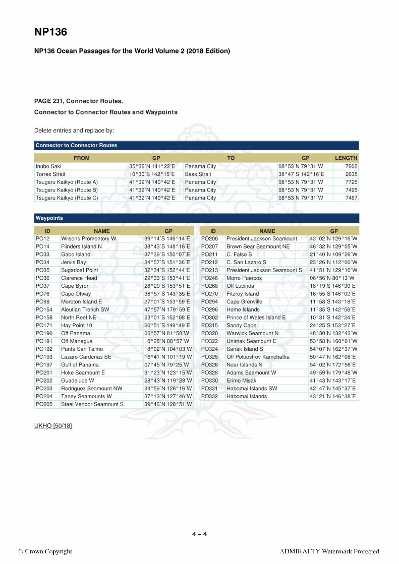
NP136
NP136 Ocean Passages for the World Volume 2 (2018 Edition)
FROM GP TO GP LENGTHInubo Saki 35°32´N 141°22´E Panama City 08°53´N 79°31´W 7602Torres Strait 10°30´S 142°15´E Bass Strait 38°47´S 142°16´E 2635Tsugaru Kaikyo (Route A) 41°32´N 140°42´E Panama City 08°53´N 79°31´W 7725Tsugaru Kaikyo (Route B) 41°32´N 140°42´E Panama City 08°53´N 79°31´W 7495Tsugaru Kaikyo (Route C) 41°32´N 140°42´E Panama City 08°53´N 79°31´W 7467
Connector to Connector Routes
ID NAME GP ID NAME GPPO12 Wilsons Promontory W 39°14´S 146°14´E PO206 President Jackson Seamount 43°02´N 129°16´WPO14 Flinders Island N 38°43´S 148°16´E PO207 Brown Bear Seamount NE 46°32´N 129°05´WPO33 Gabo Island 37°39´S 150°07´E PO211 C. Falso S 21°40´N 109°26´WPO34 Jervis Bay 34°57´S 151°36´E PO212 C. San Lazaro S 23°26´N 112°00´WPO35 Sugarloaf Point 32°34´S 152°44´E PO213 President Jackson Seamount S 41°51´N 129°10´WPO36 Clarence Head 29°33´S 153°41´E PO246 Morro Puercos 06°56´N 80°13´WPO37 Cape Byron 28°29´S 153°51´E PO268 Off Lucinda 18°19´S 146°30´EPO76 Cape Otway 38°57´S 143°35´E PO270 Fitzroy Island 16°55´S 146°02´EPO98 Moreton Island E 27°01´S 153°59´E PO294 Cape Grenville 11°58´S 143°18´EPO154 Aleutian Trench SW 47°57´N 179°59´E PO296 Home Islands 11°35´S 142°58´EPO158 North Reef NE 23°01´S 152°08´E PO302 Prince of Wales Island E 10°31´S 142°24´EPO171 Hay Point 10 20°51´S 149°49´E PO315 Sandy Cape 24°25´S 153°27´EPO190 Off Panama 06°57´N 81°58´W PO320 Warwick Seamount N 48°30´N 132°43´WPO191 Off Managua 10°28´N 88°57´W PO322 Unimak Seamount E 53°58´N 160°01´WPO192 Punta San Telmo 18°02´N 104°03´W PO324 Sanak Island S 54°07´N 162°37´WPO193 Lazaro Cardenas SE 16°41´N 101°19´W PO325 Off Poluostrov Kamchatka 50°47´N 162°08´EPO197 Gulf of Panama 07°45´N 79°25´W PO326 Near Islands N 54°02´N 172°56´EPO201 Hoke Seamount E 31°23´N 123°15´W PO328 Adams Seamount W 49°59´N 179°48´WPO202 Guadelupe W 28°43´N 119°28´W PO330 Erimo Misaki 41°43´N 143°17´EPO203 Rodriguez Seamount NW 34°59´N 126°16´W PO331 Habomai Islands SW 42°47´N 145°37´EPO204 Taney Seamounts W 37°13´N 127°46´W PO332 Habomai Islands 43°21´N 146°38´EPO205 Steel Vendor Seamount S 39°46´N 128°51´W
Waypoints
PAGE 231, Connector Routes.
Connector to Connector Routes and Waypoints
Delete entries and replace by:
UKHO [50/18]
4 -- 4

NP136 PAGE 235, Auckland, Brisbane, Buenaventura and Callao.
GP LOCODE CCODE LENGTH FOR NP
From Auckland 36°46´S 174°49´E AKL NZ NP51To Brisbane 27°17´S 153°14´E BNE AU 1589 NP15To Mebourne 38°00´S 144°55´E MEL AU 2067 NP14To Port Botany 34°01´S 151°17´E BTB AU 1547 NP14
From Brisbane 27°17´S 153°14´E BNE AU NP15To Auckland 36°46´S 174°49´E AKL NZ 1589 NP51To Lyttelton 43°35´S 172°51´E LYT NZ 1929 NP51To Tauranga 37°34´S 176°13´E TRG NZ 1673 NP51
From Buenaventura 03°48´N 77°23´W BUN CO NP7
To Harbour of Vancouver (Juan de Fuca Strait) 48°16´N 123°32´W VAN CA 4936 NP25
To Lazaro Cardenas 17°54´N 102°10´W LZC MX 1723 NP8To San Jose 13°54´N 90°46´W SNJ GT 1012 NP8To San Pedrito Port 19°02´N 104°23´W MX 1877 NP8
From Callao 12°02´S 77°14´W CLL PE NP7To Lazaro Cardenas 17°54´N 102°10´W LZC MX 2350 NP8To San Pedrito Port 19°02´N 104°23´W 2491 NP8
Port to Port Routes
PORT
FROM GP TO GP LENGTH FORAuckland 36°46´S 174°49´E Panama City 08°53´N 79°31´W 6653 Panama Canal and Caribbean portsBrisbane 27°17´S 153°14´E Mariana Islands 11°54´N 149°37´E 2460 South East Asia portsBrisbane 27°17´S 153°14´E Off Western Reef 02°35´S 144°09´E 1781 South East Asia portsBrisbane 27°17´S 153°14´E Panama City 08°53´N 79°31´W 7868 Panama Canal and Caribbean portsBrisbane 27°17´S 153°14´E Vokeo Island 02°58´S 144°00´E 1775 South East Asia portsBrisbane 27°17´S 153°14´E West Melanesian Trench 00°46´S 145°00´E 1833 South East Asia portsBuenaventura 03°48´N 77°23´W Panama City 08°53´N 79°31´W 340 Panama Canal and Caribbean portsCallao 12°02´S 77°14´W Inubo Saki 35°32´N 141°22´E 8302 South East Asia portsCallao 12°02´S 77°14´W Panama City 08°53´N 79°31´W 1355 Panama Canal and Caribbean ports
Port to Connector Routes
Port to Port Routes and Port to Connector Routes.
Delete entries and replace by:
UKHO [50/18]
4 -- 5

NP136.tnioP yaH dna )tiartS acuF ed nauJ( revuocnaV fo ruobraH ,enotsdalG ,932 EGAP
GP LOCODE CCODE LENGTH FOR NP
From Gladstone 23°50´S 151°32´E GLT AU NP15To Long Beach 33°43´N 118°11´W LGB US 6319 NP8
From Harbour of Vancouver (Juan de Fuca Strait) 48°16´N 123°32´W VAN CA NP25
To Buenaventura 03°48´N 77°23´W BUN C0 4934 NP7To Long Beach 33°43´N 118°11´W LGB US 1474 NP8To San Pedrito Port 19°02´N 104°23´W 3064 NP8To Oakland 37°49´N 122°30´W OAK US 1042 NP8
Port to Port Routes
PORT
FROM GP TO GP LENGTH FORGladstone 23°50´S 151°32´E Cabo de Hornos 56°07´S 66°55´W 6440 South Atlantic portsGladstone 23°50´S 151°32´E Caroline Islands 05°00´N 146°59´E 1956 South East Asia portsGladstone 23°50´S 151°32´E Mariana Islands 11°54´N 149°37´E 2276 South East Asia portsGladstone 23°50´S 151°32´E Off Western Reef 02°35´S 144°09´E 1585 South East Asia portsGladstone 23°50´S 151°32´E Panama City 08°53´N 79°31´W 7967 Caribbean ports
Gladstone 23°50´S 151°32´E Torres Strait 10°30´S 142°15´E 1326 South East Asia and Indian Ocean ports
Gladstone 23°50´S 151°32´E West Melanesian Trench 00°46´S 145°00´E 1637 South East Asia portsHarbour of Vancouver (Juan de Fuca Strait) (Route A)
48°16´N 123°32´W Inubo Saki 35°32´N 141°22´E 4121 South East Asia ports
Harbour of Vancouver (Juan de Fuca Strait) (Route B)
48°16´N 123°32´W Inubo Saki 35°32´N 141°22´E 4087 South East Asia ports
Harbour of Vancouver (Juan de Fuca Strait) (Route C)
48°16´N 123°32´W Tsugaru Kaikyo 41°32´N 140°42´E 3907 South East Asia ports
Harbour of Vancouver (Juan de Fuca Strait) (Route D)
48°16´N 123°32´W Tsugaru Kaikyo 41°32´N 140°42´E 3915 South East Asia ports
Hay Point 21°15´S 149°19´E Mariana Islands 11°54´N 149°37´E 2145 South East Asia ports
Hay Point 21°15´S 149°19´E Torres Strait 10°30´S 142°15´E 1119 South East Asia and Indian Ocean ports
Hay Point 21°15´S 149°19´E West Melanesian Trench 00°46´S 145°00´E 1458 South East Asia ports
Port to Connector Routes
Port to Port Routes and Port to Connector Routes.
Delete enties and replace by:
UKHO [50/18]
4 -- 6

NP136
GP LOCODE CCODE LENGTH FOR NP
From Lazaro Cardenas 17°54´N 102°10´W LZC MX NP8To Buenaventura 03°48´N 77°23´W BUN CO 1723 NP7To Callao 12°02´S 77°14´W CLL PE 2350 NP7To Newcastle 32°59´S 151°53´E NTL AU 6770 NP15
From Long Beach 33°43´N 118°11´W LGB US NP8To Gladstone 23°50´S 151°32´E GLT AU 6319 NP15
To Harbour of Vancouver (Juan de Fuca Strait) 48°16´N 123°32´W VAN CA 1474 NP25
To Melbourne 38°00´S 144°55´E MEL AU 7145 NP14To Port Botany 34°01´S 151°17´E BTB AU 6780 NP14To Quintero 32°45´S 71°34´W QTV CL 5077 NP7
From Lyttelton 43°35´S 172°51´E LYT NZ NP51To Brisbane 27°17´S 153°14´E BNE AU 1929 NP15
Port to Port Routes
PORT
FROM GP TO GP LENGTH FORLazaro Cardenas 17°54´N 102°10´W Inubo Saki 35°32´N 141°22´E 6013 South East Asia portsLazaro Cardenas 17°54´N 102°10´W Panama City 08°53´N 79°31´W 1635 Caribbean portsLazaro Cardenas 17°54´N 102°10´W Tsugaru Kaikyo 41°32´N 140°42´E 5879 South East Asia portsLong Beach 33°43´N 118°11´W Inubo Saki 35°32´N 141°22´E 4781 South East Asia portsLong Beach 33°43´N 118°11´W Panama City 08°53´N 79°31´W 3130 Caribbean portsLong Beach 33°43´N 118°11´W Tsugaru Kaikyo 41°32´N 140°42´E 4640 South East Asia ports
Port to Connector Routes
ID NAME GP ID NAME GPPO12 Wilsons Promontory W 39°14´S 146°14´E PO209 Off Harbour of Vancouver 48°29´N 124°45´WPO21 North Island N 34°19´S 173°05´E PO211 C. Falso S 21°40´N 109°26´WPO25 Gabo Island SE 38°07´S 152°36´E PO212 C. San Lazaro S 23°26´N 112°00´WPO28 Standard Seamount SE 36°53´S 159°05´E PO216 Off Lima 11°28´S 77°57´WPO30 Challenger Plateau NW 36°02´S 163°44´E PO221 P. Bayovar S 07°07´S 81°44´WPO77 Three Kings Island 34°17´S 171°32´E PO222 Paramount Seamount 03°29´N 90°18´WPO81 Lord Howe Rise 34°11´S 163°40´E PO232 Off C Johnson 47°57´N 125°18´WPO85 Taupo Seamount SW 34°03´S 154°13´E PO233 Off Columbia River 46°12´N 125°16´WPO97 Moreton Island N 26°50´S 153°30´E PO234 C Mendocino 40°23´N 125°00´WPO145 Cape Farewell 40°06´S 173°04´E PO239 Pioneer Seamount NW 37°33´N 123°39´WPO149 Off Wellington 41°19´S 174°30´E PO240 Richardson Rock 34°25´N 120°52´WPO152 Kaikoura NE 42°15´S 174°02´E PO246 Morro Puercos 06°56´N 80°13´WPO154 Aleutian Trench SW 47°57´N 179°59´E PO247 Islas San Benito SW 28°03´N 116°01´WPO159 Swain Reefs S 22°47´S 152°53´E PO253 Off San Diego 32°27´N 117°40´WPO190 Off Panama 06°57´N 81°58´W PO316 Torres Islands W 13°17´S 165°26´EPO191 Off Managua 10°28´N 88°57´W PO317 Jasper Seamount E 30°30´N 121°38´WPO192 Punta San Telmo 18°02´N 104°03´W PO318 Bishop Rock S 31°03´N 118°29´WPO195 Off Acapulco 16°39´N 100°39´W PO329 Oma Saki 41°37´N 140°54´EPO197 Gulf of Panama 07°45´N 79°25´W PO334 Hoke Seamount NE 33°40´N 124°35´WPO202 Guadelupe W 28°43´N 119°28´W
Waypoints
PAGE 243, Lazaro Cardenas, Long Beach and Lyttelton.
Port to Port Routes, Port to Connector Routes and Waypoints
Delete entries and replace by:
UKHO [50/18]
4 -- 7
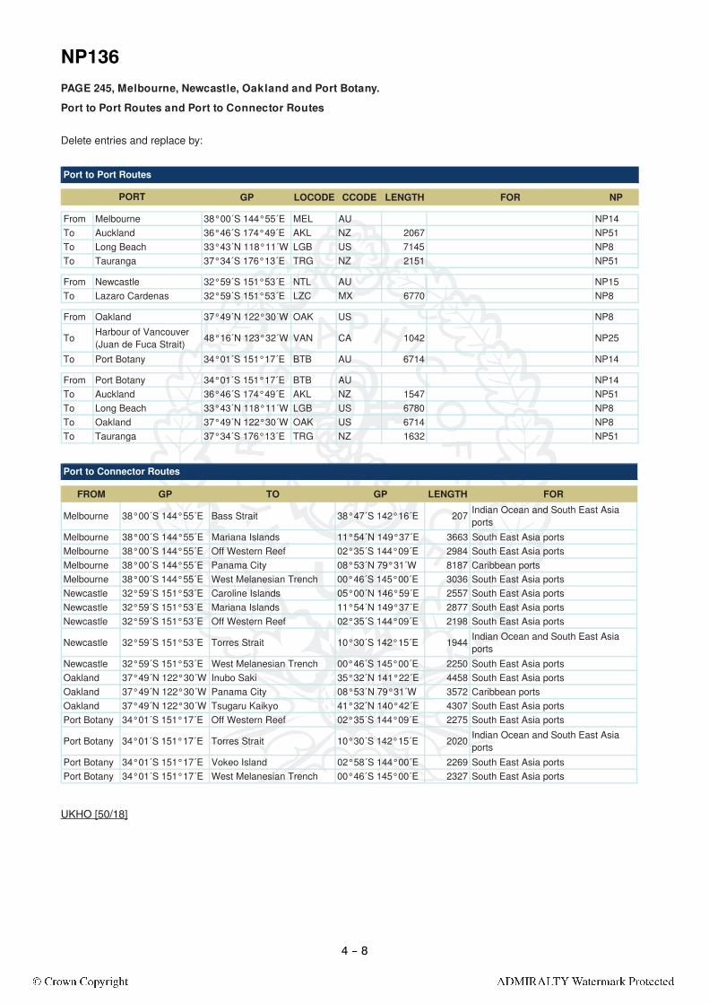
NP136PAGE 245, Melbourne, Newcastle, Oakland and Port Botany.
GP LOCODE CCODE LENGTH FOR NP
From Melbourne 38°00´S 144°55´E MEL AU NP14To Auckland 36°46´S 174°49´E AKL NZ 2067 NP51To Long Beach 33°43´N 118°11´W LGB US 7145 NP8To Tauranga 37°34´S 176°13´E TRG NZ 2151 NP51
From Newcastle 32°59´S 151°53´E NTL AU NP15To Lazaro Cardenas 32°59´S 151°53´E LZC MX 6770 NP8
From Oakland 37°49´N 122°30´W OAK US NP8
To Harbour of Vancouver (Juan de Fuca Strait) 48°16´N 123°32´W VAN CA 1042 NP25
To Port Botany 34°01´S 151°17´E BTB AU 6714 NP14
From Port Botany 34°01´S 151°17´E BTB AU NP14To Auckland 36°46´S 174°49´E AKL NZ 1547 NP51To Long Beach 33°43´N 118°11´W LGB US 6780 NP8To Oakland 37°49´N 122°30´W OAK US 6714 NP8To Tauranga 37°34´S 176°13´E TRG NZ 1632 NP51
Port to Port Routes
PORT
FROM GP TO GP LENGTH FOR
Melbourne 38°00´S 144°55´E Bass Strait 38°47´S 142°16´E 207 Indian Ocean and South East Asia ports
Melbourne 38°00´S 144°55´E Mariana Islands 11°54´N 149°37´E 3663 South East Asia portsMelbourne 38°00´S 144°55´E Off Western Reef 02°35´S 144°09´E 2984 South East Asia portsMelbourne 38°00´S 144°55´E Panama City 08°53´N 79°31´W 8187 Caribbean portsMelbourne 38°00´S 144°55´E West Melanesian Trench 00°46´S 145°00´E 3036 South East Asia portsNewcastle 32°59´S 151°53´E Caroline Islands 05°00´N 146°59´E 2557 South East Asia portsNewcastle 32°59´S 151°53´E Mariana Islands 11°54´N 149°37´E 2877 South East Asia portsNewcastle 32°59´S 151°53´E Off Western Reef 02°35´S 144°09´E 2198 South East Asia ports
Newcastle 32°59´S 151°53´E Torres Strait 10°30´S 142°15´E 1944 Indian Ocean and South East Asia ports
Newcastle 32°59´S 151°53´E West Melanesian Trench 00°46´S 145°00´E 2250 South East Asia portsOakland 37°49´N 122°30´W Inubo Saki 35°32´N 141°22´E 4458 South East Asia portsOakland 37°49´N 122°30´W Panama City 08°53´N 79°31´W 3572 Caribbean portsOakland 37°49´N 122°30´W Tsugaru Kaikyo 41°32´N 140°42´E 4307 South East Asia portsPort Botany 34°01´S 151°17´E Off Western Reef 02°35´S 144°09´E 2275 South East Asia ports
Port Botany 34°01´S 151°17´E Torres Strait 10°30´S 142°15´E 2020 Indian Ocean and South East Asia ports
Port Botany 34°01´S 151°17´E Vokeo Island 02°58´S 144°00´E 2269 South East Asia portsPort Botany 34°01´S 151°17´E West Melanesian Trench 00°46´S 145°00´E 2327 South East Asia ports
Port to Connector Routes
Port to Port Routes and Port to Connector Routes
Delete entries and replace by:
UKHO [50/18]
4 -- 8
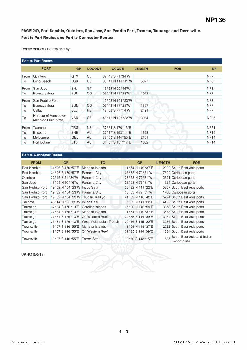
NP136PAGE 249, Port Kembla, Quintero, San Jose, San Pedrito Port, Tacoma, Tauranga and Townsville.
GP LOCODE CCODE LENGTH FOR NP
From Quintero QTV CL 32°45´S 71°34´W NP7To Long Beach LGB US 33°43´N 118°11´W 5077 NP8
From San Jose SNJ GT 13°54´N 90°46´W NP8To Buenaventura BUN CO 03°48´N 77°23´W 1012 NP7
From San Pedrito Port 19°02´N 104°23´W NP8To Buenaventura BUN CO 03°48´N 77°23´W 1877 NP7To Callao CLL PE 12°02´S 77°14´W 2491 NP7
To Harbour of Vancouver (Juan de Fuca Strait) VAN CA 48°16´N 123°32´W 3064 NP25
From Tauranga TRG NZ 37°34´S 176°13´E NP51To Brisbane BNE AU 27°17´S 153°14´E 1673 NP15To Melbourne MEL AU 38°00´S 144°55´E 2151 NP14To Port Botany BTB AU 34°01´S 151°17´E 1632 NP14
Port to Port Routes
PORT
FROM GP TO GP LENGTH FORPort Kembla 34°26´S 150°57´E Mariana Islands 11°54´N 149°37´E 2990 South East Asia portsPort Kembla 34°26´S 150°57´E Panama City 08°53´N 79°31´W 7822 Caribbean portsQuintero 32°45´S 71°34´W Panama City 08°53´N 79°31´W 2721 Caribbean portsSan Jose 13°54´N 90°46´W Panama City 08°53´N 79°31´W 924 Caribbean portsSan Pedrito Port 19°02´N 104°23´W Inubo Saki 35°32´N 141°22´E 5857 South East Asia portsSan Pedrito Port 19°02´N 104°23´W Panama City 08°53´N 79°31´W 1788 Caribbean portsSan Pedrito Port 19°02´N 104°23´W Tsugaru Kaikyo 41°32´N 140°42´E 5724 South East Asia portsTacoma 48°14´N 123°32´W Inubo Saki 35°32´N 141°22´E 4120 South East Asia portsTauranga 37°34´S 176°13´E Caroline Islands 05°00´N 146°59´E 3258 South East Asia portsTauranga 37°34´S 176°13´E Mariana Islands 11°54´N 149°37´E 3578 South East Asia portsTauranga 37°34´S 176°13´E Off Western Reef 02°35´S 144°09´E 3034 South East Asia portsTauranga 37°34´S 176°13´E West Melanesian Trench 00°46´S 145°00´E 3086 South East Asia portsTownsville 19°07´S 146°55´E Mariana Islands 11°54´N 149°37´E 2022 South East Asia portsTownsville 19°07´S 146°55´E Off Western Reef 02°35´S 144°09´E 1334 South East Asia ports
Townsville 19°07´S 146°55´E Torres Strait 10°30´S 142°15´E 635 South East Asia and Indian Ocean ports
Port to Connector Routes
Port to Port Routes and Port to Connector Routes
Delete entries and replace by:
UKHO [50/18]
4 -- 9

4 -- 10

ANNEX A (NP100) (See Page 4 - 3)
4 -- 11
Denmark
Falkland Islands
ANNEX C
The Faröe Islands
COUNTRY NATIONAL FLAG
MERCHANTENSIGN
MILITARY ENSIGN
To accompany Section VII amendment
Block for NP100 The Mariner’s Handbook 2016 Edition Annex C