
2017 KANSAS severe weather awareness week march 5-11th, 2017 2017 kansas severe weather awareness...
30
KANSAS SEVERE WEATHER AWARENESS WEEK MARCH 5-11th, 2017 2017 KANSAS SEVERE WEATHER AWARENESS WEEK MARCH 5 - 11th 2017 TORNADO SAFETY DRILL Tuesday, March 7th, 2017 10am CST/9am MST INFORMATION PACKET National Weather Service
Transcript of 2017 KANSAS severe weather awareness week march 5-11th, 2017 2017 kansas severe weather awareness...
KANSAS SEVERE WEATHER AWARENESS WEEK MARCH 5-11th, 2017
2017 KANSAS SEVERE WEATHER AWARENESS WEEK
MARCH 5 - 11th 2017
TORNADO SAFETY DRILL
Tuesday, March 7th, 2017
10am CST/9am MST
INFORMATION PACKET
National Weather Service

2
KANSAS SEVERE WEATHER AWARENESS WEEK MARCH 5-11th, 2017
Table of Contents Page Number
3
4
7
8
13
14
16
19
21
24
27
28
29
30
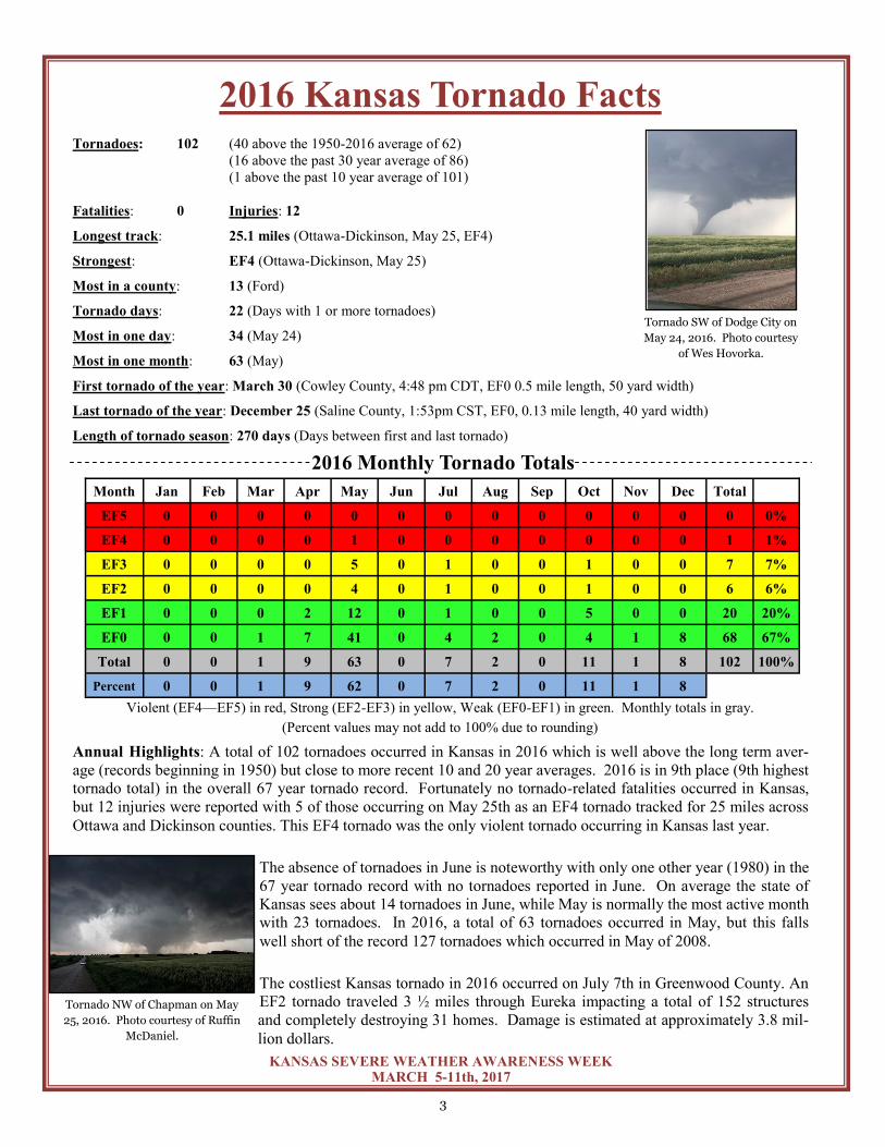
2016 Kansas Tornado Facts
Kansas Tornado Statistics by county
Weather Ready Nation Ambassador Program
Greensburg - 10 years later
2016 Severe Summary for Extreme East Central and Northeast Kansas
NWS Pleasant Hill, MO
2016 Severe Summary for Northeast and East Central Kansas
NWS Topeka, KS
2016 Severe Summary for Central, South Central and SE Kansas
NWS Wichita, KS
2016 Severe Summary for North Central Kansas
NWS Hastings, NE
2016 Severe Summary for Southwest Kansas
NWS Dodge City, KS
2016 Severe Summary for Northwest Kansas
NWS Goodland, KS
2016 Severe Summary for Southeastern Kansas
NWS Springfield, MO
Sirens are an Outdoor Warning System
StormReady
Thunderstorm Safety for Deaf and Hard of Hearing
3
KANSAS SEVERE WEATHER AWARENESS WEEK MARCH 5-11th, 2017
Month Jan Feb Mar Apr May Jun Jul Aug Sep Oct Nov Dec Total
EF5 0 0 0 0 0 0 0 0 0 0 0 0 0 0%
EF4 0 0 0 0 1 0 0 0 0 0 0 0 1 1%
EF3 0 0 0 0 5 0 1 0 0 1 0 0 7 7%
EF2 0 0 0 0 4 0 1 0 0 1 0 0 6 6%
EF1 0 0 0 2 12 0 1 0 0 5 0 0 20 20%
EF0 0 0 1 7 41 0 4 2 0 4 1 8 68 67%
Total 0 0 1 9 63 0 7 2 0 11 1 8 102 100%
Percent 0 0 1 9 62 0 7 2 0 11 1 8
2016 Kansas Tornado Facts Tornadoes: 102 (40 above the 1950-2016 average of 62)
(16 above the past 30 year average of 86)
(1 above the past 10 year average of 101)
Fatalities: 0 Injuries: 12
Longest track: 25.1 miles (Ottawa-Dickinson, May 25, EF4)
Strongest: EF4 (Ottawa-Dickinson, May 25)
Most in a county: 13 (Ford)
Tornado days: 22 (Days with 1 or more tornadoes)
Most in one day: 34 (May 24)
Most in one month: 63 (May)
First tornado of the year: March 30 (Cowley County, 4:48 pm CDT, EF0 0.5 mile length, 50 yard width)
Last tornado of the year: December 25 (Saline County, 1:53pm CST, EF0, 0.13 mile length, 40 yard width)
Length of tornado season: 270 days (Days between first and last tornado)
Violent (EF4—EF5) in red, Strong (EF2-EF3) in yellow, Weak (EF0-EF1) in green. Monthly totals in gray.
(Percent values may not add to 100% due to rounding)
2016 Monthly Tornado Totals
Tornado SW of Dodge City on
May 24, 2016. Photo courtesy
of Wes Hovorka.
Annual Highlights: A total of 102 tornadoes occurred in Kansas in 2016 which is well above the long term aver-
age (records beginning in 1950) but close to more recent 10 and 20 year averages. 2016 is in 9th place (9th highest
tornado total) in the overall 67 year tornado record. Fortunately no tornado-related fatalities occurred in Kansas,
but 12 injuries were reported with 5 of those occurring on May 25th as an EF4 tornado tracked for 25 miles across
Ottawa and Dickinson counties. This EF4 tornado was the only violent tornado occurring in Kansas last year.
The absence of tornadoes in June is noteworthy with only one other year (1980) in the
67 year tornado record with no tornadoes reported in June. On average the state of
Kansas sees about 14 tornadoes in June, while May is normally the most active month
with 23 tornadoes. In 2016, a total of 63 tornadoes occurred in May, but this falls
well short of the record 127 tornadoes which occurred in May of 2008.
The costliest Kansas tornado in 2016 occurred on July 7th in Greenwood County. An
EF2 tornado traveled 3 ½ miles through Eureka impacting a total of 152 structures
and completely destroying 31 homes. Damage is estimated at approximately 3.8 mil-
lion dollars.
Tornado NW of Chapman on May
25, 2016. Photo courtesy of Ruffin
McDaniel.

4
KANSAS SEVERE WEATHER AWARENESS WEEK MARCH 5-11th, 2017
County Tor Fat Inj County Tor Fat Inj County Tor Fat Inj
Kansas Tornado Statistics by county 1950 - 2016
TORNADOES, FATALITIES, AND INJURIES
Allen 27 0 4
Anderson 15 3 12
Atchison 15 0 11
Barber 37 0 2
Barton 96 2 38
Bourbon 19 0 7
Brown 45 0 5
Butler 78 28 225
Chase 39 0 2
Chautauqua 19 0 0
Cherokee 37 4 66
Cheyenne 42 0 0
Clark 39 0 0
Clay 42 1 31
Cloud 50 1 8
Coffey 23 0 5
Comanche 42 0 2
Cowley 73 77 293
Crawford 33 4 43
Decatur 47 0 5
Dickinson 38 1 17
Doniphan 19 0 2
Douglas 40 1 48
Edwards 50 0 7
Elk 24 2 8
Ellis 62 0 6
Ellsworth 50 0 0
Finney 97 1 41
Ford 98 0 2
Franklin 29 3 34
Geary 18 0 3
Gove 54 0 3
Graham 39 0 0
Grant 25 0 9
Gray 50 0 3
Greeley 37 0 0
Greenwood 43 0 10
Hamilton 26 0 1
Harper 62 0 1
Harvey 49 1 63
Haskell 32 0 10
Hodgeman 55 0 4
Jackson 31 4 17
Jefferson 40 0 101
Jewell 43 0 2
Johnson 42 0 12
Kearny 45 0 0
Kingman 64 0 1
Kiowa 59 11 74
Labette 42 1 29
Lane 47 0 2
Leavenworth 30 2 30
Lincoln 33 0 2
Linn 14 0 3
Logan 29 0 0
Lyon 46 7 222
Marion 47 1 2
Marshall 32 0 1
McPherson 54 1 16
Meade 51 0 0
Miami 20 4 10
Mitchell 48 0 5
Montgomery 34 1 1
Morris 33 0 7
Morton 20 1 2
Nemaha 37 0 3
Neosho 31 0 4
Ness 53 0 4
Norton 30 0 0
Osage 44 17 6
Osborne 45 0 13
Ottawa 32 2 12
Pawnee 50 0 1
Phillips 41 0 1
Pottawatomie 32 1 5
Pratt 71 3 10
Rawlins 47 0 4
Reno 79 0 22
Republic 60 0 3
Rice 46 0 6
Riley 29 0 51
Rooks 51 0 6
Rush 51 0 8
Russell 78 1 7
Saline 42 0 66
Scott 55 1 1
Sedgwick 89 13 360
Seward 38 0 15
Shawnee 54 18 528
Sheridan 38 0 0
Sherman 109 0 0
Smith 45 0 2
Stafford 70 3 5
Stanton 22 0 0
Stevens 25 1 5
Sumner 84 5 14
Thomas 46 0 1
Trego 63 5 101
Wabaunsee 34 1 26
Wallace 35 0 4
Washington 40 2 12
Wichita 35 0 4
Wilson 16 0 0
Woodson 12 0 8
Wyandotte 10 2 36
Total
4588 237 2924

5
KANSAS SEVERE WEATHER AWARENESS WEEK MARCH 5-11th, 2017
Severe Weather Terminology
Severe Thunderstorm – The National Weather Service issues severe thunderstorm warnings for
thunderstorms that are currently producing or are capable of producing winds of 58 mph or strong-
er and/or hail one inch in diameter or larger. Severe thunderstorms often may be much stronger
than this minimum criteria, so it is a good idea to take severe thunderstorm warnings seriously.
Tornado – A tornado is a violently rotating column of air, in contact with the ground, either as a
pendant from a cumuliform cloud or underneath a cumuliform cloud, and often (but not always)
visible as a funnel cloud. A funnel cloud is a condensation cloud typically funnel-shaped and ex-
tending outward from a cumuliform cloud and is associated with a rotating column of air.
Flash Flood – A flash flood is flooding that occurs very rapidly usually within 6 hours of heavy
rainfall. Flash flooding may occur along creeks, rivers or streams. It can also occur in low lying
or urban areas where drainage is poor. Water levels can rise very quickly during flash flooding
including locations that did not receive the heavy rainfall but are located downstream from areas
that received an extreme amount of rainfall. Flash flooding can occur in the winter months when
rain falls on existing snowpack and causes it to melt rapidly. Flooding is the number one severe
weather killer in the U.S.

6
KANSAS SEVERE WEATHER AWARENESS WEEK MARCH 5-11th, 2017
Check out a Storm Spotter and Weather Safety Training
presentation near you this spring…
Each spring, the National Weather Service offices that serve the state of Kansas conduct storm spotter and
weather safety training sessions in most counties in the state. The sessions are free and open to the public.
You are not required to become a storm spotter nor will you have to take a test; however, the presentations
provide a great deal of information on severe weather in Kansas. They cover severe weather safety and
ways to get weather information from the National Weather Service. You can meet a meteorologist from
your local National Weather Service office.
The schedule for storm spotter training sessions varies in each community, please check out
www.weather.gov and click on your location for more information on a training session in your area.
Kansas Tornado Facts Days with more than 20 tornadoes
Date #Tornadoes
05/23/08 70
04/14/12 43
06/15/92 39
05/05/07 36
05/24/16 34
06/04/55 33
05/29/04 28
10/26/06 28
05/25/97 25
06/09/05 25
05/15/91 24
07/07/04 23
05/06/15 22
04/26/91 21
Kansas Tornado Count by Decade
1950s: 560
1960s: 457
1970s: 303
1980s: 339
1990s: 789
2000s: 1192
2010s: 572 (through 2016)
Most Tornadoes in One Episode
May 23, 2008 70 Tornadoes
April 14, 2012 43 Tornadoes
June 15-16, 1992 41 Tornadoes
Did you know that there are seven National Weather Service
offices that serve portions of Kansas?
The NWS offices are located in Goodland; Dodge City; Wichita; Topeka; Hastings, Nebraska; Pleasant
Hill, Missouri; and Springfield, Missouri. Each office is staffed by a team of highly trained meteorologists,
technicians, electronics technicians, information technology specialists, hydrologists, and administrative
assistants. The NWS offices are staffed 24 hours a day, seven days a week, 365 days a year.
Contact the NWS office in your area to learn more about weather, weather safety, NOAA Weather Radio,
office tours, or to learn more about careers in meteorology in the NWS or in NOAA. We are here to serve
you!

7
KANSAS SEVERE WEATHER AWARENESS WEEK MARCH 5-11th, 2017
7
KANSAS SEVERE WEATHER AWARENESS WEEK MARCH 5–11th, 2017

8
KANSAS SEVERE WEATHER AWARENESS WEEK MARCH 5-11th, 2017
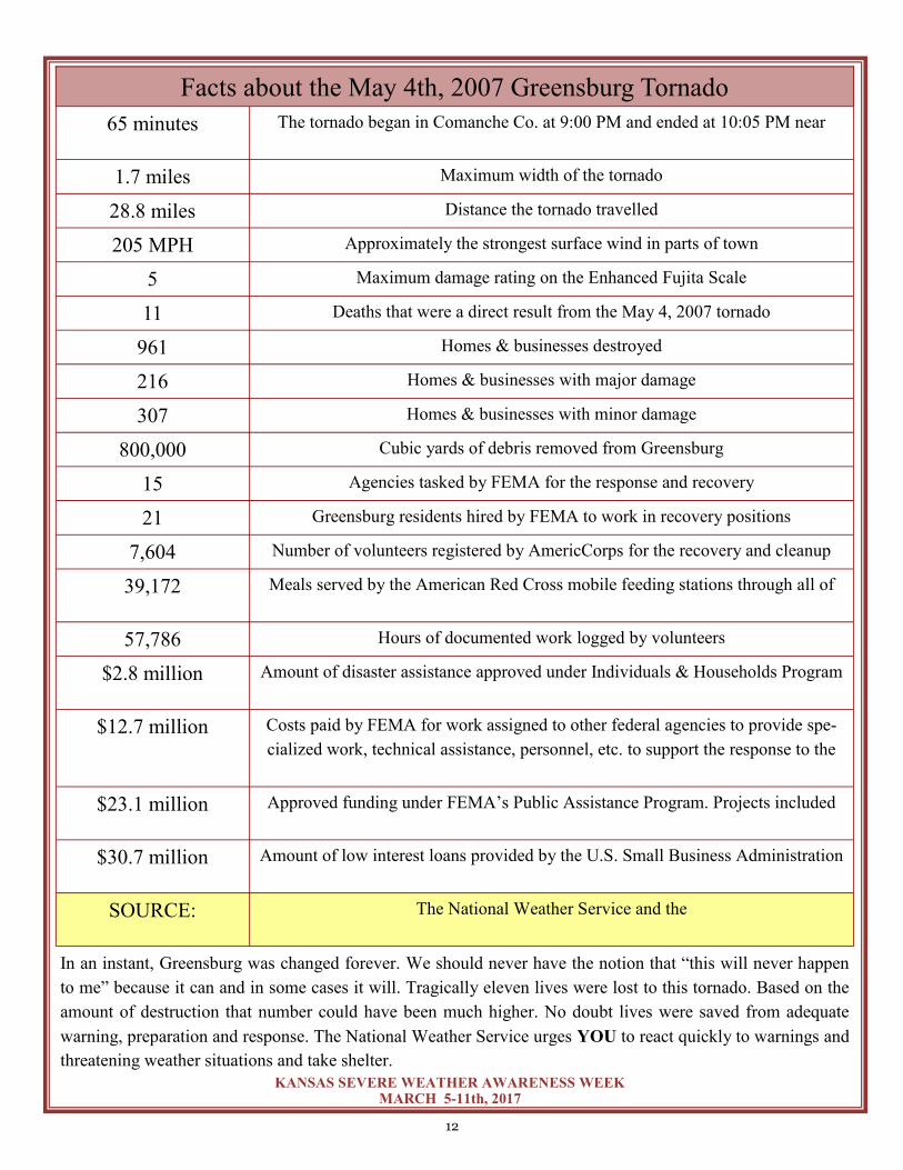
Greensburg - 10 years later
On May 4th, 2007 an enormous tornado nearly wiped out the entire town of Greensburg, Kansas causing
EF5 damage. It was the strongest recorded tornado since the May 3rd, 1999 Moore/Oklahoma City tornado.
Despite a tornado warning with a lead time of 26 minutes, the town of approximately 1500 persons still lost
11 lives. Some of those fatalities were even in basements that unfortunately were filled with a tremendous
amount of debris. Remarkably, the tornado took down the town’s only water tower which also stood above
the infamous “hand dug” well and meteorite. The tornado also destroyed a dozen homes and a church that
were south of town in rural Kiowa County.
The first warning for the tornado that eventually went through Greensburg was issued at 8:55 PM on that
May evening back in 2007. The first warning specifically mentioning the town was issued at 9:19 PM. The
tornado entered the south side of Greensburg at 9:45 PM and changed the lives and landscape forever.
For those that have never been to Greensburg, where most streets were completely tree lined, a few of the
images on subsequent pages show the remarkable damage.
Water tower before the tornado The aftermath

9
KANSAS SEVERE WEATHER AWARENESS WEEK MARCH 5-11th, 2017
Greensburg Downtown before
Downtown after
The downtown area has rebuilt, not to the extent of 2007
but certainly more so than after the tornado.
Downtown now

10
KANSAS SEVERE WEATHER AWARENESS WEEK MARCH 5-11th, 2017
Two days after the tornado, most of the streets were clear of debris, but the devastation was obvious.
Remarkable changes have taken place during this past decade. Considering that around 800,000 cubic yards
of debris had to be removed after the devastation and utilities had to be reconstructed, it’s amazing what has
transformed. Although the year 2016 population of around 800 has not recovered to pre-2007 levels, a large
number of residents and new folks to the area took to rebuilding the town. Today there are many state-of-the
art buildings, and the city prides itself with the most LEED certified buildings per capita in the world!
A landmark, the water tower stands proud
and tall overlooking the slowly growing town.
But a stark reminder of what hasn’t been rebuilt ex-
ists on the northwest side of Greensburg.

11
KANSAS SEVERE WEATHER AWARENESS WEEK MARCH 5-11th, 2017
The following image was taken the day after the tornado looking across
the north side of Greensburg.
Many empty lots remain with even a few stark reminders of the damage
as some of the original tree stumps remain.
12
KANSAS SEVERE WEATHER AWARENESS WEEK MARCH 5-11th, 2017
In an instant, Greensburg was changed forever. We should never have the notion that “this will never happen
to me” because it can and in some cases it will. Tragically eleven lives were lost to this tornado. Based on the
amount of destruction that number could have been much higher. No doubt lives were saved from adequate
warning, preparation and response. The National Weather Service urges YOU to react quickly to warnings and
threatening weather situations and take shelter.
Facts about the May 4th, 2007 Greensburg Tornado
65 minutes The tornado began in Comanche Co. at 9:00 PM and ended at 10:05 PM near
1.7 miles Maximum width of the tornado
28.8 miles Distance the tornado travelled
205 MPH Approximately the strongest surface wind in parts of town
5 Maximum damage rating on the Enhanced Fujita Scale
11 Deaths that were a direct result from the May 4, 2007 tornado
961 Homes & businesses destroyed
216 Homes & businesses with major damage
307 Homes & businesses with minor damage
800,000 Cubic yards of debris removed from Greensburg
15 Agencies tasked by FEMA for the response and recovery
21 Greensburg residents hired by FEMA to work in recovery positions
7,604 Number of volunteers registered by AmericCorps for the recovery and cleanup
39,172 Meals served by the American Red Cross mobile feeding stations through all of
57,786 Hours of documented work logged by volunteers
$2.8 million Amount of disaster assistance approved under Individuals & Households Program
$12.7 million Costs paid by FEMA for work assigned to other federal agencies to provide spe-
cialized work, technical assistance, personnel, etc. to support the response to the
$23.1 million Approved funding under FEMA’s Public Assistance Program. Projects included
$30.7 million Amount of low interest loans provided by the U.S. Small Business Administration
SOURCE: The National Weather Service and the
13
KANSAS SEVERE WEATHER AWARENESS WEEK MARCH 5-11th, 2017
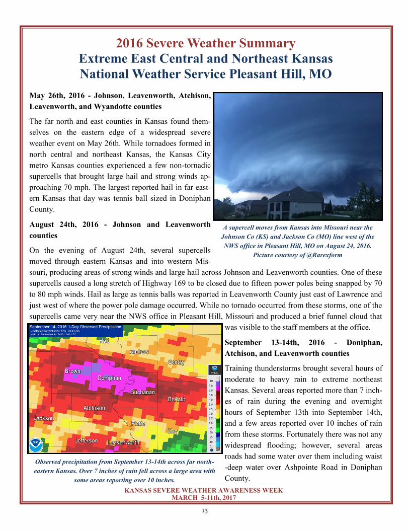
2016 Severe Weather Summary
Extreme East Central and Northeast Kansas
National Weather Service Pleasant Hill, MO
May 26th, 2016 - Johnson, Leavenworth, Atchison,
Leavenworth, and Wyandotte counties
The far north and east counties in Kansas found them-
selves on the eastern edge of a widespread severe
weather event on May 26th. While tornadoes formed in
north central and northeast Kansas, the Kansas City
metro Kansas counties experienced a few non-tornadic
supercells that brought large hail and strong winds ap-
proaching 70 mph. The largest reported hail in far east-
ern Kansas that day was tennis ball sized in Doniphan
County.
August 24th, 2016 - Johnson and Leavenworth
counties
On the evening of August 24th, several supercells
moved through eastern Kansas and into western Mis-
souri, producing areas of strong winds and large hail across Johnson and Leavenworth counties. One of these
supercells caused a long stretch of Highway 169 to be closed due to fifteen power poles being snapped by 70
to 80 mph winds. Hail as large as tennis balls was reported in Leavenworth County just east of Lawrence and
just west of where the power pole damage occurred. While no tornado occurred from these storms, one of the
supercells came very near the NWS office in Pleasant Hill, Missouri and produced a brief funnel cloud that
was visible to the staff members at the office.
September 13-14th, 2016 - Doniphan,
Atchison, and Leavenworth counties
Training thunderstorms brought several hours of
moderate to heavy rain to extreme northeast
Kansas. Several areas reported more than 7 inch-
es of rain during the evening and overnight
hours of September 13th into September 14th,
and a few areas reported over 10 inches of rain
from these storms. Fortunately there was not any
widespread flooding; however, several areas
roads had some water over them including waist
-deep water over Ashpointe Road in Doniphan
County.
A supercell moves from Kansas into Missouri near the
Johnson Co (KS) and Jackson Co (MO) line west of the
NWS office in Pleasant Hill, MO on August 24, 2016.
Picture courtesy of @Rarexform
Observed precipitation from September 13-14th across far north-
eastern Kansas. Over 7 inches of rain fell across a large area with
some areas reporting over 10 inches.

14
KANSAS SEVERE WEATHER AWARENESS WEEK MARCH 5-11th, 2017
2016 Severe Weather Summary
Northeast and North Central Kansas
National Weather Service-Topeka, KS The 2016 severe weather season was the most active since 2008 for tornadoes across north central and north-
east Kansas. The most notable event occurred on May 25th when a strong EF-4 tornado moved across por-
tions of Ottawa and Dickinson counties. Aside from the violent Dickinson County tornado, all other torna-
does that occurred across the area were either rated an EF-0 or EF-1 including an EF-1 that struck the town
of Wamego on May 26th. Thankfully no fatalities occurred from any tornadoes in 2016.
May 25th – On the evening of Wednesday,
May 25th, 2016, a weak outflow boundary and
dry-line interacted across portions of north-
central Kansas. Due to the “capped” nature of
the environment that day, very few storms de-
veloped. However, one particularly strong tor-
nadic supercell developed near this intersec-
tion during the late afternoon hours producing
its first tornado at 6:08 PM. Approximately
one hour later (7:07 PM) a second tornado
touched down just north of Niles, KS. This
violent tornado moved very slowly ESE, de-
stroying nearly everything in its path. At its
peak width it spanned nearly ½ of a mile. As the tornado approached I-70, great concern arose for Chapman
Kansas taking a direct hit, and a Tornado Emergency was issued for the city. Fortunately, the tornado moved
just south of the city by only one mile. The tornado finally dissipated near the Dickinson/Geary County line.
A National Weather Service survey team determined the tornado produced EF-4 damage with winds upwards
of 180 MPH. Although numerous homes and
buildings were destroyed, no serious injuries
or deaths occurred! Two additional tornadoes
occurred later that evening across Morris and
Wabaunsee counties; however, only minor
damage was reported.
May 26th – While cleanup efforts were on-
going across portions of the area from the
tornadoes on May 25th, attention was refo-
cused on the severe weather potential on
May 26th. A powerful upper-level system
lifted across the area during the early after-
noon hours. A surface dry-line and warm
EF4 tornado damage SW of Chapman
May 25h
Tornado north of Solomon on May 25th.
Photo courtesy of Kris Sanders

15
KANSAS SEVERE WEATHER AWARENESS WEEK MARCH 5-11th, 2017
front were oriented along I-135 and I-70 respectively.
Scattered supercell thunderstorms developed along the
warm front during the early afternoon. Three tornadoes
occurred with the first moving through the city of
Wamego. An NWS survey team concluded the tornado
was an EF-1 with winds approaching 110 MPH. Tree
and roof damage was noted within the city. This torna-
do then moved northward through Louisville before
dissipating. Two other brief, weak tornadoes occurred
near Rossville and Silver Lake. Both of these were rat-
ed EF-0 with winds approaching 80 MPH.
April 26th – During the early morning hours of
April 26th, 2016, thunderstorms developed over far
northeast Kansas. The outflow from these storms
would set the stage for severe storms during the af-
ternoon. Very large hail, damaging winds and a few
tornadoes occurred with no damage reported from
the tornadoes. The most significant reports were of
baseball sized hail. The widespread nature of the
storms also lead to localized flash flooding.
October 6th – On the evening of October 6th, a strong
upper level storm system and cold front swept through
northeast Kansas. Severe storms that developed in the
late afternoon quickly became severe with large hail up
to golf ball size, damaging winds, and two verified tor-
nadoes. The two tornadoes occurred in Clay and Wash-
ington counties in northeast Kansas. Both were rated
EF-1 with winds near 100 MPH. The strongest tornado
of the day occurred just out of the forecast area in Sa-
line County producing EF-3 damage east of Salina be-
fore dissipating near the Saline/Dickinson County line.
April 26th, Marshall County.
Photo courtesy of Pat Bussmann
Tornado near Wamego on May 26th.
Photo courtesy of Chris Schmidt
Tornado south of Clay Center on Oct. 6th.
Photo courtesy of Scott Blair
16
KANSAS SEVERE WEATHER AWARENESS WEEK MARCH 5-11th, 2017
2016 Severe Weather Summary Portions of Central, South Central and Southeast Kansas
National Weather Service - Wichita, KS
I have heard many people say that 2016 was not a very busy year in regards to hazardous weather. In all actu-
ality, central and southeast Kansas experienced normal to slightly above normal hazardous weather this past
year at least when you look at convective weather which is known as storm season.
The winter season did not pack much of a punch with only a few minor winter weather scenarios. Once the
spring storm season rolled in, several outbreaks occurred; two were highlighted by 2 EF-3 (136-165 mph) tor-
nadoes and two others had rounds of significant flash flooding. Unfortunately, two people died in 2016 due to
the flooding. This continues to amplify the importance of understanding flood safety and keeping a safe dis-
tance from flooded creeks, streams, or rivers.
For the 26 counties served by NWS Wichita 19 tornadoes were reported. This is normal when looking at the
average number of tornadoes from 1950-2016 which is 18.9. However, we were well below the last ten year
average of 26.8 and the 5 year average of 20.8. The first tornado of the year touched down on March 30th and
the last was on December 25th.
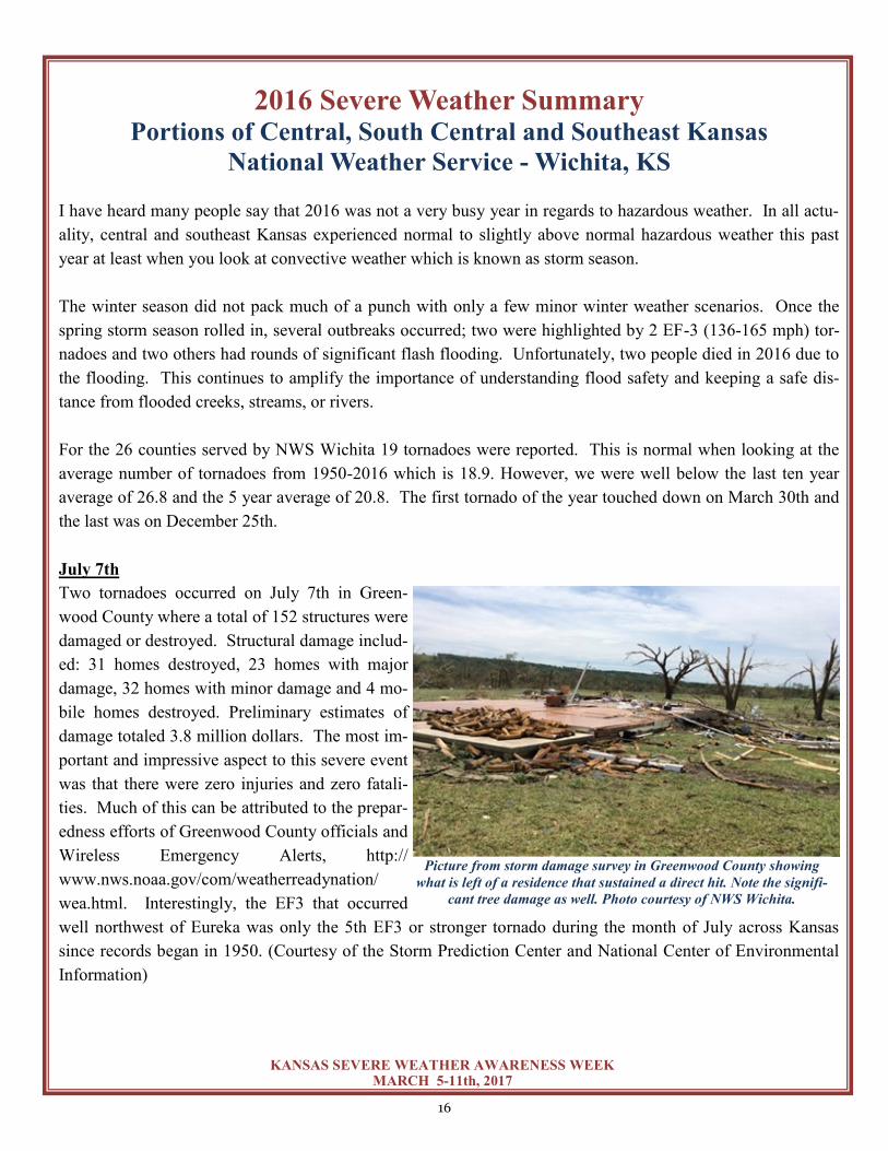
July 7th
Two tornadoes occurred on July 7th in Green-
wood County where a total of 152 structures were
damaged or destroyed. Structural damage includ-
ed: 31 homes destroyed, 23 homes with major
damage, 32 homes with minor damage and 4 mo-
bile homes destroyed. Preliminary estimates of
damage totaled 3.8 million dollars. The most im-
portant and impressive aspect to this severe event
was that there were zero injuries and zero fatali-
ties. Much of this can be attributed to the prepar-
edness efforts of Greenwood County officials and
Wireless Emergency Alerts, http://
www.nws.noaa.gov/com/weatherreadynation/
wea.html. Interestingly, the EF3 that occurred
well northwest of Eureka was only the 5th EF3 or stronger tornado during the month of July across Kansas
since records began in 1950. (Courtesy of the Storm Prediction Center and National Center of Environmental
Information)
Picture from storm damage survey in Greenwood County showing
what is left of a residence that sustained a direct hit. Note the signifi-
cant tree damage as well. Photo courtesy of NWS Wichita.
17
KANSAS SEVERE WEATHER AWARENESS WEEK MARCH 5-11th, 2017
October 6th
A second tornado outbreak similarly occurred during the
“non-tornado” time frame in early October. A total of
seven tornadoes touched down on this fall day with one
being rated as an EF-3 in Saline County. This tornado
moved NNE for approximately 6.5 miles. Fortunately
this tornado remained over rural areas; however, about
12 homes were in the cross hairs with two taking direct
hits. A manufactured double wide home which was held
down by straps was completely lifted and destroyed. Ad-
ditionally a jeep was rolled approximately 200 yards, and
there was damage to farm equipment which had been
tossed from their original locations. Another homestead
received significant tree and outbuilding damage and farm machinery was thrown across the property, includ-
ing a combine that was rolled about 75 yards.
The Wichita NWS office issued a total of 337 se-
vere thunderstorm warnings in 2016 with 486 re-
ports of hail one inch or larger and/or winds great-
er than 58 mph. The 337 warnings and the 486
reports of severe weather were the second highest
total between the years 2010-2016.
Flooding
Many locations across south central and southeast
Kansas reported above normal precipitation from
spring through the end of the year. In fact, numer-
ous areas were at least four to eight inches wetter
than normal since April with a large handful of
sites greater than eight to twelve inches above nor-
mal. The wettest areas were over the southeast
quarter of Kansas with a handful of sites twenty to
twenty-five inches wetter than normal since April
especially within about a 50 mile radius of Wichi-
ta. Two months were ranked in or near the top-ten
wettest across the Sunflower State since records
began in the 1890s: April (2nd wettest) and Au-
gust (11th wettest). Wichita experienced its 2nd
wettest January through October period on record
(since 1889),\ tallying a staggering 49.68 inches at
Courtesy Brandon Ivey
Tornado damage from Saline County (1 W. Kipp) on
October 6th, 2016

18
KANSAS SEVERE WEATHER AWARENESS WEEK MARCH 5-11th, 2017
Eisenhower National Airport.
For residents of central and south central Kansas, the
July 4th holiday weekend literally started with a
‘bang’ as numerous severe thunderstorms put on a
fireworks show of their own. On the 2nd and 3rd of
July, the nasty convection unleashed torrential rains.
Hardest hit were Reno, Sedgwick and Butler coun-
ties where 4 to 8 inches inundated many areas. Are-
as in and around Wichita were swamped by 9 inches.
The 5.72 inches measured on the 2nd at Eisenhower
Airport not only washed out the calendar day record
of 2.04 inches measured in 1989 by a staggering 3.68
inches, it was the 6th greatest 1 day rainfall of all
time. Wichita wasn’t the only location to be inundated with water during this time frame; Cow Creek in Reno
and Rice counties also experienced flooding. In fact, Rice County remained under a flood warning for a week.
On August 19th and September 8-9th, flooding inundated much of southern Kansas. Thunderstorms produced
rainfall rates around 2-3 inches per hour due to a very moist atmosphere. Several rounds of storms affected
southern Sedgwick and southern Butler counties which resulted in 5 to 7 inches of rain; most of it falling dur-
ing a two hour time period. This rapid amount of rain accumulation led to significant flash flooding, especially
near the communities of Mulvane and south of Rose Hill. Numerous water rescues took place, and homes were
evacuated.
In early September, additional rainfall amounts
proved extreme with widespread 3 to 6 inch
amounts reported across much of the southeast
quarter of Kansas. Localized amounts even ex-
ceeded 8 to 10 inches. Much of the rainfall came
in relatively short periods with rainfall rates at
times exceeding 3 inches per hour. This led to
the second round of flooding for many locations
that had just recovered from the previous event in
August. Several water rescues were performed.
In conclusion, as we reflect on this past year it
wasn’t quite as calm as people may believe. With
so much hazardous weather and so few injuries
and only two fatalities, it is important to highlight
severe weather safety any time of the year.
Kansas recorded its 10th driest March since 1895.
3-day rainfall amounts that fell between September 8-10th, 2016
Radar estimated rainfall south of Wichita, KS that caused
significant flash flooding on August 19th, 2016.

19
KANSAS SEVERE WEATHER AWARENESS WEEK MARCH 5-11th, 2017
2016 Severe Weather Summary
North Central Kansas
National Weather Service - Hastings, NE
2016 was an active and wet year when compared to the previous few years. Severe weather started in April
and continued at a steady pace through Labor Day. There was plenty of hail, wind and rain to go around. By
the end of season, a region which began the season on the dry side, finished with a flurry of rain, which re-
filled ponds, reservoirs and helped yield an excellent wheat crop. Here are a few of the more significant se-
vere weather events in north central Kansas in 2016:
April and May Tornadoes
On April 26, a brief, quite rural tornado was filmed ten
miles north of Kensington in Smith County. This EF-0
tornado lasted about two minutes and did not cause any
damage. Stronger tornadoes impacted the area when they
moved into southern Rooks County on May 8th. An EF-2
rated tornado started in Ellis County and crossed the coun-
ty line south of Codell. The tornado was only on the
ground in Rooks County for 0.4 of a mile so damage was
limited. A second tornado southeast of Codell managed to
damage fence, several power poles and trees on its nearly
three mile path. This tornado was rated an EF-1 with a peak wind of 110 mph. Fortunately, the tornadoes
crossed very rural areas and no homes were damaged, and no injuries were reported.
Labor Day Floods
Heavy rainfall in the Solomon River Basin over the Labor
Day weekend resulted in widespread flooding across
Rooks, Phillips and parts of Osborne counties. Not only
were 4 to 7 inches of rain common in Rooks and southern
Phillips county, similar if not higher amounts fell to the
west. The result was a new record flood crest on the North
Fork of the Solomon River near Glade of 18.55 feet. This
represented a 15 foot rise in the water level from where it
began the day (around 3 feet). In Rooks County, Plainville
topped the reported rain amounts with 6.50”. Simply put,
water was everywhere in this region with nearly every
creek, river or drainage basin suffering some sort of flooding, which resulted in major damage to county roads
causing several road closures.
24 - hour Precipitation ending around noon
September 4th, 2016. Image courtesy of NWS Hastings
Tornado damage south of Codell on May 8th, 2016.
Picture courtesy of NWS Hastings.

20
KANSAS SEVERE WEATHER AWARENESS WEEK MARCH 5-11th, 2017
Christmas Day Tornado
Though the fall was generally dry and warm,
an active year of weather culminated with
severe weather on Christmas Day. A line of
thunderstorms rolled into north central Kan-
sas during the late morning hours produced
40 to 50 mph winds and torrential rain, but
only lasted for about 15 minutes. Embedded
in the line was a brief tornado northwest of
Alton in Osborne County. This quick moving
EF-0 rated tornado damaged some trees, a
fence and caused minor damage to a farm-
stead on its path. Peak winds were estimated
at 85 mph. A local resident saw “the swirl”
approach over a ridge south of his home.
2016 North Central Kansas Tornado Statistics
Solomon River near Glade, Normally 15 feet wide.
Picture courtesy of Phillips county EM.
Flooding in Phillips County.
Picture courtesy of Phillips County EM.
Radar image showing a line of Thunderstorms on Christmas Morning
at 11:40am. Image courtesy of NWS Hastings
*Times and path in Rooks County only.
Date County Rating Peak Wind Speed
Begin Time End Time Path Length
Max. Path Width
April 26 Smith EF-0 75 mph 7:47 PM 7:49 PM 0.3 mi. 100 yards
May 8 Rooks EF-2 125 mph 7:21 PM* 7:23 PM* 0.4 mi.* 440 yards
May 8 Rooks EF-1 110 mph 7:27 PM 7:33 PM 2.8 mi. 500 yards
Dec. 25 Osborne EF-0 85 mph 11:45 AM 11:48 AM 1.9 mi. 50 yards
21
KANSAS SEVERE WEATHER AWARENESS WEEK MARCH 5-11th, 2017
2016 Severe Weather Summary Southwest Kansas
National Weather Service - Dodge City
The year started out “warm” and dry with temperatures much above normal for January through March. In
fact, it was the 10th warmest start to the year at Dodge City based on 141 years of record keeping. On Febru-
ary 18th, some locations across the area warmed into the lower 90s. This warm and dry weather set the stage
for potentially rapid fire growth and an active fire weather season across the parched south central and south-
west parts of Kansas. Unfortunately, the worst case scenario was realized on March 22nd and 23rd. A fire
started in northern Oklahoma late on the 22nd and the fire spread rapidly into Comanche and Barber counties
during the night. During the following day a dry line with very strong west winds moved through causing the
fire to shift and rapidly advance towards Medicine Lodge. Luckily a cold front followed and pushed the fire
southeast as the fire reached the edge of town. Nearly 400,000 acres of land burned before the fire finally was
out. In addition, as much as four inches of snow fell on the fire area early on Easter Sunday which helped ef-
forts to completely contain the fire.
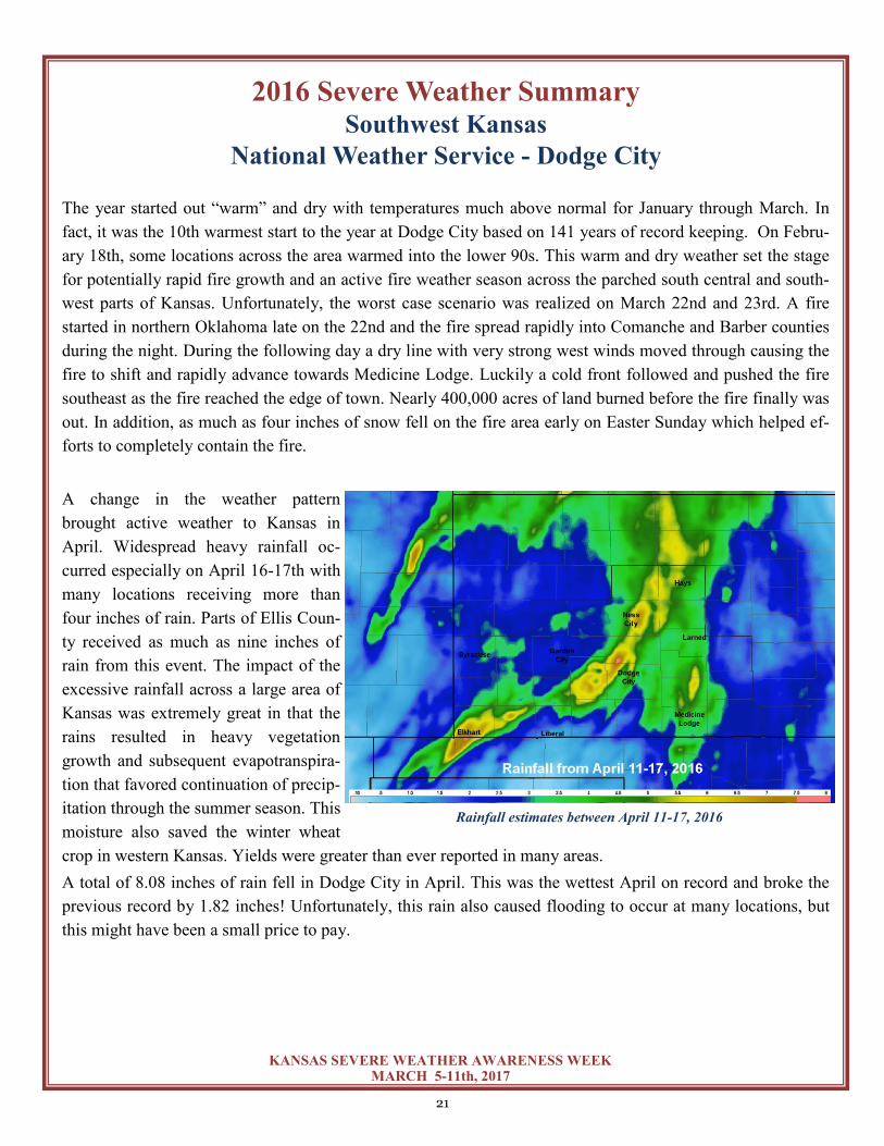
A change in the weather pattern
brought active weather to Kansas in
April. Widespread heavy rainfall oc-
curred especially on April 16-17th with
many locations receiving more than
four inches of rain. Parts of Ellis Coun-
ty received as much as nine inches of
rain from this event. The impact of the
excessive rainfall across a large area of
Kansas was extremely great in that the
rains resulted in heavy vegetation
growth and subsequent evapotranspira-
tion that favored continuation of precip-
itation through the summer season. This
moisture also saved the winter wheat
crop in western Kansas. Yields were greater than ever reported in many areas.
A total of 8.08 inches of rain fell in Dodge City in April. This was the wettest April on record and broke the
previous record by 1.82 inches! Unfortunately, this rain also caused flooding to occur at many locations, but
this might have been a small price to pay.
Below: May 24th, 2015 Tornado Tracks between Kismet and Dodge City
Rainfall estimates between April 11-17, 2016

22
KANSAS SEVERE WEATHER AWARENESS WEEK MARCH 5-11th, 2017
The first tornadoes of the year occurred on April 15th when a
supercell moved from the Oklahoma Panhandle into Morton
County and produced an EF1 tornado northeast of Elkhart
and an EF0 tornado northwest of Rolla.
Other tornadoes occurred in early May, but the big severe
weather event for the year was May 24th.
A total of 34 tornadoes occurred on May 24th including five
EF3 tornadoes. One tornado that moved just west of Dodge
City was observed by a research team using “Doppler On
Wheels;” this team measured wind speeds of just over 200
mph with brief spin-ups in the tornado vortex!
Dodge City was extremely fortunate in that many of these
potentially violent tornadoes skirted the city to the west and
north. Despite this fact, there was still significant damage in
the area with two injuries reported. In addition, an unusual
anticyclonic tornado occurred during this outbreak and was rated an EF2 in Edwards County. The anticyclon-
ic tornado tracked over five miles.
In July, of all months, another tornadic event unfolded in far western Kansas. On July 15th, an unusually
strong tornado occurred east of Syracuse. Although it did only EF1 damage, it visually appeared to be much
stronger. This tornado was well documented by a storm chaser and was a significant tornado from a signifi-
cant supercell thunderstorm for a summer month.
The upper level flow during the summer favored southwest winds aloft with frequent invasions of high level
tropical plumes originating in the south Pacific. Widespread heavy rainfall returned in July when Dodge City
received 5.3 inches of rain. Although this was not a record, it was 2.22 inches above average for the month.
Above average rainfall continued through August, but September, October, and November were dry. The ex-
ception was along I-70 where rains continued into September. Very heavy rainfall early on September 4th re-
sulted in considerable flooding in northern Ellis County.
Anomalous warmth returned in October and November. The average temperature for October was seven de-
grees above normal, and October was the fourth warmest on record at Dodge City. The average temperature
for November was 6.7 degrees above normal, making November the third warmest on record. The tempera-
ture rose to 101 in Dodge City and 100 in Garden City on October17th. This was the only day on record in
October during which the temperature reached or exceeded 100 degrees at both sites. The max temperature
broke the previous record high for the month of October, and the records in Dodge City extend back to 1874.
Tornado from May 24th, 2016

23
KANSAS SEVERE WEATHER AWARENESS WEEK MARCH 5-11th, 2017
Ashland reached a record high of 102 which was the warmest temperature observed so late in the season for
any location in the state of Kansas.
The warm weather continued into November. The temperature
reached 87 in Dodge City on November 16th and broke the pre-
vious record by eight degrees. This was the warmest tempera-
ture observed so late in the season. As such, 2016 has the dis-
tinction of having the warmest high temperature so early on rec-
ord and the warmest high temperature so late in the season. For
the first eleven months of the year, 2016 was the sixth warmest
on record.
The grand finale occurred Christmas Day when an unprecedent-
ed six tornadoes occurred across the local area. The early morn-
ing started with a very high amount of surface moisture as dew-
point temperatures rose to around 60 degrees. This is unheard of
for late December in southwest Kansas! A line of thunderstorms
marched across the area during the mid-morning
hours and along the leading edge there were brief
spin-ups. Five of these tornadoes caused minor
damage.
Even though the end of 2016 was generally very
dry, some areas (thanks to heavy spring and sum-
mer rains) ended up with a yearly precipitation to-
tal that was nearly double what is normal. A small
area in southern Gray County had nearly 45 inches.
It was so wet and humid in some areas that corn
was rotting in the husk before it could be harvest-
ed!
Be sure to find your local NWS office on facebook
NWSDodgeCity NWSSpringfield
NWSGoodland NWSTopeka
NWSHastings NWSWichita
NWSKansasCity Also be sure to check if your county
emergency manager has a facebook
page for your county.
Brief tornadoes on Christmas Day 2016.

24
KANSAS SEVERE WEATHER AWARENESS WEEK MARCH 5-11th, 2017
2016 Severe Weather Summary Northwest Kansas
National Weather Service - Goodland, KS
Drought
The drought situation across the state took a turn for the worse in 2016 particularly during the fall months.
Dry conditions began across northwest Kansas toward the end of summer. However, a slow moving weather
system produced several rounds of thunderstorms in early September leading to heavy rainfall throughout the
region. This provided a brief reprieve from late summer dry conditions.
Drought-free conditions quickly came to an end with a prolonged period of dry weather from mid-September
through November. This was due to a large ridge of high pressure that remained stationary over the Plains,
leading to well above normal temperatures with little precipitation. At Goodland Regional Airport, October
2016 ranked as the 5th warmest ever on record and the warmest since 1963. In addition, fall 2016 at Good-
land was the 2nd warmest ever which finished with an average temperature of 57.1 degrees. This was 0.2
degrees below the warmest fall ever (1939). Goodland Regional Airport received 0.04 inches of precipitation
during October which tied for the 10th driest. This was the driest October since 1999 when only 0.02 inches
of precipitation were received.
Winter Weather
The first four months in 2016 avoided winter weather for the most part; however, there were a couple notable
winter weather events. The first event was a substantial blizzard that swept through northwest Kansas on
February 1st and 2nd. During the height of the storm, visibility was less than one quarter mile for several
hours and winds gusted as high as 55 mph. In the end, many locations received over 12 inches of snow, and
drifts were as high as three to five feet.
December 27, 2016 December 29, 2015
Drought Monitor

25
KANSAS SEVERE WEATHER AWARENESS WEEK MARCH 5-11th, 2017
A second winter weather event occurred on April 29th which caught many by surprise. A cold rain changed
to snow for locations along the Colorado border. This winter storm also produced up to ten inches of snow in
eastern Colorado. Snow accumulations were lighter in northwest Kansas with a range from a trace to 6 inch-
es. The wet, slushy snow led to many accidents and slide offs along Interstate 70 in Sherman and Thomas
counties. Several injuries were reported. Westbound Interstate 70 was closed for several hours as emergency
responders cleaned up the accidents.
Severe Weather
The 2016 severe weather season started out slowly across the Tri-State Region with the first severe weather
event of the year taking place in eastern Colorado on April 15th. Northwest Kansas did not experience se-
vere weather until May 7th and 8th. On this weekend, storms produced large hail up to the size of baseballs
and one short-lived tornado in Gove County.
The last ten days in May were very active in terms of severe weather across northwest Kansas. Storms oc-
curred almost every day producing several tornadoes, many reports of large hail and wind damage, and sev-
eral instances of flash flooding. One notable storm was a large supercell that moved across Wichita County
on May 22nd. This storm produced a large wedge tornado. The tornado remained over open country east of
Lydia, KS in southeastern Wichita County. No damage was reported.
On May 26th, a significant severe weather event took place across the High Plains. A line of severe thunder-
storms developed in eastern Colorado and spread northeast across northwest Kansas. In addition, several
supercell thunderstorms developed ahead of the thunderstorm complex. The line of storms produced meas-
ured wind gusts up to 91 mph and widespread wind damage. Severe wind damage was reported in Kanarado.
These storms also produced: hail to the size of baseballs, a few funnel clouds, heavy rain, and widespread
blowing dust. Interstate 70 was closed for a brief period due to near zero visibility from blowing dust.
Blowing dirt associated with line of severe thunderstorms.
Photo courtesy of Dave Floyd
Supercell north of Leoti, KS.
Photo courtesy of Jon Zeitler

26
KANSAS SEVERE WEATHER AWARENESS WEEK MARCH 5-11th, 2017
After a very active end of May, northwest Kansas was given a reprieve from severe weather for June. Only a
few days of severe weather were reported primarily towards the end of the month. Reports included large hail
to the size of golf balls, damaging winds to 65 mph, heavy rainfall, and minor flash flooding.
Thunderstorm activity picked up once again in July. Several rounds of late evening and overnight thunder-
storms were observed throughout the month. These storms produced hail up to the size of a grapefruit, damag-
ing wind gusts to 70 mph, and flash flooding. One particular storm on July 7th was responsible for the grape-
fruit size hail in northern Cheyenne County. This storm continued southeast and several additional reports of
baseball size hail were received from Rawlins and Thomas counties. The storm strengthened as it moved fur-
ther southeast into Logan and Gove counties producing hail to 3.75 inches in diameter.
The 2016 severe weather season had one last surprise for northwest Kansas. On September 15th, a supercell
thunderstorm crossed the Colorado border and moved roughly parallel to Interstate 70. Reports of golf ball to
baseball size hail accompanied by winds gusting to 80 mph were common across Sherman, Thomas, Sheridan
and Graham counties. Widespread damage was reported due to wind-driven hail especially in Sherman and
Thomas counties. A large majority of homes and structures received damage to siding, windows and roofs,
especially on the west-facing side where the full force of wind driven hail was felt. In addition, large swaths of
crops were lost due to these storms.
Flooding
Several days of flooding were observed throughout the warm season. However, one flash flood event in par-
ticular stood out: September 2nd through September 4th. Four distinct rounds of slow moving thunderstorms
spread across northwest Kansas, producing very heavy rain in addition to severe weather. Flash flooding be-
came the main focus as heavy rains in excess of six to ten inches fell over several locations. Cheyenne, Gra-
ham and Norton counties were hit especially hard on the evening of September 3rd. During this evening, sev-
eral rounds of heavy rains were received which sent creeks well out of their banks and washed away numerous
country roads. Water rescues were conducted in Norton County as a few motorists were swept away by swol-
len creeks. Unfortunately, one individual did not survive the raging flood waters. This was the only fatality in
northwest Kansas related to severe weather and flash flooding during 2016.
Supercell thunderstorm approaching Goodland on September 15, 2016. Picture taken just prior to baseball size hail and 70-80
mph winds. Photo courtesy of Tim Lynch

27
KANSAS SEVERE WEATHER AWARENESS WEEK MARCH 5-11th, 2017
2016 Severe Weather Summary Southeast Kansas
National Weather Service - Springfield, MO
Compared to past years, 2016 was very quiet in regards to hazardous weather across far southeast Kan-
sas. Factors contributing to a less active weather season were a persistent pattern with the jet stream dis-
placed from the area and the lack of deep Gulf of Mexico moisture. The overall weather pattern was not
conducive for much in the way of active weather.
The year started off with a quiet winter season across
southeast Kansas. The overall weather pattern and jet
stream led to above average temperatures and below
average snowfall. A dusting of snow occurred
on January 21st across the area. This inactive weather
pattern continued into the spring season. There were
only a hand full of thunderstorms which produced iso-
lated reports of marginally large hail and damaging
wind gusts in April and May.
The middle of summer in 2016 turned out to be a little
more active with a couple rounds of severe weath-
er. One round of storms hit at the end of June and the
other round hit after the July 4th holiday. There were a
few reports of minor wind damage and isolated flash
flooding across portions of Crawford, Cherokee, and
Bourbon counties. Quiet weather continued into the
fall season with above average temperatures and below
average rainfall. The first frost and freeze of the season
was delayed about a month past the average for much
of the area.
Be sure to find your local NWS office on Twitter
NWS Dodge City, Kansas at @NWSDodgeCity
NWS Goodland, Kansas at @NWSGoodland
NWS Hastings, Nebraska at @NWSHastings
NWS Kansas City, Missouri at @NWSKansasCity
NWS Springfield, Missouri at @NWSSpringfield
NWS Topeka, Kansas at @NWSTopeka
NWS Wichita, Kansas at @NWSWichita
Also be sure to check
if your county emer-
gency manager has a
Twitter account for
your county.
Mid January 2016 Snowfall

28
KANSAS SEVERE WEATHER AWARENESS WEEK MARCH 5-11th, 2017
Sirens Are An Outdoor Warning System
Every year the National Weather Service and the emergency management communities get to-
gether and provide severe weather information for the public. Each year we emphasize the fact
that the outdoor sirens are just that…an Outdoor Warning System. Every year we get a multi-
tude of calls telling us that the sirens can’t be heard while in the house.
Severe weather season usually begins in the early spring in Kansas.
We all need to be prepared for severe weather at any time of the
day or night and at any time of year. The National Weather Ser-
vice, emergency management, law enforcement, the 9-1-1 center,
and the fire department cannot notify every individual of the possi-
bility of severe weather in their town. The local media outlets and
All Hazards NOAA Weather Radio are your best sources for infor-
mation concerning severe weather watches and warnings. Do not
wait for the sirens to be your warning system at home. Sirens may
not be working if the power is out and oftentimes cannot be heard
indoors. Sirens may not be activated for other severe threats such
as damaging straight line winds in excess of 60 mph, large hail, and
flooding. Monitor NOAA Weather Radio and local media then
take the appropriate action for the severe weather threat. If it ap-
pears that a severe thunderstorm is approaching your location, do
not wait for the outdoor sirens but take immediate action to protect
your life and the lives of others in your home.
Hundreds of volunteer storm spotters, amateur radio operators, and first
responders provide the first line of defense every time there is severe
weather in the local area. They do this because they care about the peo-
ple in their communities and want to make sure those people are given
the best chance at survival. The storm spotters, emergency managers,
law enforcement and other volunteers immediately relay severe weather
reports to the National Weather Service. The National Weather Service
in turn disseminates that information to the media and public through
warnings, statements, and local storm reports. Getting the word out to
the public in a timely manner may save lives. When severe weather
threatens at night while most people sleep, it can be especially danger-
ous. Oftentimes in the heat of the spring and summer, we cannot hear
outdoor sirens over running air conditioners. A NOAA Weather Radio with a back-up battery
can make the difference for you and your family.
Take responsibility…listen to the media….take protective action….survive to enjoy the won-
derful warm sunny days that also come this time of year.

29
KANSAS SEVERE WEATHER AWARENESS WEEK MARCH 5-11th, 2017
Americans live in the most severe weather-prone country on Earth, and the state of Kansas is no
exception. Each year a startling 10,000 thunderstorms, 2,500 floods, 1,000 tornadoes, and 10
hurricanes impact the United States. Potentially deadly severe weather impacts every Ameri-
can. Communities can rely on the National Weather Service’s StormReady program to help
them guard against the ravages of Mother Nature.
What is StormReady? Ninety percent of all presidentially declared disasters are weather related. Through the Storm-
Ready program, NOAA’s National Weather Service gives communities the skills and education
needed to survive severe weather – before and during the event. StormReady helps community
leaders and emergency managers strengthen their local hazardous weather operations.
StormReady Does Not Mean Storm Proof StormReady communities are better prepared to save lives from the onslaught of severe weather
through better planning, education and awareness. Communities have fewer fatalities and prop-
erty damage if they plan before dangerous weather arrives. No community is storm proof, but
StormReady can help communities save lives.
How Can My Community Become StormReady? The entire community – from the mayor and emergency managers, to business leaders and civic
groups – can take the lead on becoming StormReady. Local National Weather Service forecast
offices work with communities to complete an application and review process. To be recog-
nized as StormReady, a community must:
Establish a 24-hour warning point and emergency operations center.
Have more than one way to receive severe weather warnings and forecasts and to
alert the public.
Create a system that monitors local weather conditions.
Promote the importance of public readiness through community seminars.
Develop a formal hazardous weather plan, which includes training severe weather
spotters and holding emergency exercises.
Go to http://www.stormready.noaa.gov for more information.

30
KANSAS SEVERE WEATHER AWARENESS WEEK MARCH 5-11th, 2017
Where do you get them?
Vendors of NWR receivers packaged to accom-modate needs including grocery stores
Harris Communications (800) 825-6758 or harris-comm.com (search weather)
Homesafe, Inc. (800) 607-6737 or homesafeinc.com (click SPECIAL NEEDS PRODUCTS)
Silent Call (800) 572-5227 or silent-call.com
How much does it cost?
Roughly $100 for a system packaged with external alarm devices
Other options? RCA sells a flat screen AlertGuard television with
built-in NWR receiver
Sign-up for weather alerts from a local media sta-tion or other application on a smartphone
Wireless Weather Alerts (WEA) for extreme weather warnings
Deaf & Hard of Hearing Awareness
www.weather.gov
National Weather Service
NOAA Weather Radio
If you see lightning, you are within striking dis-
tance. Seek safe shelter IMMEDIATELY!
Outdoor Activities: Minimize the risk of being struck by moving indoors or to vehicles
Inside Activities: Things to avoid Corded phones Computers Other electrical equipment Indoor/Outdoor pools Tubs and showers and other things con-
nected to metal plumbing
Lightning Safety
Watch for developing thunderstorms and be ready to act when lightning is seen.
Lightning can strike as far as 10 miles from an area where it is raining.
What is it?
A way to notify you of dangerous weather during the day or even while you’re sleeping.
How does it notify you?
Includes ASL Instructions
Kansas


!["Self Reporting" Letter of Ethical Violations By Kansas Assistant Attorney General - Stephen Phillips, [ May 11th, 2016 ]](https://static.fdocuments.net/doc/165x107/577c7c531a28abe0549a25af/self-reporting-letter-of-ethical-violations-by-kansas-assistant-attorney.jpg)

