11/25/2015 - Idaho Transportation Department · 2015-11-25 · Map Date: 11/25/2015 LRI Revised:...
23
11/25/2015 PREPARED BY THE Idaho Transportation Department | jhill Idaho Transportation Department WENDELL HIGHWAY DISTRICT MAP BOOK SCALE 19,320
Transcript of 11/25/2015 - Idaho Transportation Department · 2015-11-25 · Map Date: 11/25/2015 LRI Revised:...

11/25/2015
PREPARED BY THE Idaho Transportation Department | jhill
Idaho Transportation Department
WENDELL HIGHWAY DISTRICT MAP BOOK SCALE 19,320

9
4 5 6
7 8 11
16
15
23
1312
17
10
18 19
20 21 22
14
WENDELL HD LOCATOR GRIDMAP BOOK PAGE NUMBERS

Legend
LRI - Road Pay Weight
PayWeight
0.52EarthGravelF-Asphalt/oil treated gravel less than 1"G-1-Road or Cold Plant mix AsphaltG-2-Hot mix asphalt pavementJ-Other (e.g., concrete,cobble stone or brick surface)
Status
UNIMPROVED#0 GNIS - Summit/Peak[· airport
ï cemeteryrange
/ islandMapGridsHighwayDistrictStateCountyCitySectionWaterbodyRiverUSFS LANDS
LRS - Routes

E 2500E 2500
§̈¦84
§̈¦84
T 07 S R 14E SECTION 9
T 07 SR 14 E
SECTION 10T 07 SR 14 E
SECTION 11T 07 SR 14 E
SECTION 12
T 07 SR 14 E
SECTION 13T 07 SR 14 E
SECTION 14
T 07 SR 14 E
SECTION 15
T 07 SR 14 E
SECTION 16
T 07 SR 14 E
SECTION 21T 07 SR 14 E
SECTION 22T 07 SR 14 E
SECTION 23T 07 SR 14 E
SECTION 24
4
5
7 8
4
987
65
10
12 13 14
11
1516 1817 19Document Path: W:\LocalRds\RoadSurface\Projects\RoadSurface-08.5x11.mxd
Prepared by the Idaho Transportation Department incooperation with the U.S. Department of TransportationFederal Highway Administration
Map Date: 11/25/2015LRI Revised: 10/31/2015
2015 ROAD SURFACE MAPWENDELL HIGHWAY DISTRICTGOODING COUNTY, IDAHO
The Idaho Transportation Department (ITD)provides this information, including geographicdata and any associated metadata "as is"without warranty of any kind, including but notlimited to its completeness, fitness for aparticular use, or accuracy of content, positionalor otherwise. It is the sole responsibility of theuser to determine the accuracy or usability ofany information, data or metadata for his, orher, own purposes. In no event shall ITD haveany liability whatsoever for damages of any kindarising out of the use of or reliance on theinformation, geographic data or metadata. Inproviding this information, data, metadata, oraccess to such, ITD assumes no obligation toassist the user in the use of such or in thedevelopment, use, or maintenance of anyapplications applied to or associated with such.
23Page: 4 of ITD MAP DISCLAIMER:
0 10.5miles

§̈¦84
§̈¦84W Canal
T 07 SR 14 E
SECTION 12
T 07 SR 14 E
SECTION 13
T 07 SR 14 E
SECTION 24
T 07 S R15 E
SECTION 7T 07 S R
15 ESECTION 8
T 07 SR 15 E
SECTION 17
T 07 SR 15 E
SECTION 18
T 07 SR 15 E
SECTION 19T 07 SR 15 E
SECTION 20
4
5
6
7 8 9
4
987
65
11
14 151312
10
16 191817Document Path: W:\LocalRds\RoadSurface\Projects\RoadSurface-08.5x11.mxd
Prepared by the Idaho Transportation Department incooperation with the U.S. Department of TransportationFederal Highway Administration
Map Date: 11/25/2015LRI Revised: 10/31/2015
2015 ROAD SURFACE MAPWENDELL HIGHWAY DISTRICTGOODING COUNTY, IDAHO
The Idaho Transportation Department (ITD)provides this information, including geographicdata and any associated metadata "as is"without warranty of any kind, including but notlimited to its completeness, fitness for aparticular use, or accuracy of content, positionalor otherwise. It is the sole responsibility of theuser to determine the accuracy or usability ofany information, data or metadata for his, orher, own purposes. In no event shall ITD haveany liability whatsoever for damages of any kindarising out of the use of or reliance on theinformation, geographic data or metadata. Inproviding this information, data, metadata, oraccess to such, ITD assumes no obligation toassist the user in the use of such or in thedevelopment, use, or maintenance of anyapplications applied to or associated with such.
23Page: 5 of ITD MAP DISCLAIMER:
0 10.5miles

")46
T 07 S R15 E
SECTION 8T 07 S R 15
E SECTION 9 T 07 SR 15 E
SECTION 10
T 07 SR 15 E
SECTION 15
T 07 SR 15 E
SECTION 16
T 07 SR 15 E
SECTION 17
T 07 SR 15 E
SECTION 20
T 07 SR 15 E
SECTION 21 T 07 SR 15 E
SECTION 22
5
6
8 9 10
4
987
65
11
14 151312
10
16 191817Document Path: W:\LocalRds\RoadSurface\Projects\RoadSurface-08.5x11.mxd
Prepared by the Idaho Transportation Department incooperation with the U.S. Department of TransportationFederal Highway Administration
Map Date: 11/25/2015LRI Revised: 10/31/2015
2015 ROAD SURFACE MAPWENDELL HIGHWAY DISTRICTGOODING COUNTY, IDAHO
The Idaho Transportation Department (ITD)provides this information, including geographicdata and any associated metadata "as is"without warranty of any kind, including but notlimited to its completeness, fitness for aparticular use, or accuracy of content, positionalor otherwise. It is the sole responsibility of theuser to determine the accuracy or usability ofany information, data or metadata for his, orher, own purposes. In no event shall ITD haveany liability whatsoever for damages of any kindarising out of the use of or reliance on theinformation, geographic data or metadata. Inproviding this information, data, metadata, oraccess to such, ITD assumes no obligation toassist the user in the use of such or in thedevelopment, use, or maintenance of anyapplications applied to or associated with such.
23Page: 6 of ITD MAP DISCLAIMER:
0 10.5miles

E 2950E 2950 E 2950E 2950
E 2800 RDE 2800 RD
S 150
0S 1
500
E 2950E 2950
E 2800 RDE 2800 RD
HAGERMAN HWY
HAGERMAN HWY
W Canal
T 07 SR 14 E
SECTION 21
T 07 SR 14 E
SECTION 22T 07 SR 14 E
SECTION 23
T 07 SR 14 E
SECTION 24
T 07 SR 14 E
SECTION 25
T 07 SR 14 E
SECTION 26
T 07 SR 14 E
SECTION 27
T 07 SR 14 E
SECTION 28
T 07 SR 14 E
SECTION 33
T 07 SR 14 E
SECTION 34T 07 SR 14 E
SECTION 35
T 07 SR 14 E
SECTION 36
T 08 S R 14E SECTION 1
T 08 S R 14E SECTION 2
T 08 S R 14E SECTION 3T 08 S R
14 ESECTION 4
4 5
7
8
12
4
987
65
1817
10
12 13 14
16
11
15
1920 2221 23Document Path: W:\LocalRds\RoadSurface\Projects\RoadSurface-08.5x11.mxd
Prepared by the Idaho Transportation Department incooperation with the U.S. Department of TransportationFederal Highway Administration
Map Date: 11/25/2015LRI Revised: 10/31/2015
2015 ROAD SURFACE MAPWENDELL HIGHWAY DISTRICTGOODING COUNTY, IDAHO
The Idaho Transportation Department (ITD)provides this information, including geographicdata and any associated metadata "as is"without warranty of any kind, including but notlimited to its completeness, fitness for aparticular use, or accuracy of content, positionalor otherwise. It is the sole responsibility of theuser to determine the accuracy or usability ofany information, data or metadata for his, orher, own purposes. In no event shall ITD haveany liability whatsoever for damages of any kindarising out of the use of or reliance on theinformation, geographic data or metadata. Inproviding this information, data, metadata, oraccess to such, ITD assumes no obligation toassist the user in the use of such or in thedevelopment, use, or maintenance of anyapplications applied to or associated with such.
23Page: 7 of ITD MAP DISCLAIMER:
0 10.5miles

E 2950E 2950 E 2950E 2950E 2950E 2950 E 2950E 2950
E 2800 RDE 2800 RDE 2800 RDE 2800 RD
E 2950E 2950 E 2950E 2950
E 2800 RDE 2800 RD
§̈¦84§̈¦84
§̈¦84
§̈¦84 §̈¦84§̈¦84
§̈¦84§̈¦84
")46
W CanalT 07 SR 14 E
SECTION 24
T 07 SR 14 E
SECTION 25
T 07 SR 14 E
SECTION 36
T 07 SR 15 E
SECTION 19
T 07 SR 15 E
SECTION 20
T 07 SR 15 E
SECTION 29
T 07 SR 15 E
SECTION 30
T 07 SR 15 E
SECTION 31
T 07 SR 15 E
SECTION 32
T 08 S R 14E SECTION 1 T 08 S
R 15 ESECTION 5
T 08 S R 15E SECTION 6
4 5 6
7
8
9
12 13
4
987
65
11
14 15
16 17 18 19
1312
10
20 232221Document Path: W:\LocalRds\RoadSurface\Projects\RoadSurface-08.5x11.mxd
Prepared by the Idaho Transportation Department incooperation with the U.S. Department of TransportationFederal Highway Administration
Map Date: 11/25/2015LRI Revised: 10/31/2015
2015 ROAD SURFACE MAPWENDELL HIGHWAY DISTRICTGOODING COUNTY, IDAHO
The Idaho Transportation Department (ITD)provides this information, including geographicdata and any associated metadata "as is"without warranty of any kind, including but notlimited to its completeness, fitness for aparticular use, or accuracy of content, positionalor otherwise. It is the sole responsibility of theuser to determine the accuracy or usability ofany information, data or metadata for his, orher, own purposes. In no event shall ITD haveany liability whatsoever for damages of any kindarising out of the use of or reliance on theinformation, geographic data or metadata. Inproviding this information, data, metadata, oraccess to such, ITD assumes no obligation toassist the user in the use of such or in thedevelopment, use, or maintenance of anyapplications applied to or associated with such.
23Page: 8 of ITD MAP DISCLAIMER:
0 10.5miles

E EFE EFAVEAVE
E EFE EFAVEAVE E EFE EF
AVEAVEE EFE EFAVEAVE
E EFE EFAVEAVE
E EFE EFAVEAVE
N FRONTAGEN FRONTAGERDRD
EE 22880000 RRDDE 2800 RDE 2800 RD
E 3000E 3000
S 190
0S 1
900
§̈¦84
§̈¦84 §̈¦84
§̈¦84 §̈¦84
§̈¦84
§̈¦84
§̈¦84
§̈¦84
§̈¦84
§̈¦84
§̈¦84
§̈¦84
§̈¦84
§̈¦84
§̈¦84
")46
")46
LateralS-2
W Canal
Lateral S-2
W Canal
WENDELL
T 07 SR 15 E
SECTION 20
T 07 SR 15 E
SECTION 21 T 07 SR 15 E
SECTION 22
T 07 SR 15 E
SECTION 27
T 07 SR 15 E
SECTION 28T 07 SR 15 E
SECTION 29
T 07 SR 15 E
SECTION 32
T 07 SR 15 E
SECTION 33
T 07 SR 15 E
SECTION 34
T 08 SR 15 E
SECTION 3T 08 S R 15
E SECTION 4T 08 S R 15
E SECTION 5
5 6
8
9
10
12 13 14
4
987
65
11
14 15
16 17 18 19
1312
10
20 232221Document Path: W:\LocalRds\RoadSurface\Projects\RoadSurface-08.5x11.mxd
Prepared by the Idaho Transportation Department incooperation with the U.S. Department of TransportationFederal Highway Administration
Map Date: 11/25/2015LRI Revised: 10/31/2015
2015 ROAD SURFACE MAPWENDELL HIGHWAY DISTRICTGOODING COUNTY, IDAHO
The Idaho Transportation Department (ITD)provides this information, including geographicdata and any associated metadata "as is"without warranty of any kind, including but notlimited to its completeness, fitness for aparticular use, or accuracy of content, positionalor otherwise. It is the sole responsibility of theuser to determine the accuracy or usability ofany information, data or metadata for his, orher, own purposes. In no event shall ITD haveany liability whatsoever for damages of any kindarising out of the use of or reliance on theinformation, geographic data or metadata. Inproviding this information, data, metadata, oraccess to such, ITD assumes no obligation toassist the user in the use of such or in thedevelopment, use, or maintenance of anyapplications applied to or associated with such.
23Page: 9 of ITD MAP DISCLAIMER:
0 10.5miles

E 3000E 3000 E 3000E 3000E 3000E 3000 E 3000E 3000E 3000E 3000
W Canal
Latera
lS-2
T 07 SR 15 E
SECTION 22 T 07 SR 15 E
SECTION 23
T 07 SR 15 E
SECTION 24
T 07 SR 15 E
SECTION 25
T 07 SR 15 E
SECTION 26
T 07 SR 15 E
SECTION 27
T 07 SR 15 E
SECTION 34
T 07 SR 15 E
SECTION 35
T 07 SR 15 E
SECTION 36
T 08 S R 15E SECTION 1
T 08 S R 15E SECTION 2
T 08 S R 15E SECTION 3
6
9
10
11
13 14 15
4
987
65
11
14 15
16 17 18 19
1312
10
20 232221Document Path: W:\LocalRds\RoadSurface\Projects\RoadSurface-08.5x11.mxd
Prepared by the Idaho Transportation Department incooperation with the U.S. Department of TransportationFederal Highway Administration
Map Date: 11/25/2015LRI Revised: 10/31/2015
2015 ROAD SURFACE MAPWENDELL HIGHWAY DISTRICTGOODING COUNTY, IDAHO
The Idaho Transportation Department (ITD)provides this information, including geographicdata and any associated metadata "as is"without warranty of any kind, including but notlimited to its completeness, fitness for aparticular use, or accuracy of content, positionalor otherwise. It is the sole responsibility of theuser to determine the accuracy or usability ofany information, data or metadata for his, orher, own purposes. In no event shall ITD haveany liability whatsoever for damages of any kindarising out of the use of or reliance on theinformation, geographic data or metadata. Inproviding this information, data, metadata, oraccess to such, ITD assumes no obligation toassist the user in the use of such or in thedevelopment, use, or maintenance of anyapplications applied to or associated with such.
23Page: 10 of ITD MAP DISCLAIMER:
0 10.5miles

S 240
0S 2
400
E 3000E 3000
WW500500
WW400400
WW300300
S 240
0S 2
400
E 3000E 3000 W 300W 300W 300W 300
S 240
0S 2
400
W 400W 400
E 3000E 3000
W Canal
Lateral S-2
T 07 SR 15 E
SECTION 24
T 07 SR 15 E
SECTION 25
T 07 SR 15 E
SECTION 36
T 07 SR 16 E
SECTION 19T 07 SR 16 E
SECTION 20
T 07 SR 16 E
SECTION 21
T 07 SR 16 E
SECTION 28
T 07 SR 16 E
SECTION 29
T 07 SR 16 E
SECTION 30
T 07 SR 16 E
SECTION 31
T 07 SR 16 E
SECTION 32
T 07 SR 16 E
SECTION 33
T 08 S R 15E SECTION 1
T 08 SR 16 E
SECTION 4T 08 S R 16
E SECTION 5T 08 S R 16
E SECTION 6
10
11
14 15
5
98
6
117
4
14 15
16 17 18 19
1312
10
20 232221Document Path: W:\LocalRds\RoadSurface\Projects\RoadSurface-08.5x11.mxd
Prepared by the Idaho Transportation Department incooperation with the U.S. Department of TransportationFederal Highway Administration
Map Date: 11/25/2015LRI Revised: 10/31/2015
2015 ROAD SURFACE MAPWENDELL HIGHWAY DISTRICTGOODING COUNTY, IDAHO
The Idaho Transportation Department (ITD)provides this information, including geographicdata and any associated metadata "as is"without warranty of any kind, including but notlimited to its completeness, fitness for aparticular use, or accuracy of content, positionalor otherwise. It is the sole responsibility of theuser to determine the accuracy or usability ofany information, data or metadata for his, orher, own purposes. In no event shall ITD haveany liability whatsoever for damages of any kindarising out of the use of or reliance on theinformation, geographic data or metadata. Inproviding this information, data, metadata, oraccess to such, ITD assumes no obligation toassist the user in the use of such or in thedevelopment, use, or maintenance of anyapplications applied to or associated with such.
23Page: 11 of ITD MAP DISCLAIMER:
0 10.5miles

T 07 S R 14 ESECTION 36
T 07 SR 15 E
SECTION 31T 07 SR 15 E
SECTION 32
T 08 S R 14E SECTION 1
T 08 SR 14 E
SECTION 12
T 08 SR 14 E
SECTION 13
T 08 S R 15E SECTION 5T 08 S R
15 ESECTION 6
T 08 S R15 E
SECTION 7T 08 S R 15
E SECTION 8
T 08 SR 15 E
SECTION 17
T 08 SR 15 E
SECTION 18
7 8 9
12
13
16 17
4
987
65
11
18 19
10
21 22 23
1716
15141312
20Document Path: W:\LocalRds\RoadSurface\Projects\RoadSurface-08.5x11.mxd
Prepared by the Idaho Transportation Department incooperation with the U.S. Department of TransportationFederal Highway Administration
Map Date: 11/25/2015LRI Revised: 10/31/2015
2015 ROAD SURFACE MAPWENDELL HIGHWAY DISTRICTGOODING COUNTY, IDAHO
The Idaho Transportation Department (ITD)provides this information, including geographicdata and any associated metadata "as is"without warranty of any kind, including but notlimited to its completeness, fitness for aparticular use, or accuracy of content, positionalor otherwise. It is the sole responsibility of theuser to determine the accuracy or usability ofany information, data or metadata for his, orher, own purposes. In no event shall ITD haveany liability whatsoever for damages of any kindarising out of the use of or reliance on theinformation, geographic data or metadata. Inproviding this information, data, metadata, oraccess to such, ITD assumes no obligation toassist the user in the use of such or in thedevelopment, use, or maintenance of anyapplications applied to or associated with such.
23Page: 12 of ITD MAP DISCLAIMER:
0 10.5miles

E 3200E 3200 E 3200E 3200E 3200E 3200E 3200E 3200
E 3000E 3000§̈¦84
§̈¦84
§̈¦84
§̈¦84
§̈¦84 §̈¦84
§̈¦84§̈¦84
§̈¦84
§̈¦84§̈¦84
")46
")46
Lateral S-2WENDELL
T 07 SR 15 E
SECTION 32
T 07 SR 15 E
SECTION 33T 07 SR 15 E
SECTION 34
T 08 S R 15E SECTION 3
T 08 S R 15E SECTION 4
T 08 S R 15E SECTION 5
T 08 S R15 E
SECTION 8
T 08 S R 15E SECTION 9 T 08 S
R 15 ESECTION 10
T 08 SR 15 E
SECTION 15
T 08 SR 15 E
SECTION 16T 08 SR 15 E
SECTION 17
8 9 10
12
13
14
16 17 18
4
987
65
11
18 19
10
21 22 23
1716
15141312
20Document Path: W:\LocalRds\RoadSurface\Projects\RoadSurface-08.5x11.mxd
Prepared by the Idaho Transportation Department incooperation with the U.S. Department of TransportationFederal Highway Administration
Map Date: 11/25/2015LRI Revised: 10/31/2015
2015 ROAD SURFACE MAPWENDELL HIGHWAY DISTRICTGOODING COUNTY, IDAHO
The Idaho Transportation Department (ITD)provides this information, including geographicdata and any associated metadata "as is"without warranty of any kind, including but notlimited to its completeness, fitness for aparticular use, or accuracy of content, positionalor otherwise. It is the sole responsibility of theuser to determine the accuracy or usability ofany information, data or metadata for his, orher, own purposes. In no event shall ITD haveany liability whatsoever for damages of any kindarising out of the use of or reliance on theinformation, geographic data or metadata. Inproviding this information, data, metadata, oraccess to such, ITD assumes no obligation toassist the user in the use of such or in thedevelopment, use, or maintenance of anyapplications applied to or associated with such.
23Page: 13 of ITD MAP DISCLAIMER:
0 10.5miles

E 320
0E 3
200E 3200E 3200
E 3000E 3000 E 3000E 3000
S 220
0S 2
200
S 220
0S 2
200
E 3200E 3200
E 3000E 3000
E 3200E 3200
E 3000E 3000
S 220
0S 2
200
E 3000E 3000
E 3200E 3200
§̈¦84
§̈¦84
Lateral S-2
T 07 SR 15 E
SECTION 34T 07 SR 15 E
SECTION 35T 07 SR 15 E
SECTION 36
T 08 S R15 E
SECTION 1
T 08 S R15 E
SECTION 2
T 08 S R 15E SECTION 3
T 08 SR 15 E
SECTION 10T 08 SR 15 E
SECTION 11T 08 SR 15 E
SECTION 12
T 08 SR 15 E
SECTION 13
T 08 SR 15 E
SECTION 14T 08 SR 15 E
SECTION 15
9 10 11
13
14
15
17 18 19
4
987
65
11
18 19
10
21 22 23
1716
15141312
20Document Path: W:\LocalRds\RoadSurface\Projects\RoadSurface-08.5x11.mxd
Prepared by the Idaho Transportation Department incooperation with the U.S. Department of TransportationFederal Highway Administration
Map Date: 11/25/2015LRI Revised: 10/31/2015
2015 ROAD SURFACE MAPWENDELL HIGHWAY DISTRICTGOODING COUNTY, IDAHO
The Idaho Transportation Department (ITD)provides this information, including geographicdata and any associated metadata "as is"without warranty of any kind, including but notlimited to its completeness, fitness for aparticular use, or accuracy of content, positionalor otherwise. It is the sole responsibility of theuser to determine the accuracy or usability ofany information, data or metadata for his, orher, own purposes. In no event shall ITD haveany liability whatsoever for damages of any kindarising out of the use of or reliance on theinformation, geographic data or metadata. Inproviding this information, data, metadata, oraccess to such, ITD assumes no obligation toassist the user in the use of such or in thedevelopment, use, or maintenance of anyapplications applied to or associated with such.
23Page: 14 of ITD MAP DISCLAIMER:
0 10.5miles

S 2300S 2300
E 3000E 3000
S 240
0S 2
400
S 240
0S 2
400
EE32003200
WW200200
WW100100
S 240
0S 2
400
W 100W 100
SS224400
00
SS 22330000
E 3000E 3000
S 230
0S 2
300
N 40
0 RD
N 40
0 RD
W 300W 300W 300W 300
S 240
0S 2
400
S 240
0S 2
400
E 3000E 3000
W 200W 200
S 240
0S 2
400
§̈¦84
§̈¦84
§̈¦84
§̈¦84
Lateral S-2
T 07 SR 15 E
SECTION 36
T 07 SR 16 E
SECTION 31
T 07 SR 16 E
SECTION 32 T 07 SR 16 E
SECTION 33
T 08 S R15 E
SECTION 1
T 08 SR 15 E
SECTION 12
T 08 SR 15 E
SECTION 13
T 08 SR 16 E
SECTION 4
T 08 S R16 E
SECTION 5
T 08 S R16 E
SECTION 6
T 08 S R16 E
SECTION 7T 08 S R
16 ESECTION 8 T 08 S
R 16 ESECTION 9
T 08 SR 16 E
SECTION 16
T 08 SR 16 E
SECTION 17
T 08 SR 16 E
SECTION 18
10 11
14 15
18 19
5
98
6
117
4
18 19
10
21 22 23
1716
15141312
20Document Path: W:\LocalRds\RoadSurface\Projects\RoadSurface-08.5x11.mxd
Prepared by the Idaho Transportation Department incooperation with the U.S. Department of TransportationFederal Highway Administration
Map Date: 11/25/2015LRI Revised: 10/31/2015
2015 ROAD SURFACE MAPWENDELL HIGHWAY DISTRICTGOODING COUNTY, IDAHO
The Idaho Transportation Department (ITD)provides this information, including geographicdata and any associated metadata "as is"without warranty of any kind, including but notlimited to its completeness, fitness for aparticular use, or accuracy of content, positionalor otherwise. It is the sole responsibility of theuser to determine the accuracy or usability ofany information, data or metadata for his, orher, own purposes. In no event shall ITD haveany liability whatsoever for damages of any kindarising out of the use of or reliance on theinformation, geographic data or metadata. Inproviding this information, data, metadata, oraccess to such, ITD assumes no obligation toassist the user in the use of such or in thedevelopment, use, or maintenance of anyapplications applied to or associated with such.
23Page: 15 of ITD MAP DISCLAIMER:
0 10.5miles

E 3500E 3500
S 170
0S 1
700
CedarDrawCreek
T 08 SR 14 E
SECTION 13
T 08 SR 14 E
SECTION 24
T 08 SR 14 E
SECTION 25
T 08 SR 15 E
SECTION 17
T 08 SR 15 E
SECTION 18
T 08 SR 15 E
SECTION 19T 08 SR 15 E
SECTION 20
T 08 SR 15 E
SECTION 29
T 08 SR 15 E
SECTION 30
12 13
16
17
20 21
7 98 11
15
16 17 18 19
10
21 22 23
14
20
12 13
4 65
Document Path: W:\LocalRds\RoadSurface\Projects\RoadSurface-08.5x11.mxd
Prepared by the Idaho Transportation Department incooperation with the U.S. Department of TransportationFederal Highway Administration
Map Date: 11/25/2015LRI Revised: 10/31/2015
2015 ROAD SURFACE MAPWENDELL HIGHWAY DISTRICTGOODING COUNTY, IDAHO
The Idaho Transportation Department (ITD)provides this information, including geographicdata and any associated metadata "as is"without warranty of any kind, including but notlimited to its completeness, fitness for aparticular use, or accuracy of content, positionalor otherwise. It is the sole responsibility of theuser to determine the accuracy or usability ofany information, data or metadata for his, orher, own purposes. In no event shall ITD haveany liability whatsoever for damages of any kindarising out of the use of or reliance on theinformation, geographic data or metadata. Inproviding this information, data, metadata, oraccess to such, ITD assumes no obligation toassist the user in the use of such or in thedevelopment, use, or maintenance of anyapplications applied to or associated with such.
23Page: 16 of ITD MAP DISCLAIMER:
0 10.5miles

")46
CedarDrawCreek
CedarDrawCreek
Cedar Draw Creek Cedar Draw Creek
Cedar Draw Creek
T 08 SR 15 E
SECTION 15
T 08 SR 15 E
SECTION 16T 08 SR 15 E
SECTION 17
T 08 SR 15 E
SECTION 20
T 08 SR 15 E
SECTION 21 T 08 SR 15 E
SECTION 22
T 08 SR 15 E
SECTION 27
T 08 SR 15 E
SECTION 28
T 08 SR 15 E
SECTION 29
12 13 14
16
17
18
20 21 22
7 98 11
15
16 17 18 19
10
21 22 23
14
20
12 13
4 65
Document Path: W:\LocalRds\RoadSurface\Projects\RoadSurface-08.5x11.mxd
Prepared by the Idaho Transportation Department incooperation with the U.S. Department of TransportationFederal Highway Administration
Map Date: 11/25/2015LRI Revised: 10/31/2015
2015 ROAD SURFACE MAPWENDELL HIGHWAY DISTRICTGOODING COUNTY, IDAHO
The Idaho Transportation Department (ITD)provides this information, including geographicdata and any associated metadata "as is"without warranty of any kind, including but notlimited to its completeness, fitness for aparticular use, or accuracy of content, positionalor otherwise. It is the sole responsibility of theuser to determine the accuracy or usability ofany information, data or metadata for his, orher, own purposes. In no event shall ITD haveany liability whatsoever for damages of any kindarising out of the use of or reliance on theinformation, geographic data or metadata. Inproviding this information, data, metadata, oraccess to such, ITD assumes no obligation toassist the user in the use of such or in thedevelopment, use, or maintenance of anyapplications applied to or associated with such.
23Page: 17 of ITD MAP DISCLAIMER:
0 10.5miles

Cedar Draw Creek
T 08 SR 15 E
SECTION 13
T 08 SR 15 E
SECTION 14
T 08 SR 15 E
SECTION 15
T 08 SR 15 E
SECTION 22T 08 SR 15 E
SECTION 23T 08 SR 15 E
SECTION 24
T 08 SR 15 E
SECTION 25
T 08 SR 15 E
SECTION 26T 08 SR 15 E
SECTION 27
13 14 15
17
18
19
21 22 23
7 98 11
15
16 17 18 19
10
21 22 23
14
20
12 13
4 65
Document Path: W:\LocalRds\RoadSurface\Projects\RoadSurface-08.5x11.mxd
Prepared by the Idaho Transportation Department incooperation with the U.S. Department of TransportationFederal Highway Administration
Map Date: 11/25/2015LRI Revised: 10/31/2015
2015 ROAD SURFACE MAPWENDELL HIGHWAY DISTRICTGOODING COUNTY, IDAHO
The Idaho Transportation Department (ITD)provides this information, including geographicdata and any associated metadata "as is"without warranty of any kind, including but notlimited to its completeness, fitness for aparticular use, or accuracy of content, positionalor otherwise. It is the sole responsibility of theuser to determine the accuracy or usability ofany information, data or metadata for his, orher, own purposes. In no event shall ITD haveany liability whatsoever for damages of any kindarising out of the use of or reliance on theinformation, geographic data or metadata. Inproviding this information, data, metadata, oraccess to such, ITD assumes no obligation toassist the user in the use of such or in thedevelopment, use, or maintenance of anyapplications applied to or associated with such.
23Page: 18 of ITD MAP DISCLAIMER:
0 10.5miles

S 240
0S 2
400
S 240
0S 2
400
S 240
0S 2
400 WESTWEST
RDRDS 2300S 2300
W 100W 100RDRD
S 400
RD
S 400
RD
S 240
0S 2
400
S 400
RD
S 400
RD
S 240
0S 2
400
S 240
0S 2
400
N 40
0 RD
N 40
0 RD
S 230
0S 2
300
E 3300E 3300
S 400
RD
S 400
RDS 2400
S 2400
WEST RDWEST RD
W 100 RDW 100 RD
T 08 SR 15 E
SECTION 13
T 08 SR 15 E
SECTION 24
T 08 SR 15 E
SECTION 25
T 08 SR 16 E
SECTION 16
T 08 SR 16 E
SECTION 17
T 08 SR 16 E
SECTION 18
T 08 SR 16 E
SECTION 19
T 08 SR 16 E
SECTION 20T 08 SR 16 E
SECTION 21
T 08 SR 16 E
SECTION 28T 08 SR 16 E
SECTION 29
T 08 SR 16 E
SECTION 30
14 15
18 19
22 23
8 9 117
15
16 17 18 19
10
21 22 23
14
20
12 13
5 64
Document Path: W:\LocalRds\RoadSurface\Projects\RoadSurface-08.5x11.mxd
Prepared by the Idaho Transportation Department incooperation with the U.S. Department of TransportationFederal Highway Administration
Map Date: 11/25/2015LRI Revised: 10/31/2015
2015 ROAD SURFACE MAPWENDELL HIGHWAY DISTRICTGOODING COUNTY, IDAHO
The Idaho Transportation Department (ITD)provides this information, including geographicdata and any associated metadata "as is"without warranty of any kind, including but notlimited to its completeness, fitness for aparticular use, or accuracy of content, positionalor otherwise. It is the sole responsibility of theuser to determine the accuracy or usability ofany information, data or metadata for his, orher, own purposes. In no event shall ITD haveany liability whatsoever for damages of any kindarising out of the use of or reliance on theinformation, geographic data or metadata. Inproviding this information, data, metadata, oraccess to such, ITD assumes no obligation toassist the user in the use of such or in thedevelopment, use, or maintenance of anyapplications applied to or associated with such.
23Page: 19 of ITD MAP DISCLAIMER:
0 10.5miles

E 3500E 3500
CLEARCLEARLAKES GRD
LAKES GRD
EE 44660000
RRIIVVEERR RRDD
N 16
00N
1600
S 170
0S 1
700
CCLLEEAARRLLAAKKEESS GGRRDD
E 3500E 3500
E 4600E 4600
RIVER RDRIVER RD
")46
")46
Cedar Draw Creek
Snake River
T 08 SR 14 E
SECTION 25
T 08 SR 14 E
SECTION 36
T 08 SR 15 E
SECTION 29
T 08 SR 15 E
SECTION 30
T 08 SR 15 E
SECTION 31T 08 SR 15 E
SECTION 32
T 09 S R 14E SECTION 1
T 09 SR 14 E
SECTION 12
T 09 S R15 E
SECTION 5
T 09 SR 15 E
SECTION 6
T 09 S R 15E SECTION 7
T 09 SR 15 E
SECTION 8
16 17
20
21
18
23
12 13 14 15
16 17
22
19
20 21
987 1110
Document Path: W:\LocalRds\RoadSurface\Projects\RoadSurface-08.5x11.mxd
Prepared by the Idaho Transportation Department incooperation with the U.S. Department of TransportationFederal Highway Administration
Map Date: 11/25/2015LRI Revised: 10/31/2015
2015 ROAD SURFACE MAPWENDELL HIGHWAY DISTRICTGOODING COUNTY, IDAHO
The Idaho Transportation Department (ITD)provides this information, including geographicdata and any associated metadata "as is"without warranty of any kind, including but notlimited to its completeness, fitness for aparticular use, or accuracy of content, positionalor otherwise. It is the sole responsibility of theuser to determine the accuracy or usability ofany information, data or metadata for his, orher, own purposes. In no event shall ITD haveany liability whatsoever for damages of any kindarising out of the use of or reliance on theinformation, geographic data or metadata. Inproviding this information, data, metadata, oraccess to such, ITD assumes no obligation toassist the user in the use of such or in thedevelopment, use, or maintenance of anyapplications applied to or associated with such.
23Page: 20 of ITD MAP DISCLAIMER:
0 10.5miles

E 3500E 3500 E 3500E 3500 E 3500E 3500
RIVER RDRIVER RD
E 3500E 3500E 3500E 3500
S 195
0S 1
950
S 195
0S 1
950
RIVER RDRIVER RD
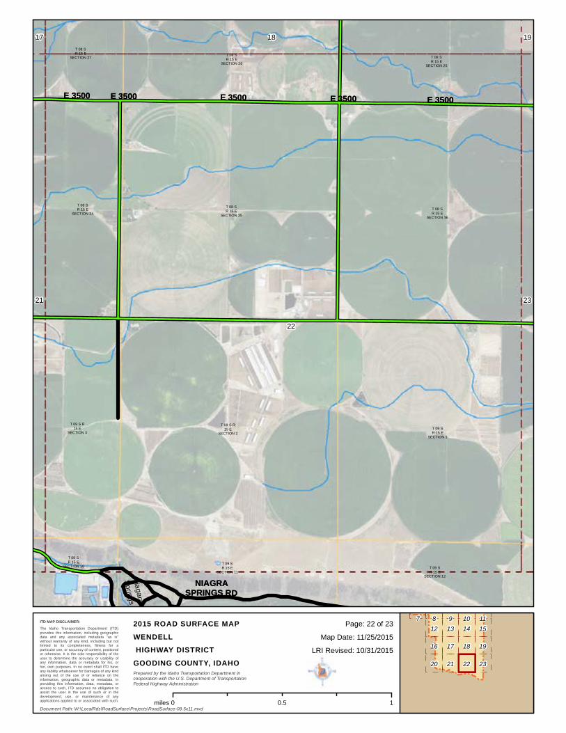
NIAGRA SPRINGS RDNIAGRA SPRINGS RD
")46
Snake River
Cedar Draw CreekT 08 SR 15 E
SECTION 27
T 08 SR 15 E
SECTION 28T 08 SR 15 E
SECTION 29
T 08 SR 15 E
SECTION 32
T 08 SR 15 E
SECTION 33 T 08 SR 15 E
SECTION 34
T 09 S R15 E
SECTION 3
T 09 S R 15E SECTION 4T 09 S R
15 ESECTION 5
T 09 SR 15 E
SECTION 8
T 09 SR 15 E
SECTION 9
T 09 S R 15E SECTION 9
T 09 SR 15 E
SECTION 10
16 17 18
20
21
22
18
23
12 13 14 15
16 17
22
19
20 21
987 1110
Document Path: W:\LocalRds\RoadSurface\Projects\RoadSurface-08.5x11.mxd
Prepared by the Idaho Transportation Department incooperation with the U.S. Department of TransportationFederal Highway Administration
Map Date: 11/25/2015LRI Revised: 10/31/2015
2015 ROAD SURFACE MAPWENDELL HIGHWAY DISTRICTGOODING COUNTY, IDAHO
The Idaho Transportation Department (ITD)provides this information, including geographicdata and any associated metadata "as is"without warranty of any kind, including but notlimited to its completeness, fitness for aparticular use, or accuracy of content, positionalor otherwise. It is the sole responsibility of theuser to determine the accuracy or usability ofany information, data or metadata for his, orher, own purposes. In no event shall ITD haveany liability whatsoever for damages of any kindarising out of the use of or reliance on theinformation, geographic data or metadata. Inproviding this information, data, metadata, oraccess to such, ITD assumes no obligation toassist the user in the use of such or in thedevelopment, use, or maintenance of anyapplications applied to or associated with such.
23Page: 21 of ITD MAP DISCLAIMER:
0 10.5miles
E 3500E 3500 E 3500E 3500E 3500E 3500 E 3500E 3500E 3500E 3500
NNIIAAGGRRAASSPPRRIINNGGSS RRDD
NiagaraSprings
T 08 SR 15 E
SECTION 25
T 08 SR 15 E
SECTION 26
T 08 SR 15 E
SECTION 27
T 08 SR 15 E
SECTION 34T 08 SR 15 E
SECTION 35T 08 SR 15 E
SECTION 36
T 09 SR 15 E
SECTION 1
T 09 S R15 E
SECTION 2
T 09 S R15 E
SECTION 3
T 09 SR 15 E
SECTION 10 T 09 SR 15 E
SECTION 11T 09 SR 15 E
SECTION 12
17 18 19
21
22
23
18
23
12 13 14 15
16 17
22
19
20 21
987 1110
Document Path: W:\LocalRds\RoadSurface\Projects\RoadSurface-08.5x11.mxd
Prepared by the Idaho Transportation Department incooperation with the U.S. Department of TransportationFederal Highway Administration
Map Date: 11/25/2015LRI Revised: 10/31/2015
2015 ROAD SURFACE MAPWENDELL HIGHWAY DISTRICTGOODING COUNTY, IDAHO
The Idaho Transportation Department (ITD)provides this information, including geographicdata and any associated metadata "as is"without warranty of any kind, including but notlimited to its completeness, fitness for aparticular use, or accuracy of content, positionalor otherwise. It is the sole responsibility of theuser to determine the accuracy or usability ofany information, data or metadata for his, orher, own purposes. In no event shall ITD haveany liability whatsoever for damages of any kindarising out of the use of or reliance on theinformation, geographic data or metadata. Inproviding this information, data, metadata, oraccess to such, ITD assumes no obligation toassist the user in the use of such or in thedevelopment, use, or maintenance of anyapplications applied to or associated with such.
23Page: 22 of ITD MAP DISCLAIMER:
0 10.5miles

S 240
0S 2
400
S 240
0S 2
400
E 3500E 3500 E 3500E 3500
W 400W 400
E 3500E 3500
S 400
RD
S 400
RD
S 240
0S 2
400
S 240
0S 2
400
S 400
RD
S 400
RD
E 3500E 3500 BOB BARTON RDBOB BARTON RD
S 240
0S 2
400
W 400W 400
S 240
0S 2
400
S 400
RD
S 400
RD
S 400
RD
S 400
RD
T 08 SR 15 E
SECTION 25
T 08 SR 15 E
SECTION 36
T 08 SR 16 E
SECTION 28
T 08 SR 16 E
SECTION 29T 08 SR 16 E
SECTION 30
T 08 SR 16 E
SECTION 31T 08 SR 16 E
SECTION 32
T 08 SR 16 E
SECTION 33
T 09 S R15 E
SECTION 1
T 09 SR 15 E
SECTION 12
T 09 S R16 E
SECTION 4
T 09 S R16 E
SECTION 5
T 09 S R16 E
SECTION 6
T 09 S R 16E SECTION 7 T 09 S R 16
E SECTION 8 T 09 S R 16E SECTION 9
18 19
22 23
18
23
12 13 14 15
16 17
22
19
20 21
98 117 10
Document Path: W:\LocalRds\RoadSurface\Projects\RoadSurface-08.5x11.mxd
Prepared by the Idaho Transportation Department incooperation with the U.S. Department of TransportationFederal Highway Administration
Map Date: 11/25/2015LRI Revised: 10/31/2015
2015 ROAD SURFACE MAPWENDELL HIGHWAY DISTRICTGOODING COUNTY, IDAHO
The Idaho Transportation Department (ITD)provides this information, including geographicdata and any associated metadata "as is"without warranty of any kind, including but notlimited to its completeness, fitness for aparticular use, or accuracy of content, positionalor otherwise. It is the sole responsibility of theuser to determine the accuracy or usability ofany information, data or metadata for his, orher, own purposes. In no event shall ITD haveany liability whatsoever for damages of any kindarising out of the use of or reliance on theinformation, geographic data or metadata. Inproviding this information, data, metadata, oraccess to such, ITD assumes no obligation toassist the user in the use of such or in thedevelopment, use, or maintenance of anyapplications applied to or associated with such.
23Page: 23 of ITD MAP DISCLAIMER:
0 10.5miles