© Crown copyright 2007 CAVIAR flight plans Stuart Newman, Met Office, Exeter, UK.
20
© Crown copyright 2007 CAVIAR flight plans Stuart Newman, Met Office, Exeter, UK
-
date post
21-Dec-2015 -
Category
Documents
-
view
218 -
download
0
Transcript of © Crown copyright 2007 CAVIAR flight plans Stuart Newman, Met Office, Exeter, UK.

© Crown copyright 2007
CAVIARflight plans
Stuart Newman, Met Office, Exeter, UK
© Crown copyright 2007
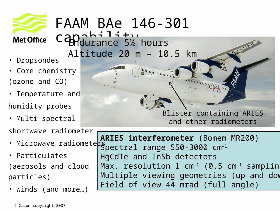
FAAM BAe 146-301 capability
Blister containing ARIES and other radiometers
ARIES interferometer (Bomem MR200)Spectral range 550-3000 cm-1
HgCdTe and InSb detectorsMax. resolution 1 cm-1 (0.5 cm-1 sampling)Multiple viewing geometries (up and down)Field of view 44 mrad (full angle)
• Dropsondes
• Core chemistry
(ozone and CO)
• Temperature and
humidity probes
• Multi-spectral
shortwave radiometer
• Microwave radiometers
• Particulates (aerosols and
cloud particles)
• Winds (and more…)
Endurance 5½ hoursAltitude 20 m – 10.5 km
© Crown copyright 2007
Making the most of the observationsMethodology for Camborne field campaign
Key questions:
Do we combine flying over ocean (stable surface emission) with flying over Camborne? Can we do both in one sortie?
Do we fly to intercept line-of-sight of NPL solar-tracking FTS?
Do we fly in coincidence with satellite overpasses, e.g. IASI interferometer on MetOp?
What heights do we need to fly at in order for aircraft interferometer measurements to be of maximum value?
Do ARIES and TAFTS have differing requirements?
© Crown copyright 2007
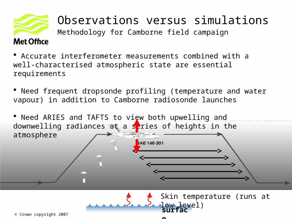
Observations versus simulationsMethodology for Camborne field campaign
surface
Skin temperature (runs at low level)
Accurate interferometer measurements combined with a well-characterised atmospheric state are essential requirements Need frequent dropsonde profiling (temperature and water vapour) in addition to Camborne radiosonde launches
Need ARIES and TAFTS to view both upwelling and downwelling radiances at a series of heights in the atmosphere

© Crown copyright 2007
Case study day: 5 September 2004High pressure subsidence implying clear skies
© Crown copyright 2007
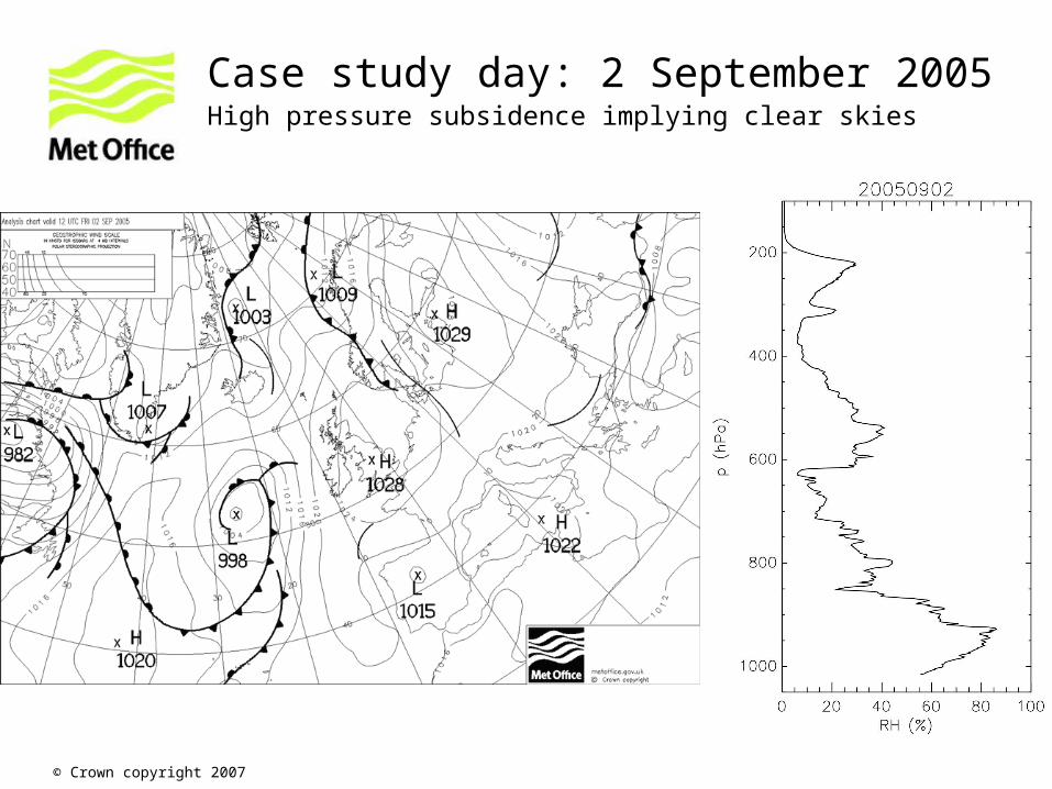
Case study day: 2 September 2005High pressure subsidence implying clear skies

© Crown copyright 2007
Case study day: 7 September 2006High pressure subsidence implying clear skies

© Crown copyright 2007
Aircraft brightness temperatures (nadir)
• Window regions sensitive to the self continuum show very little change with altitude
• Stronger water vapour bands (foreign continuum) show much greater dependence on altitude in the nadir
TAFTS ARIES
CO2
O3
strong H2O CO2
strong H2O
weak H2O
weak H2O

© Crown copyright 2007
Aircraft brightness temperatures (zenith)
• Window regions more sensitive to the self continuum when viewing in the zenith
• Stronger water vapour bands (foreign continuum) still vary with altitude
• Very cold brightness temperatures (cold radiances) are challenging to measure
TAFTS ARIES
CO2 O3
strong H2O
CO2strong H2O
weak H2O
weak H2O
© Crown copyright 2007
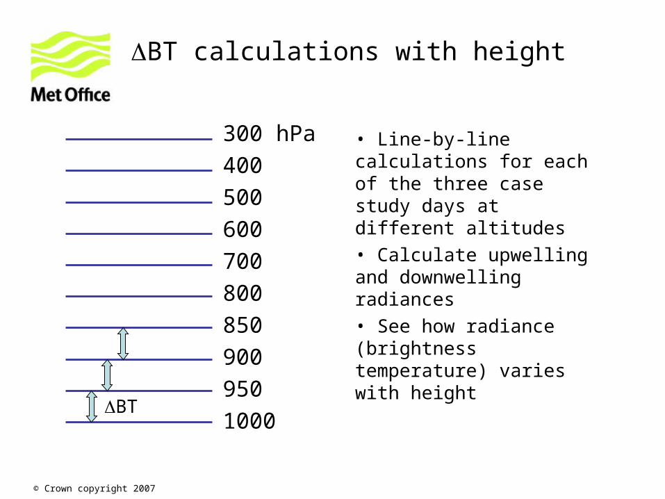
BT calculations with height
• Line-by-line calculations for each of the three case study days at different altitudes
• Calculate upwelling and downwelling radiances
• See how radiance (brightness temperature) varies with height
300 hPa
400
500
600
700
800
850
900
950
1000BT

© Crown copyright 2007
BT (nadir spectra)
• Window regions show almost no change in brightness temperature with height
• Stronger water vapour bands show changes of several K with increasing height
• Dependence on water vapour profile is evident

© Crown copyright 2007
BT (zenith spectra)
• Window regions now show a large change in brightness temperature with height, weighted towards the lower atmosphere
• Stronger water vapour bands dependence weighted towards higher atmosphere
• Dependence on water vapour profile is again evident
© Crown copyright 2007
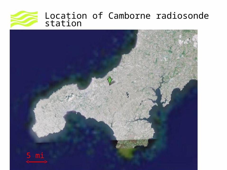
Location of Camborne radiosonde station
5 mi
© Crown copyright 2007
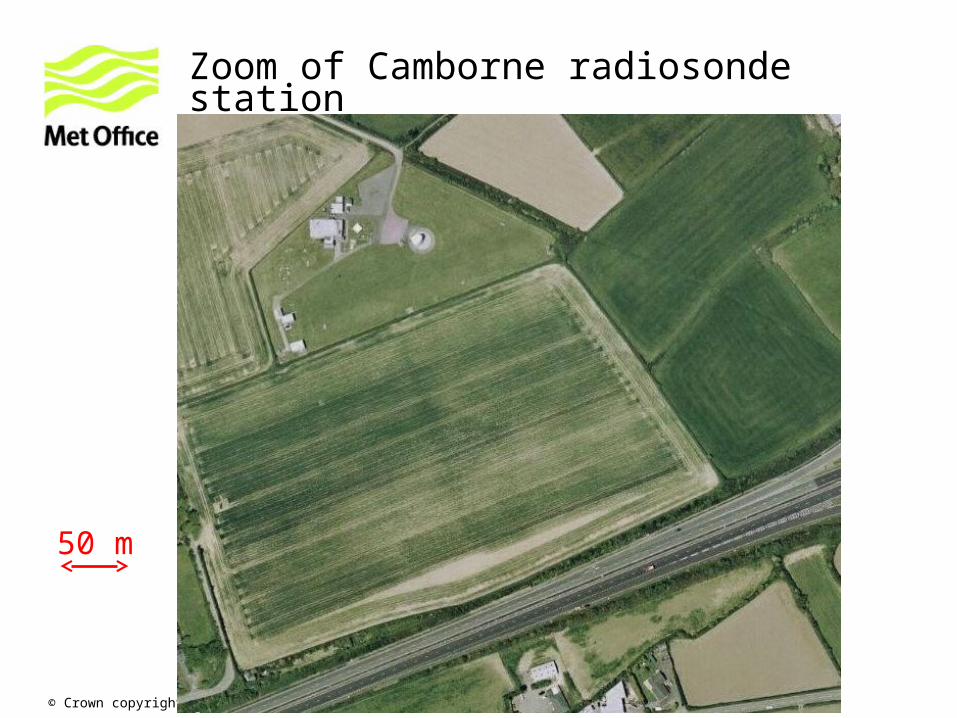
Zoom of Camborne radiosonde station
50 m

© Crown copyright 2007
NPL FTS view geometry w.r.t. solar zenith
zen (SZA)
FTS
Take e.g. 1 September 2008
GMT SZA Run0700 77.5 45.1 km0800 68.0 24.80900 59.1 16.71000 51.3 12.51100 45.4 10.11200 42.4 9.11300 42.9 9.31400 46.9 10.71500 53.5 13.51600 61.8 18.61700 70.9 28.91800 80.5 59.8
FAAM 146 (height 10 km)
NB. 9 km run for FAAM aircraft 1 minute 60 km run 6 minutes

© Crown copyright 2007
Water vapour measurements are key
• We should have a comprehensive set of water vapour instruments on board the FAAM 146 (General Eastern, FWVS, CVI and Total Water Lyman-a, SAW hygrometer)
• We should work out the best strategy for dropping sondes (good coverage in time and space)
• During straight and level runs (where instruments have time to equilibrate) we should get a good estimate of variability and uncertainty in water vapour measurements
• We have the option of “chasing” a radiosonde during a spiral ascent to directly compare with aircraft kit
• 1d-VAR retrievals of water vapour from ARIES spectra are now possible (useful for seeing structure in water vapour above and below the aeroplane)
• MARSS channels also sensitive to water vapour

© Crown copyright 2007
Flying details• We now have more flight hours for Camborne (37.5), ~ 7 full flights
• The aircraft is available for CAVIAR between 13/8/08 and 25/9/08
• We have the option of a refuel at a local airfield (St Mawgan) if the science dictates longer on task
• The are “Danger Areas” (for military use) to the south of Camborne, so operating to the north and west seems sensible

© Crown copyright 2007
Example sortie (for discussion)Assumes refuel before transit back to Cranfield
Take off from Cranfield (mins)Transit to Camborne area 45Run at FL250 over site (+ turn) 12Profile down 5000 feet 5Run at FL200 (+ turn) 12Profile down 5000 feet 5Run at FL150 (+ turn) 12Profile down 5000 feet 5Run at FL100 (+ turn) 12Profile down 2500 feet 5Run at FL075 (+ turn) 12Profile down 2500 feet 5Run at FL050 (+ turn) 12Profile down 2500 feet 5Run at FL025 (+ turn) 12Profile down to 50 feet over sea 5Run over sea at 100 feet (+ turn) 12
Transit back to Cranfield (45)Total flight time 327Drop in to St Mawgan for refuel 25Run at FL320 (+ turn) 12Profile up 7000 feet 7Run at FL250 (+ turn) 12Profile up 10000 feet 10Run at FL150 (+ turn) 12Profile up 5000 feet 5Run at FL100 (+ turn) 12Profile up 3000 feet 5Run at FL070 (+ turn) 12Profile up 3000 feet 5Run at FL040 (+ turn) 12Profile up 1500 feet 5Run at FL025 (+ turn) 12Profile up 250 feet 5
© Crown copyright 2007
Other signatures to look for?
• At what stage might ab initio calculations tell us where we might see dimer features? Do these occur in the mid-IR/far-IR?
• We think the temperature dependence of the continuum is important to distinguish between dimer and line-wing theories (so probing different temperatures in the atmosphere is necessary)
• Evidence from case studies (M. Matricardi, ECMWF) that agreement with continuum models (CKD2.4, MT_CKD) depends on water vapour loading, so will be useful to probe fairly moist versus fairly dry cases

© Crown copyright 2007
ThankyouAny questions?