


Languages
Pages
Legal


A

`

Which people groups are represented in this painting?What is the focal point of this painting?What message do you think the author is trying to portray?

What is the message of this painting?
American Progress By John Gast

Do Now
• Take our the homework you read last night titled, “Manifest Destiny: An Introduction”
Are most of the reasons justifying Manifest Destiny politically motivated, economically motived or
socially motivated?
What does this tell us about the U.S. during this time period?

MANIFEST DESTINY
• The belief that the United States was destined to expand from the Atlantic to the Pacific Ocean– Most movement was in the
1840s– It has also been used to
advocate for or justify other territorial acquisitions
• Alaska (1867)• Hawaii (1898)
evident; obvious; apparent inevitable; certain
American Progress By John Gast
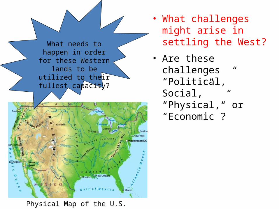
• What challenges might arise in settling the West?
• Are these challenges “Political,” Social,” “Physical,” or “Economic”?
What needs to happen in order for these Western
lands to be utilized to their fullest capacity?
Physical Map of the U.S.

U.S. TERRITORIAL EXPANSION
A
When?
From Where?
Why?
• 1776
• Great Britain
• US declared independence from Great Britain
A - 13 Original Colonies
Territory Name:

U.S. TERRITORIAL EXPANSION
9
A
When?
From Where?
Why?
• 1783
• Great Britain
• Part of the agreements made in the Treaty of Paris (ended Revolutionary War)
B
B - Western Lands
Territory Name:

U.S. TERRITORIAL EXPANSION
A
•1803
•France
•Napoleon needed $
•Originally, Jefferson contacted the French to buy New Orleans
•He got all of this instead!
B
C - Louisiana Purchase
C
When?
From Where?
Why?
Territory Name:


Lewis and Clark
• Led first expedition to the Pacific coast (1804-1806)
• Commissioned by President Thomas Jefferson to: – Establish trade routes– Find, follow and map
waterways– Find natural resources – Document an American
presence before Europeans could
– Declare sovereignty over Native American tribes
William Clark and Meriwether Lewis

Zebulon Pike• Led expedition to the South in
1806• Goal: Find the sources of the
Arkansas and Red Rivers– boundary between Spanish
territory and Louisiana• Illegally crossed over into Spanish
territory, was arrested and spent a year in jail
• Never found the Red River• Provided the first information in
English on the Great Plains and the Rio Grande Valley

Effects of Exploration
1. Accurate Maps – Valuable to later western travelers
2. Growth of Fur Trade – Boosted interest; trappers brought back knowledge of the West
3. Inaccurate view of the Plains – Pike called it a desert; led to the idea that it was not good for farming [but good for Native Americans]


U.S. TERRITORIAL EXPANSION
• 1818
• Great Britain
D – Red River Valley
CB A
D
Territory Name:
When?
From Where?
Why?• 49th parallel was determined as the border between British Canada and the U.S.
US TERRITORIAL EXPANSION
When?
From Where?
Why?
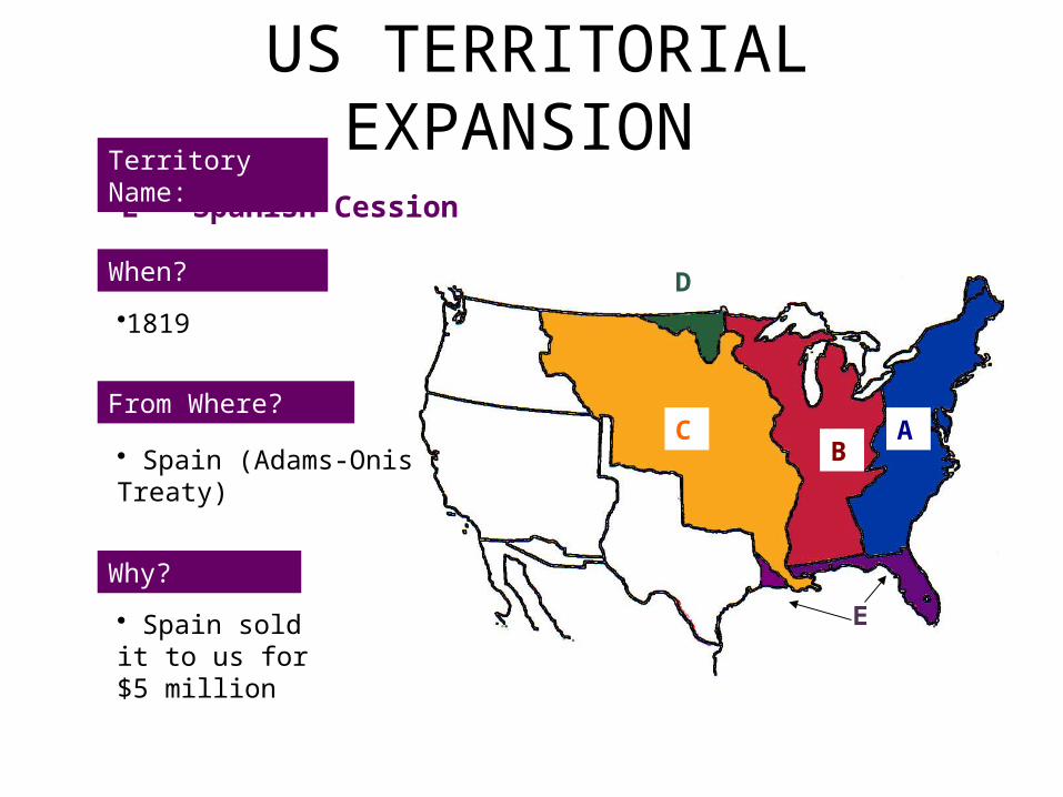
•1819
• Spain (Adams-Onis Treaty)
• Spain sold it to us for $5 million
E – Spanish Cession
AB
C
D
E
Territory Name:

US TERRITORIAL EXPANSION
18
When?
From Where?
Why?
•1845
•Republic of Texas (Independent Country)
•Texas became independent from Mexico in 1836
• Northerners feared it would become a slave state so annexation was pushed off until 1845
F - TexasD
E
Territory Name:
ABC
D
E
F

OREGON TERRITORY

MR. MANIFEST DESTINYJames K. Polk
20
What did he believe about expansion and how did he win the support of many states in the election of 1844?
• Jacksonian Democrat
• Gained support from the North and from the South
• Added more territory to the US than any other President

US Territorial Expansion
When?
From Where?
Why?
• 1846
• Great Britain
• Land has been jointly occupied
• Americans demanded “54° 40’ or fight!”
• U.S. proposed the 49° parallel as a compromise and Britain accepted
G - Oregon Territory (the first area to be touched by expansionist fever!)
C ABC
D
E
F
G
Territory Name:

US Territorial Expansion
When?
From Where?
Why?
•1848
• Mexico
• Polk offers to buy ‘H’ from Mexico & they refuse
• War erupts
• In Treaty of Guadalupe Hidalgo, US offers $15 million for ‘H”
H - Mexican Cession
ABC
D
E
F
G
H
Territory Name:

US Territorial Expansion
When?
From Where?
Why?
• 1853
• Mexico
• Needed by the U.S. in order to complete the transcontinental railroad
I – Gadsden Purchase
Territory Name:
ABC
D
E
F
H
G
I


AMERICANS HEADED WEST TO…*1.Escape religious persecution
2.Find new markets for commerce
3.Claim land for farming, ranching & mining
4.Locate harbors on the Pacific Coast
5.Seek employment and avoid creditors after the panic of 1837
6.Spread virtues of democracy
7.Convert Native Americans to Christianity
*Which are “pull” vs. ”push” factors?

Independence, MI
Portland, OR
Salt Lake City, UT
Santa Fe, NM
Nauvoo, IL
OREGON TRAIL
MORMON TRAIL
SANTA FE TRAIL
http://www.youtube.com/watch?v=2OmfzkcfJxg(6:31)

Consider:
– Take out your Westward Expansion maps• What do you anticipate being the
benefits and drawbacks of Manifest Destiny?
– Consider:• The various reasons for the move westward• The settlers point of view• The impact on Native Americans• The impact on the nation as a whole

The Great Plains
• Prior to Civil War, this area was seen as a “treeless wasteland”– Climate:
• Semiarid• Rainfall is sparse and
unpredictable– does not provide enough
precipitation to support trees, and grassland is the natural vegetation

What factors might PULL people to the West in the mid to late 1800s?
• Opportunities for land ownership
• Possibility of wealth– Gold rushes– Natural Resources: oil, sulfur,
coal, natural gas • New beginning for former
slaves• Adventure
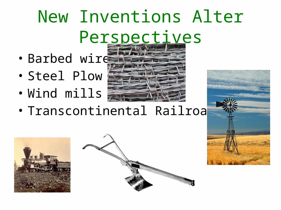
New Inventions Alter Perspectives
• Barbed wire• Steel Plow• Wind mills• Transcontinental Railroad

Adaptations in Lifestyle
• Dry farming• Sod homes• Beef cattle raising• Wheat farming

"[w]e are not going to let a few thieving, ragged Indians check and stop the progress of [the railroads]."
“The more Indians we can kill this year, the less will have to be killed the next war, for the more I see of these Indians, the more convinced I am that they all have to be killed or be maintained as a species of paupers.”
William Tecumseh Sherman: Appointed as commanding general in the construction and protection of railroad development to the west of the Mississippi River


The Transcontinental Railroad
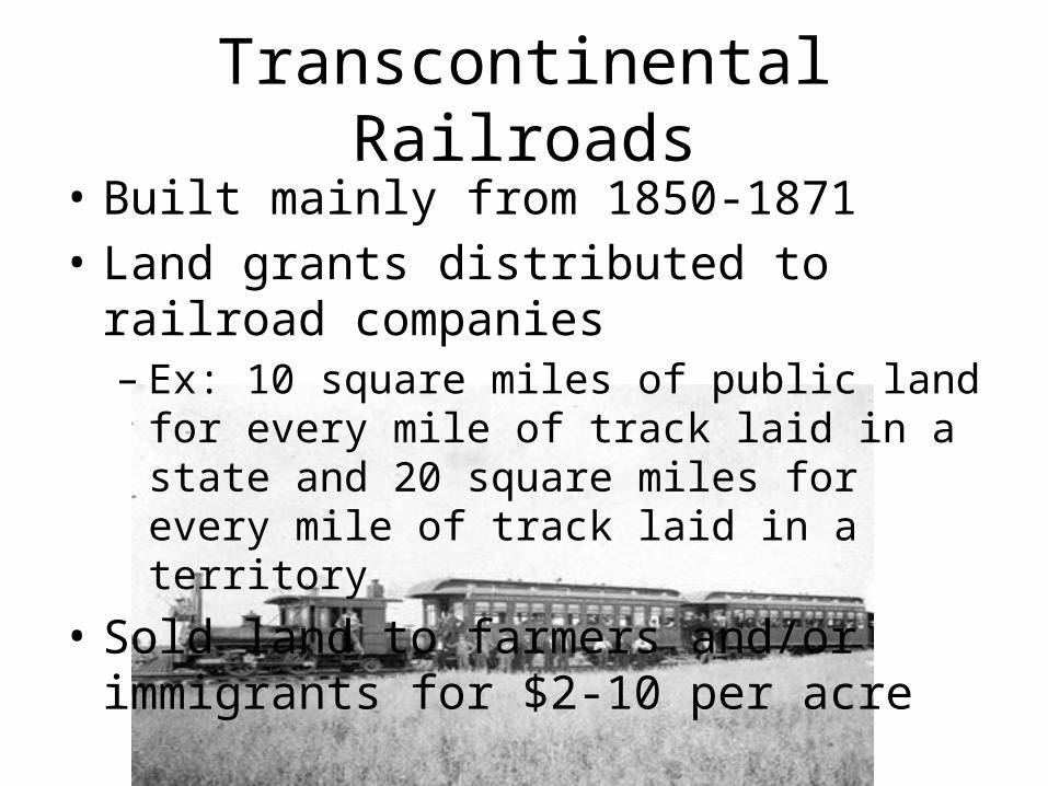
Transcontinental Railroads• Built mainly from 1850-1871• Land grants distributed to railroad companies
– Ex: 10 square miles of public land for every mile of track laid in a state and 20 square miles for every mile of track laid in a territory
• Sold land to farmers and/or immigrants for $2-10 per acre
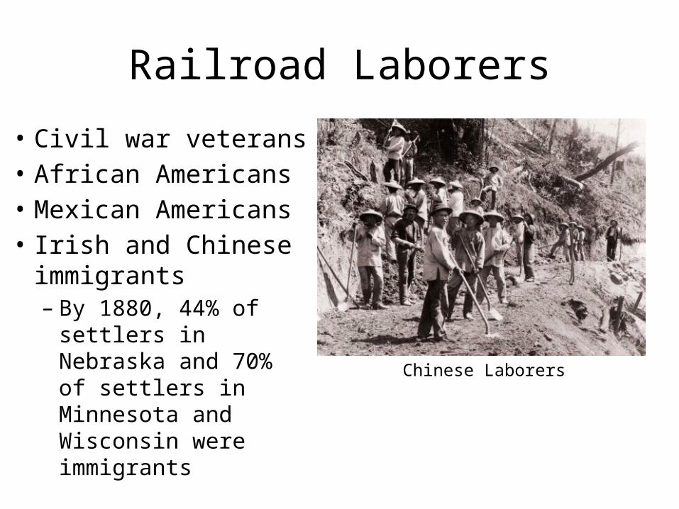
Railroad Laborers
• Civil war veterans• African Americans• Mexican Americans• Irish and Chinese
immigrants– By 1880, 44% of
settlers in Nebraska and 70% of settlers in Minnesota and Wisconsin were immigrants
Chinese Laborers

Railroad Laborers
• Pay scales ranged from – $1 a day for pick and shovel workers – $4.17 a day for foremen
• Seven days a week• 12 to 16 hours a day• Labored year around
– below-zero temperatures of winter and the 100-degree days of summer

Railroad Companies
Union Pacific (westward from Omaha, NE)
Central Pacific (eastward from Sacramento, CA)

Transcontinental Railroad
May 10, 1869 at Promontory Summit, Utah
Top Related