Zion National Park Wilderness April 2008 - Washington County, Utah · 2016-03-17 · Zion National...
1
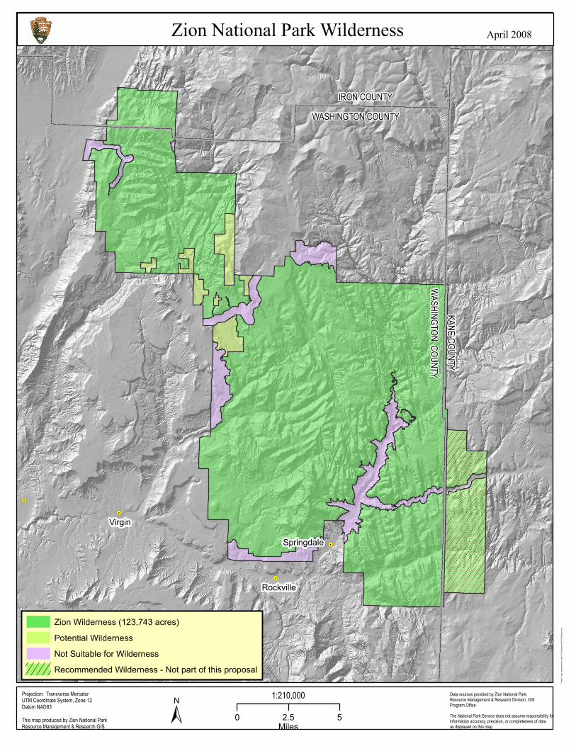
! . ! . ! . ! . ! . IRON COUNTY WASHINGTON COUNTY KANE COUNTY WASHINGTON COUNTY Virgin Rockville Springdale Zion National Park Wilderness ± 0 2.5 5 Miles Thunder: D:/gis_projects/zion/env_spec/1193_wilderns/mxds/1193_Wilderns.mxd Data sources provided by Zion National Park, Resource Management & Research Division, GIS Program Office. The National Park Service does not assume responsibility for information accuracy, precision, or completeness of data as displayed on this map. This map produced by Zion National Park Resource Management & Research GIS Projection: Transverse Mercator UTM Coordinate System, Zone 12 Datum NAD83 1:210,000 April 2008 Zion Wilderness (123,743 acres) Potential Wilderness Not Suitable for Wilderness Recommended Wilderness - Not part of this proposal
Transcript of Zion National Park Wilderness April 2008 - Washington County, Utah · 2016-03-17 · Zion National...
!.
!.
!.
!.
!.
IRON COUNTYWASHINGTON COUNTYKANE COUNTY
WASHINGTON COUNTY
Virgin
Rockville
Springdale
Zion National Park Wilderness
± 0 2.5 5Miles
Thunde
r: D:/gi
s_proje
cts/zio
n/env_
spec/1
193_w
ilderns
/mxds/
1193_W
ilderns
.mxd
Data sources provided by Zion National Park,Resource Management & Research Division, GISProgram Office. The National Park Service does not assume responsibility for information accuracy, precision, or completeness of dataas displayed on this map.
This map produced by Zion National ParkResource Management & Research GIS
Projection: Transverse MercatorUTM Coordinate System, Zone 12Datum NAD83
1:210,000
April 2008
Zion Wilderness (123,743 acres)Potential WildernessNot Suitable for WildernessRecommended Wilderness - Not part of this proposal