WSDOT SR 520 Seattle Shoreline Permit Application Information for Comment Letters.
33
WSDOT SR 520 Seattle Shoreline Permit Application Information for Comment Letters
-
Upload
grace-pierce -
Category
Documents
-
view
219 -
download
0
Transcript of WSDOT SR 520 Seattle Shoreline Permit Application Information for Comment Letters.
WSDOT SR 520 Seattle Shoreline Permit Application
Information for Comment Letters
Part OnePermit Process
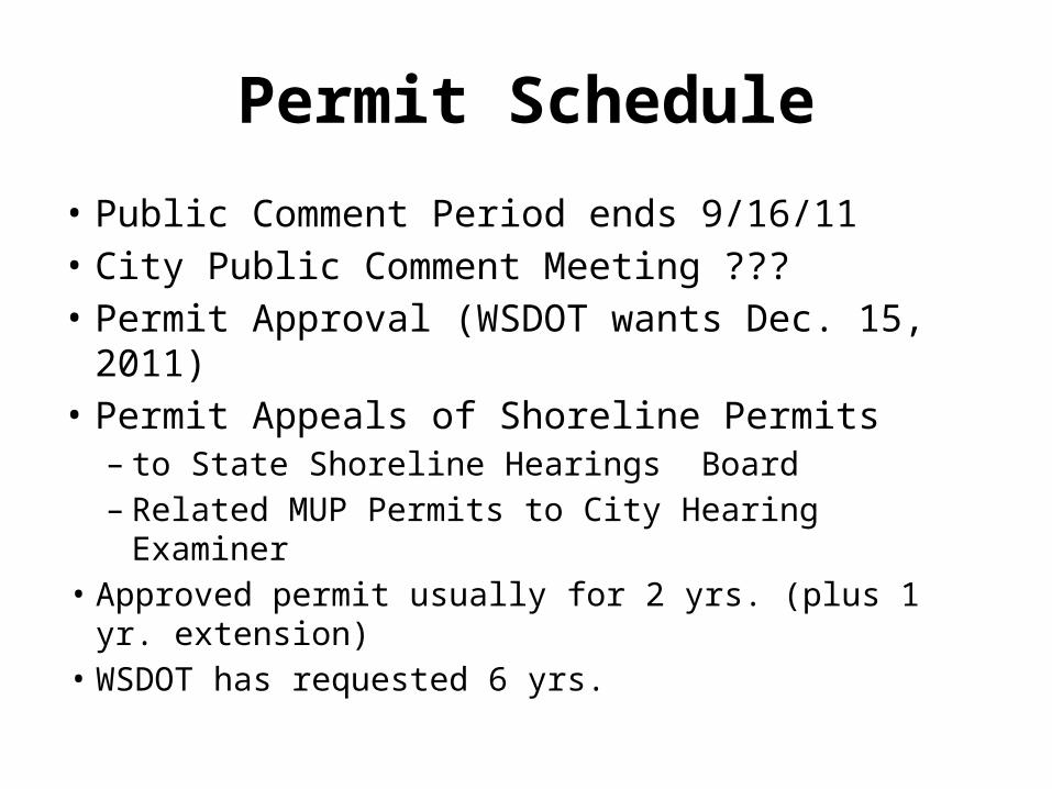
Permit Schedule
• Public Comment Period ends 9/16/11• City Public Comment Meeting ???• Permit Approval (WSDOT wants Dec. 15, 2011)• Permit Appeals of Shoreline Permits – to State Shoreline Hearings Board – Related MUP Permits to City Hearing Examiner
• Approved permit usually for 2 yrs. (plus 1 yr. extension)
• WSDOT has requested 6 yrs.
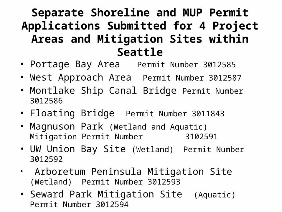
Separate Shoreline and MUP Permit Applications Submitted for 4 Project Areas and Mitigation Sites
within Seattle
• Portage Bay Area Permit Number 3012585
• West Approach Area Permit Number 3012587
• Montlake Ship Canal Bridge Permit Number 3012586
• Floating Bridge Permit Number 3011843
• Magnuson Park (Wetland and Aquatic) Mitigation Permit Number 3102591
• UW Union Bay Site (Wetland) Permit Number 3012592
• Arboretum Peninsula Mitigation Site (Wetland) Permit Number 3012593
• Seward Park Mitigation Site (Aquatic) Permit Number 3012594
• Taylor Creek Mitigation Site (Aquatic) Permit Number 3012595
Part TwoProject Impact Information
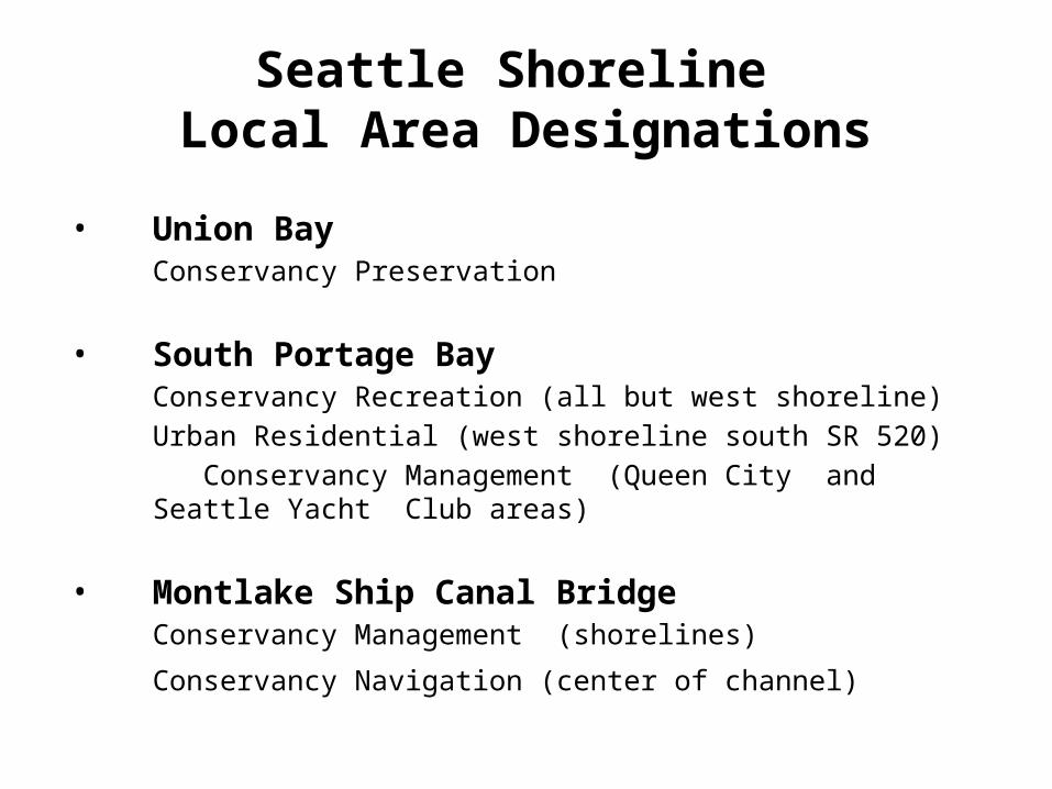
Seattle Shoreline Local Area Designations
• Union BayConservancy Preservation
• South Portage BayConservancy Recreation (all but west shoreline)Urban Residential (west shoreline south SR 520)
Conservancy Management (Queen City and Seattle Yacht Club areas)
• Montlake Ship Canal BridgeConservancy Management (shorelines)
Conservancy Navigation (center of channel)

Shoreline AreaEnvironmental Impacts
• Expanded Bridge – Fill (Mostly placement of support piers and bridge
structure)– Increase in permanent shading
• Construction Impacts – Temporary clearing– Excavation for piers– Noise, dust and vibrations
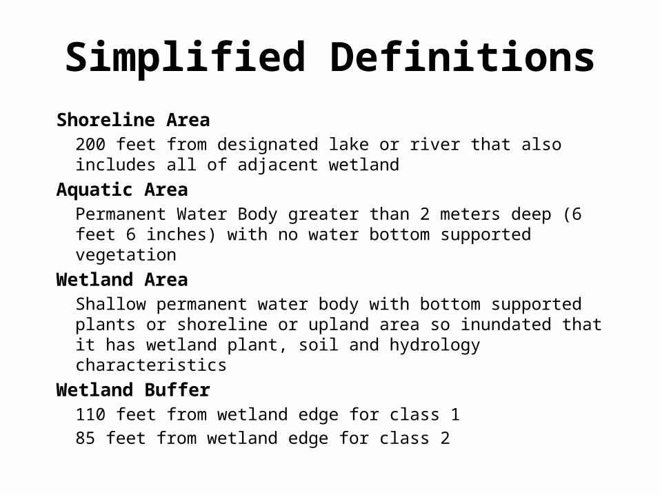
Simplified DefinitionsShoreline Area
200 feet from designated lake or river that also includes all of adjacent wetland
Aquatic Area Permanent Water Body greater than 2 meters deep (6 feet 6 inches) with no water bottom supported vegetation
Wetland Area Shallow permanent water body with bottom supported plants or
shoreline or upland area so inundated that it has wetland plant, soil and hydrology characteristics
Wetland Buffer110 feet from wetland edge for class 1 85 feet from wetland edge for class 2
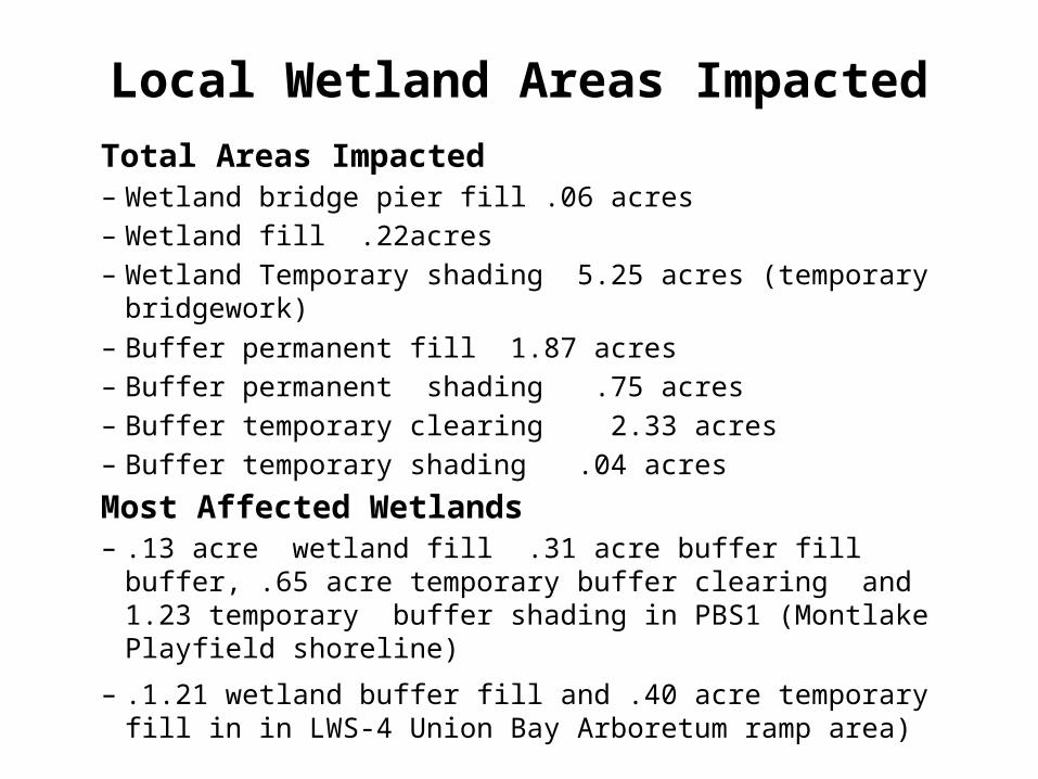
Local Wetland Areas ImpactedTotal Areas Impacted– Wetland bridge pier fill .06 acres– Wetland fill .22acres– Wetland Temporary shading 5.25 acres (temporary bridgework)– Buffer permanent fill 1.87 acres– Buffer permanent shading .75 acres– Buffer temporary clearing 2.33 acres– Buffer temporary shading .04 acres
Most Affected Wetlands – .13 acre wetland fill .31 acre buffer fill buffer, .65 acre temporary
buffer clearing and 1.23 temporary buffer shading in PBS1 (Montlake Playfield shoreline)
– .1.21 wetland buffer fill and .40 acre temporary fill in in LWS-4 Union Bay Arboretum ramp area)
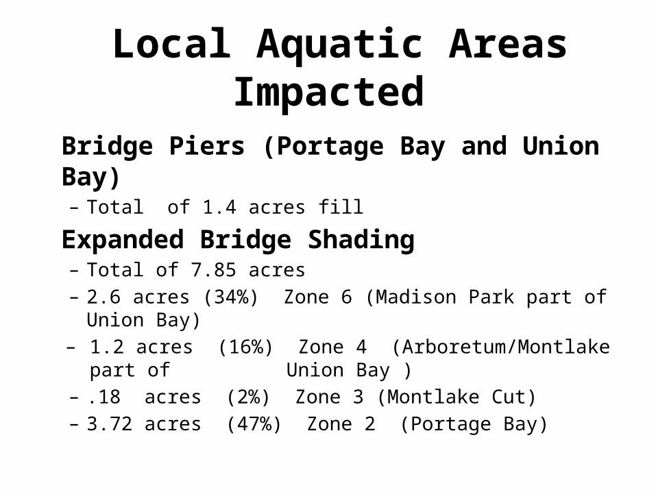
Local Aquatic Areas Impacted
Bridge Piers (Portage Bay and Union Bay)– Total of 1.4 acres fill
Expanded Bridge Shading – Total of 7.85 acres– 2.6 acres (34%) Zone 6 (Madison Park part of Union Bay)– 1.2 acres (16%) Zone 4 (Arboretum/Montlake part of
Union Bay )– .18 acres (2%) Zone 3 (Montlake Cut)– 3.72 acres (47%) Zone 2 (Portage Bay)
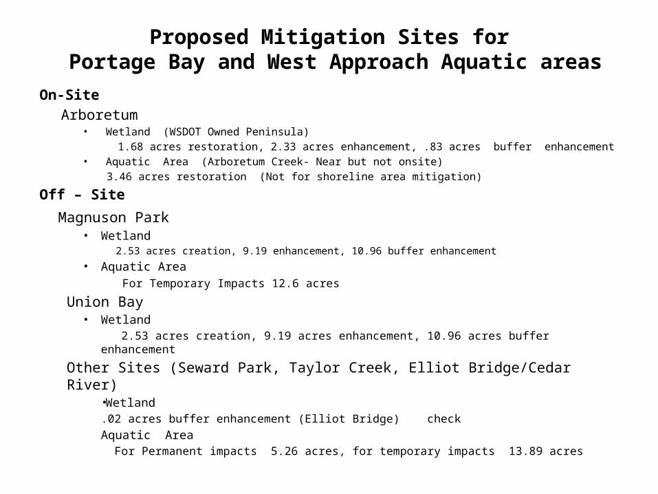
Proposed Mitigation Sites for Portage Bay and West Approach Aquatic areas
On-SiteArboretum
• Wetland (WSDOT Owned Peninsula) 1.68 acres restoration, 2.33 acres enhancement, .83 acres buffer enhancement
• Aquatic Area (Arboretum Creek- Near but not onsite)3.46 acres restoration (Not for shoreline area mitigation)
Off – Site
Magnuson Park• Wetland
2.53 acres creation, 9.19 enhancement, 10.96 buffer enhancement
• Aquatic Area For Temporary Impacts 12.6 acres
Union Bay • Wetland
2.53 acres creation, 9.19 acres enhancement, 10.96 acres buffer enhancement
Other Sites (Seward Park, Taylor Creek, Elliot Bridge/Cedar River)•Wetland .02 acres buffer enhancement (Elliot Bridge) checkAquatic Area For Permanent impacts 5.26 acres, for temporary impacts 13.89 acres
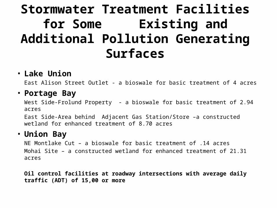
Stormwater Treatment Facilities for Some Existing and Additional Pollution Generating
Surfaces
• Lake Union East Alison Street Outlet - a bioswale for basic treatment of 4 acres
• Portage BayWest Side-Frolund Property - a bioswale for basic treatment of 2.94 acresEast Side-Area behind Adjacent Gas Station/Store –a constructed wetland for enhanced treatment of 8.70 acres
• Union Bay NE Montlake Cut – a bioswale for basic treatment of .14 acresMohai Site – a constructed wetland for enhanced treatment of 21.31 acres
Oil control facilities at roadway intersections with average daily traffic (ADT) of 15,00 or more
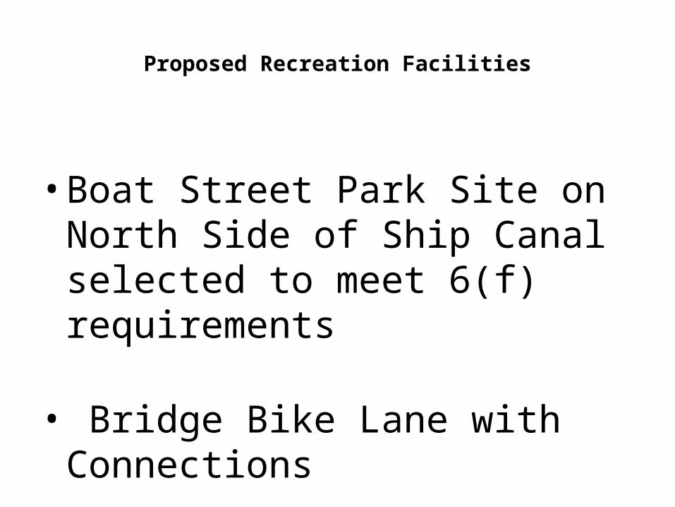
Proposed Recreation Facilities
• Boat Street Park Site on North Side of Ship Canal selected to meet 6(f) requirements
• Bridge Bike Lane with Connections
Part Three Incomplete Application
Permit Submittal
• WSDOT submitted permit applications on August ? with cover letter marked Received August 29! Yet DDPD determined it was a complete application for 1 month public review period from August 15-Sept 16.
• Some submitted plan sheets appear preliminary and required reports are drafts. Some of the reports have missing pages and appendices
• Submissions apparently are on-going with additional or updated material to be received past public comment period
Examples
• No specific analysis found on how improved recreation which is a key component of Shoreline policy will be considered or provided.
• Seattle, Army Corps of Engineers, and Washington State of Ecology permit submission requirements include review of wetland edge delineation flags. No flags have been seen at impacted wetland sites. Flags seen at mitigation sites. However, they may be those for other mitigation activities planned in these site areas.
• Submitted plan sheets are preliminary with only area outlines for proposed aquatic mitigation areas. No wetland planting plans shown for Magnuson Park mitigation site.
• No wetland and aquatic planting/grading plans have been submitted.
• Small wetland on Frolund property not documented.
• Statement that as State Essential Public Facility (EPF)City permits cannot be denied -just conditioned
• Exemptions requested from some Special Use Permits and Conditions
• Request for a 6 year Shoreline Permit (instead of 2 years plus possible 1 year extension)
WSDOT Requests Special Consideration
Part FourProject Facility Concerns
Stormwater Facilities• No specific stormwater design report in EIS or many specific
documents.• Proposed bioswales provide only primary treatment. Not
appropriate for highway runoff for road with 100,000 Average Vehicles Per Day (AVD)
• The facilities may be undersized. No statement found in Biological Assessment that the stormwater facilities were designed for 100 year storm event. This has been a common standard.
• Statement in Biological Assessment Report that stormwater drainage in access of design capacity will flow through scuppers into Portage Bay. Outfall of sediment and heavy metals into bay may still continue.
Recreation
• South Portage Bay designated as Conservation Recreation Shoreline Environment. No recreation facility or habitat mitigation proposed for 5 year noise, vibration and visibility construction impacts
• With exception of Arboretum or bike lane access, no permanent recreation facility improvements in existing public shoreline access areas such as Montlake Playfield, East Montlake Park or shoreline street end sites.
• With exception of Arboretum, No shoreline recreation activity access improvements possible at shoreline wetland mitigation site since they are proposed for upland areas.
• Depending on design details, there may be no shoreline access improvements aquatic area mitigation sites.
Part Five Mitigation Sites
Aquatic Areas versus Wetland Areas• Aquatic Impact area determined to be than wetland impact
using 2 meter (6 foot, 6 inch) depth and associated plant growth criteria.
• Though the City requires 2 foot contour lines on plan sheets, submitted plans do not show depth of Portage and Union Bay Areas.
• Submitted Reports apparently do not document Portage and Union Bay depths.
• Major impact will be increased area of shading under widened bridge. More mitigation impact resources devoted to aquatic resources over wetland impacts. Wetlands include our neighborhood shorelines while aquatic impacts do not.
On-Site or Offsite Mitigation
• Outside of Arboretum, no documentation the WSDOT seriously considered wetland or aquatic mitigation at sites to project impact area on south side of Portage and Uno0nBays
• No documented consideration of possible opportunities at:
• At existing South Portage Bay and Union Bay park area shorelines
• Frolund property, Everett and other street ends
Upland Mitigation Used for Shoreline Mitigation
• Mitigation sites at Magnuson Park and UW Union Bay property upland sites do not provide equivalent functions and values not equivalent to area’s shoreline wetlands.
• These sites generally are rated as class 3 sites. Larger Shoreline wetlands typically rated as higher class 2.
.

Photos
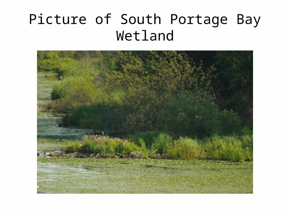
Picture of South Portage Bay Wetland
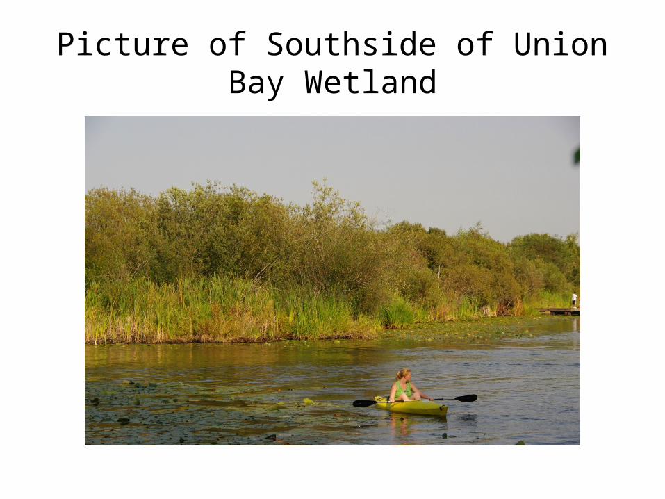
Picture of Southside of Union Bay Wetland
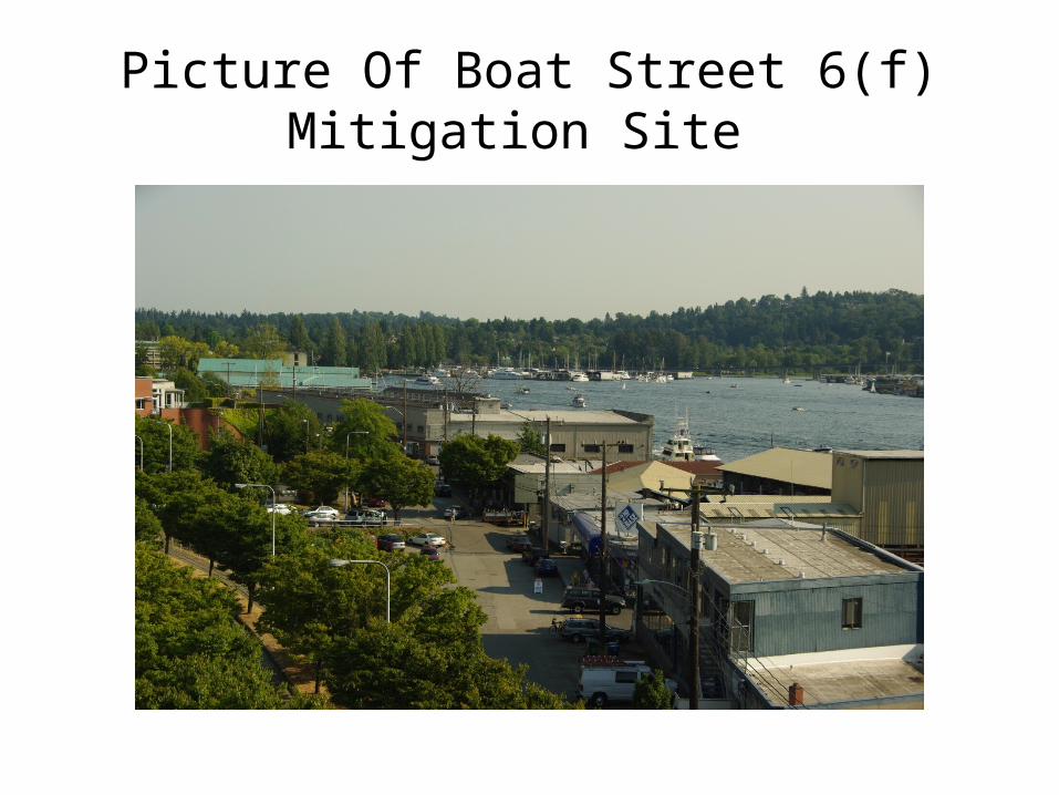
Picture Of Boat Street 6(f) Mitigation Site
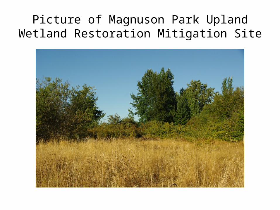
Picture of Magnuson Park Upland Wetland Restoration Mitigation Site
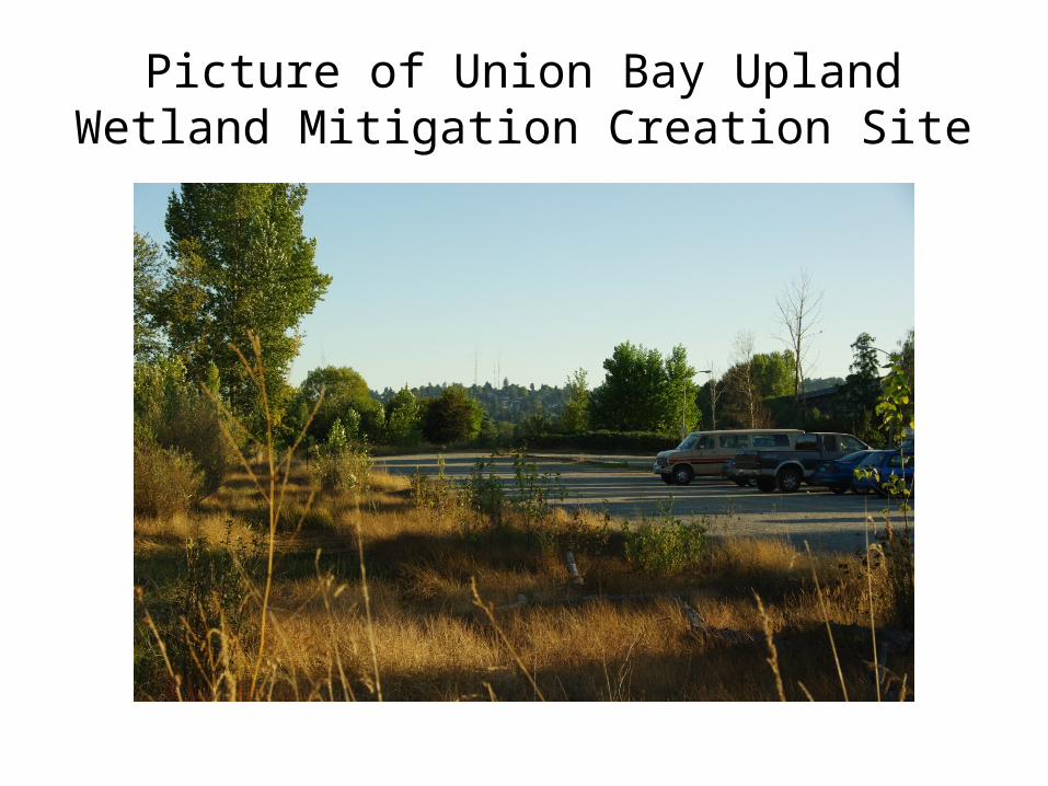
Picture of Union Bay Upland Wetland Mitigation Creation Site
Most Serious Example
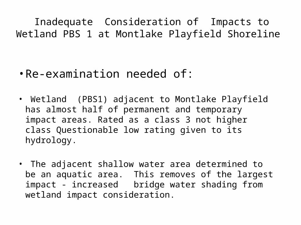
Inadequate Consideration of Impacts to Wetland PBS 1 at Montlake Playfield Shoreline
• Re-examination needed of:
• Wetland (PBS1) adjacent to Montlake Playfield has almost half of permanent and temporary impact areas. Rated as a class 3 not higher class Questionable low rating given to its hydrology.
• The adjacent shallow water area determined to be an aquatic area. This removes of the largest impact - increased bridge water shading from wetland impact consideration.
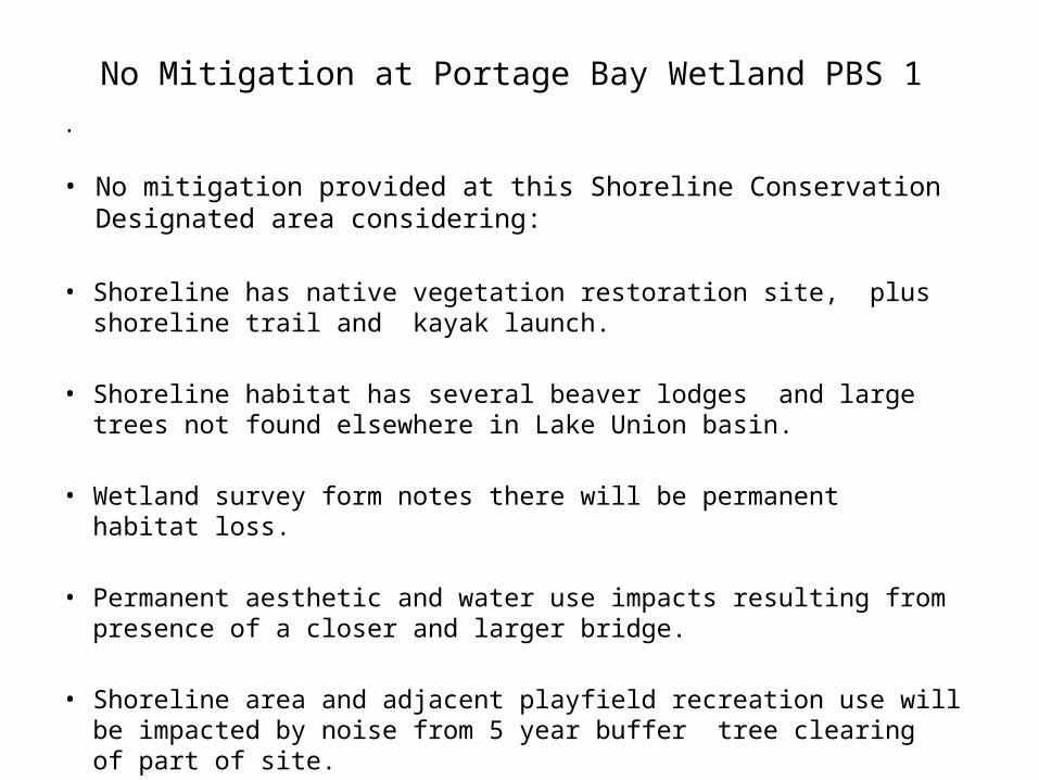
No Mitigation at Portage Bay Wetland PBS 1.
• No mitigation provided at this Shoreline Conservation Designated area considering:
• Shoreline has native vegetation restoration site, plus shoreline trail and kayak launch.
• Shoreline habitat has several beaver lodges and large trees not found elsewhere in Lake Union basin.
• Wetland survey form notes there will be permanent habitat loss.
• Permanent aesthetic and water use impacts resulting from presence of a closer and larger bridge.
• Shoreline area and adjacent playfield recreation use will be impacted by noise from 5 year buffer tree clearing of part of site.