WMO Global Observing Systems for Climate Monitoring · 2nd WCC (1990) Climate variability/change...
72
WMO Global Observing Systems for Climate Monitoring Measurement Challenges for Global Observation Systems for Climate Change Monitoring Traceability, Stability and Uncertainty Wenjian ZHANG Director, Observing and Information Systems Department World Meteorological Organization
Transcript of WMO Global Observing Systems for Climate Monitoring · 2nd WCC (1990) Climate variability/change...

WMO Global Observing Systemsfor Climate Monitoring
Measurement Challenges for Global Observation Systems for
Climate Change MonitoringTraceability, Stability and Uncertainty
Wenjian ZHANGDirector, Observing and Information Systems Department
World Meteorological Organization

WMO/OMM
WMO in The United Nations SystemInternational
Courtof Justice
GeneralAssembly
Economic and Social Council
SecurityCouncil
Secretariat TrusteeshipCouncil
Main and othersessional committees
Standing committees and ad-hoc bodies
Other subsidiary organsand related bodies
UNRWA
IAEA
INSTRAW UNCHS UNCTAD UNDCP UNDP UNEP UNFPA UNHCR UNICEF UNIFEM UNITAR UNU WFC
UNTSO UNMOGIP UNFICYP UNDOF UNIFIL UNIKOM UNAVEM II ONUSAL MINURSO UNPROFOR UNOSOM II UNOMIG UNOMIL UNMIH UNAMIR UNMOT
WFP ITC
Military Staff Committe Standing committees
and ad-hoc bodies
FUNCTIONAL COMMISIONS
REGIONAL COMMISSIONS
SESSIONAL AND STANDINGCOMMITTEES
EXPERT, AD-HOC AND RELATED BODIES
ILO FAO UNESCOWHO
World Bank Group IBRD IDA IFC MIGA
IMF ICAO UPU ITUWMO
World MeteorologicalOrganization
IMOWIPO IFAD UNIDOWTO
UN programmes and organs (representative list only)
Specialized agencies and other autonomous organizations within the system
Other commissions, committees and ad-hoc related bodies
Dr W. Zhang, WMO Presentation @ WMODr W. Zhang, WMO Presentation @ WMO--BIPM WorkshopBIPM Workshop, Geneva, Suisse, Geneva, Suisse

Organizational Structure of WMO (189 Members )
CONGRESSCONGRESS
ExecutiveExecutive CouncilCouncil
Regional AssociationsRegional Associations Technical CommissionsTechnical Commissions
Working GroupsRapporteurs
Working GroupsRapporteurs
Other Joint BodiesWCRP , IPCCGCOS
Working GroupsPanel of Experts
SecretarySecretary--GeneralGeneralSecretariatSecretariat
WMO/OMMDr W. Zhang, WMO Presentation @ WMODr W. Zhang, WMO Presentation @ WMO--BIPM WorkshopBIPM Workshop, Geneva, Suisse, Geneva, Suisse

WMO Observing Systems-Firsts
• 1780: First international observing network ( 40 weather stations with standardized observations), extending over Europe and North America, led to the development of synoptic weather chartsover a large area.
• 1873: First International Meteorological Congress, facilitated coordinated observations and instrument standardization, the establishment of the International Meteorological Organization (IMO), the predecessor of WMO
• 1896: First international cloud-atlas. • First two International Polar Years, during the periods 1882-1883
and 1932-1933, on a scale that exceeded the capabilities of any single nation.
• WMO, created in 1950. 2010: 60 years of services for your safetyand well-being.

The longest available instrumental record of Temperature

Key Values of the Organization
• The Global Nature of the Weather, Climate and Water issues
• International Collaboration and Cooperation to solve key problems which one single country can not solve:
– Global coordinated standardization of meteorological observations and real time data exchange for meteorological services
– International cooperation on Disaster Risk Reduction (weather, climate and water related)
– Joint efforts contribute to the better life, economic sectors and sustainable development.
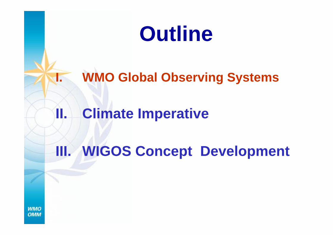
Outline
I. WMO Global Observing Systems
II. Climate Imperative
III. WIGOS Concept Development

WMO Global Observing Systems
• World Weather Watch - Global Observing System (GOS, 1963), WMO backbone system
– Surface & Ocean in situ observing networks
– Upper-air networks– Surface remote sensing
(Radar) networks– Airborne and observations– Satellite constellations


GOS Space-based development
19611961 19781978
19901990 20092009

1111
WMO Global Observing Systems Global Atmospheric Watch (GAW)

The GAW Mission
– Systematic Monitoring Of Chemical Composition of the Atmosphere.
– Analysis and Assessment in Support of International Conventions.
– Development Of Air Pollution and Climate Predictive Capability
– Understanding Climate Change

The rate of rise (ppm/yr) is increasing
1.3 ppm/yr
1.6 ppm/yr
1.5 ppm/yr
2.0 ppm/yr
2.3 ppm/yrIn 2008

GAWGAW StatustreffenStatustreffen 1616 17 March17 March14

Assessment of the quantity and quality of water resources in order to meet the needs of society, mitigation of water-related hazards global environment quality
WMO Hydrological Cycle Observing System
WMO Global Observing Systems

WMO Co-sponsored Observing Systems--Global Climate Observing System WCC-21990
UNFCCCCOP 9 2003
UNFCCCSBSTA 30
2009
UPDATEDIMPLEMENTATION
PLAN IN SUPPORT OF
UNFCCC (IP-10)2010
SATELLITESUPPLEMENT
IMPLEMENTATIONPLAN IN
SUPPORT OFUNFCCC (IP-04)
2004
SATELLITESUPPLEMENT
2007
PROGRESS REPORT
2009
GCOS
1992
GCOS PLAN1995
FIRST ADEQUACY
REPORT 1999
SECONDADEQUACY
REPORT 2003
UNFCCC


87%87%Total Total in situin situ networksnetworksMarch 2009March 200961%61%
66%66%
81%81%
59%59%79%79%48%48%54%54%
WMO CoWMO Co--sponsored Global Observing Systemssponsored Global Observing Systems----Global Ocean Observing System (GOOS) for Climate Global Ocean Observing System (GOOS) for Climate
IOC, UNEPIOC, UNEP,, WMOWMO and ICSUand ICSU
100%100%
100%100%
MilestonesMilestonesDrifters 2005Drifters 2005
Argo 2007Argo 2007
Status against JCOMM targetsStatus against JCOMM targets

TOGA, WOCE, CLIVAR, Argo:TOGA, WOCE, CLIVAR, Argo: Global Ocean ObservationsGlobal Ocean ObservationsImproved basis for an ocean prediction systemImproved basis for an ocean prediction system
Current coverageCurrent coverage

2060 monitoring sites44 networks1200 contact persons 120 environmental
variables Interactive MapsThematic modules related
to biodiversity, coastal zones, forest, hydrology and mountain.Local Climate Estimates,
Geology, Pedology and Hydrology data.
Who, what, where:
Terrestrial Ecosystem Monitoring Sites Database(TEMS)
Global Terrestrial Global Terrestrial Observing SystemObserving System

Convergence of N.Hem and S.Hem Medium Range Forecast skill
Dr W. Zhang, WMO Presentation @ WMO Dr W. Zhang, WMO Presentation @ WMO -- BBIPM WorkshopIPM Workshop, Geneva, Geneva

Outline
I. WMO Global Observing Systems
II. Climate Imperative
III. WIGOS Concept Development

Climate ChangeClimate Change
New Challenges: Climate Change and severe disaster under this background. Ever-
complex society need improved services.
Hail&LightningHail&Lightning
AvalanchesAvalanchesFlash floodsFlash floods
TornadoesTornadoes
Wildland firesWildland fires& haze& haze
Hot & cold spellsHot & cold spells
Heavy precipitationsHeavy precipitations(rain or snow)(rain or snow)
DroughtsDroughts
Storm surgesStorm surges
Storm (winds)Storm (winds)
River basin floodingRiver basin flooding
Mud & landslidesMud & landslides
Ice StormsIce Storms
Tropical cyclonesTropical cyclones
Dust stormsDust storms

Risk levels:Risk levels: Top 30%:Red; Middle 30%:yellow; Lowest 40%: Blue:Top 30%:Red; Middle 30%:yellow; Lowest 40%: Blue:
Global Hotspot studyGlobal Hotspot study (World Bank with ProVention Consortium(World Bank with ProVention Consortium))
35 countries have more than 5% pop in areas at risk from three o35 countries have more than 5% pop in areas at risk from three or more hazardsr more hazards96 countries have more than 10% pop in areas at risk from two or96 countries have more than 10% pop in areas at risk from two or more hazardsmore hazards160 countries have more than 25% pop in areas at risk from one o160 countries have more than 25% pop in areas at risk from one or more hazardsr more hazards
Global Challenges We ShareGlobal Challenges We ShareAs society becomes more complex we become more As society becomes more complex we become more
sensitive to natural and human induced variability.sensitive to natural and human induced variability.

Increasing Risks under a Changing Climate
IntensityIntensity
FrequencyFrequency
HeatwavesHeatwaves
Heavy rainfall / FloodHeavy rainfall / Flood
Tropical CyclonesTropical Cyclones
Coastal Marine HazardsCoastal Marine Hazards
Strong WindStrong Wind
Water ResourceWater ResourceManagementManagement
HealthHealth IndustryIndustry
Food Food securitysecurity
TransportTransport
EnergyEnergy
Urban areasUrban areas
HazardsHazards’’ intensityintensityand frequencyand frequencyare increasingare increasing
Exposure is increasingExposure is increasing !!
Need forNeed fordisaster riskdisaster riskmanagementmanagement

WCC-3 : a historic eventThe road to WCC-3
1st WCC (1979)2nd WCC (1990)Climate variability/change impacts
on all socioeconomic sectorsA Global Framework for Climate
Services (GFCS) requiredA Cg-XV decision (2007)A 2-year preparatory process International Organizing
CommitteePreparation with Members
Dr W. Zhang, WMO Presentation @ WMO Dr W. Zhang, WMO Presentation @ WMO -- BBIPM Workshop, GenevaIPM Workshop, Geneva

World Climate ConferenceWorld Climate Conference--33
Aug 31 Aug 31 –– Sept 4, 2009, GENEVA Sept 4, 2009, GENEVA
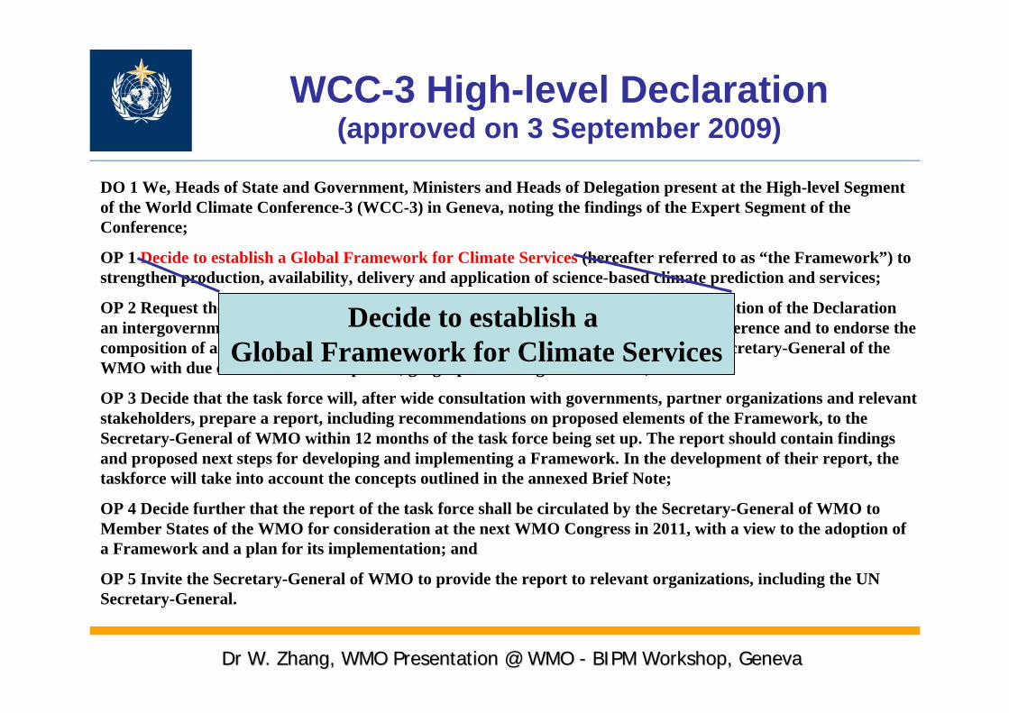
WCC-3 High-level Declaration(approved on 3 September 2009)
DO 1 We, Heads of State and Government, Ministers and Heads of Delegation present at the High-level Segment of the World Climate Conference-3 (WCC-3) in Geneva, noting the findings of the Expert Segment of the Conference;
OP 1 Decide to establish a Global Framework for Climate Services (hereafter referred to as “the Framework”) to strengthen production, availability, delivery and application of science-based climate prediction and services;
OP 2 Request the Secretary-General of WMO to convene within four months of the adoption of the Declaration an intergovernmental meeting of member states of the WMO to approve the terms of reference and to endorse the composition of a task force of high-level, independent advisors to be appointed by the Secretary-General of the WMO with due consideration to expertise, geographical and gender balance;
OP 3 Decide that the task force will, after wide consultation with governments, partner organizations and relevant stakeholders, prepare a report, including recommendations on proposed elements of the Framework, to the Secretary-General of WMO within 12 months of the task force being set up. The report should contain findings and proposed next steps for developing and implementing a Framework. In the development of their report, the taskforce will take into account the concepts outlined in the annexed Brief Note;
OP 4 Decide further that the report of the task force shall be circulated by the Secretary-General of WMO to Member States of the WMO for consideration at the next WMO Congress in 2011, with a view to the adoption of a Framework and a plan for its implementation; and
OP 5 Invite the Secretary-General of WMO to provide the report to relevant organizations, including the UN Secretary-General.
Decide to establish a Global Framework for Climate Services
Dr W. Zhang, WMO Presentation @ WMO Dr W. Zhang, WMO Presentation @ WMO -- BBIPM WorkshopIPM Workshop, Geneva, Geneva

29
Components of Global Framework for Climate Services
Research & Research &
Modeling Modeling
and Predictionand Prediction
HealthHealthHealthHealth
AgricultureAgricultureAgricultureAgriculture
TransportTransportTransportTransport
TourismTourismTourismTourism
WaterWaterWaterWater EnergyEnergyEnergyEnergy
EcosystemEcosystemEcosystemEcosystemSectoralSectoral UsersUsers
Climate Services Information SystemClimate Services Information System
User User
InterfaceInterface
ProgrammeProgramme
Research & Research & Modeling and Modeling and
PredictionPrediction
Observations and Observations and Monitoring Monitoring
HealthHealth
AgricultureAgriculture
TransportTransport
TourismTourismWaterWater
EnergyEnergy
EcosystemEcosystemUsersUsers
Climate Services Information SystemClimate Services Information System
User Interface User Interface ProgrammeProgramme
GovernmentGovernment
Private Private sectorsector

A Seamless Prediction Framework
Fore
cast
Lea
d Ti
me
Fore
cast
Lea
d Ti
me
Warnings & Alert Warnings & Alert CoordinationCoordination
WatchesWatches
ForecastsForecasts
Threats Assessments
GuidanceGuidance
OutlookOutlook
PredictioPredictionn
Applications
Tran
spor
tatio
nTr
ansp
orta
tion
Tran
spor
tatio
n
Prot
ectio
n of
Li
fe &
Pro
pert
yPr
otec
tion
of
Prot
ectio
n of
Li
fe &
Pro
pert
yLi
fe &
Pro
pert
y
Spac
e A
pplic
atio
nsSp
ace
Spac
e A
pplic
atio
nsA
pplic
atio
ns
Rec
reat
ion
Rec
reat
ion
Rec
reat
ion
Ecos
yste
mEc
osys
tem
Ecos
yste
m
Stat
e/Lo
cal
Plan
ning
Stat
e/Lo
cal
Stat
e/Lo
cal
Plan
ning
Plan
ning
Envi
ronm
ent
Envi
ronm
ent
Envi
ronm
ent
Wat
er
Man
agem
ent
Wat
er
Wat
er
Man
agem
ent
Man
agem
ent
Agr
icul
ture
AAgr
icul
ture
gric
ultu
re
Wat
er R
esou
rce
Plan
ning
Wat
er R
esou
rce
Wat
er R
esou
rce
Plan
ning
Plan
ning
Ener
gyEn
ergy
Ener
gy
Com
mer
ceC
omm
erce
Com
mer
ce
Hyd
ropo
wer
Hyd
ropo
wer
Hyd
ropo
wer
Fire
Wea
ther
Fire
Wea
ther
Fire
Wea
ther
Hea
lthH
ealth
Hea
lth
Forecast UncertaintyForecast Forecast UncertaintyUncertainty
Initial Conditions
Boundary Conditions
Minutes
Hours
Days
1 Week
2 Weeks
Months
Seasons
Years
Weather
Climate Variability
Scenarios
Anthropogenic Forcing
Climate Change.
Adapted from: NOAA
Decades
Centuries

Studying Earth as a Complex System
CirculationSurface WindsPrecipitationReflection and TransmissionSurface TemperatureEvaporationCurrentsUpwelling
CirculationCirculationSurface WindsSurface WindsPrecipitationPrecipitationReflection and TransmissionReflection and TransmissionSurface TemperatureSurface TemperatureEvaporationEvaporationCurrentsCurrentsUpwellingUpwelling
InfiltrationRunoffNutrient LoadingSurface TemperatureCurrents
InfiltrationInfiltrationRunoffRunoffNutrient LoadingNutrient LoadingSurface TemperatureSurface TemperatureCurrentsCurrents
Surface WindsPrecipitationReflection and TransmissionEvaporationTranspirationSurface Temperature
Surface WindsSurface WindsPrecipitationPrecipitationReflection and TransmissionReflection and TransmissionEvaporationEvaporationTranspirationTranspirationSurface TemperatureSurface Temperature
LandLand
OceanOcean
AtmosphereAtmosphere

Mid-1970s
Atmosphere
Mid-1980s
Atmosphere
Land Surface
Early 1990s
Atmosphere
Land Surface
Ocean & Sea Ice
Late 1990s
Atmosphere
Land Surface
Ocean & Sea Ice
SulphateAerosol
Present Day
Atmosphere
Land Surface
Ocean & Sea Ice
SulphateAerosol
Non-sulphateAerosol
Carbon Cycle
Early 2000s?
Atmosphere
Land Surface
Ocean & Sea Ice
SulphateAerosol
Non-sulphateAerosol
Carbon Cycle
DynamicVegetation
AtmosphericChemistry
Weather
Climate Change
ClimateVariability
Overview of Weather and Climate Models and the Required Observations
Need an Integrated Global Observing System meet all requirements

Importance of observations : From Observations to Consequences
Understanding
Models
Predictions
ConsequencesValidation
Assimilation Initialization
Monitoring
Analysis
Observations
The availability of new observations strongly motivates advances in understanding, prediction, and application.

PREDICTEDPREDICTED
OBSERVEDOBSERVED
Climate Model vs Observed PrecipitationClimate Model vs Observed Precipitation
Global Intensification of Global Intensification of the hydrological cyclethe hydrological cycle ??
Models indicate trend Models indicate trend ----observations donobservations don’’t confirmt confirm
Errors donErrors don’’t allow prooft allow proof

Outline
I. WMO Global Observing Systems
II. Climate Imperative
III. WIGOS Concept Development

WIGOS: OverviewCONGRESS XV (2007)• High priority -- “Towards Enhanced Integration
between the WMO Observing Systems”(WIGOS) to support weather, climate, water and related environmental services
WMO Executive Council• Established a WG on WIGOS-WIS
– Develop an WIGOS Implementation Plan– Refine the WIS-Implementation Plan– Monitor the Progress of the Pilot and Demo
projects

WIGOS Vision
• WIGOS will establish an integrated, comprehensive and coordinated observing system to satisfy in a cost-effective and sustained manner the evolving observing requirements of WMO Members and enhance coordination with partners for the benefit of society.

Scope: WIGOS will• Build upon the existing observing components:
– WWW Global Observing System (GOS)– Global Atmospheric Watch (GAW)– World Hydrological Cycle Observing System
(WHYCOS) • and will capitalize on existing, new and
emerging technologies.• Improve access to and utilization of surface-
based observations and products from co-sponsored systems such as GTOS, GOOS and GCOS through enhanced coordination with partner organizations.

Improving Value and Availability of Information
• WIGOS will address improved value and availability of information via three areas of integration and standardization:– At the Instruments and Methods of Observation
Level– At the Data, Product & Metadata Exchange
Level (WIS)– At the Data Utilization Level - QMF principles
• WIGOS Success rely on Measurements science and technology: Great Challenge

QMF Standards Instruments and methods of
observation standards
WIS
Standardsfor
Data & Metadata exchange&
Discovery, Access and Retrieval (DAR) Services
Observationsfor
Weather,Climate,Water,
Ocean, …
DataProcessing and
Forecasting
Archiving
Users
Active Quality Management
Three areas of Integrations/Standardizations

No.1 Priority: Completeness : fill-in observing gapsKey Areas: How to develop and sustain Ocean and Land (including Polar Regions and Cryosphere) observations on operational basis from both In-situ and space?

The ENSO• The predictability rely on sub-surface data• Satellite can not observe sub-surface
now

The Arctic Ocean ice has been there for 2 million years.

1979

2003

Tiksi, Russia
Alert, Canada
Barrow, Alaska
Eureka, Canada
Summit, Greenland
Ny-Alesund, Svalbard
Establishing IntensiveAtmospheric ObservatoriesIn the Arctic is the componentof NOAA/SEARCH being directed by ESRL

Countries Where Cryosphere OccursCountries Where Cryosphere Occurs95 countries identified with cryospheric components 95 countries identified with cryospheric components
Cryosphere truly is globalCryosphere truly is global

Accuracy, PrecisionRepresentativenessMeasurement traceabilityLong-time series stabilityReducing uncertainty……
No. 2 Priority: Ensure the quality of the observations to meet climate requirements

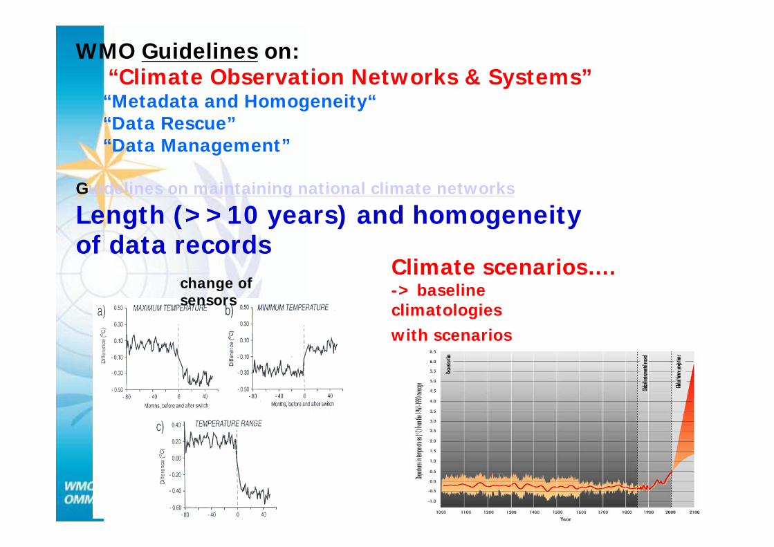
WMO Guidelines on:“Climate Observation Networks & Systems”“Metadata and Homogeneity““Data Rescue”“Data Management”
Guidelines on maintaining national climate networks
Length (>>10 years) and homogeneity of data records
Climate scenarios….-> baseline climatologies with scenarios
change of sensors

Studying Earth as a Dynamic System
Forces acting on the Earth
system
Forces acting Forces acting on the Earth on the Earth
systemsystem
Earth system response
Earth Earth system system responseresponse
IMPACTSIMPACTS
FeedbackFeedback

World Radiometric Reference (WRR)-Standard for Solar Irradiance
• Introduced by WMO in 1980 based on the comparison of 15 fully characterized instruments
• Maintained by PMOD in Davos through a group of instruments
• Disseminated world-wide by the means of intercomparisons held every 5 years

GAW-VOC Target Compounds and the future CCL
NIST (National Institute of Standard and Technology,USA)
KRISS (Korea Research Institute of Standards and Science, South Korea)
NMI-VSL (National Metrological Institute Van Swinden Laboratorium, NL)
NPL (National Physical Laboratory, GB)
DMS, ACT
NMHC
MTs
oxyVOC
Responsibilities
The responsibilities for the individual compounds are shared among several laboratories (institutions).

Long records of Carbon Dioxide (COLong records of Carbon Dioxide (CO22), Methane (CH), Methane (CH44), and ), and Nitrous Oxide (NNitrous Oxide (N22O) concentrations all show sharp increasesO) concentrations all show sharp increases
Carbon Dioxide
Nitrous Oxide
Methane
Measurements before about 1960 are mostly from bubbles trapped iMeasurements before about 1960 are mostly from bubbles trapped in glacial ice. After that, n glacial ice. After that, WMOWMO-- coordinated instrumental observations abound.coordinated instrumental observations abound.
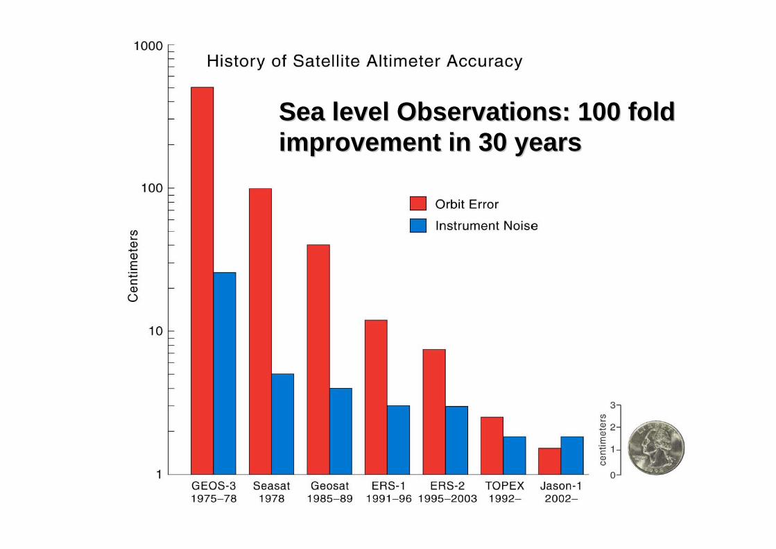
Sea level Observations: 100 fold Sea level Observations: 100 fold improvement in 30 yearsimprovement in 30 years

Globally averaged sea levelGlobally averaged sea level
TOPEX/PoseidonTOPEX/Poseidon
JasonJason--11
S. Nerem (U. Colorado)S. Nerem (U. Colorado)
mm
mm
Does this represent a longDoes this represent a long--term term trend caused by global warming trend caused by global warming or just natural variability?or just natural variability?


Trend: N10 = - 0.40 K Dec-1, N11 = 0.80 K Dec-1,
N12 = 0.36 K Dec-1, N14 = 0.43 K Dec-1
248
249
250
251
252
253
1987 1989 1991 1993 1995 1997 1999 2001 2003
NOAA10
NOAA11
NOAA12
NOAA14
Linear (NOAA10)
Linear (NOAA11)
Linear (NOAA12)
Linear (NOAA14)
Multi-satellite inter-calibration is so important to long-time data series
Trend: N10 = -0.39 K Dec-1, N11 = 0.58 K Dec-1
N12 = 0.43 K Dec-1, N14 = 0.31 K Dec-1
248
249
250
251
252
253
1987 1989 1991 1993 1995 1997 1999 2001 2003
NOAA10
NOAA11
NOAA12
NOAA14
Linear (NOAA10)
Linear (NOAA11)
Linear (NOAA12)
Linear (NOAA14)
Operational Calibration
Improved calibrated radiances using SNO- improveddifferences between sensors by order of magnitude.
Trend = 0.17 K Dec-1
250
251
252
253
254
1987 1989 1991 1993 1995 1997 1999 2001 2003
Combined
Linear (Combined)
Trends for nonlinear calibration algorithm using SNO cross calibration0.20 K Decade-1
Improved Calibration

Global Satellite Inter-Calibration System (GSICS) -an excellent example and the most important issues for global
satellites integration.
• To improve the use of satellite global observations.
• To provide for the ability to create stable long-term climate data sets.
• To ensure instruments meet specification, pre-launch tests are traceable to SI standards.
Simultaneous Nadir Simultaneous Nadir Overpass (SNO)Overpass (SNO)
Next step: Global satellite products validationNext step: Global satellite products validation
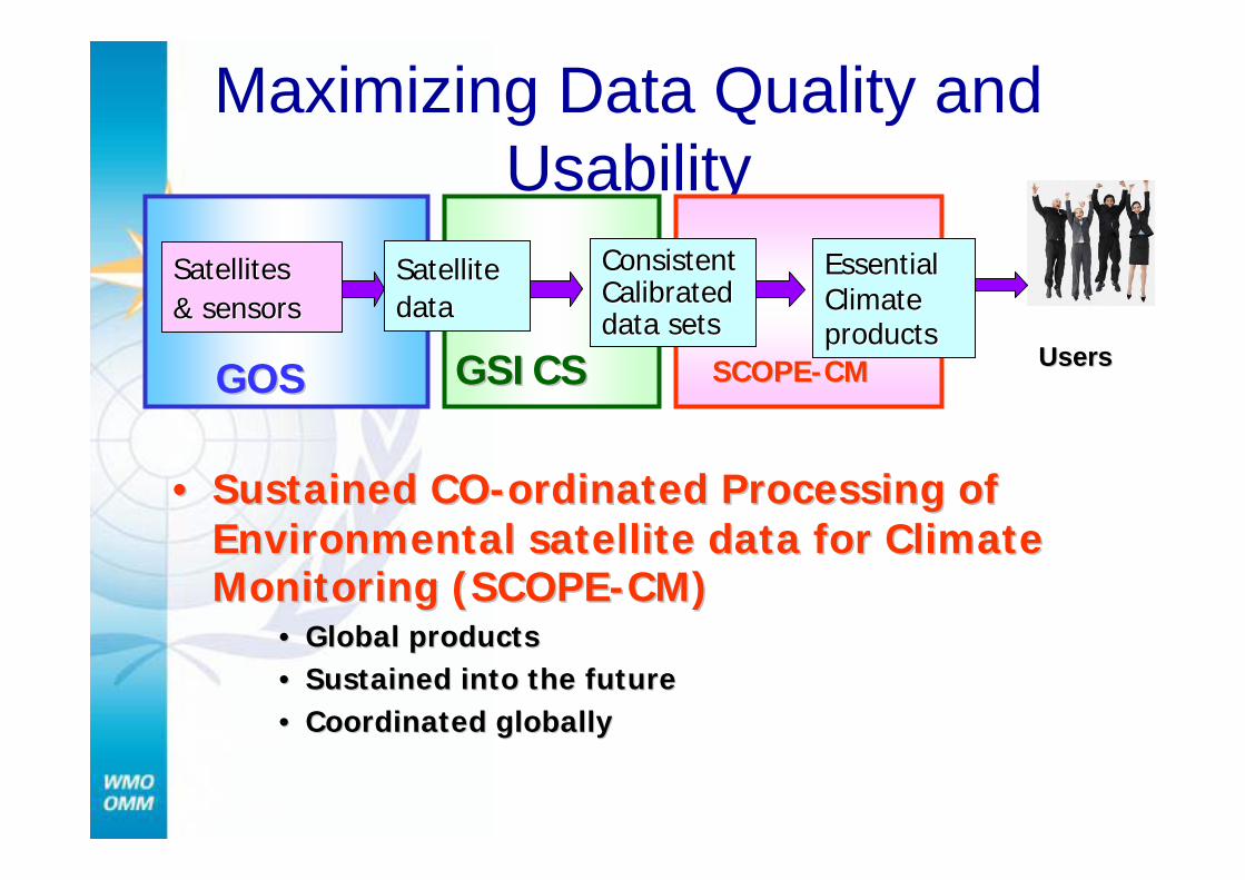
Maximizing Data Quality and Usability
UsersUsers
Satellites Satellites & sensors& sensors
Satellite Satellite datadata
Essential Essential Climate Climate productsproducts
GOSGOS GSICSGSICS
ConsistentConsistentCalibratedCalibrateddata setsdata sets
SCOPESCOPE--CMCM
•• Sustained COSustained CO--ordinated Processing of ordinated Processing of Environmental satellite data for Climate Environmental satellite data for Climate Monitoring (SCOPEMonitoring (SCOPE--CM)CM)
•• Global productsGlobal products•• Sustained into the futureSustained into the future•• Coordinated globallyCoordinated globally
Satellite climate products delivered at multiple levels-Traceability strategy
A/D Conversion
Detection
FluxManipulation
Packetization
Compression
FiltrationAux.Sensor
Data
CCSDS (mux, code, frame) & Encrypt
CommXmitter
SEN
SOR
S
OT
HE
RSU
BSY
STE
MS
Cal.Source
DataStore
ENVIRONMENTALSOURCE
COMPONENTS
SPA
CE
SE
GM
EN
T
RDRProduction
EDRProduction
SDRProduction
EDR Level
SDR Level
RDR Level
IDPS
CommReceiver
CommProcessing
Delivered Raw
C3 S
TDR Level

Integrated Global Atmospheric Chemistry Observations(IGACO) Strategy
World Integrated
Data ArchiveCentres(WIDAC) Reanalysis
Forecast Models &Data Assimilation
Cal/Val &
Quality Assurance
Globally GriddedData
Applications- Weather Prediction- Air Quality Prediction- Global Change Detection- Environ. Assessment- Ecosystem Impacts- Seasonal Forecast- Emergency Response- Climate Research- etc. etc.
Observations• Satellite• Aircraft• Surface(in situ, remote)
ObservationOptimization
Real Time Data Delivery
Air/Surface Exchange & Emissions
All Data Delivery

WIGOS need great efforts to Turn Observations into value-added climate Products, Information and Knowledge
Special attention to the Remote sensing measurements
No.3 No.3 PriorityPriority

WIGOS need Turning Observations into Knowledge and Information
• Translating raw observations of Earth into useful information
• The decadal vision are:– (1) sustained observations from space for research
and monitoring– (2) surface-based and airborne observations that are
necessary for a complete observing system– (3) models and data assimilation systems that allow
effective use of the observations to make useful analyses and forecasts, and
– (4) planning and other activities that strengthen and sustain the Earth observation and information system.

data• priority: turning
observations into products and information
• Great challenges on:– Sciences– Technologies– Coordination– Collaboration– Cooperation– ….
productsinformation
knowledge

Observations:All Sources
Global Products
IGACO-Aerosols
World Integrated Data Network:e.g. WDC-NILU
Sat. Centres (WDC-RSAT)AERONET, etc
Assimilation of Real-Time Data
By Forecast Models
(e.g. GEMS; WMO SDS-WAS)
GAW Calibration &
Quality Assurance
(GAWNET PFRs)
Data Uses/Applications1. Public Air Quality Warnings2. Public SDS Warnings3. Public Aerosol Bulletins4. Surface and air transport5. Scientific Assessments (IPCC,
Ozone, etc)6. Improved Weather Forecasts
Aircraft: MOZAIC/IAGOS
Surface-based: Remote sensing: AOD &GALIONIn situ: PM & optical In situ: Chemistry
Satellite:MODIS, CALYPSO, GEOs
WMO Real-Time Data Distribution:WMO Information System (WIS)
Leaders: WMO/GAW & Satellite Orgs & ENV OrgsLeaders: WMO/GAW & Satellite Orgs & ENV Orgs
Reanalysis

Need Great Global Consolidation Efforts

WIGOS Benefits
• Improved observing networks operations
• Increased access to observational data and products with improved quality
• More efficient use of all available resources (cost-effectiveness)
• Better preparedness to incorporate new observing systems and to interface with WMO co-sponsored observing systems

The EarthThe Earth’’s climate is a s climate is a complex systemcomplex system……
……understanding it requiring understanding it requiring comprehensive observationscomprehensive observations
Comprehensive observations will improve our climate services Let’s work together for better life and a better world

Thanks for your attention !

The production of energy and population is The production of energy and population is evident in views of the world at nightevident in views of the world at night