Wig Zamore, April 2, 2009 On behalf of Mystic View Task Force & Somerville Transportation Equity...
29
Wig Zamore, April 2, 2009 On behalf of Mystic View Task Force & Somerville Transportation Equity Partnership EPA Draft PM ISA - Citizen Comments on Public Health and Near Source Transportation Related Air Pollution (TRAP)
-
Upload
crystal-barnett -
Category
Documents
-
view
213 -
download
0
Transcript of Wig Zamore, April 2, 2009 On behalf of Mystic View Task Force & Somerville Transportation Equity...
Wig Zamore, April 2, 2009
On behalf of Mystic View Task Force &
Somerville Transportation Equity Partnership
EPA Draft PM ISA - Citizen Comments on Public Health and Near SourceTransportation Related Air Pollution
(TRAP)
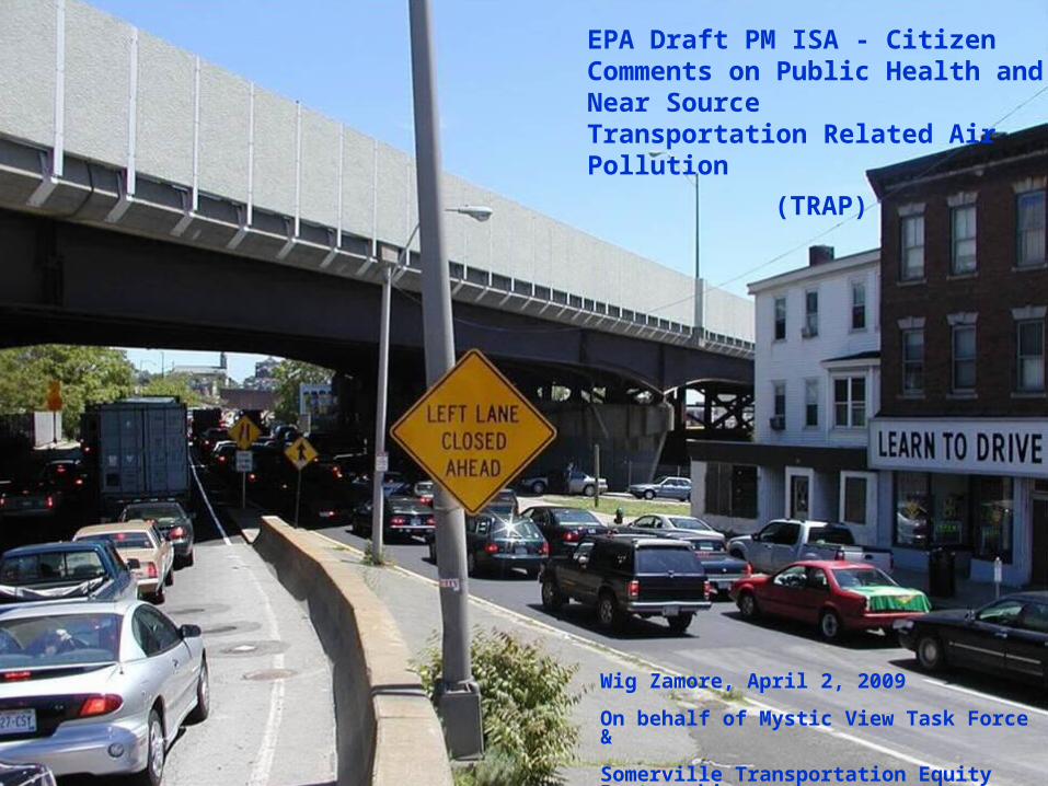
BOSTON Metropolitan Area Cities and Densities - 2000
#1 - Somerville
18,851 / Sq.Mi.
#3 - Cambridge
15,763 / Sq.Mi.
#2 - Chelsea16,018 / Sq.Mi.
#4 - Boston 12,165 / Sq.Mi.
#6 - Malden11,112 / Sq.Mi.
#5 - Everett11,254 / Sq.Mi.
#9 - Medford8,230 / Sq.Mi.
Revere7,994 / Sq.Mi.
2

Somerville and Chelsea Characteristics – Susceptible and Vulnerable
Somerville#2 Immigrants/SM #1 Population/SM#2 College Grads/SM#1 Multi-family %#3 State $$$/SM/Y#2 Transit use - buses
3
Chelsea#1 Immigrants/SM #2 Population/SM Lo SES & Education#2 Multi-family %#1 State $$$/SM/YHi Transit use - buses

Somerville and Chelsea Characteristics – Eye opener data on AMI & LC
4
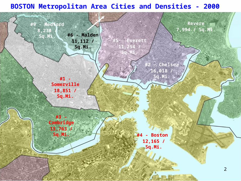
Density plus TRAP = Highest Age-adjusted Excess AMI & Lung Cancer / SM
Somerville
AMI & LC
ChelseaAMI & LC
S. Boston
AMI & LC5
Port
Port
Port
Port
Logan Airport
Produce
Markets
Port
E. Boston AMI & LC
Produce Markets
Most Highways Diesel
Rail
Charlestown
AMI & LC

Somerville Diesel Commuter Rail Trips – 200/Day – 15,000/SM/YR
6
When diesel locomotives “notch up” to accelerate they typically put out up to 100X the emissions per unit of track travel. These trains are just crossing into Somerville, which has no stops.

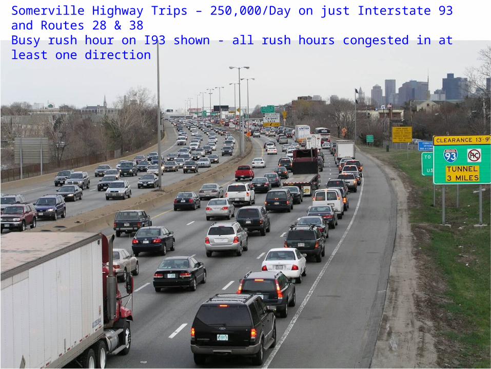
Somerville Highway Trips – 250,000 VPD - 200,000 VMT/SM City Average
7
Prospect St – Union Sq – extra busy
Somerville Ave – Union Sq – extra busy
Route 28 – busy rush hour
Route 28 – busy rush hour
8
Somerville Highway Trips – 250,000/Day on just Interstate 93 and Routes 28 & 38Busy rush hour on I93 shown - all rush hours congested in at least one direction

Harvard VA Transportation Worker Series – Garshick 2008 - one of manyThis transportation worker series is highly relevant to near source TRAP
9
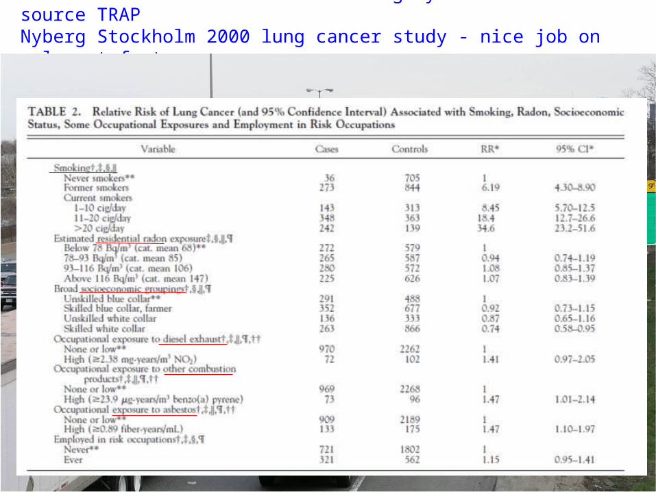
Scandinavian NO2 / NOx Series – highly relevant to near source TRAPNyberg Stockholm 2000 lung cancer study - nice job on relevant factors
10
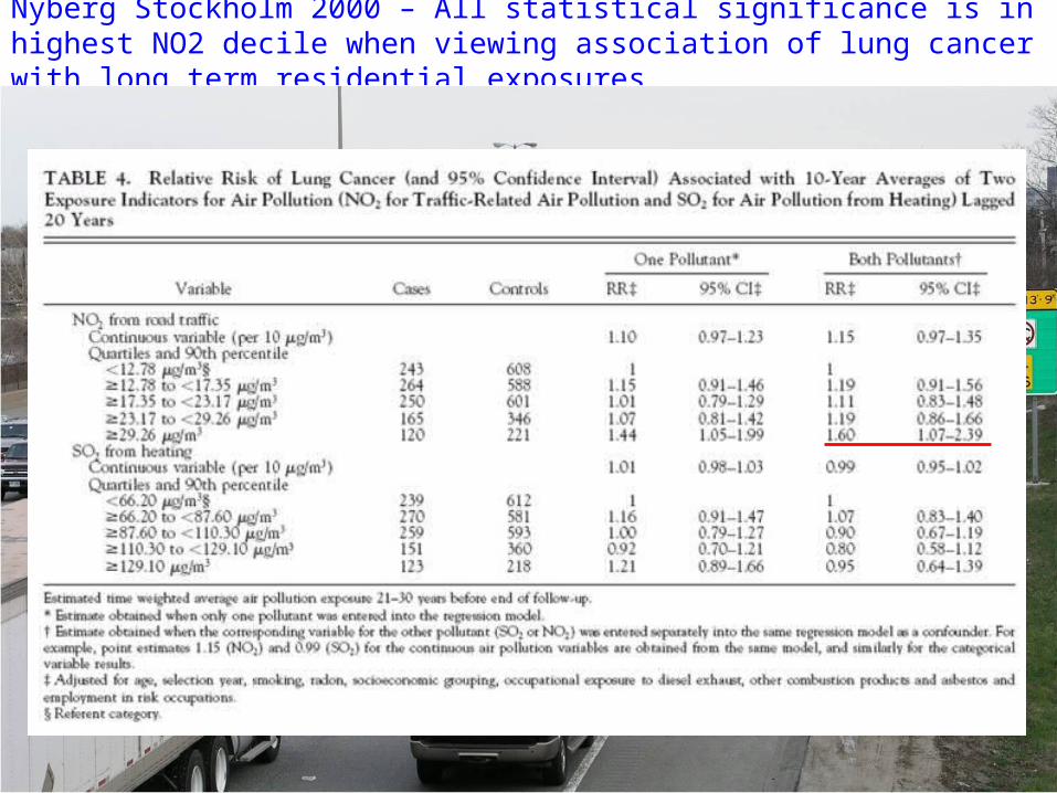
Nyberg Stockholm 2000 – All statistical significance is in highest NO2 decile when viewing association of lung cancer with long term residential exposures
11

Scandinavian NO2/NOx Series – Nafstad Oslo 2003 lung cancer study - once again all significance is in top 10% of LT NOx exposure - no SO2 association
12
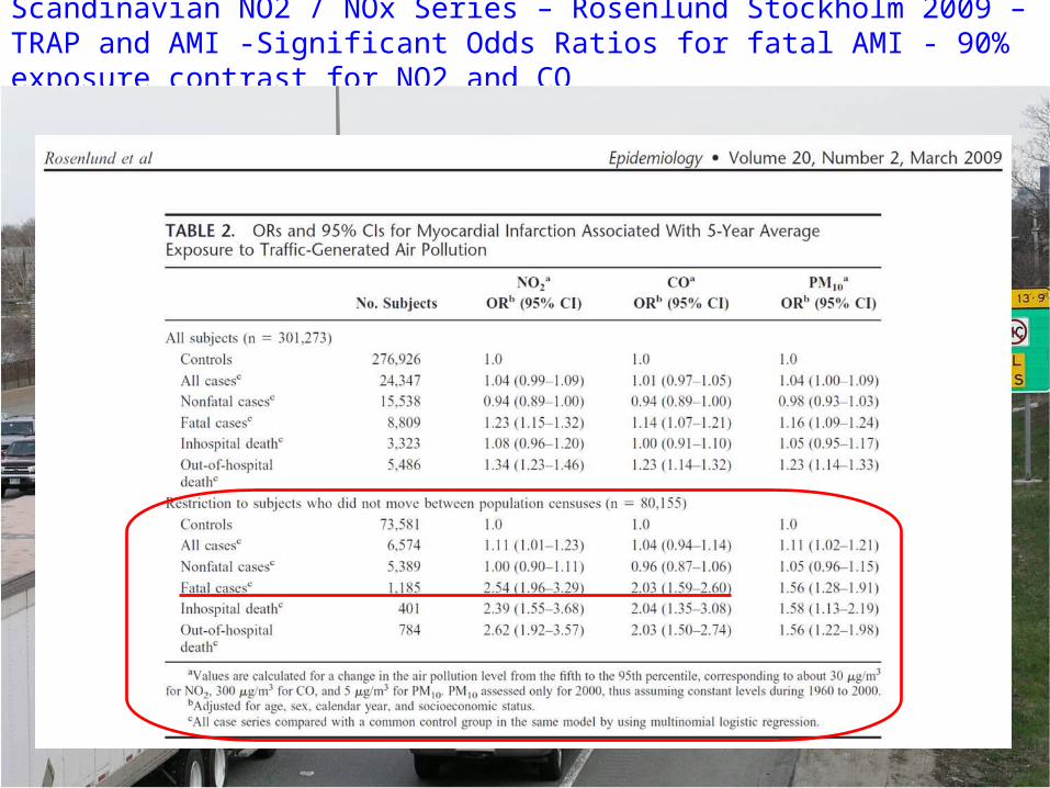
Scandinavian NO2 / NOx Series – Rosenlund Stockholm 2009 – TRAP and AMI -Significant Odds Ratios for fatal AMI - 90% exposure contrast for NO2 and CO
13
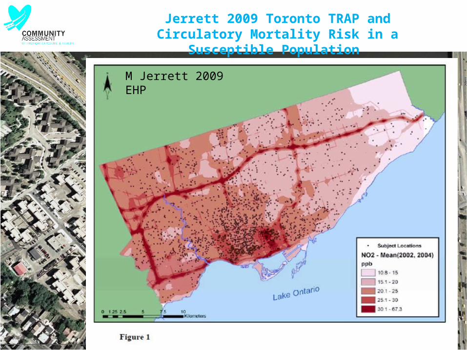
Jerrett 2009 Toronto TRAP and Circulatory Mortality Risk in a Susceptible Population
M Jerrett 2009 EHP
M Jerrett 2009 EHP
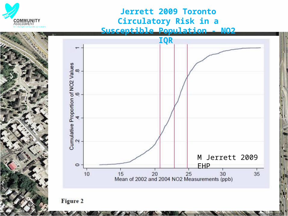
Jerrett 2009 Toronto Circulatory Risk in a Susceptible Population
- NO2 IQR
M Jerrett 2009 EHP
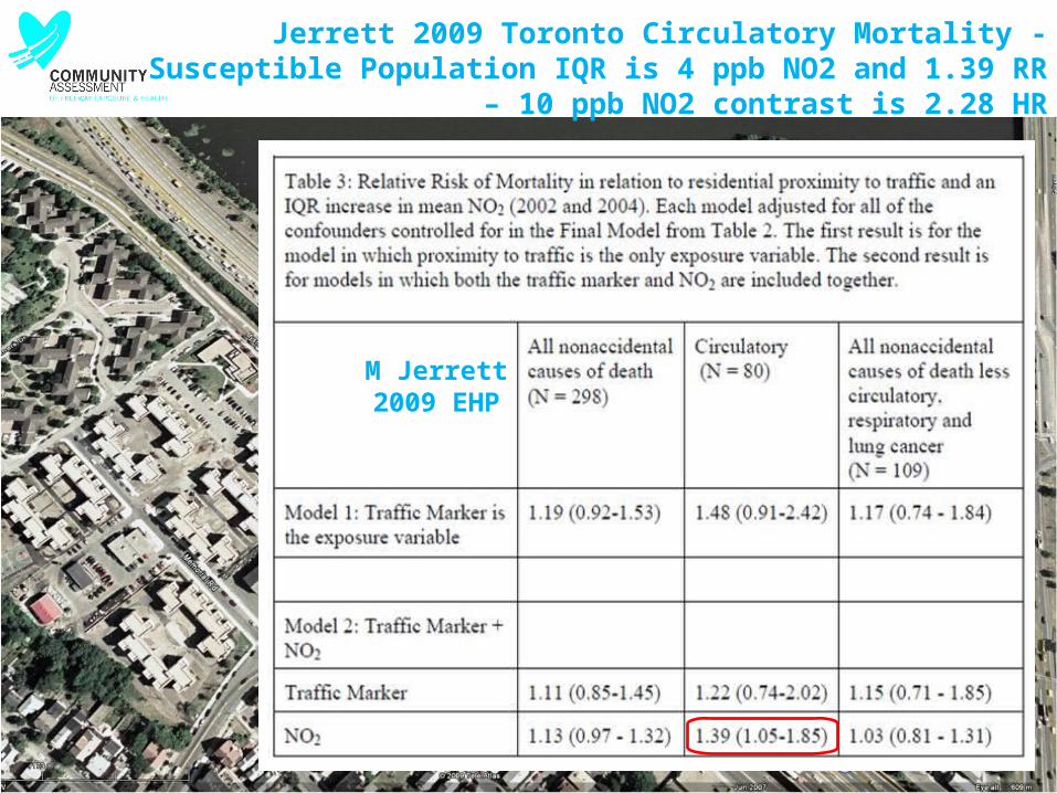
Jerrett 2009 Toronto Circulatory Mortality - Susceptible Population IQR is 4 ppb NO2 and 1.39 RR – 10 ppb NO2
contrast is 2.28 HR

Nice work by EPA & NOAA – Hagler Raleigh NC - UFP does not
correlate with PM2.5 or PM10 - PM2.5 regulations DO NOT PROTECT
vulnerable populations from UFP-TRAP
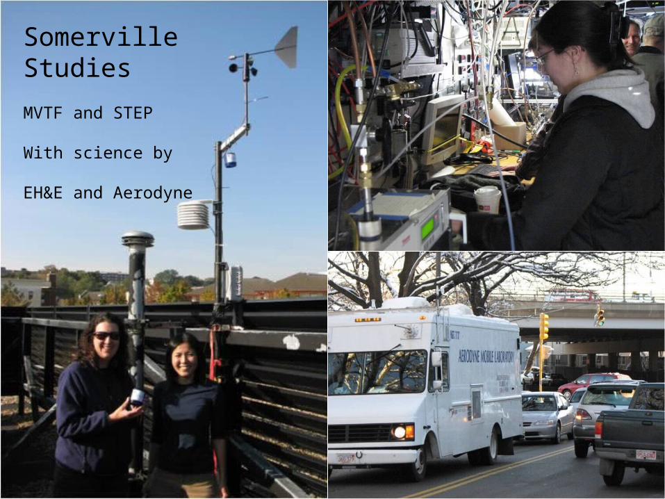
Somerville Studies
MVTF and STEP
With science by
EH&E and Aerodyne

NONO22 Along Roads Along Roads•Clear traffic-related
pattern
•NO2 measured near I-93 is twice as high as the level in Draw 7 park
•NO2 within 50 m of I-93 is similar to the concentrations at Roxbury Crossing and Kenmore Sq.
NO2 Concentration< 19 ppb19 - 20 ppb20 - 21 ppb21 - 22 ppb> 22 ppb
Draw 7 Park15 ppb
Temple & R38 & I-93
30 ppb NO2
Lynn urban backgroun
d ~ 10 ppb

NONO22 Levels Levels• Two-week averages
• Mean (SD): 20.6 (2.7) ppb• Range: 15 – 32 ppb
• NO2 weakly correlated with distance (m) to highway
• I-93: -0.19 (p=0.06)• MA-28: -0.28 (p=0.006)
• NO2 strongly correlated with traffic density (TD)
• TD25m: 0.61 (p<0.0001)• TD50m: 0.60 (p<0.0001)• TD100m: 0.48 (p<0.0001)

Route for a portion of Aerodyne investigation Morning of January 16 2008 -
analysis at Tufts

Pollutant map in Somerville: ultrafine particles1/16/2008 7:00 – 7:45 am - map by Aerodyne Research
Wind
22
Temple & R38 & I-93 - hi UFP
PNC
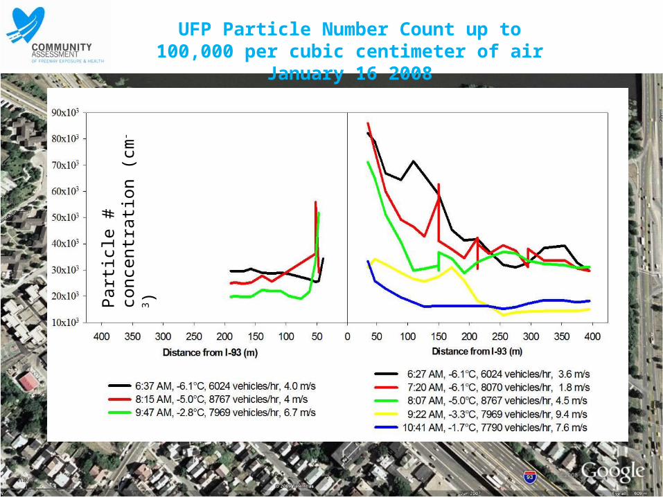
UFP Particle Number Count up to 100,000 per cubic centimeter of air
January 16 2008
Par
ticle
# c
once
ntra
tion
(cm
-3)

NO is proportional to UFP PNC but NO2 is less so Drop in NOx & UFP as morning meteorology proceeds
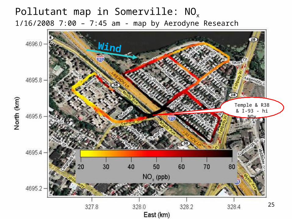
Pollutant map in Somerville: NOx
1/16/2008 7:00 – 7:45 am - map by Aerodyne Research
Wind
25
Temple & R38 & I-93 - hi NOx

Brunekreef 2009 HEI NLCS - great scientists, sponsor – big exposure issues
26
NLCS 90% Contrast is less than 10,000
vehicles per day (VPD) and 85 % of traffic data
is plugged.
Somerville high exposure is 50,000 to 250,000 VPD, 90 % Contrast will be in
150,000 VPD range.
NLCS would have to be scaled up by 15X to 20X to be used in
Somerville, Toronto, LA, Oslo, Stockholm.
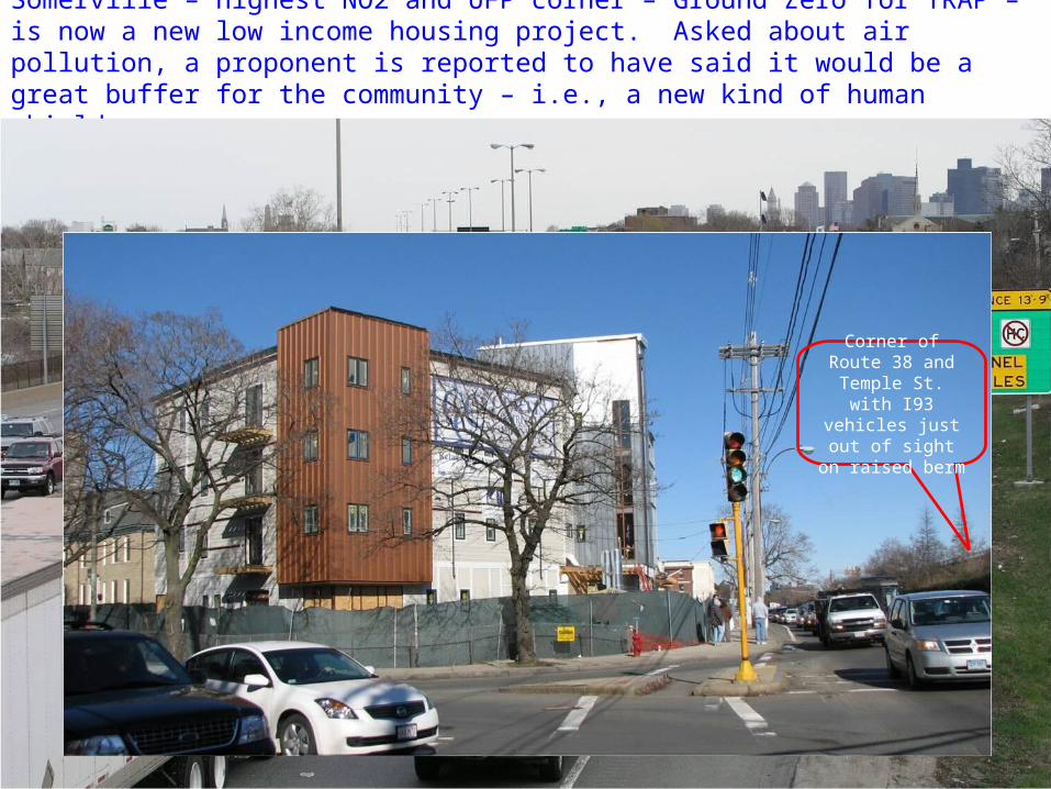
Somerville – highest NO2 and UFP corner – Ground Zero for TRAP – is now a new low income housing project. Asked about air pollution, a proponent is reported to have said it would be a great buffer for the community – i.e., a new kind of human shield.
27
Corner of Route 38 and Temple
St. with I93 vehicles just out of sight on raised
berm
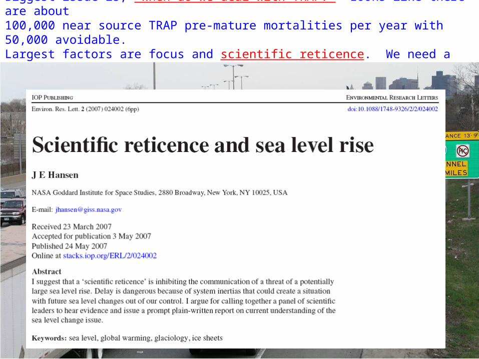
Biggest issue is, "When do we deal with TRAP?" Looks like there are about 100,000 near source TRAP pre-mature mortalities per year with 50,000 avoidable. Largest factors are focus and scientific reticence. We need a few heroes !!!
28

Mortality Records for Somerville (age adj.) 1989 – 2003 (15Y):
Lung cancer & heart attack deaths – actual 1,572
Lung cancer & heart attack deaths – at Mass rates 1,281
Lung cancer & heart attack deaths – excess 291
29
Mystic Housing is Somerville's largest low income housing facility. The city has nearly
20,000 residents per SM with large vulnerable & susceptible populations along Interstate 93 and Routes 28 and 38. Every US
urban area has many similar unprotected vulnerable & susceptible populations.