Where We Live Now - British Academy Perspectives on... · Where we live now – why does it matter...
68
Where We Live Now Perspectives on place and policy
Transcript of Where We Live Now - British Academy Perspectives on... · Where we live now – why does it matter...

Where We Live Now
Perspectives on place and policy

The British Academy is the UK's national body for the humanities and social sciences – the study of peoples, cultures and societies, past, present and future. We have three principal roles: as an independent Fellowship of world-leading scholars and researchers; a Funding Body that supports new research, nationally and internationally; and a Forum for debate and engagement – a voice that champions the humanities and social sciences.
The British Academy 10 - 11 Carlton House Terrace London SW1Y 5AH +44 (0)20 7969 5200
www.britac.ac.ukRegistered Charity: Number 233176
britac_news TheBritishAcademy Britacfilm BritishAcademy
Published 2017

Contents
Preface 2Fiona Reynolds and Deborah Lamb
What is place? The sense and feel of place 3Phenomenology and place, or: feeling that you live somewhere 4Jo Vergunst
Billia Croo, Alec Finlay 8Commentary by Heather H. Yeung
Homing Instincts and the mediation of screen space 10Ian Christie
How to capture – and create – place and ‘placeness’? 14Ruth Finnegan
The Hidden Gardens, Gerry Loose 20Commentary by Heather H. Yeung
Case study: Pope’s Urn: Twickenham 22Isobel Colchester
Understanding place: its impact on people and relationships 23Where we live now – why does it matter for our mental health 24Sarah Curtis
Turnings, Patrick Bond 28 The geographies of ethnicity and religion in contemporary Britain: how divided? 29Ron Johnston, Richard Harris, Kelvyn Jones and David Manley
Social Media, Place and Policy 37Mark Birkin
Shaping where we live for the better: practical approaches 41
Making sense of the place in which we live: ‘more than a feeling!’ 42Denise Hewlett
Case study: Waterways & Local Places 47Heather Clarke
Landscaping Change: Exploring the transformation, reconstitution and disruption of environments through the arts, humanities and social sciences 52Samantha Walton
The Bindings, Patrick Bond 56Case study: How the crowd is taking ownership of place, policy and opportunity 57Jess Ratty and Jason Nuttall
Case study: People, Place and Collaborative Research 59Maria Adebowale-Schwarte
2 Where We Live Now
Throughout 2016 the British Academy has been exploring the nature of place: what it means to people, how it features in policy making and whether it might be more useful than it currently is as a way of thinking and planning for the future.
In chapters as varied as Ruth Finnegan's literary journey through place and Denise Hewlett's analysis of the relationship between tranquillity, quality of life and place; to Jess Ratty and Jason Nuttal's lively case study of how communities engage with place through crowdfunding; and Heather Clark's work on waterways as place-makers, we see how academic and policy-related studies are enhanced by using the lens of place. Moreover, as Ron Johnston's exploration of the politics of place and new communities experiencing immigration, and Sarah Curtis' analysis of the impact of place on mental health demonstrate, these are cutting edge issues which need modern solutions. The chapters are interwoven with poetry and artwork drawing on the inspiration of place, and continually reinforce the message that we would all benefit from taking the notion of 'place' more seriously. In doing so, they also illustrate the diversity of places and people's responses to them, and that taking account of this in policy can help us better meet people's needs.
We commend these chapters to you, and encourage you to read them in tandem with the reports of our workshops in Manchester, Cornwall, Cardiff and London, and with our policy document, The case for place-based policy, which argues for bringing place into the heart of policy and decision-making.
We thank our authors warmly for their input, and the policy team at the British Academy – especially Jamiesha Majevadia – who worked so hard on the project.
Preface
We have held workshops in four locations around the country, public debates, and discussions within our Fellowship and the academic community.
We've been astonished by the enthusiasm and diversity of people's responses to the idea of giving place much more prominence. This project has occurred at a point when the idea of place has been gaining ground in mainstream agendas; an idea which offers new perspectives and potentially life changing ways of looking at the world and improving people's wellbeing.
Our conclusions from this exercise are published in an accompanying volume to this publication which sets out both the case for better place-based policy making and some practical ideas for taking it forward. The chapters in this document provide yet further evidence of the enhanced insights and perspectives that can be derived from looking at issues from a place-based perspective.
Joint Project Chairs, Where We Live NowDame Fiona Reynolds hon FBA Master, Emmanuel College, CambridgeDeborah Lamb Deputy Chief Executive, English Heritage
The sense and feel of place
What is place?
3

4 Where We Live Now
Dr Jo Vergunst, Lecturer in Anthropology, University of Aberdeen
Phenomenology and place, or: feeling that you live somewhere
Imagine a place, even a room, that you know well; let us say your bedroom. It is almost completely dark, but you need to get up out of bed. You find that you are able to do so very quietly, without being able to see, and without hitting anything. Indeed, if you are still imagining, you could recreate how you reach out your arm across the darkness to reach the door handle very precisely – there is no need to search for it across the wall. Somehow your body knows the room intimately, its distances, its obstacles and how it affords your passage through it, without your mind really thinking about it. You are still half asleep of course, and perhaps hardly thinking at all.
I am inspired in this small thought experiment by philosopher Gaston Bachelard’s book The Poetics of Space. Bachelard uses the term ‘muscular consciousness’ to convey how the body knows where it is and how to move around. His book is also a phenomenology of poetic images. He invites us to daydream our way through a house where, he writes, ‘imagination, memory and perception exchange functions. The image is created through co-operation between the real and unreal’.
Consider how you feel differently in a cellar, a kitchen, the bedroom you have just thought about, or an attic... what is it that becomes real in those places for you, or for someone else? Perhaps these are just insubstantial ‘images’ in your mind, but for Bachelard, ‘phenomenology of the imagination (...) demands that images be lived directly, that they be taken as sudden events in life.’ “The feelings we have about places are also an aspect of their reality. ”
Phenomenology is a philosophy of experience and perception. In my discipline of social anthropology, it creates rich and detailed accounts of places as they are lived in. It explores how places are made and re-made from an insider’s point of view.
It encourages deep questions: • How do people perceive and come to
know the places they are in? • What does it mean for a place to be inhabited? • What is the significance of a direct,
unmediated experience of a place, or in other words, how it actually feels to live somewhere?
These are questions that might loosen up our thinking.
What is place? The sense and feel of place 5
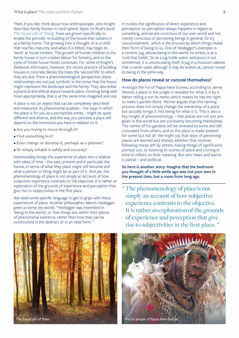
Then, if you like, think about how anthropologist John Knight describes family houses in rural upland Japan (in Rival’s book The Social Life of Trees). Trees are grown specifically to enable the periodic re-building of the house that sustains it as a family home. The growing tree is thought of as a child that reaches maturity, and when it is felled, may begin its ‘work’ as house timbers. The growth of human children in the family house in turn creates labour for forestry, and so the cycle of forest-house-forest continues. For some of Knight’s fieldwork informants, however, the recent practice of building houses in concrete denies the trees the ‘second life’ to which they are due. From a phenomenological perspective, these relationships are not just symbolic in the sense that the house might represent the landscape and the family. They also entail a practical and ethical stance towards place, involving living with trees appropriately, that is at the same time imagined and real.
A place is not an object that can be completely described and measured. Its phenomenal qualities – the ways in which the place is for you as a perceptible entity – might be quite different and diverse, and the way you perceive a place will depend on the intentions you have in relation to it:
• Are you trying to move through it?
• Find something in it?
• Even change or develop it, perhaps as a planner?
• Or simply inhabit it safely and securely?
Intentionality brings the experience of place into a relation with ideas of time – the past, present and in particular the future, in terms of what they place might still become and what a person or thing might be as part of it. And yet, the phenomenology of place is not simply an account of how subjective experience contrasts to the objective. It is rather an exploration of the grounds of experience and perception that give rise to subjectivities in the first place.
We need some specific language to get to grips with these experiences of place. Another philosopher, Martin Heidegger, gives us some key words: “Heidegger was interested in ‘being-in-the-world’, or how things are, within their places of phenomenal existence, rather than how they can be constructed in the abstract or in an ideal form. ”
It invokes the significance of direct experience and perception, so perception always happens in regard to something, and we are conscious of our own world and not merely conscious or perceiving beings in general. Or try ‘unconcealment’, which is the process by which things reveal their form of being to us. One of Heidegger’s examples is a ceramic jug, whose being-in-the-world, he writes, is as a ‘void that holds’. So as a jug holds water, and pours it out sometimes, it is unconcealing itself. A jug in a museum cabinet that is never used, although it may be looked at, cannot reveal its being in the same way.
How do places reveal or conceal themselves? Amongst the Foi of Papua New Guinea, according to James Weiner, a place in the jungle is revealed for what it is by a father telling a son its name, which means he has the right to make a garden there. Weiner argues that this naming process does not simply change the ownership of a place but actually brings it into being for what it is. This is also a key insight of phenomenology – that places are not just pre-given in the world but are constantly becoming themselves. The names of Foi gardens will be revealed to some and left concealed from others, and so the place is made present for some but not all. We might say that ways of perceiving places are learned and shared, whether that involves following traces left by others, having things of significance pointed out, or listening to stories of place and coming in time to reflect on their meaning. But who hears and learns is partial – and political.
So here is another story. Imagine that the bedroom you thought of a little while ago was not your own in the present time, but a room from long ago.
“ The phenomenology of place is not simply an account of how subjective experience contrasts to the objective. It is rather an exploration of the grounds of experience and perception that give rise to subjectivities in the first place. ”
The Foi people of Papua New GuineaThe Social Life of Trees
6 Where We Live Now
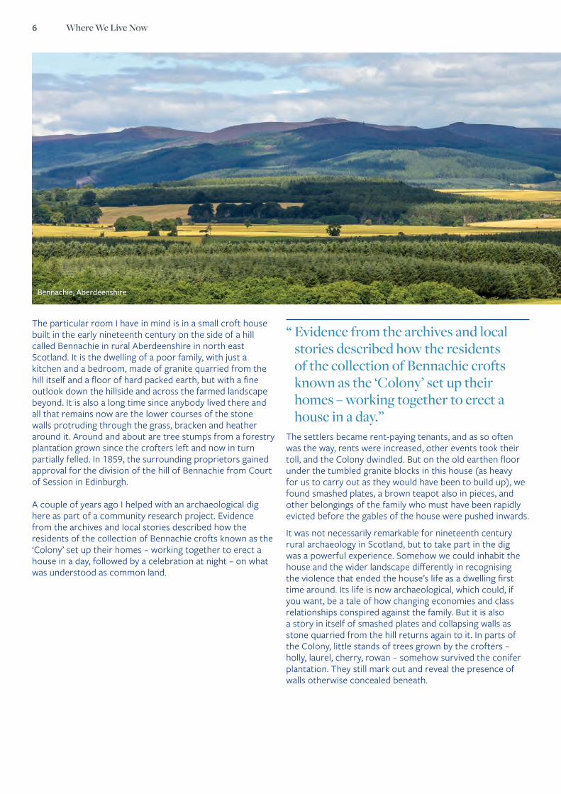
The particular room I have in mind is in a small croft house built in the early nineteenth century on the side of a hill called Bennachie in rural Aberdeenshire in north east Scotland. It is the dwelling of a poor family, with just a kitchen and a bedroom, made of granite quarried from the hill itself and a floor of hard packed earth, but with a fine outlook down the hillside and across the farmed landscape beyond. It is also a long time since anybody lived there and all that remains now are the lower courses of the stone walls protruding through the grass, bracken and heather around it. Around and about are tree stumps from a forestry plantation grown since the crofters left and now in turn partially felled. In 1859, the surrounding proprietors gained approval for the division of the hill of Bennachie from Court of Session in Edinburgh.
A couple of years ago I helped with an archaeological dig here as part of a community research project. Evidence from the archives and local stories described how the residents of the collection of Bennachie crofts known as the ‘Colony’ set up their homes – working together to erect a house in a day, followed by a celebration at night – on what was understood as common land.
“ Evidence from the archives and local stories described how the residents of the collection of Bennachie crofts known as the ‘Colony’ set up their homes – working together to erect a house in a day.”
The settlers became rent-paying tenants, and as so often was the way, rents were increased, other events took their toll, and the Colony dwindled. But on the old earthen floor under the tumbled granite blocks in this house (as heavy for us to carry out as they would have been to build up), we found smashed plates, a brown teapot also in pieces, and other belongings of the family who must have been rapidly evicted before the gables of the house were pushed inwards.
It was not necessarily remarkable for nineteenth century rural archaeology in Scotland, but to take part in the dig was a powerful experience. Somehow we could inhabit the house and the wider landscape differently in recognising the violence that ended the house’s life as a dwelling first time around. Its life is now archaeological, which could, if you want, be a tale of how changing economies and class relationships conspired against the family. But it is also a story in itself of smashed plates and collapsing walls as stone quarried from the hill returns again to it. In parts of the Colony, little stands of trees grown by the crofters – holly, laurel, cherry, rowan – somehow survived the conifer plantation. They still mark out and reveal the presence of walls otherwise concealed beneath.
Bennachie, Aberdeenshire

What is place? The sense and feel of place 7
“ It is, in short, about feeling that you live somewhere, and maybe that is something that all of us should have – even if the ‘somewhere’ might be a journey or a route as much as a fixed location.”
This is a small and partial story from a corner of Scotland distant from the current centres of political power. Not many of us, either, can make such a connection between the landscape where we live and the materials of our homes, imaginative or otherwise. At Bennachie however we have an open-ended community research project that draws people in to the history of the hill and the make-up of the landscape. I learn above all that the very act of finding out about a place leads to imaginative connections, possibilities for the future, and a new sense of place, even when discovering a difficult history.
Community heritage research often has this dynamic, and it is a field undergoing a resurgence in the UK thanks in part to dedicated Heritage Lottery Fund and Arts and Humanities Research Council funding (e.g. the Connected Communities1 programme). Researching place brings alive and enriches ideas of the past and future as well as the present. This kind of work does not need to be the preserve of ‘expert’ academics, and indeed is usually better when led by or in partnership with communities. It is, in short, about feeling that you live somewhere, and maybe that is something that all of us should have – even if the ‘somewhere’ might be a journey or a route as much as a fixed location. Place, as my colleague Tim Ingold describes, is a collection of lines and paths knotted together, more than a boundary between inside and out. It just takes research on some level to work it out.
1 https://connected-communities.org/
In social science, we often take recourse to the broad structural determinants of politics and economics that are seen as the ‘causes’ of a chain of effects in an analysis of place. But we also need to recognise other ways of understanding, or even feeling, and in particular those that derive from the experience of people themselves. This is important not just for the accuracy of academic accounts, but also for recognising the diversity of how people perceive place and shape their intentions towards it. The kinds of evidence we have for this are not just those collated through large-scale social science surveys, as useful as they may be. We also must pay attention to the personal and the cultural aspects of places that actually provide the firmament for all life. Being open to such a perspective and remembering the significance of the personal place is a possibility for everyone.

8 Where We Live Now
A poem by Alec Finlay Lat.58.972 Long.-3.354
Billia Croo
2 Alec Finlay, excerpt from ‘Billia Croo’. In Alec Finlay, Laura Watts, and Alistair Peebles, ebban an’ flowan (Edinburgh: Morningstar Publications, 2015) 30-32. Reprinted with permission of the author.
[IV]
along the bay there’s the promise of a new world
from each new device connected to the cable that runs
out under the wild rocks, into the diamond space
inside those three buoys – this is where the metal
gets salt-wet : and that’s the only true test – the problem
is elastic : what kind of roots will grip fast with moorings
subject to ebb, flood, flux, in a surge of such force?
[V]
what’s solid was once liquid as with rock and sand
which nature divided – like us – these waves were
tugged and formed, in slowness, slowness that
we’ve lost, for there’s no way to relearn the tide’s
happy knack of infinitesimal growth, except by sloshing
around, or waiting, stranded, on the heave of the moon2
What is place? The sense and feel of place 9
In the liminal space of Billia Croo, where water meets land via red sandstone cliffs and a pebble-beach, we are neither fully landed, or at sea; in terms of achieving a static sense of place, as the nature of the bay changes with the tides and the seasons, we are, therefore, literally and conceptually stranded, and can read how Finlay makes use of this landscaping pun at the end of section V.
This sense of stranded inbetweeness, or liminality, is extended in the second couplet of section V, where the simile turns us away from the impersonal landscape into the realm of anthropocentric observation for a moment; ‘like us’ is as divided as the previous line, its clausal allegiance unclear - split between ‘rock and sand’ and ‘these waves’. Split between ‘rock and sand’ and ‘these waves’, the human element of the poem is placed at the observation point either of the quarry site (past) or the wave-energy testing site (present); divided also, like most communities now, between the knowledge that more environmentally friendly energy production is a global necessity, and the sense that they don’t want its visible presence in their back yard.
Part of the aesthetic impulse of Finlay’s project was to combine into our appreciation of the landscape these renewable energies (in this case, the ‘three buoys’ of the bright orange Pelarmis tidal energy device), creating a revisionary sense of a powerful ‘new world’, where power itself, and the acknowledgement of its appearance (man-made energy harnessing devices, or ‘the heave of the moon’) is as much a part of our fascination with landscape as its sources. In this poem, we see how it is possible for the global ‘we’ (or ‘us’ of part V) is able to acknowledge our essentially liminal, co-dependent, relationship on both the natural world and our man-made devices through an appreciation of the changing nature of the places we walk past, and in which we live.
Commentary by Dr Heather H. Yeung, Assistant Professor in English Literature, Bilkent University, Ankara
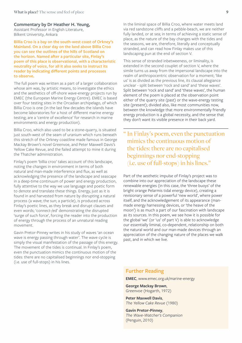
Billia Croo is a bay on the south-west coast of Orkney’s Mainland. On a clear day on the land above Billia Croo you can see the outlines of the hills of Scotland on the horizon. Named after a particular site, Finlay’s poem of this place is observational, with a characteristic neutrality of voice, for all it also seeks to instruct its reader by indicating different points and processes to observe.The full poem was written as a part of a larger collaboration whose aim was, by artistic means, to investigate the ethics and the aesthetics of off-shore wave-energy projects run by EMEC (the European Marine Energy Centre). EMEC is based over four testing sites in the Orcadian archipelago, of which Billia Croo is one (in the last few decades the islands have become laboratories for a host of different marine energy testing; are a ‘centre of excellence’ for research in marine environments and energy production).
Billia Croo, which also used to be a stone-quarry, is situated just south-west of the seam of uranium which runs beneath this stretch of the Orkney coastline made famous in George Mackay Brown’s novel Greenvoe, and Peter Maxwell Davis’s Yellow Cake Revue, and the failed attempt to mine it during the Thatcher administration.
Finlay’s poem ‘billia croo’ takes account of this landscape, noting the changes in environment in terms of both natural and man-made interference and flux, as well as acknowledging the presence of the landscape and seascape in a deep-time continuum of power and energy production, fully attentive to the way we use language and poetic form to denote and translate these things. Energy, just as it is found in and harvested from nature by disrupting a natural process (a wave; the sun; a particle), is produced across Finlay’s poetic lines, as they break and disrupt clauses and even words; ‘connect-/ed’ demonstrating the disrupted ‘surge of such force’, forcing the reader into the production of energy through the process of an unnatural reading movement.
Gavin Pretor-Pinney writes in his study of waves ‘an ocean wave is energy passing through water’. The wave cycle is simply the visual manifestation of the passage of this energy. The movement of the tides is continual. In Finlay’s poem, even the punctuation mimics the continuous motion of the tides: there are no capitalised beginnings nor end-stopping (i.e. use of full-stops) in his lines.
Further ReadingEMEC, www.emec.org.uk/marine-energy
George Mackay Brown, Greenvoe (Hogarth, 1972)
Peter Maxwell Davis, The Yellow Cake Revue (1980)
Gavin Pretor-Pinney, The Wave-Watcher's Companion (Penguin, 2010)
“ In Finlay’s poem, even the punctuation mimics the continuous motion of the tides: there are no capitalised beginnings nor end-stopping (i.e. use of full-stops) in his lines.”
10 Where We Live Now
Professor Ian Christie FBA, Anniversary Professor of Film and Media History, Birkbeck College, University of London
Homing Instincts and the mediation of screen space
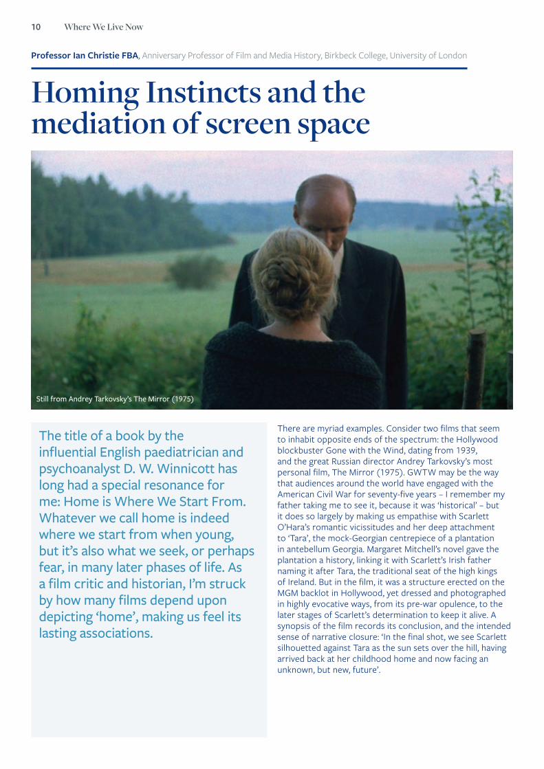
There are myriad examples. Consider two films that seem to inhabit opposite ends of the spectrum: the Hollywood blockbuster Gone with the Wind, dating from 1939, and the great Russian director Andrey Tarkovsky’s most personal film, The Mirror (1975). GWTW may be the way that audiences around the world have engaged with the American Civil War for seventy-five years – I remember my father taking me to see it, because it was ‘historical’ – but it does so largely by making us empathise with Scarlett O’Hara’s romantic vicissitudes and her deep attachment to ‘Tara’, the mock-Georgian centrepiece of a plantation in antebellum Georgia. Margaret Mitchell’s novel gave the plantation a history, linking it with Scarlett’s Irish father naming it after Tara, the traditional seat of the high kings of Ireland. But in the film, it was a structure erected on the MGM backlot in Hollywood, yet dressed and photographed in highly evocative ways, from its pre-war opulence, to the later stages of Scarlett’s determination to keep it alive. A synopsis of the film records its conclusion, and the intended sense of narrative closure: ‘In the final shot, we see Scarlett silhouetted against Tara as the sun sets over the hill, having arrived back at her childhood home and now facing an unknown, but new, future’.
The title of a book by the influential English paediatrician and psychoanalyst D. W. Winnicott has long had a special resonance for me: Home is Where We Start From. Whatever we call home is indeed where we start from when young, but it’s also what we seek, or perhaps fear, in many later phases of life. As a film critic and historian, I’m struck by how many films depend upon depicting ‘home’, making us feel its lasting associations.
Still from Andrey Tarkovsky’s The Mirror (1975)

What is place? The sense and feel of place 11
Tarkovsky’s film3, made during the Brezhnev era of Soviet ‘stagnation’, drew on his own family history, which saw his poet father leave the family when he was a child during the era of Stalin’s terror, and his mother move to Moscow, where she worked as a proof-reader. But the chronology of the film is deliberately confused, so that we are hardly aware of when any scene is set. What makes it one of the most powerful and evocative ever made is the sense of a mother and her son searching for security, for home. With its dream-images of a house on fire, of a soldier’s return from war, and of a desperate panic over a misprint during the Stalin era that could have lethal consequences, it evokes a lasting sense of unease. We might recall the term that Freud used for things that frighten us, which is normally translated in English as ‘uncanny’.4 The original sense of the German Unheimliche was ‘unhomely’, although it has come to mean more generally ‘eerie’, ‘scary’ or ‘sinister’. Yet The Mirror’s characters are shown as displaced, literally ‘unhomed’, and much of the film’s power stems from how we share their desire for home without any certainty or entitlement.
Or take another contrast, which I’ve written about recently. What possible connection is there between a Hollywood Western, such as John Ford’s My Darling Clementine or his later The Searchers, and an amateur film made in the part of London where I live? The link, I suggest, lies in our sense of the ‘local’. Even a Hollywood film can create a strong sense of locality, at least for the duration that we are immersed in it. In My Darling Clementine, we spend 90 mins in the historic Tombstone, where Wyatt Earp will reluctantly take on the Clanton family, in the famous ‘gunfight at the OK corral’, and so bring a sense of order to this frontier outpost. No matter that Ford built his version of Tombstone hundreds of miles away from the real town, largely in order to provide it with the backdrop of mesas in Monument Valley that he felt deeply attached to. This may not be an authentic or ‘realistic’ Tombstone, but it’s one we feel temporarily at home in, and could probably even find our bearings in, at least for the duration of the film.
In the case of a truly local film, like many of those we have collected in the London Screen Study Collection at Birkbeck College, what appears on screen may be already familiar to many viewers from their daily life5. A film made in North London around 1960, Beauty in the Borough, shows many parts of the then borough of Hornsey, emphasising how it has been enhanced by copious amounts of flower-planting. Showing this to a local audience, as I have done in Crouch End, encourages viewers to create their own relationships
with the screen images, noting what has changed and what hasn’t. They may be moved to think about ‘history’ on a purely personal and proximate basis, or to reflect on the course of their own lives, in terms of where they live and have lived, and perhaps aspire to live. Seeing our own home and its immediate surroundings on screen is obviously a very special case in the wider spectrum of our relationship to the representations of ‘home’.
In the case of Ford’s later, much darker vision of the historic West, The Searchers (1956)6, the theme of home explicitly frames the film. The opening image shows a family of homesteaders greeting their relative Ethan, a Civil War veteran, as he rides in from the same barren landscape that had housed Ford’s ‘Tombstone’ ten years earlier. After the family is savagely destroyed and its daughter abducted by raiding Comanche Indians, Ethan sets off on an epic search, which seems motivated as much by his demons as by family loyalty. When he eventually finds Debbie, now a grown woman living as the captive of the Comanche chief, both he and we are uncertain whether he may kill her out of disgust.
Instead, he says ‘let’s go home Debbie’. But when he returns her to a surrogate family, he cannot bear to enter the house, and returns to the wilderness, still permanently ‘unhomed’. The dark frame of the doorway that silhouettes Wayne at the beginning and end of the films seems to signify an emotional threshold between the settled and the vagrant, home and the wilderness.
3 Andrey Tarkovsky, The Mirror (1975)4 Freud’s 1919 paper ‘’Das Unheimliche’ was first translated into English in 1925. In the Collected Papers vol 4, and has since become a familiar reference-point for those seeking
to explain the deep-seated attraction of scary and grotesque stories.5 For details of the London Screen Study Collection, part of Film London’s London’s Screen Archives network, see http://londonscreenstudy.com 6 John Wayne as Ethan Edwards in The Searchers (1956)
Still from John Ford’s The Searchers (1956)
“ Seeing our own home and its immediate surroundings on screen is obviously a very special case in the wider spectrum of our relationship to the representations of ‘home’.”
“ Even a Hollywood film can create a strong sense of locality, at least for the duration that we are immersed in it.”
12 Where We Live Now
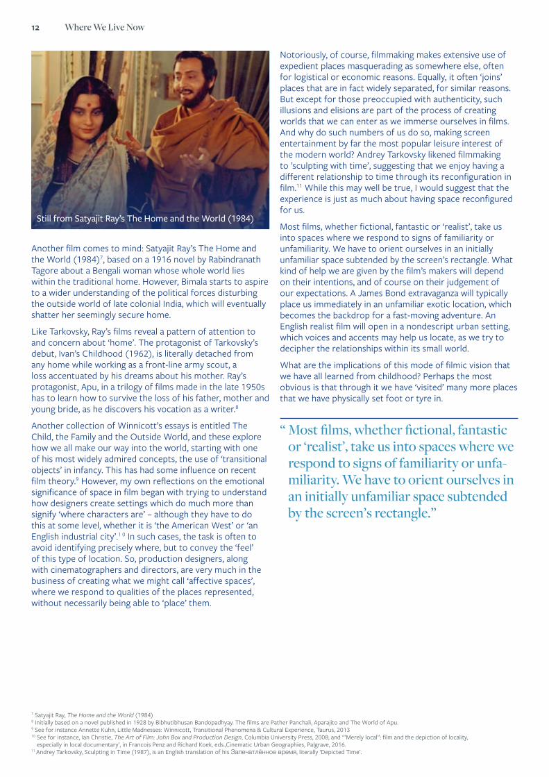
Another film comes to mind: Satyajit Ray’s The Home and the World (1984)7, based on a 1916 novel by Rabindranath Tagore about a Bengali woman whose whole world lies within the traditional home. However, Bimala starts to aspire to a wider understanding of the political forces disturbing the outside world of late colonial India, which will eventually shatter her seemingly secure home.
Like Tarkovsky, Ray’s films reveal a pattern of attention to and concern about ‘home’. The protagonist of Tarkovsky’s debut, Ivan’s Childhood (1962), is literally detached from any home while working as a front-line army scout, a loss accentuated by his dreams about his mother. Ray’s protagonist, Apu, in a trilogy of films made in the late 1950s has to learn how to survive the loss of his father, mother and young bride, as he discovers his vocation as a writer.8
Another collection of Winnicott’s essays is entitled The Child, the Family and the Outside World, and these explore how we all make our way into the world, starting with one of his most widely admired concepts, the use of ‘transitional objects’ in infancy. This has had some influence on recent film theory.9 However, my own reflections on the emotional significance of space in film began with trying to understand how designers create settings which do much more than signify ‘where characters are’ – although they have to do this at some level, whether it is ‘the American West’ or ‘an English industrial city’.1 0 In such cases, the task is often to avoid identifying precisely where, but to convey the ‘feel’ of this type of location. So, production designers, along with cinematographers and directors, are very much in the business of creating what we might call ‘affective spaces’, where we respond to qualities of the places represented, without necessarily being able to ‘place’ them.
Notoriously, of course, filmmaking makes extensive use of expedient places masquerading as somewhere else, often for logistical or economic reasons. Equally, it often ‘joins’ places that are in fact widely separated, for similar reasons. But except for those preoccupied with authenticity, such illusions and elisions are part of the process of creating worlds that we can enter as we immerse ourselves in films. And why do such numbers of us do so, making screen entertainment by far the most popular leisure interest of the modern world? Andrey Tarkovsky likened filmmaking to ’sculpting with time’, suggesting that we enjoy having a different relationship to time through its reconfiguration in film.11 While this may well be true, I would suggest that the experience is just as much about having space reconfigured for us.
Most films, whether fictional, fantastic or ‘realist’, take us into spaces where we respond to signs of familiarity or unfamiliarity. We have to orient ourselves in an initially unfamiliar space subtended by the screen’s rectangle. What kind of help we are given by the film’s makers will depend on their intentions, and of course on their judgement of our expectations. A James Bond extravaganza will typically place us immediately in an unfamiliar exotic location, which becomes the backdrop for a fast-moving adventure. An English realist film will open in a nondescript urban setting, which voices and accents may help us locate, as we try to decipher the relationships within its small world.
What are the implications of this mode of filmic vision that we have all learned from childhood? Perhaps the most obvious is that through it we have ‘visited’ many more places that we have physically set foot or tyre in.
7 Satyajit Ray, The Home and the World (1984)8 Initially based on a novel published in 1928 by Bibhutibhusan Bandopadhyay. The films are Pather Panchali, Aparajito and The World of Apu.9 See for instance Annette Kuhn, Little Madnesses: Winnicott, Transitional Phenomena & Cultural Experience, Taurus, 201310 See for instance, Ian Christie, The Art of Film: John Box and Production Design, Columbia University Press, 2008; and ‘”Merely local”: film and the depiction of locality,
especially in local documentary’, in Francois Penz and Richard Koek, eds.,Cinematic Urban Geographies, Palgrave, 2016.11 Andrey Tarkovsky, Sculpting in Time (1987), is an English translation of his Запечатлённое время, literally ‘Depicted Time’.
“ Most films, whether fictional, fantastic or ‘realist’, take us into spaces where we respond to signs of familiarity or unfa-miliarity. We have to orient ourselves in an initially unfamiliar space subtended by the screen’s rectangle.”
Still from Satyajit Ray’s The Home and the World (1984)

What is place? The sense and feel of place 13
12 Ian Sansom, review of Bayard, How to Talk About Places You’ve Never Been, trans. Michele Hutchison, Bloomsbury, 2016, Times Literary Supplement, 17.6. 2016. 13 Roger Odin, ‘Visiting and City, Watching a Film’, trans. Ian Christie, in Marcel Arbeit and Ian Christie, eds, Where is History Today? New Ways of Representing the Past, Olomouc:
Palacky University Press, 2016, p. 75. http://www.reprezentaceminulosti.cz/public/filemanager/Where-is-history-today-_-web.pdf14 Richard Taylor & Ian Christie, eds, The Film Factory: Russian and Society Cinema in Documents 1896-1939, Routledge, 199415 ‘East Coker’, one of the Four Quartets, 1940.
Indeed the selective and codified nature of filmic representation may give us a more intense sense of place than actually visiting. This extends the conceit of Pierre Bayard’s recently-translated book How to Talk About Places You’ve Never Been, described by a TLS reviewer as ‘lit crit à la mode: quirky, ironic… world lit, but not as you know it’.12 Bayard argues that it is often writers who stayed at home that have made places ‘more present than those described by writers who considered travelling to them essential’. If we apply this to the experience of film, then Ford’s transposed Tombstone, or the MGM backlot where Tara was built, have indeed rendered these places vividly ‘present’ for generations of viewers – and almost certainly disappointed location tourists in search of ‘the real place’.
“ The world of a French street that unexpectedly came to life before his eyes seemed to Gorky like ‘the shadow of life’ mainly because it was monochrome and soundless.”
After more than a century of filmic experience, now multiplied through the many devices that allow us to film our own experiences and anthologise those of others, we may have arrived at the situation where what I am calling filmic vision has actually gained the upper hand. Another French theorist, Roger Odin, has compared ‘the act of visiting a city and that of seeing a film’.13 Noting that much tourism is managed on screen, through orientation advice and guides, he suggests that ‘to visit a city, or see a film, is to enter a world or more accurately “to produce” a world, a “diegesis” as the film theorist would say’. Technically speaking, both viewer and visitor ‘function as enunciators who build a world from the signs provided’.
Strangely enough, this was how one of the very first writers to describe the experience of seeing a film put it. The Russian Maxim Gorky wrote of having visited ‘the kingdom of the shadows’, after seeing the earliest Lumière films at the Nizhny Novgorod annual fair in July 1896.14 The world of a French street that unexpectedly came to life before his eyes seemed to Gorky like ‘the shadow of life’ mainly because it was monochrome and soundless. But today, we are accustomed to scenes that are in fact more vividly life-like than much of our unmediated experience.
For the managers of many tourist destinations, the problem is indeed how to live up to expectations formed onscreen. And for those involved in creating new spaces and structures, planners and architects, the technology of ‘walk-through’ simulation has become indispensable.
This is hardly a process that can realistically be halted or reversed. Nor has it been accompanied by any decline in ‘bodily’ tourism. Rather, the two kinds of experience feed off and stimulate each other. Like Bayard, we can ‘draw upon the consequences of the permeability of the boundaries of the space of the work and real space’.
And I would add to this the hope that realising how so much of our experience is mediated may direct more attention to understanding how filmic space works for us, and may even prove profoundly therapeutic. Winnicott’s title was adapted from T S Eliot’s lines Home is where one starts from.
As we grow older The world becomes stranger, the pattern more complicated. Filmic space and vision are undoubtedly important ways through which we learn to understand and navigate the world. As adults, we cannot return to the home we started from, but we can recognise versions of this created in the affective space of the screen, as Tarkovsky, Ray and countless other filmmakers, anonymous as well as great, have done.

14 Where We Live Now
Professor Ruth Finnegan FBA, Emeritus Professor of Sociology, Open University
How to capture – and create – place and ‘placeness’?
How has that happened? In the face, too, of social scientists’ disparaging tales of the artificiality, alienation and dystopia of urban life? What features of place - of town, of country - did the idealistic policy-makers and planners take account of to be so apparently successful? Well some parts are better than others and so on; but myself I like the roundabouts and the robust irony of the concrete cows. Were they practical as well as utopian and can we gain greater insight not just from their policies - Milton Keynes is just one place after all - but from a wider consideration of what makes up a 'place'? Beyond that, of our human experience and conceptualisation of ‘placeness’?
For this we need to go wider than the specialities of urban planning, under whatever name, to poetry, music, personal memories, feelings, and more. This indeed fits with the anthropologist’s approach: the conviction that the meaning of a place – or building or settlement – is how people feel about it, experience it, define, indeed create, it for themselves (see for example Feld 2012, Hirsch 1995, Low 2003, Tilley and Kapferer 1994). To investigate that – a perfectly proper thing to do (happily, in the light of the classic work of Turner and Bruner (1986), ‘experience’ is no longer a forbidden or at best marginal concept, as it once was, in social science) – we must explore people’s thinking and emotions, not just the dry ‘facts’. And when we say ‘people’ we can, maybe must, include ourselves too. What nearer first-hand source can we have?
I live in Milton Keynes, that once 'new' city. Supposedly 'a concrete jungle' and 'cultural desert', it is now increasingly celebrated - and studied (e.g. Finnegan 1989/2007, 1998) as the home of musicians and courageous story-bearers, of artists and enterprise, lakes and river walkways, and children growing up amidst playgrounds, churches and green surrounds.
Concrete cows, Milton Keynes

What is place? The sense and feel of place 15
Let me, anthropology-wise, build on a series of examples to illustrate place - so much easier to capture and learn from than abstractions. They are largely based on my own experience. Some are in the frame of fiction - but as true, perhaps truer, than ‘reality’ – some are imagined, some sonic, some pictorial. Some will no doubt seem surprising, but ultimately, I hope, will be illuminating for capturing the full flavour and sound of a place.
A small girl experiences the place-ness of 1940s Donegal16
She was just an ordinary girl in a magical world.It was just to sit silent on the shore, scooping coarse sand grains in her hands, falling them through her fingers, grain by grain, counted, countless. Or feeling the clouds and the moon, numbering the stars …
Walking to school was a marvel, going home too. The bogs and man-insect-catching (would she ever?) butterwort, marsh grass, heart’s ease, hawkweed, myrtle, asphodel. And the wondrous thistles and the gorse, the ever-flowering hill gorse. And everywhere everywhere the heather, God’s heaven-gift.
Then leaps down the hills and over the turf cuttings and the bogs, more bogs, shoe stuck in mud, carried home, kind ‘uncle’ arms, son from the carpenter’s workshop three fields away – ‘uncle,’ no her first adult Admirer, little did she know: (but her childhood friend of her heart, brother-seeming, ever there). Barefoot was better like her companions, no stuck-in-mud, stumble over ruts sandals pierced through by the bumpy-path-thorns. ‘Ragged urchins’ her mother called them – huh, better dressed than her with tweeds, generation-handed, ‘gainst winter hail, quick-dry hair on heads.
Past the bull, fierce, fearsome, bolt in his rickety shed, no not bolted, don’t you see him staring at the splintered door, locks just just just about, just, to burst (how they laughed and shouted and rapped to stir the beast and told her of the bull that had gored the man beyond the headland to death. ‘‘Cos he’d been teasing it’ said her ma, ‘never you fear...’ but she did). And even if she passed the geese (golden? no! not for her, she knew already that mythic end wasn’t her life), geese, most aggressive of beasts, rushing her with wings, great wings, spread wide, pecking at legs under her knee-high skirt, threatening higher (that was why she always – thoughts flickered away...).
So all her life she was afraid of that, of geese, an’ all that.
And then treading across the final, named, most fertile field, the place where mythic Diarmaid slept with his love Grainne, home of the sea-gulled plough, the waving oats, sky-root flax most azure of flowers, and seeing the wisping corkscrew smoke of blazing fire. Miracle orchids, hazels, birch and old old oaks, centuries, unimaginable time to a seven-year-old and tracing the secret fairies’ path under the spring’s thickets to find the violets and soft primrose and sweet sweet sorrel flowers in the ivoried glade, image of heaven. The gentle place, the wood of fairie Tir-nan-g, the ever-youth. And her mother’s ever smile...
The music and poetics of placePlace, and certainly town planning, may seem to have little, if anything, to do with music. But consider for a moment how many musical works are known by the names of places, large and small: The London symphonies (many of them), equally the Prague, Cotswold and Scottish symphonies; the Hebrides Overture; the symphony ‘From the New World’ – not, as often thought, primarily about America but also the expression of Dvořák’s homesickness for his native land. My view of Liverpool will be forever connected to its concert hall and the ‘Liverpool Phil’; and what music-lover can divorce Manchester from its Hallé orchestra and Mendelssohn and JC Bach, Birmingham from the BSO (the City of Birmingham Symphony Orchestra), Berlin from its Philharmonic, or Venezuela from Dudamel’s great Simon Bolivar Orchestra, and so on through the countries of today’s world.
Little though we may consciously remember such descriptions, nevertheless there is a sense in which for many people, if only from school encounters, these associations play their part in the felt definition of particular places. There are Ralph Vaughan Williams’ folk tune creations too – the very mark of Englishness – and his ‘Sea symphony’ that, like Delius’ work, create the ocean for us; the ‘London Bach’; the ‘Liverpool sound’; or the associations of Leipzig and Vienna. Is our consciousness of these places not immediately coloured with our experience of the music of JC Bach, then of Mozart and Strauss? Then too there are the compositions that deliberately set out to frame and celebrate a place for us: ‘Rule Britannia’, ‘Land of Hope and Glory’, ‘Long way to Tipperary’, Aaron Copland’s works on America, Sibelius’ ‘Finlandia’: all impact on our consciousness of national identity.
There is the direct effect too of the countless national anthems of the world, in this case not just heard but actively sung in joint performance, probably the most deeply uniting of modes or, nearly a national song, Blake and Parry’s ‘And did those feet in ancient time / Walk upon England’s mountains green’. Think too of folksong collectors and arrangers. Where would English feelings of national identity be without Vaughan Williams, Edward Elgar or Percy Grainger who helped to create our land; or America without John Lomax or Francis Child, and similar collectors in just about every country of the world?
16 Extracted by permission from Chapter 2 of Ruth Finnegan’s Black Inked Pearl, Garn Press New York (2015).
“ Then too there are the compositions that deliberately set out to frame and celebrate a place for us: ‘Rule Britannia’, ‘Land of Hope and Glory’, ‘Long way to Tipperary’, Aaron Copland’s works on America, Sibelius’ ‘Finlandia’: all impact on our consciousness of national identity.”
16 Where We Live Now
Consider also the contribution of poetry to this sense of identity and place. Remember Wordsworth and Coleridge on the Lakes – how could we see them differently after that? – or Browning’s ‘Oh to be in England now that April’s here!’, Gaunt’s ‘This England’, or Brooke’s iconic
If I should die, think only this of me:
That there’s some corner of a foreign field
That is for ever England.
Yeats too for Ireland, the land where I grew up and learned through his words. When I think of my first home, how can I not feel and hear his language and poetry? And the folk songs too, grief of Irish exiles recalling their dear land, the land to which, the more attached for this reason, they never plan to return to.
All this may seem marginal, but it plays a very real part in our experience. Nor is it just a thing of the past. ‘Place poetry’ is now a recognised genre with an accepted role in Britain’s GCSE literature syllabus; and the ‘local poet’ from Sussex’s Lewes, Patrick Bond17, not only composes locally-inspired poems but leads popular expeditions to drink in the atmosphere of the places he poetically celebrates. It can be found, knowingly or not, in literature – in radio, in poems on the underground, in novels and histories and plays (the Merry Wives of Windsor; Kenilworth;
Harrison Ainsworth’s The Tower of London), in the Faber Book of Landscape Poetry, or in the evocation of places in recent novels like Rosie’s Umbrella, my own Black Inked Pearl or, so wonderfully evocative of the place-ness of Jamaica and the streets and dwellings of post-war east London, Andrea Levy’s Small Island. There is the power, too, of memoirs like my mother’s account of growing up in Ulster, and so many others; even more of myths enshrined in the land of Aboriginal peoples in Australia or Celts in Ireland; in the advertisements columns – so different yet purporting to the same end, of popular newspapers. These work to shape people’s sensibilities and meanings. For many this may be not be a fully conscious process. But it is there – a strand in our constructions of place.
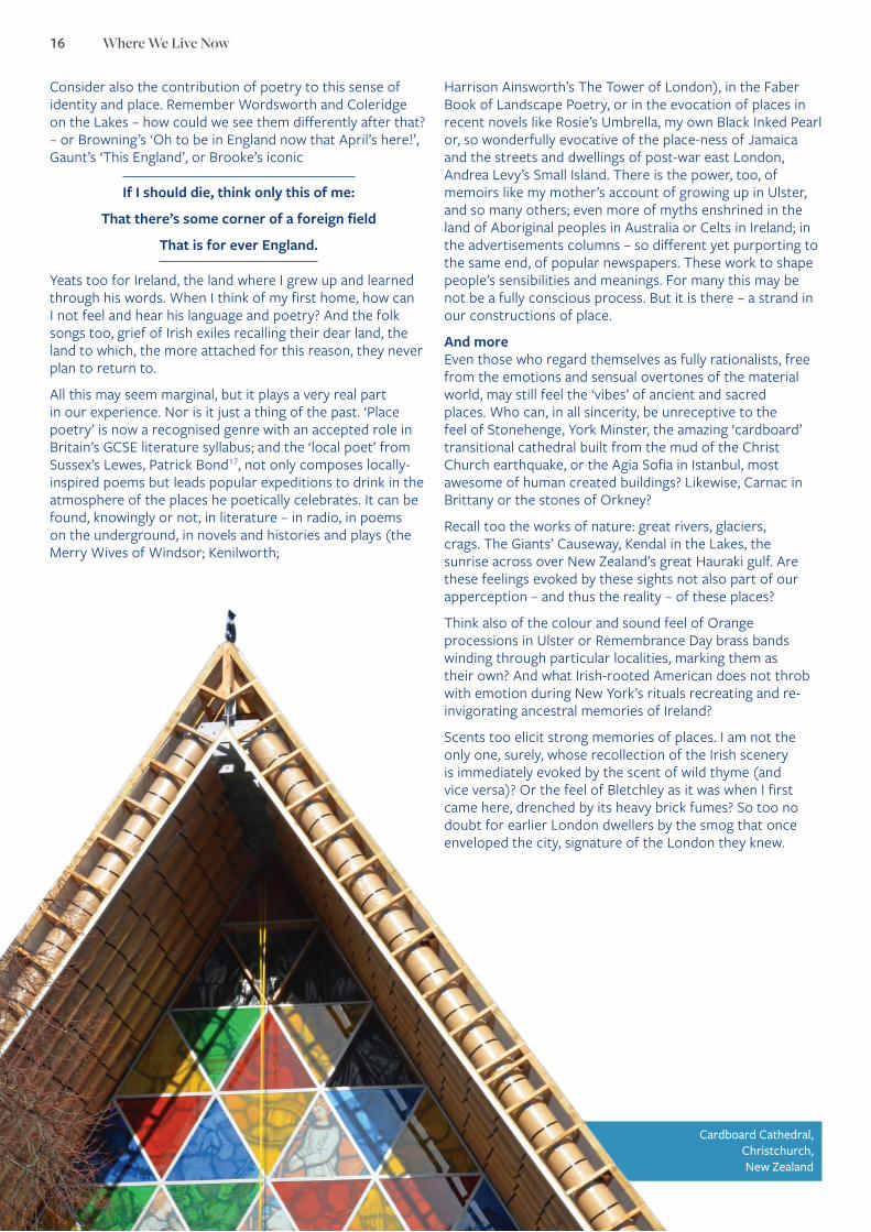
And more Even those who regard themselves as fully rationalists, free from the emotions and sensual overtones of the material world, may still feel the ‘vibes’ of ancient and sacred places. Who can, in all sincerity, be unreceptive to the feel of Stonehenge, York Minster, the amazing ‘cardboard’ transitional cathedral built from the mud of the Christ Church earthquake, or the Agia Sofia in Istanbul, most awesome of human created buildings? Likewise, Carnac in Brittany or the stones of Orkney?
Recall too the works of nature: great rivers, glaciers, crags. The Giants’ Causeway, Kendal in the Lakes, the sunrise across over New Zealand’s great Hauraki gulf. Are these feelings evoked by these sights not also part of our apperception – and thus the reality – of these places?
Think also of the colour and sound feel of Orange processions in Ulster or Remembrance Day brass bands winding through particular localities, marking them as their own? And what Irish-rooted American does not throb with emotion during New York’s rituals recreating and re-invigorating ancestral memories of Ireland?
Scents too elicit strong memories of places. I am not the only one, surely, whose recollection of the Irish scenery is immediately evoked by the scent of wild thyme (and vice versa)? Or the feel of Bletchley as it was when I first came here, drenched by its heavy brick fumes? So too no doubt for earlier London dwellers by the smog that once enveloped the city, signature of the London they knew.
Cardboard Cathedral, Christchurch, New Zealand
17 See pages 45 and 82.

What is place? The sense and feel of place 17
And of course, pictorial image plays its part too. Landscapes and seascapes run through our interpretations and memories; Ely cathedral has its existence in our minds in part through its frequent representation in images, films, and book covers, while Andrew Murray’s London, first, with its colour and humour helps us grasp the meaning of that great city and its inhabitants.
In this modern world, what is ‘place’?Even in this technologically advanced and rapid era, people’s conceptualisations of place and of one specific location, if mostly unquestioned, still runs deep. We recognise and celebrate the notions and experience of one’s own place; one’s birthplace; where I belong; my father’s, grandfather’s place; where my parents are buried; where I or my forebears came from (think of the effort that Americans – not the only ones – make to visit their place of origin). How important these are in self-identity whether for immigrants or long-time dwellers in one place.
It is notable that heaven, Eden, hell and so on, under whatever name, are so often (universally perhaps) conceptualised as physical places. In literature, they are visited only after a physical journey by epic heroes. This comes in much theological writing, too. This is odd when religious gurus from all over see them rather as spiritual states (not places) or as alternate dimensions of existence – yet the notion of place still forces its way through.
Specific items of culture too are sometimes thought of as originating from a physical location, though the specific place can change. In the Fiji of the 1930s, for example, music essentially ‘came from’, was located in, ‘belonged to’ faraway Britain. Now it belongs to the land of Fiji, located there as well as emanating from there to the new Fiji-Indian diaspora in Australia (Finnegan 2016). In the 19th century music came from and belonged to Germany (England was Das Land ohne Musik) but no longer; it has travelled the world.
How is a country conceptualised? As a place? New Zealand is seen by native born and immigrants alike in terms of place, or at least of land or landscape – the island fished up from the sea by Maui in ancient times. Even those who dismiss the myth can be unconsciously swayed by it – Aotearoa, ‘land of the long white cloud’: the name itself carries its vibes. As a native of Northern Ireland, I think of ‘Ulster’ mainly as a place, one characterised by its distinctive language and culture. Obviously, there are exceptions and complexities (the idea of ‘place’ is not the only thing: witness the emphasis for many on ‘the British way of life’), but the idea of place, ‘our’ location, certainly has a central place in our sensibilities.
My impressions, of course are exploratory only. But if there is anything in them they are indeed relevant for policy – for building, town planning, immigration, education. So, I would argue for a full understanding, we need also to take full account of our own feelings – the ‘vibes’ and dreams and memories of particular places that we know – and become sensitive to the sense-imbued ‘air’ of places.
Taking serious account of one’s own experience – feelings too – has at last become an approved approach. It is true that one must still take care to avoid, tempting though it is, over-romanticising one’s own feelings or ignoring other sources whether relating to a particular locality or the comparative literature: these enable us to pick out the salient features and avoid misleading preconceptions. But for a full understanding of some locality or local feature, taking account of not just observation but personal feelings and emotions should come in too.
Far from being seen as an essentially low-level, lazy, self-indulgent or even narcissistic method, as it might have been in the past, this approach has actually become quite fashionable within certain social science circles. It has been made particularly popular by the concept and practice of so-called ‘reflexive anthropology’: taking seriously, and reporting on the researcher’s own experience (‘experience’ being a valid concept today), a logical extension of the long-established anthropological ‘participant observation’.
Let me end then with a very personal example.
The air of DerryLast summer I went back to Derry. So many memories thronged through all my senses, filling me with my feeling for the ancient and beautiful place founded by a gentle but warlike saint as the ‘oak grove’ (daire), river girt and surrounded by hills, the place where I was born and, in part, grew up.
Derry was founded by St Columba in the 6th century, long surrounded by a strong ring of (still-standing) stone walls, a thriving port for many years, and resettled from London in the seventeenth century (a kind of colonisation – so I understand something of that too from the inside). Derry was used as a naval base during the battle of the Atlantic in the Second World War, it was plagued by the infamous ‘troubles’ of internecine religions for the long post-war years, and is now relatively at peace.
“ I would argue for a full understanding, we need also to take full account of our own feelings – the ‘vibes’ and dreams and memories of particular places that we know – and become sensitive to the sense-imbued ‘air’ of places.”

18 Where We Live Now
All that, and much more, is true, and necessary to know. But I need to add more. For I and anyone who grew up there will above all remember the feel: the contrast between (what felt like) the bigotry and closemindedness of the Protestants as against the open-to-everything ‘irrationality’ of the Pope-worshipping Catholics and, worst, the need to decide between them. There was the knowledge of killings and blood in the streets; the hatred; the river cutting its cruel division, forever it seemed, through the heart of the settlement. But then – the miracle: a thousand-strong crowd outside the Guildhall, chief building of the city, as the British Prime Minister made his incredible apology for the Bloody Sunday murders and the resultant tears of grief and of forgiveness – who could forget that? The atmosphere of it?
And now – the ‘Peace Bridge’ unites people that the river once divided: the look, feel and experience of it, things that cold-print sources cannot capture. Now I can add to my memories, I remember the gentle taxi-driver in a Derry street, his cab adorned with the insignia of catholic religion and his adherence recognisable from his facial expressions and unconscious body language (anyone brought up in Derry wouldn’t need an instant to know): without making any big point of it he mentioned that he had ‘just popped into the nearby Presbyterian church before work to say a wee prayer’. I was bereft of words but – a Protestant and not my thing really –agreed to ‘say a wee prayer’ in return: a revolution of feeling as much as of hard ‘reality’ (though maybe those are not so different). All that is now Derry.
The images too have a tale to tell: the community-made murals that replace the old pictorial incitements to hatred and murder; the statue with hands reaching out across the divisions – divisions still there, rich too in themselves, but now accepted, no longer the font of attack. The nostalgia of the ‘Londonderry air’, common to all, still hangs – and beautifully – just as the old antagonistic songs are still sung, and one-side Orange bands play at times in the streets. But now they do it (mostly) without the hatred or the militaristic intent of the past. It is true that of course we still see the impulses that human nature is ever prone to – will they ever fade totally? But there is a shared pride in the historic city that has resumed its sense of community and reconciliation.
All that too is – must be – part of the existence of Derry. How could we appreciate its history without some awareness of these intangible qualities? How we see and feel a place is indeed one dimension of its nature. Could a historian or a
policy geek give a full account without some feel for all this?
Peace Bridge, DerryDerry City
‘Hands Across the Divide’ reconciliation statue in Derry,
by Maurice Harron (Credit: Tourism Ireland)
“ And now – the ‘Peace Bridge’ unites people that the river once divided: the look, feel and experience of it, things that cold-print sources cannot capture.”

What is place? The sense and feel of place 19
Derry Stone Walls
So…?
I live, as I say, in the new-old city of Milton Keynes. I love it here. Here, with its multi-coloured memories, in this, my place.
It is a city whose planners it seems, were indeed aware of the multi-sensory dimensions of place. We have the parks, lakes and rivers, unlike in some other cities not concreted over for new dwellings – though, true, it is indeed a constant battle in which the inhabitants’ pride in place must continually be in play. We have the great cathedral of trees; the Peace Pagoda; theatre and art gallery and small places for the local bands to practice; roundabouts and grid roads and grass verges; statues in the parks and city centre; small ‘villages’ nested with their timbered pubs and a scattering of thatch amidst the entrepreneurial city; books and exhibitions of maps and photographs and audio recordings from the past; a scent garden for the blind and not so blind; churches old and new – the city centre dome is an amazement topped by a cross visible from all angles – and playgrounds for the children;
ReferencesDavies, Charlotte A. (1998) Reflexive Ethnography: A Guide to Researching Selves and Others (ASA Research Methods in Social Anthropology), London: Routledge.Etherington, Kim (2004) Becoming a Reflexive Researcher – Using Our Selves in Research, London: Jessica Kingsley.Feld, Steven (2012) Sound and Sentiment, Durham NC: Duke University Press.Finnegan, Agnes (1992) Reaching for the Fruit: Growing up in Ulster, Milton Keynes: Callender Press.Finnegan, Ruth (1989/2007) The Hidden Musicians, Cambridge: Cambridge University Press / Middletown: Wesleyan University Press.Finnegan, Ruth (1998) Tales of the City, Cambridge: Cambridge University Press.Finnegan, Ruth (2015) Black Inked Pearl, New York: Garn Press.
Finnegan, Ruth (2017) (ed.) Entrancement. Consciousness in Dreaming, Music and the World; Cardiff: University of Wales Press (in press).Hirsch, Eric (ed.) (1995) The Anthropology of Landscape: Perspectives on Place and Space, Oxford: Oxford University Press.Levy, Andrea (2004) Small Island, Tinder Press.Low, Setha M. (ed.) (2003) The Anthropology of Space and Place: Locating Culture, Wiley-Blackwell.Pahl, Kate (2017) in Finnegan 2017 (in press).Taylor, Denny (2015) Rosie’s Umbrella, New York: Garn Press.Tilley, Christopher, and Kapferer, Bruce. (1994) A Phenomenology of Landscape: Places, Paths and Monuments, London: Berg.Turner, Victor and Bruner, Edward M. (1986) The Anthropology of Experience, Urbana: University of Illinois Press.
new houses and apartments that are warm and (sometimes) beautiful, building memories for their dwellers; and all this never far from a green or a river. True, there is the thunder of traffic or, like anywhere, traffic jams, only partly mitigated by the clever roundabouts, the hoot of horns amidst the clanking of migrating goose wings in the loom and fragrance of the sky. Then, by now its football songs (‘The Dons’…) and their stadium; and, forever, its miraculous gold-red tawny trees, millions of them – what foresight by the city builders – by the roads in the autumn.
All this, and in all its complexities, is Milton Keynes.
But not just Milton Keynes or new cities. A greater awareness of the richly multi-coloured notion of place leads in to a fuller, more informed, policy for the planning and appreciation of the full sense of ‘places’ new or old, large or little. We need to think, as did those now not so recent but far-sighted tree-planting planners of the city of Milton Keynes and garden cities, of what we are about.
20 Where We Live Now
Inscribed Texts by Gerry Loose 18 Lat.55.840 Long.–4.267
The Hidden Gardens Commentary by Dr Heather H. Yeung Assistant Professor in English Literature, Bilkent University, Ankara
Gerry Loose’s Inscribed Texts (2002) are poems that exist both of and in a specific place. Created for Glasgow’s Hidden Gardens as a part of an inaugural wider project to integrate art into the gardens’ overall design, Loose’s poems are carved into a series of sandstone waymarkers. Each sandstone block was sourced from the site itself.
There are five waymarkers; five poems. Although each waymarker is self-contained in its poetic expression, the five are also thematically interrelated, and may be read as a single work stretching across various stones and areas of the Hidden Gardens (much as we read some poems in stanzas). The number of waymarkers also relates, significantly, to the symbolic importance of 5 across various cultures:
the 5 pillars of Islam and the 5 sacred Hindu trees; to this we can also add the significance of 5 as a Prime; the 5 wounds of Christ, the 5 books of the Torah, 5 sacred Sikh symbols; the Khamsa, the 5 senses, the 5 elements (in Classical Greek and East Asian traditions); the list goes on. The choice of significance is up to the passenger through the gardens. And so, even though interpretive act here is bound up in a very specific place – Glasgow city centre’s Hidden Gardens – it also reaches out towards a universal significance, and gestures towards the multiple multicultural frames of reference brought to bear on single objects or acts in cities everywhere today.
Just as the poems are borne by a particular form (sandstone blocks of varying roughness and smoothness), and this sandstone solidity sits within a specific place, framing, in some strangely reversed way, our view of the surroundings, the poems are also written in a specific form. The form used – the circle poem – creates a continuum broken only by the reader’s changed or broken perspective. Yet, the meaning of the circle poem is not as enclosed as a cursory glance as its form would perhaps imply.
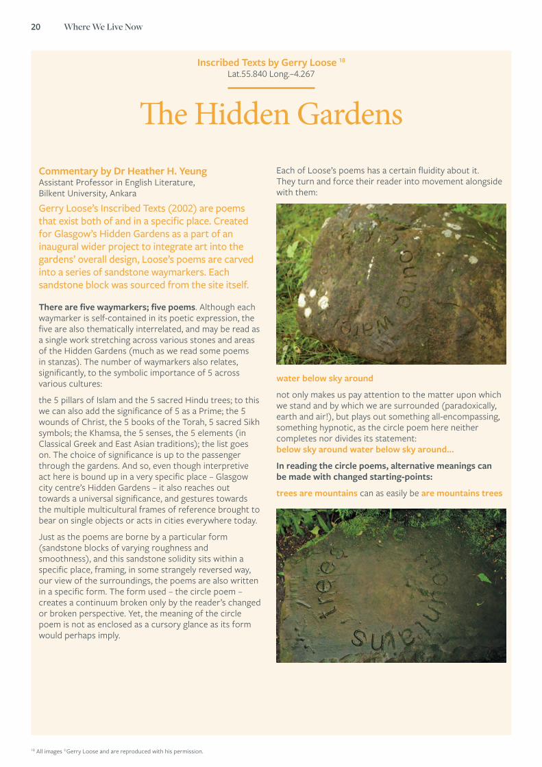
Each of Loose’s poems has a certain fluidity about it. They turn and force their reader into movement alongside with them:
water below sky around
not only makes us pay attention to the matter upon which we stand and by which we are surrounded (paradoxically, earth and air!), but plays out something all-encompassing, something hypnotic, as the circle poem here neither completes nor divides its statement: below sky around water below sky around…
In reading the circle poems, alternative meanings can be made with changed starting-points:
trees are mountains can as easily be are mountains trees
18 All images ©Gerry Loose and are reproduced with his permission.

What is place? The sense and feel of place 21
Loose’s Inscribed Texts are evidence of the power of the carefully placed written word within a given space.
They demand attention, but can just as easily be walked straight past and ignored. They point towards, frame, mark, and create a discreet sense of place within a given landscape, whilst also allowing the landscape to open out in a different way from that place. With each reader, they expand into a multiplicity of different interpretative possibilities. In doing so, they provoke conversation. With each season, they change in appearance. With time, they become further integrated into their surrounding landscape (note the moss on some of the waymarkers, and the effects of weathering can be seen on the lettering of others). The waymarkers have changed this place, and, now, change with it, and demand of their reader (or observer) to mark, too, these changes from their own points of view, in the Hidden Gardens and of themselves.
Further ReadingGerry Loose, Printed on Water (Shearsman, 2007)
www.thehiddengardens.org.uk /artwork-of-the-hidden-gardens.php
heart seeing eye playing muddles up the normal verbs attributed to the organs mentioned, but is also seeing eye playing heart, bringing to the forefront the different sorts of affective and poetic play that Loose’s circle poems evoke, and the fact that ‘vision’ in and of place is not only empirical (charted by the eye) but also emotional (observed by the heart)
And for many of them, meaning changes with angle of vision: not hidden is the only part visible from one angle of a circle poem that reads not hidden dreamed (or, dreamed not hidden); conversely, if viewed fully from the ‘dreamed’ perspective, ‘not hidden’ is invisible is the way unseen works in a similar way – with unseen unseen from some angles, and is the way from others; when read in full with shifting clauses this circle poem is at once a statement and a question, mirroring the swithering manner in which we move when the way is not immediately visible to us.
“ Each of Loose’s poems has a certain fluidity about it. They turn and force their reader into movement alongside with them.”
22 Where We Live Now
Case Study by Isobel Colchester, Chief Executive, Poet in the City
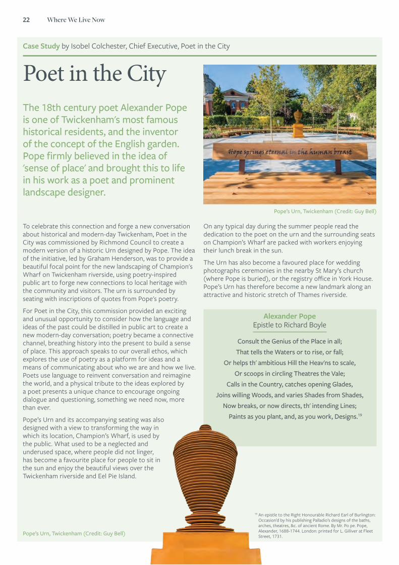
Poet in the City
To celebrate this connection and forge a new conversation about historical and modern-day Twickenham, Poet in the City was commissioned by Richmond Council to create a modern version of a historic Urn designed by Pope. The idea of the initiative, led by Graham Henderson, was to provide a beautiful focal point for the new landscaping of Champion's Wharf on Twickenham riverside, using poetry-inspired public art to forge new connections to local heritage with the community and visitors. The urn is surrounded by seating with inscriptions of quotes from Pope's poetry.
For Poet in the City, this commission provided an exciting and unusual opportunity to consider how the language and ideas of the past could be distilled in public art to create a new modern-day conversation; poetry became a connective channel, breathing history into the present to build a sense of place. This approach speaks to our overall ethos, which explores the use of poetry as a platform for ideas and a means of communicating about who we are and how we live. Poets use language to reinvent conversation and reimagine the world, and a physical tribute to the ideas explored by a poet presents a unique chance to encourage ongoing dialogue and questioning, something we need now, more than ever.
Pope’s Urn and its accompanying seating was also designed with a view to transforming the way in which its location, Champion’s Wharf, is used by the public. What used to be a neglected and underused space, where people did not linger, has become a favourite place for people to sit in the sun and enjoy the beautiful views over the Twickenham riverside and Eel Pie Island.
The 18th century poet Alexander Pope is one of Twickenham's most famous historical residents, and the inventor of the concept of the English garden. Pope firmly believed in the idea of 'sense of place' and brought this to life in his work as a poet and prominent landscape designer.
On any typical day during the summer people read the dedication to the poet on the urn and the surrounding seats on Champion’s Wharf are packed with workers enjoying their lunch break in the sun.
The Urn has also become a favoured place for wedding photographs ceremonies in the nearby St Mary’s church (where Pope is buried), or the registry office in York House. Pope’s Urn has therefore become a new landmark along an attractive and historic stretch of Thames riverside.
Pope’s Urn, Twickenham (Credit: Guy Bell)
Pope’s Urn, Twickenham (Credit: Guy Bell)
Alexander Pope Epistle to Richard Boyle
Consult the Genius of the Place in all;That tells the Waters or to rise, or fall;
Or helps th' ambitious Hill the Heav'ns to scale,Or scoops in circling Theatres the Vale;
Calls in the Country, catches opening Glades,Joins willing Woods, and varies Shades from Shades,
Now breaks, or now directs, th' intending Lines;Paints as you plant, and, as you work, Designs.19
19 An epistle to the Right Honourable Richard Earl of Burlington: Occasion’d by his publishing Palladio’s designs of the baths, arches, theatres, &c. of ancient Rome. By Mr. Po pe. Pope, Alexander, 1688-1744. London: printed for L. Gilliver at Fleet Street, 1731.
its impact on people and relationships
Understanding place:
23
24 Where We Live Now
Professor Sarah Curtis FBA , Emeritus Professor of Health and Risk, Durham University
Where we live now – why does it matter for our mental health?
5 Concrete cows, Milton Keynes
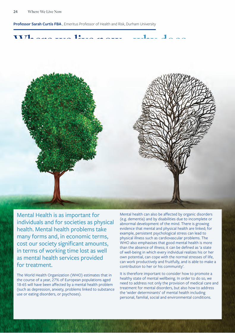
Mental Health is as important for individuals and for societies as physical health. Mental health problems take many forms and, in economic terms, cost our society significant amounts, in terms of working time lost as well as mental health services provided for treatment. The World Health Organization (WHO) estimates that in the course of a year, 27% of European populations aged 18-65 will have been affected by a mental health problem (such as depression, anxiety, problems linked to substance use or eating disorders, or psychoses).
Mental health can also be affected by organic disorders (e.g. dementia) and by disabilities due to incomplete or abnormal development of the mind. There is growing evidence that mental and physical health are linked; for example, persistent psychological stress can lead to physical illness such as cardiovascular problems. The WHO also emphasises that good mental health is more than the absence of illness; it can be defined as ‘a state of well-being in which every individual realizes his or her own potential, can cope with the normal stresses of life, can work productively and fruitfully, and is able to make a contribution to her or his community’.
It is therefore important to consider how to promote a healthy state of mental wellbeing. In order to do so, we need to address not only the provision of medical care and treatment for mental disorders, but also how to address the ‘wider determinants’ of mental health including personal, familial, social and environmental conditions.
Understanding place: its impact on people and relationships 25
Where we live matters for our mental healthAmong these wider determinants are characteristics of our living environment. In short, places matter for mental health. There is a large literature from disciplines represented in the British Academy, which shows that aspects of the settings where we live, work and play are associated with chances of good mental wellbeing or risk of mental illness. From a geographical perspective, the ‘therapeutic landscapes’ model provides a way of thinking about this, showing that the physical (material), social and symbolic aspects of places matter for mental health (Gesler, 2003; Williams, 2007; Curtis, 2010).
Some places are therapeutic in that they help us stay mentally well and protect our mental wellbeing, or they may help us recover from mental illness. These include:
• ‘green’ and ‘blue’ spaces such as woodland, parks and gardens, riverside or seaside settings that feel natural and also safe;
• places where we feel socially included and that give us a sense of ‘belonging’ in a community;
• places which are important to us because they hold spiritual significance or good memories and that reinforce a positive sense of personal or collective identity.
Often the places which benefit our mental health and wellbeing combine several of these aspects. For example, Milligan et al (2004; 2005) are among those who have recorded accounts by research participants who experienced the benefits for wellbeing of gardening and community gardens and allotments. Other studies report on how individual people feel the benefits of ‘blue’ landscapes with attractive water features (eg Bell et al., 2015; Foley and Kistemann, 2015). Often these studies show how in attractive green and blue landscapes people benefit from contacts with other people who share their interests in enjoying and maintaining these places.
Other work also underlines how a sense of social belonging in one’s community is important. Fagg et al (2006) showed that mental health among children of East Asian background in East London was better when they lived in neighbourhoods with a moderate (but not extreme) concentration of families from the same ethnic groups, rather than in areas with very few other Asian families. Several studies have also shown how sites considered to be holy or spiritually significant also influence wellbeing and can foster social bonds with others who share one’s faith or beliefs (eg Foley, 2010). Thus, a growing body of research provides evidence of how ‘therapeutic’ places bring together attractive, restorative aspects of nature in the landscape with opportunities for positive interactions with other people, as well as opportunities for peaceful reflection, and the stimulation of fond memories and emotions.
While many of these studies report in depth on individual experiences, we can also see from studies based on large scale surveys of the population that there are measurable links between environmental quality and mental health. Research shows that stress-related hormone levels are healthier among people who have more green space in their surrounding neighbourhood, underlining the link between mental and physical health benefits of proximity to green space (Ward et al, 2012; Roe et al 2013). Furthermore, the health inequalities associated with level of poverty or wealth in the population appear to be less pronounced among populations reporting greater access to green spaces (Mitchell et al, 2015).
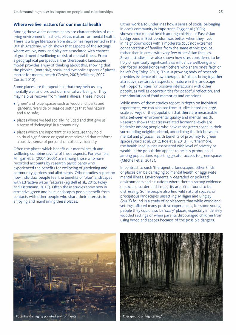
In contrast to such ‘therapeutic’ landscapes, other kinds of places can be damaging to mental health, or aggravate mental illness. Environmentally degraded or polluted environments and situations where there is strong evidence of social disorder and insecurity are often found to be distressing. Some people also find wild natural spaces, or precipitous landscapes unsettling. Milligan and Bingley (2007) found in a study of adolescents that while woodland settings offered many positive experiences, for some young people they could also be ‘scary’ places, especially in densely wooded settings or when parents discouraged children from using woodland spaces because of the possible dangers.
Therapeutic or frightening? Potential damaging polluted environments

26 Where We Live Now
Social exclusion and social isolation in communities is also known to be damaging for mental health. Hester Parr (2008) showed that for people with mental illnesses, experiences in the community may include social exclusion and stigma attached to mental illness that can be damaging, exacerbating their mental distress. More generally, indicators of ‘social fragmentation’ in local communities (originally designed by Peter Congdon and associated with weaker local social cohesion) are known to be associated with higher levels of use of psychiatric care (eg Curtis et al, 2006).
In addition, local socio-economic deprivation in communities is associated with worse mental health for all members of the population, not only for the poorest groups. This has been consistently demonstrated in many studies and is of particular concern given increasing socio-economic inequality among areas in the UK, and the recent economic recession. According to some research in England, population mental health in localities has deteriorated in association with rising unemployment (Barr et al, 2015). Bambra ( 2011) has overviewed the evidence of psychosocial as well as physical health impacts of poor, insecure conditions in the workplace.
Research also shows that we may experience solastagia (sense of loss of a landscape which is important to us) in cases where places of social and emotional value are destroyed. There are often mental health impacts for those who are exposed to natural disasters or environmental damage due to industrial pollution or destructive armed conflict. Those who have first-hand experience of recent severe flooding in the UK may well recognize the sense of trauma and loss reported in research on post-traumatic experiences after such events (eg. Few and Matthias, 2006).
How can we make use of this knowledge?In principle, we can try to promote and develop aspects of the places where we live now in ways that will foster therapeutic landscapes and mitigate the impacts of settings that harm mental health. The studies referred to above are selected examples from a large body of research that can help to inform efforts in fields including the work of urban and rural planners, managers and guardians of leisure spaces and heritage sites and other places of social and cultural significance, as well as groups operating community social clubs and associations.
“ For women, the benefits of green space were more apparent as they became older, and areas with moderate amounts of green space were most strongly associated with better health rather than areas with the largest proportion of green space.”
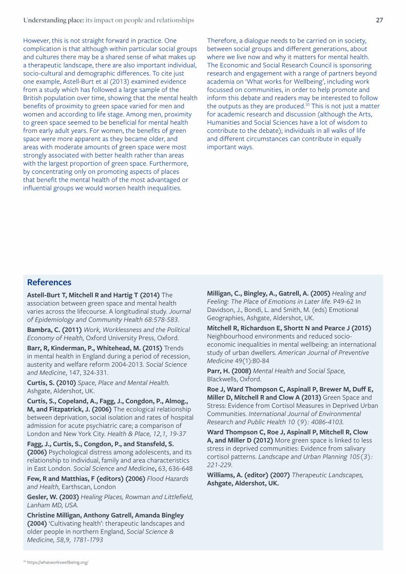
Understanding place: its impact on people and relationships 27
ReferencesAstell-Burt T, Mitchell R and Hartig T (2014) The association between green space and mental health varies across the lifecourse. A longitudinal study. Journal of Epidemiology and Community Health 68:578-583.Bambra, C. (2011) Work, Worklessness and the Political Economy of Health, Oxford University Press, Oxford.Barr, R, Kinderman, P., Whitehead, M. (2015) Trends in mental health in England during a period of recession, austerity and welfare reform 2004-2013. Social Science and Medicine, 147, 324-331.Curtis, S. (2010) Space, Place and Mental Health. Ashgate, Aldershot, UK.Curtis, S., Copeland, A., Fagg, J., Congdon, P., Almog., M, and Fitzpatrick, J. (2006) The ecological relationship between deprivation, social isolation and rates of hospital admission for acute psychiatric care; a comparison of London and New York City. Health & Place, 12,1, 19-37Fagg, J., Curtis, S., Congdon, P., and Stansfeld, S. (2006) Psychological distress among adolescents, and its relationship to individual, family and area characteristics in East London. Social Science and Medicine, 63, 636-648Few, R and Matthias, F (editors) (2006) Flood Hazards and Health, Earthscan, LondonGesler, W. (2003) Healing Places, Rowman and Littlefield, Lanham MD, USA. Christine Milligan, Anthony Gatrell, Amanda Bingley (2004) ‘Cultivating health’: therapeutic landscapes and older people in northern England, Social Science & Medicine, 58,9, 1781-1793
Milligan, C., Bingley, A., Gatrell, A. (2005) Healing and Feeling: The Place of Emotions in Later life. P49-62 In Davidson, J., Bondi, L. and Smith, M. (eds) Emotional Geographies, Ashgate, Aldershot, UK.Mitchell R, Richardson E, Shortt N and Pearce J (2015) Neighbourhood environments and reduced socio-economic inequalities in mental wellbeing: an international study of urban dwellers. American Journal of Preventive Medicine 49(1):80-84Parr, H. (2008) Mental Health and Social Space, Blackwells, Oxford.Roe J, Ward Thompson C, Aspinall P, Brewer M, Duff E, Miller D, Mitchell R and Clow A (2013) Green Space and Stress: Evidence from Cortisol Measures in Deprived Urban Communities. International Journal of Environmental Research and Public Health 10 (9): 4086-4103.Ward Thompson C, Roe J, Aspinall P, Mitchell R, Clow A, and Miller D (2012) More green space is linked to less stress in deprived communities: Evidence from salivary cortisol patterns. Landscape and Urban Planning 105(3): 221-229.Williams, A. (editor) (2007) Therapeutic Landscapes, Ashgate, Aldershot, UK.
However, this is not straight forward in practice. One complication is that although within particular social groups and cultures there may be a shared sense of what makes up a therapeutic landscape, there are also important individual, socio-cultural and demographic differences. To cite just one example, Astell-Burt et al (2013) examined evidence from a study which has followed a large sample of the British population over time, showing that the mental health benefits of proximity to green space varied for men and women and according to life stage. Among men, proximity to green space seemed to be beneficial for mental health from early adult years. For women, the benefits of green space were more apparent as they became older, and areas with moderate amounts of green space were most strongly associated with better health rather than areas with the largest proportion of green space. Furthermore, by concentrating only on promoting aspects of places that benefit the mental health of the most advantaged or influential groups we would worsen health inequalities.
Therefore, a dialogue needs to be carried on in society, between social groups and different generations, about where we live now and why it matters for mental health. The Economic and Social Research Council is sponsoring research and engagement with a range of partners beyond academia on ‘What works for Wellbeing’, including work focussed on communities, in order to help promote and inform this debate and readers may be interested to follow the outputs as they are produced.20 This is not just a matter for academic research and discussion (although the Arts, Humanities and Social Sciences have a lot of wisdom to contribute to the debate); individuals in all walks of life and different circumstances can contribute in equally important ways.
20 https://whatworkswellbeing.org/
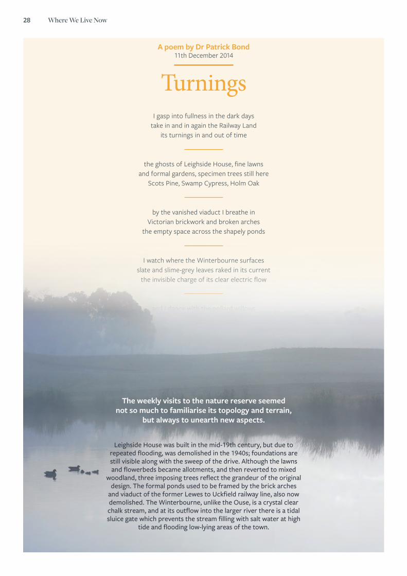
28 Where We Live Now
A poem by Dr Patrick Bond 11th December 2014
TurningsI gasp into fullness in the dark days
take in and in again the Railway Landits turnings in and out of time
the ghosts of Leighside House, fine lawns and formal gardens, specimen trees still here
Scots Pine, Swamp Cypress, Holm Oak
by the vanished viaduct I breathe in Victorian brickwork and broken arches
the empty space across the shapely ponds
I watch where the Winterbourne surfaces slate and slime-grey leaves raked in its current
the invisible charge of its clear electric flow
and I dance with the pollard willows laugh with their leaning, awkward grace
limber and lit up with shadows and shivers.
The weekly visits to the nature reserve seemed not so much to familiarise its topology and terrain,
but always to unearth new aspects.
Leighside House was built in the mid-19th century, but due to repeated flooding, was demolished in the 1940s; foundations are still visible along with the sweep of the drive. Although the lawns and flowerbeds became allotments, and then reverted to mixed
woodland, three imposing trees reflect the grandeur of the original design. The formal ponds used to be framed by the brick arches
and viaduct of the former Lewes to Uckfield railway line, also now demolished. The Winterbourne, unlike the Ouse, is a crystal clear chalk stream, and at its outflow into the larger river there is a tidal sluice gate which prevents the stream filling with salt water at high
tide and flooding low-lying areas of the town.
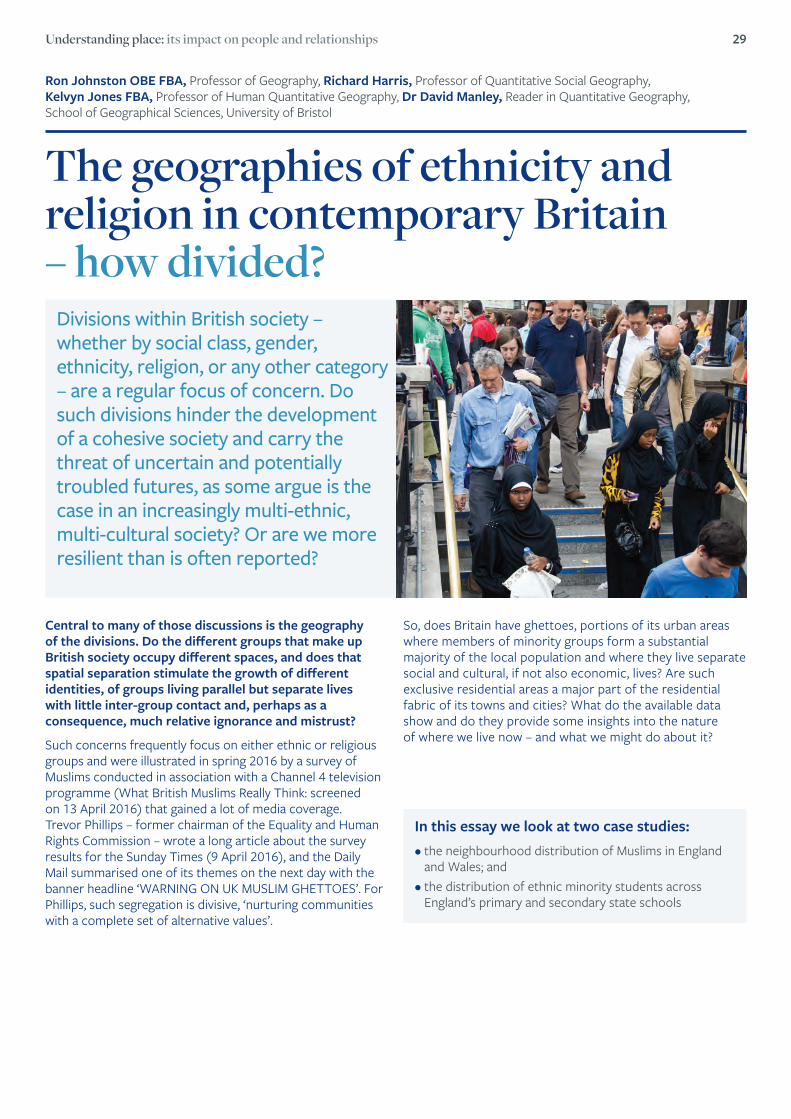
Understanding place: its impact on people and relationships 29
Ron Johnston OBE FBA, Professor of Geography, Richard Harris, Professor of Quantitative Social Geography, Kelvyn Jones FBA, Professor of Human Quantitative Geography, Dr David Manley, Reader in Quantitative Geography, School of Geographical Sciences, University of Bristol
The geographies of ethnicity and religion in contemporary Britain – how divided?
Divisions within British society – whether by social class, gender, ethnicity, religion, or any other category – are a regular focus of concern. Do such divisions hinder the development of a cohesive society and carry the threat of uncertain and potentially troubled futures, as some argue is the case in an increasingly multi-ethnic, multi-cultural society? Or are we more resilient than is often reported?
Central to many of those discussions is the geography of the divisions. Do the different groups that make up British society occupy different spaces, and does that spatial separation stimulate the growth of different identities, of groups living parallel but separate lives with little inter-group contact and, perhaps as a consequence, much relative ignorance and mistrust?
Such concerns frequently focus on either ethnic or religious groups and were illustrated in spring 2016 by a survey of Muslims conducted in association with a Channel 4 television programme (What British Muslims Really Think: screened on 13 April 2016) that gained a lot of media coverage. Trevor Phillips – former chairman of the Equality and Human Rights Commission – wrote a long article about the survey results for the Sunday Times (9 April 2016), and the Daily Mail summarised one of its themes on the next day with the banner headline ‘WARNING ON UK MUSLIM GHETTOES’. For Phillips, such segregation is divisive, ‘nurturing communities with a complete set of alternative values’.
In this essay we look at two case studies: • the neighbourhood distribution of Muslims in England
and Wales; and • the distribution of ethnic minority students across
England’s primary and secondary state schools
So, does Britain have ghettoes, portions of its urban areas where members of minority groups form a substantial majority of the local population and where they live separate social and cultural, if not also economic, lives? Are such exclusive residential areas a major part of the residential fabric of its towns and cities? What do the available data show and do they provide some insights into the nature of where we live now – and what we might do about it?

30 Where We Live Now
Religious affiliation and the nation’s neighbourhoods Most of the country’s Muslims live in neighbourhoods – areas for which the census publishes data with average populations of about 300 persons – where they form only a minority of the population. But is this a feature of the country as a whole, or are there some places with substantial ethnic enclaves where Muslims are in the majority?
According to the 2011 Census, there were just thirteen places in England outside London where a majority of the town’s or city’s Muslims lived in neighbourhoods where they formed over half of the local population (and none elsewhere in the UK). Two of them were Birmingham and Luton; the remainder were all in Lancashire and Yorkshire – in Oldham (where 86 per cent of all Muslims lived in Muslim-majority neighbourhoods), Dewsbury, Blackburn, Batley, Bradford, Halifax, Accrington, Keighley, Rochdale, Nelson, and Burnley. In Greater London, however, where the census recorded more than one million Muslims, only 7 per cent of them lived in Muslim-majority neighbourhoods, although there were considerable differences across the built-up area: 46 per cent of Tower Hamlet’s Muslims lived in Muslim-majority neighbourhoods, for example, as did 22 per cent in neighbouring Newham. But in suburban Bexley, none of the Borough’s 5,645 Muslims lived in a neighbourhood where they formed a majority of the population: the average (mean) number in each of its 728 census neighbourhoods was only seven.
The fact that there are few neighbourhoods where Muslims are in the majority does not preclude the possibility that they are very strongly concentrated in some places. We can consider this by asking if there are neighbourhoods where Muslims form more than 75 per cent, even 90 per cent, of the local population. Taking the threshold to be 75 per cent then only Oldham had more than half of its Muslims living in such exclusive areas; with a 90 per cent threshold, only 22 per cent of Oldham Muslim’s live in neighbourhoods where members of their religion predominate to that extent in the local population. In other words, neighbourhoods where Muslims predominate are very few; most of them live in relatively mixed areas. The UK does not have ghettoes as the term is generally understood from the situation of Black Americans in many US cities, where a cut-off of 50 per cent of a group’s members living in neighbourhoods where they form at least 50 per cent of the local population is usually used to define a ghetto-situation.
Outside London In Greater London
86% 46%of all Muslims lived in Muslim-majority neighbourhoods in Oldham
of all Muslims lived in Muslim-majority neighbourhoods in Tower Hamlet
“ neighbourhoods where Muslims predominate are very few; most of them live in relatively mixed areas.”
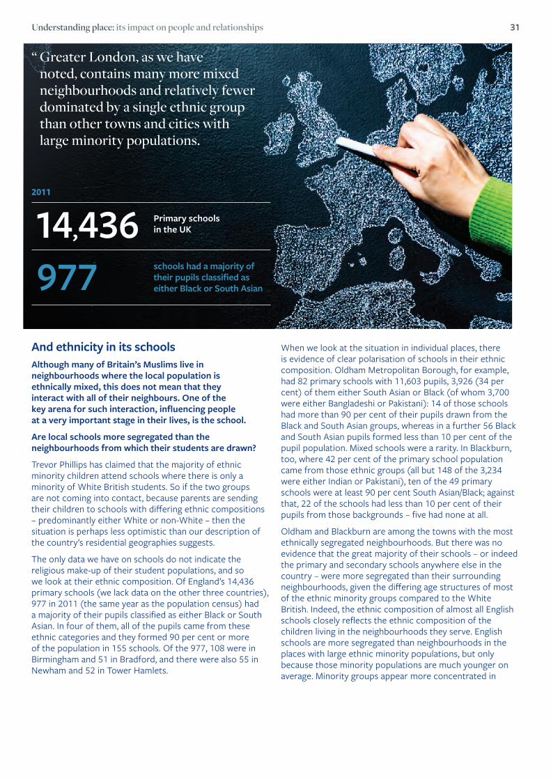
Understanding place: its impact on people and relationships 31
When we look at the situation in individual places, there is evidence of clear polarisation of schools in their ethnic composition. Oldham Metropolitan Borough, for example, had 82 primary schools with 11,603 pupils, 3,926 (34 per cent) of them either South Asian or Black (of whom 3,700 were either Bangladeshi or Pakistani): 14 of those schools had more than 90 per cent of their pupils drawn from the Black and South Asian groups, whereas in a further 56 Black and South Asian pupils formed less than 10 per cent of the pupil population. Mixed schools were a rarity. In Blackburn, too, where 42 per cent of the primary school population came from those ethnic groups (all but 148 of the 3,234 were either Indian or Pakistani), ten of the 49 primary schools were at least 90 per cent South Asian/Black; against that, 22 of the schools had less than 10 per cent of their pupils from those backgrounds – five had none at all.
Oldham and Blackburn are among the towns with the most ethnically segregated neighbourhoods. But there was no evidence that the great majority of their schools – or indeed the primary and secondary schools anywhere else in the country – were more segregated than their surrounding neighbourhoods, given the differing age structures of most of the ethnic minority groups compared to the White British. Indeed, the ethnic composition of almost all English schools closely reflects the ethnic composition of the children living in the neighbourhoods they serve. English schools are more segregated than neighbourhoods in the places with large ethnic minority populations, but only because those minority populations are much younger on average. Minority groups appear more concentrated in
“ Greater London, as we have noted, contains many more mixed neighbourhoods and relatively fewer dominated by a single ethnic group than other towns and cities with large minority populations.
And ethnicity in its schools Although many of Britain’s Muslims live in neighbourhoods where the local population is ethnically mixed, this does not mean that they interact with all of their neighbours. One of the key arena for such interaction, influencing people at a very important stage in their lives, is the school.
Are local schools more segregated than the neighbourhoods from which their students are drawn?
Trevor Phillips has claimed that the majority of ethnic minority children attend schools where there is only a minority of White British students. So if the two groups are not coming into contact, because parents are sending their children to schools with differing ethnic compositions – predominantly either White or non-White – then the situation is perhaps less optimistic than our description of the country’s residential geographies suggests.
The only data we have on schools do not indicate the religious make-up of their student populations, and so we look at their ethnic composition. Of England’s 14,436 primary schools (we lack data on the other three countries), 977 in 2011 (the same year as the population census) had a majority of their pupils classified as either Black or South Asian. In four of them, all of the pupils came from these ethnic categories and they formed 90 per cent or more of the population in 155 schools. Of the 977, 108 were in Birmingham and 51 in Bradford, and there were also 55 in Newham and 52 in Tower Hamlets.
2011
14,436 Primary schools in the UK
977 schools had a majority of their pupils classified as either Black or South Asian
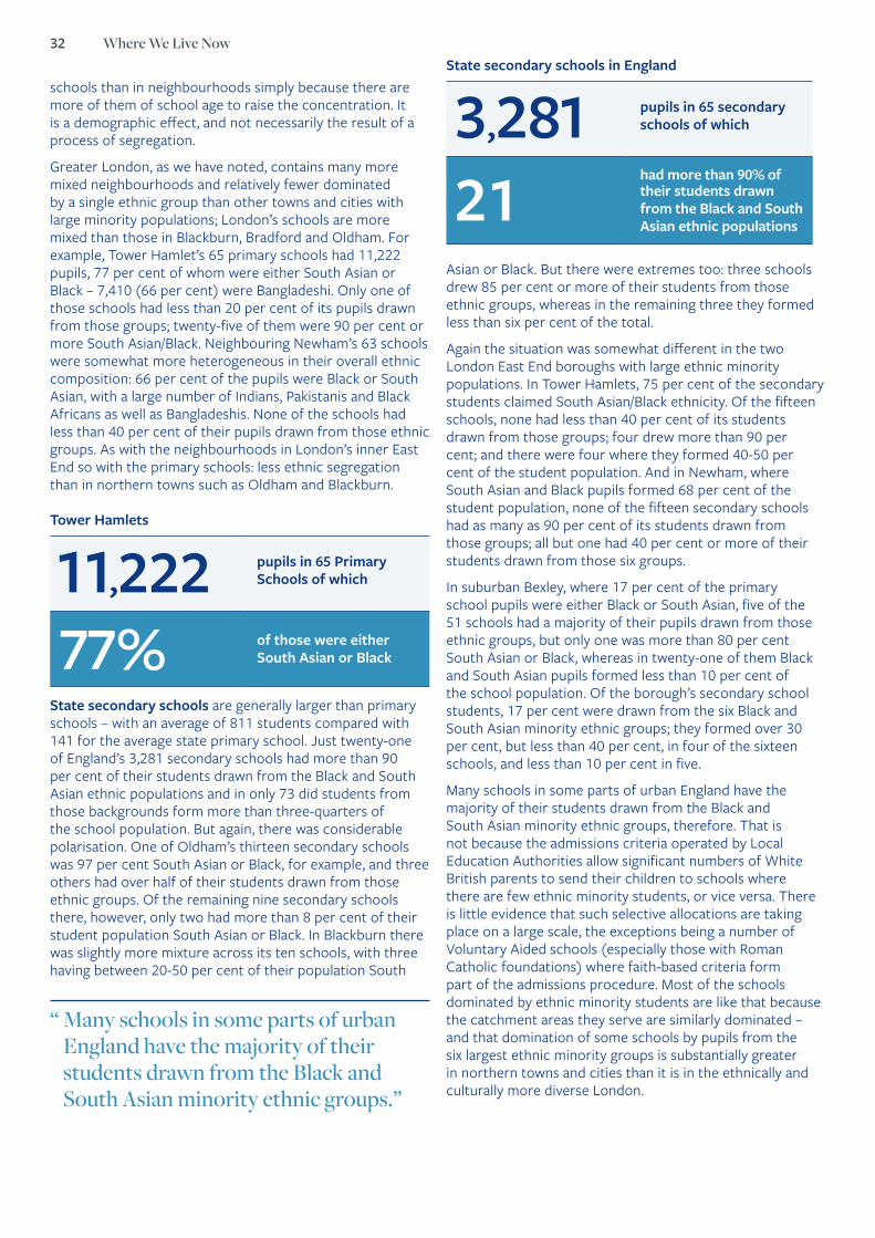
32 Where We Live Now
schools than in neighbourhoods simply because there are more of them of school age to raise the concentration. It is a demographic effect, and not necessarily the result of a process of segregation.
Greater London, as we have noted, contains many more mixed neighbourhoods and relatively fewer dominated by a single ethnic group than other towns and cities with large minority populations; London’s schools are more mixed than those in Blackburn, Bradford and Oldham. For example, Tower Hamlet’s 65 primary schools had 11,222 pupils, 77 per cent of whom were either South Asian or Black – 7,410 (66 per cent) were Bangladeshi. Only one of those schools had less than 20 per cent of its pupils drawn from those groups; twenty-five of them were 90 per cent or more South Asian/Black. Neighbouring Newham’s 63 schools were somewhat more heterogeneous in their overall ethnic composition: 66 per cent of the pupils were Black or South Asian, with a large number of Indians, Pakistanis and Black Africans as well as Bangladeshis. None of the schools had less than 40 per cent of their pupils drawn from those ethnic groups. As with the neighbourhoods in London’s inner East End so with the primary schools: less ethnic segregation than in northern towns such as Oldham and Blackburn.
State secondary schools are generally larger than primary schools – with an average of 811 students compared with 141 for the average state primary school. Just twenty-one of England’s 3,281 secondary schools had more than 90 per cent of their students drawn from the Black and South Asian ethnic populations and in only 73 did students from those backgrounds form more than three-quarters of the school population. But again, there was considerable polarisation. One of Oldham’s thirteen secondary schools was 97 per cent South Asian or Black, for example, and three others had over half of their students drawn from those ethnic groups. Of the remaining nine secondary schools there, however, only two had more than 8 per cent of their student population South Asian or Black. In Blackburn there was slightly more mixture across its ten schools, with three having between 20-50 per cent of their population South
Asian or Black. But there were extremes too: three schools drew 85 per cent or more of their students from those ethnic groups, whereas in the remaining three they formed less than six per cent of the total.
Again the situation was somewhat different in the two London East End boroughs with large ethnic minority populations. In Tower Hamlets, 75 per cent of the secondary students claimed South Asian/Black ethnicity. Of the fifteen schools, none had less than 40 per cent of its students drawn from those groups; four drew more than 90 per cent; and there were four where they formed 40-50 per cent of the student population. And in Newham, where South Asian and Black pupils formed 68 per cent of the student population, none of the fifteen secondary schools had as many as 90 per cent of its students drawn from those groups; all but one had 40 per cent or more of their students drawn from those six groups.
In suburban Bexley, where 17 per cent of the primary school pupils were either Black or South Asian, five of the 51 schools had a majority of their pupils drawn from those ethnic groups, but only one was more than 80 per cent South Asian or Black, whereas in twenty-one of them Black and South Asian pupils formed less than 10 per cent of the school population. Of the borough’s secondary school students, 17 per cent were drawn from the six Black and South Asian minority ethnic groups; they formed over 30 per cent, but less than 40 per cent, in four of the sixteen schools, and less than 10 per cent in five.
Many schools in some parts of urban England have the majority of their students drawn from the Black and South Asian minority ethnic groups, therefore. That is not because the admissions criteria operated by Local Education Authorities allow significant numbers of White British parents to send their children to schools where there are few ethnic minority students, or vice versa. There is little evidence that such selective allocations are taking place on a large scale, the exceptions being a number of Voluntary Aided schools (especially those with Roman Catholic foundations) where faith-based criteria form part of the admissions procedure. Most of the schools dominated by ethnic minority students are like that because the catchment areas they serve are similarly dominated – and that domination of some schools by pupils from the six largest ethnic minority groups is substantially greater in northern towns and cities than it is in the ethnically and culturally more diverse London.
“ Many schools in some parts of urban England have the majority of their students drawn from the Black and South Asian minority ethnic groups.”
Tower Hamlets
11,222 pupils in 65 Primary Schools of which
77% of those were either South Asian or Black
State secondary schools in England
3,281 pupils in 65 secondary schools of which
21had more than 90% of their students drawn from the Black and South Asian ethnic populations

Understanding place: its impact on people and relationships 33
A segregating society?The British media occasionally carry stories suggesting the emergence of a society ever more deeply divided by ethnicity, implying that we are drifting towards segregation (or sleepwalking in more picturesque language). However, the situation is much more nuanced than a single trend of growing spatial separation, of less sharing of neighbourhood and school spaces among ethnic and religious minority groups. Britain as a whole, and certainly England where most minority groups are concentrated, is not an intensively segregated country: there are no ghettoes in the sense of extensive tracts in towns and cities where those minority groups predominate. But there are some places – notably in Lancashire and Yorkshire – where there are substantial neighbourhoods with minority-majorities, and where the schools are even more polarised – most of them, especially the primary schools, having either a preponderance of or very few South Asians or those who identify as either Black African or Black Caribbean on their rolls, although, crucially, there is no evidence that polarisation is increasing.
London is different, however, in part reflecting its separate occupational class structure from those declining northern towns where Indians and Pakistanis are concentrated – most Bangladeshis are in London and there are relatively few of Black African and Caribbean origin the further north you go. White British form a minority of London’s population but the capital’s neighbourhoods and schools are more mixed ethnically than is the case in other places with large ethnic minority populations. The average young member of one of the minority groups in London is much more likely to live in a neighbourhood and to attend a school with members of both other minority groups and of the country’s White majority, than is the case in a small number of towns elsewhere in the country.
“ London is different, however, in part reflecting its separate occupational class structure from those declining northern towns where Indians and Pakistanis are concentrated.”
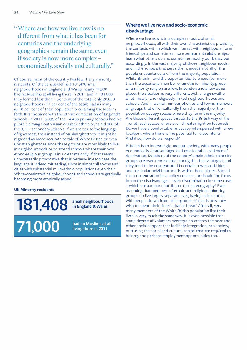
34 Where We Live Now
Of course, most of the country has few, if any, minority residents. Of the census-defined 181,408 small neighbourhoods in England and Wales, nearly 71,000 had no Muslims at all living there in 2011 and in 101,000 they formed less than 1 per cent of the total; only 20,000 neighbourhoods (11 per cent of the total) had as many as 10 per cent of their population proclaiming the Muslim faith. It is the same with the ethnic composition of England’s schools: in 2011, 5,086 of the 14,436 primary schools had no pupils claiming South Asian or Black ethnicity, as did 800 of the 3,281 secondary schools. If we are to use the language of ‘ghettoes’, then instead of Muslim ‘ghettoes’ it might be regarded as more accurate to talk of White British or even Christian ghettoes since these groups are most likely to live in neighbourhoods or to attend schools where their own ethno-religious group is in a clear majority. If that seems unnecessarily provocative that is because in each case the language is indeed misleading, since in almost all towns and cities with substantial multi-ethnic populations even their White-dominated neighbourhoods and schools are gradually becoming more ethnically mixed.
“ Where and how we live now is no different from what it has been for centuries and the underlying geographies remain the same, even if society is now more complex – economically, socially and culturally.”
Where we live now and socio-economic disadvantageWhere we live now is in a complex mosaic of small neighbourhoods, all with their own characteristics, providing the contexts within which we interact with neighbours, form friendships and sometimes more permanent relationships, learn what others do and sometimes modify our behaviour accordingly. In the vast majority of those neighbourhoods, and in the schools that serve them, most if not all of the people encountered are from the majority population – White British – and the opportunities to encounter more than the occasional member of an ethnic minority group or a minority religion are few. In London and a few other places the situation is very different, with a large swathe of ethnically- and religiously-mixed neighbourhoods and schools. And in a small number of cities and towns members of groups that differ culturally from the majority of the population occupy spaces where they form the majority. Are those different spaces threats to the British way of life – or at least spaces where such threats might be fostered? Do we have a comfortable landscape interspersed with a few locations where there is the potential for discomfort? And if so, how do we respond?
Britain’s is an increasingly unequal society, with many people economically disadvantaged and considerable evidence of deprivation. Members of the country’s main ethnic minority groups are over-represented among the disadvantaged, and they tend to be concentrated in certain towns and cities – and particular neighbourhoods within those places. Should that concentration be a policy concern, or should the focus be on the disadvantages – even discrimination in some cases – which are a major contributor to that geography? Even assuming that members of ethnic and religious minority groups do live largely separate lives, having little contact with people drawn from other groups, if that is how they wish to spend their time is that a threat? After all, very many members of the White British population live their lives in very much the same way. It is even possible that some degree of voluntary segregation creates the peer and other social support that facilitate integration into society, nurturing the social and cultural capital that are required to belong, and perhaps employment opportunities too.
UK Minority residents
181,408 small neighbourhoods in England & Wales
71,000 had no Muslims at all living there in 2011
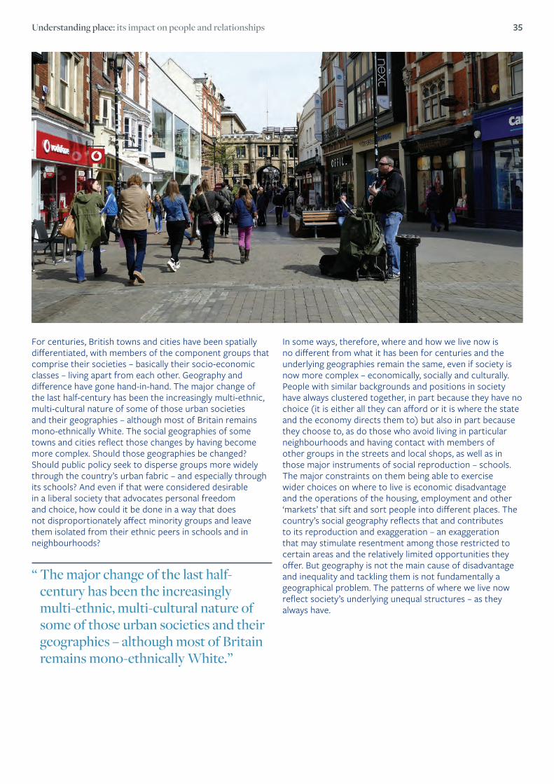
Understanding place: its impact on people and relationships 35
“ The major change of the last half- century has been the increasingly multi-ethnic, multi-cultural nature of some of those urban societies and their geographies – although most of Britain remains mono-ethnically White.”
For centuries, British towns and cities have been spatially differentiated, with members of the component groups that comprise their societies – basically their socio-economic classes – living apart from each other. Geography and difference have gone hand-in-hand. The major change of the last half-century has been the increasingly multi-ethnic, multi-cultural nature of some of those urban societies and their geographies – although most of Britain remains mono-ethnically White. The social geographies of some towns and cities reflect those changes by having become more complex. Should those geographies be changed? Should public policy seek to disperse groups more widely through the country’s urban fabric – and especially through its schools? And even if that were considered desirable in a liberal society that advocates personal freedom and choice, how could it be done in a way that does not disproportionately affect minority groups and leave them isolated from their ethnic peers in schools and in neighbourhoods?
In some ways, therefore, where and how we live now is no different from what it has been for centuries and the underlying geographies remain the same, even if society is now more complex – economically, socially and culturally. People with similar backgrounds and positions in society have always clustered together, in part because they have no choice (it is either all they can afford or it is where the state and the economy directs them to) but also in part because they choose to, as do those who avoid living in particular neighbourhoods and having contact with members of other groups in the streets and local shops, as well as in those major instruments of social reproduction – schools. The major constraints on them being able to exercise wider choices on where to live is economic disadvantage and the operations of the housing, employment and other ‘markets’ that sift and sort people into different places. The country’s social geography reflects that and contributes to its reproduction and exaggeration – an exaggeration that may stimulate resentment among those restricted to certain areas and the relatively limited opportunities they offer. But geography is not the main cause of disadvantage and inequality and tackling them is not fundamentally a geographical problem. The patterns of where we live now reflect society’s underlying unequal structures – as they always have.

36 Where We Live Now
Further readingThere is a large literature on segregation in Britain’s neighbourhoods and schools. For general overviews see N. Finney and L. Simpson, Sleepwalking to Segregation? Challenging Myths about Race and Migration (Policy Press, Bristol, 2009) and S. Jivraj and L. Simpson (editors) Ethnic Identity and Inequalities in Britain: the Dynamics of Diversity (Policy Press, Bristol, 2015). For more detailed analyses of the data deployed in this chapter, see R. Johnston, D. Manley and K. Jones ‘In search of Britain’s Muslim ghettoes’, Environment and Planning A, 48, 2018, 1684 –1690 and R. Johnston, R. Harris, K. Jones and D. Manley, ‘Segregation at school and at home: an English exploration’, Belgeo (forthcoming). Dame Louise Casey’s report – The Casey Review: A Review into Opportunity and Integration – was published by HMSO for the Department for Communities and Local Government, and is available at https://www.gov.uk/government/publications/the-casey-review-a-review-into-opportunity-and-integration.
All of the 2011 Census data quoted here were obtained from the NOMIS website https://www.nomisweb.co.uk/query/select/getdatasetbytheme.asp?opt=3&theme=&subgrp= and the school data were obtained from the National Pupil Database https://www.gov.uk/government/collections/national-pupil-database.
Plus ça changeDecember 2016 saw publication of Dame Louise Casey’s review of opportunity and integration in the UK, produced at the request of the then Prime Minister and Home Secretary. It portrayed the country as becoming increasingly segregated both ethnically and by religion, with that segregation being presented as largely negative in its consequences – both for those members of minority groups living in the segregated areas and attending their schools and for society as a whole. It stimulated the expected media response.
On 6 December, for example, The Times headlined an article on the report’s findings ‘Ethnic misogyny ‘fuels social divisions’’, and the subtitle of a leading article was ‘The Casey report casts a disturbing light on levels of segregation’; The Sun said that the report was ‘rapping a UK divided by race’.
The report presented only a partial, and potentially misleading, perspective on the extent of segregation in England and Wales. It noted the 682 wards in England and Wales containing 40 per cent or more non-Whites (a low threshold for areas supposed to be dominated by a minority population), but not that only 45 per cent of all non-Whites lived in those relatively exclusive areas. Similarly, it identified 178 wards where more than 40 per cent of the residents belonged to a ‘minority religion’ – but only 31 per cent of adherents to those religions live there: the majority live in even more diverse areas.
Intriguingly, though the report presents a largely negative view of the consequences of segregation, none of its recommendations explicitly refers to changing that aspect of the country’s geography. Instead it promotes a range of measures designed to increase integration, without recognising – even in the broadest sense – that ethnic and religious segregation are, to a considerable extent, simply reflections of an unequal society divided along a number of dimensions. While some of the recommended actions may increase inter-cultural awareness, interaction, and appreciation they will not tackle inequality, particularly economic inequality, and remove the foundations on which much segregation and other aspects of our divided society are based.
“ The Casey report presented only a partial, and potentially misleading, perspective on the extent of segregation in England and Wales.”

Understanding place: its impact on people and relationships 37
Professor Mark Birkin, Professor of Spatial Analysis and Policy, University of Leeds, Director, Consumer Data Research Centre
Social Media, Place and Policy
Social media provides an increasingly rich and interesting source of evidence about the nature of places. For example, mobile phone applications like Strava and CycleStreets tell us about the origins and destinations, travel speeds and route choices of cyclists. This can help to inform both research and policy choices for national agendas on transport planning and healthy lifestyle choices. This short essay will explore some of the ways in which social media are promoting a deeper understanding of city environments and helping to plan them more effectively in the future.
In the past, two of the main sources of data about urban mobility have been the UK Census and the National Travel Survey. The Census is a very high quality data source which details the social, demographic and economic make-up of the population, together with some limited information about behaviour patterns including daily journey-to-work patterns.
Information is provided relating to small areas such as neighbourhoods and workplace zones. However, the Census is expensive to run and is only implemented on a decennial basis. The last census was conducted in 2011 so at the time of writing all census data are more than five years out-of-date. Each individual is associated with a single origin and a single destination representing a home and a work location on census day. Hence any weekly or seasonal variations are eliminated, and trips for any other purpose such as shopping or recreation are not admitted.
The National Traffic Survey is a diary-based survey of several thousand individuals recording movement types and purpose for many and varied purposes. However, when these data are split between small geographical areas the sample sizes are quickly eroded. Hence the spatial detail which can be elicited is very limited and unreliable.
Social media data for cycling can be generated when people download applications to a mobile device and use this as a means to log their own movement patterns. Other modes of travel such as walking, running and in theory others are also supported. The data are generated continuously at a fine spatial scale regardless of trip purposes and across the days and seasons.
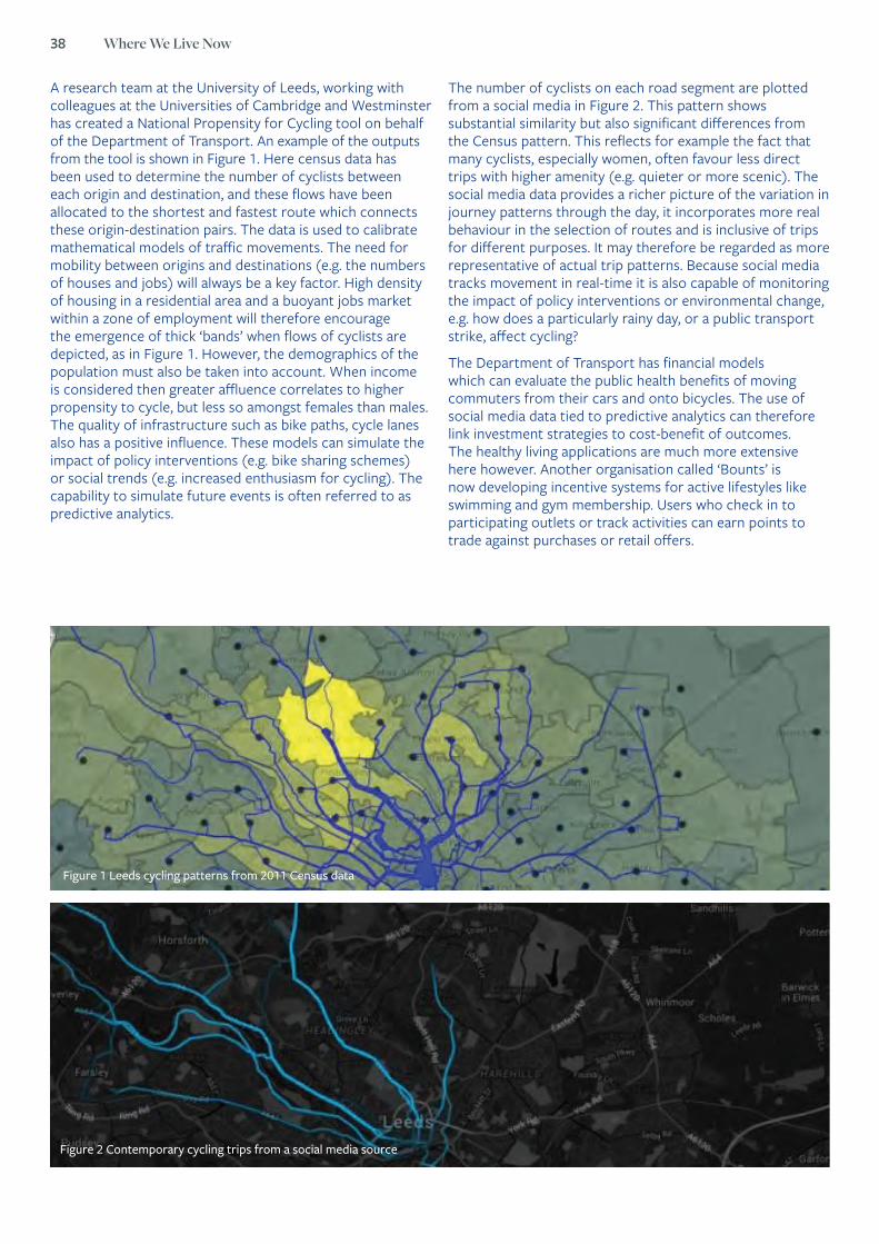
38 Where We Live Now
A research team at the University of Leeds, working with colleagues at the Universities of Cambridge and Westminster has created a National Propensity for Cycling tool on behalf of the Department of Transport. An example of the outputs from the tool is shown in Figure 1. Here census data has been used to determine the number of cyclists between each origin and destination, and these flows have been allocated to the shortest and fastest route which connects these origin-destination pairs. The data is used to calibrate mathematical models of traffic movements. The need for mobility between origins and destinations (e.g. the numbers of houses and jobs) will always be a key factor. High density of housing in a residential area and a buoyant jobs market within a zone of employment will therefore encourage the emergence of thick ‘bands’ when flows of cyclists are depicted, as in Figure 1. However, the demographics of the population must also be taken into account. When income is considered then greater affluence correlates to higher propensity to cycle, but less so amongst females than males. The quality of infrastructure such as bike paths, cycle lanes also has a positive influence. These models can simulate the impact of policy interventions (e.g. bike sharing schemes) or social trends (e.g. increased enthusiasm for cycling). The capability to simulate future events is often referred to as predictive analytics.
The number of cyclists on each road segment are plotted from a social media in Figure 2. This pattern shows substantial similarity but also significant differences from the Census pattern. This reflects for example the fact that many cyclists, especially women, often favour less direct trips with higher amenity (e.g. quieter or more scenic). The social media data provides a richer picture of the variation in journey patterns through the day, it incorporates more real behaviour in the selection of routes and is inclusive of trips for different purposes. It may therefore be regarded as more representative of actual trip patterns. Because social media tracks movement in real-time it is also capable of monitoring the impact of policy interventions or environmental change, e.g. how does a particularly rainy day, or a public transport strike, affect cycling?
The Department of Transport has financial models which can evaluate the public health benefits of moving commuters from their cars and onto bicycles. The use of social media data tied to predictive analytics can therefore link investment strategies to cost-benefit of outcomes. The healthy living applications are much more extensive here however. Another organisation called ‘Bounts’ is now developing incentive systems for active lifestyles like swimming and gym membership. Users who check in to participating outlets or track activities can earn points to trade against purchases or retail offers.
Figure 2 Contemporary cycling trips from a social media source
Figure 1 Leeds cycling patterns from 2011 Census data

Understanding place: its impact on people and relationships 39
21 Social Media Update 2014: Demographics of Key Social Networking Platforms, pewinternet.org, accessed 8th August 2016.
Social media channels by Age
Age
18-29 37 87
30-49 25 73
50-64 12 63
65+ 10 56
100
90
80
70
60
50
40
30
20
10
Age 18-29 30-49 50-64 64+
Figure 1. Penetration (%) by demographics for two social media channels21
Social media channels by Income
Income
<$30K 20 77
30-50 21 69
50-75 27 74
>=$75K 27 72
90
80
70
60
50
40
30
20
10
Income <$30K $30-50K $50-75K >$75K
Social media channels by Education
Education
School 16 70
College 24 71
Higher Ed 30 74
80
70
60
50
40
30
20
10
Education School College Higher Ed
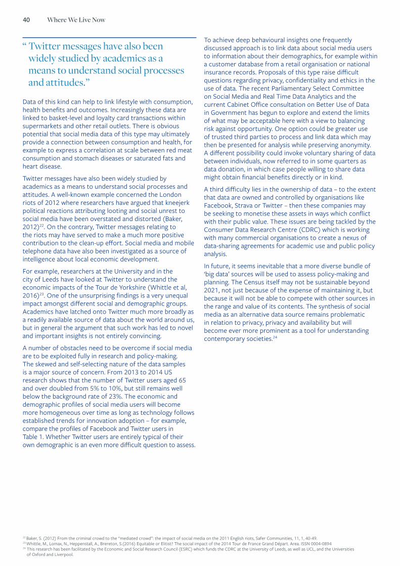
40 Where We Live Now
22 Baker, S. (2012) From the criminal crowd to the “mediated crowd”: the impact of social media on the 2011 English riots, Safer Communities, 11, 1, 40-49.23 Whittle, M., Lomax, N., Heppenstall, A., Brereton, S.(2016) Equitable or Elitist? The social impact of the 2014 Tour de France Grand Départ. Area. ISSN 0004-089424 This research has been facilitated by the Economic and Social Research Council (ESRC) which funds the CDRC at the University of Leeds, as well as UCL, and the Universities
of Oxford and Liverpool.
Data of this kind can help to link lifestyle with consumption, health benefits and outcomes. Increasingly these data are linked to basket-level and loyalty card transactions within supermarkets and other retail outlets. There is obvious potential that social media data of this type may ultimately provide a connection between consumption and health, for example to express a correlation at scale between red meat consumption and stomach diseases or saturated fats and heart disease.
Twitter messages have also been widely studied by academics as a means to understand social processes and attitudes. A well-known example concerned the London riots of 2012 where researchers have argued that kneejerk political reactions attributing looting and social unrest to social media have been overstated and distorted (Baker, 2012)22. On the contrary, Twitter messages relating to the riots may have served to make a much more positive contribution to the clean-up effort. Social media and mobile telephone data have also been investigated as a source of intelligence about local economic development.
For example, researchers at the University and in the city of Leeds have looked at Twitter to understand the economic impacts of the Tour de Yorkshire (Whittle et al, 2016)23. One of the unsurprising findings is a very unequal impact amongst different social and demographic groups. Academics have latched onto Twitter much more broadly as a readily available source of data about the world around us, but in general the argument that such work has led to novel and important insights is not entirely convincing.
A number of obstacles need to be overcome if social media are to be exploited fully in research and policy-making. The skewed and self-selecting nature of the data samples is a major source of concern. From 2013 to 2014 US research shows that the number of Twitter users aged 65 and over doubled from 5% to 10%, but still remains well below the background rate of 23%. The economic and demographic profiles of social media users will become more homogeneous over time as long as technology follows established trends for innovation adoption – for example, compare the profiles of Facebook and Twitter users in Table 1. Whether Twitter users are entirely typical of their own demographic is an even more difficult question to assess.
To achieve deep behavioural insights one frequently discussed approach is to link data about social media users to information about their demographics, for example within a customer database from a retail organisation or national insurance records. Proposals of this type raise difficult questions regarding privacy, confidentiality and ethics in the use of data. The recent Parliamentary Select Committee on Social Media and Real Time Data Analytics and the current Cabinet Office consultation on Better Use of Data in Government has begun to explore and extend the limits of what may be acceptable here with a view to balancing risk against opportunity. One option could be greater use of trusted third parties to process and link data which may then be presented for analysis while preserving anonymity. A different possibility could invoke voluntary sharing of data between individuals, now referred to in some quarters as data donation, in which case people willing to share data might obtain financial benefits directly or in kind.
A third difficulty lies in the ownership of data – to the extent that data are owned and controlled by organisations like Facebook, Strava or Twitter – then these companies may be seeking to monetise these assets in ways which conflict with their public value. These issues are being tackled by the Consumer Data Research Centre (CDRC) which is working with many commercial organisations to create a nexus of data-sharing agreements for academic use and public policy analysis.
In future, it seems inevitable that a more diverse bundle of ‘big data’ sources will be used to assess policy-making and planning. The Census itself may not be sustainable beyond 2021, not just because of the expense of maintaining it, but because it will not be able to compete with other sources in the range and value of its contents. The synthesis of social media as an alternative data source remains problematic in relation to privacy, privacy and availability but will become ever more prominent as a tool for understanding contemporary societies.24
“ Twitter messages have also been widely studied by academics as a means to understand social processes and attitudes.”

practical approaches
Shaping where we live for the better:
41

42 Where We Live Now
25 Relph, E (1976). Place and Placelessness. London: Pion26 Cresswell, T (2015) Place an introduction. 2nd. ed. Chichester: John Wiley & Sons Ltd.27 Hague, C., Jenkins, P., (2005). Place identity, participation and planning. London: Routledge28 Harpham, T., Grant, E., Thomas, E., (2002). Measuring Social Capital within Health Surveys: key issues. Health Policy and planning: 17 (1) pp106-111.
Dr Denise Hewlett FRGS Principal Investigator & Senior Fellow, University of Winchester
Making sense of the place in which we live: ‘more than a feeling!’
Making sense of the place in which we live, is complex. It is certainly not simply about identifying fixed, geographical parameters, rather the concept of place is multidimensional and feelings about an area, about its community and what is valued in that place, are highly significant25, 26, 27.
Communities will comprise homogeneous and heterogeneous groups28, and so multiple meanings and values will be conveyed from amongst the community. Consequently, the ability to capture the breadth and depth of these views is warranted and invariably, this will require a highly interdisciplinary approach to be taken to make sense of these views.

Shaping where we live for the better: practical approaches 43
The Case of Broadly Engaging with Tranquillity: A sense of a Special Place in Dorset
Figure 1: Broadly Engaging with Tranquillity: Case Study area of Purbecks, Dorset (Modified after Hewlett et all. 2017).
A genuine belief that local people are best placed to comment on their sense of place, on their community and in shaping the area in which they live, underpinned the design of the Broadly Engaging with Tranquillity project (BETP)42. Led by the University of Winchester, the BETP was funded by the Economic and Social Science Research Council (ESRC)43. A partnership approach was created with the team of the Dorset AONB and Dorset County Council who jointly provided the most current data to progress the study and additionally, facilitated our access to all relevant institutions, local groups and residents in the case study area.BETP was undertaken in the Purbecks, Dorset from March 2014 to June 2015, an area comprised urban and rural locations within an Area of Outstanding Natural Beauty (AONB) so designated for its wealth of both natural and cultural heritage (Figure 1). It is a key tourist destination in the south of England encompassing numerous historical, archaeological and environmental features that combined represent strong cultural associations with the rural and coastal landscape. The Purbecks was selected specifically for the sense of community and of special place with which it is labelled as part of the AONB. Inclusive of its World Heritage Jurassic Coastline, the area’s sense of place is managed under themes of special qualities. At the heart of these, tranquillity is a key quality promoted as representing the quintessential image perceived of the English countryside.
Whilst making sense of place is challenging, if we are able to improve our understanding of place and subsequently inform spatial planning strategies accordingly, numerous advantages are expected in enhancing our health and wellbeing29,30, even the social and psychological development of our children31, especially where access to green spaces is enhanced. Moreover, through the community’s engagement and through changes they have been able to affect, their empowerment and abilities to convey views can be enhanced32 and a greater sense of value in their area and in their community is argued to be developed 33 34,35,36,37.
Yet, public consultations, commonly used by authorities to collate local views on planning strategies, have frequently been labelled as simply tick-box exercises and subsequently are reported as tending towards disingenuous practices, albeit are legitimised in standard planning practice38, 39, 40,41. To redress this situation, we contend that operational doors need to be opened for planning officers to not only genuinely consult with the broadest range of local people but also for the consultees’ opinions to be seen to influence decisions taken. To enable this empowerment of both planning officers and of local communities, place based planning policies are required.
29 Gesler, W M. (2003) Healing Places. Lanham M D: Rowman & Littlefield Publishers.30 Louv, R (2011) The Nature Principle Reconnecting with Life in a Virtual Age. North
Carolina: Alonquin Books of Chapel Hill.31 Louv, R (2005) Last Child in the Woods. Saving our Children from Nature-Deficit
Disorder. New York: Alonquin Books of Chapel Hill32 Ledwith, M., (2005). Community Development A critical approach. Bristol: Policy Press33 Lockwood, M., Kothari, A., (2006). Social Context In: Lockwood, M., Worboys, G.L.,
Kothari, A., eds. Managing Protected Areas. London: Earthscan pp 41-7234 Lockwood, M., Worboys, G., Kothari, A., (2006). Challenges and Opportunities In:
Lockwood, M., Worboys, G.L., Kothari, A., eds. Managing Protected Areas. London: Earthscan pp 677-682
35 Oakley, P., (1999). Projects with People. The practice of participation in rural development. 2nd ed. Geneva: International Labour Organisation
36 Pimbert, M., Pretty, J., (1997). Parks, People and Professionals: Putting participation into protected area management In: Ghimire, K B., Pimbert, M. P. eds. Social Change and Conservation. London: Earthscan pp297-330.
37 Borrini-Feyerabend, G., Dudley, N., Jaeger, T., Lassen, B., Pathak Broome, N., Phillips, A., Sandwith, T. (2013) Governance of Protected Areas; from understanding to action. Geneva: IUCN
38 Arnstein, S., (1969). Ladder of Citizen Participation. AIP Journal 4, pp216-22439 Pimbert, M., Pretty, J., (1997). Parks, People and Professionals: Putting participation
into protected area management In: Ghimire, K B., Pimbert, M. P. eds. Social Change and Conservation. London: Earthscan pp297-330
40 Weldon, S., (2004). Social Science in Forestry Public Participation and partnership: a review of Forestry Commission practice and governance in a changing political and economic context. Edinburgh: Forestry Commission.
41 Vetter, A., (2007). Local politics: A resource for democracy in Western Europe? Plymouth: Lexington Books.
42 Full details on the research framework and an overview of key findings can be found at: Hewlett, D., Harding, L., Munro, T., Terradillos, A., Wilkinson, K. Broadly engaging with tranquility in protected landscapes: A matter of perspectives identified in GIS. In: Landscape and Urban Planning. 158. February 2017. Pp 185-201. http://dx.doi.org/10.1016/j.landurbplan.2016.11.002
43 The BET was funded by the ESRC ES/L001748/1 – within the Knowledge Exchange programme.
“ A genuine belief that local people are best placed to comment on their sense of place, on their community and in shaping the area in which they live, underpinned the design of the Broadly Engaging with Tranquillity project.”

44 Where We Live Now
Tranquillity – every view counts!Perhaps, unsurprisingly tranquillity tends to be a term used synonymously with ‘calm’, ‘solitude’, ‘peace and quiet’ to describe a sense of place, as much as the quality of experiencing a protected area such as an AONB. Given the highly subjective nature of these terms, tranquillity, as a sense of this place, is a concept that is in the eye, or indeed ear, nose, hands and mind of the beholder44. So, it would not be unreasonable to assume that rather than institutions’ interpretations on tranquillity taking prominence, that the far deeper notion of consulting equally and broadly with local communities, if not also visitors to the area, should/could, be pursued by local authorities.
Consequently, BETP was designed specifically on the principle that every view counts and was created with a framework to capture and depict in a Geographical Information System (GIS), the broadest and deepest range of views possible on the sense of place experienced, expected and assumed in this area. This meant that representatives of local governing authorities, parish councils, management agencies, community and user groups, residents in the area and visitors’ views were equally included through a number of surveys, consultations and workshops progressed in the area (Figure 2).
To ensure the research team and local government officers remained as true as possible to the views originally conveyed, a series of road shows were scheduled. These enabled the BETP team to confirm with the wider public and project participants that the models and maps constructed, conveyed what participants originally wanted to express in terms of their views on tranquillity, and ultimately that the sense of special place they believed most closely depicted their views, was modelled. Full details on the outputs and outcomes of the BETP are provided elsewhere45, 46, 47, 48, 49 while an overview of these results is provided below.
Figure 2: Identifying key features of place: Group F Workshop III.
44 Hewlett, D., Harding, L., Munro, T., Terradillos, A., Wilkinson, K. Broadly engaging with tranquility in protected landscapes: A matter of perspectives identified in GIS. In: Landscape and Urban Planning. 158. February 2017. Pp 185-201 http://dx.doi.org/10.1016/j.landurbplan.2016.11.002.
45 Ibid46 Hewlett, D., 2015 Broadly engaging with tranquillity. Project Report I: http://reshare.ukdataservice.ac.uk/851934/203/PJR_1_Master_Findings_FINAL.pdf47 Hewlett, D., & Harding, L. (2015). Broadly engaging with tranquillity. Project Report II: Householders: http://reshare.ukdataservice.ac.uk/851934/204/PJR_2_MASTER_BETP_Final.pdf48 Hewlett, D., & Harding, L. (2015). Broadly engaging with tranquillity. Project Report III: Visitors: http://reshare.ukdataservice.ac.uk/851934/87/PJR_3_MASTER_BETP_FINAL.pdf49 Terradillos, A., & Wilkinson, K. N. (2015). Broadly engaging with tranquillity. Project Report IV: GIS: http://reshare.ukdataservice.ac.uk/851934/197/PJR4-Final-10-September-2015.pdf
Summarising a sense of place in the Purbecks: similarities and marked distinctions
In total, more than 9,500 views on tranquillity were collated from four key participant groups:
i) representatives of institutions,
ii) of community groups,
iii) from amongst local residents and finally
iv) from visitors to the Purbecks.
More than 65% of the perspectives conveyed were able to be modelled in a Geographical Information System (GIS). All other views, primarily comprising descriptions of a state of mind or as abstract nouns, i.e. ‘serenity’, ‘solitude’ or ‘peace and quiet’, whilst not able to be modelled, were still incorporated in the overall interpretations of the models and maps that resulted.
On analysis, similar perspectives amongst the four groups could be discerned. Participants generally considered green spaces to be most representative of the tranquil sense of place expected in the area. Conversely anything of man-made origin especially in relation to being able to see, hear or experience traffic was considered to most pejoratively affect any sense of tranquillity, thus sense of the Purbecks. Yet distinctions amongst the four groups are also identified, particularly on comparing views conveyed by institutions with those of local residents. For example, on comparing a subset of views conveyed during workshops by institutions (Figure 3) with those of local residents (Figure 4) it is immediately clear, from the two models shown and through the colour scheme used, that institutions consider Purbecks to be relatively tranquil other than where towns and main roads are located. Conversely, Figure 4, comprised local residents’ perspectives, depicts the case study area almost in its entirety, as being non tranquil!
Two points arise from just this one finding. The first that the special quality managed in this area of tranquillity – a key characteristic used to describe the sense of place promoted as the Purbecks – is, according to local residents’ perspectives questioned. The second relates to the overtly demonstrable difference of opinion between institutions with their public. These results, in our view, have implications for just who should be involved in determining a sense of place and encourages at the least the thought process that institutions should engage fully and meaningfully with local residents on making sense of the place in which they live!

Shaping where we live for the better: practical approaches 45
Figure 3: GIS model: Subset of institutions’ views
Figure 4: GIS model: Subset of residents’ views
Ordnance Survey data © Crown Copyright/database right 2015. An Ordnance Survey/EDINA supplied service
Ordnance Survey data © Crown Copyright/database right 2015. An Ordnance Survey/EDINA supplied service
KEYMajor roads Minor roads Local roads Settlements Tranquility factor
KEYMajor roads Minor roads Local roads Settlements Tranquility factor
High: 16.9775 0 1.5 3 4.5 6
Low: –21.969 0 1 2 3 4
High: 23.2792 0 1.5 3 4.5 6
Low: –16.3368 0 1 2 3 4
KMMiles
KMMiles
N
N
46 Where We Live Now
Ultimately, we contend that following the results of the BETP, institutions’ opinions of local residents’ views on and aspirations for the Purbecks, characterised in this case through the concept of tranquillity, could seemingly, be at best, misinformed. At worst, should decisions be taken by local authorities on the basis of primarily or predominantly their own perspectives could mean that what is considered as the communities’ sense of Purbecks, as their place, could at least be misrepresented in the formulation and implementation of planning strategies.
The robust nature of the BETP and its findings, together with the publications that are being progressed, are contributing as ‘material considerations’ in planning processes. Increasing interest from national governing bodies is being demonstrated as to how the project might be adapted to additional areas and in implementing their statutory duties. However, the full use of the participants’ views, in determining their sense of place in their area, is proving to be a challenge.
Quite simply, local consultations lack influence!Community planning policies endorse public consultation and in rural areas particularly, are commonly considered to be broad in scope. There is also a view that there is an almost inherent sense of community in rural areas50 , suggesting that more residents could want to convey their views on their special place to local authorities who in turn, are enabled, at least in theory, to consider the community’s views in decisions taken. Where this is the case, an extensive body of knowledge in the practice of protected area management demonstrates that the formulation of policies and their implementation can be enhanced and are more likely to be effective51, 52, 53, 54, 55, 56 ,57.
The BETP is the largest consultation of its type in Dorset, perhaps in the South of England. It certainly was demonstrated to have resulted in academic terms, in a robust and rigorous study, building on equally robust work previously conducted in the north of England58. Consequently, inclusive of the publications being produced, the study results as a feasible ‘material consideration’ in more general planning frameworks.
Such is considered the value of the BETP that many authorities have already shown interest in using its consultative framework and its findings to support their decisions on implementing their duties. However, in other cases particularly those characterised as urban locations, we have identified authorities cherry picking locals’ views in what could seemingly be construed as an exercise to either support or amend authorities’ decisions taken for example, in the creation of their Local Plans.
Having investigated a rationale for this selection process, it is clear that a dilemma can exist for local authorities. Namely, on the one hand they are charged to encourage local citizenship and community engagement in favour of supporting political drives towards localism. On the other hand, they are equally responsible for progressing at the local level, central government objectives in relation to, for example, housing targets, infrastructure strategies or renewable energy developments. Such objectives require space, and the sense of place revered by local people may not reconcile itself easily with such developments.
This seemingly, ongoing practice is an issue and difficult if not impossible to equate with authorities being able to demonstrate their understanding for what local communities consider to be their sense of place, comprising what can be seen, heard, felt, experienced and recalled. Therefore, to take purely, for example, institutions’ views on tranquillity, is seriously remiss as shown through the findings of the BETP and in comparing institutions views with those of local residents, discrepancies are obvious. Additionally, in relation to authorities cherry picking views, to purely take but one factor of, for example, what can be heard as pejoratively affecting a sense of place and/or its tranquillity, wholly ignores additional perspectives conveyed during the BETP, that are emphasised by the community as of value and thus, of relevance to their views on depicting their sense of place. These two factors alone could feasibly bring into question just how representative decisions taken by some authorities, can actually be when taken in the name of the local community they serve.
Much has already been written on the traditional rational comprehensive planning approach and requirements for planners to take a far more collaborative approach, engaging in meaningful discussions with their public. We contend this thought process is at present, proving in some areas to be just that, a notion, albeit admirable. As others have reported, much more needs to be done in terms of place based policy making to provide some sense of freedom for local planners to perhaps feel able to genuinely engage with communities, allow communities a degree of influence over decisions taken, in turn, genuinely empower local people to have their say in what they see, hear and sense as their special place.
50 Gallent, N., Hamiduddin, Iqbal., Juntti, M., Kidd, S., Shaw, D. (2015) Introduction to rural planning: economies, communities and landscapes. 2nd Ed. Oxon: Routledge51 Dudley, N., Birksham, G., Jackson, B., Jeanrennaud, J.P., Oviedo, G., Phillips, A., Rosabel, P., Stolton, S., Wells, S., (1999). Challenges for Protected Areas in the 21st Century In: Stolton,
S., Dudley, N., eds., Partnerships for Protection. London: Earthscan pp3-1252 Beirle, TT.C., Konisky, D.M. (2001). What are we gaining from stakeholder involvement? Observations from environmental planning I the Great Lakes. In: Environment & Planning C:
Government and Policy Vol. 19. pp 515-527.53 Phillips, A., (2001). Caring for the Assets – the effectiveness of protected area management An international conference on the design and management of forest protected areas.
Available from. http://www.panda.org/forests4life/spotlights/trees/bt/philpaper.htm [Accessed 22 May 2004].54 Farvar, T., (2002). Indigenous and local communities and protected areas: rethinking the relationship. PARKS 12 (2) pp5-1555 Graham, J., Amos, B., Plumptre, T., (2003). Governance Principles for Protected Areas in the 21st Century. Prepared for the Fifth World Parks Congress Durban, South Africa –
June 2003 Ontario: IOG and Parks Canada56 DEFRA., (2004). Rural Strategy 2004. London: Defra57 Borrini-Feyerabend, G., Johnston, J., Pansky, D., (2006). Governance of Protected Areas In: Lockwood, M., Worboys, G.L., Kothari, A., .eds. Managing Protected Areas. London:Earthscan
pp 116-14558 MacFarlane, R., Haggett, C., Fuller, D., Dunsford, H. and Carlisle, B. (2004). Tranquillity Mapping: developing a robust methodology for planning support, Report to the Campaign to
Protect Rural England, Countryside Agency, North East Assembly, Northumberland Strategic Partnership, Northumberland National Park Authority and Durham County Council, Centre for Environmental & Spatial Analysis, Northumbria University.

Shaping where we live for the better: practical approaches 47
Case study by Heather Clarke, Director of Strategy & Planning, Canal & River Trust
Waterways & Local Places
There are more powered boats and wider range of uses on the water – in particular a rise in canoeing, rowing and other unpowered boating activities – than ever before. Since the Trust was launched in 2012 it has overseen a massive expansion in volunteering, with people giving over 410,000 hours of their time and 147 Community Canal Adoption schemes (each adoption scheme roughly equating to 1 mile) recorded in 2014/15.
If the canals and rivers are to survive, flourish and add value as community and cultural assets, they need to be seen as relevant to and valued by local communities, today and in the future. This requires stronger local community awareness, connections, participation and adoption of local canals and rivers, and a greater inclusiveness of visitors from all backgrounds.
The Trust is striving to become a charity whose customers and visitors reflect the local communities it serves. We are aiming to reach out and appeal to all communities alongside our waterways and to enrich the lives of local people, visitors and customers. Waterways have a significant role to play in creating attractive and healthy places to live, work, invest and spend leisure time, delivering public benefits and contributing to the wellbeing (in its widest sense) of the nation.
The Canal & River Trust cares for 2,000 miles of working canals and river navigations, docks and 72 reservoirs in England and Wales. The nation’s inland waterways are one of the UK’s largest free-to-access cultural spaces, visited by an estimated 18-20 million people each year, generating nearly 400 million total visits and which c.4.5m people visit regularly59.
The Added Value of Waterways – Contributing to community resilience & strong sense of place Waterways contribute to the visitor economy through tourism and leisure based boating activity. In addition, the economic prosperity of a range of places in England and Wales is dependent upon having a healthy and active workforce and upon creating attractive environments for inward investment.
Waterways and other green spaces have a beneficial impact on physical and mental wellbeing and cognitive function, improving health outcomes for people. This is particularly important in tackling physical inactivity, obesity and reducing stress and anxiety in the many disadvantaged communities along and around the waterways, able to use them free of charge.
Learning outside the classroom, on the waterways, is proven to tackle social mobility and to be of particular help to young people from disadvantaged backgrounds, increasing self-esteem, raising levels of attainment and improving young people’s mental health and wellbeing. The waterways and towpaths, as a living landscape and working heritage, support cultural, civic, learning and community activity, and have an important role in skills development and youth social action.
The network of canal towpaths and riverside paths form sustainable transport routes for walking and cycling, providing the opportunity to improve connectivity within the city regions and beyond, whilst improving air quality, lowering carbon dioxide levels and reducing congestion on local roads.
Over the last twenty years, waterways have been the catalyst and focus for an immense amount of regeneration and development activity. They continue to play a role in place – making and shaping and in improving the quality of life in areas undergoing transformational change, renewal and growth.
59 Source: Waterway Engagement Monitor 2015/16, conducted on behalf of the Canal & River Trust by BDRC Continental. The WEM is a year-round, online survey amongst a representative sample of 11,500 adults (15+) across England and Wales.
“ If the canals and rivers are to survive, flourish and add value as community and cultural assets, they need to be seen as relevant to and valued by local communities, today and in the future.”

48 Where We Live Now
Case study
A vision: ‘Living Waterways that transform places and enrich lives’ Our ambition is for more people to be using waterways and to be actively involved in caring for them, widening the current demographic profile so that it is more representative of the local population that the waterways serve. Our goal is to see the number of people using waterways for physical activities and practical volunteering and social action increasing, particularly in areas performing worse than the national average for key health indicators.
Canals, rivers, docks, reservoirs and towpaths in the care of the Trust will hence be ever-more highly valued by local communities as special amenity spaces and routes, delivering a range of benefits, strengthening the resilience of places, supporting healthy and active living.
Waterways corridors will thrive, supporting a wide range of local businesses and social enterprises, contributing to local economies by drawing in visitors, and helping to create the conditions for economic growth in less prosperous areas, enhancing ‘liveability’ and connectivity, helping to create ‘smart’ cities and towns.
Our waterways will facilitate the further engagement with young people from the full range of communities around the waterways, through different cultural activities and learning programmes, to promote active participation and skills development and provide vocational, preventative and rehabilitation programmes to improve opportunities for young adults.
The social, economic, environmental and cultural benefits provided to local communities and the UK economy generated by waterways and associated activities will continue to grow.
Making waterways relevant – being local and inclusive – are critical if the waterways and the Trust are going to have a material role to play in transforming places and enriching lives.
Extending Our Reach & Being Local & Relevant – The Challenges & OpportunitiesThe network of waterways were once the drivers of the industrial revolution and are now touching every facet of modern society. The waterways can be seen as barometers of the economic, social and environmental well-being of the nation due to the proximity of diverse communities that live and work alongside the waterways. Over 50% of the population of England and Wales lives within 5 miles of one of our waterways, which is significantly higher in urban areas. Waterways owned and managed by the Trust, by their nature, transcend:
• Metropolitan and urban areas, industrial and market towns and rural areas;
• A range of Lower Super Output Areas defined by the Office of National Statistics - prosperous and deprived areas. For example, waterways owned and managed by the Trust pass through 68% of the 50 most deprived districts and wards in England;
• 179 Local Authority areas and 900+ Parish and Community Council administrative areas in England andWales; and
• Different economic and housing markets and areas of focus for regeneration, renewal and growth as well as different landscape character areas.
• The waterways provide vital access to green space (with towpaths free for anyone to visit and use) to many of the communities that are amongst the most deprived within England and Wales: 8.1m people live within a 1km waterway corridor owned or managed by the Canal & River Trust, 89% (7.2m) of whom live in urban areas. The waterway population is 14.5% of the total for England & Wales.
• Nationally 21% of people living within a 1km waterway corridor are from BAME, compared to 14% for England and Wales. This rises to 23% in urban areas (greater than the 16.6% national average in urban areas) and falls to just 3% in rural (2.5% in rural areas nationally).
• Nationally 6% of the waterway population report being in bad or very bad health, rising marginally in urban areas and falling to 4.6% in rural. This is marginally above average for England and Wales in urban areas, but slightly lower in rural areas.
Shaping where we live for the better: practical approaches 49
Case study
Challenge 1: Our User / Visitor Population Under-Represents Ethnic Minorities
The canal and river network has many advantages in terms of equality and diversity, being an open and accessible network that is ‘local’ to millions of people. It is free to use and with few barriers to entry in terms of prior knowledge or familiarity, such as via walking or cycling. It is a facility for everyone to use. Notwithstanding this, in broad terms, our visitor population under-represents ethnic minorities. The results from the Trust’s survey in 2015/16 show that the proportion of adult visitors who are Black, Asian and Minority Ethnic to the waterways owned or managed by the Trust is only 8% compared with 14% for the population of England and Wales from the most recent Census data. This under-representation is further compounded by the fact that those living within 1km of one of our waterways are more ethnically diverse than the England and Wales average with 21% from Black, Asian and Minority Ethnic group compared to 14% across England and Wales (2011 Census). This is also reflected in the different faith profiles, with 10% of those living within 1km of one of our waterways identified as Muslim or Sikh, compared to below 6% nationally. Therefore, our visitors are not representative of many local communities that the waterways have the potential to serve. This is an important challenge if we want to achieve our ambition of being relevant to all local communities within the waterway corridors.
Challenge 2: Our Visitor Age Profile is Significantly Older
The age profile of adult visitors to waterways owned or managed by the Trust is older than that of the England and Wales population with over 45 year olds over-represented (53% of adult visitors to waterways compared to 49% amongst the GB adult population), and 71% of boat licence holders being over 55 and more likely to be male (82%), though this may mask the fact that the male may be serving as the contact for a couple. However, our recent online survey of a third of our boaters in 2015/16 has revealed that 26% of boaters use their boat as a permanent home and there appears to be:
• a growing residential / live aboard segment with more female customers and a younger demographic (under 45) for lifestyle and /or affordability reasons;
• considerable regional variation, with the greatest proportion of people using their boat as a permanent home found in London (60% of our licence holders using their boat as their primary residence).
The challenge for the Trust is to create “offers” that will attract more visitors from 15-24 year-old, 25-34 year-old and 35-44 year-old age groups, all of which are currently under-represented.
Challenge 3: Lack of Awareness of the Presence of a Canal or River on the Doorstep & Perceptions
Only 36% of the adult population in England and Wales have visited a canal in the last 12 months, with 10% of the adult population visiting at least once a fortnight, 10% of the adult population visiting once every 1-3 months and the remaining 16% of the adult population visiting less frequently.
The Trust’s Waterway Engagement Monitor on annual visitor insight for 2015/16 has revealed that those people who have visited a waterway owned or managed by the Trust in the last 12 months, improving health and wellbeing is the main motivator for their visits. Physical exercise is comfortably the strongest, single motivation for individuals and the main driver of canal visits overall (chosen 32% of visitors), followed by relaxation (26%) and getting fresh air (24%) resonating across demographic groups. The towpath network is increasingly being used as sustainable transport and healthy routes for everyday active travel and recreational walking and cycling.
Tackling the issues of lack of local awareness and having a greater understanding of perceptions are fundamental if we are to achieve the ambition of 90% of people (living close to a waterway) to be are aware of, and recognise the value of, their local waterway.
Understanding Motivations & Barriers to Community UseMaking waterways relevant – being local and inclusive – are critical if the waterways are going to have a material role to play in transforming places and enriching lives. There is a need to significantly increase everyday use and participation, and for waterways to be appealing, and be culturally relevant to everyone. However, for the Trust’s future activities and interventions to make a valuable contribution to local communities, peoples’ lives in general, and for the waterways to provide effective platforms for activity by local communities, we need to have a greater understanding of the motivations and barriers to community use and how these vary across socio-demographic groups. To help gain this understanding, the Trust is supporting PLACE at Cardiff University to undertake in-depth research into use of and engagement with the waterways owned or managed by the Trust. This research project is seeking to understand the motivations and barriers to community use and to identify opportunities for furthering community use of and engagement with the waterways owned or managed by the Trust in England and Wales.
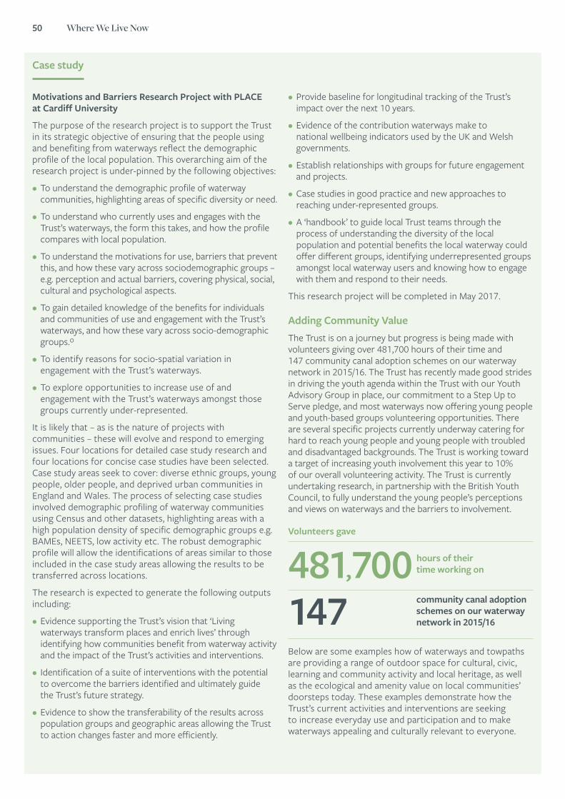
50 Where We Live Now
Case study
Motivations and Barriers Research Project with PLACE at Cardiff University
The purpose of the research project is to support the Trust in its strategic objective of ensuring that the people using and benefiting from waterways reflect the demographic profile of the local population. This overarching aim of the research project is under-pinned by the following objectives:
• To understand the demographic profile of waterway communities, highlighting areas of specific diversity or need.
• To understand who currently uses and engages with the Trust’s waterways, the form this takes, and how the profile compares with local population.
• To understand the motivations for use, barriers that prevent this, and how these vary across sociodemographic groups – e.g. perception and actual barriers, covering physical, social, cultural and psychological aspects.
• To gain detailed knowledge of the benefits for individuals and communities of use and engagement with the Trust’s waterways, and how these vary across socio-demographic groups.º
• To identify reasons for socio-spatial variation in engagement with the Trust’s waterways.
• To explore opportunities to increase use of and engagement with the Trust’s waterways amongst those groups currently under-represented.
It is likely that – as is the nature of projects with communities – these will evolve and respond to emerging issues. Four locations for detailed case study research and four locations for concise case studies have been selected. Case study areas seek to cover: diverse ethnic groups, young people, older people, and deprived urban communities in England and Wales. The process of selecting case studies involved demographic profiling of waterway communities using Census and other datasets, highlighting areas with a high population density of specific demographic groups e.g. BAMEs, NEETS, low activity etc. The robust demographic profile will allow the identifications of areas similar to those included in the case study areas allowing the results to be transferred across locations.
The research is expected to generate the following outputs including:
• Evidence supporting the Trust’s vision that ‘Living waterways transform places and enrich lives’ through identifying how communities benefit from waterway activity and the impact of the Trust’s activities and interventions.
• Identification of a suite of interventions with the potential to overcome the barriers identified and ultimately guide the Trust’s future strategy.
• Evidence to show the transferability of the results across population groups and geographic areas allowing the Trust to action changes faster and more efficiently.
• Provide baseline for longitudinal tracking of the Trust’s impact over the next 10 years.
• Evidence of the contribution waterways make to national wellbeing indicators used by the UK and Welsh governments.
• Establish relationships with groups for future engagement and projects.
• Case studies in good practice and new approaches to reaching under-represented groups.
• A ‘handbook’ to guide local Trust teams through the process of understanding the diversity of the local population and potential benefits the local waterway could offer different groups, identifying underrepresented groups amongst local waterway users and knowing how to engage with them and respond to their needs.
This research project will be completed in May 2017.
Adding Community ValueThe Trust is on a journey but progress is being made with volunteers giving over 481,700 hours of their time and 147 community canal adoption schemes on our waterway network in 2015/16. The Trust has recently made good strides in driving the youth agenda within the Trust with our Youth Advisory Group in place, our commitment to a Step Up to Serve pledge, and most waterways now offering young people and youth-based groups volunteering opportunities. There are several specific projects currently underway catering for hard to reach young people and young people with troubled and disadvantaged backgrounds. The Trust is working toward a target of increasing youth involvement this year to 10% of our overall volunteering activity. The Trust is currently undertaking research, in partnership with the British Youth Council, to fully understand the young people’s perceptions and views on waterways and the barriers to involvement.
Below are some examples how of waterways and towpaths are providing a range of outdoor space for cultural, civic, learning and community activity and local heritage, as well as the ecological and amenity value on local communities’ doorsteps today. These examples demonstrate how the Trust’s current activities and interventions are seeking to increase everyday use and participation and to make waterways appealing and culturally relevant to everyone.
Volunteers gave
481,700 hours of their time working on
147 community canal adoption schemes on our waterway network in 2015/16
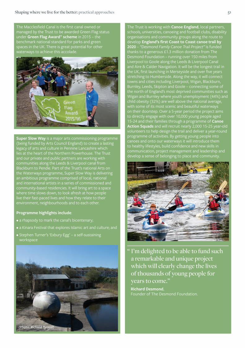
Shaping where we live for the better: practical approaches 51
The Macclesfield Canal is the first canal owned or managed by the Trust to be awarded Green Flag status under Green Flag Award® scheme in 2015 – the benchmark national standard for parks and green spaces in the UK. There is great potential for other waterways to achieve this accolade.
Super Slow Way is a major arts commissioning programme (being funded by Arts Council England) to create a lasting legacy of arts and culture in Pennine Lancashire which lies at the heart of the Northern Powerhouse. The Trust and our private and public partners are working with communities along the Leeds & Liverpool canal from Blackburn to Pendle. Part of the Trust’s national Arts on the Waterways programme, Super Slow Way is delivering an ambitious programme comprised of local, national and international artists in a series of commissioned and community-based residencies. It will bring art to a space where time slows down, to look afresh at how people live their fast-paced lives and how they relate to their environment, neighbourhoods and to each other.
Programme highlights include:
•arhapsodytomarkthecanal’sbicentenary;
•aKinaraFestivalthatexploresIslamicartandculture;and
•StephenTurner’s‘ExburyEgg’–aself-sustainingworkspace
The Trust is working with Canoe England, local partners, schools, universities, canoeing and football clubs, disability organisations and community groups along the route to develop England’s first Coast to Coast canoe trail by 2020 – “Desmond Family Canoe Trail Project” is funded thanks to a generous £1.3 million donation from The Desmond Foundation – running over 150 miles from Liverpool to Goole along the Leeds & Liverpool Canal and Aire & Calder Navigation. It will be the longest trail in the UK, first launching in Merseyside and over five years stretching to Humberside. Along the way, it will connect towns and cities including Liverpool, Wigan, Blackburn, Burnley, Leeds, Skipton and Goole – connecting some of the north of England’s most deprived communities such as Wigan and Burnley where youth unemployment (44%) and child obesity (32%) are well above the national average, with some of its most scenic and beautiful waterways on their doorstep. Over a 5-year period the project aims to directly engage with over 10,000 young people aged 15-24 and their families through a programme of Canoe Action Squads and will recruit nearly 2,000 15-25 year-old volunteers to help design the trail and deliver a year-round programme of activities. By getting young people into canoes and onto our waterways it will introduce them to healthy lifestyles, build confidence and new skills in communication, project management and leadership and develop a sense of belonging to place and community.
“ I’m delighted to be able to fund such a remarkable and unique project which will clearly change the lives of thousands of young people for years to come.”
Richard Desmond, Founder of The Desmond Foundation.
(Photo: Richard Tymon)

52 Where We Live Now
Dr Samantha Walton Lecturer in English Literature, Writing and the Environment, Bath Spa University, recipient of the British Academy Rising Star Engagement Award
Landscaping Change: Exploring the transformation, reconstitution and disruption of environments through the arts, humanities and social sciences
Changes in landscapes inevitably impact on local communities. Whether they are caused by environmental events, regeneration and conservation initiatives, or development spurred by business, changes to the material fabric of place can disturb the experience of those whose sense of identity and feelings of belonging may be entangled with that place.
Through the support of the British Academy’s Rising Star Engagement Award, over the course of 2015 and 2016 I hosted a series of events around Bristol and Bath that aimed to foster critical discussion and performative evaluation of landscapes and places under processes of change. While the main focus of ‘Landscaping Change’ has been to explore the values of place at a local and personal level, the environmental and social challenges Bristol currently faces are also being faced by communities in nations across the world, in the context of climate change and devastating threats to green and blue environments and the cultures that depend on them.
The value of connecting those interested in local environments from very different backgrounds and perspectives comes from the recognition of how rich and layered what we call ‘place’ really is. A place is – in simple terms – a physical area demarcated in some way, but how we demarcate that place may be cultural, personal, ecological and political.

Shaping where we live for the better: practical approaches 53
“ Fast and interconnected public transport links are vital in reducing the traffic and pollution caused by private transport, but at the local level, the MetroBus development around the M32 caused anger, frustration and grief amongst groups and communities deeply committed to environmental sustainability and positive changes in land use.”
Do we define the place by its usage (which is subject to historical change), or its meaning to the people who live there (who may move in or out of the area, or whose views may be excluded from dominant narratives of that place)? Is place to be defined geographically according to the river that waters it, or in a wider context; by bioregion perhaps? How will such ways of thinking of place withstand alterations to the water table caused by damming or deviating a river, or indeed by far-reaching climate change events? Thinking about ‘place’ also necessitates concern and consideration for the overlapping and interconnected networks in which place is implicated: regional, national, natural, economical, ecological, and global.
As 2015 European Green Capital, Bristol City Council launched a range of green regeneration policies and activities focused on enhancing the city’s infrastructure sustainably, improving access to natural environments that sustain health and wellbeing, and enriching habitats for wildlife. Although the Green Capital is, in my opinion, a fantastic initiative that aims to make environmental issues publically engaging and essential to policy and local politics, at a grassroots level responses to the changes connected to the award have been mixed. For example, in the first of the Landscaping Change events, a representative of the Blue Finger Alliance, Maddy Longhurst, reflected on the community organising and protesting against the MetroBus initiative that took place in east Bristol during 2015. MetroBus is an express bus service that aims to connect UK cities by rapid bus transport using segregated bus lanes. Fast and interconnected public transport links are vital in reducing the traffic and pollution caused by private transport, but at the local level, the MetroBus development around the M32 caused anger, frustration and grief amongst groups and communities deeply committed to environmental sustainability and positive changes in land use. This is because the development built directly on top of allotments and small holdings; green belt land; fields in use by the exemplary community farming project, Feed Bristol; and underneath it all, a strip of Grade 1 agricultural soil that gives the area the name ‘the blue finger’.
Objections to MetroBus were founded on local knowledge and expertise, while the alliance membership connected a range of knowledges, including agroecology, soil science, policy, planning, geography, heritage and psychology. It also – and as importantly – was animated by deeply felt attachments to place, understood not just as a static backdrop for human activity, but as an interconnected ecology, supporting the flourishing of human, animal and biological life, on the foundations of an exceptional quality of living soil.
While a crude understanding of the objections to the MetroBus development might frame the protesters as elevating local needs and attachments over urgent global crises – chief amongst which is the need to radically reduce our use of and dependence on fossil fuels – the confrontation revealed more subtle challenges to understanding the relationship between the local and the global in the context of place. Attachments to the land built on by the M32 went far beyond nostalgia for a lost sense of connectedness with nature, or a ‘nimbyist’ demand that the messy, material realities of infrastructure be obscured and located elsewhere. Instead, the campaign to save the site connected what was taking place at the local level with connected struggles nationally and globally, including raising awareness about threats to soil fertility; urban and peri-urban land use policies; the carbon cost of food production and its transportation; and building resilience through sustainable practices.

54 Where We Live Now
The campaign has been instructive in my own thinking about what landscaping change might mean, and what the series of events and network building might hope to achieve. Interconnected thinking – what Timothy Morton calls ‘the ecological thought’ – is, I believe, vital as it reminds us that local issues can never be truly contained within the ‘local’60. Ursula Heise’s careful analysis of the ways in which place – based attachments have been seen as vital to grounding environmental ethics and responsibility has also influenced me, and the thinking behind the project, considerably.
As Heise contends: In the context of rapidly increasing connections around the globe, what is crucial for ecological awareness and environmental ethics is arguably not so much a sense place as a sense of planet – a sense of how political, economical, technological, social, cultural, and ecological networks shape daily routines. … As a consequence, a wide range of different experiences and practices can serve as the point of departure for understanding these networks – some that are associated with a conventional ‘sense of place’, others that are unrelated to it.61
The fact that affective attachments to people and place were integral to building the campaign did not mean that arguments were parochial or naively resistant to change: the ‘sense of place’ and place-based attachments that inspired immediate and urgent resistance to development served as a point of departure for understanding global networks in which the soil, people, plants, industries and transport systems that make up a ‘place’ are imbricated.
Land use decisions made at a local level can seek to positively contribute to the development of more resilient, less destructive relations between humans, non-human animals and the biological, geological and chemical materialities of place.
Landscaping Change events connected writers and artists with early career researchers and, most importantly, local community groups seeking to influence policy to ensure that changes to environments work for local wildlife and connected ecologies and for local people.62 The aim was to spark discussion by organising collaborative and multidisciplinary discussion of pressing issues: building green economies; understanding how sustainable development can meet local cultural needs; and advancing environmental legislation which ensures nature’s recovery and enhances human wellbeing. Connecting researchers and practitioners working across traditional disciplinary divides was essential, as was affirming the role of subjective and creative responses to environments under processes of change.
At the Landscaping Change conference, for example, Jo Philips (PhD researcher, Manchester Metropolitan University) considered the role of public engagement in the design of transport infrastructure, specifically the landscapes of HS2. Her project explores the value of using knowledge gained from public engagement, including ‘tactics of listening, walking, cartography and psychogeography’ – concerning emotional and psychological responses to environments – over and above more polarising and disconnecting methods of conceptualising changing landscapes in public consultation, such as digital mock-ups and before-and-after simulations. Phillips proposes that ‘an atlas of qualitative local knowledge and subjective experience could enable professionals to discern key narratives of landscape to inform decision-making’, involving local people rather than locking them out.
In another presentation, collaboration between theatre _ makers, policymakers, planners and geographers was explored and evaluated. Bath Spa University’s Professor of Environmental Humanities, Owain Jones, and Dr Katherine Jones, a Research Assistant on the AHRC Towards Hydrocitizenship project, introduced the characters Proxi and Peri: these figures are ‘the tides made flesh’, and were developed by the Desperate Men Theatre Company to promote awareness of and attachment to Bristol’s extraordinary tides. As the Hydrocitizenship presentation asserted, ‘[t]ides are a key part of Bristol’s hydrological past, present and future.’ The aim of collaborating with theatre-makers is to:
seed eye-catching threads into the crowded ecologies of narrative that make up everyday culture in neighbourhoods and the wider city. And within those narrative threads, develop notions of hydrocitizenship (awareness of our water connections and responsibilities) as a subset of ecological citizenship.
“ The ‘sense of place’ and place-based attachments that inspired immediate and urgent resistance to development served as a point of departure for understanding global networks in which the soil, people, plants, industries and transport systems that make up a ‘place’ are imbricated.”
60 Timothy Morton, The Ecological Thought. Cambridge, Mass.: Harvard UP, 2010.61 Ursula Heise, Sense of Place and Sense of Planet. Oxford: OUP, 2008. p.5562 See https://landscapingchange.wordpress.com/
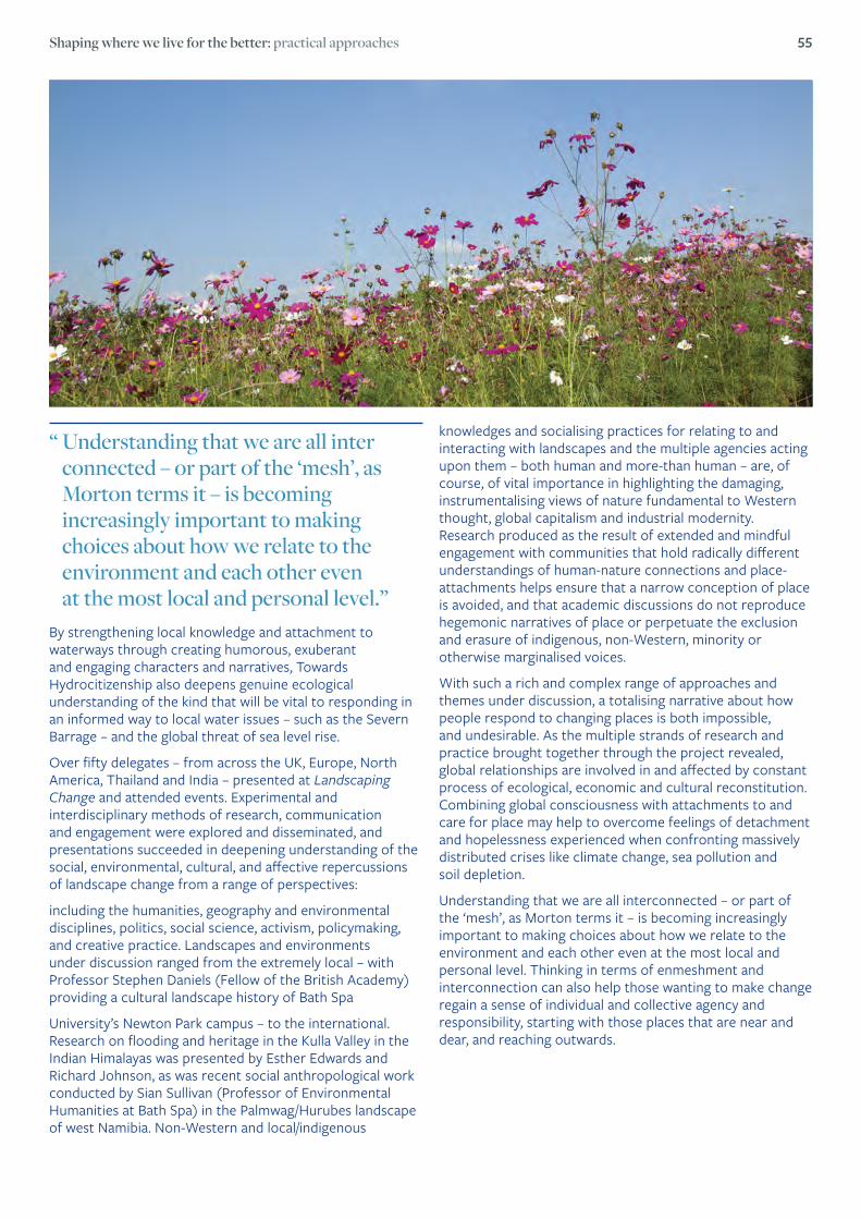
Shaping where we live for the better: practical approaches 55
By strengthening local knowledge and attachment to waterways through creating humorous, exuberant and engaging characters and narratives, Towards Hydrocitizenship also deepens genuine ecological understanding of the kind that will be vital to responding in an informed way to local water issues – such as the Severn Barrage – and the global threat of sea level rise.
Over fifty delegates – from across the UK, Europe, North America, Thailand and India – presented at Landscaping Change and attended events. Experimental and interdisciplinary methods of research, communication and engagement were explored and disseminated, and presentations succeeded in deepening understanding of the social, environmental, cultural, and affective repercussions of landscape change from a range of perspectives:
including the humanities, geography and environmental disciplines, politics, social science, activism, policymaking, and creative practice. Landscapes and environments under discussion ranged from the extremely local – with Professor Stephen Daniels (Fellow of the British Academy) providing a cultural landscape history of Bath Spa
University’s Newton Park campus – to the international. Research on flooding and heritage in the Kulla Valley in the Indian Himalayas was presented by Esther Edwards and Richard Johnson, as was recent social anthropological work conducted by Sian Sullivan (Professor of Environmental Humanities at Bath Spa) in the Palmwag/Hurubes landscape of west Namibia. Non-Western and local/indigenous
knowledges and socialising practices for relating to and interacting with landscapes and the multiple agencies acting upon them – both human and more-than human – are, of course, of vital importance in highlighting the damaging, instrumentalising views of nature fundamental to Western thought, global capitalism and industrial modernity. Research produced as the result of extended and mindful engagement with communities that hold radically different understandings of human-nature connections and place-attachments helps ensure that a narrow conception of place is avoided, and that academic discussions do not reproduce hegemonic narratives of place or perpetuate the exclusion and erasure of indigenous, non-Western, minority or otherwise marginalised voices.
With such a rich and complex range of approaches and themes under discussion, a totalising narrative about how people respond to changing places is both impossible, and undesirable. As the multiple strands of research and practice brought together through the project revealed, global relationships are involved in and affected by constant process of ecological, economic and cultural reconstitution. Combining global consciousness with attachments to and care for place may help to overcome feelings of detachment and hopelessness experienced when confronting massively distributed crises like climate change, sea pollution and soil depletion.
Understanding that we are all interconnected – or part of the ‘mesh’, as Morton terms it – is becoming increasingly important to making choices about how we relate to the environment and each other even at the most local and personal level. Thinking in terms of enmeshment and interconnection can also help those wanting to make change regain a sense of individual and collective agency and responsibility, starting with those places that are near and dear, and reaching outwards.
“ Understanding that we are all inter connected – or part of the ‘mesh’, as Morton terms it – is becoming increasingly important to making choices about how we relate to the environment and each other even at the most local and personal level.”
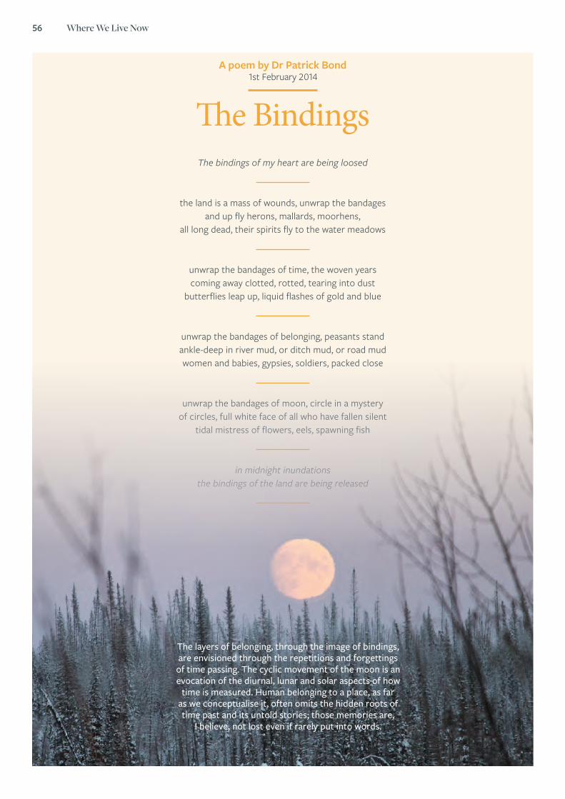
56 Where We Live Now
A poem by Dr Patrick Bond 1st February 2014
The BindingsThe bindings of my heart are being loosed
the land is a mass of wounds, unwrap the bandages and up fly herons, mallards, moorhens,
all long dead, their spirits fly to the water meadows
unwrap the bandages of time, the woven years coming away clotted, rotted, tearing into dust
butterflies leap up, liquid flashes of gold and blue
unwrap the bandages of belonging, peasants stand ankle-deep in river mud, or ditch mud, or road mud women and babies, gypsies, soldiers, packed close
unwrap the bandages of moon, circle in a mystery of circles, full white face of all who have fallen silent
tidal mistress of flowers, eels, spawning fish
in midnight inundations the bindings of the land are being released
The layers of belonging, through the image of bindings, are envisioned through the repetitions and forgettings
of time passing. The cyclic movement of the moon is an evocation of the diurnal, lunar and solar aspects of how
time is measured. Human belonging to a place, as far as we conceptualise it, often omits the hidden roots of time past and its untold stories; those memories are,
I believe, not lost even if rarely put into words.

Shaping where we live for the better: practical approaches 57
Case study by Jess Ratty, Head of Campaigns, and Jason Nuttall, Head of Funding, Crowdfunder
How the crowd is taking ownership of place, policy and opportunity
Online action is shaping the physical world around us. A not-so-quiet uprising is taking place across the UK, with people uniting to transform the places they live in. Why is this happening, and how do people now have the opportunities to shape their own environments in ways they didn’tbefore?Crowdfunding is enabling people to take matters into their own hands in ways we have never seen so prolifically in the UK. The innovation in finance and the access to funding from the crowd means communities are able to come together and democratically pledge, and in many ways, vote publicly with their wallets for the change they themselves wish to see in their local areas.
Crowdfunding is a potential solution to a myriad of issues, not least, cuts to public funding and lack of local asset management, although it is not necessarily a replacement for public funding. It also brings community action, ownership and solidarity, which are important for a sense of community cohesion and satisfaction63.
Everything and anything from large-scale community share issues to publicly accessible musical instruments, bringing joy to the masses is being funding by the crowd to improve pockets of society.
People want to own and influence their environments. For Hastings Pier, (above) residents have raised over £137,000 from more than 900 people already in 2016, to boost reserves following a £14.3m renovation. Named the People’s Pier, it has attracted support from almost 4,000 community shareholders – transforming one of the world’s oldest piers into one of the newest. Opening up community shares enabled the public to get involved in the long-term sustainability and security of the iconic location for businesses, tourism and their future local economy.
Crowdfunding turned this pier into a community-owned asset – giving the people influence and ownership of their place.
63 Community Life Survey, Cabinet Office (2016)
900 Residents of Hastings
Raised £137,000
Hastings Pier

58 Where We Live Now
Case study
There are thousands of community projects supporting people to gain a sense of control by reaching out to change their immediate environments. Another example is the Herne Hill Piano in London. Entertaining the crowds for years, keeping children occupied, and bringing music to the ears of locals, this piano was worn out, tired and falling into disrepair. The community raised £5,900 from over 180 backers in return for thank you cards and the chance to have your name on the piano as a “reward” for a pledge of cash.
Not all projects succeed, and there are many reasons why this might be the case. Mostly, civic crowdfunding projects stand on the shoulders of the communities they serve. If the target community does not think it a good idea, or feels that the community will not benefit from the project, it will not be funded. Public validation is important for more reasons than just raising core cash – it is needed to unlock further money from Councils and grant-makers too via Crowdfunder’s innovative fund-distribution services through a variety of brands, Councils and funding partners.
Not only are communities coming together to fund what is collectively important to them, they are using the crowdfunding process to request and validate further pledges of money from their local Councils and public bodies, potentially mitigating the impacts of ongoing funding
cuts. Successful crowdfunding can be a lot easier for well-connected communities with good digital skills, so it is important to engage and enable all communities to explore crowdfunding options with a view to engaging with local authorities. With the support and validation of the crowd, projects can use that groundswell of public support to apply for match funding from public bodies for their projects by showing just how many people are behind an idea and want it to become a reality. This can constitute a positive mix of collaboration, creating huge impacts on communities, policy and engagement.
Plymouth City Council was the first Council in the UK to partner with Crowdfunder in order to support local community, business, sports and charities through crowdfunding. By asking projects to crowdfund they then pledged funding on top to make ideas happen. The campaign to date has raised over £450,000 for the city with over £60,000 pledged directly to projects validated by the crowd shaping their local place.
Hannah Sloggett, Neighbourhood Planning Manager, Plymouth City Council said of the partnership and its impacts, “Working with Crowdfunder to distribute funding into crowdfunding projects has streamlined the administration that is normally involved in running a Council-led grant process. For Plymouth City Council, it is a way of publicly validating projects alongside Councillor made decisions.” This is an example of collaborative, mutually-beneficial local area development.
The collaboration is growing fast, with place transformations taking shape across the whole of the UK. Angus Council in Scotland, Birmingham Council and Dorset Council are following the same route, launching crowdfunding campaigns to fund and support the projects their communities are publicly backing. Crowdfunding is a two-way relationship that empowers people to shape their places, and offers public bodies a clear mechanism with which to engage their communities.
Piano in Herne Hill, London

Shaping where we live for the better: practical approaches 59
Case study by Maria Adebowale-Schwarte, Director, Living Space Project
People, Place and Collaborative Research
For some, running a place-making think tank and consultancy is the opposite of creative and collaborative. It smacks of policy wonkery that is purposely unintelligible, except for a select few.
But if the research is done properly, with a collaborative and cross-sector approach, you eliminate siloed approaches, and instead have a view to creating enthusiasm for getting involved in the research. At Living Space Project our methodology remains rigorous and equally, signed up to values and aims. That means facilitating the art of participatory co-created research, which seeks to develop learning and assets for everyone involved.
This is not easy. We know from the participants that there is nervousness and excitement around who gets to have a say about where they live and what that place needs to rejuvenate.
To fully realise that potential of participatory research we start with a framework to create a nexus of professions and community, social, private and public sectors. It means that the research, which the Living Space Project is commissioned to do, focuses on place-making where profit can be improved, but where and how the social roots of creating common good and prosperity can happen.
Our aim is to develop prosperity through economic, environmental, and social assets. So, our methodology is closely connected to a coalition of placemakers – communities and professionals. It means remaining aware of the differences in capabilities, resources, cultures and politics and working across boundaries, prejudices, suspicions of the other and connecting with a common aim of creating thriving cities and neighbourhoods for all.
We need to do this while presently operating in an arena impacted by the corrosive results of poor placemaking, the displacement of people, the loss of streets and the public realm.
A collaborative place-making agenda needs to navigate conflict and tackle the big ethical or policy complications that a government may ignore or exacerbate. For those interested in good place-making the focus must be on looking for equitable solutions, not only in the process but also in its outcomes.
Arguably, this means place-making needs to be co-created, co-owned and co-governed across and within communities and professions, funders, investors along with public government, social and private partners. A way for this to happen is to legitimise different levels of participation and decision-making either as part of a legal or social form of owning or by sharing the assets created by the research methodology and the potential of the actual place-making.
Our research inevitably looks at ‘evidence-based’, qualitative data and analysis that provides a context for policy development, on-the-ground practical and strategic urban place-making.
‘‘ A collaborative place-making agenda needs to navigate conflict and tackle the big ethical or policy complications that a government may ignore or exacerbate.”

60 Where We Live Now
Case Study
Street Art Paris ©Maria Adebowale-Schwarte, Living Space Project

Shaping where we live for the better: practical approaches 61
Case Study
We are commissioned to work with organisations to develop their urban place-making thinking, or look at ‘big picture’ local, global and international issues that have an impact on urban place-making such as – cities, community rights, parks, local economies, resilience, climate change, environment and equality. We do this by:
• Developing strategies, briefs and projects for; urban public realm, environment, green, spaces, housing, enterprise and local economies;
•Delivering action learning and qualitative research;
•Creating ‘pop up’ hubs to test ideas and projects;
• Facilitating collaborative stakeholder, community and cross-sector consultations;
• Setting up and facilitating community development programmes;
• Curating diverse small and large-scale interdisciplinary project and research teams;
•Providing trend and future forecasting, and policy reviews;
• Supporting neighbourhood planning, area strategies, project development; and
• Advising charitable foundations, funding and investment programmes.
The System – Eight Point AgendaThe system requires two fundamental elements:
• Understanding and tackling the roots of poverty is a challenge that has to unpack what you might hear me say are ‘tricky issues’ around creating and unlocking not only material resources, but allowing people to take part in social, economic and environmental decision-making.
• Sifting through conversations, and data for elements of place-making that tackles the roots of poverty, asset building and supporting resilient communities.
The System of 864, uses eight components together, or each one as a ‘stand-alone’. It is not a ‘one size fits all’ approach, rather it is a bespoke system carefully curated for each project we conduct. Practice, policy or research – country focused or city wide – at neighbourhood level or street scale. The System gives stakeholders the opportunity to address a broad range of place-making and green space issues: from asset building to master planning. It facilitates collaborative ways to highlight priorities, develop research that includes starting, piloting projects started, or testing them, community mapping – using film, photos and walks, and sharing the findings.
It’s a system based initially on a Living Space Project three-year partnership project SUSCIT (Citizens Science for Sustainability) funded by the EPSRC, and our co-partners Brunel University, and the University of Westminster.
It also includes a deep dive analysis of methodology models over the last ten years based on Citizen Science. One slightly lengthy way of defining citizen science is this:
• ‘a collaborative and participatory process that is inclusive of society – meaning public, communities, industry, professionals, and government – with the aim of developing and conducting public interest research that builds bridges between the sciences and the community, as well as policy, decision-making, design and planning.’
OutcomesElements of this process – such as the overall design and some of the particular tools and techniques used – may be directly applicable in other contexts.
There are some practical insights and pointers for working with multi-sector and community participants:
PartnershipsA crucial part of our research is to devise means of creating partnership and collaboration that trounce institutional and disciplinary silos, which all too often act as barriers between the participants whether a researcher, developer, local authority, practitioner or local communities.
64 http://livingspaceproject.com/how-we-work/
“ It’s a system based initially on a Living Space Project three-year partnership project SUSCIT (Citizens Science for Sustainability) funded by the EPSRC, and our co-partners Brunel University, and the University of Westminster.”
Public space, New York ©Maria Adebowale-Schwarte, Living Space Project

62 Where We Live Now
Case Study
This way we can create relationships that are equally beneficial, and all parties’ views are understood as valued and taken into consideration. This is not easy. Creating partnerships requires appreciation and understanding in every single research project of group processes and cultural sensitivities. It helps to build relationships with the principal ‘gatekeepers’ as they can be crucial in underpinning the success of diverse cross-sector dialogue, and in recruiting a diverse group of individuals with different professional and personal backgrounds to participate in the research. All of this is timely, but a crucial investment that builds relationships capable of providing invaluable insights into a sector, and personal social, political and cultural dynamics.
Trust & UnderstandingBuilding the partnerships also fosters an atmosphere of trust and understanding, which is very much required for action learning, ‘buy in’ and ongoing commitment, particularly to longer projects. Trust and understanding leverage maximum benefits from a project for all the stakeholders, but it does require open and honest, communication, consistency, respect and support.
Asset BuildingConstantly considering what the different participants will get out of the process, their motivations for engagement, and how people will benefit from the work. We look at action learning as a way of building or developing valuable skills, like film-making of space, understanding or developing master plans, redesigning charrettes so that real conversations can be had about a place, neighbourhood or a city. A big part of this is also recognising particular community members’ ability to give up unpaid time to take part in the project by providing child or care duty expenses, as well as stipends so they are not out of pocket.
Also, we work with clients and participants to see how we can develop, or sign post to resources, funding or information. This can turn a dumping ground between the church and playground into a community garden, or help a developer create a community advice group to expand the thinking on the design of the housing estate.
Legacy BuildingThe asset-building is part and parcel of the aim to create a stakeholder legacy. The legacy is one which is codesigned with maximum collaboration with all the local stakeholder organisations to see how the research and the relationship building within the project can provide significant spin-off benefits for the local community. The legacies are taking form in three ways:
• Access to knowledge, expertise and resources, through facilitating networking with a wider pool of stakeholders.
• Creating an additional channel of communication, brokering ways for community and others to discuss ideas and concerns with each other, local authority and other relevant agencies.
• Facilitating connections and conversations for the development of future place-making initiatives.
Visioning & Master PlanningVisioning how we unlock prosperity requires getting to grips with the role that urban places and spaces play as a material resource and as a critical social, economic and environmental asset. We use walks, photography, film-making, future forecasting games, real scale mapping and reviewing informal and formal urban plans. Apart from establishing future goals and addressing current and future issues, this kind of exercise is fundamental for community long-term decision-making, and cross-sector consensus building.
The collaborative, participatory research we do is not a soft option, but it works. It is ethical and hardedged, and a form of productive investment in improving where we live in towns, cities and villages. For me, it a research framework that works for place-making in a diverse society that creates good places for all.
Neighbourhood Festival, South bank London, ©Maria Adebowale-Schwarte, Living Space Project

The policy process is predominantly a sectoral one – policies for education, health, welfare, are largely designed on a national scale to affect change across all regions. Money and resources for policy implementation also flow from Whitehall according to this structure.
However, policy decisions have differential effects on different regions, places and communities. People continue to maintain powerful and meaningful associations to those places, at varying degrees of locality – their county, their town, village, or even their street. Is it possible for our political and policy processes to better take this into account?
Through Where We Live Now, the British Academy provides a rich variety of evidence that aligning the design and resourcing of policy-making to the scales at which individuals connect to places, irrespective of standard departmental or sectoral divisions, would produce more effective policies and improve people’s lives.
With thanks to the members of the working group for their support throughout this project. Secretariat: Jamiesha Majevadia, Helen Gibson, Lisa Davis, Natasha McCarthy (former)
Read morewww.wherewelivenow.comwww.britac.ac.uk/where-we-live-now
About the project


This publication is a collection of opinion pieces, case studies, poetry and imagery, towards a better understanding of the concept of place, its impact on people and relationships, and practical approaches towards policy. The views expressed are those of the authors, and do not represent an established position of the British Academy. The British Academy is an independent organisation with no party-political agenda or position.
The British Academy 10 - 11 Carlton House Terrace London SW1Y 5AH +44 (0)20 7969 5200
www.britac.ac.ukRegistered Charity: Number 233176
britac_news TheBritishAcademy Britacfilm BritishAcademy