Where Water Meets the land: the Rediscovery of the ...€¦ · the Rediscovery of the Waterfront...
9
23 Where Water Meets the land: the Rediscovery of the Waterfront Dieter Grau | Zeljka Carol Kekez The world is experiencing an explosion of design and celebra- tion of cultures on the water’s edge. Capitalizing on topograph- ical context, cities are commissioning architecturally distinctive landmarks and civic icons to honor interactions with their natu- ral resource, water – the raison d’être for different idiosyncratic urban identities. From the start, civilizations have flourished, declined and revitalized settlements on rivers, lakes, canals and on the more than 850,000 kilometres of coastline that mark the edges of the world’s continents and islands. In early days, the prosperous cradle of a sophisticated civilization, Mesopotamia, located in modern day Iraq and Syria, was situated between the life- giving rivers of Tigris and Euphrates. Also, the ancient socie- ties of Egypt, the Indus Valley and China lived in harmony with life-sustaining and spiritual qualities of water. Small local rivers in Tianjin, China, formerly used for irrigation and farm flooding, now serve as the new waterfront edge for the Zangjiawo resi- dential area. The restored ecological integrity of the river-canal makes it a community asset and a focal point for leisure and socializing for all generations. Throughout the world, cultural history has always been associated with hydrology. The science of aquaculture was also elemental to early societies in South America and in the Mexico Valley where the floating market gardens, chinampas, at the remains of the ancient Lake Xochimilco, are still in use. The man-made islands consisting of large planted rafts between the networks of canals allow for harvesting throughout the year. Historically, there is a long tradition of using water as a sculptural element and object of reverence, an inspiration for creativity, defense, art, agriculture and tourism; at the same time, water power has been har- nessed for many centuries for entrepreneurial activities. In the process of settlement, cities such as Venice, Amsterdam, Suzhou and Birmingham thrived on the technology of artificial waterways used for trade, transportation and industry. The mercantile cities of London, Paris, New York, Buenos Aires and Shanghai continue to be lively destinations celebrated for vibrant industrial and civic waterfront identities. Since the late 1980s, the river Thames provided the impetitus for developing the Paddington Basin, The Docklands and the Thames Barrier Park, regenerating some of the most deprived parts of the city and attracting high profile capital investors. Anchored by the bustling water’s edge, Tokyo, Chicago and Hong Kong also owe their successful legacies to water routes and the result- ant expansion of waterfront commerce, recreation and cultural activities. Renowned for its Victoria Harbour skyline, Hong Kong attracts people to the waterfront, by maritime approach as much as by land, while the Lake Michigan, Chicago and Ca- lumet Rivers provide a dynamic network of water infrastructure contributing to Chicago’s evolving identity. In a similar fashion, Honshu - Island, Tokyo Bay and the Pacific Ocean distinguish Tokyo’s waterfront as the premier intersection of natural and built environment. Creating a compelling reinterpretation of the water’s edge, islands like Singapore and Stockholm have flourished as thriving waterfront locations. They offer world-class cultural, commercial, recreational and residential amenities near water and encourage ecological exploration of this precious natural resource. In the case of Stockholm, intrinsic natural resources such as the Stockholm Archipelago, Lake Mälaren, the Baltic Sea and the Riddarfjärden Bay offer a strong sense of place for the waterfront itself, blurring boundaries between water and built environment. Looking back in history shows that the im- A highly polluted irrigation canal has been restored as a 1-kilometre- long river which creates an attractive clean waterscape for all gen- erations and a front to the housing estate of Zhiangijawo in Tianjin, China. The banks are softly moulded and planted, and the water is acces- sible in many places by boardwalks, steps and ramps.
Transcript of Where Water Meets the land: the Rediscovery of the ...€¦ · the Rediscovery of the Waterfront...

22 23
Where Water Meets the land: the Rediscovery of the WaterfrontDieter Grau | Zeljka Carol Kekez
The world is experiencing an explosion of design and celebra-tion of cultures on the water’s edge. Capitalizing on topograph-ical context, cities are commissioning architecturally distinctive landmarks and civic icons to honor interactions with their natu-ral resource, water – the raison d’être for different idiosyncratic urban identities.
From the start, civilizations have flourished, declined and revitalized settlements on rivers, lakes, canals and on the more than 850,000 kilometres of coastline that mark the edges of the world’s continents and islands. In early days, the prosperous cradle of a sophisticated civilization, Mesopotamia, located in modern day Iraq and Syria, was situated between the life-giving rivers of Tigris and Euphrates. Also, the ancient socie-ties of Egypt, the Indus Valley and China lived in harmony with life-sustaining and spiritual qualities of water. Small local rivers in Tianjin, China, formerly used for irrigation and farm flooding, now serve as the new waterfront edge for the Zangjiawo resi-dential area. The restored ecological integrity of the river-canal makes it a community asset and a focal point for leisure and socializing for all generations. Throughout the world, cultural history has always been associated with hydrology. The science of aquaculture was also elemental to early societies in South America and in the Mexico Valley where the floating market gardens, chinampas, at the remains of the ancient Lake Xochimilco, are still in use. The man-made islands consisting of large planted rafts between the networks of canals allow for harvesting throughout the year. Historically, there is a long tradition of using water as a sculptural element and object of reverence, an inspiration for creativity, defense, art, agriculture and tourism; at the same time, water power has been har-nessed for many centuries for entrepreneurial activities.
In the process of settlement, cities such as Venice, Amsterdam, Suzhou and Birmingham thrived on the technology of artificial waterways used for trade, transportation and industry. The mercantile cities of London, Paris, New York, Buenos Aires and Shanghai continue to be lively destinations celebrated for vibrant industrial and civic waterfront identities. Since the late 1980s, the river Thames provided the impetitus for developing the Paddington Basin, The Docklands and the Thames Barrier Park, regenerating some of the most deprived parts of the city and attracting high profile capital investors. Anchored by the bustling water’s edge, Tokyo, Chicago and Hong Kong also owe their successful legacies to water routes and the result-ant expansion of waterfront commerce, recreation and cultural activities. Renowned for its Victoria Harbour skyline, Hong Kong attracts people to the waterfront, by maritime approach as much as by land, while the Lake Michigan, Chicago and Ca-lumet Rivers provide a dynamic network of water infrastructure contributing to Chicago’s evolving identity. In a similar fashion, Honshu- Island, Tokyo Bay and the Pacific Ocean distinguish Tokyo’s waterfront as the premier intersection of natural and built environment.
Creating a compelling reinterpretation of the water’s edge, islands like Singapore and Stockholm have flourished as thriving waterfront locations. They offer world-class cultural, commercial, recreational and residential amenities near water and encourage ecological exploration of this precious natural resource. In the case of Stockholm, intrinsic natural resources such as the Stockholm Archipelago, Lake Mälaren, the Baltic Sea and the Riddarfjärden Bay offer a strong sense of place for the waterfront itself, blurring boundaries between water and built environment. Looking back in history shows that the im-
A highly polluted irrigation canal has been restored as a 1-kilometre-long river which creates an attractive clean waterscape for all gen-erations and a front to the housing estate of Zhiangijawo in Tianjin, China.
The banks are softly moulded and planted, and the water is acces-sible in many places by boardwalks, steps and ramps.

24 25
portance of water to a society has not changed much. Working in concert with nature to emphasize the cycle of life was an in-herent and practical matter for our predecessors. Today, water is not only essential for life, it is imperative to mimic its natural systems to reintegrate waterfront improvements into the sur-rounding urban fabric as socially and ecologically responsible developments.
In one of the greatest human migrations of modern times, peo-ple are rediscovering coastlines around the world, particularly those in Asia and Africa. In the 1950s, New York City was the planet’s only megacity. Today, there are 14 coastline megacities with more than 10 million inhabitants, while two-fifths of the world’s major cities are located near water.1 Significantly, future population growth patterns are intensely focused on urban wa-terfronts of less economically developed countries. In areas of North Africa and the Middle East, where access to safe drink-ing water is scarce, waterfront vitality is continually challenged by social deprivation and physical dereliction. Resuscitating the river Fez in Morocco is an example of a rehabilitation effort combining practical solutions for infrastructure, social, econom-ic and environmental concerns at the water’s edge. The goal is to enhance regional water quality while addressing the lack of open public space, overpopulation and an aging infrastructure within the Medina of Fez, the historic city.
The project consists of critical interventions strategically phased to enhance water quality, remediate contaminated sites, create open spaces, and build on existing resources for economic development. According to the Régie Autonome Distribution d’Eau & Électricité de Fés (RADEEF), the Depart-ment of Water and Power of the Municipality of Fez, “the
overall effect is a master plan that elevates the river into an urban infrastructure for bridging the gap between the needs of a 21st-century population and the historical standards for preserving the integrity of a UNESCO World Heritage designa-tion.”2
The successful transformation of Fez and other waterfront ef-forts worldwide depends on a dynamic and farsighted vision, flexible implementation plans and a commitment to sustainable initiatives. In the case of Dubai, the world’s fastest growing city – at least until a recent economic bust – the waterfront is a home to ambitious designs for some of the world’s largest artifi-cial islands. Though impressive in scale and imagination, these illustrious land reclamation efforts present a challenge for the health of the Persian Gulf. Though environmentalists speculate of their potential to cause profound ecological transformations, only time will reveal true lessons and set the stage for new expressions of city aspirations.
The 35-hectare Dubai Business Bay site located adjacent to the proposed extension of the Dubai Creek lies some 10 kilometres west of the existing Central Business District (CBD) of Dubai and is about 7 kilometres from the airport. The waterfront plan-ning and design for the Business Park and Dubai Creek Exten-sion, which attracts people and uses to the wate’s edge for cul-tural, recreational and residential developments was a serious challenge considering harsh local climatic conditions. In an ef-fort to offer a counter example to the big palm island projects, Atelier Dreiseitl, a planning office for water schemes based in Überlingen, Germany, collaborated, from the inception of the project, with ecological specialists applying sustainable design approaches to generate a clean and healthy waterscape at the
The extension of the Dubai Creek forms the edge of the Dubai Business Bay Development and creates a high potential for activat-ing the waterfront and implementing a design which increases the outdoor comfort for the people.
REDISCOVERY OF THE WATERFRONT
26 27
water’s edge. As the Dubai Creek already faces water quality problems, the concept was based on tidal energy without the use of pumps.
Envisioned as a place for pedestrian and bicycle experience, the promenade offers opportunities for enjoying nature, people-watching and active recreation. Cafés and ice cream parlours are situated along the water’s edge on the way to the Seaside Plaza. The promenade is staged in different lev-els stepping down to the waterfront adorned with an artistic paving pattern of a unique character. The Seaside Plaza is partially sheltered by trees and shading structures with a stage for public events. Highlighted through a series of water fea-tures, ending with a cascade into the creek, the plaza creates a refreshing atmosphere and emphasizes the visual axis with the Central Business District.
To optimize public use, large-scale waterfront master plans such as the Dubai waterfront should have appropriate phas-ing implementation steps. Often unveiled with the promise of recapturing land that has fallen into disrepair, large-scale wa-terfront master plans are difficult to implement and parts often never get built. The same excitement that captures the public’s imagination and the media’s attention for these mega plans can also bring about their demise. It is therefore crucial to have strong community outreach garnering broad public support.
Throughout history, similar experimental and thought-provok-ing urban development near the water’s edge led to compara-ble patterns of environmental use. Many waterfronts were left decrepit and disconnected from neighbouring communities. Important wetland habitats, coral reefs, rivers and estuaries
were being degraded or destroyed. Struggling with conflicting agendas, generations of government leaders have mismanaged long-term waterfront visions producing only mediocre results. That’s why in recent times, designers, engineers and municipal leaders have often been criticized for focusing solely on iconic waterfront projects occupying the land adjacent to the water-front rather than on a holistic waterfront experience embracing a delicate balance of the natural and built environment.
The Succession of Waterfront UsesWater and waterfront activities have always been strategic re-sources in the world, a symbol of life, and impetus for develop-ment of human settlements. Since the beginning, as engines of economic growth, cities have subscribed to evolving technolo-gies to alter the shape and the pace of their waterfront redevel-opment efforts. Many coastal communities owe their origin and prosperity to access to water, successful cultivation of land near water’s edge, related craftsmanship, industry and trade as well as water transport.
Initially, industrial ports were gateway destinations where the movement and exchange of goods were facilitated and urban services developed to promote maritime trade. Subsequently, a waterfront served as the focal point of activity, the place where water-related and urban-based functions merged. Anchoring liquid highways of worldwide commerce that carried people and goods from the heartlands to the coasts and then across the oceans, the waterfronts of the world adapted to ever- changing needs of a growing urban population.
Along the Columbia and Willamette Rivers in the Pacific North-west, Portland, Oregon, USA, served as the timber and grain ex-port gateway to Asia and the gold fields of California in the 19th century. Simular to other premier freshwater ports around the world, Portland has had its challenges in sustaining its harbour’s competitive standing and waterfront vitality. The accumulation of industrial waste and raw sewage, frequent flooding and pollu-tion, had forced businesses to locate away from the waterfront. Portland was not unique in its decline of port industry and its effort of constructing a seawall, built in 1927 and approximately 10 metres tall, to separate downtown businesses from the un-healthy waters and to protect its urban core from unpredictable water level fluctuations. Capitulating to the rise of automobile and presence of national interstates along its banks, further hindered Portland’s access to its waterfront as recently as in the 1970s. Since then, Portland’s River Renaissance programme has been focused on a long-term vision and a layered approach to waterfront development efforts. The strategy of linking Port-land’s diverse neighbourhoods and districts back to the rivers aided the city in creation of a dynamic waterfront skyline.
Previously predominantly industrial and then imbued with romanticism through the passage of time, waterfronts continue to be visually seductive settings and one of the main attractions in a city. They certainly should not be places to pass through in a car cutting people off from a distinctive public asset and opportunities for enjoyment, leisure and recreation. Many great cities throughout the world including New York, Seattle, Barce-lona and Paris, share a history of subordinating panoramic views to a drive-by experience. It was and still is not uncommon to encounter raised freeways, levees and parking lots dominating stunning waterfront views.
Portland, Oregon, served as the timber and grain export gateway to Asia but its port industry went into decline after the 1950s.
These swimming facilities on the Barcelona waterfront by ((archi-tect?)) are part of the urban park of xxx ((Olympic Port?))
REDISCOVERY OF THE WATERFRONT
In 1927, the city built a seawall of some 10 metres height to protect its urban core from unpredictable water level fluctuations. Today, the wall is deteriorating and hinders access to the water.
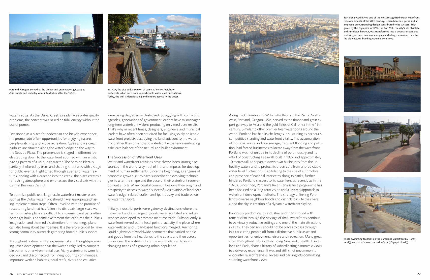
Barcelona established one of the most recognized urban waterfront redevelopments of the 20th century. Urban beaches, parks and an emphasis on outstanding design contributed to its success. Trig-gered by the Olympics in 1992, the Port Vell, the city’s old obsolete and run-down harbour, was transformed into a popular urban area featuring an entertainment complex and a large aquarium, next to the old customs building Aduana from 1902.

28 29
Barcelona’s old waterfront on the Mediterranean was much like those of many US cities such as Portland or Philadelphia on the Delaware: the area by the water was taken up by industrial land no longer in use and cut off from pedestrians by a high-way. However, Mayor Pasqual Maragall changed the face of Barcelona’s shores in his 15 years as mayor from 1982 to 1997. Growth in the city was once focused away from the waterfront, exemplified by the placement of its highway near the water, separated from the rest of Barcelona and making it a pol-luted site. However, local officials had the insight to approach their Olympics plan as a major restructuring of the city. The high-profile nature of the Games expanded the possibilities for transformation and urban improvements. The city’s plan for the 1992 Olympic Games put the highway underground, thus reconnecting the city with its waterfront. Maragall used the money the Games brought to reshape the city’s form by forging an open, well-defined relationship to the sea. On this newly-open land, he fashioned new beaches, parks and hous-ing neighbourhoods.
Porta Vell connects to the Ramblas, Barcelona’s central pedes-trian axis, via a pedestrian bridge that crosses a marina. Further east is Olympic Village, a new neighbourhood mix of public and private housing built from scratch: once the housing for athletes, it is now a new piece of the city. Integrating Olympic Village into the Barcelona fabric required reconstructing the highway so that it now ran underground, an arduous reorgani-zation of railroad, sewage and water infrastructure that proved incredibly valuable.
Seattle’s Alaskan Way Viaduct also continues to represent a barrier between Puget Sound, downtown and the waterfront.
To mitigate the waterfront’s automobile dominance, Seattle spent more than a decade in planning. It managed to secure nearly 7 hectares of contiguous waterfront property and bring them into public ownership. An extensive series of public meetings and development ideas resulted in a central water-front revitalization design that melded traditional waterfront uses with the tools of modern international trade. The central waterfront is now a prime example of how judicious real estate development can bolster an area’s economic health by attract-ing local residents as well as tourists and adding to the city’s cultural vitality through its mixed uses and interests.
In Bogota, Colombia, Enrique Penalosa, the former mayor from 1998 until 2001, resisted the accepted wisdom that more highways and roads for cars would bring economic health to his city. Instead, he rejected a plan to build an elevated beltway around Bogota and instead spent the money on paved bike-ways, sports facilities and parks. Since leaving office, Penalosa has been travelling the world, sharing his philosophy with cities like Jakarta, Dar Es Salaam, Mexico City, New York and San Francisco.
San Francisco’s shoreline on the bay was one of the busi-est areas of foot traffic in the world in the early 20th century. However, following the construction of the Bay Bridge and the decline of ferries, the area fell into decline. The rise of the automobile led to the Embarcadero Freeway being built in the 1960s, improving auto access to San Francisco but dividing the waterfront from downtown. Yet, the combination of the 1989 Loma Prieta earthquake and community opposition led to a total transformation of the shoreline and the creation of one of the most dynamic waterfronts in the United States.
The new urbanist and smart growth development on the water-front of the San Francisco Bay Area incorporates programming of the series of waterfront destinations such as the city of Her-cules, a company town founded in the late 19th century some 30 kilometres north-east of San Francisco and recently the site of several redevelopment efforts. The town is undergoing a metamorphosis into a transit-oriented mixed-use destination. Its Bayfront plan for 17 hectares of waterfront commercial land demonstrates how important it is to complement 4.5 hectares of open space with a density and mix of uses. The Bayfront will also include an intermodal transit centre with an Amtrak railway station and a ferry terminal connecting Hercules with downtown San Francisco. When fully built out, Bayfront is sup-posed to have 1,224 residential units, 3,900 square metres of retail space, 7,525 square metres of offices and 12,450 square metres of flex space adaptable for a variety of uses.
Commercial and residential developments in San Francisco and surrounding urban communities play an important role in form-ing a lively waterfront integrated with a range of public uses. Domination of waterfront sites by single use development such as housing, green space or industry squanders opportunities for creation of a vibrant waterfront.
Transformations of the waterfronts’ functional and spatial con-ditions were initially triggered by deindustrialization of the port enterprise and changes in the predominant trade routes. Global trends in the logistics of water transportation became apparent by the 1950s,3 but it was not until the later 1960s that the prob-lem of waterfront deterioration and the demand for revitaliza-tion policies achieved widespread recognition. The decline of ship building and its relocation from Europe and North America
to other regions of the world in the 1970s and 1980s, especially to Australasia where labour costs were lower, also contributed to the decline of many ports. The profound restructuring of the global trade, emergence of a new international geography and increased environmental regulations signaled a remarkable change in the economic vitality of waterfronts worldwide.
Innovation in global logistics and standardization of ship cargo further altered the functional and spatial configuration of world’s waterfronts. Today, 26 percent of all containers originate from China, while 85 percent of the world’s goods, services and capital investments are exchanged between the economically most powerful regions of Western Europe, North America and Asia. To relieve heavy congestion of transporta-tion activities in urban areas, port facilities were relocated and cities were left with degraded sites often triggering pro-grammes of urban renewal. One such example that vividly illustrates the separation of port and urban functions during the second half of the 20th century is the City of Hamburg.
The traditional harbour basins and riverside quays next to the Hamburg city centre continue to be used for conventional ship-ping and in recent times, goods storage. Without affecting the economic interests of the port, the City of Hamburg recovered the area for expansion of the city centre. When the project of HafenCity was formally established by the City Parliament Act of August 1997, Hamburg returned to the river Elbe after more than 100 years. Located on a 157-hectare site, HafenCity is one of the most prominent city centre development projects in Eu-rope and will increase the size of Hamburg’s city centre by 40 percent. Situated directly between the historic Speicherstadt warehouse district and the river Elbe, a new city will be com-
The Magellan-Terrassen, designed by Benedetta Tagliabue and Enric Miralles, are an urban plaza in the HafenCity development. They opened in 2005 and provide a transition from the city to the water.
The Alaskan Way Viaduct in Seattle is a double-decked elevated highway that carries up to 110,000 vehicles per day. It continues to represent a barrier between Puget Sound, downtown and the waterfront.
REDISCOVERY OF THE WATERFRONT

30 31
prised of a cosmopolitan mix of apartments, service businesses, culture, leisure, tourism and retail. An early competition won by KCAP proposed a mixed-use vibrant harbour development with strict ecological stewardship. The development of the entire area is anticipated to continue until 2020-2025.
In the context of worldwide economic restructuring, substitute in dock labour and the urban spatial framework of city and port, Hamburg and other cities worldwide struggle with abilities to accommodate changes and remain viable nodes in a global trade network. Modifications in the pattern of passenger trans-portation, importance of and challenges inherent in waterfront zoning and land use regulations, environmental policy, devel-opment incentives, community participation public-private partnership have all contributed to the abandonment of tradi-tional urban waterfronts and assisted in an evolution of its new identity.
The succession of different waterfront uses throughout the ages explains the connection between land use during urbani-zation efforts and current-day environmental degradation. To-day’s visible evidence of dilapidation in harbours represents an accumulation of effects over several hundred years of intensive developmental periods – agricultural, exploration and trade, industrial and urban renewal and renaissance. Ongoing envi-ronmental activists’ efforts and media presentation of images of dead fish, oiled birds and flaming rivers support sustain-able initiatives claiming that all is not right in a world driven by rapid industrialization, global competition and speculative land development.
Especially in the current situation of economic bust, evolving physical, social and environmental patterns and contributing factors of climate change, the access to clean water and sanita-tion services is vital for survival and healthy life. The popularity and necessity of living by the water’s edge still remains a funda-mental catalyst for re-discovery of the world’s waterfronts as attractive locations to live, work and play.
The city of Vancouver, British Columbia, surrounded by the wa-ters of the Burrard Inlet, the Fraser River and False Creek, has recently transitioned from a primary port city to a place of con-sistent economic growth. Central to the rebirth of Vancouver’s downtown lifestyle, the False Creek area is a model for defining Vancouver’s identity and revitalization success. The entire False Creek waterfront is united by the Seawalk, a recreational trail that maintains public access to the water at all points. Infusing a dynamic combination of activity and life into residential neigh-bourhoods while building connections with the University of British Columbia and to the Olympic Village, the Seawalk has been crucial to the success of False Creek’s rise to a premier ur-ban community. It demonstrates that waterfront redevelopment projects adjacent to downtown areas can succeed if they are well-planned, make the best use of the existing assets of the site, and have a sustained vision for long-term implementation.
“On the opposite side of the False Creek is Granville Island, an industrial reclamation and redevelopment project acclaimed as a highly successful public space. The city transformed this brownfield industrial site into a mixed-use development with residences, artist studios, light industry, a marina and a vast marketplace complete with a farmer’s market, a brewery, res-taurants and indoor and outdoor public space. The success that
is Granville Island represents a long-range joint planning strat-egy of the Canadian federal government and the City of Van-couver in the 1970s. The Granville Island Trust was founded in 1976 to manage the project, improving the physical space with walkways, roads and play areas. Then artists’ studios and retail began to fill the space, and today it is a magnet both for tour-ists and Vancouver’s inhabitants.”4 Vancouver – but also Porto and Copenhagen – are just some of the examples that rate as premier urban destinations with a poetic balance of temporary and permanent waterfront activities for all habitats and genera-tions, year-around.
Renaissance of Waterfront DevelopmentPort cities are among the oldest and most advantageous urban settlements. As gateways to the world and centres of com-merce in the early 20th century, waterfronts of the past were susceptible to abandonment due to a single-use function. Over several centuries, waterfronts have experienced complex pat-terns of growth and decline, yielding a substantial urban herit-age. In the 1990s, progressive industrial ports began to garner public enthusiasm to initiate mixed-use and green approaches to waterfront redevelopment. Focusing on water as the deter-mining design element, contemporary planning efforts, such as those in Oslo, seek to promote conservation, preservation and reuse of this precious natural resource.
Aker Brygge, a former shipyard shut down in 1982 and located at the Oslo Fjord, is an area in the City of Oslo close to the remarkable City Hall from 1950. Now a vibrant and densely packed mixed-use district with its public promenade, it offers an attractive public space. Amenities include protection from inclement weather and an area for strolling that has become the
focal point of the harbour and the entire city of Oslo. Tourists and locals enjoy the cafés, playgrounds, sittable steps, engag-ing public art, floating restaurants and small fishing boats that sell their catch at the dock. A few old industrial buildings were demolished, while several of the major workshop halls were rebuilt as retail shops.
Water’s edges continue to provide a natural setting for memo-rable urban destination. Presenting unparalleled opportunities for spaces that can accommodate diverse programmes, uses and people, the renewed planning energy has been focused on mixed-use waterfront communities. Respecting urban con-text and the ecological integrity of its watershed, waterfronts around the globe are experiencing urban renaissance and are now being revived as political, economic, educational and cultural centres.
A fusion of ground-breaking sustainable solutions also notably serves to obtain funding for waterfront redevelopment. Ha-vana, Cuba; Santos, Brazil; Bombay, India; and Dalian, China are among examples that illustrate the process of renewed commitment to improvements of water quality, reduction of noise and visual pollution, habitat restoration and green build-ing practices.
Ecological restoration and structural and spatial improvements involve high costs, progress is normally slow and returns on investments are not immediate, but, as Zanzibar illustrates, a new spirit of revival is broad and international financial aid is available. There is also an increasing awareness, both local and global, of the need to conserve elements of urban architectural heritage that are frequently in danger of being lost. Significant-
HafenCity with it s central location and a size of 157 hectares is one of the most prominent city centre development projects in Europe and will increase the size of Hamburg’s city centre by 40 percent.
Aker Brygge in Oslo, a former shipyard, has been redeveloped into a lively and densely packed mixed-use district.
REDISCOVERY OF THE WATERFRONT
The new quarter features a public promenade by the water, offering views of Oslo Fjord.1 Elbe Philharmonic Hall
2 Magellan Terrassen
12
3
4
3 Site for proposed Science Centre 4 International Maritime Museum

32 33
ly, a need exists to conserve and enhance the distinctiveness of urban, especially waterfront environments in developing countries, considering that revitalized waterfronts in advanced countries have often acquired an unwelcome similarity in their search for mixed-use renewal. Fostering public-private partner-ships in the context of long-range, comprehensive planning and development efforts, urban waterfronts seek to enhance links with the city centre.
The popularity of living, playing and working by the waterfront is evident through a creative interface between waterfront redevelopment and architectural place-making. Large invest-ments are being planned to have major influences on the form of cities – as spaces of promise. Some of the most attractive public spaces with unique character are Coney Island, New York City, Paris Rive Gauche, the area around the London Eye as well as Rome with the new Maxxi National Modern Art Museum on the river Tiber by Zaha Hadid which opened in 2010. Celebrated architectural icons like this one are regularly commissioned to generate an exciting waterfront experience with credibility and public enthusiasm for rediscovery. Another waterfront masterpiece by Zaha Hadid in Italy was envisioned to rejuvenate and regenerate the water’s area. Reggio Calabria, located on the Strait of Messina, decided to invest resources in the beautiful seaside kilometre of the harbour, to create a pres-tigious project that would become a symbol of the community. The complex, realized with private as well as public funding, will consist of two different buildings; a Museum of Mediter-ranean History and a multi-functional building for performing arts, with a library, auditoria, gym, craft workshop areas and a cinema. Keeping its connection with the Reggio Calabria area strong, the museum will be dedicated to one of the most
famous people coming from the region, Gianni Versace. With a design drawing inspiration from organic forms and aiming for distinctive shapes to be visible both from the sea and the coast, the complex is set to become one of the region’s most contem-porary landmarks.
Collaborating with architects of international prominence, world cities like Rome are generating renewed interest and excitement about ambitious designs near the water’s edge. However, designers sometimes lose the long-term perspective, paying too much attention to the physical infrastructure and not enough to the surrounding ecosystem, history and cultural heritage. They ignore the social fabric of the communities in the planning process, which frames the water as a public good. Significant criticism was levelled against lifeless architecture in recent times for its inability or unwillingness to deliver on the modernist promise of urban equality.
Some argue that Frank Gehry’s acclaimed Bilbao Guggenheim Museum, situated on the river Nervión, a symbol of urban redevelopment, is a short-term and short-sighted solution on a list of the waterfront redevelopment. Specifically disputed as a pure design statement, this bold waterfront icon is perceived as a barrier between the city centre and the river, consuming the prime waterfront real estate and limiting activity of the public space around it. Often, the Bilbao Guggenheim Museum is challenged as an example of private development dampening meaningful community involvement, discouraging public-private partnerships and limiting pedestrian experience to a singular destination.
Still, not every community can pull off what the Guggenheim Museum did. The redevelopment of the Abandoibarra district along the river Nervión has been the target of many of Bilbao’s long-term plans, yet to be implemented. The area of about 35 hectares is in a prime location identified as the new centre of the city. In former days, it was a zone dominated by shipyards, a container port facility and a regional rail line. Successful waterfront developments like Bilbao serve as an example of waterfront cities emerging from a comprehensive vision, a liv-ing process with a dynamic combination of values, aspirations and economic possibilities narrating a story of forward-thinking citizens.
Principles of Waterfront Planning and DesignIn a time of spectacular waterfront highlights, according to Franz-Josef Höing’s ”Open Spaces for Hamburg’s HafenCity”, the proposed waterfront structures must weather the ups and downs of the economy as well as the changing trends in architecture.5 The principle applies not only to Hamburg, but to other global cities undergoing rapid development as well.
Unfortunately, some fast-growing cities around the world, like Ahmedabad, Manila and Panama City are quickly ceding their prime waterfront space to excessive privatization and missing an opportunity of a lifetime to protect public access to and along the urban waterfront. According to the Waterfront Center 6, the private development is a necessary component of the waterfront renaissance process that should fit within the community’s vision, not override it.
Along with enhanced environmental stewardship, waterfronts have a heritage of serving as central places of political, eco-nomic, social and cultural interchange. To varying degrees, the hallmark of their successful evolution has been a focus on a clean, safe and active public open space, including ongoing management; maintenance or provision of public access to the water’s edge; enhanced continuity rather than increased separation between waterfront urban core and neighbour-hoods; the conservation and sensitive development of natural resources; seasonal activities; multi-modal access; the culti-vation of a diverse community as well as the preservation of links with the past. Utilizing a combination of these practices, waterfronts have evolved from traditional maritime functions to vital nodes in the exchange of ideas and connectivity in the 21st century. Cities like Barcelona, Beijing and Sydney, chosen to host events of an international prominence, have capitalized on unique opportunities to advance their urban infrastructures and waterfront developments.
Serving as links in a global network and cities’ front yards, waterfronts have always been the soul of the city reflecting the community’s unique character and local distinctiveness. Recent-ly becoming leading sites for achieving urban transformation, waterfronts compete at a global scale to attract new residents, business and visitors. At present, the land near the water’s edge is a shared space embracing highly contrasting views where the perspectives of local communities, developers, politicians, planners, port authorities and environmentalists need to be reconciled. The revitalization of Toronto’s waterfront provides the city, the province and the country with an excellent opportu-nity to ensure that Toronto remains among the best places in the world to live, work and visit. Revitalization is a significant key to future prosperity and Canada’s much envied standard of living.
REDISCOVERY OF THE WATERFRONT

34 35
Following the release of the Toronto Waterfront Revitalization Task Force’s report in March 2000, the Government of Canada, the Province of Ontario and the City of Toronto jointly an-nounced their support for the creation of Waterfront Toronto to oversee and lead waterfront renewal. Over 800 hectares of strategically located land in the heart of Canada’s economic en-gine – Toronto’s Central Waterfront – were mostly vacant and underused. With about 70 percent of the land already in public hands, the City had an extraordinary opportunity to engineer a seamless renewal and position Toronto for intense urban com-petition in the new millennium.
The development of similar successful waterfront projects in other cities such as London, New York and Barcelona has shown that a separate corporation with a strong mandate to coordinate and oversee an integrated strategy is crucial to making waterfront revitalization a reality. To put Toronto at the forefront of global cities, the city worked with the community and the public and private sectors transforming the water’s edge into parks, public spaces, cultural institutions and diverse and sustainable commercial and residential communities.
Toronto exemplifies one of the principal challenges in promot-ing a coherent waterfront redevelopment plan, namely the reconciliation of differing perspectives and amalgamation of diverse objectives. Cultivating a sense of ownership and pride, an inclusive public participation process allows for transpar-ency, the involvement of informed citizens and a long-term thriving waterfront community.
Consequently, a viable waterfront plan is more than just a design statement or an economic development plan; it is rather a delicate balance of the overall mix that makes living on the edge an attractive proposition. To offer sustainable qualities of a livable community, a new waterfront development needs to intensely embrace its community values and cultural heritage, its economic niche and its unique natural features and essential character within the greater urban context and global connec-tivity. As showcase examples for sustainability and new social optimism, vibrant waterfront environments such as Toronto continue to inspire the imagination for future generations.
Though most of the world’s great cities boast exciting water-front settings, they have neglected opportunities to create lively public destinations where people will naturally want to gather. From Barcelona to New York to Hong Kong, cities have both squandered great opportunities to create waterfront ex-periences and implemented viable waterfront projects. Despite mixed results, waterfronts should not be viewed as economic or environmental burdens; they rather offer enormous oppor-tunities to create new public spaces and rejuvenate old ones.
Waterfront planning and development requires preparing for a future that is often impossible to predict, and so must incor-porate uncertainty. Forecasts should usually describe ranges of possibilities. Although the present economic circumstances are likely to impede the completion of some projects, a trend in the conversion of urban waterfront areas should emphasize a mix of uses with residential, cultural and commercial components. Increasingly, the city waterfronts are becoming the locus of the most extensive and imaginative redevelopment projects cur-rently under way in the central city.
In 2006, the Toronto Central Waterfront Design Competition was launched to redevelop this underused part of the city by Lake On-tario. Promenades, parks and plazas at the water’s edge were to be created over a stretch of 3 kilometres.

36 37
Often the individual waterfront projects are subject of open ar-chitectural competitions; this was also the case for the Toronto Waterfront. In 2006, the Toronto Central Waterfront Design Competition was envisioned as 3-kilometre stretch of prom-enades, parks and plazas at the water’s edge between Bahurst Street and Parliament Street. The design concept of the team Foster and Partners and Atelier Dreiseitl was to bring the city to the water and the water back into the city. The goal was to overcome the separation between downtown Toronto and its waterfront, providing a continuity of space in a pedestrian-ori-ented experience. The proposed competition scheme com-prised a series of three piers extending outward from the heads of slips and mirrored, thus extending back into the city. The Foster and Partners/Atelier Dreiseitl master plan was founded on a holistic strategy for the city – one that could be realized in phases as funds became available. The overall design concept for Toronto Waterfront reduced stormwater run-off by detaining rain water. Despite some breakthrough ecological design ideas by the Foster and Partners/Atelier Dreiseitl team, the winning proposal for the Central Waterfront Promenade Competition was delivered by West 8. Focusing on triple bottom line (i.e. an approach striving to reconcile eco-nomic, ecological and social success), West 8 submitted a de-sign proposal seeking a sustainable agenda and incorporating economic, social and environmental issues. Since the competi-tion four years ago, the progress on the Waterfront includes the new HTO Park designed by Janet Rosenberg as well as the three heads of slips designed by West 8 with variations of undulating pedestrian decks over water. Fostering the historic connection of the city with the water, new segments of the waterfront will be implemented as funding becomes available.
Singapore is an example of a progressive world city striving for a comprehensive approach in future urban planning and design, landscape architecture and sensitive environmental engineering on the water’s edge. Not content with being just a Garden City, Singapore is re-imagining the idea of living by its edge while integrating blighted urban landscape with green open space. In the reclamation process, Telok Ayer Basin was removed from the map, while the Singapore River’s mouth now flows into the bay instead of directly into the sea. A barrage was completed in 2008 to make Marina Bay a reservoir for drinking water adding 20 percent of the original size or 135 km2 as of 2003, with plans for additional 99 km2. The downtown waterfront at Marina Bay has been designated to become a lifestyle hub with round-the-clock vibrancy and energy. The plan envisions residential, office and commercial developments, as well as many entertainment outlets and attractions to inject life into the area. The city’s evolving relationship with the water is the central idea of a plan embraced and supported by the government. Retaining the deepwater working port close by and integrating waterfront development into the urban fabric of surrounding neighbour-hoods has been the key to Singapore’s ecologically responsible reorganization of the water’s infrastructure.
Moving towards self sufficiency in water resources, Singa-pore has adopted the strategy of stormwater decentralization: stormwater collection and treatment are no longer concentrat-ed at nature reserves, and will occur on every possible surface that the rain falls on – including dense urban areas accounting for a large percentage of Singapore’s land mass. In particu-lar, the Marina Barrage is a significant milestone in efforts to maximize Singapore’s rainwater harvesting capacity and create a sustainable water supply. A dam built across the mouth of
An urban beach in the heart of a dense city was the vision for the HTO Park, designed by Janet Rosenberg at the Toronto Waterfront. It opened in 2007.
Singapore is an island state without aquifers and with a population of 5 million inhabitants; hence there is the necessity of capturing rainwater for use as drink-ing water.

38 39
the Marina Channel creates Singapore’s 15th reservoir and the first water reservoir in the city. The largest and most urbanized catchment, draining stormwater from approximately one-sixth of Singapore, is now collected in the Marina Reservoir. Singa-pore is an example of a modern city transforming an attractive and active waterfront while incorporating water infrastructure with access to a clean and essential water resource for the city’s fresh water supply needs.
Sparkling rivers with landscaped banks, kayakers paddling in the streams, clean waterways flowing into picturesque lakes – this scenario is a not-so-distant dream for every Singaporean. The city leadership is committed and projects are underway to transform Singapore into a City of Gardens and Water where people love to live, work and play. The Public Utility Board’s “Active, Beautiful and Clean (ABC) Waters Programme” is the most strategic initiative undertaken to date to realize this vision on the island. Under the stewardship of PUB, the design team of Atelier Dreiseitl and CH2M HILL is undertaking first imple-mentation steps by renaturalizing the river Kalang based on their compiled master plan for the central watershed of the city.
Key Factors for Successful Waterfront RedevelopmentAs memorable destinations, waterfront cities are the conver-gence point for two intensely complex ecosystems, the natural ecosystem of the water’s edge and the built ecosystem of concentrated human settlement. Historically, waterfronts have not been strategically or comprehensively planned and though many share similar characteristics, each waterfront is a reflec-tion of a unique past. Through cycles of boom and bust, wa-terfronts have become the heart and the soul of a community embodying citizens’ aspirations for the quality of life.
Enhancing community values with a desire for global connec-tivity is one of the central tenets of a successful master plan focusing on the long-term vision. Blurring boundaries between water and the built environment while respecting natural re-sources is critical to a pleasant experience on the water’s edge.
With a commitment to sustainable development, the issues of future concern for the successful waterfronts of the world represent a complex matrix of natural, cultural, social, eco-nomic and political factors. As centres of intense redevelop-ment, newly revitalized seaports and inland waterfronts should denote a distinct sense of place. Linking the downtown cen-tre and surrounding neighbourhoods with the water’s edge through multi-modal access remains the key in successful trans-formation of waterfront cities. Strong government leadership coupled with financial commitment, public-private-partnerships and community participation are necessary process ingredients leading to social improvement of waterfronts. Incorporating an approach of building on existing resources for economic progress, the waterfront redevelopment also needs to maintain and improve the water infrastructure and fresh water supply, as well as sewage and wastewater treatment. Equally signifi-cant for the success of a waterfront redevelopment is ensuring amenity values of beaches and waterfront properties while preserving public access and offering a variety of cultural, com-mercial, recreational, residential and entertainment activities appropriate for all seasons.
Encouraging urban renewal through waterfront and shoreline regeneration is a long-term planning process requiring a flex-ible implementation plan. Strategically phased waterfront de-velopment will prevent or minimize encroachment onto critical
natural ecosystems, enhance water quality, create public open space and reduce noise and visual pollution.
Protecting against local flooding and subsidence through continuing engineering works as well as planning for projected sea-level rise, increased storms and saltwater intrusions from climate change are topics that will need to be incorporated into waterfront master plans encouraging emerging bioengineer-ing methods to age-old civic infrastructure problems. Learning from the example of Singapore could mean that the main goal for the future is positioning waterfronts as ongoing catalysts for economic, environmental and social transition of mega cit-ies into a sustainable organism – where natural resources like water contribute to the health of the entire ecosystem.
Living on the EdgeWe are certainly living on the edge, not only a physical brink of the built and natural environment near water, but also on the edge of times when our way of life will destroy the balance of the planet. Starting now, we have to concentrate our global ef-forts on sustainable waterfront planning and ongoing manage-ment and maintenance for safe, active and clean public open space near the water’s edge. Public officials and architects also have to play a significant role in reinvigorating urban design be-yond the recent trend of architectural waterfront icons. Award-winning masterpieces and decorative implementations by the water are certainly helpful for urban identity but do not contrib-ute to long-lasting success and livability of our environment. Future concepts in waterfront planning can only be achieved in a common effort of the design and engineering disciplines in partnership with developers, authorities, stakeholders and the public.
Ultimately, waterfront planning begs an age-old question, namely whyis living at the water’s edge so appealing to the hu-man race and why is building on water so attractive worldwide? Each waterfront locale creates a distinct environment convey-ing a set of unique values and inspirations to every individual. Without the water, neither iconic architecture, nor incredible art, nor cutting edge design can achieve such a lively and constantly changing world, increasing the stimulation of our senses and elevating our experience to live in harmony with the natural environment.
1 John Tibbetts, “Coastal Cities: Living on the Edge”, Environmental Health Perspectives, November 2002.
2 Design to Improve Life! www.indexaward.dk
3 Various factors played a role in the decline of ports: The shift from railroad transportation to trucks (which needed space to maneuver that did not necessarily exist) the development of ever-larger cargo ships that some ports could no longer accommodate; the relocation of heavy industry (which relied on material brought through the port) from inner-city sites to cheaper sub-urban locations and the growing resist-ance against transportation of heavy goods through the city centre are amongst the changes that eroded the importance of many ports.
4 “Case Study – Vancouver: Granville Island & False Creek.” www.PlanPhilly.com
5 Franz-Josef Höing. ”Freiräume für die HafenCity Hamburg. Open spaces for Hamburg’s HafenCity”. Topos 48/2004. Coastlines and Har-bours. www.topos.de/media/Heftthema/b0162665_Franz.pdf
6 The Waterfront Cente, a non-profit educational organization, was formed in 1981 in the belief that waterfronts – where the land meets the ocean, bay, lake, river or canal – are unique, finite resources. www.waterfrontcenter.org