Natural Vegetation & Wildlife Natural Vegetation & Wild Life.
Wetland TenderField OfficerManualMay 2014


© The State of Victoria Department of Environment, Land, Water and Planning 2014
This work is licensed under a Creative Commons Attribution 3.0 Australia licence. You are free to re-use the work under that licence, on the condition that you credit the State of Victoria as author. The licence does not apply to any images, photographs or branding, including the Victorian Coat of Arms, the Victorian Government logo and the Department of Environment, Land, Water and Planning logo. To view a copy of this licence, visit http://creativecommons.org/licenses/by/3.0/au/deed.en
ISBN 978-1-76047-319-8 (pdf/online)
Accessibility
If you would like to receive this publication in an alternative format, please telephone the DELWP Customer Service Centre on 136186, email [email protected] or via the National Relay Service on 133 677 www.relayservice.com.au. This document is also available on the internet at www.delwp.vic.gov.au
Disclaimer
This publication may be of assistance to you but the State of Victoria and its employees do not guarantee that the publication is without flaw of any kind or is wholly appropriate for your particular purposes and therefore disclaims all liability for any error, loss or other consequence which may arise from you relying on any information in this publication.

1

Contents
1 Introduction 1
1.1 Purpose of this manual 11.2 Use of the Wetland Tender method in MBI projects 11.3 Overview of the Wetland Tender method 11.4 Overview of the tender process 61.5 Roles and responsibilities 9
2 Expression of Interest 10
2.1 Registration of expression of interest 102.2 Eligibility 102.3 Probity 132.4 Confidentiality 14
3 Site Assessments 16
3.1 Due diligence 163.2 Defining and identifying sites 173.3 Assessing the site 21
4 Gain Scoring 27
4.1 Gain action considerations 274.2 Wetland Tender gain scoring metric 324.3 Wetland catchment 334.4 Wetland Form 344.5 Altered Hydrology 364.6 Water Quality 394.7 Soils 424.8 Wetland Biota 434.9 Permanent protection 47
5 Implementing gain actions 48
5.1 Feasibility and adaptive management 485.2 Wetland catchment: Improving the wetland buffer 495.3 Wetland form: Restoring physical form 515.4 Hydrology: Restoring hydrological regime 535.5 Water properties: Improving water quality 55
v

5.6 Soils: Improving soil condition 605.7 Wetland biota: Weed management 635.8 Wetland biota: Revegetation and supplementary planting 655.9 Controlled grazing for weed control and biomass removal 685.10 Pest animal management 725.11 Managing native wildlife 735.12 Fire management and ecological burning 735.13 Fencing 76
6 Landholder discussion 77
7 Draft Management Plan 79
7.1 Plan development 797.2 Management actions 797.3 Management activities 797.4 Site Plan 807.5 Photographs 807.6 EnSym and the IWC DMS 80
8 Bid assessment 81
9 Management Agreements 83
9.1 Five-year Fixed-Term Agreements 839.2 Permanent protection with fixed term active management Agreements 839.3 Schedule of payments 839.4 Annual reporting and monitoring 84
References 85
Appendix 1: Threat – Gain Action – Management Activity Tables 86
Appendix 2: A guide to fencing standards 97
vi

2 IntroductionThe Wetland Tender method was developed in 2008 and has since been used in tender programs undertaken by Glenelg Hopkins, Wimmera, Corangamite and Goulburn Broken Catchment Management Authorities. The method was reviewed in 2012 and several areas for improvement were identified. The method was further developed in 2013 and the new method forms the basis of this manual. Improvements made to the Wetland Tender method include better use of the wetland condition assessment data, the inclusion of a greater number of management actions that wetland managers can undertake to score gain, and a more transparent method for estimating the amount of condition improvement for a given management action.
1.1 Purpose of this manualThe Department of Environment, Land, Water and Planning (DELWP) has developed this manual for Field Officers implementing the Wetland Tender method in market-based instrument (MBI) projects to maintain or improve wetland condition. The manual provides a guide to the key tasks associated with the role of the Field Officer, guidance on management of wetlands and the threats to wetland condition, and information on the relative improvement expected from one management action compared to another. The Field Officer is the link between the agency overseeing the project and the wetland manager (usually a private landholder) who will deliver the on-ground actions.
1.2 Use of the Wetland Tender method in MBI projectsThe Wetland Tender method is one of a number of methods applied in projects that use an auction-based approach (see also Stoneham et al. 2003, Department of Sustainability and Environment (DSE) 2008) aimed at providing cost-effective investment for protection and improved management of natural habitat on private land. Incentives offered under such approaches aim to provide further economic, social and environmental benefits through the longer term adoption of sustainable land practices.
The Wetland Tender method is specifically designed for use where incentives are provided to wetland managers to maintain or improve wetland condition. It is used most widely by agencies in projects aimed specifically at the protection and improvement of wetlands on private land (e.g. Glenelg Hopkins Wetland Tender program aimed to protect and improve the condition of wetlands in their region). However, it can be used in projects with broader objectives that also cover other ecosystem types such as terrestrial native vegetation or rivers. In such cases, it will be used in conjunction with other MBI methods such as BushTender (for terrestrial native vegetation, DSE 2008) or River Tender. If the Wetland Tender method is to be used in conjunction with BushTender or River Tender, the Regional Implementation Coordinator for the project should seek advice from the EcoMarkets team on how the metrics of each method are combined. It should be noted that agency projects that use the Wetland Tender method may be identified under other names reflecting their particular area of interest or objectives, for example HabitatTender is used by the Wimmera Catchment Management Authority (CMA) to target wetland and native vegetation protection and enhancement.
1.3 Overview of the Wetland Tender method The Wetland Tender method is specifically designed for use in wetland systems. The definition of wetlands in Victoria are areas, whether natural, modified or artificial, subject to permanent, periodic or intermittent inundation, that hold static or very slow moving water, and develop, or have the potential to develop, biota adapted to inundation and the aquatic environment (VWMS 2013). The Wetland Tender method can only be applied to wetlands that are naturally occurring and they must
Wetland Tender: Field Officer Manual 20147

not have a marine hydrological (tidal) influence. Artificial or constructed wetlands, such as farm dams, are not eligible (for further details see Section 2.2.1).
1.3.1 Key wetland conditions and processes
The Wetland Tender method is based on the key ecological components of the wetland and its catchment; it closely follows the structure of the Index of Wetland Condition (IWC). The IWC has six sub-indices based on the characteristics that define wetlands: wetland catchment, physical form, hydrology, soils, water properties and biota (DEPI, 2013). Each sub-index has one or more measures of the ecological components relevant to that sub-index. Measures are based on the ecological component, or potential impacts or activities that threaten the component (Table 1); further details are provided for each of the sub-indices (below and over page).
Table 1. Sub-indices, components and measures used in the IWC (DSE 2005).
IWC sub-index
Key ecological component
Measure Measure type
Wetland catchment
Wetland catchment Percentage of land in different land use intensity classes adjacent to the wetland Threat
Wetland bufferAverage width of the buffer Component
Percentage of wetland perimeter with a buffer Component
Physical form
Area of the wetland Percentage reduction in wetland area Component
Wetland formPercentage of wetland where activities (excavation and landforming) have resulted in a change in bathymetry
Threat
Hydrology Water regimeSeverity of change to the water regime expected from activities identified to alter the water regime
Threat
Water properties
Macronutrients (such as nitrogen and phosphorus)
Severity of nutrient enrichmentThreat
Electrical conductivity (salinity)
Severity of change in salinityThreat
SoilsSoil physical properties (soil structure, texture, consistency and profile)
Percentage and severity of wetland soil disturbance Impact
Biota Wetland plants
Wetland vegetation quality assessment based on:critical lifeformspresence of weedsindicators of altered processesvegetation structure and health
ComponentImpactImpact
Component
Wetland Tender: Field Officer Manual 20148

Wetland catchment
Land use change and native vegetation clearing within the wetland catchment can cause changes in the amount and timing of water supply (surface water flows and groundwater levels) and the levels of nutrients, sediments and pollutants entering the wetland, and can cause secondary salinisation and a reduction in habitat quality for wetland fauna. Native vegetation adjacent to the wetland (i.e. within the buffer) plays an important role in ameliorating these impacts. It also provides protection from disturbance for wetland fauna.
Physical Form
The physical form of a wetland influences flooding depth, inundation duration and mixing. It also influences biological processes. The area of the wetland determines the amount and proportion of available habitat for biota. The bathymetry (underwater topography) of a wetland is determines the types of habitats present in a wetland.
The principal threats to physical form are permanent reductions in wetland area (conversion to dry land by draining, filling, reduced water input etc.) and modifications to the wetland bed (by excavation or landforming). The IWC includes an estimate of reduction in the area and the percentage of the wetland where activities have resulted in a change in bathymetry.
Hydrology
The hydrological regime, or water-regime controls many wetland processes. It is described by the frequency of inundation (average number of times a wetland is filled in a given period of time), the duration of filling (length of time surface water is present), the depth to which it fills, and the timing of filling (season in which inundation typically occurs).
Threats to the wetland hydrological regime include activities that change the flow regime of the water source, activities that interfere with natural connectivity of water flow to and from the wetland, disposal of water into the wetland, extraction of water directly from the wetland and/or activities which change the natural depth of the wetland. The IWC measure estimates the severity of change to the water regime that results from the identified threats.
Water Properties
Water quality (described as water properties in the IWC) influences many of the biotic components of wetlands and their processes (e.g. feeding, growth and reproduction of fauna and growth and reproduction of flora). Water properties can be physical (e.g. temperature, turbidity) or chemical (e.g. nutrient concentrations, metal contamination, salinity, dissolved oxygen, electrical conductivity, pH, dissolved organic carbon). The IWC includes threat measures for nutrient enrichment and salinity.
Threats that can lead to an increase in nutrients include clearing in the wetland catchment, grazing by livestock or feral animals and aquaculture. Increased nutrients in the wetland can lead to changes in turbidity, primary productivity, the communities of plants and animals present and subsequent changes in food webs. Secondary salinisation of wetlands can be caused by catchment clearing and poor irrigation practices which raise water tables and mobilise salts in the soil. Secondary salinisation of wetlands can lead to changes in wetland biota abundance, diversity and richness, increases in water clarity and, potentially, salinity stratification of the water column. Naturally saline wetland can also become fresh from unnatural freshwater inputs (e.g. irrigation).
Wetland Tender: Field Officer Manual 20149

Soils
Wetland soils provide a physical substrate for aquatic plants and habitat for benthic invertebrates and micro-organisms. They store nutrients that are important for primary production, bind toxicants such as heavy metals and provide a site for chemical transformations and nutrient cycling. Soils have physical (soil structure, texture and consistency), chemical (redox potential, salinity, acidity, dissolved organic carbon, nutrients, trace elements) and biological (micro-organisms, invertebrates, plants) components. The IWC includes a measure of impact (soil disturbance) relating to the soil physical components.
The physical structure of wetland soils can be damaged by livestock, feral animals, human trampling, vehicles and carp. Degradation of soil physical structure can reduce soil water storage capacity, affect soil invertebrates and increase turbidity during filling.
Biota
Wetland biota depend on wetlands for all or part of their lifecycle and are characterised by their tolerance and/or dependence on flooding for part or all of the year. Wetland biota can also influence other wetland components and processes such as nutrient and energy cycling. Altered hydrology, degraded soils, grazing, degraded buffer vegetation, increased nutrients and altered salinity will all influence wetland biota. Direct threats to wetland biota include clearing of wetland vegetation and the introduction of invasive species.
The IWC includes a measure for the assessment of wetland vegetation quality, which is assessed by comparison with a relatively undisturbed system of the same vegetation type, based on the modelled pre-European Ecological Vegetation Class (EVC).
EVCs are a type of native vegetation classification described through a combination of floristics, life forms and ecological characteristics, and through an inferred fidelity to particular environmental attributes. Each EVC includes a collection of floristic communities that occur across a biogeographic range, and although differing in species, have similar habitat and ecological processes operating (Woodgate et al. 1994). EVC benchmarks were developed for terrestrial vegetation for the purpose of undertaking Vegetation Quality Assessment which is part of the Habitat Hectares method (a rapid condition assessment for terrestrial vegetation). The benchmarks describe the EVC as it would be in an undisturbed state. Separate EVC benchmarks were developed for wetlands for use in the IWC, these can be accessed using the following link: http://ics.water.vic.gov.au/ics/.
Wetland vegetation quality assessment based on four components, as follows:
Presence of critical lifeforms. Presence of weeds. Indicators of altered processes. Vegetation structure and health.
1.3.2 Wetland condition, threats and values
The aim of wetland management is to maintain or improve condition that supports wetland values. Activities can be undertaken to improve wetland condition directly (e.g. supplementary planting of vegetation), however, improved condition is usually achieved indirectly, by reducing threats (see above).
Wetland values considered in the Wetland Tender method include the following:
Naturalness, as represented by wetland vegetation condition. Connectivity, modelled for two fauna groups (birds and amphibians).
Wetland Tender: Field Officer Manual 201410

Whether the wetland forms habitat (or potential habitat) for significant flora and fauna species, as determined with reference to:
o The International Union for the Conservation of Nature (IUCN) red list of threatened species.
o The Environment Protection and Biodiversity Conservation Act 1999 (EPBC Act) list of threatened flora and fauna species and communities.
o Victorian threatened species advisory lists.o The presence of ‘Significant Ecological Vegetation Communities’, according to their
bioregional conservation status.o Formal recognition of the wetland, e.g. listing in the Directory of Important Wetlands
of Australia.o Recognition as a Ramsar site.o Recognition as a Living Murray Icon Site.o Recognition as an East Asian-Australasian Flyway Site for migratory birds.
1.3.3 Relationship between actions, condition and outcomes
The aim of wetland management is to maintain or improve condition to support wetland values. Wetland management can include undertaking actions to improve condition, or avoiding actions that would cause condition decline (e.g. grazing and cropping). Natural resource management in Victoria uses a program logic which provides a structure and describes the relationships between actions and outcomes (DEPI 2013a). The outcomes can be described as healthy functioning wetlands that are able to support wetland values as described above.
1.3.4 Tender programs
DELWP’s tender programs are based on a reverse auction, whereby landholders bid for funding to conduct environmental works on a site. Acceptance of a bid is based on value for money, with works ranked in relation to environmental benefit and cost, with those that provide the greatest benefit for the least cost selected for investment. Inexpensive interventions that lead to substantial improvement represent excellent value for money and are likely to be funded. Expensive interventions that lead to minor improvement represent poor value for money and are unlikely to be funded.
This process requires a standardised method (or metric) for estimating the environmental benefits delivered from a variety of works across a diverse landscape. A wetland tender metric was designed, to estimate the environmental benefit of works undertaken in wetlands, and facilitate this process.
1.3.5 How metrics work
Underlying each tender program is a standardised metric that is used to estimate the consequences of the management interventions on the condition of the system. There are two types of positive consequences (known as ‘gain’), maintenance of current condition and improvement compared to current condition. A metric is used to predict condition improvement or decline, based on a numerical assessment of the combined effect of allowable land uses, threats and proposed management actions.
Improvement gain (an increase in numerical value) occurs when the landholder proposes to carry out management actions which will improve condition, e.g. weed control or, revegetation. Proposed management actions must be additional to those required to fulfil legislated responsibilities (e.g. noxious weed control) to be recognised as improvement gain (see Section 4.1.1).Maintenance gain (no decline in numerical value) occurs when the landholder prevents declines in condition by agreeing to forgo existing land use entitlements that degrade condition (e.g. stock
Wetland Tender: Field Officer Manual 201411

grazing or cultivation). Maintenance gain rewards landholders for looking after their vegetation or wetland.
Wetland Tender: Field Officer Manual 201412

1.3.6 Objective setting and site selection
The objectives of tender programs are tailored according to the stated aims of projects. EcoTender and BushTender programs are aimed at improving native vegetation management and securing revegetation on private land. Other tender programs have been designed to target different vegetation or ecosystem types (e.g. Victorian Volcanic Plains Tender, Woodlands Tender, Saltmarsh Tender) and can also focus on specific values (e.g. provision of habitat for Orange-bellied Parrots). When a tender program is specifically targeting wetlands, the objectives are to maintain and/or improve wetland condition. The Wetland Tender method can also be part of a broader tender program (e.g. Coastal Tender) which has other objectives (in addition to maintaining and improving wetland condition). The agency designing the project (e.g. CMA Regional Working Group) can determine the project focus (e.g. a specific type of wetland) and define the objectives (in this example maintaining and improving wetland condition of a specific wetland type). The objectives of the project determine the project area – this is the area in which landholders will be targeted for that tender program.
The objectives of a tender program that uses the Wetland Tender method do not influence the Wetland Tender metric, i.e. they do not change the components (or the relationship between components) that make up the metric. However, if the program targets specific values or ecosystem types, the objectives can affect the multipliers (e.g. the wetland significance score, Section 3.3.2) and hence the final score for the site.
1.4 Overview of the tender process Projects that use the Wetland Tender method must utilise a structured process (Figure 1) to ensure that all participants are treated equitably and provided with the same information and opportunity to participate. Such projects must be designed to incorporate key features for better investment decisions such as competitive bidding, recognising diversity amongst landholders and diversity of biodiversity values across the landscape and a standard method for measuring and reporting both biodiversity and financial outcomes. The process requires the careful preparation, planning and implementation that forms part of any public incentive scheme. This section provides an overview of the process. The implementation of each step of the process is discussed in detail in Chapters 2 to 9.
The tender process commences with advertisement of the program, followed by an expression of interest by landholders to participate in the project and culminates with a management agreement between the agency running the program and each successful bidder. There are seven main steps:
1.4.1 Advertisement of the program
Programs should be advertised in suitable venues (newspapers, website etc.) and specify the project area, the contact details, the period over which expressions of interest are accepted and the potential value of the program.
1.4.2 Expressions of Interest (Chapter 2)
Landholders with a natural wetland (see Section 2.2.1) on their land, located within the project area can register an Expression of Interest through the advertised phone number. The Expressions of Interest (EOI) period will close when participation levels are considered sufficient, or by the advertised deadline. The Regional Implementation Coordinator will contact each landholder to determine the landholder’s degree of interest in the project, the potential value of the project to the region, eligibility, location of property and estimated size of the site or sites on the property. The Regional Implementation Coordinator will then assign the landholder an EOI number and request
Wetland Tender: Field Officer Manual 201413

that a Field Officer undertake a site visit. Landholders should be informed whether their expression of interest is considered eligible after the initial assessment.
1.4.3 Site Assessment (Chapter 3)
A Field Officer will contact each eligible landholder to arrange a site assessment. The Field Officer will assess the significance and condition of the wetland and discuss management options with the landholder. The site visit provides an opportunity to discuss appropriate wetland management with the landholder and collect valuable data. These data not only provide the basis for ranking bids in the auction evaluation, but can also contribute to improving the regional knowledge about wetland condition, rare and threatened species, pest plant and animal species as well as vegetation type and quality.
1.4.4 Consideration of management actions: Gain Scoring (Chapter 4), Implementing Gain Actions (Chapter 5), Landholder discussion (Chapter 6)
This part of the process will involve explaining to landholder how the gain is calculated (Chapter 4), and how the amount of gain will change according to the actions they undertake (e.g. how one action compares to another, and any limitations to gain according to factors such as altered water regime). This will include discussion of management methods and feasibility (Chapter 5), and discussion about which activities can be included in a management plan.
1.4.5 Draft Management Plans (Chapter 7)
Landholders will identify the actions they are prepared to undertake and the Field Officer will prepare a draft Management Plan, this is used as a basis for determining a the amount of money sought in the tender. Landholders can choose a fixed term Management Agreement or a fixed term Management Agreement with permanent protection. The draft Management Plan provides valuable guidance for the management of that site, whether or not the landholder submits a bid, and whether or not that bid is successful. It can be used by the landholder for management of the site or as a basis to secure funding from alternative sources.
1.4.6 Bid Assessment (Chapter 8)
Wetland Tender will assess bids objectively on the basis of the current conservation significance of the site, the estimated gain in vegetation condition and/or security offered through the agreed landholder management actions, and the value of the bid. It will allocate funds based on ‘best-value for money’, subject to an assessment of value, based on Wetland Tender results in previous projects.
1.4.7 Management Agreements (Chapter 9)
The Regional Implementation Coordinator of Wetland Tender will offer successful bidders a Management Agreement based on the previously agreed draft Management Plan. The agreement is a signed legal contract which includes the management plan in a schedule as well as the terms and conditions, a payment schedule and the obligations of contracting parties.
Wetland Tender: Field Officer Manual 201414
Figure 1. Wetland Tender implementation process.
Wetland Tender: Field Officer Manual 201415
Regional Implementation Coordinator
Regional Working Group - define the program objectives, determine the project area and identify potential sites
Independent Panel
Landholder & Field Officer
Landholder & Field Officer
Landholder
Field Officer
Landholder
Gain Scoring & Implementation consideration of management actions (including feasibility and gain), discussions with landholder
Bid Assessment
Draft Management Plan
Submission of Bid
Site Assessments condition assessment, threat identification
Expression of Interest
Unsuccessful Landholders
Seek alternative funding
Successful Landholders
Management Agreements
Auction – Tender Program
1.5 Roles and responsibilities Figure 1 indicates the role of the field officer and that of the other key players; additional details are included in the relevant chapters.
The Regional Working Group is responsible for the design of the tender program, in line with their regional priorities and available funding. They define the program objectives, determine the project area and identify potential sites. The Regional Implementation Coordinator oversees the program and provides support to the field officers as required.
Field Officers undertake the landholder engagement process including the site assessment and the development of the draft Management Plan. The project needs to be effectively communicated to the landholder and efficiently implemented to maximise chances of success, both for the landholder and for wetland conservation outcomes. Success of the project therefore relies heavily on the interest, commitment and enthusiasm of the Field Officer as well as their professional skills in the implementation of the process.
The role of the Field Officer is to provide landholders with information on the biodiversity and habitat values of their wetland, its ecological linkages within the landscape (i.e. connectivity), threats to the wetland and actions that can maintain or improve wetland condition. The assessment of the Wetland Tender site creates a starting point for discussion of wetland values, and the threats to these values, with the wetland manager. The Field Officer can then discuss the management actions aimed at addressing these threats and improving the condition of the wetland. Field Officers also play a critical role in providing support to landholders over the life of the project to ensure that the program objectives are achieved.
The flexible approach of the Wetland Tender method, allowing landholders to choose their management actions, aims to ensure a high rate of acceptance of the Management Agreements offered. The landholders’ involvement in the development of the Management Plan will help to ensure that the actions are within the landholder’s implementation capacity.
The Management Plan contained within the agreement must be easy to understand, with the details and timing of actions clearly specified. Support should be offered throughout the agreement period. The goal should be to achieve a high level of compliance with the Management Agreement. Most obligations under the agreement cease at the end of the fixed term, which is typically five years. However, the goal should be to maximise the potential for long-term change through increased landholder knowledge and continuing support to encourage beneficial management actions beyond the life of the agreement.
1.5.1 Requisite field officer skills
Field staff must be skilled in identifying threats such as weeds and pest animals, have an understanding of existing obligations required by law (such as weed control measures, permitted clearing zones and planning controls) and have sufficient skill in the use of EnSym to complete the documentation for the Wetland Tender program. EnSym is the Environmental Systems Modelling Platform which houses the Wetland Tender metric (Section 1.3.5), and this determines wetland landscape values and generates the management plans.
In addition, the field officer must have a thorough understanding of:
Wetland ecology and processes. Appropriate management actions to improve wetland condition. The Wetland Tender method, including how gain is calculated.
Wetland Tender: Field Officer Manual 201416

If the field officer is undertaking the IWC assessment they must meet the competency requirements as specified in the IWC Assessment Procedure (DEPI 2013b). This aims to ensure the competence of assessors and the secure and effective management of IWC data.
Wetland Tender: Field Officer Manual 201417
3 Introduction
2.1 Registration of expression of interestThe project using the Wetland Tender method will begin with a call for interested landholders in the project area to register an Expression of Interest (EOI) by calling the advertised phone number or using the advertised email address. Wetland Tender is not able to accept registrations through other contact points.
The Regional Implementation Coordinator will assign a unique EOI code to each landholder for their property. For example, landholder Langley: LAN001, or landholder Smith: SMI001. Each new landholder will be allocated the first three initials of their surname, and the next sequential numerical code for those three letters. For example, landholder J. Smith: SMI001, or landholder M. Smith: SMI002.
Some landholders will have more than one property that they wish to include in Wetland Tender. In this instance, a separate property is defined as land owned by the same individual but which is a discrete and separate (non-contiguous) property from the first property. In these cases, the Regional Implementation Coordinator will assign a separate EOI code to each property, for example: M. Smith’s first property is registered under SMI002 and it may have three sites. A second property owned by M. Smith will become SMI003.
2.2 EligibilityA number of factors are considered when determining whether a site is eligible for a project using the Wetland Tender method. Eligibility is based on location, type and the legal status of the site. It may be appropriate at this stage to consider the feasibility of managing the major threats to the site (Section 5.1). If control of these threats is not feasible the site may be excluded from further consideration and the landholder informed.
There is no minimum wetland/site area threshold for participation, however as size is a factor in the overall score for the site (see Chapter 8), very small sites will be at a competitive disadvantage compared to larger sites. Nevertheless, small significant sites where the landholder is seeking only a modest price may ultimately be successful.
The site must meet the following eligibility criteria. These are discussed in more detail below.
The site must include at least part of a naturally occurring wetland and must not have a marine hydrological (tidal) influence (Section 2.2.1).
The site must be in the project area (Section 2.2.2). The landholder must agree to the mandatory commitments (Section 2.2.3). A full condition assessment must be completed for the entire wetland (Section 2.2.4). The site cannot be under another agreement (under an incentive or grant program) or have
been used to offset the clearance of native vegetation or species habitat (Section 2.2.5). The landholder must be legally responsible for the site (Section 2.2.6).
Wetland Tender: Field Officer Manual 201418
The Regional Implementation Coordinator will contact each landholder who lodges an EOI and discuss their interest in the project, their eligibility, confirm contact details including location of their property and approximate size of the site(s).

The landholder or a member of the landholder’s immediate family cannot be a staff member of an agency involved in conducting the project in which the Wetland Tender method is used (Section 2.2.7).
2.2.1 Wetland criteria
The site must include at least part of a naturally-occurring wetland. Artificial or constructed wetlands, such as farm dams, are not eligible. Wetlands are distinguished by three characteristics: the presence of water for all or part of the hydrologic cycle, unique soil conditions (hydric soils) and vegetation adapted to wet conditions. The wetland includes any land below the maximum inundation level of the wetland.
2.2.2 Project Area
The site must be located within the project area defined by the Regional Working Group. In some cases, this is very clear, for example, where the project boundary is a road or river. However, in some cases, project areas may be defined by a bioregion or catchment boundary that may make it difficult to determine the eligibility of sites close to one of these boundaries. In this situation, the site will initially be classified as eligible, and the Field Officer will make the final determination for eligibility while on the property. Any site that straddles a project boundary is eligible if at least 50% of the area of the site is within the project area.
2.2.3 Mandatory commitments
An important aspect of the Wetland Tender site assessment is that it provides landholders with the flexibility to choose those commitments that suit their own needs and personal circumstances. However, the landholder must agree to the mandatory commitments in order for a site to be eligible. These are described in detail in Section 4.1.2.
2.2.4 Wetland condition assessment
The Wetland Tender method requires a condition assessment of the wetland using the Index of Wetland Condition (IWC) method (DEPI 2013b). The IWC method requires that the entire wetland is assessed. If any part of the wetland cannot be assessed, then the site will not be eligible for Wetland Tender. This could occur, for example if part of the wetland is on neighbouring land and the other landholder does not give permission to assess their part of the wetland.
The IWC method includes a number of subindices for different wetland components and processes. If any of these cannot be assessed then the site will not be eligible for Wetland Tender. This can occur, for example where the wetland has been dry for an extended period (e.g. over one year) causing a significant reduction in the abundance and cover of wetland plants (i.e. they are very rare or absent). In this situation the wetland vegetation (biota sub-index) cannot be assessed (for further detail see the IWC Assessment Procedure, DEPI 2013b).
2.2.5 Offsets or existing agreements
Sites that have been used to offset the clearance of native vegetation or species habitat or were part of a planning decision are not eligible.
Some landholders might have received funds from natural resource management programs such as EcoTender, PlainsTender, Landcare or grant programs. If there is an agreement covering the site under another program, the site is not eligible for Wetland Tender for the same actions. However, other sites on the same property or additional actions on the same site (delivering different types of gains) can be eligible. For more details see Section 3.1.
Wetland Tender: Field Officer Manual 201419

Wetland Tender: Field Officer Manual 201420

2.2.6 Legal responsibility for the site
Freehold land
Eligible: A site on freehold land is eligible if it meets one of the following criteria:
The landholder owns and manages the site(s.) The landholder owns the site(s) and engages a manager or leases the site to someone else to manage. The landholder (owner) commits to undertaking the management actions and informs the manager or lessee. As the recipient of the annual payments, the landholder (owner) will be responsible for all of the actions under the Management Agreement.
The landholder leases the site(s) from another landholder (owner). The landholder (lessee) commits to undertaking the management actions and the owner agrees to co-sign the agreement, agreeing to the actions on their land. As the recipient of the annual payments, the lessee will be responsible for all of the actions under the Management Agreement. Any conditions that exist on the lease are considered as part of the current obligations of the lease and will not be awarded gain through Wetland Tender. The field officer should obtain a copy of the lease and place it on the relevant agency file.
A committee or organisation manages the site(s) for a landholder (owner). The committee or organisation commits to undertaking the management actions and the owner agrees to co-sign the agreement, agreeing to the actions on their land. As the recipient of the annual payments, the committee or organisation will be responsible for all of the actions under the Management Agreement.
Not eligible: A site on freehold land is not eligible if it meets any of the following criteria:
The landholder leases the site(s) from another landholder (owner) who does not agree to co-sign the agreement for actions on their land.
Any person or organisation (managers, Non-Government Organisations, Committees, Business or Trust etc.) who manages a site on behalf of a landholder (owner) but the owner does not agree to co-sign the agreement for management actions on land that they own.
Freehold land that has been purchased with a Government grant or funding and is managed for conservation.
Crown land
Eligible: A site on Crown land is eligible if the landholder has a licence that covers the period of the agreement. The field officer must consider any conditions that exist on the licence as part of the current obligations of the licence and will not award gain for these actions. The field officer should obtain a copy of the lease and place it on the relevant agency file.
Occasionally a landholder may believe that they own the land when it is actually Crown land. As unlicensed Crown land is ineligible under projects that use the Wetland Tender method, the landholder must obtain a licence for the land prior to signing a management agreement covering the site; otherwise, it will not be eligible.
Not eligible: A site on Crown land is not eligible if the land meets any of the following criteria:
An agency has a legal responsibility to manage the land, for example parks and conservation reserves (managed by Parks Victoria).
A Committee of Management has legal responsibility to manage the land. Management of the land is vested in an Organisation or Agency.
Wetland Tender: Field Officer Manual 201421

2.2.7 Staff participation
Field staff and their immediate family are not able to participate, nor are other staff or their immediate families engaged directly in the regional project. Any staff considered part of the DELWP-CMA project team including Steering Committees, Project Control Boards or working groups and their immediate families are not able to participate.
However, other staff not directly associated with implementation or funding allocation are able to participate in the project. Where known, interested staff should notify the Regional Implementation Coordinator during the Expression of Interest (EOI) phase. The appropriate risk management actions, as recommended by the Probity Advisor will be put in place. In some instances, the Probity Advisor may recommend that the staff member withdraw their EOI because the risk of potential for conflict of interest is too high.
2.3 ProbityThe process used for projects which use the Wetland Tender method is commercial. It must be fair, open and demonstrate the highest levels of integrity in compliance with Victorian Government Purchasing Board policies. The process is applied with common sense and flexibility where appropriate; however, it dealings must remain secure and confidential and not be tainted by interference by a third party.
The essential principles of probity include:
Fairness and impartiality. Confidentiality. Competitiveness. Consistency and transparency. Compliance with legislative obligations.
To assist with maintaining the principles of probity Field Officers and Regional Implementation Coordinator should ensure:
That all bids are assessed objectively and consistently using the same criteria. That all confidential information is secure and accountability is maintained. That all actual, potential or perceived conflicts of interest are addressed. The integrity in all evaluation and selection processes by following the processes set out in
Wetland Tender manual (this document). Public and bidder confidence in the chosen processes is preserved. That decisions and processes are defensible.
An independent probity advisor examines probity issues arising from tender programs, reviews all documentation and reports any omissions in the evaluation process. The advisor will review final recommendations from each program to ensure that the appropriate process has been followed and that it is supported by relevant documentation. The advisor can also brief field staff, the Regional Implementation Coordinators and evaluation panels on probity.
Staff involved in projects where the Wetland Tender method is used must sign and execute a Confidentiality Statement and Declaration of Conflict of Interest form. This includes any persons both
Wetland Tender: Field Officer Manual 201422
The field officer should treat all landholders equitably and fairly and give them the same information and opportunity to participate.

within and outside of the organisation with whom staff have sought advice regarding Wetland Tender issues (e.g. other DELWP or CMA staff, Trust for Nature Officers). The form specifically records any actual or potential conflicts of interest and is maintained by the Regional Implementation Coordinator.
If the field officer identifies any actual or potential conflicts of interest throughout the project, they must refer them immediately to the Regional Implementation Coordinator for appropriate action. In an effort to ensure that all site assessments are impartial, if the field officer knows a landholder well, another field officer should conduct the site assessment.
When discussing Wetland Tender with landholders and other interested parties:
Do not discuss any aspect of an EOI with anyone except the landholder who has submitted the EOI without the prior approval of the Regional Implementation Coordinator.
Seek the landholder’s permission before allowing third parties (e.g. other staff, work experience students or researchers) to attend a site assessment or discussion with the landholder.
Only communicate any information that is not general public knowledge to a landholder if it is communicated to all landholders (excluding site-specific information).
Field staff must provide consistent information to landholders. Information must be supplied uniformly to ensure that no landholder receives any advantage over another.
All potential landholders interested in participating should be provided with the same information on the program’s assessment process, standards of work expected and contract information.
Field staff should focus on providing factual information to landholders, not personal opinions.
Landholders seeking advice on tax issues and implications should be directed to their tax advisor.
General discussion about landholders or their interest should not be held with anyone in relation to the selection process without prior approval from the Regional Implementation Coordinator.
Personal opinions about the price of materials, costs associated with tendering or interest level should not be shared.
Terminate any conversations where a landholder or a third party makes inappropriately persistent inquiries or seeks additional information to gain advantage. Prepare a file note detailing the conversation and forward it to the Regional Implementation Coordinator for the project who will take appropriate action.
Advise landholders to deal directly with the Regional Implementation Coordinator in all matters relating to the selection process, their tender or its status.
Field staff must not discuss the evaluation, selection procedures or content of expressions of interest with any person other than as directed by the Regional Implementation Coordinator.
Continue routine business meetings and social activities as usual, but exercise caution, and do not discuss any participants, sites etc. If someone seeks to raise issues in respect of the Wetland Tender project, indicate that it is not appropriate to discuss such matters.
Staff should not accept gifts or benefits of more than a nominal value (excluding light refreshment during a visit) from any potential participant. If a participant offers you a gift, provide a verbal report to the Regional Implementation Coordinator, followed by a written report. Examples of gifts and benefits that are of nominal value include:
Discounted products for personal use. Free or discounted travel. Free "training excursions".
Wetland Tender: Field Officer Manual 201423
Free "site visits" involving interstate or overseas travel.
2.4 ConfidentialityNotwithstanding any assurances provided on the public disclosure of sensitive information, participants need to be assured that the information they provide remains confidential. A lack of landholder confidence in security could deter them from tendering or reduce the detail and volume of information provided in support of tenders.
In particular, field officers should follow these guidelines:
Treat all related working papers, draft documents, evaluation documentation and reports as ‘commercial-in-confidence’ and stored with an appropriate level of security with access only to authorised staff.
Conduct all discussions associated with any tender process on a ‘need to know’ basis. No discussion should take place with any person other than those serving on the project team.
Field staff should not provide any information to the media without the explicit permission of the Regional Implementation Coordinator.
Keep all electronic and e-mail information secure at all times. When sending commercial-in-confidence documents by facsimile, do not initiate
transmission until the addressee confirms that they are standing by the receiving facsimile machine.
Print any e-mail messages of significance and particularly messages providing information on the distribution of tender information and place them on the relevant agency EOI file.
After the assessment process is complete, electronic files on field computers and additional copies other than master and finalised assessments kept by the Regional Implementation Coordinator should be deleted.
Wetland Tender: Field Officer Manual 201424

4 Site Assessments
3.1 Due diligenceDue diligence is essential in determining whether the landholder can comply with the Wetland Tender management actions. You must check that the landholder has legal responsibility for the land (either through ownership, lease or contract) and whether there are any existing caveats on the site. In particular, check the following issues.
Incentive and Grant schemes. A landholder’s ability to sign an agreement might be affected if they have received funds through an incentive scheme or have signed an agreement over the site. Check this by asking the landholder, and checking agency records and the Native Vegetation Information Management (NVIM) database (if available) and the Land Title (via Land Victoria). Any sites under an agreement are not eligible to participate in project using the Wetland Tender method for the same actions while under agreement. Other sites on the same property or different actions on the same site might be eligible. There might be reports that a landholder has been non-compliant with previous grants. The field officer can only consider a landholder ineligible when there are written records of non-compliance with a signed agreement. Discuss any eligibility concerns with the Regional Implementation Coordinator.
Crown land. Exclude any Crown land from the site unless it meets the Crown Land eligibility criteria (Section 2.2.6). Check the titles on Land Victoria and the cadastral data layer to determine the parcel and property boundaries. In many cases, the actual boundary between privately held land and Crown land is not fenced or delineated on the ground and the landowner might not know the exact boundaries.
Parcel boundaries. If the landholder has chosen to permanently protect the site, only the area within a parcel as shown on the Title can be included. Check the titles on Land Victoria and the cadastral data layer to determine the parcel and property boundaries. Exclude any easements or crown land from the site.
Illegal Clearing. There might be reports that a landholder has illegally cleared native vegetation. Illegally cleared sites subject to mandatory rehabilitation are not eligible. However, the field officer can only deem the landholder ineligible if there are written records of the illegal clearing, and records that the Responsible or Referral Authorities require the landholder to undertake rehabilitation of the site or offset the illegal clearing elsewhere. If there are no written records or the offset has been secured on a different site, the field officer should deem the site eligible. Discuss any eligibility concerns with the Regional Implementation Coordinator.
Offsets. Remnant patches, wetlands or revegetation that have been used to offset the clearance of native vegetation or species habitat are not eligible.
A Section 173 Agreement (Planning and Environment Act 1987). In most circumstances the presence of a Section 173 agreement will indicate that the site is an offset or that the landowner was obliged to protect the site as part of the planning decision for a subdivision or other planning approval.
A Conservation Covenant (Victorian Conservation Trust Act 1972). A conservation covenant will generally not indicate whether the site was protected as an offset, as part of a grant scheme (e.g. Wetland Tender, PlainsTender or other general grant) or as a voluntary act by the landowner (with no associated funding). To be eligible, the landholder should provide a letter from Trust for Nature, confirming that the site was not secured through an offset or other grant scheme. A DELWP Native Vegetation Officer might be able to provide information if the site was associated with a native vegetation planning referral.
Wetland Tender: Field Officer Manual 201425
A Land Management Co-operative Agreement (s.69) (Conservation Forests and Land Act 1987). In most circumstances the agreement will indicate the reason for the agreement with the landholder. This might include for the purpose of an offset (e.g. through BushBroker or under a planning permit) or through a grant scheme.
Planning controls. There might be local government and land use planning requirements that the landholder must comply with. See Section 4.1.5 for further details.
3.2 Defining and identifying sites The site includes the wetland and areas within 50 metres of the wetland boundary (known as the fringing zone) that support native vegetation (Figure 1). These areas of native vegetation are known as buffer, and must meet the following criteria:
The buffer is the native vegetation adjacent to the wetland. For the purposes of the IWC it is defined as vegetation where native species make up more than 25% of the total understory cover. Overstorey species if present must be native. Exotic vegetation can include transient (annual) weeds. The total understory vegetation cover can be less than 25%.
Revegetated areas would be classed as native vegetation if they restore the natural EVC and meet the above criteria.
The buffer can extend any distance away from the wetland but the maximum buffer width class measured in the IWC is ‘greater than 50 m’.
The buffer only includes native vegetation contiguous with the wetland, that is, where there is no break between the native vegetation and the wetland boundary.
The buffer is assessed by the IWC as a part of the Catchment sub-index score (percentage of the wetland boundary that has a buffer and the average width of the buffer). Any areas within the fringing zone that do not support native vegetation (as defined above) are not part of the current buffer, but can be included in the bid if the landholder proposes to revegetate some or all of the areas (i.e. improve or re-establish the buffer). Areas of native vegetation beyond the fringing zone are not part of the Wetland Tender site, and are not eligible for gain using the wetland metric. However, the land use intensity within the wetland catchment (within 250 metres of the wetland boundary) is used to assess the land use intensity score for the IWC catchment sub-index. Land uses are categorised into different land use intensity classes, the more intensive the land use the lower the wetland catchment score. The least intensive land use is ‘Nature conservation with low recreational use’ (for further details see IWC Assessment Procedure, DELWP 2013b). Areas outside the wetland buffer and within the wetland catchment (250 metres from the wetland boundary) can be eligible for other incentive schemes developed for terrestrial vegetation. They would be assessed using the Habitat Hectares method and gain scored through the terrestrial calculator.
Wetland Tender: Field Officer Manual 201426

Figure 2. Wetland Tender site components. The area enclosed by the solid black line is not part of the Wetland Tender site, but could be considered for a terrestrial tender (note that the native vegetation in the fringing zone is part of the Wetland Tender site rather than the terrestrial tender site).
In order to avoid conflict with native vegetation clearing exemptions for fire protection, the following exclusion zones should apply for any wetland tender sites (i.e. ensure sites do not overlap with these zones):
6m exclusion zone from all parcel boundaries (applies to both sides of the parcel boundary) 150m exclusion zone from all dwellings including neighbouring dwellings, for parcels:
o With a Bushfire Management Overlay (unless landowner has a permit stating this distance can be less)
o With dwellings constructed on or after 10 September 2009o Around any area (building footprint) earmarked as a potential dwelling site in the
future 50 m exclusion zone from dwellings, including neighbouring, for parcels:
o Where there is no BMO or the dwelling was built before 10 September 2009.
Wetland Tender: Field Officer Manual 201427

3.2.1 Site Identification
A site is a contiguous area (includes a wetland and the 50 metre fringing zone), within a single land parcel, subject to a distinct set of land use commitments and/or management. Each site is identified by a unique numerical site code. For example, a landholder (LAN001) has two discrete wetlands on their parcel. These sites will be identified as LAN001-001 and LAN001-002 (Figure 3) and must not be considered a single site.
Figure 3. Correct site identification of two separate sites, each site includes the wetland and the 50 metre fringing zone (black dashed line)
The site can include the entire wetland and fringing zone (Figure 4A) or part of the wetland and fringing zone (Figure 4B). The orange section in Figure 3B could represent neighbouring land (i.e. different landowner), a different land parcel, or an area the landholder wishes to exclude from the site.
Figure 4. Defining the site; the black dashed line delineates the fringing zone, red dashed line delineates the site boundary. The site can include the whole wetland and fringing zone (A) or part of the wetland and fringing zone (B). The orange section (B) could represent neighbouring land (i.e. different landowner) or different land parcel, or different land management.
If a landholder wants to include part or all of the wetland but none of or only part of the fringing zone they must still maintain a minimum of 10m wide exclusion zone surrounding the wetland (measured from the wetland boundary). While the zone does not have to be fenced off, the landholder must exclude from this zone any activity that may decrease the condition of the wetland,
Wetland Tender: Field Officer Manual 201428
Site 2
Site 1
BA
WetlandWetland

for example, cropping or grazing. If the site is part of a declared water supply catchment, the exclusion zone needs to be increased to a minimum of 30m (note, this is a requirement of s.60(1A)(g) of the Planning and Environment Act 1987). As parcels of land can be sold individually, sites must be contained within parcels, even if the wetland and/or fringing zone lies across the parcel boundary (Figure 5). This applies regardless of whether there is a fence on the parcel boundary.
Figure 5. Sites are defined by parcel boundaries, in this example there are two separate sites.
A wetland site that occurs within a single parcel should be separated into sites if an existing man-made division, such as a fence or road (Figure 6) is present and will be retained. The wetland condition must still be assessed for the wetland as a whole (as per the IWC Assessment Procedure, DEPI 2013b). If both sites are included in the EOI, two separate agreements would need to be created, should the tender be successful. This will allow for the capture of a different set of land use commitments and/or management regime (e.g. if the landholder wishes to graze in one section of the wetland site and not in the other). This could have a cost or monitoring implication for the landholder.
Figure 6. Sites within a parcel defined by existing features that will be retained, in this case a fence.
The wetland must always be assessed as a whole (as per the Wetland Tender Assessment Procedure, DEPI 2013b). If less than 100% of the wetland is managed to maintain or improve wetland condition the score that can be obtained will be less than would be possible if the whole wetland was included in the site, all other things being equal. This is captured as the ‘per cent managed to maintain or improve wetland condition’ and is part of the Benefit Index (see Chapter 8 for more detail).
Wetland Tender: Field Officer Manual 201429
Parcel boundary
Site 2
Site 1
Fence
Site 2
Site 1

Zone B (wetland
vegetation, EVC 810)
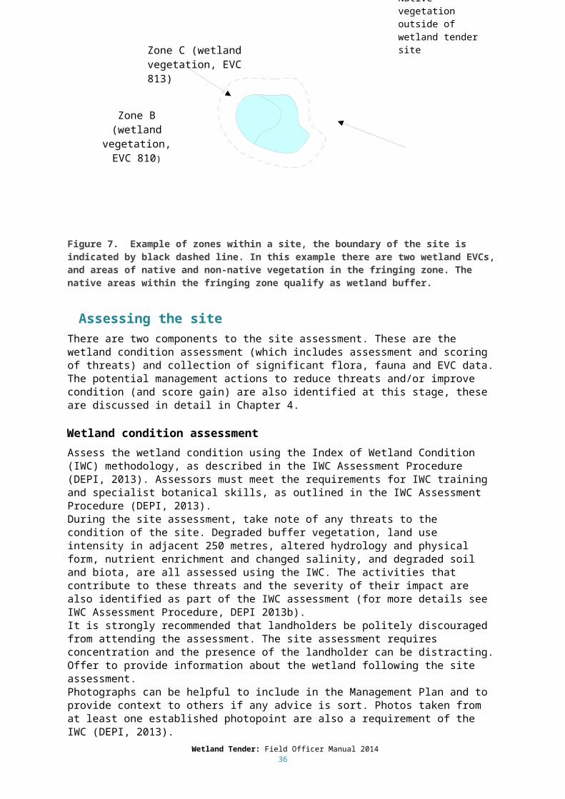
3.2.2 Zone identification
Within a site, there can be more than one habitat zone. Habitat zones are different EVCs within the wetland, or the same EVC with discrete areas of distinctly different condition. Wetland EVCs were developed for the purpose of undertaking IWC assessments; these include per cent cover for critical lifeform groupings and indicator species specific to each wetland EVC, and must be used when assessing the wetland. Where an EVC appears to be of uniform quality, or have only small patches of different quality it should be treated as a single zone. A zone should be a contiguous area within the site and not separated by another zone or feature. The field officer should give each habitat zone a unique alphabetical zone code. For example, the site LAN001-002 below (Figure 7) has four discrete habitat zones. These would be identified as LAN001-002 Zone A, LAN001-002 Zone B, LAN001-002 Zone C and LAN001-002 Zone D. The zones may be subject to different management actions depending on the threats.
The different zones can include:
Discrete areas of different EVCs within the wetland (each EVC is assessed separately in the IWC assessment, see IWC Assessment Procedure, 2013).
Discrete areas of the same EVC with different condition (each area is assessed separately in the IWC assessment, see IWC Assessment Procedure, 2013).
Areas of native vegetation within the fringing zone. Areas of non-native vegetation within the fringing zone.
Figure 7. Example of zones within a site, the boundary of the site is indicated by black dashed line. In this example there are two wetland EVCs, and areas of native and non-native vegetation in the fringing zone. The native areas within the fringing zone qualify as wetland buffer.
3.3 Assessing the siteThere are two components to the site assessment. These are the wetland condition assessment (which includes assessment and scoring of threats) and collection of significant flora, fauna and EVC data. The potential management actions to reduce threats and/or improve condition (and score gain) are also identified at this stage, these are discussed in detail in Chapter 4.
Wetland Tender: Field Officer Manual 201430
Zone C (wetland vegetation, EVC 813)
Native vegetation outside of wetland tender site
Zone D Wetland buffer vegetation
Zone A (Non-native vegetation in fringing
zone – not buffer)

3.3.1 Wetland condition assessment
Assess the wetland condition using the Index of Wetland Condition (IWC) methodology, as described in the IWC Assessment Procedure (DEPI, 2013). Assessors must meet the requirements for IWC training and specialist botanical skills, as outlined in the IWC Assessment Procedure (DEPI, 2013). During the site assessment, take note of any threats to the condition of the site. Degraded buffer vegetation, land use intensity in adjacent 250 metres, altered hydrology and physical form, nutrient enrichment and changed salinity, and degraded soil and biota, are all assessed using the IWC. The activities that contribute to these threats and the severity of their impact are also identified as part of the IWC assessment (for more details see IWC Assessment Procedure, DEPI 2013b). It is strongly recommended that landholders be politely discouraged from attending the assessment. The site assessment requires concentration and the presence of the landholder can be distracting. Offer to provide information about the wetland following the site assessment. Photographs can be helpful to include in the Management Plan and to provide context to others if any advice is sort. Photos taken from at least one established photopoint are also a requirement of the IWC (DEPI, 2013). The IWC was designed to assess the wetland as a whole and cannot be undertaken for only part of a wetland. If the site includes only a small part of a very large wetland, guidance should be sought from the appropriate DELWP IWC officer as indicated in the IWC Assessment Procedure (DEPI 2013b). When part of the site is located on neighbouring land that is privately owned, the landholder or site manager must seek permission from the neighbouring landholder for access to complete the IWC assessment. Only enter the neighbouring property at the direct invitation of the neighbouring landholder. Where the neighbouring land is in public ownership, notify the public land manager of the proposed IWC assessment of the wetland. Note that an IWC assessment is a requirement of Wetland Tender, if the whole wetland cannot be assessed then it is not eligible for the Wetland Tender program. Refer to the IWC Assessment Procedure (DEPI, 2013) for directions on the use of the DELWP wetland layer, the IWC mapping tool and the use of wetland EVC benchmarks.
3.3.2 Wetland significance score
The wetland significance score is calculated using the following criteria:
Significant flora and fauna species: species listed as rare or threatened on the international, national or state lists as outlined in Table 2.
Significant ecological vegetation communities (EVCs), as determined by the bioregional conservation status of each EVC (note only wetland EVCs are considered here).
If the site supports a nationally listed vegetation community under the EPBC Act. If the site supports a high number (five or greater) significant species (can be observed
species or potential habitat) with endangered or vulnerable status. If the wetland is part of a site with formally recognised significance, i.e. Ramsar, Living
Murray Icon or East Asian-Australasian Flyway Sites or is a Wetland listed in the Directory of Important Wetlands of Australia.
Significant species can be observed at the site or the site can represent potential habitat; potential habitat provides half of the score that is obtained for observed species (see Table 2). The rules concerning whether a species is considered to have been observed at the site or the site is potential habitat differs for different taxa. Use Table 3 when considering significant flora, Table 4 for significant birds species and Table 5 for all other fauna species.
Table 2. Method to determine the significance species score for flora and fauna species. EPBC: listed by the Environment Protection and Biodiversity Conservation Act 1999 as
Wetland Tender: Field Officer Manual 201431
threatened; IUCN: listed on the International Union for the Conservation of Nature (IUCN) red list of threatened species; Victorian species advisory lists: listed on the Advisory List of Threatened Invertebrate Fauna (2009), the Advisory List of Threatened Vertebrate Fauna (2013) or the Advisory List of Rare or Threatened Plants in Victoria (2005).
Significance score
FloraSite supports significant (listed) flora
FaunaSite supports significant (listed) Fauna
Observed = 5Potential habitat = 2.5
Victorian species advisory lists: Presumed extinct, Endangered OREPBC: Presumed extinct, Critically endangered, Endangered ORIUCN: Extinct, Extinct in the wild, Critically endangered, Endangered
Victorian species advisory lists: Extinct, Regionally extinct, Extinct in the wild, Critically endangered, Endangered OREPBC: Critically endangered or Endangered ORIUCN: Extinct, Extinct in the wild, Critically endangered, Endangered
Observed = 4Potential habitat = 2
Advisory List of Rare or Threatened Plants in Victoria: Vulnerable ORIUCN: Vulnerable OREPBC: Vulnerable
IUCN: Vulnerable OREPBC: Vulnerable ORAdvisory List of Rare of Threatened Vertebrates or Invertebrates in Victoria: Vulnerable
Observed = 3Potential habitat = 1.5
Advisory List of Rare or Threatened Plants in Victoria: Poorly known ORIUCN: Data deficient
Advisory List of Rare of Threatened Vertebrates or Invertebrates in Victoria: Data Deficient ORIUCN: Data deficient
Observed = 2Potential habitat = 1
Advisory List of Rare or Threatened Plants in Victoria: RareIUCN: Near Threatened
Advisory List of Rare of Threatened Vertebrates or Invertebrates in Victoria: Near ThreatenedIUCN: Near Threatened
If a site supports more than one significant species the species with the higher conservation status determines the score. If a site supports more than one significant EVC the EVC with the higher conservation status determines the score. If the wetland has formally recognised significance it scores additional points (two points if it is part of a Ramsar site, one point if it is part of a site that has other formally recognised significance – see above). The method used to combine these criteria to derive the significance score is outlined in Figure 8. Flora and fauna records can be accessed using resources such as the Victorian Biodiversity Atlas and Biodiversity Interactive Map. When recording significant species, note whether the species was observed or the site represents suitable habitat only. Note that species lists provided by landholders can be used as evidence of the site being suitable habitat. Take photographs of any significant flora species and keep on file. If you cannot identify the species, seek verification from experts in DELWP. To enable the significant species sighted during the assessment to be added to the departmental database, DELWP requires signed permission from the landholder. By granting permission, the landholder will be contributing the improved understanding of the species distribution in the region, and will obtain an improved site significance score. Where a landholder chooses not to sign the permission form, the record will not be used to determine the site significance score. Ignore the record and do not enter on any DELWP database or any written record on DELWP / CMA files. Non-compliance with this approach risks losing the trust of the landholder and risks undermining the integrity of the project.
Wetland Tender: Field Officer Manual 201432

3.3.3 Implications for management
If there are threatened species on the site, or the site represents potential habitat for threatened species, you might wish to consider if there are specific management requirements for these species. Refer to the relevant action statements or recovery plans (if they exist) or seek expert advice from DELWP. Note, that the objective for Wetland Tender sites is to maintain or improve wetland condition, rather than to manage the wetland for the benefit of a particular species. Managing a site to provide habitat for a specific species could require a different set of actions to those aimed at maintaining or improving wetland condition. Discuss any species-specific management requirements, or potential conflicts with Wetland Tender objectives, with the Regional Implementation Coordinator.
Table 3. Method to determine if a site is potential habitat for significant flora species
A Was the species observed during the course of the assessment?
Yes – record as species observedNo – go to B
B Has the species been recorded on the site in the last 20 years and is the site still suitable habitat?
Yes – record as potential habitat
Table 4. Method to determine if a site is suitable habitat for significant bird species
A Was the species sighted during the course of the assessment or recorded at the site in the last 20 years?
Yes – record as species observedNo – go to B
B Has the species been recorded within a 5 km radius of the site in the last 20 years?
Yes – go to CNo – not potential habitat
C Does the habitat on site clearly meet the habitat requirements of the species? Is it reasonable to expect that the species is present or would make use of the site in the medium term (e.g. within the next 10 years).
Yes – record as potential habitatNo – not potential habitat
Wetland Tender: Field Officer Manual 201433

Table 5. Method to determine if a site is suitable habitat for significant fauna species (except for birds)
A Was the species observed during the course of the assessment?
Yes – record as species observedNo – go to B
B Has the species been recorded on the site in the last 20 years and is the site still suitable habitat?
Yes – record as potential habitatNo – go to C
C Has the species been recorded within a 5 km radius of the site in the last 20 years?
Yes – go to DNo – not potential habitat
D Does the habitat on site clearly meet the habitat requirements of the species? Is it reasonable to expect that the species is present or would make use of the site in the medium term (e.g. within the next 10 years).
Yes – record as potential habitatNo – not potential habitat
Wetland Tender: Field Officer Manual 201434
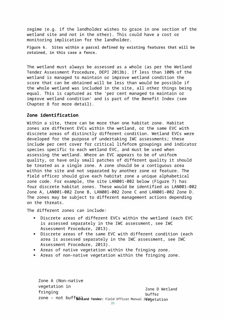
Figure 8. The four steps used to calculate the wetland significance score (EPBC: listed by the Environment Protection and Biodiversity Conservation Act 1999 as threatened; IUCN: listed on the International Union for the Conservation of Nature (IUCN) red list of threatened species; Victorian species advisory lists: include the Advisory List of Threatened Invertebrate Fauna (2009), the Advisory List of Threatened Vertebrate Fauna (2013) and the Advisory List of Rare or Threatened Plants in Victoria (2005). EVC BCS: bioregional conservation status of the EVCs present at the site).
Wetland Tender: Field Officer Manual 201435
5 Gain ScoringThe degree to which each landholder embraces the control of any threats and agrees to other objectives and commitments to manage the site is the focus for wetland ‘gain’ scoring. In general, by committing to a greater suite of management actions aimed at maintaining and improving wetland condition, the landholder will be providing a better management outcome or greater gain. The ability to do this is dependent upon the current condition of the site and the landholder’s capacity to undertake the work within the bounds of the current professionally accepted standard and/or current regional practice (see Section 4.1.3).
3.2 Gain action considerations
4.1.1 Existing legal obligations
Only management actions beyond the legal obligations of the landholder will be awarded gain. It is essential to be aware of the regional responsibilities of landholders concerning weeds and pest animals so that you can provide advice and understand how gain will be applied.
Existing legal responsibilities associated with land management apply to all landholders. Under the Catchment & Land Protection Act 1994 (s20 (1)), (CaLP Act) a landholder is required to take all reasonable steps to:
Avoid causing/contributing to land degradation. Conserve soil. Protect water resources. Prevent spread of established pest animals (Red Fox, European rabbit, European hare, feral
or wild pig, feral or wild goat, wild dog, dingo-dog hybrids). Eradicate regionally ‘prohibited’ weeds. Control and prevent further spread of regionally ‘controlled’ weeds.
There may also be local government and land use planning requirements that the landholder must comply with (see Section 4.1.5).
4.1.2 Mandatory commitments
The landholder must agree to the mandatory commitments to be eligible to participate in Wetland Tender. They receive no gain for these commitments.
All landholders must agree to the following commitments on all of their sites:
Fire prevention: take all reasonable steps to protect the site (the wetland and buffer) from fire and from potentially damaging fire protection and/or suppression activities.
Reporting: as soon as practicable after every year, submit a report on the implementation of this Management Plan, using the pro forma provided.
Weeds: Eliminate regionally prohibited weeds and prevent of the spread of regionally controlled weeds (as per CaLP Act – see above).
Control rabbits (as per CaLP Act – see above). Control or exclude livestock. Fencing:
o For a period of ten years from the commencement of the project, maintain all fencing constructed under this agreement in a stock-proof condition.
o Maintain entire fence in a stock-proof condition for the period of the Management Agreement.
Wetland Tender: Field Officer Manual 201436

Revegetation and supplementary planting: Maintain all revegetation and supplementary planting conducted under Wetland Tender for a minimum of 10 years from the date of signing the Management Agreement.
Exclusion zone: provide a zone around the wetland that excludes activities such as grazing, cropping and vehicle use; the area should be vegetated using indigenous species. If a landholder wants to include part or all of the wetland but none of or only part of the fringing zone they must maintain a minimum of 10m wide exclusion zone surrounding the wetland (measured from the wetland boundary). If the site is part of an open potable water supply catchment, provide an exclusion zone to a minimum of 30m from wetland boundary (note, this is a requirement of s.60(1A)(g) of the Planning and Environment Act 1987).
Control all on-site grazing threats. Retain all large native trees - dead or alive. Retain all native canopy trees - dead or alive. Retain all logs. Retain all fallen branches and leaf litter. Control all identified high threats.
In addition landholders must not:
Plant non-indigenous species. Feed stock supplementary feed within the site. Crop any part of the site. Construct any new dams. Apply fertiliser to the site. Undertake fuel reduction activities (removal of logs, trimming or clearing understorey plants
or trees). Allow horse-riding, cycling or motorised vehicle use off established tracks, except when those
activities are associated with managing stock in line with a controlled grazing regime Include areas that have infrastructure easements. Include areas identified for other uses, such as areas with approval to undertake activities
that will damage native vegetation (e.g. extractive industries works approvals) Undertake other land uses that are likely to degrade vegetation condition or restrict
improvement in vegetation condition. Extract water for stock and domestic use. Artificially drain water from the wetland. Undertake landforming activities except as required for wetland rehabilitation (see Chapter
5.2 for more detail).
4.1.3 Standards for undertaking actions
There are minimum standards that landholders are required to meet when undertaking management actions as part of a project using Wetland Tender (e.g. for building fences, controlling weeds and pest animals or undertaking supplementary planting), which are defined by current professionally accepted standards and/or current regional practice. For more detail and guidance on management see Chapter 5.
Landholders have some flexibility in how they achieve an outcome in line with these standards. For example, the exclusion of stock from a site may not require the construction of a fence, although the landholder will need to indicate the alternative action to achieve this goal. Innovative approaches to management can be considered. If such approaches are proposed, the field officer should determine the feasibility of the actions, the capacity of the landholder to carry out the actions and the likelihood of their success in improving wetland condition. The Regional Implementation Coordinator will only
Wetland Tender: Field Officer Manual 201437
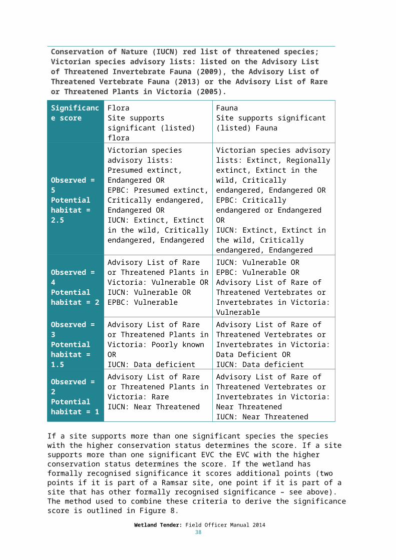
approve alternative management approaches proposed by the landholder where they do not conflict with current professionally accepted standard and/or current regional practice.
The field officer should be aware of landholders over-committing themselves and not being able to fulfil their commitments under a Management Agreement. The field officer should discuss with the landholder their capacity to undertake the actions and be clear that annual reporting and monitoring will occur during the Agreement period, with payments being dependent upon successful completion of the actions.
4.1.4 Appropriateness and feasibility of management actions
Gain actions must lead to an overall improvement in wetland condition. In deciding on appropriate management actions, landholders and field officers should:
Assess proposed management actions and identify and take steps to mitigate any potential adverse impacts on other wetland components or refrain from undertaking the action if the impacts cannot be adequately mitigated.
Assess the feasibility of reinstating the natural (pre-European) condition of the site. Assess the risk to the current values if the natural condition is reinstated.
Examples of actions where extra care is required include:
Interventions that involve excavation (e.g. to reverse infilling or remove levees) which have the potential to cause significant damage to native vegetation in the wetland or the buffer and may also initiate or worsen soil erosion and/or degrade water quality.
The use of herbicides in wetlands which may impact non-target species and water quality.
The aim of these interventions is to reinstate the original characteristics of the site, making the site suitable to support pre-European vegetation and fauna. If the pre-European condition cannot realistically be achieved, or the risk to current values is deemed too high, it may be appropriate to set a different management objective for the site. Refer to the Regional Implementation Coordinator as to whether the site is still eligible for Wetland Tender, or should be targeted by a different incentive program.
4.1.5 Permissions and stakeholder consultation
Any restoration to the wetland should minimise disturbance to soil and vegetation and impacts on neighbouring property or roads. Where it is not possible to undertake works and also avoid impacts on neighbouring property, neighbouring landholders must be consulted (as outlined below). Permission must be obtained from the owner of any structure that a landholder wishes to alter (i.e. if the structure is not owned by the landholder), e.g. water regulators (includes operation of regulator) and road culverts.
Consult with neighbouring landholders
Landholders should consult with any other party that could be affected by their actions and obtain written permission if necessary. This is particularly important when a wetland crosses a property boundary, and changes in one part of the wetland will affect the rest of the wetland and the adjoining land, for example:
Changing hydrology such that the neighboring property will receive greater inundation. Where lowering an outlet may mean greater downstream flows. Where blocking a drain may reduce downstream flows. Where groundwater extraction is changed. When Crown land would be affected.
Wetland Tender: Field Officer Manual 201438

Obtaining permits and approvals
The landholders must obtain all necessary approvals and permits to undertake works prior to submitting a bid (a process that may take several weeks).
Proposed works must comply with the following:
The Aboriginal Heritage Act 2006, e.g. if the site has been assessed to have cultural significance earthworks may not be permitted.
Local government and land use planning requirements, e.g. Environmental Significance Overlays, Farming Zone requirements.
Environment Protection and Biodiversity Conservation Act 1999: relates to requirements associated with undertaking earthworks or clearing native vegetation that could impact matters of national environmental significance (e.g. nationally threatened species or ecological communities).
An Environmental Significance Overlay might stipulate that wetlands in a specific region are a significant environmental resource, and have specific environmental objectives for these areas. These objectives are met through prohibiting certain works or activities or only permitting them subject to specified conditions. If a landholder obtains a permit to undertake the works or activities they must comply with these conditions. Note the landholder would not be awarded gain for complying with the specified conditions, but will receive a gain for the expected improvement in wetland condition.
There is also a requirement for a permit in Farming Zones (and obligation to comply with requirements of the permit if it is granted) to undertake ‘Earthworks which change the rate of flow or the discharge point of water across a property boundary’. A licence is required from the CMA waterway manager for any works that will be undertaken on a wetland that forms a part of a designated waterway as defined in the Water Act 1989 (definition provided below). Note that this definition captures those types of wetlands associated with rivers and creeks; wetlands that occur away from rivers and creeks and/or occur on private land are excluded. Note, wetlands that occur away from rivers and creeks that are on public land are defined as waterways if a declaration exists (S 3.(d). ii). The Water Act is currently under review and this definition could change.
Wetland Tender: Field Officer Manual 201439

4.1.6 Addressing landscape scale threats
Many of the issues that threaten the condition of the wetland can be addressed by the land manager. The presence of weeds, pest animals, fertiliser application, drainage, cultivation, water extraction, uncontrolled grazing (e.g. grazing when soil is moist) and types of destructive land use (e.g. rubbish dumping, off-track driving, uncontrolled vehicle access) are some of the activities which the landholder can address through the site management plan.
Other threats, such as altered hydrology and degraded water quality, can be caused by broader landscape scale factors, and will be more difficult or impossible for the landholder to fix. However, they can be mitigated by appropriate management of contributing on-site factors that can be controlled. For example, in a system where water regime has been altered it is generally not possible to influence river regulation, but other factors that affect the water regime (e.g. water extraction) might be able to be rectified. The assessor should consider whether the proposed activities could control or mitigate the target threat, and how much improvement will be seen in the period of the five year management plan. If the management activity is unlikely to be successful it should not be included in the management plan.
If a landholder proposes to fix all of the threats to a specific wetland condition component then they will score a ‘Major Improvement’ in that component. This will result in a higher predicted increase in
Wetland Tender: Field Officer Manual 201440
Definition of a waterway for CMA approval purposes (Water Act (1989), Part 1, Section 3):
Waterway means –
a) a river, creek, stream or watercourse; or
b) a natural channel in which water regularly flows, whether or not the flow is continuous; or
c) a channel formed wholly or partly by the alteration or relocation of a waterway as described in paragraph (a) or (b); or
d) a lake, lagoon, swamp or marsh, being –
a natural collection of water (other than water collected and contained in a private dam or
natural depression on private land) into or through or out of which a current that forms a whole orpart of the flow of a river, creek, stream or watercourse passes, whether or not the flow is continuous; or
a collection of water (other than water collected and contained in a private dam or a natural depression on private land) that a Governor in Council declares under section 4(1) to be a lake, lagoon, swamp or marsh; or
e) (e) land on which, as a result of works constructed on a waterway as described in paragraph (a), (b) or (c), water collects regularly, whether or not the collection is continuous; or
f) (f) land which is regularly covered by water from a waterway as described in paragraph (a), (b), (c), (d) or (e) but does not include any artificial channel or work which diverts water away from such a waterway; or
g) (g) if any land described in paragraph (f) forms part of a slope rising from the waterway to a definite lip, the land up to that lip.

the score for that component. If they do not propose to fix all of the threats to a specific wetland condition component then they will only be able to achieve a ‘Partial Improvement’ in that component. This will result in a lower predicted increase in the score for that component. Note, this will also include situations where landscape scale threats (that the landholder cannot fix) are acting. More detail regarding the effect of major and partial improvements are provided in Sections 4.3-4.8.
Other organisations (e.g. Catchment Management Authorities) might undertake (or might get another party to undertake) a complementary action to increase the benefit of the landholders action. Note that the landholder can only score gain for actions that they undertake and not for complementary actions which may be undertaken by others.
As there are some threats that the landholder will not be able to influence or mitigate, the Field Officer should ensure that expectations about changes to wetland condition in the face of broader landscape-scale factors are realistic.
4.2 Wetland Tender gain scoring metricAn understanding of how gain will be calculated is important because this can provide the landholder with the relative benefit of one management action compared to another, from a gain scoring perspective. Some actions have multiple outcomes and therefore more ‘gain’. For example, the controlling nutrient inputs will improve the water properties score as well as the weeds score, and improving the water regime will improve the hydrology score as well as the biota score. There are also limits to the amount of gain that can be scored when certain conditions are not met. For example, if the water regime is in poor condition and options proposed by the landholder to improve hydrology are limited, the predicted hydrology score (the score expected after the interventions to improve hydrology are implemented) will remain low. This is likely to lead to further decline in the wetland biota and a lower score for the biota sub-index (as predicted by the Wetland Tender metric).
There are two types of gain that may be scored using the Wetland Tender method, maintenance gain and improvement gain. A metric is used to predict condition improvement or decline, based on the combined effect of allowable land uses, threats and proposed management actions.
4.2.1 Improvement gain
Improvement gain is scored when the landholder proposes to carry out management actions that will improve the condition of the wetland, e.g. livestock exclusion, weed control or improving altered hydrology. Management commitments must be beyond current responsibilities and legislated obligations to score improvement gain.
4.2.2 Maintenance gain
Maintenance gain is scored when the landholder prevents decreases in condition by agreeing to continue to forgo any existing land use entitlements that degrade wetland condition (e.g. uncontrolled livestock grazing or cultivation). Maintenance gain rewards landholders for looking after their wetland prior to entering a contract.
4.2.3 Gain scoring metric
The basis of the Wetland Tender metric is the predicted improvement, decline or prevention of decline in wetland condition based on the:
Current condition of the wetland. Current threats acting at the site. The proposed management of the landholder (i.e. forgo allowable land uses and/or perform
management actions). Wetland Tender: Field Officer Manual 2014
41

The metric takes the current condition scores and the threats acting at the site (taken directly from the IWC assessment), and makes a prediction of the change in condition based on the proposed management interventions. The prediction is usually made as a spread of probabilities, e.g. there is a 40% probability of remaining on the same score and a 60% probability of improving one score category. The probabilities represent the likelihood that an action will achieve an improvement in condition (or that a lack of action will result in a decline). The probabilities change depending on the current threat and the proposed action. The exception to the probabilistic approach is the wetland catchment predicted score which is determined purely by the proposed management (i.e. the prediction is deterministic).
The probabilities were developed using expert knowledge and ecological understanding of wetlands. They were estimated for the amount of change likely over the 5 year term of most agreements.
For most of the wetland condition components, if there are no proposed management actions to treat an existing threat then that particular condition component is expected to decline over time. There are exceptions to this rule for wetland components that are unlikely to continue to decline under status quo management (i.e. no change to management); these are wetland physical form and hydrology. If the wetland physical form has been modified (e.g. part of the wetland filled in) we would not expect the threat to worsen over time. If wetland hydrology has been modified to alter the wetland water regime, but there are no proposed changes to management, then the assumption is that there will be no further decline predicted for the hydrology component.
If a landholder proposes to fix all of the threats to a specific wetland condition component then they will score a ‘Major Improvement’ in that component. This will result in a higher predicted increase in the score for that component. If they do not propose to fix all of the threats to a specific wetland condition component then they will only be able to achieve a ‘Partial Improvement’ in that component (note, this will also include situations where landscape scale threats, that the landholder cannot fix, are acting). This will result in a lower predicted increase in the score for that component. The term “fix” in this context is used to mean that management actions are proposed so that the specified individual threat will no longer be present.
Details of how the gain is calculated are provided for each wetland condition component (see Sections 4.3-4.8). These sections describe the management actions that can be undertaken to address threats identified in IWC assessment and outlines the gain scored if some or all of the actions are undertaken. There is a management action for each of the threats as identified in the IWC; these are the actions that are undertaken to address the threats and score gain, they are termed “gain” actions in the sections below. It should be noted that undertaking the action results in the scoring of gain for all the measures for which that action is an appropriate response to the threat they have in common (e.g. decreasing nutrients enrichment improves the water quality score and the weed score). The methods used to implement the gain action are referred to as the management activities, these will appear in the management plan. The steps in the process are as follows:
1. Assess the component using the IWC measure;o Document the current condition of componento Document the threats currently acting on the component
2. Identify the proposed management (gain) action/s.3. Score the gain.4. Identify the methods (management activities) that will be used to implement the action.
Sections 4.3-4.8 cover the first three steps in the process, the activities to implement the gain actions (the final step) are detailed in Chapter 5.
Wetland Tender: Field Officer Manual 201442

4.3 Wetland catchmentThe IWC includes a threat measure for land use intensity within 250 metres of the wetland boundary and two measures for the buffer: average width of the buffer and the percentage of the wetland perimeter with a buffer. See section 3.2 for definition of the wetland buffer. According to the IWC, reducing the land use intensity within the wetland catchment increases wetland condition. Reducing land use intensity within the catchment is not currently included as a gain action, but it may be incorporated in the future.
Scoring gain for the buffer:
If the fringing zone does not support native vegetation, the landholder can propose to revegetate some or all of the cleared area adjacent to the wetland to increase the extent of the buffer. If the area supports an original pre-European EVC but has more than 75% non-indigenous groundcover the focus might be weed control to increase the indigenous groundcover above the 25% threshold (it would then be considered to be native vegetation and would qualify as wetland buffer). Gain for weed control will only be scored for management that is beyond legal requirements under the Catchment and Land Protection Act 1994 (see Section 4.1.1).
There are two ways to obtain improvement gain for revegetating the wetland buffer: 1. Increasing the width of buffer (up to 50 metres).2. Increasing the proportion of the wetland that has a buffer.
See the IWC Assessment Procedure for details of the relative contribution of these to the wetland buffer assessment score (DEPI 2013b). The improvement to the wetland buffer assessment score is determined by the proposed management. For example, if the proposed management is to increase the score from 2 to 10 the predicted buffer score will be 10 (the field officer should however consider the feasibility of reinstating the buffer, given site conditions and landholder capacity).
Maintenance gain is obtained by maintaining the current buffer width and proportion of the wetland that has a buffer.
See table below for the gain actions that may be selected. See Chapter 5 for the management activities relevant to these actions.
Table 6. Threats to the wetland buffer and the actions that can be undertaken to score gain (the relevant management activities are presented in Chapter 5).
Threat Gain actionClearing of buffer vegetation Revegetation in bufferDegradation of buffer understory by weed invasion
Weed control in the buffer (beyond CaLP Act requirements )
4.4 Wetland Form The threats to wetland form (as defined in the IWC) are permanent reductions in wetland area and modifications to the wetland bathymetry.
4.4.1 Reduced wetland area
The reduction in wetland area has to be permanent, it does not include a temporary reduction in the extent of water present (as would be associated with periodic drying of the wetland under its natural water regime). A reduction in wetland area is the actual loss of wetland habitat such that the area of water in the wetland when fully inundated is less than its original extent under natural conditions. The causes of reduced wetland area may include physical changes to the wetland (e.g. in-filling,
Wetland Tender: Field Officer Manual 201443
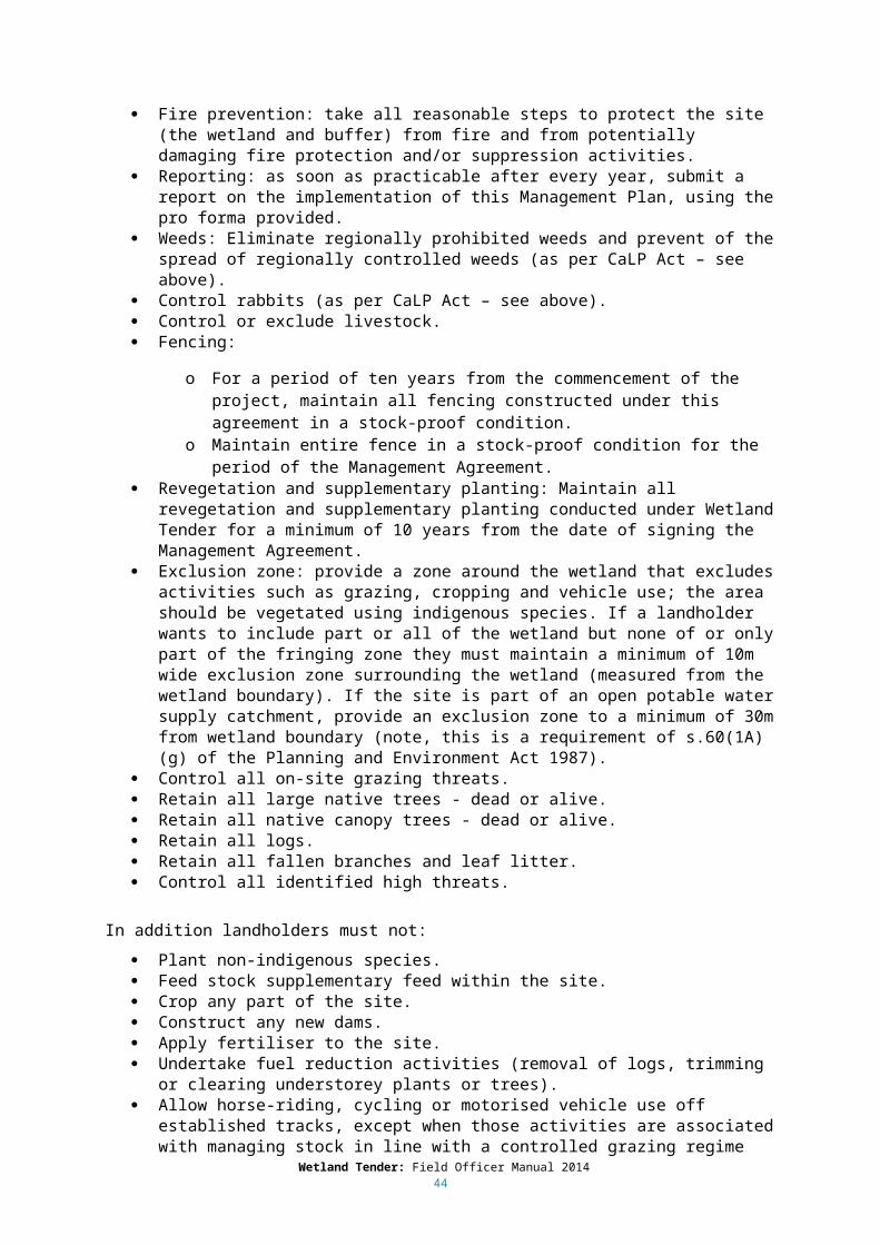
barriers to flow) or permanent hydrological changes (e.g. draining). The actions to address this threat can overlap with the actions undertaken to restore the hydrological regime (see Section 4.5).
The reason for reduction in area may include:
In-filling. Drainage of water from the wetland. Reduced water inputs. Levees or other barriers to water flow. Fire (peatland wetlands). Channelisation (peatland wetlands). Other: there may be other reasons for a reduction in wetland area that are not captured by
those outlined above. These will be identified as a part of the IWC assessment.
Scoring gain for Reduced wetland area:
Gain is scored by restoring the extent of water in the wetland to the pre-European area. The action/s required to restore pre-European extent will depend on the threat (Table 7). The management activities required to implement the gain actions are presented in Chapter 5.
Table 7. Threats that cause reduced wetland area and the actions that can be undertaken to reduce the threats and score gain (the relevant management activities are presented in Chapter 5).
Threat Gain actionInfilling Excavate wetland to reverse infillingDrainage of water from the wetland Cease drainage of waterReduced water inputs Restore natural water regimeLevees or other barriers to water flow Remove levees and barriers to natural inflowsFire (peatland wetlands) Use suppression activities to reduce fire frequencyChannelisation (peatland wetlands) Restore hydrological structure
If a landholder proposes to fix all of the threats that reduce wetland area they will achieve a ‘Major improvement’ resulting in the maximum predicted score for this component (ten). If a landholder proposes to fix some but not all of the causes of reduction in wetland area the most gain they can score is a ‘Partial Improvement’ – this will influence the predicted score as follows:
10% probability of remaining on the same score. 70% probability of improving one scoring category. 20% probability of improving two scoring categories.
If a landholder proposes to do nothing the score will remain the same, but not decline.
4.4.2 Changed Bathymetry
Bathymetry is the underwater topography of the wetland. The IWC estimates the proportion of the wetland where the bathymetry has been significantly modified by excavation or landforming activities. Excavation of the wetland bed (e.g. channels or dams) will change water depth and extent of inundation. Landforming activities (e.g. laser levelling, raised-bed cropping or building of mounds) change the natural form of the bed.
The reason for changed bathymetry can include:
Excavation of wetland bed (e.g. channels, dams, dredging). Landforming (e.g. raised bed cropping, laser-levelling, building mounds, aqueducts, tracks). Other: there may be other reasons for changed bathymetry that are not captured by those
outlined above. These will be identified as a part of the IWC assessment.
Wetland Tender: Field Officer Manual 201444
Scoring gain for Changed bathymetry: Gain is scored by restoring the wetland bathymetry to the pre-European form. The action required to restore pre-European extent will depend on the threat (see Table 8). The management activities required to implement the gain actions are presented in Chapter 5.
Table 8. Threats that cause changed bathymetry and the actions that can be undertaken to reduce the threats and score gain (the relevant management activities are presented in Chapter 5).
Threat Gain actionExcavation of wetland bed Reverse effects of excavationLandforming Restore wetland form
If a landholder proposes to fix all of the causes of changed bathymetry they will achieve a ‘Major improvement’ resulting in the maximum predicted score for this measure (ten). If a landholder proposes to fix some but not all of the causes of reduction in wetland area the most gain they can score is a ‘Partial Improvement’ – this will influence the predicted score as follows:
10% probability of remaining on the same score. 70% probability of improving one score category. 20% probability of improving two score categories.
If a landholder proposes to do nothing the score will remain the same, but not decline.
4.5 Altered HydrologyThe hydrological or water regime controls many wetland processes. It is described by the frequency (average number of times a wetland is filled in a given period of time), duration (length of time surface water is present) depth and timing (season in which inundation typically occurs) of inundation.
Threats to the wetland hydrological regime include activities that change the flow regime of the water source, activities that interfere with natural connectivity of water flow to and from the wetland, disposal of water into the wetland, extraction of water directly from the wetland or activities which change the natural depth of the wetland. The IWC measure estimates the severity of change to the water regime that results from the identified threats.
Reasons for altered hydrology can include:
River regulation. Activities that change the local surface drainage patterns. Artificially manipulated water inflow or drawdown that is not associated with maintaining or
restoring the reference condition of the wetland. Obstruction, regulation or alteration of the connection between the wetland and its water
source. Obstruction or regulation of natural water outlets. Drainage of water from the wetland through a pipe or channel. Disposal of waste or drainage water into the wetland that is not associated with maintaining
or restoring the reference condition of the wetland. Extraction of water directly from the wetland. Activities that permanently raise the water level (e.g. damming the wetland or constructing
levees to restrict the spread of water). Activities leading to an increase in groundwater height. Activities leading to a decrease in groundwater height.
Wetland Tender: Field Officer Manual 201445

Other: there may be other reasons for altered hydrology that are not captured by those outlined above, these will be identified as a part of the IWC assessment.
4.5.1 Change in hydrological regime category
The wetland hydrological regime category is determined by the frequency and duration of inundation (see Table 9 for category definitions).
Table 9. Wetland water regime categories adopted in the Victorian wetland classification framework (DELWP, in prep).
Category Category Subcategory
Frequency of inundation events
Duration of inundation
Permanent Inundated constantly, rarely drying completely
- Constant, annual or less frequently but usually before wetland dries.
Never dries or dries rarely (i.e. holds water at least 8 years in every 10), but levels can fluctuate within or between years.
Periodically inundated
Inundated annually to infrequently, holding water for at least 1 month to more than 1 year before drying
Seasonal Annual or near annual inundation (i.e. fills at least 8 years in every 10)
Holds water 1-8 months, then dries
Intermittent Infrequent – is inundated on average, 3 to <8 years in every 10
Holds water > 1 month to > 1 year, then dries
Episodic Infrequent – is inundated, on average, < 3 years in every 10
Holds water > 1 month to >1 year, then dries
Scoring gain for Change in Category:Gain is scored by reinstating the frequency and duration of inundation such that the pre-European hydrological regime category is restored. The action required to reinstate natural hydrology will depend on the threat/s acting at the site (see Table 10). The management activities required to implement the gain actions are presented in Chapter 5.
Wetland Tender: Field Officer Manual 201446
Table 10. Threats that may cause a change in water regime category and the actions that can be undertaken to reduce the threats and score gain (the relevant management activities are presented in Chapter 5).
Threat Gain actionRiver regulation Restore natural water regimeActivities that change the local surface drainage patterns Restore surface flow patternsArtificially manipulated water inflow or drawdown (not associated with maintaining or restoring the reference condition of the wetland)
Improve management arrangements
Obstruction, regulation or alteration of the connection between the wetland and its water source
Restore connection between wetland and water source
Obstruction or regulation of natural water outlets Restore outlet flow pathDrainage of water from the wetland through a pipe or channel
Cease drainage of water
Disposal of waste or drainage water into the wetland (not associated with maintaining or restoring the reference condition of the wetland)
Stop disposal of water to wetland
Extraction of water directly from the wetland Stop water extractionActivities that permanently raise the water level (e.g. damming the wetland or constructing levees to restrict the spread of water)
Lower maximum water level
Activities leading to an increase in groundwater height Cease activities that increase GW height
Activities leading to a decrease in groundwater height Cease activities that decrease GW height
If a landholder proposes to fix all of the causes of the changes to frequency and duration of inundation they will achieve a ‘Major improvement’ resulting in the maximum predicted score for this measure (ten). If a landholder proposes to fix some but not all of the causes of reduction in wetland area the most gain they can score is a ‘Partial Improvement’ – this will influence the predicted score as follows:
40% probability of remaining on the same score. 60% probability of improving one score category.
If a landholder proposes status quo management of the factors that affect hydrological category (i.e. no change to frequency or duration of inundation) the score will remain the same, but not decline.
4.5.2 Change in Seasonality
Scoring gain for Change in Seasonality:
Gain is scored by reinstating the natural timing of inundation. The action required to achieve this will depend on the threat/s acting at the site (see Table 11). The management activities required to implement the gain actions are presented in Chapter 5.
Wetland Tender: Field Officer Manual 201447

Table 11. Threats that can cause a change in seasonality and the actions that can be undertaken to reduce the threats and score gain (the relevant management activities are presented in Chapter 5).
Threat Gain actionRiver regulation Restore natural water regimeActivities that change the local surface drainage patterns Restore surface flow patternsArtificially manipulated water inflow or drawdown (not associated with maintaining or restoring the reference condition of the wetland)
Improve management arrangements
Obstruction, regulation or alteration of the connection between the wetland and its water source
Restore connection between wetland and water source
Disposal of waste or drainage water into the wetland (not associated with maintaining or restoring the reference condition of the wetland)
Stop disposal of water to wetland
Activities leading to an increase in groundwater height Cease activities that increase GW height
Activities leading to a decrease in groundwater height Cease activities that decrease GW height
If a landholder proposes to fix all of the causes of changed seasonality they will achieve a ‘Major improvement’ resulting in the maximum predicted score for this measure (ten). If a landholder proposes to fix some but not all of the causes of changed seasonality the most gain they can score is a ‘Partial Improvement’ – this will influence the predicted score as follows:
40% probability of remaining on the same score. 60% probability of improving one score category.
If a landholder proposes status quo management of the factors that affect seasonality (i.e. no change to timing of inundation) the score will remain the same, but not decline.
Changes to the timing of inundation are likely to produce conditions unsuitable for some species currently at the site. It may be appropriate to consider the plant and animal communities currently present at the site, and their intrinsic value (see Section 4.1.4).
4.6 Water Quality Water quality (described as water properties in the IWC) influences many of the biotic components of wetlands and their processes (e.g. feeding, growth and reproduction of fauna and growth and reproduction of flora). Water properties can be physical (e.g. temperature, turbidity) or chemical (e.g. nutrients, metals, dissolved oxygen, electrical conductivity, pH, dissolved organic carbon). The IWC includes threat measures for nutrients and salinity.
4.6.1 Nutrient enrichment
Threats that can lead to an increase in nutrients include clearing and land use activities in the catchment (diffuse source), delivering of nutrient rich water to the wetland (point source) and activities within the wetland (e.g. grazing by livestock or feral animals, aquaculture). Increased nutrients can lead to changes in primary productivity and subsequent changes in food webs.
Reasons for nutrient enrichment can include the following:
Discharge of nutrient-rich water to the wetland (e.g. sewage, industrial effluent, irrigation water).
Drainage of nutrient-rich water to the wetland from an urban area (via a drain). Runoff of nutrients to wetland (e.g. fertilizer application or grazing in catchment).
Wetland Tender: Field Officer Manual 201448
Grazing by livestock in the wetland. Grazing by feral animals in the wetland (e.g. pigs, goats, deer, rabbits, horses). Application of fertilizer in the wetland. Aquaculture. Other: there may be other reasons for nutrient enrichment that are not captured by those
outlined above, these will be identified as a part of the IWC assessment.
Scoring gain for Nutrient Enrichment:
Gain is scored by reducing nutrient input into the wetland (apart from the control of CaLP Act species which does not result in gain, see Section 4.1.1). The actions required to reduce nutrient input will depend on the threat/s acting at the site (see Table 12). The management activities required to implement the gain actions are presented in Chapter 5. Note that decreasing nutrient enrichment will also contribute to improving the weed component of the Biota score.
Table 12. Threats that can cause nutrient enrichment and the actions that can be undertaken to reduce the threats and score gain (the relevant management activities are presented in Chapter 5).
Threat Gain actionDischarge of nutrient-rich water to the wetland from sewage, industrial effluent and/or irrigation water
Stop or reduce discharge of nutrient-rich water to wetland
Drainage of nutrient-rich water into the wetland from an urban area
Stop or reduce drainage of nutrient-rich water to wetland
Runoff of nutrients to wetland Change land management practice in wetland catchment (area within 250 m of wetland boundary)
Grazing by livestock in the wetland Implement controlled grazing regimeExclude livestock from wetland
Grazing by feral animals in the wetland (non-CaLP species)
Control or exclude feral animals from wetland (non-CaLP species)
Grazing by feral animals in the wetland (CaLP species)
Control feral animals in wetland (CaLP species) NO GAIN
Application of fertilizer in the wetland Stop application of fertiliser in wetlandAquaculture Stop aquaculture-related activities within the
wetland
If a landholder proposes to fix all of the causes of nutrient enrichment and exclude livestock they will achieve a ‘Major improvement’ – this will influence the predicted score as follows:
20% probability of remaining on the same score. 60% probability of improving one score category. 20% probability of improving two score categories.
If a landholder proposes to fix some but not all of the causes of nutrient enrichment and/or undertake controlled grazing, the most gain they can score is a ‘Partial Improvement’ – this will influence the predicted score as follows:
80% probability of remaining on the same score. 20% probability of improving one score category.
Wetland Tender: Field Officer Manual 201449

If a landholder proposes status quo management of the factors that cause nutrient enrichment (i.e. no change in practices) – this will influence the predicted score as follows:
70% probability of dropping down one score category. 30% probability of remaining on the same score.
Note, the landholder can score gain for reducing nutrient input to the wetland, but no gain can currently be scored for removing nutrients from the system (see Section 5.4.1).
4.6.2 Altered salinity
The natural salinity regime of a wetland can be altered either by making the wetland more saline or less saline than its natural pre-European state. Increased salinity can be caused by catchment clearing and/or poor irrigation practices which raise water tables and mobilise salts in the soil. Changes in salinity can also be caused by the delivery of saline water to naturally fresh wetlands or freshwater to naturally saline wetlands. Salinisation of wetlands can lead to changes in wetland biota abundance, diversity and richness, increases in water clarity and/or salinity-driven stratification of the water column.
Reasons for altered salinity may include the following:
Non-natural saline groundwater intrusion resulting in an increase in salinity from its natural state.
Non-natural saline water intrusion from the marine environment resulting in an increase in salinity from its natural state.
Saline water being artificially delivered to a fresh or brackish wetland. Fresh water is unnaturally delivered to a saline wetland. Other: there may be other reasons for altered salinity that are not captured by those
outlined above, these will be identified as a part of the IWC assessment.
Scoring gain for Altered Salinity:
Gain is scored by reducing the activity that is causing altered salinity, the actions required to achieve this will depend on the threat/s acting at the site (see Table 13). The management activities required to implement the gain actions are presented in Chapter 5.
Table 13. Threats that can cause salinity to be altered and the actions that can be undertaken to reduce the threats and score gain (the relevant management activities are presented in Chapter 5).
Threat Gain actionSaline groundwater intrusion resulting in an increase in salinity from its natural state
Cease activities that lead to increased GW height
Saline water intrusion from the marine environment resulting in an increase in salinity from its natural state
Cease activities that lead to marine water intrusion
Saline water is unnaturally delivered to a fresh or brackish wetland
Stop delivery of saline water to wetland
Fresh water is unnaturally delivered to a saline wetland Stop delivery of freshwater to wetland
If a landholder proposes to fix all of the causes of altered salinity they will achieve a ‘Major improvement’ – this will influence the predicted score as follows:
20% probability of remaining on the same score. 60% probability of improving one score category. 20% probability of improving two score categories.
Wetland Tender: Field Officer Manual 201450

If a landholder proposes to fix some but not all of the causes of altered salinity the most gain they can score is a ‘Partial Improvement’ – this will influence the predicted score as follows:
80% probability of remaining on the same score. 20% probability of improving one score category.
If a landholder proposes status quo management of the factors that cause altered salinity (i.e. no change in practices) – this will influence the predicted score as follows:
70% probability of dropping down one score category. 30% probability of remaining on the same score.
4.7 Soils The physical structure of wetland soils can be damaged by livestock, feral animals, human trampling, vehicles and carp. Note, activities such as earthmoving, which also disturb soil, are covered in wetland form (Section 4.4). Degradation of soil physical structure can reduce soil water storage capacity, affect soil invertebrates and increase turbidity during filling.
Reasons for degraded soils can include the following:
Pugging by livestock. Disturbance or pugging by feral animals (e.g. carp, pigs, goats, deer, rabbits, horses). Carp mumbling. Trampling by humans. Cultivation. Driving vehicles on wetland. Other: there might be other reasons for degraded soils that are not captured by those
outlined above, these will be identified as a part of the IWC assessment.
Soils are more vulnerable to physical damage when they are moist, generally as the moisture increases so does the potential for damage. Less damage will be sustained in wetlands when the soil is dry.
Scoring gain for Soils:
Gain is scored by reducing the activities that impact on soil physical structure (apart from the control of CaLP Act species which does not result in gain, see Section 4.1.1), the actions required to achieve this will depend on the threat/s acting at the site (see Table 14). The management activities required to implement the gain actions are presented in Chapter 5.
Table 14. Threats that can degrade soils and the actions that can be undertaken to reduce the threats and score gain (the relevant management activities are presented in Chapter 5).
Threat Gain actionPugging by livestock Implement a controlled grazing regime
Exclude livestock from wetland
Disturbance or pugging by feral animals (non-CaLP species)
Control or exclude feral animals from wetland (non-CaLP species)
Disturbance or pugging by feral animals (CaLP species)
Control feral animals in the wetland (CaLP Act species) NO GAIN
Carp mumbling Exclude carp from wetlandTrampling by humans Exclude or manage human access in the wetlandCultivation Cease cultivation of wetlandDriving vehicles on wetland Stop or manage vehicle access in the wetland
Wetland Tender: Field Officer Manual 201451
If a landholder proposes to fix all of the causes of soil degradation they will achieve a ‘Major improvement’ – this will influence the predicted score as follows:
10% probability of improving one score category. 35% probability of improving two score categories. 55% probability of improving three score categories.
If a landholder proposes to fix some but not all of the causes of soil degradation and/or undertake controlled grazing, the most gain they can score is a ‘Partial Improvement’ – this will influence the predicted score as follows:
40% probability of remaining on the same score. 60% probability of improving one score category.
If a landholder proposes status quo management of the factors that cause soil degradation (i.e. no change in practices) – this will influence the predicted score as follows:
30% probability of remaining on the same score. 70% probability of dropping down one score category.
If the landholder undertakes controlled grazing, and there is no sign of soil pugging, and providing that the other threats to soil are not acting, they will receive a high initial score for the soil sub-index. Improvement gain for soils is limited in this situation, and a change in management for soil improvement is not required (soils are already in good or excellent condition). However, the initial score and predicted score for water properties and biota will be lower if grazing is present and continuing. The predicted score for these measures is the score expected after the management interventions have been implemented.
4.8 Wetland Biota Wetland biota depend on wetlands for all or part of their lifecycle and are characterised by their tolerance and/or dependence on flooding for part or all of the year. Wetland biota can also influence other wetland components and processes such as nutrient and energy cycling. Altered hydrology, degraded soils, grazing, degraded buffer vegetation, increased nutrients and altered salinity will all influence wetland biota. Direct threats to wetland biota include clearing of wetland vegetation and the introduction of invasive species.
The IWC includes a measure for the assessment of wetland vegetation quality, which is assessed by comparison with a relatively undisturbed system of the same vegetation type (based on the modelled pre-European EVC). This undisturbed state is described in benchmarks for each EVC.
Wetland vegetation quality assessment based on four components, as follows:
Presence of critical lifeforms. Presence of weeds. Indicators of altered processes. Vegetation structure and health.
4.8.1 Critical Lifeforms
Wetland EVCs (and benchmarks) have been developed specifically for use in the IWC (DEPI 2013c). Benchmark descriptions specify the critical lifeform groups for each EVC, and minimum species diversity and/or cover levels for each group (DEPI 2013c). Scoring is based on the presence of lifeform groups and whether or not they are substantially modified. A critical lifeform group is considered to be substantially modified if it fails to meet the benchmark thresholds for the number
Wetland Tender: Field Officer Manual 201452

of species and/or percentage cover (DSE 2012). The score is determined using the scoring guide on the field assessment sheet (for more detail see IWC Assessment Procedure, DEPI 2013b).
Note, the definitions for critical lifeform groups are different to those used in the Habitat Hectares method. Critical lifeforms are assessed for size at maturity and the groups listed in the benchmark are treated as a range and not a category.
The main threats to the critical lifeforms are as follows:
Presence of livestock. Presence of feral animals. Carp mumbling. Trampling by humans. Cultivation. Driving vehicles on wetland. Altered hydrology (see Table 10). Changed salinity (see Table 13).
Scoring gain for Critical Lifeforms:
Gain is scored by undertaking actions to reduce the effect of threat/s acting at the site. These may include the following (note relevant table for gain actions):
Altered hydrology (see Table 10) Changes to salinity (see Table 13) Livestock and feral animals (Table 12) Carp, cultivation, trampling by humans and by driving vehicles on the wetland (Table 14).
Gain can also be scored directly by revegetation or supplementary planting (see Section 5.8) with conditions imposed to achieve that gain (relating to hydrology and altered salinity scores – see below).
If a landholder proposes to fix all of the causes of the loss of critical lifeforms, exclude livestock and undertake supplementary or revegetation planting (where required) they will get the maximum gain possible.
If a landholder proposes to fix some but not all of the causes of the loss of critical lifeforms and/or undertake controlled grazing, they will achieve a lesser gain, no change or a decline.
If the predicted hydrology score (the score we expect after the interventions to improve hydrology are implemented) is zero or five, then the only possible outcome is a decline in the critical lifeforms score (even with revegetation or supplementary planting). If the predicted salinity score (the score we expect after the interventions to improve ‘changed salinity’ are implemented) is zero, then the only possible outcome is a decline in the critical lifeforms score (even with revegetation or supplementary planting). Apart from these specific situations, as the landholder reduces the threats to the critical lifeforms (or undertakes supplementary planting or revegetation) the predicted score will improve, and the gain will increase, and as the threats increase the critical lifeform score will decrease, and there can be less gain, no change or a decline.
It is harder to improve the critical lifeforms if the initial score is low, and easier if the initial score is high, this is reflected in the gain scoring metric.
4.8.2 Vegetation Structure and Health
This part of the biota sub-index assesses the condition of the structurally dominant species and/or lifeforms for the EVC (DSE 2012). Section 4 of the benchmark description specifies the structural dominants for the EVC, their benchmark cover and any additional guidance on assessing vegetation
Wetland Tender: Field Officer Manual 201453
structure and health. The percentage of this benchmark cover present for the structural dominant in the EVC is determined first. The assessor then determines the percentage of structural dominants which are healthy.
The threats to vegetation structure and health are the same as those for Critical Lifeforms (see Section 4.8.1).
Scoring gain for Vegetation Structure and Health:
The method for scoring gain for Vegetation Structure and Health is identical to the method used for Critical Lifeforms (see above).
4.8.3 Weeds
Environmental weeds can include species native to parts of Victoria but occurring outside of their natural range (e.g. Acacia longifolia subsp. sophorae, Leptospermum laevigatum and Pittosporum undulatum). In some cases, it might be necessary to decide whether invasive species represent local dryland species which have opportunistically colonised wetlands as a consequence of modified hydrology (in which case they will represent indicators of altered processes), or whether these are invasive species operating outside of their natural range (in which case they will represent weeds).
The IWC score is based on both the percentage cover of all weeds in the EVC and the proportion of weed cover made up of high threat weeds. High threat weeds are those with ability to displace native vegetation (DSE 2012). High threat weed species are specified on the EVC benchmark. The assessor can also record additional species considered as being of high threat on the field assessment sheet (these are included in the percentage cover assessment) (DSE 2012). The benchmark also specifies instances where it is appropriate to overlook low-threat weeds (DSE 2012).
The main factors that affect the presence and extent of weeds are identified as follows:
Presence of livestock. Presence of feral animals. Carp mumbling. Trampling by humans. Cultivation. Driving vehicles on wetland. Nutrient enrichment. Presence of a buffer. Management of weeds to reduce extent and abundance.
Weed Management
Only commitments beyond the legal obligations to eradicate or control weeds will be awarded gain (see Section 4.1.1). Note: Landholders must at least choose to control weeds in the wetland (as defined below), this includes monitoring for any new and emerging weeds, and eliminating them to less than one per cent cover. See Section 5.7 for more detail.
The alternatives for weed management are as follows: Control weeds in wetland:
o Ensure weed cover does not increase beyond current levels (high threat and other weeds).
o Monitor for any new and emerging weeds and eliminate to less than one per cent cover.
Eradicate weeds in wetland: o Non-high threat weeds: weeds that are up to 25% cover - ensure cover does not
increase beyond current levels, weeds with >25% cover reduce to under 25% cover. Wetland Tender: Field Officer Manual 2014
54

o High threat weeds: Eliminate all identified high threat weeds to <1% cover.
Scoring gain for Weeds:
Gain is scored by undertaking activities to reduce the threats that act to increase weeds, which include presence of livestock, feral fauna, carp, cultivation, vehicles and people in the wetland (see Table 14 for gain actions), and activities that increase nutrient input to the wetland (see Table 12 for gain actions). These can act to increase weeds via introducing weed propagules, increasing opportunities for germination and establishment and/or providing conditions suitable to increase extent. Improving the wetland buffer (see Table 5 for gain actions) will help to provide a barrier to the entry of weed propagules. Gain can also be scored by directly acting to reduce weeds (Table 18).
Table 15. Scoring gain by directly managing weeds.
Gain action Gain actionWeed management beyond CaLP Act requirements
Control weeds in wetland: Ensure weed cover does not increase beyond current levels (high threat
and other weeds).
Monitor for any new and emerging weeds and eliminate to <1% cover.
Eradicate weeds in wetland: Non-high threat weeds: weeds that are up to 25% cover - ensure cover
does not increase beyond current levels, weeds with >25% cover reduce to under 25% cover.
High threat weeds: Eliminate all identified high threat weeds to <1% cover.
If a landholder proposes to undertake activities to reduce the effect of all threats that act to increase weeds, and chooses the eradication option, they will get the maximum gain possible (‘Major Improvement’).
If a landholder proposes to undertake activities to reduce the effect of all threats that act to increase weeds, and chooses the ‘control’ option, the most gain they can score is a ‘Partial Improvement’.
If a landholder proposes to undertake activities to reduce the effect of all threats that act to increase weeds, and to do nothing to directly manage grassy and herbaceous weeds already at the site – this will influence the predicted score as follows:
40% probability of no change. 60% probability of decline.
If a landholder proposes to undertake activities to reduce some but not all of the threats that act to increase weeds and/or undertake controlled grazing, they will achieve a lesser gain, no change or a decline. As the landholder reduces the threats that increase weeds the predicted score will improve, and the gain will increase, and as the threats increase the weed score will decrease, and there might be less gain, no change or decline.
It is harder to improve the weed score if the initial score is low, and easier if the initial score is high, this is reflected in the gain scoring metric.
4.8.4 Altered Processes
This part of the biota sub-index assesses indicators of ecological change which reflect the extent of major changes in the vegetation. The assessment focuses on invasions by key indigenous indicator
Wetland Tender: Field Officer Manual 201455
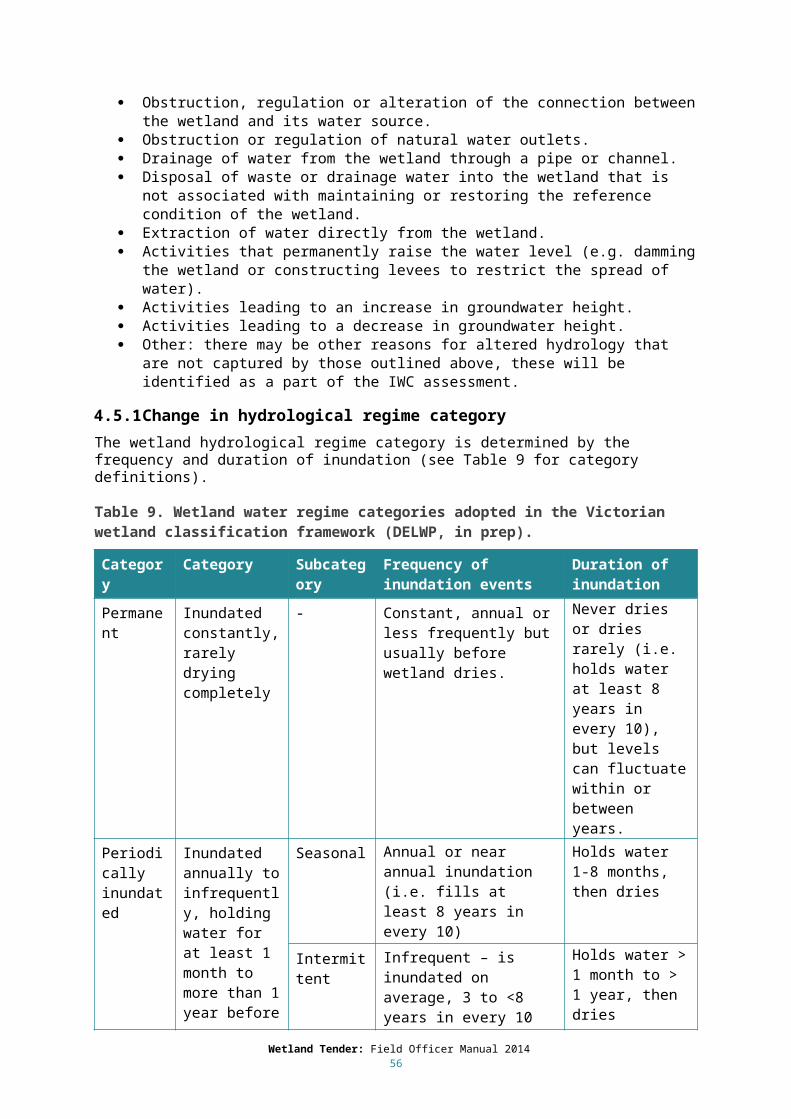
species or lifeforms (DSE 2012). Scoring is based on the percentage of critical lifeform groups present (specified in Section 1 of the benchmark description) and the presence and severity of any altered process recognised for the EVC (as described in Section 3 of the benchmark description).
Scoring gain for Altered Processes:
Gain is scored by reinstating the natural hydrology and/or salinity regime and will depend on the cause/s of the change (see Tables 10 and 13 respectively). If the EVC has been completely displaced or there is less than 50% of critical lifeform groups present, then some degree of revegetation will be required to qualify for gain.
If the predicted hydrology score (the score we expect after the interventions to improve hydrology are implemented) is zero or five, then the only possible outcome is a decline in the altered processes score. If the predicted salinity score (the score we expect after the interventions to improve ‘changed salinity’ are implemented) is zero, then the only possible outcome is a decline in the altered process score. Apart from these specific situations, as the landholder reduces the threats that cause altered processes the predicted score will improve, and the gain will increase, and as the threats increase the altered process score will decrease, and there might be less gain, no change or decline.
4.9 Permanent protectionIn projects using the Wetland Tender method, landholders have the opportunity to choose a fixed term Management Agreement or a fixed term Management Agreement plus permanent protection. The permanent protection involves a voluntary agreement registered on the property title and binds the existing owner beyond the life of the agreement and to all future landholders to protect the natural values of the site. There are two mechanisms for permanent protection: Land Management Co-operative Agreements under the Conservation, Forests and Land Act 1987 and Conservation Covenants through Trust for Nature under the Victorian Conservation Trust Act 1972. The owner of the land will need to sign the permanent protection agreement within the first 12 months of signing the Wetland Tender Management Agreement.
If the landholder chooses to permanently protect the site, they will be eligible for additional gains. To be eligible for this additional gain all of the wetland must be currently managed for conservation purposes by the landholder or neighbour, this could include Crown land managed as a protected area. A site is only eligible for the permanent protection gain once.
Sites that have already been permanently protected can still be eligible for Wetland Tender for management actions that they agree to undertake. If the site already has permanent protection, the landholder should provide confirmation that they have not received incentive funds for the site under another program and that the site is not part of an offset or planning decision (see Section 3.1). If the permanently protected site does not have an existing management agreement in place the landholder will be required to sign an agreement for the site, increasing commitments and management to meet Wetland Tender requirements. Any sites under an existing management agreement are not eligible to participate in Wetland Tender for the same actions stipulated in the agreement. Other sites on the same property or different actions on the same site can be eligible.
Wetland Tender: Field Officer Manual 201456

6 Implementing gain actions
5.1 Feasibility and adaptive management This section describes the range of management activities that can be used to implement the gain actions (as identified in Chapter 4) and provides advice on selecting the appropriate activity. The gain actions and activities are organised into groups of related management approaches. The complete list of threats, gain actions and management activities are provided in Appendix 1 as a series of tables.
Landholders make a commitment to undertake gain actions to reduce threats or directly improve condition. This section provides more detail on the issues to be considered when devising a plan to reduce the threats to wetland condition, and the minimum management standards that must be met.
The landholder makes a commitment to undertake the management activities for the duration of the Management Agreement. The management activities are included in the Management Plan as management commitments. For each management commitment, there are a number of considerations that should be discussed with the landholder, these are outlined in the sections below.
Feasibility
Some general factors to consider for any of the proposed management actions are given below (modified from DEPI 2013d):
How difficult is it to achieve the commitment? What resources would the landowner require to achieve the commitment? Can the landowner undertake the commitment using standard approaches, given the
timeframes, resources and difficulty? Can the landowner provide enough time and labour to achieve the commitment? Does the landowner require additional advice or guidance to achieve the commitment? Can the landowner undertake the commitment and minimise collateral damage to native
vegetation and water quality?
Adaptive management
With any management action, there is an inherent risk of not attaining the stated objective, or obtaining outcomes that are unexpected. Knowledge of the effects of management interventions in wetlands is often limited and management standards are lacking for many management activities (e.g. guidelines for sustainable grazing in wetlands, guidelines for revegetation and supplementary planting to provide planting densities, survival and diversity targets). For this reason, an adaptive management approach is often appropriate. This can be achieved by staging work over time and noting the effects of the management actions at each stage before undertaking the next stage. Subsequent actions can then be modified depending on the outcomes of the previous stage (DCNR 1996).
Wetland Tender: Field Officer Manual 201457

5.2 Wetland catchment: Improving the wetland bufferAny part of the fringing zone that supports native vegetation (pre-European EVC with at least 25% cover of indigenous understorey) is considered to be wetland buffer. If the fringing zone does not support native vegetation, the landholder can propose to revegetate some or all of the area to increase the extent of the buffer. If the area supports an original pre-European EVC but has more than 75% non-indigenous groundcover the focus could be weed control to increase the indigenous groundcover above the 25% threshold (it would then be considered to be native vegetation and would qualify as wetland buffer).
If the landholder proposes to revegetate the fringing zone the EVC(s) that formerly occupied the site need to be determined. Suitable species and target densities for particular life forms must be chosen with reference to the Revegetation and Supplementary Planting Standards (DSE 2006). Note that appropriate EVC benchmarks for fringing vegetation are those used for Habitat Hectares (not the wetland EVC benchmarks used for the IWC). Gain for weed control will only be scored for management that is beyond legal requirements under the Catchment and Land Protection Act 1994 (see Section 4.1.1).
There are two ways to obtain gain for revegetating the wetland buffer:
1. Increasing the width of buffer (up to 50 metres).2. Increasing the proportion of the wetland that has a buffer.
Note that when a landholder proposes to improve the wetland buffer in some way the option to “Improve wetland buffer” (including the new width and/or new percentage of perimeter) must be selected in EnSym as well as “Revegetation in buffer” and/or “Weed control in buffer”.
The management activity/activities required to restore the buffer will depend on the threat. See Table 16 for the gain actions and the relevant management activities that can be used.
Wetland Tender: Field Officer Manual 201458

Table 16. Threats to the wetland buffer, the actions that can be undertaken to score gain and the relevant management activities that can be used. There are several alternative methods for weed management which can be used singly or in combination.
Threat Gain action Management activityDegradation of buffer vegetation
Improve wetland buffer
Improve wetland buffer - Width (metres from perimeter)
Improve wetland buffer - Length (percentage of perimeter)
Clearing of buffer vegetation
Revegetation in buffer
As per minimum standards (see Revegetation and Supplementary Planting Standard)
Refer to species list attached
Collect indigenous seed/source stock
Place order with nursery
On-grow plants
Prepare planting or direct seeding area
Plant out area and guard if required
Monitor and undertake pest and weed control over planting area
Replace unsuccessful seedlings if required
Degradation of buffer understory by weed invasion
Weed control in the buffer (beyond CaLP Act requirements)
Contact field officer if weed cover in buffer increases beyond current levels
Spot spray
Hand pull
Herbicide injection
Cut and paint – apply suitable herbicide
Frilling – apply suitable herbicide
Drill and fill with suitable herbicide
Ring bark/cut down
Controlled grazing (upon written approval)
Mowing/slashing
Chipping
Supplementary planting (to replace missing species and/or lifeforms) can be undertaken in the fringing zone but the Wetland Tender metric will not score gain for this activity (though it may qualify for gain in terrestrial tender programs). If the landholder wants to undertake supplementary planting despite no gain being available, provide guidance on the appropriate species, and include management notes, rather than specific actions in the management plan.
The fringing zone might include some scattered trees. Protection of scattered trees requires the protection of an area, of at least twice the diameter of the drip line of the tree from negative impacts, to facilitate natural recruitment (Figure 11). In some cases, excluding stock combined with weed and rabbit control will be enough to facilitate natural recruitment. In other cases, additional
Wetland Tender: Field Officer Manual 201459

methods might need to be employed. Note that landholders will not score gain specifically for these activities as a part of wetland tender, though it is important to maintain the pre-European EVC with greater that 25% cover of indigenous understorey to qualify as wetland buffer (see Section 3.2). They can score gain for these activities as a part of a terrestrial tender program.
Figure 9.Stock exclusion zones for scattered trees
5.3 Wetland form: Restoring physical form The physical form of a wetland influences flooding depth, inundation duration and water mixing regime. It also influences biological and physical processes. The area of the wetland determines the amount and proportion of available habitat for biota. The bathymetry (underwater topography) of a wetland determines the types of habitats present in a wetland.
The principal threats to physical form are permanent reductions in wetland area (conversion to dry land by draining, filling, permanent reductions in water input etc.) and modifications to the wetland bed (by excavation or landforming).
The management action/s required to restore wetland physical form will depend on the threats present at the site. See Table 18 for the threats, gain actions and the relevant management activities that can be selected for inclusion in the management plan.
Wetland Tender: Field Officer Manual 201460
5m5m
Area to be protected e.g. 20m
e.g. 10m diameter
Area to be protected
e.g. 20m wide(i.e. 5m from the edge of the tree dripline)
Tree Canopy
e.g. 10m wide

Table 18. Threats to wetland physical form (reduced wetland area and changed bathymetry), the actions that can be undertaken to score gain and the relevant management activities that can be selected for the management plan.
Threat Gain action Management activityReduced wetland areaInfilling Excavate wetland to
reverse infillingRestore natural contours of wetland through earthworks
Drainage of water from the wetland
Cease drainage of water Restore natural outlet level
Remove or block outlet pipe
Block outlet channel
Install regulator on outlet channel
Change operation of existing outlet channel regulator
Reduced water inputs
Restore natural water regime
Provide environmental water in accordance with approved plan
Change operation of existing regulator
Install regulator
Levees or other barriers to water flow
Remove levees and barriers to natural inflows
Remove inflow obstructions
Remove by-pass inflow obstructions
Change operation of existing regulator
Remove existing regulator
Fire (peatland wetlands)
Use suppression activities to reduce fire frequency
Develop fire management plan for property
Create suitable offsite fire breaks
Maintain access to site
Channelisation (peatland wetlands)
Restore hydrological structure
Use artificial structures to slow water flow and create pooling (e.g. jute bags filled with coir, geotextile logs filled with red gum chips)
Changed bathymetryExcavation of wetland bed
Reverse effects of excavation
Fill in channels and dams
Landforming Restore wetland form Restore natural contours of wetland through earthworks
Remove artificial mounds
Remove built channels
Close tracks
Note that to undertake management activities that involve excavation (e.g. to reverse infilling) may require permissions and permits to be obtained (see Section 4.1.5).
If the wetland has severely impacted physical form it will not be eligible for improvement gain, as interventions are likely to cause significant damage to vegetation in the buffer and wetland, initiate or worsen soil disturbance and impact water quality. In this context, severely impacted physical form is defined as more than 50% reduction in area or more than 50% of the wetland affected by medium-high severity bathymetry change.
Wetland Tender: Field Officer Manual 201461

5.4 Hydrology: Restoring hydrological regimeNormal wetland functioning depends on hydrologic processes, the aim of wetland management should be to improve (or protect) the hydrological regime as a first priority as other wetland functions might then be restored naturally (DCNR 1996). Wetland productivity, nutrient cycling, vegetation establishment and diversity of flora and fauna are linked to regular wetting and drying, important environmental cues are provided by rising and falling water levels (DCNR 1996).
Note, there could be limited opportunities to artificially manipulate the wetting and drying cycles of the wetland (e.g. structures to allow controlled drawdown, water for environmental flows), and the most appropriate aim may be to allow natural wetting and drying patterns to occur.
The management action/s required to restore wetland hydrological regime will depend on the threats present at the site. See Table 18 for the threats, gain actions and the relevant management activities that may be selected for inclusion in the management plan.
Consider the following points when identifying the activities to be documented in the draft management plan:
The natural water regime of the wetland should be determined before the activity is agreed (i.e. frequency, duration and timing of inundation, and the depth if possible). See the Index of Wetland Condition Assessment Procedure (DEPI 2013) for further detail.
Consider the relative contribution of different water sources, which might be rivers, overland flow and/or groundwater (this is considered as a part of the IWC assessment), and the timing of their contributions.
The proposed hydrological regime should be described in terms of frequency, duration and seasonality and possibly depth depending on the action (i.e. if the action changes the depth); e.g. ‘deliver a hydrological regime that provides water at an average depth of 0.5 metres and an annual average duration of eight months, with early summer drying’ (DCNR 1996).
Where impacts on the wetland water source are beyond the influence of the landholder, consider local changes that could improve the hydrological regime (i.e. to prevent excess water entering the wetland or retain water that would otherwise drain). Where the opportunity exists to manipulate the hydrological regime, it should be done to mimic natural conditions.
Where reinstatement of the natural hydrological regime is impractical, or the risk to current values is deemed too high, it can be appropriate to set a different management objective for the site (Section 4.1.4). Refer to the Regional Implementation Coordinator as to whether the site is still eligible for Wetland Tender, or should be targeted by a different incentive program. The objective for the site could be to continue the current hydrological regime for maintenance of key species or communities that are present or might use the site (DCNR 1996). Examples of species to consider:
Dominant species: River Red Gum (Eucalyptus camadulensis), Giant Rush (Juncus ingens), Moira Grass (Pseudoraphis spinescens)
Native species that may become invasive: Typha spp., Phragmites australis. Waterbirds. Threatened flora and fauna.
In general drawdowns (the drying part of the hydrological cycle) should (DCNR 1996):
Aim to simulate natural wetting and drying patterns. Be timed to occur over the period November through to January. Be a slow process with a gradual drop in water level over the draw down period.
Wetland Tender: Field Officer Manual 201462

Table 18. Threats to wetland hydrological regime, the actions that can be undertaken to score gain and the relevant management activities that can be selected for the management plan.
Threat Gain action Management activityRiver regulation Restore natural
water regime Provide environmental water
Change operation of existing regulator
Install regulator
Activities that change the local surface drainage patterns
Restore surface flow patterns
Remove any impediments to delivery of water drained from surrounding landscape
Artificially manipulated water inflow or drawdown (not associated with maintaining or restoring the reference condition of the wetland)
Improve management arrangements
Change operation of wetland hydrology to restore natural water regime
Obstruction, regulation or alteration of the connection between the wetland and its water source
Restore connection between wetland and water source
Remove inflow obstructions
Remove by-pass inflow obstructions
Change operation of existing regulator
Remove existing regulator
Lower inflow threshold
Obstruction or regulation of natural water outlets
Restore outlet flow path
Removing obstructions at outlet
Change operation of existing outlet regulator
Remove existing outlet regulator
Drainage of water from the wetland through a pipe or channel
Cease drainage of water
Restore natural outlet level
Remove or block outlet pipe
Block outlet channel
Install regulator on outlet channel
Change operation of existing outlet channel regulator
Disposal of waste or drainage water into the wetland (not associated with maintaining or restoring the reference condition of the wetland)
Stop disposal of water to wetland
Cease production of waste water
Reduce volume of waste water (note new waste water volume, ML)
Divert water before it reaches wetland
Extraction of water directly from the wetland
Stop water extraction
N/A
Activities that permanently raise the water level (e.g. damming the wetland or constructing levees to restrict the spread of water)
Lower maximum water level
Remove internal levees or other internal barriers
Install connecting pipe through levee or internal wetland barrier
Remove or lower dam wall or sill or install outlet within dam wall
Wetland Tender: Field Officer Manual 201463
Table 18. continued.
Threat Gain action Management activityActivities leading to an increase in groundwater height
Cease activities that increase GW height
Manage surrounding landuse to decrease GW levels: Consult CMA Catchment Management
Plan
Implement more efficient irrigation practices:
o Benchmark current practice and reduce water use (note per cent reduction and new irrigation volume)
o Stop irrigation
Plant native vegetation (trees or other native deep-rooted perennials) in recharge areas (usually ridges and upper slopes)
Plant native vegetation (trees or other native deep rooted perennials) in discharge areas (break of slope, or where there is perched/laterally flowing groundwater)
Extract excess groundwater (pumping)
Activities leading to a decrease in groundwater height
Cease activities that decrease GW height
Consult CMA Catchment Management Plan
Stop groundwater extraction
Reduce groundwater extraction (note new volume)
5.5 Water properties: Improving water qualityThe effects of nutrient inputs and altered salinity are of particular concern as degrading processes in wetlands.
5.5.2 Nutrient enrichment
Nutrient enrichment results primarily from inputs of nutrient-laden wastewater (e.g. sewage effluent, urban stormwater, agricultural runoff) and grazing of herbivores (including livestock, feral and native fauna). Nutrient enrichment increases productivity of the system and promotes the growth of aquatic plants. Nutrient enrichment can cause algal blooms which deplete oxygen and cause fish kills. It can also lead to increased macrophyte growth (e.g. Typha spp., Phragmites australis) and modify vegetation structure. The restoration of nutrient enriched systems involves controlling nutrient inputs and may also involve maximising nutrient utilisation or export (DCNR 1996). Note, the landholder can score gain for reducing nutrient input to the wetland, but no gain can currently be scored for removing nutrients from the system.
The most effective method for controlling inputs is to reduce point source discharge; diffuse sources should also be controlled wherever possible (DCNR 1996).
Wetland Tender: Field Officer Manual 201464

Methods for reducing inputs: Diverting nutrient rich water away from wetlands. Removing nutrients from water before it reaches the wetland. Improve agricultural practices in surrounding landscape (e.g. methods and rates of applying
fertiliser, stock management). Revegetation in wetland catchment (vegetation will trap and utilise nutrients), this might be
more efficient than other methods if it targets specific areas (nutrient ‘hotspots’), e.g. eroding areas of the catchment.
Establish and/or maintain appropriate vegetation buffers around wetlands. Do not use fertiliser in wetland. Exclude livestock and feral fauna from wetland. Do not use wetland for aquaculture.
Methods for removing nutrients (DCNR 1996):
Flushing or diluting wetland with low-nutrient water. Removing high nutrient sediment. Macrophyte uptake and subsequent harvesting. Macrophytes used for this purpose include
Phragmites australis, Typha spp., Eleocharis sphacelata, Schoenoplectus validus, and Myriophyllum spp.
The management action/s required to reduce nutrient inputs will depend on the source of the nutrients. See Table 19 for the threats, gain actions and the relevant management activities that might be selected for inclusion in the management plan.
Wetland Tender: Field Officer Manual 201465

Table 19. Threats that contribute to nutrient enrichment, the actions that can be undertaken to score gain and the relevant management activities that can be selected for the management plan.
Threat Gain action Management activityDischarge of nutrient-rich water to the wetland from sewage, industrial effluent and/or irrigation water
Stop or reduce discharge of nutrient-rich water to wetland
Stop discharge of nutrient-rich water to wetland
Reduce discharge of nutrient-rich water to wetland (note per cent reduction and new volume, ML)
Drainage of nutrient-rich water into the wetland from an urban area
Stop or reduce drainage of nutrient-rich water to wetland
Stop discharge of nutrient-rich water to wetland
Reduce discharge of nutrient-rich water to wetland (note per cent reduction and new volume, ML)
Runoff of nutrients to wetland
Change land management practice in wetland catchment
Stop/reduce fertilizer application
Stop/reduce grazing in the catchment including the wetland buffer
Improve wetland buffer - new width (metres from perimeter)
Improve wetland buffer - new length (percentage of perimeter)
Revegetate catchment
Grazing by livestock in the wetland
Manage stock in accordance with a controlled grazing regime
DELWP is in the process of developing guidelines for stock grazing in wetlands. Pending completion of the guidelines, only the following activities should be undertaken unless expert advice indicates a variation is acceptable. Fence area to manage livestock
Erect new standard fencing
Erect new electric fencing
Install gate
Maintain or repair existing fencing
Exclude livestock when soil is moist
Remove livestock to allow native seed set
Graze for short periods only
Confirm >25% weed cover (with field staff) if grazing for weed control
Confirm native grass thatch (with field staff) if grazing for biomass removal
Wetland Tender: Field Officer Manual 201466
Table 19. continued.Threat Gain action Management activityGrazing by livestock in the wetland (cont.)
Exclude livestock from wetland
Fence area to exclude stock: Erect new standard fencing
Erect new electric fencing
Install gate
Maintain or repair existing fencing
Install off-site watering points
Grazing by feral animals in the wetland(for species not included in CaLP Act, e.g. deer, horses)
Control or exclude feral animals from wetland
Fence to exclude feral animals from wetland
Erect new standard fencing
Erect new electric fencing
Install gate
Maintain or repair existing fencing
Monitor and control as required (non CaLP species)
Shooting under appropriate permits/licenses (non CaLP species)
Grazing by feral animals in the wetland(for species included in CaLP Act: foxes, rabbits, hare, pigs, goats, wild dogs)Note: NO GAIN is scored for management activities involving these species.
Control feral animals in the wetland (CaLP species)
Monitor and control as required (CaLP species)
Shooting under appropriate permits/licenses (CaLP species)
Baiting
Trapping
Rabbit-specific control:
Warren fumigation
Hand collapse
Removal of surface harbor
Rip warrens (seek approval of Regional Implementation Manager)
Ferreting
Application of fertilizer in the wetland
Stop application of fertiliser in wetland
N/A
Aquaculture Stop aquaculture-related activities within the wetland
N/A
5.5.2 Altered salinity
The salinity regime of a wetland can be modified by human activities, this can have the effect of making the wetland more saline or less saline. Salinity varies naturally with water level – increasing with low water levels and decreasing with high water levels. Because of this, modification to the hydrological regime also exerts a strong influence on the wetland salinity regime. Long standing
Wetland Tender: Field Officer Manual 201467

changes to the hydrological regime can result in salt accumulation, as there is a lack of natural flushing and/or lack of downward pressure on saline groundwater below the wetland.
Salinisation of wetlands can be caused by catchment scale changes that cause the level of groundwater to rise. These include clearing of deep-rooted perennial plants and irrigated agriculture on poorly drained land. Groundwater can also begin discharging when surface water is drained or otherwise extracted. Wetlands are less frequently flushed than rivers and streams and therefore are more likely to have greater increases in salinity if saline water discharges to them (DCNR 1996). In some systems there will be a cumulative effect over time.
The management of salinity can rely on processes acting at a catchment level (e.g. extent of catchment clearing), and might be out of the control of the land manager. However, there may be local factors that can be managed to mitigate these. Consider the water sources for the wetland and which of these are potential sources of saline water, e.g. saline runoff, groundwater, discharge sites, and/or rivers and streams.
The management activity/activities required to restore the natural salinity regime will depend on the threats acting at the site. See Table 20 for the threats, gain actions and the relevant management activities that can be selected for inclusion in the management plan.
Table 20. Threats that contribute to altered salinity, the actions that can be undertaken to score gain and the relevant management activities that can be selected for the management plan.
Threat Gain action Management activitySaline groundwater intrusion resulting in an increase in salinity from its natural state
Cease activities that lead to increased GW height
Manage surrounding land use to decrease GW levels: Consult CMA Catchment Management Plan
Implement more efficient irrigation practices:
- Benchmark current irrigation practice and reduce water use (note per cent reduction and new irrigation volume)
- Stop irrigation
Plant native vegetation (trees or other native deep-rooted perennials) in recharge areas (usually ridges and upper slopes)
Plant native vegetation (trees or other native deep rooted perennials) in discharge areas (break of slope, or where there is perched/laterally flowing groundwater)
Undertake groundwater extraction (pumping)
Saline water intrusion from the marine environment resulting in an increase in salinity from natural state
Cease activities that lead to marine water intrusion
If marine water intrusion is due to over-extraction of fresh groundwater reduce groundwater extraction
Close artificially created connection to marine waters
Wetland Tender: Field Officer Manual 201468

Table 20. continued.Threat Gain action Management activitySaline water is unnaturally delivered to a fresh or brackish wetland
Stop delivery of saline water to wetland
Divert discharge of saline water away from wetland (point source)
Change irrigation and/or other land use practices (diffuse source, e.g. irrigation channels, saline runoff)
Fresh water is unnaturally delivered to a saline wetland
Stop delivery of freshwater to wetland
Divert discharge of freshwater water away from wetland (point source)
Change land use practice to stop freshwater delivery to wetland (diffuse source)
5.6 Soils: Improving soil conditionWetland soils provide a physical substrate for aquatic plants and habitat for benthic invertebrates and micro-organisms. They store nutrients that are important for primary production, bind toxicants such as heavy metals and provide a site for many chemical transformations and nutrient cycling. Soils have physical (soil structure, texture and consistency), chemical (redox potential, salinity, acidity, dissolved organic carbon, nutrients, trace elements) and biological (micro-organisms, invertebrates, plants) components. The IWC includes an impact measure (soil disturbance) relating to the soil physical components.
The main causes of soil disturbance in wetlands are pugging by livestock and feral animals, carp mumbling, trampling by humans, cultivation and driving vehicles on wetlands.
The management activity/activities required to improve soil condition will depend on the threats acting at the site. See Table 21 for the threats, gain actions and the relevant management activities that can be selected for inclusion in the management plan.
Wetland Tender: Field Officer Manual 201469

Table 21. The threat of clearing and degradation of wetland vegetation, the actions that can be undertaken to score gain.
Threat Gain action Management activityPugging by livestock Implement a controlled
grazing regimeDELWP is in the process of developing guidelines for stock grazing in wetlands. Pending completion of the guidelines, only the following activities should be undertaken unless expert advice indicates a variation is acceptable. Fence area to manage livestock
Erect new standard fencing
Erect new electric fencing
Install gate
Maintain or repair existing fencing
Exclude livestock when soil is moist
Remove livestock to allow native seed set
Graze for short periods only
Confirm >25% weed cover (with field staff) if grazing for weed control
Confirm native grass thatch (with field staff) if grazing for biomass removal
Exclude livestock from wetland
Fence area to exclude stock: Erect new standard fencing
Erect new electric fencing
Install gate
Maintain or repair existing fencing
Install off-site watering points
Disturbance or pugging by feral animals(for species not included in CaLP Act, e.g. deer, horses)
Control or exclude feral animals from wetland (non-CaLP species)
Fence to exclude feral animals from wetland
Erect new standard fencing Erect new electric fencing
Install gate Maintain or repair existing fencing
Monitor and control as required (non CaLP species)
Shooting under appropriate permits/licenses (non CaLP species)
Wetland Tender: Field Officer Manual 201470

Table 21. continued.
Threat Gain action Management activityDisturbance or pugging by feral animals(for species included in CaLP Act: foxes, rabbits, hare, pigs, goats, wild dogs)Note: NO GAIN is scored for management activities involving these species.
Control feral animals in the wetland (CaLP species)
Monitor and control as required (CaLP species) Shooting under appropriate
permits/licenses (CaLP species) Baiting
Trapping Rabbit-specific control:
Warren fumigation Hand collapse
Removal of surface harbor Rip warrens (seek approval of Regional
Implementation Manager) Ferreting
Carp mumbling Exclude carp from wetland
Install carp exclusion screens at inlet/s Install carp exclusion screen with trap
(push or jumping trap) at inlet/s Install carp separation cage out outlet
Allow natural drying of wetland
Trampling by humans Exclude or manage human access in the wetland
Manage pedestrian access to wetland
Prevent pedestrian access to wetland Provide low impact tracks (e.g. raised
boardwalks) Rehabilitate closed tracks
Cultivation Cease cultivation of wetland
N/A
Driving vehicles on wetland
Stop or manage vehicle access in the wetland
Exclude vehicles from wetland Confine vehicles to defined tracks
Close tracks Rehabilitate closed tracks
Wetland Tender: Field Officer Manual 201471
5.7 Wetland biota: Weed managementUnder the Catchment & Land Protection Act 1994 (s20 (1)), (CaLP Act) a landholder is required to take all reasonable steps to: (a) eradicate regionally ‘prohibited’ weeds and (b) control and prevent further spread of regionally ‘controlled’ weeds. Only commitments beyond these required legal obligations will be awarded gain.
There are two possible gain actions for weeds not included in the CaLP Act, these are control (prevent further spread when below 25 per cent cover, when over 25 per cent reduce cover to under this threshold) or eradication to less than one per cent cover. See Table 22 for the management activities that may be selected for inclusion in the management plan. Landholders must at least choose to control weeds (as defined in Table 22), this includes monitoring for any new and emerging weeds, and eliminating them to less than one per cent cover.
Table 22. The threat of weed invasion of the wetland, the actions that can be undertaken to score gain and the relevant management activities that can be used. There are several alternative methods for weed management which may be used singly or in combination.
Threat Gain action Management activityDegradation of wetland by weed invasion
Control weeds in wetland: Ensure weed cover does not
increase beyond current levels (high threat and other weeds).
Monitor for any new and emerging weeds and eliminate to <1% cover.
Eradicate weeds in wetland: Non-high threat weeds: weeds
that are up to 25% cover - ensure cover does not increase beyond current levels, weeds with >25% cover reduce to under 25% cover.
High threat weeds: Eliminate all identified high threat weeds to <1% cover.
Contact field officer if weed cover increases beyond current levels
Spot spray
Hand pull
Herbicide injection
Cut and paint – apply suitable herbicide
Frilling – apply suitable herbicide
Drill and fill with apply suitable herbicide
Ring bark/cut down
Controlled grazing (upon written approval)
Mowing /slashing
Chipping
Mulching
Where high threat weed species have become well established it is unreasonable to expect landowners to eliminate them without causing unacceptable damage to the surrounding native vegetation. For this reason, only consider this option where there is a reasonable expectation that the weed can be eliminated to less than one per cent cover, and where the initial weed score is greater than seven. Elimination is not generally achievable if the weeds on site include multiple weed species and/or difficult to control weeds such as Chilean Needle Grass. To determine if elimination to less than one per cent cover is reasonable consider the following:
Current cover of all high threat weed species. Predicted response of the species to the control methods. Size of the area to be managed.
Wetland Tender: Field Officer Manual 201472
Extent of the species (and other high threat weeds) in the vicinity and their potential to invade the site.
Landholders capacity to effectively implement the control method.
Control of some annual weeds might not be achievable (e.g. onion grass). Seek advice from the Regional Implementation Coordinator as to whether to include the weed in the Management Plan.
Successful eradication of aquatic weeds (weed species with adaptations for living submerged or at the surface of the water) is difficult. Best results are achieved with an integrated mechanical and herbicide control program. Careful removal of all aquatic weeds by hand is particularly useful for small areas. Any material physically removed from the water should be left to dry and burnt some distance from the water. Manual removal of aquatic weeds also has the advantage of removing nutrients from the water, in comparison to herbicide control in which the nutrients from dead plants are released into the water, potentially affecting water quality and encouraging new weed growth. Herbicides are effective, and there are several registered for use on aquatic weeds. There are guidelines for herbicide use in and around water (Cooperative Research Centre for Australian Weed Management, 2005). Eradication of smaller infestations is possible but requires a concerted effort with vigilant follow-up. The follow-up control should be conducted soon after the initial treatment, and repeated and monitored regularly until the entire weed population has been removed.
Consider the following general points when identifying weed control activities to include in the draft management plan:
Developing an integrated approach to weed management, by combining all appropriate weed control options into an integrated weed management (IWM) plan, is likely to be the most effective way to manage weeds (Cooperative Research Centre for Australian Weed Management, 2005).
The landholder will need to manage the likely weed ‘flush’ response when grazing pressure is removed from a site.
Weed management might involve managing mitigating factors, such as control of nutrient-rich runoff onto the site, and excluding livestock and feral fauna (sources of nutrients and weed propagules).
Managing the source of the weed infestation could be the most efficient method of weed control. This may include management beyond the site (e.g. adjoining paddock).
The establishment of a wetland buffer will provide a barrier to water and wind borne weed propagules.
Following the control or elimination of a weed species the same or a different weed could re-invade the wetland. A sustained effort is required over the five-year Management Agreement to ensure elimination of the weed.
Existing woody weeds can provide habitat for native fauna, management should ensure that weed removal does not destroy the only habitat on the site for native fauna species. The preferred approach is the staged removal of the weed with supplementary planting of indigenous shrubs, aiming to have all woody weeds removed within the period of the agreement. The ‘drill and fill’ method of weed control may be appropriate to avoid complete removal of available habitat while indigenous plants are establishing. Still standing dead woody weeds that are left in situ for habitat will be deemed eliminated.
Do not provide any advice on the type of herbicide or chemical to use, direct landholders to seek advice from their chemical distributor.
If a non-indigenous native species is not invasive, there is no requirement to manage the species unless the landholder volunteers to undertake the action. Woody plants might have been established
Wetland Tender: Field Officer Manual 201473
through public investment and a requirement to remove these plants could be perceived as ‘wasting Government funds’ or the landholder may feel a sense of blame.
If a non-indigenous native species is invasive and displacing indigenous flora, then the species must be managed. Examples of weedy native species may appear in the wetland EVC benchmark or in regional weed lists. Some Hakea and Acacia species from Western Australian, New South Wales and Queensland have become weeds in Victoria. Some Victorian species might also be weeds outside their natural range (e.g. Sweet Pittosporum and Sallow Wattle). Seek advice from DELWP officers as this could require a permit to remove native vegetation.
Some landholders might propose to use spot burning (with a weed burner) on parts of their site to control weeds. They should target a particular plant or small area rather than a burn of the whole site. Spot burning will probably not be sufficient to control the weed, and should be used in conjunction with other weed control methods such as spot spraying. If the landholder is not able to conduct spot burning one year, they should use alternative methods to control the weeds. See Section 5.12 for further information regarding fire management in wetlands.
Some landholders might wish to use controlled grazing as part of their weed management program. See Section 5.9.1 for further information on grazing in wetlands.
The DELWP and CMA websites provide information on regionally listed and environmental weeds and their control methods.
It could be useful to show the landholder a specimen of any weeds that you suggest they control (either collect a specimen or tie flagging tape to a specimen on the site as an example).
5.8 Wetland biota: Revegetation and supplementary plantingThe vegetation present in the wetland might not represent the characteristic structure and species diversity of the EVCs that originally occupied the site. If the removal of threats does not result in sufficient natural regeneration to restore the EVC, revegetation and/or supplementary planting could be required.
Natural regeneration
Consider the threats to the site that are causing the lack of diversity or missing lifeforms. In some circumstances, controlling the threat can be enough to encourage natural regeneration, and supplementary planting will not be necessary (in this situation choose ‘Supplementary planting or natural regeneration’ as the gain action). This ‘wait and see’ approach allows natural processes to operate, and depends on presence of propagules and/or the capacity of the existing vegetation to recover and colonise the site (DCNR 1996). In wetlands with a viable seed bank there is potential for substantial natural regeneration of emergent vegetation when threats have been controlled (e.g. the hydrological regime is restored). Seed longevity declines with increasing duration of drainage and is reduced by cultivation, and is also impacted by prolonged inundation. Wetlands drained for less than 20 years can still have seed banks that contain viable seeds (DCNR 1996). If desirable species do not reappear when threats have been controlled and conditions are suitable, supplementary planting must be undertaken.
Supplementary planting
Supplementary planting can be used to replace missing critical lifeforms and/or restore the cover of critical lifeform groups where they are unlikely to recolonise the wetland without intervention. Where structurally or floristically significant species are known to have been lost from the wetland supplementary planting should be considered. Supplementary planting can be a useful management
Wetland Tender: Field Officer Manual 201474

action in very weedy or disturbed patches within a site. A full species list should be provided with the management plan (see below).
Revegetation
Revegetation is required where the wetland EVC has been lost (vegetation cleared or conditions made unsuitable), and is unlikely to recolonise the wetland without intervention. In areas of the wetland where revegetation is proposed, determine the EVC(s) that formerly occupied the site, considering the topography and site conditions and by referring to the pre-1750 EVC (NV_1750) mapping layer, other physically and hydrologically similar sites in the local catchment, historic information and/or local knowledge. A full list of wetland EVCs is provided in the IWC Assessment Procedure (DEPI 2013b), and wetland EVC benchmarks can be accessed using the following link http://ics.water.vic.gov.au/ics/ . A full species list should be provided with the management plan (see below).
Species Lists
Note, Wetland Tender is unable to provide species lists for wetland EVCs. The site species list should be developed with reference to the relevant wetland EVC, and may be inferred from intact remnant wetlands of similar type within the local catchment or remnant vegetation at the site. Other factors to consider in developing the species list are the local environment and site conditions, ease of propagation and/or availability of species from nurseries. Develop a species list that identifies the range of species to be used for each life form (trees, shrubs, etc.) that is characteristic of the EVC that occupies the zone being revegetated. Specify the required plant densities and survival targets. The landholder should aim to establish the greatest diversity of species possible for that EVC. There is some guidance provided for planting densities in EnSym (and below), these can be modified according to local environment and site conditions, and current regional practice.
See Table 23 for the management activities that can be selected for inclusion in the management plan.
Wetland Tender: Field Officer Manual 201475

Table 23. The threat of clearing and degradation of wetland vegetation, the actions that can be undertaken to score gain and the relevant management activities that can be used.
Threat Gain action Management activityClearing or degradation of wetland vegetation
Supplementary planting or natural regeneration
Natural regeneration from surrounding vegetation
Monitor establishment of natural regeneration
Develop species list for supplementary planting
Collect indigenous seeds and/or divided/whole plants
Place order with nursery
Prepare planting or direct seeding area
Plant tubestock or seedlings and guard if required
Undertake weed control over planting area
Replace unsuccessful seedlings if required
Undertake further supplementary planting
Revegetation Develop species list for revegetation
Collect indigenous seeds and/or divided/whole plants
Place order with nursery
Prepare planting or direct seeding area
Plant tubestock or seedlings and guard if required
Undertake weed control over planting area
Replace unsuccessful seedlings if required
Planting zones
Planting should aim to reflect the distribution of species according to depth, three generalised planting zones have been recognised (a) littoral zone: wetland margins which are shallow (< 10 cm) when the wetland is fully inundated or damp (sedges, rushes, reeds) (b) areas subject to seasonal inundation to 60 cm deep (mostly rushes) (c) permanent or near permanent water (aquatic plants) (DCNR 1996), shallower parts of this zone may also include erect emergent sedges, and grasses and herbs with floating, emergent or submerged leaves or free floating species (Cook 2013).
Identify each of these zones in the wetland, and the approach for each zone (and the locations within the zone) where natural regeneration or planting should take place. Each of the zones should be monitored to gauge progress against the required outcomes (e.g. progress of natural regeneration, success of plantings).
Timing of management activities
The success of natural regeneration, revegetation and/or supplementary planting is likely to be highly dependent on timing in regards to inundation and the prevailing climatic conditions. Success is unlikely if planting occurs at the wrong stage of the wetland cycle or during an extended dry period (e.g. where the wetland is unexpectedly dry). Note also that the results of natural regeneration are unlikely to be apparent until suitable hydrological conditions are present.
The best time for planting is when a species is nearing its optimal growing season, which varies for different species (Cook 2013). Optimal growth conditions for plants at the margins of the wetland often occur in cooler seasons when moisture is available in this zone (Cooke 2013). For areas of more
Wetland Tender: Field Officer Manual 201476
permanent inundation planting is usually best carried out in spring and early summer, when water levels are low and temperatures are warm. Planting should be adapted to suit site conditions particularly the length of the growing season and the degree of summer drying of the site (DCNR 1996).
It can be difficult to determine at the start of the agreement when actions should be undertaken (i.e. when would we would expect to see natural regeneration, when it would be the best time to undertake supplementary planting or revegetation) as it will depend on climatic conditions at the site. A degree of flexibility should be incorporated into the management plan to take this into account.
Sourcing plant material
Wetland plants can be established by direct seeding, transplanting of divided or whole plants or seed bank material, or planting of propagated tube stock. These plants must be indigenous species and where possible from within the local catchment, seed or seed bank material should be collected as close to the wetland as possible. All plant material should be healthy and with no sign of diseases or parasites. For more details of planting methods and the likely success for different species and plant types, see the Manual of Wetland Management (DCNR 1996).
The landholder may choose to collect seed and grow their own plants or contract a nursery to do the work. Good practice seed collection ensures that seed are from are genetically diverse individuals, of the correct species, are ripe and free of weed seed (Cook 2013), for these reasons the landholder may wish to use a trained professional. Good practice seed bank collection should ensure that the ‘donor’ wetland is not damaged or degraded during collection.
Planting densities
Higher planting densities will generally result in more rapid vegetation establishment, and will help to prevent weed invasion and erosion (Cook 2013). If planting densities are too low the indigenous canopy cover will be sparse and allow a higher rate of weed invasion; this is likely to increase maintenance costs. The zones that dry out in the warmer months (zones (a) and (b) above) are more most susceptible to weed invasion (Cook 2013). Planting density of 5-6 plants per square metre should be adequate for these zones providing that weed control is carried out in the period of establishment (Cook 2013). Planting density in the deeper, more permanently inundated zone should be around 2-4 plants per square metre (Cook 2013).
Maintenance and monitoring
Successful revegetation or supplementary planting requires monitoring of plant establishment and weed invasion, and timely follow up management. Other things to monitor include water levels in the wetland, pressure from human activities, water quality issues, waterbird grazing and other fauna use, and the integrity of plant guards (Cook 2013). Ideally the site should have a weed control strategy which includes timely and appropriate treatment and monitoring (Section 5.7).
Wetland Tender: Field Officer Manual 201477
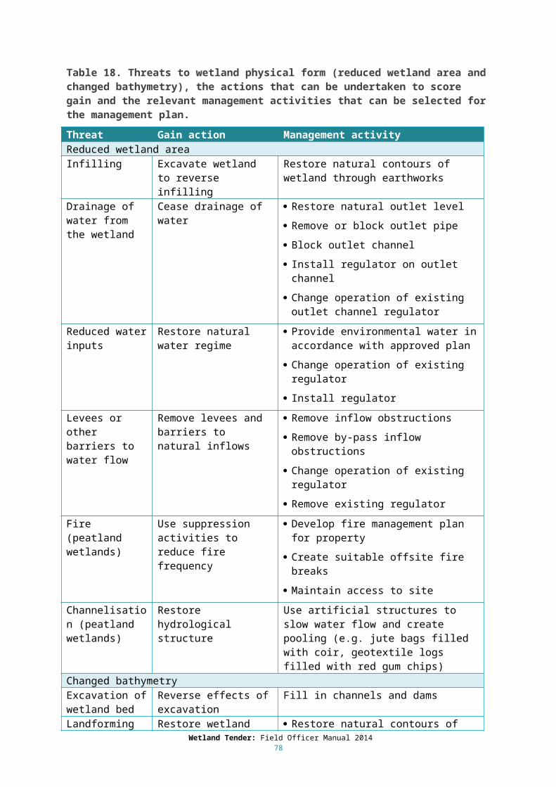
Further considerations
Consider the following points when providing advice and developing the draft management plan.
It can increase successful establishment of herbaceous species to first establish structural sedges and rushes which provide the microhabitats for these smaller species (Cook 2013).
Only include revegetation and/or supplementary planting if the landholder will exclude livestock as continued grazing is likely to lead to low success rates in establishment and survival.
Consider the other threats that might need to be controlled such as altered water and salinity regime, nutrient enrichment, carp and rabbits.
When choosing indigenous species that are potentially invasive (e.g. Typha spp and Phragmites australis) only introduce to areas where they are known to have occurred and/or where there are natural barriers to their spread (e.g. areas of deep water).
It can be necessary to protect some plant species from grazing waterbirds during the first growing season. Cook (2013) recommends an enclosure made of netting or small gauge chicken wire which can be suspended over the young plants. Enough space should be provided for the full extent of growth expected in the season. He also cautions that netting and wire must be taut and that there be no points of entry for wildlife, to avoid them becoming trapped or entangled.
5.9 Controlled grazing for weed control and biomass removal
5.9.1 Grazing in the wetland
Livestock exclusion is the preferred management approach for all wetlands, as livestock can do considerable damage to the wetland soil structure, change vegetation composition (via decline in palatable and/or grazing sensitive species), and introduce nutrients and weed propagules to the wetland. Livestock can also browse and trample rare and threatened plants and degrade habitat for threatened fauna. The effects of grazing might not be readily reversible, i.e. the removal of grazing might not return the wetland to pre-grazing condition. Landholders might currently use stock to reduce weeds, as other weed control is more expensive, however the additional costs of targeted weed control can be included in the landholder’s bid under Wetland Tender.
If a controlled grazing program is proposed the landholder can achieve some gain, but not the maximum gain possible. Note, if grazing is well managed (i.e. the soil and biota scores are good or excellent) the potential for improvement gain will be limited in any case.
If grazing is uncontrolled (livestock access is not managed) and this approach is to be continued, a decline would be recorded for soils, nutrients and biota, and for these reasons uncontrolled grazing is not an option under Wetland Tender. Where grazing is uncontrolled the initial scores for soils, water properties and biota would be more likely to be low, and improvement gain could be scored by changing to a controlled grazing program.
The management alternatives are as follows:
Exclude livestock. Controlled grazing.
There can be some undesirable effects of removing livestock from a wetland (e.g. an increase in the extent and abundance of weeds, increased native species biomass). If the undesirable impacts are likely to be long-term controlled grazing can be considered. However, where landholders initially proposed to exclude livestock (and obtained the relevant amount of gain) and subsequently want to undertake controlled grazing, a formal exemption must be obtained from the Regional
Wetland Tender: Field Officer Manual 201478
Implementation Coordinator. The process must include a site visit by the Field Officer to confirm details of the issue that the landholder wishes to manage by controlled grazing. The landholder must obtain approval for the exemption in writing, which will stipulate the details of the grazing regime, and the duration and conditions of the exemption. A reassessment is required for each year of the agreement.
Controlled grazing
The factors outlined below need to be taken into account when considering a controlled grazing program. Note, guidelines for the sustainable use of grazing in wetlands are currently under development by DELWP, and should be completed by November 2014. The guidance provided below should be used in the interim as it represents the best current available knowledge.
Consider the processes that have caused the threat that a landholder thinks might be addressed by livestock grazing. Altered salinity, nutrient enrichment, and/or changes in water regime, can encourage the growth and dominance of one or a few species, leading to a decline species diversity and changes in vegetation structure (DCNR 1996). It is preferable to first manage the degrading process rather than introduce grazing which might have other undesirable effects.
In some cases, livestock grazing can be the best option for managing native vegetation, controlling weeds, and/or maintaining open water. To determine if grazing by livestock is appropriate consider these general guidelines (modified from DCNR 1996):
If the wetland has been grazed regularly and condition meets the Wetland Tender objectives (i.e. good/excellent condition) it could be appropriate to continue the current grazing regime.
If the site is in a degraded condition, remove or otherwise control the existing threats, including grazing. Once these threats have been removed or controlled, controlled grazing can be reconsidered as a management option.
If a wetland has never been grazed in the past it should remain ungrazed.
Monitoring: If controlled grazing is to be used to manage weeds or biomass, monitoring needs to identify changes over time and determine if grazing has been effective in meeting these targets. The aim of monitoring the effects of grazing (or the removal of grazing) will be to determine if there are significant changes in vegetation characteristics that relate to Wetland Tender objectives (maintain or improve wetland condition – in this case Biota), including (modified from DCNR 1996):
Changes in species composition:o Appearance of new species (indigenous and weed species).o Return of indigenous species.o Disappearance of species (indigenous and weed species).o Elimination of rare native species.o Elimination of common native species.o Changes in dominance.
Changes in vegetation structure (including addition or elimination of critical lifeforms) e.g. the establishment, re-establishment or loss of trees, shrubs, herbs and ground flora.
Monitoring should also ascertain the effect of the grazing (or the exclusion of grazing) on soil and water quality, and the effectiveness of different grazing regimes (type of stock, stocking rates, timing).
Grazing regime: In determining the grazing regime the following factors should be considered (modified from DCNR 1996).
Type of livestock: cattle readily enter water to graze emergent macrophytes, and will pug wet soils and graze the upper stems or shrubs and lower branches of trees. Sheep are less likely
Wetland Tender: Field Officer Manual 201479

to enter water and cannot graze to the same height as cattle, however they are more likely to graze woody seedlings.
Stocking rates: When determining stock rates, the total grazing pressure should be considered, and native grazers (e.g. Purple Swamphen, Black Swan, kangaroos and wallabies) and pest animals (e.g. rabbits) must also be taken into account.
Some wetland types cannot tolerate grazing (e.g. alpine peatlands, Wahren et al 2001). In other wetland types annual herbs and ground-dwelling fauna are at risk from grazing, though grazing can be timed to reduce risk to sensitive species.
Timing: A single grazing regime is unlikely to protect all grazing sensitive species. As a rule of thumb grazing from mid to late summer up to the autumn break is likely to cause less damage to wetland vegetation than grazing at other times. Grazing should not be used during drought or after fire when the vegetation is under stress and soils are more vulnerable.
To avoid pugging and reduce detrimental impacts on water quality, graze only in dry conditions (note however that grazing with low levels of vegetation cover is likely to increase soil disturbance, even when the wetland is dry).
Duration: grazing over short periods is preferable as livestock have less chance of selectively grazing palatable species (which can be reduced to very low cover if grazed for longer periods).
Grazing for weed controlInundation will assist in reducing biomass or weeds that arise during the dry phase of the wetland and are intolerant of inundation. However, during long dry spells, wetlands can be impacted by weeds that require some form of control.
The seed bank of annual grassy weeds can be significant and controlled grazing can be an appropriate tool to manage them, in combination with targeted weed control. If applied when weed species are flowering, controlled grazing can deplete the seed source of annual weeds to the point where the landowner can control the annual weeds by targeted weed control alone (DEPI 2013d).
Controlled grazing should only be implemented when soil is dry and after spring monitoring establishes that the proportion of weeds is greater than 25 per cent of the total vegetation cover.
Introduce a high density of stock for a short period before flowering and seeding of the target weed species. Note however that many native species flower at the same time as annual weeds, and because of this controlled grazing will reduce seed set of native species as well as annual weeds.
Controlled grazing is less desirable than targeted weed control, as it carries a much higher risk of irreversible damage from stock. Stocking rates should be determined with regard to (a) controlling target weed species and (b) minimising the impacts on palatable and/or grazing sensitive indigenous species. It should not be based on the perceived feed value of the vegetation in the area to be grazed (DCNR 1996).
The effectiveness of grazing for weed management will depend on the palatability of the species to be controlled and the degree to which is it preferentially grazed by livestock. When deciding whether to use controlled grazing for control of weeds in wetland vegetation the following should be considered (modified from DEPI 2013d):
The tolerance of the targets weed species and native species to grazing. The palatability of the target weed species compared to native species. The flowering season and seed source of target weed species and native species. The likely response to grazing of the target weeds species and native species (particularly
native herbs and smaller life forms). When controlled grazing is likely to be required.
Wetland Tender: Field Officer Manual 201480

The capacity of the landowner and the resources required to undertake controlled grazing. The methods for monitoring changes in weed cover and identifying when cover reaches 25
percent.
In particular the following advice, modified from DCNR 1996, should be noted.
The plants to be controlled (their abundance or structural dominance reduced) must be more palatable to the stock being grazed than the plants whose abundance must be maintained or increased.
Grazing before or during flowering can be useful to control annual weeds, but might need to be discontinued if it is impacting native species that flower at the same to the extent that they are being eliminated from the site.
Grazing for biomass removal
In some wetland systems, native grass species can form a thatch (e.g. Australian Sweet Grass, Glyceria australis, B. McInnes pers. comm.) which can lead to reductions in diversity, as the thatch reduces the area available for recruitment of other native species characteristic of the EVC. In these situations it might be appropriate to use livestock to reduce biomass. Slashing or burning can also be used. The approach taken will depend on the characteristics of the site and site history (e.g. if a wetland has never been grazed it could support species that are sensitive to grazing, and the introduction of livestock would not be appropriate).
The objectives of biomass management are to maintain and improve species richness, the diversity of life forms and variety of habitats (DEPI 2013d). Landholders should monitor the effects of biomass management to ensure objectives are being met, and to allow for approaches to be modified if they are not (e.g. modify the period between grazing events, use slashing instead of grazing).
When deciding which biomass management technique to use, the following should be considered (modified from DEPI 2013d):
The potential for ‘thatching over’ of native grass species. The past management of the wetland. The tolerance of both invasive weed and native species to grazing and burning. The flowering season and the seed source of both invasive and native species. The optimum frequency or timing of biomass management. The capacity of the landowner and the resources required to undertake the biomass
management technique. The methods for monitoring changes in vegetation cover to identify when biomass
management should begin and end.
5.9.2 Grazing in the buffer
Grazing can also be considered to manage weeds in buffer or wetland catchment vegetation. Note that landholders will not score gain specifically for this activity in the Wetland Tender method unless grazing results in an increase in the level of cover of indigenous species in the ground layer from less than to greater than 25 per cent in a pre-European EVC. The area of the EVC where indigenous ground cover is increased to over 25 per cent would then qualify as wetland buffer if it is adjacent to the wetland (see Section 3.2). Landholders can score gain for weed management activities as a part of a terrestrial tender program. See the Native Vegetation Gain Scoring Manual (DEPI 2013d) for more details regarding use of grazing to control weeds and remove biomass in certain terrestrial vegetation types.
Wetland Tender: Field Officer Manual 201481
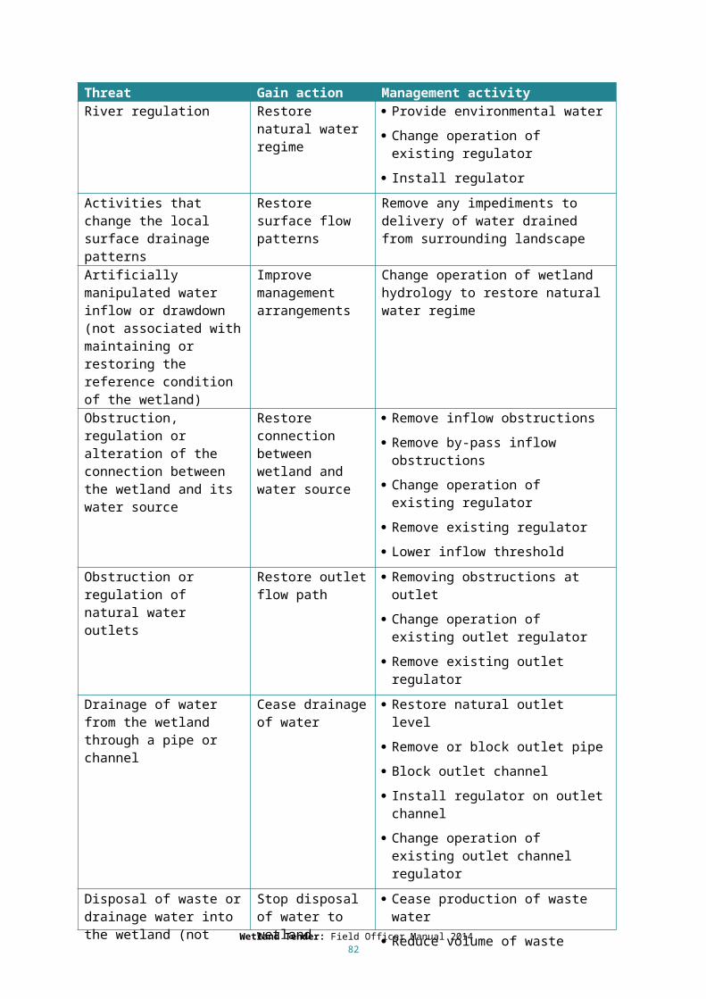
5.10 Pest animal managementWhere pest animals such as rabbits, carp, deer, horses, goats and pigs are present and causing damage to wetland soils and/or vegetation, the management plan should include strategies to manage these species.
Permits are generally required to cull deer, where a landholder possesses a current permit this can be taken as evidence of adequate management of the problem and the threat can be considered ‘controlled’. The landholder should provide a copy of the permit to confirm conditions and currency.
Under the CaLP Act, all landowners have a legal duty to prevent the spread of, and as far as possible eradicate, established pest animals. Established pest animals include foxes, rabbits, European hare, feral pigs, feral goats and wild dogs.
Rabbit control
Rabbits pose a major threat to native vegetation, in particular to the recruitment of young plants. Note that landowners cannot rely on myxomatosis and the rabbit calicivirus diseases alone to effectively control rabbits. Integrated rabbit control should be implemented to control rabbits in native vegetation, and should include a combination of:
Fumigating and hand collapsing warrens. Destruction of surface harbour. Baiting.
Employing a combination of control techniques will achieve the best outcomes, as different methods will pick up different sections of the rabbit population at different times of the year. Integrated rabbit control must be carefully implemented in native vegetation to ensure that the condition of native vegetation or habitat for indigenous species is not degraded.
The most appropriate control technique for a site will depend on the vegetation type, soil, steepness of the land, rabbit numbers and existing programs within the area. Rabbit control should aim to control rabbits, while protecting the native vegetation within the site. Warrens are key to rabbit survival and breeding; dense rabbit populations are not possible without warrens.
Consider the following points when providing advice and developing the draft management plan:
Warren fumigation and hand collapse: Fumigate then collapse warrens by hand (using shovels, mattocks, or picks). Wetland Tender does not generally support ripping due to the damage to native vegetation, and will only do so where there is existing bare ground and it is followed by supplementary planting. Discuss any potential use of ripping with the Regional Implementation Coordinator before agreeing to it with the landholder and including it in the management plan.
Removal of harbour: Surface harbour significantly increases the survival of young rabbits and provides excellent protection from predators and extreme weather. Note that surface harbour provides habitat for indigenous animal species as well as rabbits. Fallen timber, rocks and indigenous shrubs should be retained but, landowners should progressively remove introduced weeds and any discarded building/fencing materials. Discuss options for providing supplementary habitat using native species, and consider introducing nest boxes to replace any lost habitat for indigenous animal species.
Baiting: Free-feed first to determine whether the rabbits are feeding in remnant vegetation or in adjacent paddocks. Use only hand-trail baiting, with due care taken to minimise impacts on non-target species. Where native predators are using the area, monitor for and dispose of rabbit carcasses after baiting to reduce the risk of poisoning.
Wetland Tender: Field Officer Manual 201482

Shooting: Shooting can be carried out year round, as part of an integrated approach to control, effective only where rabbit numbers are extremely low.
Rabbit-proof fencing: In native vegetation that is highly sensitive to grazing by rabbits and where there is a high risk of rabbit invasion from areas adjoining the site, the landholder might choose to build a rabbit-proof fence.
5.11 Managing native wildlifeMany areas will have some level of grazing by native herbivores such as possums, wallabies, emus and kangaroos. Some grazing by native herbivores is natural and desirable within native vegetation, however sometimes the presence of a permanent water source or the fragmentation of native vegetation in the landscape can result in some area being overpopulated and affected by overgrazing. Determine whether the grazing pressure from native species is at a level that would be considered unnaturally high. If you consider grazing is too high, the Management Plan should include strategies to manage the species. This can include exclusion plots across the site for understorey protection. Permits are required to cull native species. Where a landholder possesses a current permit to cull, assume that this constitutes adequate management of the problem and consider the threat ‘controlled’. The landholder should provide a copy of the permit to confirm conditions and currency.
5.12 Fire management and ecological burningGenerally, landholders will be required to take all reasonable steps to protect the site (the wetland and buffer) from fire and from potentially damaging fire protection and/or suppression activities. The landholder might be concerned about the risk of fire from the site. In order to avoid conflict with native vegetation clearing exemptions for fire protection, exclusion zones as outlined in Section 3.2 should be applied.
Fire protection activities may include fire breaks, tracks to provide vehicle access to wetland, and/or provision of a suitable water supply. The benefits to wetland condition of fire protection activities must outweigh the potential negative impacts of these activities (e.g. loss of vegetation, destabilisation of soils, weed establishment). The identification of fire sensitive features such as wetlands is a part of pre-suppression activities, and should form a component of the fire management plan for the property.
Fire suppression activities that are suitable for wetlands include (modified from DCNR 1996):
Clearing fire breaks by hand (not by grader or bulldozer). Water supplied by specially equipped vehicles (can include aerial bombardment). Back burning. Non-nutrient based biodegradable foam retardants.
Firebreaks should not be constructed in vegetation where the substrate remains wet over summer, or intrude on low herbaceous vegetation types. They should be confined to dryland vegetation and minimise soil disturbance and the removal of vegetation (DCNR 1996).
Fire is a natural part of many of Victoria’s ecosystems and important for maintaining biodiversity over time. Ecological burning can be used to manage a particular plant species, vegetation communities and/or native animal habitat.
Wetland Tender: Field Officer Manual 201483

5.12.1 Fire in wetland vegetation
It is unlikely that fire would be a requirement for any wetland EVCs, as regeneration opportunities are dependent primarily on triggers provided as a part of the natural wetting and drying cycle (including flood events) (Cheal 2010). Most wetlands are either too wet and will burn only in extreme circumstances (e.g. after protracted drought), or only have sufficient fuels (i.e. abundant short-lived grasses) to carry fire in the period after flooding (Cheal 2010). Fire is an unusual event in these communities, and though they may occasionally burn this does not imply that fire is an appropriate management tool (Cheal 2010).
Some species associated with wetlands have life history traits that allow them to regenerate well after fire, predominantly from lignotubers, tubers and rhizomes (providing these have not been damaged by the fire event). Typha spp. and Phragmites australis have a high regenerative capacity providing the post-fire conditions are favourable and provide good growing conditions (DCNR 1996). Shrubs and trees associated with wetlands can sometimes regenerate with a combination of seedling, rootstock and resprouting from epicormic buds (DCNR 1996). Lignum (Muehlenbeckia cunninghamii) can recover from low intensity fire but is likely to be killed by high intensity fire (DCNR 1996).
A single fire event is unlikely to eliminate any species in the long term, but frequent, high intensity fire might result in loss of species and change to vegetation structure. Minimum fire intervals for different types of wetland vegetation vary between two and 90 years, there is generally no upper limit set for maximum fire intervals (Cheal 2010).
Wetland Tender objectives might include the control of the extent of monospecific stands of Typha spp. and Phragmites australis. Fire can be used to reduce the extent of these species, but success will depend on the timing and intensity of the burn, plant condition and the wetness of substrate. Draining, burning and subsequent reflooding of Typha sp. has been used in some systems to decrease Typha sp. cover and increase species diversity.
Some landholders might wish to use spot burning to control weeds (see Section 5.7) or to reduce biomass. Any ecological application of fire in wetlands should have a clear management goal, and conform with the objectives of Wetland Tender. The outcomes of burning wetlands is unpredictable, so to reduce uncertainty before applying fire to wetland vegetation managers should seek expert advice. Fire should not be used to manage alpine wetlands.
As there is a lack of detailed information on the nature and extent of fires in wetlands or the nature of the response of wetland vegetation, if a wetland is burnt post fire vegetation monitoring should be encouraged.
5.12.2 Fire in buffer vegetation
Note that fire in the local wetland catchment (particularly in the fringing zone) can lead to adverse impacts on wetland condition, due to the decreased interception of rainfall due to loss of vegetation and litter cover, reduced infiltration, and the resultant increase in flows and turbidity.
Only consider fire as a management tool in EVCs where recruitment is dependent on episodic fire events. For more information refer to the recruitment strategy in the terrestrial EVC benchmark, the tolerable fire intervals of Victorian native vegetation communities (Cheal 2010) and/or talk to the Wetland Tender Regional Implementation Coordinator.
Wetland Tender: Field Officer Manual 201484

To determine if fire is an appropriate management tool:
Assess the current levels of recruitment on the site. If recruitment is occurring (i.e. there are seedlings and saplings on the site) fire will most likely not be required.
If there are mature specimens on the site but an absence of recruitment (particularly from those species that recruit from seed following a fire), an ecological burn could be appropriate. Typical genera that are useful indicators include wattles (Acacia spp.), members of the proteaceae family (e.g. Banksia spp., Grevillea spp. and Hakea spp.) and members of the pea family (e.g. Pultenaea spp.).
Consider the appropriate fire frequency, include the history of fire on the site and the desirable frequency of disturbance for the relevant EVC. For example, the desirable period between fire events in Shrubby Foothill Forest in the Gippsland Plain bioregion is approximately 30 years. Therefore, under Wetland Tender, fire will not generally be required as a management tool on a site with this EVC that has been subject to a fire event in the past 30 years. Other EVCs such as Plains Grassland in the Victorian Volcanic Plain bioregion could require more frequent disturbance.
Determine if the site has gone beyond a desirable period since fire and if it would benefit from burning. For example, if shrub cover of fire tolerant species currently low, then fire may be an appropriate management tool.
If a site has had a history of fire, then ecological burning can be considered as an appropriate on-going management tool under Wetland Tender to maintain the quality of the vegetation over time.
Consider the following points when providing advice and developing a draft management plan:
In general, the most appropriate time to burn is late autumn to spring when the weather is mild, increasing the chance of a low intensity burn. However, certain site attributes might require that burning be conducted at a different time of year. Examples include the presence of key plant and animal species that could be adversely affected by fire at certain times.
Spring flowering native plants generally respond better to fires after the plants have set and distributed their seed in mid to late summer. This might also be the only time that there is sufficient dry matter to carry a fire.
Spring burning can be useful with very weedy sites to reduce weed seed-set, where follow up weed control (post-fire) is also planned.
Some grasslands might need to be burnt at least once every five-years. For Wetland Tender, this means that patches within a Plains Grassland site should only be burnt once during a Management Agreement period.
Rather than conducting an ecological burn across an entire site at the same time, different patches within the site should be burnt in different years. No patch should be burnt more than once during the Wetland Tender Management Agreement period, although this might not be practicable in small areas. This will create a mosaic of different vegetation age structures across the site.
Fire management and weed management are directly related. Targeted weed control should be conducted in the period following the fire. Many weed species (such as Phalaris) provide considerable fuel for fire, and by reducing weeds the landholder will be reducing the fire risk at the site.
The landholder should maintain detailed records of the site management and monitor the burnt and unburnt areas including photo point monitoring.
With the exception of some grasslands, on-going frequent burning of most EVCs beyond the management agreement period is not generally appropriate.
Wetland Tender: Field Officer Manual 201485

Some landholders might propose to use spot burning (with a weed burner) on parts of their site to encourage recruitment of species such as orchids. If conducted correctly, it should target a particular plant or small area rather than a general burn of an area.
The local Department of Environment Land, Water and Planning (DELWP) and/or the Country Fire Authority (CFA) should be able to provide advice on the most appropriate time to conduct an ecological burn at a particular site for ecological effectiveness and safety.
5.13 FencingFencing standards are provided in Appendix 2.
The siting of fences built under projects that use the Wetland Tender method is at the discretion of the landholder. The fence must include the entire site and be completed within the first year of the agreement. The landholder can include an additional area within the fence (e.g. it might be easier to fence straight lines), however do not include the additional area as part of the area of the site.
Consider the following points when providing advice and developing the draft management plan: New fencing must be built to the required standards and maintained in a stock-proof
condition for a period of ten years from the commencement of the agreement. Existing fencing must be maintained in a stock-proof condition for the period of the
agreement. Fences should be positioned to avoid or minimise disturbance of native vegetation and a
minimum of 10m from wetland boundary. The use of barbed wire is not recommended due to the potential adverse impact on
native animals. If it is necessary for stock management, barbed wire should only be used in the middle strands to minimise impacts on wildlife.
In flood prone areas stock-proof fencing may need to be adapted.
Wetland Tender: Field Officer Manual 201486
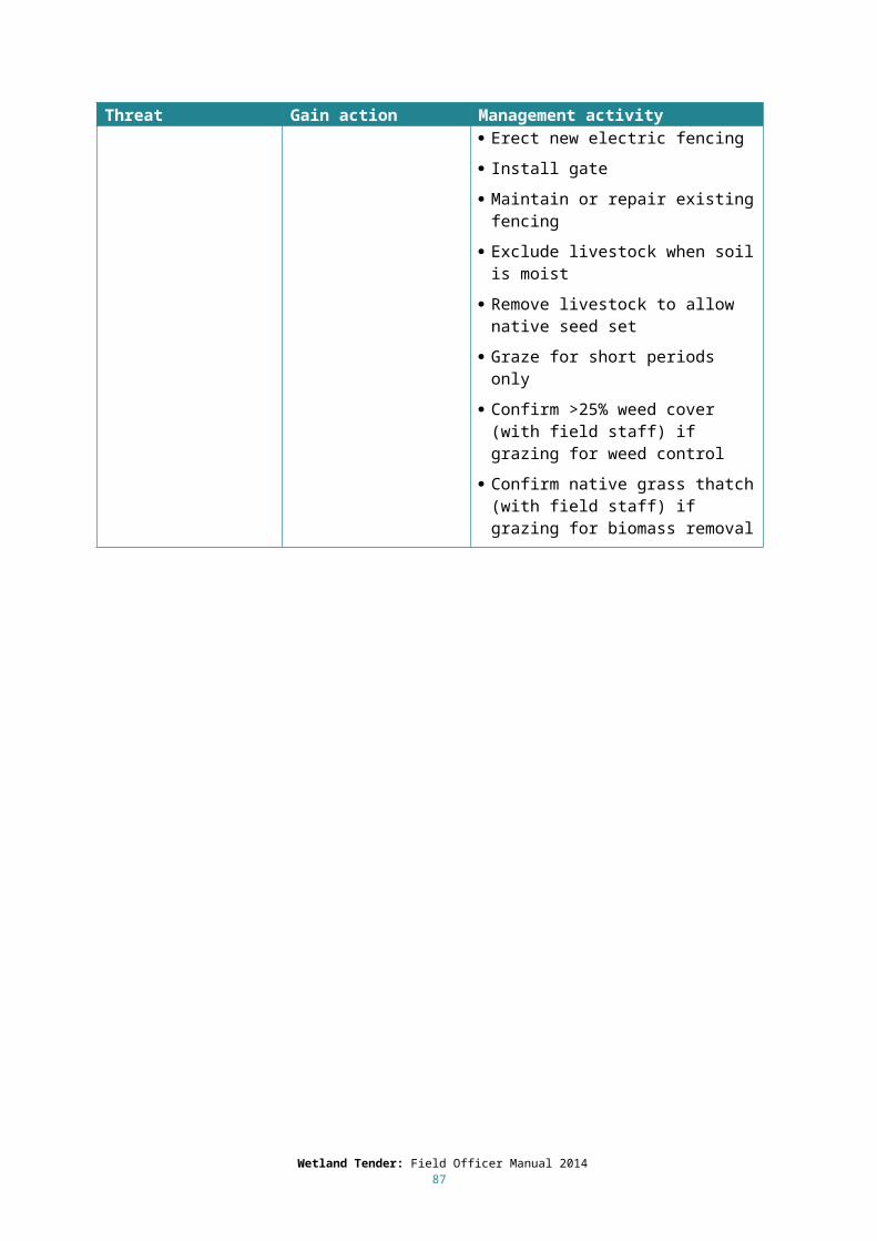
7 Landholder discussionFollowing the site assessment, meet up with the landholder to discuss the outcomes of the site assessment and their further involvement in Wetland Tender. While it is important to build a relationship with the landholder, it will be necessary to focus on the task. The field officer should make notes during the discussion as an aid to the accurate recall of details when preparing the draft management plan.
Be organized prior to the site visit and have all of the relevant paperwork prepared including any Wetland Tender information sheets that your CMA has produced.
Reiterate the objective of Wetland Tender and the landholder’s role in the program. Begin the discussion by explaining the wetland significance of the site and provide some contextual information about how the values present relate to the wetland condition, its water source and catchment setting. Explain the value of their wetland in the landscape context, for example its condition relative to similar wetlands and its contribution to regional wetland biodiversity and ecological linkages. It can be helpful to explain the values of the site in terms of the wetland types, EVCs and the lifeforms you were looking for. Mention any particular status assigned to the wetland, for example whether it is:
Formally recognised (e.g. if it is listed in A Directory of Important Wetlands in Australia). Listed as threatened wetland EVC or ecological community (EPBC act). Recognised as a high value wetland in a regional Waterway Strategy.
Base the discussion around both the management activities that you as the Field Officer would recommend to maintain or improve the condition of the wetland, as well as the landholder’s ideas on management and their future use of the site. Ensure that the outcomes that the landholder expects as a result of the management activity are realistic. Explain any constraints on improving condition such as threats to the wetland that are outside the control of the landholder. Also identify activities where outcomes are uncertain and how uncertainty can be minimised.
Generally, the discussion should include:
Conservation status of the native vegetation (EVCs) Condition of the wetland relative to the same or similar type of wetland in the region. Presence of, or potential habitat for, threatened species. Presence of particular habitat values for example habitat likely to be used for waterbird
breeding or likely to attract particular groups of species such as migratory waders or cryptic species.
Landscape context, i.e. the size and 'shape' of the site and it's 'connectedness' to other wetlands and other native vegetation in the landscape.
Potential for the wetland condition to improve through time with appropriate management.
Permanent protection. The Wetland Tender process including next steps – draft management plan, submitting a
bid, bid evaluation and offering agreements to successful landholders. The Wetland Tender management agreements: include discussion of the Benefit Index
(see Chapter 8), payment schedule (Section 9.3) and monitoring and reporting (Section 9.4).
Encourage the landholder to make a decision during the discussion about how they want to manage the site under Wetland Tender. Most landholders will already have a good idea what they are prepared to do, but may need clarification on certain issues. Aim to clarify issues and define the
Wetland Tender: Field Officer Manual 201487

particular activities in this discussion rather than make further phone calls, emails or redraft management plans.
If the landholder has any questions that cannot be answered on site, write them down and provide a response to the landholder later. If the landholder has questions that are outside the scope of the project and their site, direct them to someone who can help (even if you have knowledge and experience in it yourself).
Following the discussion of the management actions, landholders might ask for advice about how to develop their bid or how much they should bid. Do not offer advice to landholders on how to develop their bid, or how much they should bid. This is to protect the field officer against the risk of possible claims by the landholder that they were given ‘poor advice’ on these matters. It also serves to ensure that all participants are treated equally.
After the site assessment and discussion, the landholders will receive an information sheet on bidding and you can provide advice on the sorts of things the landholder could consider when formulating their bid. These could include consideration of the costs of materials, estimated labour involved, hire of contractors or foregone income over the five year agreement (or in perpetuity for permanent protection). It is not necessary to provide a breakdown of their costs or price as part of their bid.
Some landholders might wish to utilise volunteers to carry out their management actions. It is completely up to the landholder how they choose to meet their management commitments and they can use volunteers where they are available. However, the landholder must understand their responsibilities as far as fulfilling those commitments. For example, where a landholder can access volunteers to carry out their supplementary planting, it is the landholder’s responsibility to ensure that the supplementary planting standards are met.
It is assumed that the project using the Wetland Tender method is funding all agreed management actions in the Wetland Tender Management Agreement, excluding those identified as being funded by another public funding source. Landholders need to understand that this could make them ineligible to receive other public funding for the same management actions from other programs or to use the site as an offset while under the Wetland Tender Management Agreement.
Where a landholder has multiple sites, discuss the advantages and disadvantages of submitting combined bids (i.e. submitting bids covering two or more sites), or single bids (i.e. submitting a separate bid for each site). The same site cannot be included in more than one bid.
Landholders can submit a joint bid with other landholders (e.g. a neighbour or Landcare group). If successful, Wetland Tender will sign the Management Agreement with a single party on behalf of the group. This party will be accountable for the delivery and reporting of the agreed management actions. Progress payments will be made on the satisfactory completion of all management actions for a specified year.
Two key pieces of advice to give to landholders are:
Not to over-commit themselves – Landholders need to be realistic about what they can achieve during the period of the management agreement. It is important to recognise when a landholder may be taking on too much, given their current level of land management activity. If it appears that they are over-committing themselves, check whether they are intending to hire contractors or alternatively encourage them to scale back their plan.
Wetland Tender: Field Officer Manual 201488
Do not offer advice to landholders on how to develop their bid, or how much they should bid.

Not to under-value their contribution – A landholder needs to consider where they might be placed in respect to the other participants in the auction, but it is important that they do not under-value themselves in the process. For an outcome to be successful, not only does the landholder have to be successful in the auction, but they must also be able to meet their obligations for the price they bid.
Wetland Tender: Field Officer Manual 201489

8 Draft Management Plan
7.1 Plan developmentDevelop a draft Management Plan for each site as soon as practicable after the site visit, preferably within a week. It is important to prepare the plan promptly as there is the risk that important details from the landholder discussion will be forgotten and missed in the plan. Landholders who wait for extended periods to receive their plans might forget certain details important for helping them develop their bid, and some landholders can also lose interest in the process. Base the management plan on the discussions with the landholder.
7.2 Management actionsManagement actions are generated from the gain actions (Chapter 4) that the landholder has proposed to undertake in response to the threats acting at the site. In most cases each gain action has several possible management activities that the landholder can choose from (Chapter 5, also see below). There are also mandatory commitments that all landholders must agree to (Section 4.1.2), for which they do not receive gain.
7.3 Management activitiesThe Management Plan provides the landholder with the list of agreed management activities that they must undertake to meet the objectives of the plan. These should describe the actions for each zone including the target species to control, the method of control and the season and year to undertake the action. Zones can be grouped together if they have the same management actions, however if the actions are different, they should be separate. The actions should be specific enough for the landholder to understand what is required, and that a Wetland Tender Officer can monitor at a later stage.
Fencing: include the length, type, purpose (standard) and location of the fence. Draw on the map the approximate location of the fence.
Weed control: list the species, method, season, year (should be entered for each year of the agreement, the method may change over the years). If a weed species observed adjacent to the site is likely to spread into the site, the plan should state that the landholder should monitor and eradicate that species as required.
New and emerging weeds: list ‘new and emerging weeds’, and monitor and eliminate to less than one per cent of cover each year.
Periodic biomass reduction: list the type of biomass to be controlled, the method, season and year.
Controlled grazing: for each year, list monitoring of the site by DELWP/CMA to determine weed cover in autumn and graze only if annual weeds ≥25% and written approval provided. If grazing for biomass removal, list monitoring of the site by DELWP/CMA to determine when it is required, graze only when native grass thatch has formed and written approval provided.
Pest animal management: list the species, methods, season, year (should be entered for all years of the agreement).
Restoring wetland hydrology: List the preparation actions including obtaining any permits or approvals required (see Section 4.1.5). The works should be listed as an action for the first year.
Restoring wetland physical form: List the preparation actions including obtaining any permits or approvals required (see Section 4.1.5). The works should be listed as an action for the first year.
Wetland Tender: Field Officer Manual 201490
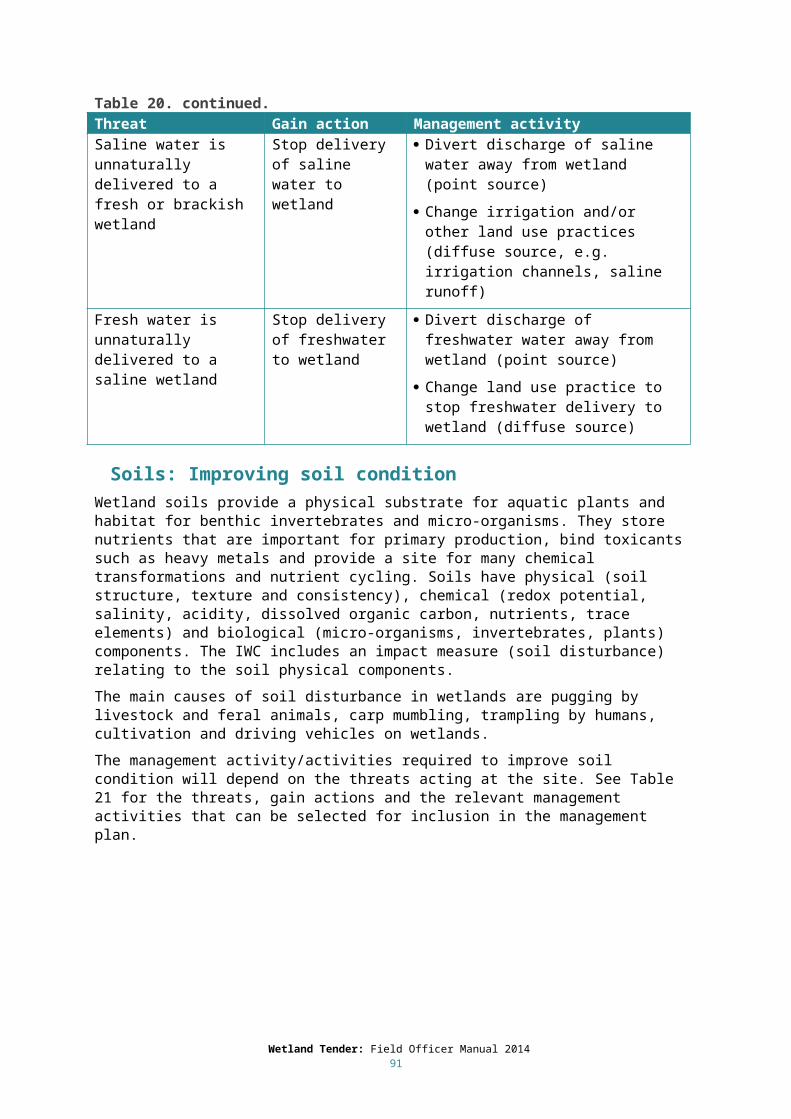
Revegetation in the buffer: list actions required for each year and provide a species list and planting density information with the draft Management Plan.
Wetland revegetation: list actions required for each year and provide a species list and planting density information with the draft Management Plan.
Supplementary planting in wetland: list actions required for each year and provide a species list and planting density information with the draft Management Plan.
If the landholder has sourced alternative funding sources for particular actions (such as the construction of a fence) on the site, the Management Plan needs to clearly articulate that these actions will be funded through the alternative source (e.g. 300m of standard fence, funded through the CMA, to be constructed along northern boundary of Zone A).
Note, there are some cases where a landholder might be asked to undertake work to improve native vegetation through actions for which they will not receive gain. For example, a landholder agrees to undertake weed control by spot spraying Phalaris which is considered a high threat weed. However, they determine that they cannot eliminate it from the site in the given time period. This activity is then listed in the management plan as a yearly activity but the gain action: Eliminate all identified high threat weeds is not chosen as a commitment/objective.
7.4 Site Plan The draft Management Plan should include a colour plan of the site with an aerial photograph, indicating each zone and EVC. Each map should include one site only; ensure that it includes the whole site and where possible, some reference points such as roads or existing fence line.
7.5 PhotographsA minimum of two photographs are required for each Management Plan; photograph’s assist in interpreting the Management Plan as well as making the plan more attractive and individually distinct. Photos taken from at least one established photopoint are also a requirement of the IWC (DEPI, 2013). Include photographs of any species of interest as well as at least one photo that illustrates the main characteristics of the site – large trees, understorey or the contrast between the wetland site and the surrounding landscape.
7.6 EnSym and the IWC DMSEnSym is software used to edit mapped polygons, enter further site assessment details, score the Benefit Index and create management plans and bid sheets for the program. A manual for using EnSym – Site Assessment Tool is provided to each field staff along with training and the software. Mandatory training is required to undertake IWC assessments (DEPI 2013b). The IWC has a data management system (DMS) that is accessed via the following website http://iwc/iwc/login.
It is the field officer’s responsibility to ensure that all relevant data and landholder and site information has been entered into the IWC DMS and EnSym. Check each landholder’s details and the data in each habitat zone carefully to ensure there are no gaps or errors and that spelling and punctuation are accurate.
Once you have checked the relevant information above, notify the Regional Implementation Coordinator that the data has been entered and the Management Plan is ready. The Regional Implementation Coordinator will check the appropriateness of the commitments and activities and ensure that the site map contains all of the relevant information. Do not send the draft Management Plan to the landholder until it has been checked and approved by the Regional Implementation Coordinator.
Wetland Tender: Field Officer Manual 201491
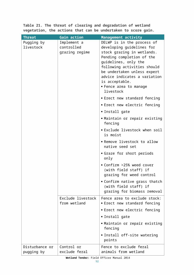
9 Bid assessmentA cost-benefit analysis is used to score and rank landholder proposals and will identify the sites that offer the ‘best value for money’. A score is calculated by dividing the project cost (the amount of money the landholder requires to carry out the actions in the Management Agreement) by a ‘Benefit Index’. The Benefit Index recognises the diversity of wetland values across the landscape and the variation in landholder actions.
The Benefit Index (Figure 12) incorporates the predicted wetland condition with and without management intervention (using the methods outlined in Chapter 4), wetland values, the area of the site and the proportion of the site that is being managed to maintain or improve wetland condition (Table 24). There are two factors that contribute to the ‘valuing’ of a site, these are (1) the Wetland Significance Score: the habitat value of the wetland for rare and threatened flora, fauna, communities and EVCs (see Section 3.3.2); and (2) wetland connectivity: how well-connected the wetland is to other wetlands in the landscape for waterbirds and amphibians (Morris et al 2012). Landholders can influence the Wetland Significance Score by agreeing to share information about the presence of significant species at the site. The product of all of these factors gives the wetland ecosystem service indices. The Wetland ecosystem service index without action is subtracted from the Wetland ecosystem service index with action to give the Benefit Index.
Figure 10. The method used to derive the Benefit Index.
Wetland significance and connectivity, site area and proportion of the wetland under management are fixed at the start of the assessment. Where a number of possible interventions are under consideration they can be scored and outcomes compared.
Cost-benefit = Project cost ($)
Benefit index
% under management
x
x
x
x
Site area
Wetland Significance Score
Wetland connectivity
Predicted wetland condition without action
% under management
x
x
x
x
Site area
Wetland Significance Score
Wetland connectivity
Predicted wetland condition with action
Wetland ecosystem service index without action
d̶Wetland ecosystem service index with actionBenefit index =

There is no minimum site area for participation in Wetland Tender, however as size is a factor in the overall score for the site, very small sites will be at a competitive disadvantage compared to larger sites.
Bids will be accepted for sites that do not include the whole of the wetland (as long as the whole of the wetland can be accessed for the IWC assessment – Section 2.2.4), however, these sites will receive a discounted score if parts of the wetland are being managed for other objectives (i.e. not to maintain or improve wetland condition). The discount rate is outlined in Table 24. For example, where less than 25 per cent of the wetland is managed to maintain or improve wetland condition the score will be reduced by 90 per cent; and where greater than 95 per cent of a wetland is managed to maintain or improve wetland condition, there will be no discount, and it will receive the full score. Note that there could be multiple landholders responsible for a single wetland, and the management objectives of the other landholders should be taken into account. If the other landholders are managing their part of the wetland to maintain or improve wetland condition it will not contribute to discounting the score.
Table 24. Multipliers used to adjust (discount) the site score where part of the wetland is being managed for objectives other than to maintain or improve condition.
Percent managed to maintain or improve wetland condition Multiplier
>95% 1
75-95% 0.7
50-75% 0.5
25-50% 0.2
<25 0.1
There is no set price that will be acceptable in Wetland Tender; each site varies in size, significance, degree of connectivity, condition, management actions and price. All the bids are evaluated in terms of their contribution to improved environmental outcomes (as indicated by the Benefits Index) and the price (as identified by the landholder) to achieve those outcomes. The bids are indexed according to “value for money”, with the most valuable being those sites which offer the greatest environmental benefit per dollar.
Landholders can further increase the value of their site by committing to improved security by placing permanent protection over the site through a covenant or other permanent agreement.
Successful bidders will be informed and given the opportunity to sign a Management Agreement based on the previously agreed draft Management Plan. Unsuccessful bidders will be informed and provided with information on other regional programs that can assist them with management of their wetland site.
Wetland Tender: Field Officer Manual 201493

10Management Agreements
7.6 Five-year Fixed-Term AgreementsSuccessful landholders sign a fixed-term Management Agreement based on the previously agreed draft Management Plan. This is a straightforward document of generally three to five pages. It contains the date of commencement and termination and obligations of the landholder and the agency managing the project which is using the Wetland Tender method. The Agreement also includes the agreed Management Plan, a map of the site, the payment schedule and reporting requirements. The fixed-term Wetland Tender Management Agreement is a contract under common law.
Most obligations under the agreement cease at the end of the fixed term. In keeping with other incentive schemes, if the landholder has received funding to erect fences, they will be required to maintain these fences in a stock-proof condition for a period of 10 years from the date on the Agreement. Revegetation and supplementary planting will also need to be maintained over a 10-year period.
Lessees will be eligible to sign a Management Agreement as long as they have the written authority of the property owner, and if the proposed management actions are not already the responsibility of the lessee under the existing lease arrangement.
The fixed term Management Agreement is not registered on title. Sale of the site or transfer of the lease would terminate the agreement. The agreement includes a clause that Wetland Tender be notified of any proposed changes in the management or ownership of the property. Wetland Tender can offer the new landholder the opportunity to sign a new agreement for completion of the actions specified in the original agreement with any remaining payments available.
The management actions in the Wetland Tender Management Agreements may be varied with the written consent of both parties. In general, only actions that lead to an equal or improved outcome will be considered.
9.2 Permanent protection with fixed term active management agreementsPermanent protection relates to the on-going management of a site for conservation. It is registered on the property title and binds all future owners in perpetuity. The owner of the land will need to sign this agreement. The landholder and all successors will be required to continue the land use commitments made under the Wetland Tender Management Agreement and to protect and maintain the site in perpetuity. After the fixed term active management period (covered by the management agreement) the landholder will be eligible to apply for other funding and participate in other incentive and/or grant programs.
9.3 Schedule of paymentsSuccessful landholders who sign Management Agreements will receive the total amount of their bid in periodic payments over the length of the agreement, subject to satisfactory completion of the actions or achievement of the management plan objectives as laid out in the agreement. The final payment is contingent on eliminating all woody weeds from the site.
Ensure that the landholder is aware of the schedule of payments and that, if successful; the funds will be spread out over the fixed term, weighted more towards the beginning and end of the contract. This could have an impact on committing to infrastructure such as large amounts of fencing or off-stream watering systems. There is limited flexibility in scheduling payments for significant infrastructure works to enable a landholder to undertake the works in an effective and cost-efficient manner (such as completing the building of very long fences). If the landholder is concerned about the scheduling of payments, they must discuss this with the Regional Implementation Coordinator prior to submitting their bid; otherwise it will be assumed that they have accepted the schedule.
Wetland Tender: Field Officer Manual 201494

If a landholder chooses the permanent protection option (such as a Conservation Covenant or Land Management Co-operative Agreement), then part of their bid price will be retained until the agreement has been registered on title.
9.4 Annual reporting and monitoringThere are four types of monitoring and reporting which are undertaken as part of Wetland Tender, which address the progress and implementation of the landholder’s management actions. These are:
Annual monitoring by Wetland Tender where a controlled grazing regime is being implemented. The monitoring visit will assess the impacts of grazing and compliance with the conditions of the grazing program, including the following:
o Livestock excluded when soil moist (assessed by presence of pugging).o Livestock excluded when native species setting seed.o Confirm >25% weed cover if grazing for weed control (Wetland Tender will provide written
approval for the landholder to implement an approved grazing regime for that year, reassessment is required for each year of the agreement).
o Confirm native grass thatch if grazing for biomass removal. Annual monitoring by Wetland Tender where the landholder has reduced threat to wetland
condition and is taking a ‘wait and see’ approach before undertaking supplementary planting (i.e. has selected ‘supplementary planting or natural regeneration’). If the species are not recolonising via natural regeneration then a plan for supplementary planting should be devised and implemented.
Annual reporting by the landholder in the form of a completed the Annual Report form. The form is sent to them on the anniversary of their signing the Management Agreement. These annual reports are kept on the landholder’s file and are required to approve the landholder’s annual payment. Annual reports can include additional material such as photographs and comments on any specific issues that have impacted on the implementation of the management plan.
Monitoring by Wetland Tender at least once over the fixed term Management Agreement period. This visit involves a discussion with the landholder regarding their progress towards site objectives, a site overview and a review of management activities undertaken.
Wetland Tender: Field Officer Manual 201495

ReferencesCheal, D. (2010). Growth stages and tolerable fire intervals for Victoria’s native vegetation data sets. Department of Sustainability and Environment, East Melbourne, Victoria.
Cook, D. (2013). Course notes from Lowland Wetland Ecology Course. Rakali Ecological Consulting. Chewton, Victoria.
Cooperative Research Centre for Australian Weed Management (2005). Guidelines – Herbicides: guidelines for use in and around water.
Department of Environment and Primary Industries (2013a). DEPI Output data standard. Department of Environment and Primary Industries, East Melbourne, Victoria.
Department of Environment and Primary Industries (2013b). Index of Wetland Condition Assessment Procedure September 2013. Department of Environment and Primary Industries, East Melbourne, Victoria.
Department of Environment and Primary Industries (2013c). Benchmarks for wetland ecological vegetation classes in Victoria. Department of Environment and Primary Industries, East Melbourne, Victoria.
Department of Environment and Primary Industries (2013d). Native vegetation gain scoring manual Version 1. Department of Environment and Primary Industries, East Melbourne, Victoria.
Department of Sustainability and Environment (2005). Index of Wetland Condition: Conceptual framework and selection of measures. Department of Sustainability and Environment, East Melbourne, Victoria.
Department of Sustainability and Environment (2006) Native Vegetation Revegetation planting standards – Guidelines for establishing native vegetation for net gain accounting. Victorian Government, Department of Sustainability and Environment, East Melbourne
Department of Sustainability and Environment (2008). BushTender: Rethinking investment for native vegetation outcomes. The application of auctions for securing private land management agreements. State of Victoria, Department of Sustainability and Environment, East Melbourne.
Department of Sustainability and Environment (2012). Index of Wetland Condition assessment of wetland vegetation update – December 2012. Department of Sustainability and Environment, East Melbourne, Victoria.
Morris, K., Ferwerda, F. and Papas, P. (2012). Wetland connectivity models. Arthur Rylah Institute of Environmental Research, Technical Report Series No. 241. Department of Sustainability and Environment, Heidelberg, Victoria.
Stoneham, G., Chaudhri, V., Ha, A., Strappazzon, L. (2003). Auctions for conservation contracts: an empirical examination of Victoria's BushTender trial. Australian Journal of Agricultural and Resource Economics 47(4): 477-500.
Wahren, C.-H., Williams, R. J. and Papst, W. A. (2001). Vegetation change and ecological processes in alpine and subalpine Sphagnum Bogs of the Bogong High Plains, Victoria, Australia. Arctic, Antarctic and Alpine Research 33: 357-368.
Woodgate, P.W., Peel, W.D., Ritman, K.T., Coram, J.E., Brady, A., Rule, A.J. and Banks, J.C.G. (1994). A study of the old growth forests of East Gippsland. Department of Conservation and Natural Resources, Victoria.
Wetland Tender: Field Officer Manual 201496

Appendix 1: Threat – Gain Action – Management Activity TablesImprove Wetland Buffer
Threat Gain action Management activityDegradation of buffer vegetation (clearing or weed invasion)
Improve wetland buffer
Improve wetland buffer - Width (metres from perimeter)
Improve wetland buffer - Length (percentage of perimeter)
Clearing of buffer vegetation
Revegetate buffer As per minimum standards (see Revegetation and Supplementary Planting Standard)
Refer to species list attached
Collect indigenous seed/source stock
Place order with nursery
On-grow plants
Prepare planting or direct seeding area
Plant out area and guard if required
Monitor and undertake pest and weed control over planting area
Replace unsuccessful seedlings if required
Degradation of buffer understory by weed invasion
Weed control in the buffer (beyond CaLP Act requirements)
Contact field officer if weed cover in buffer increases beyond current levels
Spot spray
Hand pull
Herbicide injection
Cut and paint – apply suitable herbicide
Frilling – apply suitable herbicide
Drill and fill with suitable herbicide
Ring bark/cut down
Controlled grazing (upon written approval)
Mowing/slashing
Chipping
Wetland Tender: Field Officer Manual 201497

Restore physical form
Threat Gain action Management activityReduced wetland areaInfilling Excavate wetland to
reverse infillingRestore natural contours of wetland through earthworks
Drainage of water from the wetland
Cease drainage of water Restore natural outlet level
Remove or block outlet pipe
Block outlet channel
Install regulator on outlet channel
Change operation of existing outlet channel regulator
Reduced water inputs
Restore natural water regime
Provide environmental water in accordance with approved plan
Change operation of existing regulator
Install regulator
Levees or other barriers to water flow
Remove levees and barriers to natural inflows
Remove inflow obstructions
Remove by-pass inflow obstructions
Change operation of existing regulator
Remove existing regulator
Fire (peatland wetlands)
Use suppression activities to reduce fire frequency
Develop fire management plan for property
Create suitable offsite fire breaks
Maintain access to site
Channelisation (peatland wetlands)
Restore hydrological structure
Use artificial structures to slow water flow and create pooling (e.g. jute bags filled with coir, geotextile logs filled with red gum chips)
Changed bathymetryExcavation of wetland bed
Reverse effects of excavation
Fill in channels and dams
Landforming Restore wetland form Restore natural contours of wetland through earthworks
Remove artificial mounds
Remove built channels
Close tracks
Wetland Tender: Field Officer Manual 201498
Restore hydrology
Threat Gain action Management activityRiver regulation Restore natural
water regime Provide environmental water in accordance with
approved plan
Change operation of existing regulator
Install regulator
Activities that change the local surface drainage patterns
Restore surface flow patterns
Remove any impediments to delivery of water drained from surrounding landscape
Artificially manipulated water inflow or drawdown (not associated with maintaining or restoring the reference condition of the wetland)
Improve management arrangements
Change operation of wetland hydrology to restore natural water regime
Obstruction, regulation or alteration of the connection between the wetland and its water source
Restore connection between wetland and water source
Remove inflow obstructions
Remove by-pass inflow obstructions
Change operation of existing regulator
Remove existing regulator
Lower inflow threshold
Obstruction or regulation of natural water outlets
Restore outlet flow path
Remove obstructions at outlet
Change operation of existing outlet regulator
Remove existing outlet regulator
Drainage of water from the wetland through a pipe or channel
Cease drainage of water
Restore natural outlet level
Remove or block outlet pipe
Block outlet channel
Install regulator on outlet channel
Change operation of existing outlet channel regulator
Disposal of waste or drainage water into the wetland (not associated with maintaining or restoring the reference condition of the wetland)
Stop disposal of water to wetland
Cease production of waste water
Reduce volume of waste water (note new waste water volume, ML)
Divert water before it reaches wetland
Extraction of water directly from the wetland
Stop water extraction
N/A
Wetland Tender: Field Officer Manual 201499

Restore hydrology (continued).
Threat Gain action Management activityActivities that permanently raise the water level (e.g. damming the wetland or constructing levees to restrict the spread of water)
Lower maximum water level
Remove internal levees or other internal barriers
Install connecting pipe through levee or internal wetland barrier
Remove or lower dam wall or sill or install outlet within dam wall
Activities leading to an increase in groundwater height
Cease activities that increase GW height
Manage surrounding land use to decrease GW levels:
Consult CMA Catchment Management Plan
Implement more efficient irrigation practices:
- Benchmark current irrigation practice and reduce water use (note per cent reduction and new irrigation volume)
- Stop irrigation
Plant native vegetation (trees or other native deep-rooted perennials) in recharge areas (usually ridges and upper slopes)
Plant native vegetation (trees or other native deep rooted perennials) in discharge areas (break of slope, or where there is perched/laterally flowing groundwater)
Undertake groundwater extraction (pumping)
Activities leading to a decrease in groundwater height
Cease activities that decrease GW height
Consult CMA Catchment Management Plan
Stop groundwater extraction
Reduce groundwater extraction (note new extraction volume, ML)
Wetland Tender: Field Officer Manual 2014100

Restore water quality: Nutrients
Threat Gain action Management activityDischarge of nutrient-rich water to the wetland from sewage, industrial effluent and/or irrigation water
Stop or reduce discharge of nutrient-rich water to wetland
Stop discharge of nutrient-rich water to wetland
Reduce discharge of nutrient-rich water to wetland (note per cent reduction and new volume, ML)
Drainage of nutrient-rich water into the wetland from an urban area
Stop or reduce drainage of nutrient-rich water to wetland
Stop discharge of nutrient-rich water to wetland
Reduce discharge of nutrient-rich water to wetland (note per cent reduction and new volume, ML)
Runoff of nutrients to wetland
Change land management practice in wetland catchment
Stop/reduce fertilizer application Stop/reduce grazing in the catchment
including the wetland buffer Improve wetland buffer - new width
(metres from perimeter) Improve wetland buffer - new length
(percentage of perimeter) Revegetate catchment
Grazing by livestock in the wetland
Implement a controlled grazing regime
DELWP is in the process of developing guidelines for stock grazing in wetlands. Pending completion of the guidelines, only the following activities should be undertaken unless expert advice indicates a variation is acceptable.
Fence area to manage livestock Erect new standard fencing
Erect new electric fencing Install gate
Maintain or repair existing fencing Exclude livestock when soil is moist
Remove livestock to allow native seed set Graze for short periods only
Confirm >25% weed cover (with field staff) if grazing for weed control
Confirm native grass thatch (with field staff) if grazing for biomass removal
Exclude livestock from wetland
Fence area to exclude stock: Erect new standard fencing
Erect new electric fencing Install gate
Maintain or repair existing fencing Install off-site watering points
Wetland Tender: Field Officer Manual 2014101

Restore water quality: Nutrients (continued).
Threat Gain action Management activityGrazing by feral animals in the wetland(for species not included in CaLP Act, e.g. deer, horses)
Control or exclude feral animals from wetland
Fence to exclude feral animals from wetland
Erect new standard fencing
Erect new electric fencing
Install gate
Maintain or repair existing fencing
Monitor and control as required (non CaLP species)
Shooting under appropriate permits/licenses (non CaLP species)
Grazing by feral animals in the wetland(for species included in CaLP Act: foxes, rabbits, hare, pigs, goats, wild dogs)Note: NO GAIN is scored for management activities involving these species.
Control feral animals in the wetland (CaLP species)
Monitor and control as required (CaLP species)
Shooting under appropriate permits/licenses (CaLP species)
Baiting
Trapping
Rabbit-specific control:
Warren fumigation
Hand collapse
Removal of surface harbor
Rip warrens (seek approval of Regional Implementation Manager)
Ferreting
Application of fertilizer in the wetland
Stop application of fertiliser in wetland
N/A
Aquaculture Stop aquaculture-related activities within the wetland
N/A
Wetland Tender: Field Officer Manual 2014102

Restore water quality: Altered salinity
Threat Gain action Management activitySaline groundwater intrusion resulting in an increase in salinity from its natural state
Cease activities that lead to increased GW height
Manage surrounding land use to decrease GW levels: Consult CMA Catchment Management
Plan
Implement more efficient irrigation practices:
- Benchmark current irrigation practice and reduce water use (note per cent reduction and new irrigation volume)
- Stop irrigation
Plant native vegetation (trees or other native deep-rooted perennials) in recharge areas (usually ridges and upper slopes)
Plant native vegetation (trees or other native deep rooted perennials) in discharge areas (break of slope, or where there is perched/laterally flowing groundwater)
Undertake groundwater extraction (pumping)
Saline water intrusion from the marine environment resulting in an increase in salinity from its natural state
Cease activities that lead to marine water intrusion
If marine water intrusion is due to over-extraction of fresh groundwater, reduce groundwater extraction
Close artificially created connection to marine waters
Saline water is unnaturally delivered to a fresh or brackish wetland
Stop delivery of saline water to wetland
Divert discharge of saline water away from wetland (point source)
Change irrigation and/or other land use practices (diffuse source, e.g. irrigation channels, saline runoff)
Fresh water is unnaturally delivered to a saline wetland
Stop delivery of freshwater to wetland
Divert discharge of freshwater water away from wetland (point source)
Change land use practice to stop freshwater delivery to wetland (diffuse source)
Wetland Tender: Field Officer Manual 2014103

Restore Soils
Threat Gain action Management activityPugging by livestock Implement a controlled
grazing regimeDELWP is in the process of developing guidelines for stock grazing in wetlands. Pending completion of the guidelines, only the following activities should be undertaken unless expert advice indicates a variation is acceptable. Fence area to manage livestock
Erect new standard fencing
Erect new electric fencing
Install gate
Maintain or repair existing fencing
Exclude livestock when soil is moist
Remove livestock to allow native seed set
Graze for short periods only
Confirm >25% weed cover (with field staff) if grazing for weed control
Confirm native grass thatch (with field staff) if grazing for biomass removal
Exclude livestock from wetland
Fence area to exclude stock: Erect new standard fencing
Erect new electric fencing
Install gate
Maintain or repair existing fencing
Install off-site watering points
Disturbance or pugging by feral animals(for species not included in CaLP Act, e.g. deer, horses)
Control or exclude feral animals from wetland (non-CaLP species)
Fence to exclude feral animals from wetland
Erect new standard fencing
Erect new electric fencing
Install gate
Maintain or repair existing fencing
Monitor and control as required (non CaLP species)
Shooting under appropriate permits/licenses (non CaLP species)
Wetland Tender: Field Officer Manual 2014104

Restore Soils (continued).
Threat Gain action Management activityDisturbance or pugging by feral animals(for species included in CaLP Act: foxes, rabbits, hare, pigs, goats, wild dogs)Note: NO GAIN is scored for management activities involving these species.
Control feral animals in the wetland (CaLP species)
Monitor and control as required (CaLP species)
Shooting under appropriate permits/licenses (CaLP species)
Baiting
Trapping
Rabbit-specific control:
Warren fumigation
Hand collapse
Removal of surface harbor
Rip warrens (seek approval of Regional Implementation Manager)
Ferreting
Carp mumbling Exclude carp from wetland
Install carp exclusion screens at inlet/s
Install carp exclusion screen with trap (push or jumping trap) at inlet/s
Install carp separation cage out outlet
Allow natural drying of wetland
Trampling by humans Exclude or manage human access in the wetland
Manage pedestrian access to wetland
Prevent pedestrian access to wetland
Provide low impact tracks (e.g. raised boardwalks)
Rehabilitate closed tracks
Cultivation Cease cultivation of wetland
N/A
Driving vehicles on wetland
Stop or manage vehicle access in the wetland
Exclude vehicles from wetland
Confine vehicles to defined tracks
Close tracks
Rehabilitate closed tracks
Wetland Tender: Field Officer Manual 2014105

Weed management within wetland
Threat Gain action Management activityDegradation of wetland by weed invasion
Control weeds in wetland:Ensure weed cover does not increase beyond current levels (high threat and other weeds).Monitor for any new and emerging weeds and eliminate to <1% cover.
Eradicate weeds in wetland:Non-high threat weeds: weeds that are up to 25% cover - ensure cover does not increase beyond current levels, weeds with >25% cover reduce to under 25% cover.High threat weeds: Eliminate all identified high threat weeds to <1% cover.
Contact field officer if weed cover increases beyond current levels
Spot spray
Hand pull
Herbicide injection
Cut and paint – apply suitable herbicide
Frilling – apply suitable herbicide
Drill and fill with suitable herbicide
Ring bark/cut down
Controlled grazing (upon written approval)
Mowing/slashing
Chipping
Mulching
Wetland Tender: Field Officer Manual 2014106
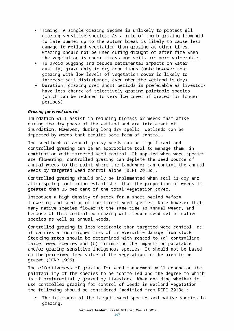
Revegetation in wetland
Threat Gain action Management activityClearing or degradation of wetland vegetation
Supplementary planting or natural regeneration
Natural regeneration expected from surrounding vegetation
Monitor establishment of natural regeneration
Develop species list for supplementary planting
Collect indigenous seeds and/or divided/whole plants
Place order with nursery
Prepare planting or direct seeding area
Plant tubestock or seedlings and guard if required
Undertake weed control over planting area
Replace unsuccessful seedlings if required
Undertake further supplementary planting
Revegetation Develop species list for revegetation
Collect indigenous seeds and/or divided/whole plants
Place order with nursery
Prepare planting or direct seeding area
Plant tubestock or seedlings and guard if required
Undertake weed control over planting area
Replace unsuccessful seedlings if required
Wetland Tender: Field Officer Manual 2014107
Appendix 2: A guide to fencing standards Note, this is not a comprehensive range of fencing options. DELWP or the relevant authority can help determine the most appropriate fencing options for a particular site.
Beef cattle Standard 6/70/30 or 7/90/30 ring-lock and plain wire or a four strand plain wire with at least two electrified strands or seven strand plain wire. (Note: Barbed wire is not recommended because of its adverse impact on native fauna.)
Posts: 6’ (1.8 m) treated pine (or other suitable material) at least 10 m apart with two droppers in between.
Strainers: 7 or 8’ (2.1 m or 2.4 m) at least (6-7”) treated pine (or other suitable material).
Stays: 10’ (3 m) treated pine (or other suitable material).
Dairy cattle Standard 6/70/30 or 7/90/30 ring-lock and plain wire or a three strand plain wire with at least two electrified strands or seven strand plain wire. (Note: Barbed wire is not recommended because of its adverse impact on native fauna.)
Posts: 6’ (1.8m) treated pine (or other suitable material) at least 10 m apart with two droppers in between.
Strainers: 7 or 8’ (2.1 m or 2.4 m) at least (6-7”) treated pine (or other suitable material).
Stays: 10’ (3 m) treated pine (or other suitable material).
Sheep Standard 6/70/30 or 7/90/30 ring-lock and plain wire or a five strand plain wire with at least three electrified strands ensuring that the bottom wire is earthed or seven strand plain wire. (Note: Barbed wire is not recommended because of its adverse impact on native fauna.)
Posts: 6’ (1.8 m) treated pine (or other suitable material) at least 10 m apart with two droppers in between.
Strainers: 7 or 8’ (2.1 m or 2.4 m) at least (5-6”) treated pine (or other suitable material).
Stays: 10’ (3 m) treated pine (or other suitable material).
Note that fences may include gates for management access where required.
Wetland Tender: Field Officer Manual 2014108


![[Vegetation and Remote Sensing] Vegetation](https://static.fdocuments.net/doc/165x107/577cdfd71a28ab9e78b21a32/vegetation-and-remote-sensing-vegetation.jpg)