Weather Briefing for Pennsylvania January 21-22, 2014 Prepared 01/21/14 (10:30 AM EST) Prepared by:...
20
Weather Briefing for Pennsylvania January 21-22, 2014 Prepared 01/21/14 (10:30 AM EST) Prepared by: National Weather Service State College, PA ([email protected])
-
Upload
irvin-morcom -
Category
Documents
-
view
213 -
download
0
Transcript of Weather Briefing for Pennsylvania January 21-22, 2014 Prepared 01/21/14 (10:30 AM EST) Prepared by:...

Weather Briefingfor Pennsylvania
January 21-22, 2014Prepared 01/21/14 (10:30 AM EST)
Prepared by:
National Weather ServiceState College, PA

Pennsylvania Weather Overview
• Weather Synopsis:– A storm system moving through the Mid-Atlantic region will
bring snow to the Commonwealth today• Snowfall will be heaviest across the southeast and south-central
counties...with lesser amounts as one travels north and west• Heaviest period of snow will be during the day today, with the snow
ending around midnight…IN ADDITION…– Another blast of arctic air will move into the region
• Cold temperatures will be not be as extreme as the previous event we experienced during the first week of the New Year
• BUT…the cold air will be more persistent, lasting at least through the end of the week
• Wind chills will be an issue

Current Warnings and Advisories

Current Radar
L

Storm Total Snowfall Forecasts
Axis of Heaviest Snow

Snow Impacts• Snow covered roads will make travel hazardous• Snowfall rates at times will be 1 to 2 inches per hour
– This is very heavy snow, and will reduce visibilities at times to near zero
• Heaviest period of snow is occurring now, and will continue through the day– Heaviest bands of snow will affect areas in the southeast– Snow will taper off from west to east
• Increasing North winds will cause blowing and drifting snow– This will be especially true this evening and overnight in the
southeast as winds pick up (some gusts of 30 mph in the southeast)

Cold Temperatures / Wind Chills Impacts
• Strong north winds on the heels of this storm system will again usher in extremely cold air– Cold air temperatures combined with strong
winds will produce bitterly cold wind chills• Wind chills of 10 to 20 below zero for tonight into
Wednesday• Wind Chill Advisories posted for all of Pennsylvania
tonight through mid day Wednesday
• Cold temperatures will persist through the week
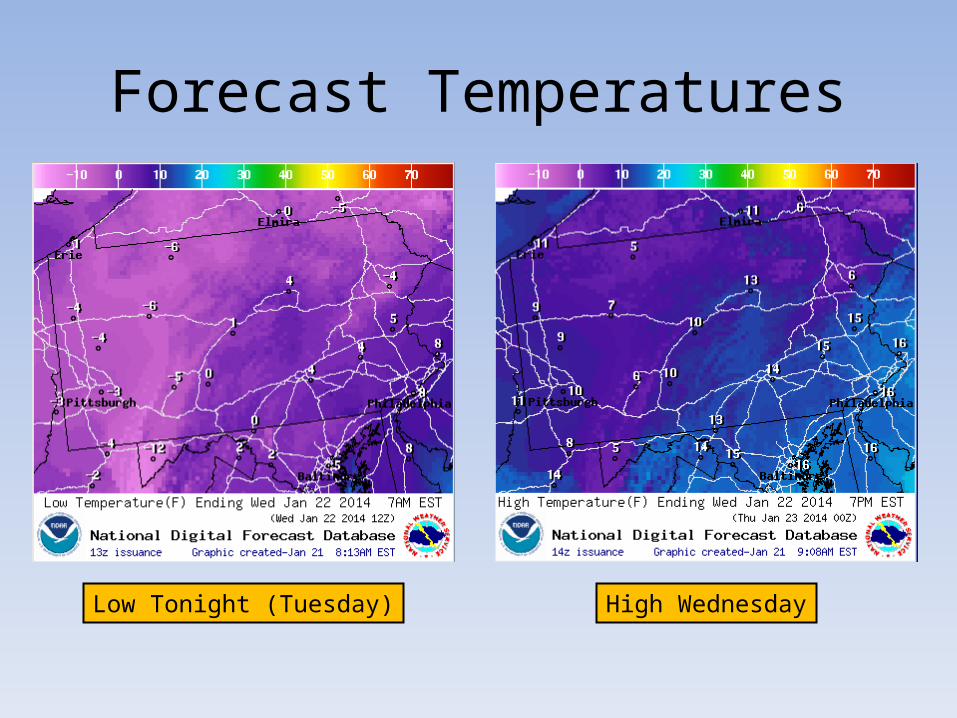
Forecast Temperatures
Low Tonight (Tuesday) High Wednesday

Forecast Temperatures
Low Wednesday Night High Thursday

Forecast Temperatures
Low Thursday Night High Friday

WINDS and WIND CHILL
Wind Chills Tonight (Tuesday Night) Wind Speeds Tonight (Tuesday Night)

WINDS and WIND CHILL
Wind Chills Wednesday Wind Speeds Wednesday

Specific Snowfall Forecasts For Central Pennsylvania Counties

NWS Wind Chill Advisory Criteria

NWS Wind Chill Warning Criteria


Cold Weather Safety
• Wear layers of loose-fitting, lightweight, warm clothing. Trapped air between the layers will insulate you. Outer garments should be tightly woven, water repellent, and hooded.
• Wear a hat, because 40% of your body heat can be lost from your head.
• Cover your mouth to protect your lungs from extreme cold.
• Mittens, snug at the wrist, are better than gloves.• Try to stay dry and out of the wind.• Don’t forget your pets!

Home/Heating Safety• USE SPACE HEATERS WISELY. ALLOW A SAFE DISTANCE BETWEEN THE HOT SURFACES OF THE HEATER AND ANY
OTHER MATERIALS SUCH AS CURTAINS...BEDDING AND CLOTHING.
• NEVER USE THE COOKING OVEN TO HEAT YOUR HOME. MAKE SURE TO KEEP CHIMNEYS SWEPT AND VENT PIPES CLEANED AND FREE FROM OBSTRUCTIONS.
• WHEN USING HEATERS AND FIREPLACES WHICH BURN FUEL LIKE NATURAL GAS...PROPANE...KEROSENE... WOOD OR COAL...A COLORLESS ODORLESS GAS CALLED CARBON MONOXIDE MAY BUILD UP IN YOUR HOME. CARBON MONOXIDE POISONING OR EVEN DEATH IS POSSIBLE IF THERE IS NOT ADEQUATE VENTILATION TO ALLOW THIS GAS TO ESCAPE.
• IT IS A GOOD IDEA TO KEEP A CARBON MONOXIDE DETECTOR IN ROOMS WHERE YOU SLEEP OR SPEND LONG HOURS IN THE WINTER. LIKE A SMOKE ALARM...IT CAN SOUND AN ALARM TO LET YOU KNOW IF THIS DANGEROUS GAS IS BUILDING UP TO UNHEALTHY LEVELS.
• WRAP PIPES IN INSULATION WHICH WILL BE EXPOSED TO THE AIR OR IN UNHEATED CRAWL SPACES. YOU MAY ALSO ALLOW FAUCETS TO DRIP...ALLOWING THE WATER TO CONTINUE FLOWING. BOTH OF THESE MEASURES WILL HELP TO PREVENT THE PIPES FROM FREEZING AND BURSTING.
• TAKE CARE IN USING CANDLES DURING ANY POWER OUTAGES. KEEP ALL FLAMMABLE MATERIAL A SAFE DISTANCE FROM THE OPEN FLAMES.
• CHECK ON YOUR NEIGHBORS...ESPECIALLY THE ELDERLY...AND MAKE SURE THEY ARE SAFE AND HEALTHY AS WELL.

Links to local NWS offices that cover Pennsylvania(Get the latest forecasts and updates!)
• NWS Cleveland– weather.gov/cleveland
• NWS Pittsburgh– weather.gov/pittsburgh
• NWS State College– weather.gov/statecollege
• NWS Binghamton– weather.gov/binghamton
• NWS Mount Holly– weather.gov/philadelphia
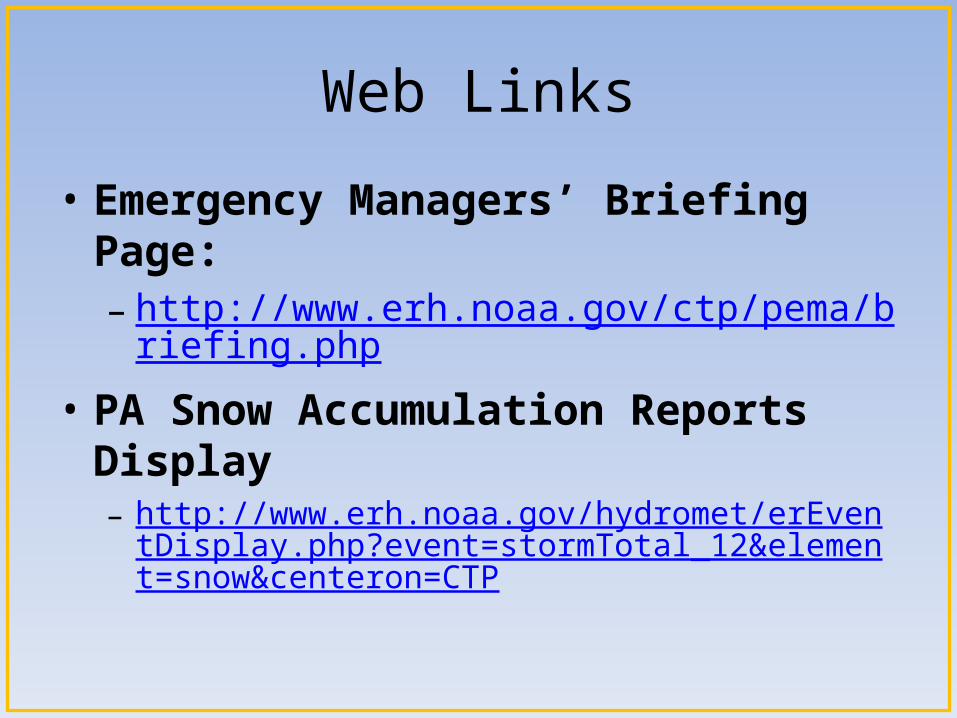
Web Links
• Emergency Managers’ Briefing Page:– http://www.erh.noaa.gov/ctp/pema/briefing.php
• PA Snow Accumulation Reports Display– http://www.erh.noaa.gov/hydromet/erEventDisplay.php?
event=stormTotal_12&element=snow¢eron=CTP