
Vol1 Tralorg Wind Farm Connection part1
91
Environmental Appraisal Tralorg Wind Farm 33 kV Overhead Line and Under- ground Cable Connection to Mark Hill Substation 2FWREHU 2018
Transcript of Vol1 Tralorg Wind Farm Connection part1
Environmental
Appraisal
Tralorg Wind Farm 33 kVOverhead Line and Under-ground Cable Connection toMark Hill Substation
2018

SP Energy Networks
Tralorg Wind Farm to Mark Hill Substation 33 kV Overhead Line
UK12-23166
CONTENTS
1. INTRODUCTION
1.1 Preamble
1.2 Background and Need for the Proposed Development
1.3 Environmental Appraisal Process
1.4 Structure of this Report
2. ROUTE SELECTION
2.1 Aim of the Process
2.2 Methodology
2.3 Consideration of Alternatives
2.4 Route Selection Outcome
3. PROPOSED DEVELOPMENT
3.1 Introduction
3.2 Limits of Deviation
3.3 Summary of Alignment
3.4 Description of Development
3.5 Construction Methods
4. CONSULTATION
4.1 Introduction
4.2 EIA Screening
5. LANDSCAPE AND VISUAL APPRAISAL
5.1 Introduction
5.2 Scope of Assessment
5.3 Assessment Methodology
5.4 Baseline Conditions
5.5 Potential Impacts and Mitigation
5.6 Residual Impacts
6. CULTURAL HERITAGE APPRAISAL
6.1 Introduction
6.2 Methodology
6.3 Baseline Conditions
6.4 Potential Impacts and Mitigation
Technical Appendix 6
6.1 Cultural Heritage Assets within the Inner Study Area
6.2 Cultural Heritage Assets within the Outer Study Area with Predicted Visibility of
the Proposed Development
6.3 List of Sources Consulted
7. ECOLOGY AND ORNITHOLOGY APPRAISAL
7.1 Introduction
7.2 Methodology
7.3 Baseline Conditions
7.4 Potential Impacts and Mitigation
7.5 Cumulative Impact Assessment
Technical Appendix 7
7.1 Ecology and Ornithology Survey Results
7.2 Protected Species List
7.3 Site Photographs
7.4 Technical Report – Analysis of Environmental DNA in Pond Water for the Detection
of GCN
7.5 Confidential Ornithology Survey Results

SP Energy Networks
Tralorg Wind Farm to Mark Hill Substation 33 kV Overhead Line
UK12-23166
8. HYDROLOGY AND HYDROGEOLOGY APPRAISAL
8.1 Introduction
8.2 Methodology
8.3 Baseline Conditions
8.4 Potential Impacts and Mitigation
Technical Appendix 8
8.1 Watercourse Crossing Assessment
8.2 Groundwater Abstraction and GWDTE Appraisal
9. FORESTRY APPRAISAL
9.1 Introduction
9.2 Methodology
9.3 Baseline Conditions
9.4 Potential Impacts and Mitigation
10. SUMMARY AND SCHEDULE OF MITIGATION
10.1 Summary
10.2 Schedule of Mitigation

SP Energy Networks
Tralorg Wind Farm to Mark Hill Substation 33 kV Overhead Line 1-1
UK1223166
1. INTRODUCTION
1.1 Preamble
Scottish Power Energy Networks (SP Energy Networks) is proposing to construct and operate a
new 33 kV wood pole overhead line (OHL) in conjunction with a section of underground cable, to
connect the consented Tralorg wind farm to grid substation at Mark Hill, north of Barrhill in South
Ayrshire (hereafter, ‘the proposed development’). The location of the proposed development,
including the location of the consented Tralorg wind farm and the Mark Hill substation, is shown
on Figure 1.1.
SP Energy Networks, as the transmission license holder in southern Scotland, will obtain any
necessary consents and land rights to install and operate the grid connection. In terms of its
licence for the transmission of electricity, SP Energy Networks is obliged by law to develop and
maintain an efficient, co-ordinated and economic system of electricity transmission and to
facilitate competition in the supply and generation of electricity. SP Energy Networks is also
responsible for developing the transmission system and connecting new demand and generation
to the grid network in accordance with the GB Security and Quality of Supply Standards.
This Environmental Appraisal provides information to support an application for consent under
section 37 of the Electricity Act 1989, and deemed consent under section 57(2) of the Town and
Country Planning (Scotland) Act 1997, as amended, for the OHL section of the proposed
development. The underground cable is considered to be ancillary development to that proposed
in the application for consent under section 37 of the Electricity Act 1989.
In addition, environmental information is also provided in order to meet the applicant’s
obligations to preserve amenity and mitigate environmental effects under Schedule 9 of the
Electricity Act 1989.
1.2 Background and Need for the Proposed Development
The Scottish Government granted consent for Tralorg Wind Farm under section 36 (s. 36) of the
Electricity Act 1989 in February 20141 which included deemed consent under the Town and
Country Planning (Scotland) Act 1997. The consent is for construction and operation of the wind
farm with a generation capacity of up to 18.8 MW. The wind farm substation will be constructed
at the eastern end of the wind farm site (see Figure 1.1). In order to connect it to the
transmission network a 33 kV connection from the wind farm is required.
1.3 Environmental Appraisal Process
SP Energy Networks submitted a written request in March 2017 for a screening opinion from the
Scottish Government Energy Consents Unit (ECU) on the need for Environmental Impact
Assessment (EIA) under regulation 5 of the Electricity Works (Environmental Impact Assessment)
(Scotland) Regulations 2000 (as amended) (the EIA regulations). A screening opinion was
received from the ECU on 5th May 2017, which confirmed that the proposed development does
not constitute EIA development.
An Environmental Appraisal has been undertaken which provides environmental information, as
set out in the request for a screening opinion, and addresses issues raised through pre-
application consultation with statutory consultees. Further information on the pre-application
consultation process is provided in Chapter 4. For the avoidance of doubt, this report does not
form an “Environmental Statement” under the EIA regulations.
1 http://www.pnewind.co.uk/projects/current-projects/tralorg/
SP Energy Networks
Tralorg Wind Farm to Mark Hill Substation 33 kV Overhead Line 1-2
UK1223166
Environmental input into the report has been collated by Ramboll Environment and Health UK Ltd
(Ramboll), with technical environmental appraisals carried out by the following consultants:
Landscape and Visual – Ramboll;
Cultural Heritage and Archaeology – CFA Archaeology Ltd;
Ecology and Ornithology – Ramboll;
Hydrology and Soils – Ramboll; and
Forestry – RTS Ltd.
1.4 Structure of this Report
This report is structured as follows:
Chapter 1 – Introduction: describes the background to the Tralorg grid connection;
Chapter 2 – Route Selection: outlines the process by which the route and final alignment was
selected and describes the reasons why other route options were discounted;
Chapter 3 – Proposed Development: describes the proposed development and provides detail
of typical construction methods;
Chapter 4 – Consultation: describes the stakeholder consultation undertaken to date;
Chapter 5: Landscape and Visual Appraisal: describes the potential landscape and visual
impact of the proposed development and how this has been mitigated through design;
Chapter 6: Cultural Heritage Appraisal: describes the potential impact of the proposed
development on the historic environment, and presents mitigation measures that will be
implemented to reduce adverse effects;
Chapter 7: Ecology and Ornithology Appraisal: describes the baseline ecological environment
and information gathered from ornithology surveys, potential impacts on the ecological
environment and ornithology and how these impacts will be mitigated;
Chapter 8 – Hydrology and Hydrogeology Appraisal: describes the baseline environment,
potential impact of the proposed development on water and soils, and how these impacts will
be mitigated;
Chapter 9 – Forestry Appraisal: describes the potential impact of the proposed development
on surrounding woodland and presents mitigation measures; and
Chapter 10 – Summary and Schedule of Mitigation: provides a summary of the appraisals
undertaken and lists the mitigation measures identified.
Technical Appendices included at the end of the report contain technical information relating to
specific assessments as referred to in the text.

SP Energy Networks
Tralorg Wind Farm to Mark Hill Substation 33 kV Overhead Line 2-1
UK1223166
2. ROUTE SELECTION
2.1 Aim of the Process
SP Energy Networks is obliged under section 9 of the Electricity Act 1989 ‘to develop and
maintain an efficient, co-ordinated and economical system of electricity transmission and to
facilitate competition in the supply and generation of electricity’. In addition, SP Energy
Networks has a duty under Schedule 9 of the Electricity Act 1989 to take account of ‘the
desirability of preserving natural beauty, of conserving flora, fauna, geological or physiographical
features of special interest and of protecting sites, buildings and objects of architectural, historic
interest and sites and structures of archaeological interest’. It is also required to take reasonable
steps to mitigate the effects of its proposals.
The aim of the route selection process was to identify a proposed alignment which is technically
feasible and economically viable and which causes the least disturbance to the environment; and
those living in it, working in it, visiting it or using it for recreational purposes.
2.2 Methodology
The proposed alignment was identified through an iterative process supported by desk-based
analysis, ground conditions and field surveys, engineering studies and landowner related
assessments. It was developed in accordance with SP Energy Networks guidance2. The guidance
recommends appropriate application of the ‘Holford Rules’ to inform routeing. These rules
advocate the application of a hierarchical approach to routeing which first avoids major areas of
highest amenity, then smaller areas of high amenity, and finally considers factors such as
backdrop, woodland and orientation.
The proposed alignment was identified based on the following key considerations:
Avoidance, where possible, of key environmental constraints identified from online searches;
Minimising exposure to high altitudes (over 200 m Above Ordnance Datum);
Avoidance, or identification of most suitable crossing locations of roads and watercourses;
Proximity to access tracks and roads;
Configuration of and approach to termination points;
Identification of main topographical and geotechnical features; and
General landscape and visual amenity (backcloth and screening).
The initial desk studies were generally carried out with reference to the following information:
Publicly available satellite imagery;
Current 1:25,000 Ordnance Survey (OS) mapping;
British Geological Survey, 2013. Geoindex Onshore 1:50 000 geological map;
British Geological Survey, Hydrogeological map of Scotland;
Historic Environment Scotland, Scottish Natural Heritage, Sustrans and Forestry Commission
databases;
The technical specification for single circuit 33 kV OHL on wood poles: SPEN Technical
Specification OHL-03-099.
The following field surveys were undertaken:
Extended Phase 1 habitat survey of the initial proposed OHL route (Figure 2.1), including a
500 m buffer area; and
2 SP Energy Networks (May 2015) Major Electrical Infrastructure Projects: Approach to Routeing and Environmental Impact
Assessment, available here: http://www.spenergynetworks.co.uk/userfiles/file/SPEN_Approach_to_Routeing_FINAL_20150527.pdf

SP Energy Networks
Tralorg Wind Farm to Mark Hill Substation 33 kV Overhead Line 2-2
UK1223166
Cultural Heritage walkover survey the initial proposed OHL (Figure 2.1), including a 100 m
buffer area.
2.3 Consideration of Alternatives
A number of alternative route alignment options were considered during the process described
above. These are shown on Figure 2.1, which shows the initial route identified by SP Energy
Networks and the alternative route alignment options identified.
SP Energy Networks’ policy is to base the initial route selection on the assumption that a new
connection would be made using OHL. This is in order to meet obligations under the Electricity
Act 1989 to provide an economic solution. An underground cable would only be considered
where all OHL options had been considered and discounted. Underground cable is typically only
used by SP Energy Networks in cases where there is a specific environmental constraint or
technical need, which outweighs the additional costs associated with the cable installation and
the additional challenges associated with maintenance of a cable.
In this case, a single wood pole OHL is considered to be suitable for the majority of the route,
from the consented Tralorg wind farm to the end of local road off B734 at Pinmore Mains. Due to
economic factors as well as technical difficulties, including but not limited to crossing the minor
road and Muck Water and crossing the existing 275 kV OHL on the approach to Mark Hill
substation, it is proposed that the final section of the line be placed underground (Figure 2.2).
2.4 Route Selection Outcome
As described above, the proposed development will consist of a combination of OHL, supported
on single and H wood poles, and underground cable. The proposed alignment is considered to
provide the optimum balance of technical, economic and environmental factors.
Key influencing factors in choosing the alignment for the new wood pole OHL sections were:
to minimise visual impact on residential properties and from the public road network;
to minimise the need for woodland removal, as far as possible; and
to make use of existing access tracks as much as possible.
Further assessments of the proposed development are considered in Chapters 5 to 9.
SP Energy Networks
Tralorg Wind Farm to Mark Hill Substation 33 kV Overhead Line 3-1
UK1223166
3. PROPOSED DEVELOPMENT
3.1 Introduction
This chapter describes the characteristics of the proposed development, including the proposed
alignment for the OHL and underground cable and the nature of proposed construction works.
More detailed descriptions of the baseline environment associated with the proposed alignment
are described in Chapters 5-9 of this report. The proposed alignment, including indicative wood
pole locations, is shown on Figure 3.1. The alignment is split into two sections; the northern OHL
section and the southern underground cable section, as shown on Figures 3.1a-3.1d.
Technical drawings showing how various items of infrastructure will be constructed are provided
in Figures 3.2 to - 3.5.
3.2 Limits of Deviation
The maximum horizontal Limits of Deviation (LoD) of 25 m either side of the proposed OHL
alignment and underground cable has been set to allow for micrositing of the wood pole
locations, in order to avoid environmental or physical features as required (Figure 3.1).
The maximum vertical LoD is 18 m, whereby the typical pole height is likely to be between 9.5 m
and 15 m above the ground level (including steel work and insulators), but poles may vary in
height in order to respond to local topographical variations, engineering and safety
considerations. Detailed site investigation may determine that there is a need for periodic
terminal poles, which are double poles. The assessments carried out for this appraisal have
assumed that the wood poles could be placed anywhere within the OHL LOD, with a typical pole
height of 11 m (9.5 to 15 m range).
3.3 Summary of Alignment
The northern part of the proposed development begins at the consented Tralorg wind farm
substation (at NGR NX22753 96868) from where it would run southwards to Tormitchell Quarry
(NGR NX23159 94487), crossing the minor road to the east of High Troweir. It would then turn
south-west towards Pinmore, running parallel with the minor road and the Water of Assel. To the
east of Pinmore, it would turn southwards crossing the River Stinchar at NGR NX21535 90851
and continuing south-east parallel to an existing track. A terminal pole would be located at the
end of the existing track off the B734 at Pinmore Mains.
The connection would be completed by underground cable from this point to the Mark Hill
substation. The cable would follow an existing track and footpath south of Pinmore Mains along
the edge of Glentrool Forest. The cable would then cross Muck Water (NGR NX23995 87373) and
the existing 275 kV OHL and continue southwards before connecting into the Mark Hill substation.
The overall length of the proposed development is ~14.6 km, comprising 9.4 km of OHL and
~5.2 km of underground cable.
3.4 Description of Development
3.4.1 Description of OHL
The proposed OHL would be constructed using 119 wood pole structures, in a combination of
single and terminal wood pole structures. Each pole is topped by galvanised steelwork cross-arm
and insulators (likely to be grey plastic). The steel cross arm and insulators would carry a single
three-phase circuit (three metal alloy conductors) in a flat formation (i.e. all at the same height).
A typical wood pole is illustrated in Photo 3.1.

SP Energy Networks
Tralorg Wind Farm to Mark Hill Substation 33 kV Overhead Line 3-2
UK1223166
Photo 3.1. Typical wood pole for Proposed Development
The wood poles would be seasoned and treated with a suitable preservative, resulting in a dark
brown appearance, which would weather to a silver/grey colour over a period of approximately
five years following installation.
The height of the wood poles would typically be 11 m above the ground level (including steel
work and insulators). Pole heights may be increased locally where required to safely cross
features such as watercourses. The statutory ground level clearance required for a 33 kV OHL is
5.2 m, as per SPEN Technical Specification OHL-14-005.
The spacing between the poles would vary depending on topography, altitude and land usage.
The distance between the poles will be determined later in the design process; an average span
of 80 m is estimated; however, the spans could range from 60 m to 110 m to accommodate
technical and environmental considerations. Stays (guy lines) will be provided for additional
stability for poles on changes in direction.
3.4.2 Description of Underground Cabling
The proposed underground cable sections would comprise three 33 kV cables installed in a trench
in a trefoil duct formation, as illustrated in Figure 3.2. A duct for fibre optic cabling has been
included as part of the proposed cable arrangement.
The trench would be excavated to the contour of the original ground so that the duct is laid to a
minimum depth of 0.9 m (max depth, 1.6 m) below ground level accommodating any bedding
materials.

SP Energy Networks
Tralorg Wind Farm to Mark Hill Substation 33 kV Overhead Line 3-3
UK1223166
Joint bays would be required to join cable lengths, with approximately 490 m between joint bays.
Final joint bay positions would be established as part of the pre-construction detailed design
work. An illustration of a typical joint bay is provided in Figure 3.3.
3.5 Construction Methods
The construction methods and proposed environmental management measures are briefly
described below for the purposes of informing this environmental appraisal. A construction phase
Environmental Management Plan (EMP) would be developed by the appointed contractor at the
pre-construction stage.
3.5.1 Site Establishment and Temporary Construction Compounds
Construction access would be from the A714 road and would use minor roads. Access routes are
shown on Figure 3.4. Existing estate access tracks and gates would be used for access to work
locations.
Temporary construction access tracks would be required in the south between Muck Water and
Mark Hill substation. The track would be a 3 m wide floating stone track, running adjacent to the
underground cable route. The track would be removed following energisation of the connection,
or before, and the ground reinstated.
Up to three temporary construction compounds would be required, with the preferred site for the
main compound located in proximity to Markhill substation and other locations still to be
determined. The main construction compound would comprise site offices, welfare facilities,
parking and limited materials storage. The contractor would obtain all the necessary consents
and permits once the precise location of all temporary construction compounds is decided upon.
The compounds would have workforce welfare facilities with material storage and handling areas.
A typical yard compound layout is provided in Figure 3.5.
Site compounds and storage areas will be kept to the minimum necessary for safe
implementation of the works. On-site storage of oil and fuels will be avoided if possible but
where on-site storage is required, the volumes to be stored would be minimised and stored in
accordance with all applicable legislation and good practice.
Clearly defined areas for the storage of oil will be identified as part of the site establishment
process. Spill kits would be located and maintained at all oil storage and refuelling locations and
on all site vehicles. An emergency response procedure would be provided as part of the
proposed EMP.
All waste would be stored securely and disposed of through a licensed waste carrier, in
accordance with waste regulations and the Site Waste Management Plan.
3.5.2 Forestry
Some felling of commercial plantation woodland would be required to construct the proposed
development. The total area of felling would be approximately 3.83 ha. SP Energy Networks
would liaise with the landowners to agree a suitable felling strategy. It is anticipated that all
timber would be extracted from the site and transported to an end user (sawmill, board/pulp mill
or wood fuel processing depot).
Further details of anticipated forestry removal are presented in Chapter 9: Forestry.
Felling would be completed using a mechanical harvester, with timber extracted using an industry
standard six or eight wheeled forwarder with telescopic boom and hydraulic grapple. Where,
either due to tree size or location, it is not viable to use a mechanical harvester, manual
chainsaw operators would complete the felling work.
SP Energy Networks
Tralorg Wind Farm to Mark Hill Substation 33 kV Overhead Line 3-4
UK1223166
3.5.3 OHL Construction
The following process would be followed for wood pole erection3:
A typical resilience corridor of up to 30 m for OHL (15 m either side of the alignment) to
ensure the electric line is resilient to disruption;
Access, delivery and assembling would be taken using a tracked excavator and low ground-
pressure vehicles (e.g. tractor, argocat, quad bikes), helicopter may also be used for delivery
of wood poles;
Bog mats and temporary track mats would be used where required to cross soft ground
where existing access tracks are not available and low ground pressure vehicles would not
suffice;
Turf and topsoil would be removed together to retain the turf root system and placed to one
side for later reinstatement;
A hole would be excavated to allow the pole brace block and/ or steel foundation braces to be
positioned in place. A typical pole excavation is 3 m2 x 2 m deep;
The excavated material is then sorted into appropriate layers and used for backfilling;
The poles are erected using normal agricultural machinery such as a digger with a lifting arm;
The excavator(s) then hoists the assembled structure into position and, once the structure
has been braced in position, the trench is backfilled;
The hole would be backfilled with soil replaced in reverse order to the order of excavation;
Backfilling would be progressed in layers of approximately 300 – 400 mm deep, with stone
hardcore added as required around foundation blocks to ensure adequate compaction and
suitable geotechnical conditions are maintained between each layer; and
When replacing the topsoil/turf around the pole it would be left slightly proud of ground level
(approximately 150/ 300 mm) to allow for the excavation to naturally compact further
through time.
It is anticipated that all material excavated for the installation of the poles and stays would be
used in backfilling the excavations.
Watercourse Crossings
The OHL construction would not require the construction of any new watercourse crossings, other
than for the Stinchar. This watercourse crossing would not require any in-channel works. Access
would use existing tracks and watercourse crossings as far as possible. Where required,
temporary track mats and bog mats would be used to cross areas of soft ground. Bog mats
would be used to cross minor watercourses without damage to bank integrity.
Where pole installation is required within 30 m of a watercourse, silt traps or other mitigation
would be put in place (which would be outlined in the EMP), with nearby watercourses checked
during periods of high rainfall during construction activities. Ground excavation work would
temporarily stop work during periods of high rainfall, where a risk to surface water quality is
identified.
3.5.4 Cabling Procedure
Excavation
A typical working corridor of a width to be agreed with relevant landowners would be required
during construction of the underground cabling sections of the proposed development.
3 For more details see SPEN document DOC-00-313 (Distribution Wood Pole Overhead Line Virtual Manual.

SP Energy Networks
Tralorg Wind Farm to Mark Hill Substation 33 kV Overhead Line 3-5
UK1223166
The trench would be excavated to a minimum depth of 0.9 m (max depth, 1.6 m) using a tracked
excavator. The trench bottom would be uniform with adequate clearance on each side of the
ducts and be free from roots, organic debris, clods, rocks, stones, and other materials likely to
cause damage to the cable duct.
Trench walls would be supported appropriately where necessary to ensure trench stability.
Excavations would be kept free from water by use of mobile pumps, with water pumped to a
suitable settlement pond, prior to either infiltration (to ground) or discharge (via piping).
Drainage design measures to ensure the discharge would not result in pollution to surface water
would be set out in the EMP.
All excavated material would be carefully stored a minimum of 10 m away from any adjacent
watercourse with particular care taken to prevent any risk of runoff or wind borne dry sediment
into the watercourses.
Cement Bound Sand (CBS) backfill will be placed surrounding the cable ducts in appropriate
layers. A 75 mm minimum bedding layer of stabilised backfill will be laid in the trench bed to
provide a bedding for the ducts. Marker boards will then be placed on top of the CBS. Excavated
material would then be placed on top of the marker board and compacted in place. Backfill
would be completed by returning the remaining excavated material to the trench in layers, in
reverse order with the existing vegetation placed on the trench where possible.
Watercourse Crossings
All underground cable watercourse crossings would require authorisation under The Water
Environmental (Controlled Activities) (Scotland) Regulations 2011 (CAR). Open-cutting with a
flume crossing would generally be used for minor watercourses– dependant on the depth and
water volumes involved. This will apply to all minor watercourse crossings for the underground
cable, as well as any temporary stone tracks that are required for construction of the
underground cable. In order to cross the Muck Water, an open-cut with a flume crossing would
also be used.
Good practice pollution prevention and control measures would be implemented at all
watercourse crossing work sites.
3.5.5 Working Hours
Working hours would be based on a 7 day week. These are:
April – September: 7 days 07.00 – 19.00; and
October – March: 7 days 07.30 – 17.00.

SP Energy Networks
Tralorg Wind Farm to Mark Hill Substation 33 kV Overhead Line 3-6
UK1223166

SP Energy Networks
Tralorg Wind Farm to Mark Hill Substation 33 kV Overhead Line 4-1
UK1223166
4. CONSULTATION
4.1 Introduction
SPEN is committed to public and stakeholder consultation to gather opinion and advice on the
proposed alignment and any site-specific sensitivities. This chapter describes the consultation
undertaken and summarises comments arising from it and how these have been dealt with.
4.2 EIA Screening
The screening opinion identified the following key issues raised by statutory consultees.
Table 4.1: Summary of Consultee Responses
Stakeholder Issue Raised Response / Action Taken
South Ayrshire
Council
It is noted that, within the designated scenic
areas of South Ayrshire and these landscape
character areas (Foothills and Intimate Pastoral
Valleys, Plateau Moorlands) which the proposed
line passes through, landscape and planning
guidance for the area seeks to encourage
underground cable solutions in preference to
pylon lines for all or part of the route. This
practice has been adopted for the major wind
farms in this area.
Chapter 5: Landscape and
Visual Appraisal provides an
appraisal of potential
landscape and visual impacts
and how such impacts have
been mitigated through
design.
Scottish Natural
Heritage
There are no nationally or internationally
designated sites within or adjacent to the
proposed OHL. In addition, there are no national
landscape designations that are likely to be
affected by this proposal. As a consequence, it
is our view that this proposal is unlikely to have
significant effects on national designations
relevant to our interests. However, we consider
that the following key issues should be
addressed:
a) Ecological impacts, including direct and
indirect impacts upon habitats (particularly
peatland) and protected species;
b) Landscape (particularly with regards to the
South Ayrshire Scenic Area) and recreational
impacts;
c) The cumulative impacts of a) and b) in
combination with other development proposals
in the area.
Ecological impacts are
considered in Chapter 7:
Ecology and Ornithology
Appraisal.
Landscape and visual
impacts, including potential
impacts on recreational
resources, are considered in
Chapter 5: Landscape and
Visual Appraisal.
Cumulative impacts alongside
other proposed developments
in the area are considered
within each of these technical
chapters.

SP Energy Networks
Tralorg Wind Farm to Mark Hill Substation 33 kV Overhead Line 4-2
UK1223166
Table 4.1: Summary of Consultee Responses
Scottish
Environment
Protection
Agency
To meet the objectives of the Water Framework
Directive, developments should be designed
wherever possible to avoid engineering activities
in the water environment. Where engineering
activities are proposed in the vicinity of a
watercourse, for example, any crossings of
streams, including by vehicles, these activities
should be undertaken in accordance with the
Water Environment (Controlled Activities)
(Scotland) Regulations 2011 (as amended)
(CAR).
We therefore recommend that the consideration
is given to micrositing the proposed pole
locations away from the vicinity watercourses
(at least 10m back from the top of watercourse
banks) to minimise the potential
impact/disturbance on the banks and bed of
watercourses and minimise the risk of pollution.
Buffer strips to watercourses should also be
adopted to protect the riparian zone.
We recommend that the developer contacts our
regulatory services team (contact details in
Section 5.1) at the earliest possible opportunity
to discuss how it is proposed to cross the
various watercourses (particularly the
underground crossing of the Muck Water) and
our requirements for the site under CAR.
Potential impacts on
hydrology are considered in
Chapter 8: Hydrology and
Hydrogeology Appraisal,
which includes a watercourse
crossing assessment
(Technical Appendix 8.1).
One of our key interests in relation to major
developments is pollution prevention measures
during the periods of construction, operation
and restoration. We therefore welcome the
intention to prepare a Construction
Environmental Management Plan (CEMP)
informed by an Environmental Appraisal.
Pollution prevention
measures, including outline
content of the proposed EMP,
are detailed in Chapter 8:
Hydrology and Hydrogeology
Appraisal
Another key issue for us is the timing of works.
Therefore, we recommend that a Schedule of
Mitigation be prepared including a timetable of
works that takes into account all environmental
sensitivities which may also be raised by SEPA,
SNH or other stakeholders. Timing should also
be planned to avoid potentially polluting
activities during periods of high rainfall.
A Schedule of Mitigation is
contained in Chapter 10:
Summary, which includes
recommendations regarding
timing of works.
Any waste materials imported to the site during
construction must be stored and used only in
accordance with a waste management licence or
exemption under the Waste Management
Licensing (Scotland) Regulations 2011.
Similarly, any waste materials removed from
the site must be disposed of at a suitably
licensed or exempt waste management facility
in accordance with these Regulations.
Provisions for transportation
and storage of waste
materials are detailed in
Chapter 8: Hydrology and
Hydrogeology Appraisal.
It is a requirement of CAR to provide a SUDS
system throughout the construction phase of
the development to ensure adequate protection
of the water environment. The system should
Details of the proposed
drainage/SUDS measures are
contained in Chapter 8:

SP Energy Networks
Tralorg Wind Farm to Mark Hill Substation 33 kV Overhead Line 4-3
UK1223166
Table 4.1: Summary of Consultee Responses
comply with the Rules detailed in GBR’s 10 &
11. Suitable pollution control measures should
be employed wherever there is an identifiable
risk to the water environment. This must give
particular consideration to contaminated surface
water run-off arising from earthworks, roads,
drainage, compounds, concrete.
Hydrology and Hydrogeology
Appraisal.
The disposal of any forestry material generated
during the works must be managed in
accordance with guidance on the Management
of Forestry Waste and Use of Trees Cleared to
Facilitate Development on Afforested Land. Any
reuse of felling waste material must in line with
this guidance.
Details of proposed forestry
felling and re-stocking are
contained in Chapter 9:
Forestry Appraisal. SP Energy
Networks is engaged in
ongoing discussions with
landowners, including the
Forestry Commission, and a
Forestry Management Plan
will be prepared as part of
the detailed design.

SP Energy Networks
Tralorg Wind Farm to Mark Hill Substation 33 kV Overhead Line 4-4
UK1223166

SP Energy Networks
Tralorg Wind Farm to Mark Hill Substation 33 kV Overhead Line
5-1
5. LANDSCAPE AND VISUAL APPRAISAL
5.1 Introduction
This chapter presents an appraisal of predicted landscape and visual impacts as a result of the
proposed 33 kV wood pole OHL and cable route connection between Tralorg Wind Farm and a
substation at Mark Hill, north of Barrhill in South Ayrshire (see Figure 5.1). The aim of the
Landscape and Visual Appraisal (LVA) is to assess the potential impacts of the proposed
development on the landscape and visual resource of the site and surrounding area.
The assessment has been carried out by Ramboll’s team of Chartered Landscape Architects and is
accompanied by the following figures:
Figure 5.1: Site Location and Study Area with Zone of Theoretical Visibility (ZTV);
Figure 5.2a: SNH Landscape Character Types within the Study Area;
Figure 5.2b: South Ayrshire Council Landscape Character Types within the Study Area;
Figure 5.3: Landscape Designations within the Study Area;
Figure 5.4: Viewpoint Locations; and
Figures 5.5 – 5.10: Viewpoint Baseline Photographs and Visualisations.
5.2 Scope of Assessment
The LVA considers impacts on:
Landscape fabric, caused by changes to the physical form and constituents of the landscape;
Landscape character, caused by changes to key characteristics and qualities of the landscape;
and
Visual amenity, caused by changes to the visual composition of views and the wider visual
resource.
The LVA also considers cumulative impacts attributable to the proposed development when
considered in conjunction with consented, operational and proposed developments of a similar
type.
The LVA was based on a single wood pole overhead line carrying 3 conductors, assuming a
typical pole height of 11 m (including insulators). In addition, the assessors have taken into
account that the maximum vertical LOD is 18 m above ground level, and poles will vary in height
up to this maximum height in certain locations in order to accommodate topographic variation.
The proposed development is described in Chapter 3: Proposed Development.
The scope of the assessment has been influenced by a combination of:
Consultation with South Ayrshire Council;
Planning policy and formal published guidance; and
Preliminary and revised visual analysis.
5.2.1 Consultation
Consultation was undertaken with South Ayrshire Council to agree the locations of a series of
representative viewpoints (VPs) and on the methodology to be used for the appraisal.
South Ayrshire Council confirmed their approval of preliminary VPs proposed by the applicant but
requested a further VP location was added to represent views from the Stranraer to Kilmarnock
railway line. This has been included as Viewpoint 5 (see Table 5.1).

SP Energy Networks
Tralorg Wind Farm to Mark Hill Substation 33 kV Overhead Line
5-2
5.2.2 Preliminary Visual Analysis
A preliminary visual analysis was carried out to identify landscape and visual receptors which are
predicted to have theoretical visibility of the proposed development based on the size, scale and
alignment of the proposed development, based on the Zone of Theoretical Visibility (ZTV)
presented in Figure 5.1.
5.3 Assessment Methodology
The purpose of the LVA is to identify, predict and evaluate potential impacts associated with the
proposed development. Wherever possible, identified impacts are quantified, however the nature
of LVA requires interpretation by professional judgement. In order to provide a level of
consistency to the assessment, the prediction of magnitude of impact and assessment of the
residual landscape and visual impacts have been based on pre-defined criteria.
5.3.1 Guidelines
The LVA accords with guidance provided in:
Landscape Institute and Institute of Environmental Management and Assessment (2013)
Guidance for Landscape and Visual Impact Assessment – Third Edition (GLVIA3);
The Countryside Agency and Scottish Natural Heritage (2002) Landscape Character
Assessment;
Scottish Natural Heritage and the Countryside Agency (2002) Topic Paper 6: Techniques and
Criteria for Judging Capacity and Sensitivity; and
Advice Note 01/2011: Photography and Photomontage in Landscape and Visual Assessment
(the Landscape Institute, 2011).
5.3.2 Data
The LVA was informed by data gathered from the following sources:
OS Terrain 50;
Ordnance Survey mapping (1:25,000; 1:50,000);
Carol Anderson Landscape Associates. (July 2013) South Ayrshire Landscape Wind Energy
Capacity Study: Appendix Report1. South Ayrshire Council;
Land Use Consultants (1998). Ayrshire Landscape Assessment. Scottish Natural Heritage
Review. No 111;
Field surveys in 2018;
Commercially available aerial photography;
Computer generated theoretical ZTV;
Site photography; and
Consultations with South Ayrshire Council.
5.3.3 Measurements
Receptor distances from the proposed development are calculated on the basis of the nearest
pole location. Where measurements are given between landscape character types, designated
areas, routes or settlements, such measurements relate to the nearest part of such areas and
routes to the proposed development.
1 This report has been used insofar as the baseline description of the landscape, including the classification of landscape character
types.

SP Energy Networks
Tralorg Wind Farm to Mark Hill Substation 33 kV Overhead Line
5-3
5.3.4 Study Area
Defining the study area takes into account the nature of the topography, the pattern of visibility
shown by the ZTV, the presence of existing vegetation and the pattern of settlement and other
visual receptors such as residents, workers and those engaging in recreation in the area
surrounding the proposed development.
For this appraisal, the study area extends to 2 km from the proposed development (see Figure
5.1). The appraisal only focuses on those areas which have ZTV coverage.
5.3.5 Assumptions and Limitations to the Assessment
This appraisal has assumed that the woodland and shelterbelts / roadside vegetation located in
the study area would be retained. Any coniferous plantation woodland is anticipated to be on
rotational felling cycle (unless otherwise known), and this is taken into consideration in the
appraisal.
Access to private properties was not requested as part of the visual assessment of impacts. It is
acknowledged the proposed development will be viewed from residential properties located within
the study area. Representative views from nearest communities (such as Pinmore) and in areas
where scattered residential properties are located have been taken to assess the impact of the
change in view for residential receptors in respect of ‘community amenity’. The LVA does not
include an assessment of impact on private views from individual properties.
5.3.6 Assessment Process
Baseline
Prior to site work being undertaken, a baseline study was carried out to gain an understanding of
the character of the landscape in the immediate and wider area of the proposed development
site, identify any areas designated for their landscape and scenic qualities, and to identify key
visual receptors most likely to be affected by the proposed development.
The assessment of baseline conditions was undertaken with reference to existing landscape
character assessment studies extant within the study area. These studies have been considered
and verified on site, and for the purposes of the LVA of the proposed development, the findings
have been adopted as defining the baseline landscape character.
The LVA also considers landscape and visual impacts on designated landscapes in the study area,
as well as non-designated sensitive landscapes such as Gardens and Designed Landscapes
(GDLs) or areas of Wild Land.
The receptors of visual amenity include the publicly accessible areas including outdoor
recreational areas, settlements, roads and the public rights of way.
Visibility Mapping
To assist in evaluating potential landscape and visual impacts arising from the proposed
development, ZTVs were generated to identify the potential extent of the proposed
development’s visibility over the study area.
The ZTV presents the area from which the proposed development may be visible. The ZTV is
produced by computer modelling using ArcMap GIS software, and a 50 m digital terrain model
(DTM) and was modelled based on the anticipated pole locations. Poles were modelled to reflect
the varying heights of each pole.
The resulting ZTV is shown on Figure 5.1, overlaid on OS 1: 50,000 mapping to provide an
indication of where the proposed development would theoretically be seen from, and which
receptors would therefore be affected by views of the works. It should be noted, that the ZTV

SP Energy Networks
Tralorg Wind Farm to Mark Hill Substation 33 kV Overhead Line
5-4
findings are based on a bare ground terrain model which does not take account of the screening
impact of vegetation or built development, nor does it include localised topographical variations
or features in topography. This is considered important in respect of the LVA as the area in
which the proposed development would be located has a high degree of forestry, tree cover,
hedges and riparian vegetation, which serve to restrict intervisibility and potential views of the
proposed development. Consequently, visibility would be considerably less than indicated in the
ZTV.
Given the inherent limitations of the ZTV, it has only used as a tool to inform the understanding
of the general pattern of visibility of the proposed development. Site work was utilised to verify
the findings of the ZTV, thereby gaining an understanding of where screening may be afforded,
and where discrepancies are found, these are described in the text. Site work has therefore
allowed the assessors an understanding of where the proposed development would be visible
from.
Site Survey and Fieldwork
Field surveys and site photography were undertaken in April 2018 to identify specific landscape
constraints, visual receptors and to verify / supplement data collected in the desk-based baseline
appraisal.
All fieldwork was undertaken in early spring however deciduous trees and hedgerows were not
yet in leaf and therefore screening was at its least effective, providing the assessors with a
worst-case scenario of the impact anticipated from the proposed development.
Landscape and Landscape Receptors
Landscape receptors include the different landscape character types or areas which may be
affected by the proposed development, as well as landscape designations or classifications within
the study area.
The ZTV indicates those areas of the landscape which have the potential to be affected (directly
or indirectly) by the proposed development. Landscape receptors considered in this appraisal
include:
The landscape of the site;
Landscape Character Types (LCTs) as they lie within the study area; and
The South Ayrshire Scenic Area (designated landscape).
Viewpoints and Visual Receptors
Only those receptors with potential for visibility (as indicated by the ZTV) have been considered
for inclusion in the visual impact appraisal. Baseline research and field work confirmed the actual
visibility of the proposed development and identified those receptors who were likely to be
affected by views of the proposed development. These receptors are:
The settlement of Pinmore;
Users of the Girvan to Barr public right of way;
Users of the A714, the B734 and the unclassified local road which runs along the Water of Assel
valley; and
Passengers travelling along the Stranraer to Kilmarnock railway line.
The assessment of these receptors was agreed in consultation with South Ayrshire Council.
The visual appraisal is illustrated from six VPs which have been selected to present typical views
from within the study area, illustrating the impacts on viewers from different directions and at
different distances. These VPs are listed and described in Table 5.1 and shown on Figure 5.4,

SP Energy Networks
Tralorg Wind Farm to Mark Hill Substation 33 kV Overhead Line
5-5
and, are all publicly accessible. The purpose of the viewpoint appraisal is to ascertain the level of
visual impact at specific locations and to help to inform the appraisal of the overall impact of the
proposed development on visual amenity.
VP locations were discussed and agreed with South Ayrshire Council prior to fieldwork taking
place. In some instances, VPs have been slightly relocated from those presented to South
Ayrshire Council. This has been required due to site work identifying that some of the agreed VPs
would not have actual views of the proposed development, or as a result of health and safety
concerns restricting access. Alternative VPs in proximity to those presented to SAC have been
sought to reflect the reason for selection of the original agreed VP location (i.e. proximity to
identified receptor, representation of landscape character). It is considered that the viewpoints
presented in Table 5.1 provide a representative spread of the locations where views of the
proposed development are available for sensitive receptors.
Table 5.1: Viewpoint Locations
VP Ref
Name
Approximate Coordinates and
Distance to Proposed Development
Description and Reason for Selection
VP01 Dinvin road at High Trowier Farm
222767, 595787
40 m west
Indicative of views from the local road
near residential properties, at the
northern end of the valley through which
the line runs.
Indicative of views from within the South
Ayrshire Scenic Area as the designation
extends across the Assel Water Valley.
Located within the transitional landscape
between the Coastal Foothills Landscape
Character Type (LCT) and the Foothills
with Forest and Wind Farms LCT.
VP02 Girvan – Barr Path at Dinvin Road
222846, 594161
120 m south east
Local recreational receptor.
Indicative of views from within the South
Ayrshire Scenic Area as the designation
extends across the Assel Water Valley.
Located within the transitional landscape
between the Coastal Foothills Landscape
Character Type (LCT) and the Foothills
with Forest and Wind Farms LCT.
VP03 Dinvin Road at the Assel Valley Wind Farm
access
221323, 593550
340 m south east
Representative of views from the local
road, from residential properties and of
the Water of Assel valley landscape.
Indicative of views from within the South
Ayrshire Scenic Area as the designation
extends across the Assel Water Valley.
Located within the transitional landscape
between the Coastal Foothills Landscape
Character Type (LCT) and the Foothills
with Forest and Wind Farms LCT.
VP04 Pinmore
220353, 592035
790 m east
Nearest settlement to the alignment of
the proposed development.
Indicative of views from within the South
Ayrshire Scenic Area as the designation
extends across the Assel Water Valley.

SP Energy Networks
Tralorg Wind Farm to Mark Hill Substation 33 kV Overhead Line
5-6
Table 5.1: Viewpoint Locations
Located within the transitional landscape
between the Coastal Foothills Landscape
Character Type (LCT) and the Foothills
with Forest and Wind Farms LCT.
VP05 A714 Layby
219882, 592952
1.3 km south east
A representative viewpoint from an
elevated position within the study area,
providing panoramic views from the
A714 and from the Stranraer to
Kilmarnock railway line.
Indicative of views from within the South
Ayrshire Scenic Area as the designation
extends across the Assel Water Valley.
Located within the transitional landscape
between the Coastal Foothills Landscape
Character Type (LCT) and the Foothills
with Forest and Wind Farms LCT.
VP06 Balligmorrie
222309, 590474
640 m west
B-road receptor, linking the Pinmore area
with Barr.
Indicative of views from within the South
Ayrshire Scenic Area as the designation
extends across the Stinchar Valley.
Located within the transitional landscape
between the Coastal Foothills Landscape
Character Type (LCT) and the Foothills
with Forest and Wind Farms LCT
Mitigation
Mitigation measures which have been developed to reduce, remedy or avoid the impacts arising
as a result of the proposed development are presented in Tables 5.5 and 5.6 of this chapter.
Residual Effects
As identified in GLVIA3, effects are identified by establishing and describing the changes to the
landscape and visual baseline resulting from the proposed development and the resulting effects
on individual landscape or visual receptors. The assessment of effects is derived from a
comparison of the sensitivity of receptors and the magnitude of impact anticipated as a result of
the construction and operation of the proposed development, as indicated in Table 5.2 below.
There is no requirement for a formal EIA to support this application. The appraisal has used the
guidance provided by GLVIA3 Statement of Clarification 1/13 on the terminology to be used in
non-EIA Landscape and Visual Appraisals:
“In carrying out appraisals, the same principles and process as LVIA may be applied but,
in so doing, it is not required to establish whether the effects arising are or are not
significant given that the exercise is not being undertaken for EIA purposes. The reason
is that should a landscape professional apply LVIA principles and processes in carrying out
an appraisal and then go on to determine that certain effects would be likely be significant,
given the term ‘significant’ is enshrined in EIA Regulations, such a judgement could trigger
the requirement for a formal EIA.
The emphasis on likely ‘significant effects’ in formal LVIA stresses the need for an
approach that is proportional to the scale of the project that is being assessed and the
nature of its likely effects. The same principle – focussing on a proportional approach –

SP Energy Networks
Tralorg Wind Farm to Mark Hill Substation 33 kV Overhead Line
5-7
also applies to appraisals of landscape and visual impacts outside the formal requirements
of EIA.”
In line with current guidance contained within GLVIA3, the terms ‘significant’ and ‘not significant’
have not been used in this appraisal. The level of impact is assessed through a combination of
two considerations – the sensitivity of the receptor (landscape or visual), and the magnitude of
impact arising from the development of the proposals, as described above. The levels of impact
have been set using the terms none, negligible, minor, moderate, or major in order to quantify
the findings of the assessment. There is a gradual, indistinct transition between levels, and the
given grade is based on many variables, weighed up by the application of professional judgement
and experience, on a case by case basis. Each assessment varies depending on the location, the
landscape and visual context and the type of development proposed.
Table 5.2: Indicative Relationship between Sensitivity of Receptor and Magnitude of
Impact
Mag
nit
ud
e o
f Im
pact
Sensitivity of Receptor to Impact
High Medium Low
High Major Major/ Moderate Moderate
Medium Major/ Moderate Moderate Minor
Low Moderate Minor Minor/ Negligible
Negligible Minor Minor/ Negligible Negligible
None None None None
Illustrative tools
In addition to the ZTV, figures have been produced to show the location of landscape
designations, landscape character areas, recreational routes and VP locations within the study
area (see Figure 5.1 – 5.4).
Photomontages have been prepared for each VP by combining a wireline of the view of the
proposed development with the photograph of the existing view and rendering the image using a
model of the proposed development (see Figures 5.5 – 5.10).
It should be noted that, whilst photography is a valuable tool to assist in the visualisation
process, it cannot be expected to replicate the actual view or predicted view which would be
attained on the ground.
5.3.7 Undertaking the Assessment
Nature of Impacts
Impacts can be adverse (resulting in the loss or erosion of key characteristics of the landscape
and/or view) or beneficial (resulting in an enhancement of improvement to the baseline condition
of the landscape and/or view). For the purposes of this assessment impacts are assumed to be
adverse unless stated otherwise. It is important to note that impacts can impact on both the
degree and nature of impacts during the course of development, and with the maturation of
some mitigation measures (e.g. tree/shrub planting which would gradually screen development
and strengthen the character, structure and condition of the landscape, offering beneficial
outcomes).
The assessment of residual impacts is set out in Section 5.5 of the LVA. Proposed mitigation
measures aimed at impact avoidance, reduction of impacts and/or replication of landscape and
visual characteristic elements are outlined in Section 5.4.
SP Energy Networks
Tralorg Wind Farm to Mark Hill Substation 33 kV Overhead Line
5-8
Landscape Sensitivity
The sensitivity of landscape receptors to impact arising from the type of development proposed is
defined as high, medium and low and is based on professional interpretation of their value and
susceptibility to the type of development proposed.
The value attached to landscape receptors (landscape character) is reflected by landscape
designations and the level of importance which they signify. However, landscape designations
are not the sole indicator of landscape value. The following factors are also important
considerations in ascribing value:
Landscape quality;
Scenic quality;
Rarity;
Representativeness;
Conservation interest;
Recreation value;
Perceptual aspects; and
Cultural associations.
Susceptibility to impact concerns the ability of the landscape receptor to accommodate the
proposed development without undue negative consequences for the maintenance of the baseline
situation and/or the landscape planning policies and strategies.
The susceptibility of landscape character to impact is defined as high, medium or low based on an
interpretation of a combination of parameters including:
The scale and pattern of the landscape and its elements/features;
The simplicity or complexity of the landscape;
The nature of skylines;
Landscape quality or condition;
Existing land use;
Visual enclosure/openness of views; and
The scope for mitigation, which would be in character with the existing landscape.
Sensitivity of Visual Receptors
The sensitivity of visual receptors is defined as high, medium and low based on professional
interpretation, combining judgements of their susceptibility to the type of impact or development
proposed and the value attached to the particular views. Visual receptors are assessed in terms
of both their susceptibility to impact in views and visual amenity and also the value attached to
particular views.
The susceptibility of different visual receptors to impact in views and visual amenity is mainly a
function of:
The occupation or activity of people experiencing the view at particular locations; and
The extent to which their attention or interest may therefore be focused on the views and the
visual amenity they experience (and expect) at that particular location.
In relation to the occupation or activity of people experiencing the view at the viewpoint, visual
susceptibility is defined as follows:

SP Energy Networks
Tralorg Wind Farm to Mark Hill Substation 33 kV Overhead Line
5-9
High: Residents of dwellings; users of outdoor recreational facilities including strategic recrea-
tional footpaths, cycle routes or rights of way, whose attention is focused on the landscape;
visitors to cultural/historic assets where views out from the location are key to the enjoyment
and experience of the asset, important landscape features with physical, cultural or historic
attributes; beauty spots or picnic areas. Travellers on key tourist routes where vehicles are
likely to contain passengers who have a particular interest in views of the landscape.
Medium: General road users, commuters and travellers not primarily focused on the landscape.
Low: People engaged in outdoor sports or recreation (other than appreciation of the landscape),
commercial buildings, and other locations where people’s attention may be focused on their
work or activity, rather than their surroundings.
5.3.8 Magnitude of Impact
Each of the landscape and visual impacts identified are evaluated in terms of their size or scale,
the geographical extent of the area influenced, and their duration and reversibility.
The magnitude of impact arising from the proposed development in respect of landscape
character is described as High, Medium, Low, Negligible or None based on the interpretation of a
combination of largely quantifiable parameters, as follows:
The distance of the receptor from the proposed development;
The extent of existing landscape elements that will be altered/lost;
Adding of new ones;
The proportion of the total extent of the landscape elements that this represents;
The degree to which aesthetic or perceptual aspects of the landscape would be altered by
removal of existing components or with the addition of new elements;
The context in which the proposed development would be seen (i.e. similar land uses in the
vicinity of the development);
The geographic area over which the loss of landscape elements will be perceived;
The alteration of the skyline/altering the vertical scale in relation to the existing landscape
features;
The duration of the impact; and
The reversibility of the impact.
The criteria utilised in ascribing magnitude of impact in respect of visual amenity is as follows:
The scale of impact in the view with respect to the loss or addition of features in the view and
impacts in its composition, including the proportion of the view occupied by the proposed de-
velopment;
The degree of contrast or integration of any new features or impacts in the landscape with the
existing or remaining landscape elements and characteristics in terms of form, scale and mass,
line, height, colour and textures;
The nature of the view of the proposed development;
The relative amount of time over which it will be experienced and whether views will be full,
partial or glimpsed;
The angle of view in relation to the main activity of the receptor;
The distance of the viewpoint from the proposed development; and
The extent of the area over which the impacts would be visible.

SP Energy Networks
Tralorg Wind Farm to Mark Hill Substation 33 kV Overhead Line
5-10
The magnitude of impacts are categorised as follows:
High: Total loss or considerable alteration to key elements, features or characteristics of the
landscape character and/or composition of views. The development is highly prominent or
even dominant and could become the defining characteristic of views and landscape
character.
Medium: Represents a notable alteration or loss of key elements, features or characteristics
of the landscape character and/or composition of views. The development is prominent, but
not dominant. In such circumstances the development may become ‘a’ defining characteristic
of the view of landscape, but not ‘the’ defining characteristic.
Low: Constitutes a partial loss to one or more key characteristics of the landscape or views.
Localised impacts within an otherwise unaltered landscape or visual context.
Negligible: Represents a barely discernible loss or alteration to one or more key elements,
features or characteristics of the baseline conditions. The underlying landscape character or
view composition would be essentially unimpacted.
None: no discernible impact apparent.
5.3.9 Cumulative Impacts
The purpose of the cumulative impacts assessment is to establish the cumulative impact of the
proposed development when considered in conjunction with similar existing consented or
proposed2 developments within the study area.
A search for other proposed developments of a similar size, scale and/or character to the
proposed development was undertaken using the Council’s online planning application search
tool. No such developments were identified within the study area.
The proposed Stranoch Wind Farm grid connection, a 132 kV OHL, runs approximately 20 km
southwards from Mark Hill substation to the Stranoch Wind Farm site, and is located
approximately 4 km from the closest pole of the proposed development3. This is the nearest
development of this nature to the proposed development and therefore has been considered for
its potential to result in cumulative impacts in relation to the proposed development. No final
alignment or pole locations have been agreed for this development at the time of this
assessment, and therefore the route corridor presented at the public consultation events held in
March and April 2017.
The Stranoch Wind Farm grid connection corridor routes south from the Mark Hill substation,
dropping into the Duisk Valley north east of Barrhill and then climbing out of the valley into the
broad landscape of the plateau moorlands where it would pass through an area of forestry;
between the Arecleoch and Chirmorie Wind Farms and then south to Stranoch Wind Farm.
The plateau moorland landscape in this area is a wind farm landscape, as wind turbines are a
dominant characteristic of the landscape above the Duisk Valley. Within the Duisk Valley,
broadleaved and plantation woodland is prolific, and it is anticipated that this vegetation would
reduce the influence of the proposed grid connection on the character of the landscape. A
number of electricity lines and transmission lines pass across the landscape in this area.
From the A714 as it runs along the Duisk Valley, views are contained by roadside vegetation and
topography, with little opportunity for wider views across the landscape. Barrhill is the closest
settlement to the proposed Stranoch grid connection development.
Site work has identified that, due to the levels of woodland, plantation forestry and existing
infrastructure within the landscape surrounding both developments, combined with the increased
2 i.e. subject to a registered planning application.
3 The cabled section of the proposed development is not considered in the cumulative assessment.

SP Energy Networks
Tralorg Wind Farm to Mark Hill Substation 33 kV Overhead Line
5-11
distance and nature of topography no cumulative impacts would be experienced. Therefore, a
detailed cumulative assessment has not been undertaken for the proposed development in
combination with the Stranoch Wind Farm grid connection.
Impacts arising from the addition of the proposed development into the existing cumulative
context (existing and consented development i.e. Tralorg Wind Farm) are considered as part of
the baseline description and the assessment of impacts presented in Section 5.6.
5.4 Baseline Conditions
5.4.1 Landscape and Landscape Context
Location
The location of the proposed development is shown in Figure 5.1.
The proposed development is situated in South Ayrshire. Its alignment commences at the Tralorg
Wind Farm and routes south towards Tormitchell Quarry, crossing the minor road (Dinvin Road)
to the east of the property at High Troweir. The alignment then turns south-west towards the
community of Pinmore, running along a valley parallel with Dinvin Road and the Water of Assel.
To the east of Pinmore, the alignment turns south, crossing the River Stinchar and then
continues south-east on an orientation which lies parallel to an existing track and footpath. A
terminal pole would be located immediately north of the minor road east of Pinwherry and north
of Muck Water (see Figure 5.1).
The connection would be completed by underground cable crossing Muck Water and the existing
275 kV OHL, before connecting into the Mark Hill substation at NGR NX23724 86057. Other,
smaller watercourses would also be crossed by underground cable.
The overall length of the proposed development is 14 km, comprising 9.4 km of OHL and 4.6 km
of underground cable.
Topography and Hydrological Features
Figure 5.1 illustrates the topography within the study area. The landscape of the study area is
characterised by a narrow, gently undulating valley enclosed by foothills. The landscape is
formed by movement of the Southern Upland Fault (SUF) which runs from Girvan in the south
west to Dunbar in the north east, across central and southern Scotland. The SUF has influenced
the alignment of the Girvan and Stinchar valleys (between which the alignment lies), as well as
the orientation of the foothills, moorland and ridges between them.
General topographic patterns follow a south-west orientation, which lie parallel to the main fault.
The Stinchar Valley Fault, sited in the south of the study area, follows this orientation and has
created a pronounced geological boundary. The alignment of the proposed development
predominantly routes through the Water of Assel valley, a narrow valley which lies between
Tralorg Hill, Troweir Hill and Dalfask Hill in the west and Greenhill, Auchensoul Hill, Kirkland Hill,
Bennan Hill and Daldowie Hill in the east.
Watercourses are frequent within the landscape. In the north of the study area, the Penwhapple
Burn flows in a west- east direction, flowing into the Water of Girvan which outfalls to the sea at
Girvan in the north.
Throughout the majority of the study area, a number of minor burns flow from the hills down into
the Water of Assel valley, forming tributaries to the Water. These water features create shallow
valleys in the surrounding hills.
The River Stinchar forms the largest water feature within the study area, located to the south
east. The meandering watercourse lies within a broader valley than the Water of Assel, however
is contained by hills of a similar character, with gentle slopes and broad tops.
SP Energy Networks
Tralorg Wind Farm to Mark Hill Substation 33 kV Overhead Line
5-12
Landscape Character Types
Figure 5.2 indicates the location and extent of a number of constituent landscape character types
within the study area. These are based on the findings of the following publications:
Scottish Natural Heritage (1998) Ayrshire Landscape Assessment No 1114; and
South Ayrshire Council (2013) Landscape Wind Capacity Study and Appendix5.
The South Ayrshire Landscape Wind Capacity Study (LWCS) documents have been used in this
assessment as they contain the most up to date descriptions of the character of each landscape
type. It should be noted, that the sensitivity ratings provided in the LWCS relate to wind turbines
and wind farm developments and are therefore considered of limited relevance to this
assessment.
The SNH landscape assessment for Ayrshire has identified three Landscape Character Types
(LCTs) within the study area:
the Foothills LCT;
the Intimate Pastoral Valley LCT; and
the Plateau Moorlands LCT.
The LWCS was informed by the SNH landscape assessment. The SNH LCTs were reviewed in the
field by the authors of the LWCS and this process resulted in some minor amendments to the
boundaries of some LCTs. Within the study area, the LWCS has split the Foothills LCT into two
separate LCTs, and, has renamed the Plateau Moorland LCT.
The LCTs classified by the LWCS which lie within the study area are:
LCT13 – Intimate Pastoral Valleys;
LCT17c – Foothills with Forest and Wind Farms;
LCT17e – Coastal Foothills; and
LCT18c – Plateau Moorlands with Forestry and Wind Farms.
For the purposes of this assessment, the LCTs categorised by the LWCS and their descriptions
have been adopted as they relate to the study area.
The proposed development would pass through each LCT, but, would predominantly be located
within the Foothills with Forest and Wind Farms LCT. A description of the key characteristics of
each LCT is presented in Table 5.3 below.
Table 5.3: Landscape Character Type Descriptions
LCT
Sensitivity Description
LCT13 - Intimate
Pastoral Valley
Medium-High
Intimate Pastoral Valleys have been cut into the foothills and moorlands of
the Ayrshire uplands. The Stinchar Valley is an example of this LCT.
The Stinchar Valley lies within the Southern Uplands Fault zone. It is a
narrow valley of medium scale with steep slopes and a relatively flat
bottom. Land cover is dominated by the structure of broadleaf woodland
which includes shelterbelts, riparian woodland and policy woodlands which
separates the valley pasture into small parcels of fields. Other field
boundaries are comprised of stone dykes and some hedgerows.
The valley is strongly contained by the adjacent uplands. Settlement is
dispersed along the valley, often located at key bridging points.
4 Land Use Consultants 1998. Ayrshire’s Landscape Assessment. Scottish Natural Heritage Review No 111.
5 These guidance documents were only referenced insofar as their categorisation of landscape character types and the baseline
description of these areas as it is a

SP Energy Networks
Tralorg Wind Farm to Mark Hill Substation 33 kV Overhead Line
5-13
Table 5.3: Landscape Character Type Descriptions
LCT17c - Foothills
with Forest and Wind
Farms
Medium
This LCT covers a large area, with only the south-western extent of the
LCT lying within the study area. In the east of the LCT, the landscape is
characterised by an expansive, undulating plateau. To the west, and in
the area of the proposed development, the landscape forms a narrower
band of hills between the Girvan Water and Stinchar valleys. More
pronounced hills lie on the outer fringes of this landscape and form
prominent ‘landmarks’, visible from the Girvan and Stinchar valley’s and
from the Upper Girvan Water. The south-western orientation of fault lines
has strongly influenced the topography of the Foothills.
The gently undulating landform rises to form subtly rounded indistinct hills
with occasional, more pronounced, hills with steep slopes and defined tops
lying on the outer fringes of this landscape. These hills include Kirkland
and Benan Hills which lie on the northern edge of the Stinchar Valley and
form the southern boundary of the study area.
This landscape has a simple land cover pattern dominated by extensive
coniferous plantations and grass moorland. Some walled pastures and
small riparian broadleaved woodlands occur on outer hill slopes. Lower
slopes, such as those in the location of the northern and central sections
of the proposed development, are of a pastoral character, with medium
sized fields enclosed by a mix of fences, stone walls and hedgerows. The
presence of extensive commercial forestry and wind farm development on
the upper elevations limits the sense of naturalness, although this
landscape can feel secluded due to the absence of settlement and major
roads, particularly in the minor valleys which dissect the plateau, such as
that formed by the Water of Assel in the location of the proposed
development.
The foothills are sparsely settled. The B734 and two minor public roads
cross this landscape and access tracks are also present within forestry.
The eastern-most minor road crossing these foothills forms National Cycle
Route 7. This landscape is seen in close proximity from popular hill walks
within the Carrick Hills. The edge hills of these foothills are also highly
visible from the well-settled Girvan and Stinchar valleys. The small
reservoir of Penwhapple is located in the western part of these foothills,
outwith the study area to the north.
LCT17e – Coastal
Foothills
Medium
This landscape is broader in the north but tapers in the south to form a
fairly narrow band of hills. The study area for the proposed development
includes the northernmost portion of the LCT, as it lies between the local
road which passes through the Water of Assel valley, and Laggan Hill.
The western edge of these hills, and particularly the craggy hills between
Saugh, Doune and Laggan Hills which lies along the south western edge of
the study area, are highly visible from the landscape along the coastline
and form an integral part of the setting to Girvan and the coast. The
steep-sided northern slopes of the group of hills centred on Troweir Hill
are additionally important in providing a backdrop to the lower lying
landscapes in the north, such as the Lower Dale LCT (LCT11) which
extends to the east of Girvan.
The rugged steep slopes and often craggy summits of these coastal hills
make them appear higher than they are. The highest hills lie to the
northeast and attain heights of between 250-300m but with relative relief
only around 200m in views from the A714 and Stinchar valley. A lower
undulating platform occurs in the south-west raised above the coast and
punctuated by occasional landmark hills. The irregular landform creates a
degree of enclosure, with interior settled glens and broader basins
surrounded by higher ridges and tops. These hills are sparsely settled with
farms sited in narrow valleys and on the lower coastal platform to the
south-west.
SP Energy Networks
Tralorg Wind Farm to Mark Hill Substation 33 kV Overhead Line
5-14
Table 5.3: Landscape Character Type Descriptions
The northern hills are predominantly steep sided with the exposed hills
against the coast featuring craggy upper slopes and summits. The narrow
band of hills immediately backing the coast between Pinbain and Byne
Hills and the steep-sided Laggan and Saugh Hills form key landmark
features.
The upper hill slopes have a simple pattern of unimproved grassland and
moor. Wetter basins and areas of semi-improved pasture occur between
hills and on lower hill slopes and these are broken by occasional small
mixed woodlands. More extensive coniferous forestry occurs in the lower-
lying areas in the south of the LCT.
As it lies within the study area, the LCT is very sparsely settled with small
farms and houses sited in sheltered valleys within these hills, associated
with minor public roads which cut through the valleys.
These coastal hills are little affected by extensive forestry and
infrastructure development such as wind farms, unlike more extensive
uplands within South Ayrshire. Areas of semi-natural vegetation on the
more rugged hills increase the sense of naturalness although the general
intervisibility of the wider farmed and settled landscapes limits a strong
sense of wildness.
LCT18c - Plateau
Moorland with
Forestry and Wind
Farms
Medium
This extensive landscape comprises a relatively low upland plateau which
forms an even and generally indistinct edge to the smaller scale settled
Intimate Pastoral Valley (LCT13) of Stinchar Valleys as it lies within the
study area. The LCT is formed of a simple, gently undulating upland
plateau with generally rounded and subtle topography. Larger hills rise to
around 300m. The extensive forest cover of this area tends to ‘flatten’ and
mask underlying topography and some occasional steeper slopes occur.
The landscape generally does not make a strong contribution to the wider
landscape composition; however, it provides a simple foreground to the
distant Galloway and Carrick Hills in views from roads and hills to the
west. This character type extends into Dumfries and Galloway to the
southeast where it comprises part of a much more extensive tract of
upland plateau, characterised by forest cover and wind farm development.
This landscape has an expansive scale due to its simple, gently undulating
plateau, landform and absence of settlement. The expansive areas of
forestry and wind farm development present within the landscape reduce
openness and there are few remaining areas of open moorland within this
character type.
This character type is very sparsely settled. No properties or roads pass
through the LCT as it lies within the study area. The operational wind
farms of Arecleoch and Mark Hill are dominant features, located outwith
the study area to the south east.
Landcover
Vegetation cover in the study area reflects the human influence upon land use and management.
In the north of the study area, vegetation is dense along the edges of water bodies. Scrubby
vegetation and roadside trees lie alongside the local road which runs along the valley floor. In the
lower areas of the valley and along the valley walls, fields of improved and semi-improved
grassland have been established and are used primarily for grazing.
Vegetation within the central extent of the study area is comprised of shelterbelts and hedgerows
along field boundaries, marshy grassland within areas associated with field drains or minor burns,
and medium sized plots of forestry which are largely found in the landscape which surrounds the
quarry and Hadyard Hill and Assel Valley wind farms. Agricultural grassland remains the
predominant land cover.

SP Energy Networks
Tralorg Wind Farm to Mark Hill Substation 33 kV Overhead Line
5-15
To the south, as the alignment crosses the River Stinchar, the vegetation cover slightly increases,
with broadleaved woodland present in large swathes along either bank of the Stinchar near
Asselfoot Farm. Pockets of woodland align the river as it meanders along the valley. Agricultural
grassland extends across the slopes above the valley floor, with large areas of coniferous
plantations at higher elevations on the moorland landscape which punctuates the rough grass
and heather ground cover.
On the uplands, in the south of the study area, rough grass and heather are the dominating veg-
etation types.
Land Use
Land use in the study area comprises agricultural grazing land across the lower lying areas which
sit adjacent to the Water of Assel and its tributaries, and alongside the River Stinchar. Areas of
forestry are present on the hillsides.
The Breedon’s Tormitchell Quarry is located at a site directly to the east of the proposed
development (see Figure 5.1). The quarry produces aggregates, asphalt products and ready-mix
concrete. A second, smaller quarry is located on the opposite side of the road.
There is a high density of wind energy development within the study area. Hadyard Hill Wind
Farm is located approximately 350 m east of the proposed development alignment at its closest
point, sited on a broad plateau on the foothills of Auchensoul Hill. Tralorg Wind Farm sits directly
adjacent to the commencement of the OHL, and Assel Valley Wind Farm is located on the upper
slopes and summit of Troweir Hill, approximately 1 km to the west of the alignment.
Landscape Designations
The location and geographical extent of landscape designations within the study area are shown
on Figure 5.3.
The route alignment is sited within the Water of Assel valley, in the foothills of the Carrick Hills.
The Carrick Hills are designated by SAC as a Scenic Area (SA) in the LDP, identified as a
landscape of particular note. The proposed route alignment is entirely contained within this
designation.
The South Ayrshire Council SA falls across a large area of landscape, extending from Ayr, along
the coast in a wide band, before extending inland at the mouth of the Water of Girvan, and
following the southern side of the valley formed by this water body to Kirkmichael. The SA covers
the full landscape south of this waterbody, defined in the east by the South Ayrshire Council
boundary, and west to the coast. The SA omits a large part of the Galloway Forest Park, before
extending along the Duisk River valley. The SA boundary lies along the northern edge of a large
extent of forestry which lies between Barrhill and Arecleoch, Chirmorie, Stranoch and Killgallioch
wind farms, excluding this area of commercial forestry and large-scale wind energy development.
No citation is provided identifying the special qualities of the SA. The LDP Policy: Protecting the
Landscape states:
We will consider proposals within or next to Scenic Areas (as defined on the LDP
environment map) against the following conditions.
a) The significance of impacts and cumulative impacts on the environment, particularly
landscape and visual effects as informed by the Ayrshire Landscape Character
Assessment (SNH 1998)”.
b) How far they would benefit the economy.
c) Whether they can be justified in a rural location.

SP Energy Networks
Tralorg Wind Farm to Mark Hill Substation 33 kV Overhead Line
5-16
As it lies within the study area, the character of the landscape within the SA is influenced by the
land uses within it (wind farms, quarries, agriculture and forestry). The proposed development
would be compatible with these existing land uses, and it is considered that the landscape of the
SA is able to accommodate the proposed development without undue consequence on the
baseline landscape. The susceptibility to change as a result of an additional OHL is considered to
be low.
The value of the SA, as a local designation, is considered to be high. Therefore, the sensitivity of
the landscape within the South Ayrshire Scenic Area is considered to be medium.
No other designated landscapes are located within the study area.
5.4.2 Visual Amenity
Settlement
The main settlement within the study area is Pinmore, which is formed of a small cluster of
semidetached and detached double storey properties located slightly east of the A714 road
(Girvan to Wigtown), approximately 670 m west of the alignment of the proposed development
at its closet point. The houses lie around the perimeter of a central area of community open
space, and, are generally oriented across the valley in an easterly or south-easterly direction.
Views from properties are not expansive, truncated by the hills on the eastern side of the valley.
The majority of properties will have direct or slightly oblique views towards the proposed
development.
Elsewhere, settlement comprises a series of scattered properties and farmsteads on the floor of
the valley. Properties are well spaced, accessed by a local road network and frequently located
within a complex of other farm buildings such as sheds and barns. Vegetation often demarcates
property boundaries.
Views from residential properties and settlements are generally static, the same view being
obtained daily. The value attached to these views is considered to be high, and its susceptibility
to the type of development proposed is considered to be medium. Existing land uses are
compatible with the proposed OHL and the scale and pattern of the landscape lends itself to
accommodating the change proposed without changing the overall character of the baseline
environment. The sensitivity of all residential receptors within settlements and communities is
considered to be high.
Transportation Routes
Due to the topography of the landscape within the study area, transportation routes generally
follow the line of valleys. This has resulted in transport routes which are contained by landform
with corresponding containment and foreshortening or channelling of views.
A714
The A714 is located in the western side of the study area and provides a key road link between
Girvan and Newton Stewart. As it passes through the study area, the road follows the line of
valley formed by the lower reaches of the Water of Assel and the River Stinchar, and in parts is
heavily bordered by dense woodland vegetation which focuses views within the road corridor and
prevents a high degree of views out across the wider area. In some locations, more expansive
views are available across the landscape to the south east particularly where the road routes east
on the approach to Pinmore, near Laigh Letterpin.
B734
The B734 runs between Pinmore Bridge and Penkill, passing through Barr, in the south of the
study area. The road follows the alignment of the Stinchar Valley, slightly elevated above the
SP Energy Networks
Tralorg Wind Farm to Mark Hill Substation 33 kV Overhead Line
5-17
valley floor. The road is aligned on both sides by a dense woodland border as it climbs up from its
junction with the A714 and along the valley sides. Views from the road (as its lies within the
study area) open up as elevation is gained and more extensive views across the landscape are
intermittently available. The road is defined by a mix of hedgerows and post and wire fencing
which vary the extent of views available from within the road corridor.
Unclassified Roads
Dinvin Road runs from Pinmore to Penkill along the floor of the Water of Assel valley. The road
closely aligns with the water, and winds through the valley. This minor road provides access to
the majority of properties located within the study area. It is bordered by a mix of scrubby
roadside vegetation, hedgerows and post and wire fencing which varies the extent of views from
the road. Views in the north are generally contained by vegetation and topography, however
within the central and southern sections of the study area, views along the valley are open but
are contained by valley topography.
The sensitivity of receptors on transport routes varies from medium in respect of general
commuter road users who may be travelling alone and concentrating on the road rather than the
adjoining landscape, and high in respect of tourists who are more likely to carry passengers, and
who are likely to focus on the landscape.
Recreational Receptors
Recreational receptors are presented on Figure 5.3. Recreational activities within the study area
are limited to walking trails which route through the landscape.
The Girvan to Barr Pathway runs in an east-west direction. As it enters the study area in the
east, it crosses the top of a small valley created by a tributary to the Water of Assel, past the
Assel Valley Wind Farm before descending through an area of coniferous forestry towards the
Water of Assel. The path crosses the Water and Dinvin Road before gaining elevation on the
eastern side of the Water of Assel valley, following an access track which runs along the northern
edge of a second area of forestry. As the path continues to rise up the valley slope it nears the
southern extent of Hadyard Hill Wind Farm before exiting the study area in the west.
Recreational receptors found within the study area are considered to be of high sensitivity. It is
anticipated that each person carrying out these activities has high value for the landscape within
which they are passing through, and a high susceptibility to change as their attention and
interest is focused on the views they experience as they pass through the landscape.
Representative Viewpoints
The location of representative VPs are shown on Figure 5.4. Baseline views and photomontages
are presented from each viewpoint in Figures 5.5 – 5.10. The following table presents a
description of the existing view from each representative viewpoint.
Table 5.4: Representative Viewpoint Baseline View
Viewpoint
Distance to
Development
Receptor Type
Baseline View Sensitivity
VP 1: Dinvin
Road at High
Trowier Farm
40 m west
Road user
The view from Dinvin Road at Upper Troweir Farm is
contained within the valley floor. The topograph rises
steeply on both sides of the valley and views are directed to
the north and south, along the road corridor. Views across
the valley landscape to the west are more open than those
to the east, which are filtered by roadside vegetation.
Road user:
Medium
SP Energy Networks
Tralorg Wind Farm to Mark Hill Substation 33 kV Overhead Line
5-18
Table 5.4: Representative Viewpoint Baseline View
See Figure 5.5
Wind turbines are present in the view to the north and
east, with large farm buildings seen on the hilltop to the
west, with the Upper Troweir Farm access leading up the
hillside from the road.
Existing overhead lines run across the eastern slope of
Tralorg Hill and form a minor element in the view. More
obvious is the telephone line which runs along the eastern
edge of Dinvin Road, amongst the roadside vegetation.
VP 2: Girvan –
Barr Path at
Dinvin Road
120 m south
east
Recreational
Residential
Workers
See Figure 5.6
The view from the Girvan-Barr path is busy and cluttered,
containing an active working environment associated with
the Tormitchell Quarry and to a lesser extent the farm
which is located within the same area.
Wind turbines are clearly visible across the skyline, seen in
combination with infrastructure and buildings associated
with quarry operations. Electricity lines cross in the
foreground of the view. Small pockets of coniferous
woodland are scattered in the middle distance, with larger
areas to the rear of the view.
The view is contained by topography, and no long distance
or expansive view is available.
Recreational: High
Residential: High
Workers: Low
VP 3: Junction of
Dinvin Road with
the Assel Valley
Wind Farm
access
340 m south
east
Residential
Road user
See Figure 5.7
At this viewpoint, at the confluence of the Dalfask Valley
and the Water of Assel valley, the valley floor widens. The
eastern hills are at a slightly greater distance from the road
user and from the residential property which lies at the
bottom of the Assel Valley Wind Farm access track –
Craigbae.
It is a tended view, agricultural fields grazed by sheep, and
shelter belts of trees breaking the skyline. Plantation
forestry is visible to the rear of the view in the south, and
areas of scrubby vegetation is present adjacent to water
features and along field boundaries. Farm access tracks are
visible across the landscape, and the line of the Water of
Assel is demarcated by sharp, low cliffs which drop from
the hillside.
A telephone line runs along the eastern edge of Dinvin
Road, and electricity infrastructure is visible on the hillside
to the west.
Residential: High
Road user:
Medium
VP 4: Pinmore
Residential
790 m east
See Figure 5.8
From the community area at Pinmore, the view is directed
towards the southern slopes of Daldowie Hill, which contain
views and create an intimate valley setting for the
community.
A single wind turbine sits above an area of broadleaved
woodland associated with the property at Machlachinston,
and a telecommunications mast is located alongside.
In the foreground of the view, telecommunication and
electricity infrastructure connect into two storey-semi-
detached properties.
Vegetation sits low in the view, associated with the line of
the Water of Assel which runs below the settlement. A
combination of post and wire fences and hedgerows divide
fields across the hills in the background of the view.
Residential: High
VP 5: A714
Layby
The view from a farm track near a layby on the A714
provides an open view across the valley landscape, while
the eastern hills of the Water of Assel valley prevent
Road and
commuter rail
user: Medium-Low

SP Energy Networks
Tralorg Wind Farm to Mark Hill Substation 33 kV Overhead Line
5-19
Table 5.4: Representative Viewpoint Baseline View
1.3 km south
east
Road and
commuter rail
traveller
Recreational (rail
traveller)
See Figure 5.9
extensive views across a wider area. The view is of an
agricultural landscape, with small clusters of farm buildings
and residential development tucked into the landform.
Distribution lines extend down into the valley in the
foreground of the view, running with the grain of the
topography. A railway line is visible to the south east of the
view, and, blends in with other linear elements in the view,
such as field boundaries, access tracks and belts of scrubby
vegetation.
Elements of human intervention are common to the view,
and, contribute to the agricultural working character of the
landscape when viewed from this location. The hills to the
rear of the view appear more natural however still contain
evidence of activity and intervention, indicated by the
presence of stone walls and forestry plantations.
Recreational (rail
traveller): High-
Medium
VP 6:
Balligmorrie
640 m west
Road user
See Figure 5.10
The view from Balligmorrie is of a tended and inhabited
valley landscape, associated with agricultural farm activity.
Telecommunications and electricity infrastructure pass
through the view, connecting with residential and
agricultural properties within the landscape.
Vegetation is prolific, associated with the River Stinchar,
with residential properties and also as part of medium sized
woodlands that fall across the upper hills in the background
of the view. Well managed hedgerows align the minor road
which passes through the valley.
Topography is undulating across the valley as it rises from
the valley floor, and a cairn sits on a minor hilltop to the
west of the view.
Road User:
Medium
5.5 Potential Impacts and Mitigation
5.5.1 Construction Phase
Potential impacts during construction of the proposed development are detailed in Table 5.5
below, which also details the relevant receptor and mitigation or control measures, where
appropriate.
Table 5.5: Potential Impacts during Construction and Relevant Mitigation/Control
Measures
Potential Impact Receptor Mitigation/Control Measures Proposed
Site clearance; excavation of
the ground for access track
construction, pole base
construction; undergrounding
of the cable section; placement
of temporary construction
compound; reinstatement
works
Landscape fabric The proposed development will follow
the alignment of existing tracks and
forestry roads as far as practicable.
The creation of new tracks or markings
across the landscape fabric will be
minimised.
Reinstatement of the ground condition
following completion of construction
activities in areas of temporary access,
particularly access tracks, the
construction compound and the cable
section, where existing vegetation will
be replaced on the excavated trench.
Temporary stone tracks associated
with the construction of the

SP Energy Networks
Tralorg Wind Farm to Mark Hill Substation 33 kV Overhead Line
5-20
Table 5.5: Potential Impacts during Construction and Relevant Mitigation/Control
Measures
underground cable will be removed
upon completion of construction and
any damage to the landscape fabric
will be restored to a condition in
keeping with adjacent ground
conditions.
Excavated material will be stored
appropriately and will be used for back
filling and dressing of disturbed areas.
Where possible, laydown areas will be
located in areas that are already
disturbed or cleared of vegetation
Laydown areas, the temporary
construction compound and all other
temporary facilities will be removed,
and the landscape restored following
completion of the construction works.
All working areas would be restricted
as far as practicable to the specified
areas and demarcated to prevent
incursion of site plant onto non-
construction areas.
Material storage/ stockpiles would be
retained for the shortest duration
practicable and would be sited to avoid
visual intrusion to neighbouring
receptor locations.
Public access along roads and paths
will be retained throughout the
construction period.
Night lighting of construction sites/
compounds will be minimised within
the requirements of health and safety,
and only in use at locations where
activity is being carried out.
Loss of mature vegetation
within the proposed
development site, and
consequent construction of the
poles.
Landscape
character
Visual amenity/
visual receptors
Tree felling will be limited to only those
necessary for the safe construction and
operation of the grid connection.
Presence of construction
activity (including movement)
and construction equipment
such as excavators, tractors
and scaffold tunnels.
Landscape
character
Visual amenity/
visual receptors
All construction equipment will be
removed, and the landscape restored
following completion of the
construction works.
Night lighting of construction sites/
compounds will be minimised within
the requirements of health and safety,
and only in use at locations where
activity is being carried out.
Material storage/ stockpiles would be
retained for the shortest duration
practicable and would be sited to avoid
visual intrusion to neighbouring
receptor locations.

SP Energy Networks
Tralorg Wind Farm to Mark Hill Substation 33 kV Overhead Line
5-21
Table 5.5: Potential Impacts during Construction and Relevant Mitigation/Control
Measures
Where possible, laydown areas will be
located in areas that are already
disturbed or cleared of vegetation.
5.5.2 Operation Phase
Potential impacts during operation are detailed in Table 5.6 below, which also details the relevant
receptor and mitigation or control measures, where appropriate.
Table 5.6: Potential Impacts during Operation and Relevant Mitigation/Control Measures
Potential Impact Receptor Mitigation/Control Measures Proposed
Presence of new wood pole line
(including conductor) within the
landscape; presence of cleared
wayleave.
Landscape
character
Visual amenity/
receptors
The height of the poles would typically
be 11 m above the adjoining ground
level (including steel work and
insulators). Pole heights may be
increased locally (up to a maximum
height of 18 m) where required to
safely cross features such as
watercourses and access tracks, such
as those at Tormitchell Quarry.
Where possible, the proposed
alignment has been routed to reduce
its impact on the character of the
landscape, and its prominence in views
from the wider area.
Disturbance, movement and
activity associated with
maintenance activities.
Landscape
fabric
Visual amenity/
receptors
Where maintenance activities are
required, they will be programmed to
ensure that they are undertaken in a
timely and localised manner.
All maintenance equipment will be
removed, and any disturbed ground
reinstated (if applicable) immediately
following completion of the
maintenance works.
5.6 Residual Impacts
The following section assesses the impacts arising from the development of the OHL section of
the proposed development. It does not assess impacts experienced as a result of the cable
section of the route. Impacts on the landscape resource and visual amenity of the area as a
result of the undergrounding of the cable would only be experienced during construction, as the
cable trench is cut, and material stored. Mitigation has been proposed to reduce the impact of
these works. Impacts would be temporary, short term, and essentially reversible. Once
reinstated, impacts arising from the development of this element of the project would reduce to
negligible over a short period of time as vegetation along the cable trench re-establishes.
Occasional maintenance activity may be required from time to time, however any impact arising
from these works would be short term and temporary and would be mitigated by the measures
outlined in Table 5.4 above.
5.6.1 Impacts on Landscape Character
The proposed development would directly impact upon the landscape fabric in the areas of the
pole foundations. Each pole excavation would disturb an area of 3 m2 and would be 2 m deep,

SP Energy Networks
Tralorg Wind Farm to Mark Hill Substation 33 kV Overhead Line
5-22
and, would measure between 10 m and 18 m in height above ground level, dependant on
location and ground clearance requirements (see Chapter 3: Project Description).
To facilitate the construction and operation of the proposed development, some small areas of
woodland would be removed, such as along the edge of an area of coniferous woodland to the
south of Tormitchell Quarry, and an 0.33 hectare (ha) swathe through an area of woodland to the
east of Pinmore. While this vegetation removal would directly impact on the fabric of the
landscape, it would not detract from the contribution that these areas of woodland make to the
overall character of the landscape, nor the integrity of the woodland areas themselves as
landscape features.
Impacts arising as a result of the proposed development would be largely contained with the
Water of Assel valley, with some localised impacts occurring within the southern extent of the
Stinchar Valley Landscape. Due to the nature of topography in these areas, the influence of the
proposed development on the wider area would be substantially constrained.
Impacts on LCT13 – Intimate Pastoral Valley
Approximately 1.7 km of the proposed development runs through the Intimate Pastoral Valley
LCT, perpendicular to the overall orientation of the Stinchar valley. The line would pass across
the brow of Daldowie Hill, and descend into the landscape of the LCT, adjacent to the path of a
burn which feeds to the River Stinchar. The proposed development would cross the river, and,
rise up across the landform towards the B734 which runs through the valley landscape. The
proposed development continues to climb, exiting the valley and crossing into the Plateau
Moorland LCT.
In this area of the Intimate Pastoral Valley LCT, the landscape is well tended and linear features
such as the existing distribution and phone line infrastructure, local roads, stone walls and post
and wire fencing contribute to the character of this managed landscape. The proposed
development would add to the presence of infrastructure within the landscape introducing both
new vertical element (poles) and linear elements (conductors). The proposed development would
fit comfortably within the existing character of the landscape, rather than contrasting with it.
The new grid connection would have a limited impact on how the existing landscape of the
Intimate Pastoral Valley is perceived. Overall, the magnitude of impact caused by the proposed
development on the character of the Intimate Pastoral Valley LCT is considered to be low,
resulting in minor impacts. These impacts would be localised within the immediate area
surrounding the OHL. Further north, as the LCT extends to the north east and south west of the
proposed development, impacts would quickly reduce to none within a small distance from the
development.
Impacts on LCT17c / 17e– Foothills with Forest and Wind Farms/ Coastal Foothills
The Foothills with Forest and Wind Farms LCT and the Coastal Foothills LCT have been considered
together in this assessment. This is because the landscape as it lies within the study area is the
transition zone between the two LCTs, and there is little difference in the character of the
landscape in this area.
The majority of the proposed development lies along the boundary of the Foothills with Forest
and Wind Farms LCT and the Coastal Foothills LCT, and, would impact on a small part of these
two large landscape types. The nature of the topography surrounding the proposed development
would contain the influence of the OHL on the overall character of the LCTs, with impacts limited
to within the valley landscape only.
The character of the landscape within this area is defined by the presence of wind turbines,
quarries, the meandering character of the Water of Assel (and its northern tributary), forestry
and access infrastructure (roads and tracks). It is a working landscape. The proposed
SP Energy Networks
Tralorg Wind Farm to Mark Hill Substation 33 kV Overhead Line
5-23
development would be consistent with this established character. In some areas the proposed
development would add to the assemblages of infrastructure, such as in the area of Tormitchell
Quarry, where a phone line and an existing distribution line are adjacent. These impacts are
experienced within a localised area, and not elsewhere along the proposed developments
alignment.
The proposed development would not impact the way that the landscape is perceived by those
who live, work or visit the area. Impacts would be localised, as the proposed development would
integrate with existing land uses and therefore the influence on the wider landscape character
would be contained. In the area of the development, the magnitude of impact caused by the
proposed development on the character of the Foothills with Forest and Wind Farms LCT and the
Coastal Foothills LCT is considered to be low-medium, resulting in minor impacts. Across the
wider LCTs, impacts would quickly reduce to none as the influence of the development is
restricted to within the valley.
Impacts on LCT18c - Plateau Moorland with Forestry and Wind Farms
In the vicinity of the proposed development, the character of the landscape transitions between
the enclosed, linear landscape of the Stinchar Valley, and the broader more open landscape of
the moorlands in the east.
Impacts on the Plateau Moorland with Forestry and Wind Farms LCT would be confined to
locations adjoining the proposed developments alignment as it crosses into this LCT from the
Stinchar Valley. The ZTV indicates the viewshed coincides with extensive areas of forest cover
which would screen the proposed development. The influence of the proposed development
would be contained across the immediate northern slopes of the moorland area, focussed
towards the Stinchar Valley landscape which is already influenced by existing infrastructural
elements.
Based on the preceding analysis, the magnitude of impact arising from the proposed
development on the Plateau Moorland with Forestry and Wind Farms LCT would be low-medium
in the immediate area surrounding the OHL as the open landscape lies between two areas of
woodland. The magnitude of impact will reduce to none in the wider extents of the LCT where
theoretical visibility ceases, and woodland cover reduces the influence of the line across the wider
LCT. On this basis, the residual impact on the character of this LCT would range from negligible
across the majority of the LCT, to minor in the local area surrounding the OHL.
5.6.2 Impacts on Landscape Designations
The proposed development would be located wholly within a landscape designated for its scenic
qualities. The special qualities of the South Ayrshire SA are not defined and therefore an
assessment has been made based on the quality of the landscape found within the study area
which would be impacted on by the proposed development.
The alignment of single wooden poles, connected by three parallel conductors would be located
within a minor valley which forms a small portion of the wider SA, and which is characterised by
human activity including wind turbines, electricity distribution and telephone lines, quarrying,
forestry, transport and agriculture.
The landscape is of a scale which has the capacity to absorb a development of the size and scale
proposed, without adversely impacting on the overall experience or appreciation of the scenic
qualities associated with the SA, as it lies across the Carrick Hills. The proposed development lies
low in the valley landscape for the majority of the alignment, and topography contains the
influence of the alignment across the wider area. Where the proposed development runs along
hilltops, such as above Pinmore and to the south of the Stinchar Valley, the extent of impact is
limited by woodland and planation forestry which is present within the immediate area.

SP Energy Networks
Tralorg Wind Farm to Mark Hill Substation 33 kV Overhead Line
5-24
Due to the level of activity and man-made features within the immediate area surrounding the
proposed development, and the relatively contained influence of the line on the wider landscape,
it is considered that the proposed development would not impact on the integrity of the
landscape to the extent where its reason for designation is compromised.
The magnitude of impact arising from the construction and operation of the proposed
development is considered to be low. The impact is considered to be minor.
5.6.3 Impacts on Visual Amenity of Settlements
The proposed development would be viewed from residential properties and public spaces within
the community of Pinmore, located to the west of the alignment as it exits the Water of Assel
valley, routing east to cross the toe of Daldowie Hill towards the Stinchar Valley. Due to the fall
of the topography into the Water of Assel valley, the aspect of properties within the community
face towards the valley and towards the proposed development although in some instances views
would be slightly more oblique.
The magnitude of impact on views from within the settlement of Pinmore is considered to be
medium. The alignment would run across the upper levels of the hills on the eastern side of the
valley, introducing a new linear feature along the skyline of the view. A number of electricity and
telephone lines run into the settlement currently, however these are positioned at lower
elevations, backclothed by the hillside. The proposed development would be more prominent
than other linear infrastructure, and, extend across a large proportion of the view. While it is
considered that the proposed development would not directly contrast with the existing view, as
the size and scale of the development is comparable to other similar elements in the landscape, it
would form a new structure within the landscape in this area. The residual impact on views from
Pinmore would be moderate.
Viewed from individual properties within the valley landscape, the proposed development would
introduce a new feature into views which already contain a number of infrastructure elements,
such as telephone lines, distribution lines, wind turbines, roads as well as developments such as
quarries and plantation forestry. The introduction of a new grid connection within this valley
would result in a magnitude of impact of low-medium for the residential communities within the
valley. The impact would be minor-moderate.
5.6.4 Impacts on Views from Roads and other Transport Receptors
Southbound travellers on the A714 would only have views to the proposed development briefly
after the road has crossed the railway line near Dinvin Motte and descends toward Pinmore. From
this location, the road routes around the landform and provides brief but clear views into the
Water of Assel valley for those travelling south. The proposed development would be visible on
the hillside to the east of the valley, however would not be a defining or key feature within views
from the road and would not be skylined. The proposed development would be seen at a distance
of approximately 750 m, within the context of farm buildings, existing linear infrastructure such
as distribution and phone lines and field boundaries. The proposed development would be
backclothed by landform and would not be a prominent feature in the view, nor would it contrast
with existing elements within the landscape. As the road descends further into the valley, it is
heavily bordered by roadside trees and woodland which obscure views into the valley and
towards the proposed development.
The magnitude of impact for south bound road users on the A714 is negligible-low. The impact
would be minor.
For road users travelling north, the proposed development would appear briefly and obliquely to
the east as the road rises out of the valley above Pinmore. The proposed development would
form a barely perceptible feature in the landscape, lying below the skyline and backclothed by

SP Energy Networks
Tralorg Wind Farm to Mark Hill Substation 33 kV Overhead Line
5-25
the valley walls. As the road bends to the north west impacts would reduce to none as the
proposed development would be to the rear of the road user. Impacts for northbound travellers
are considered to be negligible.
From the B734, between Pinmore Bridge and Barr, impacts would be experienced between the
property at Pinmore Mains and Balligmorrie. Hedgerows align the B-road and intermittently
provide partial screening/filtering of views towards the proposed development. The landscape of
the Stinchar Valley contains a high proportion of woodland and tree cover. The view from the
road is of a settled landscape, and, contains a number of existing vertical and linear elements
including phone and distribution lines, farm tracks and field boundaries formed of stone walls,
hedgerows and post and wire fencing, as well as the road itself. The proposed development
would not introduce an unfamiliar element within views and would not constitute a dominant or
defining feature.
For eastbound road users, from the junction with the A714 at Pinmore Bridge the road rises
above the Stinchar Valley and views are contained by dense roadside vegetation and topography.
At Pinmore Mains, the aspect becomes more open, and intermittent views towards the proposed
development would be experienced. Further along the mid-slopes of the valley, more expansive
views would occur as the road user nears the location of where the proposed development would
cross the road, perpendicular to the direction of travel, resulting in a medium magnitude of
impact. Once the road user has passed beneath the line, the proposed development would be
behind eastbound vehicles.
For those travelling west, the proposed development would be revealed as the road rises up from
the valley floor and is no longer enclosed by roadside vegetation (e. g. near Balligmorrie) and
expansive views open up across the valley. The proposed development would be evident as it
crosses Daldowie Hill and across the Stinchar Valley. The proposed development would be visible
for an approximately 1km stretch of road, running perpendicular to the road user, until the line
passes over the B734 and is to the rear of the road user. The magnitude of impact would be
medium, resulting in a minor impact for west bound road users.
For users of Dinvin Road which passes between Pinmore and Penkill, the development would form
a new element within a view which already contains linear infrastructure. From Pinmore,
travelling north, the line would sit at a distance of approximately 500 m on the midslopes of
Daldowie Hill, becoming gradually closer to the road as it nears Dalfask. The view across the
landscape in this area is more open, and roadside vegetation is intermittent. As the valley
narrows north of Dalfask the line runs parallel with the road, separated from road users by the
Water of Assel until Tormitchell, where the line would run directly adjacent to the road. In this
location, a phone line also runs along the roadside and the proposed development would increase
the level of infrastructure in the view.
The line crosses Dinvin Road at High Troweir, running across an area of low lying landscape
before climbing up the southern slopes of Tralorg Hill to connect into the Tralorg Wind Farm
substation. The line would sit in the direct view of road users, running parallel with the road.
From High Tralorg, Dinvin Road dips down into the Penwhapple Burn valley and views of the
alignment cease.
For south bound road users, the proposed development would be revealed as it runs parallel to,
and then crosses the road near High Troweir Farm. From this location, views would be very
similar to those experienced by northbound users as the alignment runs in parallel with the road.
Currently, as users of Dinvin Road pass through the landscape, views contain a number of
infrastructural elements. Power lines and telephone lines cross through the landscape and wind
turbines are a common feature on the tops of hills, particularly at the northern end of the route.
Tormitchell Quarry, and the slightly smaller neighbouring quarry contribute a working quality to

SP Energy Networks
Tralorg Wind Farm to Mark Hill Substation 33 kV Overhead Line
5-26
the view and have created large scars in the landscape. Large trucks passing along the road
between the quarries and Penkill (and further) are frequent. The proposed development would
introduce an additional linear feature into the view from the road. The line would not be out of
context with the existing view, nor would it form a defining element within the view. In certain,
localised areas such as along the road near Tormitchell Quarry, the alignment would create
proliferation of linear infrastructure within close proximity to one another which could result in a
‘wirescape’, however the stretches of road where this would be an impact are short and
infrequent.
The magnitude of impact for users of Dinvin Road would be medium at most, resulting in a
moderate impact (at most).
5.6.5 Impacts on Views from Recreational Receptors
For eastbound users of the Girvan – Barrhill Path, the ZTV indicates that the proposed
development would come into view as the path rises up to Troweir Hill. Theoretical visibility is
continual as the path then descends down into the Water of Assel Valley. In reality, the proposed
development would first appear in views from the path as the user exits an area of woodland on
the valley floor, and crosses Dinvin Road.
The path then crosses through an area of rough pasture below the Tormitchell Quarry, passing
underneath the proposed development. Once the eastbound path user has passed underneath
the alignment, some highly oblique views of the OHL would remain until the path user has
crossed two footbridges and passes between two small woodland plantations.
For westbound path users, views of the proposed development would appear as the path breaks
across the summit of a farm track which runs around the southern edge of the Tormitchell
Quarry. From this location elevated views across the immediate landscape are available and the
proposed development would become a new element in the view. The line would lie low in the
landscape, below the path user and would be viewed in combination with existing OHLs and
phone lines which pass through the landscape in this area.
From this elevated position, the path then descends along a quarry track, and views are screened
by topography and by vegetation.
The main impact on users of the Girvan – Barrhill Path would be experienced within the area of
Dinvin Road, where walkers pass underneath the alignment. The proposed development would be
viewed within the context of existing distribution lines, quarry and farming activity, road and
wind farm infrastructure. A new grid connection alignment in this area would contribute to this
context, adding a further feature but one which is not considered to be out of character with the
existing view nor would affect the overall enjoyment or experience of the path from this area.
The magnitude of impact in views from this section of the Girvan – Barrhill Path would be
medium, which would result in an overall moderate impact. From the wider path route, any views
of the proposed development would have a magnitude of impact of negligible or none, and
overall impacts would be minor at most.
5.6.6 Construction Impacts
During construction there would be short term landscape and visual impacts arising from the
presence of plant and activities on site, including:
Clearance of vegetation;
Site entrance and access works;
Machinery and material storage;
Vehicle movements;

SP Energy Networks
Tralorg Wind Farm to Mark Hill Substation 33 kV Overhead Line
5-27
Excavations for pole foundations and cable trenches, including backfilling; and
Construction-related lighting during winter months (if required).
Construction impacts will be short term and temporary. The construction of the full line is
anticipated to take 10 months and will be undertaken in phases to ensure that any construction
impacts are concentrated in a single area rather than across the full alignment. It is considered
that the mitigation measures presented in Section 5.5 will ensure that landscape and visual
impacts arising from the proposed development are no more than moderate.
Following construction, restoration of disturbed areas would take time to be re-established to the
original condition. With the implementation of an Environmental Quality Management Plan
(EQMP) which would include measures for post-construction restoration, bare ground would soon
become reinstated and re-vegetated. Peat turves would be stored as part of a peat management
plan, and these would be used to encourage revegetation and promote restoration. The changes
would affect the immediate landscape and VPs in close proximity to the development area from
areas where ground conditions would be discernible, however these areas would be limited in
extent.
5.6.7 Viewpoint Assessment
Table 5.7 below presents the viewpoint assessment for selected representative VPs. Baseline
descriptions for each location are described in Table 5.4 in Section 5.3.3, and the reason for
selection is explained in Section 5.2.1.
Table 5.7: Viewpoint Assessment
Viewpoint
Distance to
Development
Sensitivity
Assessment Residual Impact
VP 01: Dinvin
Road at High
Trowier Farm
40 m west
Road User:
Medium
See Figure 5.5
Facing north along Dinvin Road at Troweir Farm, the
proposed development would run down the southern slopes
of Tralorg Hill, descending into the valley. The OHL would
be skylined, and viewed in combination with wind turbines
which currently are visible on the hilltop.
Once within the valley, the OHL would lie adjacent to the
road users and in close proximity. The introduction of the
proposed development would result in linear infrastructure
running along both sides of the road however would be in
scale with existing elements within the view. The proposed
development would not introduce a foreign element into the
view from the road, but would increase the promienence of
linear and vertical elements which are already present
within the landscape.
The magnitude of impact would be medium.
Moderate
VP 02: Girvan –
Barr Path at
Dinvin Road
120 m south
east
Recreational:
High
Residential: High
From this location along the path, as the eastbound path
user experiences the first views of the proposed
development, the OHL would be viewed in the context of
wind turbines, existing electricity and telephone
infrastructure, quarry and farm buildings and forestry
plantations. It is a view which is already characterised by
built development.
There would be no loss of existing features. The proposed
development would add a new element within the view, but
not one which is out of context, scale or character with
existing elements in the landscape.
Recreational:
Moderate-minor
Residential:
Moderate-minor

SP Energy Networks
Tralorg Wind Farm to Mark Hill Substation 33 kV Overhead Line
5-28
Table 5.7: Viewpoint Assessment
See Figure 5.6
For users of the Girvan-Barr path, views would be transient
in nature and experienced over a short period of time.
Impact on the experience of walking along the path would
be localised. The magnitude of impact would be low.
For the residential property located on on Dinvin Road at
the location of the viewpoint, a dense coniferous hedge
would screen a high degree of views to the development.
The line would pass behind small areas of conifer plantation
and would then run along the edge of an existing area of
forestry. While the proposed development would introduce
a new feature in close proximity to the receptor, the impact
would be reduced as the line would be backclothed by
woodland and the overall view would remain unaltered. The
magnitude of impact is considered to be low as the line will
integrate with existing landscape baseline within this area.
VP 03: Junction
of Dinvin Road
with the Assel
Valley Wind
Farm access
340 m south
east
Residential: High
Road user:
Medium
See Figure 5.7
The proposed development would pass to the east of the
road user, at an oblique angle however for residents of
Craigbae, at the entrance to Assel Valley Wind Farm, views
would be direct from the eastern edge of the property.
In the foreground of the view, a telephone line runs along
the road edge, and provides some context to the type of
development which would be introduced by the proposed
development. The proposed development would sit in the
middle distance, running across the valley floor and then
extending up across the middle slopes of the hillside before
becoming skylined in centre and south of the view.
Trees which form a broken shelterbelt provide context to
the new vertical elements and linear pattern which would
be introduced by the proposed development, and due to
their size and scale, would reduce the overall impact of the
OHL within the southern portion of the view.
The magnitude of impact would be medium for residents of
Craigbae and medium-low for road users, as views would
be oblique and fleeting.
Residential:
Moderate
Road user:
Moderate-minor
VP 04: Pinmore
790 m east
Residential: High
See Figure 5.8
The proposed development would run high along the brow
of the landform, in the background of the view from
Pinmore. The OHL would be skylined, introducing a new
feature into the landscape in this part of the view. The
proposed development would not be out of character with
existing elements in the foreground of the view, however
would extend across a large portion of the view and would
be more prominent than similar infrastructure which is
present in the landscape.
The southern extent of the alignment, as it passes across
the top of the hill and further away from the settlement
would be screened from view by existing broadleaved
vegetation associated with the property at Machlachriston.
The magnitude of impact would be medium.
Residential:
Moderate
VP 5: A714
Layby
(representative
of views from
the A714 road
and railway)
The proposed development would be located in the
background of the view. It would be visible as a new linear
feature across the hillside, and, would be viewed within the
context of existing linear elements such as field boundaries,
the railway line, farm access tracks and existing
infrastructure which pass through the landscape.
Road user:
Negligible
Recreational:
Minor

SP Energy Networks
Tralorg Wind Farm to Mark Hill Substation 33 kV Overhead Line
5-29
Table 5.7: Viewpoint Assessment
1.3 km south
east
Road and
commuter rail
user: Medium-
Low
Recreational (rail
traveller): High-
Medium
See Figure 5.9
The proposed development would integrate with the
existing view, and, is not of a size or scale where it would
become a distinctive new feature. The character of the
existing view would not be affected.
The magnitude of impact would be low/ negligible for both
receptors.
VP 6:
Balligmorrie
640 m west
Road user:
Medium
See Figure 5.10
The proposed development would sit amongst other simlar
landscape elements which run through the valley landscape
and would integrate with, rather than contrast with, the
character of the existing view. The proposed development
would increase the level of linear infrastructure within the
view, and would intensify the presence of this type of
development within the landscape as conductors pass
across each other and vertical elements become more
clustered.
Existing vegetation would provide some screening of the
proposed development, particularly in the area where the
line would be skylined – this would reduce the overall
impact of the development on the view from this location.
The magnitude of impact would be low-negligible.
Road user: Minor
5.6.8 Summary
Impacts arising from the proposed development would be localised to within the Water of Assel
valley landscape, and within the lower reaches of the Stinchar Valley in the area of the
development. Due to the nature of the topography, and the alignment of the proposed
development lying low within the valley landscapes, impacts will be contained within a small
area.
No overall impacts of more than minor are expected within the landscape of the study area and
on the character of the LCTs through which the alignment will pass.
Impacts on the landscape within the South Ayrshire Scenic Area would be localised, limited to the
landscape within the Water of Assel and Stinchar Valleys, in the vicinity of the proposed
development. Due to the level of activity and existing man-made features within the immediate
area surrounding the proposed development, and the relatively contained influence of the line on
the wider landscape, it is considered that the proposed development would not impact on the
integrity of the landscape to the extent where its reason for designation is compromised.
In views from Pinmore, the closest settlement to the alignment, the proposed development would
run across the upper levels of the hills on the eastern side of the valley, introducing a prominent
new linear feature along the skyline of the view. Linear infrastructure is present within the
existing view, however is positioned at lower elevations and is backclothed by the hillside. The
proposed development would not directly contrast with the existing view as the size and scale of
the development is comparable to other similar elements in the landscape, however its
prominence would be exacerbated by its skyline position.

SP Energy Networks
Tralorg Wind Farm to Mark Hill Substation 33 kV Overhead Line
5-30
From A- roads which run through the study area, views of the proposed development would be
fleeting and brief. The development would be backclothed by the topography of the valley
landscape and the OHL would not be a prominent feature in views.
From the B734, impacts would be limited to the area where the road user approaches and then
passes beneath the proposed development. Existing infrastructure in views from this part of the
road reduce the prominence of the proposed development.
For users of Dinvin Road which runs along the Water of Assel valley, views already contain a
number of infrastructural elements. Power lines and telephone lines cross through the landscape
and wind turbines are a common feature on the tops of hills, particularly at the northern end of
the route. Tormitchell Quarry, and the slightly smaller neighbouring quarry contribute a working
quality to the view and have created large scars in the landscape. The proposed development
would introduce an additional linear feature into the view from the road. The line would not be
out of context with the existing view, nor would it form a defining element within the view.
The only recreational route within the study area which would be impacted on by the proposed
development is the Girvan-Barr Path. The main impact on users would be experienced within the
area of Dinvin Road, where walkers pass underneath the alignment to the south of the
Tormitchell Quarry. The proposed development would be viewed within the context of existing
distribution lines, quarry and farming activity, road and wind farm infrastructure. A new grid
connection alignment in this area would contribute to this context however is not considered to
be out of character with the existing view nor would affect the overall experience of enjoyment of
the path within this area.
A viewpoint assessment has been carried out from six locations within the study area. These
locations represent a range of receptors with views to the proposed development. Moderate
impacts were identified from Dinvin Road at Troweir Farm, where the alignment would pass in
close proximity to the road user, from a residential property location on Dinvin Road at the
junction with the Assel Valley Wind Farm, and from the settlement of Pinmore where the
proposed development would introduce a new, prominent linear feature across the skyline of the
view from this settlement. All other overall impacts are assessed as moderate-minor or less.

SP Energy Networks
Tralorg Wind Farm to Mark Hill Substation 33 kV Overhead Line
UK12-23166
6-1
6. CULTURAL HERITAGE APPRAISAL
6.1 Introduction
This chapter identifies the likely impacts on cultural heritage assets associated with the
construction and operation of the proposed development, and provides details of control
measures where appropriate. The specific objectives of the chapter are to:
Describe the cultural heritage baseline within the Inner Study Area (defined in section 6.2.1);
Assess the archaeological potential of the Inner Study Area;
Identify the potential construction (direct) and operational (indirect) impacts on cultural
heritage assets; and
Describe any mitigation or control measures proposed to address likely impacts.
This chapter is supported by:
Technical Appendix 6.1: Cultural Heritage Assets within the Inner Study Area;
Technical Appendix 6.2: Cultural Heritage Assets within the Outer Study Area with Predicted
Visibility of the Proposed Development; and
Technical Appendix 6.3: List of Sources Consulted.
Figures 6.1 and 6.2 are referenced in the text where relevant.
6.2 Methodology
6.2.1 Study Areas
Two study areas were used for the assessment:
The Inner Study Area (Figure 6.1): the extent of the Inner Study Area covered by the desk-
based study is shown on Figure 6.1. The locations of all of the heritage assets identified
within this area are also shown on the figure, and Appendix 6.1 provides a description of each
of these assets. Reconnaissance field survey was carried out within the Inner Study Area.
The Outer Study Area (Figure 6.2): this extends 3 km from the proposed OHL and was used
as the study area for the identification of heritage assets whose settings may be affected by
the proposed development. The relevant assets are listed in Appendix 6.2.
6.2.2 The appraisal was conducted in accordance with the Chartered Institute for Archaeologists’ (CIfA)
‘Code of Conduct’ (2017) and ‘Standard and Guidance for Historic Environment Desk-based
Assessment (2014).
6.2.3 Desk-Based Research
Inner Study Area
A detailed desk-based assessment was conducted for the Inner Study Area using a range of
documentary, archival and bibliographic sources as described below. Technical Appendix 6.3
contains a full list of the sources consulted.
Historic Environment Scotland Spatial Data Warehouse (HES 2018a): provided up-to-date
data on the locations and extents of Scheduled Monuments, Listed Buildings, Inventory status
Gardens and Designed Landscapes, Inventory status Historic Battlefields, World Heritage
Sites and Conservation Areas;
The West of Scotland Archaeology Service (WOSAS) Historic Environment Record (HER), a
digital database extract (obtained in August 2016);
SP Energy Networks
Tralorg Wind Farm to Mark Hill Substation 33 kV Overhead Line
UK12-23166
6-2
The Online Historic Environment Scotland database (Canmore) (HES 2018b): provided
information additional to that contained in the HER;
Ordnance Survey maps (principally 1st and 2nd edition) and other published historic maps
held by the Map Library of the National Library of Scotland;
Available on-line modern aerial photographs (GoogleEarthTM and Bing MapsTM);
The on-line Historic Land-Use Assessment Data for Scotland (HLAmap) (HES 2018c) was
consulted for information on the historic land-use character across the study area;
The Scottish Palaeoecological Archive Database (SPAD, Coles et al 1998): records the
distribution of known sites across Scotland, was consulted for information on sites with
palaeoenvironmental and palaeoecological potential; and
Relevant bibliographic sources and online historic resources (including Carter 1993).
Outer Study Area
The ‘Bare-Earth’ Zone of Theoretical Visibility (ZTV) map generated for the proposed
development was used to identify those designated assets within the Outer Study Area that
would have theoretical visibility of the proposed development.
Up-to-date information was obtained from HES and WoSAS for heritage assets with statutory and
non-statutory designations within the Outer Study Area and within the ZTV.
6.2.4 Field Survey
A walk-over field survey was carried out within the Inner Study Area. The field survey was
carried out on 10-13 July 2017.
The field survey was carried out with the following aims:
To assess the baseline conditions of the known heritage assets identified by the desk-based
study;
To identify any further features of heritage interest not detected from the desk-based study;
To assess the potential for the Inner Study Area to contain currently unrecorded, buried
archaeological remains; and
To assess the potential effect of the proposed construction works on identified assets.
No intrusive archaeological interventions have been carried out as part of this assessment.
Identified heritage assets were recorded on pro-forma monument recording forms and by digital
photography, and their positions (and where appropriate extents) were logged using a Global
Positioning System (GPS).
A gazetteer of heritage assets identified within the Inner Study Area is provided in Technical
Appendix 6.1, and their locations and extents are shown on Figure 6.1.
6.2.5 Assessment of Effects
Potential impacts were identified within the following categories:
Construction (direct) impacts: where there may be a physical impact on a heritage asset
caused by construction of the proposed development; and
Operational (indirect) impacts: where the setting of a heritage asset may be affected as a
result of the construction and operation of the proposed development.
To inform the appraisal, the sensitivity of each heritage asset has been determined from the
relative weight given to it in Scottish Planning Policy (SPP) (Scottish Government 2014) and
Historic Environment Scotland Policy Statement (HESPS) (Historic Environment Scotland 2016).
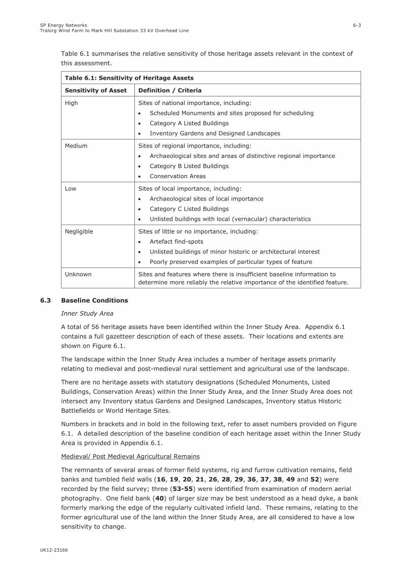
SP Energy Networks
Tralorg Wind Farm to Mark Hill Substation 33 kV Overhead Line
UK12-23166
6-3
Table 6.1 summarises the relative sensitivity of those heritage assets relevant in the context of
this assessment.
Table 6.1: Sensitivity of Heritage Assets
Sensitivity of Asset Definition / Criteria
High Sites of national importance, including:
Scheduled Monuments and sites proposed for scheduling
Category A Listed Buildings
Inventory Gardens and Designed Landscapes
Medium Sites of regional importance, including:
Archaeological sites and areas of distinctive regional importance
Category B Listed Buildings
Conservation Areas
Low Sites of local importance, including:
Archaeological sites of local importance
Category C Listed Buildings
Unlisted buildings with local (vernacular) characteristics
Negligible Sites of little or no importance, including:
Artefact find-spots
Unlisted buildings of minor historic or architectural interest
Poorly preserved examples of particular types of feature
Unknown Sites and features where there is insufficient baseline information to
determine more reliably the relative importance of the identified feature.
6.3 Baseline Conditions
Inner Study Area
A total of 56 heritage assets have been identified within the Inner Study Area. Appendix 6.1
contains a full gazetteer description of each of these assets. Their locations and extents are
shown on Figure 6.1.
The landscape within the Inner Study Area includes a number of heritage assets primarily
relating to medieval and post-medieval rural settlement and agricultural use of the landscape.
There are no heritage assets with statutory designations (Scheduled Monuments, Listed
Buildings, Conservation Areas) within the Inner Study Area, and the Inner Study Area does not
intersect any Inventory status Gardens and Designed Landscapes, Inventory status Historic
Battlefields or World Heritage Sites.
Numbers in brackets and in bold in the following text, refer to asset numbers provided on Figure
6.1. A detailed description of the baseline condition of each heritage asset within the Inner Study
Area is provided in Appendix 6.1.
Medieval/ Post Medieval Agricultural Remains
The remnants of several areas of former field systems, rig and furrow cultivation remains, field
banks and tumbled field walls (16, 19, 20, 21, 26, 28, 29, 36, 37, 38, 49 and 52) were
recorded by the field survey; three (53-55) were identified from examination of modern aerial
photography. One field bank (40) of larger size may be best understood as a head dyke, a bank
formerly marking the edge of the regularly cultivated infield land. These remains, relating to the
former agricultural use of the land within the Inner Study Area, are all considered to have a low
sensitivity to change.
SP Energy Networks
Tralorg Wind Farm to Mark Hill Substation 33 kV Overhead Line
UK12-23166
6-4
Two clearance cairns (33 and 39), which were recorded at the edge of improved pasture fields
within the Inner Study Area, are believed to be the result of recent agricultural improvement of
the land and are considered to have a negligible sensitivity to change.
The remains of a trackway (25) which is marked on the First Edition Ordnance Survey map
(1858), and identified by the field survey, is considered to have a negligible sensitivity to change.
The dwelling of Tralodden (3) is shown on the First Edition Ordnance Survey map (1858), and
continues to be occupied today. The house is considered to have a low sensitivity to change.
The building of Glenassel Lodge (5) is shown on the First Edition Ordnance Survey map (1858),
and has recently been subject to restoration. To its immediate east are the remains of small
building and enclosure which formed kennels (6). Further south are the farmsteads of
Tramitchell (8) and Daldowie (24), both of which are shown on the First Edition Ordnance Survey
map (1858), and continue to be occupied today. All of these buildings are considered to have a
low sensitivity to change.
The remains of a building (48), surviving as a low turf-covered bank, identified by the field
survey, are of uncertain date. They are considered to have a low sensitivity to change.
No upstanding remains of Tormitchell Lodge (7), or of Balligmorrie Cottage (35), which are
shown on the First Edition Ordnance Survey map (1858), were recorded by the field survey. The
former locations of the lodge and cottage are considered to have a negligible sensitivity to
change.
The location of the remnants of the non-inventory designed landscape of Tormitchell (9) is
recorded by the HER. Field survey recorded the remnants of woodland plantation belts situated
within dry-stone walled enclosures. The remnants of the designed landscape are considered to
have a low sensitivity to change.
The farmstead of Garleffin (51) which is marked on the First Edition Ordnance Survey map
(1858) survives in a ruinous condition, with the remains of an enclosure surviving to the north of
the buildings of the farmstead. The remains of the buildings and surrounding enclosures of the
farmstead are considered to have a low sensitivity to change.
Medieval / Post Medieval Industrial Features
A Kiln house and Guild Hall (10) are marked on the First Edition Ordnance Survey map (1858).
Their location lies within the modern Tormitchell Quarry and so they could not be visited by the
field survey. The remains are considered to be of unknown, but no more than low sensitivity to
change.
Remnants of a tramway leading from Tormitchell Quarry (12), survive in a grass-covered
condition. The remains of the former tramway are considered to have a negligible sensitivity to
change.
A former road (13) also runs in a south-westerly direction from Tormitchell Quarry. No
upstanding remains of the road survive within the Inner Study Area, and it is considered to have
a negligible sensitivity to change.
A lime kiln (32) which is shown on the First Edition Ordnance Survey map (1858) survives in
good condition, immediately to the east of a limestone quarry. A further lime kiln (34) survives
in a turf-covered condition further to the south. The remains of both kilns are considered to have
a low sensitivity to change.
Miscellaneous features
A number of quarries (1, 2, 17, 18, 22, 23, 27, 31, 41, 46 and 47) and gravel pits (4, 42, 43,
45 and 50) were recorded throughout the Inner Study Area. These were likely used to gather
SP Energy Networks
Tralorg Wind Farm to Mark Hill Substation 33 kV Overhead Line
UK12-23166
6-5
material to build local buildings, walls and roads. The quarries and gravel pits are all considered
to have a negligible sensitivity to change.
A well (11) which was confirmed by the field survey to be a natural spring, and a mineral spring
(15), both of which are shown on the First Edition Ordnance Survey map (1858) are considered
to have a negligible sensitivity to change.
The former location of a wooden footbridge (14) is considered to have a negligible sensitivity to
change.
A worked stone (30) situated on the top of a field bank is of uncertain origin and function. The
stone is considered to have a negligible sensitivity to change.
A stone marked with a benchmark (44) was recorded by the field survey. It is considered to
have a low sensitivity to change.
A parish boundary (56), of probable 18th century date, is recorded in the HER and is considered
to have a low sensitivity to change.
Archaeological Potential of the Inner Study Area
The current land use of the Inner Study Area is predominantly farmland or rough pasture, with
an area of forestry plantation towards the northern end of the proposed development.
There is no firm evidence for prehistoric activity within the Inner Study Area. Within the vicinity
of the proposed development, recorded archaeological remains of likely prehistoric date are
largely restricted to remains of cairns, situated on more elevated land and hill summits.
Settlement in the area is first depicted in detail on Roy’s Military Survey (1747 -55). Many of the
farmsteads which remain today bear the same names, indicating the continuing use of the area
for agricultural activity, which was focussed along the valleys of the Water of Assel and the River
Stinchar. In these areas the long period of agricultural use of the land, is likely to have resulted
in a decreased probability of surviving upstanding archaeological remains, and thus the limited
number of visible archaeological remains in these areas cannot necessarily be taken as an
indication that no buried archaeological remains are present.
The remainder of the area is shown on Roy’s Military Survey, as today, as unimproved land,
within which it would be expected that archaeological remains would survive as upstanding
remains which would be identified by the field survey. The field survey recorded only limited
areas of archaeological remains, primarily relating to former agricultural exploitation of the land.
Within the small area of woodland plantation within the Inner Study Area, forestry ploughing is
likely to have caused considerable disturbance to any archaeological remains, and it is therefore
considered that within this area there is a low potential for the discovery of previously unknown
buried archaeological remains.
Overall, taking into account the current land use of the Inner Study Area, the limited areas of
archaeological remains recorded by the field survey, and the limited areas of ground disturbance
which would be required for the proposed development, it is considered that overall there is a low
probability for the discovery of presently unknown buried archaeological remains during the
construction of the proposed development.
Outer Study Area
There are seven designated heritage assets located within 3 km of the northern part of the
proposed OHL from which one or more element of the proposed OHL would theoretically be
visible (Figure 6.2). These assets are listed in Appendix 6.2, and include a medieval motte, a
Castle, and a garden and designed landscape laid out by W.S. Gilpin.

SP Energy Networks
Tralorg Wind Farm to Mark Hill Substation 33 kV Overhead Line
UK12-23166
6-6
6.4 Potential Impacts and Mitigation
6.4.1 Construction
Ground breaking activities associated with construction of the proposed development (OHL or
underground cable) have the potential to disturb or destroy the remains of heritage assets known
to be present within the proposed development area and on any hitherto undiscovered buried
remains of archaeological interest that might also be present. Other construction activities, such
as vehicle movements, storage of construction materials, and landscaping, also have the
potential to cause direct, permanent and irreversible impacts on the cultural heritage.
A 50 m Limit of Deviation (LoD) (25m either side of the proposed development) has been defined
to allow the micrositing of wood pole locations and the underground cable in order to avoid
environmental or physical features as required. The following assessment therefore assumes the
possibility that any heritage asset within the LoD (Figure 6.1) could, without mitigation, be
directly impacted by the proposed development.
Proposed access routes for the OHL section of the proposed development (north of pole position
33) are shown on Figure 6.1. No ground breaking or track construction will be required for
access provision within this area, as low ground pressure vehicles will be used during
construction works. For the southern part of the underground cable section of the proposed
development (between the Muck Water and Mark Hill substation), temporary 3 m wide floating
stone tracks will need to be constructed. The track would be adjacent to the underground cable
route, on its eastern side (Figure 6.1).
No mitigation is considered necessary for assets of negligible sensitivity to change, and therefore
assets of negligible sensitivity within the LoD are not mentioned further.
There is potential for direct impacts on 14 assets of low sensitivity within the LoD to occur during
the construction phase. Generic, appropriate mitigation measures to reduce or off-set these
impacts are detailed in Table 6.2. These mitigation measures will be defined in full detail in a
Written Scheme of Investigation (WSI) prepared in response to any archaeological planning
condition imposed by the Council.
6.4.2 Operation
The presence of the proposed development could result in potentially adverse impacts on the
setting of heritage assets present in the surrounding landscape. Potential impacts are detailed in
Technical Appendix 6.2 and summarised below in Table 6.3.
The southern part of the proposed development comprises an underground cable. This part of
the proposed development will not be visible, and will not therefore have any effect upon the
setting of heritage assets in the wider landscape.
No potentially significant operational effects (effects upon the setting of heritage assets) have
been predicted as a result of the proposed development. No mitigation is considered necessary
to offset potential operational effects.

SP Energy Networks
Tralorg Wind Farm to Mark Hill Substation 33 kV Overhead Line
UK12-23166
6-7
Table 6.2: Potential Impacts on Cultural Heritage during Construction and Relevant Mitigation/Control Measures
Potential Impact Receptor Mitigation/Control Measures Proposed
Assets within the 50 m LoD for
the proposed development where
construction works for the
proposed development could
disturb the asset.
Asset 16: Field system and rig and furrow
cultivation remains
Asset 19(a): Field bank
Asset 20: Field system
Asset 26: Field system
Asset 28: Field bank
Asset 29: Field bank
Asset 36(b): Field bank
Asset 37: Field bank
Asset 38: Field bank
Asset 40: Field bank / Head dyke
Asset 44: Ordnance Survey benchmark
Asset 54: Enclosure; Field
Asset 55: Field bank
Detailed mitigation measures will be set out in a Written Scheme of Investigation
(WSI) in response to any archaeological planning condition imposed by South Ayrshire
Council. The WSI be developed through consultation with WoSAS, acting on behalf of
the Council, and will be implemented ahead of commencement of the construction
works.
Where possible microsite the proposed development to avoid direct impacts on
identified assets.
Mark-off assets during construction works, to ensure preservation in situ.
Assets that cannot be avoided should be investigated and recorded prior to / during
construction works.
Archaeological investigations would be carried out to a specification and standard to be
agreed in writing with South Ayrshire Council through consultation with WoSAS.
Access routes for use during
construction causing a direct
impact on cultural heritage
assets.
Asset 1: Trackway
Asset 20: Field system
Asset 26: Field system
Asset 28: Field bank
Asset 29: Field bank
Asset 36(a): Field bank
Asset 36(b): Field bank
Asset 38: Field bank
Asset 40: Field bank / Head dyke
Asset 44: Ordnance Survey benchmark
Asset 54: Enclosure; Field
Asset 55: Field bank
Detailed mitigation measures will be set out in a Written Scheme of Investigation
(WSI) in response to any archaeological planning condition imposed by South Ayrshire
Council. The WSI be developed through consultation with WoSAS, acting on behalf of
the Council, and will be implemented ahead of commencement of the construction
works.
Where possible microsite the proposed development to avoid direct impacts on asset.
Where linear assets (such as banks and walls) survive as upstanding features, access
tracks would be routed through any existing gates or broken (less well preserved)
sections where possible.
Mark-off asset during construction works, to ensure preservation in situ
Assets that cannot be avoided should be investigated and recorded prior to / during
construction works.
Archaeological investigations would be carried out to a specification and standard to be
agreed in writing with South Ayrshire Council through consultation with WoSAS.

SP Energy Networks
Tralorg Wind Farm to Mark Hill Substation 33 kV Overhead Line
UK12-23166
6-8
Table 6.2: Potential Impacts on Cultural Heritage during Construction and Relevant Mitigation/Control Measures
Potential Impact Receptor Mitigation/Control Measures Proposed
Direct impact on unknown cultural
heritage features within areas of
forestry plantation (which were
not covered by the field survey)
Unknown No mitigation necessary. The area was surveyed in advance of the planting of the
forestry in 1993 (Carter & Dalland 1993).
Direct impact on buried
archaeological remains
Unknown. Low potential for presently unknown
buried archaeological remains to survive within
areas of ground disturbance associated with the
proposed development.
Any requirement for archaeological monitoring works/watching briefs during the
construction phase would be agreed in consultation with West of Scotland Archaeology
Service (WoSAS) advisors to South Ayrshire Council.
Detailed mitigation measures will be set out in a Written Scheme of Investigation
(WSI) in response to any archaeological planning condition imposed by South Ayrshire
Council, and will be implemented ahead of commencement of the construction works.
If significant discoveries are made during archaeological monitoring and preservation
in situ is not possible, provision would be made for an appropriate amount of
investigation and recording to be agreed in writing with South Ayrshire Council through
consultation with WoSAS. That provision would include the consequent production of
written reports on the findings, with post-excavation analyses and publication of the
results of the work where appropriate.
6.4.3 Operation
Potential effects during operation are detailed in Table 6.3 below, which also details the relevant receptor and mitigation or control measures, where
appropriate.
Table 6.3: Potential Impacts on Cultural Heritage during Operation and Relevant Mitigation/Control Measures
Potential Impact Receptor Mitigation/Control Measures Proposed
Operational Impact (Impact on
the setting) of designated
heritage assets within the Outer
Study Area
One Scheduled Monument
One Category A Listed Building
One Inventory Garden and Designed Landscape
Three Category B Listed Buildings
One Category C Listed Building
No mitigation recommended.

SP Energy Networks
Tralorg Wind Farm to Mark Hill Substation 33 kV Overhead Line
UK12-23166
TECHNICAL APPENDIX 6 – CULTURAL HERITAGE APPRAISAL
6.1: Cultural Heritage Assets within the Inner Study Area
6.2: Cultural Heritage Assets within the Outer Study Area with predicted visibility of the
Proposed Development
6.3 List of Sources Consulted

SP Energy Networks
Tralorg Wind Farm to Mark Hill Substation 33 kV Overhead Line
UK12-23166
TECHNICAL APPENDIX 6.1: CULTURAL HERITAGE ASSETS WITHIN THE INNER STUDY AREA
Asset
No.
Asset Name &
Type
HER no. /
Canmore ID.
Easting Northing Source(s) Asset Description Sensitivity
1 Old Quarry
(Whinstone),
Trackways
N/A 222750 596432 Historic maps;
Field survey
The Ordnance Survey First Edition map (1858, Ayrshire, Sheet
LVI, 6” to 1 mile) marks an ‘Old Quarry (Whinstone)’ at222750,
596432. A trackway connects the quarry with the farmstead of
Tralodden to the south. The Trackway also extends to the north of
the quarry with two branches of trackway leading to the north and
west.
Field survey found the quarry and trackway as marked on the First
Edition map. The quarry was approximately 2.5 m deep and
survived in a turf covered condition. The trackway survives as a
shallow, grass-covered holloway, approximately 2 m wide and
between 0.3 and 0.4 m deep.
Negligible
2 Old Quarry
(Whinstone)
N/A 222797 596318 Historic maps;
Field survey
The Ordnance Survey First Edition map (1858, Ayrshire, Sheet
LVI, 6” to 1 mile) marks an ‘Old Quarry (Whinstone)’ at this
location.
Field survey found the quarry to be between 2.5 m and 3 m deep,
surviving in a turf-covered condition.
Negligible
3 Tralodden /
Tralodden
Cottage
N/A 222728 596258 Historic maps;
Field survey
The Ordnance Survey First Edition map (1858, Ayrshire, Sheet
LVI, 6” to 1 mile) marks ‘Tralodden’ at this location. It comprises
a square range of buildings enclosing a courtyard, with an opening
on its south-eastern side. A small additional square building is
marked to the north of the buildings within an irregular shaped
enclosure.
Tralodden Cottage is an occupied dwelling house, the square range
of buildings surviving, albeit with the northern range currently in
unroofed condition. The square building appears to no longer be
present.
Low
4 Gravel Pit N/A 222950 595120 Historic maps;
Field survey
The Ordnance Survey First Edition map (1858, Ayrshire, Sheet
LVI, 6” to 1 mile) marks a ‘Gravel Pit’ at this location on the
eastern side of the road.
Negligible
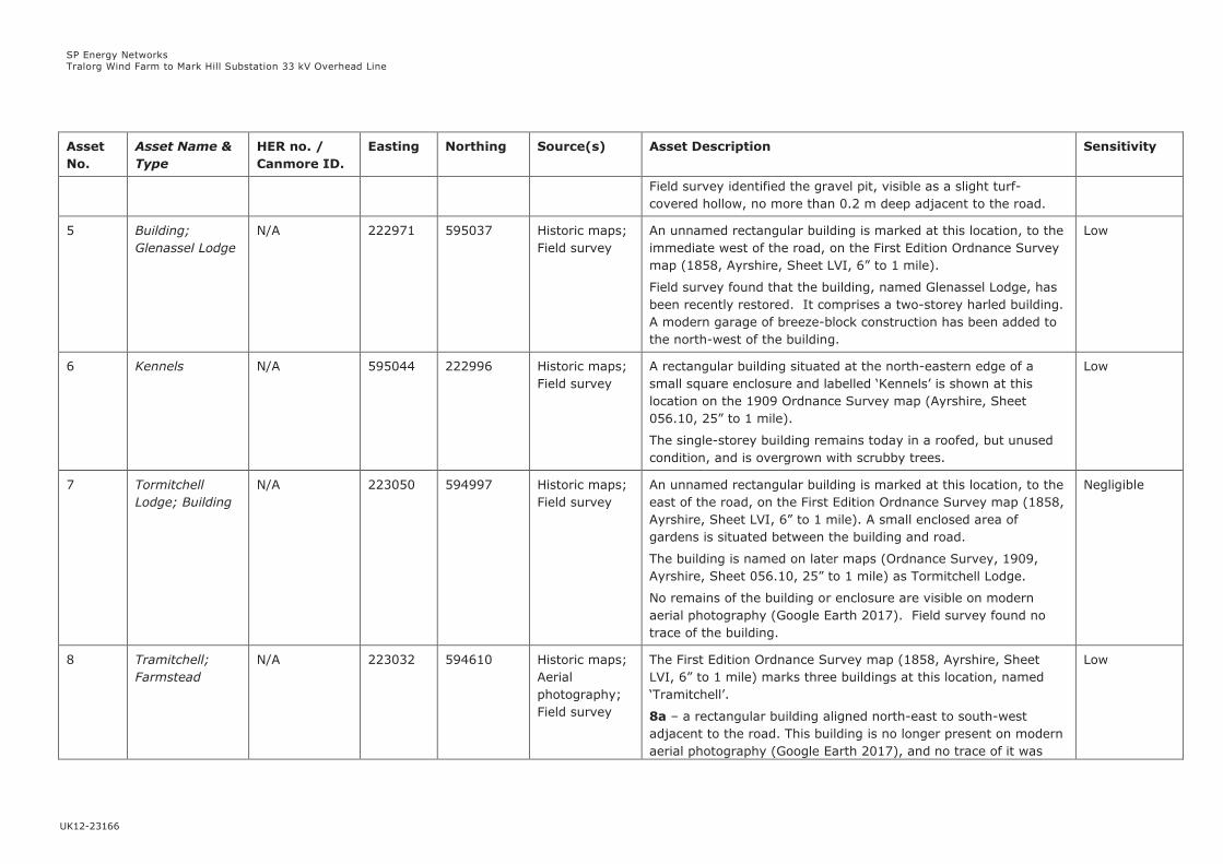
SP Energy Networks
Tralorg Wind Farm to Mark Hill Substation 33 kV Overhead Line
UK12-23166
Asset
No.
Asset Name &
Type
HER no. /
Canmore ID.
Easting Northing Source(s) Asset Description Sensitivity
Field survey identified the gravel pit, visible as a slight turf-
covered hollow, no more than 0.2 m deep adjacent to the road.
5 Building;
Glenassel Lodge
N/A 222971 595037 Historic maps;
Field survey
An unnamed rectangular building is marked at this location, to the
immediate west of the road, on the First Edition Ordnance Survey
map (1858, Ayrshire, Sheet LVI, 6” to 1 mile).
Field survey found that the building, named Glenassel Lodge, has
been recently restored. It comprises a two-storey harled building.
A modern garage of breeze-block construction has been added to
the north-west of the building.
Low
6 Kennels N/A 595044 222996 Historic maps;
Field survey
A rectangular building situated at the north-eastern edge of a
small square enclosure and labelled ‘Kennels’ is shown at this
location on the 1909 Ordnance Survey map (Ayrshire, Sheet
056.10, 25” to 1 mile).
The single-storey building remains today in a roofed, but unused
condition, and is overgrown with scrubby trees.
Low
7 Tormitchell
Lodge; Building
N/A 223050 594997 Historic maps;
Field survey
An unnamed rectangular building is marked at this location, to the
east of the road, on the First Edition Ordnance Survey map (1858,
Ayrshire, Sheet LVI, 6” to 1 mile). A small enclosed area of
gardens is situated between the building and road.
The building is named on later maps (Ordnance Survey, 1909,
Ayrshire, Sheet 056.10, 25” to 1 mile) as Tormitchell Lodge.
No remains of the building or enclosure are visible on modern
aerial photography (Google Earth 2017). Field survey found no
trace of the building.
Negligible
8 Tramitchell;
Farmstead
N/A 223032 594610 Historic maps;
Aerial
photography;
Field survey
The First Edition Ordnance Survey map (1858, Ayrshire, Sheet
LVI, 6” to 1 mile) marks three buildings at this location, named
‘Tramitchell’.
8a – a rectangular building aligned north-east to south-west
adjacent to the road. This building is no longer present on modern
aerial photography (Google Earth 2017), and no trace of it was
Low
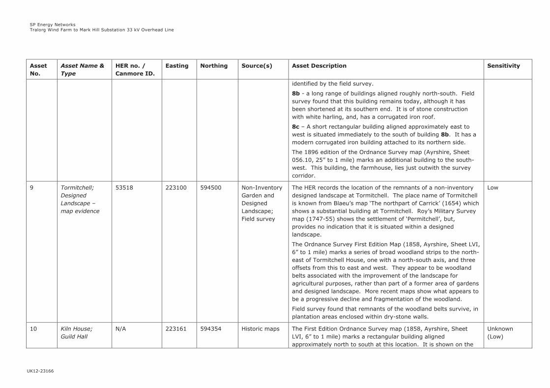
SP Energy Networks
Tralorg Wind Farm to Mark Hill Substation 33 kV Overhead Line
UK12-23166
Asset
No.
Asset Name &
Type
HER no. /
Canmore ID.
Easting Northing Source(s) Asset Description Sensitivity
identified by the field survey.
8b - a long range of buildings aligned roughly north-south. Field
survey found that this building remains today, although it has
been shortened at its southern end. It is of stone construction
with white harling, and, has a corrugated iron roof.
8c – A short rectangular building aligned approximately east to
west is situated immediately to the south of building 8b. It has a
modern corrugated iron building attached to its northern side.
The 1896 edition of the Ordnance Survey map (Ayrshire, Sheet
056.10, 25” to 1 mile) marks an additional building to the south-
west. This building, the farmhouse, lies just outwith the survey
corridor.
9 Tormitchell;
Designed
Landscape –
map evidence
53518 223100 594500 Non-Inventory
Garden and
Designed
Landscape;
Field survey
The HER records the location of the remnants of a non-inventory
designed landscape at Tormitchell. The place name of Tormitchell
is known from Blaeu’s map ‘The northpart of Carrick’ (1654) which
shows a substantial building at Tormitchell. Roy’s Military Survey
map (1747-55) shows the settlement of ‘Permitchell’, but,
provides no indication that it is situated within a designed
landscape.
The Ordnance Survey First Edition Map (1858, Ayrshire, Sheet LVI,
6” to 1 mile) marks a series of broad woodland strips to the north-
east of Tormitchell House, one with a north-south axis, and three
offsets from this to east and west. They appear to be woodland
belts associated with the improvement of the landscape for
agricultural purposes, rather than part of a former area of gardens
and designed landscape. More recent maps show what appears to
be a progressive decline and fragmentation of the woodland.
Field survey found that remnants of the woodland belts survive, in
plantation areas enclosed within dry-stone walls.
Low
10 Kiln House;
Guild Hall
N/A 223161 594354 Historic maps The First Edition Ordnance Survey map (1858, Ayrshire, Sheet
LVI, 6” to 1 mile) marks a rectangular building aligned
approximately north to south at this location. It is shown on the
Unknown
(Low)

SP Energy Networks
Tralorg Wind Farm to Mark Hill Substation 33 kV Overhead Line
UK12-23166
Asset
No.
Asset Name &
Type
HER no. /
Canmore ID.
Easting Northing Source(s) Asset Description Sensitivity
25” map as being comprised of two halves, the northern part
comprising a Kiln House and the southern part a Guild Hall.
Due to the active quarry in this area it was not possible to access
this location during the field survey, and the current condition of
this building is unknown.
11 Well N/A 594343 223102 Historic maps;
Field survey
The First Edition Ordnance Survey map (1858, Ayrshire, Sheet
LVI, 6” to 1 mile) marks a well at this location.
Field survey found a natural spring at this location.
Negligible
12 Tormitchell;
Tramway
12572;
Canmore ID.
74241
223506
221749
594401
593583
HER;
Canmore;
Historic maps;
Field survey
The Second Edition Ordnance Survey map (1896, Ayrshire, Sheet
LVI.SW, 6” to 1 mile shows the route of a tramway. It runs to the
south-west from Tormitchell Quarry towards the road, and then
runs adjacent to the road. The length of tramway recorded in the
HER runs from 223506 594401 to 221749 593583.
The HER records that a length of c.150 m of embankment was
recorded by an archaeological field survey in 1993 (Carter 1993).
The tramway was recorded as being 3 m wide, and, crossing the
Barbae Burn on wooden bridge which survived only as wooden
piles and broken upright timbers.
The current field survey found the surviving remains of the same
short section of the tramway (the surviving part is shown as a
solid line on Figure 1, and the remainder of the former tramway
marked as a dotted line) and runs between approximately NGR
223067 to 222867 594135). The tramway is up to 3 m wide and
1 m high. The tramway is now in use as a public footpath. It
survives in grass-covered, overgrown condition. To the south-
west of the property of Burnside, no trace of the tramway was
found; the course of the tramway here followed the course of the
road, and it is assumed any remains of it have been lost during
road widening etc.
Negligible
13 Tormitchell;
Road
12573 223506
221749
594401
593583
HER; Historic
maps; Field
The HER record the course of a 19th century road or trackway
which runs in a south-westerly direction from Tormitchell Quarry.
Negligible

SP Energy Networks
Tralorg Wind Farm to Mark Hill Substation 33 kV Overhead Line
UK12-23166
Asset
No.
Asset Name &
Type
HER no. /
Canmore ID.
Easting Northing Source(s) Asset Description Sensitivity
survey The road is shown on the First Edition Ordnance Survey map
(1858, Ayrshire, Sheet LVI, 6” to 1 mile), and runs from 223506
594401 to 221749 593583, from which point it continues to run in
a south-westerly direction.
A field survey in 1993 (Carter 1993) found the roadway to be
between 2.5 m and 3 m in width, and recorded that it could be
traced for much of its length. The survey recorded that the road
had been engineered to provide uniform shallow gradients. It
recorded the presence of ditches associated with the road in poorly
drained areas, and the presence of small quarries adjacent to the
road at intervals along its course. Some limited evidence of
metalling (using small angular rubble) was recorded. The roadway
was found to have been washed away at locations where it crosses
streams and gullies, and no original bridges or culverts were
located.
The current field survey found that no trace of this road survives
within the survey corridor, due to the disturbance caused by the
modern Tormitchell Quarry. A linear clearing in the woodland
plantation follows the course of this former road, and remains of it
may survive outwith the Inner Study Area for this project.
14 Footbridge N/A 594105 222830 Historic maps;
Field survey
A footbridge (wood) is marked at this location on the Ordnance
Survey First Edition map (1858, Ayrshire, Sheet LVI, 6” to 1 mile).
Field survey found no remains of this footbridge.
Negligible
15 Mineral Spring N/A 594064 222851 Historic maps;
Field survey
A mineral spring is marked at this location on the Ordnance
Survey First Edition map (1858, Ayrshire, Sheet LVI, 6” to 1 mile).
Field survey found a wet hollow at this location, measuring about
3 m in diameter, and now connected into a wider system of
drainage.
Negligible
16 Field System;
Rig and furrow
cultivation
N/A 222092 593458 Aerial
Photography
(Bing TM);
The northern part of a field system, which extends further to the
south (outside the survey area) is visible on modern aerial
photography (Bing TM).
Low
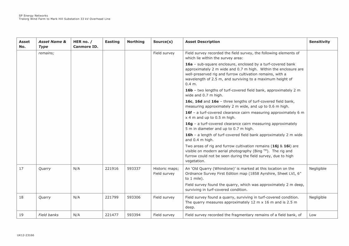
SP Energy Networks
Tralorg Wind Farm to Mark Hill Substation 33 kV Overhead Line
UK12-23166
Asset
No.
Asset Name &
Type
HER no. /
Canmore ID.
Easting Northing Source(s) Asset Description Sensitivity
remains; Field survey Field survey recorded the field survey, the following elements of
which lie within the survey area:
16a – sub-square enclosure, enclosed by a turf-covered bank
approximately 2 m wide and 0.7 m high. Within the enclosure are
well-preserved rig and furrow cultivation remains, with a
wavelength of 2.5 m, and surviving to a maximum height of
0.4 m.
16b – two lengths of turf-covered field bank, approximately 2 m
wide and 0.7 m high.
16c, 16d and 16e – three lengths of turf-covered field bank,
measuring approximately 2 m wide, and up to 0.6 m high.
16f – a turf-covered clearance cairn measuring approximately 6 m
x 4 m and up to 0.5 m high.
16g – a turf-covered clearance cairn measuring approximately
5 m in diameter and up to 0.7 m high.
16h – a length of turf-covered field bank approximately 2 m wide
and 0.4 m high.
Two areas of rig and furrow cultivation remains (16j & 16i) are
visible on modern aerial photography (Bing TM). The rig and
furrow could not be seen during the field survey, due to high
vegetation.
17 Quarry N/A 221916 593337 Historic maps;
Field survey
An ‘Old Quarry (Whinstone)’ is marked at this location on the
Ordnance Survey First Edition map (1858 Ayrshire, Sheet LVI, 6”
to 1 mile).
Field survey found the quarry, which was approximately 2 m deep,
surviving in turf-covered condition.
Negligible
18 Quarry N/A 221799 593306 Field survey Field survey found a quarry, surviving in turf-covered condition.
The quarry measures approximately 12 m x 16 m and is 2.5 m
deep.
Negligible
19 Field banks N/A 221477 593394 Field survey Field survey recorded the fragmentary remains of a field bank, of Low

SP Energy Networks
Tralorg Wind Farm to Mark Hill Substation 33 kV Overhead Line
UK12-23166
Asset
No.
Asset Name &
Type
HER no. /
Canmore ID.
Easting Northing Source(s) Asset Description Sensitivity
221532
221552
221598
593303
593392
593386
which four lengths were recorded.
The two best preserved parts of the bank (19a) were
approximately 2 m wide and up to 0.5 m high and survive to the
immediate north of a modern post and wire fence and tree-lined
boundary. These lengths of bank run between 221477 593394 to
221532 593303.
Further to the north-east two less well-preserved lengths of bank
(19b) approximately 2 m wide and 0.4 m high were recorded
situated at the edge of the higher ground, before it forms an
abrupt slope down to the Assel Water river. These lengths of bank
run between 221552 593392 to 221573 593385 and between
221598 593386 to 221635 593403.
20 Field system N/A 221437
(centred)
592974
(centred)
Aerial
photography;
Field survey
A field system comprising several fields enclosed by turf-covered
banks is visible on modern aerial photography (Bing TM) in this
area, to the north-east of Daldowie Farm. Some of the field banks
have been added to modern OS mapping.
Field survey found the banks surviving in a variety of conditions.
The main boundary within the study area which runs in a generally
north-east to south-west alignment has been recently reinforced
as a double line of post and wire fencing with a central ditch. This
alignment generally follows the earlier field bank visible on the
aerial photography. Towards its southern end the modern bank
deviates from the course of the earlier bank. The earlier bank
remains on the eastern side of the modern bank, measuring
approximately 1 m wide and 0.6 m high.
The other banks of the field system are approximately 2 m wide
and up to 0.4 m wide, surviving in a turf-covered condition.
At the southern end (221383 592818) of the field system the
remnants of two small enclosures or pens (20a) were found,
surviving as turf-covered banks approximately 1.2 m wide and up
to 0.3 m high.
Faint traces of rig and furrow cultivation remains are visible within
Low

SP Energy Networks
Tralorg Wind Farm to Mark Hill Substation 33 kV Overhead Line
UK12-23166
Asset
No.
Asset Name &
Type
HER no. /
Canmore ID.
Easting Northing Source(s) Asset Description Sensitivity
the field system on modern aerial photography (Bing TM) but
could not be traced during the field survey.
21 Field bank N/A 221409 593078 Field survey Field survey found a field bank, approximately 20 m long. The
turf-covered bank is approximately 2 m wide and 0.4 m high, and
runs in a generally north-east to south-west direction, curving to
the west at its south-western end.
Low
22 Quarry N/A 221373 592914 Field survey Field survey identified a small quarry surviving in a turf-covered
condition. The circular quarry measured c. 6 m in diameter and
was up to 3 m deep.
Negligible
23 Quarry N/A 221351 592862 Historic maps;
Field Survey
A Whinstone Quarry is marked at this location on the Ordnance
Survey First Edition map (1858 Ayrshire, Sheet LVI, 6” to 1 mile).
The 1909 Edition of the Ordnance Survey map describes the
feature as an ‘Old Quarry’ indicating that it was out of use by that
date.
Field survey recorded the quarry surviving as a turf-covered
hollow approximately 3 m deep. The quarry hollow measured
approximately 13 m x 18 m internally.
Negligible
24 Daldowie;
Farmstead
N/A 221059 592504 Historic maps;
Field survey
A farm named as ‘Daldowie’ is shown on the First Edition Ordnance
Survey map (1858. Ayrshire, Sheet LXII, 6” to 1 mile).
Daldowie comprises a rectangular building orientated north-west
to south-east with an L-shaped range of buildings to the
southwest, including a horse engine on the southern side. A small
square building is marked to the north-west of this range of
buildings and two other small rectangular buildings are marked
further to the south.
The farm remains occupied today.
Low
25 Trackway N/A 220599
221612
592417
591894
HER; Field
survey
A trackway is marked on the Ordnance Survey First Edition map
(1858. Ayrshire, Sheet LXII, 6” to 1 mile).
Within the western part of the survey area no remains of the
trackway could be seen. Within the eastern part of the survey
Negligible

SP Energy Networks
Tralorg Wind Farm to Mark Hill Substation 33 kV Overhead Line
UK12-23166
Asset
No.
Asset Name &
Type
HER no. /
Canmore ID.
Easting Northing Source(s) Asset Description Sensitivity
area the trackway is visible as a narrow holloway, with a boggy
base, approximately 1.5 m wide and enclosed on either side by
banks forming part of field system (26). The surviving piece of
trackway runs between 221292 592072 and 221612 591894.
26 Field system N/A 221373
(centre)
591994
(centre)
Aerial
photography;
Field survey
Field survey identified the edge of a field system, which extends
outside the survey area to the north-west. The wider field system
is visible on aerial photography (Bing TM).
Field survey found two parallel lengths of bank at the southern
edge of the field system, with the trackway (25) running between
them. The southernmost bank survives in turf-covered condition
and is up to 2 m wide and 0.7 m high. The northern bank is in a
similar turf-covered condition but is smaller, measuring
approximately 1 m wide and 0.4 m high.
Low
27 Quarries
(Whinstone)
N/A 221298 591872 Historic maps;
Field survey
The Ordnance Survey First Edition map (1858. Ayrshire, Sheet
LXII, 6” to 1 mile) marks two Whinstone Quarries (27a & 27b).
Field survey found that quarry 27a (at 221298 591872) has been
extended, with the original quarry surviving as a small turf-
covered hollow approximately 1 m deep, at the southern end of
the overall quarry area. The larger modern quarry is
approximately 3 m deep.
Quarry 27b is situated further to the south-east (at 221328
591807). The quarry survives in turf-covered condition, and, is
now occupied by a water tank of brick and concrete construction.
Negligible
28 Field bank N/A 221221 591606 Historic maps;
Field survey
A field bank is marked within a woodland plantation on the
Ordnance Survey First Edition map (1858. Ayrshire, Sheet LXII, 6”
to 1 mile).
Field survey identified the bank which survives within the
woodland plantation, and, is now overgrown with mature grass.
The bank is 3 m wide and survives to a height of approximately
0.7 m.
Low
29 Field bank N/A 221256 591589 Field survey Field survey identified a bank surviving within a woodland Low
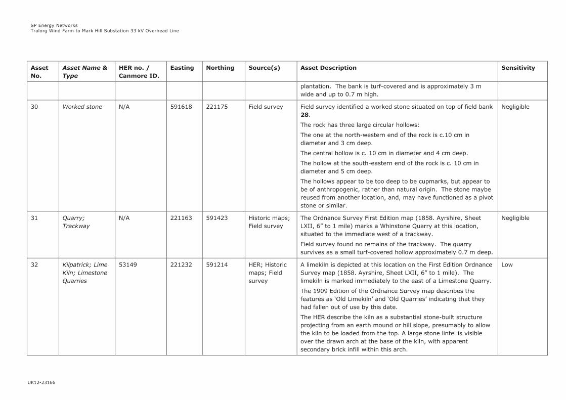
SP Energy Networks
Tralorg Wind Farm to Mark Hill Substation 33 kV Overhead Line
UK12-23166
Asset
No.
Asset Name &
Type
HER no. /
Canmore ID.
Easting Northing Source(s) Asset Description Sensitivity
plantation. The bank is turf-covered and is approximately 3 m
wide and up to 0.7 m high.
30 Worked stone N/A 591618 221175 Field survey Field survey identified a worked stone situated on top of field bank
28.
The rock has three large circular hollows:
The one at the north-western end of the rock is c.10 cm in
diameter and 3 cm deep.
The central hollow is c. 10 cm in diameter and 4 cm deep.
The hollow at the south-eastern end of the rock is c. 10 cm in
diameter and 5 cm deep.
The hollows appear to be too deep to be cupmarks, but appear to
be of anthropogenic, rather than natural origin. The stone maybe
reused from another location, and, may have functioned as a pivot
stone or similar.
Negligible
31 Quarry;
Trackway
N/A 221163 591423 Historic maps;
Field survey
The Ordnance Survey First Edition map (1858. Ayrshire, Sheet
LXII, 6” to 1 mile) marks a Whinstone Quarry at this location,
situated to the immediate west of a trackway.
Field survey found no remains of the trackway. The quarry
survives as a small turf-covered hollow approximately 0.7 m deep.
Negligible
32 Kilpatrick; Lime
Kiln; Limestone
Quarries
53149 221232 591214 HER; Historic
maps; Field
survey
A limekiln is depicted at this location on the First Edition Ordnance
Survey map (1858. Ayrshire, Sheet LXII, 6” to 1 mile). The
limekiln is marked immediately to the east of a Limestone Quarry.
The 1909 Edition of the Ordnance Survey map describes the
features as ‘Old Limekiln’ and ‘Old Quarries’ indicating that they
had fallen out of use by this date.
The HER describe the kiln as a substantial stone-built structure
projecting from an earth mound or hill slope, presumably to allow
the kiln to be loaded from the top. A large stone lintel is visible
over the drawn arch at the base of the kiln, with apparent
secondary brick infill within this arch.
Low
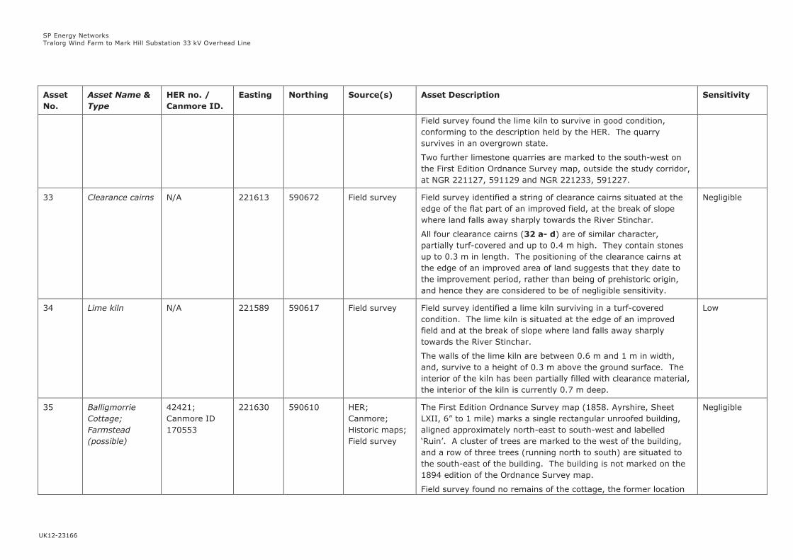
SP Energy Networks
Tralorg Wind Farm to Mark Hill Substation 33 kV Overhead Line
UK12-23166
Asset
No.
Asset Name &
Type
HER no. /
Canmore ID.
Easting Northing Source(s) Asset Description Sensitivity
Field survey found the lime kiln to survive in good condition,
conforming to the description held by the HER. The quarry
survives in an overgrown state.
Two further limestone quarries are marked to the south-west on
the First Edition Ordnance Survey map, outside the study corridor,
at NGR 221127, 591129 and NGR 221233, 591227.
33 Clearance cairns N/A 221613 590672 Field survey Field survey identified a string of clearance cairns situated at the
edge of the flat part of an improved field, at the break of slope
where land falls away sharply towards the River Stinchar.
All four clearance cairns (32 a- d) are of similar character,
partially turf-covered and up to 0.4 m high. They contain stones
up to 0.3 m in length. The positioning of the clearance cairns at
the edge of an improved area of land suggests that they date to
the improvement period, rather than being of prehistoric origin,
and hence they are considered to be of negligible sensitivity.
Negligible
34 Lime kiln N/A 221589 590617 Field survey Field survey identified a lime kiln surviving in a turf-covered
condition. The lime kiln is situated at the edge of an improved
field and at the break of slope where land falls away sharply
towards the River Stinchar.
The walls of the lime kiln are between 0.6 m and 1 m in width,
and, survive to a height of 0.3 m above the ground surface. The
interior of the kiln has been partially filled with clearance material,
the interior of the kiln is currently 0.7 m deep.
Low
35 Balligmorrie
Cottage;
Farmstead
(possible)
42421;
Canmore ID
170553
221630 590610 HER;
Canmore;
Historic maps;
Field survey
The First Edition Ordnance Survey map (1858. Ayrshire, Sheet
LXII, 6” to 1 mile) marks a single rectangular unroofed building,
aligned approximately north-east to south-west and labelled
‘Ruin’. A cluster of trees are marked to the west of the building,
and a row of three trees (running north to south) are situated to
the south-east of the building. The building is not marked on the
1894 edition of the Ordnance Survey map.
Field survey found no remains of the cottage, the former location
Negligible
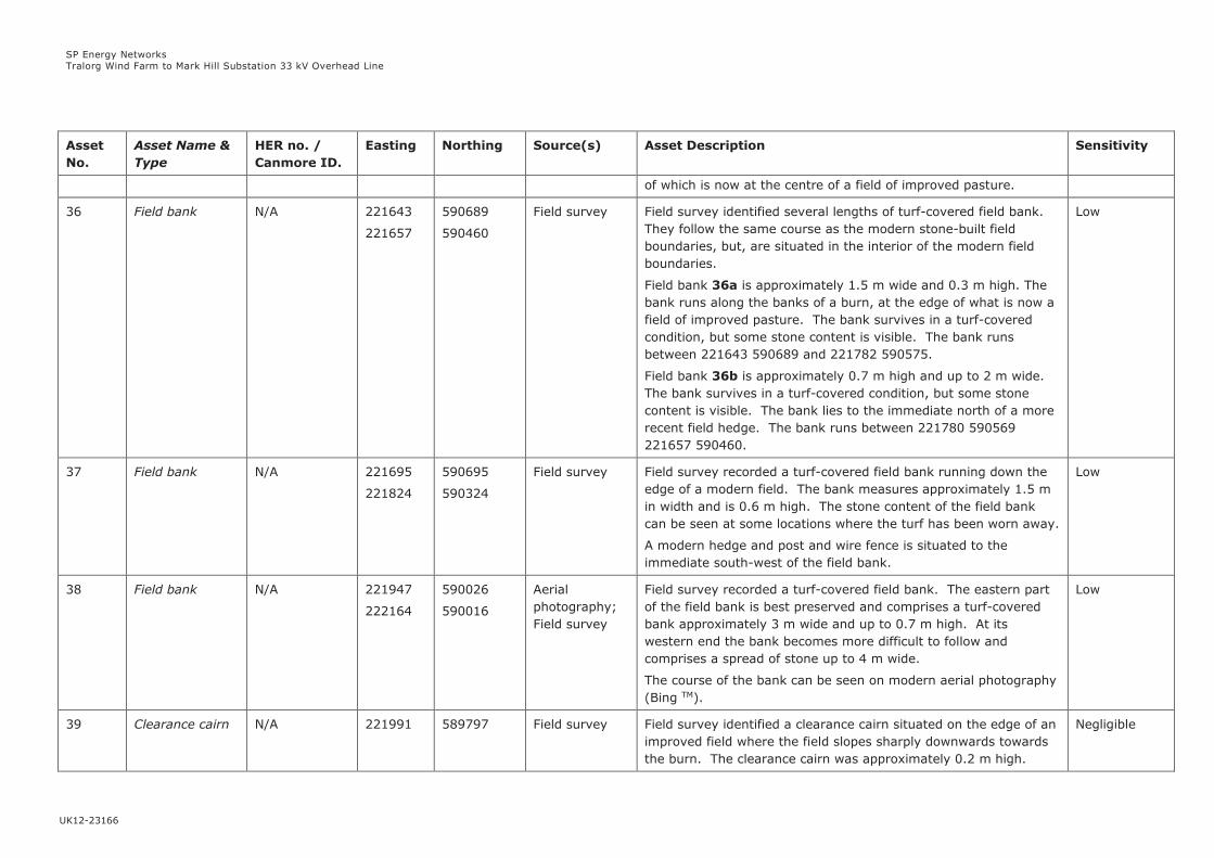
SP Energy Networks
Tralorg Wind Farm to Mark Hill Substation 33 kV Overhead Line
UK12-23166
Asset
No.
Asset Name &
Type
HER no. /
Canmore ID.
Easting Northing Source(s) Asset Description Sensitivity
of which is now at the centre of a field of improved pasture.
36 Field bank N/A 221643
221657
590689
590460
Field survey Field survey identified several lengths of turf-covered field bank.
They follow the same course as the modern stone-built field
boundaries, but, are situated in the interior of the modern field
boundaries.
Field bank 36a is approximately 1.5 m wide and 0.3 m high. The
bank runs along the banks of a burn, at the edge of what is now a
field of improved pasture. The bank survives in a turf-covered
condition, but some stone content is visible. The bank runs
between 221643 590689 and 221782 590575.
Field bank 36b is approximately 0.7 m high and up to 2 m wide.
The bank survives in a turf-covered condition, but some stone
content is visible. The bank lies to the immediate north of a more
recent field hedge. The bank runs between 221780 590569
221657 590460.
Low
37 Field bank N/A 221695
221824
590695
590324
Field survey Field survey recorded a turf-covered field bank running down the
edge of a modern field. The bank measures approximately 1.5 m
in width and is 0.6 m high. The stone content of the field bank
can be seen at some locations where the turf has been worn away.
A modern hedge and post and wire fence is situated to the
immediate south-west of the field bank.
Low
38 Field bank N/A 221947
222164
590026
590016
Aerial
photography;
Field survey
Field survey recorded a turf-covered field bank. The eastern part
of the field bank is best preserved and comprises a turf-covered
bank approximately 3 m wide and up to 0.7 m high. At its
western end the bank becomes more difficult to follow and
comprises a spread of stone up to 4 m wide.
The course of the bank can be seen on modern aerial photography
(Bing TM).
Low
39 Clearance cairn N/A 221991 589797 Field survey Field survey identified a clearance cairn situated on the edge of an
improved field where the field slopes sharply downwards towards
the burn. The clearance cairn was approximately 0.2 m high.
Negligible

SP Energy Networks
Tralorg Wind Farm to Mark Hill Substation 33 kV Overhead Line
UK12-23166
Asset
No.
Asset Name &
Type
HER no. /
Canmore ID.
Easting Northing Source(s) Asset Description Sensitivity
The position of the clearance cairn at the edge of an improved field
suggests that it dates to the improvement period, rather than
being of prehistoric origin, and hence it is considered to be of
negligible sensitivity.
40 Field bank /
Head dyke
N/A 222235 589637 Field survey;
Aerial
photography
Field survey identified a length of field bank between 1 and 1.5 m
high and up to 3 m wide. The bank survives in turf-covered
condition with occasional stones visible. The bank extends to the
north-east outwith the survey area. Its size and the length for
which it runs suggests that it may be best understood as a head
dyke (a bank formerly marking the edge of the regularly cultivated
infield land).
Low
41 Quarry N/A 222234 589589 Field survey Field survey identified a turf-covered quarry situated to the south
of a trackway (as shown on the modern Ordnance Survey map).
The quarry hollow is approximately 1.2 m deep, with no stone
visible.
Negligible
42 Gravel Pits N/A 222681 589350 Historic maps;
Field survey
Two gravel pits are marked at this location on the First Edition
Ordnance Survey map (1858, Ayr Sheet LXII.1, 25” to 1 mile).
Field survey found that the southern gravel pit (42a) is
approximately 2 m deep and is largely turf-covered with some
reeds surviving at its base.
The northern gravel pit (42b) is sub-rectangular in shape and a
maximum of 1.5 m deep. It is turf and reed filled with some
exposed bedrock.
Negligible
43 Gravel Pit N/A 222885 589224 Historic maps;
Field survey
A gravel pit is marked at this location to the east of the trackway,
on the Second Edition Ordnance Survey map (1910, Ayrshire
Sheet LXII.SW, 25” to 1 mile).
Field survey found the gravel pit to survive as a turf-covered
hollow with reeds growing within its interior. The pit is a
maximum of 3 m deep.
Negligible
44 Ordnance
Survey
N/A 222944 589131 Field survey Field survey found a stone which was marked with an Ordnance Low
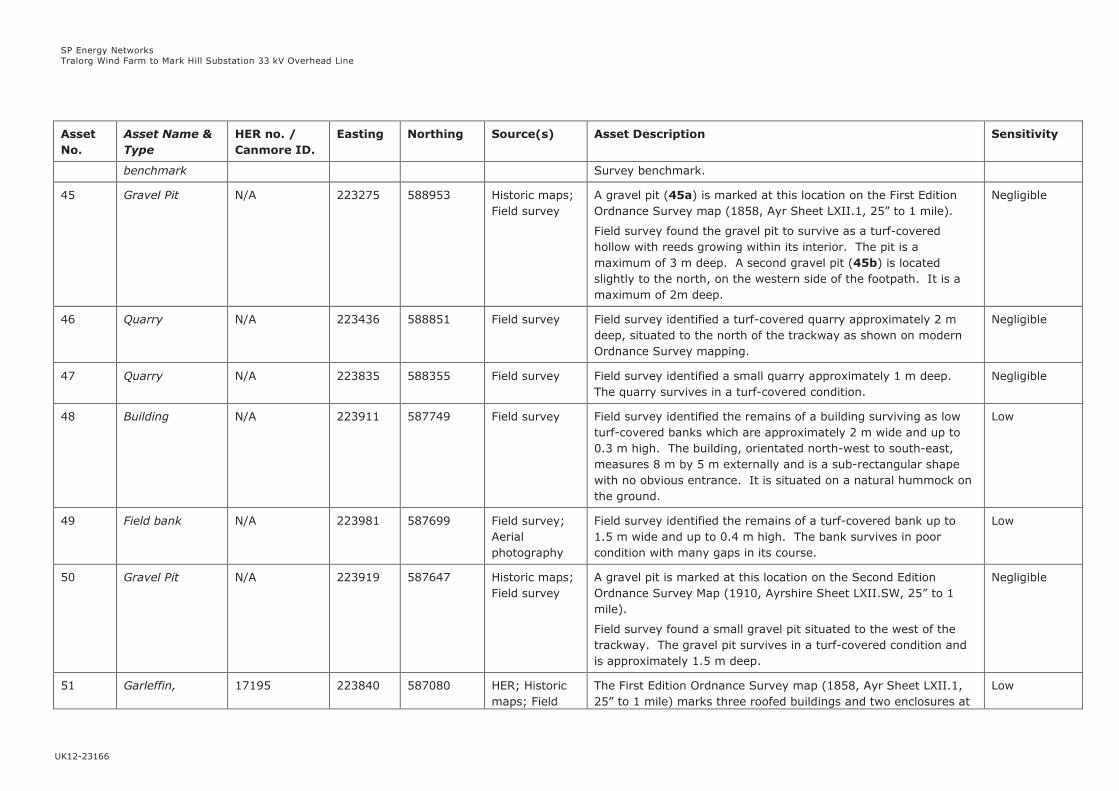
SP Energy Networks
Tralorg Wind Farm to Mark Hill Substation 33 kV Overhead Line
UK12-23166
Asset
No.
Asset Name &
Type
HER no. /
Canmore ID.
Easting Northing Source(s) Asset Description Sensitivity
benchmark Survey benchmark.
45 Gravel Pit N/A 223275 588953 Historic maps;
Field survey
A gravel pit (45a) is marked at this location on the First Edition
Ordnance Survey map (1858, Ayr Sheet LXII.1, 25” to 1 mile).
Field survey found the gravel pit to survive as a turf-covered
hollow with reeds growing within its interior. The pit is a
maximum of 3 m deep. A second gravel pit (45b) is located
slightly to the north, on the western side of the footpath. It is a
maximum of 2m deep.
Negligible
46 Quarry N/A 223436 588851 Field survey Field survey identified a turf-covered quarry approximately 2 m
deep, situated to the north of the trackway as shown on modern
Ordnance Survey mapping.
Negligible
47 Quarry N/A 223835 588355 Field survey Field survey identified a small quarry approximately 1 m deep.
The quarry survives in a turf-covered condition.
Negligible
48 Building N/A 223911 587749 Field survey Field survey identified the remains of a building surviving as low
turf-covered banks which are approximately 2 m wide and up to
0.3 m high. The building, orientated north-west to south-east,
measures 8 m by 5 m externally and is a sub-rectangular shape
with no obvious entrance. It is situated on a natural hummock on
the ground.
Low
49 Field bank N/A 223981 587699 Field survey;
Aerial
photography
Field survey identified the remains of a turf-covered bank up to
1.5 m wide and up to 0.4 m high. The bank survives in poor
condition with many gaps in its course.
Low
50 Gravel Pit N/A 223919 587647 Historic maps;
Field survey
A gravel pit is marked at this location on the Second Edition
Ordnance Survey Map (1910, Ayrshire Sheet LXII.SW, 25” to 1
mile).
Field survey found a small gravel pit situated to the west of the
trackway. The gravel pit survives in a turf-covered condition and
is approximately 1.5 m deep.
Negligible
51 Garleffin, 17195 223840 587080 HER; Historic
maps; Field
The First Edition Ordnance Survey map (1858, Ayr Sheet LXII.1,
25” to 1 mile) marks three roofed buildings and two enclosures at
Low
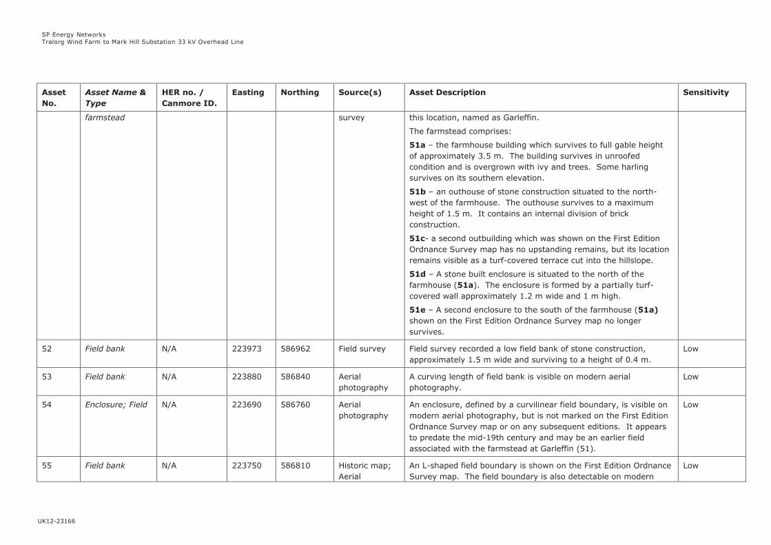
SP Energy Networks
Tralorg Wind Farm to Mark Hill Substation 33 kV Overhead Line
UK12-23166
Asset
No.
Asset Name &
Type
HER no. /
Canmore ID.
Easting Northing Source(s) Asset Description Sensitivity
farmstead survey this location, named as Garleffin.
The farmstead comprises:
51a – the farmhouse building which survives to full gable height
of approximately 3.5 m. The building survives in unroofed
condition and is overgrown with ivy and trees. Some harling
survives on its southern elevation.
51b – an outhouse of stone construction situated to the north-
west of the farmhouse. The outhouse survives to a maximum
height of 1.5 m. It contains an internal division of brick
construction.
51c- a second outbuilding which was shown on the First Edition
Ordnance Survey map has no upstanding remains, but its location
remains visible as a turf-covered terrace cut into the hillslope.
51d – A stone built enclosure is situated to the north of the
farmhouse (51a). The enclosure is formed by a partially turf-
covered wall approximately 1.2 m wide and 1 m high.
51e – A second enclosure to the south of the farmhouse (51a)
shown on the First Edition Ordnance Survey map no longer
survives.
52 Field bank N/A 223973 586962 Field survey Field survey recorded a low field bank of stone construction,
approximately 1.5 m wide and surviving to a height of 0.4 m.
Low
53 Field bank N/A 223880 586840 Aerial
photography
A curving length of field bank is visible on modern aerial
photography.
Low
54 Enclosure; Field N/A 223690 586760 Aerial
photography
An enclosure, defined by a curvilinear field boundary, is visible on
modern aerial photography, but is not marked on the First Edition
Ordnance Survey map or on any subsequent editions. It appears
to predate the mid-19th century and may be an earlier field
associated with the farmstead at Garleffin (51).
Low
55 Field bank N/A 223750 586810 Historic map;
Aerial
An L-shaped field boundary is shown on the First Edition Ordnance
Survey map. The field boundary is also detectable on modern
Low

SP Energy Networks
Tralorg Wind Farm to Mark Hill Substation 33 kV Overhead Line
UK12-23166
Asset
No.
Asset Name &
Type
HER no. /
Canmore ID.
Easting Northing Source(s) Asset Description Sensitivity
photography aerial photography; it appears to be part of a field system
associated with the farmstead at Garleffin (51). The field
boundary is not shown on later Ordnance Survey maps.
56 Barrhill /
Craigcannochie;
Parish Boundary
62001 /
300611
223730
223719
586001
585868
HER; Canmore During the construction of the Mark Hill Windfarm substation, the
boundary between Colmonell and Barr parishes was recorded. The
boundary consisted of an open ditch 1.5 -2 m wide and currently
0.5 m deep. To the north and south of the ditch and unaffected
by the development, the boundary consisted of a dry stone wall.
The changing nature of the boundary is shown on the 1st Edition
Ordnance Survey map of 1857.
The Parish Boundary is shown on both the Ordnance Survey First
and Second Edition maps but it is thought to date to the 18th
century as both parishes are mentioned in the Statistical Account
of Scotland dating to 1791-9.
Low

SP Energy Networks
Tralorg Wind Farm to Mark Hill Substation 33 kV Overhead Line
UK12-23166
TECHNICAL APPENDIX 6.2: CULTURAL HERITAGE ASSETS WITHIN THE OUTER STUDY AREA WITH PREDICTED VISIBLITY
OF THE PROPOSED DEVELOPMENT
Asset No. Asset Name Heritage
Status
Easting Northing Approx
Distance
from OHL
Maximum No.
of Wood
Poles
Theoretically
Visible
Sensitivity
of Asset
Impact of Proposed Development on Setting
SM2202 Dinvin, motte Scheduled
Monument
220032 593172 1.3km 37 High Dinvin is described as one of the best preserved
medieval mottes in Scotland. Its setting is within an
area of unimproved pasture to the north of a modern
road, and within a wider landscape in agricultural use or
comprising forestry plantations. Existing 33 kV overhead
lines run past the motte. The proposed development
would be visible beyond these existing cables, in long
distance views at least 1.3 km away.
LB1148 Penkill Castle Category A
Listed
Building
223151 598538 1.7km 1 High Penkill Castle is described as a small castle situated on a
peninsular ravine-edge site on the southern bank of the
Girvan Water. Mature woodland encloses the castle on
all sides and would likely screen views of the proposed
development, of which only one pole is predicted by the
ZTV to be visible from the Castle.
GDL00047 Bargany Inventory
Garden
and
Designed
Landscape
225042 600778 2.7km 2 High The Inventory describes Bargany as an ‘outstanding
designed landscape laid out by W.S. Gilpin’. The bare-
earth ZTV predicts visibility of a maximum of 2 wood
poles from the southernmost area of the GDL, known as
Lovestone plantation. In reality, the mature woodland
within this area would likely screen views towards the
proposed development which is c. 2.7 km away. The
proposed development would not affect any of the key
views within the GDL.
LB104 Pinwherry,
Daljarrock
Category B
Listed
219617 588154 2.9km 13 Medium Daljarrock Hotel occupies a roadside location adjacent to
a modern caravan park, within the valley of the River
Stinchar, which forms its localised setting. The proposed
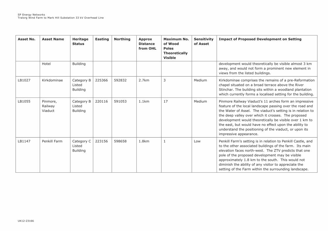
SP Energy Networks
Tralorg Wind Farm to Mark Hill Substation 33 kV Overhead Line
UK12-23166
Asset No. Asset Name Heritage
Status
Easting Northing Approx
Distance
from OHL
Maximum No.
of Wood
Poles
Theoretically
Visible
Sensitivity
of Asset
Impact of Proposed Development on Setting
Hotel Building development would theoretically be visible almost 3 km
away, and would not form a prominent new element in
views from the listed buildings.
LB1027 Kirkdominae Category B
Listed
Building
225366 592832 2.7km 3 Medium Kirkdominae comprises the remains of a pre-Reformation
chapel situated on a broad terrace above the River
Stinchar. The building sits within a woodland plantation
which currently forms a localised setting for the building.
LB1055 Pinmore,
Railway
Viaduct
Category B
Listed
Building
220116 591053 1.1km 17 Medium Pinmore Railway Viaduct’s 11 arches form an impressive
feature of the local landscape passing over the road and
the Water of Assel. The viaduct’s setting is in relation to
the deep valley over which it crosses. The proposed
development would theoretically be visible over 1 km to
the east, but would have no effect upon the ability to
understand the positioning of the viaduct, or upon its
impressive appearance.
LB1147 Penkill Farm Category C
Listed
Building
223156 598658 1.8km 1 Low Penkill Farm’s setting is in relation to Penkill Castle, and
to the other associated buildings of the farm. Its main
elevation faces north-west. The ZTV predicts that one
pole of the proposed development may be visible
approximately 1.8 km to the south. This would not
diminish the ability of any visitor to appreciate the
setting of the Farm within the surrounding landscape.


SP Energy Networks
Tralorg Wind Farm to Mark Hill Substation 33 kV Overhead Line
UK12-23166
TECHNICAL APPENDIX 6.3: LIST OF SOURCES CONSULTED
Sources Consulted
Bibliographic Sources
Carter, S. (1993) 'Barbae (Girvan parish): post-medieval settlements, cultivation', Discovery and
Excavation in Scotland, 1993, pp.85-6.
Carter, S. And Dalland, M. (1993) Forestry Survey: Barbae, Kyle and Carrick District, Strathclyde.
Chartered Institute for Archaeologists (CIfA) (2017) By-Laws: Code of Conduct, Chartered
Institute for Archaeologists, Reading.
Chartered Institute for Archaeologists (CIfA) (2014) Standard and guidance for historic
environment desk-based assessment, Chartered Institute for Archaeologists, Reading.
Historic Environment Scotland (2016) Historic Environment Scotland Policy Statement,
Edinburgh, available at: https://www.historicenvironment.scot/archives-and-
research/publications/publication/?publicationId=f413711b-bb7b-4a8d-a3e8-a619008ca8b5
Scottish Government (2014) Scottish Planning Policy, Edinburgh, available at:
http://www.gov.scot/Resource/0045/00453827.pdf
Online Sources
Coles, G.M., Gittings, B.M., Milburn, P. and Newton, A.J. (1998) Scottish Palaeoecological Archive
Database [online], available from http://www.geo.ed.ac.uk/spad (Accessed May 2018)
HES (2018a) Historic Environment Scotland (HES) GIS downloader, available at
http://portal.historicenvironment.scot/spatialdownloads (Accessed May 2018)
HES (2018b) National Record of the Historic Environment Database (Canmore) available from
http://pastmap.org.uk/map (Accessed May 2018)
HES (2018c), Historic Land-Use Assessment Data for Scotland, available at: http://hlamap.org.uk
(Accessed May 2018)
Cartographic Sources
Blaeu, J. (1654) Carricta Borealis (Mid Ayrshire)
Ordnance Survey (1858) First Edition Ayrshire, Sheet LVI 6” to 1 mile.
Ordnance Survey (1858) First Edition Ayrshire, Sheet LXII 6” to 1 mile
Ordnance Survey (1857) First Edition Ayrshire, Sheet LXVII 6” to 1 mile
Ordnance Survey (1858) First Edition, Ayr, Sheet LXII.10, 25” to 1 mile
Ordnance Survey (1858) First Edition, Ayr, Sheet LXII.14, 25” to 1 mile
Ordnance Survey (1857) First Edition, Ayr, Sheet LXVII.2, 25” to 1 mile
Ordnance Survey (1858) First Edition, Ayr, Sheet LXII.5, 25” to 1 mile
Ordnance Survey (1858) First Edition, Ayr, Sheet LXII.6. 25” to 1 mile
Ordnance Survey (1858) First Edition, Ayr, Sheet LVI.14, 25” to 1 mile
Ordnance Survey (1856) First Edition, Ayr, Sheet LVI.06, 25” to 1 mile
Ordnance Survey (1858) First Edition, Ayr, Sheet LVI.10, 25” to 1 mile
Ordnance Survey (1858) First Edition, Ayr, Sheet LVI.13, 25” to 1 mile

SP Energy Networks
Tralorg Wind Farm to Mark Hill Substation 33 kV Overhead Line
UK12-23166
Ordnance Survey (1858) First Edition, Ayr, Sheet LXII.1, 25” to 1 mile
Ordnance Survey (1896) Ayrshire, Sheet LVI.NW, 6” to 1 mile
Ordnance Survey (1910) Ayrshire, Sheet LVI.NW, 6” to 1 mile
Ordnance Survey (1896) Ayrshire, Sheet LVI.SW, 6” to 1 mile
Ordnance Survey (1910) Ayrshire, Sheet LVI.SW, 6” to 1 mile
Ordnance Survey (1897) Ayrshire, Sheet LXII.NW, 6” to 1 mile
Ordnance Survey (1910) Ayrshire, Sheet LXII.NW, 6” to 1 mile
Ordnance Survey (1897) Ayrshire, Sheet LXII.SW, 6” to 1 mile
Ordnance Survey (1910) Ayrshire, Sheet LXII.SW, 6” to 1 mile
Ordnance Survey (1897) Ayrshire, Sheet LXVII.NW, 6” to 1 mile
Ordnance Survey (1910) Ayrshire, Sheet LXVII.NW, 6” to 1 mile
Ordnance Survey (1894) Ayrshire, Sheet 056.06, 25” to 1 mile
Ordnance Survey (1909) Ayrshire, Sheet 056.06, 25” to 1 mile
Ordnance Survey (1896) Ayrshire, Sheet 056.10, 25” to 1 mile
Ordnance Survey (1909) Ayrshire, Sheet 056.10, 25” to 1 mile
Ordnance Survey (1896) Ayrshire, Sheet 056.14, 25” to 1 mile
Ordnance Survey (1896) Ayrshire, Sheet 056.13, 25” to 1 mile
Ordnance Survey (1909) Ayrshire, Sheet 056.13, 25” to 1 mile
Ordnance Survey (1896) Ayrshire, Sheet 062.01, 25” to 1 mile
Ordnance Survey (1909) Ayrshire, Sheet 062.01, 25” to 1 mile
Ordnance Survey (1896) Ayrshire, Sheet 062.01, 25” to 1 mile
Ordnance Survey (1909) Ayrshire, Sheet 062.01, 25” to 1 mile
Ordnance Survey (1896) Ayrshire, Sheet 062.06, 25” to 1 mile
Ordnance Survey (1909) Ayrshire, Sheet 062.06, 25” to 1 mile
Ordnance Survey (1896) Ayrshire, Sheet 062.10, 25” to 1 mile
Ordnance Survey (1909) Ayrshire, Sheet 062.10, 25” to 1 mile
Ordnance Survey (1896) Ayrshire, Sheet 062.14, 25” to 1 mile
Ordnance Survey (1909) Ayrshire, Sheet 062.14, 25” to 1 mile
Ordnance Survey (1896) Ayrshire, Sheet 067.02, 25” to 1 mile
Ordnance Survey (1909) Ayrshire, Sheet 067.02, 25” to 1 mile
Roy, W. (1747-55_) Military Survey of Scotland.

SP Energy Networks
Tralorg Wind Farm to Mark Hill Substation 33 kV Overhead Line
UK12-23166
7-1
7. ECOLOGY & ORNITHOLOGY APPRAISAL
7.1 Introduction
This chapter identifies the potential impacts on ecological and ornithological features associated
with the construction and operation of a proposed 33 kilovolt (kV) overhead line (OHL) (hereafter
the ‘proposed development’) connection between Tralorg wind farm and a substation at the Mark
Hill wind farm. Where appropriate, it also provides details of mitigation measures to address
these potential impacts. The specific objectives of the chapter are to:
describe the ecological and ornithological baselines;
identify the potential direct and indirect impacts on ecological and ornithological features; and
describe any mitigation or control measures proposed to address likely impacts.
This chapter is supported by:
Appendix 7.1: Ecology and Ornithology Survey Results;
Appendix 7.2: Protected Species List;
Appendix 7.3: Site Photographs;
Appendix 7.4: Great Crested Newt eDNA Survey Results; and
Appendix 7.5: Confidential Ornithology Survey Results.
Figures 7.1 – 7.4 are provided and referenced in the text, where relevant. Figure 7.4 is
confidential.
7.2 Methodology
7.2.1 Study Areas
For the desk study, an ecological study area comprising a 2 km-wide corridor centred on the
proposed development was defined, in order to enable data to be gathered to account for
potential ecological links outwith the more focused site area. The ornithological desk study area
was defined as a 20 km buffer centred on the proposed development in order to assess the
connectivity of potential key ornithological species with the proposed development.
The site was defined as a minimum 100 m-wide corridor centred on the proposed development,
which was considered to represent the area within which potential impacts on ecology or
ornithology would be concentrated due to the working corridor proposed by the Applicant.
7.2.2 Desk Study
A desk study was undertaken to collect existing baseline data about the site and the surrounding
area, such as the location of designated sites or other natural features of potential ecological or
ornithological importance. The desk study areas considered the following data sources:
Scottish Natural Heritage (SNH) Sitelink1;and
Multi Agency Geographic Information for the Countryside (MAGIC)2.
Data sources were searched for protected or notable species records. Examples of notable species
include, but are not limited to, national or local Biodiversity Action Plan (BAP) species, restricted
range species, species or species groups listed against local designated sites in the area (Local
Nature Reserves, Sites of Importance for Nature Conservation, Sites of Nature Conservation
Interest) or key species groups such as invertebrates or non-vascular plants. These species are not
1 http://gateway.snh.gov.uk/sitelink/, accessed 18th July 2017
2 http://magic.defra.gov.uk/MagicMap.aspx accessed 18th July 2017
SP Energy Networks
Tralorg Wind Farm to Mark Hill Substation 33 kV Overhead Line
UK12-23166
7-2
considered to have the same importance as those protected by legislation; however, their inclusion
allows a more holistic approach and therefore a more robust assessment in line with the
Applicant’s responsibilities under Schedule 9 of the Electricity Act 19893. This information was
used to understand what the key species for the site might be, prior to field surveys.
Supplementary information on the site and its surroundings was obtained from aerial images
available from GoogleTM Earth Pro.
The Ayrshire Rivers Trust and District Salmon Fisheries Board were also contacted for baseline
information on watercourses and their importance to fish species within the ecological study area.
7.2.3 Field Surveys
Extended Phase 1 Habitat Survey
Surveys were completed in accordance with the methodology of an extended Phase 1 habitat
survey4 and were undertaken on the 6th, 7th and 8th of July 2016. An additional survey was
conducted on the 12th of July 2017 for a deviation in the southern section of the proposed
development. The route deviation occurs approximately 500 m east of the previously proposed
route from the south of Balligmorrie to the River Muck, with the proposed development now
located closer to Knockodhar Wood. The surveys involved a site walkover with an assessment of
key habitat, land use and ecological features, focusing on areas of natural interest that could be
affected by the proposed development. These habitats were mapped using standard Phase 1
habitat survey methodology as described in the Handbook for Phase 1 Habitat Survey5. Target
notes were used to record habitats and features of particular interest.
The site was inspected for signs of any invasive plant species subject to legal controls, such as giant
hogweed Heracleum mantegazzianum or Japanese knotweed Fallopia japonica.
The site was assessed for the presence of Groundwater Dependent Terrestrial Ecosystems
(GWDTE), which are protected under the Water Framework Directive6 due to their hydrological
sensitivity and potential to be adversely impacted by development.
The survey included an assessment of the site’s ability to support species protected by
international and national legislation, particularly badger Meles meles, otter Lutra lutra, water vole
Arvicola amphibius, pine marten Martes martes, red squirrel Sciurus vulgaris and great crested
newt Triturus cristatus. A full list of all protected species known to occur naturally in Scotland is
provided in Appendix 7.2. The location of bird nests, especially those of raptor species, was also
recorded.
In addition, any notable species encountered during the course of the surveys were recorded, as
defined in Section 1.2.2.
Habitat Suitability Index (HSI)
Ponds within the site were identified and assessed for their suitability to support great crested
newt using HSI methodology7. This was undertaken on the 12th of July 2017. The HSI is a
numerical index, between 0 and 1, with 0 indicating unsuitable habitat and 1 representing
optimal habitat for great crested newt. The HSI incorporates ten suitability indices, all of which
are factors thought to affect great crested newt.
3 http://www.legislation.gov.uk/ukpga/1989/29/schedule/9 accessed 19th July 2017
4 Joint Nature Conservation Committee (JNCC) (2010) Handbook for Phase 1 Habitat Survey – A Technique for Environmental Audit.
JNCC Peterborough. 5 Ibid.
6 https://www.sepa.org.uk/media/144266/lups-gu31-guidance-on-assessing-the-impacts-of-development-proposals-on-groundwater-
abstractions-and-groundwater-dependent-terrestrial-ecosystems.pdf accessed 20th July 2017 7 http://www.narrs.org.uk/documents/HSI%20guidance.pdf accessed 20th July 2017
SP Energy Networks
Tralorg Wind Farm to Mark Hill Substation 33 kV Overhead Line
UK12-23166
7-3
Great Crested Newt eDNA Surveys
Any pond within the site with a HSI of 0.5 or greater was sampled for great crested newt eDNA
using testing kits from Surescreen Scientifics8. Four ponds were sampled on the 23rd of April
2018. Pond samples were then analysed by Surescreen Scientifics for the presence of great
crested newt eDNA, the presence of which would indicate a recent historical or current presence
of great crested newt in the pond.
Breeding Raptor Surveys
According to SNH guidance on assessing the impact of power lines on birds9, the species most
susceptible to OHL impacts include waterfowl, waders, raptors and game birds. As a result,
breeding bird surveys for passerine birds were not considered necessary. Survey efforts focused
on breeding raptor surveys, with vantage point (VP) surveys conducted along the route of the
proposed development. The objective of these surveys was to determine if raptor species, such
as goshawk Accipiter gentilis or peregrine Falco peregrinus, were breeding within the site.
Surveys were undertaken following best practice guidance10 and looked for behaviour that would
indicate the presence of a nest and, if possible, identify the location of a nest. Three-hour
surveys were undertaken at VP locations as shown on Figures 7.1a-b, which recorded all raptor
flight activity and whether flights were at collision risk height with the proposed development.
The following height bands were assigned to all flights related to the height of the proposed
development and the configuration of the OHL, as discussed in Chapter 3: Proposed
Development:
A = 0-5 m;
B = 5-18 m; and
C = >18 m.
Surveys were undertaken twice in 2016 on the 3rd May and the 13th June from two VP locations
at Barbae and Knockodhar (12 survey hours). Following recommendations from SNH11, four
additional sets of surveys from three VP locations at Barbae, Tormitchell and Glenassel were
conducted in 2017 on the 30th-31st of March, 11th of April, 10th of May and 14th of June 2017 (30
survey hours). Were any of the earlier survey visits to have identified the presence of goshawk,
a July visit would have been completed, as more activity by birds is typically seen at that time
following successful breeding. No activity by goshawk was recorded during the March, April or
May visits, so a July visit was not considered necessary.
7.2.4 Impact Assessment
A preliminary ecological appraisal12 of the site was undertaken to assess its ecological value and
to consider the likely impacts of the proposed development on the ecological and ornithological
features, with the intention of identifying mitigation requirements. No assessment is made of the
significance of potential impacts.
8 https://www.surescreenscientifics.com/edna/gcn-edna/ accessed 26th April 2018
9 http://www.snh.gov.uk/docs/A2047189.pdf accessed 19th July 2017
10 Hardey, J., Crick, H., Wernham, C., Riley, H., Etheridge, B. and Thompson, D. (2009) Raptors A Field Guide for Surveys and
Monitoring. The Stationary Office: Edinburgh. ISBN 978 0 11 497345 2. 11 CNS/ELY/OTH – Consultations – Electricity – Ayrshire - CPA143670 – A2155148.
12 CIEEM (2013) Technical Guidance Series: Guidelines for Preliminary Ecological Appraisal. Chartered Institute of Ecology and
Environmental Management, Winchester.

SP Energy Networks
Tralorg Wind Farm to Mark Hill Substation 33 kV Overhead Line
UK12-23166
7-4
7.3 Baseline Conditions
7.3.1 Desk Study
Designated Sites
Figure 7.2a shows the ecological study area and the sites designated for ecological interests and
Figure 7.2b shows the ornithological study area and sites designated for ornithological interests.
Table 7.1 details the designated sites occurring within both study areas and their connectivity
with the proposed development.
Table 7.1: Designated Sites within Ecological and Ornithological Study Areas13
Site Name Qualifying Features Distance from Proposed
Development (at closest
point)
Comments
Glen App and
Galloway Moors
Special
Protection Area
(SPA) and SSSI
Breeding population
of hen harrier Circus
cyaneus (Annex 1
species14)
10.5 km to south-west Over 10 km from proposed
development and outwith
the maximum connectivity
distance15 for hen harrier,
therefore hen harrier from
the SPA are unlikely to be
impacted
Ailsa Craig SPA
and RSPB
Reserve
Supports important
migratory species
including northern
gannet Morus
bassanus and lesser
black-backed gull.
Supports over 20,000
seabirds including
guillemot Uria aalge,
black-legged
kittiwake Rissa
tridactyla and herring
gull Larus argentatus
18 km to west No connectivity between
qualifying species and
proposed development
Lendalfoot Hills
Special Area of
Conservation
(SAC) Complex
Vegetation
assemblage, species-
rich grasslands and
well developed series
of alkaline fen
habitats
2 km to east Separate catchment from
proposed development,
which would not impact the
integrity of any qualifying
features
Aldons Hill SSSI Mosaic of grassland,
wet and dry
heathland and upland
habitats
2 km to east Separate catchment from
proposed development,
which would not impact the
integrity of any qualifying
features
13 https://www.south-ayrshire.gov.uk/documents/seaenv%20r%20appendix%201%20env%20baseline.pdf accessed 28th June 2017
14 http://eur-lex.europa.eu/LexUriServ/LexUriServ.do?uri=OJ:L:2010:020:0007:0025:EN:PDF accessed 28th June 2017
15 http://www.snh.gov.uk/docs/A994842.pdf accessed 28th July 2017

SP Energy Networks
Tralorg Wind Farm to Mark Hill Substation 33 kV Overhead Line
UK12-23166
7-5
Table 7.1: Designated Sites within Ecological and Ornithological Study Areas13
Galloway Forest
Park Important
Bird Area (IBA)
Short-eared owl Asio
flammeus, peregrine
and black grouse
Lyrurus tetrix
5.5 km to east Proposed development
outwith maximum
connectivity distance of
short-eared owl and black
grouse. Some connectivity
with foraging peregrine
and birds moving between
alternative nest sites
Wood of Cree
RSPB Reserve
Small passerine
species including pied
flycatcher Ficedula
hypoleuca and
redstart Phoenicurus
phoenicurus
16 km to south-east No connectivity between
qualifying species and
proposed development
Galloway and
South Ayrshire
Biosphere
Reserve
Based on the
Galloway Hills, a
water catchment
feeding south-west
Scotland. Includes
rivers Cree, Fleet,
Ken-Dee, Nith, Doon,
Water of Girvan and
Stinchar. Core areas
comprise Cairnsmore
of Fleet National
Nature Reserve
(NNR), the Silver
Flowe Site of Special
Scientific Interest
(SSSI) and the
Merrick Kells SSSI
Covers the entirety of the
proposed development
Proposed development
crosses River Stinchar
south of Pinmore.
Potential for
disturbance/pollution of
watercourse. However,
the District Salmon
Fisheries Board and
Ayrshire Rivers Trust have
been contacted and both
agree that, as the
proposed development
would not enter the River
Stinchar and would be far
enough from the bank,
direct impacts on the
habitat and fish species are
likely to be avoided.
Indirect impacts are still
considered possible.
There are several areas of woodland identified as ancient woodland or included on the semi-
natural woodland inventory16 occurring within the ecological study area, as shown on Figure 7.2a.
The proposed development directly crosses small areas to the north-east and east of Tormitchell,
north and south of Pinmore and north of Bellamore. The largest areas of woodland included on
the semi-natural woodland inventory occur to the north and south-west of Bellamore. Native and
ancient woodlands are important for biodiversity and nature conservation, providing habitat for
species such as badger, red squirrel, pine marten and bat species. Ancient woodland is defined
as woodlands that have been continually wooded since 1750, and there is a strong presumption
in Scottish Planning Policy against the removal of woodland on ancient woodland sites17.
Protected Species
The desk study produced the following records of protected or notable species occurring within
the study area, primarily at Girvan harbour:
red-throated diver Gavia stellata;
redshank Tringa tetanus;
16 https://gateway.snh.gov.uk/natural-spaces/dataset.jsp?dsid=AWI accessed 31st July 2017
17 http://www.snh.gov.uk/planning-and-development/advice-for-planners-and-developers/woodlands/ accessed 28th June 2017

SP Energy Networks
Tralorg Wind Farm to Mark Hill Substation 33 kV Overhead Line
UK12-23166
7-6
dunlin Calidris alpina;
eider Somateria mollissima;
oystercatcher Haematopus ostralegus;
turnstone Arenaria interpres;
goldeneye Bucephala clangula;
ringed plover Charadrius hiaticula;
shag Phalacrocorax aristotelis;
scaup Aythya marila; and
sanderling Calidris alba.
Ringed plover, shag and scaup are all red listed species on the Birds of Conservation Concern18.
The other species are amber listed. Amber and red listed species indicate an increasing level of
conservation concern.
The Muck Water is important for spawning of Atlantic salmon Salmo salar.
Invasive Species
Invasive plant species are known to be present in the area, particularly Himalayan balsam
Impatiens glandulifera and Japanese knotweed along the River Stinchar and Muck Water. Giant
hogweed is present in Tormitchell quarry.
7.3.2 Field Surveys
This section provides a summary of habitats identified during the ecological walkover survey and
any protected species recorded. A full description of habitat types, dominant plant species
recorded and target notes can be found in Appendix 7.1: Ecology and Ornithology Survey
Results.
Habitats
Figures 7.3a-i show the locations of the following habitat areas recorded and their proximity to
the proposed development:
semi-natural and plantation woodland (broadleaved, coniferous and mixed);
scrub (dense and continuous);
grassland (improved, semi-improved neutral and marshy);
bog (blanket sphagnum and wet modified);
continuous bracken Pteridium aquilinum;
running water; and
hedgerows (species-rich and species-poor, defunct and intact).
The site is dominated by heavily grazed pasture consisting of improved and semi-improved
neutral grassland of low species diversity. A large area of blanket bog occurs in the southern
part of the site, north-west of Bellamore (Figures 7.3g-h). Blanket bog is listed on Annex 1 of
the EC Habitats Directive19 as an international priority habitat. It is also a priority habitat on the
UK BAP. Two smaller areas of wet modified bog occur to the south of Balligmorrie (Figure 7.3f)
and north of Mark Hill substation (Figure 7.3i). Areas of marshy grassland also occur throughout
the proposed development.
18 https://www.bto.org/sites/default/files/shared_documents/publications/birds-conservation-concern/birds-of-conservation-concern-
4-leaflet.pdf accessed 26th April 2018 19 http://eur-lex.europa.eu/LexUriServ/LexUriServ.do?uri=OJ:L:2010:020:0007:0025:EN:PDF accessed 28th June 2017

SP Energy Networks
Tralorg Wind Farm to Mark Hill Substation 33 kV Overhead Line
UK12-23166
7-7
Nine areas of GWDTE20 were identified within the proposed development and are assessed in
Appendix 8.2: GWDTE Appraisal.
The proposed development passes through small areas of woodland on Tralodden Hill, north of
Glenassel, south of Barbae, south-east of Laggan Bridge, east of Maclachrieston and north of the
River Stinchar (Figures 7.3a-e).
Four ponds were identified during the Phase 1 habitat survey of the route deviation, as shown by
Target Notes 16, 22, 25 and 26 on Figures 7.3h-i.
No invasive plant species were recorded during the surveys.
Protected Species
The HSI of the ponds at Target Notes 16, 22, 25 and 26 recorded during the Phase 1 habitat
survey were calculated as 0.66, 0.62, 0.66 and 0.56, respectively. All four ponds have average
suitability to support great crested newt. The ponds were sampled for great crested newt eDNA
and all were negative, indicating that great crested newts are not present in the ponds. The
analysis certificates confirming no great crested newt eDNA was detected are provided in
Appendix 7.4.
A single otter spraint was recorded along the River Stinchar to the south of Mahaffie Wood, as
shown by Target Note 10 on Figure 7.3e. No holts were recorded during the survey, although
the watercourses crossed by the proposed development were noted to be suitable to support
otter.
Trees with bat roost potential were identified throughout the site, as shown by Target Notes 4, 5,
7-8, 11, 18 and 20 on Figures 7.3d-e.
Potential water vole habitat was recorded throughout the site, as shown by Target Notes 9, 12,
13, 15, 17, 21, 23 and 24 on Figures 7.3e-i. There was evidence of potential water vole runs
within the vegetation but no burrows or droppings were recorded.
Habitats were noted to be suitable to support badger although no field signs were recorded
during surveys. The peatland habitat in the southern extent of the site was also noted to be
suitable to support reptiles such as common lizard Zootoca vivipara and adder Vipera berus,
although no sightings of these species were recorded.
A small sand martin Riparia riparia colony of approximately 10 burrows was recorded on the
western bank of the Water of Assel, as shown by Target Note 3 on Figure 7.3c.
Breeding Raptors
Flight activity data gathered during the 2016 and 2017 surveys identified a kestrel Falco
tinnunculus territory and a buzzard Buteo buteo territory, as shown on confidential Figure 7.4.
Although a survey was not undertaken to search for the nests, potential nest locations are
considered to occur at Target Notes 2 and 4, as shown on Figure 7.4 and detailed in Table 7.5.2
in Appendix 7.5: Confidential Ornithology Survey Results. These locations have been considered
based on the flight activity data collected for both species. A specific nest survey was not
undertaken to avoid disturbance during the breeding season and since both locations are unlikely
to be impacted by the proposed development, as discussed in Appendix 7.5: Confidential
Ornithology Survey Results.
A single peregrine flight was recorded above collision risk height at Glenassel and a single osprey
Pandion haliaetus flight above collision risk height at Barbae. Both flights were considered to be
commuting/migratory flights. Two sparrowhawk Accipiter nisus flights were also recorded at
20 https://www.sepa.org.uk/media/144266/lups-gu31-guidance-on-assessing-the-impacts-of-development-proposals-on-groundwater-
abstractions-and-groundwater-dependent-terrestrial-ecosystems.pdf accessed 28th July 2017

SP Energy Networks
Tralorg Wind Farm to Mark Hill Substation 33 kV Overhead Line
UK12-23166
7-8
Barbae, one at collision risk height across the proposed development. Three buzzard flights also
occurred at collision risk height across the proposed development.
7.4 Potential Impacts and Mitigation
7.4.1 Construction
Potential impacts during construction are detailed in Table 7.2 below, which also details the
relevant ecological or ornithological feature and mitigation or control measures, where
appropriate.

SP Energy Networks
Tralorg Wind Farm to Mark Hill Substation 33 kV Overhead Line
UK12-23166
7-9
Table 7.2: Potential Impacts on Ecology and Ornithology during Construction and Relevant Mitigation/Control Measures
Potential Impact Feature Mitigation/Control Measures Proposed
Vegetation
clearance, tree
felling, access
track construction,
permanent
excavation of pole
bases, excavation
and
undergrounding of
cable section and
placement of
temporary
construction
compound.
Habitats
(woodland,
marshy
grassland and
hedgerows.
Blanket bog
and wet
modified bog
are considered
below.
GWDTE are
considered in
Appendix 8.2:
GWDTE
Appraisal)
Immediate reinstatement of habitats following construction activities in areas of temporary access, particularly access
tracks, the construction compound and the cable section, where existing vegetation would be replaced on the excavated
trench, where possible. Temporary access tracks proposed between Muck Water and Mark Hill substation would be 3 m
wide and of a floating stone construction, running adjacent to the underground cable route to minimise the impacts on
habitats. The track would be removed following energisation of the connection, or before, and the ground reinstated. Other
areas of the proposed development would be accessed using low ground-pressure vehicles without the construction of
access tracks;
Avoidance of areas of marshy grassland, where possible. If not possible, floating access tracks/bog mats and low ground-
pressure vehicles would be used to cross these habitats. Locating woodpoles within these habitats would be avoided as far
as possible, with only three woodpoles locations proposed in marshy grassland;
Avoidance of removal of hedgerow habitat, as shown on Figures 7.3a and 7.3f;
Avoidance of tree felling, where possible, particularly in areas classified as ancient woodland or included on the semi-natural
woodland inventory. This is in line with the Scottish Government’s Policy on Control of Woodland Removal21, as referenced
by the Scottish Planning Policy22, which includes a presumption against any woodland removal. Minimal tree felling is
considered to be required for the proposed development and is discussed in more detail in Chapter 9: Forestry. The
proposed development does not cross any areas of ancient woodland but three woodpole locations are proposed in areas
included on the semi-natural woodland inventory.
Disturbance/loss
of Annex 1
habitats from
access track
construction,
permanent
excavation of pole
bases and
Blanket bog
and wet
modified bog
Avoidance of blanket bog and wet modified bog, where possible. If not possible, floating access tracks/bog mats and low
ground-pressure vehicles would be used to cross these habitats. Peat probing results would be used to inform the
micrositing of woodpole locations to avoid areas of deep peat. However, if this is not possible, suitable restoration would be
undertaken and a Peatland Habitat Management Plan would be produced; and
Engagement with SEPA would occur in regard to any excavated peat reuse and disposal, where required. However, it is not
anticipated that there would be a need for peat disposal as all excavated material would be backfilled.
21 Forestry Commission (2009) The Scottish Government’s Policy on Control of Woodland Removal, Forestry Commission Scotland
National Office, Silvan House, 231 Corstorphine Road, Edinburgh, EH12 7AT 22 The Scottish Government (2014) Scottish Planning Policy, The Scottish Government, St Andrew’s House, Edinburgh, EH1 3DG.

SP Energy Networks
Tralorg Wind Farm to Mark Hill Substation 33 kV Overhead Line
UK12-23166
7-10
Table 7.2: Potential Impacts on Ecology and Ornithology during Construction and Relevant Mitigation/Control Measures
excavation and
undergrounding of
cable section
Felling of mature
trees or trees with
bat roost potential
Bats and red
squirrel If tree felling is necessary, mature trees or areas noted as containing trees with bat roost potential would be surveyed by a
licensed bat surveyor to ensure no bats are roosting in the trees. At the same time, trees to be felled would be checked for
the presence of squirrel dreys; and
If bats are found to be roosting in the trees, felling would only occur under an SNH licence with a licensed bat surveyor
present. Similarly, if a red squirrel drey is found to be present, felling could only occur under an SNH licence.
Disturbance from
lights, noise and
excavations
Otter, badger,
water vole and
reptiles
Undertake pre-construction surveys for otter, badger and water vole no greater than eight months prior to construction. If
the results indicate the presence of any of these species, an assessment of the impacts of the development on the species
would be completed and appropriate mitigation measures identified (if required), such as micrositing of woodpoles and
access tracks; and
Construction phase Environmental Management Plan (EMP) to include measures to protect ecological features, which would
involve covering excavations and providing ramps in excavations to allow any trapped species to escape. These measures
would be implemented at the end of each work day. A suitably qualified Ecological Clerk of Works (ECoW) would input into
the EMP to ensure appropriate mitigation measures are in place, and to reduce any disturbance impacts.
Destruction of bird
nests
Breeding birds Avoidance of sand martin colony located on the western bank of the Water of Assel; and
Ground or vegetation clearance works would be undertaken outwith the main bird nesting season (March–August inclusive),
if possible. If this is not possible, a suitably experienced ecologist would check the proposed development prior to
construction to determine if nesting birds are present, particularly the sand martin colony on the western bank of the Water
of Assel. If nesting birds are found, a suitable buffer zone would be implemented around the nest, with no work in this zone
until the young have fledged or the nest is no longer in use.
Pollution, e.g. oil
spill or siltation,
Galloway and
South Ayrshire
Biosphere
Good practice guidance2324 would be followed when working close to watercourses and ponds;
23 https://www.sepa.org.uk/media/150997/wat_sg_29.pdf accessed 28th July 2017
24 http://www.netregs.org.uk/environmental-topics/pollution-prevention-guidelines-ppgs-and-replacement-series/guidance-for-pollution-prevention-gpps-full-list/ accessed 28th July 2017

SP Energy Networks
Tralorg Wind Farm to Mark Hill Substation 33 kV Overhead Line
UK12-23166
7-11
Table 7.2: Potential Impacts on Ecology and Ornithology during Construction and Relevant Mitigation/Control Measures
and disturbance of
watercourses
Reserve (River
Stinchar),
Muck Water,
four ponds and
other
watercourses
as described in
Chapter 8:
Hydrology
The OHL construction would not require the construction of any new watercourse crossings, other than for the River Stinchar
but this would not require any in-channel works. Access would use existing tracks and watercourse crossings as far as
possible. Bog mats would be used to cross minor watercourses without damage to bank integrity;
Where pole installation is required within 30 m of a watercourse, silt traps or other mitigation would be put in place (which
would be outlined in the EMP), with nearby watercourses checked during periods of high rainfall during construction
activities. Ground excavation work would temporarily stop work during periods of high rainfall, where a risk to surface
water quality is identified;
In order to cross the Muck Water, an open-cut with a flume crossing would be used. Consultation with the Ayrshire Rivers
Trust has been undertaken and it has been agreed that the underground cable would be installed May to September,
inclusive, to avoid the salmon spawning season. A fish rescue would be organised with the Ayrshire Rivers Trust and
undertaken prior to construction; and
Measures to prevent pollution and/or siltation of watercourses, ponds and other habitats during construction would be
included in the EMP.
Spread of invasive
plant species
Habitats Although no invasive species were recorded during surveys, they are known to be present in the area. Any areas of
invasive plant species discovered prior to (such as during pre-construction protected species surveys) or during construction
would be separated from any construction by a minimum buffer of 10 m to avoid the spread of the invasive species. No
invasive plant species or soil material potentially contaminated with seeds/roots would be disturbed or removed from the
area.
7.4.2 Operation
Potential impacts during operation are detailed in Table 7.3 below, which also details the relevant ecological or ornithological feature and mitigation or control
measures, where appropriate.
Table 7.3: Potential Impacts on Ecology and Ornithology during Operation and Relevant Mitigation/Control Measures
Potential Impact Feature Mitigation/Control Measures Proposed
Disturbance due to maintenance
activities
Bats, red squirrel, otter, badger, water vole,
reptiles and breeding birds Unlikely to be required as disturbance would be at a very low level and would
utilise existing access tracks/roads; and

SP Energy Networks
Tralorg Wind Farm to Mark Hill Substation 33 kV Overhead Line
UK12-23166
7-12
Table 7.3: Potential Impacts on Ecology and Ornithology during Operation and Relevant Mitigation/Control Measures
Potential Impact Feature Mitigation/Control Measures Proposed
If any vegetation clearance is required, breeding bird and protected species
surveys would occur prior to this, where appropriate.
Pollution e.g. oil spill from
vehicles accessing proposed
development for maintenance
activities
Habitats Oil spill kits carried in vehicles, particularly when working in sensitive habitats such
as blanket bog, marshy grassland and close to watercourses or ponds.
Collision with OHL Raptor species Buzzard, peregrine, osprey and sparrowhawk are not considered to be highly
vulnerable to collision risk25. SNH guidance for power lines advises against the use
of mathematical collision risk models and instead suggests the use of mitigation to
reduce potential collision impacts where flight activity levels are high enough to
cause potential conflicts26. The flight activity levels observed within the site are
low and it is considered that the potential for impacts is similarly low. In addition,
the proposed development would consist of a wood pole line with the configuration
of wires arranged in one horizontal plane, therefore presenting only a very narrow
band within which a collision would be possible. The three wires are arranged in a
narrow configuration so that the collision zone for birds not approaching the line in
horizontal flight is similarly narrow. The likelihood of a collision is therefore
deemed to be very low and is not considered to require mitigation or control
measures.
25 Urquhart, B. (2010) SNH Avoidance Rate Information & Guidance Note: Use of Avoidance Rates in the SNH Wind Farm Collision Risk Model. SNH.
26 SNH (2016) Assessment and Mitigation of Impacts of Power Lines and Guyed Meteorological Masts on Birds, Version 1.

SP Energy Networks
Tralorg Wind Farm to Mark Hill Substation 33 kV Overhead Line
UK12-23166
7-13
7.5 Cumulative Impact Assessment
This section assesses the additional impacts from the proposed development when added to the
impacts from other committed developments that have the potential to have similar impacts and
result in a cumulative effect. Similar developments in the vicinity of the proposed development
are:
the proposed Stranoch wind farm grid connection which is a 132 kV OHL, running
approximately 20 km northwards from the proposed Stranoch wind farm site to the Mark Hill
substation. The Stranoch wind farm grid connection will be the subject of a separate
application for consent under s.37 of the Electricity Act 1989; and
the proposed 8-turbine Tralorg wind farm, which lies immediately north of the proposed
development.
Since SPEN will be the Applicant for the Stranoch wind farm grid connection, and is currently
gathering environmental data on this project, the cumulative effects of the proposed
development would be considered in the Stranoch wind farm grid connection EIA. At this
preliminary stage, taking a precautionary approach, potential impacts of the Stranoch wind farm
grid connection could include habitat loss, (blanket bog, modified bog and marshy grassland),
and destruction of breeding bird nests if work occurs during the breeding bird season. However,
no impact assessment has yet been undertaken for the Stranoch wind farm grid connection,
therefore a detailed consideration of cumulative effects and their significance cannot be made in
this assessment.
7.5.1 Tralorg Wind Farm
Potential impacts on the following ecological and ornithological features are considered in the
Tralorg wind farm EIA:
habitat loss and degradation of blanket bog and semi-natural broadleaved woodland;
loss of habitat suitable for otter and water vole; and
destruction of nests used by breeding birds.
Proposed mitigation measures included the following:
sensitive construction design and micrositing;
habitat management plan and monitoring programme to establish whether the degraded bog
could be restored;
construction method statement to include a programme for peat handling and the re-
vegetation of worked areas;
replanting with trees of local provenance to provide a direct replacement for the woodland
lost;
pre-construction protected species surveys and nesting bird survey if construction to occur
within the breeding bird season; and
general biodiversity enhancements within the wind farm area, focussing on the management
of habitats for ground nesting passerines, particularly meadow pipit Anthus pratensis and
skylark Alauda arvensis.
Following implementation of mitigation measures, the residual effects were determined to be not
significant.
Although the Tralorg wind farm EIA did not identify any significant effects, cumulative effects on
ecological or ornithological features are possible when considered in combination with the

SP Energy Networks
Tralorg Wind Farm to Mark Hill Substation 33 kV Overhead Line
UK12-23166
7-14
proposed development detailed in this Chapter. Cumulative effects may occur from the habitat
loss of blanket bog and semi-natural broadleaved woodland.