Visible Infrared Imaging Radiometer Suite (VIIRS) 750 m ...
13
Visible Infrared Imaging Radiometer Suite (VIIRS) 750 m Active Fire Detection and Characterization Algorithm Theoretical Basis Document 1.0 September 2017
Transcript of Visible Infrared Imaging Radiometer Suite (VIIRS) 750 m ...

1
VisibleInfraredImagingRadiometerSuite(VIIRS)750mActiveFireDetectionandCharacterization
AlgorithmTheoreticalBasisDocument1.0
September2017
1
TableofContents1. SCIENCERATIONALEFORTHEPRODUCT............................................................................................22. THEALGORITHM.....................................................................................................................................22.1. TECHNICALBACKGROUNDANDHERITAGE................................................................................22.2. ALGORITHMINPUT.........................................................................................................................32.3. ALGORITHMDESCRIPTION............................................................................................................4
3. PRODUCTDESCRIPTION.........................................................................................................................53.1.LEVEL2ACTIVEFIREDATA.................................................................................................................53.1.1. FILEFORMAT..............................................................................................................................53.1.2. DATACONTENT..........................................................................................................................53.2. QA/METADATA.............................................................................................................................7
4. PRODUCTASSESSMENT..........................................................................................................................84.1. THEORETICALFIREDETECTIONCURVES...................................................................................84.2. VALIDATIONAPPROACH................................................................................................................84.3. VALIDATIONRESULTS...................................................................................................................9
5. USERGUIDANCE...................................................................................................................................116. ASSOCIATEDPUBLICATIONS...............................................................................................................117. REFERENCES.........................................................................................................................................11Writtenby:WilfridSchroeder&LouisGiglioDepartmentofGeographicalSciencesUniversityofMarylandEmail:[email protected]
2
1. SCIENCERATIONALEFORTHEPRODUCTThisdocumentdescribesthebaselineVisibleInfraredImagingRadiometerSuite(VIIRS)750mactivefiredetectionproduct.TheVIIRSinstrumentwasfirstlaunchedon28October2011onboardtheSuomiNationalPolar-orbitingPartnership(S-NPP),whichwasplacedinasunsynchronousorbitatanaltitudeof829kmandwith1:30pm/1:30amequatorialcrossingtimes.ThatinstrumentwillbefollowedbyothersimilarsensorsonboardtheJointPolarSatelliteSystem(JPSS)seriesofsatellitesoperatedjointlybyNASAandNOAA.VIIRSisawhiskbroomscanningradiometerwithaswathwidthof3060km,providingglobalwall-to-wallcoverageevery12horlessdependingonthelatitude.Itconsistsofamultispectralinstrumentincludingfivespectralchannels(0.6<>12.4µm)at375m(I-bands)and16spectralchannels(0.4<>12.5µm)at750m(M-bands),inadditiontoalight-sensitive(0.5<>0.9µm)day-and-nightbandat750m(DNB). TheVIIRS750mactivefirealgorithmisanadaptationoftheMODISCollection6FireandThermalAnomaliesproduct(MOD14/MYD14)[Giglioetal.,2016].ThesamealgorithmformulationwasimplementedforVIIRS,withrelativelysmall/straightforwardchangesmadetotheinput/outputroutinesinordertoaccommodatetheparticularNetCDF4.2/HDF5dataformat.TheVIIRS750mactivefiredetectionandcharacterizationdatawasoriginallyconceivedaspartofVIIRSlandproductsuite;itprovidescontinuitytothe1kmEarthObservingSystemModerateResolutionImagingSpectroradiometer(EOS/MODIS)activefiredatarecord.
2. THEALGORITHM2.1. TECHNICALBACKGROUNDANDHERITAGE
ActivelyburningfiresoftenshowawiderangeoftemperaturesspanningseveralhundredKelvininassociationwithflamingandsmolderingphasesofcombustion.Typically,coolersmolderingfiresshowtemperaturesbetween450and850K,whereashighertemperaturesrangingfrom800Ktoupwardsof1200Kprevailduringthemoreintenseflamingphase[LobertandWarnatz,1993].Fueltypeandmoisture,andambientconditions(airtemperature,wind,andrelativehumidity)arekeyfactorsregulatingbiomasscombustion.Whenmoderatespatialresolutionsensorsareconsidered,mid-infrared(4µm)spectralchannelsarethemostresponsivetoactivelyburningfirescapturingmostoftheradiometricsignalfromsmolderingandflamingphasesofcombustionduringbothdayandnighttimepartsoftheorbit.ThepeakinemittedfireradiantenergyonchannelM13makesthatchannelresponsivetosmallsub-pixelfiresoccurringoveracool(≤300K)background.Consequently,intenseactivefires(>1000K)occupyingfractionalpixelareasassmallas10-4maybedetected.Inadditiontofacilitatingthedetectionofsub-pixelactivefires,therateofradiativeenergyreleasedbyfiresobservedinthe4µmregionisfoundtobedirectlyrelatedtothebiomassconsumedperunittime[Kaufmanetal.,1998;Woosteretal.,2003].
3
ThebaselineVIIRS750mactivefiredetectionproductwasoriginallydesignedmirroringtheMODISCollection4FireandThermalAnomaliesalgorithm(MOD14/MYD14),althoughlackingkeyoutputsciencedatalayerssuchasthe2DfiremaskandFRPretrievals[Csiszaretal.,2014;Giglioetal.,2003].ThatalgorithmwaslaterreplacedwiththeMODISCollection6algorithmequivalentincludingalloutputsciencedatalayers[Giglioetal.,2016].ThatproductisavailablethroughvariousVIIRSdataoutletsprovidingdirectreadout(NASA’sInternationalPolarOrbiterProcessingPackage[IPOPP]),nearreal-time(NOAA’sS-NPPDataExploitation[NDE]),andsciencedataaccess(NASA’sLandScienceInvestigator-ledProcessingSystem[LandSIPS]).AnalternativeVIIRSactivefireproductwassincedevelopedusingthecomplementary375mchannels[Schroederetal.,2014].Giventhehigherspatialresolutionofthatproduct,improvedfiredetectionperformanceisnormallyobservedcomparedtothe750mfireproductversion.Usersareencouragedtoconsultthedocumentationdescribingthetwoproductswhenchoosingthemostappropriatedatasetfortheirparticularapplications.TheVIIRS750mfireproductgenerationandavailabilitywillcontinueuntilfurthernotice.
2.2. ALGORITHMINPUT TheVIIRS750mfireproductusesinputdatafromsix750mchannels,inadditiontotheircorrespondingqualityflags(QF1)andgeolocationdata(Table1).Table1:ListofVIIRSchannelsusedasinputtothe750mactivefiredetectionalgorithm.ThecorrespondingVIIRSLevel1Bdataqualityflags,terrain-correctedgeolocationandquarterlyland-watermaskdatacomplementthelistofinputfilesused.
VIIRSChannels HeritageMODISChannels PrimaryUse
M5(0.662–0.682μm)
1(0.620–0.670μm)
Cloudmasking,Sunglintandfalsealarmrejection
M7(0.846–0.885μm)
2(0.841–0.876μm)
Cloudmasking,Sunglintandfalsealarmrejection
M11(2.225–2.275μm)
7(2.105–2.155μm)
Sunglintandfalsealarmrejection
M13(3.973–4.128μm)
21/22(3.929–3.989μm)
Firedetectionandcharacterization
M15(10.263–11.263μm)
31(10.780–11.280μm)
Firedetection,cloudmasking,falsealarmrejection
M16(11.538–12.488μm)
32(11.770–12.270μm)
Cloudmasking
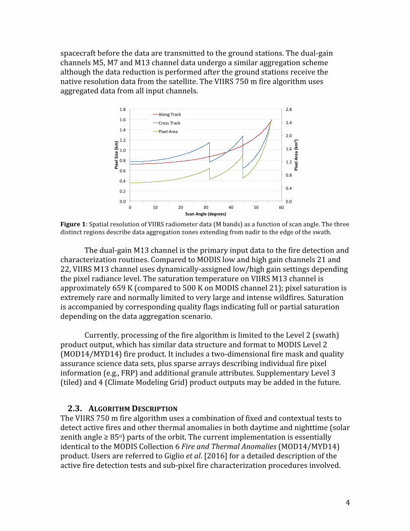
The750mdatadescribethenominalresolutionafternativepixelsarespatiallyaggregated(Figure1).Theaggregationschemechangesacrossthreedistinctimageregions.Inthefirstregion(nadirto31.59oscanangle),threenativepixelsareaggregatedinthealongscan(cross-track)directiontoformonedatasampleintheLevel1image.Inthesecondregion(31.59oto44.68oscanangle),twonativepixelsareaggregatedtoformonedatasample.Finallyinthethirdandlastregion(44.68oto56.06o-edgeofswath)onenativepixelwillresultinonedatasample.SinglegainchannelsM11,M15andM16areaggregatedonboardthe
4
spacecraftbeforethedataaretransmittedtothegroundstations.Thedual-gainchannelsM5,M7andM13channeldataundergoasimilaraggregationschemealthoughthedatareductionisperformedafterthegroundstationsreceivethenativeresolutiondatafromthesatellite.TheVIIRS750mfirealgorithmusesaggregateddatafromallinputchannels.
Figure1:SpatialresolutionofVIIRSradiometerdata(Mbands)asafunctionofscanangle.Thethreedistinctregionsdescribedataaggregationzonesextendingfromnadirtotheedgeoftheswath. Thedual-gainM13channelistheprimaryinputdatatothefiredetectionandcharacterizationroutines.ComparedtoMODISlowandhighgainchannels21and22,VIIRSM13channelusesdynamically-assignedlow/highgainsettingsdependingthepixelradiancelevel.ThesaturationtemperatureonVIIRSM13channelisapproximately659K(comparedto500KonMODISchannel21);pixelsaturationisextremelyrareandnormallylimitedtoverylargeandintensewildfires.Saturationisaccompaniedbycorrespondingqualityflagsindicatingfullorpartialsaturationdependingonthedataaggregationscenario. Currently,processingofthefirealgorithmislimitedtotheLevel2(swath)productoutput,whichhassimilardatastructureandformattoMODISLevel2(MOD14/MYD14)fireproduct.Itincludesatwo-dimensionalfiremaskandqualityassurancesciencedatasets,plussparsearraysdescribingindividualfirepixelinformation(e.g.,FRP)andadditionalgranuleattributes.SupplementaryLevel3(tiled)and4(ClimateModelingGrid)productoutputsmaybeaddedinthefuture.
2.3. ALGORITHMDESCRIPTIONTheVIIRS750mfirealgorithmusesacombinationoffixedandcontextualteststodetectactivefiresandotherthermalanomaliesinbothdaytimeandnighttime(solarzenithangle≥85o)partsoftheorbit.ThecurrentimplementationisessentiallyidenticaltotheMODISCollection6FireandThermalAnomalies(MOD14/MYD14)product.UsersarereferredtoGiglioetal.[2016]foradetaileddescriptionoftheactivefiredetectiontestsandsub-pixelfirecharacterizationproceduresinvolved.
0.0
0.4
0.8
1.2
1.6
2.0
2.4
2.8
0.0
0.2
0.4
0.6
0.8
1.0
1.2
1.4
1.6
1.8
0 10 20 30 40 50 60
PixelA
rea(km
2 )
PixelSize(km)
ScanAngle(degrees)
AlongTrack
CrossTrack
PixelArea
5
Thatpublicationisdownloadablefreeofchargethroughthelink:http://dx.doi.org/10.1016/j.rse.2016.02.054
3. PRODUCTDESCRIPTIONTheVIIRSlandproductsuiteiscomposedofLevel2(swathprojection),Level3(tiled,withsomemulti-temporaldata),andLevel4(griddeddatameetingclimatemodelingcommunityrequirements)datasets.Currently,the750mactivefiredatasetisrestrictedtoLevel2processingcarryingsimilarcharacteristicsastheinputL1Bdataingestedbythealgorithm.Thedataarestoredinswathprojectionwithindividualgranulescomprisinganorbitsegmentofapproximately6min.VIIRSLevel3&4firedataproductsshouldbecomeavailableinthenearfuture.
3.1. LEVEL2ACTIVEFIREDATA3.1.1. FILEFORMAT
VIIRSactivefiredataareoutputinNetCDF4.2fileformat.Level2filesalsoshareseveraloftheL1Bglobalattributes(includingnomenclature);filescanbemanipulatedusingstandardNetCDF-enabledsoftware.Filenameconventionisasfollows:VNP14.AYYYYDDD.HHMM.VVV.yyyydddhhmmss.ncWhere:VNP14=VIIRS750mactivefireproductidentifierYYYY=yearofdataacquisitionDDD=JuliandayofdataacquisitionHHMM=hourandminuteofdataacquisitionyyyydddhhmmss=dataprocessingtime(year,Julianday,hour,minute,second)
3.1.2. DATACONTENTTheVIIRSactivefirealgorithmoutputcontains29primarysciencedatasets,inadditiontothealgorithm’squalityflag(seeSection3.2).Theindividualsciencedatasets(SDSs)arenamedasfollows:‘firemask’ =imageclassificationarray(2D)‘FP_line’ =granulelineoffirepixel‘FP_sample’ =granulesampleoffirepixel‘FP_latitude’ =latitudeoffirepixel(degrees)‘FP_longitude’=longitudeoffirepixel(degrees)‘FP_R7’ =channelM7reflectanceoffirepixel‘FP_T13’ =channelM13brightnesstemperatureoffirepixel(kelvin)‘FP_T15’ =channelM15brightnesstemperatureoffirepixel(kelvin)‘FP_MeanT13’=channelM13meanbackgroundbrightnesstemperature(kelvin)‘FP_MeanT15’=channelM15meanbackgroundbrightnesstemperature(kelvin)
6
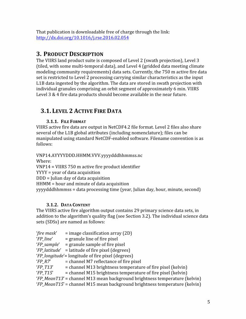
‘FP_MeanDT’ =meanbackgroundM13-M15brightnesstemperaturedifference (kelvin)‘FP_MAD_T13’=backgroundchannelM13brightnesstemperaturemeanabsolute deviation(kelvin)‘FP_MAD_T15’=backgroundchannelM15brightnesstemperaturemeanabsolute deviation(kelvin)‘FP_MAD_DT’=backgroundM13-M15brightnesstemperaturedifferencemean absolutedeviation(kelvin)‘FP_power’ =fireradiativepower(MW)‘FP_AdjCloud’=numberofadjacentcloudpixels‘FP_AdjWater’=numberofadjacentwaterpixels‘FP_WinSize’ =numberofadjacentwaterpixels‘FP_NumValid’=numberofvalidbackgroundpixels‘FP_confidence’=detectionconfidence(7=low,8=nominal,9=high)‘FP_land’ =landpixelflag‘FP_MeanR7’ =backgroundchannelM7reflectance‘FP_MAD_R7’ =backgroundchannelM7reflectancemeanabsolutedeviation‘FP_ViewZenAng’=viewzenithangleoffirepixel(degrees)‘FP_SolZenAng’=solarzenithangleoffirepixel(degrees)‘FP_RelAzAng’=relativeazimuthangleoffirepixel(degrees)‘FP_CMG_row’=climatemodelinggridrow(usedforCMGproductgeneration)‘FP_CMG_rol’ =climatemodelinggridcolumn(usedforCMGproductgeneration)‘FP_CMG_day’=dayflag(usedforCMGproductgeneration)‘FP_CMG_night’=nightflag(usedforCMGproductgeneration) The‘firemask’SDSconsistsofan8-bitintegertwo-dimensionalarraywiththesamenumberofelementsastheinputL1Bdataarray(Figure2).Firemasksgeneratedfromthestandard6-minutefileshave3,200samples(constant)and202<>203scanstotaling3,232<>3,248rows(variablenumberofscanspergranuleisdesignedtoaccommodate≈6minutedatasegments).Distinctpixelclassesareusedforland,water,cloudandfirepixels,plusadditionalclassesindicatingnon-processedpixelsandpixelswithundefinedclassification(‘unclassified’)(Table2).Thelatterdescribesthosecaseswhenbackgroundstatisticscannotberetrievedpreventingproperpixelclassification.Firepixelconfidenceclasses(‘low’,‘nominal’and‘high’)arerepresentativeoftheobservationconditionsassociatedwitheachdetection.Theadditionaldatasetsoutputbythealgorithmconsistofindividualsparsearrayscontainingimageline,column,longitude,latitude,FRP,detectionconfidence,amongotherparametersforallfirepixelsdetected.
7
Figure2:S-NPP/VIIRS750mactivefiredetectionclassificationproduct(mask)derivedfora6-mingranuleacquiredon01March2016at0618UTCoverpartsofSoutheastAsia.Rightpanelshowsmagnifiedsubsetcontainingland(green),water(blue),clouds(white)andfire(red)pixels.Table2:VIIRS750m‘firemask’datasetclasses.
PixelClass Definition0 Notprocessed1 Bowtiedeletion2 (notbeingused)3 Water4 Clouds5 Land6 Unclassified7 Lowconfidencefirepixel8 Nominalconfidencefirepixel9 Highconfidencefirepixel
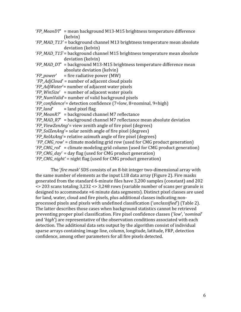
3.2. QA/METADATAAtwo-dimensionalarraycomplementsthefiremaskoutputprovidingqualityassurance(QA)informationforeverypixelprocessed.TheQAdataarestoredin32-bitunsignedintegerformatpopulatedwithseveralfieldsthattogethercanbeusedtoreconstructsomeofthekeyobservationconditionspertinenttoeachpixelanalyzed.Table3:VIIRS750mfiredetection‘algorithmQA’datasetbitsanddefinition.
Bit Description0-1 land/waterstate(00=water,01=coast,10=land,11=unused)2 EDRgroundtrimzone(0=false,1=true)3 atmosphericcorrectionperformed(0=no,1=yes)4 day/nightalgorithm(0=night,1=day)5 potentialfirepixel(0=false,1=true)6 spare(setto0)
8
4. PRODUCTASSESSMENT4.1. THEORETICALFIREDETECTIONCURVES
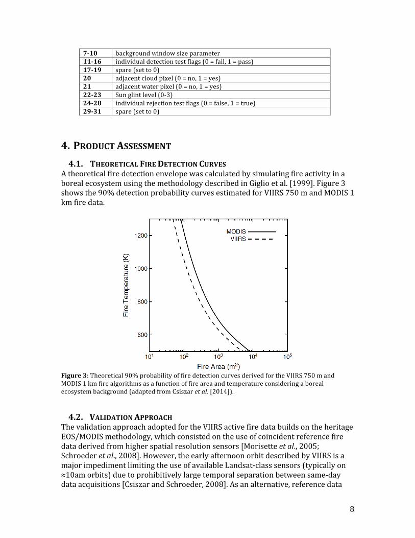
AtheoreticalfiredetectionenvelopewascalculatedbysimulatingfireactivityinaborealecosystemusingthemethodologydescribedinGiglioetal.[1999].Figure3showsthe90%detectionprobabilitycurvesestimatedforVIIRS750mandMODIS1kmfiredata.
Figure3:Theoretical90%probabilityoffiredetectioncurvesderivedfortheVIIRS750mandMODIS1kmfirealgorithmsasafunctionoffireareaandtemperatureconsideringaborealecosystembackground(adaptedfromCsiszaretal.[2014]).
4.2. VALIDATIONAPPROACHThevalidationapproachadoptedfortheVIIRSactivefiredatabuildsontheheritageEOS/MODISmethodology,whichconsistedontheuseofcoincidentreferencefiredataderivedfromhigherspatialresolutionsensors[Morisetteetal.,2005;Schroederetal.,2008].However,theearlyafternoonorbitdescribedbyVIIRSisamajorimpedimentlimitingtheuseofavailableLandsat-classsensors(typicallyon≈10amorbits)duetoprohibitivelylargetemporalseparationbetweensame-daydataacquisitions[CsiszarandSchroeder,2008].Asanalternative,referencedata
7-10 backgroundwindowsizeparameter11-16 individualdetectiontestflags(0=fail,1=pass)17-19 spare(setto0)20 adjacentcloudpixel(0=no,1=yes)21 adjacentwaterpixel(0=no,1=yes)22-23 Sunglintlevel(0-3)24-28 individualrejectiontestflags(0=false,1=true)29-31 spare(setto0)
9
setsderivedfromairbornemappinginstrumentsareused,complementedbyfieldcampaignsandotherqualitativeinformationoriginatedfromfireactivityreports.Additionally,expertimageanalystsprovidevaluableinputforthecalculationofcommissionerrorratesassociatedwiththeoccurrenceoffiredetectionpixelsinurbanareasusingavailablehigh-resolutionvisibleimagery(e.g.,GoogleEarth).
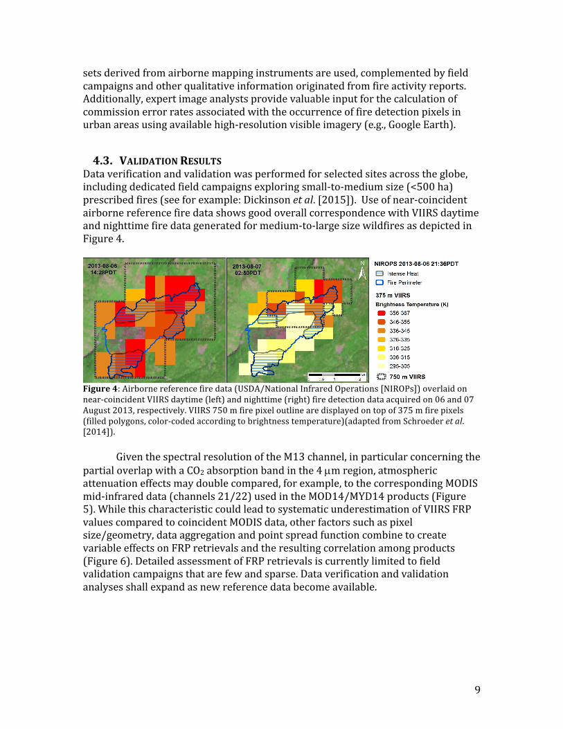
4.3. VALIDATIONRESULTSDataverificationandvalidationwasperformedforselectedsitesacrosstheglobe,includingdedicatedfieldcampaignsexploringsmall-to-mediumsize(<500ha)prescribedfires(seeforexample:Dickinsonetal.[2015]).Useofnear-coincidentairbornereferencefiredatashowsgoodoverallcorrespondencewithVIIRSdaytimeandnighttimefiredatageneratedformedium-to-largesizewildfiresasdepictedinFigure4.
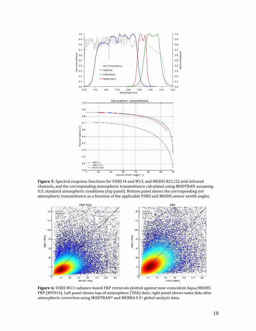
Figure4:Airbornereferencefiredata(USDA/NationalInfraredOperations[NIROPs])overlaidonnear-coincidentVIIRSdaytime(left)andnighttime(right)firedetectiondataacquiredon06and07August2013,respectively.VIIRS750mfirepixeloutlinearedisplayedontopof375mfirepixels(filledpolygons,color-codedaccordingtobrightnesstemperature)(adaptedfromSchroederetal.[2014]). GiventhespectralresolutionoftheM13channel,inparticularconcerningthepartialoverlapwithaCO2absorptionbandinthe4µmregion,atmosphericattenuationeffectsmaydoublecompared,forexample,tothecorrespondingMODISmid-infrareddata(channels21/22)usedintheMOD14/MYD14products(Figure5).WhilethischaracteristiccouldleadtosystematicunderestimationofVIIRSFRPvaluescomparedtocoincidentMODISdata,otherfactorssuchaspixelsize/geometry,dataaggregationandpointspreadfunctioncombinetocreatevariableeffectsonFRPretrievalsandtheresultingcorrelationamongproducts(Figure6).DetailedassessmentofFRPretrievalsiscurrentlylimitedtofieldvalidationcampaignsthatarefewandsparse.Dataverificationandvalidationanalysesshallexpandasnewreferencedatabecomeavailable.
10
Figure5:SpectralresponsefunctionsforVIIRSI4andM13,andMODISB21/22mid-infraredchannels,andthecorrespondingatmospherictransmittancecalculatedusingMODTRANassumingU.S.standardatmosphericconditions(toppanel).BottompanelshowsthecorrespondingnetatmospherictransmittanceasafunctionoftheapplicableVIIRSandMODISsensorzenithangles.
Figure6:VIIRSM13radiance-basedFRPretrievalsplottedagainstnear-coincidentAqua/MODISFRP(MYD14).Leftpanelshowstop-of-atmosphere(TOA)data;rightpanelshowssamedataafteratmosphericcorrectionusingMODTRAN®andMERRA0.5oglobalanalysisdata.
0.0
0.1
0.2
0.3
0.4
0.5
0.6
0.7
0.8
0.9
1.0
0.0
0.1
0.2
0.3
0.4
0.5
0.6
0.7
0.8
0.9
1.0
3.45 3.55 3.65 3.75 3.85 3.95 4.05 4.15 4.25
SpectralRespo
nse
AtmTransmi=ance
Wavelength(um)
AtmTransmi=ance
VIIRS(I4)
VIIRS(M13)
MODIS(B21)

11
5. USERGUIDANCEVIIRSfiredatausersareencouragedtoconsultthedatausersguideforadditionalinformationondataaccessibilityandhandling,andfrequentlyaskedquestions.
6. ASSOCIATEDPUBLICATIONSCsiszar,I.,Schroeder,W.,Giglio,L.,Ellicott,E.,Vadrevu,K.,P.,Justice,C.O.,andWind,B.(2014).ActivefiresfromtheSuomiNPPVisibleInfraredImagingRadiometerSuite:ProductStatusandfirstevaluationresults.JournalofGeophysicalResearch:Atmospheres,doi:10.1002/2013JD020453.
Giglio,L.,Schroder,W.,andJustice,C.(2016).TheCollection6MODISactivefiredetectionalgorithmandfireproducts.RemoteSensingofEnvironment,178,31-41.
Schroeder,W.,Oliva,P.,Giglio,L.,andCsiszar,I.(2014).ThenewVIIRS375mactivefiredetectiondataproduct:Algorithmdescriptionandinitialassessment.RemoteSensingofEnvironment,143,85-96.
7. REFERENCESCsiszar,I.,andSchroeder,W.(2008).Short-termobservationsofthetemporaldevelopmentofactivefiresfromconsecutivesame-dayETM+andASTERimageryintheAmazon:Implicationsforactivefireproductvalidation.IEEEJournalofSelectedTopicsinAppliedEarthObservationsandRemoteSensing,1(4),248-253.
Cabrera,J.,Cyamukungu,M.,Stauning,P.,Leonov,A.,Leleux,P.,Lemaire,J.,etal.(2005).FluxesofenergeticprotonsandelectronsmeasuredonboardtheOerstedsatellite.AnnalesGeophysicae,23,2,975-2,982.
Casadio,S.,Arino,O.,andSerpe,D.(2012).GasflaringmonitoringfromspaceusingATSRinstrumentseries.RemoteSensingofEnvironment,116,239-249.
Dickinson,M.B.,Hudak,A.T.,Zajkowski,T.,Loudermilk,L.E.,SchroederW.,etal.(2015).Measuringradiantemissionsfromentireprescribedfireswithground,airborneandsatellitesensors–RxCADRE2012.InternationalJournalofWildlandFire,doi:10.1071/WF15090.
Giglio,L.,Descloitres,J.,Justice,C.O.,andKaufman,Y.J.(2003).AnenhancedcontextualfiredetectionalgorithmforMODIS.RemoteSensingofEnvironment,87,273-282.
Giglio,L.,Kendall,J.D.,andJustice,C.O.(1999).EvaluationofglobalfiredetectionalgorithmsusingsimulatedAVHRRinfrareddata.InternationalJournalofRemoteSensing,20(10),1947-1985.
Kaufman,Y.J.,Justice,C.O.,Flynn,L.P.,Kendall,J.D.,Prins,E.M.,Giglio,L.,etal.(1998).PotentialglobalfiremonitoringfromEOS-MODIS.JournalofGeophysicalResearch,103(D24),32,215-32,238.
Lobert,J.M.,andWarnatz,J.(1993).Emissionsfromthecombustionprocessinvegetation.In:FireintheEnvironment:TheEcological,Atmospheric,andClimatic
12
ImportanceofVegetationFires(Editors:P.J.CrutzenandJ.G.Goldammer),JohnWiley&SonsLtd.
Morisette,J.T.,Giglio,L.,Csiszar,I.,andJustice,C.O.(2005).ValidationoftheMODISactivefireproductoverSouthernAfricawithASTERdata.InternationalJournalofRemoteSensing,26(19),4239-4264.
Schroeder,W.,Prins,E.,Giglio,L.,Csiszar,I.,Schmidt,C.,Morisette,J.T,.andMorton,D.(2008).ValidationofGOESandMODISactivefiredetectionproductsusingASTERandETM+data.RemoteSensingofEnvironment,112,2711-2726.
Wolfe,R.E.,Lin,G.,Nishihama,M.,Tewari,K.P.,Tilton,J.C.,andIsaacman,A.R.(2013).SuomiNPPVIIRSprelaunchandon-orbitgeometriccalibrationandcharacterization.JournalofGeophysicalResearch:Atmospheres,118,doi:10.1002/jgrd.50873.
Wooster,M.J.,Zhukov,B.,andOertel,D.(2003).Fireradiativeenergyforquantitativestudyofbiomassburning:derivationfromtheBIRDexperimentalsatelliteandcomparisontoMODISfireproducts.RemoteSensingofEnvironment,86,83–107.