Using GIS to Support Stormwater Management in Sampling Map ...
1
Using GIS to Support Stormwater Management in The Bahamas Dan Latham, Katie Resnick Stormwater Management in Nassau, The Bahamas: Assessment of Current Strategies and Recommendations for the Future Tufts University Water: Systems, Science & Society Program Department of Urban and Environmental Policy & Planning Sampling Map and Modeled Pollutant Loading Maps Feature Analyst Hydrologic Modeling GIS Modeling & Overall Lessons Learned Why Hydrologic Modeling? To compare “Simple Method” loading model with GIS based model and to gain a better understanding of over- land flow directions. Challenges • Most models depend on streams and rivers, which The Bahamas lacks. • Data collection and mapping effort was more time intensive than predicted, leav- ing less time for hydrologic modeling Data collection and utilization • Required a significant amount of time and effort • Important data was either unavailable or unattainable • Agencies did not share data amongst themselves • Lack of metadata made it difficult to interpret raw data • High resolution of aerial imagery made it difficult to utilize Site-specific hydrogeologic conditions in the Bahamas • Understanding of hydrogeology required for GIS modeling • Hydrologic modeling was challenging due to lack of streams and rivers and karst geology Sampling in Nassau References available upon request Extraction of Roads Why Feature Analyst? To digitally map land uses and compare the percentages and distribution of land use with the on the ground site land use sur- vey results. Challenges • High resolution of aerial im- agery made it difficult for the program to extract features of interest. What is Feature Analyst? A program that been integrated into ArcGIS as an extension to provide a complete tool- set for extracting features of interest from imagery and scanned maps. Project Purpose Stormwater pollution is recognized as one of the most significant sources of pollu- tion in coastal waters (NRDC, 1999). Stormwater runoff occurs every time it rains as water runs across land, picking up contaminants that result from varied land uses. These include agricultural fields, residential developments, roads, parking lots, roof tops, golf courses and urban areas. Most population centers are located along coastal waterways, exposing these natural resources to increased pollution levels and often leaving them highly degraded. Although stormwater systems have been developed to help address the problem of the quantity of water flowing over the land surface, un- treated stormwater is still frequently discharged into the nearest body of water (NRDC, 1999). Stormwater management is essential in Nassau, New Providence, and in Carib- bean island states as a whole, as their economies are closely tied to the environ- mental and ecological integrity of the coastal zone. Unmanaged stormwater runoff can lead to significant environmental degradation, which in turn can have negative social and economic implications. The objective of this study was to complete an integrated stormwater management assessment of Nassau Harbor, New Providence, establishing the current extent of management and potential capacities for future management. This study attempts to answer the following questions: • How does the success of regulatory strategies or lack thereof, impact the success of stormwater management and coastal environmental quality? • To what extent does the lack of successful regulatory strategies provide opportunity for the development of non-regulatory strategies in managing stormwater in The Bahamas? GIS Component: The use of GIS analysis and mapping was essential to forming recommenda- tions regarding stormwater management in Nassau. • Parcels were digitized and topology was verified to ensure spatial connectivity. • A geodatabase was created for field data and modeling results for spatial interpreta- tion. • Pollutant loading heat maps were output to visually demonstrate loading results. Future GIS modeling Possibilities: • Digitalize land use layer using Feature Analyst. • Hydrologic modeling of surface runoff. RECOMMENDATIONS Building government capacity for stormwater management: ⇒ Department of the Environment ⇒ Memorandum of Understanding (MOU) and committee among agencies involved in stormwater management ⇒ International conventions ⇒ Stormwater Utility Non-regulatory structural stormwater strategies ⇒ Bioretention retrofits in parking lots ⇒ High performance landscaping techniques, such as bioretention systems (rain gardens) and vegetated/grass swales ⇒ Rain barrels and cisterns for rooftop runoff capture and reuse Non-regulatory nonstructural stormwater strategies ⇒ Water quality monitoring ⇒ Adopt-a-beach & Adopt-a-roadway ⇒ Education and Outreach Campaign (workshops, media advertisements, mailed flyers) ⇒ Incorporating stormwater into the curriculum Parking lot island bioretention System Source: NEMO, 2008, p.1 Residential rain barrel Source: CWP, 2002, p.1 Hydrologic modeling of areas with streams and rivers Sampling Map Water quality monitoring data are linked to digital map in order to pro- vide a spatial database. Laboratory results will be included as well. Pollutant Loading Maps The loading from Nutrients (nitrogen and phosphorous) and Metals (Lead, Copper and Zinc) were mapped to determine the parcels that are Unsuccessful Extraction of Rooftops in Nassau
Transcript of Using GIS to Support Stormwater Management in Sampling Map ...
Using GIS to Support Stormwater Management in The Bahamas Dan Latham, Katie Resnick
Stormwater Management in Nassau, The Bahamas: Assessment of Current Strategies and Recommendations for the Future Tufts University Water: Systems, Science & Society Program Department of Urban and Environmental Policy & Planning
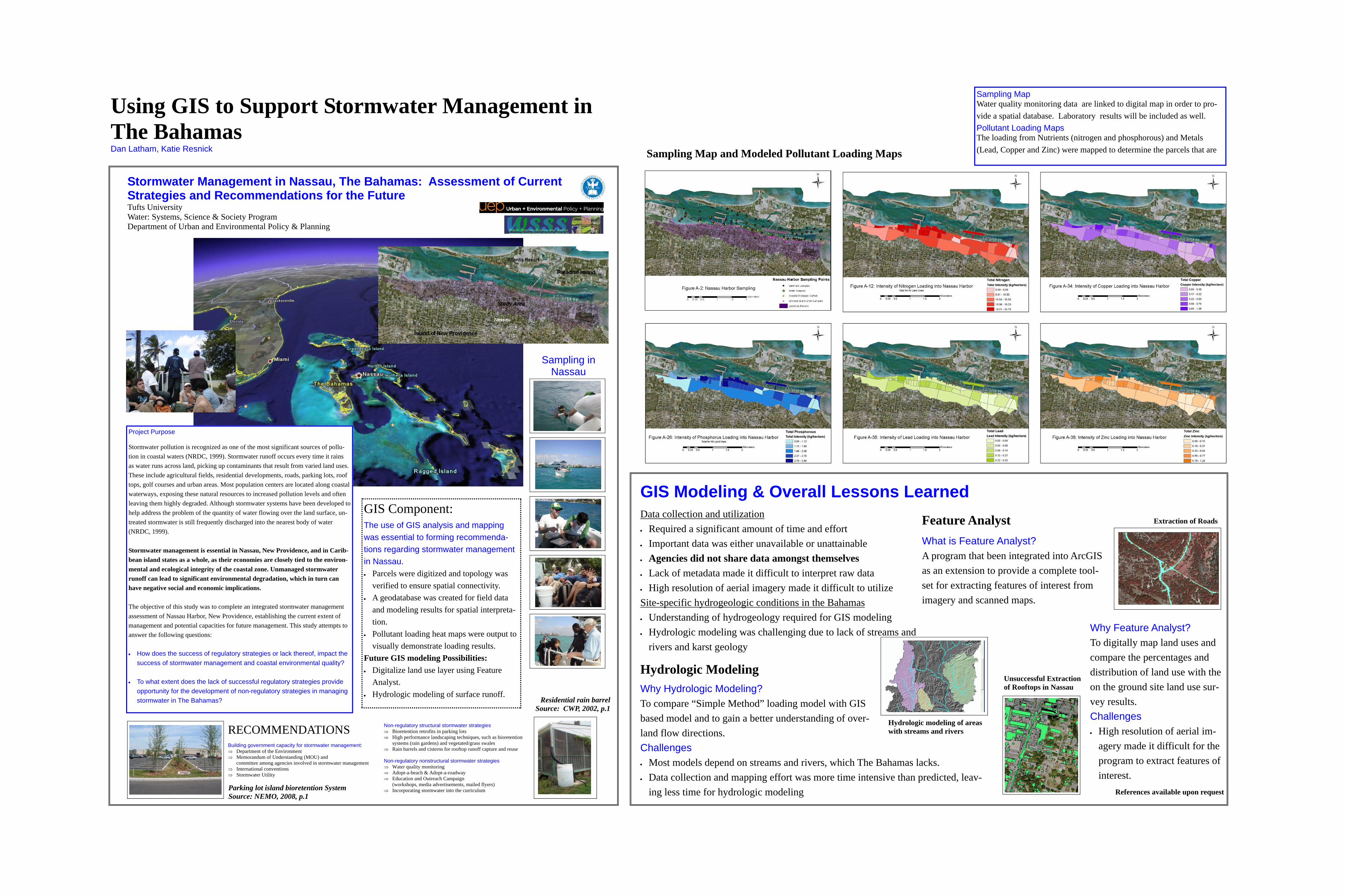
Sampling Map and Modeled Pollutant Loading Maps
Feature Analyst
Hydrologic Modeling
GIS Modeling & Overall Lessons Learned
Why Hydrologic Modeling? To compare “Simple Method” loading model with GIS based model and to gain a better understanding of over-land flow directions. Challenges • Most models depend on streams and rivers, which The Bahamas lacks. • Data collection and mapping effort was more time intensive than predicted, leav-
ing less time for hydrologic modeling
Data collection and utilization • Required a significant amount of time and effort • Important data was either unavailable or unattainable • Agencies did not share data amongst themselves • Lack of metadata made it difficult to interpret raw data • High resolution of aerial imagery made it difficult to utilize Site-specific hydrogeologic conditions in the Bahamas • Understanding of hydrogeology required for GIS modeling • Hydrologic modeling was challenging due to lack of streams and
rivers and karst geology
Sampling in Nassau
References available upon request
Extraction of Roads
Why Feature Analyst? To digitally map land uses and compare the percentages and distribution of land use with the on the ground site land use sur-vey results. Challenges • High resolution of aerial im-
agery made it difficult for the program to extract features of interest.
What is Feature Analyst? A program that been integrated into ArcGIS as an extension to provide a complete tool-set for extracting features of interest from imagery and scanned maps.
Project Purpose Stormwater pollution is recognized as one of the most significant sources of pollu-tion in coastal waters (NRDC, 1999). Stormwater runoff occurs every time it rains as water runs across land, picking up contaminants that result from varied land uses. These include agricultural fields, residential developments, roads, parking lots, roof tops, golf courses and urban areas. Most population centers are located along coastal waterways, exposing these natural resources to increased pollution levels and often leaving them highly degraded. Although stormwater systems have been developed to help address the problem of the quantity of water flowing over the land surface, un-treated stormwater is still frequently discharged into the nearest body of water (NRDC, 1999). Stormwater management is essential in Nassau, New Providence, and in Carib-bean island states as a whole, as their economies are closely tied to the environ-mental and ecological integrity of the coastal zone. Unmanaged stormwater runoff can lead to significant environmental degradation, which in turn can have negative social and economic implications. The objective of this study was to complete an integrated stormwater management assessment of Nassau Harbor, New Providence, establishing the current extent of management and potential capacities for future management. This study attempts to answer the following questions:
• How does the success of regulatory strategies or lack thereof, impact the
success of stormwater management and coastal environmental quality? • To what extent does the lack of successful regulatory strategies provide
opportunity for the development of non-regulatory strategies in managing stormwater in The Bahamas?
GIS Component:
The use of GIS analysis and mapping was essential to forming recommenda-tions regarding stormwater management in Nassau. • Parcels were digitized and topology was
verified to ensure spatial connectivity. • A geodatabase was created for field data
and modeling results for spatial interpreta-tion.
• Pollutant loading heat maps were output to visually demonstrate loading results.
Future GIS modeling Possibilities: • Digitalize land use layer using Feature
Analyst. • Hydrologic modeling of surface runoff.
RECOMMENDATIONS Building government capacity for stormwater management: ⇒ Department of the Environment ⇒ Memorandum of Understanding (MOU) and
committee among agencies involved in stormwater management ⇒ International conventions ⇒ Stormwater Utility
Non-regulatory structural stormwater strategies ⇒ Bioretention retrofits in parking lots ⇒ High performance landscaping techniques, such as bioretention
systems (rain gardens) and vegetated/grass swales ⇒ Rain barrels and cisterns for rooftop runoff capture and reuse Non-regulatory nonstructural stormwater strategies ⇒ Water quality monitoring ⇒ Adopt-a-beach & Adopt-a-roadway ⇒ Education and Outreach Campaign
(workshops, media advertisements, mailed flyers) ⇒ Incorporating stormwater into the curriculum Parking lot island bioretention System
Source: NEMO, 2008, p.1
Residential rain barrel Source: CWP, 2002, p.1
Hydrologic modeling of areas with streams and rivers
Sampling Map Water quality monitoring data are linked to digital map in order to pro-vide a spatial database. Laboratory results will be included as well. Pollutant Loading Maps The loading from Nutrients (nitrogen and phosphorous) and Metals (Lead, Copper and Zinc) were mapped to determine the parcels that are
Unsuccessful Extraction of Rooftops in Nassau