Using GIS to Help Support and Sustain U.S. Army Ranges - … GIS to Help Support and Sustain U.S....
25
1 Using GIS to Help Support and Sustain U.S. Army Ranges - A Global Approach Robert Maple, GIS Program Manager Army Sustainable Range Program (SRP) Geospatial Support Center Army Garrison Fort A.P. Hill, Virginia, USA INFRASTRUCTURE & TECHNOLOGY
Transcript of Using GIS to Help Support and Sustain U.S. Army Ranges - … GIS to Help Support and Sustain U.S....

1
Using GIS to Help Support and Sustain
U.S. Army Ranges - A Global Approach
Robert Maple, GIS Program Manager
Army Sustainable Range Program (SRP) Geospatial Support Center
Army Garrison Fort A.P. Hill, Virginia, USA
INFRASTRUCTURE & TECHNOLOGY

Report Documentation Page Form ApprovedOMB No. 0704-0188
Public reporting burden for the collection of information is estimated to average 1 hour per response, including the time for reviewing instructions, searching existing data sources, gathering andmaintaining the data needed, and completing and reviewing the collection of information. Send comments regarding this burden estimate or any other aspect of this collection of information,including suggestions for reducing this burden, to Washington Headquarters Services, Directorate for Information Operations and Reports, 1215 Jefferson Davis Highway, Suite 1204, ArlingtonVA 22202-4302. Respondents should be aware that notwithstanding any other provision of law, no person shall be subject to a penalty for failing to comply with a collection of information if itdoes not display a currently valid OMB control number.
1. REPORT DATE JUN 2010 2. REPORT TYPE
3. DATES COVERED 00-00-2010 to 00-00-2010
4. TITLE AND SUBTITLE Using GIS to Help Support and Sustain U.S. Army Ranges -A Global Approach
5a. CONTRACT NUMBER
5b. GRANT NUMBER
5c. PROGRAM ELEMENT NUMBER
6. AUTHOR(S) 5d. PROJECT NUMBER
5e. TASK NUMBER
5f. WORK UNIT NUMBER
7. PERFORMING ORGANIZATION NAME(S) AND ADDRESS(ES) Army SRP Geospatial Support Center,Army Garrison Fort AP Hill,VA,22427
8. PERFORMING ORGANIZATIONREPORT NUMBER
9. SPONSORING/MONITORING AGENCY NAME(S) AND ADDRESS(ES) 10. SPONSOR/MONITOR’S ACRONYM(S)
11. SPONSOR/MONITOR’S REPORT NUMBER(S)
12. DISTRIBUTION/AVAILABILITY STATEMENT Approved for public release; distribution unlimited
13. SUPPLEMENTARY NOTES Presented at the NDIA Environment, Energy Security & Sustainability (E2S2) Symposium & Exhibitionheld 14-17 June 2010 in Denver, CO.
14. ABSTRACT
15. SUBJECT TERMS
16. SECURITY CLASSIFICATION OF: 17. LIMITATION OF ABSTRACT Same as
Report (SAR)
18. NUMBEROF PAGES
24
19a. NAME OFRESPONSIBLE PERSON
a. REPORT unclassified
b. ABSTRACT unclassified
c. THIS PAGE unclassified
Standard Form 298 (Rev. 8-98) Prescribed by ANSI Std Z39-18

E2S2 Symposium and Exhibition - Denver, CO 2 of 2316 June 2010
Provide a brief overview of the Sustainable Range Program (SRP)
Provide an overview of the SRP Geospatial Support Center
Highlight the agencies, installations, and offices that are directly supported by the SRP Geospatial Support Center
Highlight procedures, products, and tools created in support of the SRP
Highlight several projects executed at the SRP Geospatial Support Center
So, how can Parsons support your geospatial mission?
Agenda / Objectives

E2S2 Symposium and Exhibition - Denver, CO 3 of 2316 June 2010
Sustainable Range Program (SRP)
DoDD 3200.15 signed in August 2003
• Established policy for the
sustainment of all DoD ranges
AR 350-19 established in September
2005
• Defines the SRP and the
responsibility within the SRP
The Army's overall approach for
improving the way in which it designs,
manages, and uses its ranges to ensure
long-term sustainability
Maximizes the capability, availability, and
accessibility of ranges and training lands
to support doctrinal training and testing
requirements, mobilization, and
deployments under normal and surge
conditions

E2S2 Symposium and Exhibition - Denver, CO 4 of 2316 June 2010
Sustainable Range Program (SRP)
The SRP includes two core programs, under the direction of
Headquarters Department of the Army (HQDA) G-3 Training
Simulations Division (DAMO-TRS)
Range and Training Land Program (RTLP)
• Range Operations
• Range Safety
• Range Modernization
Integrated Training Area Management (ITAM) Program
• Land Rehabilitation and Maintenance (LRAM)
• Range and Training Land Assessment (RTLA)
• Sustainable Range Awareness (SRA)
• Training Requirements Integration (TRI)
E2S2 Symposium and Exhibition - Denver, CO 5 of 2316 June 2010
SRP Geospatial Support Center
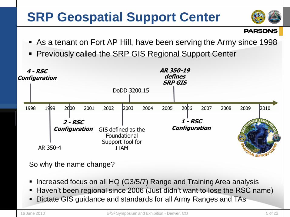
As a tenant on Fort AP Hill, have been serving the Army since 1998
Previously called the SRP GIS Regional Support Center
1998 1999 2000 2001 2002 2003 2004 2005 2006 2007 2008 2009 2010
4 - RSCConfiguration
AR 350-4
2 - RSCConfiguration GIS defined as the
Foundational Support Tool for
ITAM
AR 350-19 defines SRP GIS
1 - RSCConfiguration
So why the name change?
Increased focus on all HQ (G3/5/7) Range and Training Area analysis
Haven’t been regional since 2006 (Just didn’t want to lose the RSC name)
Dictate GIS guidance and standards for all Army Ranges and TAs
DoDD 3200.15

E2S2 Symposium and Exhibition - Denver, CO 6 of 2316 June 2010
SRP Geospatial Support Center
Mission Oriented Operation
Designed to execute achievable goals and tasks
Provide central service and support to the SRP
Structured Operation
Standard Operating Procedures.
Documented tool and application protocols
Flexible Implementation
Sustainable Range Program is dynamic
Army ranges and training are dynamic
Basic Goals
Increasing the utility and cost effectiveness of GIS
Increasing data compatibility
Eliminating redundant GIS efforts
Creating standardized products (Maps, data, etc.)

E2S2 Symposium and Exhibition - Denver, CO 7 of 2316 June 2010
Geospatial Support Center Teams

E2S2 Symposium and Exhibition - Denver, CO 8 of 2316 June 2010
Who we supportSustainable Range Program Installations and Training Areas
Support over 225 Installations / Training Areas / LTAs / Sites
Installations are divided into Tiers (Tiers 1 – 3)
Size of Installation, Installation Mission, Active Duty Units, etc.
Tiers dictate the level of GIS support we provide

E2S2 Symposium and Exhibition - Denver, CO 9 of 2316 June 2010
GIS Support Structure
Sites with a GIS Operator or that are regionally supported
• Larger SRP Installations (Tier I and II)
• Operated locally and supported by Geospatial Support Center ~ 175 Sites
Sites without a GIS Operator
• Smaller SRP Installations (Tier III)
• Centrally supported by Geospatial Support Center ~ 56 Sites
Support includes:• SRP GIS Training Program
• Military Installation Map (MIM) Development
• Standards for Hardware, Software, Geospatial Data
• Support in the procurement of Vector Data and Visualization Data/Imagery
• RFMSS Graphic Fire Desk Data Support
• GIS Technical Support (Centralized Expertise)
• Testing and Evaluation of GIS software/applications
• Data Development / Acquisition / Standardization
• Site Visits (Training and GPS)
• Data Repository for HQDA Analysis (Dedicated Offsite Back-ups)
• Augment Existing Support

E2S2 Symposium and Exhibition - Denver, CO 10 of 2316 June 2010
SRP GIS Data Repository
Maintain a database for all SRP Geospatial data
• Data delivered during Installation QC analysis
• Includes Non-SRP MIM Support Data
Merged dataset for inter-installation analysis
Provide Recoverable Installation backup
• Offsite Disaster Recovery
HQDA/ACOM analysis and data sharing
SRP GIS DATABASE

E2S2 Symposium and Exhibition - Denver, CO 11 of 2316 June 2010
SRP Tools and Application Support
Execute and document Software Qualification Test (SQT) for all tools
Provide all technical support to Army range community
Military Installation Map Toolkit (MIMT)
Range Managers Toolkit (RMTK)
• Surface Danger Zone (SDZ) Tool
• Range Development and Planning Tool (RDAP)
• Explosive Training Range (ETR) Tool
• On Range Ammunition Handling (ORAH) Tool
• Noise Tool (Planning Tool)
SRP Metadata Editor Tool (SMET)
• In Development
SRP GIS Tracker
All tools are downloadable on SRPWeb
https://srp.army.mil

E2S2 Symposium and Exhibition - Denver, CO 12 of 2316 June 2010
GIS Training Support
Online SRP GIS Professional Training Course
• Overview of SRP GIS Program
• Protocols and Procedures
• Tips to best support the installation
SRP GIS Technical Articles
• Topology Tricks and Tips
• Quality Assurance Plans for GIS Data
• Military Installation Map
• GeoPDF
SRP GIS Procedural “How-to’s”
• How to make a data dictionary
• How to use the SRP QAP geodatabase
GIS for Range Staff Course
• Range Safety Tools and basic GIS training
Workshops and Conferences

E2S2 Symposium and Exhibition - Denver, CO 13 of 2316 June 2010
SRP Data Standards
Integral component in defining all SRP Geospatial standards
– SRP GIS Quality Assurance Plans (QAPs)
– Defined by the HQ Proponency matrix (DPTMS/Range)
Created
– SRP GIS Symbology
– SRP GIS Map Templates
– SRP GIS Technical Documents
– SRP GIS Topology Rules
– SRP GIS Metadata Standard
– SRP GIS Data Dictionary
– SRP Template Geodatabase

E2S2 Symposium and Exhibition - Denver, CO 14 of 2316 June 2010
Data Development Team Projects
Following all geospatial standards
and SRP protocols, create and
maintain geospatial data for 56
installations in support of land
management and mission planning
Created and maintain over 600
military operation feature classes
for the 56 installations
Visit 25 – 30 Installations per year
for GPS data collection
Since this data is used for safety,
driving range development
decisions, stewardship; all data is
GPSed to include every firing point,
target, etc.
Very important as data drives
everything we do and support.

E2S2 Symposium and Exhibition - Denver, CO 15 of 2316 June 2010
Map Development Team Projects
Created a MIM template (.mxt) based on layout of previously
produced NGA MIMs and supporting documentation.
Created standard MIM symbology which contains symbols, labels,
and tints based on existing DoD and NGA standards.
Created MIM Production Guidance
Documentation
Military Installation Maps (MIM)

E2S2 Symposium and Exhibition - Denver, CO 16 of 2316 June 2010
Map Development Team Projects
Military Installation Maps (MIM)
G-2, SRP, and NGA signed Memorandum of Agreement (MOA) on
9 Feb 09 to formalize support for MIM production
32 MIM sheets have been finalized and validated by SRP since
2007
29 of these have been printed by NGA, and are currently in stock
at DLA, with 2 more ready for printing
Export finalized MIMs to GeoPDF format,
and they are posted to SRPWeb as well
as the Army Geospatial Center (AGC)
website, and are available for download

E2S2 Symposium and Exhibition - Denver, CO 17 of 2316 June 2010
Map Development Team Projects
Custom Map Production
Training Scenarios
Land Navigation
Range Planning
Range Analysis
Situational Maps
Emergency Response
MOUT Site Maps
Impacts to Training
Range Safety
DoD Proximity Maps
Land Management
Land Disturbance

E2S2 Symposium and Exhibition - Denver, CO 18 of 2316 June 2010
Range Support Team Projects
Provide GIS Support by (GPSing) current
range data to support installation plan
Collect natural resource, environmental, and
public works data to help identify fit and
placement of new range project
Use the RDAP and SDZ tool to identify range
location taking into account all factors:
Environmental conflicts
Infrastructure (Fiber optics, electrical,…)
Topography
Range Complex Master Plan (RCMP) Support
Charrette Support
Range project has been approved and
team goes down range to fine tune the
analysis using the same techniques used
during the RCMP
Provide GIS Support to the TCM-Live
Range modernization (Charrette)

E2S2 Symposium and Exhibition - Denver, CO 19 of 2316 June 2010
Quality Control Team Projects
SRP MIM Production Team
performs QA to ensure
consistency with symbology,
spacing, and layout
requirements (report card)
Created MIM finishing
review checklist for users
creating their own MIM
Once validated by SRP, the
MIM is sent to NGA for
inspection.
Checked for these items:
Map Production Quality Control
Absolute horizontal error
Relative horizontal (feature to feature) accuracy
Circular Map Accuracy Standard (CMAS)
Absolute vertical error
Relative vertical error

E2S2 Symposium and Exhibition - Denver, CO 20 of 2316 June 2010
Quality Control Team Projects
The RSC is responsible for performing QC on all SRP geospatial
data and products (> 225 installations)
Created and published the following QC documentation
• SRP GIS Quality Control Protocol
• SRP GIS Quality Control Protocol Report (Report Card - %))
Using PLTS and scripts to test:
• Topology
• Spatial Accuracy
• Complete Metadata
• Complete Attribution
Data Development Quality Control
E2S2 Symposium and Exhibition - Denver, CO 21 of 2316 June 2010
Technical Support
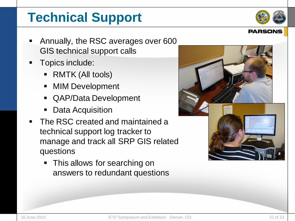
Annually, the RSC averages over 600
GIS technical support calls
Topics include:
RMTK (All tools)
MIM Development
QAP/Data Development
Data Acquisition
The RSC created and maintained a
technical support log tracker to
manage and track all SRP GIS related
questions
This allows for searching on
answers to redundant questions

E2S2 Symposium and Exhibition - Denver, CO 22 of 2316 June 2010
SRP GIS Website Statistics
SRPWeb (https://srp.army.mil)
From 1 Oct 07 to present, there were 39,285 individual SRP GIS
webpage hits with over 22,000 SRP GIS files downloaded from the
SRPWeb library to include:
7,523 Military Installation Maps
5,653 guidance documents
1081 “How-To” documents
3,920 tools
672 SRP GIS Technical Articles
531 SRP GIS Courses

E2S2 Symposium and Exhibition - Denver, CO 23 of 2316 June 2010
In Summary
Provided a snapshot of the work executed at the SRP Geospatial
Support Center
The SRP Geospatial Support Center is:
Mission Oriented
Structured Operation
Striving for standard products and data
Dynamic and Flexible
GIS Center of Excellence
Time tested success (12+ years)

E2S2 Symposium and Exhibition - Denver, CO 24 of 2316 June 2010
Mr. Mark Wald
Vice President, SRP Program Manager
Parsons Infrastructure & Technology (PI&T)
Richmond, Virginia, USA
Comm: 804.327.7457
Email: [email protected]
Mr. Robert Maple
Manager,
Army SRP Geospatial Support Center
Army Garrison Fort AP Hill, VA, USA
Commercial: 804.633.8730
DSN: 578.8730
Email: [email protected]
Points of Contact