USGS QRev Software - Alberta Irrigation Technology …USGS QRev Software A Consistent and ......
19
U.S. Department of the Interior U.S. Geological Survey USGS QRev Software A Consistent and Efficient Processing Approach of ADCP Streamflow Measurements Scott Whiteman U.S. Geological Survey Wyoming-Montana Water Science Center
Transcript of USGS QRev Software - Alberta Irrigation Technology …USGS QRev Software A Consistent and ......
U.S. Department of the InteriorU.S. Geological Survey
USGS QRev SoftwareA Consistent and Efficient
Processing Approach of ADCP Streamflow Measurements
Scott WhitemanU.S. Geological Survey
Wyoming-Montana Water Science Center

U.S. Department of the InteriorU.S. Geological SurveyU.S. Department of the InteriorU.S. Geological Survey
USGS ADCP Inventory
• Below is a breakdown of ADCPs currently in use within the USGS
2
0
50
100
150
200
250
300
186
9 2035
149
296 195
107
1

U.S. Department of the InteriorU.S. Geological Survey
The typical ADCP
user will not be an
ADCP expert!
Provide HELP and
GUIDANCE through
SMART SOFTWARE

U.S. Department of the InteriorU.S. Geological SurveyU.S. Department of the InteriorU.S. Geological Survey
QRev – Goals & Requirements• Process both SonTek and TRDI data
• Logical workflow
• Automated data quality review and feedback
• Consistent algorithms
• Use best available data
• Manual overrides
• Issue specific dialog windows
• Feedback to user on measurement uncertainty
• Tablet friendly

U.S. Department of the InteriorU.S. Geological Survey
Automated Review and Feedback

U.S. Department of the InteriorU.S. Geological SurveyU.S. Department of the InteriorU.S. Geological Survey
Workflow• Collect data in field using manufacturer software
– WinRiverII
– RiverSurveyorLive
– Use USGS procedures as before
• Post process data in field using QRev– For current versions of RSL you will need to reprocess the data
in RSL to create the Matlab files.
– Once data are loaded into QRev the manufactures software should not longer be used for processing.
• Office checking
6

U.S. Department of the InteriorU.S. Geological SurveyU.S. Department of the InteriorU.S. Geological Survey
Buttons on the Main Window• Buttons arranged from top to bottom to lead user
through steps loading, reviewing and finalizing a measurement.
• Button look helps guide the user– No quality checks done associated with button, but access to
other functions or windows
– Loaded measurement does not have data associated with feature
– Data checks performed passed all quality checks
– Data quality checks have identified potential issue but likely not critical. Message panel will contain any issues identified
– Data quality checks identified an issue that could have significant impact on measurement

U.S. Department of the InteriorU.S. Geological SurveyU.S. Department of the InteriorU.S. Geological Survey
Red and Yellow Buttons Have Associated Messages
8

U.S. Department of the InteriorU.S. Geological SurveyU.S. Department of the InteriorU.S. Geological Survey
Extrapolation
9

U.S. Department of the InteriorU.S. Geological Survey
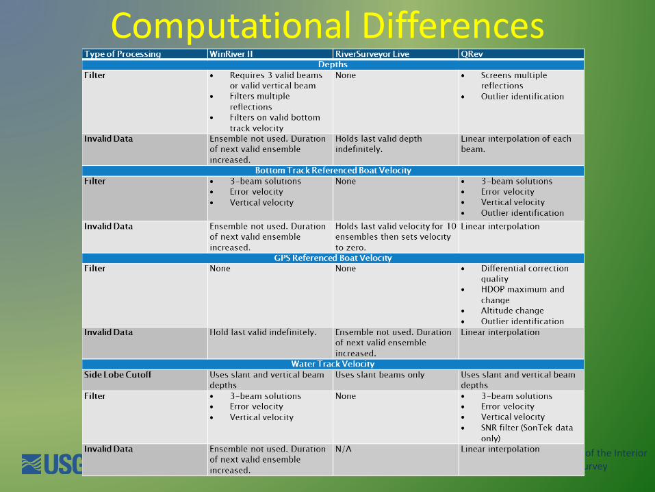
Inconsistent algorithms
If you could process the same data in both
RiverSurveyor Live and WinRiver II, you would
get different discharges due to the differences
in how various situations are handled.
U.S. Department of the InteriorU.S. Geological Survey
Computational Differences

U.S. Department of the InteriorU.S. Geological SurveyU.S. Department of the InteriorU.S. Geological Survey
Best Available Data• To load and review data, the user works
from top to bottom along the buttons on the left. This approach leads the user through the premeasurement steps first. Navigation reference, depth, and water data are needed to compute discharge.
• By working top to bottom the best navigation data are obtained, then the best depth data.
• Finally the best water data, which are dependent on the navigation reference and depth.
• Thus, the final discharge is based on the best available data.

U.S. Department of the InteriorU.S. Geological Survey
Example with Invalid Depths

U.S. Department of the InteriorU.S. Geological Survey
Example Invalid Water Track Data

U.S. Department of the InteriorU.S. Geological Survey
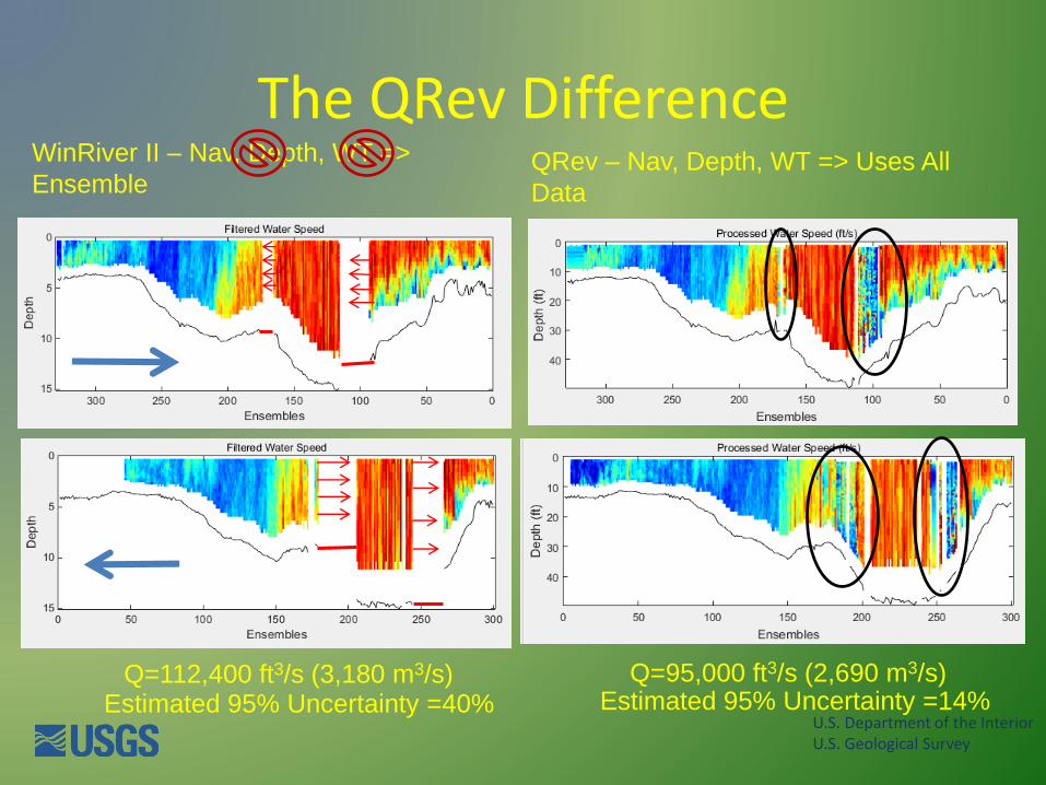
Iowa R. at Wapello, 7/3/2014
U.S. Department of the InteriorU.S. Geological Survey
The QRev DifferenceWinRiver II – Nav, Depth, WT =>
EnsembleQRev – Nav, Depth, WT => Uses All
Data
Q=112,400 ft3/s (3,180 m3/s) Q=95,000 ft3/s (2,690 m3/s)Estimated 95% Uncertainty =14%Estimated 95% Uncertainty =40%
U.S. Department of the InteriorU.S. Geological Survey
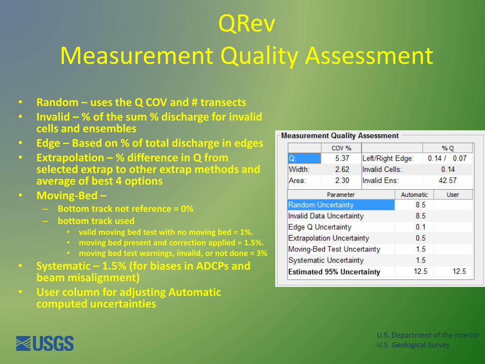
QRevMeasurement Quality Assessment
• Random – uses the Q COV and # transects• Invalid – % of the sum % discharge for invalid
cells and ensembles• Edge – Based on % of total discharge in edges• Extrapolation – % difference in Q from
selected extrap to other extrap methods and average of best 4 options
• Moving-Bed –– Bottom track not reference = 0% – bottom track used
• valid moving bed test with no moving bed = 1%. • moving bed present and correction applied = 1.5%. • moving bed test warnings, invalid, or not done = 3%
• Systematic – 1.5% (for biases in ADCPs and beam misalignment)
• User column for adjusting Automatic computed uncertainties

U.S. Department of the InteriorU.S. Geological Survey
https://hydroacoustics.usgs.gov/movingboat/QRev.shtml

U.S. Department of the InteriorU.S. Geological Survey
Questions