URBAN WAYFINDING PLANNING AND IMPLEMENTATION … · The BART/MTA mapping and wayfinding system in...
68
URBAN WAYFINDING PLANNING AND IMPLEMENTATION MANUAL Photo courtesy of Vertigo Barcelona
-
Upload
doankhuong -
Category
Documents
-
view
223 -
download
0
Transcript of URBAN WAYFINDING PLANNING AND IMPLEMENTATION … · The BART/MTA mapping and wayfinding system in...

URBAN WAYFINDING PLANNING AND IMPLEMENTATION MANUAL
Pho
to c
ourt
esy
of V
ertig
o B
arce
lona

1Sign Research Foundation
Getting StartedWorking with Stakeholder Groups
Working With Government Officials
and Community Leaders
Getting Started: A Stakeholder Framework
Case Study: Philadelphia, PA 5Planning, Design, Fabrication,
and Management Costs
Leading Sources of System Financing
Instruments for Ongoing Financing
Case Study: Phoenixville, PA
System Financing
92 3The Case for
Wayfinding SystemsDefining a Sense of Place
Highlight Complementary Destinations
Enhancing the Urban Commercial Brand
Supports the Entire Community
Traffic Controls and Parking Identification
Consistency and Consolidation (De-Clutter)
Case Study: Legible London
What Comprises a Wayfinding SystemGateway and Area Identification
Vehicular Wayfinding
Pedestrian Wayfinding
Destination Identity
Urban and Street Identity
Media and Print Support
Case Study: City of Charlotte, NC
4
Contents 1Introduction

2Sign Research Foundation
Contents
11AcknowledgementsChecklist Summary10Highlights and
Further Readings
6The Disconnect Between Best Practices and Regulations
Using Research to Make the Case
Developing Regulations for Different Urban Environments
Framing Perceptions
Case Study: Miami Beach, FL
Managing the Regulatory Framework 7Pre-Planning
Planning
Design
Fabrication
Installation
Case Study: Los Angeles, CA
Managing the Design Process
4Getting StartedWorking with Stakeholder Groups
Working With Government Officials
and Community Leaders
Getting Started: A Stakeholder Framework
Case Study: Philadelphia, PA 5Planning, Design, Fabrication,
and Management Costs
Leading Sources of System Financing
Instruments for Ongoing Financing
Case Study: Phoenixville, PA
System Financing8Planning
Identity
Design
Legibility
Materials and Technology
Case Study: Rockville Town Center, MD
Design Issues 9Materials Selection and System Durability
Managing the System
Maintenance
Expansion and Design Management
Case Study: Vancouver, BC
System Management

3Sign Research Foundation
Introduction1With the current climate, communities see stronger wayfinding systems as a way to sustain economic viability.
4Sign Research Foundation
Introduction
Over the last twenty years, urban areas from small town
main streets to the downtown districts of the largest cities
have developed wayfinding and identity systems to enhance
their brand, ease navigation and reinforce key destinations.
With the current climate, communities have seen stronger
wayfinding systems as a way to sustain economic viability.
These important wayfinding projects have developed to the
point where they have been integrated in the Manual on
Uniform Traffic Control Devices, published in magazines and
books and accepted as part of municipal bond and other
financing programs.
Yet there is very little information available to planners and city
officials who want to develop these programs and learn from the
cities that have been most successful. Given that these projects
may take two years from conception to final installation, this
information is crucial. In addition, there is little support to help
city leaders make the case for spending the effort and dollars to
make these programs possible.
The Sign Research Foundation (SRF) is a not-for-profit organization
serving academia, planners/regulators and businesses by
advancing the knowledge base in the topical areas of science,
technology, art, marketing and regulation. Working along with
the International Sign Association (ISA), SRF presents this
workbook and an associated online education program to provide
a comprehensive overview of the steps towards a successful
wayfinding program, including financing, conceptualization, the
approval process, implementation and ongoing management. The
workbook also provides best practices from successful programs
and guidance for hiring consultants including environmental
graphic designers and sign fabricators. Finally the book provides
a current roadmap for the approval process with community
leaders, government officials and other stakeholders.
The Sign Research Foundation hopes that towns and cities
will be encouraged to use the tools and guidance contained in
this book to take a leadership role in developing a wayfinding
program that enhances their community.
5Sign Research Foundation
The Case for Wayfinding Systems2Wayfinding elements can enrich and enhance our
experiences with urban environments.
The Case for Wayfinding SystemsWe live in a world where cities can be navigated through a smart-
phone or other technologies and any information on a destination
can be found within minutes. With all of these tools at our disposal,
why are physical wayfinding elements even necessary?
Municipal wayfinding systems serve an important and crucial
role well beyond responding to the need for basic navigation,
identification and information. Wayfinding elements – such as
monuments, directional systems, directories, interpretive and even
regulatory signs – can enrich and enhance our experiences with
urban environments.

6Sign Research Foundation
The Case for Wayfinding Systems
The City of Midland, MI, wayfinding program developed by Cloud Gehshan Associates reflecting the Frank Lloyd Wright inspired architecture on gateways, parks and recreational areas. The case for such an extensive wayfinding program is in reinforcing the entire urban brand through placemaking.
The BART/MTA mapping and wayfinding system in San Francisco, CA, by Studio L’Image shows the value of developing legible places and includes maps, signs, print and web. The wayfinding project’s value is in connecting visitors to destinations through transit which can be measured in increased use of bus and rail.
You are here, but how do you know where here is?
Municipal wayfinding systems not only direct
visitors to destinations, but also serve as a teaching
tool that educates the visitor on the boundaries,
destinations and key features of the urban
environment. This creates a “legible city” where
wayfinding and identification elements support the
overall urban structure and experience.
Urban geographer Kevin Lynch developed the
legible city concept in his book, The Image of
the City. In his research, Lynch suggests that all
cities have a specific vocabulary that residents and
visitors can “read” in the streets, landmarks, nodal
areas and unique districts. Designers discovered
that by utilizing a system of gateways, signage
and streetscape elements, they could enhance
the legibility of the respective city. Today, the
Lynch method of testing legibility through personal
cognitive maps has shown the effectiveness of
successful municipal wayfinding systems.
London, England has the largest municipal
wayfinding system in the world, referred to as
Legible London. (See Case Study for full summary.)
The guidelines for Legible London were developed
utilizing the cognitive mapping process. Studies
have validated the increased urban understanding
by visitors and residents who used the wayfinding
system which includes signs, directories,
print maps, and mobile applications.
Defining a Sense of Place

7Sign Research Foundation 7
The Case for Wayfinding Systems
The City of Lancaster, PA, wayfinding gateway and directional sign program by Sussman/Prejza both brands the city and directs visitors to smaller destinations and parking. The system is credited with a 10% increase in attendance a year after the system was put in place.
In an age where GPS systems allow us to find our
primary destination quickly and easily, visitors may
end up bypassing lesser known destinations of
potential interest. Wayfinding programs seek to
bring awareness of the museums, retail districts,
historical areas and landmarks that visitors may not
know about and that may not be included in modern
navigation technologies.
Highlight Complementary Destinations
An example of the power of a municipal wayfinding
system to impact less prominent destinations is in
Lancaster, a small city in central Pennsylvania. After
installing a city-wide wayfinding system in 1999,
attendance at five major destinations in the city
increased by 10% in one year.
In addition, the city recorded that name recognition
went up in particular for secondary destinations
like the Art Museum and Central Market. Both of
these locations show the value of the investment
made in implementing and effective municipal
wayfinding system within their community.

8Sign Research Foundation 8
The Case for Wayfinding Systems
The world famous Chicago Theatre in Chicago, IL, is an on-premise commercial sign and landmark that enhances the entire community and brands the city through frequent appearances on television and movies.
The Domino Sugars sign in Baltimore, MD, is a historic sign that enhances the entire community by serving as both a gateway and landmark.
Municipal wayfinding systems are not limited to
identifying and directing visitors to city and related
institutional destinations. The inclusion of standards
as well as promotion of high-quality commercial
on-premise signs, including-free standing
monuments and building mounted identifications
and marquees, play a key role in enhancing the
overall brand of the community.
Research by Charles R. Taylor, Matthew E. Sarkees,
and Hae-Kyong Bang, detailed in their book
Understanding the Value of On-Premise Signs
as Marketing Devices for Legal and Public
Policy Purposes, illustrates that on-premise signage
plays a significant role in enhancing the positions
(value) of both small and large businesses within
the community, and will in turn enhance the value
of the real estate they occupy, the business levels
that they achieve, and the resulting tax revenues
to the city. In addition, large commercial signs,
when properly coordinated with the city, can serve
as valuable gateways and landmarks. Landmarks
like the CITGO sign in Boston, MA, PSFS Tower
in Philadelphia, PA, or the Domino Sugars sign in
Baltimore, MD, are important urban touchstones
that define the commercial importance of the city.
Enhancing the Urban Commercial Brand Supports the Entire Community

9Sign Research Foundation
The Case for Wayfinding Systems
In Albuquerque, NM, the municipal wayfinding system, developed by Jettwalker, Inc. with Lance Wyman, integrates wayfinding, identification and street lighting to consolidate elements and reduce the number of individual sign locations.
When it comes to vehicular wayfinding signage,
locating a destination is not the only key issue.
Vehicular wayfinding signage is also utilized to
control desired traffic circulation patterns and aid
motorists in efficiently identifying both public and
private parking lots and garages by utilizing
consistent wayfinding and identification standards
defined in the system. Incorporating new media
and data tracking technologies into municipal
wayfinding systems also can provide real-time
information on traffic flow and parking availability.
Implementation of effective vehicular wayfinding
systems within communities can aid in creating
safer driving conditions by providing drivers clear
directions at strategic locations, thus reducing
driver confusion and distraction while traveling
busy streets.
It has been common for individual districts, retail
areas or campuses within cities to
implement unique wayfinding and signage systems.
Sometime these are very effective, but in other
cases can create inconsistencies in brand, style and
design within a single community. Lack of system
consistency can result in obsolete, inconsistent
or low-quality elements that can compromise
the brand value of the community to visitors
and residents alike. In addition, a proliferation of
specialized banners, redundant neighborhood
gateways and private interpretive projects created
urban environments that appear disjointed and
disorganized. A well-defined and comprehensive
municipal wayfinding system will contribute to
creating a consistent urban brand, a sense of
organization, improved vehicular flow and safety
while maintaining a perception of quality for the
system, the city and its amenities.
Legibility research at the Pennsylvania State
University has shown that inconsistent and
cluttered environments can adversely affect viewer
legibility and vehicular safety by relaying too many
incomplete and ineffective messages.
Traffic Controls and Parking Identification
Consistency and Consolidation (De-Clutter)

10Sign Research Foundation
Legible LondonThe largest municipal wayfinding system ever developed,
Legible London, also included an extensive research
process for justifying the expense and the effort to develop
a comprehensive system containing more than 1,000
individual elements. The primary objective of the system
was to promote the value of walking in London. *
Case Study: Legible LondonThe primary objective of the system was to promote the value of walking in London.

11Sign Research Foundation
The Case for Wayfinding Systems / Case Study: Legible London
The project developed by Applied Information Group
focused on enhancing pedestrian experiences in five
major areas:
TransportationImproving pedestrian accessibility in the city would
lessen the burden on London’s notoriously
congested transit and road systems.
SocietyMore pedestrian traffic on the streets would lessen
the opportunity for criminal activity and encourage
social interaction.
EnvironmentWalking is the most environmentally friendly
mode of transportation and reduces communities’
carbon footprints.
CommercialAn improved pedestrian understanding of
neighborhoods, landmarks and amenities increases
the opportunities for people finding and using
commercial resources in these areas.
HealthWalking improves general health and well being
and is a key tool in fighting obesity and many other
health issues.The Legible London concept is to build the pedestrian experience around five-minute journeys exemplified in maps that would show five-minute areas. This is also reinforced on the Legible London web site and mobile applications. Research indicated that the best design approach for achieving the highest pedestrian value would be to use information landmarks that would support a greater wayfinding program.
Legible London Yellow book
B
Step
s
Step
s
Step
s
Step
s
Step
s
OX
FO
RD
ST
RE
ET
NEW Q
UEBEC STREET
GLOUCESTER PLACE M
EWS
MONTAGU STREET
QUEBEC MEW
S
MONTAGU MEW
S WEST
GEORGE STREET
GLOUCESTER PL
GLOUCESTER PLACE
MARYLEBONE H
IGH S
T
NEW
CAVEN
D ISH S
T
PA DD I NG T ON S
T RE E T
PADD
ING
TON
STREET
DORSET STREET
DORSET STRE ET
BAKER STREET
DE WALDEN
ST WESTMORELAND S
TREET
WHEAT L E Y S
T
B LANDFORD S
TREET
BLANDFORD S
T
PORTM
AN
CLO
SE
WELBECK S
TREET
GEORGE STREET
BU
LSTROD
E STREET
MANCHESTER ST
QUEEN A
NN
E ST
WIGMORE P
LACE
MANDEVIL
LE PLACE
BEN
T INCK M
EWS
GEORGE STREET
GEORGE STREET
MANCHESTER STREET
PORTM
AN
MEW
S SO
UTH
ROBERT ADAM
STREET
F I TZHARD IN
GE ST
P I CTON
PLACE
BEN
T INCK S
TREET
SEYMOUR MEW
S
BAKER'S M
S
BERKELEY MEW
S
JOHN PRINCE'S STREET
HEN
R I ET TA
PLA
CE
MARYLEBONE LANE
HOLLES STREET
WIG
MO
RE STREET
WIMPOLE S
TREET
WELBECK S
TREET
VERE STREET
THAYER STREET
H INDE S
T
DAV I E
S MEW
S
MO
UN
T RO
W
ST AN
SE LM'S
PL
GREEN
STREET
GEO
RGE Y
ARD
RED PLACE CARLOS P
LACE
BINNEY STREET
GILBERT STREET
DUKE STREET
STRATFORD PLACE
DAVIES ST
DAVIES STREET
JAMES STREET
LUMLEY STREET
DUKE STREET
BIRD STREET
GRANV I LL E P
L
PORTMAN STREET
GRO
SVENO
R HI L
L
MO
UN
T STREET
NO
RTH R
OW
DU
KE ' S Y
D
MT
ST
MEW
S
TENTERD
EN S
TREET
WOODSTOCK ST
NEW BOND STREET
PR INCES S
TREET
BARRETT STREET
WE IG
HH
OU
SE ST
NORTH AUDLEY S
TREET
BRO
OK S
TREET
BRO
OK S
TREET
BRO
OK S
T
HAREWOOD P
L
HA
NO
VER STREET
NORTH R
OW
BLE
NH
EIM
ST
MA
RGA
RET STREET
BRYANSTON
STREET
WIG
MORE S
TREET
GRO
SVENO
R ST
WELBECK W
AY
MARYLEBONE LANE
M A RY L E B O N E L N
B L A N D F O R D S T
HARLEY STREET
BROADSTONE PLACE
BAKER ST
RODMARTON STREET
K E N R I C K P L
CHILTERN STREET
LUXBOROUGH STREET
DUKE STREET
WELBECK S
TREET
BALDERTON STREET
BRO
WN
HA
RT GD
NS
BRO
WN
HA
RT GD
NS
THREE K
ING
S YA
RD
BRO
OK ’ S
MEW
S
S O U T H M O LT O N S T
CRAMER S
TAYBROOK S
TREET
WESLEY S
T
SPANISH PL
UPPER B
ERKE L E Y ST
GREAT CUMBERLAND P
LACE
GARBUTT PL
ASHLAND PLACE
JACOB'S WELL MEWS
HAUNCH OF VENISON YD
WYTHBURN
PLACE
C L ENSTON
MEW
S
MONTAGU MS S
TH
SWALLOW
PLSWL PSG
DERING STREET
DE
RIN
G S
T
CHAPEL PLACE
A V E R Y R O W
BOURDON PL
CARPENTER ST
BOURNE
MEW
S
DU
KE ' S M
S
S T V I N C E N T S T
CROSS KE YS C
LOSEBULSTRODE P
LACE
MEWS
DEAN'S
JAS
ON
CT
EASLEY’S
MS
BROWNING M
S
M A N C H E S T E R
M E WS
KENDALL PL
ALDBURGH M
S
BROADBENT ST
BOURDON ST
MARYLEBONE LANE
GEES COURT
SE
DLE
YP
LAC
E
S O U T H M O LT O N L A N E
JONES ST
25
1
3
23
35
39
79
79
9
62
35
54
36
44
48
42
2
20
5
1
1
101
400
94
2
3
1c
9475
257
271
44
13
30
117
36
17
67
123 46
17
47
53
51
43 34
130
2111
39
64
39
79
2a
130
21
48
1
25
34
7
88
14
5
21
10
112
3017
26
118
5
16
27
7
117
1
110
339
65
16
77
28
1
76
58
4
12
48
10
16
308
293
39
212
274
95
415
396
19
59
68
79
20
68
76
46
96
1
504
18
14
47
88
35
13
17
35
130
110
39
51
9
40
19
9
241
1
249
268
105
58
78
89
76
55
9110
0
44
66
31
35
67
701
67
1
12
20
29
46
42
29
54
19
1
62
28
24hr
Oxf
ord
Cir
cus
Bond
Str
eet
Cla
rid
ge’s
Mar
iott
,G
rosv
en
or
Sq
uar
e
Arg
en
tin
eEm
bas
sy
Du
rran
tsH
ote
l
Th
eH
ear
tH
osp
ital
Un
ive
rsit
y o
fW
est
min
ste
r
Han
de
lH
ou
seM
use
um
Emb
assy
of
Ital
y
Can
adia
n H
igh
Co
mm
issi
on
Ho
use
of
Fras
er
Ro
yal
So
cie
ty o
fM
ed
icin
e
Ro
yal
Co
lle
ge o
fN
urs
ing
Wig
mo
reH
all
Bri
tish
De
nta
lA
sso
ciat
ion
Th
eH
ell
en
icC
en
tre
Pad
din
gto
nS
tre
et
Gar
de
ns
Th
e M
and
evi
lle
Ho
tel
Wal
lace
Co
lle
ctio
n
Jury
sC
lift
on
Ford
Ho
tel
Ch
urc
hil
lH
yatt
Re
gen
cy
Th
istl
eM
arb
leA
rch
Su
sse
xH
ote
l Mar
ks &
Sp
en
cer
Be
rksh
ire
Ho
tel
St
Pe
ter’
s
Cla
rid
ge’s
Fen
wic
k
Re
iss
Gap
HM
V
We
st O
ne
Sh
op
pin
gC
en
tre
Bo
ots
De
be
nh
ams
Ne
xt
Ap
ple
Sto
re
H&
M
Top
sho
pN
ikeT
ow
n
Joh
n L
ewis
Se
lfri
dge
s
Mo
nta
guS
qu
are
Han
ove
rS
qu
are
Gro
sve
no
rS
qu
are
Cav
en
dis
hS
qu
are
Po
rtm
anS
qu
are
Man
che
ste
rS
qu
are
Lan
cash
ire
Co
urt
Ad
mir
alC
ou
rt
Cav
en
dis
hS
qu
are
So
uth
Mo
lto
nS
tre
etS
t C
hri
sto
ph
er’
sP
lace
Pad
din
gto
nS
tre
et
Gar
de
ns
St
Ch
rist
op
he
r
Tit
ch
fie
ld
Ca
ve
nd
ish
Ma
ryle
bo
ne
Vil
lage
Po
rtm
an
Ba
ker
Ha
no
ve
r
Gro
sve
no
r
So
uth
Mo
lto
n
Oxf
ord
Cir
cus
Bake
r St
reet
Marble Arch
Marylebone Road
MA
YF
AIR
SO
HO
MA
RY
LE
BO
NE
Based on these value metrics Applied Information Group developed a research program to illustrate how a comprehensive wayfinding system would increase pedestrian access to the city and deliver on these value objectives. The resulting system increased visitor pedestrian use extensively, particularly during the 2012 Summer Olympics. Surveys to gauge tourist comfort showed the wayfinding system as a key factor in finding urban neighborhoods and destinations.
*Summary from the Yellow Book Legible London Research report. The report is available at http://www.tfl.gov.uk/assets/downloads/businessandpartners/yellow-book.pdf
12Sign Research Foundation
What Comprises aWayfinding System3Successful systems utilize common design cues
including color, typography, shape, logo, material and nomenclature.
What Comprises a Wayfinding System?Wayfinding systems mean different things to different
people based on their experience. Wayfinding can be
experienced on a highway, in a park or in a pedestrian mall.
The key to successful wayfinding in urban areas is how
these different experiences are linked.
Peeling the OnionA wayfinding system has many moving parts that fit
together. To structure how all these elements work, it is
important to look at the individual elements as a series
of layers that a visitor encounters when experiencing an
urban environment. This encounter begins at the vehicular
edges of the region and continues into downtown. Finally,
it culminates in pedestrian main streets and destinations.
While all of these layers of experience do not need to be
clearly linked through design, successful systems utilize
common design cues including color, typography, shape,
logo, material and nomenclature.

13Sign Research Foundation
What Comprises a Wayfinding System
Gateways define the entry into a distinct place with
a defined identity. Gateways exist on a number of
levels in an urban area including:
Regional Gateways: Sign and landmarks that
identify entrance to a regional area which can
include government entities (states and counties),
heritage areas and economic zones (industrial and
commercial corridors).
City Gateways: Signs and landmarks that identify
a city or town. City gateways can be freestanding
or attached to other landmarks including bridges,
buildings and parks.
District and Neighborhood Gateways: Signs that
identify a unique district in a city. These can include
clearly defined mixed use districts (Downtown,
Chinatown, Historic District), neighborhoods, and
large park areas.
Area Identification: Signs that identify less defined
areas with distinct cultural (art districts), commercial
(main street corridors or areas of unique commercial
entities) or political (government nodes) importance.
Gateways and Area Identification
From top to bottom: Miami Beach City Gateway, MERJE Design; Highland Park Neighborhood Gateway, Cloud Gehshan Associates; Narberth Borough Bridge Gateway, VSBA, LLC.
From top to bottom: Haverson London Borough Gateway, Jason Bruges Studio;King of Prussia Gateway, King of Prussia BID.

14Sign Research Foundation
Downtown and Neighborhood Signs: These smaller
scale vehicular signs are located inside downtowns,
neighborhoods and districts. They direct to a large
range of destinations and parking. These signs can
also include trailblazers that lead motorists back to
interstate and state roads.
Pedestrian Wayfinding Design elements that direct pedestrians to
destinations inside of a defined district or
neighborhood. Pedestrian wayfinding signs
include:
What Comprises a Wayfinding System
These elements direct motorists to districts, cities,
parks, heritage areas, destinations and parking.
Vehicular wayfinding is meant to be seen at high
speeds in public right-of-ways and is heavily
regulated by departments of transportation.
These signs include:
Controlled Access Road Signs: Signs that direct
to destinations on the interstate highway system.
These signs are designed and planned based on
strict Federal Highway Administration guidelines
and are administered by the individual states.
Regional Signs: Signs that direct to cities,
parks, agricultural facilities (golf courses/wineries),
institutional and commercial destinations and
heritage areas outside of urban areas.
Regional signs can be administered by state
bodies, by individual counties, or by aggregated
counties and towns. These signs often include
distance information.
Large Scale Signs: In urban areas outside
downtowns and neighborhoods these signs direct
to large scale destinations and urban districts.
From top to bottom: Atlantic City Expressway Signs;Gore Valley Regional Wayfinding, Corbin Design;Port of Los Angeles Wayfinding Sign, Selbert Perkins Design.
Portland Riverfront combined Directional/Maps/Identity, Mayer/Reed.
Vehicular Wayfinding

15Sign Research Foundation
Pedestrian Directional Signs: Signs that direct
pedestrians directly to destinations.
Map Signs: Pedestrian maps that define the urban
district and the key landmarks and destinations
within that district.
Directories: Maps that also contain a directory of
destinations with additional information including
addresses, phone numbers or interpretive
descriptions.
Destination IdentityLandmark elements that direct to specific
destinations. Destination identity signs include:
Institutional Identity: Free-standing signs or
signs attached to buildings that identify a
government, cultural, educational, transportation
or health institutions.
Identity/Gateway: Identity signs can also serve as
gateways to educational, corporate, transportation
and healthcare campuses.
What Comprises a Wayfinding System
Interpretive Identity: Signs that combine destination
identification and interpretive information.
On-Premise Commercial Landmarks:
Free-standing or signs attached to buildings that
identify commercial or corporate destinations that
also serve as urban landmarks.
Parking: Signs that identify parking garages and lots.
From top to bottom: San Juan Capistrano Map/Directory, Hunt Design; Wissahickon Park, Cloud Gehshan Associates;Hudson River Interpretive Kiosks, Joel Katz Design Associates.
From top to bottom: World Trade Center Pedestrian Kiosk, C&G Partners;Hong Kong Connect 12 Building Identity, Calori & Vanden-Eynden.
16Sign Research Foundation
What Comprises a Wayfinding System
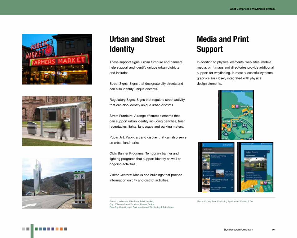
Media and Print SupportIn addition to physical elements, web sites, mobile
media, print maps and directories provide additional
support for wayfinding. In most successful systems,
graphics are closely integrated with physical
design elements.
Urban and Street IdentityThese support signs, urban furniture and banners
help support and identify unique urban districts
and include:
Street Signs: Signs that designate city streets and
can also identify unique districts.
Regulatory Signs: Signs that regulate street activity
that can also identify unique urban districts.
Street Furniture: A range of street elements that
can support urban identity including benches, trash
receptacles, lights, landscape and parking meters.
Public Art: Public art and display that can also serve
as urban landmarks.
Civic Banner Programs: Temporary banner and
lighting programs that support identity as well as
ongoing activities.
Visitor Centers: Kiosks and buildings that provide
information on city and district activities.
From top to bottom: Pike Place Public Market;City of Toronto Street Furniture, Kramer Design;Park City, Utah Olympic Park Identity and Wayfinding, Infinite Scale.
Mercer County Park Wayfinding Application, Winfield & Co.
17Sign Research Foundation
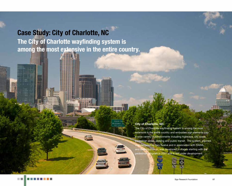
City of Charlotte, NCThe City of Charlotte wayfinding system is among the most
extensive in the entire country and embodies sign elements into
a wide variety of environments including highways, city roads,
pedestrian areas, parking and public transit. The system, planned
and designed by Two Twelve and in association with DAWA
and Brinkley Design, was developed in stages starting with the
pedestrian program in 2007 and is still under development.
Case Study: City of Charlotte, NCThe City of Charlotte wayfinding system is among the most extensive in the entire country.
18Sign Research Foundation
What Comprises a Wayfinding System / Case Study: City of Charlotte, NC
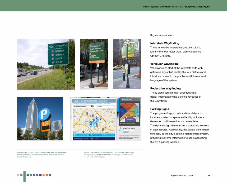
Key elements include:
Interstate WayfindingThese innovative interstate signs use color to
identify the four major urban districts defining
Uptown Charlotte.
Vehicular WayfindingVehicular signs start at the interstate exits with
gateways signs that identify the four districts and
introduce drivers to the graphic and informational
language of the system.
Pedestrian WayfindingThese signs contain map, directional and
transit information while defining key areas of
the Downtown.
Parking SignsThe program of signs, both static and dynamic,
include a system of space availability indicators
developed by Kimley-Horn and Associates.
The dynamic sign elements are updated via sensors
in each garage. Additionally, the data is transmitted
wirelessly to the city’s parking management system,
providing real-time information to users accessing
the city’s parking website.
Top - from left to right: Color-coded interstate signs; Vehicular signs; The pedestrian sign contains identification, wayfinding, map and transit information;
Bottom - from left to right: Dynamic electronic message center signs identify the number of parking spaces in a garage; The parking web site connects with the system.

19Sign Research Foundation
Getting Started4Getting StartedBeginning an urban wayfinding project requires a great
deal of preparation before establishing a plan or unveiling
a design concept. Like a bridge or a highway, wayfinding
programs affect a number of constituencies who need
to be consulted throughout the planning, design and
implementation process. The key to project success is the
involvement and preparation of stakeholder constituencies
at the outset.
Like a bridge or a highway, wayfinding programs affect a number of constituencies who need to be consulted throughout the planning, design and implementation process.

20Sign Research Foundation
Getting Started
There are dozens of different constituencies that
must be consulted in specific ways and managed
through different groups and committees. These
groups include:
Steering CommitteeA steering committee’s role is to assist in decision
making throughout the entire planning, design and
implementation process. The steering committee is
usually small (5-8 people) and include stakeholder
representatives that can take a leadership role in key
areas of the process. Steering committee
members are also responsible for communicating
decisions to larger stakeholder constituencies.
Management Committees and Task ForcesOften wayfinding programs have unique needs that
require the efforts of a specialized group to focus
on narrow topic areas. This can include tasks like
approvals, financing and maintenance; or dealing
with unique community issues. An example of the
latter can be found in a task force developed for a
wayfinding program in the Upper Perkiomen Valley,
a community of small towns and villages in eastern
Pennsylvania. Because each town and village will
be responsible for implementing the guidelines
developed for the entire area, a task force was set
up specifically to navigate the financing, design
issues, implementation and management particular
to the towns while a steering committee managed
the overall design and guidelines process.
General Stakeholder Group Public projects require community outreach and
input to be successful, and wayfinding programs
usually require a greater degree of transparency
than a typical infrastructure project. Reaching out to
the broader public requires the development of a
stakeholder group consisting of political and
community leaders, key destinations, funding
agencies and the media. These groups in turn
communicate with the public. General stakeholder
groups usually have a very limited say in day-to-day
program process decisions, but should be informed
and able to comment on key decisions, particularly
related to design. In today’s era of social media, the
public meeting input is often being supplemented
online, with public comments and feedback possible
outside the scope of a single public meeting.
Who Spearheads the Project?Wayfinding projects often take from 12 months to
2 years to get from initial planning to installation.
In addition the projects often need to move through
a difficult bidding and installation process followed
by years of ongoing management. It takes
organizations with long-term management
capabilities to take on these programs. The
expansion of special service and business
improvement districts that are managing an array
of city services from funding to maintenance has
led to an increase in wayfinding systems over the
past 20 years While larger cities have quasi-public
groups with full-time staff, smaller cities and towns
often need to make do with a single city manager
or streets official. In these cases, the need for
structured steering committees become even more
important, with community volunteers taking on
many tasks including seeking financing, managing
meetings and coordinating community outreach.Washington D.C., where one of the largest wayfinding programs in North America utilized a steering committee of federal, state and local government officials to manage the complex jurisdictional issues.
Working withStakeholder Groups
21Sign Research Foundation
Getting Started
Why so few privately developed wayfinding programs? In Europe, most wayfinding and identity programs are developed by private companies like JCDecaux while in the U.S. non-profit and quasi-governmental organizations are often the program developers. This has much to do with how cities are run in different geographies. European cities have a top-down management approach where most decisions are made from a central authority. In the U.S., decision making is often pushed down to community and specialized organizations, working with city leaders. (Above project is the Dublin, Ireland, wayfinding program; Specialty Bush Shelter in Copenhagen, Denmark; Interpretive Touch Map in London, England; by JCDecaux).
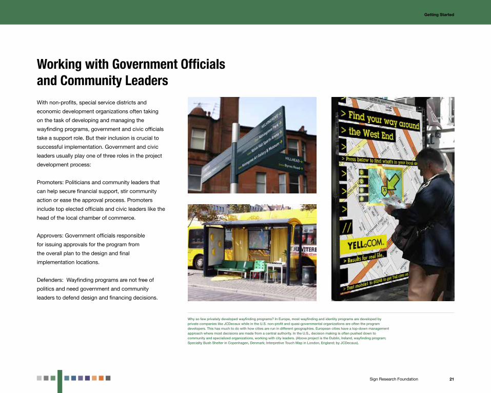
Working with Government Officials and Community LeadersWith non-profits, special service districts and
economic development organizations often taking
on the task of developing and managing the
wayfinding programs, government and civic officials
take a support role. But their inclusion is crucial to
successful implementation. Government and civic
leaders usually play one of three roles in the project
development process:
Promoters: Politicians and community leaders that
can help secure financial support, stir community
action or ease the approval process. Promoters
include top elected officials and civic leaders like the
head of the local chamber of commerce.
Approvers: Government officials responsible
for issuing approvals for the program from
the overall plan to the design and final
implementation locations.
Defenders: Wayfinding programs are not free of
politics and need government and community
leaders to defend design and financing decisions.

22Sign Research Foundation
Getting Started
Stakeholder framework: A stakeholder project map is a handy tool for linking the process of wayfinding development with potential stakeholders, by defining the groups responsible for specific program tasks, and the stakeholders that would work best with each group.
Getting Started: A Stakeholder Framework

23Sign Research Foundation
Philadelphia, PAThe City of Philadelphia’s wayfinding program was initiated
in 1988 with the first signs installed in 1992 making it among
the longest duration actively managed system in the country.
The program was a pioneer in many of the stakeholder and
management systems seen today.
The City of Philadelphia’s wayfinding program is among the longest duration actively managed system in the country.
Case Study: Philadelphia, PA

24Sign Research Foundation
Getting Started / Case Study: Philadelphia, PA
Project LeadershipThe project started as the DirectionPhiladelphia
vehicular wayfinding program in Center City
Philadelphia. The Foundation for Architecture,
a non-profit city institution, led the stakeholder
process, managed the Sussman/Prejza design team,
and implemented and managed the program.
The program eventually spread into many areas
and neighborhoods outside of Center City,
including a system developed for Fairmount Park
with the Fairmount Park Association. The organization
partnered with the Center City District, a special
services district, in the development of a pedestrian
program and the University City District in the
expansion of the program into West Philadelphia.
Joel Katz designed the expansions. Eventually both
special service districts took over management of
the system with the Center City District managing
expansion.
Stakeholder DevelopmentThe project was spearheaded by a steering
committee made up of leading institutions and city
officials, which managed the planning, design
development and approval process. A large
stakeholder group of participating destinations, city
and institutional leaders was kept informed of key
program developments and had the opportunity to
participate in meetings involving larger design and
implementation decisions.The DirectionPhiladelphia wayfinding program started in the historic core of the city and spread through the city with the leadership of The Foundation for Architecture.
Top: The Walk!Philadelphia pedestrian program developed by Joel Katz Design Associates.Bottom: Over the years the system was integrated into the tourism fabric of the city including banners, print maps, web sites and visitor center information.
City ParticipationThe city of Philadelphia officially took ownership
of all the wayfinding system components and
played an active role in financing, approving
and securing Department of Transportation
approval for the complete program through the
Streets Department.

25Sign Research Foundation
System Financing5The key to successful system financing is to
understand the complete design and implementation process, while identifying a range of financing solutions.
Financing a Wayfinding SystemOne of the most difficult parts of developing a wayfinding
system is developing an approach to financing the process.
Often funds can be used for some areas and not others.
The key to successful system financing is to understand the
complete design and implementation process, while
identifying a range of financing solutions.

26Sign Research Foundation
System Financing
Planning, Design, Fabrication and Management CostsGenerally the financing of wayfinding systems is
divided into four major areas:
Planning: The cost of initial planning includes the
design brief, planning scope and conceptual design
of the system. These costs are generally from
$10,000-$50,000 (depending on the size and
complexity of the project) and usually are paid for
by grants, donations or directly from an
organization’s budget.
Design: The cost of designing the full program
including design development, approvals,
documentation and bidding. Design fees can
range from $35,000-$500,000 and, like planning
fees are often paid for from grants, organizational
budgeting and city line budgeting. Sample design
budgets include:
Neighborhoods and Main Streets
$ 35,000 - $75,000
Small Town
$ 75,000 - $100,000
Small Downtown or Mid Sized City
$ 100,000 - $150,000
Large Downtown
$125,000 - $300,000
Entire Cities and Regional Areas
$125,000- $500,000
Fabrication and Installation: The final cost of
shop drawings, fabrication and installation can range
from $100,000-$5,000,000 and is financed through
an assortment of local, state and federal programs.
Sample fabrication budgets include:
Neighborhood and Main Streets
$75,000 - $150,000
Small Towm
$200,000 - $350,000
Small Downtown or Mid Sized City
$ 350,000 - $750,000
Large Downtown
$ 750,000 - $1.5 million
Entire Cities and Regional Areas
$1.5 million - $3 million+
Ongoing Management: The cost of cleaning,
replacing and expanding the system. Management
is financed through a range of approaches including
destination fees, business levies and internal
budgeting.
Leading Sources of System FinancingGrants and DonationsFor initial planning and design stages, financing
must be as flexible and unencumbered as possible.
There are a number of local and state grant
opportunities for sign programs ranging from
foundations to regional planning organizations.
Other leading sources of planning and design
money are direct donations from commercial and
institutional interests. Donations are also a great
source of funding for unique program areas including
gateways and park programs.
Integration of new technologies often attracts local grant support. The Mercer County Park System wayfinding program in New Jersey developed by Winfield & Co. is a combination of signs, maps and mobile applications. It was funded by Open Space Preservation grants which is a fund established by the State of New Jersey to purchase, maintain and support historic properties.
Note: This is a general overview of design and fabrication budgets representative of 2013, when this study was published.. Some projects including specialty gateways, landmarks, lighting, streetscape and media projects could cost more and should be analyzed as unique projects. In addition, there is a great deal of variability in the size and scope of projects that can affect pricing.

27Sign Research Foundation
System Financing
Business Improvement District (BID)The last 20 years have seen a dramatic increase
in the number of Special Assessment, Business
Improvement and Property-Based Improvement
Districts (BID/PBID). A BID/PBID can assess an
annual tax on a property which can be used for
maintenance and for promoting the district identity
by the means of wayfinding, events and business
activities. These districts also have the authority to
improve streetscape infrastructure by using special
taxing powers to provide for specific projects or
overall improvements. These districts also can issue
bonds for capital costs on large improvements.
Tax Increment Financing (TIF)Tax Increment Finacing provides a way for municipal
authorities to help finance new capital projects.
This happens by taking advantage of expected
property tax returns (after the property is designated
as blight and is determined as a redevelopment
project area) where it can borrow against expected
increased tax revenues to build infrastructure. Often,
the sign system is financed in whole or in pieces
as part of a much larger streetscape improvement
or infrastructure project like a bridge or paving
program.
State and Federal Funds (TEA-LU, CDBG)There are multiple state and federal sources
that can be used to fund system fabrication and
The Calgary, AB, Downtown Wayfinding Program developed by Corbin Design is primarily being funded through the Downtown Improvement and Beltline Community Investment Funds. These funds are generated through downtown licensing fees and developer bonusing contributions and are intended to be used for public realm improvements projects such as this program.
implementation. One such program is the
Transportation Equity Act: A Legacy for Users (TEA-
LU), a federally funded program for infrastructure
improvements to highways and roads. Usually this
money is folded into large city street improvements.
A stand-alone source of federal funding is through
the Community Development Block Grant Program
(CDBG) of the Department of Housing and Urban
Development (HUD) which is often used to support
urban streetscape projects, and National Scenic
Byway Grants which fund regional programs.
In addition to federal funding, most states have
programs for urban improvements through
their respective commerce departments, which
also receive federal funding.
The township of Lower Merion and borough of Norristown, PA, with systems designed by Cloud Gehshan and Seiler Drury Architects (with Stacy Kent) used similar sources of funding available to them in Pennsylvania. A combination of community county planning grants along with federal community development block grants and the state redevelopment Assistance Capital Program funded the programs.
28Sign Research Foundation
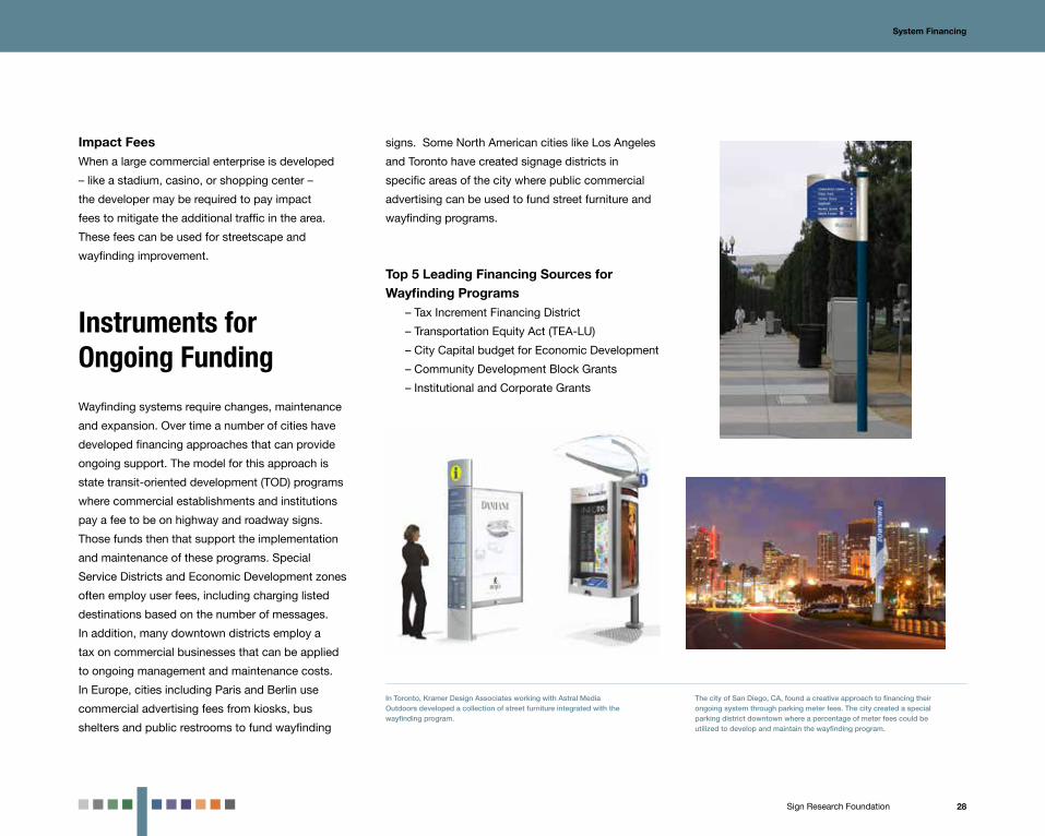
Impact FeesWhen a large commercial enterprise is developed
– like a stadium, casino, or shopping center –
the developer may be required to pay impact
fees to mitigate the additional traffic in the area.
These fees can be used for streetscape and
wayfinding improvement.
Instruments for Ongoing Funding
Wayfinding systems require changes, maintenance
and expansion. Over time a number of cities have
developed financing approaches that can provide
ongoing support. The model for this approach is
state transit-oriented development (TOD) programs
where commercial establishments and institutions
pay a fee to be on highway and roadway signs.
Those funds then that support the implementation
and maintenance of these programs. Special
Service Districts and Economic Development zones
often employ user fees, including charging listed
destinations based on the number of messages.
In addition, many downtown districts employ a
tax on commercial businesses that can be applied
to ongoing management and maintenance costs.
In Europe, cities including Paris and Berlin use
commercial advertising fees from kiosks, bus
shelters and public restrooms to fund wayfinding
System Financing
signs. Some North American cities like Los Angeles
and Toronto have created signage districts in
specific areas of the city where public commercial
advertising can be used to fund street furniture and
wayfinding programs.
Top 5 Leading Financing Sources for Wayfinding Programs
– Tax Increment Financing District
– Transportation Equity Act (TEA-LU)
– City Capital budget for Economic Development
– Community Development Block Grants
– Institutional and Corporate Grants
The city of San Diego, CA, found a creative approach to financing their ongoing system through parking meter fees. The city created a special parking district downtown where a percentage of meter fees could be utilized to develop and maintain the wayfinding program.
In Toronto, Kramer Design Associates working with Astral Media Outdoors developed a collection of street furniture integrated with the wayfinding program.
29Sign Research Foundation
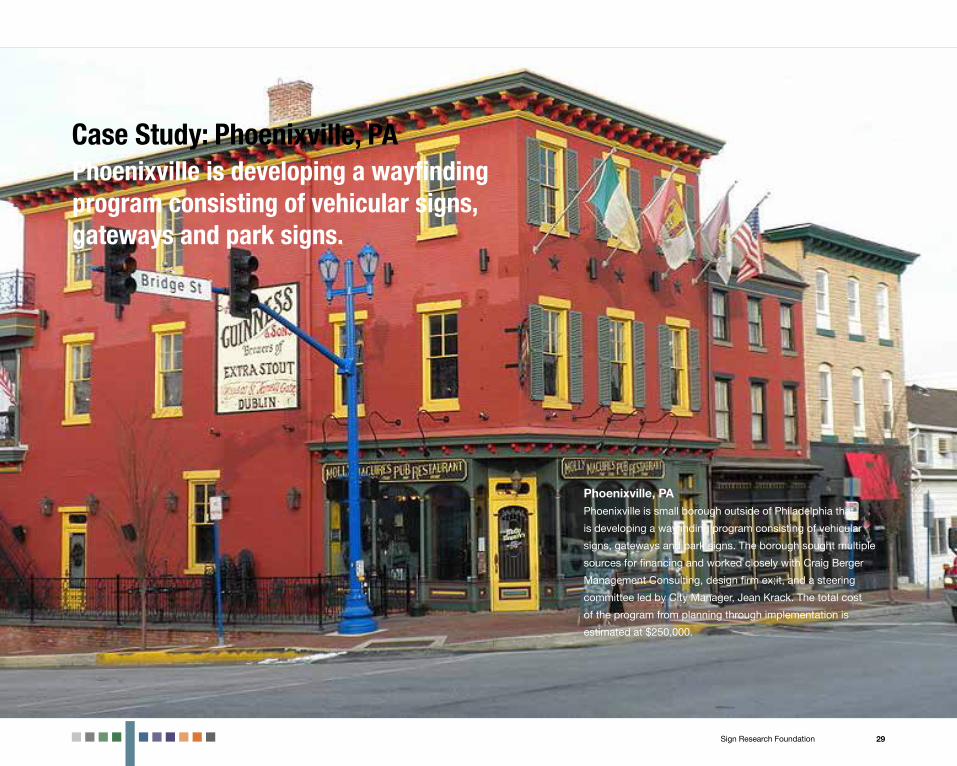
Phoenixville, PAPhoenixville is small borough outside of Philadelphia that
is developing a wayfinding program consisting of vehicular
signs, gateways and park signs. The borough sought multiple
sources for financing and worked closely with Craig Berger
Management Consulting, design firm ex;it, and a steering
committee led by City Manager, Jean Krack. The total cost
of the program from planning through implementation is
estimated at $250,000.
Phoenixville is developing a wayfinding program consisting of vehicular signs, gateways and park signs.
Case Study: Phoenixville, PA

30Sign Research Foundation
System Financing / Case Study: Phoenixville, PA
PlanningThe $16,000 initial planning cost was split between
a grant from the Delaware Valley Regional Planning
Commission and cash and in-kind donations from
the borough.
Conceptual Design and DevelopmentThe design phase was funded with $35,000 from
the Phoenixville Community Health Foundation
and the borough.
Prototype Development, Fabrication and ImplementationFor the park trail signs, $40,000 was raised from the
Schuylkill River Heritage Center, the Natural Lands
Trust and private developers adjoining the trail.
For the gateways and wayfinding signs,
$150,000 was raised through the Chester County
Revitalization Program.
ManagementOngoing management will be provided by the
borough through existing streetscape
maintenance contracts. The money was raised
over the course of 18 months, with the planning
phase used to apply for design funding and
with the concept design used to apply for
implementation funding.
The planning phase helped the borough apply for design and implementation funding.The design development process was also used to solicit funding for implementation.

31Sign Research Foundation
Managing theRegulatory Framework6Over the last 20 years governments have updated codes to
meet the requirements of wayfinding and identity systems.
Managing the Regulatory FrameworkWayfinding systems are designed to be integral parts of public
space, which are highly regulated by local, state and federal
government entities. Over the last 20 years governments have
updated codes to meet the requirements of wayfinding and
identity systems. Still there often are a number of gaps between
the needs of a successful program and the existing regulatory
structure. Developing a regulatory framework is every bit as
important to the success of the project as financing or design. It
creates the environment to make a project possible and effective.
Since commercial on-premise identity and wayfinding signs
are important to the overall community brand, this chapter will
review the regulatory hurdles found in both public or institutionally
managed wayfinding systems and private on-premise signs with
an impact on the urban environment.

32Sign Research Foundation
100
Cum
ulat
ive
Perc
ent (
%)
Luminance (cd/m²)
LI = 20 ft/in
LI = 40 ft/in
LI = 30 ft/in
b. Street Name Sign
90
80
70
60
50
40
30
20
10
00.1 1 10 100
Managing the Regulatory Framework
The Disconnect Between Best Practices and Regulations
A number of regulatory roadblocks stand in the
way of developing wayfinding systems that reflect a
mismatch between best practices defined by
research, history, precedent and regulations. Most
of the key regulatory issues and conflicts can be
summed up in two statements:
Codes Require Wayfinding Elements to be Too Big or Too Separated from the EnvironmentThe entities that govern wayfinding signs focus on
the safety of the motorist, though interestingly, not
the pedestrian. These entities tend to focus more
heavily on roads with a higher speed limit. Their
concerns may be legitimate for high speed roads,
but often create a regulatory mismatch between
low-speed pedestrian-oriented urban streets and
large-scale highway environments.
Codes Require Commercial and Gateway Signs to be Too Small and DimOn the flip side are zoning codes for shopping
and commercial centers that require signs to be
too small and less legible. Since commercial signs
are an important complement to urban programs,
particularly for larger shopping and entertainment
centers, this in fact leads to legibility issues for
finding destinations.
For a regulatory framework to be successful,
this mismatch must be approached in a way that
improves the entire environment. In the case of a
single or small group of signs, this often means
seeking a variance or legal exception based on
unique circumstances. An entire wayfinding
program requires developing sign codes and
guidelines based on sound research and an
honest analysis of the specific urban conditions.
The new FHWA Manual on Uniform Traffic Control Devices (MUTCD) has a section dedicated to community signs. This has alleviated many of the issues between signs designed for highways and those designed for urban areas, but still requires successful interpretation by local department of transportation officials who administer the guidelines.
The International Sign Association has developed extensive research reports detailing the importance of legible signs for both commercial success and safety. These reports have been used to seek variances, but even more importantly, to impact code reforms.

33Sign Research Foundation
Managing the Regulatory Framework
Most of the public believes that codes and policies
are determined by research and precedent. But
this often isn’t the case. Committees may use
very little underlying research to make decisions
and may be influenced by advocacy. Legitimate
research has led to great successes in improving the
environment including reforming the FHWA Manual
on Uniform Traffic Control Devices (MUTCD) and
the development of more legible model codes from
communities. While original research can be time
consuming and costly, simpler approaches may lead
to the same results. Existing research combined with
examples from successful wayfinding programs may
be used.
The development of Clearview, PA, by Donald Meeker included research by the Pennsylvania Transportation Institute that showed that the new typeface was more effective than those currently used on highways. This resulted in the eventual transition to Clearview for new highway signs in addition to other reforms including the use of upper and lower case letters.
Using Research to Make the Case
The unfortunate tendency of sign codes is to create
blanket solutions whether the signs are in urban,
rural or suburban areas. When codes are not
appropriate for specific conditions on the ground,
the resulting signage is unlikely to meet the needs of
the community.
Best practices from similar environments offers a
successful approach to developing regulatory
codes. Best practices may be obtained through
organizations like the International Sign Association
(ISA) or through observations based on sign
codes of desired environments. This may help
establish a code structure that most closely fits the
environment. In addition, case studies of successful
systems like those profiled in this manual can be
used to develop a successful regulatory framework.
Developing Regulations for Different Urban Environments
34Sign Research Foundation
When negotiating with code officials, success
is more likely if the discussion is framed around
a respect for the current code structure. This
conversation should involve developing a strategy
based on strong knowledge of existing codes,
careful consideration of which codes need to be
changed or re-interpreted and an approach that
seeks reform for all future projects instead of carving
out small exceptions. A respectful approach usually
achieves a better chance of success than using
political pressure or seeking one-time gains.
In contrast, seeking one-time only variances based
on quasi-judicial advocacy can often backfire when
developing larger guidelines and systems. Variances,
unless they are due to unique circumstances,
often undermine the validity of the code and make it
more difficult to expand programs over time.
Framing Perceptions
Managing the Regulatory Framework
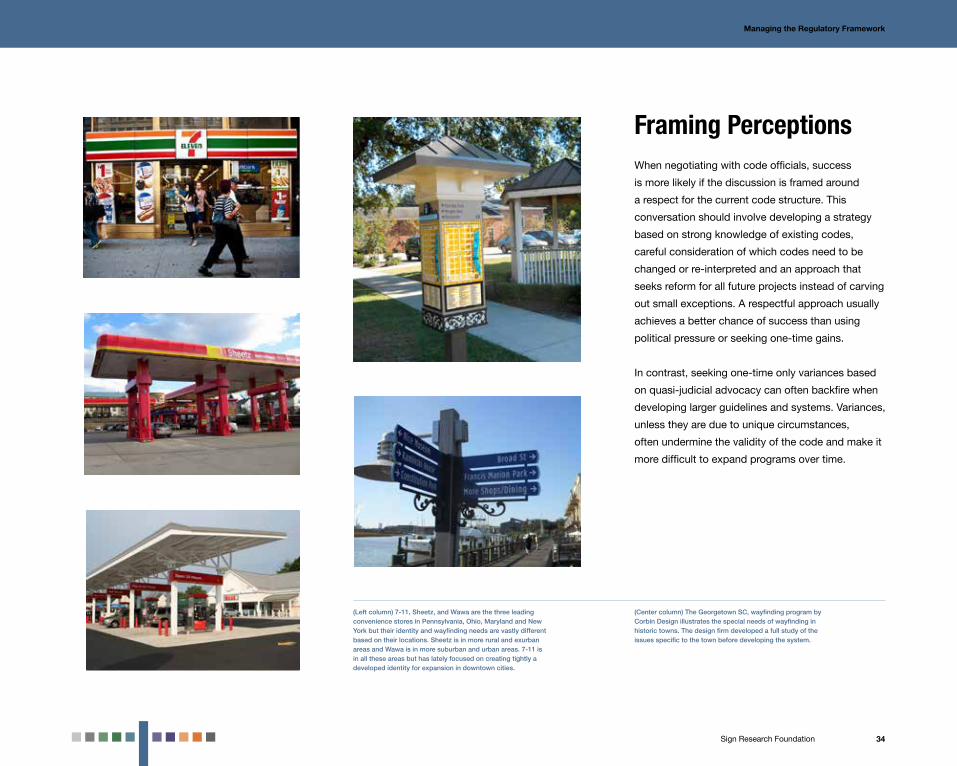
(Center column) The Georgetown SC, wayfinding program by Corbin Design illustrates the special needs of wayfinding in historic towns. The design firm developed a full study of the issues specific to the town before developing the system.
(Left column) 7-11, Sheetz, and Wawa are the three leading convenience stores in Pennsylvania, Ohio, Maryland and New York but their identity and wayfinding needs are vastly different based on their locations. Sheetz is in more rural and exurban areas and Wawa is in more suburban and urban areas. 7-11 is in all these areas but has lately focused on creating tightly a developed identity for expansion in downtown cities.

35Sign Research Foundation
Miami Beach, FLThe gateway and wayfinding program for the city began in
2001 with design development beginning in 2003. The program
became a model for development of a regulatory approval
process that allowed further development of programs in
Florida and other states. The design firm MERJE, working
with a stakeholder group led by the City of Miami Beach,
established the regulatory structure.
The gateway and wayfinding program for the city became a model for development of a regulatory approval.
Case Study: Miami Beach, FL

36Sign Research Foundation
Managing the Regulatory Framework / Case Study: Miami Beach, FL
Regulatory GuidelinesA key part of the early project was the development
of design guidelines that focused on addressing
specific code issues that would be reviewed by the
Department of Transportation. These standards for
sign size, messaging, color and type allowed the
project team to develop a strategy on which codes
needed to be followed strictly, where leeway was
allowed and what restrictions had to be changed.
ResearchWhile the project team was successful in getting
approval for all their design guidelines, one area
needed additional research, the approval of a non-
MUTCD compliant typography, Futura. To have
Futura approved, MERJE worked closely with the
Larsen Institute at Penn State to develop a research
process that showed that Futura was more legible
than highway Gothic, the standard for font approval.
Framing PerceptionThe early and pro-active approach of the city and
design team to involve local and state officials, as
well as a strong knowledge of existing codes, was
just as important as the development of guidelines
and research. This created an atmosphere where
there was clear respect for existing precedent while
understanding the need to make changes for a
successfully designed system.
*The research report for typeface testing is in the resource section of Chapter 5.
Mapping out regulatory guidelines made for a clear and transparent strategy to be developed.
The successful field research program for Futura.Final Miami Beach wayfinding sign.
37Sign Research Foundation
Managing theDesign Process7Even the simplest wayfinding system is
a complex undertaking.
Planning and Design ProcessEven the simplest wayfinding system is a complex
undertaking. The planning and design phase often can
take up to two years. Additionally, no matter the size of the
municipality, whether a small town or major metropolitan
area, a complex and bureaucratic approval process can
slow things down.

38Sign Research Foundation
Managing the Design Process
Pre-PlanningDesign BriefBefore hiring planners and designers it is important
to develop a brief that outlines the key mission, goal
and scope of the potential project. The design brief
also provides an approach for selecting designers
and planners as well as provide a scope for the
entire project. Chapters 2-6 lay out most of the key
issues, considerations and content required as part
of the design brief, including:
Mission Statement: This statement lays out the
rationale and goals for a project. (See chapter 2 for
approaches to the development of specific goals
for systems.)
Potential Design Elements: A list of design elements
being considered. (See chapter 3 for a description
of design elements that can be included.)
Stakeholders: This requires identifying key focus
groups that provide feedback at all phases of the
project including steering and management
committees. (See chapter 4 for a description of
stakeholder groups)
Confirmation of Scope Area and Definition of
Preliminary Destinations: This identifies key
destinations included in the project as well as
the overall area. This approach should include a
preliminary hierarchy based on the type of design
The town of Chamblee, GA, wanted to utilize an extensive wayfinding and identity program to advance the image of the city as a place for innovation. The detailed design brief allowed for the hiring of a design firm, Sky Design, as well as detailed process for development, financing and implementation.
elements being developed and can include:
Areas including a geographic region, an entire city,
a neighborhood, campus or corridors;
Arrival mode including vehicular, pedestrian or
public transportation; and
Functions including primary/secondary/tertiary
visitor destinations (by visitation), amenities, retail/
commercial, trails or parking.
Regulatory Issues: A list of key regulatory issues and
the government entities required for approval.
(See chapter 6 for a description of key regulatory
issues.)
Financing and Implementation Plan:
A framework for completing the design and
fabrication process around financing. The financing
plan will also help define a set of scenarios for
how the design and development process will be
developed and phased over time (See chapter 5 for
a full review of system financing).
Combined Planning and Design: The same design
and planning team is hired to develop the entire
approach at one time.
Separated Planning and Design: A project plan and
concept is developed that is used as the basis of a
separate design agreement.
Design/Build: The design team is paired with a
fabrication team either through the prototype stage
or the complete project.
Management Contract: One team is included
to develop the system, manage fabrication and
maintain the system.

39Sign Research Foundation
Managing the Design Process
Planning The project team refines the scope and strategic
approach to the project. This part of the process can
also result in preliminary design descriptions and
recommendations. This stage can be developed as
part of a larger design process or as a stand-alone
project that will inform a larger design project or a
number of design projects. The planning process
consists of the following elements:
Research Process: This phase may include reviewing
of best practices from existing projects; analyzing
pedestrian and vehicular circulation routes; surveys
of field conditions and analysis of existing sign
messaging protocols. The research process can also
include visitor, resident and stakeholder surveys, as
well as focus groups.
Strategy and Management Approach: A series of
recommendations for the design, implementation
and management of the program. The strategy
stage also offers the opportunity to rethink ideas
established during the pre-planning stage including
the role of stakeholders, the financing plan and even
the original goals of the project.
Preliminary Design Concept Report: This report
should articulate design elements through
descriptions or best practices. It also should
include the initial structure of the program, such
as a draft destination hierarchy (with criteria for
The planning process required for a system sometimes is far more extensive than the actual development of the project elements. In the Laurel Highlands, PA, regional system (planned by Gannett Fleming) and the Schuylkill River Pennsylvania marker system (planned by Cloud Gehshan Associates) complex planning was needed for the small number of actual signs being used.
destination selection), preliminary routes and
sample locations. This step should be initialized
during the end of the planning stage or the
beginning of the design process.
DesignThe design phase is usually a two-part process:
schematic or concept design and design
development. This approach allows greater ability to
manage the design, stakeholder review and approval
processes, as well as ensuring buy-in to a chosen
concept at strategically defined benchmarks.
The two-part process is advisable for large urban
areas or complex wayfinding program with multiple
stakeholder groups.
The process can be combined in some
circumstances in small communities where budgets
and/or timeframes are restrictive and the wayfinding
system is simple.
Schematic or Concept Design: A preliminary design
is developed by referencing feedback from the
survey and analysis in the strategy phase. Single
or multiple design concepts are developed for
stakeholder input including placement of elements,
magnitude of the final built product, budgeting,
material selection and design standards. Developing
a design concept also provides stakeholders with
the opportunity to revisit goals established in the
strategy phase.
Design Development: Schematic or conceptual
design elements evolve into a fully realized design.
Typography, colors, materials and attachments
are developed in more specific detail, based on
40Sign Research Foundation
Managing the Design Process
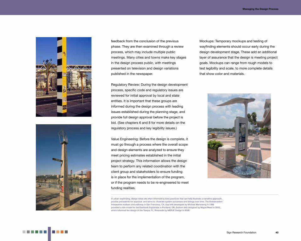
In urban wayfinding, design ideas are often informed by best practices that can help illustrate a narrative approach, provide precedents for approval and serve to illustrate system successes and failings over time. The Embarcadero Interpretive markers and walkway in San Francisco, CA, (top left) developed by Michael Manwaring in 1996 provided a role model for the Eastbank Esplanade in Portland, OR, (bottom left) designed by Mayer/Reed in 2002, which informed the design of the Tampa, FL, Riverwalk by MERJE Design in 2008.
feedback from the conclusion of the previous
phase. They are then examined through a review
process, which may include multiple public
meetings. Many cities and towns make key stages
in the design process public, with meetings
presented on television and design variations
published in the newspaper.
Regulatory Review: During the design development
process, specific code and regulatory issues are
reviewed for initial approval by local and state
entities. It is important that these groups are
informed during the design process with leading
issues established during the planning stage, and
provide full design approval before the project is
bid. (See chapters 6 and 8 for more details on the
regulatory process and key legibility issues.)
Value Engineering: Before the design is complete, it
must go through a process where the overall scope
and design elements are analyzed to ensure they
meet pricing estimates established in the initial
project strategy. This information allows the design
team to perform any related coordination with the
client group and stakeholders to ensure funding
is in place for the implementation of the program,
or if the program needs to be re-engineered to meet
funding realities.
Mockups: Temporary mockups and testing of
wayfinding elements should occur early during the
design development stage. These add an additional
layer of assurance that the design is meeting project
goals. Mockups can range from rough models to
test legibility and scale, to more complete details
that show color and materials.

41Sign Research Foundation
Managing the Design Process
Fabrication With all the plans approved, the wayfinding elements
can be constructed. This can prove to be the most
challenging and stressful element of the project. All
the planning and design work must be translated
The town of Banff and Banff National Park in Alberta designed by the Entro | G+A shows how a prototype exploration and rollout plan can produce a successful implementation of complex signs, landmarks and banners.
into a program that can be built, installed and
maintained. Civic projects also have many rules for
fabricator selection, complicating the documentation
and administration at this stage. These are the
important areas that define this stage in the process.
Bid Documentation: With final approval, all
documents should be prepared for a public or
negotiated bid. The level of documentation should
be developed to match the bidding process. Publicly
bid projects require exact specifications to ensure
that proposals are as closely aligned as possible.
Negotiated projects can include more general
specifications where the fabricator could propose
alternative solutions and approaches.
Prototypes and Rollout Administration: For any large
scale wayfinding system with multiple elements,
a prototype stage must be included as part of the
overall bidding process. This involves fabricating
a single wayfinding element, which can inform the
final review. This is especially necessary for public
bids in which the lowest bidder will be selected. A
prototype can ensure that fabricators and entities
awarding the bid understand the project. Prototypes
can be developed by a single fabricator and used
as a bidding tool or be required by all fabricators
submitting a bid.
Final Plan: The stakeholder steering committee
should review all documentation to make sure it is
ready to be submitted for approvals. This includes:
Formal destination hierarchy and criteria for
destination selection;
Route and circulation plans;
All designed wayfinding elements;
Specifications for all materials, technologies and
construction processes;
Specific location plan(s) of all elements; and
Message schedules.
Final Approval: This concludes the planning and
design processes, with a final review of route
plans, message schedules and design elements. A
separate survey and review should be conducted
with the stakeholder steering committee, city leaders
identified in the early planning stages and local and
state code officials.
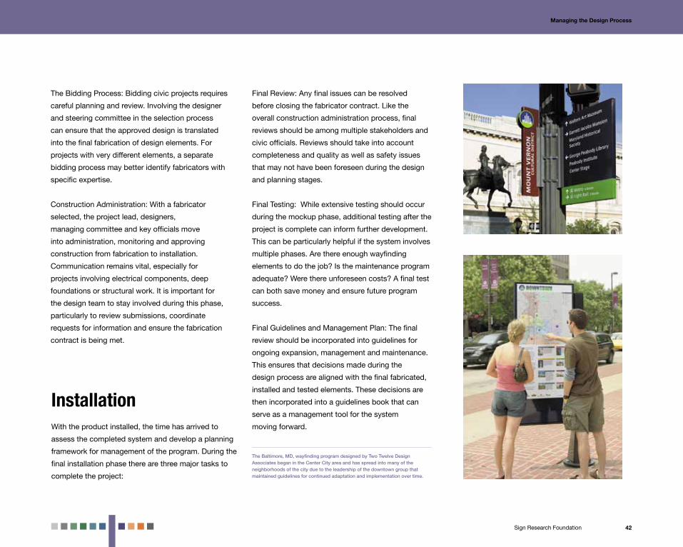
42Sign Research Foundation
Managing the Design Process
With the product installed, the time has arrived to
assess the completed system and develop a planning
framework for management of the program. During the
final installation phase there are three major tasks to
complete the project:
The Baltimore, MD, wayfinding program designed by Two Twelve Design Associates began in the Center City area and has spread into many of the neighborhoods of the city due to the leadership of the downtown group that maintained guidelines for continued adaptation and implementation over time.
Final Review: Any final issues can be resolved
before closing the fabricator contract. Like the
overall construction administration process, final
reviews should be among multiple stakeholders and
civic officials. Reviews should take into account
completeness and quality as well as safety issues
that may not have been foreseen during the design
and planning stages.
Final Testing: While extensive testing should occur
during the mockup phase, additional testing after the
project is complete can inform further development.
This can be particularly helpful if the system involves
multiple phases. Are there enough wayfinding
elements to do the job? Is the maintenance program
adequate? Were there unforeseen costs? A final test
can both save money and ensure future program
success.
Final Guidelines and Management Plan: The final
review should be incorporated into guidelines for
ongoing expansion, management and maintenance.
This ensures that decisions made during the
design process are aligned with the final fabricated,
installed and tested elements. These decisions are
then incorporated into a guidelines book that can
serve as a management tool for the system
moving forward.
The Bidding Process: Bidding civic projects requires
careful planning and review. Involving the designer
and steering committee in the selection process
can ensure that the approved design is translated
into the final fabrication of design elements. For
projects with very different elements, a separate
bidding process may better identify fabricators with
specific expertise.
Construction Administration: With a fabricator
selected, the project lead, designers,
managing committee and key officials move
into administration, monitoring and approving
construction from fabrication to installation.
Communication remains vital, especially for
projects involving electrical components, deep
foundations or structural work. It is important for
the design team to stay involved during this phase,
particularly to review submissions, coordinate
requests for information and ensure the fabrication
contract is being met.
Installation

43Sign Research Foundation
Los Angeles, CAThe LA Walks offers one of the largest and most complex
wayfinding systems in the United States. The project was
developed by a coalition of nine Business Improvement
Districts (BIDs), with a goal of making downtown easier to
navigate for pedestrians and motorists.
The LA Walks offers one of the largest and most complex wayfinding systems in the United States.
Case Study: Los Angeles, CA

44Sign Research Foundation
Managing the Design Process / Case Study: Los Angeles, CA
PlanningThe planning and design team was a partnership
between Hunt Design and Corbin Design. This
group was led by Urban Place Consulting, who
managed funding, overall planning and installation.
Early analysis showed that there was a need for
13 total districts in the downtown to include well-
known destinations like Bunker Hill and the Jewelry
District. Based on an early goal to develop a system
oriented to pedestrians and public transportation,
the wayfinding approach also included directing
motorists to garages and pointing pedestrians to
destinations with directional signs and maps.
DesignThe system was developed around unique symbols
with colors and messaging that allows for easy
differentiation on maps and directional signs.
These symbols are effectively used on rolling maps
that provide a key view of downtown and more
specific information for a four–block area. Additional
directional message signs support the map.
ApprovalsA close negotiation with the California DOT took
more than two years and resulted in modifications to
the existing system, including changes in color and
text height to conform to California’s interpretation of
the Manual of Uniform Traffic Control Devices.
Pedestrian Signs.Vehicular Wayfinding Sign.
Key and Rolling Map.
ImplementationThe fabricator, Fluoresco, worked with the project
lead and designers to develop a program that would
withstand the intense urban environment. Sturdy
materials, such as embedded fiberglass, were used.
The final project, which was implemented over three
months, cost $2 million.

45Sign Research Foundation
Design Issues8Every planner or city official starts a project with one clear goal: To develop a quality program that fits the unique needs of the community.
Design IssuesEvery planner or city official starts a project with one clear
goal: To develop a quality program that fits the unique
needs of the community. How that goal translates into
specific decisions produces innumerable issues that should
be explored before starting the planning process.

46Sign Research Foundation
Design issues
Development in Stages or All at Once?There is often a great deal of pressure to complete
a wayfinding program in one project. While this
approach has much to benefit it, particularly in
smaller communities and downtown areas, there
are a number of positive reasons to stage projects,
either by community or by wayfinding element.
Developing a program in one area allows for greater
testing of the system, as well as a trial run for the
approval, fabrication and implementation process.
Developing individual segments of a system as
stand-alone projects may benefit the overall design,
particularly with elements that incorporate unique
technologies and methodologies. This also allows
for a fabricator selection process that best fits the
specific skill sets for the project, while maintaining
consistency across the system.
Regional sign projects like the Yadkin Valley, NC, wayfinding program by MERJE Design provide a toolkit that can be implemented in stages. The map support and web site developed for the program serves as a tool for understanding the entire area while physical elements are installed.
6'-0"
SCALE: 3/8" = 1'-0"
7'-6"
9'-0"
10'-6"
12'-0"
13'-6"
15'-0"
COUNTY GATEWAY SIGNSEntering County Between County
Wayfinding and Signage Program - Yadkin Valley, NCDesign Development | OCTOBER 24, 2011C o u n t y G a t e w a y s - N C D O T R O A D W AY S
WELCOME TO
CALDWELLCOUNTY
WELCOME TO
CALDWELLCOUNTY
WELCOME TO
SURRYCOUNTY
WELCOME TO
WILKESCOUNTY
WELCOME TO
YADKINCOUNTY
3'-6"
5"
7 3/4"
6'-1/2"
1'-9"
5"
1'-3"
Breakaway and sign supports to follow MUTCD for Highway .
Sign to Follow: North Carolina Department of Transportation, Division of HighwaysTra�c Engineering and Safety Systems Branch STANDARD PRACTICE for Optional “Welcome To” Signs
Entering the YADKIN VALLEY
Entering the YADKIN VALLEY
Entering the YADKIN VALLEY
YADKIN VALLEY
Entering the YADKIN VALLEY
Things to Do
What’s Nearby
Social Media
My Favorites
Visit Our Web Home
Update My Location(GPS enabled phones only)
search
Hover or tap state: increase black to 30 for new pantone swatch for selected category.
search bar
tap/hover state
Agritourism
Historical and Cultural
Outdoors and Recreation
Scenic Byways
Wineries
Visitors Centers
Home > Things To Do
Hover/tap state after user selects wineries. Color modification: black 75. Icon appears on tap event for the given category.
tap/hover state
category iconlogo still remains in same location
search
Splash screen enters and disappears upon opening the application.
Allison Oaks Vineyard
221 East Main StreetYadkinville, North Carolina 27055
www.allisonoaksvineyards.com
Add To FavoritesMake This My Location
Nearby Here
no details are available
Home > Things To Do > Wineries> Allison Oaks Vineyard
After selecting choice among wineries, the user can now see one whole screen dedicated to a particular winery, in this case Allison Oaks Vineyard. Color palette is inclusive to that of category (wineries).
search
Planning

47Sign Research Foundation
Top: The Brandywine Valley, PA, system has few cues that link it to a place but the simplicity and utility of the program has allowed it to stay highly effective and relevant for over 30 years.Bottom: The Houston, TX, wayfinding system designed by Gensler contained enough unique design elements that it was able to easily adapt to a change in one key branded element that impacted the entire system.
The Uptown Normal, IL, wayfinding and identity program by Cardosi Kiper shows the success of an integrative approach to wayfinding with branding, by focusing the program on the business district, with simple graphics, clearly linked to more universal wayfinding issues.
Design issues
Should programs be fully integrated into one system or include unique freestanding elements? Many wayfinding projects are designed to fit into
one fully integrated system, where everything from
gateways, to streetscape elements, to the internet all
share similar graphics, typography and format. This
approach has become particularly popular with the
rise of Special Service Districts which focus both on
branding themselves and the community they are in.
This level of branding can create issues over time.
Communities like companies, go through periodic
rebranding, which impacts the very expensive and
permanent wayfinding project elements. Many
communities acknowledge this by designing some
parts of the system for constant change (maps and
pedestrian directories), and other parts to remain
permanent (vehicular wayfinding signs and gateways).
Communities also should be wary about designing
for changes that occur over the life of the system.
Cities and towns that are undergoing rapid
expansion should consider avoiding the use of
design elements that require constant change unless
they are designed for that change.
Identity

48Sign Research Foundation
The Fashion Institute for Technology in New York, NY, has a program for developing window displays and public exhibition as an anchor for its public urban space.
The Woodward Avenue Tributes in Detroit, MI, by Calori & Vanden-Eynden utilize a combination of scale, shape and light to cast a large presence as a landmark in the community.
Design issues
Are signs the best option for a wayfinding system?Whenever wayfinding projects are discussed, the
first thought goes to directional signs. For many
communities though, these are not always the best
option. Some towns are small enough where most
of the major vehicular destinations are in one small
area, while others require only pedestrian or parking
access. Even for identity programs, a sign may not
prove as effective as banners, window displays
or landmarks. The key is to view the needs of the
community with an open mind, before committing to
specific system approach.
Where should scale and legibility truly matter?To departments of transportation, the main legibility
issues that matter are size and contrast for vehicular
signs. For many communities, the key issue is
finding the right size design for the unique needs of
a place. Testing for scale should not just be part of
the approval process, but also should be a key test
for the effectiveness of wayfinding elements in the
environment. Testing for proper scale through the use
of photo montages and mockups are an important
part of the design development process, and should
be utilized even during the early concept stages.
Design Legibility

49Sign Research Foundation
Mixed use retail like the Americana in Glendale, CA, by Romero Thorsen, uses innovative lighting solutions for gateways, identity and wayfinding. LED sign technology developed by companies like Bitro, Element Labs and Traxxon, has merged lighting and digital technology creating a hybrid that is revolutionizing urban signs.
The Millennium Fountain in Chicago, IL, designed by Juame Plensa with the Barnycz Group, was a trend setter for highly interactive digital public art and placemaking.
Design issues
Design for today or tomorrow?Wayfinding projects withstand a great deal of
wear and tear including pollution, vandalism and
ultraviolet light which require durable materials. At
the same time wayfinding elements may become
obsolete due to style or system changes. When
developing a wayfinding program, measuring
longevity should be an important part of the material
specification process.
How should cities approach digital and lighting technology?
Digital technology including billboards, public art,
facades and wayfinding, has grown increasingly
common in cities and towns over the last few years
as technology has dropped in price and become
more accessible.
Approaches like the use of advanced lighting
through projection and LED lighting also can play an
effective role in enhancing community identity. These
systems can provide many of the advantages of a
digital system including change and movement at a
lower price, and also is more durable over time. That
being said, the cost of implementing and managing
a digital system is still typically more costly than a
static system.
Materials and Technology

50Sign Research Foundation
Rockville Town Center, MDThe Rockville Town Center is among the leading
examples of a public/private partnership for the
development of a new mixed-use transit-oriented
development. Centered on the Rockville Town Square
mixed use project, the Town Center contains a number
of innovative wayfinding system approaches.
The Town Center contains a number of innovative wayfinding system approaches.
Case Study: Rockville Town Center, MD

51Sign Research Foundation
Design Issues / Case Study: Rockville Town Center, MD
Planning InnovationWayfinding elements including signs, gateways,
street furniture, public places and directories were
part of the planning process from the beginning of
the site development process. This allowed these
elements to be part of larger streetscape projects,
which allowed for faster development due to early
financing and pre-existing stakeholder groups.
Design InnovationBecause more than 70% of the project was
developed through private funding, the level of
integration of design elements with the streetscape,
commercial buildings and parking facilities made
for both a highly complementary design (by Selbert
Perkins Design), and a mix of unique fountains and
public spaces.
Ongoing DevelopmentThe Town Center plan is meant to be developed
over decades. In recent years, a library, innovation
center and apartment homes have been added. A
series of guidelines including wayfinding as part of
the larger urban design has maintained the
cohesion of the project.
A full review of the project can be found at:
http://www.terrain.org/unsprawl/27/
Building attached parking sign.Gateway and directional sign.
A fountain/light show anchors the Rockville Town Square.Streets signs developed as part of a cohesive wayfinding program.

52Sign Research Foundation
System Management9A wayfinding program is meant
to last for a long period of time, sometimes as long as 20 years.
System ManagementA wayfinding program is meant to last for a long period
of time, sometimes as long as 20 years, so it can’t
be considered “complete” after implementation. In
addition, the environment changes over time, requiring
a wayfinding program to be developed to consider
expansion, destination change, design improvements
and system damage.

53Sign Research Foundation
Material selection plays a crucial role in system
durability. Research on existing wayfinding programs
has shown that a wide range of environmental factors
from pollution, to ultraviolet light, to vandalism can
shorten the life of a wayfinding program to a much
greater degree than originally thought. The key to
wayfinding program longevity is to specify materials
and methodologies based on an intended lifespan
that can range from 1 to 20 years. Material selection
generally falls into these broad areas:
Paints and Coating: These items generally have
the most visual manifestation of wear over time.
Technology has extended longevity greatly in the last
few years, but it is important not to underestimate
the environment’s impact on fading. In addition
frequent cleaning and changes can compromise
painted elements.
Printing: Like paint, digital printing has improved
greatly in durability. Where at one time it was thought
that only baked printing processes like porcelain
could withstand environmental rigors now a variety of
printing approaches from printing on high pressure
System Management
Banners are often the most popular urban identity programs and the ones where durability over time plays a significant role. Banners can be developed to last a week or a decade and use materials ranging from cloth and vinyl, to steel.
The Norcross, GA, wayfinding program by Sky Design utilizes stone and metal frames in the construction of program elements.
Materials Selection and System Durability

54Sign Research Foundation
System Management
laminate to vinyl combined with weather resistant
coating can stay durable over long periods of time.
Like paint, printed materials fade under intense
environmental conditions.
Substrates and Framing: Aluminum, steel, wood,
stone and concrete are all underlying materials that
can be utilized on projects. Durability falls not just
with the materials themselves but also their
connectors which often fail first. Adhesives in
particular often fail after a few years, making the
selection of mechanical fasteners and hinges crucial
to the specification process.
Modular Systems: Modular elements including
prefabricated boxes, removable messages, and
standard connectors allow systems to stay durable
with frequent changes, but with multiple parts, can
be easier to vandalize.
The Dallas, TX, Design District by FocusEGD utilized steel I-beams and cut metal to stand up to harsh weather conditions and present an industrial image for the district.

55Sign Research Foundation
System Management
The city of Alexandria, VA, recently completed a large scale vehicular and pedestrian wayfinding program designed by Sasaki Associates and led by the city planning commission. The city handed responsibility of sign maintenance and management to the State Department of Transportation and Environmental Services which manages cleaning and replacement of damaged signs. The State Department of Parks and Recreation manages the extensive landscaping around gateways. The key to successful system management has been guidelines that are made transparent to the public and outline the roles of all groups involved.
Managing the SystemDeveloping a durable wayfinding system is only half
the battle. In addition, wayfinding programs must
be managed. There are three key management areas
that communities should consider:
Maintenance: From regular cleaning to repairs to
replacement, maintenance is an ongoing issue that
never goes away throughout the life of the program.
Maintenance includes periodic cleaning as well as
replacement of damaged elements.
Change: Managing the addition or subtraction of
destinations as well as expansion into new areas.
Removal: Managing the streetscape environment
including the removal of unauthorized signs and
obsolete elements.
Finding groups that can consistently maintain and
manage wayfinding programs is difficult. Costs can
often range from 7-15% of total capital expenditures
on a yearly basis, and people must be found that
can dedicate their time to ongoing management.
While larger cities have been leaving this task up
to special services districts, smaller cities and
communities often must rely both on city managers
and contracts with private companies. When it
comes to wayfinding management clear guidelines
are crucial to ongoing success. Many successful
programs post their guidelines in public places to
ensure that the public understands which entities are
responsible for program management.

56Sign Research Foundation
System Management
Commarts (now Stantec) developed the wayfinding program for Uptown Houston, TX, with the understanding that the program would need to require minimal maintenance and few changes. The design includes large scale landmarks that are out of reach of most visitors and require few moving parts.
MaintenanceMaintaining programs over time requires a great
deal of diligence, as well as an understanding that
maintenance should be incorporated into planning
and design process, to ensure effective program
maintenance when the program is implemented.
Maintenance issues include the following areas:
Material Selection and Design: A wayfinding
program should be designed to reflect the intended
maintenance program as well as environmental
hazards. For example, a wayfinding element that
receives minimal maintenance should have few
removable connections, while wayfinding elements
that require ongoing management should be easy
to open and take apart. In addition lighting and
dynamic technologies should only be utilized on
elements that will have extensive maintenance
programs.
Designing a Program Around Needs: Wayfinding
program management should be developed to
respond to specific environmental hazards. Urban
systems usually need extensive graffiti cleaning
and sticker removal programs, while programs in
industrial areas may require frequent replacement
from collisions with vehicles. Usually it is a good
idea to consult municipalities with similar systems to
get an idea of maintenance needs and challenges.
Change: The number of changes in a wayfinding
program has a major impact in how the elements
should be both designed and maintained. If changes
are frequent design elements should be modular,
contain a ready supply of replacement materials and
be easy to access. In contrast, a wayfinding program
that rarely changes can be designed to be tamper
proof and utilize more unique designs
Special Services Districts and Business Improvement Districts have taken the lead role in most communities for managing wayfinding programs, with extensive tools for ongoing streetscape management that are often outside the means of municipalities. The King of Prussia, PA, Business Improvement District manages the gateway, identity and landscape programs for an area that overlaps multiple municipalities.

57Sign Research Foundation
Vancouver, BCVancouver enhanced all street furniture for the city, including
bus shelters, maps, kiosks and newspaper boxes in a
project coordinated by the city’s TransLink, which manages
all public transportation services. Kramer Design Associates
and the IBI Group crafted a plan to design the system
and build upon an existing streetscape program currently
managed by JCDecaux.
Vancouver enhanced all street furniture for the city, including bus shelters, maps, kiosks and newspaper boxes.
Case Study: Vancouver, BC

58Sign Research Foundation
System Management / Case Study: Vancouver, BC
Materials and MethodologiesA design analysis explored the environmental
hazards of the existing system and compared
Vancouver’s streetscape to similar systems in North
America. The review recommended that the street
furniture use interchangeable parts across the entire
system and incorporate predominantly aluminum
extrusions and connectors to withstand the moist
environment. In addition, weatherproof frames were
recommended to house changeable elements.
ManagementMultiple sets of guidelines already were developed
for the management program, based on group
responsibilities. The new streetscape furniture
will augment these existing guidelines. A wayfinding
guideline manual was developed to manage system
changes as was a street furniture maintenance
guide. The latter was especially important as
multiple agencies would be responsible for
program management. Guidelines also included
plans for placement of all new street furniture to
maintain a consistent look across the system.
MaintenanceThe street furniture program was designed
to be easy to change and durable for a street
environment in close contact with pedestrians.
Recommendations included encasing advertising
and wayfinding elements in a uniform, modular
frame that would allow for quick changes and
withstand frequent cleaning.
Vancouver, BC, coordinated street furniture program kiosks with solar power screens. Analysis of existing conditions showed a need for extremely durable materials, to withstand the moist climate and stand up to frequent maintenance.
Toronto was used as a model for bus shelter maps and information.

59Sign Research Foundation
10Highlights and Further Readings

60Sign Research Foundation
Highlights and Further Readings
The Case for Wayfinding SystemsChapter 2 Highlights
– Wayfinding Systems enhance the urban
brand by improving the legibility, navigation,
understanding and accessibility of the
environment.
– Wayfinding Systems support the urban brand
by reinforcing the history, architecture and
landmarks that define a place.
– Wayfinding Systems create an organizational
structure for destination hierarchy which
enhances the identification and utilization of
lesser known destinations and districts.
– Wayfinding Systems improves traffic flows,
safety and ease in finding parking and allowing
vehicular traffic to convert to more valuable
pedestrian and transit use.
– Wayfinding Systems reduce visual clutter by
consolidating information in defined standards
which contribute to solidifying a consistent
urban brand identity and character.
Case Study: Legible London
Further ReadingKevin Lynch, The Image of the City
Yellow Book Legible London Research Report
(http://www.tfl.gov.uk/assets/downloads/
businessandpartners/yellow-book.pdf)
Martin Flores, ASLA, and Michael Young,
Wayfinding, the Value in How to Get There
Philip Garvey, Pennsylvania State University
Research Report, Clutter and Wayfinding
Emily Badger for the The Atlantic Cities, The
Surprisingly Complex Art of Urban Wayfinding
Charles R. Taylor, Matthew E. Sarkees, and
Hae-Kyong Bang, Understanding the Value of
On-Premise Signs as Marketing Devices for
Legal and Public Policy Purposes
What Comprises a Wayfinding SystemChapter 3 Highlights
– Wayfinding elements can be viewed as a
series of connected layers based on a user’s
experience in the urban environment.
– Wayfinding elements differ when viewed
through the perspective of vehicular, pedestrian
or identity components.
– Design elements can be linked by destination,
color, typography, logo or material.
Case Study: City of Charlotte, NC
Getting StartedChapter 4 Highlights
– Stakeholder groups should be divided by
responsibility and task.
– Project management and implementation
should be controlled by groups that can manage
both stakeholder participation and specific
program resource needs.
– A specific outreach plan is needed to ensure
that stakeholders allied with the project have
the tools they need to communicate to their
constituency.
– Develop a stakeholder map based on the
wayfinding program development process.
This map should define specific roles as well as
responsibilities of key leaders.
Case Study: Philadelphia, PA
Further ReadingInternational Downtown Association
(www.ida-downtown.org)
Contains multiple articles and approaches on
stakeholder development.
Craig Berger, Wayfinding: Designing and
Implementing Graphic Navigational Systems
Glenn A. Bowen, Community Development:
Journal of the Community Development
Society 2005, Local-level Stakeholder
Collaboration: A Substantive Theory of
Community-driven Development
Alexander Garvin, The Planning Game
Gail Diebler Finke, Identity Magazine, Direction
Philadelphia: A New Direction for Managing
Public Sign Projects

61Sign Research Foundation
Highlights and Further Readings
System FinancingChapter 5 Highlights
– Different funding sources are effective for
different phases of the design, implementation
and management process.
– Special Service Districts and Tax Improvement
Financing Districts can roll system financing into
larger streetscape initiatives.
– Capital funding for sign programs can come
from standalone federal and state grants, or
can be integrated into larger infrastructure and
building programs.
– Cities can fund program implementation
and ongoing management through fees from
destinations, commercials interests, parking and
other user fees.
Case Study: Phoenixville, PA
Further ReadingTransportation Equity Act Web site
(http://www.fhwa.dot.gov/safetealu/summary.htm)
Community Development Block
Grant Program
(http://portal.hud.gov/hudportal/HUD?src=/
program_offices/comm_planning/
communitydevelopment/programs)
Managing the Regulatory FrameworkChapter 6 Highlights
– Understand how codes are developed and the
mismatches between codes and best practices.
– Utilize research to make the case for regulatory
changes.
– Use precedent and best practices to
determine the code framework that fits specific
environments.
– Show respect for the existing regulatory
framework when developing a strategy for
change.
Case Study: Miami Beach, FL
Further ReadingFederal Highway Administration, Manual For
UniformTraffic Control Devices
(http://mutcd.fhwa.dot.gov/)
International Downtown Association Web Site
(www.ida-downtown.org)
International Sign Association and
Sign Research Foundation
(www.signresearch.org)
EMC’s and Traffic Safety
A Framework for On-Premise Sign Regulations
An Evidence-Based Model Sign Code
EMC Night-Time Brightness Recommendations
Research by the Pennsylvania State
University Larson Transportation Institute
led by Phil Garvey and Martin Petrucha
– Legibility of Conventional Road Guide Sign
– Typography and Format
– New Font and Arrow for National Park Service
– Guide Signs
Research by the Pennsylvania State
University Larson Transportation Institute
led by Phil Garvey and sponsored by
the United State Sign Council
(For additional research go to www.ussc.org)
– Sign Legibility, The Impact of color and
Illumination
– Sign Visibility, Effects of Traffic Characteristics
and Mounting Height
– Sign Legibility, Overview and Calculation –
– Methodology, Sign Legibility Index
– On Premise Signs: Determination of Parallel
Sign Legibility and Letter Heights
Trip Gabriel, New York Times, Fuel and Food
Are Quick, but the Fealty Is Forever

62Sign Research Foundation
Highlights and Further Readings
Managing the Design ProcessChapter 7 Highlights
– Before hiring a design or planning firm, create a
fully developed design brief.
– The planning stage should include a possible
re-invention of the initial design concepts.
– Mockups and prototypes should be integrated
into the design review and fabrication bidding
process.
– Complete design guidelines based on final
review and testing.
Case Study: Los Angeles, CA
Further ReadingThe Environmental Graphic Design Awards
web site (www.segd.org)
Contains many best practice examples of urban
wayfinding programs including pictures, credits,
and summaries.
David Gibson, The Wayfinding Handbook
Chris Calori, Signage and Wayfinding Design
Craig Berger, Wayfinding: Designing and
Implementing Graphic Navigation Systems
Andreas Ubele, Signage Systems and
Information Graphics
Reid Ewing and Keith Bartholomew, Pedestrian
and Transit-Oriented Design
System ManagementChapter 8 Highlights
– Before starting a sign program make sure
to educate stakeholders in the key planning,
design, and implementation issues.
– A wayfinding system should be planned and
designed based on longevity decisions made
early in the process.
– Continuous legibility testing should be
integrated into the design process.
– Think beyond signs when developing a
system.
Case Study: Rockville Town Center, MD
Further ReadingPer Mollerup, Wayshowing: A Guide to
Environmental Signage Principles and
Practices
Design IssuesChapter 9 Highlights
– Materials should be selected based on the
intended longevity of the program.
– Development of design guidelines with clear
roles and responsibilities outlined ensures a
more viable management program.
– Future maintenance concerns should impact
the design process.
– Maintenance programs should reflect unique
environmental hazards and the need for change
in the system.
Case Study: Vancouver, BC
Further ReadingCity of Alexandria Wayfinding Program
Guidelines
Direction Philadelphia Program Guidelines

63Sign Research Foundation
11Advisory Council
Project Coordinators
Mike KestiSRF Research Comittee Chairman
Sign Research Foundation
E. Jean KrackBorough Manager
Borough of Phoenixville, PA
Wendy Moeller, AICPPrincipal
Compass Point Planning
Scott MullerSenior Consultant
Poblocki Sign Company
Jonathan PosnettCreative Director
TWO TWELVE
Mark Andreasson President
Design Communications Ltd.
John Bosio Principal
MERJE Design
Grady BrownPresident
iZone Imaging
Jamie CowgillPrincipal
JRC Design
Leslie Gallery DilworthArchitect/Planner/FAIA
Darren FavaSpecial Assistant to the Executive Director
Fairmount Park Commission Office
Anne-Marie GirardSign Specification Manager
Akzo Nobel Coatings, Inc
Wayne Hunt Principal
Hunt Design
Dr. Dawn JourdanAssociate Professor and Director of
Regional and City Planning
University of Oklahoma
Sachin Kalbag Planning, Design, Transportation & Services
Miami Downtown Development Authority
Acknowledgements
Sapna Budev - Project ManagerExecutive Director
Sign Research Foundation /
International Sign Association
Thiago Eichner - Graphic DesignerExhibition and Visual Designer
Craig Berger - Lead ResearcherChair, Visual Presentation and Exhibition Design
Fashion Institute of Technology

64Sign Research Foundation
Acknowledgements
Highland Park Neighborhood Gateway
Designer: Cloud Gehshan Associates
Fabricator: Urban Sign
Gore Valley Regional Wayfinding
Designer: Corbin Design
Port of Los Angeles Wayfinding Sign
Designer: Selbert Perkins Design
Fabricator: AD/S
Hudson River Interpretative Kiosk
Designer: Joel Katz Design Associates
Portland Riverfront combined
Directional/Maps/Identity
Designer: Mayer/Reed
Fabricator: Decorative Metal Services, Windsor
Fireform
San Juan Capistrano Map/Directory
Designer: Hunt Design
Fabricator: Adcon Inc.
Wissahickon Park
Designer: Cloud Gehshan Associates
Fabricator: Capital Sign
Sign Research Foundation would like to thank the
following groups for their support on this research
project.
The International Sign Association for their support
towards research and education on the societal
benefits of signage.
The Society for Environmental Graphic Design
Design Awards and magazine where many urban
best practices were identified.
The advisory council for identifying key projects.
Unless otherwise stated all photos credits are to the
design firms listed.
Chapter 2: The Case for Wayfinding Systems
City of Midland, MI
Designer: Cloud Gehshan Associates
Fabricator: Huron Signs
The BART/MTA Mapping and Wayfinding system
Designer: Studio L’Image
Fabricator: Priority Architectural Graphics
City Of Lancaster, PA
Designer: Sussman/Prejza
Albuquerque, NM, Wayfinding
Design: Jettwalker Inc. with Lance Wyman and
Vaughn Wedeen Creative
Legible London
Design: Applied Information Group
Fabricator: Wood and Woods
Chapter 3: What Comprises a Wayfinding System
Haverson London Borough Gateway
Designer: Jason Bruges Studio
Fabricator: Francis & Lewis International Ltd.
Miami Beach City Gateway
Designer: MERJE Design
Fabricator: Gable Signs
Narberth Borough Bridge Gateway
Designer: VSBA, LLC.
King of Prussia Gateway
Designer: King of Prussia BID with
Craig Berger and Fitch Brands
Fabricator: AGS
Credit List

65Sign Research Foundation
Acknowledgements
Park City, UT, Olympic Park identity and wayfinding
Designer: Infinite Scale
Fabricator: ID Signs
City of Toronto Street Furniture
Designer: Kramer Design Group
Fabricator: Provincial Signs, Transworld Signalex,
Atec Signs, Enseicom, Poitras
World Trade Center
Designer: C&G Partners
Connect 12 building identity, Hong Kong
Designer: Calori & Vanden-Eynden
Fabricator: Gradation Design and Engineering
Mercer County Park Wayfinding Application
Designer: Winfield & Co.
City of Charlotte, NC, Wayfinding Program
Designer: Two Twelve in association with DAWA and
Brinkley Design
Fabricator: Signs Etc.
Photo: Charlotte, NC, directional, highway, and
pedestrian sign photos by Jonathan Posnett.
Chapter 4: Getting Started
Washington, D.C.
Designer: Calori & Vanden-Eynden
Fabricator: Cornelius Architectural Products
Dublin, Ireland
Copenhagen, Denmark
London, England
Designer: JCDecaux
Fabricator: JCDecaux
Philadelphia Wayfinding Program
Designer: Sussman/Prejza,
Joel Katz Design Associates
Fabricator: AGS, DVS
Chapter 5: System Financing
Mercer County Park System
Designer: Winfield & Co.
Borough of Norristown, PA
Designer: Seiler Drury Architects and Stacy Kent
Fabricator: City Signs
Township of Lower Merion, PA
Designer: Cloud Gehshan
Fabricator: City Signs
Photo: Tom Crane Photography
Calgary, AB, Downtown
Designer: Corbin Design
Fabricator: Architectural Graphics, Inc.
City of San Diego, CA
Designer: MERJE Design
Toronto, Ontario
Designer: Kramer Design Associates with
Astral Media Outdoors
Fabricator: Image Management Group Inc.
Phoenixville, PA
Designer: ex;it
San Diego Parking District Downtown
Designer: MERJE Design
Chapter 6: Managing the Regulatory Framework
Clearview Typeface
Designer: Donald Meeker
Georgetown, SC
Designer: Corbin Design
Fabricator: Image Management Group
Miami Beach, FL
Designer: MERJE Design
Fabricator: Gable
Chapter 7: Managing the Design Process
Chamblee, GA
Designer: Sky Design
Fabricator: A.I.M
Laurel Highlands, PA
Designer: Sussman/Prejza and Gannett Fleming

66Sign Research Foundation
Acknowledgements
Schuylkill River System
Designer: Cloud Gehshan Associates
Embarcadero Interpretative markers and walkway
Designer: Michael Manwaring
Fabricator: groupdelphi
Eastbank Esplanade
Designer: Mayer/Reed
Tampa Riverwalk
Designer: MERJE Design
Fabricator: Urban Sign Company
Banff and Banff National Park, AB
Designer: Entro | G+A
Fabricator: 3 Dimensional Services Inc.
Downtown Baltimore, MD
Designer: Two Twelve
Fabricator: Triangle Signs
Los Angeles, CA
Designer: Hunt Design and Corbin Design
Fabricator: Flouresco
Chapter 8: Design Issues
Yadkin Valley, NC
Designer: MERJE Design
Brandywine Valley, PA
Designer: Mitchell Associates
Uptown Normal, IL
Designer: Cardosi Kiper Design Group
Fabricator: Valley City Signs
Houston, TX, Downtown
Designer: Gensler
Fashion Institute of Technology, New York, NY
Designer and Fabricator: Visual Presentation and
Exhibition Design Program
Woodward Avenue Tributes
Designer: Calori & Vanden-Eynden
Fabricator: Harmon Signs
Americana, Glendale, CA
Designer: Romero Thorsen
Fabricator: Creo Industrial Arts
Millennium Fountain, Chicago, IL
Designer: Juame Plensa with the Barnycz Group
Fabricator: Kruek and Sexton Architects
Rockville Town Center
Designer: Selbert Perkins
Fabricator: Design Communications
Chapter 9: System Management
King of Prussia Streetscape
Designer: Banners, Finch Brands; Landscape,
LRSLA Studio
Fabricator: AGS
Dallas Design District
Designer: FocusEGD
Fabricator: Artografx
City of Alexandria, VA
Designer: Sasaki Associates
Norcross, GA
Designer: Sky Design
Fabricator: Image Management Group Inc.
Uptown Houston, TX
Designer: Stantec (formerly Commarts)
Fabricator: Graphtec
Vancouver Transit System
Designer: JCDecaux
Fabricator: IBI Group

PUBLISHED BY:
© 2013 Sign Research Foundation and International Sign Association. All Rights Reserved.