URBAN RENEWAL TAKING INTO CONSIDERATION ... RENEWAL TAKING INTO CONSIDERATION DISASTER RISK...
5
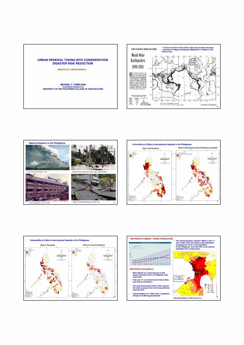
URBAN RENEWAL TAKING INTO CONSIDERATION DISASTER RISK REDUCTION MAKATI CITY, METRO MANILA MAKATI CITY, METRO MANILA MICHAEL V. TOMELDAN MICHAEL V. TOMELDAN [email protected] [email protected] UNIVERSITY OF THE PHILIPPINES COLLEGE OF ARCHITECTURE UNIVERSITY OF THE PHILIPPINES COLLEGE OF ARCHITECTURE 2 THE PACIFIC RING OF FIRE THE PACIFIC RING OF FIRE • Composed of 75% of the world of 75% of the world’s active and dormant volcanoes. s active and dormant volcanoes. • Average of 19 Major Earthquakes (Magnitude 7 & Higher) in the Average of 19 Major Earthquakes (Magnitude 7 & Higher) in the World a Year World a Year 3 Natural Disasters in the Philippines Mount Pinatubo Eruption, 1991 Luzon Earthquake, July 16, 1990 Negros Oriental Earthquake, Feb 26, 2012 Negros Oriental Earthquake, Feb 26, 2012 Typhoon Typhoon Ondoy Ondoy (Ketsana Ketsana) Flood, Sept. 2009 (Reuters) ) Flood, Sept. 2009 (Reuters) 4 Vulnerability of Cities to Geo of Cities to Geo-physical Hazards in the Philippines physical Hazards in the Philippines HISTORIC PRESERVATION 5 Vulnerability of Cities to Geo Vulnerability of Cities to Geo-physical Hazards in the Philippines physical Hazards in the Philippines METROPOLITAN MANILA: 6 Metro Manila Map Metro Manila Map (by TAM Planners Co.) (by TAM Planners Co.) • There are 17 There are 17 Local Government Units ( Government Units (LGUs LGUs), ), each with its own Mayor; each with its own Mayor; • The Local Government Code of 1991 requires The Local Government Code of 1991 requires the the LGUs LGUs to prepare their own Comprehensive to prepare their own Comprehensive Land Use Plan Land Use Plan • Metro Manila Metro Manila has a total land area of 638 a total land area of 638 square kilometers (0.2% of Philippines Total square kilometers (0.2% of Philippines Total Land Area). Land Area). • Total Population of 11.556 in 2011; Population Total Population of 11.556 in 2011; Population Density of 18,097/square kilometer Density of 18,097/square kilometer THE WORLD THE WORLD’S URBAN S URBAN – RURAL POPULATION RURAL POPULATION • The world population reached 7 Billion in 2011. It The world population reached 7 Billion in 2011. It was in 2007, when the world was in 2007, when the world’s urban population s urban population surpassed the surpassed the world’s rural population. rural population. • In the Philippines, more than 50% of the national In the Philippines, more than 50% of the national population live in urban areas. population live in urban areas.
Transcript of URBAN RENEWAL TAKING INTO CONSIDERATION ... RENEWAL TAKING INTO CONSIDERATION DISASTER RISK...
URBAN RENEWAL TAKING INTO CONSIDERATIONDISASTER RISK REDUCTION
MAKATI CITY, METRO MANILAMAKATI CITY, METRO MANILA
MICHAEL V. TOMELDANMICHAEL V. [email protected]@yahoo.com
UNIVERSITY OF THE PHILIPPINES COLLEGE OF ARCHITECTUREUNIVERSITY OF THE PHILIPPINES COLLEGE OF ARCHITECTURE
22
THE PACIFIC RING OF FIRETHE PACIFIC RING OF FIRE•• Composed of 75% of the worldof 75% of the world’’s active and dormant volcanoes.s active and dormant volcanoes.
•• Average of 19 Major Earthquakes (Magnitude 7 & Higher) in the Average of 19 Major Earthquakes (Magnitude 7 & Higher) in the
World a YearWorld a Year
33
Natural Disasters in the Philippines
Mount Pinatubo Eruption, 1991
Luzon Earthquake, July 16, 1990Negros Oriental Earthquake, Feb 26, 2012Negros Oriental Earthquake, Feb 26, 2012
Typhoon Typhoon OndoyOndoy ((KetsanaKetsana) Flood, Sept. 2009 (Reuters)) Flood, Sept. 2009 (Reuters)
44
Vulnerability of Cities to Geoof Cities to Geo--physical Hazards in the Philippinesphysical Hazards in the Philippines
HISTORIC PRESERVATION
55
Vulnerability of Cities to GeoVulnerability of Cities to Geo--physical Hazards in the Philippinesphysical Hazards in the Philippines
METROPOLITAN MANILA:
66Metro Manila Map Metro Manila Map (by TAM Planners Co.)(by TAM Planners Co.)
•• There are 17 There are 17 Local Government Units (Government Units (LGUsLGUs), ),
each with its own Mayor;each with its own Mayor;
•• The Local Government Code of 1991 requires The Local Government Code of 1991 requires
the the LGUsLGUs to prepare their own Comprehensive to prepare their own Comprehensive
Land Use PlanLand Use Plan
•• Metro Manila Metro Manila has a total land area of 638 a total land area of 638
square kilometers (0.2% of Philippines Total square kilometers (0.2% of Philippines Total
Land Area).Land Area).
•• Total Population of 11.556 in 2011; Population Total Population of 11.556 in 2011; Population
Density of 18,097/square kilometerDensity of 18,097/square kilometer
THE WORLDTHE WORLD’’S URBAN S URBAN –– RURAL POPULATIONRURAL POPULATION•• The world population reached 7 Billion in 2011. It The world population reached 7 Billion in 2011. It
was in 2007, when the worldwas in 2007, when the world’’s urban population s urban population
surpassed the surpassed the world’s rural population.rural population.
•• In the Philippines, more than 50% of the national In the Philippines, more than 50% of the national
population live in urban areas.population live in urban areas.

POPULATION DENSITIES IN MAKATI CITY AND METRO MANILADENSITIES IN MAKATI CITY AND METRO MANILA
Land Area (sq. kms) Population Pop. Density
Metro Manila 638.55 11.556 M. 18,097/sq.km.
Manila 38.55 1.660 M 43,061/sq.km.
Quezon City 161.12 2.679 M. 16,627/sq.km.
Makati City 27.36 0.567 M. 20,724/sq.km.
POPULATION DENSITIES IN OTHER CITIESPOPULATION DENSITIES IN OTHER CITIES
Land Area (sq. kms) Population Pop. Density
New York City 786.00 8.175 M. 10,401/sq.km.
Tokyo Metropolis 1,808.00 13.047 M. 7,216/sq.km.
Singapore 710.00 5.183 M. (3.257 M. are
Singaporeans)
7,300/sq.km.
Hong Kong 1,104.00 7.061 M. 6,396/sq.km.
INCREASE EFFICIENCY IN THE USE OF A FINITE RESOURCEEFFICIENCY IN THE USE OF A FINITE RESOURCE
88
THE HYOGO THE HYOGO FRAMEWORK FOR ACTION (HFA)FOR ACTION (HFA)
Reduce loss of lives, and social, economic, and Reduce loss of lives, and social, economic, and
environmental assets environmental assets when hazards strike.hazards strike.
Priority Action 1: Ensure that disaster risk reduction is a natiPriority Action 1: Ensure that disaster risk reduction is a national and a local priority onal and a local priority
with a strong institutional basis for implementation.with a strong institutional basis for implementation.
Priority Action 2: Identify, assess and monitor disaster risks aPriority Action 2: Identify, assess and monitor disaster risks and enhance early nd enhance early
warningwarning..
Priority Action 3: Use knowledge, innovation and education to buPriority Action 3: Use knowledge, innovation and education to build a culture of safety ild a culture of safety
and resilience at all and resilience at all levels..
Priority Action 4: Priority Action 4: Reduce the underlying risk factors.the underlying risk factors.
Priority Action 5: Priority Action 5: Strengthen disaster preparedness for effective response at all levels.disaster preparedness for effective response at all levels.
99
MAINSTREAMING MAINSTREAMING DISASTER RISK REDUCTION IN HIGHLY URBANIZED CITIESRISK REDUCTION IN HIGHLY URBANIZED CITIES
-- The The Local Government Code mandates all cities and municipalities to Local Government Code mandates all cities and municipalities to formulate a formulate a Comprehensive Land Use Plan (CLUP) that will serve as the Local Government Land Use Plan (CLUP) that will serve as the Local Government
UnitUnit’’s (s (LGULGU’’ss) Comprehensive Development Plan and Land Use Plan. ) Comprehensive Development Plan and Land Use Plan.
-- Areas that are found to be highAreas that are found to be high--risk have to be redeveloped to respond better to risk have to be redeveloped to respond better to
geophysical and hydrogeophysical and hydro--meteorological hazards. meteorological hazards.
-- NEDA has prepared a set of guidelines called NEDA has prepared a set of guidelines called ““Mainstreaming Disaster Risk Mainstreaming Disaster Risk
Reduction in SubReduction in Sub--national Developmentnational Development”” (funded buy UNDP and European (funded buy UNDP and European
Commission for Humanitarian Aid) Commission for Humanitarian Aid)
-- Very few urban Very few urban centerscenters today were planned taking into consideration disaster today were planned taking into consideration disaster
risk reduction. risk reduction.
-- And since disaster risk reduction is a new concept, only a few And since disaster risk reduction is a new concept, only a few cities have cities have
started to restarted to re--examine their districts with regards to vulnerability to earthquakes their districts with regards to vulnerability to earthquakes
and other disasters.and other disasters.
-- The poor and informal settlers are considered the most vulnerabThe poor and informal settlers are considered the most vulnerable to le to
earthquakes and disasters. Urban lowearthquakes and disasters. Urban low--cost housing are often located in areas cost housing are often located in areas
with narrow roads and congested conditions.with narrow roads and congested conditions.
THE VULNERABILITY GAP
1010
Makati City, Metro ManilaMakati City, Metro Manila
The Makati CBD and gated subdivisions were master planned in the late 1940s and are now the addresses of the
Philippines biggest corporations and affluent. families.
URBAN RENEWAL TAKING INTO CONSIDERATION DISASTER RISK REDUCTION
11
- Metro Manila Impact Reduction Study (MMEIRS) – funded by JICA (2002-2004)
- identified 18 possible earthquake scenarios that may severely affect Metro Manila.
VULNERABILITY
Physical vulnerability of an area
will depend on the exposure of
vulnerable structural elements
within an area such as buildings,
dwellings, critical facilities, and
other infrastructures;
Economic vulnerability will come
from the area’s wealth, income,
potential for growth, among
others;
Social vulnerability stems from the
characteristics of individuals or
groups in the area that determine
their well-being in terms of their
income and access to basic
services such as education and
health; and
Environmental vulnerability refers
to the state of the environment.
(UNDP, 2004 – Mainstreaming DRR in
Subnational Development and Land
Use/Physical Planning in the Philippines).
URBAN RENEWAL TAKING INTO CONSIDERATION DISASTER RISK REDUCTIONURBAN RENEWAL TAKING INTO CONSIDERATION DISASTER RISK REDUCTION
12
WEST VALLEY FAULT LINE AND AREAS PRONE TO LIQUEFACTION
Liquefaction magnifies impact of tremors.

• An area is assessed to be high riskAn area is assessed to be high risk
•• the Local Government Authorities are willing the Local Government Authorities are willing
to plan for to plan for redevelopment
•• the Local Community is willing to participate the Local Community is willing to participate
in the redevelopment for DRR.in the redevelopment for DRR.
CONDITIONS FOR DRRCONDITIONS FOR DRR--BASED RENEWAL/ BASED RENEWAL/
REDEVELOPMENTREDEVELOPMENTPRINCIPLES THAT WILL PRINCIPLES THAT WILL GUIDE THE RENEWAL/ REDEVELOPMENT PLANTHE RENEWAL/ REDEVELOPMENT PLAN
•• Rehabilitation of high risk sections of the Redevelopment areaRehabilitation of high risk sections of the Redevelopment area
•• Provision for Emergencies and RescueProvision for Emergencies and Rescue
•• Adherence to Adherence to Existing National Building Laws ad Local Building OrdinancesNational Building Laws ad Local Building Ordinances
•• Sustainable Planning and DesignSustainable Planning and Design
•• Community Involvement in Planning and DesignCommunity Involvement in Planning and Design
•• Responsive Land Use PlanningResponsive Land Use Planning
•• Minimal DisplacementMinimal Displacement
POPULATION DENSITY BY BARANGAY
1414
Makati City, Metro ManilaCity, Metro Manila
LEVELS OF LAND USE AND INFRASTRUCTURE INTERVENTIONLEVELS OF LAND USE AND INFRASTRUCTURE INTERVENTION
•• Enforce a Enforce a ““no new building, no addition, no renovation policyno new building, no addition, no renovation policy”” along 10along 10--meter meter
easementeasement
•• Ensure Ensure safety of Disasterof Disaster--response buildingsresponse buildings
•• Clear the 10Clear the 10--meter easementmeter easement
•• Convert lots traversed by the faultConvert lots traversed by the fault--line into a linear park.line into a linear park.
2.02.0 Plan for a Plan for a safe, secure, and liveable environment., secure, and liveable environment.MAKATI CITY CLUP/CDPCITY CLUP/CDP
2.1 Disaster risk reduction and mitigation 2.1 Disaster risk reduction and mitigation
measuresmeasures
-- Assess, plan for and address geoAssess, plan for and address geo--hazardshazards
-- Integrated program for disaster preparednessIntegrated program for disaster preparedness
-- Provision of disasterProvision of disaster--response facilitiesresponse facilities
2.02.0 Plan for a safe, secure, and liveable environment.for a safe, secure, and liveable environment.
2.1 Disaster risk reduction and mitigation measures2.1 Disaster risk reduction and mitigation measures
MAKATI CITY CLUP/CDPCITY CLUP/CDP
East Rembo MultiEast Rembo Multi--purpose purpose
Hall is traveresed by the Hall is traveresed by the
West Valley FaultWest Valley Fault
The Local Government facilities (e.g., hospitals, health centersThe Local Government facilities (e.g., hospitals, health centers, barangay , barangay
halls, schools) perform relief functions during halls, schools) perform relief functions during disasters. These facilities . These facilities
have to remain safe to continue performing their roles as first have to remain safe to continue performing their roles as first response response
facilities during disasters.facilities during disasters.
SCARCITY OF PARKS AND OPEN SPACES
URBAN RENEWAL TAKING INTO URBAN RENEWAL TAKING INTO CONSIDERATION DISASTER RISK REDUCTIONDISASTER RISK REDUCTION
One of the deficiencies of Makati is the lack of parks and open spaces. These spaces are not just for recreation but also
serve as evacuation sites or staging areas during disasters.

FLOOD PRONE AREAS – Recorded flood level rise in Makati City during typhoon Ketsana
Pateros River
Creek
Tripa de
Galina
Flood waters Flood waters rose along creeks and drainage channels.along creeks and drainage channels.
MAKATI CITY CLUP/CDP
Existing Conditions of Creeks and Drainage Channels
Tripa de Galina, Barangay Bangkal
Pasay CityMakati City
Makati City Pasay City
•• In Makati City, the main rivers and creeks serve as the In Makati City, the main rivers and creeks serve as the
natural and official boundaries with natural and official boundaries with neighboringneighboring LGUsLGUs. .
•• Enforcement of easements and maintenance of the shared of easements and maintenance of the shared
drainage channels involved drainage channels involved LGUsLGUs..
••must be coordinated efforts by themust be coordinated efforts by the
MAKATI CITY CLUP/CDP
• In Makati City, the main rivers and creeks serve as In Makati City, the main rivers and creeks serve as
the natural and official boundaries with the natural and official boundaries with neighboringneighboring
LGUsLGUs. .
•• Enforcement of easements and maintenance of the Enforcement of easements and maintenance of the
shared drainage channels must be coordinated shared drainage channels must be coordinated
efforts by the involved efforts by the involved LGUsLGUs..
Barangay Guadalupe Nuevo
Pateros Bgy. Pembo,
Makati City Bgy.Pembo,
Makati CityPateros
Pateros River, Barangay Pembo
Existing Conditions of Creeks and Drainage
ChannelsNECESSARY MEASURES
TO MITIGATE FLOODING
• Singapore’s enforces easements and maintains
drainage channels.
• In spite of that, the city-state still experiences
floods.
2.1 Flood Mitigation Proposals
WATER DETENTION PONDS
• Detention ponds are dry and become
receiving basins for excessive run-off during
heavy rains.
• Skateboard parks can address the lack of
parks and open spaces and also serve as
detention ponds.
Skateboard Parks as Detention Ponds
2.1 Flood Mitigation Measures – DETENTION PONDS also address the lack of open spaces
Sunken amphitheaters as detention pondsSkateboard parks as Detention ponds

25
CONCLUSION: Complying wit the Hyogo Framework for Action
Priority Action 1: Ensure that disaster risk reduction is a national and a local
priority with a strong institutional basis for implementation.
• NEDA has formulated a set of guidelines for mainstreaming DRR into the formulation of land use plans.
• Some cities, like Makati City have considered DRR in the formulation of the Comprehensive Land Use Plan
LEGAZPI CITY WITH MAJESTIC BUT ACTIVE MAYON VOLCANO
26
Priority Action 2: Identify, assess and monitor disaster risks and enhance early warning.
Many of the natural hazards have been identified but the actual occurrence cannot be predicted.
Legazpi City, has always existed with Mayon Volcano looming in the background. Volcanoes and even floods have warnings.
Earthquakes have no warnings. Planning, however, should recognize the geo-physical hazards present.
Earthquake Drills in Schools (2006)
27
Priority Action 3: Use knowledge, innovation and education to build a culture of safety and resilience at
all levels.
Education plays a key role in the awareness of geo-physical and hydro-meteorological hazards. The
science of natural hazards are part of the curriculum. Drills are also conducted on a regular basis not
just to remind us of the constant threat but more importantly to keep us prepared for such eventualities.28
• When a natural disaster occurs, the
nearest place where the assistance and
rescue will come from is the community
itself. Communities have to sustain the
“bayanihan” spirit in order to help
themselves.
• All of us in the urban areas can learn a lot
from the rural areas. The traditional Filipino
Architecture was sustainable because it
used the materials such as bamboo that
was in abundance in the area. Material and
design produced passively cooled
architecture.
• In a sense, the bahay kubo is disaster-
resilient. It is raised on stilts and could be
safe from floods. Because it is made of
bamboo, the bahay kubo is flexible and will
sway with the motion of an earthquake and
hence, will often survive it.
• Like the bahay kubo, the community has
to be resilient…and that includes being
disaster-resilient.
Priority Action 5: Strengthen disaster
preparedness for effective response at all
levels.
“BAYANIHAN” – COMMUNITY SPIRIT
END OF PRESENTATION... THANK
YOU.
CONCLUSION:
URBAN RENEWAL TAKING INTO CONSIDERATIONDISASTER RISK REDUCTION
MAKATI CITY, METRO MANILACITY, METRO MANILA
MICHAEL V. TOMELDANMICHAEL V. [email protected]@yahoo.com
UNIVERSITY OF THE PHILIPPINES COLLEGE OF ARCHITECTUREUNIVERSITY OF THE PHILIPPINES COLLEGE OF ARCHITECTURE