Updates to smartinit downscaling in 2014-2015 Haines Index Using static reference levels AWIPS DRG...
14
Updates to smartinit downscaling in 2014-2015 April 17, 2015 NCEP/EMC 1
Transcript of Updates to smartinit downscaling in 2014-2015 Haines Index Using static reference levels AWIPS DRG...

Updates to smartinit
downscaling in 2014-2015
April 17, 2015
NCEP/EMC
1
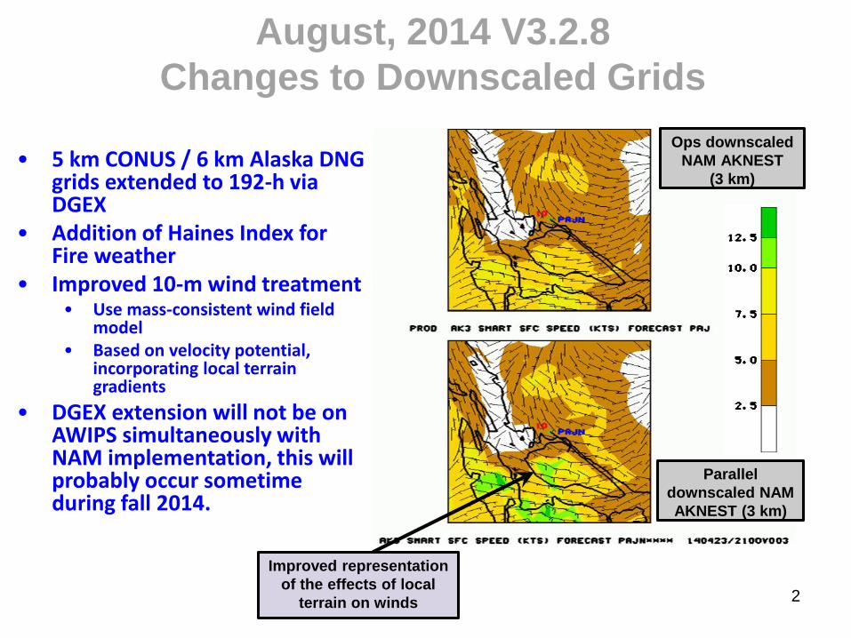
August, 2014 V3.2.8
Changes to Downscaled Grids
• 5 km CONUS / 6 km Alaska DNG grids extended to 192-h via DGEX
• Addition of Haines Index for Fire weather
• Improved 10-m wind treatment • Use mass-consistent wind field
model • Based on velocity potential,
incorporating local terrain gradients
• DGEX extension will not be on AWIPS simultaneously with NAM implementation, this will probably occur sometime during fall 2014.
2
Ops downscaled
NAM AKNEST
(3 km)
Parallel
downscaled NAM
AKNEST (3 km)
Improved representation
of the effects of local
terrain on winds

Correction to NAM/DGEX Wind Downscaling
Into Production on Nov. 13, 2014 12 UTC
3
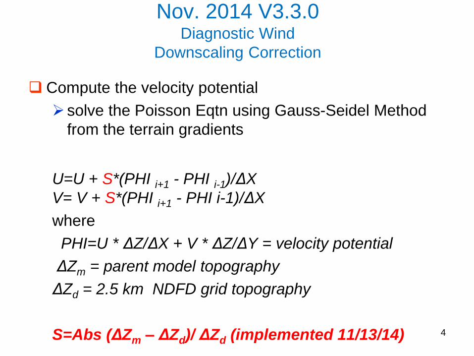
Nov. 2014 V3.3.0 Diagnostic Wind
Downscaling Correction
Compute the velocity potential
solve the Poisson Eqtn using Gauss-Seidel Method
from the terrain gradients
U=U + S*(PHI i+1 - PHI i-1)/ΔX
V= V + S*(PHI i+1 - PHI i-1)/ΔX
where
PHI=U * ΔZ/ΔX + V * ΔZ/ΔY = velocity potential
ΔZm = parent model topography
ΔZd = 2.5 km NDFD grid topography
S=Abs (ΔZm – ΔZd)/ ΔZd (implemented 11/13/14)
4

Smartinit upgrade Q2FY15 V3.3.3
Haines Index for NAM/DGEX on AWIPS
Correction to AWIPS version
Error in Dewpoint depression calculation
Error in lower limit
modified to use WMO headers
Corrected T-1, T-2 hours time stamp
Integrated smartinit code with GFS DNG
smartinit.fd changes
https://svnemc.ncep.noaa.gov/projects/smartinit/tags/RB-V3.3.3
5
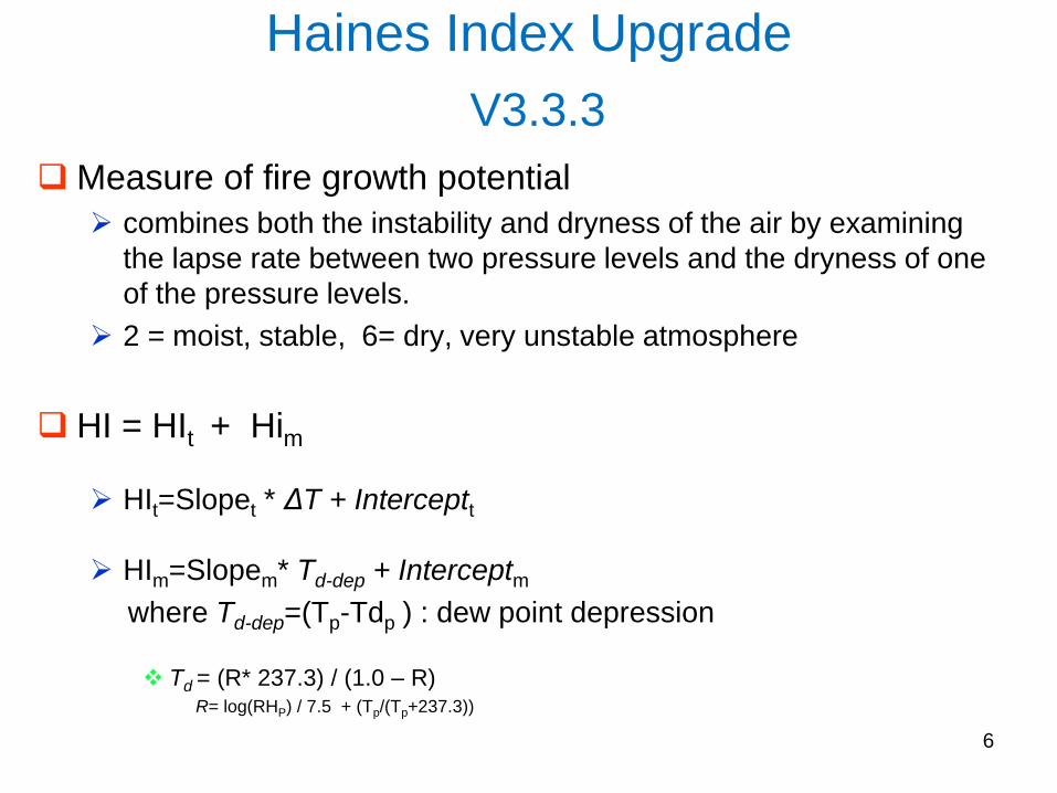
Haines Index Upgrade
V3.3.3
Measure of fire growth potential
combines both the instability and dryness of the air by examining
the lapse rate between two pressure levels and the dryness of one
of the pressure levels.
2 = moist, stable, 6= dry, very unstable atmosphere
HI = HIt + Him
HIt=Slopet * ΔT + Interceptt
HIm=Slopem* Td-dep + Interceptm
where Td-dep=(Tp-Tdp ) : dew point depression
Td = (R* 237.3) / (1.0 – R) R= log(RHP) / 7.5 + (Tp/(Tp+237.3))
6

Haines Index D.A. Haines, 1988, Nat. Wea. Dig
7
Level ΔT P level
for Tp
Std T
Lapse
T
interc
Std Td
Lapse
Td
intercpt
Low
Psfc>950mb
Zsfc <540m
T950 – T850
850 mb 0.2 1.0 0.2 0.6
Middle
Psfc>850mb
Zsfc<1456m
T850 – T700
850 mb 0.183 0.75 0.125 0.9375
High
Psfc<850mb
Zsfc>1456m
T700 – T500
700 mb 0.2 -1.8 0.143 -0.428
For DNG, corresponding standard atmosphere elevation used
instead of varying surface pressure
- To provide static low/middle/high reference level
required for effective use by forecaster

Calculation Reference Level from ground elevation
8
1(green <540 m) = use low level Haines Index calculation
2(yellow <1456 m) = use mid level Haines Index calculation
3(red >1456 m) = use high level Haines Index calculation

NAM CONUS Nest vs DNG 2.5 km Haines Index: Feb 5, 2015, 12 UTC
9
NAM 12 NAM 4
DNG 2.5
http://www.emc.ncep.noaa.gov/mmb/aq/smart/web/html

CONUS Nest vs DNG 2.5 km
10
Boise, Idaho South West U.S.
DNG 2.5
Nest 4

CONUS Nest vs DNG 2.5 km
11
Hawaii
DNG
Nest
Alaska Puerto Rico
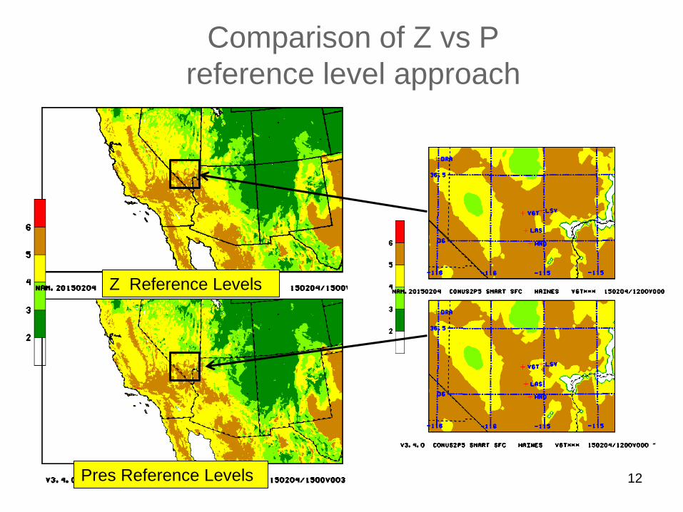
Comparison of Z vs P
reference level approach
12 Pres Reference Levels
Z Reference Levels
Summary Haines Index Using static reference levels
AWIPS DRG written (NWS fire weather)
AWIPS WFO headers developed (NCO)
Correction to computation
Similar to NAM nest outputs
Higher than Raob based Haines Index
Synchronized with GFS One executable for GFS/NAM/DGEX/HRW & various domains
CONUS 2.5 and 5 km
Alaska 6 and 3 km
Guam 2.5 km (from GFS and HRW)
Hawaii, Puerto Rico 13

14
14
Q3FY15 Smartinit Downscaling Upgrade Project Status as of 01/15/2015
Issues/Risks
Finances
Scheduling Project Information and Highlights
Lead: Jeff McQueen, Manuel Pondeca, EMC and Chris Magee, NCO
Scope: Significant upgrade that introduces:
- Expanded CONUS 2.5 km domain;
- GRIB2 input/output;
- Physics upgrade (adiabatic wind adjustments, improved
coastline adjustments for lakes, temperatures in valleys);
- NLDAS 2 m temperature, spec. humidity option;
- New products (significant weather, 80 m winds for Energy)
- Code optimization with EMC;
Expected Benefits:
1. Improved winds and temperatures in complex terrain
2. Address forecaster concerns around coastlines and in valleys
3. Provide improved background fields for RTMA/URMA
Associated Costs:
Funding Sources: EMC Base: T2O 3 man-months NCO Base:
1 man-months for implementation, 1 man-month annually for
maintenance
Management Attention Required G R v1.0 09/14//07
Y
G
Issues:
Risks:
Mitigation:
Milestone (NCEP) Date Status
Initial coordination with SPA team Developer 3/01/15
EMC testing complete / EMC CCB Developer 4/01/15
Final Code Delivered to NCO Developer 4/04/15
Technical Information Notice Issued Developer 5/1/15
SPA begins prep work for 30 day test NCO 5/1/15
30-day evaluation begins NCO 6/1/15
30-day evaluation ends NCO 6/1/15
IT testing ends NCO
Management Briefing NCO 6/10/15
Operational Implementation NCO 6/15/15
Y R
14 Potential Management Attention Needed On Track
R G
G
R G