UNESCO - SWAT · 2011-06-16 · 1 UNESCO A new ‘floodland’ module in the SWAT codes for the...
18
1 A new ‘floodland’ module in the SWAT codes for the simulation of periodically wet areas Ann van Griensven, Shreedhar Maskey, Mohan Kumar Shakya Core of Hydrology and Water Resources Department of Water Engineering UNESCO-IHE Institute for Water Education [email protected]
Transcript of UNESCO - SWAT · 2011-06-16 · 1 UNESCO A new ‘floodland’ module in the SWAT codes for the...

1
A new ‘floodland’ module in the SWAT codes for the simulation of periodically wet areas
Ann van Griensven, Shreedhar Maskey, Mohan Kumar Shakya
Core of Hydrology and Water Resources
Department of Water Engineering
UNESCO-IHE Institute for Water Education

Soil and Water Assessment Tool Simulation of processes at land and water phase
Spatially distributed (different scales)
Semi physically based / empirical approaches
Simulation of changes (climate, land use, management etc.)
Water quantities, incl. different runoff components
Water quality: Nutrients, Sediments, Pesticides, Bacteria, (algae and oxygen), etc.
…. all that on a daily time step and at different spatial scales and (more or less) readily available data sets!!

Landscape units: land or water
Land: agricultural, urban, natural permanently dry
Water: river, pond, reservoir permanently wet

4
Water in the landschape
Water balance in wetlands, ponds and reservoir is computed using the equation:
V: Volume of water in impoundment in m3 Vstored: Volume of the water stored in the water
body at the beginning of the day in m3 Vflowin: flow entering the water body during the
day. Vflowout: flow flowing out. Vpcp: Volume of precipitation falling on the water
body. Vevap: removed from water body by evaporation Vseep: Volume of water lost by seepage
Wet areas: Land: HRU (floodplains, potholes); ponds and wetlands River: reservoirs/lakes

Temporary wet areas

Temporary wet areas

Problem
Good calibration only with very low curve numbers
Little surface runoff
Not realistic
-> need to adapt SWAT for temporarily storage of water
7
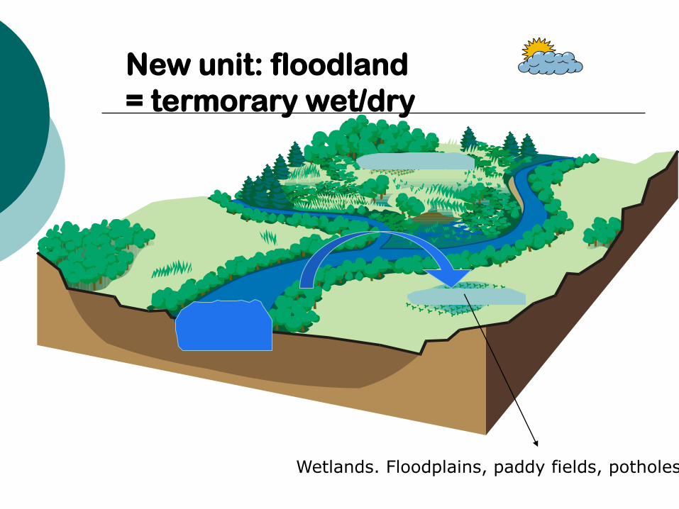
New unit: floodland
= termorary wet/dry
Wetlands. Floodplains, paddy fields, potholes

9
FLOODLAND-module
Flood occurence, depending on type (eg. Paddy field, riverine wetland, floodplain,…) in order to define the FLOOD_HRU variable that defines the fraction of wet area
Splitted routines for Wet fraction -> wet HRU processes (cfr potholes)
(1) Free water evaporation
(2) Hydraulic conductivity for groundwater recharge
(3) Overtopping (>maximum volume) gives surface runoff
Dry fraction -> normal HRU processes

Original

Modified

Results for paddy field
0
200
400
600
800
1000
1200
1400
1600
1800
2000
PRECmm SURQmm GWQmm ETmm
without paddy With paddy - original with paddy - adapted

13
Kathmandu
Mela
mch
i R
iver
Yangri
Khola
Catchment scale:Indrawati river basin
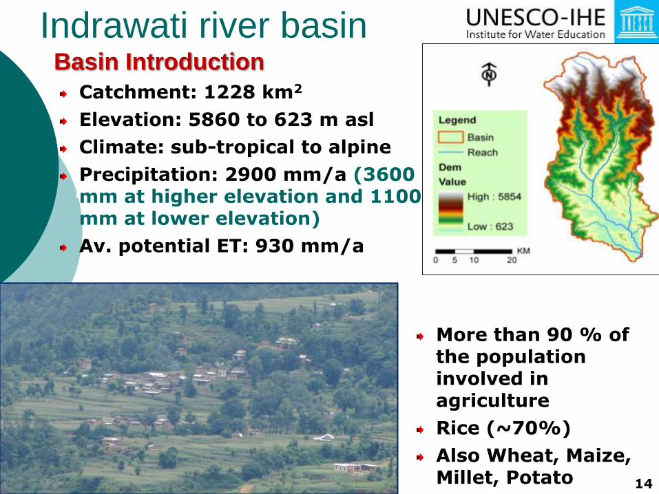
Basin Introduction
Catchment: 1228 km2
Elevation: 5860 to 623 m asl
Climate: sub-tropical to alpine
Precipitation: 2900 mm/a (3600 mm at higher elevation and 1100 mm at lower elevation)
Av. potential ET: 930 mm/a
More than 90 % of the population involved in agriculture
Rice (~70%)
Also Wheat, Maize, Millet, Potato 14
Indrawati river basin

Calibration / Validation Results: Indrawati basin outlet
0
100
200
300
400
500
Averag
e m
on
thly
fl
ow
[m
3/
s]
a. Calibration - monthly timestep
simulatedNSE = 0.83 R2 = 0.86
0
100
200
300
400
Av.
mo
nth
ly f
low
[m
3/
s]
b. Validation - monthly …
NSE = 0.94 R2 = 0.95
simulated
0
200
400
600D
aily D
isch
arg
e
[m
3/
s]
b. Validation - daily timestep
simulatedNSE = 0.86 R2 = 0.87
16
Indrawati river basin

Multiple pothole HRU’s
17

Results for the Indrawati
catchment
0
500
1000
1500
2000
2500
3000
PRECIPSURFACERUNOFF Q
LATERAL SOIL Q GROUNDWATERQ
ET
Original Modified

Conclusion
Generic floodmodule has been presented, that can be used for temporary and partially wet areas, such paddy fields and wetlands
Adaptations needed to current paddy field
Strong effect to hydrology
To be done:
- Water quality processes
- Floodplain events