TUOLUMNE RIVER SPECIAL RUN POOL 10 RESTORATION 1. TITLE
18
TUOLUMNE RIVER SPECIAL RUN POOL 10 RESTORATION 1. TITLE PAGE ~ PROJECT APPLICANT Tttrlock Irrigation District, 333 East Canal Drive, Turlock, CA 95380 CONTACTS For contract and project administration: Wilton Fryer, Water Planning Dept. Mgr. 209-883-8316, FAX 209-656-2143 e-mail: wbfiy, [email protected] PARTICIPANTS: Tuolum~e River Technical Advisory Commillee (TRTAC) made up of the Turloek In’igation District (TID), Modesto Irrigation District (MID), Ci~ & County of San Franalsoo (CCSF), California Dept. offish & Game (CDFG), and the US Fish & Wildlife Service (USFWS). Collaborating stakeholder groups with TRTAC are the Tuolumne River Preservation Trust, Friends of the Tuolunme, California Sports Fishing Protection Alliance, Bay Area Water Users Association, Eaat Stanislaus Resource Conservation District, National Marine Fishery Service (NMFS),and local mining operators and landowners. COST SHARE PARTICIPANTS: USFWS through the CVPIA-AFRP and TID, MID, and CCSF through the TRTAC. SUMMARY DESCRIPTION: The full Special Run Pool (SRP) I0 Restoration Project involves restoration ofinstream aquatic habitat and shaded riverine aquatic habitat and reduction of predatory fish habitat for the primary benefit of San Joaquin River fall-ran chinook salmon. The SRP 9 & SRP 10 projecls were originally developed as one project because of their proximity to each other along the fiver. From a practical construction and funding view point they are two projects, each with a very similar scope of work. The lessons leataed in ttrst restoring the smaller SRP 9, will be incorporated in adjusting the final design of SRP 10. The full SRP 10 project will rebuild a select portion of the Tuolumne River channel, at river male 25.4, (approximately 15 miles east of Modesto) where past instream gravel mining created a large deep lake area in the main channel that changed the habitat to one favoring wama water predator species like largemouth b~ss. Adjacent to SRP 10 there is an old off stream mining pit pond ~at has a breach in the dike separating SRP 10 and the pond. Project monitoring in !998 confirmed the pond is a major contributing source to the bass predation known to be in SRP 10. This CALFED funding request is being made to cover the costs of one further year of pro project monitoring for SRP 9 & 10 and to facilitate the repairs to the dike in 1999 rather than wait until 2001. BIOLOGICAL OBJECTIVES: 1. Reduce salmonid fish predator habitat. TID & TRTAC CALFED lUmP: SRP 10 1 30 dUNE 1998 I --021 239 1-021239
Transcript of TUOLUMNE RIVER SPECIAL RUN POOL 10 RESTORATION 1. TITLE

TUOLUMNE RIVER SPECIAL RUN POOL 10 RESTORATION
1. TITLE PAGE ~
PROJECT APPLICANTTttrlock Irrigation District, 333 East Canal Drive, Turlock, CA 95380
CONTACTSFor contract and project administration: Wilton Fryer, Water Planning Dept. Mgr.
209-883-8316, FAX 209-656-2143e-mail: wbfiy, [email protected]
PARTICIPANTS:Tuolum~e River Technical Advisory Commillee (TRTAC) made up of the TurloekIn’igation District (TID), Modesto Irrigation District (MID), Ci~ & County of SanFranalsoo (CCSF), California Dept. offish & Game (CDFG), and the US Fish &Wildlife Service (USFWS). Collaborating stakeholder groups with TRTAC are theTuolumne River Preservation Trust, Friends of the Tuolunme, California Sports FishingProtection Alliance, Bay Area Water Users Association, Eaat Stanislaus ResourceConservation District, National Marine Fishery Service (NMFS),and local miningoperators and landowners.
COST SHARE PARTICIPANTS:USFWS through the CVPIA-AFRP and TID, MID, and CCSF through the TRTAC.
SUMMARY DESCRIPTION:The full Special Run Pool (SRP) I0 Restoration Project involves restoration ofinstream
aquatic habitat and shaded riverine aquatic habitat and reduction of predatory fish habitat for theprimary benefit of San Joaquin River fall-ran chinook salmon. The SRP 9 & SRP 10 projeclswere originally developed as one project because of their proximity to each other along the fiver.From a practical construction and funding view point they are two projects, each with a verysimilar scope of work. The lessons leataed in ttrst restoring the smaller SRP 9, will beincorporated in adjusting the final design of SRP 10. The full SRP 10 project will rebuild aselect portion of the Tuolumne River channel, at river male 25.4, (approximately 15 miles east ofModesto) where past instream gravel mining created a large deep lake area in the main channelthat changed the habitat to one favoring wama water predator species like largemouth b~ss.Adjacent to SRP 10 there is an old off stream mining pit pond ~at has a breach in the dikeseparating SRP 10 and the pond. Project monitoring in !998 confirmed the pond is a majorcontributing source to the bass predation known to be in SRP 10. This CALFED funding requestis being made to cover the costs of one further year of pro project monitoring for SRP 9 & 10 andto facilitate the repairs to the dike in 1999 rather than wait until 2001.
BIOLOGICAL OBJECTIVES:1. Reduce salmonid fish predator habitat.
TID & TRTAC CALFED lUmP: SRP 10 1 30 dUNE 1998
I --021 2391-021239

TUOLUMNE RIVER SPECIAL RUN POOL 10 RESTORATION
H. PROJECT DESCRIPTION
A. PROYECT DESCRIPTION AND APt~.OACH
The Tuoluame River Technical Advisory Committee (TRTAC), under the au~ices of the1995 Don Pedro Project Settlement Agreement (FSA) (FERC License No. 2299), is developing aplan to restore instream aquatic habitat and shaded riverine aquatic habitat for the primary benefitof San Joaquin fall-run chinook ~,almon in the Tuolunme River below La Grlmgn dam. TheTRTAC spocifieally identified both SRP 9 & SRP 10 as prime "predator isolation" projects forthe Tuolunme River. The geomorphology firm of McBaln & Trash has developed a detaileddescription of the proposed restoration work for the TRTAC.
The SRP 9 & SRP 10 projects were originally developed as one project because of theirproximity to each other along the river. From a practical construction and funding view paintthey are two projects, each with a very similar scope of work. The lessons learned in firstrestoring the smaller SRP 9, will be incorporated in adjusting the final design of SRP 10.
"l]~ese t~vo adjacent restoration segnaents including their associated revegetation, are tobe reconstructed over a three to four year period, ~Ath SP~ 9 te be reconstructed first starting h31999 followed by SKI) 10 smrflng in 2000~ These two SRPs are stand alone projects, howeverdie CEQA! NEPA mitigated EA!IS, permitting, civil design, and revegetation design are beingdone together to facilitate fiature CALFED and AFRP funding for the full SRP 10 restorationconstruction. SRP 9 was originally envisioned for one year of constrtictian and SRP10 wasanticipated to take two years to cons~uet given the larger volume of rnaterial involved.However, the Air Resources District mitigation developed in the EA/!S dictated that constroetionof SRP 9 should be done over two years because diesel emissions resulting from the volume ofmaterials to be hauled for SRP 9 combined with that pl~mned for the Mining Reach, 7Xl 1Segment, restoration project occurring during the s~.me period exceeded State standards. Thelando~ners adjaecat to the SRP projects have asked the "lid to seek a variance that would allowSRP 9 to be constructed in the ofigthal one year period to minimize impacts to their land andfarming operations.
The full SRP 10 restoration work consists of flllthg in deep (10 to 34 feet below normalchmmel grade) lake like pool areas created by past instremn gravel mining and re-creating a rifflearm ru~ pattarn that follows the restored meander obermel of the fiver. The ehannel will bereformed into a 500 foot wide riparian flood plain complete with native vegntation planted onfill terraces in a roix similar to that found along undisturbed segmant~ of the river. The aerialex]ent of the project area including the restoration work proposed is shown in EAklS Figure 10,from the project dasctiption in the EA/1S. The reconstructed floodway ehatmel eross-sectlon willbe hydraulically sized to be art active fiverine channel at currently regulated flows. These flowsperiodically could reach as high az 15,000 cfs for short periods, the highest regulated flow fromDon Pedro Dam. The rebuilt channel is sized assuming afiver stage elevation that results fromfull grown riparian forest vegetation at design flows. It is ’anticipated and platmed that duringthese high flow events there will be some movement of the channel witinn the flood plain to
T1D& TRTAC CALFEDRFP: SRP IO 2 .’,OJUNF. 1998
I --0212401-021240

expose added spawning mataria]s and clean existing spawning gravels. To minimize long termfuture maintenance expenditures, this restoration work is being designed with the intent to
¯ ~, provide a self maintaining rip,~r]an floodway channel once the revegetation is completed andestablished.
Adjacant to SRP 10 there is a.n old off stremn mining pit pond that has a breach in thedike separating SRP 10 and the pond. Project monitoring in 1998 confirmed the pond is a majorcon~butiug source to the bass predation known to be in SRP 10. This CALFED funding requestis beimz made to cover the costs of one further year ofpre project monitorin~ for SRP 9 & 10 andto facilitate the repairs to the dike in 1999 rather than wait until 2001.
B. GENERAL CONDITIONS OF PROPOSED WORK
The breach to be repaired is approximately 100 feet long and was created os a result ofthe January 1997 flood. Ti~e dike repair will include work in the edge of the dyer and iaanticipated to be limited for fishery reasons to an armual opportunity window of about 90 workdays from mid-June througJz September whan saiznon are not as abundant in the dyer.Construction above the wnter level can proceed al~er September, but should be completed beforeabout December to avoid the potential of early flood releases damaging incomplete work.Restoration plantings will not be included until the full SRP 10 restoration on the south bank iscompleted.
Construction design, revegetation design, completion of CEQA/NEPA through amitigated EAfIS, pemtilling, and acquisition of conservation easements axe being done for bethSRP 9 & 10 in 1999 using AF1LP fi.mding. The repair work is not anticipated to require aconservation easement to be in place before construction.
The materials for this project will need to be imported into the site. The anticipatedsources of materlals are deposits of dredger railings along the upper Tuoltmme River.Alternatively, the material could come f~om active off channel and off site gravel mining areasbetween Geer Road and La Grange. The project EA/IS identified and addressed mitigation forutilization and transportation of the various sources of restoration materials available for thisproject.
Recreation of the riparian floodway habitat zone raises an izsue of lung term maintenanceof project improvements. TID and lv’dD are working with the landowners to develop some formof locally administered conservation easement process that protects the public investmun’l, but atthe same time protects the landowner properly fights. Parehase of these conservation easementswill be with AF1LP funds.
IlL PRO,IECT LOCATION
The full Special Run Pool 10 Restoration Project will rebuild a 2,100 foot long portion ofthe Tuolumne River channel, starting at river mile 25.4, do~vnstream of the Oeer Road bridgecrossing the Tuolumne River, approximately 15 miles cast’of Modesto in Stanislaus County.The section of dike to be repaired is along the middle of the south batik. The project location is
TID & TRTAC CA LFED RFP: SRP 10 3 JO JUNE 1998
I --0212411-021241

FIGURE I.- ""-’PROJECT SITE LOCATION
~" SRP 9-10 RESTORATIONTUOLUMNE RIVER MILE 25.1 TO 26.0
k’(cB~in & Trush 1999t
I --021 2421-021242

FIGURE 2 TUOLUMNE RIVERGRAVEL MINING REACH AND SRP 9&10
McBoin & Trush 1998]RESTORATIONSITE LOCATIONS

shown in Figure I and the relationship to the Mining Reach in Figure 2.
IV. EXPEL-~TED EI2OLOGIC~L OBJECTIVES & PROJECT BENEFITS/’" The full SRP 10 project will address all four objectives listed below, however this repair
and monitoring phase will o~y deal with Obj eetive 1.
1. Reduce salmonid fish predator habitat.2. Restore and increase habitat for natural salmon production.3. Reconstruct a natural channel geometry scaled Io current eharmel forming flows.4. Restore native riparian plant communities within their predicted hydrological
regime.
The SRP 9 & 10 projects address the ERPP objectives and vision~ for the TuoinmneRiver Ecological Unit identified on pages 409 & 410 of the ERPP Vol. 11. These inuluderestoration of stream & riparian habitat; ecological processes; gravel recruitment, transport, andcleanlng processes; a diverse self- sustaining riparian corridor; and predator reduction. Theegepairs focus onl,w on the predator habitat reduct!on and the monitotin~ f~cnses on establishingpro proiect predator populations a~d habitat cond tions
A, BACKGROUND & TECHNICAL .FUSTIFICATION
The Tuolumne River is a major tribatm2� of the San Joaquin River. The Don PedroProject is the largest reservoir located above the fall-rim chinook salmon spavcning reach on theTuolunme. Don Pedro Rese~woir is owned by the Torinck Irrigation District (TID) and theModesto hTigation District (MID) and is licensed by the Federal Energy Regulatory Commission(FERC).
The fall nm chinook salmon in the tributaries of the San Joaquin River are currently listedas a species of concern by the USFWS. Anadromous salmonid populations in the lowerTuoltmme River require adequate ecosystem health to achieve and sustain their potentialproductivity. Restoring and maintaining dynamic geomorphic processes are crucial for insuringhealthy river ecosystems with natural productive salmohid populations. When completerestoration of a river ecosystem is infeasible, ~ for alluvial rivers regulated by dams, limitingfactors, like predator habitat and poor qnaliry tiverine habitat, must be identified for prioritizingantions that would best improve the ecosystem, particularly salmonid habitat. Predation onjuveniIe salmon and smolts has been identified through field studies as having a siginfieantimpact on survival of salmon in the Tuolumne River. Cun’ently nearly all naturally producedjuvenile salmon must pass through SRP 9 and SRP 10. Reducing predator habitat byreconstructing riparian floodplain m~s these desired priority action.
The TRTAC specifically idenhfied habitat conditions to be improved to enhance naturalsalmon production in the Tuolunme River. The TRTAC has developing a final draft integrated,hing-term restoration plan and monitoring program that utilizes adaptive management forenhancing the natural production of salmon. The TRTAC and the AFRP have cacti funded$117,500 towards this integrated restoration plan, inehifli~g n public outreach program. Thefiver has been divided into seven reaches with individual segments representing specific types of
TID& TRTACCALFEDRFP: SRP I0 4 30JUNEI998
I --021 2441-021244


restoration projects within each reach. There are projec~ that fueus on restoration ofg~omorphicprocesses, ~ther~ for riparian restoration and predator redu~titm, and still o~ers deal with gravelre-introductian and cleaning.
The Tuolunme River supports a population of fall-am chinook salmon, whose numbershave fluetuated from 40,000 fish in 1985, to a low of 100 fish in 1991, and is on another upwardswing with 7,200 fish in 1997 and 7,900 in 1998. The underlying premise of the SRP 9 & 10projects are that by creating the proposed sustainable riverine habitat both the native fishery andriparian species will benefit and stressors will be reduced. T~e prime target of this project is toiraprove the survival of juvenile salmon and smohs by reducing the habitat of in~’odueedpredator spealas, primarily largemouth bass. The impacts of predators an smolt survival arebased on feeding studies conducted by EA Engineering for the Districts. The riparianreforestation is intended to provide thod and shade for the juvenile salmon. There is the addedbenefit to terrestrial species in providing a more continuous corridor of riparian habitat in therestored areas. The restored channel sinuosity is intended to provide a ~stainable and dynamicriver morphology, i.e. infrequent flood-related channel-bed movement with periodic scour, thatpartially or fully restores the processes associated with natural sahnon production and survival.
The full SRP 10 restoration project will provide long term low araintenanee predatorcontrol combined with habitat restoration. This can be contrasted with an annual system of non-selective predator control, such as electroshoclong, toumament fishing, poisoning, etc., that has alower up front cost. However, this alternative solution requires continued annual expenses, is oflimited effectiveness in targeting the primary predators, has unfavorable social consequences,and does not meet the intent of the CALFED solutions by providing an improved self sustainingrivet’Me habitat for salmon. Such alternatives will not be considered flttther. The repairs in thedike are intanded to aliminate ~:wo years of predation ~md entrapment in the pond a~jaeeta to SRP10_0_0_0_0_0_0_0_0_~Erior to the fi~ll restoration work being constructed.
V. MONITORING PLAN
A detailed mitigation mad monitoring plan for SRP 9 & 10 w~as developed with theproject EA/IS (EArlS Attachment D; 27 pages). Attached Tables 1 and 2 from the EA\ISsummarize the basic monitoring program and cost estimmes over the life of the restorationproject. With the delay in completing the conservation easemem process for the construction onSRP 9, the post project monitoring portion of the scbedu]e has been delayed one yeas. Thisconstruction delay provides an opportunity for a second year of pre-project data to be collected.This CALFED application will cover the costs of that added ye~ ofpre project mo~toriag. Themonitoring plan can be grouped into three basic areas.
l. Physical habitat changes:Pre and post construction changes will be reeerded from the as-built engineeringdrawings. This assures that the desired ehartnel comours, ~ross sectinas, and thalweg linewere built as designed and these as-built records can be used to assess furore
geoarorphologieal ehangas a~er major flood events~. ¯
2. Riparian habitat changes:
77D & I’RTAC CALFED RFP: SRP IO J 30 dUNE I998
I --021 2461-021246

I --0212471-021247

Table 2. ~slimal~d cosls associ,~led wilh Ibe hypolbcsized moz]illn’ing schedLd~. ’fbe b==dgel ~ssumes all monhoring compone~ls areJmplemerll¢d as described Jn the schedule.
1998 1999 2000 2001 2002 2003 2004 2005 2006 2007 TOTAL
GR~VEL MINING REACH

Revagetation will require annual inspections during the first few years to cortfirmsurvival of planted materials, perform replanting if deemed necessary, and to assess
¯ ~-- natural changes in the vegetation mix. This will be part of the contractors warranteeperiod~ Monitoring vegetation would then be reduced to evaluations afler significantflood events.
Note: The riparian forest res’~oration pland ng is designed to accommodate moditoring.There are 19 different hexagonal planting units classed by predominant vegetationtype. These planting units are grouped mgethar to recreate the diverse mosaicpatches and strings of vegetatinn found on undisturbed areas of the Tuolunme.Tffls plan enables the center point for any "hax" that will be monitored to berelocated at a later date from the as-built drawings and project bench marks.
3. Fish population changes:This will involve evaluation ofpre ~md post projset changes in habitat eondition~ for bothfish predators and salmon. Mouitoring criteria would include items such as flow velocity,temperature, comparisons of estimated transit time through the old vs. new streamchannel, combined with sampling and observations offish populations and spawningriffle conditions.
Pro project monitoring started in 1998. Post project monitoring will start after thecompletion of the SRP 9 restoration in 2000¯ Generally the monitoring for a given project orsegment will extend for 2 years after the eompietian of construction. The more detailedmonitoring plan is available through the D~strict as is the mitigation monitoring outlined in theEALiS. The project specific monitoring was designed to compliment the fishery monitoringrequirements of the FSA. Annual monitoring summaries will be provided to the TRATC, andother interested parties upon request. In addition, the Districts and CCSF spend an average of$100,000 per year on FSA monitoring fur the Tuolunme River.
The first level of peer review comes from the biologists that make up the regularrepresentation on the TRTAC. There is a moniwrin8 subcommittee of the TRTAC charged withclose technical review of the FSA and project speaifie inouitoting. Recently the UC DavisCenters for Water and Wildland Resources was asked to evaluate competing fry and smeltsurvival monitoring methods currently used on the Tuolumne River. Stillwater Sciencesprovides teclmicai design of monitoring programs and statistical analysis of the results.
VI. TECHNICAL FEASIBILITY AND TIMING
A, CEQA \ NEPA
SRP 10 is the fourth of several restoration projects being proposed for the TuolumneRiver based on the restoration plan developed by the TRTAC. The steaef is also working closelywith the affected landowners in the development of site specific adjustments to the preliminaryplans. The firm EDAW, Inc. was hired to assist with the CEQA, NEPA, and pormitling work.The NEPA portion was coordinated with NEPA work developed by the USFWS and coordinatedwith the AFRP program. A mitigated EA/IS was jointly developed between the TID, ~s project
TID & TRTAC CALFED RFP: SRP lO 6 30 dE~NE 1998
I --0212491-021249

CONSERVATION EASEMENT ELEMENTS
K__BANK FULL NEW SETBACK (PROJECT EASEMEN[)CHANNEL
wi~ TREES)
PROJECT NOTES:CHANNEL DYNAMICS
1) NEW CONSTRUCTION TO CUP & SMARA

manager & lead agency, and the USFWS as a Federal funding agency. The EA/IS tiers offthe1995 EIS for the FERC Settlement Agreement for the Don Pedro Project. Public agencycomments were received in July and August 1998 and the comments focused on economic issuesof compensation for conservation easements and lost availability of aggregate supplies. Noeavirolmlental conmaents were received.
The t-mat EA\IS approval is pending resointion of the complex compensation issuesinvolved with the acquisition of the eonservafion easements slatting with SRP 9 and the MiningReach, 7~11 Segment. TID enntrol of the conservation easements ha* taken a long time toresolve with the landowners due to their concerns over potential public access to their land. Thesame process will be used to acquire conservation easements in lhe three subsequent segments inthe Mining Reach and SRP 10. Development and acceptance of an appraisal process that coversland owner and leasehold mining imerests has taken lot~ger than antieipsted. Figure 3 shows in acrass section typical easement elements that are involved in the ROW issues.
B. PERMITS
A partial list of the anticipated permits and agencies to be dealt with prior to constructionis as follows: 404 Fill & Dredge Permit from the USCOE; 1600 Series Streambed AlterationAgreement from CDFG, a mining lease and Botmdary Delineation finding from the State LandsCommission; RWQCB 401 waiver for water quality; end an Encroachment Permit from theReclamation Board.
VII. COSTS AND SCHEDULES
BUDGET COSTS
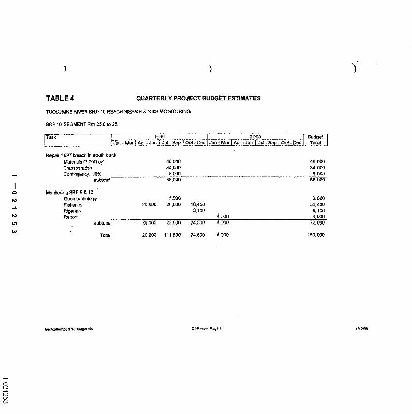
The CALFED is being asked to fired $88,000 for the costs of the breach repair and$72,000 in added pre-project monitoring for a total of $160,000. The attached spreadsheets,Table 3 Tuolumne River SRP 10 Reach Restoration and Table 4 Quarterly Project Budget, detailthe cost breakdown. The USFWS-AFRP has funded $128,000 through 1998 under the currentmonitoring program and it is anticipated they will fund $228,000 of post project monitoring
SCHEDULE
The attached Gantt chart schedule, Figure 4, shows the basic components ofSP~ 9 andSR.P 10 restoration. The schedule shows StLP 9 consmacted as a two year project, assuming ourrequest for a variance from the Air Control District is not granted. The SP,2’ 10 north siderestoration can start in 2000 with the remainder of the SRP 9 because the total volume ofmaterial moved combined with that in the Mining Reach 2, MJ Ruddy Segment, will notgenerate diesel emissions exceeding the threshold used by the local Air Resources District.
VIII. THIRD PARTY IMPACTS
The parties most directly impacted by the proposed project are the local tendowners at the
I --021 2511-021251

TABLE 3 PROJECT BUDGET SUMMARY
TUOLUMNE RIVER SRP 10 REACH REPAIR & 1999 MONITORING
SRP 10 SEGMENT Rm 25.6 fo 25.1
Repair 1997 breach Jn sout~ bankMaterials (7.700 cy) 46,000Transporatio~ 34,000Contingency, 10% 8,000
sub tata~ 88,000 88,000
MonifodngGeomonphology 3,500Fisheries 55,400Riparian 8,100Report 4,000
sub total 72,000 72,000
F-~ CALFED Total 160,000
note: The monitoring cost estmates are ~’om the EArlS Table 2 for 1999, wit~t~e report estimated as 41% of the total report cost. All values roundedto the nearest $100.
I --021 2521-021252


project site, those along the haul road route, and the County Public Works Department. ~D staffand coiasultutus have been and will continue to meet wit.b the affected st,~kehulders to listen toand address their individual concerns. Recognizing those individual concerns, th~ landowners atthe site contacted to date have been cooperative stud ~upportive of the project. The EAdlS forboth the SRP 9 & 10 restoration projects outlines the mitigation and monitoring that are to befolinwed to minimize impacts associated with the restoration activities.
IX. APPLICANT QUALIFICATIONS
Since 1971, TID, MID, and CCSF, in cooperation with DFQ and USFWS, havemonitored river conditions and developed prepares that enhance the natural production of fall-run chinook salmon in the Tuolumne River. Tile project manager for these activities has been"IqD.
A. TRTAC and Other Local Support for Project
The fluvial geomorphulogy ftim ofMeBain & Trush was retained in 1996 by TIDthrough the TRTAC to develop an integrated, long-term fish and riparian habitat restoration planfor the Toolurrme River below La G-range Dana and to prepare preliminary designs for specificrestoration projects which have been approved by the TRTAC participants as higfla priorityprojects. The SRP 9 & 10 had long been identified as a portion of the river tha¢ had beensubstantially altered by past mining operations that would benefit fi’om restoration of roorenatural geomorphic processes.
t3 Project Management
The Project Manager is Wilton Fryer, P.E. Mr. F~er graduated from the University ofCalifontia at Davis with a BS in Soil & Water Science, an MS in Irrigation Science, and laterME in Civil Engineering with an emphasis in water resources. He is currently registered as botha Civil Engineer and an Agricultural Engineer. Accomplishments are: Development andimplementation of the Oakdale Irrigation District Irrigation Master Plan; Directed a $22 millioncanal rehabilitation project for OlD where 54 miles of dii~ canals were replaced with pipe;Development of the OlD domestic ",~ater service system; Designer and project manager for areplacement water treatmen( phmt for the La Grange Domestic Water Syslem.
Tim Ford has been the staff aquadc biologist for TID and MID since 1981. Mr. Fordgraduated from the University of Califorina at Davis with a BS in Wildlife & Fisheries Biologyin 1977. He worked as a Biological Technician for the Modoc, Tahoe, and Stanislaus NationalForests prior to working for the Districts. Mr. Ford is tasked ~ith planning, eoordin0fing andconducting the aquade resources program for the Districts, and his responsibilities at’liD ineindefield studies, program devethpment, eensultant supervision, and coordination with Don Pedroproject operations.
The firm EDAW, Inc. has been retained to perform the CEQA and NEPA environmentalwork and to obtain necessary permits. " "
TID& TRTAC CALFED RFP: SRP I0 8 30 JUNE 1998
I --021 2551-021255
TID Engineering will assist with pro’riding canmnmtinn management and inspectionservices to the project. Contracting s~ppon and finmaciM service suppor~ as needed will beprovided by TID sc~t’f. The engineering firm HI)R, Inc. has been retained to prepare detailedcon~ruction plans ~md specifications, oversee construction management, and assist "~ith ROWeasement documentation. The firm of HART, Inc., will provide revegetation design.
Project design work has been perforated by McBain & Trnsh ~vho will eantinue toprovide oversight of the civil construction design work, revegetatian design and implementation,and fluvial process monitoring. McBain & Trosh is a professional consulting parmershipspecializing in applying fluvial geomorphlc and ecological research to river management andrestoration, paaicutarly in regulated river ecosystems. The principals on this project are ScottMcBaln, Dr. Willies Trush, and John Bah’, Scott McBalu is a hydraulic engineer and fluvialgeomerphologist with a MS in Civil Eagineeting from the University of California at Berkeley.He specializes in effects of high stream flows on channel morphology, bedioad ~ransport,watershed sediment yields, and stream restoration. Dr, William Trush is an adjunct professor inthe Humboldt State University Fisheries Department, specializing in anadromous fish ecology.anadromous fisla interactions with fluvial geomorphnlogy, channel maintenance flows andhydrology, riparian ecology, and stream restoration and management. He is also Director of theHSU Institatte for River Ecosystems. John Balr is a riparian botanist with a MS inEnvironmental Systems form Humboldl State University. He specializes in riparian interactionswith geomorphic processes and riparian restoration.
The firm Stillwater Sciences has beeu retained to assist ~vi*h the design andimplementation of the fishery monitoring plan components. Stillwater Sciences is also activelyinvolved with the river wide mointoring assoeisted the Districts’ FERC Settlement Agreement.
X. NON ECOSYSTEM OBJECTIVES
Expansion of the riparian floodway capacity to 15,000 efs in the Mining Reach isconsistent with the Governor’s Flood Emergency Action Team recommendations and thesubsequent Corps of Engineers preliminary, flood improvement feasibility studies on theTuoinmne River.
TID & TRTAC CALFED RFP: SRP !0 930,IUNE 1998
I --021 2561-021256