Transportation Master Plan April 2017 iTransportation Master Plan April 2017 2 OCP Transportation...
132
Transcript of Transportation Master Plan April 2017 iTransportation Master Plan April 2017 2 OCP Transportation...

Transportation Master Plan April 2017 i

Transportation Master Plan April 2017 ii
City of Regina Policy
Title Transportation Master Plan (TMP)
Version Version 2.1, April 2017
Policy Tracking #
2017-1-CPD
Link to the Official Community Plan
This master plan provides further policy direction on the following Official Community Plan Goals: Support Regional Growth - Support a more sustainable and beneficial approach to growth within the region through collaborative regional planning and service delivery.
Transportation - Support regional economic growth through an effective and efficient transportation system.
Sustainable Transportation Choices - Offer a range of year-round sustainable transportation choices for all, including a complete streets framework.
Public Transit - Elevate the role of public transit.
Integrated Transportation and Land Use Planning - Integrate transportation and land use planning in order to better facilitate walking, cycling, and transit trips.
Road Network Capacity - Optimize road network capacity.
Active Transportation - Promote active transportation for healthier communities.
Safe and Efficient Infrastructure - Meet regulatory requirements and industry best practices for design, construction and operation of infrastructure.
Asset Management and Service Levels - Ensure infrastructure decisions result in long term sustainability.
Planned Infrastructure for Growth – The infrastructure needed for growth will be planned from a long term perspective.
Infrastructure Staging - Build infrastructure in a sequential and coordinated manner.
Complete Neighbourhoods - Enable the development of complete neighbourhoods.
Safety and Urban Planning - Improve overall health of the public through urban planning.
Health and Environmental Impacts - Minimize social and environmental impacts and improve the health and safety of the city and region.
Service Levels Definition
The TMP provides further policy direction on City of Regina services such as Transit, Parking, Roads, and Parks.
Policy Owner
Director of Planning Department
Next Scheduled Review
The TMP is scheduled for a full review every 5 years, with the first review occurring in 2022.

iii April 2017 Transportation Master Plan
The City of Regina acknowledges the contributions of the IBI Group to the development of the Transportation Master Plan:
The City of Regina would like to recognize the many stakeholders and members of the public who shared their thoughts to shape our city through the process of developing this plan.
The City of Regina would also like to thank the participants who helped prepare the Transportation Master Plan. This document is a testament to our employees’ hard work and commitment.

Transportation Master Plan April 2017 iv
Executive Summary
In 2013 City Council approved Design Regina, the Official Community Plan Bylaw No. 2013-48 (OCP). Aligning with the OCP Community Priority “Creating Better, and More Active Ways of Getting Around,” the Transportation Master Plan (TMP) is a comprehensive and multi-modal transportation policy and planning document. The TMP also delivers more detailed policy direction on the five Design Regina Transportation Policy Goals found in Section D3 of the OCP.
In developing the TMP, the policies, actions and future transportation networks are structured around seven Transportation Directions (Directions). These Directions were developed in consultation with the community, approved by Council in 2012, and encompass all modes and roles of transportation. The Directions were based on guiding principles of accessibility, environmental protection, social equity, technology, fit for four seasons and safety. Since 2012 the TMP has been adjusted to conform to the city’s new master plan template while leaving the previously approved directions, goals, policies and actions in place.
The Directions highlight the community priorities to provide Regina residents with a choice of travel mode that complements travel by private vehicle. New and existing neighbourhoods will be tailored to make it easier to get around by incorporating transit as a competitive travel choice and providing a network of sidewalks, multi-use pathways and bikeways to promote healthier communities. The city will invest in affordable and durable infrastructure by maximizing the life span and optimizing the road network to reflect community context and modern design standards. Also emphasized is the efficient and effective movement of goods and people in support of economic growth.
From the seven Directions, this document consists of 33 Goals, 216 Transportation Policies and Recommended Actions, Transportation Network Maps for all modes of travel, and a Complete Streets Framework.
By developing a transportation system that balances all modes and promotes sustainable transportation choices, the City of Regina can promote the development of connected and complete neighbourhoods and create a healthy and vibrant city for all residents. Improving transportation choices for all residents requires shifting how the city invests in and manages transportation infrastructure now and in the future.
Over the next 25 years, the City of Regina will need to provide adequate funding to accommodate population growth by improving and expanding multi-modal transportation networks to meet the Plan’s goals. The TMP provides policy direction to inform decisions that are made by Administration and Council as part of the defined budget process. The TMP is not a commitment for future investment, however, the expenditures in this plan are higher than the current spend. Transportation investments that are recommended to meet the Directions and Goals of this plan will be approved only after Council approves the budget in any given year.

v April 2017 Transportation Master Plan
Transportation Master Plan April 2017 vi
Table of Contents
City of Regina Policy ___________________________________________________ ii
Executive Summary____________________________________________________ iv
Introduction __________________________________________________________ 1
Current Reality ________________________________________________________ 8
Future Vision ________________________________________________________ 15
D1 Offer a Range of Sustainable Transportation Choices for All ____________ 21
D2 Integrate Transportation and Land use Planning _____________________ 27
D3 Elevate the Role of Public Transit _________________________________ 35
D4 Promote Active Transportation for Healthier Communities ______________ 41
D5 Optimize Road Network Capacity _________________________________ 47
D6 Invest in an Affordable and Durable System _________________________ 53
D7 Support a Prosperous Regina and Region __________________________ 59
Implementation Plan __________________________________________________ 62
Appendix A: Maps
Appendix B: Transportation Capital Investments
Appendix C: Summary of TMP Policies and Actions
Appendix D: Framework for Complete Streets
Appendix E: Definitions

1 April 2017 Transportation Master Plan
Introduction
Purpose
In recent years, Regina has experienced unprecedented growth attracting new residents and new jobs. Supporting this growth and change requires planning the transportation system to allow all residents access to housing, employment, community amenities, and entertainment opportunities year-round.
The community has said they want a transportation system that is people-focused and supports users of all ages, abilities, and modes of transportation.
The TMP provides direction on how to balance investment in transportation infrastructure and provide all residents with improved transportation choices. Maximizing the capacity of existing infrastructure will help to meet the needs of a growing population. Improving transit service with express routes and providing safe and attractive walking and cycling environments will connect more people to employment and neighbourhood opportunities. Considering the long term costs of transportation infrastructure will ensure that investment in new roads and sidewalks is balanced with timely maintenance of existing assets. Shifting the way transportation infrastructure is designed and operated will support the development of complete streets that promote the safety and accessibility of residents of all ages and abilities. Improving transportation choices also requires an adjustment in expectations of how residents move by balancing the level of service on roadways with what the city can afford to invest and maintain over the long term.
Scope
The City of Regina defines a master plan as a long term plan of up to 25 years that describes citywide outcomes for a service or group of services and should have a strong link to the Official Community Plan. The TMP is a comprehensive and multi-modal transportation policy and planning document for all modes of transportation, walking, cycling, transit and vehicles, that encompasses the investment and operation of transportation infrastructure.
The TMP was developed as part of the Design Regina process and is consistent with the objectives and policies of the OCP, as a whole, and delivers more detailed direction on the following goals of Section D3:
Transportation Master Plan April 2017 2
OCP Transportation Goal 1 - Sustainable Transportation Choices:
Offer a range of year-round sustainable transportation choices for all, including a complete streets framework (Appendix D).
OCP Transportation Goal 2 - Public Transit:
Elevate the role of public transit.
OCP Transportation Goal 3 - Integrated Transportation and Land Use Planning:
Integrate transportation and land use planning in order to facilitate better walking, cycling and transit trips.
OCP Transportation Goal 4 - Road Network Capacity:
Optimize road network capacity.
OCP Transportation Goal 5 - Active Transportation:
Promote active transportation for healthier communities.
Process and Engagement
Design Regina: Official Community Plan Bylaw No. 2013-48
In 2013, Regina adopted a new OCP which directs how the city will grow and change over the next 25 years. The OCP is the highest level policy document at the City of Regina; all other policies, strategies, and plans must align with the OCP.
As per OCP Policy 5.1, the TMP will be the guiding document for transportation policy and planning. Changes to the TMP may trigger the need for OCP policy and map amendments and vice versa. In the near term, updates to city policies and bylaws will be undertaken to support the TMP goals and policies.
A Community Priority developed as part of the OCP is to “Create Better, More Active Ways of Getting Around”. While the TMP aligns closely with this priority, it is informed by all OCP Community Priorities including “Develop Complete Neighbourhoods”, “Achieve Long Term Financial Viability”, and “Optimize Regional Cooperation”.
The OCP Growth Plan will accommodate population growth in the city to 300,000 people. Growth in the city will strengthen existing neighbourhoods, centres, and urban corridors while also supporting growth in new neighbourhoods. To support intensification, 30 per cent of population growth will be directed to existing urban areas including 10,000 new residents within the City Centre. By focusing transportation planning on improving transportation options, residents living in existing

3 April 2017 Transportation Master Plan
and new neighbourhoods will be able to meet their needs using a range of transportation choices.
Previous City of Regina Transportation Master Plan
Regina’s last major Transportation Plan was developed in 1991 and primarily focused on the road network and transit. Although it was updated in 2001, a new multi-modal plan which reflects modern transportation planning best-practices and the renewed vision for the city in Design Regina was needed.
Regina Transit Investment Plan
In 2009, Regina Transit completed a Transit Investment Plan (TIP) to identify short and long term transit improvements to respond to changing customer demand and to grow transit ridership. The preferred service alternative, which will guide transit network planning in Regina, is known as the “top-down” approach which focuses on developing direct transit services that connect the Downtown to activity hubs on the periphery of the city along major corridors. The TMP builds on the transit supportive practices recommended in the TIP including providing transit service that connects neighbourhoods and destinations, increased reliability of transit service through priority measures, improved customer information and fare policies that encourage transit use, and developing a positive image of transit in the city.
Downtown Transportation Study
In 2014, the City of Regina completed the Downtown Transportation Study (DTS), which examined transportation issues and identified opportunities to improve conditions for all users (pedestrians, cyclists, transit riders, vehicles and delivery vehicles) in the downtown. The TMP supports the recommendations from the DTS within larger citywide goals and policies.
Plan Development
The process of developing the TMP began in 2012 and was fully integrated with the OCP planning and consultation process. The TMP project team worked closely with the OCP project team during the development of the OCP. This involved working together to participate in OCP development activities, developing transportation-related goals and policies, and assessing growth options from a transportation perspective.
Guided by the OCP’s Community Priorities, Transportation Directions (Directions) were developed to inform goals and policies included in both the OCP and the TMP. The Directions were presented to the public for feedback and to understand which

Transportation Master Plan April 2017 4
Directions represented their transportation priorities. Draft goals, policies, and actions were developed for the TMP along with network maps for all modes. Working with the public, stakeholder groups, and city staff, these policies and networks have been finalized.
Public Engagement
Throughout the development of the TMP, there was a high level of public engagement which provided a variety of opportunities and methods for residents to provide input, suggestions, and feedback. Public input was sought at different stages of plan development including the development of the Directions, draft goals and policies, as well as during the development of the draft networks.
Public Open Houses:
A number of public open house events were held throughout the TMP planning process. An initial series of open house events were held in May 2012 as part of the TMP launch. The public identified priorities they wanted to see reflected within the TMP and provided feedback on the draft Directions. The next series of open house events, held in October 2013, presented the draft goals and transportation networks
Figure 1: Plan Development Process

5 April 2017 Transportation Master Plan
to the public. Residents were asked to provide input and feedback on policies and actions they felt would help to achieve the Directions and goals. A final open house was held in April 2014 to present and seek feedback on the refined goals, policies and networks.
Online Engagement:
In conjunction with the public open houses, residents were encouraged to provide feedback on the draft Directions, goals, and networks using online surveys. The surveys were publicized on the TMP section of the Design Regina website and responses were encouraged through the Design Regina email list.
Stakeholder Meetings:
Meetings with stakeholder groups were held as the plan was developed to allow for focused discussions around particular areas of interest.

Transportation Master Plan April 2017 6
The Community Working Group was comprised of representatives of various community interests and included representatives from advocacy groups, community organizations, school boards, and businesses.
The Multi-Modal Working Group included representatives from mode-specific organizations, such as transit, cycling, care share, rail companies, and emergency services.
The Regional Stakeholders included representatives from government agencies around the Regina region, including provincial departments and surrounding rural municipalities.
The homebuilder and development industry representatives included members from the Regina & Region Home Builders’ Association.
Meetings were also held with additional stakeholder groups such as representatives from the Knowledge Corridor including the University of Regina and Saskatchewan Polytechnic.
Multi-modal Workshops
Multi-modal workshops were held as part of the engagement program for the TMP. The primary purpose of the workshops was to provide a more intensive look at the challenges and opportunities for three alternative modes of travel: transit, walking, and cycling. The workshops included presentations of current conditions and best practices followed by breakout sessions (transit) or off-site tours (pedestrian and cycling). Attendees at these workshops included city staff, members of the project team, representatives from community and advocacy groups, and the general public.
Internal Staff Consultation
Through the planning process, there was a high level of consultation with internal staff to ensure that the Directions, goals and policies would be feasible and respond to local conditions. Staff members from a variety of areas were represented and provided valuable feedback during development of the TMP.
Role of the Municipality
The city’s role is to provide, operate and maintain transportation infrastructure for all modes of transportation including active modes, transit, personal vehicles and movement of goods. The city is a partner, stakeholder, and advocate for regional transportation issues. Some things within the city’s control include road right-of-ways (ROWs), street infrastructure and land use. Safety, financial and environmental regulatory compliance, and sustainability are key aspects that are considered in transportation decision making.

7 April 2017 Transportation Master Plan
Guiding Principles
The Guiding Principles represent the broad objectives integrated throughout the TMP. They should continue to be considered during transportation planning and operations.
Accessibility The TMP will continue advancing towards an inclusive, universally accessible transportation system that is responsive to changing demographics, mobility needs, and best practices in universal and barrier-free design.
Environmental Protection Improvements to the environmental performance of the transportation system through travel reduction, modal shift, alternative fuels, and emissions reduction will be identified to help conserve resources and preserve the environment for future generations.
Social Equity Transportation strategies will aim to promote equitable access to mobility, develop safe and healthy communities, and maximize opportunities for all residents in Regina.
Technology Transportation in Regina will take advantage of advances and innovations in technology to improve the efficiency of the network and improve traveler information. Open data would encourage local solutions to local challenges.
Fit for Four Seasons The TMP recognizes that Regina is a city with four distinct seasons. Policies and strategies must consider the challenges of, but also the opportunities provided by, the climate.
Safety Ensuring the safe movement of people and goods regardless of travel mode is paramount within the TMP.

Transportation Master Plan April 2017 8
Current Reality
How We Move
Currently, most trips in Regina are made by private vehicles. Figure 2 depicts the trips by mode for the various modes of travel in Regina. A background study found that 85 per cent of all peak period trips are made by car, of which 67 per cent are made in single-occupant vehicles (SOVs); 18 per cent of all peak period trips are made as an auto passenger1. Active modes account for approximately eight per cent of all peak period trips, while transit accounts for only three per cent of all peak period trips, which is low compared to similar Canadian cities2.
Figure 2: Current Mode Share Percentages, a.m. Peak Period
The majority of trips are made to access employment and schools during the morning peak period, depicted in Figure 3. Morning peak period travel is largely toward the City Centre, however, there are a number of longer trips, including from the northwest across the city and north/south trips made through the middle of the city.
1 City of Regina Household Travel Survey. 2009.
2 Transportation Association of Canada (TAC). 2016. Urban Transportation Indicators - Fifth Survey

9 April 2017 Transportation Master Plan
Figure 3: Trip Flows Between Traffic Zones, a.m. Peak Period

Transportation Master Plan April 2017 10
Some peak period travel flows to the City Centre have transit mode shares between five and 10 per cent and trips to the University have transit mode shares of 15 per cent or more.3.
As the city grows and changes, travel patterns also change. Transit is increasingly becoming an attractive travel choice as the cost of driving and congestion increases. In 2013, improvements to transit service, including the introduction of more express and direct routes, as well as scheduling changes, were successful in increasing citywide transit ridership by 13.8 per cent within the first months of implementation.
Overall, Regina’s transportation infrastructure can be currently defined by the amount of assets which make up the vehicular, active and transit modes it serves. This infrastructure impacts the distance and time travelled to and from destinations within the city. As the city continues to grow, this plan will provide the guidance necessary to offer increased transportation choices for residents in a sustainable manner.
Figure 4: Regina’s Transportation Infrastructure
3 There may be a degree of random sampling bias in these numbers due to the lower survey sample for these flows.
Sidewalks: 1,475 km
Multi-use Pathway: 41 km
On-street Bike Lanes: 21 km
Transit Routes: 21
Bus Stops: 1363
Transit Shelters: 255
Paved Roads: 1135 km
Paved Alleys: 173 km
Signalized Intersections: 202
Pedestrian Half Signals: 9

11 April 2017 Transportation Master Plan
Figure 5: Average Travel Time for Regina, 2012
Figure 6: Average Peak Period Trip Length, a.m. Peak Period

Transportation Master Plan April 2017 12
How We Invest
Historically, a large portion of Regina’s transportation budget has been dedicated to roadways including street and bridge infrastructure renewal, traffic control and safety, streetscape development, roadway improvements and safety improvements. Past investment in transit was largely to fund the purchase of replacement buses and vehicles, facilities such as shelters and fare boxes, and general office equipment. Sidewalk construction and repair is included within the roadways budget and construction of pathways and bike lanes are funded through specific annual budget requests. There is currently no dedicated funding for the construction of active transportation facilities. Existing active transportation expenditures consist primarily of asphalt recapping of multi-use pathways.
The following graphs depict a breakdown of funds allocated to the different modes for both capital and operating expenditures. This section highlights what the city has historically invested in transportation.
Figure 7 depicts the average annual capital investment, differentiated by mode, for the period 2012 to 2016. Historically, 82 per cent of funds have been allocated to roadways capital programs which include, among other things, investments in new roadways, road widenings and intersection upgrades. 15 per cent of funds historically have been allocated to transit related projects such as fleet expansion and replacement. Active transportation generally includes investments in on-street bicycle lanes, multi-use pathways and infill sidewalks. Multi-modal expenditures can be attributed to the development of specific programs and policies such as the OCP, TMP and the Downtown Transportation and Transit Study.
Figure 7: Transportation Capital Budget Allocation (2012-2016)
Category Average Annual
Capital Investment
Roadways $35.5M
Transit $6.4M
Active Transportation $0.7M
Multi-modal $0.6M
Total Investment $43.2M
13 April 2017 Transportation Master Plan
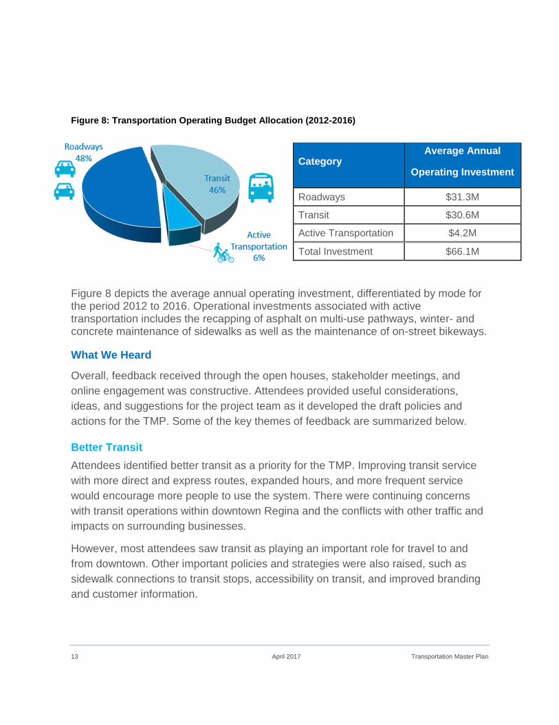
Figure 8: Transportation Operating Budget Allocation (2012-2016)
Figure 8 depicts the average annual operating investment, differentiated by mode for the period 2012 to 2016. Operational investments associated with active transportation includes the recapping of asphalt on multi-use pathways, winter- and concrete maintenance of sidewalks as well as the maintenance of on-street bikeways.
What We Heard
Overall, feedback received through the open houses, stakeholder meetings, and
online engagement was constructive. Attendees provided useful considerations,
ideas, and suggestions for the project team as it developed the draft policies and
actions for the TMP. Some of the key themes of feedback are summarized below.
Better Transit
Attendees identified better transit as a priority for the TMP. Improving transit service
with more direct and express routes, expanded hours, and more frequent service
would encourage more people to use the system. There were continuing concerns
with transit operations within downtown Regina and the conflicts with other traffic and
impacts on surrounding businesses.
However, most attendees saw transit as playing an important role for travel to and
from downtown. Other important policies and strategies were also raised, such as
sidewalk connections to transit stops, accessibility on transit, and improved branding
and customer information.
Category Average Annual
Operating Investment
Roadways $31.3M
Transit $30.6M
Active Transportation $4.2M
Total Investment $66.1M

Transportation Master Plan April 2017 14
Address Winter Travel
Greater enforcement of snow removal on sidewalks, especially in core areas of the
city and near bus stops, was seen as a priority. Other suggestions related to winter
transportation included clearing pathways of snow in the winter, providing heated
transit shelters, and better communication of snow removal policies.
Expand the cycling network
Most attendees appreciated the inclusion of a comprehensive network for cycling,
particularly, the definition of a priority cycling network for near-term implementation.
Improving local connections to citywide pathway networks was defined as a priority,
as are routes to major destinations such as the downtown and the university.
Significant input was received from the public and stakeholder groups that help refine
the draft cycling network.
Manage roadway congestion
People travelling around Regina by car were concerned that travel times are
increasing as congestion and traffic volumes grow. Bottlenecks and missing links in
the roadway network are cited as key concerns. Major regional projects, such as the
Regina Bypass are seen as imperative projects to help improve traffic flow.
Improved accessibility
Accessibility of the transportation network was a high priority for many in Regina and
recognized to be a pressing priority today and in the future as our population ages.
Providing travel choices for persons with disabilities, which includes an accessible
conventional transit system, paratransit, and a barrier-free built environment, is
important. Short term initiatives, such as accessible pedestrian signals, more and
better designed curb ramps, and sidewalk maintenance were also suggested.
Timely maintenance and renewal
Ensuring that our roadways, structures, sidewalks, and vehicles are well maintained
was identified as a priority. In some instances, maintenance was seen as a higher
priority than expanding the network to accommodate growth. Common feedback
included better monitoring and reporting of infrastructure, quicker responses to
complaints, and a clear system for prioritizing repairs.

15 April 2017 Transportation Master Plan
Future Vision
The TMP Guiding Principles and Directions reflect the city’s collective vision for Regina’s transportation system.
Transportation Directions
The TMP is structured around seven Directions which are the guiding statements for the development of the plan’s goals, policies, strategies and transportation networks. The Directions were developed in consultation with the community and encompass all modes and roles of transportation in the city such as promoting a healthy, vibrant city, improving modal choice, fostering economic prosperity, and creating a sustainable transportation network. The Directions also support the Community Priorities identified in the OCP.
Direction 1: Offer a Range of Sustainable Transportation Choices for All.
Regina’s residents will have a choice of travel modes that complement access by private vehicle. Strategies around transit, walking, cycling, and carpooling, combined with programs that educate and maximize existing transportation infrastructure, will offer travel choices that are easy, affordable, sustainable and more enjoyable for all users.
Direction 2: Integrate Transportation and Land Use Planning.
By planning land use and transportation concurrently, Regina can tailor new and existing neighbourhoods to make it easier to get around by all modes. Complete Streets, which feature a range of transportation modes, will help support vibrant, active and Complete Neighbourhoods.
Direction 3: Elevate the Role of Public Transit.
Public transit will play a pivotal role in Regina’s transportation future by becoming a competitive travel choice tightly integrated with our neighbourhoods. Transit will work toward becoming a more accessible system with frequent and reliable service, extended hours, and enhanced customer amenities. The identification of primary transit corridors suitable for express routes will help shape land use.
Direction 4: Promote Active Transportation for Healthier Communities.
Active modes such as walking, rolling, and cycling will be integral for day-to-day travel and for recreation. Pathways and bikeways will be extended to provide a connected network of comfortable and safe active corridors between key destinations.

Transportation Master Plan April 2017 16
Educational programs will promote mutual respect among all road users and advocate the benefits of active transportation.
Direction 5: Optimize Road Network Capacity.
Road network planning will focus on optimizing existing capacity to minimize the need for widening and expansion, reducing infrastructure costs while managing congestion. A hierarchy of road classes will provide citywide connectivity while minimizing neighbourhood traffic impacts. New and existing roads will be tailored to reflect community context and modern design standards.
Direction 6: Invest in an Affordable and Durable System.
Investment in the transportation system will be made based on a long term outlook through a framework of life cycle costing. Existing infrastructure will be monitored, inspected regularly, and undergo timely maintenance to maximize life span. Maintenance will demonstrate leadership through adopting environmentally responsible procedures and practices.
Direction 7: Support a Prosperous Regina and Region.
The transportation network will provide efficient and effective movement of goods and people to support economic growth, particularly in Regina’s key employment areas. Regional and inter-governmental partnerships will help to ensure Regina is competitive in a global economy.
How We Will Move
Regina possesses unique opportunities for multi-modal transportation. The city's
relative compactness is its greatest opportunity, with a higher proportion of short trips
than most cities its size. More than half of all daily trips in the city are less than five
kilometers in length, which can be easily travelled by walking, cycling or transit. The
concentration of employment in the downtown also creates a critical mass for high-
quality transit services and increases the effectiveness of transportation demand
management (TDM) programs.
As the city grows, travel distances and commute times will increase (Figure 9).
Providing increased choice of transportation modes and travel options is needed to
help keep travel times and costs low.

17 April 2017 Transportation Master Plan
Figure 9: Average Travel Time for Regina
The focus of the TMP is to improve transportation options for all residents and
encourage a multi-modal approach to transportation planning. This includes walking,
cycling, transit, ridesharing, and vehicle travel. Setting ambitious but achievable
targets for sustainable transportation choices will allow the city to support population
and employment growth while maintaining the things residents like about the current
transportation system such as shorter commute times and minimal congestion
(Table 1).

Transportation Master Plan April 2017 18
Table 1: Vision of the TMP
Target TMP Implementation Horizon
Sustainable Transportation
Residents will have more choice when travelling around the city. Transit will be a competitive alternative to driving. Residents will be able to walk and cycle within their neighbourhoods and to get to work and school. In the future, sustainable modes (ridesharing, active modes, and transit) will increase from 29% to 36% of all peak period trips.
Limited increase in Vehicle Kilometres Travelled
By coordinating transportation and land use policies, the city will be able to limit the growth in vehicle kilometres that residents travel to reach destinations and community amenities.
Improved Transit Service
Transit will provide competitive travel times and attractive service to more destinations and areas of the city. In the future 90% of all residents, and workplaces will be within 400 m of transit routes and there will be more frequent service.
Safer Cycling and Pedestrian Environments
The pathway system will continue to be the backbone to an all-season network, supported by an extensive system of on-street bikeways. The TMP will add approximately 106 km of off-street pathways and 122 km of on-street bikeways to the city’s bike network. Improved sidewalk maintenance and snow clearing will improve accessibility and safety year-round.
Assumptions
The following assumptions were made during the development of the TMP:
There will be growth in population to 300K.
Existing transportation infrastructure will be maintained.
There will be improvements to the transportation network.
There will be a shift in mode share.
Commute times and travel distances will increase.
Regional partnerships will be fostered.
Increased funding will be required.

19 April 2017 Transportation Master Plan

Transportation Master Plan April 2017 20
Transportation Directions

21 April 2017 Transportation Master Plan
D1 Offer a Range of Sustainable Transportation Choices for All
Policies and actions within this Direction complement the overarching Growth Plan and Infrastructure Policies presented in the OCP and support the Community Priority to “Create Better, More Active Ways of Getting Around”.
Investing in a range of transportation modes will help ensure that the city can sustainably accommodate future population growth while managing congestion on roadways. Offering a range of sustainable transportation choices such as walking, cycling or transit is important to increase mobility and accessibility for residents of all ages and income levels as everyone can participate in these modes of transportation.
The focus of the “Offer a Range of Sustainable Transportation Choices for All” policies in the TMP is to encourage modal shift in the design of transportation infrastructure through Travel Demand Management measures and consideration of all users throughout all seasons.
Goal 1: Mode share targets will inform transportation planning and policies.
Rationale: Measureable mode share targets allow the city to track progress and identify areas in need of improvement. This leads to more effective infrastructure investment and allows the city to adjust policies and actions as needed to achieve objectives.
Policies and Recommended Actions
1.1 Adopt short term and long term mode share targets for citywide travel by the 300,000 population horizon (Table 2).
Table 2: Citywide mode share targets for peak period travel
Travel Mode Current Mode Share
Short Term Mode Share
Long term Mode Share
Single-Occupant Vehicles
67% 65% 60%
Auto Passenger 18% 18% 20%
Transit 3% 4% 6%
Walking or Cycling 8% 9% 10%
Other (taxi/school bus) 4% 4% 4%
Current mode share based on 2009 Regina Travel Study, shares are for the a.m. Peak Period

Transportation Master Plan April 2017 22
1.2 Identify and adopt district-specific mode share targets for trips to downtown and to the University of Regina/Saskatchewan Polytechnic recognizing unique transportation needs and opportunities in these districts, such as the higher potential for sustainable transportation (Table 3 and Table 4).
Table 3: Downtown Regina mode share targets
Travel Mode Current Mode Share Long term Mode Share
Single-Occupant Vehicles 64% 45%
Auto Passenger 14% 20%
Transit 4% 15%
Walking or Cycling 17% 20%
Current mode share based on 2009 Regina Travel Study
Table 4: University of Regina/Saskatchewan Polytechnic mode share targets
Travel Mode Current Mode Share Long term Mode Share
Single-Occupant Vehicles 55% 40%
Auto Passenger 15% 20%
Transit 20% 25%
Walking or Cycling 10% 15%
Current mode share based on University of Regina Master Plan 2011
1.3 Consider adopting mode share targets for other key districts and trip generators in the city.
1.4 Incorporate mode share targets as a planning tool in new developments and in corridor and neighbourhood planning.
1.5 Establish targets for operational and capital investment in transportation, such as transit service hours or new kilometres of bikeways, to help achieve mode share targets.
1.6 Conduct a citywide travel survey every five years to measure progress toward achieving mode share targets and gauge the success of TMP goals and policies. This will also help to keep the city's travel demand model up to date, and ensure that transportation investments are made wisely and with timely data.

23 April 2017 Transportation Master Plan
1.7 Lobby the provincial government to enable the city to use provincial funding to invest in other modes of transportation in addition to roadway investments.
Goal 2: The transportation system will provide a greater range of multi-modal transportation choices for all seasons.
Rationale: Directing resources towards a multi-modal transportation approach will ensure increased access for all users as well as maximizing the efficient movement throughout the city during all seasons. This includes ensuring that pedestrian infrastructure is designed and maintained to provide comfort and safety for residents of all ages and abilities and providing accessible transit services and paratransit services for customers with reduced mobility to ensure equal access.
Policies and Recommended Actions
1.8 Establish a cross-divisional internal Transportation Advisory Committee to oversee the implementation of various plans and projects related to the TMP and divisional work plans.
1.9 Ensure that multi-modal transportation is a key part of the city’s planning, operations, and processes to expand transportation choice. Justification will be provided where it is not feasible due to such factors as distance, safety, or cost.
1.10 Adopt a lead-by-example policy to meet universal accessibility needs in transportation infrastructure and services.
1.11 Ensure connectivity between transportation modes. This may include park-and-ride programs, pathway and street connections, bus connections to bike and pedestrian destinations, and filling sidewalk gaps to transit stops. Review and update city policies and standards to reflect multi-modal transportation needs for all seasons.
1.12 Review and update city policies and standards to reflect multi-modal transportation needs for all seasons.
1.13 Incorporate the concept of a multi-modal level of service (MMLOS) when assessing transportation needs at all levels of planning and develop a standard set of assessment criteria to utilize for MMLOS analysis (see Goal 21).
1.14 Develop a winter travel strategy that integrates and complements the city’s Winter Maintenance Policy and that clearly defines priorities, level of service expectations, and responsibilities for winter transportation for all modes.

Transportation Master Plan April 2017 24
Goal 3: A Complete Streets Framework will balance the needs of all users.
Rationale: Traditional street planning and engineering processes have typically taken the approach of placing priority on vehicular movement; whereas, complete streets planning focuses on ensuring all modes are considered in the design. A Complete Streets Policy reinforces consistent design and operation of roads to ensure the comfort and safety for all users, regardless of age, ability or income.
Policies and Recommended Actions
1.15 Create a Complete Streets Policy using the Framework for Complete Streets (Appendix D) that fits the context of Regina to allow planners and engineers to consistently design and operate streets with all users in mind.
1.16 Develop a strategy to identify existing corridors that should be transitioned to complete streets. The strategy will prioritize streets with existing potential to incorporate multiple modes during road reconstruction. Coordination between departments will be important to allocate funding for reconstruction projects and reduce overall costs of reconstruction (see Direction 6).
1.17 Support the development of complete streets in Regina by:
coordinating complete streets and complete neighbourhoods as part of the land use planning process (Direction 2);
integrating complete streets principles into existing documents, such as the Development Standards Manual;
developing a toolkit for accommodating multiple modes on different classes of streets and through the adoption of standard roadway cross-sections for new streets (Direction 5);
identifying best practices for retrofitting existing streets to accommodate multiple modes;
ensuring complete streets are part of the planning, design, and assessment of all new and renewed transportation projects; and,
placing a higher priority or preference for options and projects that reflect complete streets principles.
1.18 Establish evaluation criteria and monitor the progress of achieving the objectives of the Complete Streets Policy, once developed. Criteria should include factors such as access to multiple modes of travel and travel safety statistics.
1.19 Review the Complete Streets Policy, once developed, as part of future updates to the TMP to reflect changing travel patterns, needs, and urban contexts.

25 April 2017 Transportation Master Plan
Goal 4: Travel Demand Management will be a key component of sustainable transportation.
Rationale: Travel Demand Management (TDM) is a key tool in transportation planning and operations and represents a cost-effective way to ease congestion, expand transportation choice, and reduce the need to expand capacity. TDM encompasses a wide range of strategies to encourage travellers to change their travel choices including shifting modes away from single occupant vehicles (SOVs), reducing the number of trips they make, and travelling more efficiently.
Policies and Recommended Actions
1.20 Adopt a lead-by-example policy to promote TDM strategies within the City of Regina municipal corporation.
1.21 Increase the visibility of sustainable modes and provide educational information about TDM.
1.22 Hire a TDM Coordinator to serve as a resource and liaison for citywide TDM initiatives.
1.23 Explore the expansion of the Community Grants Program to provide an annual budget for TDM initiatives that encourage local organizations and businesses to pilot or initiate TDM strategies.
1.24 Monitor and implement, when appropriate, innovative applications of technology that have potential to change travel behaviour, improve transportation options, or increase awareness of TDM.
1.25 Target TDM initiatives to key community partners and institutions that can make a large impact.
1.26 Partner with community leaders to improve the perception, attitudes, and awareness of alternative modes.
1.27 Encourage more community events and festivals to integrate TDM initiatives in their programming. Build off the success of current event-related TDM initiatives such as the Football Express transit service for Roughrider games, transit shuttles that circulate between pavilions for the Mosaic Cultural Festival, and community bike valet services at the Regina Folk Festival.
1.28 Support advocacy groups and organizations that promote sustainable transportation modes.

Transportation Master Plan April 2017 26
Integrate Transportation and Land Use Planning.

27 April 2017 Transportation Master Plan
D2 Integrate Transportation and Land Use Planning
Policies and actions within this Direction complement the overarching Land Use and Built Environment Policies presented in the OCP and support the Community Priority to “Develop Complete Neighbourhoods”.
Land use and transportation are two key aspects of urban development that influence one another. By planning land use and transportation concurrently, the city can tailor neighbourhoods that provide access to various destinations by means of complete streets.
The focus of the “Integrate Transportation and Land Use Planning” policies in the TMP is to coordinate the development of vibrant, safe, well connected neighbourhoods that enhance multi-modal transportation options and land use planning.
Goal 5: Transportation and land use planning processes will be coordinated.
Rationale: It is important for land use plans to be developed in conjunction with transportation planning to meet capacity needs while ensuring that roads are designed for the development of an efficient citywide transportation network.
Policies and Recommended Actions
2.1 Ensure land use and transportation planning goals are achieved through regular communication, coordination, and collaboration between planning, engineering, operations, and maintenance staff.
2.2 Employ integrated land use forecasting and transportation models as part of long-range planning and engineering activities.
2.3 Ensure long-range development goals identified in the OCP are supported through appropriate transportation investments, such as improved transit and pedestrian infrastructure.
2.4 Update the Zoning Bylaw to provide incentives for development that expands transportation choices and supports the goals of the TMP.
2.5 Use land use planning tools such as secondary plans, concept plans, and site plan approvals to ensure that:
land uses support transportation investments and plans including express transit corridors and transit nodes;
the design of streets is complimentary to existing land uses and proposed land uses during reconstruction;

Transportation Master Plan April 2017 28
multiple modes of transportation are integrated; and,
transportation gaps and needs are identified and addressed.
2.6 Update “Map 5 – Transportation” in the OCP to reflect the TMP transportation networks as part of a future amendment.
2.7 Ensure that the transportation network maps in the TMP are updated as secondary and concept plans for new neighbourhoods are approved.
2.8 Develop site design guidelines that support and promote multi-modal transportation including providing active transportation facilities and connections to transit.
2.9 Develop a strategy to protect land for transportation needs, including ROWs and future transit corridors, as part of the land use planning and approvals processes. Real Estate staff should be made aware of future corridor requirements to inform where land should be retained by the city or purchased to accommodate future transportation needs.
Goal 6: Transportation will support vibrant, safe, and well-connected complete neighbourhoods.
Rationale: Transportation planning can be used to support the development of complete neighbourhoods by ensuring multi-modal access and connectivity to neighbourhood destinations such as employment centres, community services, and open spaces. The street layout, design and location of transportation infrastructure can foster a sense of place, affirm the role of streets as places, and ensure the safety and comfort of all users are taken into account. Focusing on neighbourhood structure and development will lead to a connected and integrated transportation system which will support the safe and efficient movement of all residents and users within and between different neighbourhoods.
Policies and Recommended Actions
2.10 Update the Subdivision Bylaw No. 7748 (Subdivision Bylaw) to incorporate transportation infrastructure as a mechanism to help define neighbourhood structure and support multiple land uses and multiple modes.
2.11 Ensure neighbourhood transportation planning provides integration of multiple modes within neighbourhoods and connectivity between adjacent neighbourhoods.
2.12 Utilize transportation planning as a mechanism to foster a sense of place, character, and identity within the public realm. This could include:

29 April 2017 Transportation Master Plan
adopting a Complete Streets Policy that ensures all users are considered when designing transportation infrastructure;
developing roadway cross-sections and design guidelines that support safe and comfortable routes for all users;
utilizing the hierarchy of the street network as a positive character defining element in the public realm; and,
emphasize the role of streets as key public spaces and destinations by creating neighbourhood streetscaping programs, supporting place making activities, and providing resources to make improvements in the public realm.
2.13 Coordinate complete neighbourhoods and complete streets initiatives as part of ongoing integration of land use and transportation planning in new and existing neighbourhoods.
Goal 7: Existing neighbourhoods and employment areas will have enhanced transportation options.
Rationale: Existing neighbourhoods may not currently meet the mobility needs of all residents or support long term planning priorities. Enhancing transportation options and services in existing neighbourhoods will provide for better connectivity and accessibility to local and citywide services and amenities.
Policies and Recommended Actions
2.14 Update the Zoning Bylaw to enable infill developments of higher densities as well as those that incorporate mixed-uses and to support expanded transportation choices in existing neighbourhoods. Updates may include:
increasing density allowances to encourage higher density and transit-oriented development at transit nodes and along primary transit and express transit corridors;
permitting mixed uses in additional zones;
reviewing exceptions to parking standards in additional zones to support infill development; and,
expanding bike parking requirements to additional zones (in particular residential zones).

Transportation Master Plan April 2017 30
2.15 Expand the existing Development Standards Manual (DSM) to include guidance on infill development in order to support enhanced transportation choices in existing neighbourhoods.
2.16 Explore potential interim measures to improve the accommodation of multiple modes within existing neighbourhoods during the process of updating city bylaws and the DSM.
2.17 Ensure that transportation needs are identified and that transportation design is included in the neighbourhood planning process.
2.18 Improve existing transportation infrastructure to support multiple modes of transportation and increase universal accessibility within existing neighbourhoods.
2.19 Use cycling, pedestrian, transit, and road networks to identify and address gaps in existing transportation infrastructure and improve connectivity between neighbourhoods.
2.20 Leverage infill development in existing neighbourhoods to address transportation needs and gaps and to expand multi-modal transportation options.
2.21 Update the Transportation Impact Assessment (TIA) guidelines to include a strategy to monitor the cumulative impacts of infill development projects and establish when a TIA should be required for infill projects.
2.22 Incorporate multi-modal transportation considerations into TIA requirements for infill projects.
2.23 Review applications for roadway/alley closures and property sales to ensure that existing and future transportation connections are maintained.
Goal 8: New neighbourhoods and employment areas will incorporate multi-modal transportation options.
Rationale: Planning of new neighbourhoods greatly impacts the mode of transportation people choose to use. Integrating multi-modal transportation choices into the planning approval process during neighbourhood development will minimize the impacts on transportation infrastructure and help promote alternative modes of transportation.
Policies and Recommended Actions
2.24 Ensure new neighbourhoods provide direct connections to existing transportation bike and transit networks and protect for future neighbourhoods and employment areas to connect to these networks.
31 April 2017 Transportation Master Plan
2.25 Develop criteria to direct the types of facilities that are to be included on different road classifications (see Goal 17).
2.26 Ensure new neighbourhoods and employment areas provide direct connections to adjacent neighbourhoods and employment areas. Preserving the existing grid network should be a priority with connections between neighbourhoods occurring on collector streets where possible (see Goal 24).
2.27 Ensure new neighbourhoods and employment areas protect for connections to future neighbourhoods and employment areas. Temporary dead end streets should be used to protect for future connections in conjunction with phased development. Where current barriers exist, protecting for future connections is still recommended.
2.28 Ensure infrastructure in new neighbourhoods and employment areas is designed to support universal accessibility.
2.29 Update the Zoning Bylaw to enable the development of new neighbourhoods that make efficient use of existing infrastructure and transportation services. This may include:
promoting increased density along express transit corridors and within a walkable distance;
increasing the provision of mixed-uses in additional zones;
reviewing parking standards in neighbourhoods located near planned transit corridors and transit nodes (see Goal 9); and,
ensuring the provision of cycling facilities and amenities near employment and community centres, and within new development projects.
2.30 Update the planning approvals process to integrate consideration for multi-modal transportation in neighbourhood, concept, subdivision, and site plans.
2.31 Develop a strategy to monitor the cumulative impacts of rezoning and subdivision iterations in new neighbourhoods to establish when an updated TIA is required.
2.32 Explore the use of financial and other incentive mechanisms to promote higher density development near identified express transit corridors and near transit nodes.
2.33 Explore the potential to include additional transportation related items within Servicing Agreement Fees (SAFs) and Development Levies (DLs) as applicable and appropriate. This should be done within the context of future SAF and DL policy reviews.

Transportation Master Plan April 2017 32
2.34 Explore changing eligibility for SAFs and DLs to be applied towards other transportation needs under The Planning and Development Act, 2007.
Goal 9: Parking policies will be a tool to encourage multi-modal transportation options and achieve land use objectives.
Rationale: The quantity and location of parking should be tailored to the surrounding land use. Providing an appropriate amount of parking is important to support the economic health and viability of businesses and residential development projects; however, providing too much can undermine cycling, walking or efforts to promote transit ridership.
Policies and Recommended Actions
2.35 Review parking policies and standards in the Zoning Bylaw to ensure they support transportation goals and objectives.
2.36 Examine separate title parking for development projects located near areas identified for intensification, along transit corridors, and near transit nodes.
2.37 Review parking pricing strategies in areas of high demand to encourage parking space turn-over and discourage the use of single occupancy vehicle travel.
2.38 Review land use classifications and property tax rates for parking infrastructure, in particular for surface parking and ground floor parking, to encourage the development of structured parking.
2.39 Increase resources towards citywide parking enforcement.
2.40 Pursue policy changes allowing parking revenue to be reinvested into parking and transportation infrastructure and programs.
2.41 Examine the potential for future development of high-density parkade structures to replace surface parking lots in areas with high parking demand.
2.42 Initiate parking studies for areas outside of the downtown that experience parking challenges.
2.43 Encourage high-quality urban design and the use of green infrastructure for parking structures to minimize impacts on the environment.

33 April 2017 Transportation Master Plan

Transportation Master Plan April 2017 34
Elevate the Role of Public Transit

35 April 2017 Transportation Master Plan
D3 Elevate the Role of Public Transit
Policies and actions within this Direction complement the overarching Growth Plan Policies presented in the OCP and support the Community Priority to “Create Better, More Active Ways of Getting Around”.
Public transit plays an important role in Regina by providing mobility across the city, serving neighbourhoods, workplaces, schools, shopping, and other destinations. As the city grows, transit use will need to increase, particularly for areas of the city where access is constrained by road capacity. In addition, the demand for transit will increase with an aging population and increase in new residents who are accustomed to transit systems in other cities.
The focus of the “Elevate the Role of Public Transit” policies in the TMP is to make transit more reliable and easy to use, by integrating it into the community, ensuring it is accessible to all, and developing a positive identity for transit.
Goal 10: Transit will be a reliable and convenient travel choice throughout Regina.
Rationale: Making transit more convenient and reliable can be accomplished by shortening walking distances to transit stops, reducing wait times, and decreasing travel times. Increasing cost competiveness between transit and private vehicles, as well as improving travel times and levels of service associated with the transit system will ensure that residents view transit as a viable alternative compared to private vehicles.
Policies and Recommended Actions
3.1 Utilize transit coverage standards to ensure that 90 per cent of all residents, secondary and post-secondary schools, and workplaces are within 400 m of neighbourhood transit service and 2 km of express transit service. Actual walking distance and other barriers should be considered when defining whether or not an area is covered by transit.
3.2 Design the transit system and its routes to provide direct and time-competitive service.
3.3 Implement transit priority measures to increase service reliability and reduce travel times.
3.4 Expand transit service through increased frequencies and/or hours of service where appropriate.

Transportation Master Plan April 2017 36
3.5 Adopt fare strategies that ensure transit is cost competitive with private vehicle use.
Goal 11: The transit network will be easy-to-understand and structured around express transit.
Rationale: The TMP encourages continued restructuring of the transit system with the development of a clear network structure as the system grows. Increasing the usability of the transit network and improving the express transit system will encourage increased ridership.
Policies and Recommended Actions
3.6 Implement the transit network as shown in Appendix A.
3.7 Adopt a transit network hierarchy to provide clear structure and expectations for levels of service and coverage (Table 5):
Neighbourhood transit will provide local service into neighbourhoods, connecting them to local destinations and to primary transit and express transit at transit nodes.
Primary transit will serve as the base transit network that maximizes connectivity throughout the city and provides direct service between transit nodes and destinations.
Express transit will provide fast, limited-stop service to key destinations, along urban corridors, and following major travel flows.
Table 5: Transit level of service and coverage standards
Transit service type Service frequency Average transit stop spacing
Neighbourhood Transit Peak periods: 15 - 30 minutes
Off-peak periods: 30 - 60 minutes 200 - 400 m
Primary Transit Peak periods: 15 minutes or better Off-peak periods: 15 - 30 minutes
400 m
Express Transit Peak periods: 30 minutes or better
Off-peak periods: 30 minutes or better 800 m
3.8 Establish transit nodes that will serve as transfer points between routes. Safe and direct walking and cycling connections to these nodes will need to be developed to improve access to transit.
37 April 2017 Transportation Master Plan
3.9 Support elevated transit service to areas that are identified for significant intensification within the OCP, including the City Centre and along urban corridors.
3.10 Protect and plan for long term implementation of higher-order transit.
3.11 Work with stakeholders to evaluate potential for regional transit connections. Explore potential for park and ride at regional gateways (see Goal 33).
Goal 12: Transit will be aligned with destination, land uses, and growth.
Rationale: Emphasizing the integration of transit with destinations, land uses and the accommodation of growth, will increase the viability of transit as a mode of transportation. Transit services must also keep pace with increased population and employment growth which will require greater investment.
Policies and Recommended Actions
3.12 Develop a plan to increase and maintain overall investment in transit on a per capita basis, comparable to levels of similar sized Canadian municipalities. Operational subsidies and investments in transit will be kept in pace with population and employment growth to ensure services meet the needs of the community.
3.13 Reinforce and expand the role of transit within the City Centre as the primary means to accommodate growth in travel demand.
3.14 Orient and locate higher intensity land uses at transit nodes and along express transit and primary transit corridors.
3.15 Proactively protect and extend express transit into growth areas and connect new destinations to transit nodes.
3.16 Ensure that new neighbourhoods and development projects are designed to maximize the coverage and efficiency of neighbourhood transit and connectivity to primary transit and express transit. Regina Transit will review concept plans to achieve these objectives and ensure routes and transit stop locations are satisfactory for the operation of transit and connectivity to surrounding land use.
3.17 Align new and existing neighbourhoods to meet minimum densities for neighbourhood transit service and target higher densities along primary transit and express transit corridors.
Transportation Master Plan April 2017 38
3.18 Explore programs with developers to provide transit service at the earliest opportunity in new neighbourhoods.
3.19 Establish and retrofit pedestrian connections from nearby destinations, residences, and workplaces to transit stops with associated maintenance procedures to ensure all-season access.
3.20 Develop a continuous process of transit planning and service improvements to respond to changes in travel demand and change in land uses, with the target of completing a major service review every five years.
3.21 Extend transit service to all major employment and residential areas in the city that currently do not have transit service.
Goal 13: Transit will be universally accessible and complemented by paratransit.
Rationale: Providing universally accessible transit and paratransit systems will ensure that equitable transportation exists for all residents. Transit is especially important for residents with disabilities and reduced mobility. Paratransit will play a key role in meeting mobility needs and will continue to create a fully accessible transit system.
Policies and Recommended Actions
3.22 Integrate accessibility as part of the overall transit planning process to identify needs and action plans on an ongoing basis.
3.23 Continue engagement with the Accessibility Advisory Committee to identify and address transit accessibility issues.
3.24 Complete an audit of all transit stops to review necessary upgrades for accessibility and work to prioritize and implement identified improvements.
3.25 Maintain the paratransit system to meet the needs of individuals unable to use the conventional transit system.
3.26 Complete a Paratransit Service Plan to identify future needs, required actions, and funding implications.
Goal 14: Transit will have a strong and positive identity reflected by a high-quality customer experience.
Rationale: Strengthening the identity of transit will improve the reputation of transit as a viable mode of transportation and build support and ridership within the community. A renewed identity and brand for Regina Transit will be supported by a high-quality

39 April 2017 Transportation Master Plan
customer experience including trip planning resources, transit stops, fleet vehicles, and access to destinations.
Policies and Recommended Actions
3.27 Develop a unique brand and identity for Regina Transit that is positive and reflects the sustainability and future role of transit in the community.
3.28 Use education and promotional campaigns to increase the awareness of transit services, their benefits, and the value to the community.
3.29 Evaluate and adopt on-board and off-board technologies to enhance the quality and availability of customer information and amenities.
3.30 Develop a toolkit and warrant system for transit stop amenities.
3.31 Continue to improve and increase accessibility of customer service and trip planning tools.
3.32 Integrate multi-modal opportunities with transit.
3.33 Evaluate the potential for the use of loyalty or discount programs to encourage the use of transit.
3.34 Utilize the information gathered through the R-Card to gain a better understanding of travel patterns, customer needs, and opportunities to encourage ridership.
3.35 Re-invest advertising and ridership revenue from transit towards improvements in transit infrastructure and services.

Transportation Master Plan April 2017 40
Promote Active Transportation for Healthier Communities.

41 April 2017 Transportation Master Plan
D4 Promote Active Transportation for Healthier Communities
Policies and actions within this Direction complement the policies presented in the OCP and support the Community Priority to “Create Better, more Active Ways of Getting Around”.
There are many social, environmental, and economic benefits associated with active modes of transportation. Active transportation can be an important aspect of promoting healthy lifestyles particularly when incorporated into people’s daily activities. Walking and cycling are affordable and sustainable modes of transportation where people of all ages and income levels can participate.
The focus of the “Promote Active Transportation for Healthier Communities” policies in the TMP is to make walking and cycling more safe, accessible, efficient and attractive for all users as a way to get around the city.
Goal 15: Active modes of transportation will be prioritized in city policies and processes.
Rationale: Updating and enforcing municipal policies, bylaws and design standards to support active modes will increase the number of residents who perceive walking and cycling as safe, convenient, and enjoyable ways to move around the city.
Policies and Recommended Actions
4.1 Integrate the planning and design of active transportation facilities within secondary/neighbourhood plans, concept plans and site plans (see Goal 5).
4.2 Update the DSM to address active transportation-related issues. This will include development standards for:
traffic calming measures;
pedestrian facilities; and,
cycling facilities.
4.3 Update the Zoning Bylaw to address active transportation-related issues (see Direction 2).
4.4 Update TIA Guidelines to account for cycling and pedestrian comfort, safety, and convenience.
4.5 Amend the Traffic Bylaw No. 9900 (Traffic Bylaw) to reduce barriers for active modes.

Transportation Master Plan April 2017 42
Goal 16: Active modes will be promoted as an integral part of how Regina residents get to work and school.
Rationale: Increasing the visibility and profile of active transportation within Regina will encourage multi-modal transportation choices and reinforces the notion that active modes are safe and efficient ways to access destinations. Support for active modes can be provided through provision of facilities, trip planning resources and promotion.
Policies and Recommended Actions
4.6 Develop a strategy to increase awareness of active transportation mode opportunities and their benefits.
4.7 Publicize the locations of amenities that benefit active modes, especially those near community destinations.
4.8 Expand trip planning resources to include directions to employment nodes, schools, and city facilities. Active transportation directions should also be included in promotional material about city-run events and festivals.
4.9 Encourage employers, business groups, and educational institutions to provide amenities and facilities to promote commuting by active modes.
4.10 Increase data collection about active modes to monitor changes in mode share split.
4.11 Provide local walking and cycling groups with resources and opportunities to build awareness around active transportation.
Goal 17: A comprehensive citywide bikeway network will connect people to destinations and activities.
Rationale: Filling gaps in the existing network and developing a comprehensive citywide network that features a variety of on-street and off-street facilities will help support active modes through increased accessibility. In addition to recreational use the city’s multi-use pathways should be strategically expanded to help support utilitarian trips, such as commuting to school or work.
Policies and Recommended Actions
4.12 Expand the current multi-use pathway network. This will require establishing an evaluation system to determine the location and timing for network expansion. Priority should be placed on creating pathways to destinations such as schools and activity centres, and improving connections between the pathway network and on-street facilities (Appendix A).

43 April 2017 Transportation Master Plan
4.13 Identify a list of improvements to the existing network with input from cyclists. Priority projects will be determined based on cost-effective opportunities for implementation, demand and budget considerations.
4.14 Increase the number of on-street bikeways and pathways oriented towards commuters (Appendix A).
4.15 Work with stakeholders to explore potential for constructing multi-use pathways within utility, pipeline, and railway corridors.
4.16 Establish criteria to direct the type of bike facilities that need to be integrated in secondary/neighbourhood, concept and subdivision plans. These criteria will be reflective of the long term bicycle network and ensure that new neighbourhoods provide direct connections to the existing network (see Goal 8).
4.17 Establish bikeway design guidelines for both on-street and off-street routes.
4.18 Review and upgrade developed on-street and off-street cycling facilities to ensure they meet the bikeway design guidelines.
4.19 Develop a comprehensive wayfinding strategy for trail routes and on-street bike routes.
4.20 Pursue opportunities to connect the citywide bike network to local and regional trails (see Goal 33).
Goal 18: Streets throughout the city will be accessible and walkable.
Rationale: Improving the quality and design of sidewalks will improve the comfort and safety of walking and promoting pedestrian activity for residents of all ages and abilities. Properly designed and maintained sidewalks in Regina can create a consistent and high-quality pedestrian network.
Policies and Recommended Actions
4.21 Update neighbourhood design standards to support pedestrian culture.
4.22 Update the DSM to identify improvements to sidewalk and adjacent features in support of pedestrian comfort.
4.23 Update the current inspection and maintenance policies for improvements to sidewalk quality. This strategy will need to be developed in coordination with a neighbourhood renewal strategy (see Goal 27).
4.24 Update sidewalk design standards to increase accessibility. New guidelines should be developed with particular attention to sidewalk width, quality of materials and the provision of accessible pedestrian curb ramps.

Transportation Master Plan April 2017 44
4.25 Identify missing sidewalk connections and prioritize the installation of sidewalks on collector and arterial roads, particularly along transit corridors and other high-use pedestrian corridors.
4.26 Update crosswalk design standards to increase safety and accessibility. This should be developed with input from the Accessibility Committee.
4.27 Integrate capital funding for audible pedestrian signals and countdown pedestrian signals.
4.28 Provide effective wayfinding in areas of high pedestrian activity and within the city’s pathway system.
Goal 19: The city will be safe for pedestrians and cyclists in all four seasons.
Rationale: Safety is paramount in the design, maintenance and year round operation of pedestrian and cyclist facilities. Consideration needs to be given to providing safe and accessible walking and cycling routes year-round to increase usability. This includes not only providing safe pathways and bikeways, but also providing education and awareness initiatives to improve the perceived safety of using active modes.
Policies and Recommended Actions
4.29 Develop a winter maintenance policy for active transportation corridors including off-street and on-street cycling routes (see Goal 2).
4.30 Prioritize snow clearing along priority pedestrian corridors. This policy will be coordinated with increased education and enforcement of the city’s Clean Property Bylaw No. 9881.
4.31 Prioritize street sweeping along bike networks in spring to remove gravel on road shoulders.
4.32 Increase education and awareness about how motor vehicles and cyclists can safely share road space. Materials and resources should be developed with community partners including SGI Canada.
4.33 Integrate Crime Prevention through Environmental Design (CPTED) considerations into sidewalk, pathway and pedestrian corridor design.
4.34 Improve underpass conditions to increase safety for active modes including increasing lighting and providing sufficient space to accommodate pedestrians and cyclists on busy arterial roadways.

45 April 2017 Transportation Master Plan

Transportation Master Plan April 2017 46
Optimize Road Network Capacity.

47 April 2017 Transportation Master Plan
D5 Optimize Road Network Capacity
Policies and actions within this Direction complement the Infrastructure, Financial, and Health and Safety Policies presented in the OCP and support the Community Priority to “achieve long term financial viability”.
Roads are the backbone of Regina’s transportation system and provide opportunities to move people and goods. There is greater competition for limited road space as the population grows. Pressures for road expansion must be balanced with the need to maintain and operate the expanded transportation network.
The focus of the “Optimize Road Network Capacity” policies is to develop a road network that moves the most number of people and goods throughout the city in a safe and efficient manner while adhering to modern design standards.
Goal 20: A hierarchy of roadway classes will provide citywide connectivity while minimizing neighbourhood impacts.
Rationale: Roadway classification is an important tool for the planning, design, operation and maintenance of roadways. As new neighbourhoods are developed, a comprehensive road classification system will be important to address the growing diversity of roadway functions. Additionally, there is a need to define new arterial corridors that maintain the integrity of the existing road network and minimize adverse impacts such as bottle necks and traffic infiltration into existing neighbourhoods.
Policies and Recommended Actions
5.1 Adopt an integrated road network classification system to guide network planning, design, and operations. Roads will be classified by function (Table 6).
5.2 Review and adopt new standard roadway cross-sections to ensure new streets are designed with all users in mind (see Goal 3).
5.3 New roadways will be designed to be consistent with the new standard roadway cross-sections (as per 5.2).
5.4 Ensure that the integrity of the existing road network is maintained and that the grid network is extended to new neighbourhoods (see Goal 8, 25).
5.5 Work with the province and regional partners to optimize connectivity to the regional transportation system (see Goal 33).

Transportation Master Plan April 2017 48
Table 6: Road Network Classification System
Goal 21: Strategies to move the most people effectively will influence roadway and network planning, design, and operations.
Rationale: The majority of traffic currently consists of SOVs. Strategies will be developed to promote alternative options such as auto-passenger, bike and transit which have the potential to carry more people in a given space and increase the overall level of service. Figure 10 illustrates the amount of space required to move 50 people by transit, bike or car.
Figure 10: Approaches to Allocating Road Space (source: Cycling Promotion Fund)
Classification Primary Function
Provincial Highway Under the jurisdiction of the province; intended to serve regional and provincial travel.
Expressway Carry relatively high volumes of traffic in conjunction with other types of roads. Direct access to and from abutting properties is prohibited.
Arterial Serve travel in conjunction with other roads. Direct access to and from abutting properties is permitted, under rigid controls. Connect highways and expressways to local networks.
Collector Provide circulation within neighbourhoods and connectivity between local and arterial roadways. Direct access to abutting properties is generally permitted with some access controls.
Local Provide direct access to adjacent lands
Alley Provide secondary access from a public road to an abutting lot

49 April 2017 Transportation Master Plan
Policies and Recommended Actions
5.6 Use MMLOS indicators to evaluate person movement capacity of roadways which will be used to inform planning and design decisions on the allocation of road space between modes (see Goal 2).
5.7 Plan and design road infrastructure based on 100 per cent capacity during peak hours as opposed to 85 per cent capacity over a single peak hour in order to avoid over-building roads.
5.8 Investigate the feasibility of implementing a High Occupancy Vehicle (HOV) network by converting selected transit-only lanes to transit-plus-HOV lanes.
Goal 22: Use of existing road network capacity will be maximized before expansion.
Rationale: Maximizing the capacity of the current roadway network will reduce the need for future capital investments as well as the additional long term maintenance associated with new transportation infrastructure.
Policies and Recommended Actions
5.9 Continue to improve and invest in road use data collection to inform decisions on the timing and prioritization of road improvements.
5.10 Continue to improve the city’s advanced traffic management system (ATMS) focusing on improving travel time reliability and safety.
5.11 Update the Winter Maintenance Policy to minimize impacts on road capacity.
5.12 Implement localized improvements to address bottlenecks in the existing road network.
5.13 Explore the use of SAFs and DLs to fund measures that optimize road capacity.
5.14 Examine ways to accommodate other modes within existing ROWs without reducing auto capacity (see Goal 3).
Goal 23: Road safety for all users and for all seasons will be paramount.
Rationale: The city is required to ensure all transportation facilities operate safely year round. Just as important is the need to address real and perceived safety and security concerns that may be discouraging the use of walking, cycling and transit.

Transportation Master Plan April 2017 50
Policies and Recommended Actions
5.15 Adopt an Engineering, Enforcement, Education and Emergency (4E) approach to road safety.
5.16 Implement safety treatments to address collision hot-spots.
5.17 Implement improvements to address vulnerable road users (see Goal 19).
5.18 Update the Winter Maintenance Policy to safely accommodate multiple modes.
Goal 24: New and existing roads will reflect modern design standards.
Rationale: Implementing modern design and accessibility standards will support all forms of transportation. The layout of neighbourhoods and street hierarchy should support the development of complete neighbourhoods and facilitate ease of movement.
Policies and Recommended Actions
5.19 Layout new neighbourhoods around a closely spaced or modified grid network to provide the most connectivity (Figure 11).
Figure 11: Walking Distances for Street Network Designs (source: Translink Transit-Oriented
Communities Design Guidelines)

51 April 2017 Transportation Master Plan
5.20 Develop and adopt updated design standards that reflect complete streets principles.
5.21 Ensure the planning and design of pedestrian infrastructure reflects modern accessibility standards (see Goal 18).
5.22 Ensure that roadway design standards support emergency services and other service vehicles.
5.23 Encourage high quality and aesthetically pleasing design for transportation related infrastructure.
5.24 Develop a process to identify potential low cost modifications to neighbourhood streets.
5.25 Adopt access control strategies that maintain traffic flow while ensuring good connections for pedestrians and cyclists.
Goal 25: The road network will serve new and expanded neighbourhoods.
Rationale: Road expansion will be required to serve new neighbourhoods and address the impacts of increased demand on the existing network. Major roadway projects are identified in Appendix B and include building new roads, widening roads, reconstruction and intersection improvements.
Policies and Recommended Actions
5.26 Adopt the future road network shown in Appendix A.
5.27 Conduct detailed studies to finalize the alignments and design elements of the proposed road network.
5.28 Protect and acquire lands required for future ROWs.
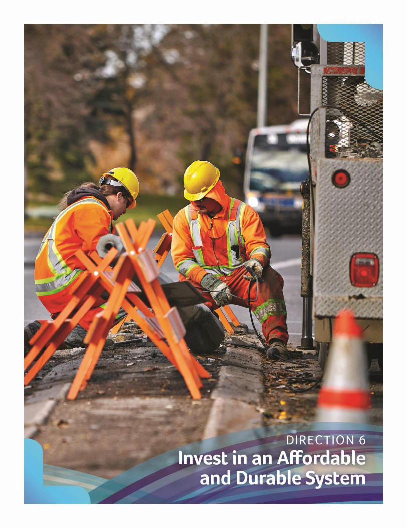
Transportation Master Plan April 2017 52
Invest in an Affordable and Durable System.

53 April 2017 Transportation Master Plan
D6 Invest in an Affordable and Durable System
Policies and actions within this Direction complement the Financial Policies presented in the OCP and support the Community Priorities to “Achieve Long term Financial Viability” and “Promote Conservation, Stewardship and Environmental Sustainability”.
It is important to consider the ongoing affordability and durability of transportation investments, not only to ensure responsible and effective use of limited capital dollars, but also to increase the city’s ability to maintain the transportation system. While a large portion of the city's transportation infrastructure is built or funded by new development, ongoing maintenance and renewal is funded by the tax base. This creates challenges in maintaining the transportation infrastructure especially as it approaches the end of its useful life.
The focus of the “Invest in an Affordable and Durable System” policies is to ensure that we design, build and operate the most cost efficient transportation network that meet the needs of residents.
Goal 26: A life cycle costing approach, integrated with social and environmental components, will be used to guide transportation investments.
Rationale: Incorporating life cycle costing into infrastructure investments will ensure all related operation, maintenance and replacement costs are considered before investment occurs.
Policies and Recommended Actions
6.1 Develop a life cycle costing strategy to ensure that transportation infrastructure and investments are costed to include ongoing operation and maintenance costs over the total life of the asset.
6.2 Develop a database resource to assess the life cycle costs of various transportation infrastructure elements.
6.3 Develop cost-benefit criteria to assess transportation, environmental, economic, and community benefits for all major transportation investments. This approach should identify opportunities to coordinate multiple projects.
6.4 Provide annual reporting to Council regarding the life cycle costs of building new infrastructure and infill developments.

Transportation Master Plan April 2017 54
Goal 27: Improved asset management through regular monitoring, inspections and timely maintenance will maximize the lifespan of existing infrastructure.
Rationale: Improved management of transportation infrastructure will allow for better coordination of infrastructure renewal and focus on reducing long term costs and decreasing project time frames.
Policies and Recommended Actions
6.5 Develop an asset management strategy for transportation infrastructure.
6.6 Improve coordination of transportation infrastructure projects including ongoing operations, maintenance, repair, and future capacity upgrades.
6.7 Develop a program for neighbourhood renewal to coordinate improvements of transportation infrastructure.
6.8 Develop new roadway, sidewalk, and structural inspection timelines to ensure existing infrastructure is monitored, and routine maintenance is conducted.
6.9 Update current processes and timelines to inspect transportation infrastructure within new developments.
6.10 Explore the creation of a long term fleet management strategy for transit vehicles to help meet ridership needs of the system.
6.11 Streamline tools for resident-reporting of infrastructure maintenance and repair requests.
Goal 28: Transportation infrastructure will be developed in an orderly and efficient manner.
Rationale: Transportation investment should be coordinated in a sustainable and efficient manner to ensure capital and maintenance dollars are used wisely.
Policies and Recommended Actions
6.12 Prioritize transportation investments to optimize the efficiency or capacity of the existing system (see Goal 27).
6.13 Identify and protect land for future transportation needs.
6.14 Ensure new and expanded transportation infrastructure is developed in accordance with transportation demand and new development.
55 April 2017 Transportation Master Plan
6.15 Align maintenance and planned upgrades of existing transportation infrastructure with new infrastructure and redevelopment projects.
6.16 Develop guidelines to extend the life of infrastructure.
Goal 29: System and infrastructure design, construction, and operation will reflect best practices and standards for sustainable transportation.
Rationale: Durable materials, leading edge construction processes and timely maintenance will ensure the transportation infrastructure is affordable and sustainable.
Policies and Recommended Actions
6.17 Ensure design, construction and operation of infrastructure complies with relevant legislative and regulatory requirements and follows industry best-practices.
6.18 Explore the use of construction and maintenance procedures that are more sustainable.
6.19 Develop an ecological assessment process to evaluate potential impacts of transportation infrastructure projects.
6.20 Implement green initiatives within the transportation system particularly when long term benefits from reduced life cycle costs can be realized.
6.21 Utilize pilot programs to evaluate alternative approaches to design, construction, and maintenance operations.
Goal 30: Investment in transportation infrastructure will make use of diverse funding sources and delivery approaches.
Rationale: Consideration will be given to alternative approaches for funding transportation infrastructure and service delivery as increased investment will place added pressure on the city’s financial resources.
Policies and Recommended Actions
6.22 Advocate for sustainable and predictable investment by higher levels of government.
6.23 Explore alternative project funding models including public-private partnerships (P3s).

Transportation Master Plan April 2017 56
6.24 Examine the potential for cost-sharing agreements with large development projects and regional, provincial and interprovincial governments (see Goal 33).
6.25 Assess the potential of revenue tools to fund transportation infrastructure and programs.
6.26 Examine cost-sharing agreements between municipal departments and utility companies.
6.27 Report to Council regularly regarding the long term funding requirements for transportation infrastructure and available taxation revenue allocated to make improvements.

57 April 2017 Transportation Master Plan

Transportation Master Plan April 2017 58
Support a Prosperous Regina and Region.

59 April 2017 Transportation Master Plan
D7 Support a Prosperous Regina and Region
Policies and actions within this Direction complement the Regional Policies presented in the OCP and support the Community Priorities to “Optimize Regional Cooperation” and “Foster Economic Prosperity”.
Collaboration between the city and regional partners is essential in supporting national and international movement of goods and services which reinforces economic vitality.
The focus of the “Support a Prosperous Regina and Region” policies is to ensure that the city will support the safe and efficient movement of people and goods, as well as the overall economic vitality of the region through a collaborative approach to regional transportation planning.
Goal 31: Goods movement will be safe and efficient.
Rationale: Developing and updating local and regional transportation routes will ensure safety and efficiency in the movement of goods throughout Regina and region to support economic growth.
Policies and Recommended Actions
7.1 Work with the province, surrounding municipalities and regional partners to develop a regional truck route network (Appendix A). The network should identify municipal and regional roadways and will define:
routes where dangerous goods are permitted;
routes for pick-up and delivery vehicles;
routes for heavy or long combination vehicles; and,
truck route areas in industrial districts.
7.2 Ensure truck and dangerous goods routes are clearly signed to reduce infiltration into areas where these vehicles are not permitted.
7.3 Evaluate goods movement by means of railways to identify potential improvements.
7.4 Support access to municipal and regional intermodal facilities including the Regina International Airport.

Transportation Master Plan April 2017 60
Goal 32: Transportation services and infrastructure will support key employment areas in the city and region.
Rationale: Transportation services and infrastructure in employment areas will help direct transportation investments to support employment growth.
Policies and Recommended Actions
7.5 Encourage an increase in multi-modal transportation choices that support new and existing employment areas in Regina and the region.
7.6 Create attractive investment opportunities in employment areas by providing high-quality multi-modal transportation connections.
7.7 Support continued growth of employment in downtown by incorporating recommendations from the Downtown Transportation Study.
7.8 Identify employment areas that require transportation studies to identify future development and transportation investment needs.
Goal 33: Coordination of regional transportation planning and service delivery will continue to be done in partnership with the province, surrounding municipalities and other regional stakeholders.
Rationale: Collaboration between the city and their regional partners is imperative for determining opportunities to increase regional connectivity and ensuring future growth is directed towards efficient service delivery throughout the region.
Policies and Recommended Actions
7.9 Support a coordinated approach to transportation infrastructure development through the formation of a regional transportation planning committee.
7.10 Participate in the development of a Regional Transportation Plan.
7.11 Develop and update the Regional Transportation Model.
7.12 Work with regional partners to protect corridors and ROWs that support future regional transportation needs. Joint transportation studies should be undertaken for areas denoted on the maps (Appendix A).
7.13 Work with regional partners to create design, development and access guidelines and standards.
7.14 Work with regional partners to develop shared servicing and cost agreements for transportation infrastructure.

61 April 2017 Transportation Master Plan
7.15 Lobby the provincial and federal governments for additional funding of provincial and interprovincial transportation infrastructure.
7.16 Encourage the timely completion of the Regina ByPass by the Province.
7.17 Initiate a railway study to review the role of railways and coordinate policies that may be impacted by railway infrastructure. Items to be reviewed will include:
land use and development regulations near railways;
the location of railway crossings and regulations related to at-grade and grade-separated crossings;
anti-whistling policies;
the use of railway corridors and buffers for pathways and trails; and,
issues related to railway relocation.
7.18 Explore long term regional transit connections.
7.19 Identify opportunities to link the city’s pathway network to regional pathways.
7.20 Support the development of regional TDM initiatives.
7.21 Reinforce the role of Regina International Airport as one of the city’s key regional, national, and international gateways.
Transportation Master Plan April 2017 62
Implementation Plan
A strategy for realizing the plan is needed to support its effective implementation over time. This section provides clarity on some key aspects and considerations that will be used to set the stage for developing more specific and detailed TMP implementation strategies.
Plan Ownership and Execution
It will be important to establish a cross-divisional implementation team to take ownership of the plan and be responsible for its execution. A Transportation Advisory Committee will need to be established and will be responsible for overseeing the implementation of various plans and projects related to the TMP (Policy 1.8). Ideally, the Transportation Advisory Committee would include senior engineers and managers with sponsorship from directors representing various city departments involved in transportation. The Committee should meet regularly to review departmental priorities as they relate to the TMP and identify projects that should be pursued in the next fiscal year. The Transportation Advisory Committee would also be responsible for recommending project funding and communicating priorities to Council.
The city will need to provide adequate funding to accommodate population growth by expanding multi-modal transportation networks. The TMP provides policy direction to inform decisions that are made by Administration and Council as part of the defined budget process. The TMP is not necessarily a commitment for future investment, however, the expenditures in this plan are higher than the current spend. Recommended transportation investments will proceed only after Council approves the budget in any given year.
Phasing and Financing
Implementation of the policies and actions identified within the TMP are intended to be completed within the 25 year horizon. Implementation and phasing of capital investments will be partially dependent on growth and the phasing of new developments. Overall financial capacity and funding mechanisms will also have an impact as to whether the implementation aspects requiring investment will be realized. Capital funding for transportation infrastructure will be governed by provincial legislation and Council approved financial policies.
Policies and Actions
Time frames for implementation of the policies and actions identified in the TMP are identified in Appendix C. The policies and actions are summarized in Table 7.

63 April 2017 Transportation Master Plan
Table 7: Implementation Time Frames for TMP Policies and Actions
Direction Short Term Medium Term Long term
D1 Offer a Range of Sustainable Transportation Choices for All
The majority of policies and actions will be implemented.
More area specific mode share targets will be refined, considered and adopted.
Undertake regular mode share measurements with the possibility of updating and refining the TMP. Integrate multi-modal aspects of transportation into planning and operation processes.
D2 Integrate Transportation and Land Use Planning
Make use of the policies in the TMP and amend or create new policies where applicable.
Expand the focus on strategic long term transportation planning. Examine policy changes in support of funding transportation infrastructure.
Implementation and refinement of various policies will continue to address gaps, ensure connectivity and protect for future transportation uses.
D3 Elevate the Role of Public Transit
Examine policies to amend throughout TMP implementation.
Extension and alignment of routing within intensification and new growth areas.
Explore opportunities for regional connections and higher order transit. Maximize transit coverage, address accessibility, and improve customer service.
D4 Promote Active Transportation for Healthier Communities
Update standards, bylaws and procedures to promote active modes.
Expand and improve wayfinding in areas with a higher amount of active transportation.
Expand, educate, promote, collect data and enhance active mode networks.
D5 Optimize Road Network Capacity
Address standards, classifications and new and existing policies.
Explore HOV network opportunities.
Enhance the connectivity of the existing road network, plan for expansion necessary for future connectivity.
D6 Invest in an Affordable and Durable System
Consider lifecycle costing strategies and asset management approaches.
Expanding asset management strategies to the transit fleet.
Prioritize phasing. Identify cost opportunities in transportation implementation and explore green initiatives.
D7 Support a Prosperous Regina and Region
Identify areas for collaboration with the province and region.
Focus on goods movements, regional plan development and partnerships with regional and inter-governmental partners.
Review actions on employment nodes in terms of connectivity, the safe and efficient movement of goods and multi-modal aspects.

Transportation Master Plan April 2017 64
Transportation Networks
Roadway Network
The roadway network is identified in Appendix A and a more detailed project list is provided in Appendix B. Future alignments and details will be subject to further studies prior to implementation. Timing of roadway network improvements will be recommended based on level of service capacity and budget constraints unless the project is required for a new development and is funded external to the city.
Cycling Network
The cycling network is identified on two maps in Appendix A and a more detailed list is provided in Appendix B. Future alignments and details will be subject to further studies prior to implementation. The cycling maps in Appendix A include the Full Cycling Network and Priority Cycling network. The initial focus will be on completing the Priority Networks unless opportunities for coordination with other activities arise. Timing of cycling network improvements will be recommended based on budget constraints unless the project is required for a new development and is funded external to the city.
Transit Network
The future transit network is identified in Appendix A. Future transit routes will be subject to further studies prior to implementation. Timing of transit enhancements will be dependent on budget constraints.
Pedestrian Network
Enhancements to the pedestrian network is not detailed at this level but is outlined in more general terms in the policies and actions of this plan. Timing of pedestrian network improvements is dependent on budget constraints unless the project is required for a new development and is funded external to the city.
Summary of Investments
Capital and operating expenditures for the various modes are depicted in the following charts. These charts provide a comparison between the current and future funding allocations and highlight the city’s historical investments in transportation and the recommended funding required to implement the policies and actions identified within the TMP. Investing as per the TMP is a change in the level of investment required by the city. The TMP is not a commitment for future investment, however, the expenditures in this plan are higher than the current spend. Transportation investments that are recommended to meet the Directions and Goals of this plan will

65 April 2017 Transportation Master Plan
be approved only after Council approves the budget in any given year. Appendix C identifies the resources needed to implement each of the policies and actions and evaluates the risk of not completing these goals.
Full TMP implementation capital expenditures are compared to historical capital expenditures in Figure 12. Investments allocated to roadways form a smaller percentage of total investments as evident by the decrease in allocation from 82 per cent to 76 per cent although actual spending will increase over the course of the next 25 years as shown in Table 8. Investments in transit will increase from 15 per cent to 20 per cent, and investments in active transportation will increase from two per cent to three per cent.
Figure 12: Transportation Capital Budget Allocation
Table 8: Transportation Capital Expenditures
Capital Expenditures (in Millions of $’s)
Component Existing (2012 – 2016)
25 year Average (per year)
25 Year Total
Roadways $35.5 $48.4 $1,210
Transit $6.4 $12.7 $316
Active Modes $0.7 $1.8 $45
Multi-modal $0.6 $0.4 $11
Total Investment $43.2 $63.3 $1,582
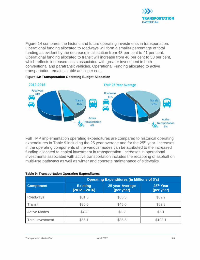
Transportation Master Plan April 2017 66
Figure 14 compares the historic and future operating investments in transportation. Operational funding allocated to roadways will form a smaller percentage of total funding as evident by the decrease in allocation from 48 per cent to 41 per cent. Operational funding allocated to transit will increase from 46 per cent to 53 per cent, which reflects increased costs associated with greater investment in both conventional and paratransit vehicles. Operational Funding allocated to active transportation remains stable at six per cent.
Figure 13: Transportation Operating Budget Allocation
Full TMP implementation operating expenditures are compared to historical operating expenditures in Table 9 including the 25 year average and for the 25th year. Increases in the operating components of the various modes can be attributed to the increased funding allocated to capital investment in transportation. Increases in operational investments associated with active transportation includes the recapping of asphalt on multi-use pathways as well as winter and concrete maintenance of sidewalks.
Table 9: Transportation Operating Expenditures
Operating Expenditures (in Millions of $’s)
Component Existing (2012 – 2016)
25 year Average (per year)
25th Year (per year)
Roadways $31.3 $35.3 $39.2
Transit $30.6 $45.0 $62.8
Active Modes $4.2 $5.2 $6.1
Total Investment $66.1 $85.5 $108.1

67 April 2017 Transportation Master Plan
Plan Monitoring
The TMP is intended to be a living document that is regularly reviewed and updated to ensure it meets the needs of the city and reflects the TMP Directions and Guiding Principles, as well as the Community Priorities outlined in the OCP. On-going review of the TMP will include:
an annual review and update to Council regarding progress towards implementation of the policies and plans identified in the TMP; and,
a full review of the TMP every five years to ensure it is effective at addressing the city’s transportation needs.
The five-year review of the TMP should be completed in conjunction with updates to the OCP to ensure transportation related issues in the city are reflected in larger corporate planning policies and decision making.
Implementing the TMP will require consistent monitoring to evaluate how effective the policies, programs, and infrastructure improvements are at meeting the needs of the city and achieving the Directions and goals outlined in the plan. Establishing performance indicators will allow the city to track changes in mode share, land use patterns, economic sustainability, and transportation system performance. Proposed performance indicators are identified in Table 10. Some indicators will require additional data collection, and the city may choose to modify some indicators based on available data, funding, and staffing.
A comprehensive review of performance indicators should be done in conjunction with the five-year TMP review and update.
Table 10: Recommended Performance Measures
D1 Offer a Range of Sustainable Transportation Choices for All
Mode shares for all trips (a.m. peak period, p.m. peak period, and all day)
Mode shares for key districts (e.g. U of R, City Centre)
Mode shares for short-trips (<5 km)
Vehicle kilometers travelled per capita
Number of implemented complete streets projects
Number of TDM initiatives adopted by city and large employers

Transportation Master Plan April 2017 68
D2 Integrate Transportation and Land Use Planning
Population density (population per ha)
Employment density (employment per ha)
Vehicle ownership (vehicles per capita)
Residential transit accessibility (proportion of households within 400 m of neighbourhood transit and 2 km of rapid transit)
Employment transit accessibility (proportion of employment within 400 m of neighbourhood transit and 2 km of rapid transit)
D3 Elevate the Role of Public Transit
Transit mode share (a.m. peak period, p.m. peak period and all day)
Transit supply (a.m. peak period, p.m. peak period and all day; seat km per capita)
Transit ridership (rides per capita)
Average transit commute time (minutes)
Transit service level wait times (minutes)
Paratransit trips (trips per day)
Accessible transit stops (number of stops)
D4 Promote Active Transportation for Healthier Communities
Bicycle mode share (a.m. peak period, p.m. peak period and all day)
Pedestrian mode share (a.m. peak period, p.m. peak period and all day)
Sidewalk provision (% of collector and arterial roadways with sidewalks, km of missing sidewalks installed)
On-street bicycle facilities (lane km of bike lanes)
Off-street bicycle facilities (km of pathways/km2 of built area)
Repair and winter maintenance of sidewalks (% of network repaired annually, % of network ploughed annually)
Snow removal on pathways (% of network ploughed)

69 April 2017 Transportation Master Plan
D5 Optimize road network connectivity
Average a.m. peak period and p.m. peak period auto trip travel time (minutes)
Auto occupancy (a.m. peak period, p.m. peak period and all day)
Collision statistics (number of injuries and fatalities)
D6 Invest in an Affordable and Durable System
Capital investments in transportation ($/capita)
Operating expenditures in transportation ($/capita)
Snow clearing service standards (% of sidewalks and roads cleared)
Average age of transportation infrastructure (number of years)
Availability of transit vehicles (number of functional vehicles)
Estimated transportation infrastructure deficit ($)
D7 Support a Prosperous Regina and Region
Status of regional and provincial initiatives (% complete)
Average truck travel times (minutes)
Government investment for provincial and interprovincial facilities ($)

Appendix A: Maps
Transit Network
Cycling Priority Network
Cycling Full Network
Roadways Network
Strategic Goods Routes


Appendix B: Transportation Capital Investments

Bike Network Projects – Priority Locations
Project Description Type of Facility Length (km)
East Regina - Bike Network Projects
12th Ave (Angus St to Osler St) Bike lane 2.10
13th Ave (Albert St to Smith St) Bike lane 0.35
14th Ave (Broad St to Smith St) Bike lane 0.50
15th Ave (Albert St to Edgar St) Bike lane 2.15
15th Ave (Harvey St to Lindsay St) Bike lane 0.50
15th Ave (St. Augustine School) Multi-use path 0.20
25th Ave (Hillsdale St to Bell St) Multi-use path/Boulevard trail 1.50
5th Ave N (Winnipeg St to Albert St) Bike Boulevard 1.60
7th Ave (Albert St to Broad St) Bike lane 0.85
Arcola Ave (College Ave to Highway 1 ByPass) Multi-use path/Boulevard trail 2.35
Arcola Ave (University Park Dr to Chuka Blvd) Multi-use path/Boulevard trail 3.35
Arcola Ave (Arcola School to Lacon St) Multi-use path/Boulevard trail 0.75
Arens Road (Heseltine Rd to Tower Rd) Bike lane 3.85
Assiniboine Ave E (Park St to MacDonald St) Bike Boulevard 0.60
Bell St (25th Ave to Parliament Ave) Bike Boulevard 0.35
Broad St (4th Ave to 15th Ave) Shared bike/bus lane 2.25
Chuka Blvd (Arcola Ave to Green Apple Dr) Multi-use path/Boulevard trail 0.75
Chuka Blvd (Green Apple Dr to Dewdney Ave) Bike lane 3.85
Cornwall St (7th Ave to Dewdney Ave) Bike lane 0.35
Cornwall St (8th Ave N to CPR) Bike Boulevard 1.40
Eastgate Dr (@ Victoria Ave Intersection) Bike lane 1.30
East-West multi-use pathway north of Dewdney Ave E (Prince of
Wales to Tower Rd)
Multi-use path/Boulevard trail 1.65
East-west pathway (University Park Dr to Park St) Multi-use path/Boulevard trail 1.64
Haughton Rd (Prince of Wales to Woodland Grove Dr) Bike lane 0.65
Haughton Rd (Woodland Grove Dr to Tower Rd) Bike lane 1.45
Hillsdale St (Broad St to Kramer Rd) Bike lane 1.25
Kramer Rd (Wascana Pkwy to Hillsdale St) Multi-use path/Boulevard trail 0.45
Lorne St (Saskatchewan Dr to 12th Ave) Bike lane 0.35
MacDonald St (Douglas Ave to Assiniboine Ave E) Bike Boulevard 0.80
Macpherson Ave (Hillsdale St to Bell St) Bike Priority Road 0.75
Multi-use pathway S of future Riverside Development (Highway 1
ByPass to McKell Park)
Multi-use path/Boulevard trail 1.30

Project Description Type of Facility Length (km)
Park St (North Service Rd to Mullin Ave) Multi-use path/Boulevard trail 1.80
Parliament Ave (Bell St to Albert St) Bike lane 0.65
Prince of Wales (Dewdney Ave E to Wascana Gates) Multi-use path/Boulevard trail 4.55
Quance St (University Park Dr to Prince of Wales Dr) Bike lane 1.40
Redbear Ave (Fleet St to Prince of Wales) Multi-use path/Boulevard trail 1.65
Tower Rd (400m N of Haughton Rd to 400 m S of Victoria Ave) Multi-use path/Boulevard trail 2.66
Wascana View Dr (Arcola Ave to Wascana Gate E) Bike lane 0.55
Wascana Gate E (Wascana View to pathway in Environmental
Reserve)
Bike lane 0.60
Wascana Gate N (Prince of Wales to pathway in Wascana View Park) Bile lane 0.35
Wascana Gate S (Prince of Wales to Wascana Cir) Bike lane 0.15
Wascana Pkwy (Highway 1 W to Saskatchewan Polytechnic) Bike lane 0.70
Wascana Pkwy/Broad St (15th Ave to Hillsdale St) Bike Priority Road 1.85
Winnipeg St (north end of Mount Pleasant Sport Park to Ring Rd) Multi-use path/Boulevard trail 0.80
Winnipeg St (Ring Rd to 6th Ave N) Bike lane 0.60
Woodland Grove Dr (Woodhams Dr to Haughton Dr) Multi-use path/Boulevard trail 1.75
West Regina - Bike Network Projects
11th Ave (Alexandra St to Empress St) Bike lane 0.88
11th Ave (Empress St to Campbell St ) Bike Boulevard 0.80
13th Ave (Albert St to Sandra Schmirler Way) Bike lane 2.60
15th Ave (Albert St to Pasqua St) Bike lane 1.65
5th Ave N (Albert St to Angus St/Woodward Ave) Bike Boulevard 0.28
7th Ave (Albert St to Campbell St) Bike lane 3.25
9th Ave N (McCarthy to Pinkie Rd) Multi-use path/Boulevard trail 4.10
15th Ave (Albert St to Pasqua St) Bike lane 1.65
Albert St (5th Ave to College Ave) Shared bike/bus lane 2.30
Albert St (25th Ave to Parliament Ave) Bike Priority Road 1.50
Albert St (19th Ave to 25th Ave) Multi-use path/Boulevard trail 2.10
Argyle St (Pasqua St to Rochdale Blvd (L-shaped )) Bike lane 1.30
Argyle St (Rochdale Blvd to Sangster Blvd N) Multi-use path/Boulevard trail 0.55
Argyle St (Sangster Blvd N to Woodward Ave) Bike lane 1.55
Armour Rd (Diefenbaker Dr to McCarthy Blvd) Multi-use path/Boulevard trail 2.00
Campbell St (Highway 1 to 400m N of Gordon Rd) Multi-use path/Boulevard trail 1.30
CPR (Albert St to Elphinstone St) Multi-use path/Boulevard trail 1.80

Project Description Type of Facility Length (km)
Courtney St (Rink Ave to Diefenbaker Dr) Multi-use path/Boulevard trail 2.35
Courtney St (A.E Wilson park to Dewdney Ave) Multi-use path/Boulevard trail 1.30
Dewdney Ave (Devonian pathway to Courtney St) Multi-use path/Boulevard trail 1.60
East-West pathway through Westerra Multi-use path/Boulevard trail 2.15
Elphinstone St (Woodward Ave to Kiwanis Park Ext) Bike lane 3.80
Garnet St (McMurchy Ave to Woodward Ave) Bike lane 0.45
Gordon Rd (Campbell St to Courtney St) Multi-use path/Boulevard trail 1.65
Gordon Rd (Multi-use pathway to Campbell St) Multi-use path/Boulevard trail 0.80
Hill Ave (Pasqua St to Kinsmen Park) Multi-use path/Boulevard trail 0.10
McCarthy Blvd (Diefenbaker Dr to Armour Rd) Multi-use path/Boulevard trail 0.50
McCarthy Blvd (Wadge St to Whelan Dr) Multi-use path/Boulevard trail 0.60
Pathway through Lakeview neighbourhoods (Lakeview Ave to Regina
Ave)
Multi-use path/Boulevard trail 1.65
North Storm Channel Pathway (Alexandra St to Albert St) Multi-use path/Boulevard trail 1.85
Northwest Storm Channel Pathway (Pasqua St to Courtney St) Multi-use path/Boulevard trail 1.70
Parachute Dr (Highway 1 to 400m N of Gordon Road) Multi-use path/Boulevard trail 1.30
Parliament Ave (Elphinstone St to Albert St) Bike lane 0.94
Parliament Ave (Elphinstone St to Lewvan Dr) Multi-use path/Boulevard trail 0.90
Pasqua St (13th Ave to Gordon Rd) Bike lane 4.45
Alexandra St (7th Ave to CPR) Bike Boulevard 1.20
Pathway through Walsh Acres to Juniper Park Multi-use path/Boulevard trail 1.65
Pinkie Rd (9th Ave N to Diefenbaker Dr) Multi-use path/Boulevard trail 2.75
Regina Ave (Wascana St to Sandra Schmirler Way) Multi-use path/Boulevard trail 0.55
Regina Rugby Park (Parliament Ave to 25th Ave) Multi-use path/Boulevard trail 0.45
Rink Ave (Courtney St to Pinkie Rd) Bike lane 1.60
Rink Ave (Dalgliesh Dr to Courtney St)) Bike Boulevard 3.20
Tutor Way (Campbell St to Courtney St) Multi-use path/Boulevard trail 1.65
Tutor Way (Multi-use pathway to Campbell St) Multi-use path/Boulevard trail 0.80
Wascana Centre Pathway (Harrington Mews to Lorne St) Multi-use path/Boulevard trail 0.50
Woodward Ave (Argyle St to Garnet St) Bike Boulevard 0.47
The above routes are conceptual. Some routes may need to be added, deleted, altered or moved to
adjacent locations as new information becomes available.
Cycling routes in new neighbourhoods will be determined through the Concept Plan process.

Bike Network Projects – Full Network
Project Description Type of Facility Length (km)
East Regina - Bike Network Projects
11th Ave (McDonald St to Arcola Ave) Multi-use path/Boulevard trail 0.58
12th Ave (Osler to Arcola Ave ) Bike lane 2.10
12th Ave E (Park St to McDonald St) Bike lane 0.95
23rd Ave (Albert St to Wascana Pkwy) Bike lane 1.61
25th Ave (Bell St to Albert St) Multi-use path/Boulevard trail 1.50
2nd Ave (Broad St to Albert St (@3rd Ave) Multi-use path/Boulevard trail 0.85
4th Ave (MacDonald St to Toronto St) Bike lane 1.11
5th Ave (Toronto St to Broad St) Multi-use path/Boulevard trail 0.51
9th Ave N (Cornwall St to Albert St) Multi-use path/Boulevard trail 0.41
Arcola Ave (11th Ave to College Ave) Multi-use path/Boulevard trail 2.35
Arens Road (Quance St to Heseltine Rd) Bike lane 3.85
Broad St (12th Ave N to 4th Ave ) Shared bike/bus lane 3.49
Chuka Blvd/Chuka Dr(Arcola Ave to Wascana View Dr) Bike lane 0.80
Cornwall St (CPR to 2nd Ave) Bike Boulevard 1.40
CPR (Prince of Wales to MacDonald St) Multi-use path/Boulevard trail 4.23
Dewdney Ave (Grid Road to Toronto St) Bike lane 3.32
Douglas Ave (Park St to MacDonald St) Bike lane 0.81
Eastgate Dr (Victoria North service Road to Victoria Ave) Bike lane 1.30
Fines Dr (Multi-use pathway in Fines Dr Park to Fleet St) Bike lane 0.75
Fleet St (Turvey Road to Cavendish St) Multi-use path/Boulevard trail 1.69
Grant Road Bike lane 3.50
Henderson Dr/Leonard St Multi-use path/Boulevard trail 3.78
Highway 1 (SW on-ramp(Wascana Pkwy) to NE off-ramp to Gordon
Rd)
Multi-use path/Boulevard trail 3.35
Highway 1(Arcola Ave to Assiniboine Ave E) Multi-use path/Boulevard trail 1.48
Looped pathway(Albert St at Gordon Rd to Wascana Pkwy at Grant
Rd)
Multi-use path/Boulevard trail 3.54
MacDonald St (15th Ave to 20th Ave) Bike lane 1.20
MacDonald St (CPR to 11thAve) Bike Boulevard 0.79
Massey Road (Grant Road to Parliament Ave) Bike lane 0.85
Multi-use pathway (Assiniboine Ave to multi-use pathway in Selinger
Park)
Multi-use path/Boulevard trail 2.30
Multi-use pathway in Northeast park (9th Ave N to 8th Ave N) Multi-use path/Boulevard trail 0.25
North-south multi-use pathway along rail line(Ross Ave to 6th Ave) Multi-use path/Boulevard trail 0.65
Park St (Mullin Ave to Assiniboine Ave) Bike lane 1.57

Project Description Type of Facility Length (km)
Park St (Dewdney Ave to North Service Road) Multi-use path/Boulevard trail 1.80
Parliament Ave (Massey Rd to Bell St) Bike lane 0.65
Prince of Wales (Wascana Gates to Saskatchewan Polytechnic) Multi-use path/Boulevard trail 4.00
Prince of Wales (Dewdney Ave E to Redbear Ave) Multi-use path/Boulevard trail 3.50
Ross Ave (Sioux St to Broad St) Multi-use path/Boulevard trail 3.06
Toronto St (South Railway St to College Ave) Bike Boulevard 1.50
Truesdale Dr (Victoria Ave to Arens Road) Bike lane 0.73
Victoria North Service Road (Eastgate Dr to Park St) Bike lane 1.22
Windsor Park Rd/Quance Gate (Victoria Ave to Arens Road) Bike lane 1.52
Winnipeg St (Winnipeg St to Broad St) Bike lane 0.79
Woodhams Dr (Prince of Wales Dr to Green Bank Road) Bike lane 1.00
West Regina - Bike Network Projects
1st Ave N (Pasqua St to Campbell St) Multi-use path/Boulevard trail 1.63
2nd Ave N (Alexandria St to Wascana St) Multi-use path/Boulevard trail 0.30
31st (Albert St to Rae St) Bike lane 0.21
3rd Ave (Albert St to Pasqua St) Bike lane 1.63
9th Ave N (McIntosh St to McCarthy Blvd) Multi-use path/Boulevard trail 4.10
25th Ave (Albert St to Pasqua St) Bike lane 1.60
Albert St (Parliament to Gordon Rd) Bike Priority Road 1.50
Albert St (5th Ave N to 5th Ave) Shared bike/bus lane 1.75
Alexandra St (McIntosh St to 7th Ave) Multi-use path/Boulevard trail 1.81
Campbell St (1st Ave N to 40m south of CNR) Multi-use path/Boulevard trail 0.16
CPR (Elphinstone to Lewvan Dr) Multi-use path/Boulevard trail 1.80
CNR (Campbell St to Courtney St) Multi-use path/Boulevard trail 3.25
CNR (Elphinstone St to Pasqua St) Multi-use path/Boulevard trail 0.70
Fairways Road (9th Avenue North to Diefenbaker Dr) Multi-use path/Boulevard trail 2.75
Fairways Road (9th Avenue North to Doiron Road) Bike lane 0.96
Gordon Road (Albert St to pathway 200m west of Harbour landing) Bike lane 2.62
Grace St (Northwest Blvd to 7th Ave) Bike Boulevard 0.27
South of Hammond Rd (Argyle St to Albert St) Multi-use path/Boulevard trail 0.85
Hill Ave (Albert St to Pasqua St) Bike lane 1.68
Junor Road (Pasqua St to McIntosh St) Bike lane 0.68
W of Lewvan Dr (800m N of Regina Ave to Parliament Ave) Multi-use path/Boulevard trail 2.89
Looped pathway at Lewvan Dr at Gordon Rd northwards to Albert
St at Gordon Rd
Multi-use path/Boulevard trail 3.28
McIntosh St (1st Ave N to McKinley Ave) Multi-use path/Boulevard trail 0.21

Project Description Type of Facility Length (km)
McIntosh St (Junor Road to 1st Ave N) Bike lane 3.60
Multi-use pathway S of Hammond Rd (Albert St to Argyle St) Multi-use path/Boulevard trail 1.00
CNR (Sherwood Dr to Northwest Storm Channel) Multi-use path/Boulevard trail 3.00
Northwest Blvd (York St to Grace St) Bike Boulevard 1.20
Parliament Ave (Lewvan Dr to Campbell St) Bike lane 1.60
Pasqua St (1st Ave N to 3rd Ave) Bike lane 0.72
Pasqua St (Rochdale to Diefenbaker Dr) Multi-use path/Boulevard trail 0.90
Pathway through Lakeview neighbourhoods (Lakeview Ave to
Regina Ave)
Multi-use path/Boulevard trail 1.65
Queen St (Parliament Ave to Gordon Road) Bike lane 0.93
Queen St (Hill Ave to 25th Ave) Bike lane 0.84
Rae St (25th Ave to Gordon Road) Bike lane 1.58
Rae St (Regina Ave to 25th Ave) Bike Boulevard 1.81
Regina Ave (Albert St to Pasqua St) Bike lane 1.62
Regina Ave Loop within Airport Multi-use path/Boulevard trail 1.33
Rochdale Blvd (Argyle St to Pinkie Road) Bike lane 5.62
Sunset Dr (Rae St to Pasqua St) Bike lane 1.42
Wells St ( Rink Ave to Rochdale Blvd) Bike lane 1.10
Whelan Dr (Courtney St to Pinkie Rd) Multi-use path/Boulevard trail 1.60
The above routes are conceptual. Some routes may need to be added, deleted, altered or moved to
adjacent locations as new information becomes available.
Cycling routes in new neighbourhoods will be determined through the Concept Plan process.

Roadway Projects
Project Description Improvement Type Length (km)
East Regina - Traffic Signals
Arens Rd & Chuka Blvd Traffic Signals Signal NA
Broad St & 12th Ave N Traffic Signals Signal NA
Chuka Dr & Green Apple Dr Traffic Signals Signal NA
Chuka Dr & Harvard Commercial Rd Traffic Signals Signal NA
Chuka Dr & Haughton Rd Traffic Signals Signal NA
Chuka Dr & Primrose Green Dr Traffic Signals Signal NA
College Ave & Arcola Ave Traffic Signals Signal NA
Dewdney Ave & McIntyre Signals Signal NA
Dewdney Ave & Prince of Wales Dr Traffic Signals - Reconstruct Signal NA
Fleet St & Redbear Ave Traffic Signals Signal NA
Haughton Rd & Windsor Park Dr Traffic Signals Signal NA
Henderson Dr (north) & McDonald St Traffic Signals Signal NA
Hwy 1 & Chuka Blvd Traffic Signals Signal NA
Prince of Wales Dr & Assiniboine Ave Traffic Signals - Dual Lefts Signal NA
Prince of Wales Dr & Wascana Gate S Traffic Signals Signal NA
Turvey Rd & Fleet St Traffic Signals Signal NA
Wascana Pkwy & 23rd Ave Traffic Signals Signal NA
Winnipeg St & 1st Ave N Traffic Signals Signal NA
East Regina - Roadway Improvements
9th Ave N Widening (Winnipeg St to McDonald St) Widening 1.65
Arcola Ave Extension (Winnipeg St to Victoria Ave) New 1.10
Arcola Ave Intersection Improvements (Park St & University Park Dr) Improvement NA
Arens Rd Extension (Woodland Grove Dr to Chuka Blvd) New 0.80
Chuka Blvd Extension (Primrose Green Dr to Arens Rd) New 0.90
Chuka Blvd Extension (Victoria Ave to Dewdney Ave) including intersection New 0.90
Chuka Dr Extension (Arens to Victoria Ave) New 1.40
College Avenue Corridor Improvements (Winnipeg St to Arcola Ave) Improvement 1.50
Dewdney Ave Extension (N/S Grid to Chuka Blvd) Construct New 0.70
Dewdney Widening (Oxford St to Park St) Variable Lanes Improvement NA
Fleet St & Dewdney Ave Intersection (Turn Lanes) Improvement NA
Fleet St Twinning (MacRae Bay to Turvey Rd - W.S.) Construct Widening 1.50
Fleet St Twinning (Turvey Rd to Hwy 46 - E.S.) Widening 0.80
Hwy 6 East Service Road (North City Limits to North of Kensington Greens) New 0.90
McDonald St Widening (Kress St to Fleet St) Widening 1.00
Prince of Wales Dr Twinning (Dewdney Ave to Jenkins Dr) Widening 1.20
Prince of Wales Dr Twinning (Dewdney Ave to Jenkins Dr) Construct Widening 1.20
Prince of Wales Dr Twinning (Eastgate Dr to Dewdney Ave) Construct Widening 0.45

Project Description Improvement Type Length (km)
Prince of Wales Reconstruction - Jenkins Dr to Redbear Ave Construct New 0.90
Redbear Ave Extension (Fleet St to Phase 1 Limits) Construct New 0.90
Redbear Ave Extension (Phase 1 Limits to Prince of Wales Dr) Construct New 0.90
Ring Rd Widening (Albert St to McDonald St) Widening 3.20
Ring Rd Widening (Ross Ave to Dewdney Ave) Widening 1.20
Ross Ave & McDonald St Intersection (N/S left turns) Improvement NA
Ross Ave & Winnipeg St Intersection (lengthen lefts) Improvement NA
Saskatchewan Dr Widening (Halifax St to Quebec St) Widening 0.60
Trans Canada Hwy Bypass Lighting (Wascana Pkwy to Albert St South) Improvement 2.80
Victoria Ave & Park St Intersection SB double lefts Improvement NA
Victoria Ave & Ring Rd Widening (Glencairn Rd to Park St) Widening 1.25
Victoria Ave E Widening (Coleman to Tower) Widening 2.70
Wascana Parkway/Prince of Wales Dr Extension New 4.00
Winnipeg St Widening (CNR Crossing near 5th Ave N) Widening 0.50
Winnipeg St reconstruction (12th Ave N to North City Limit) Construct New 1.40
East Regina - Interchanges / Grade Separations
Assiniboine Ave & Hwy 1 Bypass Interchange NB On-Ramp Ramp 0.50
Prince of Wales Grade Separation (CPR & CNR) Grade Separation NA
Ring Road & Winnipeg St Interchange Interchange NA
Victoria Ave & Ring Road Interchange Widen Vic Ave Interchange NA
Wascana Pkwy & Trans Canada Hwy Bypass Interchange EB to NB Capacity Loop 0.60
West Regina - Traffic Signals
13th Ave & Pasqua St Traffic Signals Signal NA
1st Ave N & Courtney St Traffic Signals Signal NA
25th Avenue & Argyle St Traffic Signals Signal NA
9th Ave N & Fairways Rd Traffic Signals Signal NA
9th Ave N & Pinkie Rd Traffic Signals Signal NA
Albert St & 29th Avenue Traffic Signals Signal NA
Argyle St N & Sangster Blvd (north) Traffic Signals Signal NA
Coopertown Blvd & Rink Ave Traffic Signals Signal NA
Courtney St & Dalgliesh Dr Traffic Signals Signal NA
Courtney St & Mapleford Gate Traffic Signals Signal NA
Courtney St & Rink Ave Traffic Signals Signal NA
Courtney St & Whelan Dr Traffic Signals Signal NA
Dewdney Ave & Condie Rd Traffic Signals Signal NA
Dewdney Ave & Courtney St (Dieppe) Traffic Signals Signal NA
Dewdney Ave & Courtney St Traffic Signals Signal NA
Dewdney Ave & Dorothy St Traffic Signals Signal NA
Dewdney Ave & East of Pinkie Rd Traffic Signals Signal NA

Project Description Improvement Type Length (km)
Dewdney Ave & Fleming Rd Traffic Signals Signal NA
Dewdney Ave & McIntosh St Signals Signal NA
Dewdney Ave & New road into Parcel 21 Traffic Signals Signal NA
Dewdney Ave & New road into Parcel 22 Traffic Signals Signal NA
Dewdney Ave & Pinkie Rd Traffic Signals Signal NA
Dewdney Ave & West of Courtney St Traffic Signals Signal NA
Diefenbaker Dr & Armor Rd Traffic Signals Signal NA
Fairway Rd & Rink Ave Traffic Signals Signal NA
Gordon Rd & Campbell St Signal NA
Gordon Rd & James Hill Rd Traffic Signals Signal NA
Gordon Rd & Queen St Traffic Signals Signal NA
Harbour Landing Dr & James Hill Rd Traffic Signals Signal NA
Jim Cairns Blvd & Harbour Landing Dr Traffic Signals Signal NA
McCarthy Blvd & Diefenbaker Dr Traffic Signals Signal NA
Parliament Ave & Campbell St Signal NA
Parliament Ave & Harbour Landing Dr Traffic Signals Signal NA
Parliament Ave & James Hill Rd Traffic Signals Signal NA
Parliament Ave & Montague St Traffic Signals Signal NA
Pasqua St & Big Bear Blvd Traffic Signals Signal NA
Pasqua St & Diefenbaker Dr Traffic Signals ('T' to full intersection) Signal NA
Pasqua St & Junor Dr Traffic Signals ('T' to full intersection) Signal NA
Pinkie Rd & first intersection south of Dewdney Traffic Signals Signal NA
Pinkie Rd & second intersection south of Dewdney Traffic Signals Signal NA
Rink Ave & Fairway Rd Traffic Signals Signal NA
Rochdale Blvd & Argyle St N Traffic Signals Signal NA
Rochdale Blvd & Coopertown Blvd Traffic Signals Signal NA
Rochdale Blvd & Courtney St Traffic Signals Signal NA
Rochdale Blvd & Fairway Rd Traffic Signals Signal NA
Rochdale Blvd & Vanstone St Traffic Signals Signal NA
Saskatchewan Dr & Courtney St Traffic Signals Signal NA
Saskatchewan Dr & Sandra Schmirler Way Traffic Signals Signal NA
Sherwood Dr & Courtney St Traffic Signals Signal NA
West Regina - Roadway Improvements
13th Ave Corridor Improvements (Albert St to Lewvan Dr) Improvement 0.85
13th Ave Corridor Improvements (Lewvan Dr to Campbell St) Improvement 1.50
9th Ave N twinning (Courtney St to Pinkie) Widening 2.00
9th Ave N twinning (Pinkie to West Regina Bypass) Widening 0.70
9th Ave N Widening (Pasqua St to Courtney St) Widening 3.35
Argyle St N Extension (1/2 way across pipeline to Rochdale Blvd) New 0.25
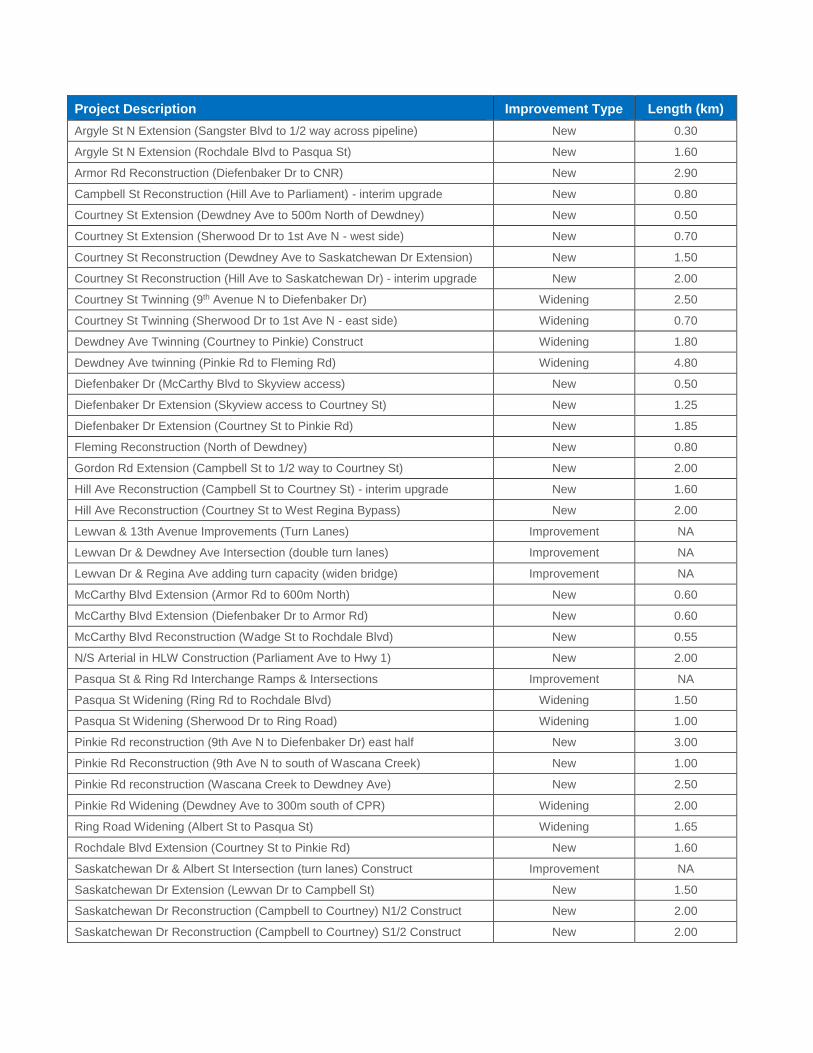
Project Description Improvement Type Length (km)
Argyle St N Extension (Sangster Blvd to 1/2 way across pipeline) New 0.30
Argyle St N Extension (Rochdale Blvd to Pasqua St) New 1.60
Armor Rd Reconstruction (Diefenbaker Dr to CNR) New 2.90
Campbell St Reconstruction (Hill Ave to Parliament) - interim upgrade New 0.80
Courtney St Extension (Dewdney Ave to 500m North of Dewdney) New 0.50
Courtney St Extension (Sherwood Dr to 1st Ave N - west side) New 0.70
Courtney St Reconstruction (Dewdney Ave to Saskatchewan Dr Extension) New 1.50
Courtney St Reconstruction (Hill Ave to Saskatchewan Dr) - interim upgrade New 2.00
Courtney St Twinning (9th Avenue N to Diefenbaker Dr) Widening 2.50
Courtney St Twinning (Sherwood Dr to 1st Ave N - east side) Widening 0.70
Dewdney Ave Twinning (Courtney to Pinkie) Construct Widening 1.80
Dewdney Ave twinning (Pinkie Rd to Fleming Rd) Widening 4.80
Diefenbaker Dr (McCarthy Blvd to Skyview access) New 0.50
Diefenbaker Dr Extension (Skyview access to Courtney St) New 1.25
Diefenbaker Dr Extension (Courtney St to Pinkie Rd) New 1.85
Fleming Reconstruction (North of Dewdney) New 0.80
Gordon Rd Extension (Campbell St to 1/2 way to Courtney St) New 2.00
Hill Ave Reconstruction (Campbell St to Courtney St) - interim upgrade New 1.60
Hill Ave Reconstruction (Courtney St to West Regina Bypass) New 2.00
Lewvan & 13th Avenue Improvements (Turn Lanes) Improvement NA
Lewvan Dr & Dewdney Ave Intersection (double turn lanes) Improvement NA
Lewvan Dr & Regina Ave adding turn capacity (widen bridge) Improvement NA
McCarthy Blvd Extension (Armor Rd to 600m North) New 0.60
McCarthy Blvd Extension (Diefenbaker Dr to Armor Rd) New 0.60
McCarthy Blvd Reconstruction (Wadge St to Rochdale Blvd) New 0.55
N/S Arterial in HLW Construction (Parliament Ave to Hwy 1) New 2.00
Pasqua St & Ring Rd Interchange Ramps & Intersections Improvement NA
Pasqua St Widening (Ring Rd to Rochdale Blvd) Widening 1.50
Pasqua St Widening (Sherwood Dr to Ring Road) Widening 1.00
Pinkie Rd reconstruction (9th Ave N to Diefenbaker Dr) east half New 3.00
Pinkie Rd Reconstruction (9th Ave N to south of Wascana Creek) New 1.00
Pinkie Rd reconstruction (Wascana Creek to Dewdney Ave) New 2.50
Pinkie Rd Widening (Dewdney Ave to 300m south of CPR) Widening 2.00
Ring Road Widening (Albert St to Pasqua St) Widening 1.65
Rochdale Blvd Extension (Courtney St to Pinkie Rd) New 1.60
Saskatchewan Dr & Albert St Intersection (turn lanes) Construct Improvement NA
Saskatchewan Dr Extension (Lewvan Dr to Campbell St) New 1.50
Saskatchewan Dr Reconstruction (Campbell to Courtney) N1/2 Construct New 2.00
Saskatchewan Dr Reconstruction (Campbell to Courtney) S1/2 Construct New 2.00

Project Description Improvement Type Length (km)
Saskatchewan Dr Widening (Lorne St to Lewvan Dr) Construct Widening 2.10
West Regina - Interchanges / Grade Separations
Courtney St Flyover at CP Mainline Grade Separation NA
Pasqua St & Ring Rd Interchange Interchange NA
Pinkie Road Flyover at CP Mainline Grade Separation NA
Saskatchewan Dr & Lewvan Dr Flyover Interchange NA
The above routes are conceptual. Some routes may need to be added, deleted, altered or moved to
adjacent locations as new information becomes available.
Alignment of new roads and new neighbourhoods will be determined by the Concept Plan process.
The above projects represents projects under the city’s jurisdiction as of the time of writing this report.

Proposed changes to existing truck routes
Road
Current
Designation
Proposed
Designation Requirement
Wascana Pkwy east of Hwy 1 H/LCV and P&D Only P&D
None
Albert St (25th Ave to Hwy 1) H/LCV and P&D Only P&D
None
25th Ave (Lewvan Dr to Campbell St) H/LCV and P&D Not Applicable Construction of Parliament Ave to Campbell St.
Campbell St (25th Ave to Hill Ave) H/LCV and P&D Only P&D
Construction of the West Regina Bypass and interchanges
Hill Ave (Campbell St to Courtney St) H/LCV and P&D Only P&D
Construction of the West Regina Bypass and interchanges
Courtney St (Hill Ave to Dewdney Ave)
H/LCV and P&D Only P&D
Construction of the West Regina Bypass and interchanges
Dewdney Ave (Lewvan Dr to Albert St)
H/LCV and P&D Only P&D
Construction of the West Regina Bypass and interchanges
Saskatchewan Dr (Lewvan Dr to Winnipeg St)
H/LCV and P&D Only P&D
Construction of the West Regina Bypass and interchanges
Courtney St (9th Ave N to Armor Rd) H/LCV and P&D Only P&D
Construction of the West Regina Bypass and interchanges
(H/LCV = Heavy or Long Combination Vehicle, P&D = Pickup and Delivery)


Appendix C: Summary of TMP Policies and Actions
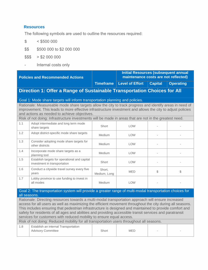
Resources
The following symbols are used to outline the resources required:
$ < $500 000
$$ $500 000 to $2 000 000
$$$ > $2 000 000
- Internal costs only
Policies and Recommended Actions
Timeframe
Initial Resources (subsequent annual maintenance costs are not reflected)
Level of Effort Capital Operating
Direction 1: Offer a Range of Sustainable Transportation Choices for All
Goal 1: Mode share targets will inform transportation planning and policies.
Rationale: Measureable mode share targets allow the city to track progress and identify areas in need of improvement. This leads to more effective infrastructure investment and allows the city to adjust policies and actions as needed to achieve objectives.
Risk of not doing: Infrastructure investments will be made in areas that are not in the greatest need.
1.1 Adopt intermediate and long term mode
share targets Short LOW - -
1.2 Adopt district-specific mode share targets Medium LOW - -
1.3 Consider adopting mode share targets for
other districts Medium LOW - -
1.4 Incorporate mode share targets as a
planning tool Medium LOW - -
1.5 Establish targets for operational and capital
investment in transportation Short LOW - -
1.6 Conduct a citywide travel survey every five
years
Short,
Medium, Long MED $ $
1.7 Lobby province to use funding to invest in
all modes Medium LOW - -
Goal 2: The transportation system will provide a greater range of multi-modal transportation choices for all seasons.
Rationale: Directing resources towards a multi-modal transportation approach will ensure increased access for all users as well as maximizing the efficient movement throughout the city during all seasons. This includes ensuring that pedestrian infrastructure is designed and maintained to provide comfort and safety for residents of all ages and abilities and providing accessible transit services and paratransit services for customers with reduced mobility to ensure equal access.
Risk of not doing: Reduced mobility for all transportation users throughout all seasons.
1.8 Establish an internal Transportation
Advisory Committee Short MED - -

Policies and Recommended Actions
Timeframe
Initial Resources (subsequent annual maintenance costs are not reflected)
Level of Effort Capital Operating
1.9 Ensure multi-modal transportation is part of
planning and operations processes Short,
Medium, Long LOW $ $
1.10 Adopt lead-by-example policy to meet
universal accessibility needs Short MED - -
1.11 Ensure connectivity between transportation
modes Short MED - -
1.12 Update policies and standards to reflect
multi-modal needs in all seasons Short LOW - -
1.13 Incorporate MMLOS to assess
transportation needs Short MED - -
1.14 Develop a winter travel strategy Short MED - -
Goal 3: A Complete Streets Framework will balance the needs of all users.
Rationale: Traditional street planning and engineering processes have typically taken the approach of placing priority on vehicular movement; whereas, complete streets planning focuses on ensuring all modes are considered in the design. A Complete Streets Policy reinforces consistent design and operation of roads to ensure the comfort and safety for all users, regardless of age, ability or income.
Risk of not doing: New development and improvements will not take into account the needs of all users.
1.15 Create a Complete Streets Policy using the
Framework for Complete Streets Short MED - -
1.16 Develop strategy to identify corridors to be
transitioned to complete streets Short LOW - -
1.17 Support the development of complete
streets in Regina Short MED $$ $
1.18 Establish evaluation criteria and monitor
progress towards the objectives of the
Complete Streets Policy Short LOW - -
1.19 Review Complete Streets Policy as part of
TMP updates
Short,
Medium, Long LOW - -
Goal 4: Travel Demand Management will be a key component of sustainable transportation.
Rationale: Travel Demand Management (TDM) is a key tool in transportation planning and operations and represents a cost-effective way to ease congestion, expand transportation choice, and reduce the need to expand capacity. TDM encompasses a wide range of strategies to encourage travellers to change their travel choices including shifting modes away from single occupant vehicles (SOVs), reducing the number of trips they make, and travelling more efficiently.
Risk of not doing: Travel demand will exceed network capacity causing inefficient travel for all users.
1.20 Adopt lead-by-example policy to promote
TDM within the municipal corporation Short LOW - -
1.21 Increase visibility of sustainable modes Short LOW $ -
1.22 Hire TDM Coordinator Short MED $$ -

Policies and Recommended Actions
Timeframe
Initial Resources (subsequent annual maintenance costs are not reflected)
Level of Effort Capital Operating
1.23 Explore budget options for Community
Grants, TDM initiatives Short LOW - -
1.24 Implement technology to support travel
behaviour change, increase TDM
awareness Medium MED $ -
1.25 Target TDM initiatives to community
partners and institutions Short LOW - $
1.26 Partner with community leaders to improve
perception/awareness of alternative modes Short LOW - -
1.27 Encourage TDM integration with
community events Short LOW - $
1.28 Support advocacy groups and
organizations that promote sustainable
modes
Medium LOW - -
Direction 2: Integrate Transportation and Land Use Planning
Goal 5: Transportation and land use planning processes will be coordinated.
Rationale: It is important for land use plans to be developed in conjunction with transportation planning to meet capacity needs while ensuring that roads are designed for the development of an efficient citywide transportation network.
Risk of not doing: Infrastructure investments will not be aligned with the future capacity needs.
2.1 Ensure regular communication/coordination
between planning, engineering, operations,
and maintenance.
Short,
Medium, Long MED - -
2.2 Employ integrated land use forecasting and
transportation models Medium LOW - -
2.3 Support OCP long-range development
goals through transportation investments Medium LOW - -
2.4 Update Zoning to incentivize developments
that expand transportation choices Short LOW - -
2.5 Support goals of TMP within land use
planning tools Short LOW - -
2.6 Update OCP Transportation Map to reflect
TMP Short LOW - -
2.7 Update TMP maps as new neighbourhood
concept plans approved Short,
Medium, Long LOW - -
2.8 Develop site design guidelines that
promote multi-modal transportation Short MED - -
2.9 Develop strategy to protect transportation
needs as part of land use planning Medium MED - -
Goal 6: Transportation will support vibrant, safe, and well-connected complete neighbourhoods.
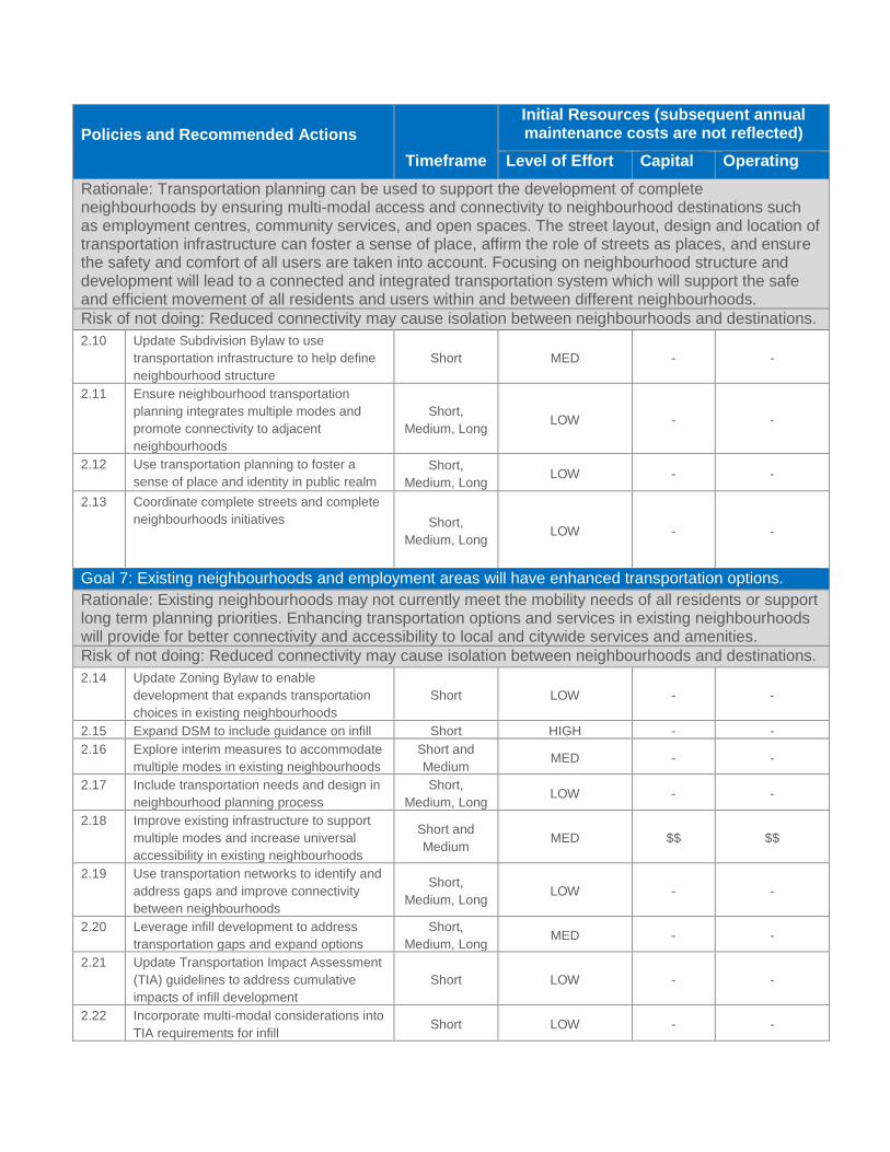
Policies and Recommended Actions
Timeframe
Initial Resources (subsequent annual maintenance costs are not reflected)
Level of Effort Capital Operating
Rationale: Transportation planning can be used to support the development of complete neighbourhoods by ensuring multi-modal access and connectivity to neighbourhood destinations such as employment centres, community services, and open spaces. The street layout, design and location of transportation infrastructure can foster a sense of place, affirm the role of streets as places, and ensure the safety and comfort of all users are taken into account. Focusing on neighbourhood structure and development will lead to a connected and integrated transportation system which will support the safe and efficient movement of all residents and users within and between different neighbourhoods.
Risk of not doing: Reduced connectivity may cause isolation between neighbourhoods and destinations.
2.10 Update Subdivision Bylaw to use
transportation infrastructure to help define
neighbourhood structure
Short MED - -
2.11 Ensure neighbourhood transportation
planning integrates multiple modes and
promote connectivity to adjacent
neighbourhoods
Short,
Medium, Long LOW - -
2.12 Use transportation planning to foster a
sense of place and identity in public realm
Short,
Medium, Long LOW - -
2.13 Coordinate complete streets and complete
neighbourhoods initiatives Short,
Medium, Long LOW - -
Goal 7: Existing neighbourhoods and employment areas will have enhanced transportation options.
Rationale: Existing neighbourhoods may not currently meet the mobility needs of all residents or support long term planning priorities. Enhancing transportation options and services in existing neighbourhoods will provide for better connectivity and accessibility to local and citywide services and amenities.
Risk of not doing: Reduced connectivity may cause isolation between neighbourhoods and destinations.
2.14 Update Zoning Bylaw to enable
development that expands transportation
choices in existing neighbourhoods
Short LOW - -
2.15 Expand DSM to include guidance on infill Short HIGH - -
2.16 Explore interim measures to accommodate
multiple modes in existing neighbourhoods
Short and
Medium MED - -
2.17 Include transportation needs and design in
neighbourhood planning process
Short,
Medium, Long LOW - -
2.18 Improve existing infrastructure to support
multiple modes and increase universal
accessibility in existing neighbourhoods
Short and
Medium MED $$ $$
2.19 Use transportation networks to identify and
address gaps and improve connectivity
between neighbourhoods
Short,
Medium, Long LOW - -
2.20 Leverage infill development to address
transportation gaps and expand options
Short,
Medium, Long MED - -
2.21 Update Transportation Impact Assessment
(TIA) guidelines to address cumulative
impacts of infill development
Short LOW - -
2.22 Incorporate multi-modal considerations into
TIA requirements for infill Short LOW - -

Policies and Recommended Actions
Timeframe
Initial Resources (subsequent annual maintenance costs are not reflected)
Level of Effort Capital Operating
2.23 Review applications for roadway/alley
closures and city property sales to protect
existing and future transportation linkages
Short,
Medium, Long LOW - -
Goal 8: New neighbourhoods and employment areas will incorporate multi-modal transportation options.
Rationale: Planning of new neighbourhoods greatly impacts the mode of transportation people choose to use. Integrating multi-modal transportation choices into the planning approval process during neighbourhood development will minimize the impacts on transportation infrastructure and help promote alternative modes of transportation.
Risk of not doing: New development will not take into account the needs of all users.
2.24 Ensure new neighbourhoods connect to
existing networks and protect for future
connections
Short,
Medium, Long LOW - -
2.25 Develop criteria to direct types of facilities
on different road classes /
2.26 Ensure new neighbourhoods and
employment areas provide direct
connections to existing neighbourhoods
Short,
Medium, Long LOW - -
2.27 Ensure new neighbourhoods and
employment areas protect connections to
future development
Short,
Medium, Long LOW - -
2.28 Ensure new infrastructure supports
universal accessibility
Short,
Medium, Long MED $ $
2.29 Update Zoning to enable development that
makes efficient use of existing
transportation infrastructure and services
Short LOW - -
2.30 Update planning approvals process to
integrate multi-modal transportation in site,
concept, and subdivision plans
Short MED - -
2.31 Develop strategy to monitor cumulative
impacts of rezoning in new neighbourhoods
to see when new TIA is required
Short LOW - -
2.32 Explore incentives to promote higher
density near identified express transit and
nodes
Short,
Medium, Long LOW - -
2.33 Explore use of SAFs and DLs for additional
transportation items Medium MED - -
2.34 Explore city’s priority to change eligibility of
SAFs and DLs under Provincial Planning
Act
Short and
Medium LOW - -
Goal 9: Parking Policies will be a tool to encourage multi-modal transportation options and achieve land use objectives.
Rationale: The quantity and location of parking should be tailored to the surrounding land use. Providing an appropriate amount of parking is important to support the economic health and viability of businesses and residential development projects; however, providing too much can undermine cycling, walking or efforts to promote transit ridership.
Risk of not doing: Parking policies will limit the connectivity of the transportation network for all users.

Policies and Recommended Actions
Timeframe
Initial Resources (subsequent annual maintenance costs are not reflected)
Level of Effort Capital Operating
2.35 Review parking policies and standards to
support transportation goals and objectives
Short and
Medium LOW - -
2.36 Examine separate title parking in
intensification areas, along transit corridors Medium LOW - -
2.37 Review parking pricing in high demand
areas Short LOW - -
2.38 Review classifications and tax rates for
parking infrastructure Short MED - -
2.39 Increase resources for parking
enforcement
Short,
Medium, Long LOW - $$
2.40 Pursue policy changes for parking revenue
to be reinvested in parking and
transportation infrastructure and programs
Medium MED - -
2.41 Examine potential for future parking
structures in high demand areas Medium MED - -
2.42 Initiate parking studies for areas with
parking challenges
Short and
Medium LOW $$ -
2.43 Encourage high-quality urban design and
green infrastructure for parking structures Short,
Medium, Long LOW - -
Direction 3:Elevate the Role of Public Transit
Goal 10: Transit will be a reliable and convenient travel choice throughout Regina.
Rationale: Making transit more convenient and reliable can be accomplished by shortening walking distances to transit stops, reducing wait times, and decreasing travel times. Increasing cost competiveness between transit and private vehicles, as well as improving travel times and levels of service associated with the transit system will ensure that residents view transit as a viable alternative compared to private vehicles.
Risk of not doing: Transit will not be utilized as a viable mode of travel which will impact ridership.
3.1 Utilize transit coverage standards to ensure
90% of residents, schools, and workplaces
are within 400 m of neighbourhood transit
and 2 km of express transit
Medium MED - -
3.2 Design transit service and routes to provide
direct and time-competitive service
Short and
Medium MED - $
3.3 Implement transit priority measures to
improve reliability and travel times Medium MED $$ $
3.4 Expand transit service where appropriate Medium and
Long LOW $$ $$
3.5 Adopt fare strategies to ensure transit is
cost competitive
Short and
Medium LOW - -
Goal 11: The transit network will be easy-to-understand and structured around express transit.
Rationale: The TMP encourages continued restructuring of the transit system with the development of a clear network structure as the system grows. Increasing the usability of the transit network and improving the express transit system will encourage increased ridership.
Risk of not doing: Transit will not be utilized as a viable mode of travel which will impact ridership.
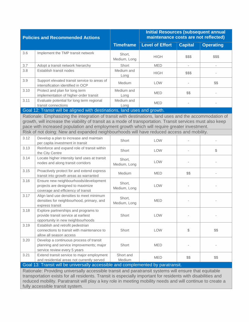
Policies and Recommended Actions
Timeframe
Initial Resources (subsequent annual maintenance costs are not reflected)
Level of Effort Capital Operating
3.6 Implement the TMP transit network Short,
Medium, Long HIGH $$$ $$$
3.7 Adopt a transit network hierarchy Short MED - -
3.8 Establish transit nodes Medium and
Long HIGH $$$ -
3.9 Support elevated transit service to areas of
intensification identified in OCP Medium LOW - $$
3.10 Protect and plan for long term
implementation of higher-order transit
Medium and
Long MED $$ -
3.11 Evaluate potential for long term regional
transit connections
Medium and
Long MED - -
Goal 12: Transit will be aligned with destinations, land uses and growth.
Rationale: Emphasizing the integration of transit with destinations, land uses and the accommodation of growth, will increase the viability of transit as a mode of transportation. Transit services must also keep pace with increased population and employment growth which will require greater investment.
Risk of not doing: New and expanded neighbourhoods will have reduced access and mobility.
3.12 Develop a plan to increase and maintain
per capita investment in transit Short LOW - -
3.13 Reinforce and expand role of transit within
the City Centre Short LOW - $
3.14 Locate higher intensity land uses at transit
nodes and along transit corridors Short,
Medium, Long LOW - -
3.15 Proactively protect for and extend express
transit into growth areas as warranted Medium MED $$ -
3.16 Ensure new neighbourhoods/development
projects are designed to maximize
coverage and efficiency of transit
Short,
Medium, Long LOW - -
3.17 Align land use densities to meet minimum
densities for neighbourhood, primary, and
express transit
Short,
Medium, Long MED - -
3.18 Explore partnerships and programs to
provide transit service at earliest
opportunity in new neighbourhoods
Short LOW - -
3.19 Establish and retrofit pedestrian
connections to transit with maintenance to
allow all season access
Short LOW $ $$
3.20 Develop a continuous process of transit
planning and service improvements; major
service review every 5 years
Short MED - -
3.21 Extend transit service to major employment
and residential areas not currently served
Short and
Medium MED $$ $$
Goal 13: Transit will be universally accessible and complemented by paratransit.
Rationale: Providing universally accessible transit and paratransit systems will ensure that equitable transportation exists for all residents. Transit is especially important for residents with disabilities and reduced mobility. Paratransit will play a key role in meeting mobility needs and will continue to create a fully accessible transit system.

Policies and Recommended Actions
Timeframe
Initial Resources (subsequent annual maintenance costs are not reflected)
Level of Effort Capital Operating
Risk of not doing: The transit system will not provide equitable access to all users.
3.22 Integrate accessibility in overall transit
planning process Short LOW - -
3.23 Continue to ID and address issues with
Accessibility Advisory Committee
Short,
Medium, Long LOW - -
3.24 Complete audit of all transit stops to review
accessibility upgrades Short MED - $$
3.25 Maintain paratransit system Short,
Medium, Long MED $$ $$
3.26 Complete Paratransit Service Plan Short MED - -
Goal 14: Transit will have a strong and positive identity reflected by a high-quality customer experience.
Rationale: Strengthening the identity of transit will improve the reputation of transit as a viable mode of transportation and build support and ridership within the community. A renewed identity and brand for Regina Transit will be supported by a high-quality customer experience including trip planning resources, transit stops, fleet vehicles, and access to destinations.
Risk of not doing: Transit will not be utilized as a viable mode of travel which will impact ridership.
3.27 Create a unique brand for Regina Transit Short and
Medium MED $ $
3.28 Use education and promotional campaigns
to increase awareness of transit services
Short and
Medium MED $ $
3.29 Evaluate and adopt on-board and off-board
technologies
Short and
Medium MED $ $
3.30 Develop toolkit and warrant system for
transit stop amenities Short MED $$ $
3.31 Continue to improve and increase
accessibility of customer service and trip
planning tools
Short,
Medium, Long MED - $
3.32 Integrate multi-modal opportunities with
transit Short and
Medium LOW - -
3.33 Evaluate potential for loyalty and discount
transit programs
Short and
Medium LOW - -
3.34 Utilize R-Card data to identify opportunities
to encourage ridership
Short,
Medium, Long LOW - -
3.35 Re-invest transit advertising and ridership
revenue into infrastructure and services
Short,
Medium, Long LOW - -
Direction 4: Promote Active Transportation for Healthier Communities
Goal 15: Active modes of transportation will be prioritized in city policies and processes
Rationale: Updating and enforcing municipal policies, bylaws and design standards to support active modes will increase the number of residents who perceive walking and cycling as safe, convenient, and enjoyable ways to move around the city.
Risk of not doing: Active modes will not be utilized as a viable and safe mode of travel.
4.1 Integrate planning and design of AT
facilities within planning processes
Short,
Medium, Long LOW - -
4.2 Update DSM to address AT related issues Short HIGH - -

Policies and Recommended Actions
Timeframe
Initial Resources (subsequent annual maintenance costs are not reflected)
Level of Effort Capital Operating
4.3 Update Zoning Bylaw to address AT
related issues Short LOW - -
4.4 Update TIA guidelines to explicitly account
for cycling and pedestrian impacts Short LOW - -
4.5 Amend Traffic Bylaw to reduce barriers for
those using active modes Short LOW - -
Goal 16: Active modes will be promoted as an integral part of how Regina residents get to work and school.
Rationale: Increasing the visibility and profile of active transportation within Regina will encourage multi-modal transportation choices and reinforces the notion that active modes are safe and efficient ways to access destinations. Support for active modes can be provided through provision of facilities, trip planning resources and promotion.
Risk of not doing: Active modes will not be utilized as a viable and safe mode of travel.
4.6 Develop a strategy to increase awareness
of AT modes Short LOW - -
4.7 Publicize locations of AT amenities Short,
Medium, Long LOW - $
4.8 Expand trip planning resources to include
estimated travel times for active modes,
include AT in information about city events
Short LOW - $
4.9 Encourage employers and institutions to
provide AT amenities and facilities Short LOW - -
4.10 Increase data collection about active
modes, monitor changes in mode split
Short,
Medium, Long MED - $
4.11 Provide walking and cycling groups with
resources to increase awareness Medium LOW - $
Goal 17: A comprehensive citywide bikeway network will connect people to destinations and activities.
Rationale: Filling gaps in the existing network and developing a comprehensive citywide network that features a variety of on-street and off-street facilities will help support active modes through increased accessibility. In addition to recreational use the city’s multi-use pathways should be strategically expanded to help support utilitarian trips, such as commuting to school or work.
Risk of not doing: Cycling will not be utilized as a viable and safe mode of travel.
4.12 Expand the multi-use pathway network Short,
Medium, Long HIGH $$$ $$
4.13 ID a list of small network improvements,
with input from cyclists Short LOW $ -
4.14 Increase the number of on-street
bikeways and pathways for
commuters
Short,
Medium, Long HIGH $$$ $$
4.15 Explore potential for pathways in
utility/pipeline/railway corridors
Short,
Medium, Long LOW - -
4.16 Establish criteria for bike facilities to be
included in plans for new neighbourhoods Short MED - -
4.17 Establish consistent bikeway design
guideline for on-street off-street routes
Short,
Medium, Long MED - -
4.18 Review and upgrade existing facilities Medium MED $$ $$

Policies and Recommended Actions
Timeframe
Initial Resources (subsequent annual maintenance costs are not reflected)
Level of Effort Capital Operating
4.19 Develop way-finding strategy for on-street
and off-street routes
Short and
Medium MED $ $
4.20 Pursue opportunities to connect bike
network to local and regional trails
Medium and
Long LOW - -
Goal 18: Streets throughout the city will be accessible and walkable.
Rationale: Improving the quality and design of sidewalks will improve the comfort and safety of walking and promoting pedestrian activity for residents of all ages and abilities. Properly designed and maintained sidewalks in Regina can create a consistent and high-quality pedestrian network.
Risk of not doing: Pedestrian activity will not be utilized as a viable and safe mode of travel.
4.21 Update neighbourhood design standards Short LOW - -
4.22 Update DSM to ID sidewalk and public
realm improvements for pedestrian comfort Short and
Medium HIGH - -
4.23 Update inspection and maintenance
policies for sidewalk quality improvements Short LOW - -
4.24 Update sidewalk design standards to
increase universal accessibility Short LOW - -
4.25 ID missing sidewalk connections Short MED - $
4.26 Update crosswalk design standards to
increase safety and accessibility Short LOW - -
4.27 Integrate funding for audible and
countdown signals into long term budget Short,
Medium, Long LOW - -
4.28 Provide effective wayfinding in areas with
high pedestrian activity and on pathways Medium MED $ $
Goal 19: The city will be safe for pedestrians and cyclists in all four seasons.
Rationale: Safety is paramount in the design, maintenance and year round operation of pedestrian and cyclist facilities. Consideration needs to be given to providing safe and accessible walking and cycling routes year-round to increase usability. This includes not only providing safe pathways and bikeways, but also providing education and awareness initiatives to improve the perceived safety of using active modes.
Risk of not doing: Active modes will not be safely accessible in all four seasons.
4.29 Develop winter maintenance policy for AT
corridors Short MED - -
4.30 Prioritize snow clearing along priority
pedestrian corridors Short,
Medium, Long MED - $$
4.31 Prioritize street sweeping along bike
networks Short,
Medium, Long MED - $$
4.32 Increase education and awareness about
how all modes can safely share the road Short,
Medium, Long LOW - -
4.33 Integrate CPTED into sidewalk, pathway,
and pedestrian corridor design Short and
Medium LOW - -
4.34 Improve underpass conditions to increase
safety for active modes
Short and
Medium MED $$ $$

Policies and Recommended Actions
Timeframe
Initial Resources (subsequent annual maintenance costs are not reflected)
Level of Effort Capital Operating
Direction 5: Optimize Road Network Capacity
Goal 20: A hierarchy of roadway classes will provide citywide connectivity while minimizing neighbourhood impacts.
Rationale: Roadway classification is an important tool for the planning, design, operation and maintenance of roadways. As new neighbourhoods are developed, a comprehensive road classification system will be important to address the growing diversity of roadway functions. Additionally, there is a need to define new arterial corridors that maintain the integrity of the existing road network and minimize adverse impacts such as bottle necks and traffic infiltration into existing neighbourhoods.
Risk of not doing: Road network will have decreased connectivity causing adverse impacts.
5.1 Adopt road network classification system Short LOW - -
5.2 Review and adopt new standard roadway
cross-sections to ensure new streets are
designed with all users in mind
Short LOW - -
5.3 New roadways will be designed to be
consistent with the new standard roadway
cross-sections
Short,
Medium, Long LOW - -
5.4 Ensure the integrity of the existing road
network is maintained
Short,
Medium, Long MED - -
5.5 Work with partners to optimize connectivity
to regional transportation system
Short,
Medium, Long MED - -
Goal 21: Strategies to move the most people effectively will influence roadway and network planning, design and operations.
Rationale: The majority of traffic currently consists of SOVs. Strategies will be developed to promote alternative options such as auto-passenger, bike, and transit which have the potential to carry more people in a given space and increase the overall level of service.
Risk of not doing: Travel demand will exceed network capacity causing inefficient travel for all users.
5.6 Use MMLOS indicators to evaluate person
movement capacity of key roadways Short LOW - -
5.7 Plan and design road infrastructure based
on average peak hour volumes
Short,
Medium, Long LOW - -
5.8 Investigate feasibility of implementing an
HOV network
Medium and
Long LOW - -
Goal 22: Use of existing road network capacity will be maximized before expansion.
Rationale: Maximizing the capacity of the current roadway network will reduce the need for future capital investments as well as the additional long term maintenance associated with new transportation infrastructure.
Risk of not doing: Travel demand will exceed network capacity causing increased infrastructure expenditures.
5.9 Continue to improve upon and invest in
data collection about use of roads
Short,
Medium, Long LOW $ $
5.10 Continue to improve ATMS to improve
travel time reliability and safety
Short,
Medium, Long MED - $
5.11 Update Winter Maintenance Policy to
minimize impacts on road capacity Short LOW - -
5.12 Continue to implement localized
improvements to address bottlenecks
Short,
Medium, Long MED $$ $$

Policies and Recommended Actions
Timeframe
Initial Resources (subsequent annual maintenance costs are not reflected)
Level of Effort Capital Operating
5.13 Explore use of SAF and DL for measures
that improve road capacity
Short and
Medium LOW - -
5.14 Examine accommodation of other modes
within existing road network capacity Short MED - -
Goal 23: Road safety for all users and for all seasons will be paramount.
Rationale: The city is required to ensure all transportation facilities operate safely year round. Just as important is the need to address real and perceived safety and security concerns that may be discouraging the use of walking, cycling and transit.
Risk of not doing: Road networks will not be utilized as a viable and safe alternative for all modes.
5.15 Adopt 4E approach to road safety Short,
Medium, Long MED - -
5.16 Implement safety treatments to address
collision hot-spots
Short,
Medium, Long MED $$ $$
5.17 Implement improvements to address
vulnerable users
Short and
Medium MED $$ $$
5.18 Examine updates to Winter Maintenance
Policy to reflect need to safely
accommodate multiple modes
Short LOW - -
Goal 24: New and existing roads will reflect modern design standards.
Rationale: Implementing modern design and accessibility standards will support all forms of transportation. The layout of neighbourhoods and street hierarchy should support the development of complete neighbourhoods and facilitate ease of movement.
Risk of not doing: Road networks will not support use by all modes.
5.19 Layout new neighbourhoods around grid or
modified grid
Short,
Medium, Long LOW - -
5.20 Develop and adopt updated design
standards to reflect complete streets
principles
Short MED - -
5.21 Ensure planning and design of pedestrian
infrastructure reflects modern accessibility
standards
Short,
Medium, Long LOW $ -
5.22 Ensure new roadway design standards
support emergency services and other
service vehicles
Short,
Medium, Long LOW - -
5.23 Encourage high quality, aesthetically
pleasing design for transportation related
infrastructure
Short,
Medium, Long LOW $$ $
5.24 Develop a process to ID low-cost
modifications to neighbourhood streets Medium MED - -
5.25 Adopt access control strategies Short and
Medium LOW - -
Goal 25: The road network will serve new and expanded neighbourhoods.
Rationale: Road expansion will be required to serve new neighbourhoods and address the impacts of increased demand on the existing network.
Risk of not doing: Road network capacity will not meet increased demand.
5.26 Adopt the future road network Short MED - -

Policies and Recommended Actions
Timeframe
Initial Resources (subsequent annual maintenance costs are not reflected)
Level of Effort Capital Operating
5.27 Conduct detailed studies to finalize
alignment and design of proposed road
network improvements
Short,
Medium, Long HIGH $$$ $
5.28 Protect and acquire lands required for
future ROWs
Short,
Medium, Long HIGH $$$ $
Direction 6: Invest in an Affordable and Durable System
Goal 26: A life cycle costing approach, integrated with social and environmental components, will be used to guide transportation investments.
Rationale: Incorporating life cycle costing into infrastructure investments will ensure all related operation, maintenance, and replacement costs are considered before investment occurs.
Risk of not doing: Financial sustainability of infrastructure investments will be adversely impacted.
6.1 Develop life cycle costing strategy Short MED - -
6.2 Develop database resource to assess life
cycle costs of transportation infrastructure Short MED - -
6.3 Develop cost-benefit criteria for major
transportation investments Short MED - -
6.4 Provide annual reporting to Council
regarding life cycle costs of new
infrastructure, and infill developments
Short,
Medium, Long LOW - $
Goal 27: Improved asset management through regular monitoring, inspections, and timely maintenance will maximize the lifespan of existing infrastructure.
Rationale: Improved management of transportation infrastructure will allow for better coordination of infrastructure renewal and focus on reducing long term costs and decreasing project time frames.
Risk of not doing: Lifespan of existing infrastructure will decrease causing increased financial liability.
6.5 Develop an asset management strategy for
transportation infrastructure
Short and
Medium MED - -
6.6 Improve coordination of transportation
infrastructure projects Short LOW - -
6.7 Develop program for neighbourhood
renewal Short MED - -
6.8 Develop new roadway, sidewalk, and
structural inspection timelines (monitoring
and maintenance)
Short and
Medium LOW - $
6.9 Update processes and timelines to inspect
transportation infrastructure in new
developments
Short and
Medium LOW - -
6.10 Explore creation of long term fleet
management strategy for transit vehicles Medium LOW - -
6.11 Streamline tools for resident-reporting of
maintenance and repair requests Short LOW $ $
Goal 28: Transportation infrastructure will be developed in an orderly and efficient manner.
Rationale: Transportation investment should be coordinated in a sustainable and efficient manner to ensure capital and maintenance dollars are used wisely.
Risk of not doing: Financial sustainability of infrastructure investments will be adversely impacted.
6.12 Prioritize investments that optimize
efficiency or capacity of existing system
Short,
Medium, Long MED - -

Policies and Recommended Actions
Timeframe
Initial Resources (subsequent annual maintenance costs are not reflected)
Level of Effort Capital Operating
6.13 Identify and protect for future transportation
needs
Short,
Medium, Long MED $$ $
6.14 Ensure new/expanded infrastructure is
developed and phased in accordance with
transportation demand in new development
Short,
Medium, Long LOW - -
6.15 Align maintenance and upgrades of
infrastructure with new infrastructure and
redevelopment projects
Short,
Medium, Long MED - -
6.16 Develop guidelines to extend the life of
infrastructure
Short and
Medium MED - -
Goal 29: System and infrastructure design, construction, and operation will reflect best practices and standards for sustainable transportation.
Rationale: Durable materials, leading edge construction processes and timely maintenance will ensure the transportation infrastructure is affordable and sustainable.
Risk of not doing: Infrastructure lifespan will decrease causing increased financial liability.
6.17 Ensure design, construction, and
operations comply with regulatory
requirements and follows best practices
Short,
Medium, Long LOW - -
6.18 Explore use of construction and
maintenance procedures that are more
sustainable
Short,
Medium, Long LOW - -
6.19 Develop ecological assessment process to
evaluate potential impacts of transportation
projects
Short MED - -
6.20 Explore and implement green initiatives Short,
Medium, Long LOW $$ $$
6.21 Utilize pilot programs to evaluate
alternative approaches to design,
construction, and maintenance operations
Short,
Medium, Long LOW $ $
Goal 30: Investment in transportation infrastructure will make use of diverse funding sources and delivery approaches.
Rationale: Consideration will be given to alternative approaches for funding transportation infrastructure and service delivery as increased investment will place added pressure on the city’s financial resources.
Risk of not doing: Decreased financial sustainability and flexibility of infrastructure investments.
6.22 Advocate for sustained investment in
infrastructure by higher levels of
government
Short,
Medium, Long MED - -
6.23 Explore alternative project funding models Short,
Medium, Long LOW - -
6.24 Examine potential for cost-sharing
agreements where infrastructure serves
regional, provincial, interprovincial travel
Short,
Medium, Long LOW - -
6.25 Assess potential of revenue tools to fund
infrastructure and programs
Short,
Medium, Long LOW - -
6.26 Examine cost-sharing agreements between
municipal departments and utility
companies
Short and
Medium LOW - -

Policies and Recommended Actions
Timeframe
Initial Resources (subsequent annual maintenance costs are not reflected)
Level of Effort Capital Operating
6.27 Reporting to Council regularly regarding
long term funding requirements and
available taxation revenue
Short,
Medium, Long MED - $
Direction 7: Support a Prosperous Regina and Region
Goal 31: Goods movement will be safe and efficient.
Rationale: Developing and updating local and regional transportation routes will ensure safety and efficiency in the movement of goods throughout Regina and region to support economic growth.
Risk of not doing: Adverse impacts on economic growth as the transportation of goods are impeded through inefficient routes.
7.1 Work with province and region to develop a
regional truck route network Short LOW - -
7.2 Ensure truck and dangerous goods routes
are clearly signed Short,
Medium, Long MED $ $
7.3 Evaluate goods movement by means of
railways to identify potential improvements Medium MED - -
7.4 Support direct and efficient access to
intermodal facilities Medium LOW - -
Goal 32: Transportation services and infrastructure will support key employment areas in Regina and region.
Rationale: Transportation services and infrastructure in employment areas will help direct transportation investments to support employment growth.
Risk of not doing: Decreased economic growth and reduced connectivity between neighbourhoods and employment areas.
7.5 Encourage increase in multi-modal
transportation choices that support new
and existing employment areas
Short,
Medium, Long LOW - -
7.6 Provide high-quality multi-modal
connections to key employment areas Short,
Medium, Long MED $$ $$
7.7 Incorporate recommendations from the
DTS Short and
Medium MED $$ $$
7.8 ID key employment areas that require
transportation studies Short LOW - -
Goal 33: Coordination of regional transportation planning and service delivery will be done in partnership with the province, surrounding municipalities, and other regional stakeholders.
Rationale: Collaboration between the city and their regional partners is imperative for determining opportunities to increase regional connectivity and ensuring future growth is directed towards efficient service delivery throughout the region.
Risk of not doing: Adverse impacts on economic growth and regional connectivity.
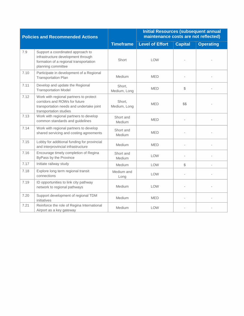
Policies and Recommended Actions
Timeframe
Initial Resources (subsequent annual maintenance costs are not reflected)
Level of Effort Capital Operating
7.9 Support a coordinated approach to
infrastructure development through
formation of a regional transportation
planning committee
Short LOW - -
7.10 Participate in development of a Regional
Transportation Plan Medium MED - -
7.11 Develop and update the Regional
Transportation Model Short,
Medium, Long MED $ -
7.12 Work with regional partners to protect
corridors and ROWs for future
transportation needs and undertake joint
transportation studies
Short,
Medium, Long MED $$ -
7.13 Work with regional partners to develop
common standards and guidelines Short and
Medium MED - -
7.14 Work with regional partners to develop
shared servicing and costing agreements Short and
Medium MED - -
7.15 Lobby for additional funding for provincial
and interprovincial infrastructure Medium MED - -
7.16 Encourage timely completion of Regina
ByPass by the Province
Short and
Medium LOW - -
7.17 Initiate railway study Medium LOW $ -
7.18 Explore long term regional transit
connections Medium and
Long LOW - -
7.19 ID opportunities to link city pathway
network to regional pathways Medium LOW - -
7.20 Support development of regional TDM
initiatives Medium MED - -
7.21 Reinforce the role of Regina International
Airport as a key gateway Medium LOW - -

Appendix D: Framework for Complete Streets

Framework for Complete Streets
This Framework is meant to outline Complete Streets concepts and be a first step towards adopting a formal Complete Streets Policy. The Framework highlights updates to municipal bylaws, policies, design guidance documents, and operations and maintenance processes. It also identifies new tools and strategies the city can use to support a Complete Streets approach to planning streets.
What are Complete Streets?
A Complete Street is a street where the entire corridor is planned, designed, operated and maintained to ensure that users of all ages, abilities, and modes of transportation can use the street safely.
Complete Streets Approach
Traditional street planning and engineering processes have typically taken the approach of starting at the centreline of the road and designing outward. This places priority on vehicular movement over other modes and may lead to streets that do not have sufficient space to accommodate pedestrians, cyclists, or transit safely. A Complete Streets approach to street design starts at the building face and designs inwards, considering how each user can be accommodated.
Complete streets are designed to reflect neighbourhood context and street function while balancing the needs of all users. Elements of Complete Streets include sidewalks, bikeways, dedicated bus lanes, accessible transit stops, accessible crossings, and median refuge islands; however, not all of these elements are required for a street to be considered complete.
The process of planning and designing Complete Streets often requires that compromises be made. Increased levels of service for one mode may result it decreased levels of service for another mode, particularly where ROWs are constrained. In these instances, developing priority networks for each mode can help to identify routes where different modes may take precedent. Figure 1 shows examples of complete streets successfully implemented in other cities.

Figure 1: Complete Street Examples
(photo credits: top left - New York City DOT, top right – IBI Group, bottom left and right - Laurence Lui)
Complete Streets and Regina’s OCP and TMP
Many aspects of complete streets are supported throughout Regina’s OCP and TMP including the coordination of land use and transportation planning, support for complete neighbourhoods, the integration of multiple modes within roadway design, and the consideration in implementation strategies. In particular, Policy 5.6 of the OCP, “Adopt a complete streets framework for new road construction as well as the renewal of existing streets, where feasible” identifies the development of complete streets. Another Community Priority identified within the OCP is the development of complete neighbourhoods (OCP Appendix A) which feature “safe, accessible and connected modes of transportation…”
OCP Policy 7.1.7 identifies some guidelines for complete neighbourhoods that are consistent with the complete streets framework and are as follows:
Sidewalks should be separated from streets by landscaped strips, street trees and curbs, especially in primarily residential areas.
Encourage rear-lane access to homes to provide a more enjoyable and safe street space.
Avoid long blocks and street walls that limit interconnectivity, and incorporate mid-block walkways into blocks greater than 250 m in length.

Avoid curvilinear, loop and cul-du-sac street design, as this pattern limits transportation and servicing interconnectivity.
Ensure safe, walkable and aesthetically pleasing active transportation connections between districts and neighbourhood hubs, parks, amenities and institutional uses.
Ensure that neighbourhoods are well connected to urban centres and urban corridors for access to citywide amenities and employment areas.
Also, the TMP identifies a number of city policies, guidelines, standards, and processes that should be updated which will allow the city to support the development of Complete Streets. Some of these include:
Update the subdivision bylaw to integrate neighbourhood design and transportation system design (Policy 2.9)
Update the Zoning Bylaw to support increased transportation choices within new and existing developments (Policy 2.4, 2.13, 4.3)
Use existing networks to identify gaps and improve connectivity (Policy 2.18)
Expand and update the DSM and other design standards to improve accessibility standards and multi-modal provisions in new and existing neighbourhoods (Policy 2.14, 4.2, 4.22, 4.24, 4.26, 5.20)
Update existing inspection and maintenance processes to improve sidewalk quality and universal accessibility (Policy 4.23)
Improve existing infrastructure to support multiple modes and improve accessibility in existing neighbourhoods (Policy 2.17)
Use secondary plan, concept plan, and site plan processes and approvals to ensure all modes are accommodated within development projects (Policy 2.5, 2.28, 4.1, 4.16)
Amend the Traffic Bylaw to reduce barriers for active modes (Policy 4.5)
Expand the citywide bike network both on-street and off-street (Policy 4.13, 4.15)
Adopt a transit network hierarchy to provide improved coverage and make transit an attractive mode choice (Policy 3.7)
Improve universal accessibility of transit stops (Policy 3.22)
Update the Transportation Impact Assessment requirements to ensure all modes are accounted for (Policy 2.21, 4.4)
The TMP also identifies a number of new initiatives for the city to undertake which support the planning, design, and operation of complete streets. These include:
Adopt a roadway classification system (Policy 5.1)
Adopt new standard roadway cross-sections to ensure new streets are designed with all users in mind (Policy 5.2, 5.19)

Integrate streets as an early part of planning neighbourhood structures (Policy 2.9)
Develop Site Design Guidelines that will support and promote multiple modes (Policy 2.7)
Use a MMLOS to assess the performance of a roadway and inform planning decisions on allocation of ROW space for different modes (Policy 1.13, 5.5)
Develop a winter travel strategy to identify updates to maintenance and operation of the transportation system to ensure all users are supported in all four (Policy 1.14)
Develop and update winter maintenance policies to increase safety and mobility for all modes (Policy 4.29, 4.30, 5.17)
Use planning and design of streets to foster a sense of place and identity through placemaking (Policy 2.11)
Develop a toolkit of transit stop amenities (Policy 3.31)
Establish consistent bikeway design guidelines (Policy 4.17)
Increase the number of on-street bikeways by creating bike boulevards (Policy 4.14)
Examine opportunities to connect the city’s bike network to regional trails (Policy 4.20, 7.19)
Develop a program for neighbourhood renewal to coordinate improvements citywide (Policy 6.7)
Ensure infrastructure in new neighbourhoods and employment areas supports universal accessibility (Policy 2.26)
Adopt mode share targets to guide transportation planning (Policy 1.1, 1.4)
Pursue improvements for vulnerable users (Policy 5.16)
Examine ways to accommodate other modes within the existing road network capacity (Policy 5.13)
Use road reconstruction projects to incorporate facilities for multiple modes and transition to complete streets (Policy 1.16)
Encourage integration of green infrastructure (Policy 2.41, 5.22, 6.20)
Create evaluation criteria to monitor progress of achieving objectives of the Complete Streets Framework (Policy 1.18)
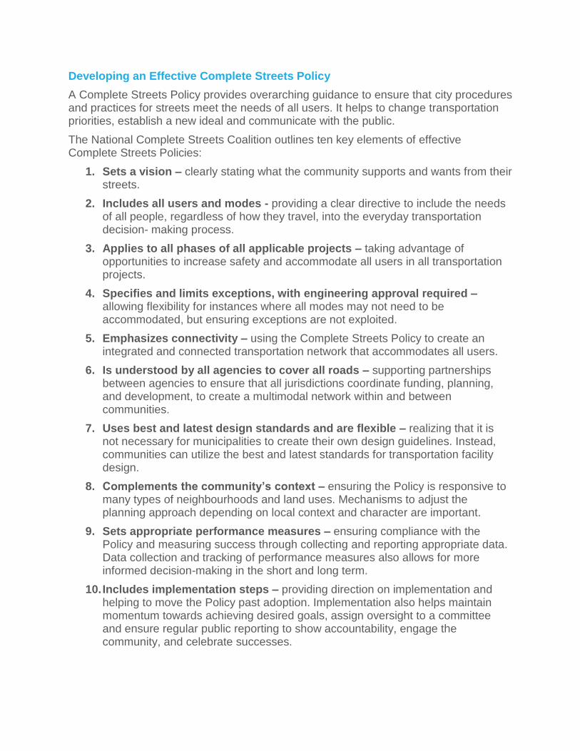
Developing an Effective Complete Streets Policy
A Complete Streets Policy provides overarching guidance to ensure that city procedures and practices for streets meet the needs of all users. It helps to change transportation priorities, establish a new ideal and communicate with the public.
The National Complete Streets Coalition outlines ten key elements of effective Complete Streets Policies:
1. Sets a vision – clearly stating what the community supports and wants from their streets.
2. Includes all users and modes - providing a clear directive to include the needs of all people, regardless of how they travel, into the everyday transportation decision- making process.
3. Applies to all phases of all applicable projects – taking advantage of opportunities to increase safety and accommodate all users in all transportation projects.
4. Specifies and limits exceptions, with engineering approval required – allowing flexibility for instances where all modes may not need to be accommodated, but ensuring exceptions are not exploited.
5. Emphasizes connectivity – using the Complete Streets Policy to create an integrated and connected transportation network that accommodates all users.
6. Is understood by all agencies to cover all roads – supporting partnerships between agencies to ensure that all jurisdictions coordinate funding, planning, and development, to create a multimodal network within and between communities.
7. Uses best and latest design standards and are flexible – realizing that it is not necessary for municipalities to create their own design guidelines. Instead, communities can utilize the best and latest standards for transportation facility design.
8. Complements the community’s context – ensuring the Policy is responsive to many types of neighbourhoods and land uses. Mechanisms to adjust the planning approach depending on local context and character are important.
9. Sets appropriate performance measures – ensuring compliance with the Policy and measuring success through collecting and reporting appropriate data. Data collection and tracking of performance measures also allows for more informed decision-making in the short and long term.
10. Includes implementation steps – providing direction on implementation and helping to move the Policy past adoption. Implementation also helps maintain momentum towards achieving desired goals, assign oversight to a committee and ensure regular public reporting to show accountability, engage the community, and celebrate successes.

Moving Toward a Complete Streets Policy for Regina
Adopting a Complete Streets Policy will support city staff to consistently design, operate, and maintain streets with all users and modes in mind.
Next Steps:
1) Develop and adopt a formal Complete Streets Policy, incorporating the key effective elements, to be adopted by Council to support the development of complete streets.
2) Create a strategy to implement complete streets in all roadway projects. This may include:
identifying internal and external stakeholders who should be engaged in implementation of complete streets;
coordinating ongoing updates to municipal policies, standards, and procedures in order to streamline decision making and support consistent implementation of complete streets;
updating existing design guidelines for streets and ROWs, or identifying design guidelines from recognized professional organizations that the city should adopt to implement complete streets;
developing priority networks for different modes, or creating a toolkit of measures to accommodate multiple modes on different street classes;
providing education, training, and outreach activities for city staff, Council, and residents to better understand the policy; and,
creating relevant performance measures to monitor implementation of the policy.
3) Set timelines to jumpstart implementation of the Complete Streets Policy. Figure 2 identifies five-year action items to support complete streets implementation.
Figure 2: Five-year action items
Category Actions
Overall implementation activities
Develop a formal Complete Streets Policy which incorporates the key effective elements to be presented to Council
Form a Complete Streets Committee with representation from planning, engineering, maintenance, and operations staff as well as external stakeholders to review roadways projects and ensure they reflect the Complete Streets Policy
Identify funding sources to support the development of complete streets
Municipal processes to be reviewed
Review and coordinate street development processes to streamline decision-making between city departments
Initiate Winter Maintenance review
Identify priority networks for different modes
Updates to municipal plans/
Conduct regular updates to TMP and OCP to support the development of complete streets

guideline documents
Adopt interim design guidelines/standards for ROWs (using design guidelines from recognized professional organizations)
Coordinate updates to municipal policies and guideline documents identified in the OCP and TMP to support the development of complete streets,
Update urban design guidelines for ROWs and develop standard roadway cross-sections
Create a toolkit of measures to accommodate multiple modes on different street classes
Training for staff, leaders, and the public
Provide training opportunities to educate staff about the Complete Streets Policy and how it should inform their work
Develop education materials and outreach activities to Council and Residents to understand the Complete Streets Policy
Publicize examples of complete streets being implemented (new and retrofitted streets)
Performance measures
Set complete streets project targets to monitor (e.g. two road diet projects within five years)
Reinstate annual collision reporting
Track annual budget expenditures by mode

Appendix E: Definitions
access/ accessible/
accessibility
A general term used to describe the degree to which an activity, service, or
physical environment is available to as many people as possible, regardless of
their physical abilities or socio-economic background. From a transportation
perspective, this relates to the ease of getting around regardless of physical,
cognitive, or other needs. Improving accessibility involves removing economic,
physical, cultural, and transportation barriers to participation in programs, projects
and facilities.
active transportation Modes of travel which rely on self-propulsion and include walking, cycling,
rollerblading, skateboarding. Also: active modes
alley (lane) A public right-of-way providing a secondary level of access to the side or rear of a
lot or parcel of land.
arterial street A road with controlled access that carries major traffic flows to and from major trip
generators and communities. Generally provides connections between collector
streets and expressways.
arterial street (major) A road with controlled access that carries major traffic flows to and from trip
generators and communities. Generally provides connections between collector
streets and expressways. Residential frontage is not permitted. Direct access is
not desirable and median openings are not permitted except at intersections.
Parking is not permitted on major arterial streets.
arterial street (minor) A road with controlled access that carries major traffic flows to and from from
major trip generators and communities. Used to supplement major arterial streets
and provide connection between expressways and local road networks. Direct
access to abutting propertis is generally permitted with some access controls.
barrier-free To eliminate physical barriers to use or visitation, so that it is accessible to anyone
regardless of age or physical ability, and without a need to adaptation. In general,
it is a term that describes a design that maximizes accessibility.
bike boulevard A type of bikeway; particularly a street with low vehicle traffic volumes designated
to give bicycle travel priority. Identified with the use of signs and pavement
markings.
bike lane A type of bikeway, particularly an on-street lane dedicated for use by bicycles
only.
bikeway A facility designed for the movement of bicycles. Can be located on- or off- street.
built or approved
neighbourhoods
Comprise lands that are predominantly built or approved residential areas that will
be subject to additional change through limited intensification in accordance with
the Official Community Plan.
bus lane A lane dedicated for the movement of transit vehicles during a part of, or
throughout, the day. Sometimes shared with high-occupancy vehicles, bicycles,
and taxis.
bypass A road that serves as a diversion route for traffic that is destined to travel around
the city.
capacity In transportation planning, a limit, usually defined by infrastructure, of the number
of vehicles or people that can pass through the infrastructure over a set period of
time.
City Centre The area of Regina that includes the Downtown and surrounding
neighbourhoods, or portions of these neighbourhoods, which is planned for
10,000 new residents through intensification. The city Centre area and boundary
is depicted on the Growth Plan within the Official Community Plan.
collaborative planning area See Policy 3.17 of Official Community Plan.
collector street A road designed to intercept, collect and sitribute traffic between local and arterial
streets. Direct access to abutting properties is permitted.
community amenity A built form or public realm feature, element, or structure that provides a desirable
or favourable service or benefit to the local community, and at no cost to the
community.
complete neighbourhoods Neighbourhoods which provide easy access to the daily life necessities for people
of all ages, abilities and backgrounds. This includes choice of lifestyle, food,
housing options, employment, services, retail and amenities, multi-modal
transportation, and educational and recreational facilities and programs.
complete street A policy and design approach for streets to ensure the provision of safe and
comfortable movement by all modes of travel and for users of all ages and
abilities.
conventional transit system A fixed network of bus routes that provide passenger transportation within the city
(i.e. Regina Transit).
Crime Prevention
Through Environmental
Design (CPTED)
A set of design principles that reduce opportunities for crime and nuisance
activity.
cul-de-sac Local dead-end streets that are open to traffic on one end and have a turn-around
on the other end.
current contributions to capital General revenue from tax dollars directed towards capital infrastructure projects.
cycle track A type of bikeway - a lane of travel dedicated for use by bicycles only, physically
separated from other traffic (e.g. curb, bollards)
dangerous goods route A route designated for the movement of dangerous goods, as defined by the City
of Regina Traffic Bylaw 9900.
ecological assessment A detailed and comprehensive evaluation that determines the short- and long
term impacts a development will have on identified natural features and functions.
The assessment will also recommend and identify ways to minimize, mitigate, or
eliminate these effects and/or compensate for their impacts. Ecological
Assessment, if required, must be completed, reviewed and approved prior to a
development's/project's implementation.

express transit corridor A route designated to be served by a higher level of transit, including express
buses with limited stops and/or local buses operating at high frequencies.
expressway A divided road with fully controlled access that provides for relatively unimpeded
traffic flow at high speeds. Direct access to abutting properties is not permitted.
Intersections are either grade separated or controlled by traffic signals.
freeway A divided road with full controlled access that provides unimpeded traffic flow at
high speeds. Direct access to abutting properties is not permitted. All intersections
are grade separated.
greenway A landscaped pathway or sidewalk along roadways, easements, and parks to
allow for extended, safe, unimpeded walking and cycling and other forms of active
transportation. Greenways link community destinations together.
high-occupancy vehicle (HOV) A vehicle travelling with two or more people, including the driver.
highway (provincial) Defined in the Highways and Transportation Act, 1997 as a road allowance or
road, street, or lane that is: i) subject of a departmental plan; or ii) is prescribed as
a provincial highway; and includes a weighing and inspection facility.
industrial street A road designed primarily to provide access to abutting industrial property.
intermodal In the goods movement sense, refers to the transportation of goods across
multiple modes, such as truck and rail.
intensify/intensification Construction of new buildings or addition to existing buildings on serviced land
within existing built areas through practices of building conversions, infill within
vacant or underutilized lots and redevelopment of existing built areas.
Intensification Area A specific area where the creation of new development is accommodated within
existing buildings or on previously developed land through common practices of
building conversions, infill within vacant or underutilized lots and redevelopment of
existing built areas.
joint planning area The undeveloped land area within city limits that abuts the R.M. of Sherwood and
the area within the R.M. of Sherwood between the city limits and the boundary
defined by the Province in their correspondence dated February 22, 2013 and as
depicted on Map 3 - Regional Policy Context of the Official Community Plan.
Lands within the Global Transportation Hub Authority area and First Nations
Reserve Lands are not included within this area given their standing as their own
planning authorities.
local street A road designed primarily to provide frontage for service and access to abutting
lots.
mixed-use Any urban, or suburban development, or a single building, that combines
residential with various uses such as commercial, employment, cultural,
institutional or industrial where those functions are physically and functionally
integrated and provide pedestrian connections, as well as access to multi-modal
transportation options.

mode share The proportion of trips taken by a particular mode (or type) of travel (e.g. auto,
transit, active transportation); also known as mode split
mode share targets Targets established by a planning or policy document for various modes of travel.
mode split See mode share.
natural areas Lands containing environmentally sensitive or ecologically significant natural
prairie or naturalized areas, features and elements including wetlands,
waterbodies, floodplains, habitat areas, riparian areas, streams, and other core
areas within the City of Regina and region.
natural corridors Lands comprising a linear network of private and public open space along natural
waterways inclusive of riverbank, floodplain, hillslope, upland interior, upland edge
habitat as well as top-of-bank agricultural lands that provide habitat requirements
to facilitate movement for a wide range of species.
naturalized corridors Critical natural and open space linkages between environmentally sensitive areas
and habitat or along watercourses that join to natural corridors and create a
connected natural system.
natural system Lands containing core natural areas, natural corridors and linkages between them
comprised of naturalized corridors, which together form an integrated system of
protected areas.
neighbourhood traffic calming See traffic calming.
new employment areas Lands that will accommodate a full range of employment-generating uses
primarily industrial or industrial-commercial in nature.
new neighbourhoods Lands that are primarily undeveloped or vacant that will accommodate new
residential development with supporting services and amenities. New
neighbourhoods are located on the periphery of, or adjacent to, existing areas of
the city.
paratransit system A transit system designed to provide curb-to-curb passenger transportation for
persons who are unable to use the conventional transit system due to physical,
cognitive, or other needs.
park and ride Designated parking to allow transit passengers to access transit by car - usually
at express bus stops or transit stations and nodes.
pathway An off-street facility that is typically shared by active transportation modes (e.g. a
type of bikeway).
peak period Period(s) of the day when traffic congestion and crowding on public transportation
is highest. Often the a.m. peak and PM peak periods occur during typical daily
commute times.
private street A road constructed on private property that has similar features to a public road.
public realm Places and spaces that are shared by the public. This includes all public places,
open spaces, and streetscapes.
rapid transit Higher-order transit that provides higher capacity and operating speed, typically in
a dedicated or exclusive right-of-way.
right of way The area of land acquired for or devoted to the provision of a road.
road The public right-of-way comprising of a thoroughfare that has been paved or
otherwise improved to allow travel by some form of conveyance.
road diet Sometimes a traffic calming measure, a road diet is typically a reduction in
vehicular lanes of a roadway to improve safety and to accommodate other modes
of travel, through inclusion of bike lanes, expanded sidewalks, or other means.
The most common type of road diet is the reduction of a four-lane street to a two-
lane street with a shared centre left-turn lane and the addition of bike lanes.
segregated bike lane A type of bikeway; particularly a bike lane which is physically separated from
vehicle traffic by some type of barrier.
service street A road adjacent to a highway, freeway, expressway, or major arterial, providing
direct access to abutting properties.
separate title parking Parking stalls located near a high density residential complex (apartment or condo
building) that are not included in the unit cost, but can be purchased separately by
tenants or other buyers.
shared-use lane A type of bikeway, particularly a designated lane in which bicycles and other
vehicles are encouraged to share road space, typically identified through the use
of road markings, known as sharrows.
single occupant vehicle (SOV) A vehicle travelling with only one person (the driver).
special study area An area, determined by the city, which requires further, more detailed study to
determine future land use and phasing or timing of development based on impact
to the city.
strategic goods route Includes routes designated for the movement of dangerous goods, as defined by
the City of Regina Traffic Bylaw 9900, Pickup and Delivery Vehicle Routes and
Heavy or Long Combination Vehicle Routes.
street A public road or thoroughfare that is usually paved and may include a sidewalk or
sidewalks.
temporary road A street to provide temporary access to a development until the permanent street
system is complete.
traffic calming Physical measures implemented on streets to reduce traffic infiltration and/or
speed, usually in residential areas, but also in heavy pedestrian areas.
Trans Canada Trail The world's longest network of recreational trails, which will stretch 23,000 km
from the Atlantic to the Pacific to the Arctic Oceans once connected.

transit corridors Routes identified with the density and/or ridership to justify higher level of
frequency and quality of transit service.
transit nodes Points identified in the transit network that meet one or more of the following:
- serves as a major, citywide destination, such as Downtown or the University of
Regina;
- a major transfer location between multiple transit routes; and/or,
- is adjacent to mixed-use or denser areas.
A transit node should also provide for multi-modal connections and have potential
for transit-oriented development to serve as anchors for transit in local
communities.
transit-oriented development Higher density development in proximity to transit with design qualities that
encourage the use of transit, such as high quality pedestrian environment and a
mix of uses.
transit priority Measureseither physical or operationalto improve the reliability or speed of
transit service, particularly in congested areas.
Transportation Demand
Management (TDM)
Strategies and measures to encourage specific travel behaviours that reduce
demand on the transportation network. Some of these measures could include
carpooling, providing travel alternatives, encouraging shift to other modes of
travel, providing incentives and disincentives. TDM is sometimes referred to as
sustainable transportation choices.
Transportation Impact
Assessment (TIA)
A report prepared as part of the development application process that requires the
applicant to assess the impact of the proposal on the transportation system and
identify measures to mitigate the impact.
Transportation System
Management (TSM)
Strategies and measures to optimize the transportation system and the use of
existing roadways through intersection and operational improvements to benefit
all modes of travel.
truck route area Areas identified on the Strategic Goods Routes Maps, which denote the types of
trucks that are permitted on all roads within the specific area. Dangerous Goods,
Heavy or Long Combination, and Pick-up & Delivery Vehicles are allowed on all
roads within “Unrestricted Truck Route Areas”; Heavy or Long Combination and
Pick-up & Delivery Vehicles are allowed on all roads within “Heavy or Long
Combination and Pick-up & Delivery Truck Route Areas”; and, Pick-up & Delivery
Vehicles are allowed on all roads within “Pick-up & Delivery Truck Route Areas”.
urban corridor The lands around an established or new major road, urban arterial or transit
corridor that have the potential to provide a focus for higher density or mid-rise,
mixed-use development that facilitate active transportation modes. Urban
corridors link new neighbourhoods with the City Centre and with each other.
urban design Urban design is the process of planning, designing and constructing buildings,
public spaces, sites, neighbourhoods and cities to give them form, shape, and
character. Urban design combines key aspects of urban planning, architecture
and landscape architecture to create beautiful and functional places. It involves
understanding the inter-relationships between the natural system, the physical
built environment, economic forces, and social context of a particular site or area.

wayfinding A system that assists travelers in orienting, navigating, and moving through an
environment through the use of visual or other measures, including signage.