Topic Paper: Flood Risk - guildford.gov.uk · fluvial floods occurring in: 1900, 1928, 1968, 2000,...
15
Topic Paper: Flood Risk December 2017 To accompany Guildford borough Submission Local Plan: strategy and sites
-
Upload
hoangkhuong -
Category
Documents
-
view
216 -
download
0
Transcript of Topic Paper: Flood Risk - guildford.gov.uk · fluvial floods occurring in: 1900, 1928, 1968, 2000,...
Topic Paper:
Flood Risk
December 2017
To accompany Guildford borough Submission Local Plan: strategy and sites

Guildford borough Topic Paper: Flood Risk 2
Alternative formats
If you would like to read this consultation
document in a different format such as large
print or a different language, please contact
Planning Policy:
Telephone: 01483 444471
Email: [email protected]

Guildford borough Topic Paper: Flood Risk 3
Contents
1. Purpose of this topic paper 4
2. Defining Flood Risk 4
3. Policy Context 5
4. Key evidence 8
5. Appraisal 9
6. Local Plan Policy Approach 12
7. How feedback from the Draft Local Plan Consultations 14 has informed the policy
8. Conclusion 15
9. Next steps 15
Guildford borough Topic Paper: Flood Risk 4
1. Purpose of this topic paper 1.1 This document is one in a series of topic papers that set out how we have developed the key
strategy and policies contained within the Guildford borough Submission Local Plan: strategy and sites document. Each topic paper looks at the relevant national and local guidance that informs the Submission Local Plan. Topic papers explain how the strategy has developed, in addition to the information, evidence and feedback that have informed the choices made in formulating the policies.
1.2 The intention of the topic papers is to provide background information; they do not contain any policies, proposals or site allocations. Topic papers have been produced to accompany the Submission Local Plan: strategy and sites to the Secretary of State for examination.
The main areas covered by this topic paper are:
The national planning policy context for flooding and flood risk
An overview of key evidence which has been used to inform the policy approach taken in the Local Plan: strategy and sites
An appraisal of the local flood risk context and policy considerations
An overview of the Local Plan policy approach for mitigating flood risk in the borough
An overview of how the Draft Local Plan consultation in June 2014 has informed the policy
2. Defining flood risk 2.1 Flood events are becoming increasingly frequent and severe; posing a greater risk to society
than ever before. Such events have the potential to cause damage to property, lead to a loss of business and result in injury or death.
2.2 Mitigating flood risk is an increasingly important function of the planning system. In
producing strategies and plans for future growth and development, planners must take account of various types and sources of flooding. Fluvial, sea, groundwater and surface water flooding can all pose a threat to communities.
2.3 The Environment Agency has developed flood risk maps for the entire country that identify
areas of land at risk of flooding. The map classifies land within one of the following three flood zones:
1) Flood Zone 1 – Land with a low probability of river or sea flooding (less than 1 in
1,000 chance of annual flooding)
2) Flood Zone 2 – Land with a medium probability of river or sea flooding (land having between 1 in 100 and 1 in 1,000 chance of annual river flooding or between 1 in 200 and 1 in 1,000 chance of annual sea flooding)
3) Flood Zone 3* – Land with a high probability of flooding (1 in 100 or greater probability of annual flooding by river or 1 in 200 or greater probability of annual flooding by sea)
*National Planning Practice Guidance subdivides Flood Zone 3 into Zone 3a and Zone 3b.
Flood Zone 3b is known as the functional floodplain and constitutes land where water has to
flow or be stored in times of flood.
Guildford borough Topic Paper: Flood Risk 5
3. Policy Context
National context 3.1 A Local Plan can only be found sound by a Planning Inspector if its policies are positively
prepared, justified, effective and consistent with national policy. The National Planning Policy Framework (NPPF) sets out the overarching planning policy framework for Local Planning Authorities in England and is supported by National Planning Practice Guidance (NPPG).
3.2 The NPPF provides comprehensive guidance to Local Planning Authorities on mitigating
flood risk. Paragraph 100 states:
“Inappropriate development in areas at risk of flooding should be avoided by directing
development away from areas at highest risk, but where development is necessary,
making it safe without increasing flood risk elsewhere. Local Plans should be supported
by Strategic Flood Risk Assessment and develop policies to manage flood risk from all
sources, taking account of advice from the Environment Agency and other relevant flood
risk management bodies, such as lead local flood authorities and internal drainage
boards. Local Plans should apply a sequential, risk-based approach to the location of
development to avoid where possible flood risk to people and property and manage any
residual risk, taking account of the impacts of climate change, by:
applying the Sequential Test;
if necessary, applying the Exception Test;
safeguarding land from development that is required for current and future flood management;
using opportunities offered by new development to reduce the causes and impacts of flooding; and
where climate change is expected to increase flood risk so that some existing development may not be sustainable in the long-term, seeking opportunities to facilitate the relocation of development, including housing, to more sustainable locations.”
3.3 Paragraph 101 of the NPPF states that Local Planning Authorities should refuse
development proposals if there are reasonably available sites appropriate for the proposed development in areas with lower probability of flooding. The Local Planning Authority’s Strategic Flood Risk Assessment (SFRA) provides the basis for applying this requirement.
3.4 Following the application of the sequential test, if it is deemed not possible to locate the
development proposal in an area at lower risk of flooding, the Exception Test can be applied (if appropriate). To pass the Exception Test, applicants must demonstrate that the development provides wider sustainability benefits to the community that outweigh flood risk, and submit a site-specific flood risk assessment that illustrates that the development is safe for its lifetime, taking account the vulnerability of its users, without increasing flood risk elsewhere and, where possible, reducing flood risk overall.
3.5 When determining planning applications, local planning authorities should ensure that flood
risk is not increased elsewhere. Paragraph 103 of the NPPF states that development should only be considered appropriate in areas at risk of flooding where they have been informed by a site specific Flood Risk Assessment and following the sequential test, and if necessary the exception test, it can demonstrate that:
Guildford borough Topic Paper: Flood Risk 6
i) Within the site, most vulnerable development is located in areas at lowest risk unless there are overriding reasons not too
ii) Development is flood resilient and resistant, including the provision of safe access and escape routes, any residual risk can be safely managed, and it gives priority to the use of sustainable drainage systems.
3.6 The NPPF also instructs Local Planning Authorities that the sequential test does not need to
be applied to individual development allocated in the development plan. 3.7 The development of Policy P4 of the Proposed Submission Local Plan has also been
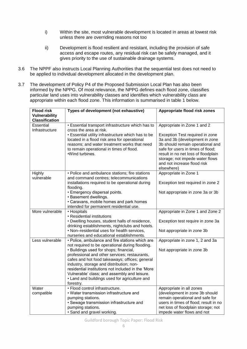
informed by the NPPG. Of most relevance, the NPPG defines each flood zone, classifies particular land uses into vulnerability classes and identifies which vulnerability class are appropriate within each flood zone. This information is summarised in table 1 below.
Flood risk Vulnerability Classification
Types of development (not exhaustive) Appropriate flood risk zones
Essential Infrastructure
• Essential transport infrastructure which has to cross the area at risk. • Essential utility infrastructure which has to be located in a flood risk area for operational reasons; and water treatment works that need to remain operational in times of flood. •Wind turbines.
Appropriate in Zone 1 and 2 Exception Test required in zone 3a and 3b (development in zone 3b should remain operational and safe for users in times of flood; result in no net loss of floodplain storage; not impede water flows and not increase flood risk elsewhere)
Highly vulnerable
• Police and ambulance stations; fire stations and command centres; telecommunications installations required to be operational during flooding. • Emergency dispersal points. • Basement dwellings. • Caravans, mobile homes and park homes intended for permanent residential use.
Appropriate in Zone 1 Exception test required in zone 2 Not appropriate in zone 3a or 3b
More vulnerable • Hospitals • Residential institutions • Dwelling houses, student halls of residence, drinking establishments, nightclubs and hotels. • Non–residential uses for health services, nurseries and educational establishments.
Appropriate in Zone 1 and Zone 2 Exception test require in zone 3a Not appropriate in zone 3b
Less vulnerable • Police, ambulance and fire stations which are not required to be operational during flooding. • Buildings used for shops; financial, professional and other services; restaurants, cafes and hot food takeaways; offices; general industry, storage and distribution; non-residential institutions not included in the ‘More Vulnerable’ class; and assembly and leisure. • Land and buildings used for agriculture and forestry.
Appropriate in zone 1, 2 and 3a Not appropriate in zone 3b
Water compatible
• Flood control infrastructure. • Water transmission infrastructure and pumping stations. • Sewage transmission infrastructure and pumping stations. • Sand and gravel working.
Appropriate in all zones (development in zone 3b should remain operational and safe for users in times of flood; result in no net loss of floodplain storage; not impede water flows and not
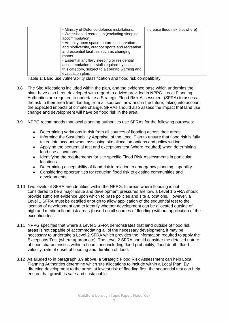
Guildford borough Topic Paper: Flood Risk 7
• Ministry of Defence defence installations. • Water-based recreation (excluding sleeping accommodation). • Amenity open space, nature conservation and biodiversity, outdoor sports and recreation and essential facilities such as changing rooms. • Essential ancillary sleeping or residential accommodation for staff required by uses in this category, subject to a specific warning and evacuation plan.
increase flood risk elsewhere)
Table 1: Land use vulnerability classification and flood risk compatibility
3.8 The Site Allocations included within the plan, and the evidence base which underpins the plan, have also been developed with regard to advice provided in NPPG. Local Planning Authorities are required to undertake a Strategic Flood Risk Assessment (SFRA) to assess the risk to their area from flooding from all sources, now and in the future, taking into account the expected impacts of climate change. SFRAs should also assess the impact that land use change and development will have on flood risk in the area.
3.9 NPPG recommends that local planning authorities use SFRAs for the following purposes:
Determining variations in risk from all sources of flooding across their areas
Informing the Sustainability Appraisal of the Local Plan to ensure that flood risk is fully taken into account when assessing site allocation options and policy writing
Applying the sequential test and exceptions test (where required) when determining land use allocations
Identifying the requirements for site specific Flood Risk Assessments in particular locations
Determining acceptability of flood risk in relation to emergency planning capability
Considering opportunities for reducing flood risk to existing communities and developments
3.10 Two levels of SFRA are identified within the NPPG. In areas where flooding is not
considered to be a major issue and development pressures are low, a Level 1 SFRA should provide sufficient evidence upon which to base policies and site allocations. However, a Level 1 SFRA must be detailed enough to allow application of the sequential test to the location of development and to identify whether development can be allocated outside of high and medium flood risk areas (based on all sources of flooding) without application of the exception test.
3.11 NPPG specifies that where a Level 1 SFRA demonstrates that land outside of flood risk
areas is not capable of accommodating all of the necessary development, it may be necessary to undertake a Level 2 SFRA which provides the information required to apply the Exceptions Test (where appropriate). The Level 2 SFRA should consider the detailed nature of flood characteristics within a flood zone including flood probability, flood depth, flood velocity, rate of onset of flooding and duration of flood.
3.12 As alluded to in paragraph 3.9 above, a Strategic Flood Risk Assessment can help Local
Planning Authorities determine which site allocations to include within a Local Plan. By directing development to the areas at lowest risk of flooding first, the sequential test can help ensure that growth is safe and sustainable.
Guildford borough Topic Paper: Flood Risk 8
Neighbourhood Planning 3.13 Neighbourhood planning enables Neighbourhood Forums and Parish Councils to develop a
vision and planning policies for a designated neighbourhood area. Those ‘Neighbourhood Plans’ which are successfully adopted will form part of the statutory development plan for the area that they cover. Where a Neighbourhood Plan is adopted or emerging before an up-to-date Local Plan is in place, the local planning authority should take it into account when preparing Local Plan policies.
3.14 There is currently one adopted Neighbourhood Plan (Burpham) , one emerging, post-
examination Neighbourhood Plan (Effingham), and one progressing towards examination (East Horsley) within the borough. Six other Parish Councils are also currently producing neighbourhood plans.
3.15 Burpham Neighbourhood Plan policy B-FD4 requires new developments to consider water supply and flood risk. The policy states that “approval for new residential units will be granted, subject to other policies in this Plan, after the applicant has demonstrated that all the following are met:
• Demand for water supply and water network infrastructure, both on and off site,
will be met; and • Demand for sewage treatment and sewage network infrastructure, both on and
off site, will be met; and • The development can be justified having regard to appropriate flood risk
assessments and application of the sequential test in accordance with Planning Practice Guidance; and
• The surface water drainage requirements of the development will be met using best practice in Sustainable Drainage Systems where appropriate”
As articulated in sections seven below, Policy P4 of the Local Plan: strategy and sites document also addresses these issues and is not considered to conflict with the adopted neighbourhood plan.
3.16 The weight given to an emerging plan will depend on, among other things, the extent to
which there are unresolved objections to the plan (NPPF paragraph 216). Therefore, an emerging neighbourhood plan will pick up weight once evidence of consultation is published and the level of unresolved objection is known. At time of writing, the Effingham Neighbourhood Plan has been through examination, has resolved any remaining objections, and is progressing towards a referendum. The East Horsley neighbourhood plan has been submitted for examination but not been examined and is therefore accorded very little weight at this stage. Details are available at http://www.guildford.gov.uk/neighbourhoodplanninginformation.
4. Key evidence 4.1 The National Planning Policy Framework requires us to develop policies based on up to date
evidence. Our evidence base comprises documents that have helped inform past and current stages of our Local Plan policy development. The views and feedback of the community, key stakeholders and partner organisations also form part of our evidence base. In particular, the Council has utilised advice from the Environment Agency in developing our evidence base related to flood risk.
4.2 The following evidence base documents are relevant to mitigating flood risk:
Guildford Borough Strategic Flood Risk Assessment Level 1 (2016)
Guildford borough Topic Paper: Flood Risk 9
Guildford Borough Local Plan Flood Risk Sequential and Exception Test (May 2016)
Guildford Borough Strategic Flood Risk Assessment Level 2 (2016, and 2017 Addendum)
Ash Surface Water Study (2014)
Guildford Surface Water Management Plan (2014)
4.3 Further information regarding the evidence base is available to read on the Council’s website via the following link: www.guildford.gov.uk/researchandevidence
5. Appraisal
Local context
5.1 Guildford borough is not subject to regular severe flooding. However, a significant proportion of the borough is located within either Flood Zone 2 or 3 and is thus considered to be at medium or high risk of flooding (see paragraph 2.3). The River Wey and its tributaries (including the Tillingbourne and Cranleigh Water) are the primary sources of flooding in the area. The River Blackwater, which flows through the west of the borough, is a further source of fluvial flooding.
5.2 Widely associated with climate change, flood events are anticipated to become increasingly
frequent and severe. In Guildford borough, heavier rainfall in winter will increase the hazards posed by fluvial flooding and the number of properties vulnerable to flooding. Such weather patterns will also create higher peak river flows (which will subsequently result in some areas becoming more prone to fluvial flooding), whilst more frequent storm events are likely to be associated with greater surface water flooding, particularly in identified hotspot areas.
5.3 A few developed areas in the borough, most notably Guildford town centre and parts of Ash,
are currently considered to be at high risk of flooding. Approximately 1,000 properties within the borough have a 1 in 100 (1%) or greater annual probability of flooding. However, predictions indicate that the number of properties within the wider Thames Catchment Flood Management Plan Area with a 1% or greater probability of annual flooding is likely to rise by twenty percent as a result of climate change.
5.4 The borough has experienced fluvial and groundwater flood events in the recent past; large
fluvial floods occurring in: 1900, 1928, 1968, 2000, 2006, 2007, 2012, 2013 and 2014. Groundwater flooding also occurred in 2000 around the Stoke Park area of Guildford.
5.5 River modelling has, and continues to be, undertaken on the River Wey. Where available,
revised data and maps for the river have been used in the Council’s SFRA to assess flood risk for sites that drain into the River Wey. At the time the plan was submitted to the Secretary of State, this data was available for the majority of sites allocated in the Submission Local Plan that are affected by flood risk. Modelling for other areas of the borough is not as advanced; for these areas, the SFRA uses the most up-to-date Environment Agency (EA) flood zones. The Council is generally reliant on work undertaken by the EA; we have engaged with them throughout preparation of the Local Plan and our plan follows their recommendations in relation to identifying and assessing flood risk.

Guildford borough Topic Paper: Flood Risk 10
Policy considerations
5.5 National planning policy and guidance instructs Local Planning Authorities to guide development to the areas at lowest risk of flooding. Where this is not possible, or there is a proven need for development in an area of flood risk, proposals should prove that the development will be safe throughout its lifetime, be flood resilient and provide safe access and egress. More vulnerable uses should be located towards areas of the site at lowest flood risk.
5.6 The Council’s Level 1 SRFA and flood risk sequential test (published in 2016) emphasise
that the borough’s development needs cannot be fully accommodated within flood zone one. Accordingly, in producing the Local Plan, the Council has been required to assess whether locating a small amount of development within medium and high risk flood zones can pass the flood risk sequential and exception tests.
5.7 In accordance with the NPPF, the Council has planned for its objectively assessed needs
(OAN) for housing and other land uses across the plan period. Some new development will therefore necessarily be located in areas at medium or high risk of flooding where it passes the flood risk sequential and exception tests.
5.8 To ensure that people and property remain safe from flooding, planning policies should
ensure that the most vulnerable land uses are located in areas at lowest risk. Developers should also be required to ensure that the proposed development will provide significant community benefits which outweigh flood risk, will be safe for its lifetime, is flood resilient and has made provision for safe access and egress.
5.9 In developing a flood risk planning policy, plan-makers should take account of local
circumstances. The Council’s Level 1 SRFA notes that some of Guildford’s functional floodplain (flood zone 3b) has historically been built upon. The document therefore differentiates between the ‘developed functional floodplain’ and the ‘undeveloped functional floodplain’. Whilst the NPPF states that the functional floodplain should be reserved for water storage and flow in times of flood, the SRFA argues that development or redevelopment in the ‘developed functional floodplain’ may be acceptable when flood risk betterment, appropriate mitigation and risk management can be achieved and implemented.
5.10 Given the findings of the Level 1 SFRA, it is reasonable to argue that the functional
floodplain does not need to be entirely excluded from development and can contribute to accommodating the borough’s objectively assessed needs, if betterment, mitigation and management can be achieved.
5.11 A number of places in the borough are susceptible to surface water flooding. To ensure that
development does not increase the risk of surface water flooding, the NPPF recommends that proposals give priority to sustainable drainage systems. The Guildford Surface Water Management Plan and Ash Surface Water study outline various mitigation measures that may help reduce the risk of surface water flooding in identified hotspot areas. Where development proposals come forward in such areas it would therefore seem reasonable for developers to have regard to the recommendations of these evidence base studies. The use of suitable and effective sustainable drainage systems can also help maintain and improve the quality of the local water systems.
5.12 The borough contains a number of aquifers, which are vital to providing a clean and healthy
water supply. To ensure that these aquifers are protected, the Environment Agency has identified ‘Source Protection Zones’ around them and recommends that local planning authorities put in place policies which prevent harmful development in these areas. The

Guildford borough Topic Paper: Flood Risk 11
Environment Agency suggests that harmful development is likely to include polluting industries, cemeteries and other similar uses.
5.13 In considering the inclusion of a strategic flood risk policy within the Submission Local Plan:
strategy and sites, and the scope of any such policy, it is important to identify and understand the consequences of not having such provision in place. Without a flood risk policy the Council would most likely rely on policy G1 (6) of the saved Local Plan (2003) in the determination of future planning applications until such a time that it is considered out of date. Policy G1(6) states that “areas of floodplain, identified on the Proposals Map, are safeguarded from development that would increase the risk to people or property from flooding”.
5.14 Although a saved Local Plan policy is in place and planning applications will be determined
against the NPPF where a Local Plan is out-of-date or silent on a particular matter, it is important that the new Local Plan has a policy in place which recognises and reflects the current local context. Without such a policy it may be difficult to meet the borough’s development needs and direct development to the most sustainable locations. For the Plan to be found sound, the site allocations included within it must also be well justified and based on substantive evidence, including a flood risk sequential test and Level 2 Strategic Flood Risk Assessment (SFRA). The lack of an up-to-date strategic flood risk policy or updated evidence base documents (such as a sequential test and SFRA) would most likely result in the Council receiving an objection from the Environment Agency and the plan being found unsound at examination.
5.15 Precedent set by recent Examinations in Public and planning application appeals can also
be used to justify a policy approach. The June 2014 Examination in Public of Doncaster LDF Sites and Policies Development Plan Documents is particularly useful in regards to developing a flood risk policy and informing the site allocations of a Local Plan. The inspector’s report is notable for the strong emphasis it places on applying flood risk as a development constraint. Most importantly, the report states that a Council’s starting point should be to “steer development away from areas with highest probability of flood risk” and that “It is only where it is ‘not possible’ to direct development to areas of lower flood risk that the Council can move on to apply the Exceptions Test. The test is not that it would be preferable to locate development in the areas of highest risk of flooding but that it should be impossible to do otherwise”. Local Planning Authorities should thus seek to avoid allocations in areas of higher risk of flooding.
5.16 The report also suggests that where it may not genuinely be possible to locate development
in areas at low risk of flooding, the Local Plan should be revisited, rather than assuming it may be appropriate to develop in areas at greater risk of flooding. This would include giving due consideration to developing in the countryside or green belt, which should not be regarded as more significant constraints than flood risk.
5.17 An appeal determined in 2012 (APP/Y3615/A/11/2157736I) against the refusal of a proposal
for a residential dwelling in Guildford also has implications for future planning policy. The report states that the “proposal would conflict with the relevant provisions of PPS25 and LP Policy G1 (6) which are designed to protect new and existing development against increased flood risks. None of the submitted information demonstrates that on this site such risks could be satisfactorily overcome, or safely disregarded”. The appeal decision reinforces the point that significant weight should be given to flood risk as a development constraint.
Guildford borough Topic Paper: Flood Risk 12
Consultation feedback 5.18 As part of developing the Local Plan, we have consulted at the following main stages:
Regulation 18 Issues and options (October 2013) – which identified a range of issues and potential options for how we should plan for Guildford borough
Regulation 18 Draft Local Plan (July 2014) – which outlined our preferred approach for planning for Guildford borough
Regulation 19 Proposed Submission Local Plan (June 2016) – which included the policies and sites that we had intended to submit for examination
Regulation 19 Proposed Submission Local Plan (June 2017) – a targeted consultation on proposed changes to policies and sites
5.19 Comments received as part of the consultation stages have been taken into account in the
preparation of the Local Plan. The main issues raised in all four consultations, together with our response, are set out in the accompanying Consultation Statement.
6. Local Plan Policy Approach Policy P4 Flooding, flood risk and groundwater protection zones
6.1 Policy P4 (2) of the Proposed Submission Local Plan allows development provided that: a) the vulnerability of the proposed use is appropriate for the level of flood risk on the
site b) the proposal passes the sequential and exception test (where required) as outlined
in the NPPF and Government guidance. c) a site–specific flood risk assessment demonstrates that the development, including
the access and egress, will be safe for its lifetime, taking into account climate change, without increasing flooding elsewhere, and where possible, will reduce flood risk overall;
d) the scheme incorporates flood protection, flood resilience and resistance measures appropriate to the character and biodiversity of the area and the specific requirements of the site;
e) when relevant, appropriate flood warning and evacuation plans are in place and approved; and
f) site drainage systems are appropriately designed taking account of storm events up to 1 in 100 year chance of flooding with an appropriate allowance for climate change
6.2 Policy P4 continues that:
“(3) Development proposals in the ‘developed’ flood zone 3b will also only be approved where the footprint of the proposed building(s) is not greater than that of the existing building(s). Proposals within these areas should facilitate greater floodwater storage.
(4) With the exception of the provision of essential infrastructure, ‘undeveloped’ flood zone 3b will be safeguarded for flood management purposes.”
6.3 The policy also states that development proposals should not increase surface water run-off,
should have regard to the measures identified in in the Guildford Surface Water Management Plan or Ash Surface Water Study and give priority to incorporating SuDs (Sustainable Drainage Systems). Development within Groundwater Source Protection Zones and Principal Aquifers will only be permitted provided it has no adverse impact on the quality

Guildford borough Topic Paper: Flood Risk 13
of the groundwater resource and it does not put at risk the ability to maintain a public water supply.
6.4 The policy approach adopted is considered to meet national policy and guidance in regards
to the Sequential and Exception tests. On the advice obtained from the Environment Agency during the Regulation 19 consultation on the Local Plan, amendments have been made to the policy wording to ensure that it has greater regard to the impacts of climate change.
6.5 By requiring development proposals to pass both tests (where necessary), the policy will
direct development to the safest and most sustainable areas of the borough. However, the policy allows for development in areas of greater flood risk provided that a series of measures are put in place to ensure that the development is safe over its life course and the vulnerability of the use is suitable to its location.
6.6 By enabling some development in Flood Zones 2 and 3, including the developed functional
floodplain (subject to certain criteria being met), the policy reflects the town centre’s unique setting and will enable the Council to meet its objectively assessed need for housing and other land uses. The policy also requires developers to have regard to the Council’s surface water management studies (which form part of the evidence base supporting the plan) and utilise sustainable drainage schemes wherever possible. Harmful development will not be permitted in the identified source protection zones to ensure that a safe and reliable drinking water supply is maintained.
Site Allocations
6.7 The Housing Delivery Topic Paper sets out the stages of consideration of flood risk in terms of determining proposed site allocations for new homes. This includes sequential and exception testing, which has been applied to ensure that development is directed to areas at least risk of flooding in the first instance.
6.8 The application of the sequential test (which forms part of the Level 1 SFRA) demonstrates that not all of the borough’s development needs can be accommodated within flood zone 1 (low risk).
6.9 The application of the Sequential and Exception tests have resulted in two non-residential site allocations (A2: Cinema, Guildford; and A9: 77 to 83 Walnut Tree Close, Guildford) being located in flood zone 3b developed (functional flood plain). Such development would need to achieve flood risk betterment, mitigation and management to be acceptable in planning terms.
6.10 The NPPG does not permit residential development in flood zone 3b developed ; the key consideration being the sequential test, and reasonable alternative locations for housing (of which the Housing Delivery Topic Paper considers Green Belt as an alternative). Main town centre uses are proposed for site allocations A2 and A9 and thus the consideration of reasonable alternatives is different to that for residential development. Whilst the town centre is the most sustainable location for residential development, C3 uses (and other residential uses) do not have to be located in the town centre.
6.11 Site allocation A6 (North Street, Guildford) features primarily retail uses but includes some residential development. Three quarters of the site is located within flood zone 1 (low risk), just under a quarter in Flood Zone 2 and a small proportion (2.5%) in Flood Zone 3. Retail is a main town centre use and the flood risk sequential test demonstrates that there is no alternative reasonable site(s) to provide this quantum of retail floorspace.
Guildford borough Topic Paper: Flood Risk 14
6.12 During the Regulation 19 consultation in 2016, the Environment Agency objected to three Local Plan sites (Policy A5: Jewsons, Policy A13: Kernal Court and Policy A14: Wey Corner) on the grounds that safe access and egress may be questionable due to flood risk and the apparent lack of evidence that this had been taken into account. We met with the Environment Agency to talk through their comments in more detail with the result that we agreed to address their objections as part of an update to the Level 2 SFRA. We undertook this update in the form of a 2017 Addendum to the Level 2 SFRA, which we added to the evidence base prior to submission of the Plan.
6.13 The Environment Agency also made a number of comments in relation to the SFRA Level 1
Flood Risk Sequential and Exception Test. These have been addressed by means of an update to that document. .
7.0 How has feedback received from the Draft Local Plan consultations informed the revised policies?
7.1 The Draft Local Plan published for public consultation in June 2014 failed to include a flood risk policy and was not informed by a flood risk sequential test or Level 2 SFRA. The Environment Agency highlighted this omission within their representations on the Draft Local Plan and stated that they would raise an objection should later versions not include such a policy.
7.2 A flood risk policy (policy P4) was therefore included in the Proposed Submission Local Plan
(2016) and is in the final submission version. A SFRA Level 1 Flood Risk Sequential and Exception test and Level 2 SFRA were also prepared to support the site allocations in the Plan and are also supported by a flood risk sequential test and Level 2 SFRA. The policy addresses concerns raised by the Environment Agency and is based upon a series of studies which form part of the Council’s evolving evidence base (including the Level 1 and 2 Strategic Flood Risk Assessment). The reasoned justification to the policy sets out the sequential approach that will be applied to development proposals on unallocated sites and identifies the importance of protecting Source Protection Zones.
7.3 A number of minor amendments were made to Policy P4 following the Regulation 19 Local
Plan consultation in 2016. These amendments included:
Further text added to the supporting text, policy criteria c) and f) and the reasoned justification to better reflect the requirement for Local Plans to take account of climate change
Further text added to the supporting text to clarify that undeveloped flood zone 3b forms an important flood flow route and should not be developed. This position has been confirmed by the Environment Agency and rebuts a number of comments received at the Regulation 19 consultation that state that it should be the extent of existing hardstanding, rather than the extent of existing buildings on a site (as stated in Policy P4), which forms the development boundary for proposals in flood zone 3b.
7.5 We made some further amendments to the Plan policies and its supporting evidence base to
take account of representations in relation to flood risk issues made by the EA during the second Regulation 19 consultation on the Plan, held in June 2017. These included:
Preparation of an Addendum to update the May 2016 Level 2 SFRA (see paragraph 6.12) to set out the approach taken by the SFRA in relation to climate change and include a recommendation that developers consult the Government’s latest climate change guidance if a proposed site is likely to be affected
Guildford borough Topic Paper: Flood Risk 15
Minor modification to policy ID1 to add a requirement that developers must demonstrate adequate on- and off-site wastewater capacity and surface water drainage to serve a proposed development and provide details of any infrastructure capacity improvements that may be necessary to make it satisfactory in planning terms.
Added wording to policy P4 to make it clear that ‘there should be no increase in development vulnerability’ for development proposals within the developed flood zone 3b, i.e. functional floodplain
Added additional key considerations to sites with groundwater protection concerns (in particular, where part of a site falls within a Source Protection Zone, or overlays a Principal Aquifer)
8.0 Conclusion 8.1 This topic paper outlines and explains how policy P4 of the Proposed Submission Local Plan
has evolved from the Council’s evidence base, national planning policy and guidance and consultation comments received from the Draft Local Plan. The document is intended to provide background information and does not in itself contain any policies or site allocations.
8.2 By considering and reflecting national policy and guidance, the local context and public
opinion, Policy P4 provides a strong strategic policy, which will help direct development towards the most sustainable locations in the borough. The policy will enable the Council to accommodate all of its objectively assessed development needs safely without increasing flood risk.
9.0 Next steps 9.1 The draft Local Plan strategy on flood risk responds to the requirements of national policy
and the results of our evidence. 9.2 This topic paper accompanies the Submission Local Plan: strategy and sites that is
submitted to the Secretary of State in December 2017. For more information, please visit: www.guildford.gov.uk/newlocalplan.