TO: ALBANY PLANNING & ZONING COMMISSION
27
TO: ALBANY PLANNING & ZONING COMMISSION FROM: Jean Eisberg, Contract Planner Anne Hersch, Planning Manager SUBJECT: San Pablo Avenue Specific Plan – Draft Land Use Framework & Policies DATE: May 26, 2021 STAFF RECOMMENDATION Staff recommends that the Planning & Zoning Commission hold a study session to: • Receive a presentation on the San Pablo Avenue Specific Plan project regarding draft land use policies and draft development potential/buildout • Provide feedback on the policies presented or additional ideas generated during the discussion SUMMARY The Specific Plan aims to fulfill the General Plan’s objective for San Pablo Avenue: to transform the avenue into an attractive, pedestrian-oriented, mixed use corridor. However, existing zoning standards do not align with this objective nor with the density and height of development common in the East Bay. As a result, the corridor has seen little revitalization since the General Plan was adopted in 2016. The Specific Plan proposes to modify development standards in a way that supports this vision and integrates with lower density residential development. The tool to enable this transformation and the key concept for the Land Use framework of the Specific Plan is the idea of a local density bonus program. This program would generally maintain the existing height, density standards, and application processing procedures as they are. In exchange for additional below-market rate housing and other community benefits, an applicant could receive height and density bonuses, as well as modifications to other development standards. Projects would be required to go through design review similar to current requirements. In this way, the program allows the City to capture the value of upzoning properties, in the form of additional affordable housing and other desired amenities.
Transcript of TO: ALBANY PLANNING & ZONING COMMISSION

TO: ALBANY PLANNING & ZONING COMMISSION FROM: Jean Eisberg, Contract Planner Anne Hersch, Planning Manager SUBJECT: San Pablo Avenue Specific Plan – Draft Land Use Framework & Policies DATE: May 26, 2021 STAFF RECOMMENDATION Staff recommends that the Planning & Zoning Commission hold a study session to:
• Receive a presentation on the San Pablo Avenue Specific Plan project regarding draft land use policies and draft development potential/buildout
• Provide feedback on the policies presented or additional ideas generated during the discussion
SUMMARY The Specific Plan aims to fulfill the General Plan’s objective for San Pablo Avenue: to transform the avenue into an attractive, pedestrian-oriented, mixed use corridor. However, existing zoning standards do not align with this objective nor with the density and height of development common in the East Bay. As a result, the corridor has seen little revitalization since the General Plan was adopted in 2016. The Specific Plan proposes to modify development standards in a way that supports this vision and integrates with lower density residential development. The tool to enable this transformation and the key concept for the Land Use framework of the Specific Plan is the idea of a local density bonus program. This program would generally maintain the existing height, density standards, and application processing procedures as they are. In exchange for additional below-market rate housing and other community benefits, an applicant could receive height and density bonuses, as well as modifications to other development standards. Projects would be required to go through design review similar to current requirements. In this way, the program allows the City to capture the value of upzoning properties, in the form of additional affordable housing and other desired amenities.

Page | 2
Following this introduction, this report: 1. Outlines next steps for the Specific Plan and the Commission’s review, which includes
review of the following topics over a series of three study sessions: a. Land Use (topic of this meeting) b. Urban Design/Design Guidelines c. Infrastructure and Transportation
2. Identifies the framework for the land use section of the plan and draft land use policies, including the local density bonus program, node concept, and revised use regulations.
3. Analyzes development potential (i.e., dwelling units and commercial square feet) that could result from the plan and, for the purposes of the CEQA analysis, how this compares to the buildout anticipated in the General Plan EIR.
QUESTIONS
1. Do you support the guiding land use principles? Any recommended changes? 2. Are there circumstances where an affordable housing impact fee is preferable to
creation of affordable housing within future housing development projects? 3. Do you support the Local Density Bonus Program?
a. Do you have suggested changes to the “menu” of development standards? b. Modifications to proposed amenities? c. What is your perspective on public open space on the San Pablo frontage
as an amenity? 4. Do you support land use policies and revisions to standards? Any recommended
changes? BACKGROUND
This section recaps the purpose of the project and the work completed to date.
Project Objectives The City of Albany was awarded a $160,000 SB2 grant which is being used for this project. This funding source provides local governments with reimbursement grants and technical assistance to prepare plans and process improvements that achieve the following objectives:
1. Streamline housing approvals; 2. Facilitate housing affordability (particularly for lower- and moderate-income
households); and 3. Accelerate housing production.
The Specific Plan aims to fulfill the policy objectives for San Pablo Avenue, as stated in the General Plan Land Use Designation for the corridor, to enable: “a transformation of this corridor from auto-oriented commercial uses to more attractive, pedestrian-oriented, mixed use development.” Although the vision for the corridor is set, existing zoning standards do not align with this objective. For example, while lot coverage and setback

Page | 3
regulations are generous, height, FAR, daylight plane, and residential density are limiting redevelopment potential and market viability. This Specific Plan project aims to modify zoning standards to meet General Plan goals and Housing Element targets for the corridor, as well as the goals of SB2. Higher intensity and height allowances on the corridor would provide a greater incentive for redevelopment and more units on opportunity sites. The plan will incorporate ongoing circulation planning work related to the San Pablo Avenue Complete Streets project and the Alameda County Transportation Commission corridor project. Consultants are preparing mobility and infrastructure analyses to determine potential impacts and required improvements, as part of the planning process and review consistent with the California Environmental Quality Act (CEQA). Planning Process & Timeline The Planning & Zoning Commission held three study sessions last summer and fall to review key aspects of the planning effort, including housing and commercial uses, social equity and inclusion, and effects of height, density, and other parking and development standards. Over the winter, the City held a virtual open house, with 443 participants attending over the course of 2.5 months. The Commission received a debrief on the open house on March 10, 2021. Feedback from Commissioners and community members from these meetings is summarized in Attachment 1. Figure 1 illustrates the process to date and going forward. Figure 1: Project Timeline
Over the next several months, City staff and consultants will present key components of the Specific Plan to the Planning & Zoning Commission over a series of three meetings:
1) Land Use (topic of this meeting), 2) Urban Design/Design Guidelines, including design standards, quality, and
architecture; and

Page | 4
3) Infrastructure/Transportation, including requirements for infrastructure and mobility improvements in concert with development, and analysis of potential traffic.
In the fall, the Commission and City Council will review the complete draft plan and CEQA analysis. Parallel Planning Efforts: Housing Element The City recently initiated its Housing Element update process. The City has a draft 2023-2031 Regional Housing Needs Assessment (RHNA) allocation of 1,125 dwelling units (vs. 335 units in the 2014-2022 cycle). The City expects to accommodate the majority of the RHNA target on San Pablo Avenue. As a result, the San Pablo Avenue Specific Plan proposes zoning changes necessary to meet the RHNA requirement and facilitate certification of the Housing Element by the Department of Housing and Community Development (HCD). In the absence of changes to the City’s zoning standards along San Pablo Avenue, the California Department of Housing and Community Development may not accept the continued use of some of the existing housing opportunity sites along San Pablo Avenue. DISCUSSION & ANALYSIS Land Use Framework Overview This report presents the draft land use framework for the Specific Plan. The framework includes land use designations, policies for specific uses, and proposed modifications to development standards. The key concept of the land use framework is a Local Density Bonus Program in order for the City to capture the value of increasing building heights and densities. The program is set up as incentive-based strategy: more flexible development standards are offered in exchange for additional below-market rate housing and other amenities. The program is structured as an alternative to (and greater incentive than) State Density Bonus Law. An applicant would still be required to undergo design review with the Planning & Zoning Commission, and approval by the City Council. Policies are divided into two categories:
1. Guiding Principles: Statements of intent that provide the general objectives of the land use framework. Principles will be developed for each topic/chapter of the Specific Plan.
2. Implementing Policies: Specific implementation strategies, zoning amendments, and other action-oriented programs to support the guiding principles and plan vision.

Page | 5
Guiding Principles The land use framework aims to generate housing at a range of income levels and for a range of household types. The framework seeks to balance the need for development standards that allow for walkable and feasible residential mixed-use development, with building designs that are contextually appropriate and transition to adjacent residential zoning districts.
1. Housing Equity and Diversity. Facilitate housing for a range of income levels and housing types in order to improve socioeconomic and racial equity and inclusion.
2. Varied Commercial Uses. Support local- and regional-serving retail and commercial uses accessible to all modes.
3. Neighborhood Retail Pattern. Concentrate small-format retail, service, and restaurant development in a fine-grain pattern that supports vibrancy and synergy between commercial uses.
4. Alternative Modes. Develop a mix of uses and an expanded residential population that support transit use, biking, and walking.
5. Context and Transitions. Modify development standards to facilitate feasible residential and mixed-use development, while ensuring height and bulk transitions to abutting residential districts.
Implementing policies below in the blue boxes are objective, action-oriented zoning changes to facilitate implementation. Land Use Designations Land use is regulated by designations in the General Plan and district standards in the Zoning Ordinance. With the exception of UC Village, the San Pablo Mixed Use and High Density Residential General Plan land use designation correspond to the San Pablo Commercial and High-Density Residential Zoning Districts, respectively. These designations and zones are illustrated in Figures 1 and 2. At present, the Specific Plan does not propose another layer of land use designations. This is because the General Plan land use designations and Zoning district purposes already convey the intended direction of the plan efforts. The framework does propose zoning map amendments from SPC to the High Density Residential (R-3) on the parcels fronting Kains Avenue south of Washington Avenue, and the related General Plan map amendments (see inset maps on Figures 1 and 2). This is to allow for additional development opportunities on parking lots, including the parcel occupied by Mechanics Bank, on a block that is adjacent to Solano Avenue and already occupied by 2- and 3-story homes and apartments. When City staff and consultants return to the Commission later this summer to review design guidelines and design standards, we may recommend map and text and map changes to the overlay districts in the Zoning Ordinance (e.g., Planned Residential Commercial Overlay). Additional General Plan and Zoning amendments will be prepared, along with the Draft Plan, later this year.

Page | 6
Figure 1: General Plan Land Use Designations and Overlays (Existing and Proposed)
Figure 2: Zoning Districts and Overlays (Existing and Proposed)

Page | 7
Uses/Nodes The focus of the Specific Plan (and the State funding sources for the project) is housing. However, commercial development on San Pablo Avenue is also essential in terms of vibrancy, shopping, and the sense of place that it provides local residents and regional shoppers. At the same time, ground-floor commercial development is potentially at odds with housing development. It competes for ground-level space, creating challenges for site planning and circulation. This Specific Plan aims to balance these factors by clarifying where ground-floor commercial uses are required and where and how residential uses may be acceptable. The plan aims to concentrate retail uses within key “nodes” and enable a fine-grain pattern of stores within these walkable locations. These nodes would concentrate retail activity to the benefit of retailers in the form of synergies as customers visit multiple shops and for the benefit of customers who can complete multiple errands or activities.
1) At the north end of the corridor, north of Clay Street and Brighton Avenue to take advantage of large site sizes, the proximity to El Cerrito Plaza and related retail on San Pablo Avenue.
2) At Solano Avenue (both the San Pablo Avenue and Solano Avenue frontages) to complement the existing pattern of small-format retail.
3) On the east side of San Pablo Avenue, between Marin Avenue and Dartmouth Street, to complement the UC Village retail, and the large concentration of residents in existing apartments and at UC Village (existing and planned units).
Outside of these nodes, draft land use policies propose a process and exceptions to allow 100% residential projects (e.g., on 100% BMR projects, small sites, mid-block, shallow depth or low ceiling height design, etc.). With the exception of the southern node, the idea of “nodes” is not a new concept and is identified in both the General Plan and Zoning overlays. However, the Zoning Ordinance does not provide standards or programs to bring the idea to fruition. Draft policies begin to consider incentives (i.e., taller height limits and higher densities for the northern node), in locations where retail is required. The “node” concept will be further explored in the Urban Design framework and policies to be explored with the Commission later this summer. Policy LU-1: Establish three “nodes” to support placemaking: north of Clay Street/Brighton Avenue, at Solano Avenue, and between Marin Avenue and Dartmouth Street (east side of San Pablo), as shown in Figure 3. In these locations, ground-floor commercial is required and iconic architectural features and public art is encouraged. In the node north of Clay/Brighton, taller building heights and higher densities are permitted.

Page | 8
Figure 3: Proposed Nodes (in green)
Policy LU-2: Revise the SPC zone to support ground-floor commercial uses, active ground floor designs, and prioritize housing and residential mixed-use development:
1) Prohibit new commercial development above the ground-floor on sites identified as housing opportunity sites in the Housing Element.
2) Add live/work as an allowed use. 3) Require active ground-floor design, regardless of use. (See standards to come
in Chapter 3) 4) Require ground-floor commercial uses on the San Pablo and Solano Avenue
frontages at three nodes: a) North of Clay Street and Brighton Avenue b) At Solano Avenue node c) Between Marin Avenue and Dartmouth Street (east side of San Pablo
Avenue) 5) Allow ground-floor commercial or common area residential uses (i.e., exclusive
of dwelling units) on the San Pablo Avenue frontage, if: a) The site is listed as an opportunity site in the Housing Element; or b) A project includes 100% below-market rate units (up to 120% of AMI) except
for the manager’s unit; or c) The site is outside of a node and:
i) Located mid-block (i.e., not corner sites), or ii) Located on a lot that is less than 10,000 square feet and with a lot width
of less than 50 feet; or iii) The Planning & Zoning Commission issues a Conditional Use Permit upon
making findings (TBD).

Page | 9
Local Density Bonus Program A key concept for the Specific Plan is a local density bonus program, designed as an alternative to State Density Bonus Law. This draft program is structured to generate additional below-market rate units in exchange for additional height and density, and other modifications in development standards, if required. An applicant could receive flexibility in development standards in exchange for the provision of below-market rate units in excess of the typical 15%1 inclusionary housing requirement (currently proposed as at least 20%2 on-site inclusionary or fee in-lieu for ownership units). An applicant would also be required to meet a minimum threshold for additional benefits, related to open space, sustainability, transportation improvements, and public art, as proposed in Policy LU-3. This menu of benefits would be adopted by resolution so that they can be more easily adjusted as priorities change over time and based on the effectiveness of the program. The base SPC zoning would continue to limit building height to 38 feet and density to 63 du/ac and 2.25 FAR. An applicant who does not need these modifications can still pursue a project under the current SPC standards. As shown in Table 1 and proposed in Policy LU-4, the program proposes a menu of options for flexibility in terms of building height/daylight plane, residential density, FAR, setbacks, and open space. Proposed changes primarily affect the SPC zone; proposed changes to the R-3 zone under this program are limited. Similar to the State program, the draft local program also offers flexibility in other development standards. However, it allows the City more control over modifications to other development standards and over the design review and approval process, since it would require Planning & Zoning Commission and City Council review and approval. Projects pursuing streamlining under SB35 or SB330 would not be eligible for increased heights and densities under the local program, since they would not meet objective standards (i.e., base zoning densities). The next subsections in the report describe the proposed development standards in greater detail and the rationale behind the proposals.
1 The City’ inclusionary housing ordinance, AMC 20.40.030, identifies requirements for BMR housing units. Projects with 5 or more units provide at least 15% percent BMR units, half designated for very-low-income households and half for low-income households. 2 For comparison, the City of Berkeley has an affordable housing fee of $39,746 per unit or a requirement that 20% of on-site units are affordable (half for Very Low and half for Low Income households for rental housing). Berkeley requires ownership projects to provide 20% of units affordable to Low incomes or Moderate, depending on construction pricing. The City of El Cerrito requires 10-12% of its units for Low to Moderate Income households or the option of paying an in-lieu fee ($18-$21/sq. ft.). The City of Emeryville requires ownership projects to set aside 20% for Moderate income households; rental projects pay $31,032 for each unit or provide 12% on-site (mix of Low and Very Low).

Page | 10
Policy LU-3: Create a Local Density Bonus Program applicable to the San Pablo Avenue Specific Plan planning area that allow for modifications to development standards in exchange for the provision of additional below-market rate housing and other community benefits, and subject to review and approval by the Planning & Zoning Commission and the City Council. Applicants would voluntarily choose to participate in this program as an alternative to State Density Bonus Law if these meet the following two eligibility requirements: 1) BMR Requirement: Increase the below-market rate unit requirement from 15% to
20%, split between low and very-low income units (or fee in-lieu for ownership).
2) Additional Benefits: Require either: a) A least one amenity from List A
i) Publicly-accessible open space (e.g., plazas) equal to at least 1,500 square feet of 10% of the lot area, whichever is greater.
ii) Ground-floor commercial tenant space greater than 10,000 square feet iii) Mid-block pedestrian connection on through-lots that extends from San
Pablo Avenue to Adams or Kains iv) Design and construction of site-appropriate bicycle, transit and pedestrian
facilities in the adjacent public right-of-way (e.g., bus shelter, on-street bike facility, planned crosswalk)
OR b) At least two amenities from List B:
i) On-site public art (may not be satisfied with an in-lieu fee), consistent with the City’s Art in Public Places Ordinance.
ii) Family-Friendly Housing, with at least 20% of units designed with 3+ bedrooms.
iii) All electric construction iv) Maximized installation on-site photovoltaic or solar hot-water panels. v) EV-ready charging for all off-street project parking spaces
Note: Amenity list should be adopted by resolution so that it may be updated from time to time by the Planning & Zoning Commission and/or City Council.

Page | 11
Table 1: Summary of Existing and Proposed Development Standards for the SPC District
Standard Existing SPC Zoning
(General Plan)
Proposed Base (15%
Inclusionary) Local Density Bonus
(20% Inclusionary) Building Height
Standard 38 feet/3 stories No change 68 feet/6 stories 85 feet/8 stories at node north of Clay/Brighton (i.e., max. for Type III over I)
Abutting R-3 (Daylight Plane)
38/20/12 feet No change None (see setback changes)
Residential Density Minimum: 20 du/acre Maximum: 63 du/acre
No change Minimum: 30 du/acre Maximum: None
Floor Area Ratio 2.25 (3.0)a No change 3.5 (4.5 in northern node) Setbacks None, except abutting
residential zones, except in overlay areas
No change None, except refined setbacks in lieu of daylight plane when abutting residential zones
Open Space 200 sq. ft. common open space/unit b
No change 100 sq. ft. of common or private open space
Residential Vehicle Parking
1 space /unit
• Reduce by 1 vehicle space for every 10 bike parking spaces provided, by right (instead of P&Z review, currently)
• Reduce parking requirement by 20%, if monthly Clipper Card/AC Transit Easy Pass is provided (minimum 1 per unit)
Residential Bicycle Parking
1 protected bicycle space per residential unit
• Require at least 10% of spaces to accommodate long-tail bikes, when more than 20 bike spaces are provided
• Require at least 10% of spaces to have electrical sockets accessible to the spaces. Each electrical socket must be accessible to horizontal bicycle parking spaces.
Use Limitations Commercial required on ground floor frontage (residential lobby entrance and rear units okay)
• Require ground-floor commercial in nodes along San Pablo and Solano Avenues.
• Allow residential-only projects on small sites, for 100% BMR projects, and on Housing Element sites
Review and Approval Process
Design Review subject to Planning & Zoning Commission review; City Council review for State Density Bonus Law projects
No change Design Review subject to Planning & Zoning Commission review; City Council review for Local Density Bonus Law projects
a SPC zoning district identifies a maximum FAR of 2.25 (max. 1.3 residential; max. 0.95 commercial); the General Plan states that bonuses up to 3.0 FAR may be provided through zoning b Except that each square foot of private usable open space, up to a maximum of 100 sq. ft. for each individual unit, may be substituted for 2 sq. ft of the common requirement

Page | 12
Height Transitions: Existing Daylight Plane Currently, the Zoning Ordinance includes a daylight plane requirement. It applies to SPC-zoned sites that abut residential districts at an interior property line (rear and side yards) and at exterior property lines (i.e., across the street). The code offers two ways for projects to meet the interior requirement, as shown in Figure 4, with setbacks ranging of 0 to 10 feet at the ground. Notably, the daylight plane does not currently apply to the overlay areas within the SPC zone (i.e., around Solano Avenue and north of Clay/Brighton). Figure 4: Existing Daylight Plane Requirement, Interior Rear Yard
Figure 4 shows the shadows cast assuming the maximum volume without the daylight plane.3 The shadows cast from a 38-foot building are not long enough to make a substantial impact on neighboring buildings. In general, daylight planes are more applicable to skyscrapers and very tall buildings, and to avoid shadows on public parks. Shadows reduce direct sunlight, but not necessarily daylight which includes ambient light or overcast light. In urban areas, and even lower density areas with topographical changes, it is common for buildings to cast shadows on neighboring properties during certain times of day and year.
3 This study shows shadows for 9am, noon, and 3pm during the equinox (March 21 and September 21) as an average condition with the full volume of the building envelope. There is no impact on the first floor of the neighboring R-3 structure until just before 3pm.

Page | 13
Figure 4: Shadows at the Spring/Fall Equinox (March 21/September 21)
Height Transitions: Setbacks/Stepbacks The local density bonus program proposes to remove the daylight plane requirement. As a building in the SPC district gets taller, the daylight plane would extend so deeply into a 68-foot building, it would render the project physically infeasible, as shown in Figure 5. Instead, Policy LU-4 proposes zoning changes that would create setback requirements that aim to preserve buildable area and provide for sunlight access to adjacent properties. A 10-foot rear yard setback would be required. Above 38 feet (typically 3 stories and similar to the height of the R-3 High Density Residential District) a new 20-foot stepback would be required, as shown in Figure 5. For abutting interior side yards, a 5-foot setback is required, but no additional stepbacks at upper stories. Figure 5: Proposed Rear Yard Setback Standard Compared to Daylight Plane
Note: One existing daylight plane option shown in grey; proposed setbacks shown in blue.
Page | 14
At the exterior property line, the existing 15-foot setback is proposed to remain for both SPC and R-3 districts. However, again the daylight plane is proposed to be replaced with a stepback at 38 feet, as shown in Figure 6. This allows for more feasible development (i.e., no loss of potential units), while utilizing the width of the right-of-way to allow for sunlight access. Figure 6: Proposed Exterior Street Setback Standard
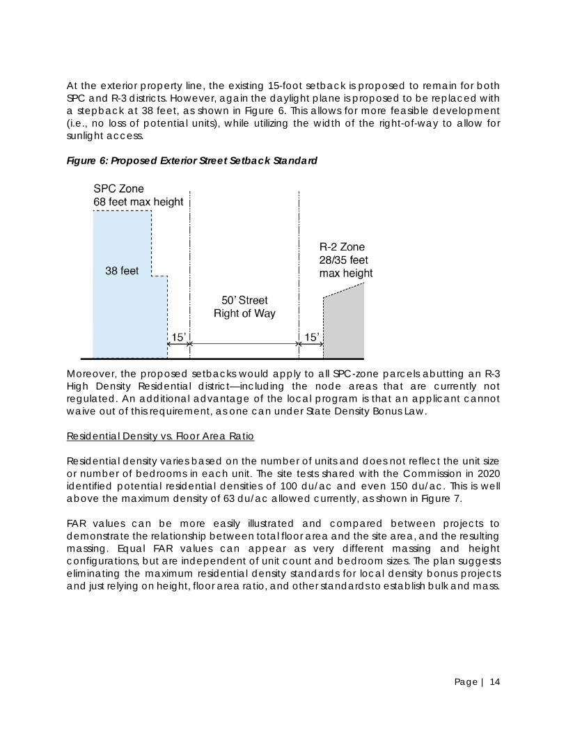
Moreover, the proposed setbacks would apply to all SPC-zone parcels abutting an R-3 High Density Residential district—including the node areas that are currently not regulated. An additional advantage of the local program is that an applicant cannot waive out of this requirement, as one can under State Density Bonus Law. Residential Density vs. Floor Area Ratio Residential density varies based on the number of units and does not reflect the unit size or number of bedrooms in each unit. The site tests shared with the Commission in 2020 identified potential residential densities of 100 du/ac and even 150 du/ac. This is well above the maximum density of 63 du/ac allowed currently, as shown in Figure 7. FAR values can be more easily illustrated and compared between projects to demonstrate the relationship between total floor area and the site area, and the resulting massing. Equal FAR values can appear as very different massing and height configurations, but are independent of unit count and bedroom sizes. The plan suggests eliminating the maximum residential density standards for local density bonus projects and just relying on height, floor area ratio, and other standards to establish bulk and mass.

Page | 15
Policy LU-4: The Local Density Bonus Program would allow modifications to base standards as follows: 1) SPC Height: Allow an additional 30-40 feet (3-4 stories) in building height in the SPC
district, increasing potential heights from 38 feet (3 stories) to 68 feet/6 stories to 85 feet/7-8 stories on SPC-zoned through-lots and in the northern node at Brighton Avenue/the City border.
2) SPC FAR: Allow additional floor area ratio (FAR) in the SPC zone, increasing density from 2.25 FAR for residential mixed-use development to 3.5. Allow up to 4.5 FAR on SPC-zoned through-lots and in the northern node at Brighton Avenue/the City border.
3) R-3 High Density Residential Height & FAR (Through-Lots): Provide an incentive for lot consolidation for contiguously-owned through-lots (i.e., that extend from San Pablo Avenue to Kains Avenue or Adams Street):
a) Allow an additional 15 feet in building height in the R-3 district component of the project, increasing potential heights from 35 feet (3 stories) to 50 feet/4-5 stories.
b) Allow an increase in density from 1.5 FAR to 2.0 in the R-3 district.
4) Residential Density (Minimum Only): Eliminate maximum residential density requirements in the SPC and R-3 zones, but maintain minimum densities for new construction of 30 du/ac and 20 du/ac, respectively (ADUs may count toward calculating residential densities). For the purposes of determining residential capacity yield for the Housing Element or other regulatory requirements, the City may use a combination of FAR and average unit size (based on unit sizes in recent projects in Albany and neighboring cities), or similar proxy.
5) Setback as Height Transition: Eliminate the daylight plane requirements in the SPC and R-3 High Density Residential zones. To provide transitions to residential districts, establish a height transition requirement based on setbacks and height:
a) On SPC-zoned sites abutting R-3 High Density Residential zones or other residential zones:
i) At the rear yard, require a rear yard minimum of 10 feet. Above the third story and no greater than 38 feet above grade (i.e., similar to maximum height in the R-3 district), require a minimum 20-foot stepback from the property line.
ii) At the side yard (or rear yard if building fronts on side street perpendicular to San Pablo Avenue), require an interior side yard minimum of 5 feet.
b) On SPC-zoned across the street from R-3, R-2, or other residential zones, continue to require a 15-foot setback. Replace the front yard daylight plane with a minimum 20-foot stepback from the property line, above 38 feet in height.
6) Usable Open Space: Allow reductions in the usable open space requirement in the SPC and R-3 zones to improve development viability, match the provision of open space to the needs of residents:
Page | 16
Figure 7: Site Test Example (SPC Zone)
Bicycle & Vehicle Parking As discussed with the Commission in July 2020, reduced parking requirements can improve site planning, site circulation, and access, and reduce potential development costs. However, the site tests also demonstrate that reducing parking below the current 1 space per unit requirement does not necessarily increase unit yield, especially if bike parking requirements are increased. This is generally because we assume that stackers can be used for efficient parking configuration. Instead, draft policies in LU-5 and LU-6 propose ways to expand flexibility in the how parking can be configured and based on the needs of the target market of a given development over time. This includes requirements for rideshare (Uber/Lyft) and delivery pick-up/drop-off, opportunities to reduce parking requirements in exchange for bicycle parking, the provision of transit passes, or other means, and conversions post-occupancy if demand changes.
a) Reduce requirement from 200 square feet per unit to 100 square feet per unit, whether provided as private open space or common open space.
b) Reduce the common open space dimension (on any side) from 50 feet to 30 feet.
c) Allow on-site publicly-accessible open space to satisfy up to 50% of the open space requirement, except within the Solano Avenue node, where it may satisfy up to 100%.
7) Additional Modifications: The Planning & Zoning Commission may approve additional modifications to the development standards described above, and any other development standards and parking requirements with the making of findings (TBD).

Page | 17
Policy LU-5: Within the San Pablo Avenue Specific Plan planning area, revise vehicular parking and loading standards to allow flexibility in parking configuration and respond to changes in parking demand over time: 1) Residential Parking Reductions: Allow for reduction in required residential vehicle
parking spaces:
a) Bike Parking (Required + Any Additional). AMC 20.28.030.C.3 (footnote 1) states that for every ten (10) bicycle spaces provided on site, the Planning and Zoning Commission may waive one (1) required off-street parking space. Bicycle spaces adjacent and accessible to electric outlets to accommodate electric bicycles count as two (2) spaces for the purposes of this reduction. Allow this exchange and reduction by up to 20%, by right (i.e., Commission approval is not required).
b) Transit Passes. Reduce parking requirement by 20%, by right, if monthly Clipper Card/AC Transit EZ Pass is provided (1 per unit) for the life of the project.
c) Other (Discretionary Approval). Additionally, applicants would continue to have options to reduce parking through AMC 20.28.030.A.4: The Planning and Zoning Commission may by Conditional Use Permit, reduce the residential parking requirement through consideration of on-site car-share service, unbundled parking, private bicycle share program, a Transportation Demand Management Plan (TDM) or a combination thereof.
d) These reductions are cumulative, but shall not exceed 50% reduction without Planning & Zoning Commission approval.
2) Unbundling: Require unbundled parking for rental housing.
3) Loading: Requiring adequate loading spaces for rideshare (Lyft/Uber) and delivery services.
4) Parking Stackers: Mechanical lifts may be used to satisfy a portion of the required residential parking and commercial parking, for regular use by employees. Lifts shall not be permitted for customer parking. Lift design must allow for removal of any single vehicle without necessitating the temporary removal of any other vehicle.
5) Conversion of Unneeded Parking: Parking spaces may be allowed to convert to housing, shared amenity space, personal storage, or other uses in the future if they are no longer needed. This modification shall be based on a post-occupancy study following review and approval by the Planning & Zoning Commission.

Page | 18
Policy LU-6: Within the San Pablo Avenue Specific Plan planning area, revise bike parking standards as follows: 1) Long-Tail Bikes: Require at least 10% of the required bike parking spaces
accommodate long-tail bikes (e.g., cargo bikes, bikes with trailers), when at least 20 protected bike parking spaces are required.
2) Electric Bikes: Require at least 10% of spaces to have electrical sockets accessible to the spaces, when at least 20 protected bike parking spaces are required. Each electrical socket must be accessible to horizontal bicycle parking spaces, including a portion of long-tail bikes.
Summary of Local Density Bonus Program The draft local density bonus program provides greater benefits compared to State Law for market rate projects, in terms of density and height, and how the inclusionary requirement may be met, and therefore may be more likely to be used despite the higher inclusionary housing requirement. Figure 8 and Table 2 compare the current (and proposed) SPC base zoning to State Density Bonus Law and the proposed local program. State law generally allows more flexibility and limits the City’s discretion to deny modifications to development standards in the form of waivers. The draft local program generally offers more density and height compared to State law. However, State Law does offer lower parking requirements compared to the local program or existing conditions. Lastly, since the local program allows more units and a slightly higher BMR requirement, it would generate substantially more BMR units compared to State law or existing conditions. Figure 8: Comparison of City, State Density Bonus, and Proposed Local Program

Page | 19
Table 2: Comparison of State and Draft Local Density Bonus Programs
Standard
Existing + Proposed SPC Base Zoning
State Density Bonus (15-20% Inclusionary)
Local Density Bonus (20% Inclusionary)
Building Height Standard 38 feet/3 stories No limit, but likely 48-68
feet/4-6 stories (see 540 SPA proposal at 68 feet)
68 feet/6 stories 85 feet/8 stories in northern node
Abutting R-3 (Daylight Plane)
38/20/12 feet No limit. Could be 48+’ with waiver.
None (see setback changes)
Max. Residential Density
63 du/acre 35% bonus = 85 du/ac 50% bonus = 95 du/ac
None
Floor Area Ratio 2.25 (3.0) No limit. Reduction with waiver.
3.5 (4.5 within northern node)
Setbacks None, except abutting residential zones
None, with waiver. None, except refined when abutting residential zones
Open Space 200 sq. ft. common open space/unit
No limit. Reduction with waiver/concession.
100 sq. ft. of common or private open space
Residential Vehicle Parking
1 space /unit
0.5 spaces/unit (within ½ mile of major transit, i.e., entire planning area)
1 space /unit (by right and discretionary reductions available)
Use Limitations Ground floor commercial required
Could be residential-only with concession request
Ground floor commercial required in nodes; not required if small site, 100% BMR, Housing Element site, or with CUP
Review and Approval Process
Design Review subject to Planning & Zoning Commission review
Design Review subject to P&Z Commission review (however, discretion on waivers is limited); City Council review for Density Bonus component
Design Review subject to Planning & Zoning Commission review; City Council review for Density Bonus component
Prototypical Project, 10,000 sq. ft. site
15 du (3 BMR) 35% bonus: 20 du (3 BMR) 50% bonus: 22 du (3 BMR)
42 du (8 BMR) or fee in-lieu. Assumes 6 stories, avg. 900 sq. ft./unit.

Page | 20
Development Potential The most substantial redevelopment opportunities in the planning area are located within the SPC zoning district, especially on lots where the SPC zone extends through to Kains Avenue or Adams Street, or where ownership extends in a through-lot to these parallel streets, with zoning split between SPC and R-3. These sites tend to be larger and allow for more efficient site planning, circulation, and access. Proposed zoning changes focus within these areas, and at their transition points to residential districts. The Specific Plan estimates development potential that could result from the Plan for several purposes:
1. Community Expectations: Understand the type and amount of development that can be anticipated for the corridor and in which locations.
2. Mobility: Determine effects on the need for transportation-related improvements.
3. Infrastructure: Determine additional demand, capacity and infrastructure needs, including regarding water, wastewater, and stormwater.
4. CEQA: City staff and consultants anticipate that an Addendum to the General Plan EIR will be prepared to comply with the requirements of CEQA.
5. Housing Element: The City may also use this buildout information to support the housing opportunity sites analysis in the Housing Element update.
To estimate potential buildout, City staff and consultants identified opportunity sites through data and fieldwork. Based on the site tests presented to the Planning & Transportation Commission, and feedback on development standards provided by the Commission and community members, the team made assumptions about development standards. The methodology for opportunity sites and assumptions for standards are detailed in Attachment 2. Based on County 2020 land use data, obtained from City staff, consultants:
1) Calculated existing development (dwelling units and non-residential square footage);
2) Subtracted out existing development on opportunity sites that would be demolished to allow for new housing; and
3) Added net new development on opportunity sites, based on the assumptions above; note that numbers below include the Albany Bowl and Kains & Portland development projects
As shown in Table 3, this buildout scenario estimates 1,160 new housing units and 45,000 new square feet of commercial development accommodated over the time horizon of the plan. This would generate approximately 2,680 new residents based on current household size.4 The actual number of units and commercial floor area produced could be more or less depending on property owner interest.
4 Population based on 2.437 persons per household (California Department of Finance Estimates, 2020) and adjusting for a typical 5% vacancy rate.

Page | 21
Table 3: Development Potential for the San Pablo Avenue Specific Plan Area
Type Unit/Sq. Ft. Residential Units Multifamily Apartments/Condos(1) 1,130 Townhomes(1) 30 Subtotal 1,160 Existing Dwelling Units(2) 651 Total 2040 Dwelling Units (Rounded) 1,810 Commercial (sq. ft.) Sq. Ft. New 45,000 Lost due to New Housing 119,000 Net Change -74,000 Existing 482,000 Total 2040 Commercial (Rounded) 408,000
(1) Includes development projects: Albany Bowl apartments (207 units) and Kains & Portland townhomes (9 units). (2) Includes 175 units at Belmont Village that were anticipated as part of the General Plan buildout. NEXT STEPS City staff and consultants will revise the land use framework and policies based on feedback from the Commission and community members. The team will return to the Commission this summer to review additional topics, including urban design/design guidelines and standards, and infrastructure and transportation/traffic. Following these meetings, consultants will prepare the draft Specific Plan. ATTACHMENTS
1. Summary of Comments from Previous Study Sessions 2. Development Potential Methodology

Page | 22
Attachment #1: Summary of Comments from Previous P&Z Study Sessions
May 27, 2020 Planning & Zoning Commission Study Session At its May 27, 2020 meeting, City staff and consultants provided an overview of the project and a summary of key issues. The Planning & Zoning Commission reviewed and discussed topics related to land use, development standards, and market factors. Commissioners expressed the following comments:
1. General support for removing regulatory barriers in order to build higher density housing and mixed-use development at and above 5 stories
2. General support to require height transitions between higher and lower density districts, though not necessarily with a daylight plane standard
3. General support for the idea of creating nodes, with higher densities and heights allowed in some locations
4. Mixed reactions to modifying the current regulation requiring that commercial uses be required on the ground-floor along the entire corridor
5. Some Commissioners were concerned that parking requirements and open space requirements are too high
6. General support for exploring alternate ways to regulate massing (e.g., form-based vs. density standard)
7. General desire to include the street and streetscape in the planning process 8. General support for design guidelines and public spaces to help create a sense
of place Below is a summary of public comments:
1. Many commenters expressed a desire to include bike parking in the plan and future development projects
2. Some commenters were concerned about increasing the height limit and potential impacts on adjacent lower density/height housing, while other commenters supported removing barriers to develop multifamily housing
3. Some commenters were concerned about amending the General Plan to allow taller heights
4. Several commenters wanted to see more affordable housing and were concerned about displacement
5. Several commenters discussed the importance of the street and public spaces. At least one commenter was concerned about safety when crossing San Pablo Avenue; another wanted to see an iconic civic space on the corridor.
July 22, 2020 Planning & Zoning Commission Study Session At its July 22nd, 2020 meeting, the Commission explored the relationships between building height, residential density, floor area ratio, and parking (vehicular and bike), which impact building massing, unit yield, project viability, and livability/desirability. Below is a summary of Commissioner comments:

Page | 23
1. Most Commissioners supported reducing vehicle parking requirements on the corridor, especially in exchange for supporting alternative transportation modes, including motorcycles, bicycles, and transit use.
2. Most Commissioners supported increases in the height limit; at least two Commissioners suggested a height limit of 6 or more stories; one Commissioner recommended a 5-story height limit.
3. Most Commissioners supported using building height as the metric for massing, as opposed to residential density or floor area ratio.
4. At least two Commissioners were concerned about redevelopment taking place too quickly if zoning changes entice the market.
5. Generally, Commissioners supported a simple standard for height transitions, such as an upper story stepback.
6. Commissioners were uncertain about potential changes to the R-3 district and needed more information before determining where zoning changes are appropriate.
7. Mixed reactions about the idea of a local density bonus ordinance; Commissioners wanted more information. Some Commissioners mentioned the importance of finding a balance between incentives and requirements, and how the City benefits from upzoning private property.
8. Several Commissioners were concerned about gaps in retail and vibrancy, if residential or live/work is permitted on the ground floor. At least one Commissioner recommended off-street parking access from side streets to avoid gaps and conflicts.
Below is a summary of public comments:
1. Substantial support for alternative transportation modes, including increasing amount and types of bike parking, improving bike parking access, reducing vehicle parking requirements, and encouraging transit use and other transportation demand management measures.
2. Some support for exploring a local density bonus initiative. 3. At least one commenter was concerned about shadow impacts and effects of
State Density Bonus law on increasing height limits. 4. At least one commenter supported design of the ground floor to support
pedestrian and walk-in customers.
September 23, 2020 Planning & Zoning Commission Study Session At its September 23, 2020 meeting, the Planning & Zoning Commission reviewed and discussed the planning area boundary, land use issues including the tradeoffs between mixed use, retail-only, and residential-only designations and requirements; and the concept of nodes and how they relate to land use, economic development and urban design. This meeting also explored the social and racial equity impacts of this planning effort, consistent with the Planning Department’s recent expansion of what is analyzed in staff reports. Commissioners expressed the following comments:
1. Commissioners supported the proposed plan boundaries.

Page | 24
2. Commissioners prefer ground-floor commercial in all locations of San Pablo Avenue, but especially at nodes, such as Solano Avenue, where there should be smaller tenant sizes to support a more walkable retail area. The plan should consider incentives to encourage larger floor plate commercial uses.
3. Commissioners said that ground-floor residential may be acceptable at certain locations, if well designed (e.g., set back), but is generally less desirable. Commissioners agreed that ground floors should be active regardless of use, which could include stoops or public space that facilitate engagement.
4. Commissioners continue to express a range of preferences for building heights, from 38 feet (existing) to 5 stories, and up to 85 feet at the northern end of the corridor. There was more consensus to have taller heights at nodes, especially at the north end of the corridor.
5. Commissioners support the idea of nodes, but were skeptical since they have been in place for many years without implementation. Solano Avenue and the northern portion of the corridor were identified as primary nodes for retail, public open space, and potentially taller heights. At least a couple Commissioners also support gateway features at the northern and southern plan boundaries.
6. Commissioners supported racial and economic equity and inclusion in the plan. Some Commissioners supported housing development with smaller, efficient units, and/or unit mix requirements on the north end of the corridor, closer to BART, as an equity strategy.
7. Some Commissioners were concerned about upzoning without capturing benefits.
Below is a summary of public comments:
1. Concerns about increases in building height and single-family homes off of the main corridor.
2. A desire for open space, community garden plots, play areas, and green corridors on the creeks.
3. Support for housing at 6-8 stories to facilitate housing development. 4. Support for the direction of the plan effort and the City’s Climate Action Plan
goals. 5. Support for premise of plan, but no proposed implementation. 6. Desire for more retail and apartments; support for lower parking requirements
since not everyone owns a car. 7. Support for intent of plan and need for change since development has not
happened yet. 8. Need sunlight protections for units; does not support height and daylight plane
changes. 9. Support plan changes to enable pedestrian and bicycle use, more outdoor
space, and unbundled parking. 10. Support more retail and live/work on San Pablo Avenue to support more everyday
retail and services, indoor/outdoor retail spaces, in a safe inviting public realm.

Page | 25
March 10, 2021 Planning & Zoning Commission Study Session At its March 10, 2021 meeting, City staff presented the results of the virtual open house which was conducted on the Neighborland platform from November 20, 2020 through January 31, 2021. A total of 443 individuals participated, with 72 users contributing comments or filling out a survey. Of those contributing, 50% live in Albany and 40% live within two blocks of the San Pablo Avenue Corridor. Many people visited the site more than once; the average visit was more than 5 minutes. Participants expressed a range of views: some support keeping San Pablo Avenue the same and mentioned preservation of the character of the community, concerns about increased traffic, and tall buildings blocking views and reducing natural light. People in support of changing San Pablo Avenue mentioned increasing the density of underutilized sites, locating housing near transit, and enhancing the vibrancy of the street. Of those who filled out the survey, 60% supported increasing building heights with most favoring five or six stories. Responses regarding ground-floor uses, retail vs. residential, were mixed. With respect to parking requirements, 32% opposed reducing parking requirements, while the remaining 68% percent supported reduced parking requirements, if coupled with improvements in other modes, such as developers providing incentives for bicycle amenities and transit ridership (e.g., transit passes). In general, participants support requiring spaces for long-tail bikes. Commissioners expressed a range of comments related to the open house and the plan overall. They expressed a desire for periodic plan updates in order to refine policies, by topic. Several Commissioners acknowledged that the City will need to make changes to meet State law, the RHNA requirements, and respond to the housing affordability crisis and equity goals. There is a desire to match housing growth with infrastructure and public realm improvements. Below is a summary of public comments:
1. Support for increased density and a variety of building and unit sizes. 2. Concern that the plan is inconsistent with the General Plan. Desire to see more
analysis of open house results. 3. City needs to provide affordable housing; taller and more dense housing to meet
RHNA requirements. The City should consider parking permits for residents to manage parking.
4. Concerns about the lack of development projects resulting from the State Density Bonus Law and whether planning efforts will result in increased affordability.
5. Strong need for new housing. Density along San Pablo Avenue is logical because of transit availability. Increasing transit ridership will help achieve climate goals.

Page | 26
Attachment #2: Development Potential Methodology
To estimate development potential, City staff and consultants identified opportunity sites through data and fieldwork, and made assumptions about development standards. Opportunity Sites Potential opportunity sites were identified as follows.
• Parcels designated as “vacant” or “parking lots” according to Alameda County 2020 data provided by the City and County.
• Parcels on which assessed building value is less than assessed land value, according to County 2020 data.
• Parcels greater than 10,000 sf (including lot consolidation for contiguously-owned sites)
• Sites identified as housing opportunity sites in the current Housing Element • Sites occupied by single-family homes were excluded as opportunity sites
This exercise resulted in 56 opportunity sites, which total 12.5 acres, as shown in the figure below. The total buildout reported in Table 3 assumes that 65% of the opportunity sites would build out over the plan horizon. Potential Opportunity Sites

Page | 27
Notably, this map is only intended as an illustrative example of which sites could redevelop. Property owners of opportunity sites may or may not be interested in redevelopment now or in the future depending on their tenants’ lease terms and other business interests. Additionally, sites that are not shown on this could redevelop following plan adoption. Development Assumptions The potential development described in the staff report includes the following assumptions and “prototypes” for development. These prototypes correspond to development typologies common in the local East Bay housing market, the height limits discussed with the Planning & Transportation Commission and the community at-large, and the site tests presented to the Commission last year. In general, the higher density product types in the table below (#1,2,3) are attributed to SPC-zoned sites, which include sites that extend from San Pablo Avenue to Kains or Adams. The lower density residential-only product types (#3,4) are applied to the R-3 zoned sites on the side streets. In addition to the assumptions below, the calculation assumes a site efficiency factor of 75%, which addresses setbacks, lot coverage, common areas, corridors, mechanical rooms, etc. The prototypes generally assume a parking ratio of 1 space per unit, provided in a podium and/or in parking stackers. Assumptions and Prototypes #
Protype Applicability Avg. Unit Size Retail (% of Net Ground Floor)
1 6-Story Mixed Use SPC Zone on SPA and through lots 900 sf 20% 2 5-Story Mixed Use SPC Zone on SPA, Solano, and
through lots 1,000 sf 20%
3 4-Story Residential SPC Zone on SPA, and R-3 Zone on Kains, Adams, and side streets
1,100 sf N/A
4 2-3 Story Townhome R-3 Zone on Kains, Adams, and side streets
1,600 sf N/A
These assumptions and opportunity sites methods lead to the development potential described in Table 3 of the report.