PLANNING & ZONING COMMISSION Council Chambers + Virtual ...
28
PLANNING & ZONING COMMISSION A G E N D A PLANNING & ZONING COMMISSION Council Chambers + Virtual Zoom Meeting REGULAR MEETING CITY HALL THURSDAY, September 24 th , 2020 201 S. CORTEZ STREET 9:00 AM PRESCOTT, ARIZONA The following agenda will be considered by the PLANNING & ZONING COMMISSION at its meeting to be held on September 24 th , 2020 , public may attend in person or through the use of a technological device via Zoom teleconferencing. Notice of this meeting is given pursuant to Arizona Revised Statutes, Section 38-431.02. Join Zoom Webinar: https://us02web.zoom.us/j/86309416183 Dial by telephone (if computer audio not available): 1 346 248 7799 or 1 669 900 6833 Webinar ID: 863 0941 6183 I. CALL TO ORDER- Housekeeping- Please keep your phone on mute unless you are speaking in order to minimize background noise. Please identify yourself each time you speak so that we can record your comments in the minutes and properly count motions and votes. II. ATTENDANCE III. REGULAR AGENDA ITEMS 1. Approval of the August 27 th , September 10 th & September 15 th , 2020 meeting minutes. 2. CSP20-003: Comprehensive Sign Plan for Gurley Street Grill; 230 W Gurley St.; Property Owner: PBE LLC, Mike Freet; Applicant: Chris Totton of Boots & Duke Sign Company; APN 113-15-095. IV. STAFF UPDATES V. ADJOURNMENT CERTIFICATION OF POSTING OF NOTICE The undersigned hereby certifies that a copy of the foregoing notice was duly posted at Prescott City Hall and on the City’s website on 9/18/2020 at 4:00 pm in accordance with the statement filed with the City Clerk’s Office. ____________________________________ Sarah Siep, City Clerk MEMBERS Don Michelman, Chair Greg Lazzell Ted Gambogi, Vice Chair George Lee Stan Goligoski Butch Tracey Thomas Hutchison Sarah M. Siep
Transcript of PLANNING & ZONING COMMISSION Council Chambers + Virtual ...
PLANNING & ZONINGCOMMISSION A G E N D A
PLANNING & ZONING COMMISSION Council Chambers + Virtual Zoom MeetingREGULAR MEETING CITY HALLTHURSDAY, September 24th, 2020 201 S. CORTEZ STREET9:00 AM PRESCOTT, ARIZONA
The following agenda will be considered by the PLANNING & ZONING COMMISSION at itsmeeting to be held on September 24th, 2020 , public may attend in person or through the use ofa technological device via Zoom teleconferencing. Notice of this meeting is given pursuant toArizona Revised Statutes, Section 38-431.02.
Join Zoom Webinar: https://us02web.zoom.us/j/86309416183
Dial by telephone (if computer audio not available):
1 346 248 7799 or1 669 900 6833
Webinar ID: 863 0941 6183
I. CALL TO ORDER- Housekeeping- Please keep your phone on mute unless you arespeaking in order to minimize background noise.
Please identify yourself each time you speak so that we can record your comments inthe minutes and properly count motions and votes.
II. ATTENDANCE
III. REGULAR AGENDA ITEMS
1. Approval of the August 27th, September 10th & September 15th, 2020 meeting minutes.
2. CSP20-003: Comprehensive Sign Plan for Gurley Street Grill; 230 W Gurley St.;Property Owner: PBE LLC, Mike Freet; Applicant: Chris Totton of Boots & Duke SignCompany; APN 113-15-095.
IV. STAFF UPDATES
V. ADJOURNMENT
CERTIFICATION OF POSTING OF NOTICEThe undersigned hereby certifies that a copy of the foregoing notice was duly posted at Prescott City Hall and on theCity’s website on 9/18/2020 at 4:00 pm in accordance with the statement filed with the City Clerk’s Office.
____________________________________Sarah Siep, City Clerk
MEMBERSDon Michelman, Chair Greg LazzellTed Gambogi, Vice Chair George LeeStan Goligoski Butch TraceyThomas Hutchison
Sarah M. Siep

THE CITY OF PRESCOTT ENDEAVORS TO MAKE ALL PUBLIC MEETINGS ACCESSIBLE TO PERSONS WITH DISABILITIES.With 72 hours advanced notice, special assistance can be provided for sight and/or hearing-impaired persons at this meeting.Reasonable accommodations will be made upon request for persons with disabilities or non-English speaking residents.Please call the City Clerk (928) 777-1272 to request an accommodation to participate in this public meeting. Prescott TDDnumber is (928) 445-6811. Additionally, free public relay service is available from Arizona Relay Service at 1-800-367-8939 andmore information at www.azrelay.org.
Planning & Zoning Commission Page 1 of 5 Minutes – August 27, 2020
PLANNING & ZONING COMMISSION MINUTES August 27, 2020
PRESCOTT, ARIZONA
• MINUTES of the PRESCOTT PLANNING & ZONING COMMISSION MEETING held on August 27th, 2020 at 9:00 AM in Council Chambers and via ZOOM teleconferencing.
I. CALL TO ORDER
Chair Don Michelman called the meeting to order at 9:00 a.m.
II. ATTENDANCE
III.
REGULAR AGENDA ITEM
1. Approval of the August 13th, 2020 Meeting Minutes.
A motion was made by Commissioner Gambogi to approve the August 13th, 2020 minutes. The motion was seconded by Commissioner Lazzell and approved unanimously (7-0).
2. AED South Annexation (ANX18-005), Master Plan (MPA18-003) and Rezoning (PLN18-019) for properties generally located east of SR 89, south and west of Granite Dells Estates and northeast of Watson Lake. Parcels include: 103-01-031N, 103-04-002D, 103-04-003A, 103-04-003Q, 103-04-004A, 103-04-004C, 103-04-010B, 103-04-011, 106-01-001, 106-001A, 106-10-001, 106-10-001A. Community Development Director Bryn Stotler presented an overview of the meeting agenda, explaining that the primary focus of this meeting will be the south annexation and that we will need to carry over to the September 10th meeting in order to review all items. There will be no actions taken at this meeting. Ms. Stotler also reviewed Arizona Revised Statutes regarding annexations, as well as Proposition 400, which applies to annexations of 250 acres or greater.
Planning Manager George Worley presented an aerial map of both the north and south annexation areas with references to waterways and washes, traffic access points, the Prescott Regional Airport and the Granite Dells. He also explained that the two annexations do not touch one another and, therefore, must be processed and reviewed as separate projects per Arizona statutes.
Mr. Worley explained that the current, county zonings of the parcels contained in AED South are RCU 2-A (residential 2-acre), R1L-35 (residential 35,000 sq ft lots) and R1L-18 (residential 18,000 sq ft lots). The city is recommending equivalent zonings of RE-2 (rural estate 2 acre), SF-35 (single family 35,000 sq ft lots) and SF-18 (single family 18,000 sq ft lots). A roadway access point map was presented which depicts two primary access points to AED South; through the existing Granite
COMMISSIONERS STAFF MEMBERS Don Michelman, Chair Bryn Stotler, Community Dev. Director Ted Gambogi, Vice Chair George Worley, Planning Manager Stan Goligoski Tammy DeWitt, Community Planner Thomas Hutchison Kaylee Nunez, Recording Secretary Gregory Lazzell Jon Paladini, City Attorney George Lee Butch Tracey COUNCIL Councilman Steve Sischka, Liaison
Councilmember Cathey Rusing Mayor Pro Tem Billie Orr

Planning & Zoning Commission Page 2 of 5 Minutes – August 27, 2020
Dells Parkway interchange and a future crossing to be constructed over Granite Creek to the west. Mr. Worley presented a map of the General Plan Uses designated for the area which are: commercial/employment, low-medium density residential and very low density residential. He compared the city’s General Plan map to the proposed Master Plan map, which exhibit substantial conformance with one another. A proposed zoning map was also presented, which depicts a mix of residential and commercial uses (MF-H, SF-6, SPC and NOS DISTRICTS). Commissioner Lee asked for clarification on the dark green area of the zoning map. Mr. Worley explained that it is private open space and consists mostly of wash areas from Granite Creek.
City of Prescott Parks and Recreation Director Joe Baynes presented drone footage of the AED South project. The footage highlighted key points of reference such as No Name Creek, the Peavine & Iron King trails, Point of Rocks and Highway 89 as well as the proposed developments in relationship to these areas. Commissioner Hutchison asked whether there are any ‘sacred’ grounds to be cognizant of. Mr. Baynes answered that the [annexation] area does contain Native American ruins as well as area significant to local ranching and railroad history. Commissioner Lazzell asked for clarification on the elevation of the Peavine trail, Mr. Baynes answered that it is elevated approximately 40 feet from the surrounding grade at its highest point. Commissioner Lee asked for confirmation that the crossing would not be at-grade; Mr. Baynes clarified that over or under is desired but that the LOI also includes the option of ‘at grade’. Mr. Baynes also emphasized the importance of the wildlife corridors and riparian areas, which would be preserved in the proposed open space. The future housing developments are proposed on parcels F, G & H, to the northwest of Point of Rocks.
Commissioner Hutchison asked whether the current access road would be sufficient in order handle all residential and commercial traffic. Mr. Baynes answered that the city engineering staff would review those concerns and any new roadways will meet the city’s road standards. Commissioner Tracey asked whether the ponds depicted in the drone footage were natural or stock ponds; also whether the city could access them for maintenance. Mr. Baynes confirmed that they are all stock tanks and that it’s likely maintenance will have to occur in the near future so that the tanks can be functional for wildlife.
Planning Manager George Worley presented the proposed zoning map again and explained the topography of the proposed zoning districts in relationship to one another. The resort will be at a higher elevation than both the open space and residential zoning areas. He also explained that the northern portion of the South annexation area is flat, which makes it suitable for residential. Mr. Worley also presented the Airport Specific Area Plan (ASAP), which recommends uses based on aviation traffic and safety data gathered. The proposed zoning districts for AED South are compatible with the ASAP.
Airport Director Dr. Robin Sobotta shared further details of the ASAP as well as various FAA guidance. The ASAP’s purpose is to aid ‘in making decisions regarding future uses & development of the properties in the vicinity of the airport, Planning & Zoning Commission and the City Council shall take into consideration the [ASAP] recommendations.’ Dr. Sobotta also presented an Airport Impact Zone and noise contour map. Certain impact zones require noise attenuation techniques in the construction of habitable buildings (Zone 6); others prohibit new residential development outright (zones 1-5, except for student dorms in zone 3). Dr. Sobotta also presented an Airport Influence Area (AIA) avigation easement map as well as a flight track density map which highlighted that PRC is the 45th busiest airport in the United States with 232,000 aircraft ops recorded in 2019.
Dr. Sobotta also presented an analysis of AED North annexation performed by Airport staff. She emphasized what benefits the extension of the runway will bring. She also explained what studies would need to be performed (FAA & Air Carrier). Staff recommends that the ASAP be amended to adjust residential densities to very-low and low-medium (instead of high/high medium) and to rezone the airport approach from commercial to industrial. Dr. Sobotta presented analysis of AED
Planning & Zoning Commission Page 3 of 5 Minutes – August 27, 2020
South, which will also require FAA and Air Carrier studies, as well as interior residential soundproofing in certain zones. She also requested an amendment to the ASAP to adjust land use in commercial areas to another [lower] density use district proposed by AED.
Planning Manager George Worley reiterated that staff requests that no actions (votes) be taken today so that the Commission incorporates all actions in one meeting on September 10th or a later meeting at the Commission’s discretion This will begin the 60 day comment period as required by Proposition 400 for both projects at the same time, rather than staggering the start dates of the 60 day comment period. A fifteen minute intermission was taken, the meeting re-convened at 10:31 am.
Dr. Tom Rusing, Prescott resident and member of Save the Dells gave a PowerPoint presentation. The presentation covered the request of conservation buffers to prevent negative transition effects (between natural and undeveloped land). Elements requested in the buffers include: attractive fencing, sufficient access points through the fencing, and multi-level, native vegetation. The presentation also addressed the road leading to and crossing Peavine trail, requesting specific locations and the removal of an at-grade crossing. Dr. Rusing also gave visual examples from other jurisdictions, including St. George Utah, which depicted a development using sufficient visual buffers. After the presentation, Chair Michelman asked whether either of the AED North & South annexations would create ‘county islands’. Mr. Worley clarified that they would not, and that doing so is prohibited by state law.
Walt Anderson, local resident and member of Save the Dells gave a PowerPoint presentation including a map requesting slight deviations of open space boundaries. The presentation included a map that depicted deviations AED made to the open space boundaries that were proposed by Save The Dells including: adding two parcels west of Granite Creek, extending the ‘rocky thumb’ boundary to the north and the displacement of the H parcel boundary to the south. He requested an adjustment of the open space boundary in the southwest portion of H parcel to the north to protect views and archaeological ruins. Mr. Anderson also discussed the creation of a potential visitor center near the archaeological site along with parking and access point(s) for such. Mr. Anderson also proposed a buffer next to Granite Creek on parcel G to protect the riparian area.
Paula Burr, resident of Prescott Valley and member of Save the Dells, provided additional slides for the Commissioners’ review. She explained that Save the Dells largely agrees with the City in their proposed multi-family zoning districts for AED south. However, there is a concern that multi-family development might be too close to the trail, particularly in parcel B. Ms. Burr also wanted confirmation that the 850 units of residential would be strictly adhered to, with each unit counting as one (i.e. a duplex would constitute (2) living units, not (1)). Ms. Burr also expressed concern with the resort parcels K & L, that they could be developed into residential housing if they are not zoned as NOS until such time as AED presents an actual plan for the resort. She said Save the Dells would like a guarantee that this area be either a low-impact resort or open space. City Attorney Jon Paladini clarified that the city is not allowed to adopt zoning with ‘conditions’ to limit uses. All uses allowable in a specific zoning district are assumed upon establishment [of the zoning district]. Mr. Paladini also explained that a development agreement is the only way to contract uses in areas so to speak. He also clarified that the 850 units will indeed be counted separately, not by structures. Mr. Worley also clarified that the SPC designation itself requires a separate master plan review and approval process through both P & Z and Council.
Ralph Hess, member of Save the Dells, commented on the staff recommendation of the SPC zoning for parcels K & L. More specifically, he requested that the Commission and Council welcome and take into account public input in creating the master plan for those parcels. Parker Northrup, Prescott resident and member of the Airport Advisory Committee and Chair of the Flight Department of Embry Riddle Aeronautical University, spoke to the importance of the airport staff recommendations. Mr. Northrup stated that it is critical to follow the ASAP for safety and for noise
Planning & Zoning Commission Page 4 of 5 Minutes – August 27, 2020
mitigation. Cindy Gresser, Prescott resident and the Executive Director of the Museum of Indigenous People (formerly known as the Smoki Museum) expressed specific concern about archaeological ruins found in Parcel H. Ms. Gresser explained that there are pit house, pueblo and human remains findings at the site. She asked the Commission to please consider moving the open space boundaries to encompass preservation of an approximately 10-23 acre portion to preserve these ruins.
Daryl Austermiller, a local resident and the Aircraft Owners and Pilots Association (AOPA) representative for Prescott, President of Prescott Airport Users Association and member of the Airport Advisory Committee, spoke to his and his members’ concerns. Mr. Austermiller spoke specifically about the noise impact for the proposed residential units in proximity to the airport. Mr. Austermiller clarified that there should be specific provisions in buyers contracts to provide recognition of the noise impacts. Recording Secretary Kaylee Nunez read a letter from North Aire Aviation President Jason Kopcsak who expressed concern that the community misconceptions of the airport will only increase with additional residential development nearby. Mr. Kopcsak also stressed the importance of adhering to the ASAP and that the City must be aware of the consequences of major changes to airport operations, which could pose safety risks.
Prescott resident Barbara Jacobsen asked for clarification on the north side connectivity to AED South, whether there will be additional roads built. Ms. Jacobsen also expressed concern about the possibility of an ‘at grade’ crossing of the Peavine to the resort and asked for clarification on location and features of the proposed park. Prescott resident Charles Betts asked about the water issue for all the proposed development. Chair Michelman explained that water allocation is not within the purview of the Planning & Zoning Commission. Mr. Worley further clarified that water resources are discussed and vetted through a thorough, separate process which is ultimately approved by the City Council. Commissioner Hutchison asked for clarification as to why the Planning Commission doesn’t address water rights/allocations. City Attorney Jon Paladini clarified that the Planning Commission is an advisory authority on land use only, whose purpose is to make recommendations on land use decisions to the City Council. He also explained that this is a multi-step process and that the Commission will have input on the subdivision plats which address more details (streets, utilities, traffic, lighting, common area tracts/buffers, etc). Paula Burr of Save the Dells reiterated the need to protect parcels K & L, as development agreements can expire. She stated they need to be assigned zoning that will not have unintended consequences.
Jason Gisi (923 E Gurley, Suite 203), CEO of Arizona Eco Development, commended City staff on the compilation and presentation of accurate data on the proposed development. Mr. Gisi clarified that the proposed crossing site in the drone footage is no longer the location that AED proposes, as it would require excavating into the natural open space area. They are currently working on finding a more appropriate crossing point. Mr. Gisi also expressed his strong support for the economic development of the community and the tremendous financial investment required to get this project to just the preliminary stage. Commissioner Goligoski addressed the concerns about Parcel H brought forward by the community (due to archaeological ruins found in this area); specifically whether Mr. Gisi would make any provisions to accommodate preservation of the ruins.
Mr. Gisi explained that he would like to create a ‘lake’ in the proposed park area (near the old, 89A bridge). He also explained he would like to put a parking lot in that area for the visitor’s area. Mr. Gisi explained he is not certain whether the visitors’ area will be constructed on city property or his property. He feels satisfied with the acreage already donated to the city per the Letter of Intent (LOI). Mr. Gisi further addressed the archaeological ruins, citing that they are quite common in Arizona. He said that an archaeological study will be required and that the findings of the study will dictate how they handle the ruins. He expressed his intent to strictly adhere to federal, state, and local codes/laws on his handling of this archaeological site and any others found on his land.
Planning & Zoning Commission Page 5 of 5 Minutes – August 27, 2020
3. AED North Annexation (ANX18-004), Master Plan (MPA18-002) and Rezoning (PLN18-018) for
properties generally located east of Prescott Regional Airport and north of SR 89A. Parcels: 103-01-031M, 103-01-028D, 103-01-015, 103-01-021G, 103-01-014
*These items will be addressed at the next Planning & Zoning Commission meeting on September 10th, 2020*
IV. SUMMARY OF CURRENT OR RECENT EVENTS Community Development Director Bryn Stotler advised the public that we will continue to gather commentary to deliver to Commissioners prior to the next meeting.
V. ADJOURNMENT Chair Michelman adjourned the meeting at 11:44 am Kaylee Nunez, Recording Secretary
Don Michelman, Chair
Planning & Zoning Commission Page 1 of 6 Minutes – September 10, 2020
PLANNING & ZONING COMMISSION MINUTES September 10, 2020
PRESCOTT, ARIZONA • MINUTES of the PRESCOTT PLANNING & ZONING COMMISSION MEETING held on September 10th,
2020 at 9:00 AM in Council Chambers and via ZOOM teleconferencing. I. CALL TO ORDER Chair Don Michelman called the meeting to order at 9:00 a.m.
II. ATTENDANCE
III. REGULAR AGENDA ITEMS
1. Approval of the August 27th, 2020 Meeting Minutes.
Item tabled due to corrections requested.
2. CSP20-002: Comprehensive Sign Plan for Founding Fathers Collective; 200 N Granite St.; Property Owner: Founding Fathers Properties LLC; APN 113-15-012B and 113-15-006.
Commissioner Lazzell recused himself from discussion and voting on this item as he is the General Contractor.
Community Planner Tammy Dewitt presented aerial photos of the site as well as a floor plan of the existing building and sign renderings. All signage will be painted on the building: the side facing granite street has 484.5 sq ft of signage proposed, the side facing the creek has 956 sq ft proposed and the side facing the parking lot has 26 sq ft proposed for a total of 1,476.5 sq ft. Chair Michelman pointed out that the creek side signage would not be visible approximately half the year due to foliage and asked the applicant to speak to this.
Applicant Grant Quezada explained that the building itself is 14,000 sq ft, with the back porch being 1,500 sq ft. The walking path is across the creek (to the west) and they are trying to catch the attention of pedestrians walking along it. Commissioner Gambogi asked how far the building front was from the trail, Mr. Quezada answered approximately 25 yards.
A motion was made by Commissioner Goligoski to approve CSP20-002. The motion was seconded by Commissioner Lee and passed (6-0). *Commissioner Lazzell recused himself from voting.*
COMMISSIONERS STAFF MEMBERS Don Michelman, Chair Bryn Stotler, Community Dev. Director Ted Gambogi, Vice Chair George Worley, Planning Manager Stan Goligoski Tammy DeWitt, Community Planner Thomas Hutchison Kaylee Nunez, Recording Secretary Gregory Lazzell Jon Paladini, City Attorney George Lee Matt Podracky, Assistant City Attorney Butch Tracey Dr. Robin Sobotta, Airport Director Craig Dotseth, Public Works Director COUNCIL Councilman Steve Sischka, Liaison
Councilmember Cathey Rusing Councilman Phil Goode Mayor Pro Tem Billie Orr
Planning & Zoning Commission Page 2 of 6 Minutes – September 10, 2020
3. AED South Annexation (ANX18-005), Master Plan (MPA18-003) and Rezoning (PLN18-019) for
properties generally located east of SR 89, south and west of Granite Dells Estates and northeast of Watson Lake. Parcels include: 103-01-031N, 103-04-002D, 103-04-003A, 103-04-003Q, 103-04-004A, 103-04-004C, 103-04-010B, 103-04-011, 106-01-001, 106-001A, 106-10-001, 106-10-001A.
Planning Manager George Worley stated that City has had many questions about the Development Agreement (DA) and the Letter of Intent (LOI), which are not in the P& Z Commissions’ purview but are pertinent to the overall discussion. City Attorney Jon Paladini then gave a presentation regarding the LOI and the evolution of the DA, which is currently being drafted and exchanged by the parties. Mr. Paladini explained that the LOI is a non-binding agreement and an expression of the basic terms and conditions to be incorporated into the Development Agreement (DA). The City and AED will follow state law, City Charter, and city code requirements for the north and south annexations and developments. He further stated the LOI sets up the framework for the DA but is not an equivalent to it. Commissioner Hutchison asked for clarification on the first two paragraphs of the LOI discussing the pre-annexation agreement; noting he feels we are discussing the annexation at this point (as opposed to the pre-annexation). Mr. Paladini clarified that we are not voting on the annexation itself today, we are making a recommendation (pre-annexation) to the Council who will vote on the actual annexation. Mr. Paladini also clarified that the Pre-Annexation Development Agreement is not part of the Master Plan and will be considered by Council prior to the annexation vote by Council.
Mr. Paladini presented the AED North & South maps included with the LOI and commented that they have been refined further. The land conveyance is as follows: +/- 475 acres of Natural Open Space (NOS) at no cost to the City from the South project and +/-270 acres of NOS at no cost to the City from the North project. Chair Michelman asked for clarification on the +/- descriptor. Mr. Paladini explained that the +/- accounts for minimal variances that may occur when the parcels are formally surveyed. The LOI also specifies that the City will purchase +/- 131 acres from the North project for airport use and that the purchase amount will be determined by a qualified appraiser. Mr. Paladini presented the Water Use Conditions laid out in the LOI. Mr. Paladini clarified that 375 acre feet of surface water will be conveyed to the City annually from AED’s existing surface water rights, whereas the 753 acre feet of ground water will be ‘credited’ to AED from the city over a longer period of time.. Mr. Paladini also clarified that water users in Section 33 of the North project, which is outside city limits and NOT a part of the current applications, will pay an additional 30% surcharge for water service. Commissioner Hutchison asked for clarification regarding Prop 400 requirements on effluent [wastewater]. Mr. Paladini explained that the provisions of Prop 400 require that annexations over 250 acres in size must return all effluent for permanent recharge to the aquifer.
Mr. Paladini stated that the crossing extending Phippen Trail over Granite Creek (to connect to Dells Ranch Rd), will be paid for by development impact fees from the City. He also explained that the City will attempt to acquire the old (89A) bridge from Yavapai County for pedestrian purposes. One to two ‘through the fence’ access agreements for aviation uses-related business will also be provided on the North project. Mr. Paladini also reviewed the LOI terms for the proposed resort on parcels K & L in the South annexation area. The terms include an agreement regarding transaction privilege tax and bed tax amounts, the traffic crossing at the Peavine Trail, and the expected resort character, which will be designed to blend in with the environment.
Planning Manager George Worley reviewed Arizona Revised Statutes concerning the Commission’s scope and duties regarding annexations and associated applications, as well as which items fall outside of the Commission’s purview. Commissioner Hutchison asked for clarification on the intent of Prop 400; Mr. Worley answered that its function is to provide additional public review and comment on large annexations (250+ acres). Mr. Worley further recapped the Prescott City Charter and Prop 400 requirements for the Commission’s benefit. AED South information from the prior meeting was presented, including aerial photos, the zoning equivalents table and the Master Plan (MP) map. Mr. Worley stated that the MP map is intended to guide development, and that more specific details will be addressed in the DA and through the
Planning & Zoning Commission Page 3 of 6 Minutes – September 10, 2020
review of future subdivision plats. The AED South zoning map was also presented, which showed more details regarding the proposed development density of all the labeled areas.
Mr. Worley brought up a list of commonly asked questions and concerns received from the public since the last Commission meeting on August 27th. The list contained the following items:
- Location and type of the crossing of the Peavine Trail to the resort site. - Trail buffering (from adjoining residential development). - The Special Planned Community (SPC) zoning designation of the resort site. - Noise mitigation in home construction in over flight areas. - Number of homes proposed in the area around the airport. - How multifamily density is calculated. - The archaeological sites and how they will be addressed
Mr. Worley provided additional explanation for each item. Commissioner Lee asked about the first item, specifically whether the City would be covering the cost of the Peavine Trail crossing. City Attorney Jon Paladini answered that is unlikely that the City would have to cover the costs of the crossing. Mr. Paladini also clarified the level of detail that will be provided in the SPC (versus the Master Plan), which will be considerably greater. Mr. Worley briefly discussed noise mitigation techniques required in over flight areas, which are part of the Airport Specific Area Plan (ASAP) adopted by the City in 2001. The very north side of the North annexation and the very west side of the North annexation will be subject to ASAP guidelines. Mr. Worley addressed a public comment made at the August 27th meeting suggesting that the north Prescott area would see growth in the 50,000 homes range, clarifying that across ALL approved and proposed master plans currently being considered, number of homes proposed is estimated at a maximum of 12,000-13,000 homes, adjacent subdivisions included. He also reiterated that the City counts multi-family units individually, and not by building (i.e. apartments, condos, or duplexes/triplexes will be counted individually).
Mr. Worley presented information on federal, state and local laws with regard to cultural resources (archeological sites) protection to address significant public concern about the archaeological sites located within AED’s annexation areas. He reiterated that all archaeological survey work must be completed by registered and licensed archaeological consultants and that the contents of the survey are restricted per federal and state laws. He noted the AED South annexation area had a comprehensive survey completed back in 2006, which found approximately two dozen sites within it, 35% of which are identified as pre-historic. These pre-historic sites are recommended for avoidance or, if not possible, for data recovery per the survey and report on file. Mr. Worley also explained that the north annexation area is covered in small portions by previous surveys but that a survey for the entire annexation area will be required prior to any plat approval. Commissioner Hutchison asked for clarification on who would be performing the surveys and be held liable for their contents. Mr. Worley explained that the State Historic Preservation Office (SHPO) has the ultimate authority regarding any archaeological survey results.
* A ten minute recess was taken at 10:35 am*
4. AED North Annexation (ANX18-004), Master Plan (MPA18-002) and Rezoning (PLN18-018) for
properties generally located east of Prescott Regional Airport and north of SR 89A. Parcels: 103-01-031M, 103-01-028D, 103-01-015, 103-01-021G, 103-01-014
Planning Manager George Worley presented an aerial map of AED North and explained that it would share the same primary point of access as AED South, using the Granite Dells Parkway Interchange. Mr. Worley presented a photographic tour of the proposed AED North zoning districts which gave current panoramic views of the properties. Current and proposed zoning maps as well as the General Plan Land Use Designations were presented, along with the AED North Master Plan.
Planning & Zoning Commission Page 4 of 6 Minutes – September 10, 2020
Dr. Robin Sobotta, City of Prescott Airport Director, reintroduced an outline of the Airport Specific Area Plan (ASAP) & FAA guidances, the purposes of which are: to limit damage caused by aviation accident(s), to protect the viability of the airport, and to limit the impact of over flight and noise over residential areas. Dr. Sobotta presented an airport impact zone and noise contour map, which models noise impacts over a 24 hour period. She explained that the ASAP does not allow residential development in Zones 1-5, excepting student dorms allowed in Zone 3 by a prior City decision. In Zone 6, habitable buildings are allowed but must be constructed using noise attenuation techniques. Dr. Sobotta presented a map of the Airport Influence Area (AIA), which carries a recommendation to use noise attenuation techniques when constructing habitable buildings inside its boundaries. A flight track density map was presented which depicts areas that have the highest instances of air traffic; she also noted that Prescott Regional Airport is the 45th busiest airport in the United States. Dr. Sobotta made recommendations that the possible school in Section 29 shift east and require 45dB interior sound mitigation.
Dr. Sobotta recommended two amendments to the ASAP for AED North: to adjust Figure 6 to reflect proposed AED land use changes and residential densities in Section 29 and Section 30, and to rezone the airport approach area from Commercial zoning to Industrial/NOS zoning with building height limits. She also reviewed ASAP requirements for AED South as well as recommending one amendment to the ASAP to adjust land use from commercial/employment and commercial/recreation to the AED proposed land uses and density.
Jason Gisi (923 E. Gurley, Suite 203), applicant and CEO of Arizona Eco Development, was questioned by Commissioner Lee regarding the details of the Peavine Trail crossing. Mr. Gisi explained that the LOI specifies an at-grade crossing, yet he believes that a pedestrian overpass will likely be constructed. Commissioner Lee also asked whether Mr. Gisi plans to construct any homes himself in the AED South project. Mr. Gisi explained that AED is going to design and develop the resort first and that the residential development is more uncertain at this time as it will be completely market driven. He noted the resort will drive the development of the other areas in AED South. Mr. Gisi also clarified that AED South is limited to 850 residential units maximum.
Walt Anderson, a local resident and member of Save the Dells, gave a PowerPoint presentation. Mr. Anderson stated that Save the Dells believes a small shift in boundaries of the AED South open space will benefit the City. More specifically, the ‘Rocky Thumb’ to the North and the 11 acres of NOS parcels to the west bisected by Highway 89A. Save the Dells proposes trading these 11 acres of proposed NOS for similar acreage of functional open space by moving the south boundary of H up so that the ruins are protected. Mr. Anderson also specified that the area of the proposed ‘park’ should be protected as a nature preserve and not be made into a traditional park such as Granite Creek Park.
Recording Secretary Kaylee Nunez read a comment by Prescott resident and Airport Advisory Committee member Michael Gjede. Mr. Gjede expressed his concern regarding residential encroachment near the airport. More specifically, by allowing the wrong type of development (residential) too close to the airport, there is potential for large issues for both parties.
Paula Burr, a local resident and Vice Chair of Save the Dells expressed her concern that the 11 acres of NOS in the County proposed in AED South might be excluded from the DA. She also expressed concern about the SPC zoning proposed for parcels K & L, more specifically, what future uses could occur in that area should it not be developed into an eco-resort/hotel. Mr. Paladini clarified that the DA will address the 11 acres of NOS, as well as clarification that the K & L parcels will not be eligible for anything other than the eco-resort/hotel. This eligibility will be secured by contractual details that will be specified in the DA.
Ralph Hess, a Prescott resident and member of Save the Dells, expressed that he believes that the Commission cannot effectively vote on recommendation for zonings on parcels K & L without reviewing the details of the required SPC [sub] master plan. Mr. Hess expressed that the master plan for parcels
Planning & Zoning Commission Page 5 of 6 Minutes – September 10, 2020
K & L should be presented to P & Z Commission for review. Mr. Hess also cited Arizona Revised Statutes requirements on pre-annexations, which does not preclude the review of DAs by P & Z Commission.
Leslie Hoy, a Prescott resident, expressed concern about water allocation. More specifically, how much water the City of Prescott will be getting from AED versus how much AED will be taking from the City. Ms. Hoy requested more data on the projected water use and recharge. She also asked how the City intends to enforce recharge requirements.
Paula Burr followed up on her prior comments regarding the potential amendment and expiration of the Development Agreement, with concern as to what would happen should the eco resort not be established. Planning Manager Worley clarified that a master plan must be approved specifically for the SPC and the controls for use will be specified through that process. He also stated that Parcels K and L would have to effectively go through a re-zoning process should they desire to change the use, because the SPC zoning has no designated allowable uses. Mr. Paladini also clarified that DAs do not expire, that they ‘run with the land’.
Commissioner Hutchison questioned if this meeting was a continuation of the August 27, 2020 meeting. He was advised that it was a separate meeting, and the 8/27 meeting was adjourned on 9/27. Commissioner Hutchison stated that he was invoking his right to postpone the vote on this item. He asserted that the Commission by laws allowed him to do so. (The bylaws provide that an item shall not be voted upon at the initial meeting if there is an objection to a vote by one Commission member). As this was not the initial meeting, Commissioner Hutchison was advised that he could make a motion to table the items. Commissioner Hutchison made a motion to table voting on items until a future meeting. The motion was not seconded and therefore failed.
AED South Motions:
A motion was made by Commissioner Gambogi to approve ANX18-005. The motion was seconded by Commissioner Goligoski and passed (5-2) with Commissioners Hutchison and Lee dissenting.
A motion was made by Commissioner Gambogi to approve MPA18-003. The motion was seconded by Commissioner Lazzell and passed (5-2) with Commissioners Hutchison and Lee dissenting. A motion was made by Commissioner Gambogi to approve PLN18-019. The motion was seconded by Commissioner Goligoski and passed (5-2) with Commissioners Hutchison and Lee dissenting.
AED North Motions:
A motion was made by Commissioner Gambogi to approve ANX18-004. The motion was seconded by Commissioner Goligoski and passed unanimously (7-0). A motion was made by Commissioner Gambogi to approve MPA18-002. The motion was seconded by Commissioner Lazzell and passed (6-1) with Commissioner Hutchison dissenting. A motion was made by Commissioner Gambogi to approve PLN18-018. The motion was seconded by Commissioner Tracey and passed (6-1) with Commissioner Hutchison dissenting. ASAP Amendment recommendation, directing staff to initiate the suggested amendments:
Planning & Zoning Commission Page 6 of 6 Minutes – September 10, 2020
Motion made by Vice Chair Gambogi with consensus of the rest of Commission in concurrence. IV. STAFF UPDATES
None
V. ADJOURNMENT Chair Michelman adjourned the meeting at 12:29 pm. _________________________________ _______________________________ Kaylee Nunez, Recording Secretary Don Michelman, Chair
Planning & Zoning Commission Page 1 of 3 Minutes – September 15, 2020
PLANNING & ZONING COMMISSION MINUTES September 15, 2020
PRESCOTT, ARIZONA
• MINUTES of the PRESCOTT PLANNING & ZONING COMMISSION SPECIAL MEETING held on September 15th, 2020 at 9:00 AM in Council Chambers and via ZOOM teleconferencing.
I. CALL TO ORDER
Chair Don Michelman called the meeting to order at 9:00 a.m.
II. ATTENDANCE
III. REGULAR AGENDA ITEM
1. AED South Annexation (ANX18-005), Master Plan (MPA18-003) and Rezoning (PLN18-019) for properties generally located east of SR 89, south and west of Granite Dells Estates and northeast of Watson Lake. Parcels include: 103-01-031N, 103-04-002D, 103-04-003A, 103-04-003Q, 103-04-004A, 103-04-004C, 103-04-010B, 103-04-011, 106-01-001, 106-001A, 106-10-001, 106-10-001A.
Planning Manager George Worley stated that this meeting is intended to facilitate further discussion between on all voting items for AED South & North. Mr. Worley presented slides comparing the 2018 and 2019 proposed AED South Master Plans. He noted that the public and private open space percentages increased from 31% to 33% between the 2018 & 2019 versions. Mr. Worley then presented the 2020 revision to the AED South Master Plan, in which the public open space increased to 55%. He also presented the 2020 AED North Master Plan which specifies 45% public open space. He also went over the open space requirements per the City Land Development Code, which specifies a minimum of 25% NOS required in a Planned Area Development (PAD).
Dr. Tom Rusing, a Prescott resident, spoke about his concern about the public not having access to the Development Agreement (DA) at this time. Mr. Rusing also spoke to the zoning of parcels K and L in AED South, noting he feels SPC zoning is too flexible and doesn’t commit the developer to an eco-resort. He recommended that it be zoned NOS.
Commissioner Goligoski referenced Dr. Rusing’s prior presentation on buffer zones along trail corridors. Dr. Rusing explained that vegetation is preferable to visually buffer walls, especially along the Peavine Trail. Mr. Goligoski assured that he would pay close attention to the buffer zone details in future plats.
COMMISSIONERS STAFF MEMBERS Don Michelman, Chair Bryn Stotler, Community Dev. Director Ted Gambogi, Vice Chair George Worley, Planning Manager Stan Goligoski Tammy DeWitt, Community Planner Thomas Hutchison Kaylee Nunez, Recording Secretary Gregory Lazzell, Absent Jon Paladini, City Attorney Butch Tracey Matt Podracky, Assistant City Attorney George Lee Joe Baynes, Parks & Recreation Director Dr. Robin Sobotta, Airport Director COUNCIL Councilman Steve Sischka, Liaison
Councilmember Cathey Rusing Councilman Phil Goode
Planning & Zoning Commission Page 2 of 3 Minutes – September 15, 2020
City Attorney Jon Paladini clarified that Council can put a parenthetical denominator in the SPC zoning to specify a hotel and that no other uses can be established prior to a master plan for the SPC area being debated and approved.
Commissioner Lee asked for clarification on the Multifamily zoning of parcels A, B & C of AED South. Mr. Worley answered that the parcels are designated as Multifamily High (MF-H), which represents a high density residential zoning allowing multi-family products. The MF-H would also allow all lesser residential densities. Mr. Worley also clarified that the maximum height in the MF-H district is 40’-0”.
2. AED North Annexation (ANX18-004), Master Plan (MPA18-002) and Rezoning (PLN18-018) for properties generally located east of Prescott Regional Airport and north of SR 89A. Parcels: 103-01-031M, 103-01-028D, 103-01-015, 103-01-021G, 103-01-014.
*There were no specific questions regarding AED North.* Further discussion regarding stipulations for actionable items occurred between Planning Manager George Worley, City Attorney Jon Paladini and Commissioners, specifically for the [Peavine Trail] crossing and the resort designation for parcels K & L [ in AED South].
AED South Motions:
A motion was made by Commissioner Gambogi to approve ANX18-005. The motion was seconded by Commissioner Goligoski. During discussion after the motion and second, Commissioner Hutchison commented that he will be voting no on the AED Annexation as he feels the Master Plan is incomplete. Specifically, that Prop 400 requires more information in the pre-annexation review prior to Council voting. Commissioner Lee commented that his understanding is that many items will be accomplished through the Development Agreement (DA), which will be reviewed by City staff and the City Attorney. Planning Manager Worley explained that contract negotiations (i.e. the DA) are usually not discussed at this point and that Prop 400 mandates are explicit in recommending that the P & Z Commission vote on the Master Plan only. Commissioner Lee asked whether the P & Z Commission will have any input in the DA. City Attorney Paladini responded that the Commissioners have had input via their discussions in the past two meetings and this meeting. Mr. Paladini further explained that the DA is not ready for review, as negotiations with the developer have not been finalized. Mr. Paladini also explained that the ‘building blocks’ of the DA were established in the Letter of Intent (LOI). The motion passed unanimously (6-0).
A motion was made by Commissioner Gambogi to approve MPA18-003 with stipulations that the Peavine Trail crossing be at ‘separated grade’ and an SPC designation of ‘(Hotel)’ be affixed to parcels K & L. The motion was seconded by Commissioner Goligoski. During discussion after the motion and second, Staff and Commissioners discussed the pros and cons of having an under-grade crossing stipulation. Commissioner Lee introduced the stipulation amendment. Commissioner Lee expressed that the location of the crossing should also be a stipulation. Parks & Recreation Director Joe Baynes requested the stipulation be ‘separated grade’ [as opposed to under or over-grade], which provides more flexibility. The motion passed (5-1) with Commissioner Hutchison voting against the motion. Commissioner Hutchison reiterated that he voted no as he feels the Master Plan is insufficient and incomplete.
Planning & Zoning Commission Page 3 of 3 Minutes – September 15, 2020
A motion was made by Commissioner Gambogi to approve PLN18-019. The motion was seconded by Commissioner Lee and passed (5-1), with Commissioner Hutchison voting against the motion. Commissioner Hutchison explained his no vote, noting that he feels the SPC zoning is ‘like a blank check.’
AED North Motions:
A motion was made by Commissioner Gambogi to approve ANX18-004. The motion was seconded by Commissioner Tracey and passed unanimously (6-0). A motion was made by Commissioner Gambogi to approve MPA18-002. The motion was seconded by Commissioner Goligoski and passed (5-1), with Commissioner Hutchison voting against the motion. Commissioner Hutchison explained his dissenting vote, stating that he feels that the Master Plan is incomplete and insufficient. A motion was made by Commissioner Gambogi to approve PLN18-018. The motion was seconded by Commissioner Tracey and passed (5-1), with Commissioner Hutchison voting against the motion. Commissioner Hutchison explained his dissenting vote, stating he is concerned about the close proximity of air traffic in the residential areas.
IV. SUMMARY OF CURRENT OR RECENT EVENTS
None
V. ADJOURNMENT Chair Michelman adjourned the meeting at 9:56 am. _____________________________ _______________________________ Kaylee Nunez, Recording Secretary Don Michelman, Chair
~/~ c rrYoF PRESCOTT
EJJ7bfJ 1-rf)-11' cttJaJ/l , PLANNING & ZONING COMMISSION MEMO
MEETING DATE: September 24, 2020
AGENDA ITEM: CSP20-003, Comprehensive Sign Plan for Gurley Street Grill ; 230 W Gurley St.; Property Owner: PBE LLC, Mike Freet; Applicant: Chris Totton of Boots & Duke Sign Company; APN 113-15-095.
Approved By: Date: Director:
Planning Manager:
Community Planner: Tammy DeWitt
Item Summary
This is a request for a Comprehensive Sign Plan for the Gurley Street Grill Restaurant to add a new blade sign on the corner of the building to be visible from both W. Gurley Street and N. Granite Street. Currently, the building has 54.18 square feet of signage on the front along W. Gurley Street for the restaurant and 183. 7 square feet of signage of legal non-conforming signage for off-premise businesses along N. Granite Street (which does not count towards their allowed signage allowance).
Background
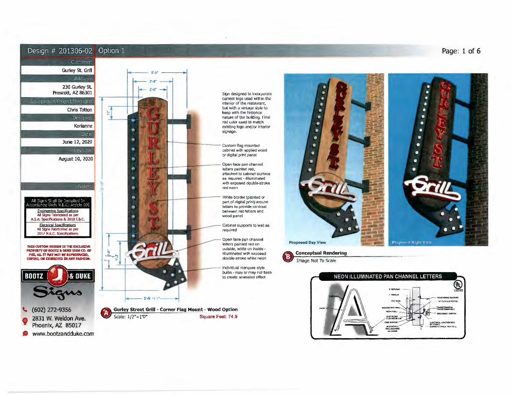
The Gurley Street Grill is the sole occupant in the building with approximately 6,600 square feet. The applicant is requesting an additional 74.9 square foot blade sign on the corner of the building to allow it to be visible from W. Gurley Street and N. Granite Street. Currently, the building has 54.18 square feet of signage on the front along W. Gurley Street for the restaurant. Under the existing sign code allowance, the building would be allowed a total of 100 square feet of signage overall, but the applicant is requesting a total of 129.08 square feet. The existing signage is all painted on the building and the new blade sign will project off the corner of the building with neon and LED lights.
Exterior Sign Placement Locations
The applicant is proposing a 74.9 square foot new blade sign that will project off the corner of the building at the intersection of W. Gurley Street and N. Granite Street. In the request, the applicant has 2 different renderings with different finishes. The Commission can either make a recommendation as to finish or leave it to the owner. This property is not in the historic district and did not have to be reviewed by the Preservation Commission.
AGENDA ITEM: CSP20-003, Comprehensive Sign Plan for Gurley Street Grill ; 230 W Gurley St. ; Property Owner: PBE LLC, Mike Freet; Applicant: Chris Totten of Boots & Duke Sign Company; APN 113-15-095.
Staff Comments and Next Steps
It can be viewed that the request is not unreasonable due to the location of the building and there not being any signage for the restaurant on the N. Granite Street side of the building. After review and recommendation from the Planning and Zoning Commission, this request will be forwarded to City Council for final approval.
Attachments:
1. Aerial vicinity map 2. Comprehensive sign plan
Recommended Action:
MOVE to recommend approval of CSP20-003, Comprehensive Sign Plan for Granite Street Grill.
2
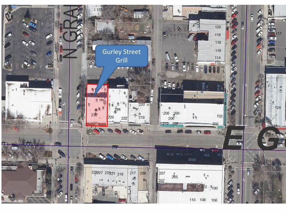
Gurley Street Grill
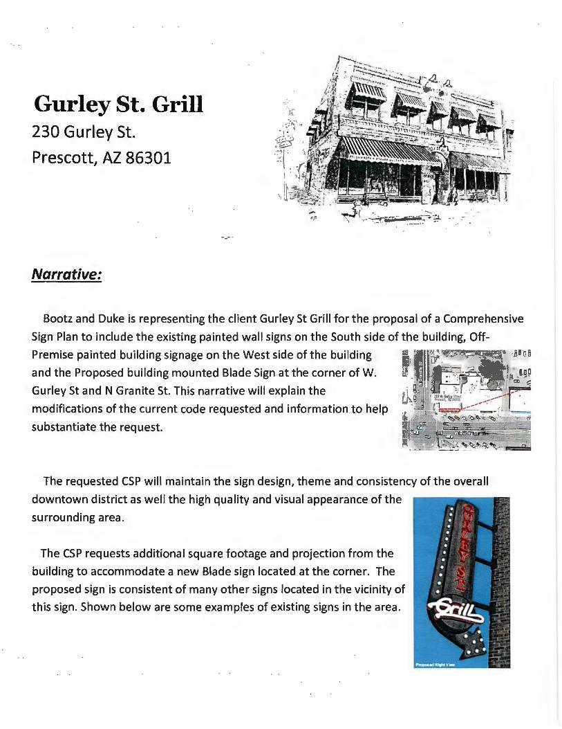
Gurley St. Grill 230 Gurley St.
Prescott, AZ 86301
Narrative:
Bootz and Duke is representing the client Gurley St Grill for the proposal of a Comprehensive
Sign Plan to include the existing painted wall signs on the South side of the building, Off-
Premise painted building signage on the West side of the building
and the Proposed building mounted Blade Sign at the corner of W.
Gurley St and N Granite St. This narrative will explain the
modifications of the current code requested and information to help
substantiate the request.
The requested CSP will maintain the sign design, theme and consistency of the overall
downtown district as well the high quality and visual appearance of the
surrounding area.
The CSP requests additional square footage and projection from the
building to accommodate a new Blade sign located at the corner. The
proposed sign is consistent of many other signs located in the vicinity of
this sign. Shown below are some examples of existing signs in the area.

The proposed sign will be mounted at a 4Sdegree angle from
each elevation on the corner. The sign will also project S'S" from
the wall but per Section 6.12.9.G. of the City of Prescott Land
Development Code, signs projecting from the wall perpendicular
to the building cannot exceed 36 inches. The request is
consistent with similar signs in the downtown district.
Material to be used on the proposed blade sign are all high
grade quality material; aluminum, polyurethane paint, neon and LED bulbs to replicate
incandescent. This sign will be designed and fabricated to replicate the times and theme taking
into consideration of the downtown history.
1. The use will not cause an adverse impact on adjacent property or properties in the
area. Adverse impacts would include, for example: a significant increase in vehicular
or pedestrian traffic in adjacent residential areas; emission of odor, dust, gas, noise,
vibration, smoke, heat, or glare at a level exceeding ambient conditions; contribution

in a measurable way to the deterioration of the area or contribution to the lowering
of property values.
The proposed sign is consistent with other signs in the immediate vicinity and would not
have an adverse impact in the area; in fact the sign would better inform the public of
the business adding better visibility and less confusion locating the property. The sign
will not emit any odor, gas, dust, noise, vibration, heat or glare.
Thank you for taking a moment to read the above narrative and taking into
consideration the request!
Chris Totton
Sales Representative
Bootz and Duke
602.272.9356
August 10, 2020
j Notes:
All Signs Sra ll Be Insta lled I n Accordcl'Ce With l•L E.C. Artic le 60C
Engineerina Specifications Alt Signs Fabricated as per
A.S.A. Specifications & 2018 I.B.C.
Electrical Scecifications All Signs Fablicated as per 2017 N.E.C. Specifications
THIS CUSTOM DESIGN IS THE EXCWSIVE PROPERTY OF BOOTZ &. DUKE SIGN CO. OF
PHX, AL IT MAY NOT BE REPRODUCED, COPIED, OR EXHIBITED IN ANY FASHION.
\. (602) 272-9356 f 2831 W. Weldon Ave.
Phoenix, AZ 85017 e www.bootzandduke.com
3'-9 , , , .
Sign designed to incorporate current logo used within the interior of the restaurant, but with a vintage style to keep with the historical nature of the building. Final red color used to match existing logo and/or interior signage.
fi'l t"----ll!!llf,-'. ____ Custom flag mounted
cabinet with appl ied wood or digital print panel
lLJ__---11~"'"'----- Open face pan channel letters painted red, attached to cabinet siurface as required - illluminated with exposed double-stroke red neon
EJLl---~'f--:------ White border (painted or part of digital print) around letters to provide contrast between red letters and wood panel
Cabinet supports to wall as required
Open face pan channel letters painted red on outside. white on inside -ill luminated with exposed double-stroke white neon
'-_l*A!-'- ---- Individual marquee style bulbs - may or may not flash to create animated effect
Gurley Street Grill - Corner Flag Mount - Wood Option
Scale: 1/2"=1'0" Square Feet: 74.9
Page: 1of6
Proposed Day View
Conceptual Rendering
Image Not To Scale
August 10, 2020
1 Notes:
All Signs Sl1all Be In>: "l ied In Accordance With fJ.E.C. Article 60Cr
Enoineering Specifications All Signs Fabricated as per
A.S.A. Specifications & 2018 I.B.C.
Electrical Speclflcat!oos All Signs Fabricated as per 2017 N.E.C. Specifications
THIS CUSTOM DESIGN IS THE EXO.USM PROPERTY OF BOOTZ • DUKE SIGN CO. OF
PHX, AZ. IT MAY NOT BE REPRODUCED, COPIED, OR EXHIBITED IN ANY FASHION.
\. (602) 272-9356
t 2831 W. Weldon Ave. Phoenix, Al. 85017
8 www.bootzandduke.com
Sign designed to incorporate current logo used within the interior of the restaurant, but with a vintage style to keep with the historical nature of the building. Final red color used to match existing logo and/or interior signage.
~+---ffMr-,.,----- Custom nag mounted
-- 3'-9 1/ 2"---
cabinet with copper face panel
Open face pan channel letters painted red, attached to cabinet siurface as required - illluminated with exposed double-st roke red neon
White border around letters to provide contrast between red letters and wood panel
Cabinet supports to wa ll as required
Open face pan channel letters painted red on outside, white on inside -illluminated with exposed double-st roke white neon
Individual marquee style bulbs - may or may not flash to create animated effect
Gurley Street Grill - Corner Flag Mount - Copper Option
Scale: 1/2"= 1'0" Square Feet: 74.9
Page: 2 of 6

Al l S1grs Sl1all Be I nstalled In Ac,ordance Vl>lh 11.:.c. Article 60:l
Engineerina Soecifications All Signs Fabricated as per
A.S.A. Specifications & 2018 l .B.C.
E!ectrjca! Speciftc.ations All Signs fabricated as per 2017 N.E.C. Specifications
nus CUSTOM DESIGN IS THE EXCLUSIVE PROPERTY OF BOOlZ &. DUKE SIGN CX>. OF
Ptlll, AZ. IT MAY NOT BE REPRODUCED, COPIED, OR EXHIBITED IN ANY FASHION,
\. (602) 272-9356
' 2831 W. Weldon Ave. Phoenix, AZ. 85017
AD www.bootzandduke.com
~ Gurley Street Grill - Comer Flag Mount - Conceptual Rendering
WI Image Not To Scale
• Proposed corner sign, mounted to promote visibility from both Gurley and Granite streets (see page 3 & 4 for sign details)
• Existing gooseneck lights to be painted to match red color in sign -matching lights to be used on west elevation for graphics illumination
• Wall sign letters to be repa inted to match black/charcoal color in sign
Page: 3 of 6
Existing Gurley St. Grill Fascia painted Sign - Top Square Feet: 35.875
Existing Gurley St. Grill Fascia painted Sign - Entrance Square Feet: 18.3
I Notes:
All Signs Shal l Be I nstalled I n Accordan.e Vll l h r' E.C Article 6JC
Enojneerina Specifications AH Signs Fabricated as per
A.S.A. Specifications & 2018 1.6.C.
Electrical Soecifications All Signs Fabricated as per 2017 N.E.C. Specifications
THIS CUSTOM DESIGN IS THE EXQ.USM PROPERTY OF BOOn • DUKE SIGN CO. OF
PHX, AZ. IT MAY NOT BE REPRODUCED, COPIED, OR EXHIBITED IN ANY FASHION.
~ (602) 272-9356
f 2831 W. Weldon Ave. Phoenix, AZ 85017
8 www.bootzandduke.com
Proposed Day View
West Elevation - Conceptual Rendering Scale: Not to Scale 183.7 Sq.Ft.
Page: 4 of 6
Notes:
• Gooseneck lights (to match front) to be used on west elevation for graphics illumination - color to be determined based on decision wether or not to paint existing fixtures on builing front
• Quantity to be determined based on light fixture selection
All Signs Shall Be Jnstalled In Accordance With N.E.C. Article 600
Engineerino Specifications All Signs Fabricated as per
A.S.A. Specifications & 2018 1.8.C.
Electrtcal Soeciftcatlons All Signs Fabricated as per 2017 N.E.C. Specifications
THIS CUSTOM DESIGN IS 111E EXCLUSIVE PROPERTY OF BOOTZ • DUKE SIGN CO, OF
PHX, A7.. IT MAY NOT BE REPRODUCED, COPIED, OR EXHIBITED IN ANY FASHION.
\. (602) 272-9356
~ 2831 W. Weldon Ave. Phoenix, AZ 85017
8 www.bootzandduke.com
Page: Sof 6
o Gurley Street Grill - Corner Flag Mount - Top View Scale: l"~ l 'O" Square Feet: 9
Scale: 1/16"=1'
August 10, 2020
Notes: I
All Signs S0 all Be [nstoilled In Accordan:e Vllth r •. E.C. Article GOO
Engjoeering SOes:jficatjons All Signs Fabricated as per
A.S.A. Specifications & 2018 J.B.C.
Electrical Soecifications All Signs Fabricated as per 2017 N.E.C. Specifications
TlfIS CUSTOM DESIGN IS THE EXO.USIVE PROPERTY OF BOOTZ ti. DUKE SIGN ro. OF
PHX, A1.. IT MAY NOT BE REPRODUCED, COPIED, OR EXHIBITED IN ANY FASHION.
(602) 272-9356
t 2831 W. Weldon Ave. Phoenix, AZ 85017
AD www.bootzandduke.com
Page: 6of 6
52·-0·, Main Business Fi·, · .. :,: 1•
Image Not To Scale
Gurley Street Grill - Project Location