THERMAL INFRARED REMOTE SENSING … INFRARED REMOTE SENSING USING NANO-SATELLITES FOR MULTIPLE...
35
A Mission Idea and Business Model Presented by: ENGR. EDGARDO G. MACATULAD Environmental Systems Applications of Geomatics Engineering (EnviSAGE) Research Laboratory, University of the Philippines 10.10.2012 THERMAL INFRARED REMOTE SENSING USING NANO-SATELLITES FOR MULTIPLE ENVIRONMENTAL APPLICATIONS
Transcript of THERMAL INFRARED REMOTE SENSING … INFRARED REMOTE SENSING USING NANO-SATELLITES FOR MULTIPLE...

A Mission Idea and Business Model
Presented by: ENGR. EDGARDO G. MACATULAD
Environmental Systems Applications of Geomatics Engineering (EnviSAGE) Research Laboratory, University of the Philippines
10.10.2012
THERMAL INFRARED REMOTE SENSING USING NANO-SATELLITES FOR MULTIPLE
ENVIRONMENTAL APPLICATIONS

University of the Philippines Department of Geodetic Engineering and Training Center for Applied Geodesy and
Photogrammetry (UP DGE-TCAGP)
The UP Department of Geodetic Engineering is
the country's leading institution in geospatial
research and instruction, serving the nation
through its undergraduate and graduate
degree programs, and its various training
modules.

Environmental Systems Applications of Geomatics Engineering
(EnviSAGE) Research Laboratory
• Recently created Research Laboratory of the UP DGE-TCAGP
• Focuses on the use of Geomatics for environmental research, including the
interactions between the physical and natural environments and socio-
economic systems.
Head: Dr Ariel C. Blanco
Chairman, UP DGE-TCAGP
Regional Coordinator, MIC
On-going Projects
• JST-JICA Coastal Ecosystem Conservation and
Adaptive Management (CECAM) Project
• Guimaras Project (Assessment of hydrologic
carrying capacity of island watersheds:
Groundwater resource assessment)
• Establishing the 3D Campus GIS of UP Diliman
(UPDGIS-3D) Project

• Edgardo G. Macatulad – Team Leader
Research Field: Disaster Risk Reduction and Mitigation
• Ed Carla Mae A. Tomoling
Research Field: Water Resource Monitoring and
Management
• Mylene J. Villanueva
Research Field: Urban Environmental Conditions
Assessment and Modelling
The EnviSAGE MIC Team
Outline
• Introduction
o TIR RS for the Philippine environmental setting
• Mission Idea and Business Model
• Business Feasibility
o Cost Model
o Projected Financial Estimates
• Risk Analysis
• Conclusion and Recommendation
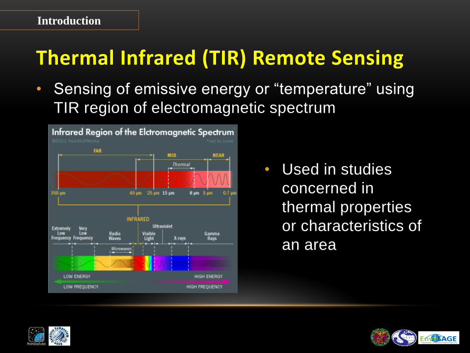
Thermal Infrared (TIR) Remote Sensing
• Sensing of emissive energy or “temperature” using
TIR region of electromagnetic spectrum
Introduction
• Used in studies
concerned in
thermal properties
or characteristics of
an area

TIR RS for the Philippine environmental setting
1. Urban Heat Island Effects/Climatology
2. Temperature Analysis for Weather Predictions
3. Pre-Earthquake Temperature Anomaly Studies for
Earthquake Prediction
4. Identification and Monitoring of Volcanic Activity
5. Water Quality Monitoring for Ecosystem and Resource
Management
Introduction

TIR RS for the Philippine environmental setting
1. Urban Heat Island Effects/Climatology
Introduction
http://ars.els-cdn.com/content/image/1-s2.0-
S0303243405000565-gr3a.jpg
• Integrated with in-situ data to determine internal climates of buildings and model energy exchanges with the urban atmosphere
Assessment with satellite data of the urban heat island effects in Asian mega cities Hung Tran et .al.

TIR RS for the Philippine environmental setting
2. Temperature Analysis for Weather Predictions
Introduction
http://img81.imageshack.us/img81/7122/philvisyi2.jpg
• Typhoon tracking and
intensity determination
• Determining cloud heights
and types
• Calculation of land and
surface water temperatures
TIR RS for the Philippine environmental setting
3. Pre-Earthquake Temperature
Anomaly Studies for Earthquake
Prediction
Introduction
http://www.gisdevelopment.net/application/natural
_hazards/earthquakes/images/mi08299_1.jpg
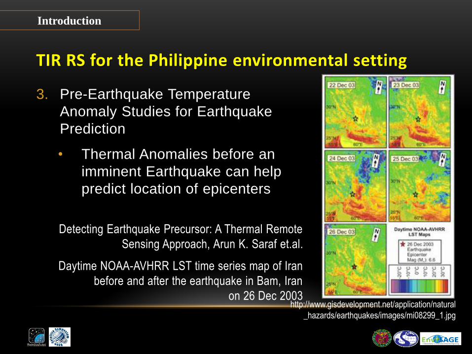
• Thermal Anomalies before an
imminent Earthquake can help
predict location of epicenters
Detecting Earthquake Precursor: A Thermal Remote
Sensing Approach, Arun K. Saraf et.al.
Daytime NOAA-AVHRR LST time series map of Iran
before and after the earthquake in Bam, Iran
on 26 Dec 2003

TIR RS for the Philippine environmental setting
3. Pre-Earthquake Temperature
Anomaly Studies for Earthquake
Prediction
Introduction
http://www.phivolcs.dost.gov.ph/index.php?option=c
om_content&view=article&id=78&Itemid=500024
• Will be beneficial for the
Philippines, being located
in the “Pacific Ring of Fire”

TIR RS for the Philippine environmental setting
4. Identification and Monitoring of
Volcanic Activity
Introduction
http://www.maps.nfo.ph/philippines-distribution-of-volcanoes/
• As of 29 July 2008, there
are 23 listed active
volcanoes in the Philippines
• Detecting, tracking, and
quantifying eruption clouds
and lava flows

TIR RS for the Philippine environmental setting
5. Water Quality Monitoring for Ecosystem and Resource
Management
Introduction
• SST
• Heated
effluent
discharges
• Upwelling
phenomena
http://www.osdpd.noaa.gov/data/sst/anomaly/2011/anomnight.2.7.2011.gif
TIR RS for the Philippine environmental setting
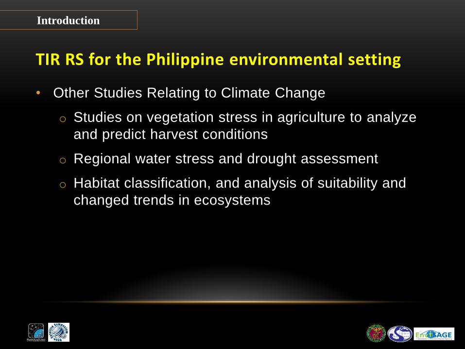
• Other Studies Relating to Climate Change
o Studies on vegetation stress in agriculture to analyze
and predict harvest conditions
o Regional water stress and drought assessment
o Habitat classification, and analysis of suitability and
changed trends in ecosystems
Introduction

Why Nano-Satellites?
• Less demands in terms of
financial and technical
requirements
• Less complicated satellite
design
• Faster implementation
• Give developing countries
opportunities to engage in
own satellite missions
Introduction

Space Program in the Philippine Setting
• The country’s space program is still in its infant stage
• No official agency mandated to undertake and manage space
research, missions and development
• UP DGE Recent Initiatives:
o 2010 – Prof. Florence Galeon, KARI Workshop for Small
Satellite Systems
o August 2012 – Prof. Rosario Ang, UNISEC 3rd CanSat
Leader Training Program
Introduction

Mission Idea:
Philippine National Agency for Space (PINAS) • Will be the lead agency responsible for the development,
management and maintenance of space and nano-satellite
missions including the acquisition and distribution of data
products.
• It shall provide its services to academic, government and
private institutions in the country.
Mission Idea

Business Model Structure
Mission Idea

Service Provider
Business Model
DOST-PCASTRD UP DGE-TCAGP NAMRIA

Key Customers
• Lead Government Agencies:
Department of Environment and Natural Resources
Philippine Institute of Volcanology and Seismology
Philippine Atmospheric Geophysical and Astronomical Services
Administration
• Local Government Units
• Academic Institutions
• Other organizations, private individual and companies which
deals with environmental programs, projects and researches
Business Model

Key system specifications
Business Model
SYSTEM SPECIFICATIONS
Payload and Bus Level Temp. Resolution of 0.5 Kelvin, Ground resolution of 50m,
Coverage area of 25 x 25km ; Medium Bus level requirement ;
Image size of 0.5MB for a 20km x 20km compressed JPEG image
Number of Satellites (N)
Two (2) nano-satellites; Revisit interval L = 1 day for both
satellites;
Ave. Revisit Interval (L/N) = 0.5 days
Number and
Specifications of
Ground Stations (G)
Four (4) Ground Stations, each with1Mbps downlink speed ;
DownlinkLatency (12hrs/G) = 3 hrs.;
2,400 images can be downlinked per day (2400 x G x Downlink x
speed/Data size)
Launch Configuration Coordinated “piggyback” launch
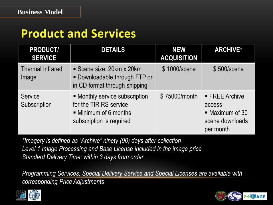
Product and Services PRODUCT/
SERVICE
DETAILS NEW
ACQUISITION
ARCHIVE*
Thermal Infrared
Image
Scene size: 20km x 20km
Downloadable through FTP or
in CD format through shipping
$ 1000/scene $ 500/scene
Service
Subscription
Monthly service subscription
for the TIR RS service
Minimum of 6 months
subscription is required
$ 75000/month FREE Archive
access
Maximum of 30
scene downloads
per month
Business Model
*Imagery is defined as “Archive” ninety (90) days after collection
Level 1 Image Processing and Base License included in the image price
Standard Delivery Time: within 3 days from order
Programming Services, Special Delivery Service and Special Licenses are available with
corresponding Price Adjustments

Cost model SPECIFICATIONS UNIT COST
(M$)
TOTAL COST
(M$)
Bus Cost
(2 Nano Satellites)
Medium (1 Mbps downlink speed) 2 4
Bus Cost
(2 Nano Satellites)
Infrared thermal sensor
(Temperature resolution 0.5 Kelvin,
ground resolution 50m, 25 x 25km)
1.2 2.4
Ground Station Operation Cost
(4 Stations)
1Mbps downlink speed 0.5 2
Launch Cost
(2 Nano Satellites)
Coordinated “piggyback” 4 8
TOTAL INITIAL COST (ONE TIME) 16.4
Ground Station Operation
Cost (4 Stations)
1Mbps downlink speed 0.2 0.8
Data Analysis Cost Infrared thermal sensor 1 1
TOTAL YEARLY COST (PER ONE WHOLE YEAR) 1.8
Business Feasibility
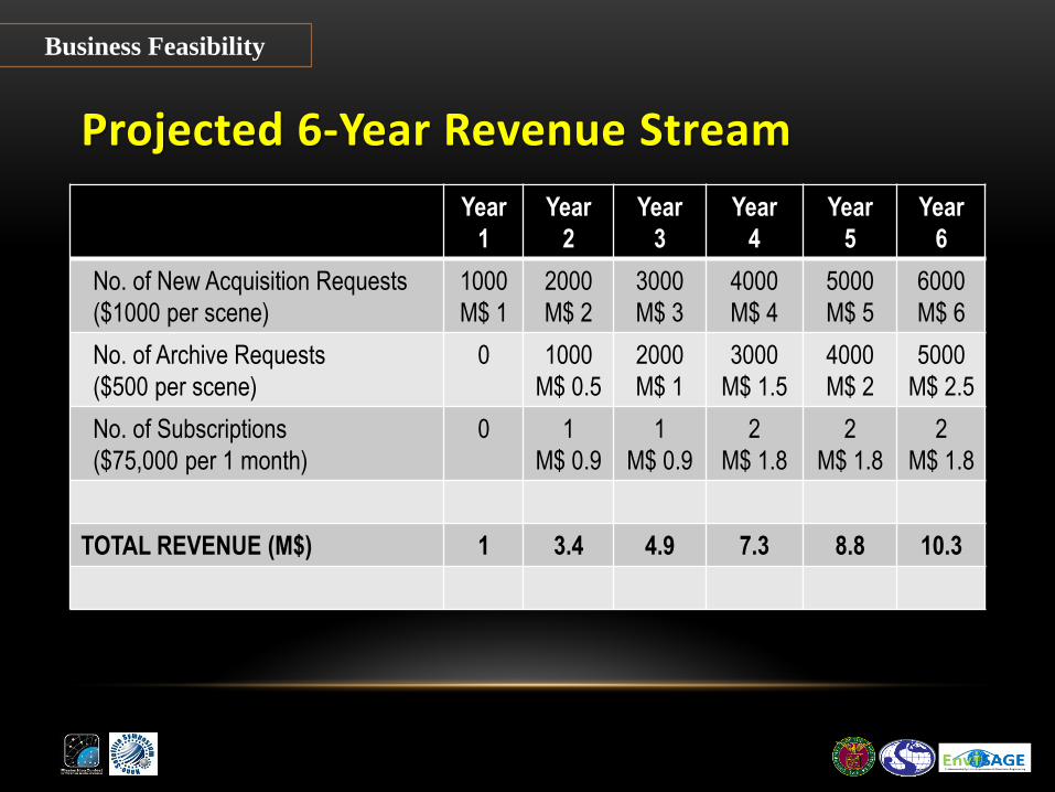
Projected 6-Year Revenue Stream
Year
1
Year
2
Year
3
Year
4
Year
5
Year
6
No. of New Acquisition Requests
($1000 per scene)
1000
M$ 1
2000
M$ 2
3000
M$ 3
4000
M$ 4
5000
M$ 5
6000
M$ 6
No. of Archive Requests
($500 per scene)
0 1000
M$ 0.5
2000
M$ 1
3000
M$ 1.5
4000
M$ 2
5000
M$ 2.5
No. of Subscriptions
($75,000 per 1 month)
0 1
M$ 0.9
1
M$ 0.9
2
M$ 1.8
2
M$ 1.8
2
M$ 1.8
TOTAL REVENUE (M$) 1 3.4 4.9 7.3 8.8 10.3
Business Feasibility

Projected 6-Year Financial Estimates
Year
1
Year
2
Year
3
Year
4
Year
5
Year
6
TOTAL COST (M$) 18.2 1.8 1.8 1.8 1.8 1.8
Total Initial Cost 16.4 - - - - -
Total Yearly Cost 1.8 1.8 1.8 1.8 1.8 1.8
TOTAL REVENUE (M$) 1 3.4 4.9 7.3 8.8 10.3
TOTAL PROFIT (M$) -17.2 -15.6 -12.5 -7.0 0.0 8.5
Business Feasibility

Anticipated Risks
• Market acceptance and competition
• Financing and Financial stability
• Organizational structure
• Technical Capacity and Capability
Risk Analysis
Anticipated Risks
• Market acceptance and competition
Existing satellite services with sensors that already provide
both imaging and thermal; competitors who are more
established in terms of market presence, technical
capability, and financial stability
The proposed business model intends to offer an advantage
through higher ground resolution and shorter revisit time,
producing more accurate and up-to-date TIR data.
Risk Analysis

Anticipated Risks
• Financing and financial stability
There may be concerns on the availability of financial
resources and sustaining funds for subsequent years of
operation
Possible sources of funding: sponsorship through
international space initiative collaborations, or through the
Congressional Commission on Science & Technology and
Engineering (COMSTE) of the Philippine Government.
Risk Analysis
Anticipated Risks
• Organizational Structure
Due to many different agencies coming together to create a
national space agency, complex organization scheme may
arise; this can be subject to several institutional concerns
Well facilitated and participated forum on the establishment
of a national space agency is necessary to achieve the best
possible effective and efficient organizational structure for
the same.
Risk Analysis

Anticipated Risks
• Technical capacity and capability
Requires specialized researches, trainings and
consultations with experts in the field of satellite
technologies
Continuous efforts of capability building for developing
country’s space agency (i.e. visit to KARI, delegation of
participant to the Regional Space Application Programme
for Sustainable Development)
Risk Analysis

Conclusion and Recommendations • Establishment of the PINAS would not just be a means to
earn income, but also to have a provider of relevant and up
to date TIR RS data of the Philippines.
• PINAS would provide for the forging of environmental
solutions for the country, considering effects such as
climate change, among others.
• Further capacity and capability building is needed to create
a mature space agency envisioned to spearhead the
development of the country’s space technology.
• A common objective mindset for all concerned: “We
want to see it happen.”
Conclusion

References A. Prakash. Thermal Remote Sensing: Concepts, Issues and Applications. International
Archives of Photogrammetry and Remote Sensing. Vol. XXXIII, Part B1. pp. 239-243
(Amsterdam 2000)
Tran Thi Van, Le Van Trung and Hoang Thai Lan. Application of Thermal Remote Sensing in
Study on Surface Temperature Distribution of Ho Chi Minh City. 7th FIG Regional
Conference Spatial Data Serving People: Land Governance and the Environment –
Building the Capacity. Hanoi, Vietnam, 19-22 October 2009
J. A. Voogt and T. R. Oke. Thermal remote sensing of urban climates. Remote Sensing of
Environment. Volume 86, Number 3, pp. 370-384 (15 August 2003 )
http://dx.doi.org/10.1016/S0034-4257(03)00079-8
A. K. Saraf, S. Choudhury, V. Rawat, P. Banerjee, S. Dasgupta and J.D. Das. Detecting
Earthquake Precursor: A Thermal Remote Sensing Approach. Map India-2008, 6-8 Feb.
2008, GIS Development
http://www.gisdevelopment.net/application/natural_hazards/earthquakes/mi08_299.htm
(accessed 30 April 2012).
References

References M. Trusculescu, M. Balan, C. Dragasanu, A. Pandele and M. Piso. Nanosatellites: The Tool for
Earth Observation and Near Earth Environment Monitoring, Earth Observation, ISBN:
978-953-307-973-8, InTech (2012) Available from:
http://www.intechopen.com/books/earth-observation/nanosatellites-the-tool-for-earth-
observation-and-near-earth-environment-monitoring (accessed August 2012)
F. Ramdani. Application of satellite-derived surface temperature analysis. just learn. (4 April
2012). http://fatwaramdani.wordpress.com/2012/04/04/application-of-satellite-derived-
surface-temperature-analysis/ (accessed 30 April 2012)
M. Tiangco, A.M. Lagmay, J. Argete. ASTER-based study of the night-time urban heat island
effect in Metro Manila. International Journal of Remote Sensing, Volume 29, Number 10,
pp. 2799-2818(20) (2008)
L. Flynn, A. Harris and R. Wright. Improved identification of volcanic features using Landsat 7
ETM+. Remote Sensing of Environment, ISSN: 0034-4257 Volume 78, Issue 1-2 pp. 180-
193 (October, 2001)
PHIVOLCS website.
http://www.phivolcs.dost.gov.ph/index.php?option=com_content&view=article&id=57:activ
e-volcanoes&catid=55:volcanoes-of-the-philippines (accessed August 2012)
References

Acknowledgements
• Special Thanks to:
Dr. Ariel C. Blanco
Prof. Shinichi Nakasuka
Ms. Rei Kawashima
UNISEC
Nano-satellite Symposium Office
Acknowledgements

Thank you for listening…