The usage of unmanned aerial vehicle technology in ...
33
i
Transcript of The usage of unmanned aerial vehicle technology in ...

i


The usage of unmanned aerial vehicle technology in participatory land use planning
and mapping
Sustainable cropland and forest management in priority agro-ecosystems of Myanmar
PROJECT SYMBOL: GCP/MYA/017/GFF
Food and Agriculture Organization of the United Nations
Naypyitaw, 2020

Required citation: FAO. 2020. The usage of unmanned aerial vehicle technology in participatory land use planning and mapping. Naypyidaw. The designations employed and the presentation of material in this information product do not imply the expression of any opinion whatsoever on the part of the Food and Agriculture Organization of the United Nations (FAO) concerning the legal or development status of any country, territory, city or area or of its authorities, or concerning the delimitation of its frontiers or boundaries. Dashed lines on maps represent approximate border lines for which there may not yet be full agreement. The mention of specific companies or products of manufacturers, whether or not these have been patented, does not imply that these have been endorsed or recommended by FAO in preference to others of a similar nature that are not mentioned. The views expressed in this information product are those of the author(s) and do not necessarily reflect the views or policies of FAO. © FAO, 2020
Some rights reserved. This work is made available under the Creative Commons Attribution-NonCommercial-ShareAlike 3.0 IGO licence (CC BY-NC-SA 3.0 IGO; https://creativecommons.org/licenses/by-nc-sa/3.0/igo/legalcode). Under the terms of this licence, this work may be copied, redistributed and adapted for non-commercial purposes, provided that the work is appropriately cited. In any use of this work, there should be no suggestion that FAO endorses any specific organization, products or services. The use of the FAO logo is not permitted. If the work is adapted, then it must be licensed under the same or equivalent Creative Commons licence. If a translation of this work is created, it must include the following disclaimer along with the required citation: “This translation was not created by the Food and Agriculture Organization of the United Nations (FAO). FAO is not responsible for the content or accuracy of this translation. The original [Language] edition shall be the authoritative edition.” Disputes arising under the licence that cannot be settled amicably will be resolved by mediation and arbitration as described in Article 8 of the licence except as otherwise provided herein. The applicable mediation rules will be the mediation rules of the World Intellectual Property Organization http://www.wipo.int/amc/en/mediation/rules and any arbitration will be conducted in accordance with the Arbitration Rules of the United Nations Commission on International Trade Law (UNCITRAL). Third-party materials. Users wishing to reuse material from this work that is attributed to a third party, such as tables, figures or images, are responsible for determining whether permission is needed for that reuse and for obtaining permission from the copyright holder. The risk of claims resulting from infringement of any third-party-owned component in the work rests solely with the user. Sales, rights and licensing. FAO information products are available on the FAO website (www.fao.org/publications) and can be purchased through [email protected]. Requests for commercial use should be submitted via: www.fao.org/contact-us/licence-request. Queries regarding rights and licensing should be submitted to: [email protected]. The boundaries and names shown and the designations used on this map do not imply the expression of any opinion whatsoever on the part of FAO concerning the legal status of any country, territory, city or area or of its authorities, or concerning the delimitation of its frontiers and boundaries. Dashed lines on maps represent approximate border lines for which there may not yet be full agreement.

iii
Abstract
Participatory Land Use Planning (PLUP) requires active involvement of the local stakeholders and the village
tract communities. The use of unmanned aerial vehicles (UAV) in mapping and planning land uses, is an
emerging and efficient technology for acquiring thematic spatial data for participatory land use planning and
mapping at village or township levels. The use of UAV was preferred for cost-effectively collecting quality
geospatial data and information at very high resolution in a flexible, participatory, and transparent manner
in NyaungU and Kyaukpaduang townships at Village tract level. Data collected using the UAV included; aerial
imagery for mapping of village boundaries, land use, land cover, infrastructure, public facilities and utilities,
point cloud data for creating digital terrain models. The same participatory procedures were used in the great
delta of Ayeyarwady Region in Labutta Township and in the upland areas of Mindat and Kanteplet Townships
in Chin State. The usage of UAV technology enhanced the participatory process by enabling identification of
visible land use types, crop types, infrastructure, facilities, and delineable boundaries by the local non-
technical village participants. These information was used in the PLUP process at several stages namely; the
preparation stage, Mapping existing land uses and other features (infrastructure, utilities, and facilities,
delineating village boundary), Mapping of proposed land use sites, i.e. community forest sites, and delineating
land tenure systems in the selected project sites.
Keywords: UAV, Participatory Land Use Planning and Mapping


v
CONTENTS
ABSTRACT.......................................................................................................................................................................... iii
ACRONYMS ....................................................................................................................................................................... vi
1. INTRODUCTION ............................................................................................................................................................ 1
1.1 Spatial Data Infrastructure (SDI) for Myanmar ............................................................................................................. 2
1.1.1 Regulations governing drone mapping in Myanmar ............................................................................................. 3
1.2 Problem statement ............................................................................................................................................................. 3
1.3 Adoption of UAV mapping in PLUP in Myanmar ........................................................................................................... 3
1.3.1 Comparison of current satellite and UAV imagery data for mapping at village tract level ............................... 4
1.4. Objectives of using UAV in PLUP process ate village tracts .......................................................................................... 4
1.5 Project areas ....................................................................................................................................................................... 5
1.5.1 Mindat and Kanpetlet townships in the upland areas of Myanmar ..................................................................... 5
1.5.2 Labutta township in the coastal zone....................................................................................................................... 6
1.5.3 Kyaukpadaung and Nyaung Oo townships, in the central dry zone .................................................................... 7
2. METHODOLOGY FOR PLUP WITH UAV ...................................................................................................................... 9
2.1 Software and material ....................................................................................................................................................... 9
2.2 Data collection ................................................................................................................................................................ 10
2.3 Image acquisition and processing ................................................................................................................................. 11
2.4 Participatory land use mapping and planning at village/village tract level ............................................................. 12
3. RESULTS AND DISCUSSION ....................................................................................................................................... 14
3.1 Final PLUP output ........................................................................................................................................................... 15
3.2 Discussion........................................................................................................................................................................ 16
3.2.1 Drone technology requirement in township level mapping and planning ...................................................... 16
3.2.2 Best practices for drone applications in mapping and planning ....................................................................... 16
4. CONCLUSION .............................................................................................................................................................. 17
REFERENCES ..................................................................................................................................................................... 19
ANNEX 1 ........................................................................................................................................................................... 21
vi
Title of Figures and Tables
FIGURES
Figure 1 Myanmar Spatial Data and Information Management Structure (Modified from DPSMAP) ................................ 2
Figure 2 Kanpatlet Township in Chin State, the Uplands of Myanmar ................................................................................... 5
Figure 3 Mindat Township in Chin State, the Uplands of Myanmar ....................................................................................... 6
Figure 4 Labutta Township in the Great Ayeyarwady Delta region within the Coastal Zone of Myanmar ......................... 7
Figure 5 Kyaukpadaung Township in Mandalay region within the Central Dry Zone of Myanmar ................................... 8
Figure 6 Nyaung Oo Township in Mandalay region within the Central Dry Zone of Myanmar ......................................... 8
Figure 7 Workflow for PLUP using UAV .................................................................................................................................... 9
Figure 8 Pix4D Showing the Setting of Flight Path Characteristics ...................................................................................... 11
Figure 9 Photos of the DJI Mavic 2 Pro and GIS expert launching drone flight in Labutta................................................ 12
Figure 10 Participatory Land Use Mapping and Planning Steps in Khee Rein Village, Mindat Township ....................... 13
Figure 11 Ortho-mosaic imagery extracted from UAV data acquired on 21/10/2019 in Labutta Township ................ 14
Figure 12 Participatory Boundary Delineation ....................................................................................................................... 15
Figure 13 Digitized village boundary and land use features presented in 3D model to the villagers for confirmation . 15
Figure 14. Drone panoramic photos extracted from UAV data ........................................................................................... 21
Figure 15 Ortho-mosaic imagery extracted from UAV data ................................................................................................. 21
Figure 16 Section of panorama photo extracted from UAV data acquired in Labutta Township ...................................... 21
Figure 17 Current Land Use Land Cover (LULC) Map .............................................................. Error! Bookmark not defined.
Figure 18 Proposed Land Use Plan resulting from the community participation................................................................ 22
TABLES
Table 1: Comparison of current satellite and UAV imagery data for mapping at Village Tract Level .................................. 4
Table 2: List of free and commercial software for drone data processing ............................................................................... 9
Table 3 Specifications of UAV DJI Mavic 2 Pro ....................................................................................................................... 11

vii
Acronyms
CF Community Forestry CSO Civil Society Organization DALMS Department of Agriculture Land Management and Statistics DSM Digital Surface Model DTM Digital Terrain Model FAO Food and Agriculture Organization of the United Nations FD Forest Department GAD General Administration Department
GCP Geodetic Control Points GNDVI Green Normalized Difference Vegetation Index IDP Internally Displaced Person LIS Land Information System LSC Local Stakeholders Committee LUC Land Use Certificate LULC Land Use and Land Cover LUT Land Use Type MIMU Myanmar Information Management Unit (www.themimu.info) NDVI Normalized Difference Vegetation Index NLIS National Strategy for Land Information System Development NLUP National Land Use Policy NSDI National Spatial Data Infrastructure PLUP Participatory Land Use Planning UAV Unmanned aerial vehicles VARI Visible Atmospherically Resistant Index VC Village Committee VFV Virgin, Fallow, and Vacant VTC Village Tract

viii

1
1. Introduction
The approaches of participatory mapping and planning provide a platform for documenting spatial
understanding of local communities by conjoining modern cartography tools, active participation, and
interactive mapping planning techniques (Rainforest Foundation UK, 2019). This approach was used to bring
forth local historical and indigenous knowledge, social and cultural attachments of the communities on land
use, demographic and socio-economic patterns, and other livelihood characteristics at the village level.
Participatory mapping was used to enhance PLUP by improving acceptance and ownership of the maps and
interactive identification of traditional and indigenous land resources which the communities view as a
stratagem for recognition, upholding of land rights, boundaries, and tenure security (IFAD, 2009).
Remote sensing approaches to natural resources mapping have been applied in data collection and analysis
for planning and management since 1970s. There are conventional satellite datasets developed, which
include Landsat, ASTER, SPOT, ALOS, Rapid-Eye, Geo-Eye, Pleiades, Quick-bird, and IKONOS, Worldview,
and Sentinel-2 imagery. These satellite data is mostly used for the exploration of natural resource through
remote sensing technologies. However, these data is limited due to cloud cover, spatial and temporal
resolutions, and operation costs. Currently, the UAV or drones are used to dynamically capture very high-
resolution data; providing a new frontier for collecting detailed spatial data and information on natural
resources. Several studies have been conducted using UAV with different spatial resolution fitting specific
uses (Kachamba D. et al., 2016, Anggoro A. et al., 2018, Waite C. et al., 2019).
The advent of the UAV applications in remote sensing is increasingly closing the gap between the labor
intensive and time consuming ground data collection and the inflexible and costly satellite/airborne
observations. In view of the cost-effectiveness, flexibility, and prompt data acquisition, the UAV system has
been applied in many areas to generate high resolution ortho-images, point clouds data, and digital surface
models (Colomina and Molina, 2014, Crommelinck S. et al 2019). Maurice et al., 2015 pointed out that the
UAV are used in data collection for land administration and updating cadastral maps (Manyoky et al., 2011;
Koeva et al., 2016; Jazeera et al., 2014). In addition, the UAV’s high-resolution ortho-photos are used to
digitize boundaries of land use or parcels; manually and or automatically and attributive information is added
to the generated spatial data (IAAO, 2015). The resulting informative map is crucial for a land use planning,
recording of existing land use, tenure systems, and land rights. This consents the establishment of
administrative functions, participatory land use planning, and mapping to facilitate decision-making
(Williamson et al., 2010). There are other studies using this remote sensing technology to gather spatial
information at large scales for environmental monitoring and planning (Nurdin N. et al., 2014, Nurdin N. et
al., 2015, Siregar V. P. et al., 2013).
Due to huge costs involved in the collection of land information, the land rights of over 70 percent of the
population are unrecognized. This challenge can be resolved using innovative, reliable, affordable,
transparent, scalable, and participatory tools purposely for flexible and responsible land mapping and
management (Enemark et al., 2014). This can be achieved by simplifying the mapping protocols to allow for
participatory marking of boundaries and other features of interest on the ortho-photos. In the event of
modification and formalization of the mapping protocols, surveying costs and processing time will be

2
reduced, while improving efficiency, achieving ownership by local communities and high accuracy (Luo et
al., 2017).
Manual and automatic approaches are available for extracting visible feature boundaries from UAV data. The
main use of UAV technology in the project areas was to facilitate participatory land use planning and mapping
as an alternative for bridging the gap for the required spatial data acquisition that is less costly and more
flexible, efficient, and effective at the village tract level.
1.1 Spatial Data Infrastructure (SDI) for Myanmar
The spatial data infrastructure of Myanmar is well defined among several actors. However, there is no
clearing house for all spatial data. Data is managed by several institutions within government and non-
governmental organizations with each managing spatial data themes under their respective mandates. There
are GIS units in the Department of Agriculture Land Management and Statistics (DALMS), the Department of
Forestry (DF), and MoIP all managing thematic data. Following the need to harmonize Geospatial Technology
in support of SDI, Myanmar formulated the One Map Policy. One Map project has since developed a geo-
portal for archiving, sharing, and managing all spatial data. Further, a multi-agency team including NGOs
and the UN agencies implementing projects within the country, have developed Myanmar Information
Management Unit (MIMU) to support the development of NSDI1. It is worth noting that the NSDI is still in its
infancy as most institutions are still struggling with duplication of efforts and inadequate data sharing
arrangement. Considering the emerging demand for UAV technology in mapping and planning, these key
players need to formulate relevant policies to govern its utilization. Figure 1 illustrates the governance
structure of Myanmar which also infers the geospatial data administration and management. At national
level, data is managed at the Union Territory of Nay Pyi Taw, then each of the 7 regions and 7 states generate
and manage their own data. This also is done at the township levels within the respective Ministries and their
departments.
Figure 1. Myanmar Spatial Data and Information Management Structure
1 For more information, please see Myanmar Information Management Unit (MIMU) website, and insert the link in the acronym
Data Source: Design Printing Services (www.dpsmap.com/gis)

3
1.1.1 Regulations governing drone mapping in Myanmar
There is no specific laws governing the drone use. However, the applicable Myanmar laws and regulations
for Drone technology usage are drawn from the general principles of safety, security, and privacy. The
practice of using drone for mapping is allowed in Myanmar, but when flying the following rules must be
followed.
a) Obtain permission to own and operate a drone
b) Avoid flying over large crowds of people
c) Strictly observe and respect the privacy interests/rights of others when flying a drone
d) Avoid flying in proximity to airports (5Kms)
e) Must fly during the daytime and in manageable weather conditions
f) Must not fly over sensitive government areas including military facilities.
g) Avoid flying drones near religious sites
h) Avoid flying drones in Naypyidaw
The permits to operate the drones in Myanmar are issued by the Ministry of Transport and Communication.
It is worth noting that there significant restriction for foreign operators due to security reasons.
1.2 Problem statement
The UAV were introduced for military purposes in the in 19’s century. In the recent past, the use of the UAV
increasingly extended into applications in civil mapping and planning activities including land cadastral
registration, delineating land uses, and village boundaries. Ramadhani (2016) used UAV delineate rice fields
boundaries of in Tenggara, Indonesia. Silalahi et al., (2016) who also used UAV for mapping the district
boundaries in Indonesia, reiterate this fact. Further, Sadikin et al., (2014) concludes that UAV are applied
satisfactorily to resolve geometric accuracy issues, as an approach to rural land parcels mapping and
identification of assets, tenure system boundaries. The countries that have used UAV for cadaster include
Netherlands; juridical verification of cadastre border (Rijsdijk et al., 2013), Alaska State and Poland; updating
cadastre maps, and for taxation purposes (Cunningham et al., 2015, Lukitasari F., 2017).
Participatory land use planning can be ineffective, time consuming and expensive process without current
visual data as orthophoto and or maps at sufficient spatial resolution for village/village tract level planning.
In the PLUP process the local communities respond well to visible information as opposed to interpreted lower
resolution data. Therefore, this project adopted UAV to support the land use planning and mapping at village
tract level, and this paper focuses on documenting best practices and lessons learnt in comparison with other
terrestrial airborne methods, considering accuracy, cost, time and participatory opportunities. It was noted
that most existing village tract boundaries need verification and most village boundaries are not formal.
1.3 Adoption of UAV mapping in PLUP in Myanmar
Participatory mapping for land use planning at village tract level was carried out in the Central Dry Zone,
Mandalay Region, Nyaung-U Township (Dahatsee village tract), and Kyaukpadaung Township (Thanbo
village tract). In the great Ayeyarwady delta Region; Labutta Township (Baing Daing Chaung village tract)
and in the upland areas of Chin State, Mindat Townships (Khee Rein village tract), and Kanpetlet Townships
at village tract, were selected for the PLUP process. The mapping of land use types, natural resources, and
boundaries was illustrated in a participatory process involving the local communities. Geo-spatial data
collected using the UAV included basic geo-information imagery for mapping and documenting land use,
4
hypsography, inland waters (estuary/brackish), topographical names, boundaries, transportation and
utilities, settlements and public facilities. This data was used to gain understanding of the village/village tract
level land resources for the planning purposes. The participatory process using the UAV was focused on
mobilizing the village community to get involved in the land use decision making within their locality through
the gained understanding of the maps developed. The final production of land use maps showing the village
boundaries, land resources, land use types, and proposed plans for community forest sites was intended to
support efficient and effective decision-making processes. This project aims to develop a model process for
PLUP with the aid of UAV at village tract level for replication in other villages within the townships.
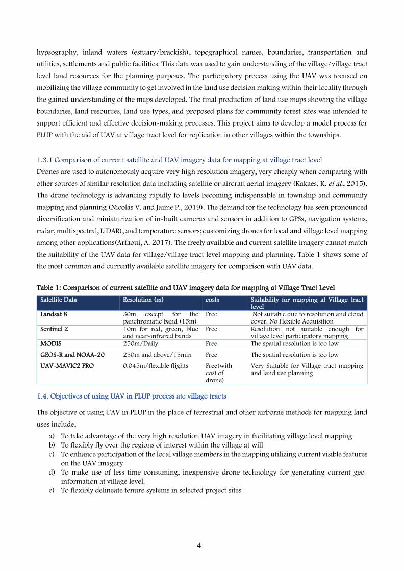
1.3.1 Comparison of current satellite and UAV imagery data for mapping at village tract level
Drones are used to autonomously acquire very high resolution imagery, very cheaply when comparing with
other sources of similar resolution data including satellite or aircraft aerial imagery (Kakaes, K. et al., 2015).
The drone technology is advancing rapidly to levels becoming indispensable in township and community
mapping and planning (Nicolás V. and Jaime P., 2019). The demand for the technology has seen pronounced
diversification and miniaturization of in-built cameras and sensors in addition to GPSs, navigation systems,
radar, multispectral, LiDAR), and temperature sensors; customizing drones for local and village level mapping
among other applications(Arfaoui, A. 2017). The freely available and current satellite imagery cannot match
the suitability of the UAV data for village/village tract level mapping and planning. Table 1 shows some of
the most common and currently available satellite imagery for comparison with UAV data.
Table 1: Comparison of current satellite and UAV imagery data for mapping at Village Tract Level
Satellite Data Resolution (m) costs Suitability for mapping at Village tract level
Landsat 8 30m except for the panchromatic band (15m)
Free Not suitable due to resolution and cloud cover. No Flexible Acquisition
Sentinel 2 10m for red, green, blue and near-infrared bands
Free Resolution not suitable enough for village level participatory mapping
MODIS 250m/Daily Free The spatial resolution is too low
GEOS-R and NOAA-20 250m and above/15min Free The spatial resolution is too low
UAV-MAVIC2 PRO 0.045m/flexible flights Free(with cost of drone)
Very Suitable for Village tract mapping and land use planning
1.4. Objectives of using UAV in PLUP process ate village tracts
The objective of using UAV in PLUP in the place of terrestrial and other airborne methods for mapping land
uses include,
a) To take advantage of the very high resolution UAV imagery in facilitating village level mapping
b) To flexibly fly over the regions of interest within the village at will
c) To enhance participation of the local village members in the mapping utilizing current visible features
on the UAV imagery
d) To make use of less time consuming, inexpensive drone technology for generating current geo-
information at village level.
e) To flexibly delineate tenure systems in selected project sites

5
1.5 Project Areas
The project areas selected for PLUP represent three different ecological states: the upland areas, coastal zone,
and central dry zone. These sites are representative of the general landscape of Myanmar.
1.5.1 Mindat and Kanpetlet townships in the upland areas of Myanmar
Kanpetlet project site is located within 93°29’00”- 94°07’30” E and 20°38’ 20” - 21°18’20” N while
Mindat project area falls within 93°28’30”- 94°07’37” E and 21°04’ 40” - 21°48’53” N, in Chin State. The
Townships lie within the mountainous areas with altitude up to 1 463 meters in the southwest of Myanmar.
There is a total population of about 64 000 people drawn from multi-ethnic groups with about 50 000
living in the rural areas where they practice shifting cultivation. The townships cover an area of
approximately 570 000 hectares. The total protected forest area Mindat is 55 000 hectares and 12 000
hectares in Kanpetlet totaling to approximately 72 000 hectares. Owing to the upland geography of the
townships, there is high levels of endemism. However, land degradation is advancing at unprecedented
rate due to inadequate land use planning.
Figure 2. Project area I, Kanpatlet Township in Chin State, the Uplands of Myanmar
© FAO
Adapted from MIMU GIS resources (http://themimu.info/gis-resources) including State and Region Boundary, Township
Boundary, Town Locations, Village Locations, Road, River and Hill shade produce from SRTM30.
The boundaries and names shown and the designations used on this map do not imply official endorsement or acceptance by the United Nations

6
Figure 3. Project area II, Mindat Township in Chin State, the Uplands of Myanmar
1.5.2 Labutta township in the coastal zone
Labutta Township is located within 94°32’15”- 95°07’04” E and 15°42’ 06” - 16°23’43” N in Myanmar’s
coastal zone, within the great Ayeyarwady Delta. The Township presents opportunities for integrated crop
farming, fisheries, and forestry practices within the coastal zone including exploration of blue economy
opportunities. The low lying, moist areas of Labutta Township have substantial mangrove forest and are
important for rice and fishery/aquaculture production in Myanmar. The township has total population of
500 000 of which 469 000 people in rural areas and are vulnerable to the Nargis Cyclone. The
communities mainly practice non-mechanized, low input rice production in approximately 148 300
hectares, while 73 000 ha are covered by mangrove forests out of the total land area about 300 000
hectares. According to the national plans, Reserved Forests cover about 100 000 hectares.
© FAO
Adapted from MIMU GIS resources (http://themimu.info/gis-resources) including State and Region Boundary, Township
Boundary, Town Locations, Village Locations, Road, River and Hill shade produce from SRTM30.
The boundaries and names shown and the designations used on this map do not imply official endorsement or acceptance by the United Nations

7
Figure 4. Project area III, Labutta Township in the Great Ayeyarwady Delta region within the Coastal Zone of Myanmar
1.5.3 Kyaukpadaung and Nyaung Oo townships, in the central dry zone
Nyaung Oo Township is are located within 94°49’27”- 95°14’10” E and 20°51’40” - 21°18’16” N while
Kyaukpadaung Township is falls within 94°59’32”- 95°32’40” E and 20°32’30” - 21°06’50” N, in the
Mandalay Region within the central dry zone of Myanmar. The two townships covering an area of about
400 000 ha, have 120 000 ha of forest and 200 000 ha in agricultural use while 80 000 ha are considered
a waste land. A single household in the central dry zone, requires 3-4 ha for sustenance. However, 25
percent of the rural populations are landless while most of the remaining population have less than 2ha. In
this zone, Agriculture is the economic main stay, where the pulse crops account for 70 percent of dryland
agriculture in addition to paddy, sesame, and groundnut with significant grazing. Further, the residents
largely depend on natural forest for livestock production and fuel wood. The area is characterized with
ephemeral streams, pronounced water scarcity, and about 20 percent of households falling into the food
insecurity brackets.
© FAO
Adapted from MIMU GIS resources (http://themimu.info/gis-resources) including State and Region Boundary, Township Boundary, Town Locations,
Village Locations, Road, River and Hill shade produce from SRTM30.
The boundaries and names shown and the designations used on this map do not imply official endorsement or acceptance by the United Nations

8
Figure 5 Project area IV, Kyaukpadaung township in Mandalay region within the central dry zone of Myanmar
Figure 6. Project area IV, Nyaung Oo township in Mandalay region within the central dry zone of Myanmar
© FAO
© FAO
Adapted from MIMU GIS resources (http://themimu.info/gis-resources) including State and Region Boundary, Township
Boundary, Town Locations, Village Locations, Road, River and Hill shade produce from SRTM30.
Adapted from MIMU GIS resources (http://themimu.info/gis-resources) including State and Region Boundary, Township
Boundary, Town Locations, Village Locations, Road, River and Hill shade produce from SRTM30.
The boundaries and names shown and the designations used on this map do not imply official endorsement or acceptance by the United Nations
The boundaries and names shown and the designations used on this map do not imply official endorsement or acceptance by the United Nations

9
2. Methodology for PLUP with UAV
There are three main stages used in the participatory mapping using the UAV: the preparation stage, data
acquisition stage, and the participatory mapping stage as illustrated in figure 1 below.
Figure 7. Workflow of PLUP using UAV
2.1 Software and material
There are a number of software available for drone data processing which can be classified open source, free
or commercial categories. The free and open source software OpenDroneMap (ODM) and Menci APS were
selected for data processing in addition to the Pix4D software; commercially available at reasonable periodic
subscription fee. There other available commercial software are shown in table 2.
Table 2: List of free and commercial software for drone data processing
Software Commercial/free/open
source
Main products Source
Drone Mapping With OpenDroneMap (ODM), Web-ODM
Free and
open source
a) Geo-referenced Orth mosaics. b) Geo-referenced Point Clouds data:, c) Geo-referenced Digital Terrain/Surface Models d) 3D Models: Textured 3D models in .OBJ format. e) Measurements of volume and areas f) Vegetation indexes for checking plant health including NDVI,
GNDVI, VARI, and others g) Creates additional GCPs and uses them for improved accuracy. h) Produces contours in preview and Contours; Preview and file
formats for export as AutoCAD, Geo-Package, and Shape-file, JPGs and TIFFs
i) Processed multi-spectral images. j) 3D models and easy sharing of data
https://www.opendronemap.org/
Menci aps free a) Geo-referenced Digital Terrain/Surface Models b) 4 channel imagery c) Photo-Scan Import tool d) Algorithm for DSM generation e) Algorithm for filling holes in DSM
http://www.menci.com/it/

10
Software Commercial/free/open
source
Main products Source
f) Ortho-Photos Drone Deploy Commercial a) 3D models and
b) Ortho-photos and GEO-Tiff, JPG, Shape-files, Point Cloud data, and Contours
c) Autonomous flight features
https://www.dronedeploy.com/
Pix4Dmapper Commercial
with flexible
payment
options
a) Undistorted images b) Densified Point Cloud (.las, .laz, .xyz, .ply) c) Digital Surface Model (Grid DSM, Raster DSM) d) Digital Terrain Model (DTM: Raster DTM) e) Ortho-mosaic (Geo-TIFF, KML file, Google Maps HTML file) f) Index Map (Geo-TIFF, Colored KML file, Grid Shape-file) g) 3D Textured Mesh (.obj, .fbx, .dxf, .ply, .pdf, .osgb, .slpk) h) Contour lines (.shp, .pdf, .dxf) i) Video animation (.mp4, .mkv, .avi) j) 3D Digitized objects: Polyline, Surface, Volume base surface
(.shp, .dxf,.kml, .dgn)
https://www.pix4d.com/
DJI Ground Station (GS PRO)
Commercial/ comes with drone
Does not export any files, mission planner only. Does import KML/SHP files for more accurate mission planning
Agisoft Standard Version
Commercial a) Camera Parameters (Internal parameters, External parameters, Bingo, SSK)
b) Undistorted Images c) Densified Point Cloud (.las, .laz, .xyz, .ply) d) Digital Surface Model (Grid DSM, Raster DSM) e) Digital Terrain Model (DTM: Raster DTM), f) Ortho-mosaic (Geo-TIFF, KML file, Google Maps HTML file) g) Index Map (Geo-TIFF, Colored KML file, Grid Shape-file) h) 3D Textured Mesh (.obj, .fbx, .dxf, .ply, .pdf, .osgb, .slpk) i) Contour Lines (shp, .pdf, .dxf) j) Video Animation (.mp4, .mkv, .avi)
https://www.
agisoft.com/fe
atures/profess
ional-edition/
The DJI Mavic 2 pro drone having a flight range of less than 10km, a weight less than 5kg, and a flight
altitude of less than 250m is classified as a micro UAV. Among its peers which include the DJI Phantom 4
Pro+(flight time 15min and range 150m), DJI Mavic Air (flight time 20min and range 4 000m), AR X-Star
Premium (flight time 25min and range 2 000m), GoPro Karma (flight time 20min and range 2 000m); the
DJI Mavic 2 pro has a flight time of 27min and a range of 7 000m. The DJI Mavic 2 pro was selected for
the tasks of this project.
To following resources were availed for this project activity;
a) UAV: DJI Mavic 2 pro b) Instruments: Smartphone; Laptop/ Computer Desktop c) Software: DJI GS Pro; ODM, Pix4Dmapper; QGIS 3.10.3 d) Personnel: GIS expert, Facilitators, LCS officers (government authorities)
e) Ancillary data: existing geospatial data collected from various providers, including land cover maps
developed for township levels
2.2 Data collection
There two types of datasets that were collected; the primary data and ancillary (secondary) data. While the
primary dataset was collected through the fieldwork, the ancillary data was obtained from existing records
and databases in the respective mandated institutions. The digital imagery was acquired by flying the UAV
(DJI Mavic 2 pro) in the project areas of interest. The other tools used for processing data include a laptop
computer with QGIS software.

11
Table 3. Specification of UAV DJI Mavic 2 Pro
Characteristic Details
UAV DJI Mavic 2 Pro Weight 907 g
Max. Speed 72 kph (S-mode)
Max. Service Ceiling Above Sea Level 7 000 m (Default altitude limit: 120 m above take-off point)
Max Flight Time (no wind) 31 minutes (at a consistent 25 kph)
GPS Mode
GPS+GLONASS
Sensor 1” CMOS Effective Pixels: 20 million
Lens FOV: about 77°
Image Max. Size (width x height) 5472×3648
Supported File Formats Photo: JPEG, DNG; Video: MP4, MOV
Internal Storage 8 GB
Sensing System Omnidirectional Obstacle Sensing (left/right, up/down, and forward/backward
obstacle sensing)
Data quality and safety of the flight largely depends on the flight paths design. The design of the flyways took
into consideration the drone tool specifications, the target feature, and the characteristics of the region of
interest. Pix4D software was used to design the flight path based on accessibility and elevation by providing
desired flight height, speed, and data capture overlap between flight paths as shown in Figure 8. The village
tract boundary was uploaded into the Pix4D Software in a KML file format to guide the design of flight paths.
The commonly used flight height in the fieldwork was an average of about 200m and an overlap of 65
percent. The average area covered per flight was approximately 200 acres and a maximum of 5 flights per
day with 5 drone batteries. It is normal to cover 1 000 acres per day with a total of around 800 images being
acquired per day using the Mavic 2 Pro drone. The ortho-photos and panorama drone pictures were used to
map facilities, utilities, and other infrastructure within the village/village tract.
Figure 8. Pix4D Showing the Setting of Flight Path Characteristics
2.3 Image acquisition and processing
Image Acquisition was done within the village tract boundary in accordance to the flight plans. Trial flights
were conducted to test the connectivity between the ground station and the UAV. The flight parameters that
© FAO

12
include flight height, side and frontal overlaps and data capture extents were set based on the testing results.
The UAV produced aerial imagery/photographs at a spatial resolution of about 4.5 cm taken from an average
height of about 200m and an overlap of 65 percent. UAV aerial photographs were processed into ortho-
mosaics and digital elevation model using the Menci and ODM software. The resultant imagery was
processed using QGIS 3.10.3 software. The data was projected to Universal Transverse Mercator (UTM), zone
46 North (UTM 1984). Finally, the ortho-photo/imagery was used to identify land uses in the village as well
as introduce the new technology to government authorities and local committee. Visual interpretation of the
ortho-photo was carried out manually through on-screen digitization. In addition, the resultant spatial data
was presented using a projector during the village workshop forum. The participatory land use mapping
and planning at the village/village tract data were integrated into the township land use land cover and
planning map, produced by this project.
Figure 9. Photos of the DJI Mavic 2 Pro and GIS expert launching drone flight in Labutta
2.4 Participatory land use mapping and planning at village/village tract level
The participatory mapping and planning involved the following standard tools, which include;
a) Hands-on mapping,
b) Using Scale maps and images for boundary demarcations
c) GPS data collection for unclear boundaries area
d) Using participatory on screen 3-D models,
e) Participatory Geographic Information Systems (PGIS), and
The hands-on mapping, was used as basic mapping method where community members drew maps based
on their memories on the ground and or a piece of paper. The inexpensive mapping technique required no
technology and was low-resource-input, mainly for brainstorming in the village meeting forums. This was
used to capture past land uses and invincible features and attributes on the maps and imagery. It enabled
the village/community members to familiarize with mapping techniques and achieving consensus on the
village/ village tract boundary among neighbor villages. Using scale maps and images for participatory
mapping involved discussions with the community members who marked boundaries for the village and
© FAO © DJI
13
land uses on the topographic maps. This was done in the presence of the Local Stakeholder Committee (LSC),
Village committee (VC), and other members of the village tracts. In places where the boundary areas were
not clear, field verification were carried out.
The on-screen 3-D modelling was used to enhance the visualization of landforms and other land features
for the community members to incorporate into their spatial knowledge and combine it with data on land
including elevation, scaled maps, and other geo-referenced models to support decision making. Fly through
videos and panoramic views captured by the UAV were used to enhance the spatial understanding of the
project areas in addition to internet-based mapping using google earth (IFAD, 2009). Participatory GIS was
applied to collect, store, retrieve, analyze, and present spatial information and will be practiced more during
the implementation of land use plans and when conducting monitoring.
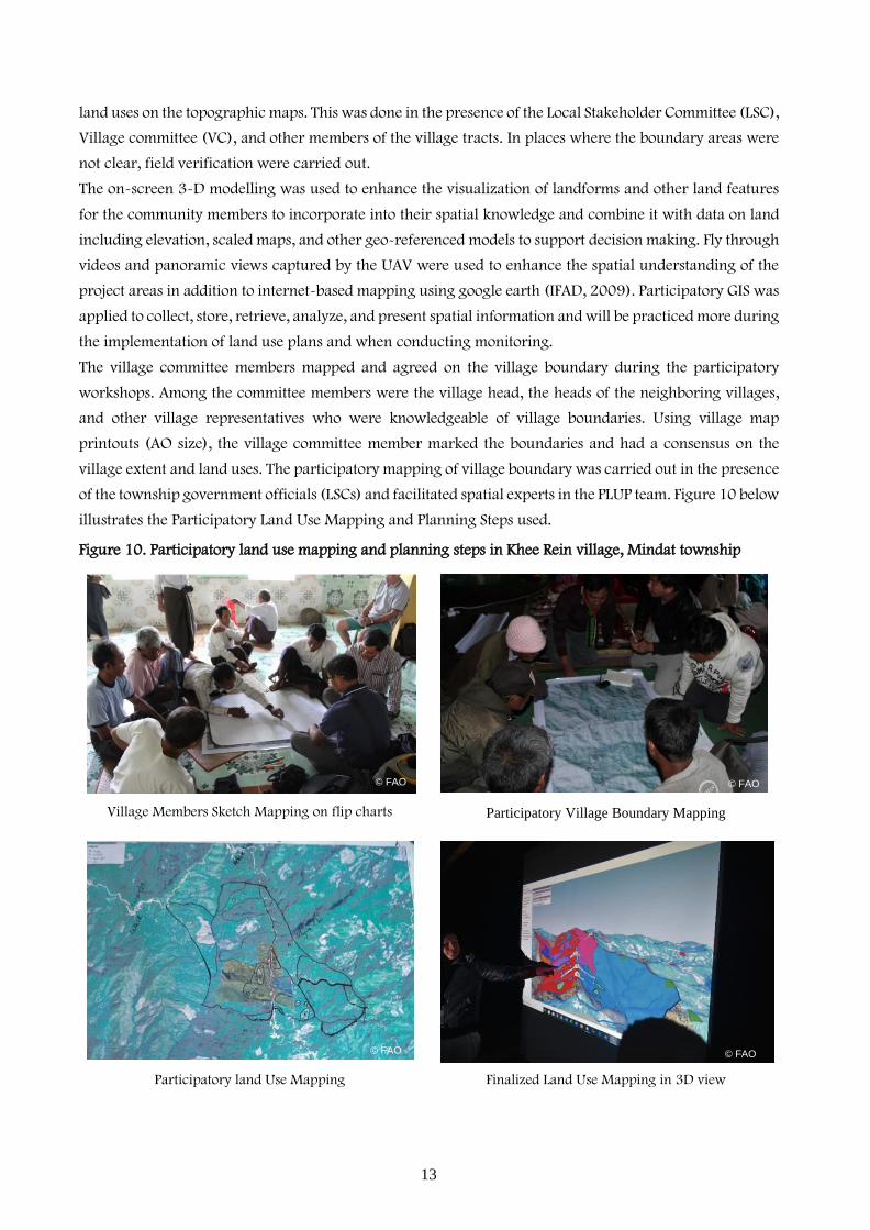
The village committee members mapped and agreed on the village boundary during the participatory
workshops. Among the committee members were the village head, the heads of the neighboring villages,
and other village representatives who were knowledgeable of village boundaries. Using village map
printouts (AO size), the village committee member marked the boundaries and had a consensus on the
village extent and land uses. The participatory mapping of village boundary was carried out in the presence
of the township government officials (LSCs) and facilitated spatial experts in the PLUP team. Figure 10 below
illustrates the Participatory Land Use Mapping and Planning Steps used.
Figure 10. Participatory land use mapping and planning steps in Khee Rein village, Mindat township
Village Members Sketch Mapping on flip charts Participatory Village Boundary Mapping
Participatory land Use Mapping Finalized Land Use Mapping in 3D view
© FAO
© FAO
© FAO
© FAO

14
When the land uses were agreed among the participants, it was marked digitally on the computer screen or
manually on the printouts for digitization. Field verification was also done to ascertain various features, tree
species, land use types, and crop varieties.
3. Results and discussion
The UAV ortho-photos generated from the mosaicked photographs, capture highly detailed ground features
to levels never witnessed before in the geospatial mapping as shown in figure 11 below, where tree species,
crop types, and farm boundaries are prominently visible. It is an extremely affordable mapping technology
when considering the resolution and the rate of areal coverages, perfectly fitting mapping and planning ate
Township and village levels. Adopting the drone technologies in land use planning improves the social
inclusion, enhances transparency, and empowers the local communities. Active participation of the local
communities using visible features captured by the drone in their own villages, drew most participants into
the whole process of land use planning as a result of the sense of achievement and recognition.
Figure 11. Section of Ortho-mosaic imagery extracted from UAV data acquired on 21/10/2019 in Labutta township
The results indicate the advantages of using UAV for participatory mapping and land use planning
capitalizing on its interactive nature, flexibility of flying, and cost effectiveness with very high geometric
accuracy and resolution that best fits village level mapping. The geospatial data generated complies with
the required data standards. In conclusion, that adoption of the UAV for PLUP process enhances the
mapping process through reduced costs, increased interactive mapping, higher resolution products,
flexibility and replicability of flying over the targets of interest.
© FAO
© FAO
© FAO
© FAO

15
Figure 12. Participatory Boundary Delineation
3.1 Final PLUP output
The final maps indicating detailed geospatial information at the village tract level was recorded for next
land use planning processes. The main next step is to compile the information collected from the local
people and land users with the current LULC, Land suitability and capability analysis results, land tenure,
and National Land Use Policy for Myanmar to come up with Draft Township and village tract land use
plans. The draft land use plans will provide the local communities with prioritized alternative land use types
for selection into the final plan through a participatory process. Figure 12 shows a digitized village
boundary and land use features presented in an on-screen 3D model to the villagers for confirmation.
Figure 13. Digitized village boundary and land use features presented in 3D model to the villagers for confirmation
The village boundary Proposed Land use
© FAO
© FAO © FAO
Data Source: Village tract boundary, village facilities and Ortho-mosaic drone imagery produced by SLM project, and Township
boundary from MIMU (http://themimu.info/gis-resources), Rapid Eye Imagery from OneMap Myanmar Project
Adapted from OneMap Myanmar Project resources including village tract boundary, village facilities and Ortho-mosaic drone imagery produced by SLM project, and
Rapid Eye Imagery.

16
3.2 Discussion
Several studies approve the usage of UAV in mapping and describe this practice as efficient, effective,
accurate, and lower cost compared to the conventional techniques. Ramadhani (2016) carried out
participatory mapping of rice field boundaries using UAV for surveying and mapping in Indonesia and
concluded that UAV usage in mapping is 70 percent cheaper compared to terrestrial method (Ramadhani,
2016). Further, Radjawali & Pye (2015) conducted a study on the usage of UAV for participatory land
mapping West Kalimantan, where the village participants identified their land properties. Sadikin et al.,
(2014) also used UAV for identifying and inventorying state assets (Sadikin et al., 2014). In view of these
studies, it is prudent to apply participatory land use planning using UAV at village tract level.
Nevertheless, the uses of UAV in land surveying and or mapping is mostly restricted to government
purposes. There is a need to formulate a flexible policy on the UAV for mapping and strict enough for
observing security measures and privacy rights.
3.2.1 Drone technology requirement in township level mapping and planning
The Townships have huge mapping and planning responsibilities and functions that can be economically
and efficiently carried out using UAV. The technical capacity required to operate township drone mapping
functions are well documented in various literatures and capacity building can be done for the local staff.
However, there is a need to carry out needs assessments before deploying drones for mapping as a best
practice and limit the social risks associated with the new UAV technology applications. In addition, the
needs assessment will help to optimize time, resources, and reduce potential tensions and or conflicts that
may include political interests (Paneque-Gálvez, J. et al., 2016). Further, before drone deployment it is
important to map key actors, establish the intended drone applications, required trainings, drone and data
ownership, data sharing arrangements, and a management plan (Vargas-Ramírez, N. et al., 2018.).
Considering the emerging requirements for drone technology at township levels and the diversity of drone
purposes, there is need for formulating regulations and guidelines for applications in resource mapping
and planning.
3.2.2 Best Practices for drone applications in mapping and planning
a) Preliminary/needs assessments:
This practice should be focused on the following;
(i) Identifying existing/past projects that benefited from or were hindered by drone applications;
(ii) Identifying the key stakeholders or actors that may be in support of or against the application
of drones and or the data collected;
(iii) Identify the Government institution mandated to control or enhance the use of drones at the
national to local levels or those institutions that manage data collected using the drones
(iv) Identify the conflicting situations that may be escalated or ameliorated in the events of drone
applications;
(v) Carry out a needs assessment and the local capacity in terms of literacy and infrastructure i.e.
internet, mobile network coverage, ICT equipment, etc.
(vi) The existing rules and regulations including the local and national legislation that may favor
and or limit drones applications in various functions.
b) Design of the mapping and planning activity:
The design determined by the following;
(i) The purpose of the UAV data and images;

17
(ii) The mapping extent and terrain characteristics are used to decide on the drone type and size;
(iii) The capacity needs of the community in acquiring, processing and analyzing UAV data and
information;
(iv) The requirement for equipment sharing and or data sharing should be drafted into agreements
between the key stakeholders
c) Implementation:
The implementation of any project involving drone application within the township or local communities
will require the following;
(i) A free explicit consent that is solicited prior to the project commencement;
(ii) The agreed mode/format of delivery and or sharing of information and data resulting from the
use of UAV.
(iii) Established data quality framework including control points for geo-referencing;
(iv) Documented needs of the township or community; either financial, Technical, or
infrastructural requirements for implementing participatory approaches for data acquisition,
processing, and analysis;
(v) The durability of the equipment (Drones) provided including its robustness in terms of repairs
and maintenance
d) Monitoring:
There should a monitoring plan determine the following;
(i) Whether the community or township expectations from drone applications are met;
(ii) Whether selected the drone type(s) corresponded with the information and data needs of the
townships while meeting the maintenance, repairs, and replacements as per the specifications.
(iii) Check for any additional requirements or improvements required in terms of equipment
(improved camera specification for multispectral sensors), applied methods or additional actors
required in order to authenticate drone data with the objective of meeting the community
interests;
(iv) Check for any changes in information and data needs
(v) Formulate any appropriate corrective measures to address potential factors that can cause
deviation from achieving township satisfaction in drone applications
e) Mitigation of negative impacts
In the course of the project implementation, there may rise unachievable expectations which may lead to
mistrust if not properly addressed. If there is lack of funds, capacity to manage drone information is
inadequate, the project leadership should timely address the issues transparently and decisively. The
decision may include project closure and documentation of lessons for future improvements
4. Conclusion
The usage of UAV in PLUP is more interactive and participatory, time and cost efficient, flexible in timing
and frequency of flying, provides data in appropriately high resolutions for village level mapping, and is
easy to learn and practice by the local technical officers. The UAV/Drone technology provides alternative
method of flexibly providing spatial data in very high spatial and temporal resolution for land use mapping
at village level with very high accuracies. The main challenge in data acquisition using the UAV is the
dynamic fluctuation of the nature of weather and topography. Further, standardization of technical factors
affecting data quality including overlap, flight speed, and height is required.
The ortho-photo produced at village level can be used for land use land cover classification by applying
segmentation methods. This data can be used to identify tree species, crop varieties, aquaculture, rice fields,

18
settlements, road networks, house yard, cultural sites, public and social facilities and utilities. The maps
showing village boundaries and land resources are a fundamental basis for achieving the objectives of
participatory land use planning at the village level. Spatial planning and land use mapping can be used
document land suitability and capability based on the historical and indigenous knowledge of the local
populations. In UAV methods for participatory land use mapping, a notification letter and holding of LSC
pre-meetings are mandatory procedures for presenting task overviews and gain permission to fly before
meeting the village level participants.

19
References
1. Anggoro, A., Siregar, V.P., & Agus, S.B. 2018. Multiscale Classification for Geomorphic Zone and Benthic Habitats Mapping Using Obia Method in Pari Island, 89–93.
2. Arfaoui, A. 2017. Unmanned aerial vehicle: Review of onboard sensors, application fields, open problems and research issues, International Journal of Image Process. 11. 12–24.
3. Colomina, I., Molina, P. 2014. Unmanned aerial systems for photogrammetry and remote sensing: a review. ISPRS Journal of Photogrammetry and Remote Sensing, 79–97.
4. Cunningham, K., Walker, G., Stahlke, E., & Wilson, R. 2011. Cadastral Audit and Assessments Using Unmanned Aerial Systems. ISPRS - International Archives of the Photogrammetry, Remote Sensing and Spatial Information Sciences, XXXVIII-1/, 213–216. http://doi.org/10.5194/isprsarchives-XXXVIII-1-C22:213–2011
5. Enemark, S., Bell, K.C., Lemmen, C., McLaren, R. 2014. Fitfor-purpose land administration. 6. IAAO. 2015. Standard on digital cadastral maps and parcel identifiers. Int. Association of Assessing
Officers (IAAO), Kansas City, MO, USA. 7. IFAD. 2009. Good practices in participatory mapping. A review prepared for International Fund for
Agricultural Development (IFAD). 8. Jazayeri, I., Rajabifard, A., Kalantari, M. 2014. A geometric and semantic evaluation of 3D data
sourcing methods for land and property information, Land Use Policy, 219–230. 9. Jiang, H., Wu, Y., Yuan, Z. 2013. Probabilistic salient object contour detection based on superpixels.
2013 IEEE International Conference on Image Processing, ICIP 2013 - Proceedings. 3069-3072. 10. Kachamba, D., J., Ørka, H., O., Gobakken, T., Eid, T., and Mwase, W. 2016. Biomass estimation using
3D data from unmanned aerial vehicle imagery in a tropical woodland, Remote Sensing, 1–18. 11. Kakaes, K., Greenwood, F., Lippincot, M., Dosemagen, S., Meier, P., Wich, S. 2015. Drones and Aerial
Observation New Technologies for Property Rights, Human Rights, and Global Development. 12. Koeva, M., Muneza, M., Gevaert, C., Gerke, M., Nex, F. 2016. Using UAV for map creation and
updating. A case study in Rwanda, Survey Review, 1–14. 13. Lukitasari F. 2017. The usability of Unmanned Aerial Vehicle (UAV) for land cadastral registration in
Indonesia, Thesis Report: GIRS-2017-20, Wageningen University and Research Centre, Laboratory of Geo-Information Science and Remote Sensing, The Netherlands August 2017. http://edepot.wur.nl/424199
14. Luo, X., Bennett, R., Koeva, M., Lemmen, C., Quadros, N. 2017. Quantifying the overlap between cadastral and visual boundaries: a case study from Vanuatu, Urban Science, 1(4), 32.
15. Manyoky, M., Theiler, P., Steudler, D., Eisenbeiss, H. 2012. Unmanned aerial vehicle in cadastral applications. In: Int. Archives of the Photogrammetry, Remote Sensing and Spatial Information Sciences, Zurich, Switzerland, 14-16 September, 1–6.
16. Maurice, M.J., Koeva, M.N., Gerke, M., Nex, F., Gevaert, C.A. 2015. Photogrammetric approach for map updating using UAV in Rwanda. In: GeoTechRwanda, Kigali, Rwanda, 18-20 November, 1–8.
17. Nicolás, V., and Jaime, P. 2019. The Global Emergence of Community Drones (2012–2017), Centro de Investigaciones en Geografía Ambiental, Universidad Nacional Autónoma de México, Antigua carretera a Pátzcuaro No. 8701, Morelia CP 58190, Michoacán, Mexico.
18. Nurdin, N., Amri, K., Djalil A.R., Jaya, I., Aris, A., and Akbar, M.A.S. 2014. Geospatial dynamic of seagrass in outer zone, Spermonde Archipelago, Indonesia using Landsat data from 1972-2013, Ocean Remote Sensing and Monitoring from Space. Proceedings of SPIE vol 92610N1, ed R .J. Frouin, D. Pan, H. Murakami and Y. B. Son (The International Society for Optical Engineering), 1–13.
19. Nurdin, N., Komatsu, T., Agus, Akbar, A.S.M., Djalil, A. R. and Amri, K. 2015. Multisensor and multitemporal data from Landsat images to detect damage to coral reefs, small islands in the Spermonde archipelago, Indonesia, Ocean Sci. J. 50, 317–25.
20. Paneque-Gálvez, J., Vargas-Ramírez, N., & Morales-Magaña, M. 2016. Uso comunitario de pequeños vehículos aéreos no tripulados (drones) en conflictos ambientales: Un factor innovador desequilibrante?, Teknokultura 2016, 13, 655–679.
21. Eisen, J., Epie, p., Ayari, I. 2019. Putting Forest Communities on the Map: Participatory Land-use planning in the Democratic Republic of Congo.
22. Ramadhani, S.A.Y.U. 2016. Using unmanned aircraft system image to support Cadastral boundary data acquisition in Indonesia, University of Twente. Retrieved from www.itc.nl/library/papers_2016/msc/la/ramadhani.pdf
23. Rijsdijk, M., Hinsbergh, W., Witteveen, W., Buuren, G., Schakelaar, G., Poppinga, G., Ladiges, R. 2013. Unmanned Aerial Systems in the Process of Juridical Verification of Cadastral Border. ISPRS-International Archives of Photogrammetry and Remote Sensing, XL(1/W2), 325–331. Retrieved from
20
http://www.uavg.org/Presentations/UAS_for_Cadastal_Applications/Rijsdijk_MUAS_in_the_process_of_juridical_verification.pdf.
24. Sadikin, H., Saptari, A.Y., & Abdulharis, R. 2014a. UAV System With Terrestrial Geo-referencing For Small Area Mapping UAV System With Terrestrial Geo-referencing For Small Area Mapping, 1–13. Retrieved from https://www.fig.net/.../TS10E_sadikin_saptari_et_al_7146.pdf
25. Sadikin, H., Saptari, A.Y., Hernandi, A., & Haris, R.A. 2014b. National’s Assets Iventory in High Density Population Using UAV Methods. Retrieved from geosmartasia.org/2014/pdf/Asep Yusof Saptari.pdf
26. Silalahi, B. J., Panjaitan, A.M., Tinus, F., & Feryandi, H. 2016. Implementing Remote Sensing and Drone Mapping Technology for Land Management in Indonesia’ s Boundary Zone, Christchurch, New Zealand. Retrieved from https://www.fig.net/resources/proceedings/fig_proceedings/fig2016/papers/ts04a/TS04A_silalahi_panjaitan _et_al_8321_abs.pdf.
27. Siregar, V.P., Wouthuyzen, S., Sunuddin, A., Anggoro, A.and Mustika, A. 2013. Shallow water habitat mapping and reef fish stock estimation using high resolution satellite data.
28. Vargas-Ramírez, N. 2018. Evaluación del Potencial de Uso de Pequeños Vehículos Aéreos no Tripulados para el Monitoreo Ambiental y la Defensa Territorial Indígena en México.
29. Waite, C. E., van der Heijden, G. M. F., Field, R. and Boyd, D. S. 2019. A view from above: Unmanned aerial vehicles (UAV) provide a new tool for assessing liana infestation in tropical forest canopies.
30. Williamson, I., Enemark, S., Wallace, J., Rajabifard, A. 2010. Land administration for sustainable development.

21
Annex 1
Figure 14. Section of drone panorama photos extracted from UAV data acquired on 24/01/2020 in Mindat Township
Figure 15. Section of Ortho-mosaic imagery extracted from UAV data acquired on 25/02/2020 in Labutta Township
Figure 16. Section of panorama photo extracted from UAV data acquired on 21/10/2019 in Labutta Township
Settlements
© FAO
© FAO
© FAO © FAO
© FAO
© FAO

22
Figure 17. Current Land Use Land Cover (LULC) Map
Adapted from SLM project resources including village Tract Boundary, current land use land cover data and Hill shade from SRTM 30.
Figure 18. Proposed land use plan resulting from the community participation
Adapted from SLM project resources including village Tract Boundary, current land use land cover data, Ortho-mosaic drone imagery and Hill shade from SRTM 30.
© FAO
© FAO

Contact information:
FAO Representation in Myanmar
United Nations Building, No. 20-25 Kyine Tone Street
Zawana Theidi Quarter, Oattara Thiri Township Nay Pyi Taw, Myanmar
http: //www.fao.org/myanmar/en CA8990EN
/1/0
9.2
0