The University of British Columbia UBC Transportation...
45
The University of British Columbia UBC Transportation Plan vancouver campus
Transcript of The University of British Columbia UBC Transportation...

The University of British Columbia
UBC Transportation Plan
vancouver c a mpus
t r a n s p o r tat i o n p l a n
1
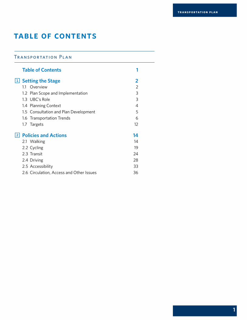
table of contents
Tr ansp ortation Pl an
Table of Contents 1
1 Setting the Stage 21.1 Overview 21.2 Plan Scope and Implementation 31.3 UBC’s Role 31.4 Planning Context 41.5 Consultation and Plan Development 51.6 Transportation Trends 61.7 Targets 12
2 Policies and Actions 142.1 Walking 142.2 Cycling 192.3 Transit 242.4 Driving 282.5 Accessibility 332.6 Circulation, Access and Other Issues 36

2
1 setting the stage
1.1overvie wThe Vision in UBC’s Strategic Plan – Place and Promise: The UBC Plan – states:
As one of the world’s leading universities, the University of British Columbia creates an exceptional learning environment that fosters global citizenship, advances a civil and sustainable society, and supports outstanding research to serve the people of British Columbia, Canada and the world.
One of the ways UBC supports this vision is through campus planning. Planning guides decision-making to support UBC’s academic mission. It also strengthens the university’s local and international cultural, economic and research contributions. And it ensures the campus is considerate of its stunning natural setting and its many neighbours.
Transportation is a key part of campus planning. An effective, accessible and flexible transportation system is incredibly important. It can save you money, improve your health, and give you more time to study, research, exercise and enjoy the beauty of UBC’s campus.
UBC is dedicated to promoting sustainable transportation options for the university community. Over the past decade, UBC has been successful in improving the transportation system for trips to and from campus. This Transportation Plan builds on that success. It is a long-term strategic plan for UBC’s Vancouver Point Grey campus that updates and replaces UBC’s 2005 Strategic Transportation Plan.
This Transportation Plan brings a new focus to on-campus transportation and consolidates existing transportation policies and actions that reside in UBC’s Land Use Plan, Vancouver Campus Plan, and Strategic Transportation Plan. The Transportation Plan also identifies gaps in these existing plans related to transportation around campus and provides new policies and actions to achieve aspirational long-term targets. The Plan may be updated from time to time as new issues and challenges emerge.
Section One – Setting the Stage – describes the plan’s scope, UBC’s planning context, the university’s role in transportation, the Transportation Plan’s consultation and development process, transportation trends, and UBC’s long-term transportation targets. Section Two – Policies and Actions – describes the detailed transportation initiatives UBC is taking in the areas of walking, cycling, transit, driving, accessibility, and circulation, service and other transportation measures.

t r a n s p o r tat i o n p l a n
3
1.2pl an scope and implementationThis Transportation Plan is for UBC’s Vancouver Point Grey campus. The Plan provides long-term strategic guidance and may be updated from time to time, in consultation with the campus and neighbouring community, to respond to changing conditions.
The actions identified in the Transportation Plan will be implemented by UBC Campus and Community Planning in collaboration with other UBC departments. Many of the actions are being implemented on an ongoing basis already. Other actions will require more detailed study and community consultation. UBC will prioritize implementation to reflect available resources, practical constraints, and data collected from transportation monitoring. Information about projects, data collection and other initiatives related to the Transportation Plan will be posted on planning.ubc.ca.
1.3ubc’s roleThere are a number of ways that UBC can influence the transportation system and travel behaviour. Some areas that are under the university’s direct control include:
• Guiding land development through planning, housing and urban design policies;
• Regulating campus streets and parking;
• Building and maintaining campus roads, sidewalks and public spaces; and,
• Educating and empowering the campus community to make sustainable transportation choices.
Other transportation issues extend beyond UBC’s boundaries and fall under regional or provincial control, such as highways and transit. For example, the BC Ministry of Transportation and Infrastructure has authority for roads such as West 16th Avenue, and TransLink has authority for public transit to, from and around campus. On these issues, UBC can improve transportation options and influence travel behaviour by being a partner, stakeholder and advocate for the campus community.
This Transportation Plan contains policies and actions to address transportation issues under both direct and regional control.
N
0 200 400100 m
0 Approx. 5 mins
East Mall
West Mall
Thun
derb
ird B
lvd
Stad
ium
Roa
d
Stud
ent U
nion
Blv
d
NW
Mar
ine
Driv
e
Uni
vers
ity B
lvd
Main Mall
Wes
t 16t
h A
venu
e
SW Marine Drive
Chan
cello
r Bou
levar
d
Acadia Road
Wesbrook Mall
UniversityEndowment
Lands
Pacific Spirit Regional Park
F r a s e r R i v e r
MOTI Roads
Student Residences
Neighbourhoods
Wesbrook Place
Hawthorn Place
East Campus
Hampton Place
Chancellor Place
UBCHospital
UBC Farm
UBC Botanical Gardens
NitobeGarden
ChanCentre
MoA
BeatyMuseum
SUBNewAMS
Thunderbird Sports Centre
WesbrookVillage
TRIUMF
Wreck BeachTrail 6
HighSchool
OldBarn
AquaticCentre
Auditorium
Bookstore
Studios
Theatre
Irving K.Barber
KoernerLibraryArt
GalleryPacific
Museum
RecitalHall
Gym
Tennis
SRC
GSAB
BrockHall
TotemPark
Thunderbird
MarineDrive
PlaceVanier
Gage
GreenCollege
St. John’sCollege
AcadiaPark
FairviewCrescent
PonderosaCommons
TrolleyBus Loop
Diesel BusLoop
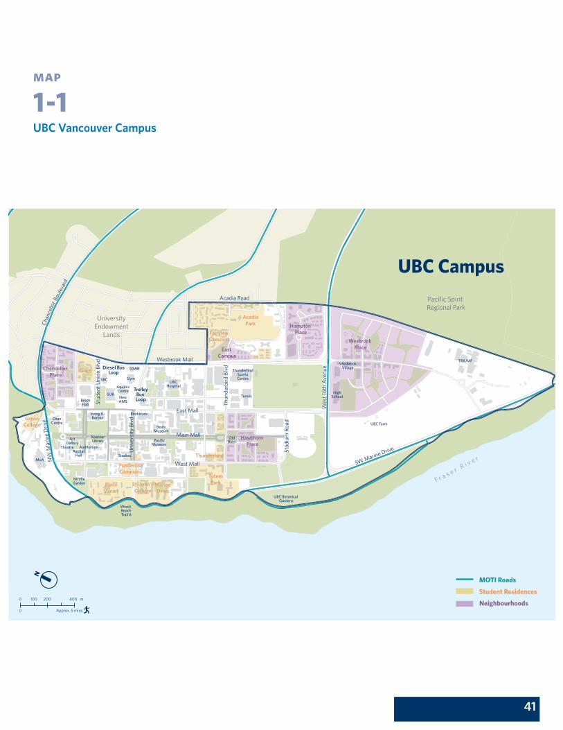
UBC Campus
UBC Vancouver Campus Map 1-1, Page 41

4
1.4pl anning conte x tUBC has a number of existing campus planning documents that contain transportation planning principles and policies. These include the UBC Land Use Plan, Vancouver Campus Plan, Neighbourhood Plans, and the 2005 Strategic Transportation Plan. These plans have resulted in a successful ‘made-at-UBC’ transportation solution that focuses on walking, cycling and public transit as the preferred options for travel to, from and around the UBC Vancouver campus. All of UBC’s plans – including this Transportation Plan – support the university’s strategic direction in Place and Promise: The UBC Plan.
Land Use PlanUBC’s Land Use Plan establishes land uses and provides policies for the development of UBC’s Vancouver Point Grey campus lands, such as supporting the development of a public transit-oriented campus community rather than one that is focused on cars. It also supports creating a pedestrian- and bicycle-friendly environment to minimize pollution and provide sustainable transportation options.
Vancouver Campus PlanUBC’s 2010 Vancouver Campus Plan guides where and how future academic activities, student housing and associated campus services will be accommodated over the following 20 years. The Vancouver Campus Plan prioritizes creating a sustainable campus that is well-connected and accessible for pedestrians, cyclists and non-motorized modes of transportation. The Plan also guides UBC’s capital investment in facilities for teaching and research, student housing, and campus infrastructure and services.
Neighbourhood PlansEach of UBC’s non-institutional neighbourhoods has a Neighbourhood Plan describing site-specific land uses, development controls, design guidelines, and servicing and transportation strategies consistent with UBC’s Land Use Plan. These plans ensure each neighbourhood has the amenities and services required to achieve a compact, transit-oriented, pedestrian-friendly community. These plans contain specific requirements for each neighbourhood and are much more detailed than the policies and actions in this Transportation Plan.
Strategic Transportation PlanUBC’s Strategic Transportation Plan is a comprehensive and integrated transportation management strategy. The Plan was first adopted in 1999 and renewed in 2005. The Strategic Transportation Plan includes a wide range of transportation initiatives intended to reduce automobile traffic, increase transit ridership and manage travel demand. To date, UBC has pursued these initiatives with considerable success, and has become a leading example of transportation demand management in the region.

t r a n s p o r tat i o n p l a n
5
Each of UBC’s existing plans undertook a comprehensive public consultation process. This Transportation Plan does not alter the transportation policies and actions in these plans, except by removing those that are now obsolete. Instead, it updates and brings these policies and actions together in one document, consolidating them for future transportation initiatives. The Transportation Plan also addresses gaps in the existing plans and policies, especially related to on-campus travel.
UBC also works with regional partners on transportation issues. The Transportation Plan reflects UBC’s place in the region by also drawing on transportation and land use plans from UBC’s regional partners, including the City of Vancouver, TransLink, Metro Vancouver and the University Endowment Lands.
1.5consultation and pl an de velopmentThe policies and actions contained in this Transportation Plan are based on existing directions, best practices from around the world, regional expertise, and public input received during a comprehensive consultation with the university community.
The public consultation process was essential to ensuring UBC’s Transportation Plan meets the campus community’s needs. Public consultation occurred between January 2013 and April 2014. It included broad notification, advertising and outreach to campus and neighbouring stakeholders over three phases:
• April 2013, Phase I: In this phase, the public was offered both online and in-person opportunities to identify issues and opportunities as they relate to on-campus transportation. Input was collected through an interactive mind map activity, an online questionnaire and feedback forms. The feedback from this phase helped identify opportunities to better address how people get around campus and informed the policy directions presented in Phase II.
• November 2013, Phase II: In this phase, the public was invited to learn more about the process of developing the Plan, and comment through both in-person and online feedback opportunities on proposed policy directions to improve on-campus transportation.
• March/April 2014, Phase III: In this final phase, a draft of the Transportation Plan was presented to the campus and neighbouring community for input. Both in-person and online feedback opportunities were offered.

6
A Transportation Plan Advisory Committee also provided invaluable stakeholder input to shape the Transportation Plan. The Committee reviewed and provided comments on community engagement and consultation, policy gaps in current plans, and proposed policy directions and actions. The Committee met ten times throughout the planning process and included representatives from the following UBC departments and campus stakeholders:
• Alma Mater Society
• Graduate Student Society
• University Neighbourhoods Association
• UBC Student Housing and Hospitality Services
• UBC Building Operations
• UBC Parking and Access Control Services
• UBC Payment and Procurement Services
• UBC Access and Diversity
• UBC Campus Mail
• UBC School of Community and Regional Planning
• UBC Properties Trust
• UBC Campus and Community Planning
• Vancouver Fire and Rescue Services
1.6tr ansp ortation trendsCampus Land Use
Land use and transportation are intimately connected. How UBC develops its campus determines where people live, work, shop, play and learn. UBC’s Land Use Plan and Vancouver Campus Plan ensure transportation and land use policies are coordinated with the goal of creating a model sustainable community.
UBC’s land use policies support building a complete academic and residential community on campus. This is reflected in how the campus lands have developed, including the growth of on-campus student and residential housing and investments to transform the academic core. These trends will continue with commitments in UBC’s Land Use Plan and Vancouver Campus Plan to improve the campus walking and cycling networks, support a diverse range of housing types, increase student housing, build K-12 schools and community centres on campus, improve recreational opportunities, and locate new residential development near shops and services. All of these land use choices will influence sustainable transportation choices.

t r a n s p o r tat i o n p l a n
7
A Growing CampusUBC’s daytime campus population – students, staff and faculty – has grown by 51% from 1997-2012, and the UBC neighbourhoods have grown to include nearly 9,000 residents as of 2013.
This growth is projected to continue. By 2021, UBC estimates the Vancouver campus will be home to approximately 22,500 residents – including 10,000 students in on-campus residences. Student enrolment is also expected to continue to grow, reaching more than 60,000 full time equivalents by 2041 and bringing corresponding growth in faculty and staff support along with new facilities for teaching, research and campus life. Additional residential housing in the university neighbourhoods is also planned; at full community build out in 2041, the total university neighbourhood population is projected to be approximately 24,000 people.
Table 1. UBC 2021/2041 Growth Projections
Projections 2021 2041Residents in UBC student accommodations 10,000 16,000 Residents in UBC neighbourhoods 12,500 24,000Student enrolment 47,294 60,294
Source: UBC Campus and Community Planning
More people living and working at UBC means adding more trips to the transportation network, but campus road space will not change significantly. In addition, the university’s neighbours in the University Endowment Lands are expected to grow over the coming years with development such as the Musqueam First Nation’s Block F proposal. For UBC’s transportation network to accommodate this growth, trips to, from and around the campus need to be shifted to walking, cycling and transit, which can be encouraged by UBC’s land use and other policies in this Plan.
70,000
52,500
35,000
17,500
0
1997 2012
FacultySta�Students
9,000
6,750
4,500
2,250
0
2009 2013
Chart 1. UBC Daytime Population Growth (Students, Staff and Faculty), 1997-2012
Source: UBC Planning and
Institutional Research
Source: UBC Campus and Community
Planning estimates. NB These figures do not
include student residents.
Chart 2. UBC Residential Population (Campus Neighbourhoods), 2009-2013

8
Transportation To and From CampusUBC has been tracking travel patterns to and from campus since 1997. These patterns are monitored through a variety of different data collection methods and described in annual Transportation Status Reports.
Since 1997 there has been a significant change in how people travel to and from UBC. The chart below shows how mode share – the relative proportion of trips by transportation mode during a particular time period – has shifted over that time period from vehicles to public transit.
Chart 3. Travel Mode Shares to and from UBC, 1997 and 2012
Source: UBC Fall 2012 Transportation Status Report
This mode share shift is also reflected in the change in daily person trips – a measure of all people arriving to and from UBC by each mode – and in daily trips per person – a measure that, unlike daily person trips, removes the impact of population growth from the calculation by looking at trips per capita.
3
1
2
3
1
2
UniversityEndowment
Lands
Pacific Spirit Regional Park
F r a s e r Ri v e r
Arterial Roads
Collector Roads
Bicycle Routes
Existing Future
Existing
Future
Existing
Existing
Secured Shared Bicycle Storage
Surface Parking
Future Infill Sites
Parkades
Regional Transit Routes
UBC Vancouver Campus
Neighbourhood Housing/Special Plan Areas
Institutional Building Footprints
N
0 300150 m
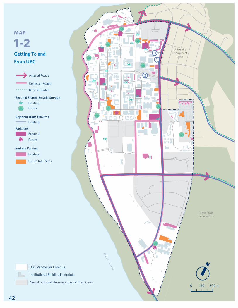
Transportation to and from UBC Map 1-2, Page 42
● Single-passenger car trips● Transit● Carpool and Vanpool● Bicycle● Walk● Other
Fall 1997
43%
34%
18%
1%3% 1%
Fall 2012
28%
14%
55%
1%1% 1%

t r a n s p o r tat i o n p l a n
9
Chart 4. Daily Person Trips to and from UBC, by mode, 1997-2012
Source: UBC Fall 2012 Transportation Status Report
Chart 5. Daily Trips per Person to and from UBC, by mode, 1997-2012
Source: UBC Fall 2012 Transportation Status Report
● Total● Transit● SOV● HOV
0
0.75
1.50
2.25
3.00
‘97 ‘99 ‘01 ‘03 ‘05 ‘07 ‘09 ‘11
● Other● Pedestrians● Bicycle
● Transit● HOV● SOV
‘97 ’98 ‘99 ’00 ‘01 ’02 ‘03 ’04 ‘05 ’06 ‘07 ’08 ‘09 ’10 ‘11 ’120
30000
60000
90000
120000
150000
10
The increase in transit mode share from 18% to 55% over this time is due to a number of factors: population growth; the 2003 introduction of the student U-Pass, which offers unlimited bus, SkyTrain and SeaBus services to all students; more transit service to and from campus; and UBC programs and policies to encourage sustainable transportation. As the chart below shows, the change is substantial: daily transit person trips to and from UBC have increased by 298% from 1997-2012.
Chart 6. Transit, Daily Person Trips to and from UBC, 1997-2012
Source: UBC Fall 2012 Transportation Status Report
The success in increasing transit mode share has contributed to a decrease in single occupancy vehicle travel to UBC. From 1997-2012, the number of daily SOV person trips has decreased 15%, even though UBC’s daytime population has grown 51% over the same time. Similarly, over the same period the number of SOV trips per person has decreased 44%. These reductions contribute to meeting UBC’s Land Use Plan target of reducing single occupant vehicle travel to and from the campus by 20% from 1996 levels.
Chart 7. SOV, Daily Person Trips to and from UBC, 1997-2012
Source: UBC Fall 2012 Transportation Status Report
60,000
50,000
40,000
30,000
20,000
10,000
0
‘97 ’98 ‘99 ’00 ‘01 ’02 ‘03 ’04 ‘05 ’06 ‘07 ’08 ‘09 ’10 ‘11 ’12
80,000
60,000
40,000
20,000
0‘97 ‘99 ‘01 ‘03 ‘05 ‘07 ‘09 ‘11

t r a n s p o r tat i o n p l a n
11
Cycling has also been declining as a method of transportation for trips to and from UBC but remains strong on campus. As the chart below shows, cycling person trips have declined by 33% from 1997-2012. This is likely a result of the shift to transit, increased housing costs close to campus, and the topography cyclists face as they travel west from the City of Vancouver.
Chart 8. Cycling, Daily Person Trips to and from UBC, 1997-2012
Source: UBC Fall 2012 Transportation Status Report
Transportation Around CampusOn-campus travel is not tracked with the same level of detail as travel to and from UBC. To improve this, the Transportation Plan commits to implementing comprehensive on-campus travel monitoring, described in more detail below. In the meantime, surveys of the campus community provide a good snapshot of travel patterns around the campus. The most recent comprehensive, representative survey took place in 2013.
Not surprisingly, as the chart below shows, walking is by far the most popular way for people to move around the campus. UBC’s Neighbourhood Plans ensure walkability is a key design principle in the campus residential communities. The university has also made significant investments in walkability in the academic core through the Public Realm Plan, which has transformed UBC’s campus. The importance of walking for on-campus travel is expected to continue thanks to these efforts, as well as the projected increase in the on-campus student and residential population. After walking, cycling accounts for the next largest portion of on-campus travel, followed by driving and public transit.
4,000
3,000
2,000
1,000
0‘97 ‘99 ‘01 ‘03 ‘05 ‘07 ‘09 ‘11
● Pedestrian● Bicycle● SOV● Transit● Other
88%
3%1% 2%
6%
East Mall
West M
all
Thunderbird Boulevard
Stadium Road
Walter Gage Road
NW Marine Drive
University Boulevard
Main M
all
West 16th Avenue
SW M
arine Drive
Chancellor Boulevard
Acadia Road
Wesbrook M
all
UniversityEndowment
Lands
Pacific Spirit Regional Park
F r a s e r Ri v e r
N
0 300150 m
Pedestrian Priority Zone
Pedestrian Paths
Existing
Future
Restricted Vehicle Access
AMS Bike Kitchen + Co-op
Greenway
Community Shuttle Route
UBC Vancouver Campus
Neighbourhood Housing/Special Plan Areas
Institutional Building Footprints
Transportation Around UBC Map 1-3, Page 43
Chart 9. Primary Mode of Travel on UBC Campus (Survey Results), 2013.
n = 1665

12
1.7targ e t sThis Transportation Plan includes targets to ensure accountability, shape decision making and inspire the community to act in ways to achieve UBC’s campus vision. The Plan retains key targets from the 2005 Strategic Transportation Plan related to the volume of daily automobile traffic and the reduction of single occupant vehicle trips, and also adds aspirational targets to increase sustainable travel to and from UBC. These targets support UBC’s overall Land Use Plan target for reducing single occupant vehicle travel to and from the campus by 20% from 1996 levels. UBC will work to meet these targets through the policies and actions identified in the Section 2.
Target 1 Sustainable Travel
These ambitious new targets reflect UBC’s sustainability goals and the university’s historic success in shifting trips to sustainable travel modes such as transit.
These mode share targets are based on a measure of all trips to and from the campus. The goal of increasing sustainable travel mirrors the City of Vancouver’s Transportation 2040 Plan and is consistent with direction in TransLink’s Regional Transportation Strategy.
It will be challenging for UBC to reach the two-thirds target by 2040. To do so requires shifting almost one-quarter of daily single and high occupancy vehicle trips to walking, cycling or transit (based on 2012 numbers). UBC believes the actions in this Transportation Plan can achieve this ambitious goal.

t r a n s p o r tat i o n p l a n
13
Target 2 Single Occupant Vehicles
These targets come from UBC’s Land Use Plan and 2005 Strategic Transportation Plan, respectively.
Since 1996, daily SOV travel in terms of person trips to and from UBC has decreased 15%, even though UBC’s daytime population has grown 51% over the same time. There is still more work to be done to reach a 20% reduction, but UBC believes the actions in this Transportation Plan will help reach this ambitious target.
The target of reducing daily SOV trips per person by 30% provides an additional measure of UBC’s success in getting people out of cars. Unlike total trips, per person trips take into account the effects of student and population growth. From 1997-2012, SOV trips per person have decreased 44% due to increases in transit usage and more people living and working on campus. By continuing to reduce SOV trips, UBC will be able to remove parking lots and repurpose land for academic facilities, housing and green space.
Target 3 Daily Private Automobile TrafficThis target is also maintained from the 2005 Strategic Transportation Plan. Private automobile traffic refers to all single and high occupancy vehicles, but excludes buses and commercial vehicles.
UBC is developing its campus as a pedestrian-friendly, transit-oriented community. Efforts such as the successful coordination of land use and transportation investments, significant investments in the public realm and pedestrian priority zones, and transportation demand management programs help reduce automobile traffic on campus roads. Reduced traffic makes it safer to walk or cycle and means less noise and emissions, resulting in a higher quality of life for people on campus.

14
2 policies and actionsThis section provides a detailed description of UBC’s Transportation Plan policies and actions for each transportation mode.
Transportation Plan policies reflect high-level principles to guide UBC’s transportation decisions. Actions are specific initiatives that UBC will take to implement the policies, to address identified policy gaps, and to meet the Transportation Plan targets described above. Throughout each section below it is clear where policies and actions are consolidated from existing transportation initiatives in UBC’s Land Use Plan, Vancouver Campus Plan and the 2005 Strategic Transportation Plan. Where new actions are included, they are identified as coming from this Transportation Plan.
This Transportation Plan’s development included identifying gaps in UBC’s existing transportation policies and actions. This work was supported through public consultation and input from the Transportation Plan Advisory Committee. The gaps identified through these processes are described in detail in each section below.
2.1walk ingBackgroundWalking is the beginning and end of almost all trips. It has important health benefits and is the cheapest and most space-efficient way to travel. It also provides opportunities for community interaction, animates public spaces, and delivers sustainability benefits. For all these reasons, UBC favours walking, along with cycling and transit, in travel to, from and around campus.

t r a n s p o r tat i o n p l a n
15
p olic y ba sisWalking Network UBC is a walking campus. The walking network – UBC’s streets, sidewalks and paths that are intended for pedestrians – is well-developed throughout most of the campus. The university has a vehicle-restricted core and parking lots located outside the campus core. The Vancouver Campus Plan established pedestrian priority zones across the campus. Walking is also made safer and more enjoyable through Land Use Plan and Vancouver Campus Plan commitments to upgrade intersections and crosswalks across the campus, and to improve greenways and pathways.
UBC’s planned land use and development will continue to improve the walking network by creating a built environment that minimizes walking distances between key destinations. For example, the Vancouver Campus Plan includes ‘mixed-use hubs’ in the academic core. The first of these hubs – Ponderosa Commons – provides student housing, teaching and learning space, and recreational and retail opportunities. Future hubs will offer the same opportunities, enlivening the campus and improving the pedestrian experience. These principles have also been applied in UBC’s neighbourhood development, which encourages walking by providing a diversity of land uses, amenities and services.
Public Realm PlanUBC’s walking network is a significant part of the university’s public realm. UBC’s public realm has been undergoing transformative change through the 2009 Public Realm Plan. The Public Realm Plan implements key directions from the Vancouver Campus Plan to create a network of outdoor public spaces that animate the campus, instill pride in the campus community, and enhance UBC’s informal educational places, among other goals. These public realm investments include the north-south corridor created by the Main Mall Greenway, where vehicles are restricted and bicycle travel speed is reduced. UBC will continue to implement the Public Realm Plan and encourage creative uses of greenways and streets.
Policy GapsDespite UBC’s walking successes, there is room for improvement. Some areas of the campus require lighting and sidewalk and pedestrian facility improvements, which UBC will continue to implement as described in the Vancouver Campus Plan. Other gaps identified in the development of this Transportation Plan are the:
• Lack of a formal commitment to support and promote campus walkability through educational programming targeted at university neighbourhoods; and,
• Need to improve east/west pedestrian connections to link key campus destinations.

16
p olic ie s and ac tionsW1. Walking Network W1.1 Favour pedestrians (along with cyclists and transit) in travel to, from and around campus.
W1.1.1 Disallow through travel in the pedestrian core by UBC vehicles. Redesign Main Mall to deter motor vehicle use. Install passable barriers in key locations on perimeter of pedestrian core to limit access to authorized vehicles only. Source: 2005 Strategic Transportation Plan
W1.1.2 Promote alternative non-automobile travel modes (walking and cycling) both generally and through the development of greenways. Source: Land Use Plan
W1.1.3 Design each neighbourhood to contain a fine-grained pedestrian and cycle route network with mid-block connections. Source: Land Use Plan
W1.1.4 Ensure the width and design of greenways gives priority to pedestrians and cyclists and, in some cases, accommodates service and private vehicles without conflict. Source: Land Use Plan
W1.1.5 Integrate the pedestrian and cyclist network with the greenway system. Source: Land Use Plan
W1.1.6 Limit vehicular access in the pedestrian priority zone to emergency and security vehicles and those with disabled access privileges. Reengineer existing roads in this area over time to emphasize the area’s pedestrian nature. Source: Vancouver Campus Plan
W1.1.7 Implement specific road, pathway and intersection improvements identified in the Vancouver Campus Plan to make walking, cycling and transit more convenient. Source: Vancouver Campus Plan

t r a n s p o r tat i o n p l a n
17
W1.2 Make the campus even safer for walking.
W1.2.1 Upgrade intersections and key marked crosswalks on campus including, as appropriate: improved illumination, raised crosswalks, median islands, flashing lights, audible and tactile indicators. Source: 2005 Strategic Transportation Plan
W1.2.2 Apply traffic calming principles, both in the residential and academic areas, to ensure the safety and attractiveness of the public realm for pedestrians and cyclists. Source: Vancouver Campus Plan
W1.2.3 Implement improved lighting that is energy efficient and dark sky friendly to improve personal safety. Source: Land Use Plan
W1.2.4 Create a map of high traffic night routes and include this information on UBC’s wayfinding websites. Source: New - Transportation Plan
W1.2.5 Implement the UBC Point Grey Campus Safety Working Group’s recommendations to improve mobility and visibility on campus. Source: New - Transportation Plan

18
W1.3 Make the campus even easier to navigate by foot.
W1.3.1 Maintain the continuity of routes for the east / west pedestrian pathways to strengthen pedestrian access through campus. Source: Vancouver Campus Plan
W1.3.2 Complete the southward greenway across West 16th Avenue and then along South Campus Road to the border with Pacific Spirit Park to provide a safe and pleasant pedestrian and cyclist link between South Campus and the Main Campus. Source: Vancouver Campus Plan
W1.3.3 In partnership with the University Neighbourhoods Association, support and develop programming for the campus community that encourages walking on campus (including elementary and secondary school trips). Source: New - Transportation Plan
W1.3.4 Identify and map the shortest and most frequently travelled routes to link key destinations on campus. Source: New - Transportation Plan
W1.3.5 Identify opportunities to implement improvements to east / west connections as part of the Public Realm Plan and as new developments and land use changes occur. Source: New - Transportation Plan
W1.3.6 Continue to develop and implement a comprehensive on-line and on-campus wayfinding system. Source: New - Transportation Plan
W2. Public Realm W2.1 Continue improving the campus public realm.
W2.1.1 Implement the Public Realm Plan to support a pedestrian-friendly campus that is animated, invigorated and lively. Source: Vancouver Campus Plan
W2.1.2 Provide a larger supply of student housing and more mixed land uses throughout the campus to support a pedestrian-friendly campus and significantly reduce the number of vehicle trips. Source: Vancouver Campus Plan
W2.1.3 Expand the network of weather-protected walking routes criss-crossing campus. Source: Vancouver Campus Plan

t r a n s p o r tat i o n p l a n
19
2.2c yclingBackgroundFor many people, cycling is a fast, fun, affordable and healthy way to travel. There is mounting evidence that cycling provides benefits for the economy, the environment and individual and community health. In recognition of these benefits, UBC favours cycling, along with walking and transit, in travel to, from and around campus.
p olic y ba sisCycling NetworkUBC’s relatively large campus and gentle topography makes cycling an ideal transportation mode. Cycling routes are most useful when they form a network of direct and convenient connections to important campus destinations like housing, shops, sports facilities, libraries, and residential neighbourhoods. A good cycling network is also well lit at night, clearly identified through appropriate signage and lane markings, maintained over time, and linked to neighbouring cycling networks.
UBC’s planning documents commit to making the campus safer and more comfortable for cyclists by enhancing the cycling network. This includes specific commitments in the Vancouver Campus Plan to improve pathways and intersections for cycling, as well as the 2005 Strategic Transportation Plan commitment to include bicycle lanes on all major roads on campus. University Boulevard, for example, was converted to a two-lane cross section with bicycle lanes in both directions, and Main Mall has been converted to a bicycle- and pedestrian-only area, where motor vehicle traffic is restricted.
Cycling FacilitiesFacilities that make it easy and safe to cycle encourage more people to get on a bicycle. These facilities include secure places for short- or long-term bicycle storage, such as bicycle racks at a building entrance, bicycle cages in a parkade or a bicycle locker at a residence hall. They also include end-of-trip facilities such as lockers and showers. The Vancouver Campus Plan commits to enhancing all of these cycling facilities at UBC to encourage cycling to, from and around the campus.
Cycling AccessEnhancing cycling access also helps encourage cycling at UBC. TransLink buses accommodate bicycles so cyclists can travel longer distances by combining cycling and transit. This can help overcome barriers to cycling, like UBC’s topography or Vancouver’s rain. The Vancouver Campus Plan also commits to improving cycling access by exploring the development of a public bicycle sharing system on campus. Bicycle sharing provides the convenience and

20
benefits of cycling without the need to own a bicycle or ride to and from UBC. Development of a UBC bicycle sharing system would include consultation with the university community and the University Neighbourhoods Association.
Policy GapsThere is still room for improvement to increase cycling to, from and around UBC. Most importantly, a comprehensive campus cycling network needs to be completed. While many of UBC’s campus cycling routes are appropriate for people already comfortable riding in traffic, a complete network would make cycling at UBC a safe, convenient, comfortable and fun experience for people of all ages and abilities. UBC will continue to implement policies and actions from existing planning documents to improve the cycling network. Other gaps identified in the development of this Transportation Plan are the:
• Need to more effectively manage cyclist and pedestrian behaviour and interactions, in particular within the pedestrian priority zone;
• Need for a formalized cycling network map showing a complete cycling network;
• Importance of establishing that vehicles such as electric-assisted bicycles, scooters or skateboards are allowed in pedestrian priority zones, and informing the university community that they are subject to the same behaviour expectations as cyclists; and,
• Importance of establishing that electric vehicles with license plates are considered motorized vehicles and are subject to the same enforcement protocol as all other motorized vehicles on campus (i.e. ticketing and fines).
t r a n s p o r tat i o n p l a n
21
p olic ie s and ac tionsC1. Cycling Network C1.1 Favour cyclists (along with pedestrians and transit) in travel to, from and around campus.
C1.1.1 Promote alternative non-automobile travel modes (walking and cycling) both generally and through the development of greenways. Source: Land Use Plan
C1.1.2 Design each neighbourhood to contain a fine-grained pedestrian and cycle route network with mid-block connections. Source: Land Use Plan
C1.1.3 Ensure the width and design of greenways gives priority to pedestrians and cyclists and, in some cases, accommodates service and private vehicles without conflict. Source: Land Use Plan
C1.1.4 Integrate the pedestrian and cyclist network with the greenway system. Source: Land Use Plan
C1.1.5 Implement specific road, pathway and intersection improvements identified in the Vancouver Campus Plan to make walking, cycling and transit more convenient. Source: Land Use Plan
C1.2 Create a complete, safe cycling network to accommodate cyclists of all ages and skill levels.
C1.2.1 Ensure bicycle lanes on all major roads on campus. Source: 2005 Strategic Transportation Plan
C1.2.2 Ensure shared wide travel lanes on Marine Drive between West Mall and West 16th Avenue. Source: 2005 Strategic Transportation Plan
C1.2.3 Work with the University Endowment Lands, the City of Vancouver, and the Ministry of Transportation and Infrastructure to ensure route planning for bicycles and pedestrians is supportive and consistent with other routes being planned outside the Land Use Plan area. Source: Land Use Plan

22
C1.2.4 Plan school sites to be accessible from an extension of the greenway to enhance pedestrian and cyclist access. Source: Land Use Plan
C1.2.5 Complete the South Campus Greenway to provide people with a pedestrian and cycling connection between Pacific Spirit Park and Southwest Marine Drive, ensuring a clear distinction between public and private functions in the area. Source: Vancouver Campus Plan
C1.2.6 Identify and fill gaps in the cycling network as land use changes and future development occur. Source: New - Transportation Plan
C1.3 Ensure everyone shares the cycling network safely.
C1.3.1 Develop a comprehensive signage and education plan to promote safe cycling on campus, including installing “slow cycling” signage in key areas such as pedestrian priority zones. Source: New - Transportation Plan
C1.3.2 Establish that electric vehicles with license plates are considered motorized vehicles and are subject to the same enforcement protocol as all other motorized vehicles on campus (i.e. ticketing and fines). Source: New - Transportation Plan
C1.3.3 Establish that electric vehicles (such as electric-assisted bicycles, scooters or skateboards) are allowed in pedestrian priority zones and are subject to the same behaviour expectations as cyclists in the pedestrian priority zones. Source: New - Transportation Plan
C1.3.4 Increase driver awareness of cyclists through signage, road markings and promotional campaigns. Source: New - Transportation Plan
C1.3.5 Provide opportunities for the UBC community to engage in cycling skills training and road safety programs provided internally and by external partners. Source: New - Transportation Plan

t r a n s p o r tat i o n p l a n
23
C2. Cycling Facilities C2.1 Provide excellent bicycle parking and end-of-trip facilities across campus.
C2.1.1 Cover a minimum of 25% of UBC’s bicycle racks. Source: 2005 Strategic Transportation Plan
C2.2.2 Create an end-of-trip facilities plan for secure bicycle parking and amenities. Source: Land Use Plan
C2.2.3 Improve campus cycling facilities through increased secure storage and better route mapping and wayfinding. Source: Vancouver Campus Plan
C2.2.4 Increase end-of-trip facilities for cyclists through the requirement for all new academic buildings and mixed use hubs to provide lockers, showers and covered secure bicycle storage in scale with the facility’s floorspace. Source: Vancouver Campus Plan
C2.2.5 Prioritize investments in improved route mapping, pavement markings, more bicycle racks and secure parking either under cover or in parkades. Source: Vancouver Campus Plan
C3. Cycling Access C3.1 Make it easier to cycle to, from and around campus.
C3.1.1 Explore the development of a public bicycle sharing system on campus. Source: Vancouver Campus Plan
C3.2.2 Develop a map to show the cycling network to, from and around campus. Source: New - Transportation Plan
24
2.3tr ansitBackgroundPublic transit is essential to the region’s economic, environmental and social development. It greatly extends the network and distance for a person to walk or cycle. It also provides a sustainable and cost-effective transportation option for a large number of people, especially students. And it reduces congestion for both people and goods movement by providing an alternative to driving. UBC will continue to favour transit, along with walking and cycling, in travel to, from and around campus.
p olic y ba sisTransit NetworkTransit is UBC’s biggest transportation success story and biggest challenge. Major increases in transit ridership to and from UBC have reduced vehicles on campus and emissions associated with travel. However, the demand for transit services to UBC exceeds capacity and passengers are routinely passed up or face long lineups to board.
The transit network servicing UBC features a range of services: community shuttles which circulate around the campus and connect key destinations; local bus routes with service into surrounding Vancouver neighbourhoods; and express bus services like the 99 B-Line which offer more direct connections to regional destinations and rapid transit stations.
Public transit decisions are under the control of TransLink, Metro Vancouver’s regional transportation authority. Through the Land Use Plan and Vancouver Campus Plan, UBC has committed to working with TransLink to improve UBC’s transit network. These efforts include developing streets and facilities to accommodate transit, protecting corridors for future routes and stations, and making transit-supportive land-use decisions such as locating high-use campus facilities in close proximity to transit.
UBC is also committed to advancing improvements to the local and regional transit network. This includes optimizing on-campus shuttle routes, as was done with an improved community shuttle route introduced in 2013 to better utilize transit resources and service rapidly changing areas of the campus. This work also includes advocating for expanded transit service to the campus, with the goal of implementing rapid transit to UBC.
Transit Facilities and ImpactsHigh quality facilities improve the transit experience and encourage people to take transit. Both the 2005 Strategic Transportation Plan and the Vancouver Campus Plan commit UBC to improving transit facilities. Examples of this range from the small – installing new bus shelters on University Boulevard – to the very large – creating a space for a permanent diesel bus terminal on campus.
t r a n s p o r tat i o n p l a n
25
Policy GapsThe most significant gap in transit to, from and around UBC is due to demand overwhelming transit network capacity. UBC will continue to work with TransLink on solutions to this gap. Demand will be alleviated in part through plans to increase the on-campus student and residential population. However, to meet existing demand and support UBC’s long-term goals, more transit service and new investment is needed. Other gaps identified during development of this Transportation Plan are the:
• Lack of a UBC policy to determine the location of community shuttle stops across the campus; and,
• Lack of a UBC policy on the provision of bus shelters across the campus.
p olic ie s and ac tionsT1. Transit NetworkT1.1 Favour transit (along with cyclists and pedestrians) in travel to, from and around campus.
T1.1.1 Continue to support the student U-pass program. Source: 2005 Strategic Transportation Plan
T1.1.2 Support the regional emphasis on the development of a transit-oriented and automobile-restrained transportation system. Source: 2005 Strategic Transportation Plan
T1.1.3 Locate higher density development in proximity to transit service. Source: 2005 Strategic Transportation Plan
T1.1.4 Plan transit systems in conjunction with land use to provide access throughout both the campus and residential areas. Source: Land Use Plan
UBC-Broadway LineBus service in the UBC-Broadway Corridor cannot meet current transportation demands and will only become more strained with population and employment along the corridor projected to nearly double over the next 30 years. A rail-based rapid transit line all the way to UBC is needed to meet the Broadway corridor’s transit demands. Importantly, rapid transit would connect UBC, one of the province’s key innovation and employment hubs, to the rest of the region.
More information on the UBC-Broadway Line project is available at planning.ubc.ca.

26
T1.2 Advance ongoing improvements to local and regional transit.
T1.2.1 Support TransLink initiatives to increase the accessibility of the campus by transit from elsewhere in the Lower Mainland. Source: Land Use Plan
T1.2.2 Work to ensure UBC will be the destination of better more effective transit service. Source: Land Use Plan
T1.2.3 Focus most transit service on the transit terminal, with other routes to ensure convenient access to the campus. Source: Land Use Plan
T1.2.4 Develop, in conjunction with TransLink, on-campus shuttle bus routes that provide convenient coverage to all parts of the campus, and adjust routes from time-to-time. Source: Land Use Plan
T1.2.5 Continue to schedule classes and activities, within UBC’s institutional constraints, to reduce the peak demands on transit. Source: Land Use Plan
T1.2.6 Locate facilities with high use such as the SUB and mixed use hubs in close proximity to transit shuttle routes. Source: Vancouver Campus Plan
T1.2.7 Work with TransLink on increasing and revising the routes of community shuttle services to better fit with the evolving campus structure and transit demand. Source: Vancouver Campus Plan
T1.2.8 Work with TransLink to locate community shuttle stops and bus shelters to optimize service and encourage use. Source: New - Transportation Plan

t r a n s p o r tat i o n p l a n
27
T1.3 Support the development of rapid transit to UBC.
T1.3.1 Design a below-grade transit station to be compatible with future rapid transit. Source: 2005 Strategic Transportation Plan
T1.3.2 Plan for the provision of new transit facilities such as high capacity transit to UBC. Source: Land Use Plan
T1.3.3 Support, with Metro Vancouver, the extension of higher capacity transit service to the campus and plan for the redevelopment of UBC’s transit terminal to accommodate this service. Source: Land Use Plan
T1.3.4 Work with regional partners and senior levels of government to expand rapid transit service all the way to UBC, including examining innovative funding mechanisms. Source: New - Transportation Plan
T2. Transit Facilities and Impacts
T2.1 Improve transit facilities and reduce transit-related impacts.
T2.1.1 Encourage TransLink to use quiet, clean fuel vehicles for community shuttles, and quieter diesel and alternative fuel buses. Source: 2005 Strategic Transportation Plan
T2.1.2 Attempt to reduce the impact of bus noise on campus and in neighbourhoods adjacent regional bus routes. Source: 2005 Strategic Transportation Plan
T2.1.3 Work with the campus community, TransLink and the provincial government to create permanent trolley and diesel bus facilities, and the future rapid transit station close to the University Boulevard Neighbourhood. Source: Vancouver Campus Plan
T2.1.4 Provide safe, accessible, weather protected, convenient and attractive transit facilities. Source: Vancouver Campus Plan

28
2.4drivingBackgroundDriving plays an important role in moving people and goods. But it also requires significant space, contributes to congestion, and has the largest environmental impact trip of the transportation modes detailed here. Reducing driving provides important benefits by creating more space for transit as well as cars and trucks that need to be on the road, such as vehicles moving goods, making deliveries or responding to emergencies. Although driving will continue to play a role at UBC, the university is committed to restraining automobile use in favour of walking, cycling and transit.
p olic y ba sisRoad NetworkUBC’s planning policies seek to reduce single occupant vehicles commuting to and from the university and restrain driving on campus. This policy direction is implemented through measures in the Land Use Plan and Vancouver Campus Plan. These include the Land Use Plan target for reducing single occupant vehicle travel to and from the campus by 20% from 1996 levels, which UBC has accomplished on an annual per person basis and continues to work to achieve in terms of total SOV trips. These measures also include support for telecommuting and incentives for carpooling. In addition, UBC implements traffic calming measures such as road, pathway and intersection improvements to reduce travel speeds and accident volumes. The result is reduced traffic on campus and improved safety and comfort for walking, cycling and transit, in addition to contributing to a sense of place at UBC.
UBC’s land use planning also contributes to restraining driving on campus. As the on-campus community continues to grow, the need to travel off campus for services and amenities will decrease. To this point UBC has been successful in accommodating a growing population without increasing private vehicle volume. Other directions in the Land Use Plan and Vancouver Campus Plan that impact driving include reengineering roads to be shared streets with paving and other features to offer visual cues for pedestrian priority, designating pedestrian priority zones, and transportation demand management programs like those described above.
Of course, driving can be a necessity. UBC community members with disabilities or mobility impairments must be assured of equal access to all the university offers. UBC’s large campus requires delivery of goods from the outside world and efficient service routes. And emergency responders need access to all areas of UBC in case people on campus need help. These issues are addressed in more detail in the ‘Accessibility’ and ‘Circulation, Access and Other’ sections below.

t r a n s p o r tat i o n p l a n
29
ParkingParking availability and pricing is one of the biggest influences on driving mode share. UBC has a relatively constrained parking supply that will decrease in coming years as surface parking lots continue to be converted to new academic and housing facilities, as described in the Vancouver Campus Plan. Campus parking prices will continue to be used to influence parking demand. This will make alternative modes of transportation such as transit more cost-effective and attractive, helping to reduce driving to and from UBC.
Car Sharing and Electric VehiclesCar sharing programs provide convenient, cost-effective vehicle access and free up road and parking space for other users. Recent partnerships with car share providers have improved transportation options for students, staff, faculty and residents. This is a relatively new area for UBC, as the policy gap below makes clear, but one where there are opportunities for continued success, such as working with the University Neighbourhoods Association to ensure an integrated campus-wide car sharing network. Similarly, expanding electric vehicle charging stations through UBC’s parking facilities and neighbourhood development provides an alternative to traditional single occupancy vehicles on campus.
Policy GapsThe development of this Transportation Plan identified the following policy gaps around driving on campus:
• Unclear communication of UBC’s land use and transportation visions for the campus;
• Need to discourage off-campus, on-street parking in neighbourhoods adjacent to the university in order to meet UBC’s transportation and sustainability goals;
• Lack of enforcement of restricted vehicle access in UBC’s pedestrian priority zones; and,
• Limited policies and programs in relation to car-sharing on campus.
p olic ie s and ac tionsD1. Road NetworkD1.1 Restrain automobile use on campus, especially single occupancy vehicles.
D1.1.1 Encourage single occupancy vehicle commuters to shift to carpooling and vanpooling. Source: 2005 Strategic Transportation Plan
D1.1.2 Adopt policies that favour higher occupancy vehicles (carpool/vanpool). Source: Land Use Plan

30
D1.1.3 Advance opportunities for telecommuting where possible. Source: Land Use Plan
D1.1.4 Maintain measures to encourage carpooling (e.g. transferable parking passes). Source: Vancouver Campus Plan
D1.1.5 Reduce the need to travel off campus by providing a broader range of services for daily convenience, social and recreational needs. Source: Vancouver Campus Plan
D1.1.6 Ensure destinations for vehicles travelling to UBC are located at the perimeter of the campus, in structured parkades or below grade parking facilities, with the exception of vehicles with disabled access privileges. Source: Vancouver Campus Plan
D1.1.7 Collaborate with UBC Properties Trust, developers, realtors and other stakeholders to communicate UBC’s land use and transportation visions. Source: New - Transportation Plan
D1.2 Ensure everyone shares the road network safely.
D1.2.1 Apply traffic calming principles, both in the residential areas and in the academic areas, to ensure the safety and attractiveness of the public realm for pedestrians and cyclists. Source: Land Use Plan
D1.2.2 Implement road and intersection improvements to improve safety for pedestrians and cyclists and create a better sense of place for the campus. Source: Vancouver Campus Plan
D1.2.3 Over time, reengineer portions of the roads bordering or running through the pedestrian priority zone to be ‘shared streets’ so the paving and other design features give visual clues for pedestrian priority. Source: Vancouver Campus Plan
D1.2.4 Discourage commuter vehicle use of ‘shared streets’. Source: Vancouver Campus Plan
D1.2.5 Work with provincial authorities to implement traffic management initiatives with the purpose of reducing speeds and accidents and improving wayfinding. Source: Vancouver Campus Plan
D1.2.6 Undertake a visioning and design process for Wesbrook Mall. Source: New - Transportation Plan

t r a n s p o r tat i o n p l a n
31
D1.3 Enforce restricted vehicle access in pedestrian priority zones.
D1.3.1 Develop and implement a permitting and citation process for vehicles in pedestrian priority zones. Source: New - Transportation Plan
D2. ParkingD2.1 Use parking costs and measures to support reduced single occupancy vehicle usage.
D2.1.2 Index minimum daily parking prices to transit fares (twice the one zone adult cash fare). Source: 2005 Strategic Transportation Plan
D2.1.3 Provide any additional parking in neighbourhood housing areas at an additional cost to residents. Source: 2005 Strategic Transportation Plan
D2.1.4 In neighbourhood housing areas, accommodate parking primarily underground. Source: Land Use Plan
D2.1.5 Continue to reduce the amount of commuter parking. Source: Land Use Plan
D2.1.6 Discontinue the use of surface parking lots over time by converting them to future academic building sites or other interim uses, such as recreational areas. The loss of approximately 500 surface stalls can be accommodated by existing parkades. Source: Vancouver Campus Plan
D2.1.7 Should it be needed, accommodate additional on campus parking in new parking structures at two locations: • An academic building at the corner of Main Mall and Agronomy Road; and, • In the south campus research precinct. Additional parking will only be constructed once surface lots are used as infill sites for future academic facilities. Source: Vancouver Campus Plan
D2.1.8 Discourage off campus, on-street parking in adjacent university neighbourhoods by collaborating with partner organizations and sharing information online and through social media channels. Source: New - Transportation Plan

32
D2.1.9 Collaborate with the University Neighbourhoods Association to harmonize campus parking regulations and reduce incentives to drive. Source: New - Transportation Plan
D2.2 Reduce traffic and parking impacts from special events.
D2.2.1 Share information about parking options, parking regulations and alternative modes of travel to and from campus for special events, in addition to event-related traffic management. Source: New - Transportation Plan
D3. Car Sharing and Electric VehiclesD3.1 Support car sharing and electric vehicles as alternatives to conventional single occupancy vehicles.
D3.1.1 Expand car sharing parking locations across campus to meet demand. Source: New - Transportation Plan
D3.1.2 Expand electric vehicle charging stations in academic and residential areas. Source: New - Transportation Plan

t r a n s p o r tat i o n p l a n
33
2.5acce ssib il it yBackgroundAccessibility ensures people can participate equally regardless of their physical, sensory or cognitive abilities. Transportation accessibility is about creating a barrier-free transportation system. At UBC, the challenges faced by people with disabilities include: long distances between buildings on a large campus; a complicated network of informal and formal pedestrians routes; a major slope rising from West Mall to Main Mall; limited parking and vehicle access in the campus core; access barriers to some main entrances, particularly in older buildings. UBC addresses these challenges and improves transportation accessibility by building the campus to the standards of universal design.
p olic y ba sisUniversal Design UBC’s goal is to create a barrier-free environment. This means going beyond basic regulatory compliance and encouraging the application of universal design principles in the planning and designing of all new facilities on campus. UBC’s Land Use Plan and Vancouver Campus Plan reflect this commitment by ensuring the university creates a network of buildings and outdoor spaces that allow equal access to all people.
Recent upgrades through the Public Realm Plan have significantly improved accessibility on campus, as has the completion of phase one of UBC’s first mixed-use hub, Ponderosa Commons. These initiatives help to address the issues described above: access barriers to older buildings; complicated pedestrian routes; and the steep slope rising from West Mall to Main Mall. Continued investments in the public realm and future mixed-use hubs will continue to improve campus accessibility.
Accessible ParkingDesignated accessible parking allows persons with disabilities easier access to buildings and community services. The introduction of pedestrian priority zones and removal of surface parking lots to support a walking campus have resulted in decreased parking on campus. To ensure all buildings are easily accessed by persons with disabilities, the Vancouver Campus Plan requires new buildings have access to accessible parking. As the policy gap below makes clear, more work is necessary to make sure UBC is meeting the accessible parking needs of campus visitors with disabilities.

34
Policy GapsThe Transportation Plan development process identified the following policy gap around campus accessibility:
• Need for improving the availability of accessible parking across the campus, and to provide better information about accessible parking for major events (e.g. graduation).
p olic ie s and ac tionsA1. Universal DesignA1.1 Integrate universal design principles at all stages of the planning and development process.
A1.1.1 Create a physically accessible campus, with a substantially improved pedestrian experience and integrated universal design. Source: Land Use Plan
A1.1.2 Locate new buildings to provide direct access for people with disabilities to the pedestrian and cycling network. Source: Vancouver Campus Plan
A1.1.3 Create a linked network of facilities and pathways that welcome equal participation by people with disabilities. Source: Vancouver Campus Plan
A1.1.4 Limit vehicular access in the pedestrian priority zone to emergency and security vehicles and those with disabled access privileges. Source: Vancouver Campus Plan
A1.1.5 Clearly label pedestrian and vehicular routes to define the spatial structure of the campus and clarify movement and direction for those with visual impairments and learning disabilities. Source: Vancouver Campus Plan
A1.1.6 Require new projects to provide weather protection at major and minor building entries. Source: Vancouver Campus Plan
A1.1.7 Require all new and renovation projects on east/west pedestrian routes between West and Main Mall to provide generous flat areas with rain protection for persons with disabilities making their way up the steep slopes. Source: Vancouver Campus Plan

t r a n s p o r tat i o n p l a n
35
A2. Accessible ParkingA2.1 Ensure barrier-free accessible parking on campus.
A2.1.1 Provide accessible parking spaces to BC Building Code standards on-site or within 100 metres of all new buildings. Source: Vancouver Campus Plan
A2.1.2 Review existing parking stalls to ensure barrier-free access to neighbouring buildings and payment machines. Source: New - Transportation Plan
A2.1.3 Evaluate the current accessible parking supply against expected future demand. Source: New - Transportation Plan
A2.1.4 Improve information sharing about parking on campus, particularly for major events (e.g. graduation). Source: New - Transportation Plan
2.6circul ation , acce ss and other issue sBackgroundThis section includes a number of policies and actions that cut across transportation modes. A functional transportation system needs to circulate people through the transportation network efficiently and effectively. The transportation system also needs to provide appropriate access routes and loading areas for deliveries, services and emergency vehicles. As part of this, the impacts from heavier vehicles like delivery and construction trucks need to be mitigated to ensure livability and transportation safety. Finally, monitoring is an essential element of any planning process and provides the data needed to identify challenges, measure success, and adjust plans as necessary.
p olic y ba sisCirculation Management As the number of faculty, staff, students and residents who live, work and play at UBC grows, so too will the demands on UBC’s transportation system. The policies and actions presented earlier in this Plan set a framework for ensuring the campus transportation system functions well and supports UBC’s vision of being a model sustainable community. This section of the Transportation Plan builds on these initiatives to improve circulation by ensuring better coordination and management for other traffic on campus, such as deliveries, tour and athletics buses, and special event traffic. Communicating with visitors to UBC about where and when to travel will help reduce unnecessary use of the road network and respond to the policy gaps identified below.

36
Service and Emergency AccessRecent changes to UBC’s academic core have had a profound impact on campus access. The heart of campus is now a pedestrian priority zone. Bollards have been installed at entry points to the campus walking network and a number of parking lots have been eliminated across campus. These changes reflect the Vancouver Campus Plan direction and have strengthened the sense of place on campus.
At the same time, UBC’s own operations staff and partner agencies like the RCMP and Vancouver Fire Department require appropriate access routes to all buildings on campus in order to keep UBC functioning and safe. The Vancouver Campus Plan provides detailed service and emergency routes for UBC’s campus. To ensure these routes are effective and continue to be maintained, UBC will audit service access and ensure ongoing communication with emergency responders about access routes. The university will also promote on-campus mail services to reduce demand for outbound courier deliveries, thus reducing traffic to and from the campus.
Other Issues – Heavy TrucksHeavy trucks such as construction vehicles travel to and from UBC on a daily basis, largely due to the construction of new academic facilities. Heavy truck traffic to UBC has often exceeded the daily targets included in the 2005 Strategic Transportation Plan. This is because UBC has little control over the timing and availability of capital funding for new academic facilities, which depends on major investment in higher education by the provincial and federal governments. As a result, this Transportation Plan continues work with UBC’s neighbours to minimize the impacts of trucks to, from and around campus, while replacing the 2005 truck targets with revised actions that focus UBC’s efforts on further reducing waste material from campus projects. This approach ensures UBC continues to build needed teaching and research facilities and retains its place as one of the world’s leading universities.
Other Issues – Transportation Monitoring Monitoring transportation patterns and behaviour is essential to identifying trends, assessing investment impacts, and measuring progress towards achieving the Transportation Plan targets. UBC has monitored annual travel patterns to and from the campus since 1997 through a variety of different data collection methods. The majority of the data are collected during the fall which provides a consistent basis for year-by-year comparisons of the travel patterns, mode shares and traffic volumes. UBC is committed to continuing to monitor this data as shown in the table below. This monitoring allows for an iterative process, where plans, policies and actions can be modified as necessary in the face of changing conditions or new information.

t r a n s p o r tat i o n p l a n
37
Table 2. UBC’s Annual Transportation Data Collection
Data Collection Activity Locations DescriptionScreenline traffic counts Screenline Automatic counters on road for
7 days, 24 hours / day Campus traffic counts Roads through-
out campus Automatic counters (tubes) on road for a minimum of 48 hours
Intersection counts Intersections throughout campus
Manual observation for 8 hours (3 in AM, 2 in midday, 3 in PM) for one day
Vehicle classification and occupancy
Screenline Manual observation for 8 hours (3 in AM, 2 in midday, 3 in PM) for one day
Transit Ridership Screenline Manual observation from 6:00 AM to 4:30 PM for one day
Bicycles and Pedestrians Screenline Manual observation for 8 hours (3 in AM, 2 in midday, 3 in PM) for one day
Heavy construction trucks All construc-tion projects
Weekly reports from contractors for entire year, verified with periodic audits / counts
Heavy non-construction trucks
Screenline Manual observation for 12 hours for one or more days
Policy Gaps Along with the issues described in the section above, the Transportation Plan development process identified the following policy gaps around circulation, access and other issues:
• Circulation:
» Lack of formalized routes or designated parking for tour buses on campus.
• Access:
» Confusing service vehicles access and parking given changes to the public realm and implementation of the pedestrian priority zone.
» Lack of up-to-date access information for emergency responders coming to campus.
• Other:
» Inability to meet aspirational truck targets contained in the 2005 Strategic Transportation Plan.
» Limited data about on-campus transportation patterns and behaviours.

38
p olic ie s and ac tionsCAO1. Circulation ManagementCAO1.1 Clearly communicate preferred transportation routes and parking options to minimize on campus congestion.
CAO1.1.1 Reduce trips to, from and around campus and optimize delivery times through: • Better promotion of existing campus mail services; • Increased use of the “UBCBuySmart” online purchasing system; and, • Other appropriate channels. Source: New - Transportation Plan
CAO1.1.2 Create a delivery access map with details for the entire campus and include this information on UBC’s wayfinding websites. Source: New - Transportation Plan
CAO1.1.3 Identify, map and publicize preferred bus routes and parking locations to reduce impacts on outdoor spaces, and reduce traffic congestion on campus roads. Source: New - Transportation Plan
CAO1.1.4 Coordinate with UBC Athletics to disseminate information to athletics bus operators. Source: New - Transportation Plan
CAO2. Service and Emergency AccessCAO2.1 Ensure all buildings on campus have appropriate service access.
CAO2.1.1 Ensure service vehicles use the service routes identified in the Vancouver Campus Plan (Map 2-8) in order to improve efficiency and reduce emissions. Use of service routes inside the pedestrian priority zone will require authorization from UBC. Source: Vancouver Campus Plan
CAO2.1.2 Limit vehicular access in the pedestrian priority zone to emergency and security vehicles with disabled access privileges. Reengineer existing roads in this area over time to emphasize the area’s pedestrian nature. Source: Vancouver Campus Plan
CAO2.1.3 Conduct an audit of service access, led by UBC Parking. Source: New - Transportation Plan

t r a n s p o r tat i o n p l a n
39
CAO2.2 Ensure emergency access routes exist and are well communicated.
CAO2.2.1 Allow emergency vehicles to access all roads and buildings on campus. Source: Vancouver Campus Plan
CAO2.2.2 Install passable barriers in key locations around the pedestrian core to provide access for emergency, security and other authorized vehicles but limit access by other vehicles. Source: Vancouver Campus Plan
CAO2.2.3 Provide up-to-date information to emergency responders on any changes to building access and transportation networks on campus. Source: New - Transportation Plan
CAO3. Other – Heavy Trucks
CAO3.1 Minimize the impacts of truck travel to, from and around campus.
CAO3.1.1 Encourage trucks travelling to and from UBC to only use designated truck routes (provincial highways and City of Vancouver truck routes). Source: 2005 Strategic Transportation Plan
CAO3.1.2 Address truck travel in cooperation with the City of Vancouver. Source: Land Use Plan
CAO3.1.3 Ensure appropriate on-campus road connections exist for heavy trucks. Source: New - Transportation Plan
CAO3.1.4 Explore opportunities to reduce waste material in order to minimize heavy truck traffic to and from campus. Source: New - Transportation Plan

40
CAO4. Other – Transportation Monitoring
CAO4. Monitor travel to, from and around campus.
CAO4.1.1 Conduct an annual survey of bicycle rack usage to identify locations for additional bicycle racks. Source: 2005 Strategic Transportation Plan
CAO4.1.2 Monitor construction truck traffic on an ongoing basis, based on reports from contractors, verified with periodic counts and audits. Estimate daily non-construction truck traffic from one or more annual counts of weekday non-construction trucks. Source: 2005 Strategic Transportation Plan
CAO4.1.3 Develop an on-campus transportation monitoring program to complement existing annual monitoring and reporting efforts. Monitoring will include: • Mode share at key locations across campus; • Speed, volume and mode share at key intersections and along major roads for all modes of transportation; • Heavy truck origin and destination data; and, • Transit, cycling and vehicle trip generation in neighbourhoods compared to standard ITE averages. Source: New - Transportation Plan
N
0 200 400100 m
0 Approx. 5 mins
East Mall
West Mall
Thun
derb
ird B
lvd
Stad
ium
Roa
d
Stud
ent U
nion
Blv
d
NW
Mar
ine
Driv
e
Uni
vers
ity B
lvd
Main Mall
Wes
t 16t
h A
venu
e
SW Marine Drive
Chan
cello
r Bou
levar
d
Acadia Road
Wesbrook Mall
UniversityEndowment
Lands
Pacific Spirit Regional Park
F r a s e r R i v e r
MOTI Roads
Student Residences
Neighbourhoods
Wesbrook Place
Hawthorn Place
East Campus
Hampton Place
Chancellor Place
UBCHospital
UBC Farm
UBC Botanical Gardens
NitobeGarden
ChanCentre
MoA
BeatyMuseum
SUBNewAMS
Thunderbird Sports Centre
WesbrookVillage
TRIUMF
Wreck BeachTrail 6
HighSchool
OldBarn
AquaticCentre
Auditorium
Bookstore
Studios
Theatre
Irving K.Barber
KoernerLibraryArt
GalleryPacific
Museum
RecitalHall
Gym
Tennis
SRC
GSAB
BrockHall
TotemPark
Thunderbird
MarineDrive
PlaceVanier
Gage
GreenCollege
St. John’sCollege
AcadiaPark
FairviewCrescent
PonderosaCommons
TrolleyBus Loop
Diesel BusLoop
UBC Campus
41
map
1-1UBC Vancouver Campus
3
1
2
3
1
2
UniversityEndowment
Lands
Pacific Spirit Regional Park
F r a s e r Ri v e r
Arterial Roads
Collector Roads
Bicycle Routes
Existing Future
Existing
Future
Existing
Existing
Secured Shared Bicycle Storage
Surface Parking
Future Infill Sites
Parkades
Regional Transit Routes
UBC Vancouver Campus
Neighbourhood Housing/Special Plan Areas
Institutional Building Footprints
N
0 300150 m
42
map
1-2Getting To andFrom UBC

East Mall
West M
all
Thunderbird Boulevard
Stadium Road
Walter Gage Road
NW Marine Drive
University Boulevard
Main M
all
West 16th Avenue
SW M
arine Drive
Chancellor Boulevard
Acadia Road
Wesbrook M
all
UniversityEndowment
Lands
Pacific Spirit Regional Park
F r a s e r Ri v e r
N
0 300150 m
Pedestrian Priority Zone
Pedestrian Paths
Existing
Future
Restricted Vehicle Access
AMS Bike Kitchen + Co-op
Greenway
Community Shuttle Route
UBC Vancouver Campus
Neighbourhood Housing/Special Plan Areas
Institutional Building Footprints
43
map
1-3Getting AroundUBC

UBC Campus and Community Planning 2210 West Mall, Vancouver, BC V6T 1Z4 Tel. 604-822-8228 Fax. 604-822-6119
w w w.pl anning .ubc .c a
Please note, this publication had a limited print run in an effort to reduce paper waste. Should you require printed copies, please contact Campus and Community Planning. Interactive PDF copies can be downloaded any time from our website.