The Roadmap for a GMES Operational Oceanography - ESA
7
The Roadmap for a GMES Operational Oceanography Mission The Roadmap for a GMES Operational Oceanography Mission
Transcript of The Roadmap for a GMES Operational Oceanography - ESA
The Roadmap for a GMES OperationalOceanography Mission
The Roadmap for a GMES Operationala G M E S O p e ra t i o n a lOceanography Oce a n o g ra p hy MissionMi s s i o n
esa bulletin 124 - november 2005 43
GMES
Operational OceanographyThe development and maturation ofoperational weather forecasting during thelast century has resulted in its ascendancyfrom broad public awareness to itscommon acceptance in everyday use. Wecan view ‘operational oceanography’ as theequivalent suite of forecasting andassessment capabilities for the state of theWorld’s oceans. The development of thesecapabilities to a similar level of maturityand the same widespread use as
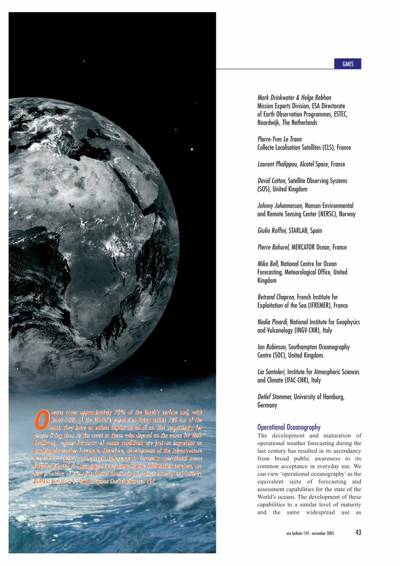
Mark Drinkwater & Helge RebhanMission Experts Division, ESA Directorate of Earth Observation Programmes, ESTEC,Noordwijk, The Netherlands
Pierre-Yves Le TraonCollecte Localisation Satellites (CLS), France
Laurent Phalippou, Alcatel Space, France
David Cotton, Satellite Observing Systems(SOS), United Kingdom
Johnny Johannessen, Nansen Environmentaland Remote Sensing Center (NERSC), Norway
Giulio Ruffini, STARLAB, Spain
Pierre Bahurel, MERCATOR Ocean, France
Mike Bell, National Centre for OceanForecasting, Meteorological Office, UnitedKingdom
Betrand Chapron, French Institute forExploitation of the Sea (IFREMER), France
Nadia Pinardi, National Institute for Geophysicsand Vulcanology (INGV-CNR), Italy
Ian Robinson, Southampton OceanographyCentre (SOC), United Kingdom.
Lia Santoleri, Institute for Atmospheric Sciencesand Climate (IFAC-CNR), Italy
Detlef Stammer, University of Hamburg,Germany
O ceans cover approximately 70% of the Earth’s surface and, withabout 60% of the World’s population living within 200 km of the
coast, they have an untold impact on all of us. Not surprisingly, forpeople living close to the coast or those who depend on the ocean for theirlivelihood, regular forecasts of ocean conditions are just as important astraditional weather forecasts. Therefore, development of the infrastructureneeded to support and sustain independent, European operational oceanforecasting, and the associated coastal and marine information services, arekey priorities of the joint Global Monitoring for Environment and Security(GMES) initiative by the European Commission and ESA
OO ceans cover approximately 70% of the Earth’s surface and, withc e a n s c o v e r a p p r o x i m a t e l y 7 0 % o f t h e E a r t h ’s s u r f a c e a n d , w i t habout 60% of the World’s population living within 200 km of thea b o u t 6 0 % o f t h e Wo r l d ’s p o p u l a t i o n l i v i n g w i t h i n 2 0 0 k m o f t h e
coast, they have an untold impact on all of us. Not surprisingly, forc o a s t , t h e y h a v e a n u n t o l d i m p a c t o n a l l o f u s . N o t s u r p r i s i n g l y, f o rpeople living close to the coast or those who depend on the ocean for theirp e o p l e l i v i n g c l o s e t o t h e c o a s t o r t h o s e w h o d e p e n d o n t h e o c e a n f o r t h e i rlivelihood, regular forecasts of ocean conditions are just as important asl i v e l i h o o d , r e g u l a r f o r e c a s t s o f o c e a n c o n d i t i o n s a r e j u s t a s i m p o r t a n t a straditional weather forecasts. Therefore, development of the infrastructuret r a d i t i o n a l w e a t h e r f o r e c a s t s . T h e r e f o r e , d e v e l o p m e n t o f t h e i n f r a s t r u c t u r eneeded to support and sustain independent, European operational oceann e e d e d t o s u p p o r t a n d s u s t a i n i n d e p e n d e n t , E u r o p e a n o p e r a t i o n a l o c e a nforecasting, and the associated coastal and marine information services, aref o r e c a s t i n g , a n d t h e a s s o c i a t e d c o a s t a l a n d m a r i n e i n f o r m a t i o n s e rv i c e s , a r ekey priorities of the joint Global Monitoring for Environment and Securityk e y p r i o r i t i e s o f t h e j o i n t G l o b a l M o n i t o r i n g f o r E n v i r o n m e n t a n d S e c u r i t y(GMES) initiative by the European Commission and ESA( G M E S ) i n i t i a t i v e b y t h e E u r o p e a n C o m m i s s i o n a n d E S A
44 esa bulletin 124 - november 2005 www.esa.int
meteorology is a major challenge for the21st century. The near-term objective is toprovide an integrated service tointermediate and end-users and decisionmakers in support of safe and efficientoffshore activities, pollution monitoring,environmental management, security andsustainable use of marine resources. Aroutine integrated assessment of oceanstate will also be extremely beneficial toweather forecasting, and ocean, ecosystemand climate research.
A Roadmap for GMES and the Sentinel-3missionSeveral major efforts have been initiatedover the last five years to develop Europe’scapacity in global operational ocean-ography. These efforts are now beingintegrated and pursued through the jointEC/ESA GMES initiative. Within the EC’sFramework Programme, the MarineEnvironment and Security for theEuropean Area (MERSEA) project isdeveloping a European system foroperational monitoring and forecasting ofthe ocean physics, biogeochemistry, andecosystems, on both global and regionalscales (www.mersea.eu.org). In parallel,the ESA GMES Services Element (GSE)is developing complementary ‘down-stream’ marine and coastal environmentalinformation services to end-users(www.esa.int/gmes). These EC and ESAinitiatives will be coordinated with theimplementation of the ocean-observingspaceborne component by the GMESProgramme Office, to allow thedevelopment and deployment of the oceancomponent of GMES by 2015.
To develop a truly operationaloceanography infrastructure that respondsto the GMES requirements, a long-termcommitment to ocean satellite-measurement systems must, however, beguaranteed. Without such global satellitemeasurements, these integrated systemswill not be sufficiently supported byobservations to provide routine, robust andreliable products. These thoughts arebehind the development of the ESA GMESSentinels, for which preparatory activitieshave now begun. These activities will pavethe way for a decision on the full
implementation of the GMES spacecomponent. The Roadmap described heretargets the preliminary definition of theGMES ocean mission, Sentinel-3.
From February 2004 to March 2005, anESA study titled ‘Definition of Scenariosand Roadmap for OperationalOceanography’ was carried out by aconsortium led by CLS. The teamconsisted of eleven partners from sixEuropean countries: CLS, IFREMER,INGV, MERCATOR Ocean, NERSC,Satellite Observing Systems, SouthamptonOceanography Centre, STARLAB, the UKMeteorological Office’s National Centrefor Ocean Forecasting, the University ofHamburg, and Alcatel Space. This articlesummarises the main results of this study,as essential background to the GMESSentinel-3 preparatory study activities.
GMES Marine Services and UsersGMES marine services have beenestablished that support, reinforce andimprove European capacities linked to:• Verification and enforcement of
international treaties, and assessment ofEuropean policies.
• Sustainable exploitation andmanagement of ocean resources(offshore oil-and-gas industry, fisheries,etc.).
• Improvement of safety and efficiency ofmaritime transport, shipping, and navaloperations, as well as of nationalsecurity and reduction of public-healthrisks.
• Anticipation and mitigation of theeffects of environmental hazards andpollution crises (oil spills, harmful algalblooms, etc.).
• Advanced marine research for betterunderstanding of the ocean ecosystemsand their variability.
• Contribution to ocean climate variabilitystudies.
• Contribution to seasonal climateprediction and its effects on coastalpopulations.
• Coastal management and planningservices.
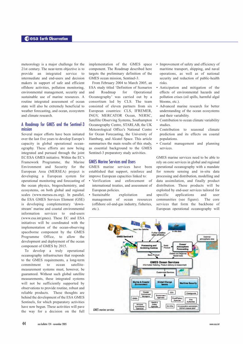
GMES marine services need to be able torely on core services in global and regionaloperational oceanography with a mandatefor remote sensing and in-situ dataprocessing and distribution, modelling anddata assimilation, and finally productdistribution. These products will beexploited by end-user services tailored forspecific applications and usercommunities (see figure). The coreservices that form the backbone ofEuropean operational oceanography will
Earth Observation
GMES marine services
esa bulletin 124 - november 2005www.esa.int 45
address the requirements from nationaland European policies, internationalconventions (e.g. OSPAR, HELCOM,UNCLOS), as well as European andinternational agencies (e.g. EEA, ICES,WCRP, UNFCC), for data, informationproducts and indicators on theenvironment. Users will also includeoperational agencies responsible formarine meteorology, weather forecasting,maritime safety, and environmentalmonitoring. Companies from the privateor public sectors providing ship-routingservices, offshore operation support,environmental impact studies, coastalstructure design or coastal managementstudies will also benefit from these coreservices. End-user services will success-ively build on these core services toaddress specific applications (e.g. for oilspills and illegal discharges, or harmfulalgae blooms) (see accompanying figures).
Operational Oceanography Requirements The backbone of operational ocean-ography is formed by global/basin-scale/regional modelling and dataassimilation systems that use remotesensing and in-situ measurements toprovide a regular, robust, comprehensivedescription and forecast of the ocean state.A core objective for the Sentinel-3 missionis therefore to provide the space-basedobservations required by these ‘integrated’systems.
The primary operational EarthObservation (EO) satellite observationrequirements specified by the GMESMERSEA project, the ESA GSE studies,and the Global Ocean Data AssimilationExperiment (GODAE) are as follows: • Global, near-real-time, high-accuracy
and high-resolution observations of seasurface topography. The minimumrequirement is at least two (preferablyfour) altimeter-bearing missions includ-ing one long-term and highly accuratemission for climate applications.
• Global, near-real-time, high-resolutionsea-surface-temperature (SST) productsas specified by the GODAE HighResolution SST Pilot Project (GHRSSTPP). These products, based on themerging of satellite and in-situ data, are
needed at time intervals of less than 24hours and at a spatial resolution of betterthan 10 km for the global ocean, andbetter than 2 km for regional seas andcoastal areas.
• While some R&D activities are stillneeded to develop the effective use ofsatellite ocean-colour (OC) data inocean forecasting models, it is foreseenthat by 2008 MERSEA operationalmodels will routinely use ocean-colourdata as an input to ecosystem models.Resolution requirements should be closeto those specified for SST, though manynear-shore coastal applications requirespatial resolutions better than 1 km.
• Global sea-ice concentration and sea-icedrift (daily, with resolution better than25 km) and possibly sea-ice-thicknessfields.
In addition to the above EO datarequirements, meteorological forcingfields from Numerical Weather Predictionsystems are required as inputs to theoperational ocean models. These should becomplemented by vector winds from atleast two wide-swath wind scatterometers(including the Advanced Scatterometer onMetOp, planned for launch in 2006).Though ocean-surface salinity is also avery important parameter that shouldultimately be monitored from space, thefeasibility of salinity retrievals must firstbe demonstrated by ESA’s SMOS andNASA’s Aquarius missions.
Requirements for the Sentinel-3 Mission As explained above, sea level, sea-surfacetemperature, sea ice, ocean colour andwind vectors are the key prognosticquantities in operational oceanography.The European contribution to ocean windmeasurements is already addressed by theAdvanced Scatterometer (ASCAT)instrument on the MetOp series ofsatellites. Existing and planned missionsshould additionally provide the requiredinformation on sea-ice edge, concentrationand drift, but not the ice thickness. Anocean altimeter mission could, however, beadapted to address the sea-ice thicknessrequirement.
There is also a strong requirement forSynthetic Aperture Radar (SAR) dataexpressed by the marine user community,in connection for instance with oil-spillmonitoring. The SAR marine requirementsare addressed in principle by Sentinel-1,but will nonetheless benefit from forecastinformation provided by ocean modelsconstrained by Sentinel-3 observationdata. Other more critical marine services,such as oil-spill drift forecasting, wouldnot be possible without Sentinel-3 data,since wind, wave and ocean currentforecasts are required.
Existing EO data requirements for oceansurface-wave modelling and forecastingmust also be addressed by the Sentinels.This calls for access to surface wind fieldsas well as satellite observations of sea statecurrently provided by altimeters (in the form
GMES
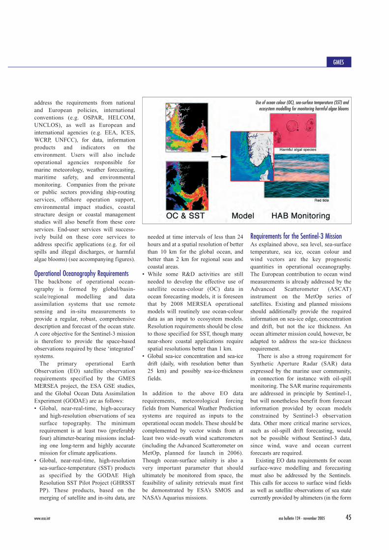
Use of ocean colour (OC), sea-surface temperature (SST) andecosystem modelling for monitoring harmful algae blooms
46 esa bulletin 124 - november 2005 www.esa.int
of significant wave height) and SARs (aswave spectra). New concepts for effectiveglobal measurements of these parametersneed to be developed, but in the meantime acombination of multiple altimeter and SAR-bearing EO satellite missions would providea suitable alternative.
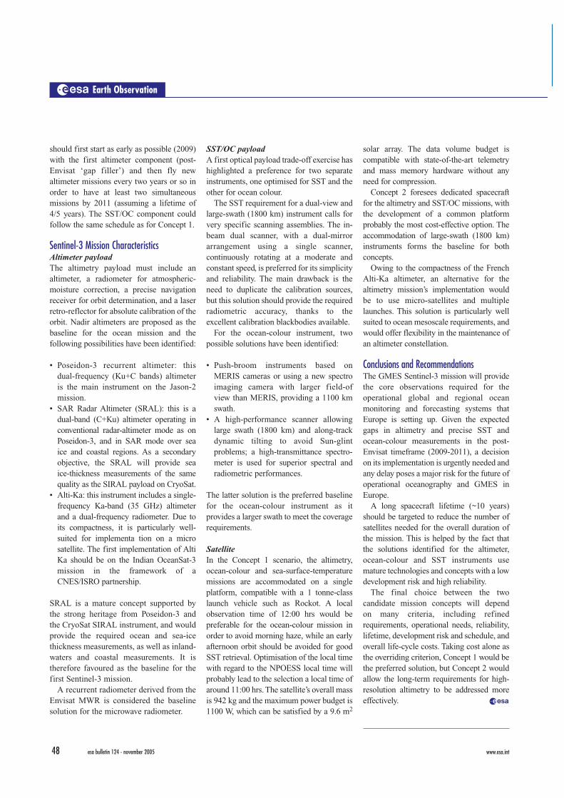
The main conclusion drawn from adetailed study of the requirements is thusthat Sentinel-3 should be the first of anestablished series of operational, long-termocean-monitoring satellites providing coremeasurements of ocean altimetry, sea-surface temperature and ocean colour. TheSentinel-3 measurement requirementssummarised below have been distilledfrom the analysis of existing and plannedmissions (see tables).
Ocean/Ice AltimetryThe most urgent requirement is to fly a post-Envisat, radar-altimeter-bearing mission,while in the longer term a high-resolutionaltimeter measurement system should be inplace for the operational GMES phase. Itwould also provide useful data both foroperational ocean-wave forecasting and sea-ice-thickness monitoring.
Altimetry provides the oceantopography in the form of precise sea-surface height measurements. Such data
are required to adequately represent oceaneddies and associated currents (the ‘oceanweather’) in models. Most operationaloceanography applications, such as marinesecurity and pollution monitoring, requirehigh-resolution surface-current data,which will not be adequately reproduced
without a high-resolution altimeter system.The altimeter system that is being
proposed should complement the Jasonseries, which we assume will continue toprovide precise long-term data. TheEuropean Commission’s GAMBLE study(www.altimetrie.net) recommends aconstellation of three optimised altimetermissions in addition to the Jason series.
Sea-Surface Temperature and OceanColourAnalysis of planned missions shows that the basic operational oceanographyrequirements should be fulfilled from 2011onwards with the VIIRS optical and CMISmicrowave sensors that will fly on allNPOESS satellites. Europe has, however,developed a strong heritage and leadershipin the highest-precision measurement ofclimate-quality SST with the ERS andEnvisat ATSR and A/ATSR sensors. Thesesensors have so far been the ‘gold standard’for high-quality ocean-surface-temperaturemeasurements, and a successor wouldprovide an extremely importantcomplement to the planned NPOESS andMetOp missions. Similar logic holds for precise/high-resolution ocean-colourmonitoring applications using Envisat data,
Earth Observation
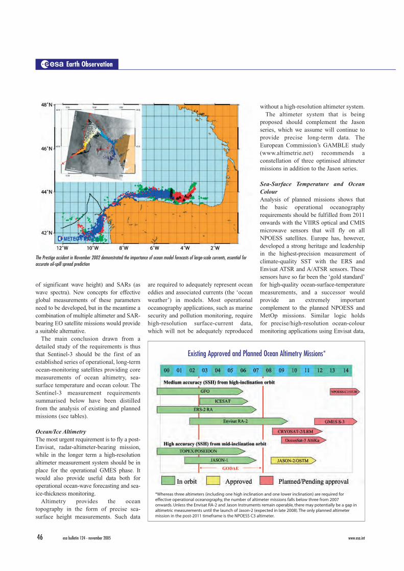
The Prestige accident in November 2002 demonstrated the importance of ocean model forecasts of large-scale currents, essential foraccurate oil-spill spread prediction
*Whereas three altimeters (including one high inclination and one lower inclination) are required foreffective operational oceanography, the number of altimeter missions falls below three from 2007onwards. Unless the Envisat RA-2 and Jason Instruments remain operable, there may potentially be a gap inaltimetric measurements until the launch of Jason-2 (expected in late 2008). The only planned altimetermission in the post-2011 timeframe is the NPOESS C3 altimeter.
Existing Approved and Planned Ocean Altimetry Missions*

esa bulletin 124 - november 2005www.esa.int 47
whereby the MERIS instrument channelsprovide specific benefits for GMES marineand coastal services. The importantsynergies between SST and ocean-colourmeasurements also make a strong case for acombined SST/OC sensor capability on thesame platform.
The Sentinel-3 Concept Two concepts have been analysed as part ofthe Sentinel-3 Roadmap exercise: – Concept 1: Altimetry/SST/Ocean Colour
on single platform in a polar orbit. – Concept 2: Altimetry and SST/Ocean
Colour on two independent polarorbiting platforms.
While co-located SST, ocean-colour andaltimetry observations show scientificpotential in the context, for example, ofocean-atmosphere exchanges and couplingbetween physical and biochemicalcomponents of the upper ocean, there arecurrently no specific GMES requirementsfor flying an altimeter and an SST/OCpayload on the same platform. Concept 2would allow optimisation of the orbit choices(e.g. repeat/non-repeat orbit, altitude,minimisation of Sun-glint effects, etc.) and tohave different observing schedules for thealtimeter and the SST/OC missions.
AltimetryA high-inclination altimetry mission isrecommended to cover high-latituderegions. The orbit could be Sun-synchronous, preferably using the samerepeat track as Envisat. The mainrequirement for high-resolution oceanaltimetry would be to fly three altimeters inaddition to the Jason series, either directlyas a constellation or built up progressivelywith a launch every 2 to 3 years. Thepreferred option would be to phase theorbit of each satellite to improve thesampling interval as much as possible.Swath altimetry is an attractive means forimproving the spatial/temporal coverage,but a demonstration of the concept prior toentering operational status is required. Inthe longer run, use of Global NavigationSatellite System (GNSS) reflected signalsshould also be considered to supplementconventional radar-altimetry data.
Sea-Surface Temperature/Ocean ColourThe primary requirement is to retrieve SSTwith AATSR instrument-type accuracy. Inthis case, an along-track view (bi-angularobservation) is mandatory to compensatefor atmospheric-dust and aerosol-inducederrors. Ideally, the system should thusprovide high-quality SST measurementsover a wide swath, as well as a dual viewover a narrower swath as a ‘gold standard’for all other SST measurements. Theobjective of the ocean-colour instrument isto monitor the global open ocean, whilstalso supporting several importantapplications in coastal areas. This willrequire a selection of wavelengths similar
to MERIS. A revisit time of 1 day atEuropean latitudes should be a goal for theSST/OC mission and this requires largeswath widths (>2000 km). Orbit timeand/or phasing should be optimised versusNPOESS and MetOp.
Time scheduleThe timetable for Concept 1 could be to flythe first mission as early as possible(2010/2011) and to ensure continuity of thedata streams currently provided by Envisat.One should allow some overlap between themissions for a precise inter-calibration of the different sensors. The schedule forConcept 2 might be slightly different. One
GMES
* Overall outlook appears to ensure good available of SST and OC observations from space, but theEuropean contribution to OC monitoring is very limited and calls for readjustment. The main issue forSST is to continue to provide high-quality products for climate applications.
Sea-Surface Temperature*
Ocean Colour*
48 esa bulletin 124 - november 2005 www.esa.int
should first start as early as possible (2009)with the first altimeter component (post-Envisat ‘gap filler’) and then fly newaltimeter missions every two years or so inorder to have at least two simultaneousmissions by 2011 (assuming a lifetime of4/5 years). The SST/OC component couldfollow the same schedule as for Concept 1.
Sentinel-3 Mission CharacteristicsAltimeter payloadThe altimetry payload must include analtimeter, a radiometer for atmospheric-moisture correction, a precise navigationreceiver for orbit determination, and a laserretro-reflector for absolute calibration of theorbit. Nadir altimeters are proposed as thebaseline for the ocean mission and thefollowing possibilities have been identified:
• Poseidon-3 recurrent altimeter: thisdual-frequency (Ku+C bands) altimeteris the main instrument on the Jason-2mission.
• SAR Radar Altimeter (SRAL): this is adual-band (C+Ku) altimeter operating inconventional radar-altimeter mode as onPoseidon-3, and in SAR mode over seaice and coastal regions. As a secondaryobjective, the SRAL will provide seaice-thickness measurements of the samequality as the SIRAL payload on CryoSat.
• Alti-Ka: this instrument includes a single-frequency Ka-band (35 GHz) altimeterand a dual-frequency radiometer. Due toits compactness, it is particularly well-suited for implementa tion on a microsatellite. The first implementation of AltiKa should be on the Indian OceanSat-3mission in the framework of aCNES/ISRO partnership.
SRAL is a mature concept supported bythe strong heritage from Poseidon-3 andthe CryoSat SIRAL instrument, and wouldprovide the required ocean and sea-icethickness measurements, as well as inland-waters and coastal measurements. It istherefore favoured as the baseline for thefirst Sentinel-3 mission.
A recurrent radiometer derived from theEnvisat MWR is considered the baselinesolution for the microwave radiometer.
SST/OC payloadA first optical payload trade-off exercise hashighlighted a preference for two separateinstruments, one optimised for SST and theother for ocean colour.
The SST requirement for a dual-view andlarge-swath (1800 km) instrument calls forvery specific scanning assemblies. The in-beam dual scanner, with a dual-mirrorarrangement using a single scanner,continuously rotating at a moderate andconstant speed, is preferred for its simplicityand reliability. The main drawback is theneed to duplicate the calibration sources,but this solution should provide the requiredradiometric accuracy, thanks to theexcellent calibration blackbodies available.
For the ocean-colour instrument, twopossible solutions have been identified:
• Push-broom instruments based onMERIS cameras or using a new spectroimaging camera with larger field-ofview than MERIS, providing a 1100 kmswath.
• A high-performance scanner allowinglarge swath (1800 km) and along-trackdynamic tilting to avoid Sun-glintproblems; a high-transmittance spectro-meter is used for superior spectral andradiometric performances.
The latter solution is the preferred baselinefor the ocean-colour instrument as itprovides a larger swath to meet the coveragerequirements.
SatelliteIn the Concept 1 scenario, the altimetry,ocean-colour and sea-surface-temperaturemissions are accommodated on a singleplatform, compatible with a 1 tonne-classlaunch vehicle such as Rockot. A localobservation time of 12:00 hrs would bepreferable for the ocean-colour mission inorder to avoid morning haze, while an earlyafternoon orbit should be avoided for goodSST retrieval. Optimisation of the local timewith regard to the NPOESS local time willprobably lead to the selection a local time ofaround 11:00 hrs. The satellite’s overall massis 942 kg and the maximum power budget is1100 W, which can be satisfied by a 9.6 m2
solar array. The data volume budget iscompatible with state-of-the-art telemetryand mass memory hardware without anyneed for compression.
Concept 2 foresees dedicated spacecraftfor the altimetry and SST/OC missions, withthe development of a common platformprobably the most cost-effective option. Theaccommodation of large-swath (1800 km)instruments forms the baseline for bothconcepts.
Owing to the compactness of the FrenchAlti-Ka altimeter, an alternative for thealtimetry mission’s implementation wouldbe to use micro-satellites and multiplelaunches. This solution is particularly wellsuited to ocean mesoscale requirements, andwould offer flexibility in the maintenance ofan altimeter constellation.
Conclusions and RecommendationsThe GMES Sentinel-3 mission will providethe core observations required for theoperational global and regional oceanmonitoring and forecasting systems thatEurope is setting up. Given the expectedgaps in altimetry and precise SST andocean-colour measurements in the post-Envisat timeframe (2009-2011), a decisionon its implementation is urgently needed andany delay poses a major risk for the future ofoperational oceanography and GMES inEurope.
A long spacecraft lifetime (~10 years)should be targeted to reduce the number ofsatellites needed for the overall duration ofthe mission. This is helped by the fact thatthe solutions identified for the altimeter,ocean-colour and SST instruments usemature technologies and concepts with a lowdevelopment risk and high reliability.
The final choice between the twocandidate mission concepts will depend on many criteria, including refinedrequirements, operational needs, reliability,lifetime, development risk and schedule, andoverall life-cycle costs. Taking cost alone asthe overriding criterion, Concept 1 would bethe preferred solution, but Concept 2 wouldallow the long-term requirements for high-resolution altimetry to be addressed moreeffectively. r
Earth Observation