Fabrizio Battazza, ASI – Osservazione della Terra GMES ... · ASI – Osservazione della Terra....
12
Rome – 27.06.2012 GMES: III Workshop di FP7 1 Earth Observation ASI EO Missions Fabrizio Battazza, ASI – Osservazione della Terra GMES: III WS di FP7 Rome, 27.06.12
Transcript of Fabrizio Battazza, ASI – Osservazione della Terra GMES ... · ASI – Osservazione della Terra....
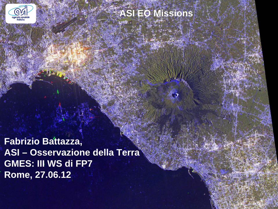
Rome – 27.06.2012 GMES: III Workshop di FP7 1
Earth Observation
ASI EO Missions
Fabrizio Battazza,ASI – Osservazione della TerraGMES: III WS di FP7Rome, 27.06.12
Rome – 27.06.2012 GMES: III Workshop di FP7 2
Earth Observation
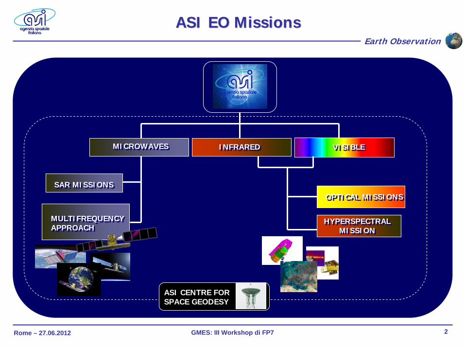
ASI EO ASI EO MissionsMissions
MICROWAVESMICROWAVES VISIBLEVISIBLEINFRAREDINFRARED
SAR MISSIONSSAR MISSIONS
MULTIFREQUENCY APPROACH MULTIFREQUENCY APPROACH
ASI CENTRE FOR SPACE GEODESY
OPTICAL MISSIONSOPTICAL MISSIONS
HYPERSPECTRAL MISSION
HYPERSPECTRAL MISSION
Rome – 27.06.2012 GMES: III Workshop di FP7 3
Earth Observation
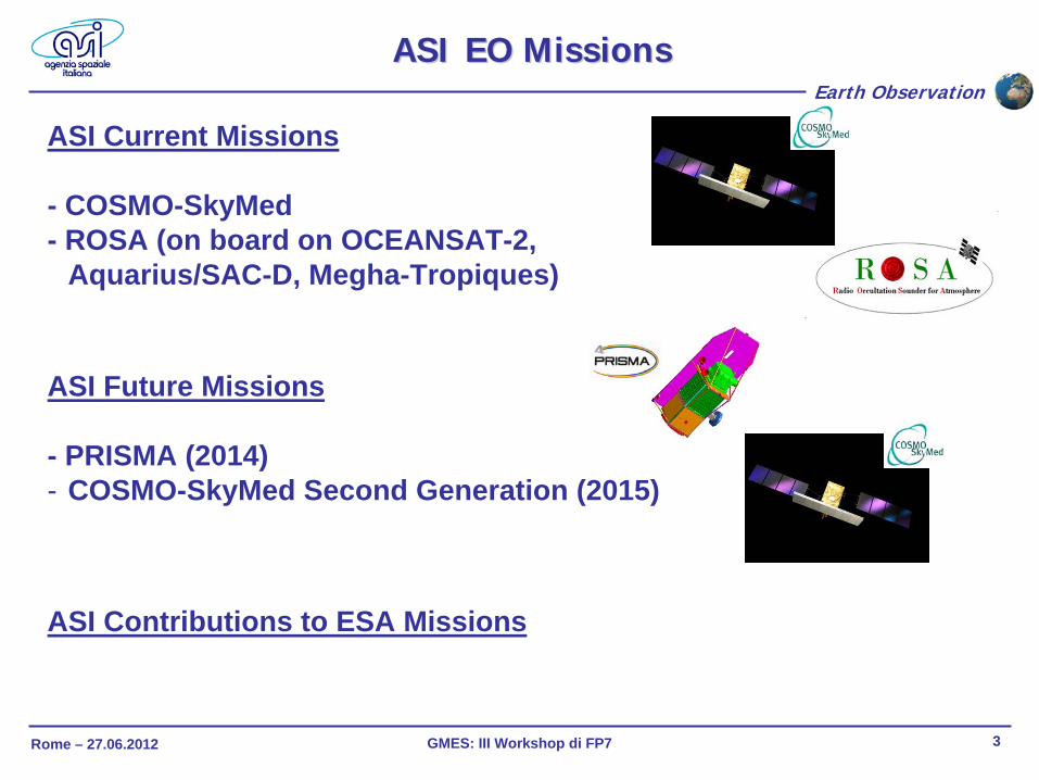
ASI Current Missions
- COSMO-SkyMed- ROSA (on board on OCEANSAT-2,
Aquarius/SAC-D, Megha-Tropiques)
ASI EO ASI EO MissionsMissions
ASI Future Missions
- PRISMA (2014)- COSMO-SkyMed Second Generation (2015)
ASI Contributions to ESA Missions
Rome – 27.06.2012 GMES: III Workshop di FP7 4
Earth Observation
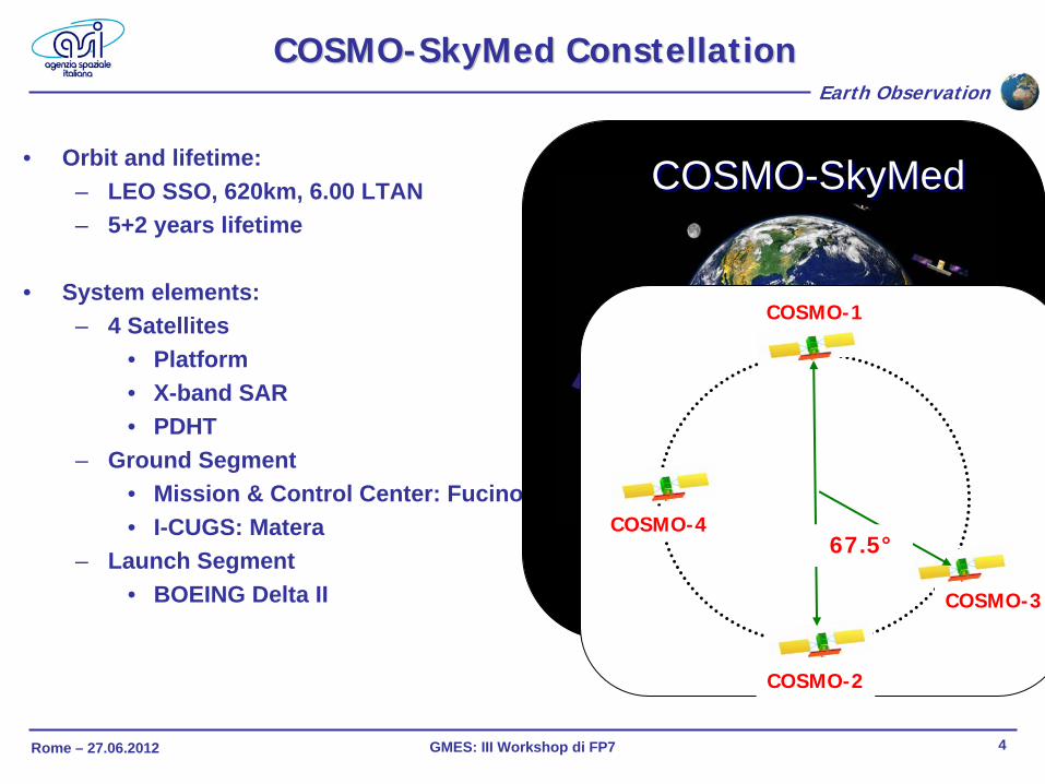
• Orbit and lifetime:– LEO SSO, 620km, 6.00 LTAN– 5+2 years lifetime
• System elements:– 4 Satellites
• Platform• X-band SAR• PDHT
– Ground Segment• Mission & Control Center: Fucino• I-CUGS: Matera
– Launch Segment• BOEING Delta II
COSMOCOSMO--SkyMed SkyMed ConstellationConstellation
COSMO-SkyMedCOSMO-SkyMed
THE LARGEST ITALIAN INVESTMENT
IN SPACE SYSTEM FOR EO
4 X-BAND SAR SATELLITES
COSMO-1
COSMO-2
67.5°
COSMO-3
COSMO-4
Rome – 27.06.2012 GMES: III Workshop di FP7 5
Earth Observation
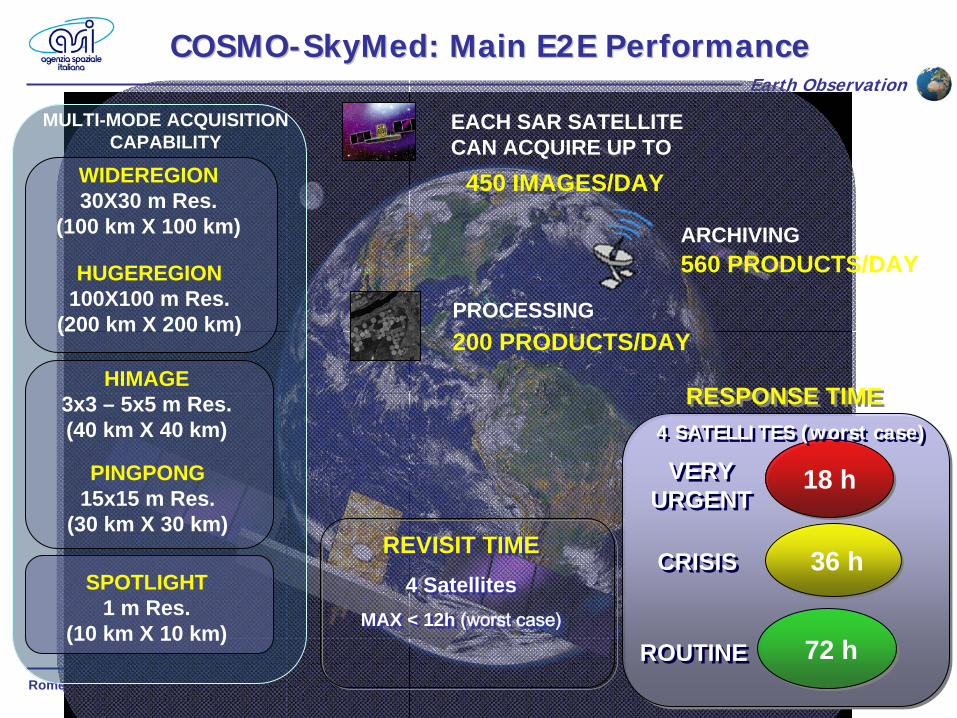
MULTI-MODE ACQUISITION CAPABILITY
PINGPONG15x15 m Res.
(30 km X 30 km)
HIMAGE3x3 – 5x5 m Res.(40 km X 40 km)
HUGEREGION100X100 m Res.
(200 km X 200 km)
WIDEREGION30X30 m Res.
(100 km X 100 km)
SPOTLIGHT1 m Res.
(10 km X 10 km)
450 IMAGES/DAY
EACH SAR SATELLITE CAN ACQUIRE UP TO
560 PRODUCTS/DAYARCHIVING
200 PRODUCTS/DAYPROCESSING
COSMOCOSMO--SkyMed: SkyMed: MainMain E2E PerformanceE2E Performance
REVISIT TIME4 Satellites
MAX < 12h (worst case)
REVISIT TIME4 Satellites
MAX < 12h (worst case)
18 h18 h
36 h36 h
72 h72 h
4 SATELLITES (worst case)4 SATELLITES (worst case)
VERY URGENT
VERY URGENT
CRISISCRISIS
ROUTINEROUTINE
RESPONSE TIMERESPONSE TIME
Rome – 27.06.2012 GMES: III Workshop di FP7 6
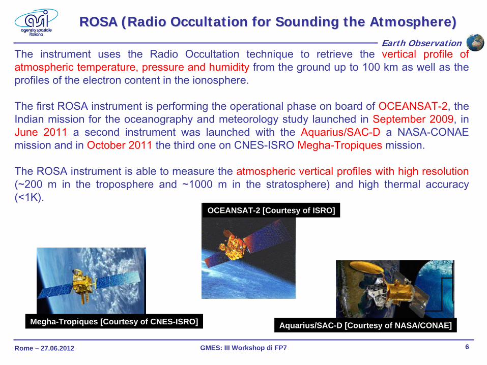
Earth ObservationThe instrument uses the Radio Occultation technique to retrieve the vertical profile of
atmospheric temperature, pressure and humidity
from the ground up to 100 km as well as the profiles of the electron content in the ionosphere.
The first ROSA instrument is performing the operational phase on
board of OCEANSAT-2, the Indian mission for the oceanography and meteorology study launched in September 2009, in June 2011
a second instrument was launched with the Aquarius/SAC-D
a NASA-CONAE mission and in October 2011
the third one on CNES-ISRO Megha-Tropiques
mission.
The ROSA instrument is able to measure the atmospheric vertical profiles with high resolution (~200 m in the troposphere and ~1000 m in the stratosphere) and high thermal accuracy
(<1K).
ROSA (Radio ROSA (Radio OccultationOccultation for for SoundingSounding the Atmosphere)the Atmosphere)
OCEANSAT-2 [Courtesy of ISRO]
Aquarius/SAC-D [Courtesy of NASA/CONAE]Megha-Tropiques [Courtesy of CNES-ISRO]
Rome – 27.06.2012 GMES: III Workshop di FP7 7
Earth Observation
• Mission Objectives:– Pre-operational and technology
demonstrator nature– Focus on
• Space qualification of Hyperspectral (HYP) and panchromatic (PAN) payloads
• Development and production of PAN/HYP products/ applications
• Program Highlights:– National program – Fully funded by ASI– B2/C/D/E1 contract running– Launch schedule: 2014
Applications:Vegetation monitoringGeological mappingAgricultural diagnostics, agricultural indicatorsLand cover maps and crop inventories Urban and functional areas mapping and monitoringCoastal and inland productivity assessment of aquatic ecosystemsMonitoring of carbon sources and sinks on land (Kyoto Protocol)Land surface hydrology and water management, Risk Management Support (fires, landslides, volcanic and seismic hazard).Atmosphere characterization
PRISMA = PRecursore IperSpettrale della Missione Applicativa
PRISMA PRISMA MissionMission
Rome – 27.06.2012 GMES: III Workshop di FP7 8
Earth Observation
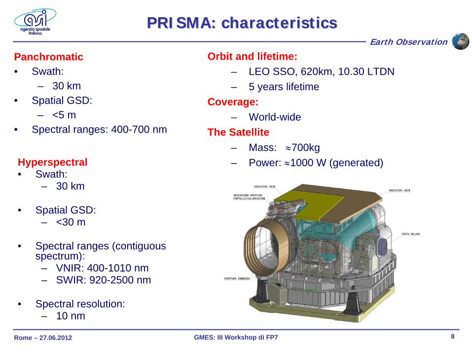
Hyperspectral• Swath:
– 30 km
• Spatial GSD:– <30 m
• Spectral ranges (contiguous spectrum):
– VNIR: 400-1010 nm– SWIR: 920-2500 nm
• Spectral resolution: – 10 nm
Panchromatic• Swath:
– 30 km• Spatial GSD:
– <5 m• Spectral ranges: 400-700 nm
PRISMA: PRISMA: characteristicscharacteristics
Orbit and lifetime:– LEO SSO, 620km, 10.30 LTDN– 5 years lifetime
Coverage:– World-wide
The Satellite– Mass: ≈700kg– Power: ≈1000 W (generated)

Rome – 27.06.2012 GMES: III Workshop di FP7 9
Earth Observation
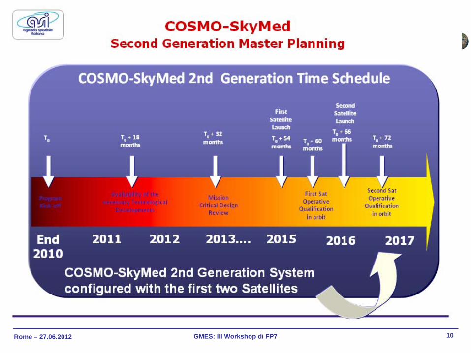
COSMOCOSMO--SkyMed SkyMed SecondSecond GenerationGeneration
• COSMO 2nd Gen. system is conceived as the follow-on to COSMO-SkyMed first generation (COSMO 1st Gen.) with main goals of assuring performance improvement and operational continuity.
Improved operational profiles• CSK = 450 products/day/satellite• CSG = 1000 ca. products/day/satellite
(equivalent to. CSK products)
Main improvements in terms of :• SAR Antenna• PDHT (higher data volume)
Rome – 27.06.2012 GMES: III Workshop di FP7 10
Earth Observation
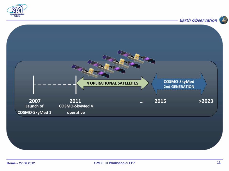
Rome – 27.06.2012 GMES: III Workshop di FP7 11
Earth Observation
4 OPERATIONAL SATELLITES
2011 …2007
COSMO‐SkyMed 2nd GENERATION
2015Launch
of
COSMO‐SkyMed 1
>2023COSMO‐SkyMed 4
operative
Rome – 27.06.2012 GMES: III Workshop di FP7 12
Earth Observation
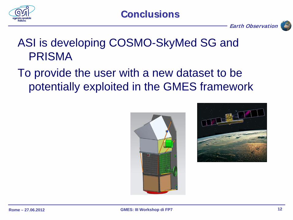
ConclusionsConclusions
ASI is developing COSMO-SkyMed SG and PRISMA
To provide the user with a new dataset to be potentially exploited in the GMES framework