Conceptual Design Guidelines. Application of Engineered Logjams
The Physical and Biological Effects of Engineered Logjams (ELJs) in the
Elwha River, Washington
Executive Summary
Salmon Recovery Funding Board (SRFB) Interagency Committee for Outdoor Recreation (IAC)
April 1, 2007
Michael McHenry1, George Pess2, Tim Abbe3, Holly Coe2, Jennifer Goldsmith3, Martin Liermann2, Randall McCoy1, Sarah Morley2, Roger Peters4
1 Lower Elwha Klallam Tribe, Fisheries Dept., 51 Hatchery Road, Port Angeles, WA 98363 2 NOAA Fisheries, Northwest Fisheries Science Center, 2725 Montlake Blvd. E., Seattle, WA 98122 3 Herrera Environmental Consultants, 2200 Sixth Avenue, Suite 1100, Seattle, WA 98121 4 US Fish and Wildlife Service, 510 Desmond Drive SE, Suite 102, Lacey WA 98503
Elwha River Engineered Logjam Monitoring Report
Executive Summary
This report summarizes the results of monitoring efforts on Elwha River Engineered Logjams (ELJs) for the period from 1999-2006. During this period, a total of 21 ELJs have been constructed in the Elwha River by the Lower Elwha Klallam Tribe. Since constructed (2000-2004), ELJs have proved to be stable with little significant change in position or surface area noted despite frequent inundation from floods including two peak floods that rank within the top 10% of floods recorded for over 100 years of record. The ELJs have retarded bank erosion along two outside meanders. The ELJs have also helped maximize habitat area by partially balancing flows between two major channels. During flood flows, ELJs have increased exchange of water with floodplain surfaces, primarily through backwatering. This has resulted in the expansion of side-channel habitats, including groundwater fed channels that provide critical habitats for multiple salmonid species. We monitored the response of physical habitat for multiple parameters including habitat type and area, pool depth, channel bed substrate, elevation, temperature and flows. Pool development occurred rapidly around constructed ELJs. Twenty of the twenty-one ELJs built since 1999 have developed scour pools, the deepest of which has a maximum depth exceeding 5 m. The ELJs had a significant effect on sediment storage within the project reach where a 60% increase in the amount of sediment stored in gravel bars occurred over the 5 year study. Associated with these changes we also observed a significant reduction in bed substrate grain size in the vicinity of several ELJs, with the mean particle size changing from large cobble to gravel. Spawning of several species of salmonids, including Chinook, chum, coho and steelhead has been observed in the vicinity of ELJs. Biological results indicate that ELJs have a measurable and significant effect on primary productivity, secondary productivity and juvenile fish populations. In terms of primary productivity we measured significantly higher (6 times) mean organic matter and chlorophyll concentrations on wood in ELJs than on cobbles alone. Differences in chlorophyll concentrations were significant in one year but not in two other years. Mean invertebrate densities were also significantly higher (2-5 times) on wood in ELJs. The invertebrate communities found on ELJs are fundamentally different from those encountered on inorganic substrates. Juvenile fish response varied considerably by species, size, season and year. The proportion of juvenile salmonids was consistently greater in ELJ units than non-ELJ units for 75% of the different species/size class categories. However, because of variability this difference was rarely significant. While the median density of juvenile salmonids was generally similar between ELJ and non-ELJ units, the difference was significant in terms of biomass. These patterns suggest that the proportion of occurrence and median density and biomass of juvenile, sub-adult and resident salmonids were positively influenced by ELJs. Our data supports that ELJs are an effective tool for restoring physical and biological conditions critical to salmon recovery in large alluvial rivers of western Washington.
Elwha River Engineered Logjam Monitoring Report ii

Table of Contents Executive Summary ........................................................................................................................ ii
List of Tables ................................................................................................................................. iv
List of Figures ..................................................................................................................................v
List of Figures ..................................................................................................................................v
Introduction......................................................................................................................................1
Study Area ................................................................................................................................2
Monitoring Methods ........................................................................................................................8
Results..............................................................................................................................................9
Structure Performance ..............................................................................................................9
Physical Parameters .......................................................................................................................13
Distribution of Flows..............................................................................................................13 Bank Erosion ..........................................................................................................................15 Changes in Habitat Area.........................................................................................................17 Side-Channel Formation.........................................................................................................18 Pool Depths.............................................................................................................................18 Sediment Storage/Topography ...............................................................................................20 Surface Substrate Composition...............................................................................................21 Temperature............................................................................................................................25 Wood Budget ..........................................................................................................................26 Wood Tracking .......................................................................................................................27
Biological Parameters ....................................................................................................................39
Primary Productivity...............................................................................................................39 Secondary Productivity...........................................................................................................40 Juvenile Fish Density-ELJ vs. non-ELJ..................................................................................41 Juvenile Fish Density-Complex vs. Simple Habitat ...............................................................42 Juvenile Micro-distribution ....................................................................................................49 Chinook Spawning..................................................................................................................49
Discussion......................................................................................................................................50
Sediment Storage ....................................................................................................................50 Habitat Effects ........................................................................................................................51 Primary & Secondary Productivity.........................................................................................52 Juvenile Fish Response...........................................................................................................53
Summary Conclusions ...................................................................................................................56
Acknowledgements........................................................................................................................58
Literature Cited ..............................................................................................................................59
Appendix 1. Elwha Engineered Log Jam Descriptions ................................................................63
Elwha River Engineered Logjam Monitoring Report iii

List of Tables
Table 1. Log structure identification codes and characteristics for engineered logjams built in the Elwha River, Washington (1999-2004). .......................................................5
Table 2. Physical and biological monitoring parameters used for engineered logjam effectives monitoring on the Elwha River. .....................................................................9
Table 3. Summary table of Elwha River engineered logjam performance as of 2005. ................12
Table 4. Changes in the percentage of three size classes of gravel following construction of engineered logjams in the Elwha River. Significant differences (p≤0.05, 95% Confidence) are bolded.........................................................................................23
Table 5. Summary of Lower Elwha River LWD snag inventory for years monitored between 2001 and 2006.................................................................................................26
Table 6. Summary of Lower Elwha River LWD snag inventory for years monitored between 2001 and 2006.................................................................................................27
Table 7. Lower Elwha River LWD type and average movement between 2001 and 2002 wood surveys.................................................................................................................28
Table 8. Lower Elwha River LWD type and average movement between 2002 and 2004 LWD surveys (1,2,)..........................................................................................................29
Table 9. Lower Elwha River LWD type and average movement between 2004 and 2006 LWD surveys (1,2,)..........................................................................................................30
Elwha River Engineered Logjam Monitoring Report iv
List of Figures
Figure 1. The Elwha River watershed depicting the percentage of the watershed in Olympic National Park and mainstem hydroelectric dams.............................................4
Figure 2. Number of logs, key pieces and total volume for 21 engineered logjams constructed in the Elwha River, Washington (1999-2004).............................................6
Figure 3. Location of engineered logjams on the lower Elwha River, Washington (1999-2004). ..............................................................................................................................7
Figure 4. Mean daily discharge for the Elwha River at the McDonald Bridge Gauge site, 1999-2005. Flows above dashed line fully inundate the ELJs.....................................10
Figure 5. Annual peak discharge (cfs) for the Elwha River (McDonald Bridge Gauge), 1999-2005. ....................................................................................................................11
Figure 6. Discharge (cfs) and ratio (EM/HRC) of discharge during summer baseflow distributed between the Hunt Road channel and east mainstem channel, Elwha River (1998-2006).........................................................................................................13
Figure 7. Upstream portions of HRC and EMC in 1999 and 2006. Note two-fold enlargement of HRC and formation of large natural logjams with recruitment of mature trees associated with channel expansion. Meanwhile vegetation has encroached on the EMC (particularly along left bank point bar)..................................14
Figure 8. Historic channel locations of the Lower Elwha, 1971-2001, showing outward migration of meanders upstream and downstream of the HRC inlet. ...........................16
Figure 9. Changes in habitat type and area in the Elwha River engineered logjam treatment reach, 2000-2004...........................................................................................18
Figure 10. Changes in maximum pool depth over time in five areas that had engineered logjams constructed within existing pool habitats, Elwha River. .................................19
Figure 11. Maximum pool depth over time at thirteen engineered logjam sites lacking pre-existing pools, Elwha River, Washington. .............................................................19
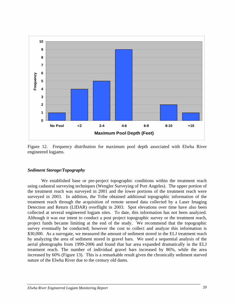
Figure 12. Frequency distribution for maximum pool depth associated with Elwha River engineered logjams. ......................................................................................................20
Figure 13. Number of gravel bars and their surface area (m2) in the Elwha River engineered logjam treatment reach, 1994-2006. ...........................................................21
Figure 14. Particle-size distribution on channel bed surfaces immediately downstream of engineered logjam #01-1, Elwha River, 2001-2006. Arrows show median particle size in 2001 and 2006.......................................................................................22
Figure 15. Particle size distribution by size class on Elwha River bed surface immediately downstream of engineered logjam #02-2, 2003-2006. . Arrows show median particle size in 2001 and 2006. ...............................................................22
Elwha River Engineered Logjam Monitoring Report v

Figure 16. Substrate on bar associated with engineered logjam #04-1, Elwha River. Top Photo taken fall 2002. Bottom photo taken winter 2007. ............................................24
Figure 17. Difference between surface (solid) and bottom (dashed) water temperature at an Elwha engineered logjam (site 02-3), September 2006. ..........................................25
Figure 18. Flow chart of wood inventory protocol .......................................................................31
Figure 19. 2001 Lower Elwha wood inventory. Note the near absence of wood in the EMC, particularly when compared to the HRC. ...........................................................32
Figure 20. 2002 Lower Elwha wood inventory. Wood loading in the HRC has increased significantly since 2001, primarily from local recruitment, with no change in the EMC. .......................................................................................................................33
Figure 21. 2004 Lower Elwha wood inventory. Small increase in EMC, coincident with ELJs in the EMC. No major change in HRC, but a large increase upstream of Sisson property..............................................................................................................34
Figure 22. 2006 Lower Elwha wood inventory. Significant net increases in wood in HRC, SC5, and river segment including SC3, with some increase in the EMC...........35
Figure 23. Historic channel locations of the Lower Elwha, 1939-2001. Note the lack of migration near the HRC and persistence of trees that now provides a source of key pieces. .....................................................................................................................36
Figure 24. . Height of riparian trees based on differencing of first return and bare earth LiDAR (2004). Note the presence of large trees along the HRC and East of SC3 and SC5. ................................................................................................................37
Figure 25. Tree height (the darker the red, the taller the tree) based on difference of first return and bare earth LiDAR data. Note the presence of tall trees along HRC and lack of large trees along SC 5, the Sisson property, and the EMC (with exception of old patch at meander apex).......................................................................38
Figure 26. Ash-free dry mass (organic matter) and chlorophyll a concentrations on engineered logjams (ELJ), ELJ influenced habitats, and reference habitats in the Elwha River, 2003-2005. ........................................................................................39
Figure 27. Invertebrate density on engineered logjams (ELJ), ELJ influenced habitats and reference habitats in the Elwha River, 2003-2004. ................................................40
Figure 28. Invertebrate community composition on engineered logjams (ELJ), ELJ influenced habitats, and reference habitats in the Elwha River, 2003-2004.................41
Figure 35. Elwha engineered logjam 99-1 during winter 2000 flood, looking West from right bank. .....................................................................................................................63
Figure 36. Elwha engineered logjam #01-1 immediately after completion, fall 2000. ................64
Figure 37. Elwha engineered logjams #02-4 (foreground) and 02-1 (across river) during October 2003 flood. Photo looking East from left bank. .............................................65
Elwha River Engineered Logjam Monitoring Report vi
Figure 38. Elwha engineered logjam 02-2 immediately following construction in 2002 (left) and at typical winter discharge. Photos are looking Northwest in the direction of flow............................................................................................................66
Figure 39. Elwha engineered logjam #99-5 splitting flow between Hunt Road Channel (HRC) and East mainstem channel (EMC), winter 2000. Photo is looking Northeast down EMC....................................................................................................67
Figure 40. Elwha engineered logjam #02-5, December 2005, three years after construction. Note large gravel bar behind structure. Photo is looking West-Southwest up the EMC from the right bank..................................................................68
Figure 41. Elwha engineered logjam #01-3 during construction, August 2001. Photo taken from the left bank looking East-Northeast (downstream). ..................................69
Figure 42. Elwha engineered logjam #01-1 during construction, August 2001. Photo from right bank looking North across the EMC............................................................70
Figure 43. Elwha engineered logjam #02-3 located on left bank of EMC, immediately following construction, September 2003. Photo taken from right bank looking North across EMC.........................................................................................................71
Figure 44. Elwha engineered logjam #03-1 immediately following construction, August 2003. Photo taken from right bank of EMC looking South (upstream). ELJ 03-2 is visible in background (left center of photo)......................................................72
Figure 45. Elwha engineered logjam #03-2, winter 2004. Photo taken from right bank looking North (downstream). ........................................................................................73
Figure 46. Elwha engineered logjam #99-2 situated along Sisson property at bankfull flow, winter 2002. Photo taken from left bank looking South (upstream). .................74
Figure 47. Elwha River engineered logjam #99-3, winter 2002. Photo taken from left bank looking North (downstream) at inlet to HRC.......................................................75
Figure 48. Elwha River engineered logjam #00-2 located along left bank of Sisson property, during construction, fall 2000. Photo is taken from gravel bar looking West across the river........................................................................................77
Figure 49. Elwha River engineered logjam #00-2 during October 2003 flood. Photo taken from left bank looking North (downstream). ......................................................77
Figure 50. Elwha engineered logjam #99-6, summer 2005, located along left bank immediately upstream of HRC inlet. Photo taken from cobble bar looking Northwest (downstream)...............................................................................................79
Figure 51. Elwha engineered logjam #04-1 situated along the left bank of the EMC immediately downstream of where a HRC distributary channel re-enters the EMC, winter 2007. Photo taken from left bank of EMC looking Northwest (downstream). ...............................................................................................................80
Elwha River Engineered Logjam Monitoring Report vii
Figure 52. Elwha engineered logjam #04-2 situated along the left bank of the EMC immediately downstream of where a HRC distributary channel re-enters the EMC (visible on left), winter 2007. Photo taken from left bank of EMC looking North (downstream). ........................................................................................81
Figure 53. Logjam formation upstream of 2003 unanchored key pieces placed in Side Channel 5. Photo taken after October 2004 flood flow, looking Northeast (downstream). Alder trees visible in photo are racked up on key pieces and were eroded from upstream floodplain as Side Channel 5 increased in size due to flood flows. The side channel is almost devoid of wood upstream of this location. ELJ 00-1 is located at inlet to Side Channel 5 and may have contributed to the increase in flow down the side channel. ..........................................82
Elwha River Engineered Logjam Monitoring Report viii

Introduction
Large wood has been used to restore stream habitats around the world for several decades, however until recently had not been applied in large rivers. Research documenting the function of wood in undisturbed large rivers (Abbe and Montgomery 1996), led to the development of engineered analogs as a tool for restoration in large rivers. Several of these projects were implemented on Washington Rivers using public restoration monies. During 2001, the Salmon Recovery Funding Board (SRFB) instituted a funding moratorium on new engineered logjams in large rivers in Washington. This moratorium was in response to questions concerning the effectiveness of ELJs in high energy, large river environments. In order to provide scientific data to evaluate this question, the SRFB commissioned a 5-year (2001-2006) effectiveness study in two river basins where such logjams had been recently constructed: the Elwha and North Fork Stillaguamish Rivers. The Elwha Tribe was contracted to conduct the monitoring efforts on the Elwha River, while Washington Trout led monitoring efforts on the Stillaguamish River. To assist with study design and monitoring efforts in the Elwha River, the Tribe partnered with experts from Herrera Environmental, NOAA Fisheries and the US Fish and Wildlife Service to design a study plan (McHenry et al. 2001). Study implementation began in 2001 and progress reports have been given to the SRFB annually. Based upon the positive results reported from these studies in 2002-2004 progress reports, the SRFB moratorium was removed for 5th round SRFB grants. Construction of ELJs has continued or is planned in several large western Washington Rivers including the Nooksack, Hoh, Quinault and Dungeness. On the Elwha, planning continues for the installation of an additional 25-35 logjams in the lower river in preparation for dam removal in 2009.
The genesis of engineered logjam construction on the Elwha River dates to the loss of a natural logjam at the head of the largest side-channel in the lower Elwha River in 1998. The natural logjam metered flow into the Hunt Road Channel (HRC) where the majority of remaining productive habitat for native stocks of Elwha River salmon was believed to occur. After the logjam washed out during 1998 flooding, there was concern that the HRC would capture more of the river’s flow and threaten productive habitats in the HRC. In response to these events, the Lower Elwha Klallam Tribe applied for and received an Early Action Grant in 1999 to reconstruct the protective logjam at the head of the HRC, as well as additional logjams upstream of the HRC entrance. These projects were designed and completed by the Tribe in 1999. Building upon the previous years efforts, the Tribe received funding in 2000 from the Salmon Recovery Funding Board (SRFB) for its Elwha Floodplain Restoration Proposal. This proposal included additional mainstem and side-channel logjam construction efforts. Logjam construction progressed cautiously attempting to balance river response using an adaptive management approach. There was also the need to sequence construction with monitoring projects being developed with partners at NOAA Fisheries. In 2002, the Tribe received restoration support from the Bureau of Indian Affairs. This money was used to compliment previous SRFB grants and allowed the construction of new logjams in 2003. Pacific Coastal Salmon Recovery (PCSRF) funds have allowed the construction of additional ELJs in 2004. This brings the total number of constructed logjams on the Elwha to 21, one of the most significant restoration efforts to date on a large Pacific Northwest River (Figure 3).
Twenty-one engineered logjams were constructed in a one-mile reach of the Lower Elwha River (river mile 1.33-2.25) on land owned by the Lower Elwha Tribe, Washington
Elwha River Engineered Logjam Monitoring Report 1

Department of Fish and Wildlife and the Sisson family. A total of 882 pieces of wood including 129 key pieces were used to construct the logjams (Table 1; Figure 2). The structures were primarily of two types, bar apex jams (BAJ’s) and deflector jams (DJ’s). Tim Abbe and Dave Montgomery developed the concept of engineered logjams, basing the design on natural logjams in large rivers. In the Queets River, Abbe and Montgomery (1996) describe three types of logjams (bar top, meander and bar apex). Of the three logjam types identified, only the bar apex and meander jams were stable and capable of influencing channel morphology, stream habitat and riparian forest conditions. The stability of these logjams is attributed to the presence of one or more key pieces of large wood. Key pieces are typically large diameter conifers with the root wad attached. Key pieces are large enough to affect local channel hydraulics causing their deposition on the streambed, parallel to stream flow with rootwads oriented upstream. Each jam included elements of natural jams including key pieces. Bar Apex type logjams were excavated into the streambed (to a depth of 8-12’). In contrast meander jams were generally not excavated into the stream bed and are free-standing, gravity structures. Meander jams were anchored using limited excavation into the bank (deaden) in combination with driven piling and cable to secure the structure. These construction techniques were dictated by a decision not to divert the river from the construction site and to minimize turbidity impacts. Because adult Chinook salmon were present during construction periods it was felt that diversion and turbidity impacts outweighed the benefits of excavation. Completed logjams on the Elwha River contained 20-70 logs of which 10-20 were considered key pieces and have wood volumes of between 40-160 m3
(Figure 2). This executive summary is intended to summarize monitoring results associated with the
construction of 21 separate engineered logjams in the Elwha River from 1999-2006. The report is designed to answer basic questions concerning the stability and function of ELJ technology on a large western Washington River. The report is divided into physical and biological response sections. The authors anticipate that this monitoring report will result in several peer reviewed publications concerning the effectiveness of engineered logjams. These include a sampling methodology paper (Coe et al. 2007), a juvenile fish movement study (Peters et al. In Review), a reach scale assessment of ELJs and a floodplain process paper. Study Area
Two hydroelectric dams constructed on the Elwha River in 1913 and 1925 without fish passage facilities, decimated native populations of salmon including large bodied spring Chinook known to exceed 100 pounds in size. The dams have also affected habitat forming processes in the lower river by effectively truncating the alluvial transport of gravel and large wood. Additionally, the dams have altered natural hydrologic and temperature regimes. Other human caused impacts have further degraded habitat conditions in the five miles of habitat currently accessible to anadromous fish. The Elwha River, like many rivers in the Pacific Northwest, has a long history of riparian deforestation, channel clearing and snag removal, levee construction and channelization. As a result, the Elwha River below Elwha Dam has lost habitat complexity, and provides limited spawning and rearing habitat for remnant populations of native Pacific salmon. Efforts to restore the Elwha River have long centered on removal of the dams to restore access to pristine habitats in Olympic National Park. The Elwha Ecosystem and Fisheries
Elwha River Engineered Logjam Monitoring Report 2
Restoration Act (1992) authorize the Department of Interior to remove the dams beginning in 2009.
The Elwha River drains a 313 mi2 watershed on the Olympic Peninsula with its headwaters radiating off the slopes of Mt Olympus. The Elwha flows north to its confluence with the Strait of Juan de Fuca with over 85% of the watershed protected within the boundaries of Olympic National Park (Figure 1). Mainstem hydroelectric dams were constructed without fish passage facilities at river miles 4.9 in 1912 (Elwha) and 1925 (Glines Canyon) reducing the habitat accessible to anadromous fish by over 90%. Additionally, the dams have altered the natural physical processes that sustain and create habitat in large alluvial rivers. The dams have significantly reduced the supply of sediments and large wood to the middle and lower reaches of the river and its floodplain. Human activities such as floodplain logging, diking and channelization contributed to a loss of physical complexity and habitat below the dams. Downstream of the dams there has been a reduction in the river’s sinuosity and incision of the mainstem channel that has diminished connectivity to its floodplain (Pohl 1999). Spawning gravel has disappeared from much of the lower river as the river’s ability to transport bed-load has exceeded recruitment from new sources. As a result, the Elwha Rivers legendary fish runs that included 10 species of Pacific salmon have declined to very low levels. Two species of fish (Chinook and bull trout) are listed as threatened under the Endangered Species Act and a third (steelhead) is proposed for listing.
Elwha River Engineered Logjam Monitoring Report 3
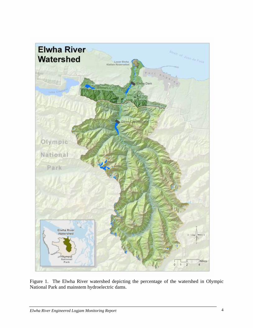
Figure 1. The Elwha River watershed depicting the percentage of the watershed in Olympic National Park and mainstem hydroelectric dams.
Elwha River Engineered Logjam Monitoring Report 4
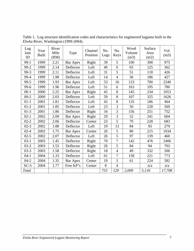
Table 1. Log structure identification codes and characteristics for engineered logjams built in the Elwha River, Washington (1999-2004).
Log Jam ID
Year Built
River Mile (RM)
Type Channel Position
No. Logs
No. Keys
Wood Volume
(m3)
Surface Area (m2)
Vol. (m3)
99-1 1999 2.21 Bar Apex Right 39 5 100 308 975 99-2 1999 2.14 Deflector Left 40 0 65 125 362 99-3 1999 2.11 Deflector Left 31 5 51 118 426 99-4 1999 1.98 Deflector Left 14 4 36 186 427 99-5 1999 1.93 Bar Apex Left 53 16 123 700 2240 99-6 1999 1.96 Deflector Left 51 6 163 195 780 00-1 2000 2.25 Bar Apex Right 45 8 145 234 1053 00-2 2000 2.03 Deflector Left 59 8 107 325 1626 01-1 2001 1.81 Deflector Left 45 8 135 186 464 01-2 2001 1.85 Deflector Left 23 3 50 228 569 01-3 2001 1.86 Deflector Right 34 3 156 251 752 02-1 2002 2.09 Bar Apex Right 29 3 52 241 604 02-2 2002 2.06 Deflector Center 23 5 70 228 683 02-3 2002 1.88 Deflector Left 19 13 84 93 279 02-4 2002 1.75 Bar Apex Center 20 5 80 215 1034 02-5 2002 2.07 Deflector Left 26 5 97 139 460 03-1 2003 1.45 Deflector Right 70 7 142 476 2406 03-2 2003 1.53 Deflector Right 26 5 84 94 703 03-3 2003 1.58 Deflector Right 18 4 49 332 506 04-1 2004 1.33 Deflector Left 61 7 158 221 773 04-2 2004 1.35 Bar Apex Center 19 5 61 224 582 SC-5 2004 1.77 Free KP’s Center 8 4 n/a n/a Total 753 129 2,009 5,116 17,708
Elwha River Engineered Logjam Monitoring Report 5

0
20
40
60
80
100
120
140
160
180
99-1 99-2 99-3 99-4 99-5 99-6 00-1 00-2 01-1 01-2 01-3 02-1 02-2 02-3 02-4 02-5 03-1 03-2 03-3 04-1 04-2
Structure Number
Woo
d Vo
lum
e (m
3)
0
10
20
30
40
50
60
70
80
Num
ber o
f Log
s
Wood Volume (m3) Number of Logs Number Key Pieces
Figure 2. Number of logs, key pieces and total volume for 21 engineered logjams constructed in the Elwha River, Washington (1999-2004).
Elwha River Engineered Logjam Monitoring Report 6

Federal Levee
East Mainstem Channel
Lower Meander
Hunts Road Side Channel (HRSC)
Side Channel 5
Upper Meander
Sisson Property
Figure 3. Location of engineered logjams on the lower Elwha River, Washington (1999-2004).
Elwha River Engineered Logjam Monitoring Report 7
Monitoring Methods
An ELJ monitoring study plan was prepared by project partners for the Elwha River (McHenry et al. 2001) and approved by the SRFB board. The goals of the study plan were to provide the SRFB with information regarding the effectiveness of ELJs techniques as a restoration tool in large alluvial rivers. The definition of large river for purposes of western Washington streams was defined as having a bankfull width of >50 m. The SRFB was particularly interested in basic questions of ELJ stability, habitat formation and fish response. The Elwha study design (McHenry et al. 2001) included both physical habitat and biological response sections. The physical habitat section focused on the interaction of alluvial sediment, flows and wood, while the biological sections focused on trophic relationships between ELJ and non-ELJ influenced habitats, with particular emphasis on quantifying primary production, secondary production and juvenile fish density. A companion study on the Stillaguamish River used complementary monitoring methods but focused more on the response of adult fish to the ELJs (Washington Fish Conservancy 2007). Reviewers of this paper should be aware that we did not attempt to answer questions concerning the effects of ELJs on fish survival or productivity. Physical and biological parameters measured, methodology used and frequency of measurement are summarized in Table 2. McHenry et al. (2001), Coe et al. (2006) and Pess et al. (In Preparation) provide greater levels of detail for both physical and biological methods.
Elwha River Engineered Logjam Monitoring Report 8
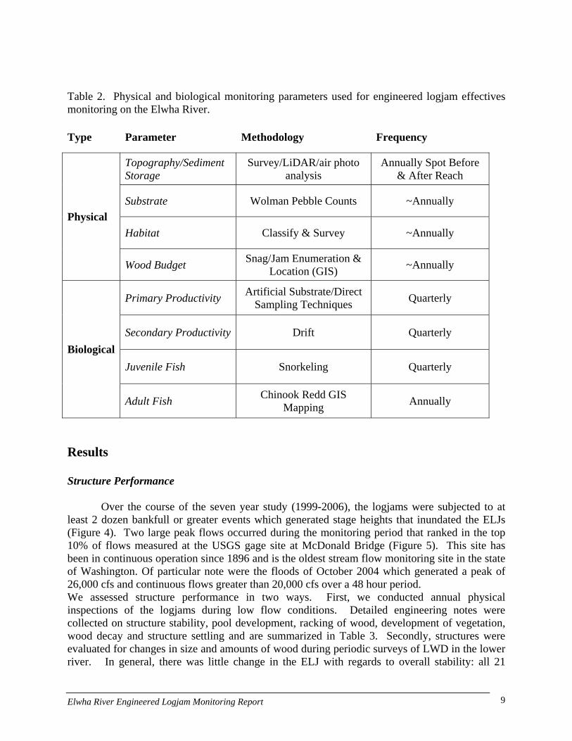
Table 2. Physical and biological monitoring parameters used for engineered logjam effectives monitoring on the Elwha River.
Type Parameter Methodology Frequency
Topography/Sediment Storage
Survey/LiDAR/air photo analysis
Annually Spot Before & After Reach
Substrate Wolman Pebble Counts ~Annually
Habitat Classify & Survey ~Annually Physical
Wood Budget Snag/Jam Enumeration & Location (GIS) ~Annually
Primary Productivity Artificial Substrate/Direct Sampling Techniques Quarterly
Secondary Productivity Drift Quarterly
Juvenile Fish Snorkeling Quarterly Biological
Adult Fish Chinook Redd GIS Mapping Annually
Results
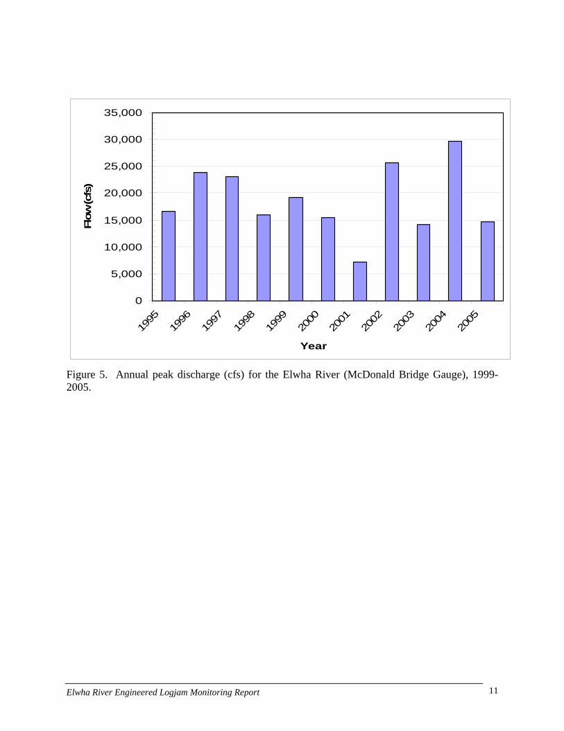
Structure Performance Over the course of the seven year study (1999-2006), the logjams were subjected to at
least 2 dozen bankfull or greater events which generated stage heights that inundated the ELJs (Figure 4). Two large peak flows occurred during the monitoring period that ranked in the top 10% of flows measured at the USGS gage site at McDonald Bridge (Figure 5). This site has been in continuous operation since 1896 and is the oldest stream flow monitoring site in the state of Washington. Of particular note were the floods of October 2004 which generated a peak of 26,000 cfs and continuous flows greater than 20,000 cfs over a 48 hour period. We assessed structure performance in two ways. First, we conducted annual physical inspections of the logjams during low flow conditions. Detailed engineering notes were collected on structure stability, pool development, racking of wood, development of vegetation, wood decay and structure settling and are summarized in Table 3. Secondly, structures were evaluated for changes in size and amounts of wood during periodic surveys of LWD in the lower river. In general, there was little change in the ELJ with regards to overall stability: all 21
Elwha River Engineered Logjam Monitoring Report 9

structures were in the same position and had similar surface areas in which they were constructed. In terms of integrity of the wood used to construct the logjams only minor decay associated with insect damage was noted on one logjam. The majority of structures were found to be racking fluvially transported wood and trapping finer organic debris (flotsam). There appeared to be a difference in the racking ability of the ELJs based on construction techniques: with BAJ being more efficient at trapping larger wood. In 18 of 21 ELJs constructed, woody vegetation had established on top of the structures within the study period. Primary woody species included: Black cottonwood, red alder and Sitka willow. Since the ELJs surfaces (except for one) were not intentionally planted, the vegetation was naturally recruited from local floodplain forests. One ELJ surface (#00-1) was heavily colonized by non-native Scotch broom. This invasive non-native plant was removed by weed wrenching in the winter of 2007.
We observed some fundamental differences between ELJs that were placed onto the existing river bed (DJs) versus those dug into the river bed (BAJs). ELJs built onto the existing riverbed were more susceptible to scour and undercutting, particularly flow deflectors placed along the left bank at the Sisson property. Scour led to settling of some of these deflector ELJs (e.g., 99-4 and 99-6) whereas there hasn’t been any noticeable changes to the ELJs that were excavated into the riverbed. The deepest scour hole, 5 m, was observed at the deflector ELJ 00-2 located near the apex of the meander along the Sisson property. Structure architecture and construction techniques are important determinants in ELJ function and considerable differences may be found between practitioners.
02,0004,0006,0008,000
10,00012,00014,00016,00018,00020,000
10/
01/1
998
03/
12/1
999
08/
21/1
999
01/
30/2
000
07/
10/2
000
12/
19/2
000
05/
30/2
001
11/
08/2
001
04/
19/2
002
09/
28/2
002
03/
09/2
003
08/
18/2
003
01/
27/2
004
07/
07/2
004
12/
16/2
004
05/
27/2
005
Dai
ly M
ean
Flow
(cfs
)
Figure 4. Mean daily discharge for the Elwha River at the McDonald Bridge Gauge site, 1999-2005. Flows above dashed line fully inundate the ELJs.
Elwha River Engineered Logjam Monitoring Report 10
0
5,000
10,000
15,000
20,000
25,000
30,000
35,000
1995
1996
1997
1998
1999
2000
2001
2002
2003
2004
2005
Year
Flow
(cfs
)
Figure 5. Annual peak discharge (cfs) for the Elwha River (McDonald Bridge Gauge), 1999-2005.
Elwha River Engineered Logjam Monitoring Report 11

Table 3. Summary table of Elwha River engineered logjam performance as of 2005.
Log Jam ID
Woody Vegetation on Structure
Racked Pieces
Pool
Undercutting Occurring
Flotsam on Structure
Decay Settling
99-1 99-2 99-3 99-4 99-5 99-6 00-1 00-2 01-1 01-2 01-3 02-1 02-2 02-3 02-4 02-5 03-1 03-2 03-3 04-1 04-2
Key: = Attribute was present during survey.
Elwha River Engineered Logjam Monitoring Report 12
Physical Parameters
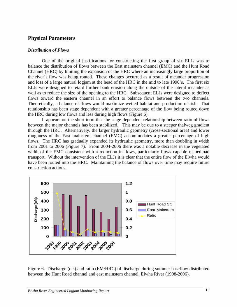
Distribution of Flows One of the original justifications for constructing the first group of six ELJs was to
balance the distribution of flows between the East mainstem channel (EMC) and the Hunt Road Channel (HRC) by limiting the expansion of the HRC where an increasingly large proportion of the river’s flow was being routed. These changes occurred as a result of meander progression and loss of a large natural logjam at the head of the HRC in the mid to late 1990’s. The first six ELJs were designed to retard further bank erosion along the outside of the lateral meander as well as to reduce the size of the opening to the HRC. Subsequent ELJs were designed to deflect flows toward the eastern channel in an effort to balance flows between the two channels. Theoretically, a balance of flows would maximize wetted habitat and production of fish. That relationship has been stage dependent with a greater percentage of the flow being routed down the HRC during low flows and less during high flows (Figure 6).
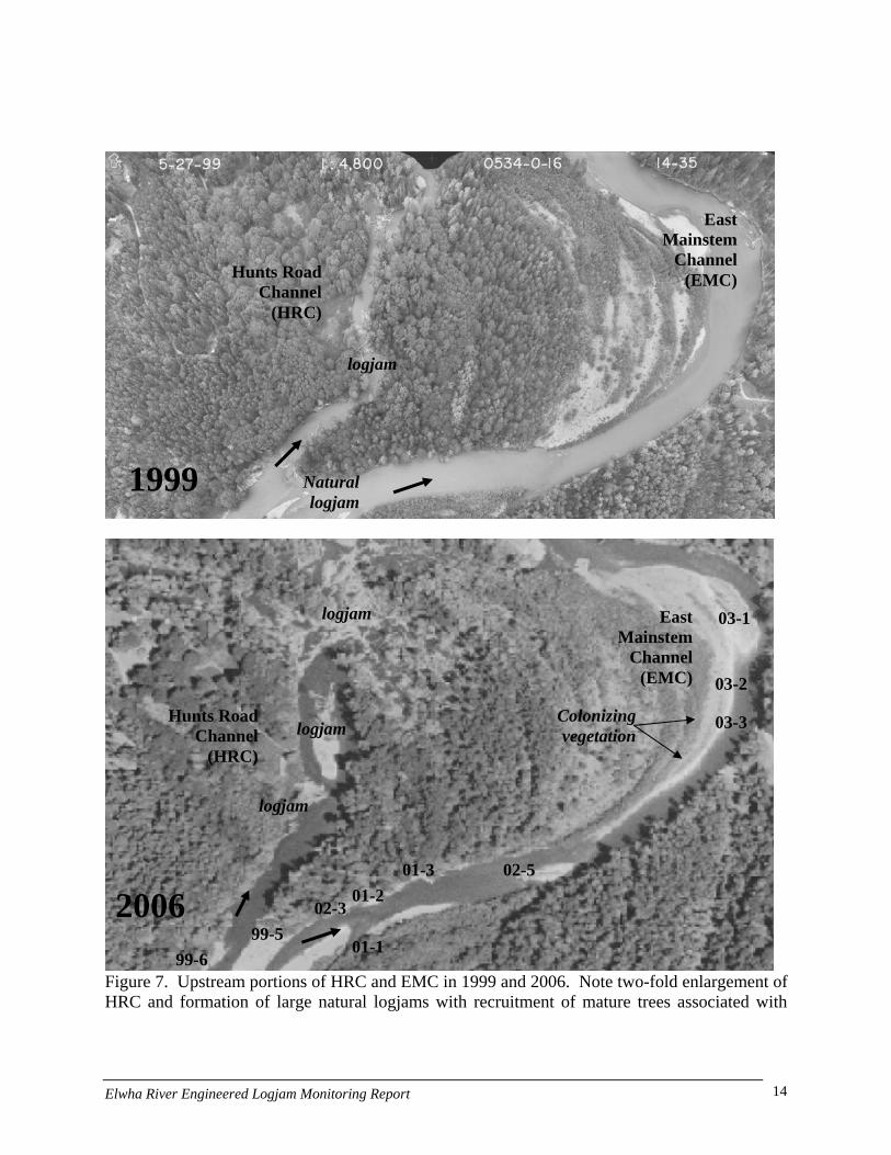
It appears on the short term that the stage-dependent relationship between ratio of flows between the major channels has been stabilized. This may be due to a steeper thalweg gradient through the HRC. Alternatively, the larger hydraulic geometry (cross-sectional area) and lower roughness of the East mainstem channel (EMC) accommodates a greater percentage of high flows. The HRC has gradually expanded its hydraulic geometry, more than doubling in width from 2001 to 2006 (Figure 7). From 2004-2006 there was a notable decrease in the vegetated width of the EMC consistent with a reduction in flows, particularly flows capable of bedload transport. Without the intervention of the ELJs it is clear that the entire flow of the Elwha would have been routed into the HRC. Maintaining the balance of flows over time may require future construction actions.
0
100
200
300
400
500
600
1998
1999
2000
2001
2002
2003
2004
2005
2006
Disc
harg
e (c
fs)
0
0.2
0.4
0.6
0.8
1
1.2
Hunt Road SCEast MainstemRatio
Figure 6. Discharge (cfs) and ratio (EM/HRC) of discharge during summer baseflow distributed between the Hunt Road channel and east mainstem channel, Elwha River (1998-2006).
Elwha River Engineered Logjam Monitoring Report 13
Natural logjam
logjam
1999
East Mainstem
Channel (EMC)Hunts Road
Channel (HRC)
Hunts Road Channel
(HRC)
East Mainstem
Channel (EMC)
logjam Colonizing vegetation
logjam
logjam
99-5
02-501-301-2
02-3
01-1
03-3
03-2
03-1
2006
Figure 7. Upstream portions of HRC and EMC in 1999 and 2006. Note two-fold enlargement of HRC and formation of large natural logjams with recruitment of mature trees associated with
99-6
Elwha River Engineered Logjam Monitoring Report 14
channel expansion. Meanwhile vegetation has encroached on the EMC (particularly along left bank point bar). Bank Erosion
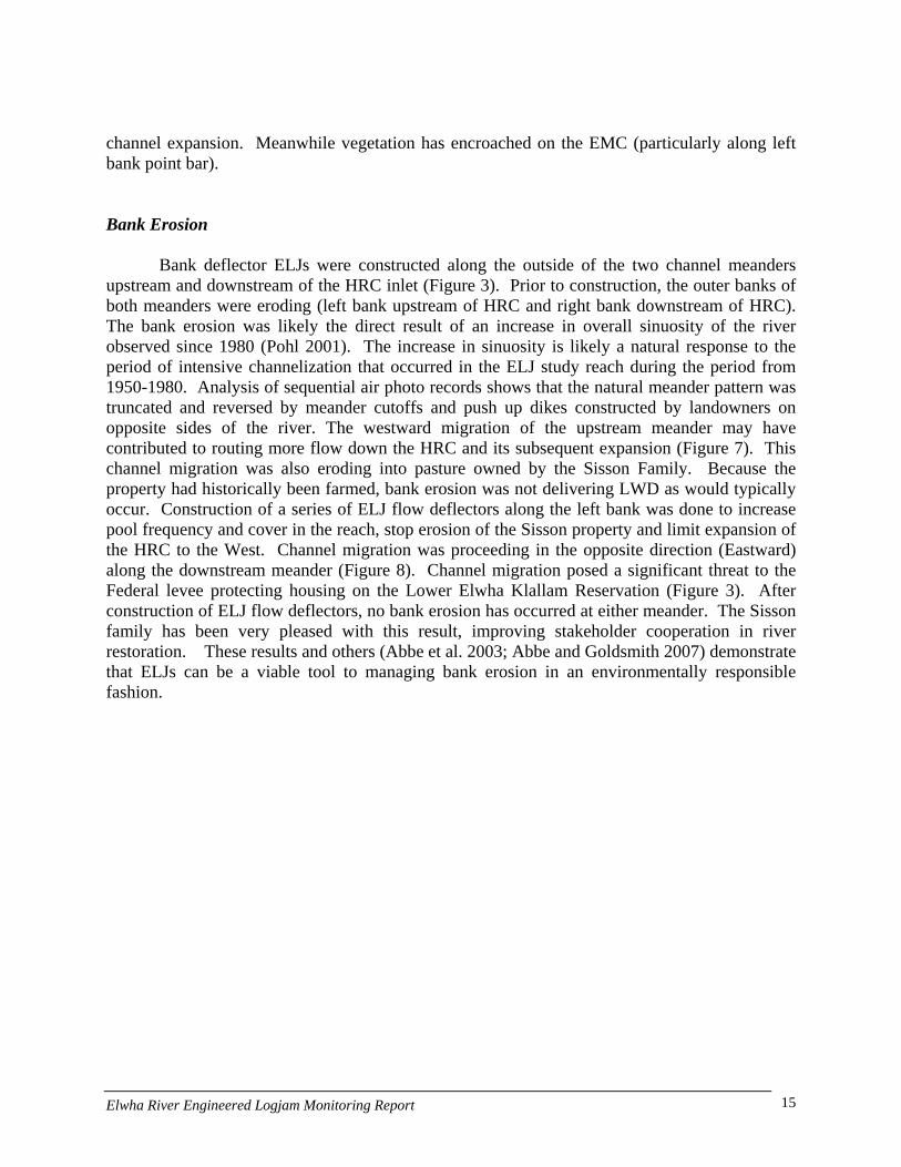
Bank deflector ELJs were constructed along the outside of the two channel meanders
upstream and downstream of the HRC inlet (Figure 3). Prior to construction, the outer banks of both meanders were eroding (left bank upstream of HRC and right bank downstream of HRC). The bank erosion was likely the direct result of an increase in overall sinuosity of the river observed since 1980 (Pohl 2001). The increase in sinuosity is likely a natural response to the period of intensive channelization that occurred in the ELJ study reach during the period from 1950-1980. Analysis of sequential air photo records shows that the natural meander pattern was truncated and reversed by meander cutoffs and push up dikes constructed by landowners on opposite sides of the river. The westward migration of the upstream meander may have contributed to routing more flow down the HRC and its subsequent expansion (Figure 7). This channel migration was also eroding into pasture owned by the Sisson Family. Because the property had historically been farmed, bank erosion was not delivering LWD as would typically occur. Construction of a series of ELJ flow deflectors along the left bank was done to increase pool frequency and cover in the reach, stop erosion of the Sisson property and limit expansion of the HRC to the West. Channel migration was proceeding in the opposite direction (Eastward) along the downstream meander (Figure 8). Channel migration posed a significant threat to the Federal levee protecting housing on the Lower Elwha Klallam Reservation (Figure 3). After construction of ELJ flow deflectors, no bank erosion has occurred at either meander. The Sisson family has been very pleased with this result, improving stakeholder cooperation in river restoration. These results and others (Abbe et al. 2003; Abbe and Goldsmith 2007) demonstrate that ELJs can be a viable tool to managing bank erosion in an environmentally responsible fashion.
Elwha River Engineered Logjam Monitoring Report 15

Downstream meander
HRC inlet
Upstream meander
Figure 8. Historic channel locations of the Lower Elwha, 1971-2001, showing outward migration of meanders upstream and downstream of the HRC inlet.
Elwha River Engineered Logjam Monitoring Report 16

Changes in Habitat Area Construction of ELJs appeared to have a relatively minor effect on the distribution of
habitat types as measured by surface area. But the number of pool units increased dramatically (58%), reflecting the development of localized scour pools in association with the ELJs over time, the surface area of the reach classified as pool habitat increased only modestly (Figure 9). Areas classified as riffle and glide increased and decreased, respectively from 2000-2006, possibly as a result of increased sediment deposition around the ELJs. There was not clear trend in the number of habitat units. The lack of dramatic change in habitat surface area is not particularly surprising considering the geomorphic conditions of the treatment reach which is dominated by two meander bends with very large lateral scour pools. These features are controlled by larger scale geomorphic processes (i.e. meander formation, channel avulsions) that dictate scour and sediment deposition (point bars) and habitat formation. In large river mainstem habitats, ELJs influence habitat at both site and reach scales. At the site scale, ELJs created pools, increased complex cover, frequency of gravel bars and islands. At the reach scale, ELJs influence channel planform (meanders), trigger side channel formation, and significantly increase hydraulic roughness within a channel. For example, ELJs 99-5 and 99-6 limited the expansion of the HRC and ELJs 99-1 and 00-1 were positioned to encourage flow into side channel 5 (Figure 3). Several recent ELJ projects were successful at re-activating large areas of habitat by sending water down disconnected side channels (Hook et al. 2006, Abbe and Goldsmith 2007). Since ELJs form flow obstructions that locally elevate water surface elevations they are effective at increasing the inundation frequency of side channels (Abbe and Montgomery 2003; Abbe et al. 2003).
0%
10%
20%
30%
40%
50%
60%
2000 2003 2004
Habi
tat S
urfa
ce A
rea
0
2
4
6
8
10
12
14
No.
Of P
ool U
nits Pool Area (%)
Riffle Area (%)Glide Area (%)number of Pool UnitsEdge Area (%)
Elwha River Engineered Logjam Monitoring Report 17

Figure 9. Changes in habitat type and area in the Elwha River engineered logjam treatment reach, 2000-2004.
Side-Channel Formation
Two Bar Apex Jams (00-1 & 99-1) contributed to the reconnection of the Elwha River
with its historic floodplain through the expansion of habitat in a side-channel. The logjams backwatered water elevations along the right bank to increase overbank flows into side-channel five, a groundwater fed channel (Figure 3). Over the study period, increasing flow and channel scour occurred in this channel resulting in an increase in groundwater exchange and frequency of overbank inundation. We measured the available wetted habitat in side channel 5 in 2001 and again in 2006 and found that the wetted habitat area increased from 532 to 1,271 m2. This expansion was also assisted by the placement of 4 unanchored key pieces by the Tribe in 2003 at the downstream end of side channel 5 (Figure 3). The wood was critical in forming a stable logjam that trapped smaller wood that moved through the side channel, particularly after the high flow in the fall of 2003. The high flow that enlarged the side channel 5 introduced small diameter alder trees, which racked on the placed key pieces. We believe that LWD retention in side channel 5 is entirely due to the presence of the introduced key pieces since there are no large riparian trees like there were along the HRC. There was no LWD retention in side channel five prior to the introduction of key pieces. These logjams in turn provided roughness that formed scour pools and trapped gravel. Adult spawning by chum, coho and steelhead has been observed since 2003 in side-channel 5. Pool Depths
We monitored the development of pool scour using maximum pool depth as the primary
metric for habitat quality. Of the 21 ELJs constructed on the Elwha River, five were located in existing pool habitats while the remaining 16 were built in non-pool habitat types including riffles, glides or non-wetted gravel bars. ELJs built in existing pool habitats caused in increase in maximum pool depth in all of the pre-existing pools (Figure 10). The increase ranged from 21-63% (average = 50%). For ELJs constructed in non-pool habitats, pool development was measured at 15 of the 16 (94%) ELJ sites (Figure 11). Pool development was typically rapid, usually within one or two years of construction but maximum pool depth was variable (Figure 12). The variability in maximum pool depth between years was likely a result of pool scour and fill processes between years. The depth of pool formed was directly related to the amount of hydraulic energy exerted on the ELJs. The deepest pools formed in ELJs built in existing pool habitats. These universally occurred upstream of the split of flows at the Hunt Road Channel. Depth of scour is also likely limited in the Elwha by the existing very coarse characteristics of the bed. The only ELJ that has not directly resulted in a pool was #99-4 which was completely buried in the floodplain in an effort to prevent lateral migration around the entrance to the Hunt Road Channel.
Elwha River Engineered Logjam Monitoring Report 18

14
16
18
0
2
4
6
8
10
12
2000
2002
2003
2004
2006
Max
imum
Poo
l Dep
th (f
t)
#99-2#99-3#99-6#00-2#02-5
Figure 10. Changes in maximum pool depth over time in five areas that had engineered logjams constructed within existing pool habitats, Elwha River.
8
9
#99-1
0
1
2
3
4
5
6
7
2000
2002
2003
2004
2006
Max
imum
Poo
l Dep
th (f
t)
#99-5#00-1#01-1#01-2#01-3#02-1#02-2#02-3#02-4#03-1#03-2#03-3
Figure 11. Maximum pool depth over time at thirteen engineered logjam sites lacking pre-existing pools, Elwha River, Washington.
Elwha River Engineered Logjam Monitoring Report 19
0
1
2
3
4
5
6
7
8
9
10
No Pool <2 2-4 4-6 6-8 8-10 >10
Maximum Pool Depth (Feet)
Freq
uenc
y
Figure 12. Frequency distribution for maximum pool depth associated with Elwha River engineered logjams.
Sediment Storage/Topography
We established base or pre-project topographic conditions within the treatment reach
using cadastral surveying techniques (Wengler Surveying of Port Angeles). The upper portion of the treatment reach was surveyed in 2001 and the lower portions of the treatment reach were surveyed in 2003. In addition, the Tribe obtained additional topographic information of the treatment reach through the acquisition of remote sensed data collected by a Laser Imaging Detection and Return (LIDAR) overflight in 2003. Spot elevations over time have also been collected at several engineered logjam sites. To date, this information has not been analyzed. Although it was our intent to conduct a post project topographic survey or the treatment reach, project funds became limiting at the end of the study. We recommend that the topographic survey eventually be conducted; however the cost to collect and analyze this information is $30,000. As a surrogate, we measured the amount of sediment stored in the ELJ treatment reach by analyzing the area of sediment stored in gravel bars. We used a sequential analysis of the aerial photographs from 1999-2006 and found that bar area expanded dramatically in the ELJ treatment reach. The number of individual gravel bars increased by 86%, while the area increased by 60% (Figure 13). This is a remarkable result given the chronically sediment starved nature of the Elwha River due to the century old dams.
Elwha River Engineered Logjam Monitoring Report 20

0
10000
20000
30000
40000
50000
60000
1994 2000 2003 2006
Surfa
ce A
rea
(m2)
0
2
4
6
8
10
12
14
No. o
f Gra
vel B
ars
Figure 13. Number of gravel bars and their surface area (m2) in the Elwha River engineered logjam treatment reach, 1994-2006.
Surface Substrate Composition
The bed of the lower Elwha River is currently coarse because of the reduced sediment supply resulting from dam construction nearly a century ago. We measured changes in channel bed substrate condition by conducting Pebble Counts (Wolman 1954) at seven selected engineered logjam sites during low flow conditions each summer. We sampled primarily bar surfaces behind or downstream of bar apex logjams, as these types have the greatest impact on sediment storage. Deflector logjam, particularly those constructed in existing pools along outside meanders or lateral scour pools, often result in local scour and have not caused significant sediment storage. We found that engineered logjams had a dramatic effect on bed fining (Figures 14 & 15), resulting in a reduction of the dominant substrate from cobble to gravel (Figure 16). We assessed the increase in three size classes of gravel at seven ELJ sites over time on the Elwha and found that the majority of sites had statistically significant increases in fine (<8 mm), medium (<16 mm) and coarse gravel (<32 mm) through the study period (Table 4). This effect has a direct impact on spawning habitat for adult salmon including Chinook, coho, chum and steelhead which have consistently been observed utilizing habitats created by ELJs throughout the study. For example during the winter of 2007, spawning chum (~70) were observed utilizing gravel around ELJs 04-1 and 04-2.
Elwha River Engineered Logjam Monitoring Report 21

0102030405060708090
100
<2 >2 >4 >6 >8 >11
>16
>22
>32
>45
>64
>90
>128
>180
>256
Pebble Size (mm)
Cum
ulat
ive
Perc
enta
ge
20012006
Figure 14. Particle-size distribution on channel bed surfaces immediately downstream of engineered logjam #01-1, Elwha River, 2001-2006. Arrows show median particle size in 2001 and 2006.
0102030405060708090
100
<2 >2 >4 >6 >8 >11
>16
>22
>32
>45
>64
>90>1
28>1
80>2
56
Pebble Size (mm)
Cum
ulat
ive
Per
cent
age
20032006
Figure 15. Particle size distribution by size class on Elwha River bed surface immediately downstream of engineered logjam #02-2, 2003-2006. . Arrows show median particle size in 2001 and 2006.
Elwha River Engineered Logjam Monitoring Report 22
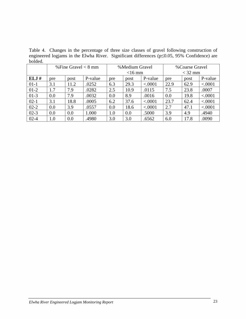
Table 4. Changes in the percentage of three size classes of gravel following construction of engineered logjams in the Elwha River. Significant differences (p≤0.05, 95% Confidence) are bolded. %Fine Gravel < 8 mm %Medium Gravel
<16 mm %Coarse Gravel
< 32 mm ELJ # pre post P-value pre post P-value pre post P-value 01-1 3.1 11.2 .0252 6.3 29.3 <.0001 22.9 62.9 <.0001 01-2 1.7 7.9 .0282 2.5 10.9 .0115 7.5 23.8 .0007 01-3 0.0 7.9 .0032 0.0 8.9 .0016 0.0 19.8 <.0001 02-1 3.1 18.8 .0005 6.2 37.6 <.0001 23.7 62.4 <.0001 02-2 0.0 3.9 .0557 0.0 18.6 <.0001 2.7 47.1 <.0001 02-3 0.0 0.0 1.000 1.0 0.0 .5000 3.9 4.9 .4940 02-4 1.0 0.0 .4980 3.0 3.0 .6562 6.0 17.8 .0090
Elwha River Engineered Logjam Monitoring Report 23
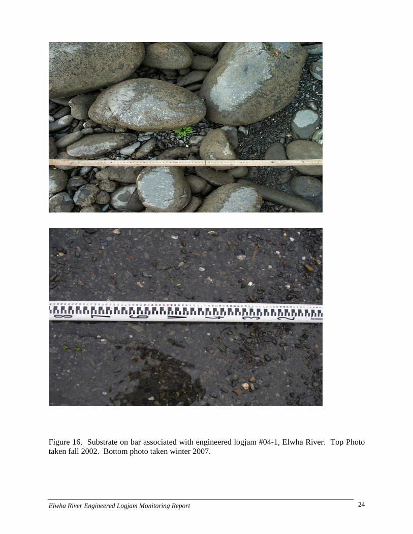
Figure 16. Substrate on bar associated with engineered logjam #04-1, Elwha River. Top Photo taken fall 2002. Bottom photo taken winter 2007.
Elwha River Engineered Logjam Monitoring Report 24

Temperature
We placed temperature loggers in the Elwha River during the September of 2006 as part of the juvenile fish movement study. We selected the former mainstem (eastern channel) which during baseflow was receiving very little surface flow and was prone to heating from solar interception during the summer. The temperature loggers were placed in pairs in pool units associated with ELJs: one near the surface and another near the bottom. For two of the three ELJ sites monitored, we found that the difference between surface and bottom temperature was between 0.5-2.o Celsius through the September monitoring period (Figure 17). This trend tended to diminish in a downstream direction as groundwater influence increased from other areas of the floodplain diminishing the localized effect. This data suggests that in some situations, ELJs may provide thermal refugia for temperature sensitive species. Indeed, we observed temperature sensitive species such as pre-spawning Chinook salmon and adult bull trout holding in ELJ pools on several occasions during the study. As such ELJs may be a useful tool to help manage temperature in some systems. We hypothesize that ELJs may affect stream temperature in four primary ways:
1. Creating local hydraulic gradients that interact with increased channel complexity to drive flow into the hyporheic zone and cool water temperatures.
2. Changing channel geometry through reach-scale sediment trapping causing a reduction in width to depth ratio,
3. Forming scour pools which effectively increase groundwater exchange, and 4. By intercepting solar radiation.
12
13
14
15
16
17
18
19
20
9/1/06
9/8/06
9/15/0
6
9/22/0
6
9/29/0
6
Deg
rees
Cel
sius
ELJ 1 SurfaceELJ 1 Bottom
Figure 17. Difference between surface (solid) and bottom (dashed) water temperature at an Elwha engineered logjam (site 02-3), September 2006.
Elwha River Engineered Logjam Monitoring Report 25
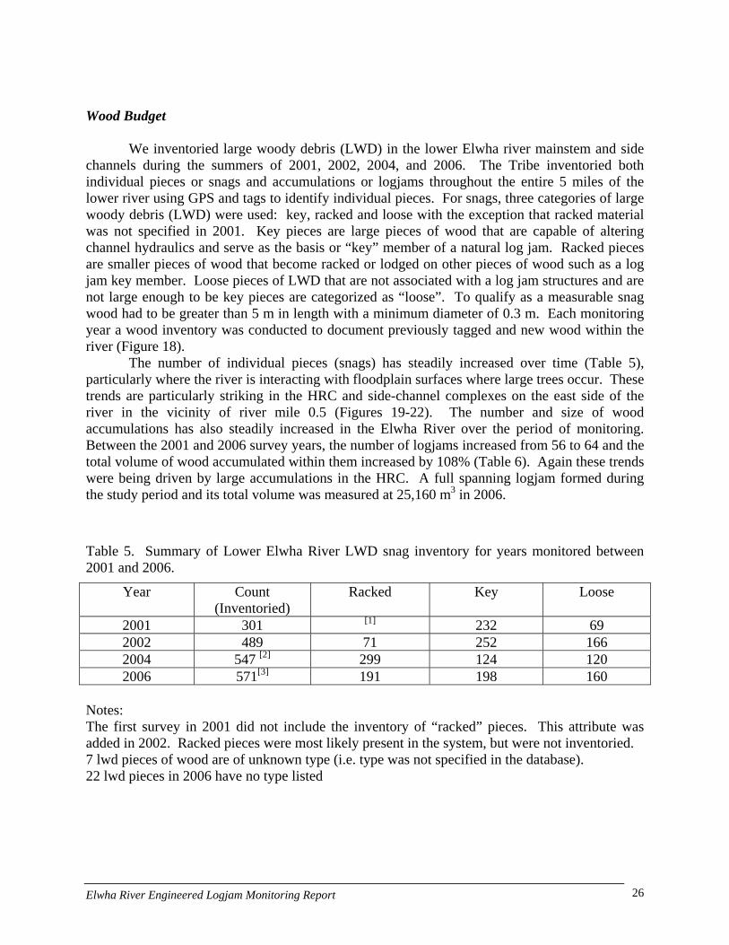
Wood Budget We inventoried large woody debris (LWD) in the lower Elwha river mainstem and side channels during the summers of 2001, 2002, 2004, and 2006. The Tribe inventoried both individual pieces or snags and accumulations or logjams throughout the entire 5 miles of the lower river using GPS and tags to identify individual pieces. For snags, three categories of large woody debris (LWD) were used: key, racked and loose with the exception that racked material was not specified in 2001. Key pieces are large pieces of wood that are capable of altering channel hydraulics and serve as the basis or “key” member of a natural log jam. Racked pieces are smaller pieces of wood that become racked or lodged on other pieces of wood such as a log jam key member. Loose pieces of LWD that are not associated with a log jam structures and are not large enough to be key pieces are categorized as “loose”. To qualify as a measurable snag wood had to be greater than 5 m in length with a minimum diameter of 0.3 m. Each monitoring year a wood inventory was conducted to document previously tagged and new wood within the river (Figure 18).
The number of individual pieces (snags) has steadily increased over time (Table 5), particularly where the river is interacting with floodplain surfaces where large trees occur. These trends are particularly striking in the HRC and side-channel complexes on the east side of the river in the vicinity of river mile 0.5 (Figures 19-22). The number and size of wood accumulations has also steadily increased in the Elwha River over the period of monitoring. Between the 2001 and 2006 survey years, the number of logjams increased from 56 to 64 and the total volume of wood accumulated within them increased by 108% (Table 6). Again these trends were being driven by large accumulations in the HRC. A full spanning logjam formed during the study period and its total volume was measured at 25,160 m3 in 2006.
Table 5. Summary of Lower Elwha River LWD snag inventory for years monitored between 2001 and 2006.
Year Count (Inventoried)
Racked Key Loose
2001 301 [1] 232 69 2002 489 71 252 166 2004 547 [2] 299 124 120 2006 571[3] 191 198 160
Notes: The first survey in 2001 did not include the inventory of “racked” pieces. This attribute was added in 2002. Racked pieces were most likely present in the system, but were not inventoried. 7 lwd pieces of wood are of unknown type (i.e. type was not specified in the database). 22 lwd pieces in 2006 have no type listed
Elwha River Engineered Logjam Monitoring Report 26
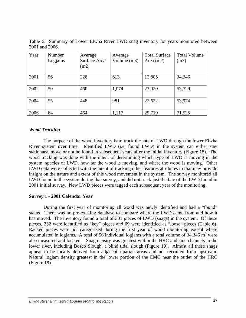
Table 6. Summary of Lower Elwha River LWD snag inventory for years monitored between 2001 and 2006.
Year Number Logjams
Average Surface Area (m2)
Average Volume (m3)
Total Surface Area (m2)
Total Volume (m3)
2001 56 228 613 12,805 34,346
2002 50 460 1,074 23,020 53,729
2004 55 448 981 22,622 53,974
2006 64 464 1,117 29,719 71,525 Wood Tracking
The purpose of the wood inventory is to track the fate of LWD through the lower Elwha River system over time. Identified LWD (i.e. found LWD) in the system can either stay stationary, move or not be found in subsequent years after the initial inventory (Figure 18). The wood tracking was done with the intent of determining which type of LWD is moving in the system, species of LWD, how far the wood is moving, and where the wood is moving. Other LWD data were collected with the intent of tracking other features attributes to that may provide insight on the nature and extent of this wood movement in the system. The survey monitored all LWD found in the system during that survey, and did not track just the fate of the LWD found in 2001 initial survey. New LWD pieces were tagged each subsequent year of the monitoring. Survey 1 - 2001 Calendar Year
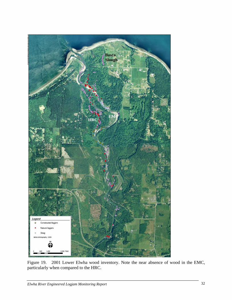
During the first year of monitoring all wood was newly identified and had a “found” status. There was no pre-existing database to compare where the LWD came from and how it has moved. The inventory found a total of 301 pieces of LWD (snags) in the system. Of these pieces, 232 were identified as “key” pieces and 69 were identified as “loose” pieces (Table 6). Racked pieces were not categorized during the first year of wood monitoring except where accumulated in logjams. A total of 56 individual logjams with a total volume of 34,346 m3 were also measured and located. Snag density was greatest within the HRC and side channels in the lower river, including Bosco Slough, a blind tidal slough (Figure 19). Almost all these snags appear to be locally derived from adjacent riparian areas and not recruited from upstream. Natural logjam density greatest in the lower portion of the EMC near the outlet of the HRC (Figure 19).
Elwha River Engineered Logjam Monitoring Report 27
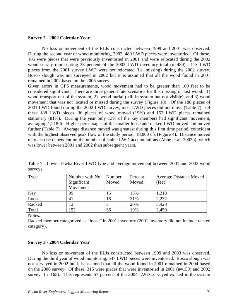
Survey 2 - 2002 Calendar Year
No loss or movement of the ELJs constructed between 1999 and 2001 was observed. During the second year of wood monitoring, 2002, 489 LWD pieces were inventoried. Of these, 185 were pieces that were previously inventoried in 2001 and were relocated during the 2002 wood survey representing 38 percent of the 2002 LWD inventory total (n=489). 113 LWD pieces from the 2001 survey LWD were not relocated (i.e. missing) during the 2002 survey. Bosco slough was not surveyed in 2002 but it is assumed that all the wood found in 2001 remained in 2002 based on the 2006 survey. Given errors in GPS measurements, wood movement had to be greater than 100 feet to be considered significant. There are three general fate scenarios for this missing or lost wood: 1) wood transport out of the system, 2) wood burial (still in system but not visible), and 3) wood movement that was not located or missed during the survey (Figure 18). Of the 188 pieces of 2001 LWD found during the 2002 LWD survey, most LWD pieces did not move (Table 7). Of these 188 LWD pieces, 36 pieces of wood moved (19%) and 152 LWD pieces remained stationary (81%). During the year only 13% of the key members had significant movement, averaging 1,218 ft. Higher percentages of the smaller loose and racked LWD moved and moved further (Table 7). Average distance moved was greatest during this first time period, coincident with the highest observed peak flow of the study period, 18,000 cfs (Figure 4). Distance moved may also be dependent on the number of stable LWD accumulations (Abbe et al. 2003b), which was lower between 2001 and 2002 than subsequent years.
Table 7. Lower Elwha River LWD type and average movement between 2001 and 2002 wood surveys.
Type Number with No Significant Movement
Number Moved
Percent Moved
Average Distance Moved (feet)
Key 99 15 13% 1,218 Loose 41 18 31% 2,232 Racked 12 3 20% 3,928 Total 152 36 19% 2,459 Notes: Racked member categorized as “loose” in 2001 inventory (2001 inventory did not include racked category). Survey 3 - 2004 Calendar Year
No loss or movement of the ELJs constructed between 1999 and 2003 was observed. During the third year of wood monitoring, 547 LWD pieces were inventoried. Bosco slough was not surveyed in 2002 but it is assumed that all the wood found in 2001 remained in 2004 based on the 2006 survey. Of these, 315 were pieces that were inventoried in 2001 (n=150) and 2002 surveys (n=165). This represents 57 percent of the 2004 LWD surveyed existed in the system
Elwha River Engineered Logjam Monitoring Report 28
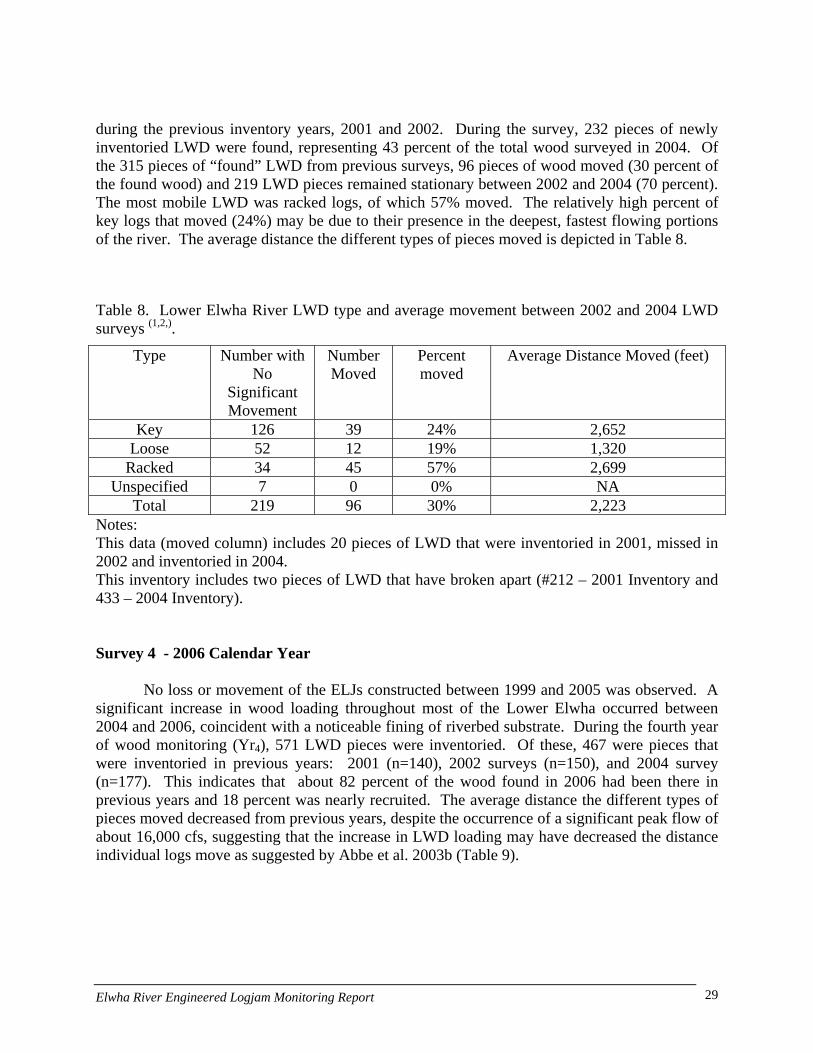
during the previous inventory years, 2001 and 2002. During the survey, 232 pieces of newly inventoried LWD were found, representing 43 percent of the total wood surveyed in 2004. Of the 315 pieces of “found” LWD from previous surveys, 96 pieces of wood moved (30 percent of the found wood) and 219 LWD pieces remained stationary between 2002 and 2004 (70 percent). The most mobile LWD was racked logs, of which 57% moved. The relatively high percent of key logs that moved (24%) may be due to their presence in the deepest, fastest flowing portions of the river. The average distance the different types of pieces moved is depicted in Table 8.
Table 8. Lower Elwha River LWD type and average movement between 2002 and 2004 LWD surveys (1,2,).
Type Number with No
Significant Movement
Number Moved
Percent moved
Average Distance Moved (feet)
Key 126 39 24% 2,652 Loose 52 12 19% 1,320
Racked 34 45 57% 2,699 Unspecified 7 0 0% NA
Total 219 96 30% 2,223 Notes: This data (moved column) includes 20 pieces of LWD that were inventoried in 2001, missed in 2002 and inventoried in 2004. This inventory includes two pieces of LWD that have broken apart (#212 – 2001 Inventory and 433 – 2004 Inventory). Survey 4 - 2006 Calendar Year
No loss or movement of the ELJs constructed between 1999 and 2005 was observed. A significant increase in wood loading throughout most of the Lower Elwha occurred between 2004 and 2006, coincident with a noticeable fining of riverbed substrate. During the fourth year of wood monitoring (Yr4), 571 LWD pieces were inventoried. Of these, 467 were pieces that were inventoried in previous years: 2001 (n=140), 2002 surveys (n=150), and 2004 survey (n=177). This indicates that about 82 percent of the wood found in 2006 had been there in previous years and 18 percent was nearly recruited. The average distance the different types of pieces moved decreased from previous years, despite the occurrence of a significant peak flow of about 16,000 cfs, suggesting that the increase in LWD loading may have decreased the distance individual logs move as suggested by Abbe et al. 2003b (Table 9).
Elwha River Engineered Logjam Monitoring Report 29
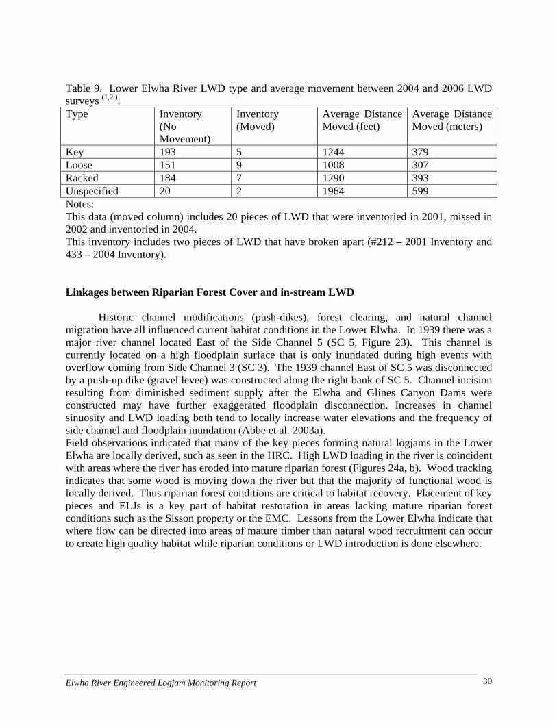
Table 9. Lower Elwha River LWD type and average movement between 2004 and 2006 LWD surveys (1,2,). Type Inventory
(No Movement)
Inventory (Moved)
Average Distance Moved (feet)
Average Distance Moved (meters)
Key 193 5 1244 379 Loose 151 9 1008 307 Racked 184 7 1290 393 Unspecified 20 2 1964 599 Notes: This data (moved column) includes 20 pieces of LWD that were inventoried in 2001, missed in 2002 and inventoried in 2004. This inventory includes two pieces of LWD that have broken apart (#212 – 2001 Inventory and 433 – 2004 Inventory). Linkages between Riparian Forest Cover and in-stream LWD
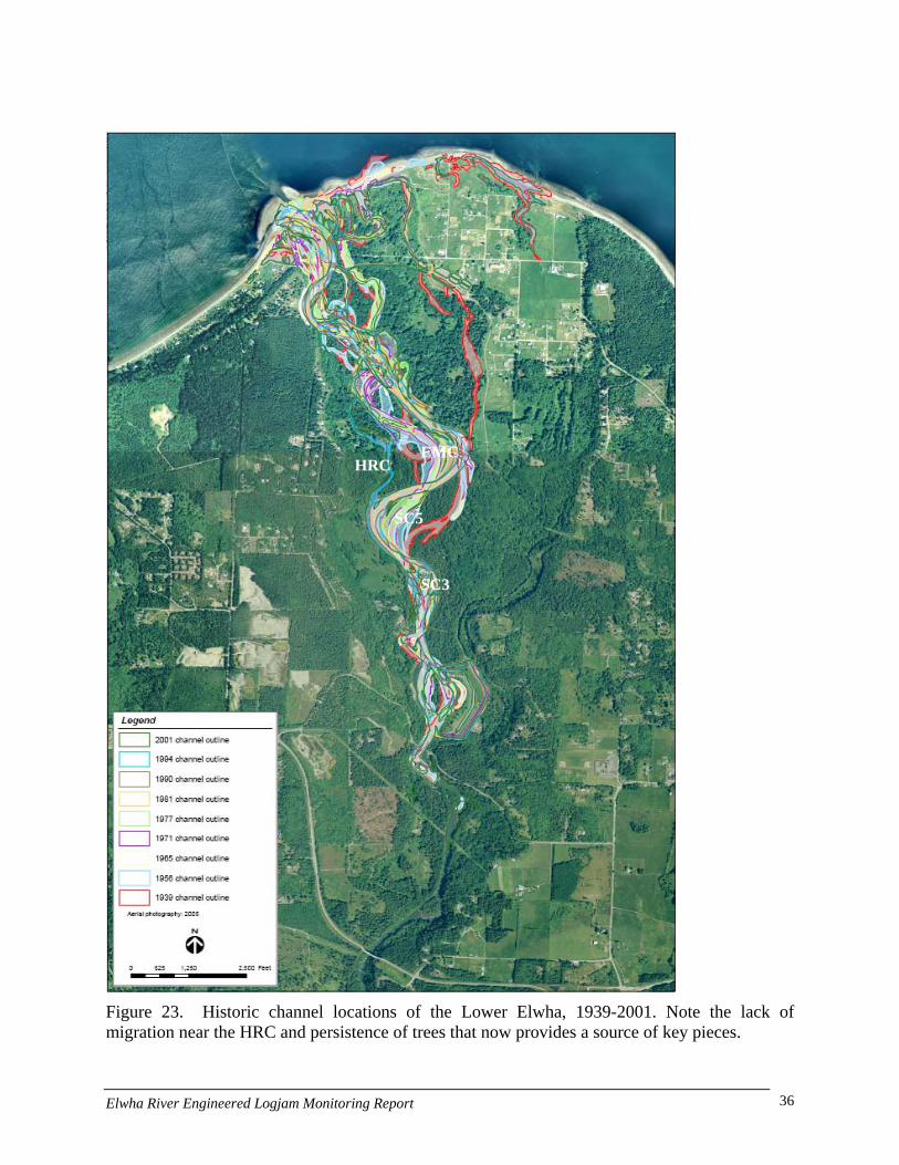
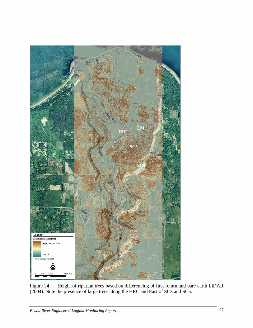
Historic channel modifications (push-dikes), forest clearing, and natural channel migration have all influenced current habitat conditions in the Lower Elwha. In 1939 there was a major river channel located East of the Side Channel 5 (SC 5, Figure 23). This channel is currently located on a high floodplain surface that is only inundated during high events with overflow coming from Side Channel 3 (SC 3). The 1939 channel East of SC 5 was disconnected by a push-up dike (gravel levee) was constructed along the right bank of SC 5. Channel incision resulting from diminished sediment supply after the Elwha and Glines Canyon Dams were constructed may have further exaggerated floodplain disconnection. Increases in channel sinuosity and LWD loading both tend to locally increase water elevations and the frequency of side channel and floodplain inundation (Abbe et al. 2003a). Field observations indicated that many of the key pieces forming natural logjams in the Lower Elwha are locally derived, such as seen in the HRC. High LWD loading in the river is coincident with areas where the river has eroded into mature riparian forest (Figures 24a, b). Wood tracking indicates that some wood is moving down the river but that the majority of functional wood is locally derived. Thus riparian forest conditions are critical to habitat recovery. Placement of key pieces and ELJs is a key part of habitat restoration in areas lacking mature riparian forest conditions such as the Sisson property or the EMC. Lessons from the Lower Elwha indicate that where flow can be directed into areas of mature timber than natural wood recruitment can occur to create high quality habitat while riparian conditions or LWD introduction is done elsewhere.
Elwha River Engineered Logjam Monitoring Report 30
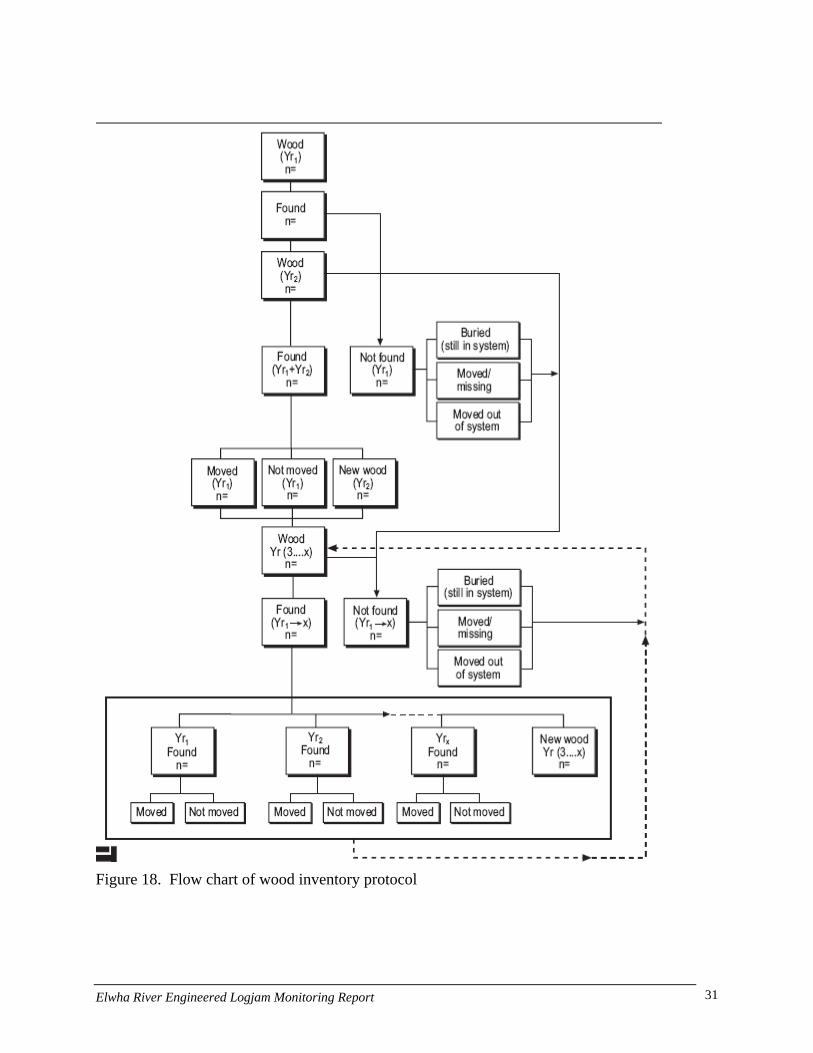
Figure 18. Flow chart of wood inventory protocol
Elwha River Engineered Logjam Monitoring Report 31
Bosco Slough
EMC HRC
Figure 19. 2001 Lower Elwha wood inventory. Note the near absence of wood in the EMC, particularly when compared to the HRC.
Elwha River Engineered Logjam Monitoring Report 32

Bosco Slough
EMC HRC
SC5
SC3
Figure 20. 2002 Lower Elwha wood inventory. Wood loading in the HRC has increased significantly since 2001, primarily from local recruitment, with no change in the EMC.
Elwha River Engineered Logjam Monitoring Report 33
Bosco Slough
EMC HRC
SC5
SC3
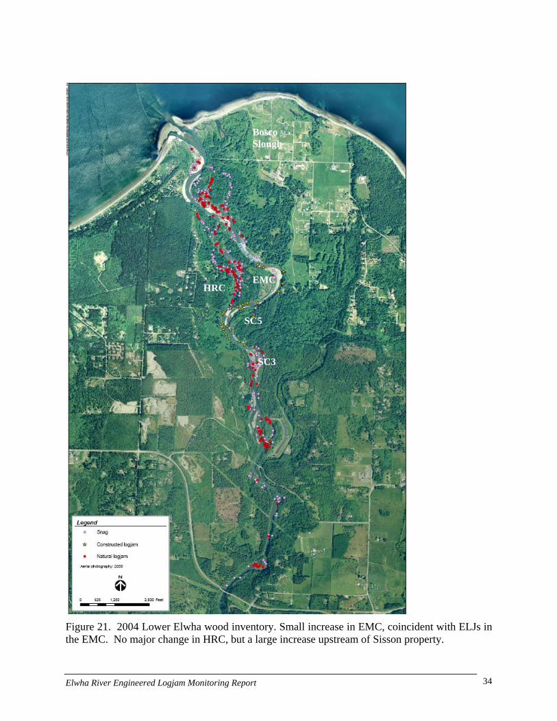
Figure 21. 2004 Lower Elwha wood inventory. Small increase in EMC, coincident with ELJs in the EMC. No major change in HRC, but a large increase upstream of Sisson property.
Elwha River Engineered Logjam Monitoring Report 34

Bosco Slough
EMC HRC
SC5
SC3
Figure 22. 2006 Lower Elwha wood inventory. Significant net increases in wood in HRC, SC5, and river segment including SC3, with some increase in the EMC.
Elwha River Engineered Logjam Monitoring Report 35
EMC HRC
SC5
SC3
Figure 23. Historic channel locations of the Lower Elwha, 1939-2001. Note the lack of migration near the HRC and persistence of trees that now provides a source of key pieces.
Elwha River Engineered Logjam Monitoring Report 36
EMC HRC
SC5
SC3
Figure 24. . Height of riparian trees based on differencing of first return and bare earth LiDAR (2004). Note the presence of large trees along the HRC and East of SC3 and SC5.
Elwha River Engineered Logjam Monitoring Report 37
Side Channel5 (SC5)
Hunts Road Channel (HRC)
East Mainstem Channel
Sisson Property
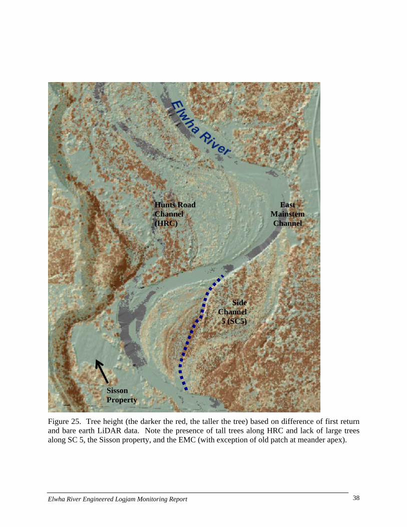
Figure 25. Tree height (the darker the red, the taller the tree) based on difference of first return and bare earth LiDAR data. Note the presence of tall trees along HRC and lack of large trees along SC 5, the Sisson property, and the EMC (with exception of old patch at meander apex).
Elwha River Engineered Logjam Monitoring Report 38
Biological Parameters
Primary Productivity
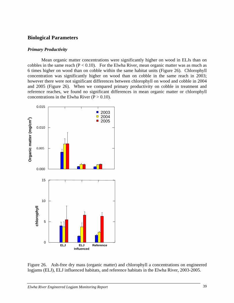
Mean organic matter concentrations were significantly higher on wood in ELJs than on cobbles in the same reach (P < 0.10). For the Elwha River, mean organic matter was as much as 6 times higher on wood than on cobble within the same habitat units (Figure 26). Chlorophyll concentration was significantly higher on wood than on cobble in the same reach in 2003; however there were not significant differences between chlorophyll on wood and cobble in 2004 and 2005 (Figure 26). When we compared primary productivity on cobble in treatment and reference reaches, we found no significant differences in mean organic matter or chlorophyll concentrations in the Elwha River (P > 0.10).
0.015
Figure 26. Ash-free dry mass (organic matter) and chlorophyll a concentrations on engineered logjams (ELJ), ELJ influenced habitats, and reference habitats in the Elwha River, 2003-2005.
200520042003
Org
anic
mat
ter (
mg/
cm2 )
0.010
0.005
0.000
15
0
5
10
chl
orop
hyll
2
ELJ ReferenceELJ Influenced
Elwha River Engineered Logjam Monitoring Report 39
Secondary Productivity
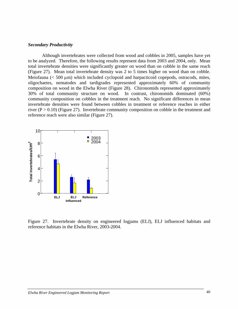
Although invertebrates were collected from wood and cobbles in 2005, samples have yet to be analyzed. Therefore, the following results represent data from 2003 and 2004, only. Mean total invertebrate densities were significantly greater on wood than on cobble in the same reach (Figure 27). Mean total invertebrate density was 2 to 5 times higher on wood than on cobble. Meiofauna (< 500 µm) which included cyclopoid and harpacticoid copepods, ostracods, mites, oligochaetes, nematodes and tardigrades represented approximately 60% of community composition on wood in the Elwha River (Figure 28). Chironomids represented approximately 30% of total community structure on wood. In contrast, chironomids dominated (60%) community composition on cobbles in the treatment reach. No significant differences in mean invertebrate densities were found between cobbles in treatment or reference reaches in either river (P > 0.10) (Figure 27). Invertebrate community composition on cobble in the treatment and reference reach were also similar (Figure 27).
10
Figure 27. Invertebrate density on engineered logjams (ELJ), ELJ influenced habitats and reference habitats in the Elwha River, 2003-2004.
ELJ ELJ Influenced
Reference0
2
4
6
8
Tota
l inv
erte
brat
es/c
m2 2004
2003
Elwha River Engineered Logjam Monitoring Report 40
Figure 28. Invertebrate community composition on engineered logjams (ELJ), ELJ influenced habitats, and reference habitats in the Elwha River, 2003-2004.
Juvenile Fish Density-ELJ vs. non-ELJ
The proportion of juvenile Chinook (50-100 mm) in ELJ units was consistently greater than in non-ELJ units for both summer and winter sampling events (Figure 29). However, this difference was only significant for the summer of 2003. Juvenile Chinook density did not have a distinct seasonal pattern. Juvenile Chinook (>100 mm) were not regularly observed; however when they did occur they were proportionally higher in ELJ units versus non-ELJ units. Densities of juvenile Chinook (> 100 mm) did not show any pattern over season or time. The proportion of ELJ units with coho fry (0+) was also consistently higher but this did not result in any significant differences in proportion in any of the sampling events (Figure 30). Median Coho fry densities were also not significantly different between ELJ and non-ELJ units. There was a pattern of decreasing median coho fry density over time in the summer and winter. Coho parr (1+) were not consistently observed at all sampling events. Significant numbers were only counted in 3 of the 7 sampling events. There was a significant difference in median density in ELJ units relative to non-ELJ units in the summer of 2003. The proportion of ELJ units with young of year trout (< 50 mm) was greater than or equal to non-ELJ units at higher abundance levels of trout < 50mm (Figure 30). None of these differences, however, resulted in statistically significant proportional differences. There were also no clear patterns between differences in median density between ELJ and non-ELJ units for young of year trout. The proportion of juvenile trout (50-100 mm) was significantly different for winter 2003 but no other sampling event (Figure 30). Juvenile trout (50-100 mm) were present
0 10 20 30 40 50 60 70 80 90
100
% C
omm
unity
Com
posi
tion
TrichopteraPlecopteraEphemeropteraOther DipteraChironomidaeMeiofauna
ELJ ReferenceELJ Influenced
Elwha River Engineered Logjam Monitoring Report 41
more frequently in ELJ units than non-ELJ units in 4 of the 7 sampling events. Density of juvenile trout (50-100 mm) was significantly greater in ELJ units during the summer 2003 (Figure). Larger trout (100-200 mm) had a similar pattern of occurrence and median density as trout between 50-100 mm. There were no significant density differences in trout 100-200 mm between ELJ and non-ELJ units (Figure 30). Large trout were consistently present more frequently in ELJ units than non-ELJ units with the exception of winter 2005 (Figure 30). There were significant differences in the proportion of large trout between ELJ and non-ELJ units during the summers of 2001 and 2003 (Figure 30). Large trout median density was significantly greater during the summer of 2003. The proportion of biomass in ELJ and non-ELJ units was similar for 5 of the 7 sampling events (Figure 31). Winter biomass proportion was greater in ELJ than non-ELJ units in 2 of the 3 sampling events, and was significantly different in winter 2003 (Figure 31). Median biomass density was significantly greater in ELJ units than non-ELJ units during the summer of 2001 and 2003. ELJ units had a higher median biomass density in 5 of the 7 sampling events. Juvenile Fish Density-Complex vs. Simple Habitat
The proportion of juvenile Chinook (50-100 mm) in complex habitat units was significantly greater than in simple habitat units for all summer sampling event and winter 2003 (Figure 31). There were no clear patterns in juvenile Chinook (50-100 mm) densities between different habitat complexity categories, however highly complex habitats had significantly higher median densities during the summer of 2000. For Chinook greater than 100 mm, there were no clear patterns in proportion or median density. The proportion of coho fry (0+) in highly complex habitats was significantly greater than in simple habitats during the summers of 2000, 2001, 2003, and winter of 2003 (Figure 32). Median Coho fry density was significantly greater in highly complex habitats during the summer of 2001. Coho fry were consistently more abundant in complex habitats with the exception of winter 2005. There were no clear patterns in proportion or median density for coho parr (1+) (Figure 32). Coho parr (1+) were more frequent in complex habitat during the winter of 2001 and had significantly higher median densities in complex habitats during the summer of 2003.
The proportion and density of young of year trout (< 50 mm) in complex habitats was significantly greater during the summer of 2003 (Figure 32). The proportion of trout (50-100 mm) was also significantly greater in complex habitats during the winter of 2001 (Figure 33). Juvenile Trout (50-100 mm) density was significantly greater during the summer of 2000 and 2003. The proportion of juvenile trout (100-200 mm) was significantly greater in complex habitats during the summers of 2001 and 2002 and winter of 2003 (Figure 33). Trout (100-200 mm) density was significantly greater during the summer of 2000 and 2003. Large trout (<200 mm) were present more frequently in highly complex habitats during all summer sampling events, with the summer of 2001 and 2003 being statistically significant (Figure 33). There was not consistent pattern of occurrence during the winter sampling events. Large trout median density in highly complex habitats was significantly greater during the summer of 2003. There were no clear patterns in the proportional differences between biomass for simple, moderate, and highly complex habitats (Figure 34). Median biomass density was significantly greater in highly complex habitats during the summers of 2000, 2001, and 2003, while there were no clear patterns in median biomass density for the winter sampling events.
Elwha River Engineered Logjam Monitoring Report 42

Figure 29. Juvenile salmonid proportion and density by species and size class in ELJ and non-ELJ bankunits in the Elwha River 2000 to 2005. The shaded bars represent bank units with ELJs while the whitebars represent bank units without ELJs. The bars in the bottom panel represent the proportion of lanesoccupied by that species/size class. The box plots in the upper panel describe the distribution of fishdensities for bank units that are occupied. The lowest and upper marks represent the 5 and 95 percentile,while the middle mark is the median. Outliers are represented by filled circles. Statistically significantdifferences in proportion are denoted with an *, while significant differences in fish density +.
Elwha River Engineered Logjam Monitoring Report 43
Figure 30. Juvenile and adult trout proportion and density by species and size class in ELJ and non-ELJ bank units in the Elwha River 2000 to 2005.
Elwha River Engineered Logjam Monitoring Report 44
Elwha River Engineered Logjam Monitoring Report 45

Figure 32. Juvenile chinook and coho proportion and density by species and size class in units with low, moderate, and high habitat complexity in the Elwha River 2000 to 2005.
Elwha River Engineered Logjam Monitoring Report 46
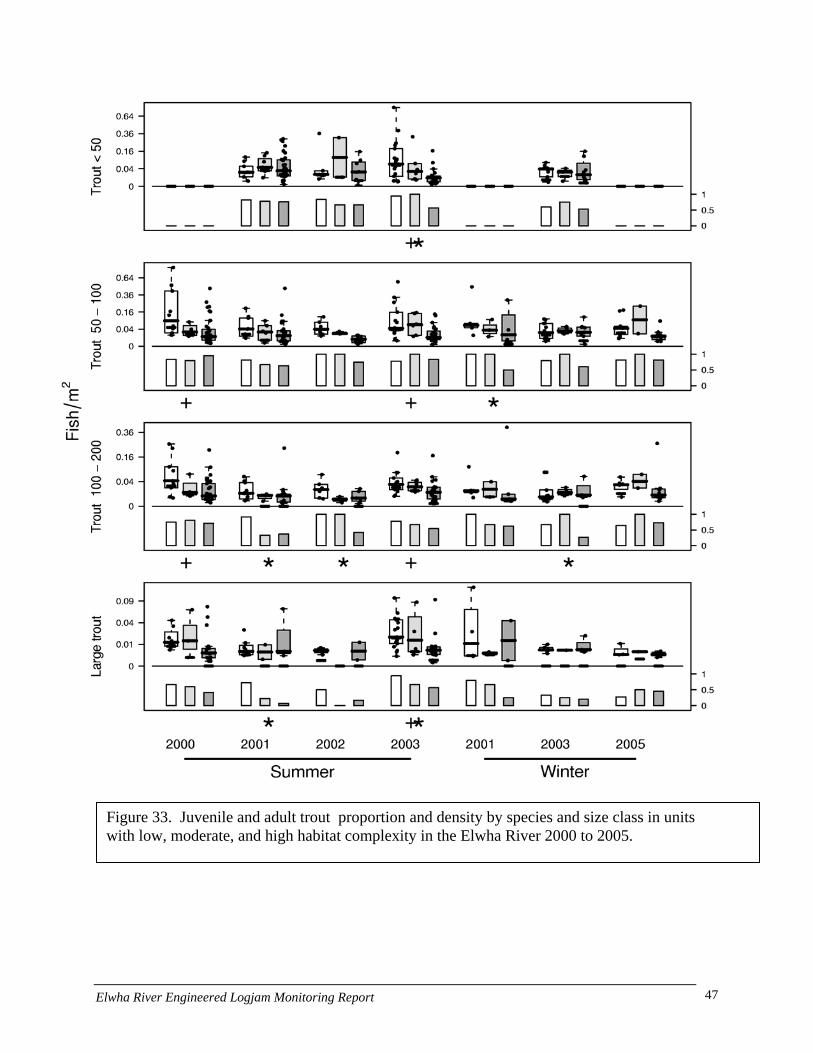
Figure 33. Juvenile and adult trout proportion and density by species and size class in units with low, moderate, and high habitat complexity in the Elwha River 2000 to 2005.
Elwha River Engineered Logjam Monitoring Report 47
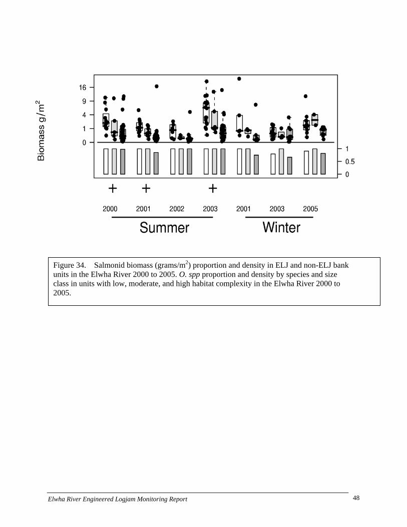
Figure 34. Salmonid biomass (grams/m2) proportion and density in ELJ and non-ELJ bank units in the Elwha River 2000 to 2005. O. spp proportion and density by species and size class in units with low, moderate, and high habitat complexity in the Elwha River 2000 to 2005.
Elwha River Engineered Logjam Monitoring Report 48
Juvenile Micro-distribution
A shift in distribution was observed between daytime and nighttime rearing locations. The distance between daytime and nighttime rearing locations increased later in the year as the fish grew; ranging from 0-31 m. The position of juvenile coho salmon within the water column varied from day to night as well. Juvenile coho salmon tended to hold in mid-water locations during the day and close to the bottom at night. The shift from daytime to nighttime rearing habitats resulted in differences in daytime and nighttime habitat use. Juvenile salmonids tended to move further from wood debris and closer to the water’s edge at night. Juvenile coho and zero-aged trout also moved into lateral habitats such as alcoves and overflow channels at night when they were available. The fish community observed was generally more diverse at night and during the summer. Zero-age salmonids were more abundant during the day than at night during the spring (5 oC) and summer (14-15 oC), but not winter (13 oC). In contrast, age 1+ and older juvenile salmonids were more abundant at night during all seasons. Movements from daytime to nighttime habitats did not appear to be strictly motivated by energy conservation, since we observed this movement at a site where there was essentially no current throughout the entire study reach.
These results show that juvenile salmonids use different daytime and nighttime rearing locations. The distance between day and night rearing locations increases later in the year and can be substantial relative to fish size (>30 m). Day and night habitat use also varies, with juvenile salmonids located further from the water’s edge and closer to woody debris during the day than at night. Habitat complexity surrounding logjams appears to provide both day and night habitat. The results also provide information regarding the spatial scale necessary to examine the influence of logjams on juvenile salmonid habitats. Chinook Spawning
Surveys of redd locations and the abiotic variables associated with those redds were conducted in the lower Elwha beginning in 2001. Parallel surveys of large woody debris (LWD) locations (both snags and engineered log jams) were also conducted beginning in 2001. The analysis were conducted with a geographical information system (ArcGIS 9.1) using spatial statistical tools. A nearest neighbor analysis indicated that, in 2001, there was significant (p<0.001) clustering of redds in the lower Elwha (z score = -11.6). A Getis-Ord General G cluster analysis indicated that redds which were far from the nearest LWD tended to cluster (z score = 8.2, p<0.01) and that redds did not spatially cluster by velocity. A nearest neighbor analysis performed on the 2002 data again indicated that there was significant spatial clustering of redds (z-score = -26.7, p<0.01). Like in the previous year redds which where far from LWD tended to cluster (z score = 8.2, p<0.01). Unlike the previous year redds with high water velocities did tend to cluster (z score 12.6, p<0.01).
This analysis indicates that LWD alone does not cause redds to significantly cluster and that other abiotic variables may have a stronger control on redd clustering. It should be noted that the presence of LWD does affect abiotic variables, and that increased velocities near wood may provide good spawning habitat. This feature may not come to light in statistical analyses because the abiotic variables (depth, velocity, etc.) are not dependent on the presence of wood
Elwha River Engineered Logjam Monitoring Report 49
and thus spawning site selection will be dispersed among areas of high and low LWD density habitat.
Discussion
The Elwha River, like other rivers in western Washington, has been degraded by human activities over the last century. The loss of large woody debris from the cumulative impacts of logging and channelization is increasingly recognized as a major cause of habitat degradation and loss of ecological complexity. Efforts to reverse or slow these trends have led to dramatic expansion of restoration activities throughout the world and in Washington State. While the use of large woody debris in small rivers has generally been accepted as an accepted restoration technique, there has been some debate concerning its utility on larger rivers (>50 m bankfull width). In the past decade, engineered logjams have been used as a management technique for achieving multiple restoration objectives. However, until recently there has been little published information regarding their actual effect on stream habitats and processes and even less on their biological effects. Brooks et al. (2006) offer one of the few experiments in large river rehabilitation using wood in a southeast Australian stream. Here, 436 logs were used to construct 20 ELJs in an 1100 m reach of the Williams River beginning in 1999 (an effort very similar to scale to the Elwha). Brooks et al. (2006) reported that the project halted the degradation of the river and resulted in a dramatic increase in stored sediment within the treatment reach. However, they tempered the results and indicated that this effect represented only a ≤2% reduction of the post-disturbance sediment storage capacity and that far greater restoration efforts will be necessary. Sediment Storage
The rapid reach level response and 40% increase in stored sediment within the treatment reach is an unexpected and extraordinary result considering that the Elwha River has two mainstem dams that have truncated alluvial sediment transport for a century. The lower dam is located only 2 miles above the treatment reach and the source of accumulated sediments is likely local from limited floodplain areas above the project area. Unfortunately we were unable to complete the vertical accretion portion of the study because of limitations in funding. However, the pre-project elevation conditions within the treatment reaches have been completed and it a post project survey could be completed for approximately $30,000. Brooks et al. (2006) reported a similar effect where construction of ELJs resulted in an increase of 41,000 m3 of stored sediment in 1,500 m of an Australian River.
We found that ELJs changed the surface bed substrate particle size distribution from being dominated by cobble to various size classes of gravel. We monitored this response at seven ELJ sites over the course of the study and found a statistically significant reduction in particle size distribution for 16 of 21 (76%) size class and ELJ combinations assessed. Prior to construction the Elwha project reach contained few areas with significant spawning gravel used by anadromous fish for spawning. ELJs were successful at creating these habitats, largely by trapping bed load being transported in floods. We documented spawning on the newly formed ELJ gravels for the following species: chum, coho, steelhead, and chinook. ELJs likely influence
Elwha River Engineered Logjam Monitoring Report 50
spawning habitat for salmonids not only by trapping smaller size classes of alluvium, but also by increasing groundwater exchange rates through scour processes.
Increase sediment storage at the reach level may also affect connectivity processes between the mainstem and its floodplain. We observed an increase in water being routed onto floodplain surfaces within the treatment reach during the course of the study. This was most apparent in overflow channels that feed side-channel 5. Here increasing scour lengthened the amount of low flow habitat in a groundwater fed channel. ELJ were constructed adjacent to two overflow channels during the study and we hypothesize that increasing amounts of flood flows were routed into these channels as a result of backwatering. This process was also enhanced by the direct addition of free key pieces of LWD by the Tribe in 2002. This wood interacted with flood flows routed into the side channel and scoured to a depth to increase An increase in sediment storage may also set up a positive feedback loop between stored sediment and wood. We observed a modest increase in accumulated LWD upstream of the channel split over time following construction of ELJ. The increase appeared to coincide with increases in stored sediment. Habitat Effects
Construction of ELJs on the Elwha resulted in a number of beneficial habitat effects. Twenty of twenty-one ELJs constructed to date resulted in pool formation, primarily through scour processes. The one ELJ that did not form a pool was actually 90% buried in the bank and designed to prevent further expansion of the opening to the HRC. We observed two general patterns for ELJs pool development on the Elwha River: When ELJs were constructed within existing pools the pools deepened. When ELJs were constructed in non-pool habitats pools formed. These results are consistent with geomorphic theories derived from the study of the role of LWD in small streams (Montgomery and Buffington 1994; Montgomery et al 1996; Beechie and Sibley 1997). These studies indicate that wood in streams may influence habitat processes both by influencing sediment storage and through scour processes. The depth of scour may be significant in ELJ associated pools in large rivers. We observed the development of pools exceeding 4 m maximum depth. In the Elwha River the rate of pool development was rapid, typically within 1-2 winters of installation.
By influencing depth of scour, ELJs may also affect stream temperature conditions, at least at the local level. We observed a significant difference in temperature conditions during the summer when comparing surface and bottom temperatures in the vicinity of ELJs. This difference was as much as 2-3 degrees C during peak summer temperature conditions in August of 2006. Reductions in water temperature have been documented as a function of depth of scour into alluvium (Evans & Petts 1997). A reduction in peak water temperatures may have a synergistic effect for fish usage of complex wood structures such as ELJs. Peters et al. (In Review) demonstrated that juvenile fish use complex cover in a diurnal pattern: where fish tended to stay close to complex cover during the day and migrate away from cover at night (purportedly to forage). An increase in groundwater exchange may have additional important implications for providing refuge that enhances metabolic efficiency. Salmonids are known to have preferred temperature conditions for rearing that vary by species. Species such as bull trout have particularly low tolerances for elevated temperature. Additionally, species such as Chinook salmon typically seek deep pools with groundwater influence for maturation prior to spawning.
Elwha River Engineered Logjam Monitoring Report 51

Chinook spawning often occurs in close proximity to deep holding pools (Pess et al 2005). As a result, ELJs can and have been used as a management tool to affect the distribution of spawning Chinook on the Stillaguamish River (Abbe et al. 2003b).
Wood budget studies conducted on the Elwha River showed that the frequency of functional snags was initially very low. However, following the expansion of the HRC and in combination with several large floods, significant amounts of new wood was recruited from local floodplain forests. These areas were primarily on islands in the river that had not been logged in 50-60 years. Recruitment of mature trees from these surfaces resulted in the development of very large logjam features that influence channel form and large scale habitat forming processes. Our results indicate that the majority of wood has been retained within the river over the period of study. The distance that wood moves varies as a function of flood intensity and complexity of the channel and forest type downstream. We found that the total distance moved for wood in the Elwha was generally less than 2,500’. Primary & Secondary Productivity
We found significantly higher periphyton biomass and total invertebrate densities on wood than on cobbles in treatment or reference reaches. Differences in invertebrate density were likely underestimated as scraping alone overlooks wood-burrowing invertebrates, yielding only 70% of the organisms residing on wood (Braccia & Batzer 2001). Regardless, our findings were consistent both across years, and supported previous work by Coe et al. 2006. We speculate that differences between wood and cobble were due primarily to substrate type, as periphyton biomass and invertebrate densities and community structure were not significantly different on cobbles in treatment and reference reaches. In addition, ELJs are likely to have well established algal and invertebrate communities relative to cobbles because they serve as refugia during extreme flood events (Sedell et al. 1991, Wondzell and Bisson 2003, Bond et al. 2006). Our findings are not surprising as many studies have documented high levels of primary and secondary productivity, and diversity on wood (Wallace & Benke, 1984; Benke et al. 1985: O’Connor 1992, Scholtz & Boon, 1993). In fact, habitats with wood have been shown to contribute substantially to overall system productivity, even in systems where wood comprised a relatively small proportion of overall habitat (Wallace & Benke, 1984; Benke et al. 1985: O’Connor, 1992, Scholtz & Boon, 1993; Bond et al. 2006). The importance of wood, however, is often dependent on the availability of other stable substrates (Benke et al. 1985; Bond et al. 2006).
While wood appeared to be more productive than cobbles in treatment and reference reaches, we are not suggesting that wood is contributing substantially to overall reach productivity, as wood in the treatment reach contributes little to overall habitat relative to cobbles. Rather, our study suggests that addition to wood to systems devoid of naturally occurring wood is important for increasing overall volume habitat for periphyton and invertebrate colonization. For example, the addition of 16 ELJs to the Elwha River contributed as much as 10,407 m2 to available habitat previously lacking in this highly altered system. Although invertebrate densities were higher on ELJs, we suspect that invertebrate biomass was substantially lower on wood than on cobbles. Invertebrate communities on wood were dominated by meiofauna (< 500 µm), including copepods, ostracods, mites, oligochaetes, nematodes and tardigrades, whereas cobbles were dominated by larger chironomids. Despite
Elwha River Engineered Logjam Monitoring Report 52
their fast life cycles (Schmid-Araya et al. 2002), meiofauna generally contribute little to overall biomass and production (Hakenkamp and Morin 2000) relative to larger macroinvertebrates. We do speculate, however, that ELJs contributed substantially to overall biological diversity within the treatment reach. Meiofauna are largely understudied, and therefore underrepresented in lotic system studies, yet they are believed to be both abundant and diverse (Hakenkamp and Morin 2000). In this case, meiofauna were likely far more diverse than our coarse taxonomic resolution indicated. In addition, although we only collected invertebrates from the surface of the wood, we suspect that ELJs support a community of wood miners, gougers and tunnelers (Hoffman and Hering 2000) uniquely associated with wood (obligate xylophages) (Benke and Wallace 2003). In conclusion, our study supports the importance of incorporating periphyton and invertebrate as response variables for measuring effectiveness of restoration techniques such as wood placement. In addition to providing habitat for fish, introduced wood can serve as both a highly stable, physical refugia and important substrate for periphyton and invertebrates, including meiofauna. Although understudied and underrepresented in lotic studies, meiofauna are believed to be the trophic link between detritus, microbial communities and macroinvertebrates (Hakenkamp and Morin 2002). These findings may have important implications for restoration, particularly if periphyton and invertebrates on wood are linked to higher trophic levels such as fish (Bond et al. 2006). Juvenile Fish Response
The proportion and median densities of juvenile, subadult, and resident salmonids in Elwha River bank units with and without ELJs varied considerably by species and size class, season, and year. Regardless there were several notable patterns. First, the proportion of juvenile, sub-adult, and resident salmonids was consistently greater in ELJ than non-ELJ bank units in 6 of the 8 species/size class categories. However due to the variation in abundance over time this was only significant in 5 of the 56 combinations (species x size class x sampling events). Median density in juvenile, sub-adult, or resident salmonids did not exhibit a similar pattern to proportion between ELJ and non-ELJ bank units, but had significant differences in 3 of the 56 combinations. The greatest difference between ELJ and non-ELJ bank units occurred with biomass estimates. Higher overall abundance levels resulted in significant differences between ELJ and non-ELJ banks (e.g., summer of 2001 and 2003), while proportional differences occurred when overall biomass was lower (e.g., winter 2003). The patterns that suggest that the proportion of occurrence and median density of juvenile, sub-adult, and resident salmonids in bank units were influenced by ELJs.
Habitat complexity differences resulted in clearer differences in juvenile, sub-adult, and resident salmonid occurrence and median density. Four of the 8 species/size class categories had consistently significant differences in proportions between high, moderate, and low habitat complexity. Three of the 8 species/size class categories had significant differences between proportions due to habitat complexity, while only Chinook > 100mm did not have any differences in proportion due to the habitat complexity of habitat units. The median density due to habitat complexity followed a similar pattern where 2 of the 8 categories had significantly different median densities due to habitat complexity, and 5 of the 8 had significant differences in
Elwha River Engineered Logjam Monitoring Report 53
median density due to habitat complexity. Again only Chinook > 100mm did not have any significant differences in median density due to habitat complexity. Biomass estimates also suggest a strong pattern of consistent significant differences between the median density of juvenile, sub-adult, and resident salmonids during the summer sampling events. The patterns in the habitat complexity results strongly suggest that proportion of occurrence and median density of juvenile, sub-adult, and resident salmonids in bank units are influenced by habitat complexity.
ELJs and habitat complexity determined by wood accumulations is correlated to two key factors that could be the main determinant of greater proportions and mean densities – velocity and instream cover. Wood accumulations allow for the convergence and divergence of flow in and around the obstructions resulting in an increase in slower water habitats and the potential use of wood as instream cover. Juvenile salmonid associations with slower water and wood cover may be related to several factors depending on the time of year including: 1) protection from current, particularly during higher flows, 2) food availability during times when growth is critical to survival, 3) or camouflage from predators especially during seasonal low flow periods (Angermeir and Karr 1984, Lehane et al. 2001).
Logjam placement may be supporting some or all of these functions. For example, winter flows are typically higher than other seasons in the Elwha. Slower water environments, such as edge areas along the river margin become more important because many of the juvenile salmonids are not large enough to maintain a position in faster water. Thus ELJs can potentially minimize the negative effects of high water velocity by providing refuge from higher flow events that can potentially decrease survival. The combination of slower water edges areas, plus added protection and reduced velocities on the downstream side of logjams, make such habitat critical to juvenile salmonids in the Elwha. For example, an increase in physical structure provides visual isolation that can minimize competitive predator-prey interactions, allows fish to spend more time feeding, and creates greater opportunities for fish to identify and access optimal foraging locations. It is important to note an increase in predation can also occur due to the increase larger trout associated with ELJs and higher habitat complexity.
The positive response of juvenile salmonid abundance and density to wood placement is similar to what others have found in rivers in the Pacific Northwest and the other parts of the world (Slaney et al. 1994, Peters et al. (1998), Inoue and Nakano 1998, Roni and Quinn 2000, Lehane et al. 2001, Miyakoshi et al. 2002). Both Slaney et al. (1994) and Peters et al. (1998) reported a positive correlation between salmonid fry densities, such as chinook, coho, and trout, and wood cover at the habitat-unit scale. Inoue and Nakano (1998) found positive correlations at habitat-unit scale between woody-debris cover area and juvenile Masu salmon (Oncorhynchus masou) densities. Significant and positive responses to constructed debris dam structures were identified in 0+, 1+, and 2+ salmonid density and biomass one to two years after wood placement in Douglas River, Ireland (Lehane et al. 2001). Between 40% and 69% of the total variation in density and biomass was attributed to environmental variables associated with the structures such as an increase in water depth, pool habitats, and instream cover in the form of vegetation and wood (Lehane et al. 2001). Abundance and biomass of juvenile brown (Salmo trutta) and rainbow trout increased in the treatment compared to the control in the Muhlebach, a tributary to the Rhine River in Liechtenstein (Zika and Peter 2002). This increase was attributed to slower velocities and more cover associated with the treatment areas (Zika and Peter 2002). Densities of juvenile masu salmon during the winter months were significantly correlated to
Elwha River Engineered Logjam Monitoring Report 54
wood cover availability in the Masuhoro River Japan (Miyakoshi et al. 2002). This relationship decrease in other seasons, such as fall, implying that cover availability may be more important during certain times of the year, which may vary by species and life stage (Angermeier and Karr 1984, Miyakoshi et al. 2002).
A key assumption that we have been using to determine the juvenile and adult salmonid response to increases in instream habitat complexity is that the “spatial variation in population density arises from, and accurately reflects, underlying differences among habitats (Belanger and Rodriguez 2002).” Although this may be true in general, it is important to identify that it may also breakdown under certain circumstances. For example, juvenile density estimates measured only during one season may not be the most critical stage that determines survival to adulthood. Another example is the large variation in density estimates due to large-scale fish movements away from specific habitats due factors such as changes in food availability, predator population changes, or other environmental factors. Another method that can be used to measure differences in habitat quality is measures of local fish movement into and out of specific habitats. Measuring the amount of habitat-specific immigration and emigration, coupled with measurements of growth within each habitat unit and reach, can potentially provide a more reliable way to determine the mechanistic basis for habitat selection (Belanger and Rodriguez 2002).
A possible explanation for the observed differences between summer and winter fish density may be due to sampling differences (day/night). We collected data at night during the winter because juvenile salmon hide during the day at the low temperatures common during this period. However, we observed that fish used wood during the day and moved away from wood at night during the microdistribution work. If this behavior is similar during the winter, we may be underestimating the value of the ELJs during the winter. Based on the observations of one author (Peters) of coho smolts in the Stillaguamish ELJs were using ELJs during the day but moving away from the jam at night. This may explain the lack of significance during many of the winter observations.
Juvenile and resident adult salmonids generally follow diel cycles of habitat use. Juvenile salmonids observed during this study reared in different areas during the day and night. This may be due to one of two possible population responses. First, fish may simply move between day and night rearing areas throughout the diel cycle. Alternatively, groups of fish observed during these observation periods may simply be different fish; one displaying diurnal activity and the other nocturnal activity. Diurnally active fish would presumably hide at night and would not be observed by snorkelers, while nocturnal fish would hide during the day and would not be observed by snorkelers. Although studies have shown that both of the above explanations are viable, it seems more likely that fish in the current study moved from day to night rearing locations. Radio-telemetry studies have shown that salmonids are generally mobile during the diel cycle and that many move between daytime and nighttime habitats (e.g., Clapp et al. 1990; Roussel and Bardonnet 1999; Hildebrand and Kershner 2000; Diana et al. 2004). If this pattern is true, ELJs may provide an important refuge area for resting and avoiding predators during the day.
Elwha River Engineered Logjam Monitoring Report 55
Summary Conclusions
• Since 1999, 21 logjams have been constructed within the treatment reach using 752 pieces of wood (cut logs) and 129 key pieces with a total volume of 2,009 m3.
• The ELJs have been subjected to 20 (or more) bankfull or greater flows, including three flows exceeding 25,000 cfs which corresponds with the top 10% of peak flows recorded for the Elwha River.
• To date, all 21 ELJs are intact with no change in position. The majority of ELJs have trapped natural debris and have vegetation growing on their surfaces.
• Placement of ELJs has been partially effective at distributing flows between two major branches of the Elwha River. However, this relationship is stage dependent: as flows recede, an increasing proportion of the flow is routed to the Hunt Road Channel.
• ELJs have retarded rates of bank erosion and represent a viable management tool for treating eroding stream banks.
• Scour Pools have developed or expanded in size for 20 of 21 of the ELJs constructed to date. The majority of scour pools are between 1-2 m in depth although pool depths exceeding 5 m have occurred at two ELJs.
• By increasing the depth of scour in homogenous river reaches, ELJs can increase the exchange of groundwater and may influence temperature regime at least locally.
• ELJs, particularly Bar Apex Jams, are a viable management tool to store sediment at the reach level. We measured a nearly doubling of the area of alluvium stored in gravel bars within the ELJ treatment reach between pre-project conditions and 2006. This result suggests that ELJs may affect topographic conditions in the floodplain and thereby increase connectivity in the floodplain.
• The composition of channel bed substrate sizes has changed as sediment stored at ELJs has increased over time. Particle size distributions have changed from those dominated by large and medium cobble to medium and fine gravel at several ELJs.
• ELJs can affect spawning habitat. Spawning by adult Chinook, chum, coho and steelhead was directly observed on newly formed gravel deposits. Prior to placement of the ELJs, these areas did not support spawning.
• A wood budget data base has been established for the lower Elwha River below Elwha Dam. Results to date indicate that levels of wood are increasing over time. Wood recruitment in the lower river is primarily from flood plain surfaces occupied by older forest stands, not upriver sources. Recruited wood is mostly being retained and transport distances between survey years for individual pieces are generally less than ?
• The most significant amount of wood recruitment is occurring in the Hunt Road Channel were two full spanning logjams have formed in the last decade. These features are influencing habitat at a much larger scale than constructed ELJs and represent a graphic example of how large alluvial rivers in western Washington function naturally.
• Primary production as measured by total organic matter was significantly higher (6 times) on ELJ surfaces than on other habitat types. Chlorophyll concentrations were higher on wood surfaces in 2003 but not in 2004 and 2005.
• Mean total invertebrate density is also significantly higher (2-5 times) on ELJ surfaces than on other habitats.
Elwha River Engineered Logjam Monitoring Report 56

• Macroinvertebrate community composition is significantly different on ELJs: while chironomids dominant other habitat types, meiofauna composes up to 60% of the invertebrate community on Elwha River ELJs.
• The proportion of juvenile, sub-adult, and resident salmonids was consistently greater in ELJ than non-ELJ bank units in 75% species/size class categories; however because of high variance the significance was generally small.
• While the density of juvenile salmonids was generally similar between habitat with ELJs and those without, there were significant differences in juvenile fish biomass.
• When juvenile fish populations were assessed by habitat complexity clearer differences were apparent: 5 of 8 species had significant differences between simple and more complex habitat types.
• The patterns suggest that the proportion of occurrence and median density of juvenile, sub-adult, and resident salmonids in bank units were positively influenced by ELJs.
• There was a diurnal pattern to juvenile fish movements around ELJs , with fish tending to disperse away from wood in the night and return in the day apparently to maximize feeding efficiency. The distances moved were generally small (<30 m). Juvenile fish are using wood to avoid predators and as resting habitat when not feeding.
• Questions regarding the influence of ELJs on fry to smolt survival (productivity) remain and were beyond the scope of this study.
• The distribution of chinook redds in the lower river was assessed for the period of study. Spatial patterns indicate that natural spawning is controlled by a complex suite of features. The analysis indicates that LWD alone does not cause redds to significantly cluster and that other abiotic variables may have a stronger control on redd clustering.
Elwha River Engineered Logjam Monitoring Report 57
Acknowledgements
We thank the Salmon Funding Recovery Board for providing funding for this project. IAC staff Mike Ramsey and Marc Dubowski provided project management. Many people have contributed to the efforts to understand the effectiveness of ELJs as a restoration technique on the Elwha River. The author’s wishes to recognize the following individuals: Todd Bennett, Kris Kloehm, Mel Elofson and Ernest Sampson have provided their local knowledge and expertise to monitoring efforts. The Lower Elwha Klallam Tribes restoration crew including Jim Bolstrom, Roger Hopie, Les Pooler, and Keith Charles expertly constructed the ELJs. Jay Petersen and Four Seasons Engineering managed surveying efforts and assisted with design and construction management. A special thanks to the Sisson family who graciously supported ELJ construction on their property.
Elwha River Engineered Logjam Monitoring Report 58
Literature Cited
Abbe, T.B. and J.B. Goldsmith. 2007. November floods test engineered logjam projects. American Water Resources Association Washington Section Newsletter, January-February 2007, p.4-6.
Abbe, T.B., and D.R. Montgomery. 1996. Large woody debris jams, channel hydraulics and
habitat formation in large rivers. Regulated Rivers 12:201-221. Abbe, T.B. and D.R. Montgomery. 2003. Patterns and processes of wood debris accumulation
in the Queets River basin, Washington. Geomorphology 51, 81-107. Abbe, T.B., A.P. Brooks and D.R. Montgomery. 2003a. Wood in river rehabilitation and
management. In S. Gregory et al. (Editors), Wood in World Rivers. American Fisheries Society.
Abbe, T.B., G. Pess, D.R. Montgomery, and K.L. Fetherston. 2003b. Integrating engineered
logjam technology into river rehabilitation. In Montgomery, DR, S. Bolton, D.B. Booth, and L. Wall (Editors), Restoration of Puget Sound Rivers. University of Washington Press. Seattle, WA pp.443-482.
Angermeier, P.L., and J.R. Karr. 1984. Relationships between woody debris and fish habitat in a
small warmwater stream. Transactions of the American Fisheries Society. 113:716-726. Belanger, G. and M.A. Rodriguez. 2002. Local movement as a measure of habitat quality in
stream salmonids. Environmental Biology of Fishes. 64: 155-164. Beechie, T.J. and T.J. Sibley. 1997. Relationship between channel characteristics, woody
debris, and fish habitat in northwestern Washington streams. Transactions of the American Fisheries Society. 126:217-229.
Benke, A.C., R.L. Henry, D.M. Gillespie, and R.J. Hunter. 1985. Importance of snag habitat for
animal production in southeastern streams. Fisheries 10: 8-13. Benke, A.C. and J.B. Wallace. 2003. Influence of wood on invertebrate communities in streams
and rivers. American Fisheries Society Symposium 37: 149-177. Bond, N.R., S. Sabater, A. Glaister, S. Roberts and K. Vanderkruk. 2006. Colonization of
introduced timber by algae and invertebrates, and its potential role in aquatic ecosystem restoration. Hydrobiologia 556: 303-316.
Braccia, A. and D. Batzer. 2001. Invertebrates associated with wood debris in a southeastern
U.S. forested floodplain stream. Wetlands 21: 18-31.
Elwha River Engineered Logjam Monitoring Report 59
Brooks, A.P., T. Howell, T.B. Abbe, A.H. Arthington. 2006. Confronting hysteresis: Wood based river rehabilitation in highly altered riverine landscapes of south-eastern Australia. Geomorphology 79:395-422.
Clapp, D.E., R.D. Clark, Jr., and J.S. Diana. 1990. Range, activity, and habitat of large free-
ranging brown trout in a Michigan stream. Transactions of the American Fisheries Society 119:1022-1034.
Coe, H.C., P.M. Kiffney and G.R. Pess. 2006. A comparison of methods to evaluate the
response of periphyton and invertebrates to wood placement in large Pacific coastal rivers. Northwest Science 80: 298-307.
Diana, J.S., J.P. Hudson, and R.D. Clark, Jr. 2004. Movement patterns of large brown trout in
the mainstem Au Sable River, Michigan. Transactions of the American Fisheries Society 133:34-44.
Evans E.C, and G.E. Petts. 1997 Hyporheic temperature patterns within riffles. Journal of
Hydrologic Sciences 42:199-213. Hakenkamp, C.C. and A. Morin. 2000. The importance of meiofauna to lotic ecosystem
functioning. Freshwater Biology: 165-175. Hildebrand, R.H., and J.L. Kershner. 2000. Movement patterns of stream-resident cutthroat trout
in Beaver Creek, Idaho-Utah. Transactions of the American Fisheries Society 129:1160-1170.
Hoffman, A. and D. Hering. 2000. Wood-associated macroinvertebrate fauna in Central European streams. International Review of Hydrobiology 85: 25-48.
Hook, A., E. Ablow, T. Abbe, S. Powell and D. Chapin. 2006. Using large woody debris to
restore geomorphic process and floodplain connectivity in a regulated river system. EOS Transactions (Poster), American Geophysical Union Annual Meeting. San Francisco.
Inoue, M. and S. Nakano. 1998. Effects of woody debris on the habitat of juvenile masu salmon
(Oncorhynchus masou) in Northern Japanese streams. Freshwater Biology. 40:1-16. Lehane, B.M., P.S. Giller, J.O’Halloran, C. Smith, and J. Murphy. 2001. Experimental provision
of large woody debris in streams as a trout management technique. Aquatic Conservation: Marine and Freshwater Ecosystems. 12: 289-311
McHenry, M.L., Pess, G.R., and R. Peters. 2001. Physical and biological monitoring of
Engineered logjams: Study plan 2001-2006. Unpublished Report. Lower Elwha Klallam Tribe, Fisheries Dept., Port Angeles, Washington
Elwha River Engineered Logjam Monitoring Report 60

Miyakoshi,Y., H. Hayano, H. Omori , M. Nagata, and J. Irvine. 2002 Improtance of instream cover for young masu salmon, Oncorhynchus masou, in autumn and winter. Fisheries Management and Ecology. 9:217-223.
Montgomery, D.R., T.B. Abbe, Buffington, J.M., N.P. Peterson, K.M. Schmidt and J.D. Stock.
1996. Distribution of bedrock and alluvial channels in forested mountain drainage basins. Nature 381:587-589.
O’Connor, N.A. 1992. Quantification of submerged wood in a lowland Australian stream
system. Freshwater Biology 27: 387-395. Pess G.R., M. Liermann, M.McHenry, R. Peters, K. Kloehn, T. Bennett, and H. Coe. In
preparation. Juvenile and adult salmonid response to the placement of logjams in the Elwha River.
Peters, R.J., B.R. Missildine, and D.L. Low. 1998. Seasonal fish densities near river banks
treated with various stabilization methods: First year report of the flood technical assistance project. USFWS. Western WA office, Aquatic Resources Division. Lacey, WA.
Peters, R.J., M.T. Celedonia, D.W. Lantz, and G.R.Pess. In Review. Juvenile Salmonid Diel
Distribution near Logjams in Two Western Washington Rivers. Submitted to the North American Journal of Fisheries Management.
Pohl, M.M. 1999. The dams of the Elwha River, Washington: Downstream impacts and policy
implications. Ph.D Dissertation. Arizona State University, Tempe. Roni, P., and T. P. Quinn. 2001. Density and size of juvenile salmonids in response to placement
of large woody debris in western Washington and Oregon streams. Canadian Journal of Fisheries and Aquatic Sciences 58:282-292.
Roussel, J.M, and A. Bardonnet. 1999. Ontogeny of diel pattern of stream-margin habitat use by
emerging brown trout, Salmo trutta, in experimental channels: influence of food and predator presence. Environmental Biology of Fishes 56:253-262.
Sedell, J.R., R.J. Steedman, H.A. Regier and S.V. Gregory. 1991. Restoration of human
impacted land-water ecotones. In Holland, M.M., P.G. Risser and R.J. Naiman (eds), Ecotones: The role of landscape boundaries in the management and restoration of changing environments. Chapman and Hall, London: 110-129.
Schmid-Araya, J.M., A.G. Hildrew, A. Robertson, P.E. Schmid and J. Winterbottom. 2002. The
importance of meiofauna in food webs: evidence from an acid stream. Ecology 83: 1271-1285.
Elwha River Engineered Logjam Monitoring Report 61
Scholz, O. and P. Boon. 1993. Biofilm development and extra-cellular enzyme activities on wood in billabongs of southeastern Australia. Freshwater Biology 30: 359-368.
Slaney, P.A., B.O. Rublee, C.J. Perrin, and H. Goldberg. 1994. Debris structure placements and
whole-river fertilization for salmonids in a large regulated stream in British Columbia. Bulletin of Marine Science. 55: 1160-1180Roussel, J.M, and A. Bardonnet. 1999. Ontogeny of diel pattern of stream-margin habitat use by emerging brown trout, Salmo trutta, in experimental channels: influence of food and predator presence. Environmental Biology of Fishes 56:253-262.
Wallace, J.B. and A.C. Benke. 1984. Quantification of wood habitat in sub-tropical coastal-
plain rivers. Canadian Journal of Fisheries and Aquatic Sciences 41: 1643-1652. Wolman, M.G. 1954. A method of sampling coarse river bed material. Transactions of
American Geophysical Union 35: 951-956. Wondzell, S.M. and P.A. Bisson. 2003. Influence of wood and aquatic biodiversity. In
Gregory, S., K. Boyer and A. Gurnell (eds), The Ecology and Management of Wood in World Rivers. American Fisheries Society, Bethesda, MD: 249-263.
Zika, U. and A. Peter. 2002. The introduction of woody debris into a channelized stream: effect
on trout populations and habitat. Ricer Research and Applications 18:355-366.
Elwha River Engineered Logjam Monitoring Report 62

Appendix 1. Elwha Engineered Log Jam Descriptions
Log Jam 99-1
Log jam 99-1 (a bar apex jam) is located on the right bank floodplain at approximate RM 2.21. This log jam and was built in 1999 and is the first ELJ structure constructed in the Lower Elwha River by the Tribe (Figure 35). The architecture of this jam was different from Bar Apex Jams that followed in that it was built without excavating key pieces into the bed. At the time of construction this log jam was only wetted during bankfull floods. The log jam is approximately 82 feet long and 40 feet wide. Racked LWD pieces have accumulated on the structure. A scour pool has developed at the head of the structure and at the time of the summer surveys had a maximum depth of 3 feet. The structure has been undercut by scour. This undercut area is approximately 8 feet by 15 feet in size and extends from the front of the structure towards the bank under the structure. Vegetation on the log jam consists of young willows and alder trees growing on the log jam and on the bank adjacent to the log jam. Some termite activity was noted on some of the logs, otherwise minimal wood decay of the structure was noted and no significant structure settling of the structure has occurred. An overflow channel has developed on the front side of the logjam and water has been routed across the floodplain to the east. This has directly resulted in the formation of a new side-channel.
Figure 35. Elwha engineered logjam 99-1 during winter 2000 flood, looking West from right bank.
Elwha River Engineered Logjam Monitoring Report 63

Log Jam 00-1
Log jam 00-1 (a bar apex jam) was constructed in 2000 as a flow deflector bank structure. This jam was deeply excavated into the floodplain and the majority of the structure is buried. The log jam is located on the right bank at approximate RM 2.25 (Figure 36) and is the most upstream log jam constructed by the Tribe in the Elwha River to date. Log jam 00-1 is approximately 60 feet long and 42 feet wide. During summer surveys, a scour pool was present and was approximately 5 feet at its maximum depth. The log jam is approximately undercut by 6 feet. No significant vegetation is growing on the exposed logs of the ELJ. The buried portion of the logjam was revegetated by the Tribe, however most of the plantings, with the exception of native Lupine did not survive. Volunteering woody vegetation, especially black cottonwood and red alder have since colonized the surface. Flotsam material has collected on the upstream side of the log jam and is racked against the vertical pilings and logs. No significant wood decay or structure settling has been noted to-date.
Figure 36. Elwha engineered logjam #01-1 immediately after completion, fall 2000.
Log Jam 02-1
Log jam 02-1 is located on the right bank at RM 2.09 and was constructed as a bank flow deflector structure in 2002 (Figure 37). The log jam is approximately 65 feet long and 40 feet wide and is approximately 8 feet high. The log jam is sparsely vegetated that consists of a young
Elwha River Engineered Logjam Monitoring Report 64

cottonwood growing in the middle of the structure and three young willows growing on the upstream side of the structure. Abundant weeds were growing in and around the log jam on the cobble and gravel. Larger cottonwood, willow and alder trees were observed growing adjacent to the log jam on the bank. Racked pieces were noted on the log jam. During summer surveys the pool depth was approximately 3 feet along the upstream side of the structure. Pool substrate consisted of cobble. Significant amounts of alluvium have been trapped in the lee of the structure. Flotsam was found along the upstream side of the structure with most accumulation adjacent to the vertical pilings. No visible or settling were noted. No significant undercutting was observed under the structure.
Figure 37. Elwha engineered logjams #02-4 (foreground) and 02-1 (across river) during October 2003 flood. Photo looking East from left bank.
Log Jam 02-2
Log jam 02-2 is located in the east mainstem channel at approximately RM 2.06 and was constructed as a mid-channel bar apex structure in 2002. This structure was constructed specifically to encourage a flow split between the Hunt Road Channel and the former mainstem (Figure 38). The structure is approximately 57 feet long and 43 feet wide. The height of the log jam was approximately 10-12 feet above the water surface at the time of summer low flow surveys. Pool depths were collected throughout the structure and ranged from approximately 2 feet to 5.6 feet. Pool substrate consisted of cobble. Significant amounts of alluvium have been trapped downstream of the structure. The log jam is undercut by approximately 23 feet
Elwha River Engineered Logjam Monitoring Report 65
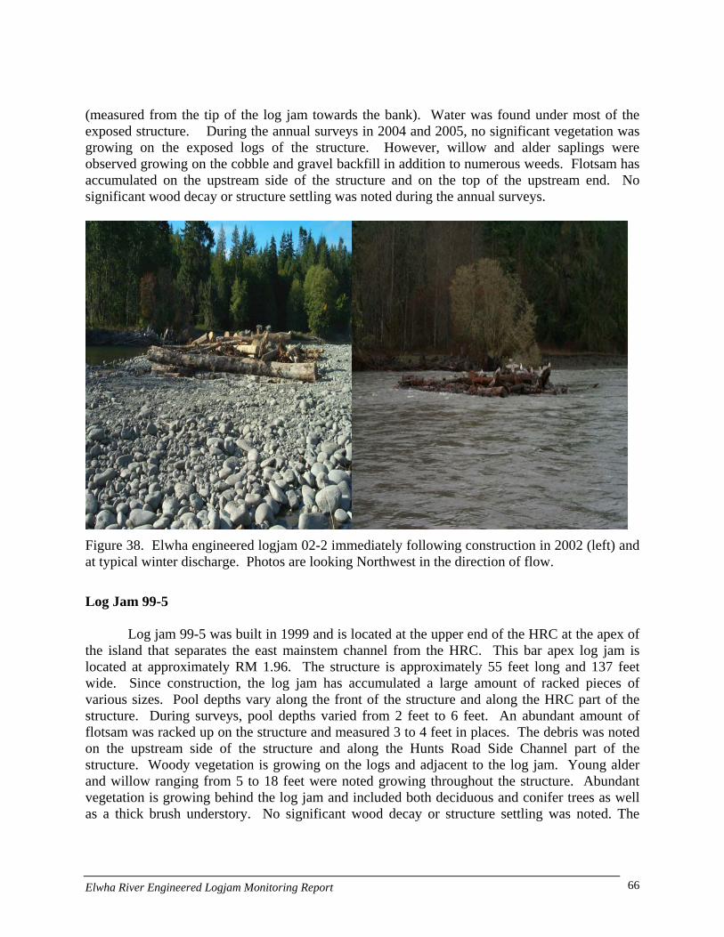
(measured from the tip of the log jam towards the bank). Water was found under most of the exposed structure. During the annual surveys in 2004 and 2005, no significant vegetation was growing on the exposed logs of the structure. However, willow and alder saplings were observed growing on the cobble and gravel backfill in addition to numerous weeds. Flotsam has accumulated on the upstream side of the structure and on the top of the upstream end. No significant wood decay or structure settling was noted during the annual surveys.
Figure 38. Elwha engineered logjam 02-2 immediately following construction in 2002 (left) and at typical winter discharge. Photos are looking Northwest in the direction of flow.
Log Jam 99-5
Log jam 99-5 was built in 1999 and is located at the upper end of the HRC at the apex of the island that separates the east mainstem channel from the HRC. This bar apex log jam is located at approximately RM 1.96. The structure is approximately 55 feet long and 137 feet wide. Since construction, the log jam has accumulated a large amount of racked pieces of various sizes. Pool depths vary along the front of the structure and along the HRC part of the structure. During surveys, pool depths varied from 2 feet to 6 feet. An abundant amount of flotsam was racked up on the structure and measured 3 to 4 feet in places. The debris was noted on the upstream side of the structure and along the Hunts Road Side Channel part of the structure. Woody vegetation is growing on the logs and adjacent to the log jam. Young alder and willow ranging from 5 to 18 feet were noted growing throughout the structure. Abundant vegetation is growing behind the log jam and included both deciduous and conifer trees as well as a thick brush understory. No significant wood decay or structure settling was noted. The
Elwha River Engineered Logjam Monitoring Report 66
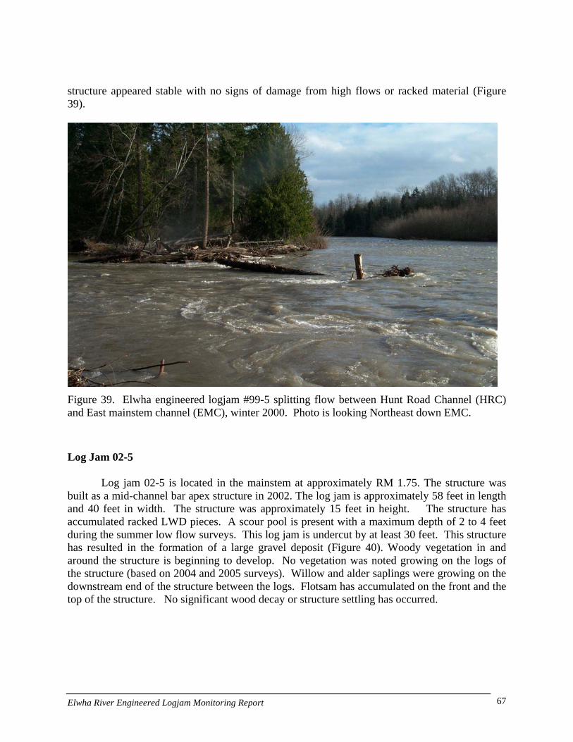
structure appeared stable with no signs of damage from high flows or racked material (Figure 39).
Figure 39. Elwha engineered logjam #99-5 splitting flow between Hunt Road Channel (HRC) and East mainstem channel (EMC), winter 2000. Photo is looking Northeast down EMC.
Log Jam 02-5
Log jam 02-5 is located in the mainstem at approximately RM 1.75. The structure was built as a mid-channel bar apex structure in 2002. The log jam is approximately 58 feet in length and 40 feet in width. The structure was approximately 15 feet in height. The structure has accumulated racked LWD pieces. A scour pool is present with a maximum depth of 2 to 4 feet during the summer low flow surveys. This log jam is undercut by at least 30 feet. This structure has resulted in the formation of a large gravel deposit (Figure 40). Woody vegetation in and around the structure is beginning to develop. No vegetation was noted growing on the logs of the structure (based on 2004 and 2005 surveys). Willow and alder saplings were growing on the downstream end of the structure between the logs. Flotsam has accumulated on the front and the top of the structure. No significant wood decay or structure settling has occurred.
Elwha River Engineered Logjam Monitoring Report 67
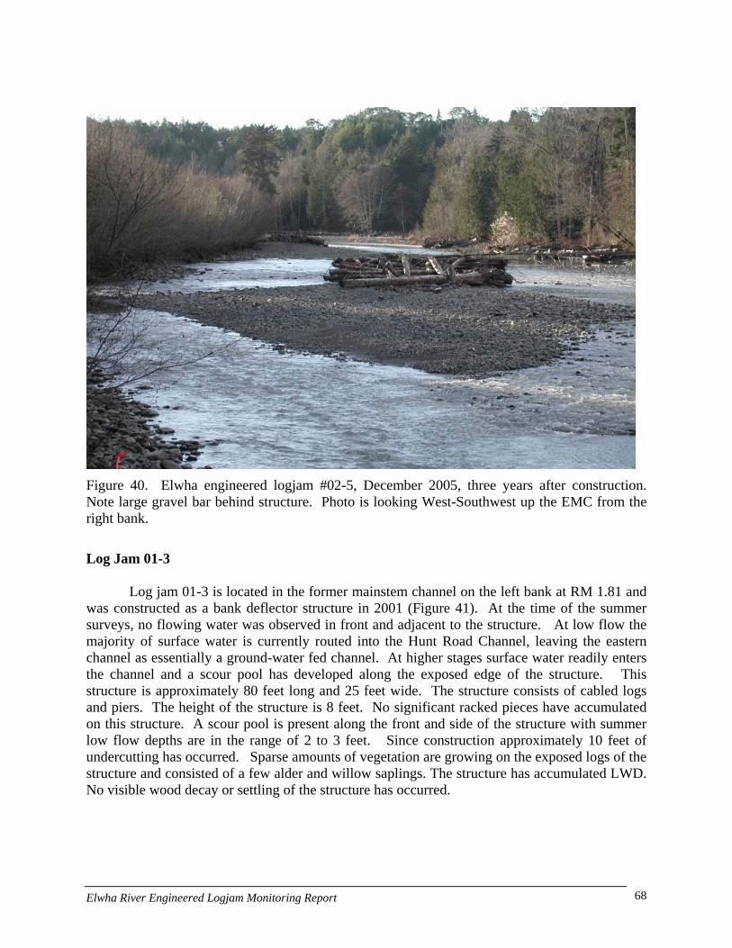
Figure 40. Elwha engineered logjam #02-5, December 2005, three years after construction. Note large gravel bar behind structure. Photo is looking West-Southwest up the EMC from the right bank.
Log Jam 01-3
Log jam 01-3 is located in the former mainstem channel on the left bank at RM 1.81 and was constructed as a bank deflector structure in 2001 (Figure 41). At the time of the summer surveys, no flowing water was observed in front and adjacent to the structure. At low flow the majority of surface water is currently routed into the Hunt Road Channel, leaving the eastern channel as essentially a ground-water fed channel. At higher stages surface water readily enters the channel and a scour pool has developed along the exposed edge of the structure. This structure is approximately 80 feet long and 25 feet wide. The structure consists of cabled logs and piers. The height of the structure is 8 feet. No significant racked pieces have accumulated on this structure. A scour pool is present along the front and side of the structure with summer low flow depths are in the range of 2 to 3 feet. Since construction approximately 10 feet of undercutting has occurred. Sparse amounts of vegetation are growing on the exposed logs of the structure and consisted of a few alder and willow saplings. The structure has accumulated LWD. No visible wood decay or settling of the structure has occurred.
Elwha River Engineered Logjam Monitoring Report 68
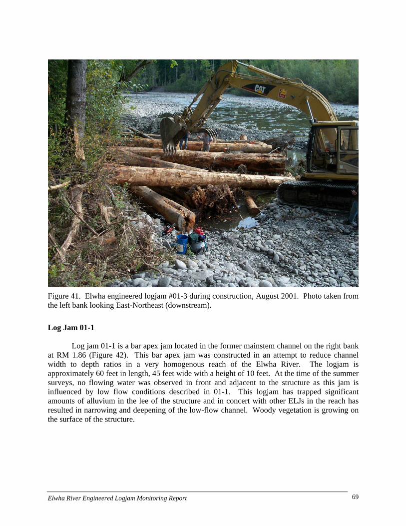
Figure 41. Elwha engineered logjam #01-3 during construction, August 2001. Photo taken from the left bank looking East-Northeast (downstream).
Log Jam 01-1
Log jam 01-1 is a bar apex jam located in the former mainstem channel on the right bank at RM 1.86 (Figure 42). This bar apex jam was constructed in an attempt to reduce channel width to depth ratios in a very homogenous reach of the Elwha River. The logjam is approximately 60 feet in length, 45 feet wide with a height of 10 feet. At the time of the summer surveys, no flowing water was observed in front and adjacent to the structure as this jam is influenced by low flow conditions described in 01-1. This logjam has trapped significant amounts of alluvium in the lee of the structure and in concert with other ELJs in the reach has resulted in narrowing and deepening of the low-flow channel. Woody vegetation is growing on the surface of the structure.
Elwha River Engineered Logjam Monitoring Report 69
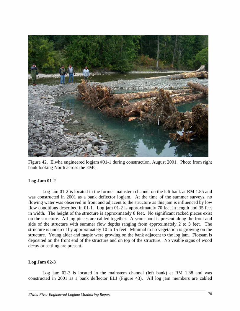
Figure 42. Elwha engineered logjam #01-1 during construction, August 2001. Photo from right bank looking North across the EMC.
Log Jam 01-2
Log jam 01-2 is located in the former mainstem channel on the left bank at RM 1.85 and was constructed in 2001 as a bank deflector logjam. At the time of the summer surveys, no flowing water was observed in front and adjacent to the structure as this jam is influenced by low flow conditions described in 01-1. Log jam 01-2 is approximately 70 feet in length and 35 feet in width. The height of the structure is approximately 8 feet. No significant racked pieces exist on the structure. All log pieces are cabled together. A scour pool is present along the front and side of the structure with summer flow depths ranging from approximately 2 to 3 feet. The structure is undercut by approximately 10 to 15 feet. Minimal to no vegetation is growing on the structure. Young alder and maple were growing on the bank adjacent to the log jam. Flotsam is deposited on the front end of the structure and on top of the structure. No visible signs of wood decay or settling are present. Log Jam 02-3
Log jam 02-3 is located in the mainstem channel (left bank) at RM 1.88 and was constructed in 2001 as a bank deflector ELJ (Figure 43). All log jam members are cabled
Elwha River Engineered Logjam Monitoring Report 70

together. At the time of the survey, no flowing water was observed in front and adjacent to the structure as this jam is influenced by low flow conditions described in 01-1. The structure is approximately 40 feet long and 25 feet wide. The height of the structure is 9 feet. No vegetation is growing on the structure. No significant racked pieces are on the structure. A scour pool is present along the front and the side the structure with summer low flow depths ranging from approximately 3 to 4 feet. The structure is undercut by approximately 5 to 15 feet. Some racked material has accumulated on the structure. No visible wood decay or settling of the structure has occurred.
Figure 43. Elwha engineered logjam #02-3 located on left bank of EMC, immediately following construction, September 2003. Photo taken from right bank looking North across EMC.
Log jam 03-03
Log jam 03-03 is located on the right bank at approximately RM 1.58 in mainstem channel and is the most upstream log jam of the structures built in 2003 (Figure 44). This bank deflector type log jam was constructed for fish habitat (along with 03-2 & 03-1) in a uniform glide along an outside meander. The structure is approximately 45 feet long and 40 feet wide. The height of the log jam is 11.5 feet. No trees or saplings are growing on the structure and the surface of the logjam is located directly on an active overflow channel. Weeds are growing on the logs and on the cobble covering parts of the structure. A scour pool has developed along the
Elwha River Engineered Logjam Monitoring Report 71

structure. The maximum pool depth was 2 feet at the time of the low flow surveys. The pool extends 25 feet under the structure. No undercutting is occurring at the structure, the logs area sitting on the channel bed. No trees or saplings are growing on the structure. Weeds are growing on the logs and on the cobble covering parts of the structure. Flotsam is deposited on the front of the structure as well as middle. No visible wood decay or settling of the structure has occurred.
Figure 44. Elwha engineered logjam #03-1 immediately following construction, August 2003. Photo taken from right bank of EMC looking South (upstream). ELJ 03-2 is visible in background (left center of photo).
Log jam 03-2
Log jam 03-02 is located on the right bank at approximately RM 1.53 in the mainstem channel and is the middle log jam structure built in 2003 located between 03-1 and 03-3 (Figure 45). This deflector type log jam is approximately 50 feet in length and 45 feet in width. The height of the log jam is 12 to 15 feet. No trees or saplings are growing on the structure. Substantial pool depth scour has occurred along the edge of this structure. No undercutting is
Elwha River Engineered Logjam Monitoring Report 72

occurring at the structure. Flotsam is deposited on top of the structure as well as some near the downstream end. The structure shows no signs of wood decay or settling.
Figure 45. Elwha engineered logjam #03-2, winter 2004. Photo taken from right bank looking North (downstream).
Log jam 03-1
Log jam 03-01 is located on the right bank at approximately RM 1.45 in the mainstem channel and is the most downstream log jam structure built in 2003. Minor amounts of water are flowing in front of the log jam at low flow because most of the river’s flow is in the HRC. The log jam is approximately 100 feet in length and 90 feet in width. The height of the log jam is 15 feet. This log jam is the largest of the 2003 structures built. No vegetation is growing on the wood, with the exception of growth on racked rootwad at upstream part of log jam. Weeds and grass are growing on cobble and sand backfill over the buried part of the jam. Some small racked pieces have accumulated on the front of the structure. A scour pool is present along the structure. Minor undercutting is occurring at the structure. The structure is sitting on the
Elwha River Engineered Logjam Monitoring Report 73

channel bed. No deposition is occurring on the log jam with the exception of flotsam. The structure shows no sign of wood decay or significant settling. Log Jam 99-2
Log jam 99-2 is located on the left bank at approximate RM 2.14 and was constructed as a bank deflector ELJ (Figure 46). The log jam is located along the left bank of the active mainstem channel. The log jam is approximately 42 long and 32 feet wide. The log jam is 10.5 feet high. A few alder saplings are growing on the exposed wood part of the structure. On the buried part of the structure along the bank the ground is covered with grass and young Douglas fir. Since construction some racked material has accumulated on the structure. A scour pool is present at the structure and during summer low flow surveys the pool depth ranged from 3 to 5.5 feet. The structures show no signs of significant decay. However, some of the vertical pilings are splitting at the ends. The outer tip of the structure appears to have settled approximately 3 feet. Settling could be from undercutting and should be verified.
Figure 46. Elwha engineered logjam #99-2 situated along Sisson property at bankfull flow, winter 2002. Photo taken from left bank looking South (upstream).
Elwha River Engineered Logjam Monitoring Report 74

Log Jam 99-3 Log jam 99-3 is located on the left bank at approximate RM 2.11 and was built in 1999 as
a bank deflector ELJ (Figure 47). The log jam is located along bank of the active channel that receives most of the river’s flow upstream of the HRC. The structure is approximately 51 feet in length and 25 feet in width. The log jam is 12.5 feet high. On the buried part of the structure along the bank the ground is covered with grass, thistle and blackberry bushes. No significant racked pieces have accumulated on the structure. A scour pool is present and with pool depths that ranged from 3 to 6.2 feet. Undercutting is likely occurring beneath this structure because of the settling that has occurred. Minor amounts of flotsam were found throughout the structure. Significant amounts of water were observed under the log jam because of the undercutting at the log jam. No vegetation is growing on the exposed wood of the structure. One 3 foot alder was noted growing out a second key member. The structure showed no significant signs of wood decay.
Figure 47. Elwha River engineered logjam #99-3, winter 2002. Photo taken from left bank looking North (downstream) at inlet to HRC.
Log Jam 02-4
Log jam 02-4 is located on the left bank at approximate RM 2.07 and was built in 2002 as
a bank deflector ELJ. The structure is located along left bank of the mainstem upstream of the HRC. The log jam is approximately 60 feet in length and 25 feet in width. The log jam height
Elwha River Engineered Logjam Monitoring Report 75
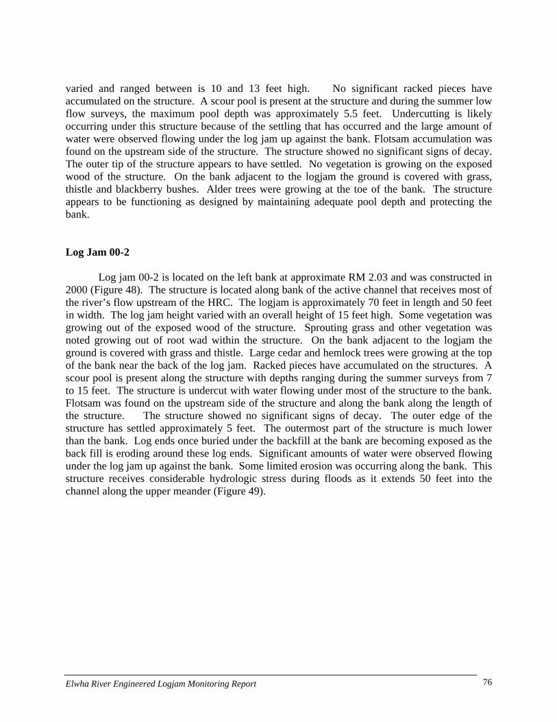
varied and ranged between is 10 and 13 feet high. No significant racked pieces have accumulated on the structure. A scour pool is present at the structure and during the summer low flow surveys, the maximum pool depth was approximately 5.5 feet. Undercutting is likely occurring under this structure because of the settling that has occurred and the large amount of water were observed flowing under the log jam up against the bank. Flotsam accumulation was found on the upstream side of the structure. The structure showed no significant signs of decay. The outer tip of the structure appears to have settled. No vegetation is growing on the exposed wood of the structure. On the bank adjacent to the logjam the ground is covered with grass, thistle and blackberry bushes. Alder trees were growing at the toe of the bank. The structure appears to be functioning as designed by maintaining adequate pool depth and protecting the bank. Log Jam 00-2
Log jam 00-2 is located on the left bank at approximate RM 2.03 and was constructed in 2000 (Figure 48). The structure is located along bank of the active channel that receives most of the river’s flow upstream of the HRC. The logjam is approximately 70 feet in length and 50 feet in width. The log jam height varied with an overall height of 15 feet high. Some vegetation was growing out of the exposed wood of the structure. Sprouting grass and other vegetation was noted growing out of root wad within the structure. On the bank adjacent to the logjam the ground is covered with grass and thistle. Large cedar and hemlock trees were growing at the top of the bank near the back of the log jam. Racked pieces have accumulated on the structures. A scour pool is present along the structure with depths ranging during the summer surveys from 7 to 15 feet. The structure is undercut with water flowing under most of the structure to the bank. Flotsam was found on the upstream side of the structure and along the bank along the length of the structure. The structure showed no significant signs of decay. The outer edge of the structure has settled approximately 5 feet. The outermost part of the structure is much lower than the bank. Log ends once buried under the backfill at the bank are becoming exposed as the back fill is eroding around these log ends. Significant amounts of water were observed flowing under the log jam up against the bank. Some limited erosion was occurring along the bank. This structure receives considerable hydrologic stress during floods as it extends 50 feet into the channel along the upper meander (Figure 49).
Elwha River Engineered Logjam Monitoring Report 76
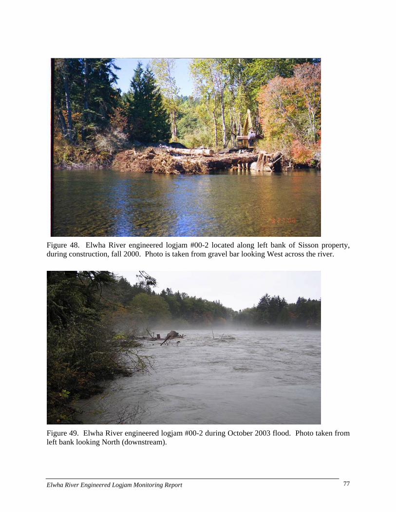
Figure 48. Elwha River engineered logjam #00-2 located along left bank of Sisson property, during construction, fall 2000. Photo is taken from gravel bar looking West across the river.
Figure 49. Elwha River engineered logjam #00-2 during October 2003 flood. Photo taken from left bank looking North (downstream).
Elwha River Engineered Logjam Monitoring Report 77

Log Jam 99-4 Log jam 99-4 is a buried log jam located on the left bank of the river at approximately
RM 1.98 This log jam was constructed in 1999 and is located upstream of the inlet to HRC in the mainstem. It was constructed to prevent lateral erosion around log jam 99-6. Very little of the structure is visible from the bank. A few key pieces and a vertical piling are visible from the bank. The exposed portion of the log jam is approximately 25 feet length and exposed width was 10 feet. Most of the exposed wood has resulted from erosion that has occurred since 2003. Very little woody vegetation is growing on the log jams. On the bank, grass and thistle mostly dominated the vegetation with some young alder trees. No significant racked pieces are on the structure. Most racked material was small in size. Because most of this structure is built into the bank, no pool exists under or at the structure. The exposed part of the structure was completely undercut with flowing water under all parts of the exposed structure. Because the structure is mostly buried in the bank the structure shows no significant signs of decay or settling. Log Jam 99-6
Log jam 99-6 was built in 1999 and is in the mainstem channel upstream of the inlet to the HRC. The original plan was to reconstruct the full spanning log jam at the entrance to the Hunt Road Channel that had eroded from 1996-1998. However the presence of spawning Chinook at the time of construction caused a change in construction plans. The structure was built in tandem with another logjam (99-5) as a bank deflector on the left and bar apex jams on the right bank at RM 1.96. Log jam (99-6) is approximately 30 feet in width and approximately 70 feet long. The log jam height is 13 feet high. Young conifer trees are growing on the bank. A clump of alder trees were growing on the upstream end of the log jam. Very little to no racked material has accumulated on the structure. A deep scour pool is present at the structure with maximum depth of approximately 12-15 feet during the summer low flow period. Undercutting is occurring beneath this structure as settling has occurred. The structure was repaired in 2003 following significant undercutting associated with the October 2003 flood. The structure showed no significant signs of wood decay. However, the outer tip of the structure appears to have settled approximately 3 feet. Significant amounts of water were observed flowing under the log jam up against the bank (Figure 50). Very little vegetation is growing on the exposed wood of the structure. On the bank adjacent to the logjam the ground is covered with grass and thistle.
Elwha River Engineered Logjam Monitoring Report 78
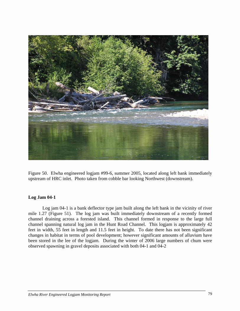
Figure 50. Elwha engineered logjam #99-6, summer 2005, located along left bank immediately upstream of HRC inlet. Photo taken from cobble bar looking Northwest (downstream).
Log Jam 04-1
Log jam 04-1 is a bank deflector type jam built along the left bank in the vicinity of river mile 1.27 (Figure 51). The log jam was built immediately downstream of a recently formed channel draining across a forested island. This channel formed in response to the large full channel spanning natural log jam in the Hunt Road Channel. This logjam is approximately 42 feet in width, 55 feet in length and 11.5 feet in height. To date there has not been significant changes in habitat in terms of pool development; however significant amounts of alluvium have been stored in the lee of the logjam. During the winter of 2006 large numbers of chum were observed spawning in gravel deposits associated with both 04-1 and 04-2
Elwha River Engineered Logjam Monitoring Report 79
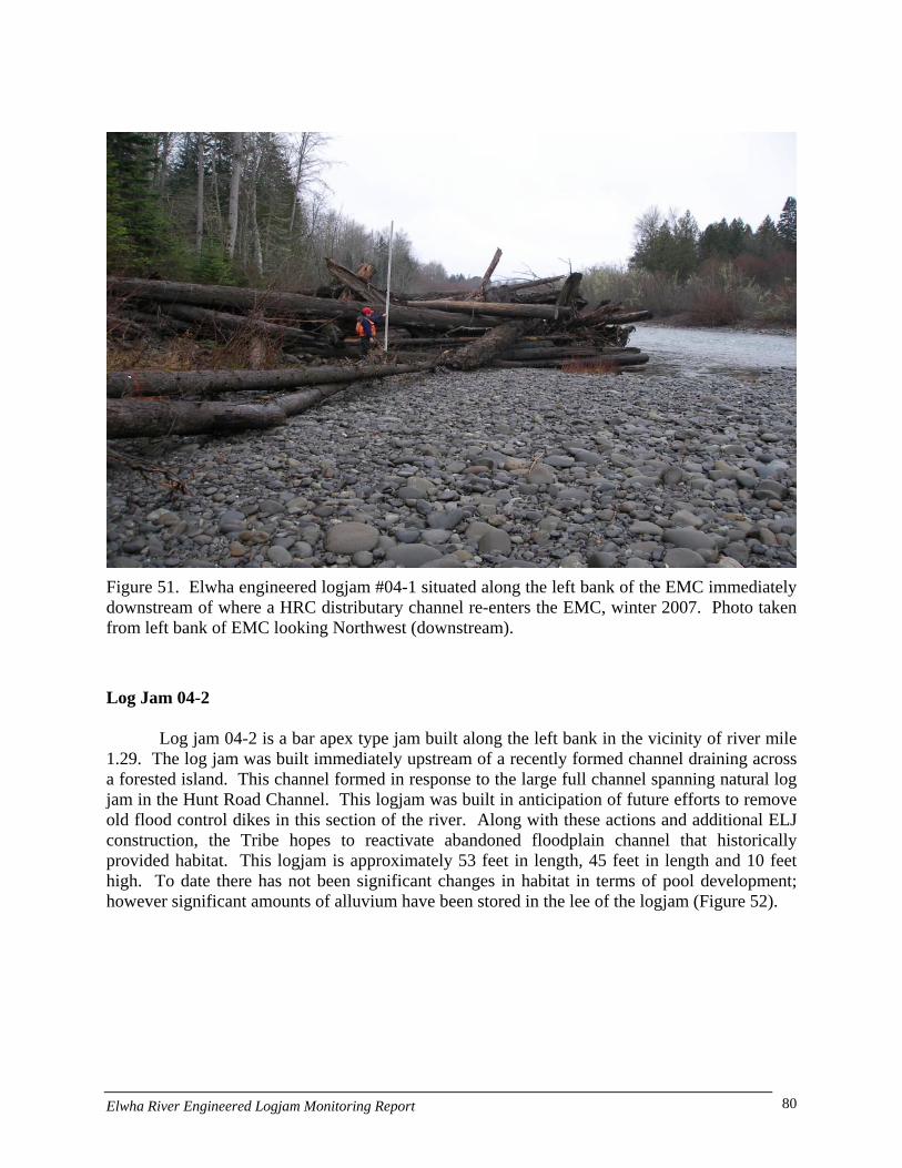
Figure 51. Elwha engineered logjam #04-1 situated along the left bank of the EMC immediately downstream of where a HRC distributary channel re-enters the EMC, winter 2007. Photo taken from left bank of EMC looking Northwest (downstream).
Log Jam 04-2
Log jam 04-2 is a bar apex type jam built along the left bank in the vicinity of river mile 1.29. The log jam was built immediately upstream of a recently formed channel draining across a forested island. This channel formed in response to the large full channel spanning natural log jam in the Hunt Road Channel. This logjam was built in anticipation of future efforts to remove old flood control dikes in this section of the river. Along with these actions and additional ELJ construction, the Tribe hopes to reactivate abandoned floodplain channel that historically provided habitat. This logjam is approximately 53 feet in length, 45 feet in length and 10 feet high. To date there has not been significant changes in habitat in terms of pool development; however significant amounts of alluvium have been stored in the lee of the logjam (Figure 52).
Elwha River Engineered Logjam Monitoring Report 80
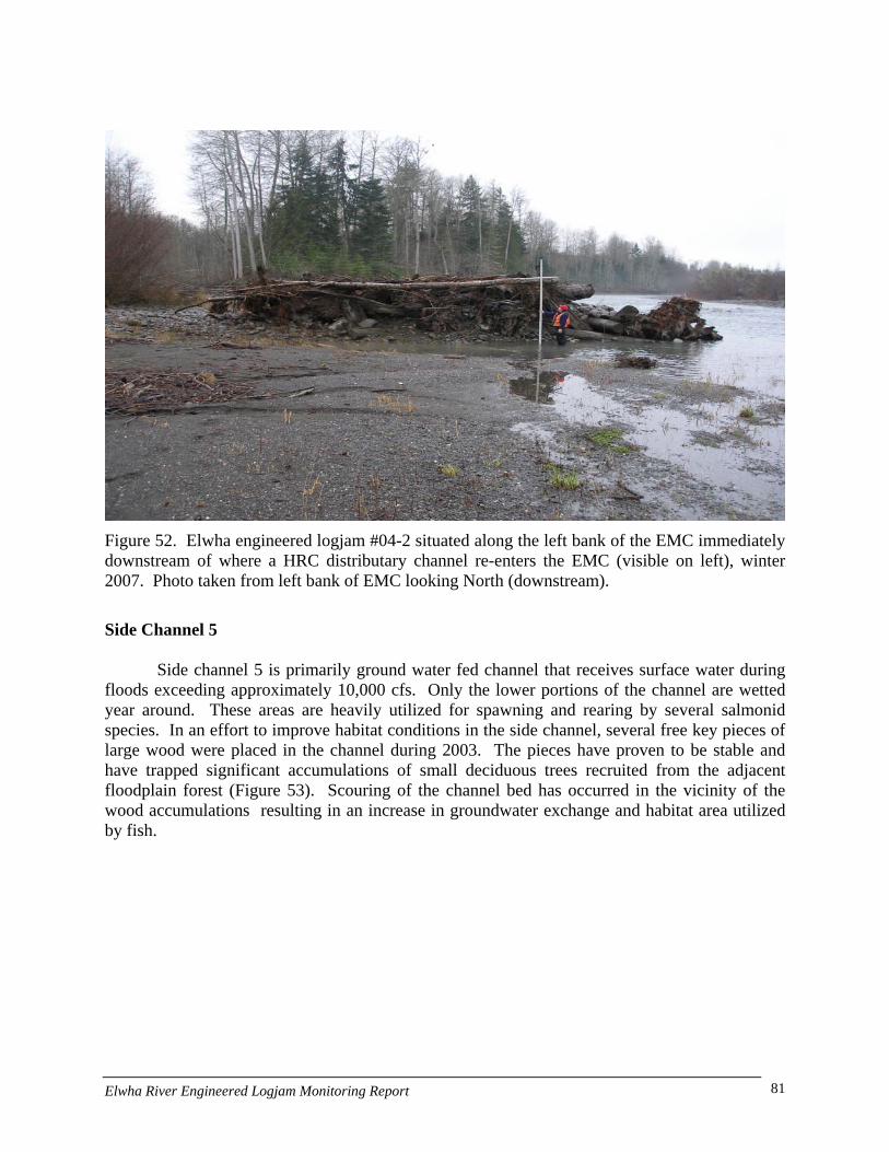
Figure 52. Elwha engineered logjam #04-2 situated along the left bank of the EMC immediately downstream of where a HRC distributary channel re-enters the EMC (visible on left), winter 2007. Photo taken from left bank of EMC looking North (downstream).
Side Channel 5
Side channel 5 is primarily ground water fed channel that receives surface water during floods exceeding approximately 10,000 cfs. Only the lower portions of the channel are wetted year around. These areas are heavily utilized for spawning and rearing by several salmonid species. In an effort to improve habitat conditions in the side channel, several free key pieces of large wood were placed in the channel during 2003. The pieces have proven to be stable and have trapped significant accumulations of small deciduous trees recruited from the adjacent floodplain forest (Figure 53). Scouring of the channel bed has occurred in the vicinity of the wood accumulations resulting in an increase in groundwater exchange and habitat area utilized by fish.
Elwha River Engineered Logjam Monitoring Report 81

Key pieces
Figure 53. Logjam formation upstream of 2003 unanchored key pieces placed in Side Channel 5. Photo taken after October 2004 flood flow, looking Northeast (downstream). Alder trees visible in photo are racked up on key pieces and were eroded from upstream floodplain as Side Channel 5 increased in size due to flood flows. The side channel is almost devoid of wood upstream of this location. ELJ 00-1 is located at inlet to Side Channel 5 and may have contributed to the increase in flow down the side channel.
Elwha River Engineered Logjam Monitoring Report 82