Logjams are not jammed: measurements of log motions in Big ...
20
Logjams are not jammed: measurements of log motions in Big Creek, Idaho Nakul S. Deshpande * and Benjamin T. Crosby Department of Geosciences, Idaho State University, 921 S 8th Ave, Pocatello, ID 83209 November 5, 2019 Abstract Colloquially, a “logjam” indicates a kinematic arrest of movement. Taken literally, it refers to a type of dense accumulation of wood in rivers widely recognized as bestowing numerous biological and physical benefits to the system but also present serious hazards to infrastructure. Despite this, no in-situ field measurements have assessed the degree of arrest in a naturally-formed logjam. Using time-lapse photography, repeat total station surveys and water level loggers, we provide an unprecedented perspective on the evolution of a logjam in central Idaho. Despite the namesake, we find that the logjam is not jammed. The ensemble of logs progressively deforms in response to shear and buoyant lift of flowing water, modulated by the rising limb, peak and falling limb of the snowmelt hydrograph. As water rises and log drag against the bed and banks decreases, they collectively translate downstream, generating a heterogeneous pattern of deformation. As streamflow recedes and the logs reconnect with the bed and banks, the coherent deformation pattern degrades as logs settle opportunistically amongst their neighbors. Field observations of continuous movement at a low rate are qualitatively similar to creep and clogging, behaviors that are common to a wide class of disordered materials. These similarities open the possibility to inform future studies of environmental clogging, wood- laden flows, logjams, hazard mitigation and the design of engineered logjams by bridging these practices with frontier research efforts in soft matter physics and granular rheology. Keywords— logjams, log rafts, jamming, clogging, anisotropic granular materials * now at: Department of Earth and Environmental Sciences, University of Pennsylvania 251 Hayden Hall, 240 S 33rd St, Philadelphia, PA 19104 [email protected] 1
Transcript of Logjams are not jammed: measurements of log motions in Big ...
Logjams are not jammed:
measurements of log motions in Big Creek, Idaho
Nakul S. Deshpande ∗and Benjamin T. Crosby
Department of Geosciences, Idaho State University, 921 S 8th Ave, Pocatello, ID 83209
November 5, 2019
Abstract
Colloquially, a “logjam” indicates a kinematic arrest of movement. Taken literally, it
refers to a type of dense accumulation of wood in rivers widely recognized as bestowing
numerous biological and physical benefits to the system but also present serious hazards
to infrastructure. Despite this, no in-situ field measurements have assessed the degree of
arrest in a naturally-formed logjam. Using time-lapse photography, repeat total station
surveys and water level loggers, we provide an unprecedented perspective on the evolution
of a logjam in central Idaho. Despite the namesake, we find that the logjam is not
jammed. The ensemble of logs progressively deforms in response to shear and buoyant
lift of flowing water, modulated by the rising limb, peak and falling limb of the snowmelt
hydrograph. As water rises and log drag against the bed and banks decreases, they
collectively translate downstream, generating a heterogeneous pattern of deformation.
As streamflow recedes and the logs reconnect with the bed and banks, the coherent
deformation pattern degrades as logs settle opportunistically amongst their neighbors.
Field observations of continuous movement at a low rate are qualitatively similar to creep
and clogging, behaviors that are common to a wide class of disordered materials. These
similarities open the possibility to inform future studies of environmental clogging, wood-
laden flows, logjams, hazard mitigation and the design of engineered logjams by bridging
these practices with frontier research efforts in soft matter physics and granular rheology.
Keywords— logjams, log rafts, jamming, clogging, anisotropic granular materials
∗now at: Department of Earth and Environmental Sciences, University of Pennsylvania 251 Hayden Hall, 240 S 33rd St,
Philadelphia, PA 19104 [email protected]
1
1 Wood in rivers
Wood is considered both friend and foe in river systems. Accumulations of wood are critical agents in facilitating
river function and form by means of rich interactions between wood, sediment, flow and ecology [Gurnell et al., 2002;
Faustini and Jones, 2003; Montgomery et al., 2003; Gurnell et al., 2005], which render them a popular tool in river
restoration efforts [Gerhard and Reich, 2000; Kail et al., 2007; Abbe, 2011; Roni et al., 2014]. These efforts are in
light of, and a reaction to, legacy logging practices and river corridor management which have altered wood-river
feedbacks [Wohl, 2014]. Historically, these large accumulations were the subject of great public interest due to their
prodigious size and the removal efforts that accompanied them [Humphreys, 1971; McPhee, 1987] and were central
in timber industry’s log drives [Rajala, 2010]. In a contemporary context, logs collected by floods can accumulate
and persist at bridge piers and increase the chances of structural damage, flooding and scour, presenting hazards
to communities and infrastructure [Diehl, 1997; Lyn et al., 2007; Comiti et al., 2012; Mazzorana et al., 2009; Wohl
et al., 2016]. In both cases, these accumulations are often assigned the generic descriptor ‘logjams’ - a reference to
both the material and their (apparently) physically arrested state. Many taxonomies of wood accumulations exist
and depend on a number of environmental variables [Wohl et al., 2010; Collins et al., 2012] and transport regime
[Kramer and Wohl, 2017]. Logjam studies have been conducted in steep, single-threaded mountainous settings [Wohl
and Beckman, 2014] and low-gradient alluvial settings where wood-floodplain interactions are important [Wohl, 2013;
Collins et al., 2012]. Logjams which grow to a size such that they span the entire channel width and are of significant
length are referred to as ’log rafts’ – these features can occur in low-gradient alluvial settings [Boivin et al., 2015],
behind reservoir dams [Moulin and Piegay, 2004; Le Lay and Moulin, 2007; Fremier et al., 2010] and along coastlines
[Kramer and Wohl, 2015]. To date, no studies have explored large, channel-spanning ‘log rafts’ in steep, mountainous,
single-threaded reaches.
Determining the full risks and beneficial potential of logjams and log rafts is contingent on an understanding of
their physics, complimented by observations in the field. Current models of wood transport mechanics determine
hydrodynamic entertainment thresholds for single log pieces [Braudrick and Grant, 2000; Alonso, 2013]. Log-log
(ensemble) movement has been observed in congested modes of transport [Braudrick et al., 1997], when multiple
wood pieces are mobilized, but are little explored. In both cases, the type of transport (single log or ensemble)
is strongly coupled to the channel geometry and supply mechanism in the field; in the single-log scenario, wood is
supplied via near-bank recruitment and deposition [Piegay et al., 2015], while delivery via breached logjams or mass
wasting and hillslope processes [Wohl et al., 2009; Ruiz-Villanueva et al., 2014] generally lead to congested modes of
transport.
Observations of wood and transport are difficult to collect in the field and few studies exist. Workers have
conducted multi-year field surveys [Wohl and Goode, 2008], collected photos with ground cameras [Benacchio et al.,
2017], tagged logs with RFID tags and GPS [Ravazzolo et al., 2014; Schenk et al., 2014; Macvicar and Piegay,
2012]. These field observations encode signatures of hysteresis [Piegay et al., 2015], are dependent on diverse fluvial
process such as ice break-out floods [Boivin et al., 2015] and are highly sensitive to hydrograph shape and timing
[Ruiz-Villanueva et al., 2014] - all of which place strong non-linear constraints on physical frameworks. Challenges
in our knowledge of congested modes of transport, coupled with the opportunity provided by growing repositories
of image data and recognition of non-linearity in wood transport have motivated recent efforts in casting dense,
ensemble log transport as ‘wood-laden-flows’ [Ruiz-Villanueva et al., 2019]. Inspired by descriptions of fluid-particle
2
geophysical flows [Iverson, 2005], this framework casts ensemble kinematics of logs as a function of the corresponding
wood volume-fraction of the flow, in kinship to the phenomenology of yield stress fluids.
2 Clogging and jamming
Although the namesake logjam is common in the vernacular, jamming theory accounts for how numerous disordered,
‘soft’ materials [de Gennes, 1992] transition from fluid to solid-like states [Liu and Nagel, 2010; O’Hern et al., 2003].
These transitions also occur when particles are driven through confined geometries and clog [Zuriguel, 2014; Thomas
and Durian, 2015] or disordered landscapes, where obstacles inhibit movement by pinning particles that would oth-
erwise be mobile [Peter et al., 2018; Reichhardt and Olson Reichhardt, 2017]. Granular materials fall within the
jamming paradigm [Majmudar et al., 2007] and clogging behavior is observed in dense flows of elongated grains
[Borzsonyi et al., 2016; Torok et al., 2017]. Logjams have been explicitly citepd as macroscopic manifestations of
granular phenomenology [Borzsonyi and Stannarius, 2013] and invoked as an inspiration in the assembly of nanoma-
terials [Whang et al., 2003; Yang, 2003]. Further, fruitful advances in our understanding of landscapes have been
made via an embrace of the granular roots of sediment transport [Zimmermann et al., 2010; Frey and Church, 2011;
Houssais et al., 2015; Ferdowsi et al., 2017, 2018]. Likewise, we look to these branches of physics as an inspiration for
the framing and interpretation of the work herein and for informing future investigations of the physics of logjams.
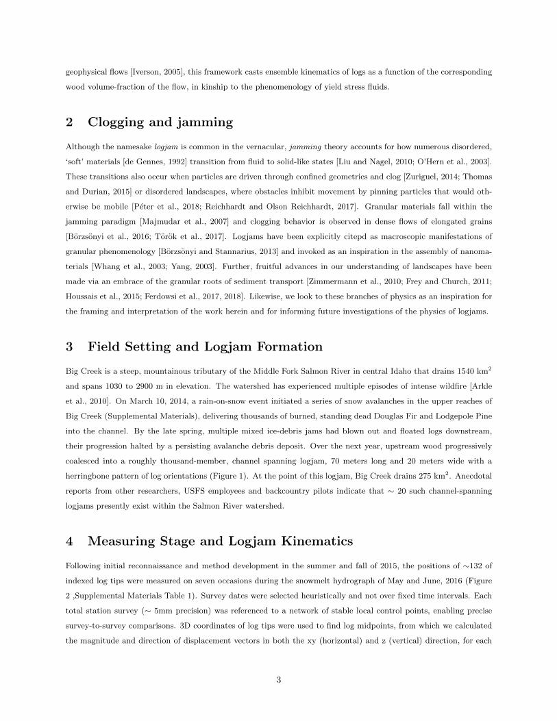
3 Field Setting and Logjam Formation
Big Creek is a steep, mountainous tributary of the Middle Fork Salmon River in central Idaho that drains 1540 km2
and spans 1030 to 2900 m in elevation. The watershed has experienced multiple episodes of intense wildfire [Arkle
et al., 2010]. On March 10, 2014, a rain-on-snow event initiated a series of snow avalanches in the upper reaches of
Big Creek (Supplemental Materials), delivering thousands of burned, standing dead Douglas Fir and Lodgepole Pine
into the channel. By the late spring, multiple mixed ice-debris jams had blown out and floated logs downstream,
their progression halted by a persisting avalanche debris deposit. Over the next year, upstream wood progressively
coalesced into a roughly thousand-member, channel spanning logjam, 70 meters long and 20 meters wide with a
herringbone pattern of log orientations (Figure 1). At the point of this logjam, Big Creek drains 275 km2. Anecdotal
reports from other researchers, USFS employees and backcountry pilots indicate that ∼ 20 such channel-spanning
logjams presently exist within the Salmon River watershed.
4 Measuring Stage and Logjam Kinematics
Following initial reconnaissance and method development in the summer and fall of 2015, the positions of ∼132 of
indexed log tips were measured on seven occasions during the snowmelt hydrograph of May and June, 2016 (Figure
2 ,Supplemental Materials Table 1). Survey dates were selected heuristically and not over fixed time intervals. Each
total station survey (∼ 5mm precision) was referenced to a network of stable local control points, enabling precise
survey-to-survey comparisons. 3D coordinates of log tips were used to find log midpoints, from which we calculated
the magnitude and direction of displacement vectors in both the xy (horizontal) and z (vertical) direction, for each
3
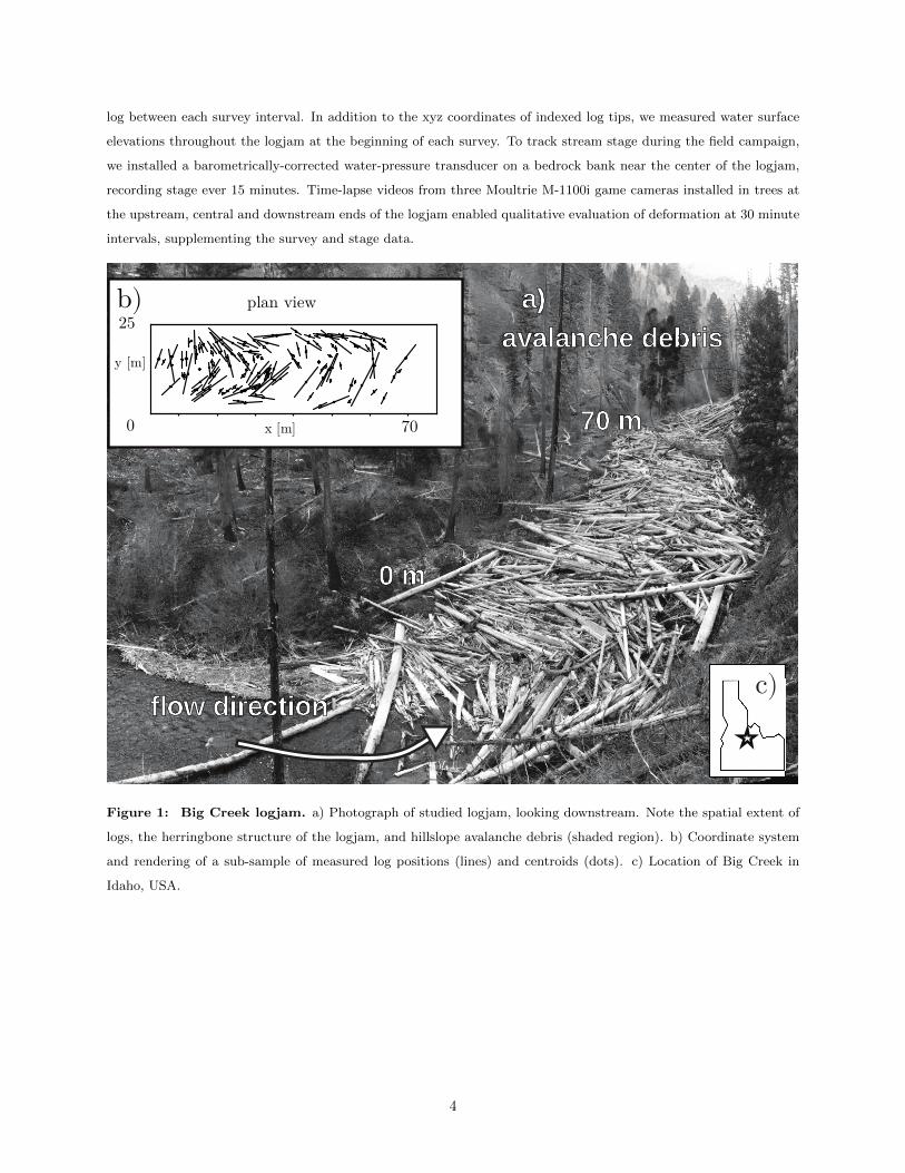
log between each survey interval. In addition to the xyz coordinates of indexed log tips, we measured water surface
elevations throughout the logjam at the beginning of each survey. To track stream stage during the field campaign,
we installed a barometrically-corrected water-pressure transducer on a bedrock bank near the center of the logjam,
recording stage ever 15 minutes. Time-lapse videos from three Moultrie M-1100i game cameras installed in trees at
the upstream, central and downstream ends of the logjam enabled qualitative evaluation of deformation at 30 minute
intervals, supplementing the survey and stage data.
Figure 1: Big Creek logjam. a) Photograph of studied logjam, looking downstream. Note the spatial extent of
logs, the herringbone structure of the logjam, and hillslope avalanche debris (shaded region). b) Coordinate system
and rendering of a sub-sample of measured log positions (lines) and centroids (dots). c) Location of Big Creek in
Idaho, USA.
4
5 Results
5.A Water level
Two long-wavelength snowmelt peaks superimposed with lesser diel melt fluctuations characterize the flow conditions
during the survey campaign (Figure 2a). River stage almost peaks in mid-May but the highest and most persistent
flows occur in early June. Water surface profiles measured within the logjam slope gently and linearly downstream
(Figures 3c,3d). The shape of these profiles do not change during the survey period, although they shift in elevation
in concert with the hydrograph. At ∼50 m along the logjam, near the debris blockage, there is a pronounced inflection
where the water surface drops about 0.5 m. The existence, location and magnitude of the water surface inflection
persists throughout the field campaign.
0.51.01.5
river stage [m]
0 20 40 60x [m]10-310-210-1100
xy [m]
A B C D E F
0 20 40 60 −0.6−0.4−0.20.00.20.40.6z [m]
May 15 May 20 May 25 May 30 June 4 June 9 June 14 June 19 June 242016
a)b) c) June 29
x [m]Figure 2: Variation in river stage drives logjam deformation a) Measurements of river stage (blue line) during
the survey campaign during May-June of 2016. Shaded domains indicate the duration of measurement surveys and are
labeled with the corresponding label and color. Longitudinal profile of log centroid displacements in the (b) horizonal
and (c) vertical directions. Centroids are colored by survey interval. Note that horizontal centroid displacements are
greater in the upstream section of the logjam and decrease downstream.
5.B Total Station
Total station data capture temporally and spatially heterogeneous patterns of deformation. Displacement distri-
butions of are broad and tens of centimeters in magnitude during intervals A and B (Figure 2 3). The largest
displacements occurred over interval C, when displacements average an order of magnitude greater than the two pre-
vious intervals. During the falling limb of the hydrograph (intervals D, E and F), displacements are low in magnitude
5
but finite and within our measurement error. On June 9th (the beginning of interval C), log elevations cluster tightly
at the water surface. During interval C, deformation proceeds uniformly in the downstream direction. Horizontal
movement is greatest upstream (0-30 m) and is ∼3 times larger than displacements downstream (Figure 3a,3e).
This is in contrast to log positions on June 19th (the beginning of interval F, during low flow), which are broadly
distributed above the water surface (Figures 3b,3f). During interval E, log displacements are low in magnitude and
semi-random in orientation.
70x[m]0
25
y[m
]
0.0
0.5
1.0
1.5
2.0
2.5
3.0
70x[m]0
25
y[m
]
−0.1
0.0
0.1
0.2
0.3
0.4
0 20 40 60x[m]
0
1
2
3
4
5
z[m
]
1122324354
0 20 40 60x[m]
0
1
2
3
4
5
z [m
]3581114
Interval C Interval E
log centroid
water surface
inferred bed
June 9th June 19thflow direction
Δ xy Δ xya) b)
c) d)
e) f)
Figure 3: Deformation patterns during intervals C and E. Interpolated fields of horizontal logjam deformation
with arrows showing measured log displacement vectors (a and b) and wind rose diagrams showing the distribution
of magnitudes and directions of displacements (e and f). Longitudinal sections (c and d) show the measured water
surface and log midpoints at the beginning of each interval.
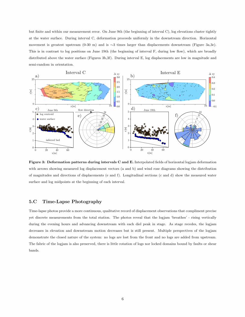
5.C Time-Lapse Photography
Time-lapse photos provide a more continuous, qualitative record of displacement observations that compliment precise
yet discrete measurements from the total station. The photos reveal that the logjam ‘breathes’ - rising vertically
during the evening hours and advancing downstream with each diel peak in stage. As stage recedes, the logjam
decreases in elevation and downstream motion decreases but is still present. Multiple perspectives of the logjam
demonstrate the closed nature of the system: no logs are lost from the front and no logs are added from upstream.
The fabric of the logjam is also preserved, there is little rotation of logs nor locked domains bound by faults or shear
bands.
6
6 Discussion
6.A Logjam deformation partitions into three phases
Logjam deformation is linked to the rising limb, peak, and falling limb of the hydrograph. Small magnitude, down-
stream displacements occur during the rising limb, amplified by diel snowmelt-driven pulses in stage. These collective,
downstream-oriented ensemble movements are greatest at the peak of the hydrograph. As water level falls, the log-
jam settles in kind; log motions are discrete, low in magnitude and randomly oriented. We infer that these three
phases of logjam movement correspond to two modes of deformation: shortening during compression and random
displacements during settling. Quantitatively distinct behaviors on both limbs of the hydrograph are demonstrative
of non-linearity in the physical response of the logjam to hydrodynamics.
6.B Competition between shear, buoyancy and pinning
Compression can be accommodated by increasing the volume fraction horizontally, and/or by stacking logs vertically.
This occurs only during peak flows in the front of the logjam, near the hillslope deposit which inhibits the downstream
progression of wood and therefore ‘pins’ the jam (Figure 2). Horizontal compression is ultimately a result of fluid
shear, while vertical deformation is a function of stage rise and fall and the buoyant response of logs to water. We
infer that these two irreversible processes are critically linked. When buoyant lift is significant enough to release
constraining stresses on intertwined or grounded logs, it reduces friction and enables them to respond to shear. As
water level lowers, so do the logs until some critical depth where logs re-establish frictional contact with the bed.
At this point, logs are no longer buoyant but are supported by the bed, banks and each other, thus inhibiting
downstream deformation. Our kinematic measurements result from the competition between shear and buoyancy,
and while qualitative, help bridge previously proposed conceptual force balances [Wohl, 2011; Doyle and Manners,
2008] with a fully dynamical model of log interactions and logjam deformation.
Preservation of the ‘herringbone’ geometrical structure of the logjam and the absence of locked domains is in con-
trast to qualitative observations from historical photos of logjams [Borzsonyi and Stannarius, 2013] and experiments
of horizontal pattern formation in vibrated rods [Narayan et al., 2006; Galanis et al., 2006; Kudrolli et al., 2008]. This
is because the particle length is a control parameter which dictates the patterning of driven elongated particles. In
our case, the average log width is much larger than the channel width. Vertical structure within the logjam is driven
by increased water levels, which create accommodation space beneath the logjam, and the possibility for logs to be
stacked on top of each other. This ‘heaping’ behavior is similar that observed in experiments of sheared elongated
particles [Fischer et al., 2016].
Inflections in displacement and water surface profiles occur at the same location in the logjam (∼50m) - proximate
to the hillslope debris. We interpret these inflections in xy displacements and water level as being controlled by the
pinning debris deposit. Logjam accumulation, growth and persistence clearly depends on channel geometry [Curran,
2010], but is also dependent on pinning obstructions in the form of bridge piers [Schmocker and Hager, 2010; Cicco
et al., 2015; Gschnitzer et al., 2015] and by naturally occurring debris jams [Lancaster and Grant, 2006]. Improving
our understanding of the interplay between deformation dynamics and the nature of the pinning site could benefit
greatly from theoretical investigations [Reichhardt and Reichhardt, 2019] or other clogging studies [Borzsonyi et al.,
2016]. Our observations lead us to speculate about the mechanisms of logjam break up and propagation downstream:
7
a) destroy obstruction, b) over-ride obstruction, c) circumvent obstruction.
6.C Backwater persistence and drag
At low stage, a portion of logs are submerged and thus are still being subjected to fluid shear. This amount of
shear may be non-negligible, as the persistence of the inflection of the water surface profile demonstrates a constant
gravitational acceleration of flow and significant drag on the logjam. Large wood effects on channel hydraulics are
well-known from field measurements [Abbe and Montgomery, 1996] and the geometry of our water surface profile
is similar to backwater effects studied in flume studies of debris accumulation [Schmocker and Hager, 2013; Schalko
et al., 2019a,b]. Drag coefficients for single wood pieces have been measured in field experiments [Shields and Alonso,
2012; Alonso, 2013], proposed in numerical models [Hygelund and Manga, 2003; Manga and Kirchner, 2000] and
measured for stable, engineered structures [Bennett et al., 2015; Gallisdorfer et al., 2014], but our measurement
of the hydrodynamics are not sufficient to make a full connection with these models. Future work could seek to
make explicit force measurements of logs, or to constrain flow velocities, with the intent of making connections with
hydrodynamic models of drag.
7 Conclusions
We conducted field investigations to map the spatio-temporal patterns of deformation within in a channel-spanning
mountain logjam in Big Creek, Idaho. Our measurements demonstrate that the logjam is not jammed, but is
highly sensitive to variations in river flow. Deformation is driven by the competition of shear, buoyancy, and the
stability of the hillslope avalanche debris. These observations complicate the task of developing thresholds for logjam
break up and downstream propagation, as precisely determined thresholds for movement are memory-dependent and
time-varying. Therefore, applications of constitutive models which require the specification of a finite yield stress
are problematic. Although our observations are from a single field site, the modes of deformation and sensitivity to
hydrograph shape and timing should be applicable to logjams in constrained channels with time varying flow. Further
work which explicitly measures forces in the logjam can be more concretely connected to experiments and simulations
of granular rheology. The language of pinning, clogging and creep open the space for quantitative treatment of the
phenomenology of wood-laden flows and their states of arrest as logjams. This can lead to more informed wood
retention structures for restoration, bridge pier design, river corridor management and flood hazard mitigation.
8 Acknowledgments
We thank the DeVlieg Foundation for providing funding to support this work. We also thank the US Forest Service
and Arnold Aviation, who provided transportation and field support. Further, the caretakers of Taylor Ranch and
the residents of Big Creek Village provided much appreciated assistance. We are also deeply grateful to Caitlin
Vitale-Sullivan for assistance in the field.
8
9 Works cited
T. B. Abbe. Geomorphic, engineering, and ecological considerations when using wood in river restoration. In Stream
Restoration in Dynamic Fluvial Systems: Scientific Approaches, Analyses, and Tools, pages 419—-451. American
Geophysical Union Washington, DC, 2011.
T. B. Abbe and D. R. Montgomery. Large Woody Debris Jams, Channel Hydraulics and Habitat Formation in Large
Rivers. Regulated Rivers: Research & Management, 12(2-3):201–221, 1996. ISSN 08869375. doi: 10.1002/(SICI)
1099-1646(199603)12:2/3〈201::AID-RRR390〉3.0.CO;2-A.
C. V. Alonso. Transport Mechanics of Stream-Borne Logs. Riparian Vegetation and Fluvial Geomorphology, pages
59–69, 2013. doi: 10.1029/008WSA05.
R. S. Arkle, D. S. Pilliod, and K. Strickler. Fire, flow and dynamic equilibrium in stream macroinvertebrate commu-
nities. Freshwater Biology, 55(2):299–314, 2010. ISSN 00465070. doi: 10.1111/j.1365-2427.2009.02275.x.
V. Benacchio, H. Piegay, T. Buffin-Belanger, and L. Vaudor. A new methodology for monitoring wood fluxes in
rivers using a ground camera: Potential and limits. Geomorphology, 279:44–58, 2017. ISSN 0169555X. doi:
10.1016/j.geomorph.2016.07.019.
S. J. Bennett, S. M. Ghaneeizad, M. S. Gallisdorfer, D. Cai, J. F. Atkinson, A. Simon, and E. J. Langendoen. Flow,
turbulence, and drag associated with engineered log jams in a fixed-bed experimental channel. Geomorphology,
248(April 2016):172–184, 2015. ISSN 0169555X. doi: 10.1016/j.geomorph.2015.07.046.
M. Boivin, T. Buffin-Belanger, and H. Piegay. Implementation and validation of large wood analysis for wood
budgeting in a semi-alluvial river. 2015.
T. Borzsonyi and R. Stannarius. Granular materials composed of shape-anisotropic grains. Soft Matter, 9(31):
7401–7418, 2013. ISSN 1744683X. doi: 10.1039/c3sm50298h.
T. Borzsonyi, E. Somfai, B. Szabo, S. Wegner, P. Mier, G. Rose, and R. Stannarius. Packing, alignment and flow
of shape-anisotropic grains in a 3D silo experiment. New Journal of Physics, 18(9), 2016. ISSN 13672630. doi:
10.1088/1367-2630/18/9/093017.
C. A. Braudrick and G. E. Grant. When do logs move in rivers? Water Resources Research, 36(2):571–583, feb 2000.
ISSN 00431397. doi: 10.1029/1999WR900290. URL http://doi.wiley.com/10.1029/1999WR900290.
C. A. Braudrick, G. E. Grant, Y. Ishikawa, and H. Ikeda. Dynamics of Wood Transport in Streams: A Flume
Experiment. Earth Surface Processes and Landforms, 22:669–683, 1997. ISSN 01979337. doi: 10.1002/(SICI)
1096-9837(199707)22:7〈669::AID-ESP740〉3.3.CO;2-C.
P. N. D. Cicco, L. Solari, and E. Paris. Bridge clogging caused by woody debris : Experimental analysis on the effect
of pier shape. Third International Conference on Wood in World Rivers 2015, (August 2014):6–10, 2015.
B. D. Collins, D. R. Montgomery, K. L. Fetherston, and T. B. Abbe. The floodplain large-wood cycle hypothesis: A
mechanism for the physical and biotic structuring of temperate forested alluvial valleys in the North Pacific coastal
9
ecoregion. Geomorphology, 139-140:460–470, 2012. ISSN 0169555X. doi: 10.1016/j.geomorph.2011.11.011. URL
http://dx.doi.org/10.1016/j.geomorph.2011.11.011.
F. Comiti, V. D. Agostino, M. Moser, M. A. Lenzi, F. Bettella, A. D. Agnese, E. Rigon, S. Gius, and B. Mazzorana.
Preventing Wood-Related Hazards In Mountain Basins : From Wood Load Estimation To Designing Retention
Structures. 12th Congress INTERPRAEVENT 2012 Conference Proceedings, pages 651–662, 2012.
J. C. Curran. Mobility of large woody debris (LWD) jams in a low gradient channel. Geomorphology, 116(3-4):
320–329, 2010. ISSN 0169555X. doi: 10.1016/j.geomorph.2009.11.027.
P.-G. de Gennes. Soft Matter (Nobel Lecture). Angewandte Chemie International Edition in English, 31(7):842–845,
jul 1992. ISSN 0570-0833. doi: 10.1002/anie.199208421. URL http://doi.wiley.com/10.1002/anie.199208421.
T. Diehl. Potential Drift Accumulation at Bridges. US Department of Transportation, Federal Highway Administra-
tion, Research and Development, Turner-Fairbank Highway Research Center, (April):45, 1997.
R. B. Doyle and M. Manners. A mechanistic Model of Woody Debris Jam Evolution and its Application to Wood-
Based Restoration and Management. River Research and Applications, 24:1104–1123, 2008. doi: 10.1002.
J. M. Faustini and J. A. Jones. Influence of large woody debris on channel morphology and dynamics in steep, boulder-
rich mountain streams, western Cascades, Oregon. Geomorphology, 51(1-3):187–205, 2003. ISSN 0169555X. doi:
10.1016/S0169-555X(02)00336-7.
B. Ferdowsi, C. P. Ortiz, M. Houssais, and D. J. Jerolmack. River-bed armouring as a granular segregation phe-
nomenon. Nature Communications, 8(1), 2017. ISSN 20411723. doi: 10.1038/s41467-017-01681-3.
B. Ferdowsi, C. P. Ortiz, and D. J. Jerolmack. Glassy dynamics of landscape evolution. Proceedings of the National
Academy of Sciences, 115(19):4827–4832, 2018. ISSN 0027-8424. doi: 10.1073/pnas.1715250115.
D. Fischer, T. Borzsonyi, D. S. Nasato, T. Poschel, and R. Stannarius. Heaping and secondary flows in sheared
granular materials. New Journal of Physics, 18(11), 2016. ISSN 13672630. doi: 10.1088/1367-2630/18/11/113006.
A. K. Fremier, J. I. Seo, and F. Nakamura. Watershed controls on the export of large wood from stream corridors.
Geomorphology, 117(1-2):33–43, 2010.
P. Frey and M. Church. Bedload: A granular phenomenon. Earth Surface Processes and Landforms, 36(1):58–69,
2011. ISSN 01979337. doi: 10.1002/esp.2103.
J. Galanis, D. Harries, D. L. Sackett, W. Losert, and R. Nossal. Spontaneous Patterning of Confined Granular Rods.
Physical Review Letters, 96(2):028002, jan 2006. ISSN 0031-9007. doi: 10.1103/PhysRevLett.96.028002.
M. S. Gallisdorfer, S. J. Bennett, J. F. Atkinson, S. M. Ghaneeizad, A. P. Brooks, A. Simon, and E. J. Langendoen.
Physical-scale model designs for engineered log jams in rivers. Journal of Hydro-Environment Research, 8(2):
115–128, 2014. ISSN 15706443. doi: 10.1016/j.jher.2013.10.002.
M. Gerhard and M. Reich. Restoration of streams with large wood: Effects of accumulated and built-in wood on
channel morphology, habitat diversity and aquatic fauna. International Review of Hydrobiology, 85(1):123–137,
2000. ISSN 14342944. doi: 10.1002/(SICI)1522-2632(200003)85:1〈123::AID-IROH123〉3.0.CO;2-T.
10
T. Gschnitzer, B. Gems, M. Aufleger, B. Mazzorana, and F. Comiti. On the evaluation and modelling of wood clogging
processes in flood related hazards estimation. Engineering Geology for Society and Territory - Volume 3: River
Basins, Reservoir Sedimentation and Water Resources, pages 139–143, 2015. doi: 10.1007/978-3-319-09054-2 27.
A. M. Gurnell, H. Piegay, F. J. Swanson, and S. V. Gregory. Large wood and fluvial processes. Freshwater Biology,
47(4):601–619, apr 2002. ISSN 0046-5070. doi: 10.1046/j.1365-2427.2002.00916.x.
A. M. Gurnell, K. Tockner, P. Edwards, and G. Petts. Effects of deposited wood on biocomplexity of river corridors.
Frontiers in Ecology and the Environment, 3(7):377–382, 2005.
M. Houssais, C. P. Ortiz, D. J. Durian, and D. J. Jerolmack. Onset of sediment transport is a continuous transition
driven by fluid shear and granular creep. Nature Communications, 6:1–8, 2015. ISSN 20411723. doi: 10.1038/
ncomms7527. URL http://dx.doi.org/10.1038/ncomms7527.
H. Humphreys. Photographic Views of Red River Raft , 1873. Louisiana History: The Journal of the Louisiana
Historical Association, 12(2):101–108, 1971.
B. Hygelund and M. Manga. Field measurements of drag coefficients for model large woody debris. Geomorphology,
51(1-3):175–185, mar 2003. ISSN 0169555X. doi: 10.1016/S0169-555X(02)00335-5. URL https://linkinghub.
elsevier.com/retrieve/pii/S0169555X02003355.
R. M. Iverson. Regulation of landslide motion by dilatancy and pore pressure feedback. Journal of Geophysical
Research: Earth Surface, 110(2):1–16, 2005. ISSN 21699011. doi: 10.1029/2004JF000268.
J. Kail, D. Hering, S. Muhar, M. Gerhard, and S. Preis. The use of large wood in stream restoration: Experiences
from 50 projects in Germany and Austria. Journal of Applied Ecology, 44(6):1145–1155, 2007. ISSN 00218901.
doi: 10.1111/j.1365-2664.2007.01401.x.
N. Kramer and E. Wohl. Driftcretions: The legacy impacts of driftwood on shoreline morphology. Geophysical
Research Letters, 42(14):5855–5864, 2015. ISSN 19448007. doi: 10.1002/2015GL064441.
N. Kramer and E. Wohl. Rules of the road: A qualitative and quantitative synthesis of large wood transport through
drainage networks. Geomorphology, 279:74–97, 2017. ISSN 0169555X. doi: 10.1016/j.geomorph.2016.08.026.
A. Kudrolli, G. Lumay, D. Volfson, and L. S. Tsimring. Swarming and swirling in self-propelled polar granular rods.
Physical Review Letters, 100(5):2–5, 2008. ISSN 00319007. doi: 10.1103/PhysRevLett.100.058001.
S. T. Lancaster and G. E. Grant. Debris dams and the relief of headwater streams. Geomorphology, 82(1-2):84–97,
2006. ISSN 0169555X. doi: 10.1016/j.geomorph.2005.08.020.
Y.-F. Le Lay and B. Moulin. Dams and the issue of floating wood: gathering, treating and recovering. HOUILLE
BLANCHE-REVUE INTERNATIONALE DE L EAU, (3):96–103, 2007.
A. J. Liu and S. R. Nagel. The Jamming Transition and the Marginally Jammed Solid. Annual Review of Condensed
Matter Physics, 1(1):347–369, 2010. ISSN 1947-5454. doi: 10.1146/annurev-conmatphys-070909-104045.
11
D. Lyn, T. Cooper, and C. Condon. Factors in Debris Accumulation at Bridge Piers. Technical Report
FWHA/IN/JTRP-2006/36, Joint Transportation Research Program, 2007. URL http://docs.lib.purdue.edu/
jtrp/241.
B. Macvicar and H. Piegay. Implementation and validation of video monitoring for wood budgeting in a wandering
piedmont river, the Ain River (France). Earth Surface Processes and Landforms, 37(12):1272–1289, 2012. ISSN
01979337. doi: 10.1002/esp.3240.
T. S. Majmudar, M. Sperl, S. Luding, and R. P. Behringer. Jamming transition in granular systems. Physical Review
Letters, 98(5):1–4, 2007. ISSN 00319007. doi: 10.1103/PhysRevLett.98.058001.
M. Manga and J. W. Kirchner. Stress partitioning in streams by large woody debris. Water Resources Research, 36
(8):2373–2379, aug 2000. ISSN 00431397. doi: 10.1029/2000WR900153.
B. Mazzorana, A. Zischg, A. Largiader, and J. Hubl. Hazard index maps for woody material recruitment and
transport in alpine catchments. Natural Hazards and Earth System Science, 9(1):197–209, 2009. ISSN 16849981.
doi: 10.5194/nhess-9-197-2009.
J. McPhee. The control of nature. 1987.
D. R. Montgomery, B. D. Collins, J. M. Buffington, and T. B. Abbe. Geomorphic effects of wood in rivers. In
American Fisheries Society Symposium, volume 37, pages 21–47, 2003.
B. Moulin and H. Piegay. Characteristics and temporal variability of large woody debris trapped in a reservoir on
the River Rhone (Rhone): implications for river basin management. River Research and Applications, 20(1):79–97,
2004.
V. Narayan, N. Menon, and S. Ramaswamy. Nonequilibrium steady states in a vibrated-rod monolayer: Tetratic,
nematic, and smectic correlations. Journal of Statistical Mechanics: Theory and Experiment, (1), 2006. ISSN
17425468. doi: 10.1088/1742-5468/2006/01/P01005.
C. S. O’Hern, L. E. Silbert, A. J. Liu, and S. R. Nagel. Jamming at zero temperature and zero applied stress: The
epitome of disorder. Physical Review E, 68(1):1–19, 2003. ISSN 1063-651X. doi: 10.1103/physreve.68.011306.
H. Peter, A. Libal, C. Reichhardt, and C. J. Reichhardt. Crossover from jamming to clogging behaviours in hetero-
geneous environments. Scientific Reports, 8(1):2–10, 2018. ISSN 20452322. doi: 10.1038/s41598-018-28256-6.
H. Piegay, M. G. Kondolf, T. J. Minear, and L. Vaudor. Trends in publications in fluvial geomorphology over two
decades: A truly new era in the discipline owing to recent technological revolution? Geomorphology, 248:489–500,
2015. ISSN 0169555X. doi: 10.1016/j.geomorph.2015.07.039. URL http://dx.doi.org/10.1016/j.geomorph.
2015.07.039.
R. A. Rajala. ”This Wasteful Use of a River”: Log Driving, Conservation, and British Columbia’s Stellako River
Controversy, 1965-72. BC Studies, (165):31–74, 2010.
12

D. Ravazzolo, L. Mao, L. Picco, and M. A. Lenzi. Tracking log displacement during floods in the Tagliamento
River using RFID and GPS tracker devices. Geomorphology, 228:226–233, 2014. ISSN 0169555X. doi: 10.1016/j.
geomorph.2014.09.012.
C. Reichhardt and C. J. Olson Reichhardt. Depinning and nonequilibrium dynamic phases of particle assemblies driven
over random and ordered substrates: A review. Reports on Progress in Physics, 80(2), 2017. ISSN 00344885. doi:
10.1088/1361-6633/80/2/026501.
C. Reichhardt and C. J. Reichhardt. Thermal creep and the skyrmion Hall angle in driven skyrmion crystals. Journal
of Physics Condensed Matter, 31(7), 2019. ISSN 1361648X. doi: 10.1088/1361-648X/aaefd7.
P. Roni, T. Beechie, G. Pess, and K. Hanson. Wood placement in river restoration: fact, fiction, and future
direction. Canadian Journal of Fisheries and Aquatic Sciences, 72(3):466–478, 2014. ISSN 0706-652X. doi:
10.1139/cjfas-2014-0344.
V. Ruiz-Villanueva, E. Blade Castellet, A. Dıez-Herrero, J. M. Bodoque, and M. Sanchez-Juny. Two-dimensional
modelling of large wood transport during flash floods. Earth Surface Processes and Landforms, 39(4):438–449,
2014. ISSN 10969837. doi: 10.1002/esp.3456.
V. Ruiz-Villanueva, B. Mazzorana, E. Blade, L. Burkli, P. Iribarren-Anacona, L. Mao, F. Nakamura, D. Ravazzolo,
D. Rickenmann, M. Sanz-Ramos, M. Stoffel, and E. Wohl. Characterization of wood-laden flows in rivers. Earth
Surface Processes and Landforms, 2019. ISSN 10969837. doi: 10.1002/esp.4603.
I. Schalko, C. Lageder, L. Schmocker, V. Weitbrecht, and R. M. Boes. Laboratory flume experiments on the for-
mation of spanwise large wood accumulations Part I: Effect on backwater rise. Water Resources Research, page
2018WR024649, 2019a. ISSN 0043-1397. doi: 10.1029/2018WR024649.
I. Schalko, C. Lageder, L. Schmocker, V. Weitbrecht, and R. M. Boes. Laboratory Flume Experiments on the
Formation of Spanwise Large Wood Accumulations: Part II-Effect on local scour. Water Resources Research,
pages 0–3, 2019b. ISSN 00431397. doi: 10.1029/2019WR024789.
E. R. Schenk, B. Moulin, C. R. Hupp, and J. M. Richter. Large wood budget and transport dynamics on a large
river using radio telemetry. Earth Surface Processes and Landforms, 39(4):487–498, 2014. ISSN 10969837. doi:
10.1002/esp.3463.
L. Schmocker and W. H. Hager. Drift accumulation at river bridges. River Flow 2010 – Dittrich, Koll, Aberle &
Geisenhainer (eds), pages 713–720, 2010.
L. Schmocker and W. H. Hager. Scale Modeling of Wooden Debris Accumulation at a Debris Rack. Journal of
Hydraulic Engineering, 139(8):827–836, 2013. ISSN 0733-9429. doi: 10.1061/(ASCE)HY.1943-7900.0000714.
F. D. Shields and C. V. Alonso. Assessment of flow forces on large wood in rivers. Water Resources Research, 48(4):
1–16, 2012. ISSN 00431397. doi: 10.1029/2011WR011547.
C. E. Thomas and D. E. Durian. Fraction of Clogging Configurations Sampled by Granular Hopper Flow. Physical
Review Letters, 114(17), 2015. ISSN 10797114. doi: 10.1103/PhysRevLett.114.178001.
13
J. Torok, S. Levay, B. Szabo, E. Somfai, S. Wegner, R. Stannarius, and T. Borzsonyi. Arching in three-dimensional
clogging. EPJ Web of Conferences, 140:1–4, 2017. ISSN 2100014X. doi: 10.1051/epjconf/201714003076.
D. Whang, S. Jin, Y. Wu, and C. M. Lieber. Large-scale hierarchical organization of nanowire arrays for integrated
nanosystems. Nano Letters, 3(9):1255–1259, 2003. ISSN 15306984. doi: 10.1021/nl0345062.
E. Wohl. Threshold-induced complex behavior of wood in mountain streams. Geology, 39(6):587–590, 2011. ISSN
00917613. doi: 10.1130/G32105.1.
E. Wohl. Floodplains and wood. Earth-Science Reviews, 123:194–212, 2013. ISSN 00128252. doi: 10.1016/j.earscirev.
2013.04.009. URL http://dx.doi.org/10.1016/j.earscirev.2013.04.009.
E. Wohl. A legacy of absence: Wood removal in US rivers. Progress in Physical Geography, 38(5):637–663, 2014.
ISSN 03091333. doi: 10.1177/0309133314548091.
E. Wohl and N. Beckman. Controls on the longitudinal distribution of channel-spanning logjams in the Colorado Front
Range, USA. River Research and Applications, 30(1):112–131, jan 2014. ISSN 15351459. doi: 10.1002/rra.2624.
E. Wohl and J. R. Goode. Wood dynamics in headwater streams of the Colorado Rocky Mountains. Water Resources
Research, 44(9):1–14, 2008. ISSN 00431397. doi: 10.1029/2007WR006522.
E. Wohl, F. L. Ogden, and J. Goode. Episodic wood loading in a mountainous neotropical watershed. Geomorphology,
111(3-4):149–159, 2009. ISSN 0169555X. doi: 10.1016/j.geomorph.2009.04.013.
E. Wohl, D. A. Cenderelli, K. A. Dwire, S. E. Ryan-Burkett, M. K. Young, and K. D. Fausch. Large in-stream wood
studies: A call for common metrics. Earth Surface Processes and Landforms, 35(5):618–625, 2010. ISSN 01979337.
doi: 10.1002/esp.1966.
E. Wohl, B. P. Bledsoe, K. D. Fausch, N. Kramer, K. R. Bestgen, and M. N. Gooseff. Management of Large Wood in
Streams: An Overview and Proposed Framework for Hazard Evaluation. Journal of the American Water Resources
Association, 52(2):315–335, 2016. ISSN 17521688. doi: 10.1111/1752-1688.12388.
P. Yang. Wires on water. Nature, 425(6955):243–244, 2003. ISSN 0028-0836. doi: 10.1038/425243a.
A. Zimmermann, M. Church, and M. A. Hassan. Step-pool stability: Testing the jammed state hypothesis. Journal
of Geophysical Research: Earth Surface, 115(F2):1–16, 2010. doi: 10.1029/2009jf001365.
I. Zuriguel. Invited review: Clogging of granular materials in bottlenecks. Papers in Physics, 6(November):
1–13, dec 2014. ISSN 1852-4249. doi: 10.4279/pip.060014. URL http://papersinphysics.org/index.php/
papersinphysics/article/view/231.
14
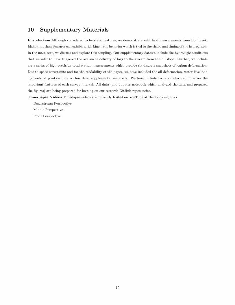
10 Supplementary Materials
Introduction Although considered to be static features, we demonstrate with field measurements from Big Creek,
Idaho that these features can exhibit a rich kinematic behavior which is tied to the shape and timing of the hydrograph.
In the main text, we discuss and explore this coupling. Our supplementary dataset include the hydrologic conditions
that we infer to have triggered the avalanche delivery of logs to the stream from the hillslope. Further, we include
are a series of high-precision total station measurements which provide six discrete snapshots of logjam deformation.
Due to space constraints and for the readability of the paper, we have included the all deformation, water level and
log centroid position data within these supplemental materials. We have included a table which summarizes the
important features of each survey interval. All data (and Jupyter notebook which analyzed the data and prepared
the figures) are being prepared for hosting on our research GitHub repositories.
Time-Lapse Videos Time-lapse videos are currently hosted on YouTube at the following links:
Downstream Perspective
Middle Perspective
Front Perspective
15
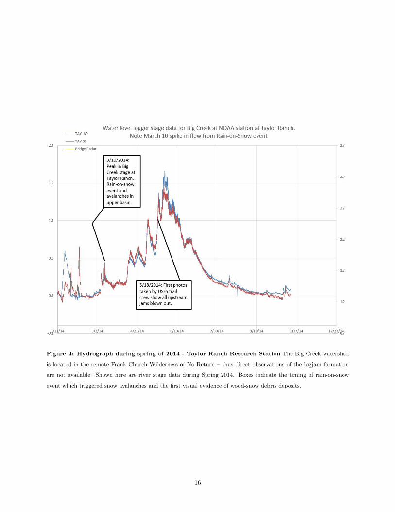
Figure 4: Hydrograph during spring of 2014 - Taylor Ranch Research Station The Big Creek watershed
is located in the remote Frank Church Wilderness of No Return – thus direct observations of the logjam formation
are not available. Shown here are river stage data during Spring 2014. Boxes indicate the timing of rain-on-snow
event which triggered snow avalanches and the first visual evidence of wood-snow debris deposits.
16
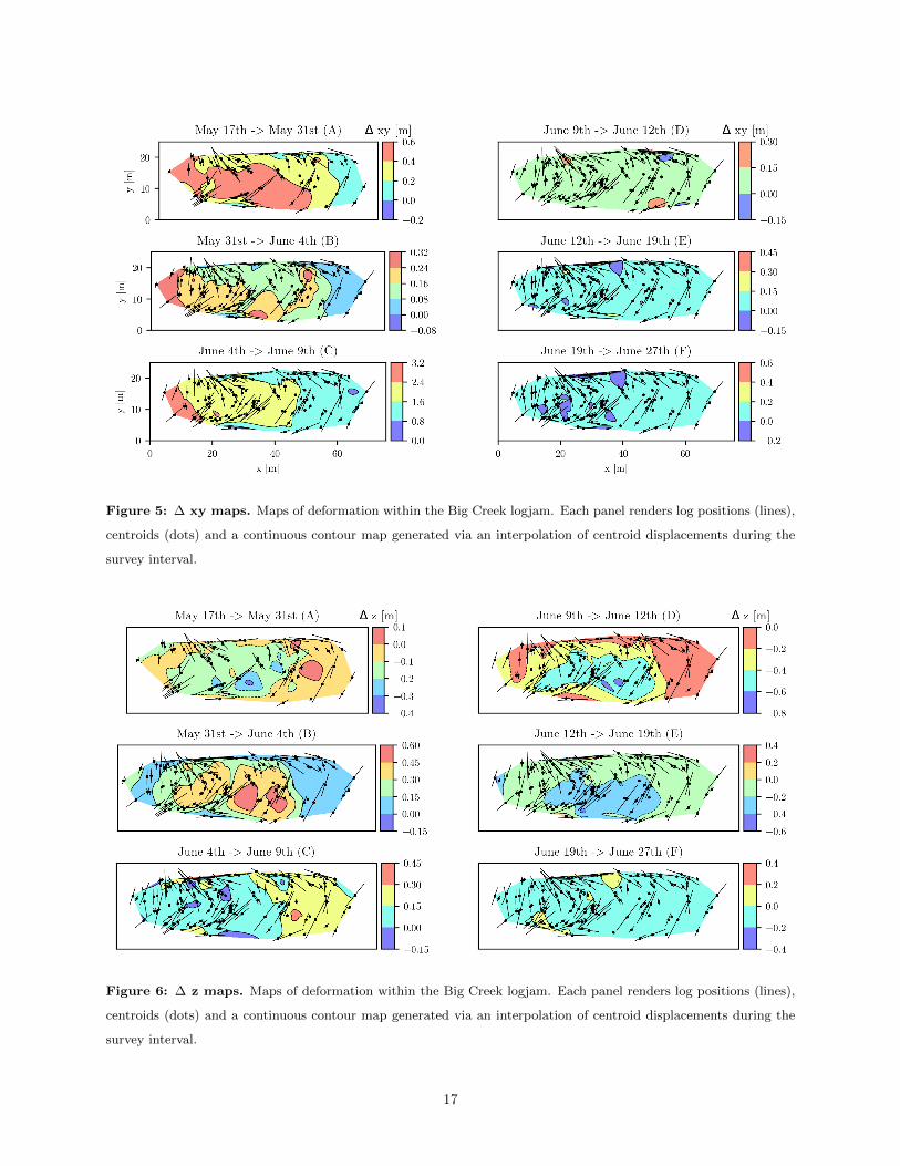
Figure 5: ∆ xy maps. Maps of deformation within the Big Creek logjam. Each panel renders log positions (lines),
centroids (dots) and a continuous contour map generated via an interpolation of centroid displacements during the
survey interval.
Figure 6: ∆ z maps. Maps of deformation within the Big Creek logjam. Each panel renders log positions (lines),
centroids (dots) and a continuous contour map generated via an interpolation of centroid displacements during the
survey interval.
17
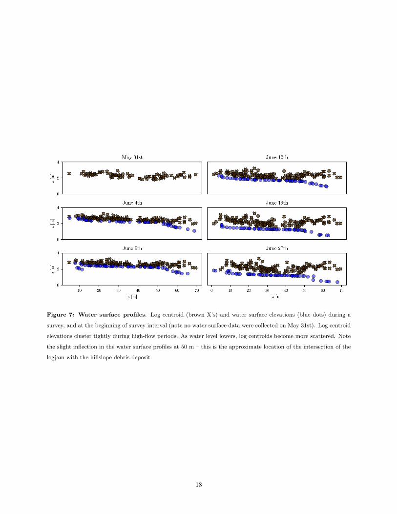
Figure 7: Water surface profiles. Log centroid (brown X’s) and water surface elevations (blue dots) during a
survey, and at the beginning of survey interval (note no water surface data were collected on May 31st). Log centroid
elevations cluster tightly during high-flow periods. As water level lowers, log centroids become more scattered. Note
the slight inflection in the water surface profiles at 50 m – this is the approximate location of the intersection of the
logjam with the hillslope debris deposit.
18
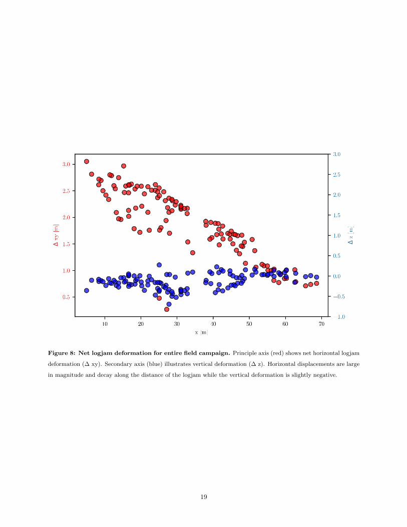
Figure 8: Net logjam deformation for entire field campaign. Principle axis (red) shows net horizontal logjam
deformation (∆ xy). Secondary axis (blue) illustrates vertical deformation (∆ z). Horizontal displacements are large
in magnitude and decay along the distance of the logjam while the vertical deformation is slightly negative.
19

Table
1:
Table
of
surv
eydate
s,num
ber
of
logs
and
the
mea
ndis
pla
cem
ents
mea
sure
d.
Survey
dates
andinterval
nam
es#
ofsurveyed
logs
changein
stage[m
]mean
delta
xy[m
]
mean
delta
z[m
]
May
17th
toMay
31st
(A)
73-0.119
0.325
-0.099
May
31st
toJune4th
(B)
122
0.325
0.145
0.227
June4thto
June9th
(C)
119
0.093
1.70
0.116
June9thto
June12th
(D)
130
-0.532
0.067
-0.290
June12th
toJune19th
(E)
134
-0.411
0.042
-0.153
June19th
toJune27th
(F)
131
n/a
(waterlevelfellbelow
installed
logger)
0.016
-0.025
20