The NPS Maritime Domain Protection Research Groupfaculty.nps.edu/brutzman... · Area Surveillance...
35
Coalition Operating Area Surveillance and Targeting System (COASTS) Mr. James Ehlert 13 December 2005 The NPS Maritime Domain Protection Research Group
Transcript of The NPS Maritime Domain Protection Research Groupfaculty.nps.edu/brutzman... · Area Surveillance...

Coalition Operating Area Surveillance and Targeting System (COASTS)
Mr. James Ehlert13 December 2005
The NPS Maritime Domain ProtectionResearch Group

• From the draft ASD(HD) Maritime Domain Awareness Initiative Guidance:– NPS “is tasked with developing and
executing several research programs, including data and target modeling, war gaming, threat and vulnerability assessments, and data integration.”
– “All projects must support overarching national policy as well as the DoD Strategy for Homeland Defense and Civil Support and the National Strategy for Maritime Security.”
Higher Echelon Guidance…

NPS Expertise & Resources
• Systems Engineering• Computer Science• Information Science• Operations Research• Defense Analysis• Modeling and
Simulation• Meteorology and
Oceanography• Physics • Intelligence• Information
networking
• US Navy/Marines
• US Coast Guard• US Army• US Air Force • Special
Operations (All services)
• Civilian (Federal, State and Local)
• Coalition: ~300 students from 55 nations
• MDP spans the entire NPS campus and leverages both faculty & student expertise

Define, design, and potentially implement a national Maritime Domain Protection System that
includes a vulnerability assessment, concept of operations
across multiple lines of defense and domains, and coordinated
through a national command and control system.
FOCUS: War-fighters perspective to dissuade, deter, preempt, interdict, or defeat threats and aggression
as early and as far from US borders as possible.
Broad Charter Requires a Spectrum of Research Efforts

Current MDP Research…
• Decision making tools for comprehensive and agile MDP
• Coalition Operating Area Surveillance and Targeting System (COASTS)
• Development of a prototype knowledge management system for maritime domain data sources
• Knowledge discovery and data mining in large databases
• Multi-source fusion and correlation• Integration tool for atmosphere effects on
radar/IR Surveillance • Ship detection and tracking with satellite
observations in cloudy conditions• MDP systems engineering design and
Integration

Primary: Rapidly deploy and integrate low cost, unclassified, networked air, ground, and maritime sensors providing real-time sensor-to-decision-maker information
Secondary: Foster information sharing at the R&D level and establish relationships with counter-parts to:– exercise, train, and demonstrate with technology to
counter illegal narcotics and immigration – demonstrate and promote operational potential of inter-
linked Command & Control / Data Fusion Centers– utilize Red Teams (Joint IO Command) to address/
examine security implications at the on-set relative to the technologies of interest
COASTS ObjectivesCOASTS Objectives

•Secure borders contributes to regional & international stability and security
• Regional, UN and international focus on countering piracy, terrorism, illegal fishing, resource theft, smuggling and various other lawless activities that contribute to national, regional, and international instability
• COASTS cooperation and research underway today while larger efforts (policy, ACTD, etc.) take shape
Why COASTS? Why COASTS?

• 9/11 Commission Report– “Practically every aspect of US counterterrorism strategy relies on international cooperation.”
– “Coordinate the resolution of the legal, policy, and technical issues across agencies to create a ‘trusted information network’.”
• National Security Presidential Directive NSPD-41; Homeland Security Presidential Directive HSPD-13, December 21, 2004: Maritime Security Policy– “. . . Identify threats to the Maritime Domain as early and as distant from our shores as possible”
– “Ensuring the security of the Maritime Domain must be a global effort, in which USG efforts are developed and furthered with the support of other governments . . . “
•The National Defense Strategy of the United States of America, March 2005– “The United States cannot achieve its defense objectives alone. Our concept of active, layered defense includes international partners.”
The COASTS Imperative

US Sponsors/Participants/Stakeholders• U.S. Pacific Command (USPACOM)• U.S. Coast Guard Monterey• U.S. Embassy Bangkok• Dept. of Homeland Security Immigration & Customs Enforcement (Bangkok)• U.S. Special Operations Command (USSOCOM)• Joint Inter Agency Task Force-West (JIATF-West)• U.S. Marine Corps Systems Command• Air Force Research Lab• Lawrence Livermore National Labs
International Sponsors/Participants• Thai National Security Council• Defense Research & Development Office• Royal Thai Air Force Combat R&D Office• Royal Thai Air Force Academy• Royal Thai Navy• Interagency Intelligence Fusion Center, Chiang Mai• Malaysian Maritime Enforcement Agency• Australian Defence Tech & Management Advisor (Thailand)
Commercial Sponsors• Mercury Data Systems• CyberDefense UAV• Identix• Advanced Info Service (Thai)• Roto-Motion
Major StakeholdersMajor Stakeholders
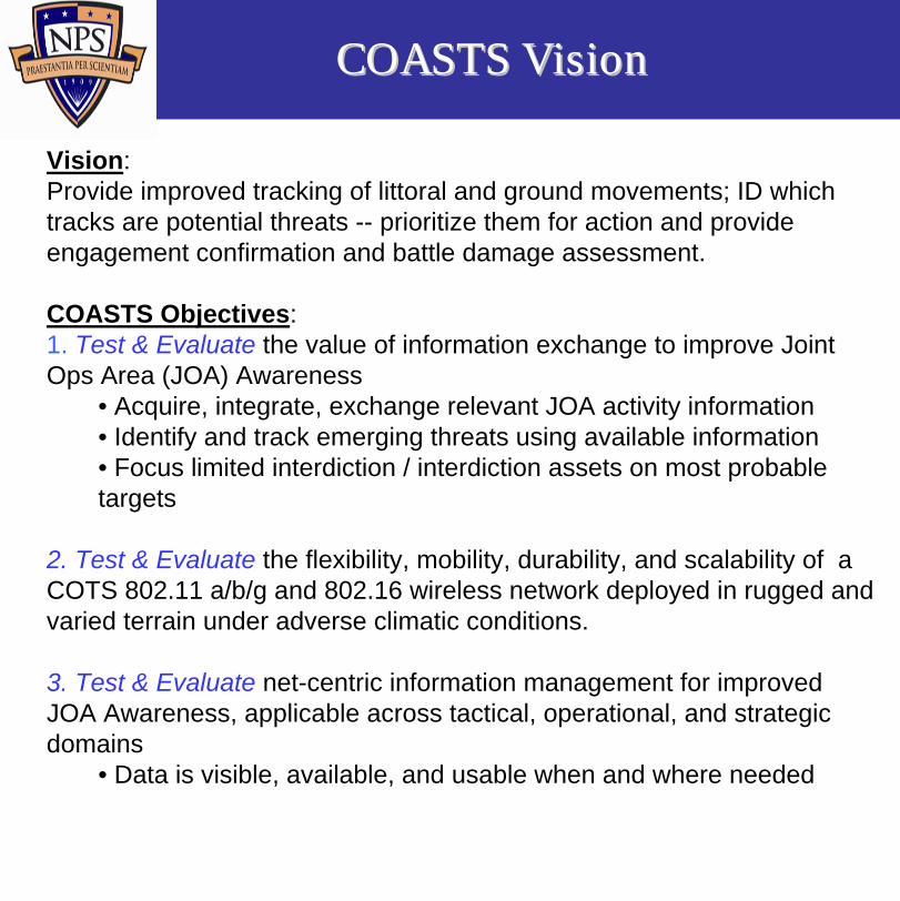
Vision: Provide improved tracking of littoral and ground movements; ID which tracks are potential threats -- prioritize them for action and provide engagement confirmation and battle damage assessment.
COASTS Objectives:1. Test & Evaluate the value of information exchange to improve Joint Ops Area (JOA) Awareness
• Acquire, integrate, exchange relevant JOA activity information• Identify and track emerging threats using available information• Focus limited interdiction / interdiction assets on most probable targets
2. Test & Evaluate the flexibility, mobility, durability, and scalability of a COTS 802.11 a/b/g and 802.16 wireless network deployed in rugged and varied terrain under adverse climatic conditions.
3. Test & Evaluate net-centric information management for improved JOA Awareness, applicable across tactical, operational, and strategic domains
• Data is visible, available, and usable when and where needed
COASTS VisionCOASTS Vision

Scenario TopologyScenario Topology

Global TopologyGlobal Topology

Scenario Over View

Patrol Craft equipped with the maritime Fly-Away Kit (FLAK). FLAK will include a omni-directional antenna, AN-50 bridge, laptop, and UPS.
RHIB equipped with the maritime FLAK. FLAK will include a omni-directional antenna, AN-50 bridge, PATROLCAM, laptop, UPS, wearable IP camera and an 802.11g ITT/MESH dynamic link.
802.11 MESH
802.16
802.16
802.16
Control (C2) Center/HQ – Equipped with an 802.16 OFDM omni-directional antenna. Shore based Fusion Center or Command and Center can be linked back to HHQ via SATCOM or further 802.16 OFDM point-to-point links.

Maritime TopologyMaritime Topology

Littoral CommunicationsLittoral Communications
Using 802.16 OFDM wireless technology as a backbone, fly-away kits (FLAK) for C4ISR can be utilized to counter asymmetric threats in the maritime tactical theatre

Maritime CommunicationsMaritime Communications
•The FLAK can be converted into a boarding intelligence / biometric data collection tool thru:- wireless access point- wearable wireless data camera- wireless biometric reader

802.11 B/G Meshed Network
“Provide Wi-Fi Connectivity for mobile Ground and Aerial
clients.”
MeshDynamics MD-325
•2.4GHz Structured MeshTMbackhaul •Self-Healing, Self-Forming •Session-persistent roaming •Integrated 802.11 b/g access •AES-CCMP encrypted backhaul •WPA (Personal and Enterprise) security •Multiple-SSIDs with 802.1q VLAN support •Independent Security profile per SSID •Remote Management and Monitoring •Power over Ethernet •NEMA rated outdoor enclosure

MeshDynamics MD325: provides ground and aerial 802.11b network coverage, and a wired connection to the Axis 213 camera (below).
Blimp Works 3M Balloon:aerial platform with a MeshDynamics MD325 wireless node and Axis camera payload.
Axis Communications Axis-213 IP Camera: a full Pan-Tilt-Zoom and auto-focus camera providing streaming video and still images over the network; capable of multicasting to multiple users.
Aerial Balloon NodeAerial Balloon Node
“Demonstrate Extended range capabilities of 802.11 Meshed Networks by increasing the altitude of Network Nodes”

• Man portable 802.16 products provide:– High-throughput – Long-haul–Point to mobile-multipoint communications
•Connection to Mobile Maritime Units
802.16 Network Nodes

Unmanned Aerial Vehicles
RotoMotion VTOL UAV• 121cc 8.7 HP gasoline 2-stroke engine • Up to 20kg /50 lbs payload capacity • Ready-to-Fly • Safety/Manual aircraft controller & transmitter• 802.11-based telemetry system • Stable hover (patent pending)
CyberDefense CYBERBUG• Payload: Day/Night Camera•Range:Control - 14 Miles, Video-2-3M•Hand Launched•Control•Autonomous (GPS)•Manual
Allsopp Helikite:
Compact, high altitude video surveillance
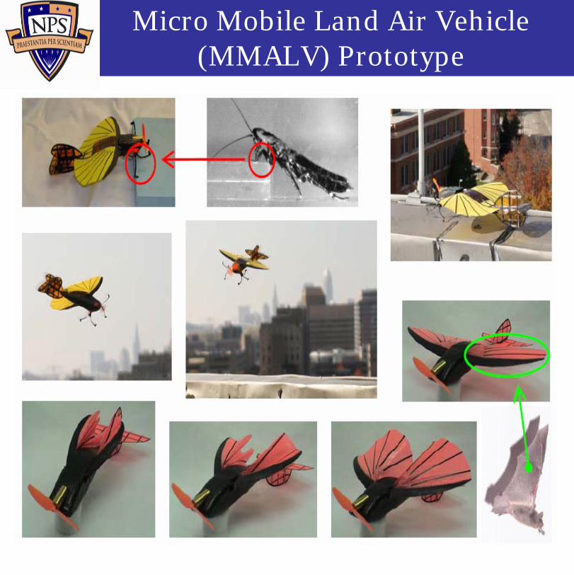
Micro Mobile Land Air Vehicle (MMALV) Prototype
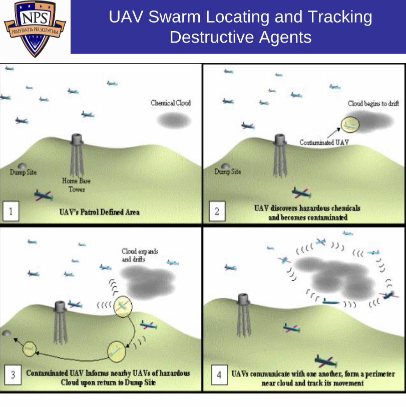
UAV Swarm Locating and Tracking Destructive Agents

Crossbow Sensor NetworkCrossbow Sensor Network
Description
• IEEE 802.15.4 Low data rate, Sensor network protocol
• Self-forming and Self-healing Mesh network
• Passive IR, Acoustic, and Magnetic Sensors
• Low power consumption
• Sensors powered by two AA batteries
• Covert Radar signal
• All weather day/night operation
Asset Detection, Classification and Tracking
• Passive IR detects and tracks targets up to 50 feet from sensor and up to 40mph
• Magnetometer used to classify objects
Perimeter and Border Security
• Small & concealable
• Rapidly deployable, local or remote monitoring
• Dense node deployment increases effectiveness by providing overlapping detection areas
• System alarms provide early warning
• GPS capable

Indoor, Outdoor, Jungle Indoor, Outdoor, Jungle oror
UndergroundUndergroundNavigation and Location Navigation and Location
Tracking for Personnel and Tracking for Personnel and Unmanned Vehicle SystemsUnmanned Vehicle Systems
LightweightLightweightWearable & ModularWearable & Modular
Navigation when GPS Fails Navigation when GPS Fails ––Inertial Navigation System (INS)Inertial Navigation System (INS)
•• Location and Tracking of any AssetsLocation and Tracking of any Assets•• Spatial Awareness ApplicationSpatial Awareness Application
•• TrakPoint C2 TrakPoint C2 -- Command & ControlCommand & Control•• TrakPoint MobileTrakPoint Mobile
•• Perimeter Detection SensorsPerimeter Detection Sensors•• UAV SupportUAV Support•• Wireless Mesh Networks CommunicationWireless Mesh Networks Communication•• Heads Up Display (HUD)Heads Up Display (HUD)
Blue Force Tracker: Deny GPS
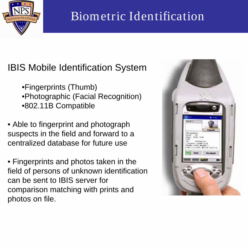
Biometric Identification
IBIS Mobile Identification System
•Fingerprints (Thumb)•Photographic (Facial Recognition)•802.11B Compatible
• Able to fingerprint and photograph suspects in the field and forward to a centralized database for future use
• Fingerprints and photos taken in the field of persons of unknown identification can be sent to IBIS server for comparison matching with prints and photos on file.

• Spectrex Corp. MD-2– rugged, hand-held,
lightweight explosive material biometric detection device
• Detects over 40 types of explosives– no false positives– no maintenance cost– no calibration– no downtime
• Fully functional in any environment
Biometric Explosive Detection

Research Common Information Environment applications in partnership with Mercury Data Systems:• Enhancing map functionality• Integration of sensors• RF Ranging for mobile version• Human factoring study
C2 Application: C3Trak

• Research of existing alternative power sources
• Renewable, high-capacity, fuel cell/solar, etc.
• Feasibility of implementation in military and tactical environments
• Concept of operations and notional architecture for support to a sensors, communications devices, and other network components
Alternative Mobile Power Supplies

Mini/Micro-UAVs EW Applications
DRAGON DRONE mini-UAV (USMC)• Tactical jammer currently capable against comms (radars?)
• 20 lb. cargo• NBC sensor• Day or night cameras with laser range finders
• Cruise speed 85 mph, max. 115 mph• Range: 35 NM
DRAGON DRONE mini-UAV (USMC)• Tactical jammer currently capable against comms (radars?)
• 20 lb. cargo• NBC sensor• Day or night cameras with laser range finders
• Cruise speed 85 mph, max. 115 mph• Range: 35 NM
Stand-In Jamming• Lethality of threat for manned platforms
• Resistance to stand-off jamming through sidelobe suppression
• Ability of UAVs to get close and jam with relatively low power due to range

COASTS Test I (Pt Sur)
Sensors
Blue Forces
802.11802.16
802.16
Camera
N

• Network/experiment fragility…less fault tolerant than CONUS-based field experimentation; resource constrained partners and VIP-laden events
• Substantial logistic pitfalls…can’t transport many high-duration batteries by comm air; plan for a slow boat ride.
• Force Protection…buddy rule in effect in SEA since 9/11; want to buy a power cord? Better divert two people.
• Physical hardship…20% of team down for entire mission from illness (flu/stomach); start your doxycyclineearly and often!
• Weather…don’t get a “warm fuzzy” just because it worked great at Point Sur.
Diverse Challenges Beyond the Technical Realm…

“The vision we seek is: Americans secure at home and abroad; sea and air lanes open and free for the peaceful, productive movement of international commerce; enduring national and international naval relationships that remain strong and true; steadily deepening cooperation among the maritime forces of emerging partner nations; and a combat ready Navy – forward deployed, rotational and surge capable –large enough, agile, enough, and lethal enough to deter any threat and defeat any foe in support of the Joint Force.”
-- CNO Guidance for 2006
Notable QuotableNotable Quotable

• Another step for…– regional security and cooperation– mutual security & economic interests– potential long term cost-savings – effective inter-operability exchange
and cooperative training opportunity– low-level (researcher-to-researcher)
way to “push the ball” forward
Other international sponsors desired
ConclusionConclusion