The National Cohesive Wildland Fire Management Strategy ...
101
Transcript of The National Cohesive Wildland Fire Management Strategy ...


iv

v
TABLE OF CONTENTS EXECUTIVE SUMMARY .............................................................................................................................. 1
CHAPTER 1 − THE VISION ......................................................................................................................... 3
The Cohesive Strategy Planning Process ................................................................................................ 4 Building the National Strategy .................................................................................................................. 5
CHAPTER 2 – NATIONAL AND REGIONAL CHARACTERIZATION ........................................................ 9
Regional Characterization ........................................................................................................................ 9 National Characterization ....................................................................................................................... 14 Landscape Classes ................................................................................................................................ 14 Community Clusters ............................................................................................................................... 18 Intersecting Landscape Classes and Community Clusters .................................................................... 21
CHAPTER 3 – NATIONAL CHALLENGES AND OPPORTUNITIES ........................................................ 23
Vegetation and Fuels .............................................................................................................................. 26 Homes, Communities, and Values at Risk ............................................................................................. 38 Human-caused Ignitions ......................................................................................................................... 43 Effective and Efficient Wildfire Response ............................................................................................... 47
CHAPTER 4 – THE NATIONAL STRATEGY ............................................................................................ 55
Risk Tradeoffs ......................................................................................................................................... 55 National Guidance .................................................................................................................................. 57 National Priorities .................................................................................................................................... 59
CHAPTER 5 – IMPLEMENTATION ........................................................................................................... 67
Strategic Alignment ................................................................................................................................. 67 Communication and Collaborative Engagement .................................................................................... 68 Programmatic Alignment ........................................................................................................................ 70 Conclusion .............................................................................................................................................. 73
Appendix A: Acknowledgements – Committees, Councils, and Work Groups ................................. 75
Appendix B: Cohesive Strategy Achievements, Resources and References ................................... 83
Appendix C: Barriers and Success Factors .......................................................................................... 87
Appendix D: Glossary .............................................................................................................................. 91
Appendix E: Acronyms ............................................................................................................................ 92
vi
LIST OF FIGURES Figure 1.1. Vision, national goals, and national challenges .......................................................................... 6 Figure 2.1. Classification tree used to subdivide counties based on variables relevant to the topic of
landscape classification ............................................................................................................... 15 Figure 2.2. Map of the geographical distribution of the 11 landscape classes across the conterminous
United States. .............................................................................................................................. 16 Figure 2.3. Visual summarization of the characteristic features of 11 landscape classes with respect to
eight variables of interest. ........................................................................................................... 17 Figure 2.4. Visual summarization of the characteristic features of eight community clusters with respect to
six variables of interest. ............................................................................................................... 19 Figure 2.5. Spatial distribution of community clusters ................................................................................ 20 Figure 3.1. A simple conceptual model of wildfire ...................................................................................... 24 Figure 3.2. Historical fire regime group values in areas currently dominated by natural vegetation .......... 28 Figure 3.3. Spatial distribution of the three management options suggested for maintaining or increasing
the use of prescribed fire ............................................................................................................. 32 Figure 3.4. Spatial pattern of counties where options for managing wildfires for resource objectives and
ecological purposes might prove useful ...................................................................................... 34 Figure 3.5. Spatial distribution of counties where mechanical, biological, or other non-fire treatments
might be useful ............................................................................................................................ 36 Figure 3.6. Spatial distribution of counties where mechanical treatments of forested areas might be used
as a precursor to expanded wildland fire use .............................................................................. 37 Figure 3.7. Bar chart showing the relative area burned, proportion of structures lost, and proportion of
buildings involved for each of the eight community clusters. Data from 2002 to 2011. .............. 40 Figure 3.8. Counties across the Nation where homes and other structures have been involved in wildfires,
suggesting greater emphasis on actions by individual property owners ..................................... 41 Figure 3.9. Counties where community-level planning is most essential ................................................... 41 Figure 3.10. Counties with higher than average rates of home construction and WUI growth where
building ordinances might have a more positive effect on reducing home losses ...................... 42 Figure 3.11. Smoothed time trace of wildfire incidents reported and attributed to different causes
throughout the United States, 2002 through 2011 ...................................................................... 43 Figure 3.12. Smoothed time trace of area burned from incidents attributed to different causes throughout
the United States, 2002 through 2011 ......................................................................................... 44 Figure 3.13. Spatial distribution of counties differentially affected by either high or low numbers of
accidental ignitions and high or low area burned by accidental ignitions .................................... 45 Figure 3.14. Spatial distribution of counties differentially affected by either high or low numbers of
incendiary ignitions and high or low area burned by incendiary ignitions. .................................. 46 Figure 3.15. Relative frequency of occurrence of fires of concern during the period 2002 to 2011 ........... 49 Figure 3.16. The relative risk of experiencing a wildfire .............................................................................. 50 Figure 3.17. Spatial pattern of counties where the numbers of structures lost per area burned is high
relative to the area burned, vice versa, and where both indices are high ................................... 51 Figure 3.18. Spatial pattern of the intersection of counties with higher than normal numbers of buildings
involved per incident with the relative numbers of accidental human ignitions ........................... 52 Figure 4.1. Three hypothetical scenarios for temporal trends in risk nationwide ........................................ 56 Figure 4.2. Generalized relationship between the three national goals and the development of national
priorities ....................................................................................................................................... 60 Figure 4.3. National priorities for broad-scale fuels management .............................................................. 61 Figure 4.4. National priorities for community planning and coordination .................................................... 62 Figure 4.5. National priorities for managing human-caused ignitions ......................................................... 63

vii
Figure 4.6. Intersection of the large, long-duration wildfire potential with the opportunities map for managing wildfires for resource objectives ................................................................................. 64
Figure 5.1. Primary conservation partners in each county based on area managed by each entity .......... 71
LIST OF TABLES Table 2.1.The number of counties within the conterminous 48 states that fall within each combination of
community cluster and resiliency class ....................................................................................... 21 Table 3.1. High-priority barriers and critical success factors ...................................................................... 25 Table 3.2. Fire regime groups and descriptions.......................................................................................... 27 Table 3.3. Summary of management options ............................................................................................. 54

1
EXECUTIVE SUMMARYIn the past two decades, a rapid escalation of extreme wildfire behavior, accompanied by significant increases in risk to responders and citizens, home and property losses, costs, and threats to communities and landscapes have been observed. In the Federal Land Assistance, Management, and Enhancement Act of 2009 (FLAME Act), Congress mandated the development of a national cohesive wildland fire management strategy to comprehensively address wildland fire management across all lands in the United States. Shortly after enactment of the FLAME Act, a three-phased, intergovernmental planning and analysis process involving stakeholders and the public was initiated and is commonly referred to as the Cohesive Strategy effort. The culmination of three-phases of planning and analysis is this National Strategy and a companion National Action Plan.The National Strategy is the result of a collaborative effort by Federal, state, local, and tribal governments and non-governmental partners and public stakeholders, in conjunction with scientific data analysis.
Achieving the national goals requires that the Nation address the broad challenges of: managing vegetation and fuels; protecting homes, communities, and other values at risk; managing human-caused ignitions; and effectively and efficiently responding to wildfire. The National Strategy describes how the Nation can focus future efforts in making strategic investments to reduce the severe effects of wildfire on areas of high risk. Multiple opportunities are available to meet today’s wildland fire challenges. No one-size-fits-all approach exists to address the challenges facing the Nation. Adopting any option involves spatial and temporal tradeoffs. Reducing long-term risk requires prioritization of investment and use of resources, acceptance of increased short-term risk, and greater collective investment. Management options allow policy and decision-makers to understand where each option is more likely to reduce risk. The National Strategy is not prescriptive in deciding which options to apply locally or regionally.
The National Strategy includes a set of guidelines intended to provide basic direction when planning activities. Broadly defined to address national challenges, these guidelines can be tailored to meet local and regional needs. Meeting the challenges requires priorities. Safe and effective response to wildfires is the highest priority of the National Strategy, and includes enhancing wildfire response preparedness with an emphasis on both structural protection and wildfire prevention to maximize the effectiveness of initial response. The second priority is vegetation and fuels management, and is perhaps the most challenging issue. General guidance in this area includes designing and prioritizing fuel treatments; strategically placing fuel treatments; increasing use of wildland fire for meeting resource objectives; and continuing and expanding the use of all methods to improve the resiliency of our forests and rangelands. The third priority involves engaging homeowners and communities in taking proactive action prior to wildfires. The fourth priority includes emphasizing programs and activities, tailored to meet identified local needs, which seek to prevent human-caused ignitions.
Cohesive Strategy vision for the next century:
To safely and effectively extinguish fire, when needed; use fire where allowable; manage our natural resources; and as a Nation, live with wildland fire.
2
Beyond general guidelines, the National Strategy also prioritizes where activities will be emphasized from a national perspective—based on the premise that planned actions have a greater likelihood of beingmost effective and efficient in areas where conditions contributing to the issue are most severe. Four national maps provide the prioritized locations across the Nation for each of the national challenges. The
maps are centered on geographic areas to be considered for broad-scale fuels management; programs related to homes, communities, and values at risk; actions for managing human-caused ignitions; and areas of focus for effective and efficient wildfire response. The intent of the fourth map is to suggestareas where greater flexibility in the management of large wildfires might be effective.
The National Strategy sets broad, strategic, and national-level direction as a foundation for implementing
actions and activities across the Nation. Three components, intended to be conducted concurrently, are necessary for implementing the National Strategy:
• strategic alignment, where all parties agree to the same goals, principles, and strategic course of action;
• collaborative engagement, which includes governance, shared information and resources, communications, and monitoring and accountability; and
• programmatic alignment, where individual agency or organization objectives are explicitly supportive of the national cohesive strategy goals.
The Cohesive Strategy effort, including this National Strategy and the many other milestones achievedover the last 3 years, collectively establishes a national vision for wildland fire management, defines three national goals, describes the wildland fire challenges, identifies opportunities to reduce wildfire risks, and establishes national priorities focused on achieving the national goals. These achievements form the foundation for achieving the vision for the future of wildland fire management. The release of the National Strategy and the companion National Action Plan will complete the effort to develop a Cohesive Strategy as initiated in 2010. The National Strategy—though significant and foundational—represents a new starting point rather than an ending point as implementation toward the vision begins.
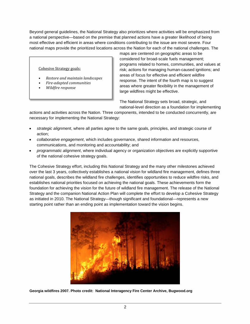
Georgia wildfires 2007. Photo credit: National Interagency Fire Center Archive, Bugwood.org
Cohesive Strategy goals:
• Restore and maintain landscapes • Fire-adapted communities • Wildfire response

3
CHAPTER 1 − THE VISION
In 2009, Congress passed the Federal Land Assistance, Management, and Enhancement Act (FLAME Act), which directs the U.S. Department of Agriculture (USDA) and the Department of the Interior (DOI) to develop a national cohesive wildland fire management strategy to comprehensively address wildland fire management across all lands in the United States. Under the direction of the intergovernmental Wildland Fire Leadership Council (WFLC), the National Cohesive Wildland Fire Management Strategy effort (Cohesive Strategy) was initiated in 2010 through a three-phased approach to planning, risk analysis, and collaboration by Federal, state, local and tribal governments and non-governmental partners and public stakeholders. The phased approach allowed systematic and thorough engagement by stakeholders throughout the effort. Each phase included milestones that serve as the building blocks for subsequent steps. This report, The National Strategy, The Final Phase in the Development of the National Cohesive Wildland Fire Management Strategy (National Strategy), and the companion National Action Plan culminate the third phase of the Cohesive Strategy effort.
The National Strategy recognizes and accepts fire as a natural process necessary for the maintenance of many ecosystems, and strives to reduce conflicts between fire-prone landscapes and people. By simultaneously considering the role of fire in the landscape, the ability of humans to plan for and adapt to living with fire, and the need to be prepared to respond to fire when it occurs, the Cohesive Strategy takes a holistic approach to the future of wildland fire management.
The Wildland Fire Leadership Council (WFLC) adopted the following vision for the next century:
To safely and effectively extinguish fire, when needed; use fire where allowable; manage our natural resources; and as a Nation, live with wildland fire.
The primary, national goals identified as necessary to achieving the vision are:
Restore and maintain landscapes: Landscapes across all jurisdictions are resilient to fire-related disturbances in accordance with management objectives.
Fire-adapted communities: Human populations and infrastructure can withstand a wildfire without loss of life and property.
Wildfire response: All jurisdictions participate in making and implementing safe, effective, efficient risk-based wildfire management decisions.
Early in the planning process, stakeholders collaboratively established the following guiding principles and core values for wildland fire management to guide fire and land management activities:
• Reducing risk to firefighters and the public is the first priority in every fire management activity. • Sound risk management is the foundation for all management activities. • Actively manage the land to make it more resilient to disturbance, in accordance with management
objectives. • Improve and sustain both community and individual responsibilities to prepare for, respond to, and
recover from wildfire through capacity-building activities. • Rigorous wildfire prevention programs are supported across all jurisdictions.
4
• Wildland fire, as an essential ecological process and natural change agent, may be incorporated into the planning process and wildfire response.
• Fire management decisions are based on the best available science, knowledge, and experience, and used to evaluate risk versus gain.
• Local, state, tribal, and Federal agencies support one another with wildfire response, including engagement in collaborative planning and the decisionmaking processes that take into account all lands and recognize the interdependence and statutory responsibilities among jurisdictions.
• Where land and resource management objectives differ, prudent and safe actions must be taken through collaborative fire planning and suppression response to keep unwanted wildfires from spreading to adjacent jurisdictions.
• Safe aggressive initial attack is often the best suppression strategy to keep unwanted wildfires small and costs down.
• Fire management programs and activities are economically viable and commensurate with values to be protected, land and resource management objectives, and social and environmental quality considerations.
The challenges for fire management are formidable and growing more complex. Accepting the vision, national goals, guiding principles and core values as the foundation, the National Strategy provides the strategic direction necessary to address the significant, long-standing challenges to managing the ever-growing wildland fire risks facing the Nation. To combat escalating risks posed by wildfire, thorough understanding of resource needs and opportunities by all is required. Additionally, the efficient and effective allocation and use of finite resources is essential. Continued collaboration among stakeholders remains a key to success.
In conjunction with the National Action Plan, the National Strategy culminates the Cohesive Strategy planning phases and more than three years of collaborative effort to improve the Nation’s ability to prepare for, respond to, and recover from the inevitable occurrence of wildfire.
The Cohesive Strategy Planning Process The Cohesive Strategy effort is defined by three phases, with the third and final phase being the completion of this National Strategy and a National Action Plan. Phase I involved establishing the vision statement, national goals, and the guiding principles referenced above. The National Science and Analysis Team (NSAT) also was formed and charged with assembling the scientific information needed to inform deliberations.
A constant theme within the Cohesive Strategy planning efforts is the importance of risk as a central defining issue. As the Phase I report (p. 13) notes,
Risk is an inescapable component of living with wildfire. Whether one uses risk in the conventional sense of “something bad may happen” or a more precise definition such as the expected loss from an uncertain future event(s), the basic elements of uncertainty and loss are there. Following this basic reasoning, one can view the Cohesive Strategy as a classic problem of risk management. That is, effective management requires understanding the nature of wildfire and its contributing factors, recognizing the consequences—good and bad—of fire, addressing uncertainty, and crafting plans that reduce the chances of catastrophic losses. Real-

5
world constraints on funding, available resources, and administrative flexibility further require consideration of economic efficiency and practicality.
Phase I participants adopted comparative risk assessment as a framework for subsequent planning efforts.
In Phase II, the focus shifted to understanding regional and local wildland fire management challenges and opportunities. Three Regional Strategy Committees (RSC) were created: Northeast, Southeast, and West. Each comprises a diverse group of stakeholders including wildland fire management agencies and organizations, land managers, and policy-making officials representing multiple levels of government, and interests from non-governmental organizations. The RSCs were tasked with clarifying regional goals and objectives and identifying regional challenges and opportunities for improved land and fire management. The regional planning and analysis products completed in Phase II formed the basis for the regional risk analyses and action plans developed in Phase III.
Phase III was undertaken in stages. The first stage involved descriptive analyses of regional issues contributing to risk. The NSAT worked with the regions individually to bring together data describing the wildland fire situation in each region. This information was used by the regions to develop Regional Risk Analysis Reports that characterize each region and outline regional recommendations for achieving the three Cohesive Strategy goals. This work was further refined in Regional Action Plans, which describe actions and tasks to implement the recommendations.
The second stage of Phase III involved the development of the National Strategy through a science-based, intergovernmental planning and analysis process. The analytical basis for the National Strategy comes from information originally assembled and used within the regional analyses, which has been reanalyzed from a national perspective along with supplemental national information. The results of Phase III include the National Strategy and a companion National Action Plan, which provides a framework for implementation of the National Strategy. This concludes the three-phased Cohesive Strategy planning effort and begins implementation activities.
Building the National Strategy The National Strategy is designed to find a balance encapsulated in the vision, identify strategic opportunities that respond to national challenges, and establish national priorities for achieving the national vision and goals of the Cohesive Strategy. Its development builds on each preceding phase of the Cohesive Strategy effort and continues the emphasis on stakeholder engagement.
Specifically, the vision, national goals, and national and regional challenges formed the foundation for the approach to developing the National Strategy. The relationship between the vision, national goals, and national challenges is illustrated in figure 1.1.
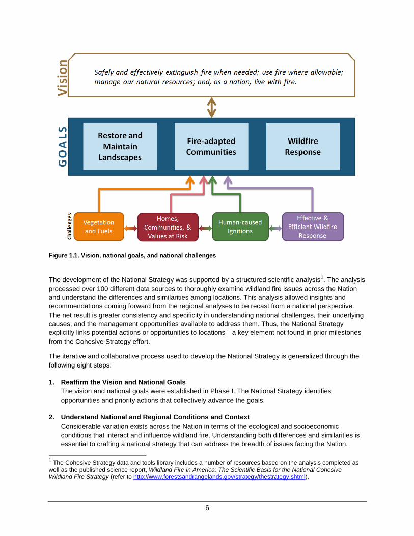
6
Figure 1.1. Vision, national goals, and national challenges
The development of the National Strategy was supported by a structured scientific analysis1. The analysis processed over 100 different data sources to thoroughly examine wildland fire issues across the Nation and understand the differences and similarities among locations. This analysis allowed insights and recommendations coming forward from the regional analyses to be recast from a national perspective. The net result is greater consistency and specificity in understanding national challenges, their underlying causes, and the management opportunities available to address them. Thus, the National Strategy explicitly links potential actions or opportunities to locations—a key element not found in prior milestones from the Cohesive Strategy effort.
The iterative and collaborative process used to develop the National Strategy is generalized through the following eight steps:
1. Reaffirm the Vision and National Goals The vision and national goals were established in Phase I. The National Strategy identifies opportunities and priority actions that collectively advance the goals.
2. Understand National and Regional Conditions and Context Considerable variation exists across the Nation in terms of the ecological and socioeconomic conditions that interact and influence wildland fire. Understanding both differences and similarities is essential to crafting a national strategy that can address the breadth of issues facing the Nation.
1 The Cohesive Strategy data and tools library includes a number of resources based on the analysis completed as well as the published science report, Wildland Fire in America: The Scientific Basis for the National Cohesive Wildland Fire Strategy (refer to http://www.forestsandrangelands.gov/strategy/thestrategy.shtml).
7
3. Understand National Challenges Many different issues and challenges were identified through various forums. Most can be categorized and understood within a smaller set of four general classes: vegetation and fuels; homes, communities, and other values at risk; human-caused ignitions; and effective and efficient wildfire response.
4. Identify and Analyze National Opportunities Opportunities for affecting risk vary considerably across the Nation, depending on local conditions and the character or magnitude of multiple factors. Each national challenge presents its own special opportunities, which are revealed through formal analysis.
5. Prioritization of Opportunities Prioritization involves looking at potential actions thematically and in a broader context. The concept of a national priority for thematic actions follows the premise that concerted actions are most likely to be efficient or effective in areas where conditions contributing to an issue are most acute.
6. Understand Implications and Tradeoffs Hard choices have to be made in deciding how to allocate available resources. Investments made in one location or program area may preclude investments in other areas, signifying distributional tradeoffs. Similarly, choices made today may limit choices that can be made in the future, requiring temporal tradeoffs.
7. Define the National Strategy The National Strategy consists of two primary elements: general guidelines for choosing among and implementing management options, and four national priority maps that illustrate national priorities and suggest areas of greatest need or opportunity.
8. Implementation The National Strategy informs subsequent implementation actions and activities at all scales. Implementation is a necessary commitment if the goals and vision for the future of wildland fire management are to be realized.
Chapter 1 Summary
The National Strategy sets broad, strategic, and national-level direction as a foundation for implementing actions and activities across the Nation. The National Strategy is informed by regional and national analyses, including in-depth risk-based analysis of wildland fire issues and the interrelationships among biophysical and socio-economic drivers. Intergovernmental governance groups and public forums used structured analytical processes to explore and evaluate management options, to determine risk reduction opportunities, and ultimately, to inform the direction in this National Strategy.

9
CHAPTER 2 – NATIONAL AND REGIONAL CHARACTERIZATION
The United States is vast and beautiful, with diverse, sweeping landscapes and abundant local cultures, customs, and traditions. If you were to pick any 10 counties at random and ask residents to describe their local environments and communities, their answers would undoubtedly contain a rich tapestry of descriptions. It is then possible to analyze those descriptions by parsing them into elements that differ and those that are similar. Characteristics that differ among locations could be counted as contributing to overall diversity. In contrast, similar elements could be counted as contributing to a shared national identity. Both similarities and differences are essential to comprehensively describe the national character.
This same story holds true with respect to wildland fire. Ask fire management specialists from different locations to describe their circumstances and it is quickly evident that there are both unique differences and shared concerns. Both the differences and similarities are essential elements of the national picture of wildland fire, and they must be thoroughly understood and addressed to have a truly comprehensive and cohesive national strategy.
Recognizing similarities and differences is not enough, however, if the intent is to effect change by judiciously applying management resources and effort. Understanding the underlying relationships among biophysical landscapes, the people that live there, and wildland fire is also essential. Characterizing and mapping conditions across the Nation—and recognizing the relationships in play—helps establish a context for determining where strategic opportunities lie, as well as where barriers to implementation exist.
Regional Characterization In Phase III, the three RSCs worked with practitioners and the National Science and Analysis Team (NSAT) to describe the wildfire situation in each region using biophysical and socioeconomic data. This chapter begins with a brief synopsis of the regional understanding of wildland fire in each of the three regions
Northeast Regional Context
Diverse ecosystems comprise the Northeast Region. From prairie to pine, hardwoods to boreal forests, and coastal wetlands to mountains, the region displays the full range of fire regimes. Some of the most critically endangered ecosystems include grasslands, savannas, and pine barrens. The vast majority of land is in private ownership. Land uses and ownership patterns are complex, with many small holdings, and a diverse range of owner objectives. Public lands are often isolated among other land uses, including private and industrial forests and agricultural lands. Many public lands are managed for multiple uses.
The Northeast can be described in risk management terms as having a large number of small, mostly human-caused, wildfires with a low occurrence of large wildfires. But fires present a high risk to life and property when they do occur. The larger fires tend to occur in areas containing more contiguous and

10
undeveloped forested tracts of land. Many wildland fires can be fast moving, but they are often contained within a single day. Most wildfires are human-caused; accidental fires and arson are the primary causes of fires in the region. During the 5-year period from 2008 through 2012, the Northeast averaged 21,083 reported wildfires per year, which burned an average of 135,591 acres each year (National Interagency Coordination Center 2013).
Natural events increase the risk of wildfire. Wind, ice, disease, and insects can create large areas of downed timber and increased fuels, leading to exacerbated wildfire conditions. All ecosystems can experience short- and long-term wildfire hazards if these event fuels remain in place. Removal of event fuels before a wildfire is crucial as population continues to grow in forested areas, with homes and infrastructure near wildland fuels. These event fuels may also represent an economic opportunity to supply forest product needs, ranging from biomass to higher valued products.
Downed timber after the 1999 blowdown in the Boundary Waters Canoe Area Wilderness. This area burned in the Ham Lake Fire of May 2007. Photo credit: Eli Sagor, University of Minnesota, Bugwood.org.
Wildland fire management responsibilities are characterized by a patchwork of jurisdictions and ownership, and often more than one agency may be involved in managing wildland fire incidents. Firefighter and public safety is of utmost concern at every level. Wildland fire management is the result of collaboration, partnerships, and cooperation among states (interstate forest fire compacts), Federal fire management agencies (e.g., U.S. Forest Service (USFS), Bureau of Indian Affairs (BIA), National Park Service (NPS), U.S. Fish and Wildlife Service (USFWS), tribal governments, and many local fire departments). Federal agencies are responsible for fire management activities on Federal lands. Stateand local fire protection agencies are responsible for protection of non-Federal lands. As landowners, Federal agencies have flexibility to address land management considerations in their fire management activities. However, state and local statutes and regulations generally mandate suppression of all wildfires. Maintaining, improving the efficiency and effectiveness, or in some cases, increasing the capacity of local fire departments to respond to wildfires is vital to augment state, Federal, and tribal response needs. Most of the fire community is also vital to all hazard response in the Northeast. Effective integration of wildfire response training into all-hazard response training is critical to maintain local response capability in the Northeast.
11
A high percentage of wildfires in the region involve homes and infrastructure. With the heavy population and large proportion of landscape in the wildland-urban interface (WUI) intermix, even small wildfires threaten structures, increasing the risk and complexity for firefighters. A proactive, collaborative approach to identifying risks in the WUI, combined with developing Community Wildfire Protection Plans (CWPPs), reducing hazardous fuels, treating event fuels, and educating the public in the context of managing fuels across a multi-jurisdictional, fragmented landscape will prepare communities for wildfire. Wildland fire managers in the Northeast believe that focusing on preventing unwanted fires and increasing homeowner-shared responsibility will reduce firefighter risk and decrease the need for firefighting responses.
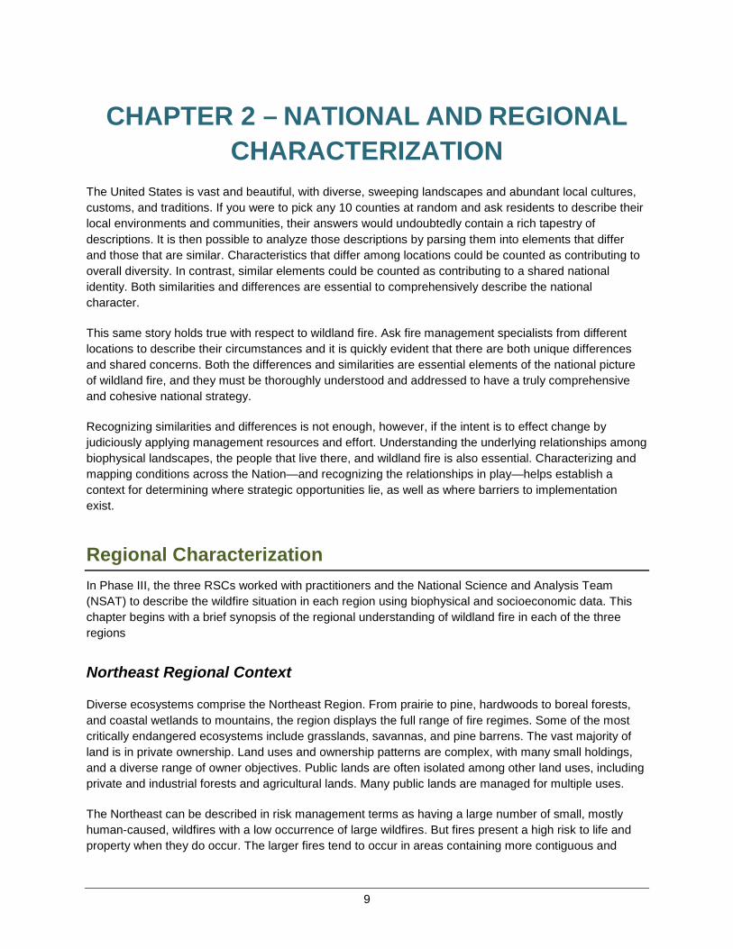
Southeast Regional Context
Thirteen states comprise the Southeast Region, stretching from the Atlantic seaboard west through Texas, including Puerto Rico and the U.S. Virgin Islands, with nearly 90 percent of the land base privately held. The Southeast has many diverse fire-dependent ecosystems including but not limited to: the Florida Everglades, coastal pine forests, Appalachian montane forests, and the grasslands of Texas. The Southeast wildfire problem is characterized by a year-round fire season, highly fragmented land ownership, an expansive WUI throughout much of the South and high population growth in WUI areas, high fuel loading, and a high number of unplanned ignitions. The majority of unplanned ignitions in the Southeast are human-caused. For the 5-year period from 2008 through 2012, the Southeast averaged 38,582 wildfires each year, burning an average of 1,733,496 acres per year (National Interagency Coordination Center, 2013).
Wildland fire is a key process in southern ecosystems to maintain resiliency, ecosystem health, wildlife habitat, and ecosystem services, such as timber products and stable carbon storage. With the long growing season, Southeast forest ecosystems have a frequent fire return interval. Prescribed burning is a common practice to prevent the buildup of excessive fuel loads and manage for other benefits, such as wildlife habitat. In the past, the southeastern fire and land management community has relied on cultural and historical acceptance of land management activities, including prescribed fire, to implement appropriate management activities. New residents, however, are often unfamiliar with the use of fire as a valuable management tool. This population and an accompanying significant urbanized demographic shift, along with other factors, are creating new challenges for the fire management community.
The Southeast is experiencing rapid urbanization, leading to the development of many dense human communities located in landscapes that require frequent burning for hazardous fuel reduction and ecosystem maintenance. As the extent of the WUI increases, so does the potential for impacts from prescribed burning and wildfires. The mosaic of urban and wildlands compounds issues related to smoke, emissions release, liability, and the acceptance of fire by the general public. New residents need to be educated with respect to wildland fire, the use of prescribed burning, and effective land management of their own property to reduce wildland fire risk.
The diverse ecosystems, land management goals, and landscapes across the Southeast mean that a single solution will not work for everyone. Additionally, with nearly 90 percent of southeastern land owned privately, decisions cannot be made at the state or regional level for the vast majority of landholdings. Landscape management requires a focus on collaboration between government and non-government agencies, individuals, and other interests.
12
Fire Learning Network (FLN) sponsored prescribed fire learning exchange near Victoria, Texas, in 2009. Photo credit: Wendy Fulks, The Nature Conservancy.
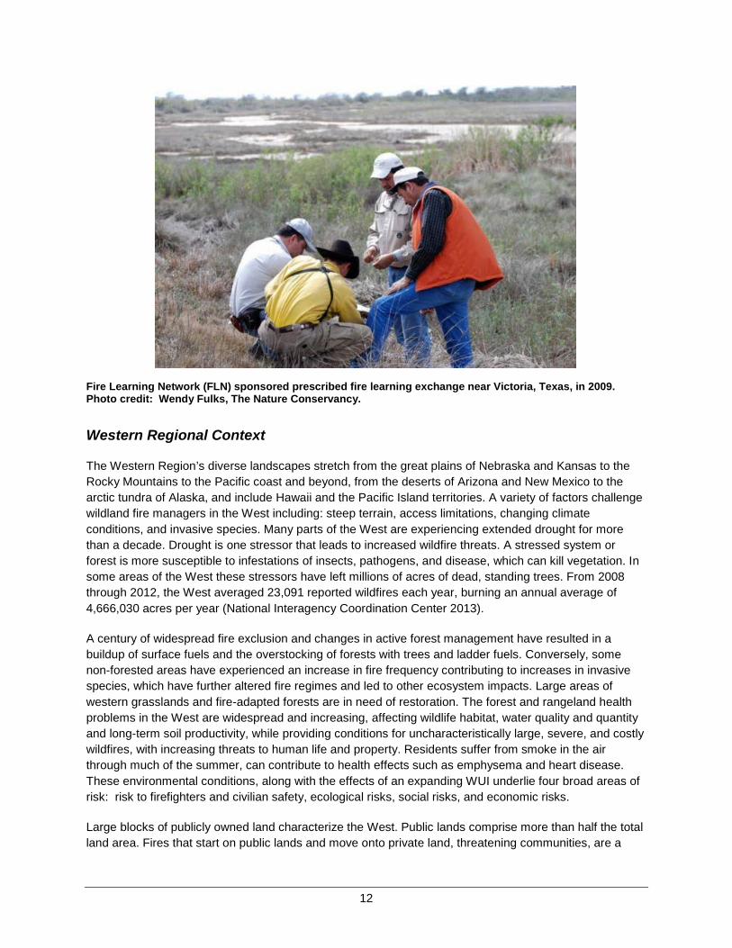
Western Regional Context
The Western Region’s diverse landscapes stretch from the great plains of Nebraska and Kansas to the Rocky Mountains to the Pacific coast and beyond, from the deserts of Arizona and New Mexico to the arctic tundra of Alaska, and include Hawaii and the Pacific Island territories. A variety of factors challenge wildland fire managers in the West including: steep terrain, access limitations, changing climate conditions, and invasive species. Many parts of the West are experiencing extended drought for more than a decade. Drought is one stressor that leads to increased wildfire threats. A stressed system or forest is more susceptible to infestations of insects, pathogens, and disease, which can kill vegetation. Insome areas of the West these stressors have left millions of acres of dead, standing trees. From 2008through 2012, the West averaged 23,091 reported wildfires each year, burning an annual average of 4,666,030 acres per year (National Interagency Coordination Center 2013).
A century of widespread fire exclusion and changes in active forest management have resulted in a buildup of surface fuels and the overstocking of forests with trees and ladder fuels. Conversely, some non-forested areas have experienced an increase in fire frequency contributing to increases in invasive species, which have further altered fire regimes and led to other ecosystem impacts. Large areas of western grasslands and fire-adapted forests are in need of restoration. The forest and rangeland health problems in the West are widespread and increasing, affecting wildlife habitat, water quality and quantity and long-term soil productivity, while providing conditions for uncharacteristically large, severe, and costly wildfires, with increasing threats to human life and property. Residents suffer from smoke in the air through much of the summer, can contribute to health effects such as emphysema and heart disease. These environmental conditions, along with the effects of an expanding WUI underlie four broad areas of risk: risk to firefighters and civilian safety, ecological risks, social risks, and economic risks.
Large blocks of publicly owned land characterize the West. Public lands comprise more than half the total land area. Fires that start on public lands and move onto private land, threatening communities, are a
13
major problem in the West. This is compounded by the finite amount of fire protection resources. Vast expanses of the West have less than 1 fire station per 100 square miles. This leads to extended response times in rural areas—areas often characterized by Federal ownership, steep slopes, beetle-killed trees, and poor road access.
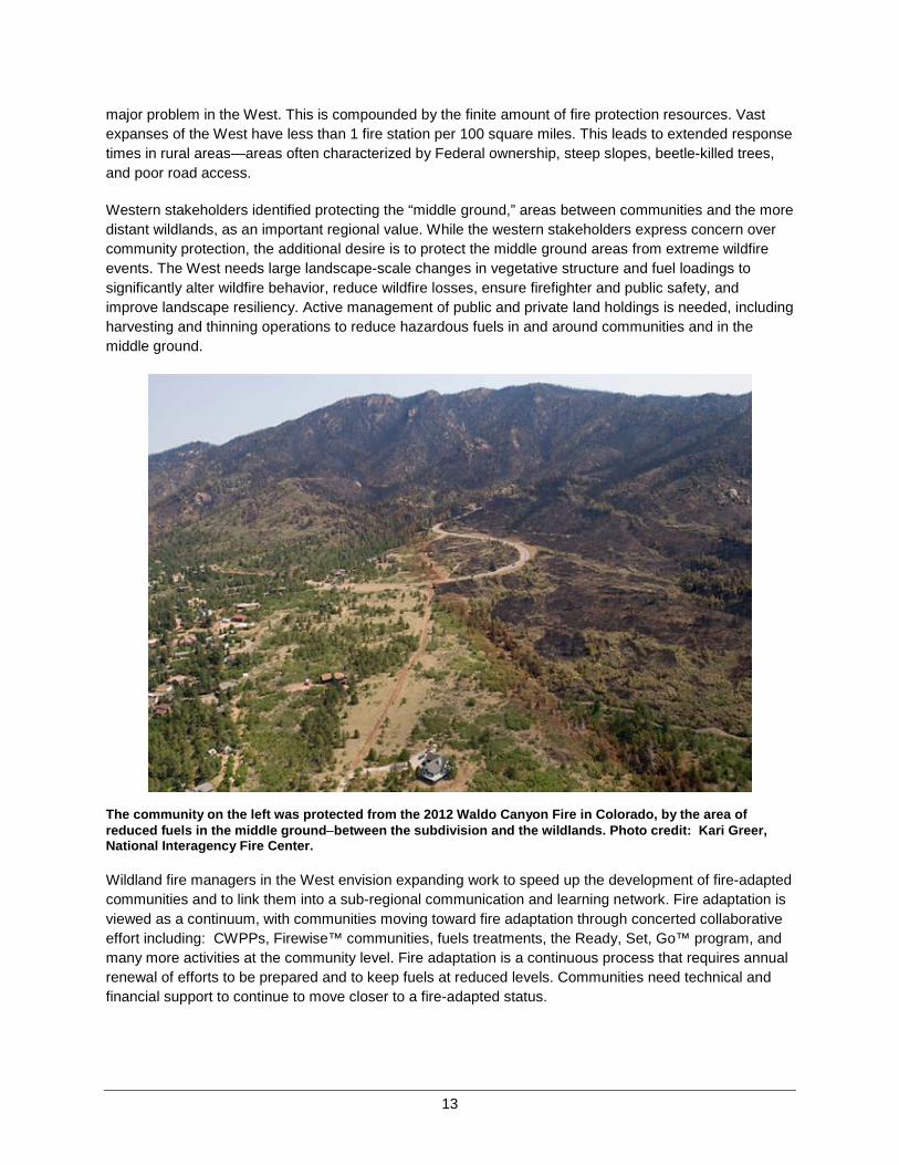
Western stakeholders identified protecting the “middle ground,” areas between communities and the more distant wildlands, as an important regional value. While the western stakeholders express concern over community protection, the additional desire is to protect the middle ground areas from extreme wildfire events. The West needs large landscape-scale changes in vegetative structure and fuel loadings to significantly alter wildfire behavior, reduce wildfire losses, ensure firefighter and public safety, and improve landscape resiliency. Active management of public and private land holdings is needed, including harvesting and thinning operations to reduce hazardous fuels in and around communities and in the middle ground.
The community on the left was protected from the 2012 Waldo Canyon Fire in Colorado, by the area of reduced fuels in the middle ground−between the subdivision and the wildlands. Photo credit: Kari Greer, National Interagency Fire Center.
Wildland fire managers in the West envision expanding work to speed up the development of fire-adapted communities and to link them into a sub-regional communication and learning network. Fire adaptation is viewed as a continuum, with communities moving toward fire adaptation through concerted collaborative effort including: CWPPs, Firewise™ communities, fuels treatments, the Ready, Set, Go™ program, and many more activities at the community level. Fire adaptation is a continuous process that requires annual renewal of efforts to be prepared and to keep fuels at reduced levels. Communities need technical and financial support to continue to move closer to a fire-adapted status.
14
National Characterization The preceding discussion of regional conditions highlights the considerable variation that exists throughout the Nation, as well as many of the shared issues. Indeed, every state, county, management unit, or community can claim its own unique fire regime, history, and special circumstances. Such differences are important when planning at the local level, but may overwhelm a national analysis designed to inform a national strategy that addresses all lands. On the other hand, generalities are useful only to a certain extent; at some point, a location’s specifics must be fully considered. One of the challenges of a national analysis is finding an adequate balance between generalization and specification that highlights important differences while also recognizing commonalities.
Data spanning a broad spectrum of environmental, socioeconomic, and fire-related statistics were assembled to support development of the Cohesive Strategy. These data were summarized and consolidated to the county level to provide a comparable unit of analysis across data sets. Where appropriate, they also have been normalized to allow equitable comparisons across counties of different sizes. That is, some variables are expressed on a unit area (e.g., fires per square mile) or per capita basis. This allows data from multiple sources and of various forms to be used to discern relationships among driving factors and influential variables. It also allows creation of national maps that highlight many of the intra- and inter-regional or state similarities and differences.
Because the Cohesive Strategy planning effort relies on existing data sources, limitations inherent in those data naturally constrain the scope and extent of the national analysis. One of the more important limitations is that several of the more influential data sets are restricted to the 48 conterminous states and exclude Alaska, Hawaii, Puerto Rico, and other territories. Thus, the national characterization and subsequent analyses that depend on it are similarly restricted. Options for extending the analysis to the excluded states and territories are being explored.
Even county-level metrics pose challenges to completing a national analysis. There are 3,109 counties in the conterminous United States and each has its own unique story. This analysis is not directed at telling those unique stories, but rather highlights the pattern of similarities and differences found among the counties and uses those common attributes to develop a manageable set of narratives that can be linked to nationwide management options. To that end, grouping counties along two principal themes of landscape character and risk to communities provides a serviceable classification system. Counties are grouped together based upon their similarities with respect to key variables that are relevant to the principal themes. Two different techniques were used to better match the nature of the themes and patterns within the data.
Landscape Classes The first national goal of the Cohesive Strategy is to restore and maintain resilient landscapes. Landscape resiliency has been defined in various ways, but at its core are sustainability and resistance to and recovery from disturbance. Given that landscapes are complex intersections of natural, built, and human components, simple definitions or measures of landscape resiliency have limited utility. A more useful approach is to recognize that discussions about sustaining values and resiliency are contextual, that is, they vary from location to location and depend upon a host of local considerations, including both ecological and human dimensions.
15
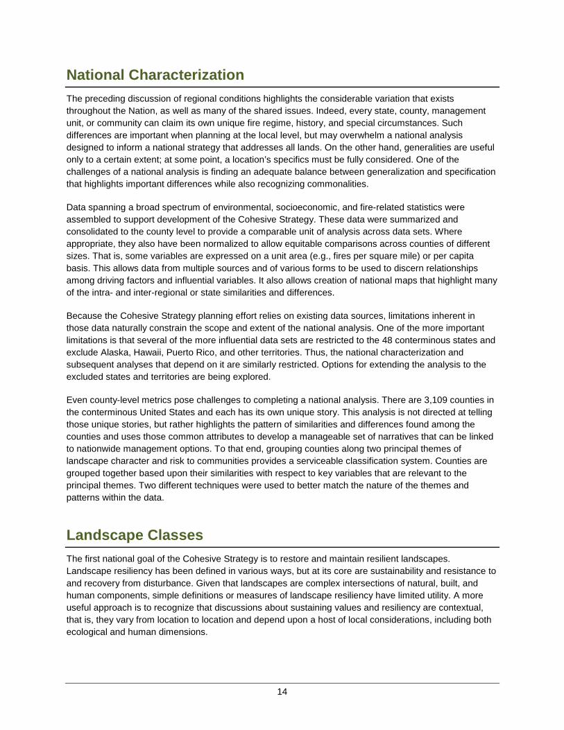
The classification system designed and used here divides counties into landscape classes where similar conversations about land management objectives and resiliency might occur, using county-level attributes. Counties were assigned to different landscape classes using a classification tree. A classification tree begins with all counties in a single group and then progressively divides them into more similar subgroups based on key variables. Each junction in the classification tree involves a dichotomous division based on a single variable. The classification tree used the relative urban landcover within a county, the modal fire regime,2 geographical region, area forested, area of public lands, and various measures of fire occurrence to assign counties to one of 11 classes labeled A through K (figure 2.1).
Figure 2.1. Classification tree used to subdivide counties based on variables relevant to the topic of landscape classification
The classes tend to have strong geographical associations due to the influence of regional similarities in landcover and fire regimes (figure 2.2); a notable exception is the urban class (Class A), which follows the national pattern of population density and urban development.
2 Historical fire regimes refer to the characteristic frequency and severity of wildfires prior to European settlement. Further discussion of fire regime can be found in Chapter 3.
16
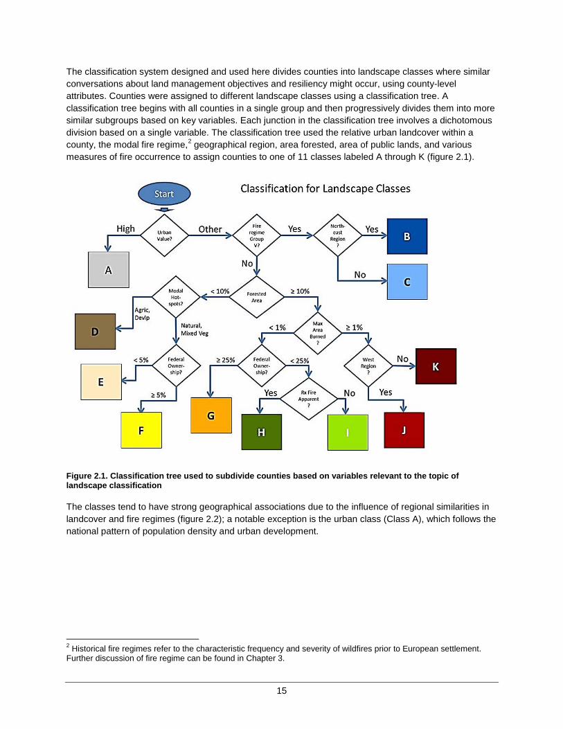
Figure 2.2. Map of the geographical distribution of the 11 landscape classes across the conterminous United States.
The nature of each class is revealed by looking at both the variables used in the classification tree and the broader range of descriptive variables for each county. Figure 2.3 provides an abbreviated label for each class as well as some simple comparison graphics for looking at the distributions of eight selected variables within each class. For example, landscape class D characterizes agricultural and grassland areas that are relatively devoid of forested areas or Federal ownership, historically experienced very high levels of natural fire, and generally fall in the lower half (moderate) of the national range with respect to the four other variables. Using this and other information, one can develop an informative, general narrative that applies to the counties within each class.
Class labels are provided in figure 2.3

17
Figure 2.3. Visual summarization of the characteristic features of 11 landscape classes with respect to eight variables of interest.
Furthermore, the landscape class narratives help point to possible management options or policies that would advance the goal of landscape resiliency within each class, recognizing that each class could connote a unique interpretation of “landscape resiliency” that is specific to the conditions found therein. Thus, landscape classes are used to promote a context-specific discussion of management options that matches actions and activities to landscapes. More complete landscape class narratives and data descriptions are available online through the Cohesive Strategy data and tools library (refer to http://www.forestsandrangelands.gov/strategy/thestrategy.shtml).
Conclusion: Counties have been classified using a relatively small set of variables into various “landscape classes” that share common attributes. Examining multiple variables reveals both similarities and differences among counties relative to the theme of landscape resiliency.
Note: Scores of low to very high are established relative to the national distribution of values for each variable.
18
Community Clusters The second national goal of the Cohesive Strategy is promoting fire-adapted communities. The wildfire risk to communities and values can be viewed as the intersection of three principal elements: wildfire occurrence and extent, homes and communities, and social and economic resources. The first simply captures the magnitude of the hazard posed by wildfire. The second and third reflect the principal values at stake. The values threatened include buildings, homes, infrastructure, public and firefighter safety, public health, and many of the benefits that communities derive from the landscapes around them.
Quantifying all of the values that could be threatened by wildfire across the Nation is impractical. The number and distribution of homes located within the WUI is often used as a surrogate for many of the tangible values at risk, a convention followed here. Homes do not capture all of the values that are affected by wildfire, but it also recognized that losing a home is a catastrophic loss for the individual(s) affected. The number of homes lost in a wildfire is often equated by the public with the magnitude of the overall damage, even though other values are clearly impacted.
The capacity of a community to prepare for, respond to, and recover from a wildfire event is also a critical concern. There is an emerging literature on the concept of social vulnerability to catastrophic events. Researchers have generally looked at a combination of demographic and economic information to assess the vulnerability of individuals, families, and communities. Survey data on family incomes, education, and indicators of household stress were used to suggest relative vulnerability, while also considering metrics of economic activity within each county.
A statistical technique known as cluster analysis was used to group counties. Variables reflective of the amount of area in WUI and density of homes within it, demographic measures of household stress and economic advantage, and measures of area burned by wildfires and ignition density were used in the cluster analysis. Cluster analysis was used because it provided a cleaner separation of counties when considering all variables simultaneously, as opposed to sequentially as in a classification tree.
The result of the cluster analysis is a set of eight “community clusters” that are simply numbered 1 to 8 in no particular order. Simple labels were assigned based upon the distribution of key variables within each community cluster (figure 2.4).
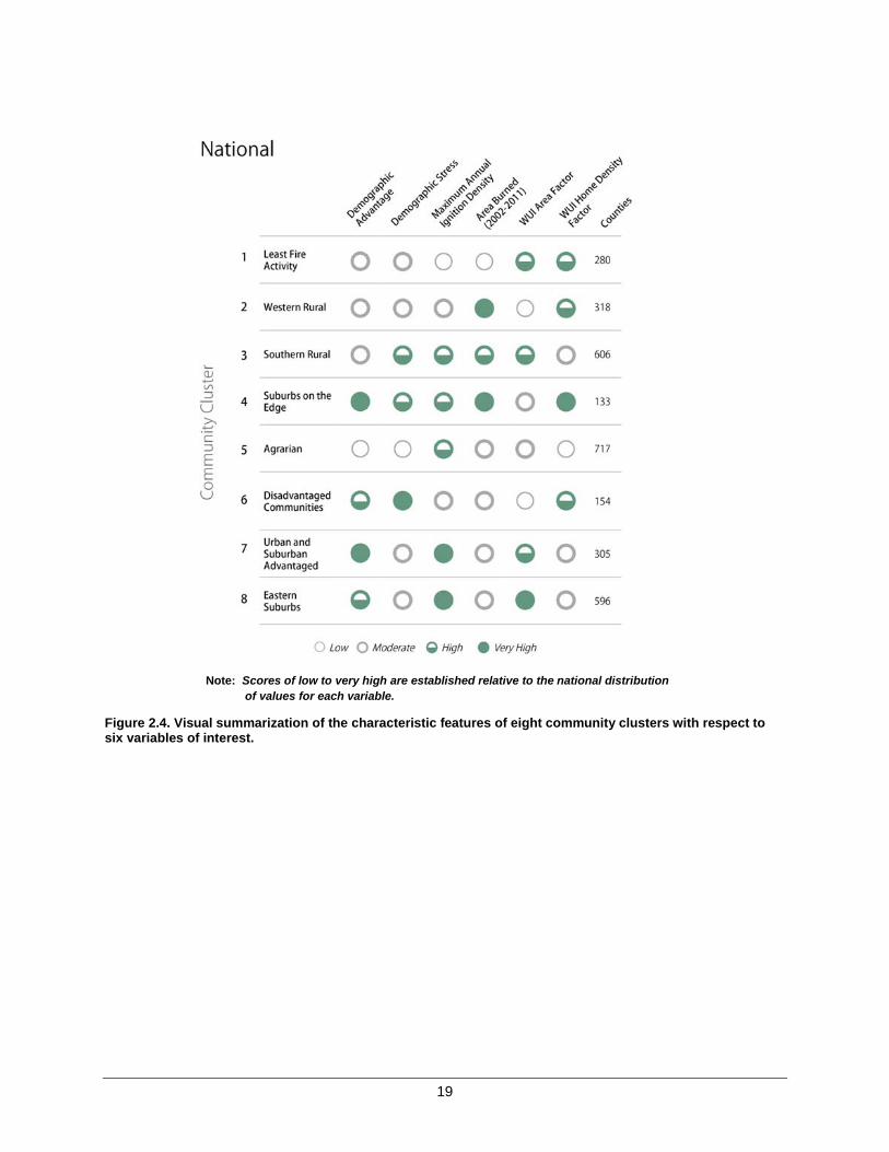
19
Figure 2.4. Visual summarization of the characteristic features of eight community clusters with respect to six variables of interest.
Note: Scores of low to very high are established relative to the national distribution of values for each variable.
20
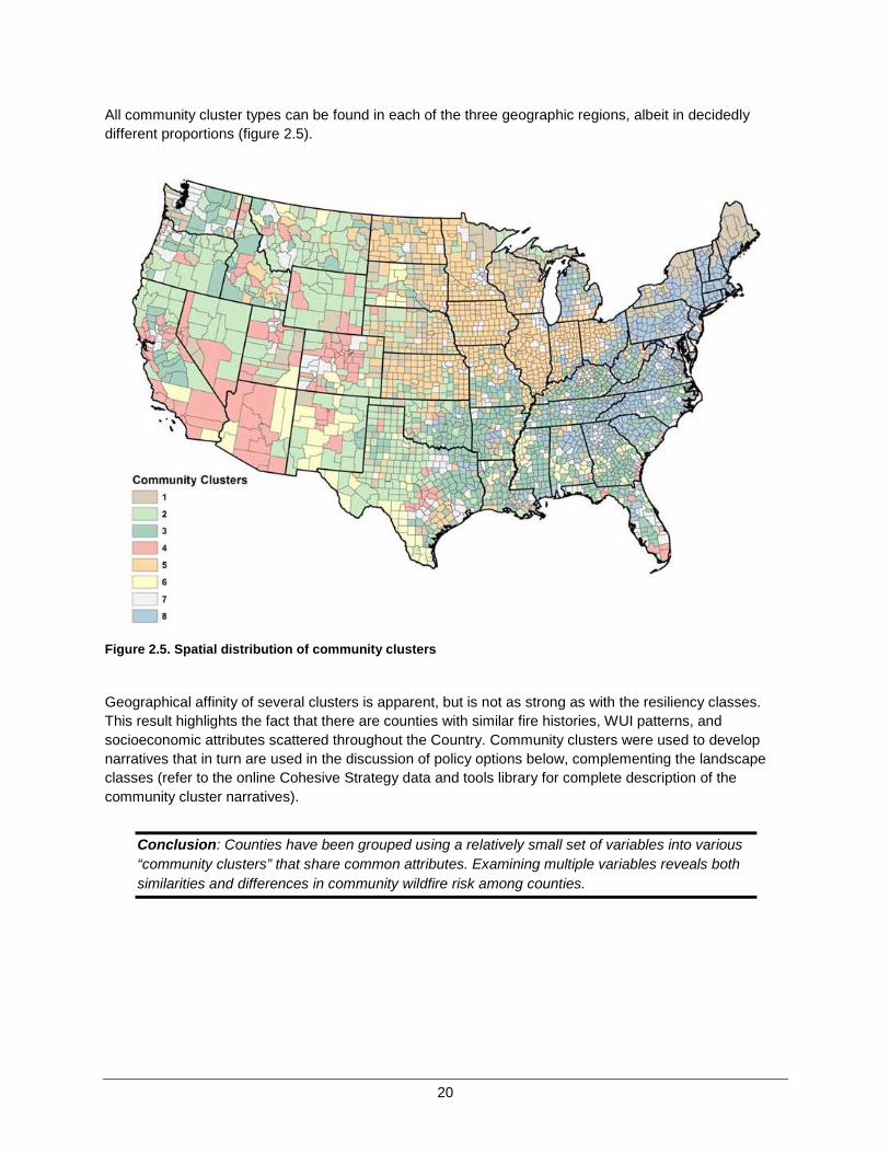
All community cluster types can be found in each of the three geographic regions, albeit in decidedly different proportions (figure 2.5).
Figure 2.5. Spatial distribution of community clusters
Geographical affinity of several clusters is apparent, but is not as strong as with the resiliency classes. This result highlights the fact that there are counties with similar fire histories, WUI patterns, and socioeconomic attributes scattered throughout the Country. Community clusters were used to develop narratives that in turn are used in the discussion of policy options below, complementing the landscape classes (refer to the online Cohesive Strategy data and tools library for complete description of the community cluster narratives).
Conclusion: Counties have been grouped using a relatively small set of variables into various “community clusters” that share common attributes. Examining multiple variables reveals both similarities and differences in community wildfire risk among counties.

21
Intersecting Landscape Classes and Community Clusters The most vexing problems in wildland fire management cannot be solved by looking solely at landscape conditions, nor is a community perspective adequate by itself. A combination of the two sheds light on the most difficult issues. Placing the community clusters in juxtaposition with the landscape classes creates a combination class that provides greater environmental context to the community clusters, while simultaneously enhancing the socioeconomic dimensions of the landscape classes.
The intersection of the community clusters with the landscape resiliency classes and the number of counties in each combination class is shown in
table 2.1. Blank spaces in the table indicate that no counties fell within the intersection. The table indicates the number of counties, not the spatial extent covered by each combination class; differences in county size across the country affect the distribution of area.
Table 2.1.The number of counties within the conterminous 48 states that fall within each combination of community cluster and resiliency class
Landscape Classes
Community Clusters Grand Total
1 2 3 4 5 6 7 8
A 8 3 31 30 71 4 129 194 470 B 68 5 6
78 1 6 56 220
C 15 5 6 12
9 7
54 D 56 38 29 2 265 5 14
409
E 22 76 7 3 28 22 1
159 F 2 32 6 8 12 7 1
68
G 18 24 28 12 4 8 20 17 131 H 29 8 189 8 30 54 42 99 459 I 62 18 145 7 207 24 60 192 715 J
69 24 38 7 4 8
150
K
40 135 13 15 16 17 38 274
Grand Total 280 318 606 133 717 154 305 596 3,109 Note: Combinations highlighted in green show strong positive association between classes and clusters.
An interesting observation from this table is that almost all of the possible combinations are represented by one or more counties. This spread across combinations reflects the considerable diversity found across the United States. It also highlights the challenges that arise when trying to make generalizations. Fortunately, the total number of combinations (79) is manageable, and there are distinct patterns that suggest common narratives.
Although a landscape class may be distributed across all community clusters (or vice versa), they are not independent. That is, there are distinct patterns of association or spatial correlations between the two such that various combinations occur more frequently than they would by chance alone, while others occur less frequently. Combinations where the observed frequency is twice or more the expected frequency are highlighted in green in
22
table 2.1. For example, landscape class A, which represents a landscape dominated by human development, is strongly associated with community clusters 7 and 8, which are primarily urban and suburban communities, respectively. Similarly, landscape class D has a strong association with community cluster 5, both of which are often associated with counties dominated by agricultural development. The association between classes and clusters reflects both the human footprint on landscapes, and conversely how biophysical landscapes have influenced human development. Many of the unique attributes of each combination are described in online references (see Appendix C).
It is reasonable to ask whether the combination of landscape and communities is sufficient to cover all the complexities and issues that are involved in wildland fire. For example, can we distinguish between areas with different levels of response capacity, the complexities of mixed land ownership, and overlapping jurisdictional responsibilities? Many of these issues were examined, and consideration was given to whether an additional classification system(s) might be necessary. In general, the two-dimensional system proved adequate for addressing the issues at hand. Those few issues that exhibit geographical patterns that cannot be explained with the combination classes can be examined using other means.
Conclusion: The combination of landscape resiliency classes and community clusters provides a powerful mechanism to discern and relate both the environmental and socioeconomic dimensions of the landscape simultaneously.
Chapter 2 Summary
Wildland fire in the United States involves multiple, complex issues that exhibit considerable variation across the country, as well as remarkable similarities. Understanding both the differences and similarities is necessary to develop a cohesive national strategy. Previous efforts within the Cohesive Strategy have documented many of the issues from a regional perspective, which allows interregional comparisons, but falls short of providing a national perspective needed to develop a national strategy.
Comprehensive data sets from multiple sources were combined through a rigorous analytical classification process to group counties along two central themes: landscape features and community risk. This combination classification system provides a useful mechanism for developing common narratives for subsets of counties, irrespective of regional boundaries. These common narratives facilitate development of national management direction that recognizes and is tailored to more specific local conditions. The combination of landscape classes and community clusters is used to explore management opportunities and suggest national priorities, as described in following chapters.

23
CHAPTER 3 – NATIONAL CHALLENGESAND OPPORTUNITIES
Wildland fire encompasses numerous interacting and complex social, ecological, and physical factors. Throughout each phase of the Cohesive Strategy effort, simple conceptual models have been used to illustrate how management actions interact with the physical and human-built environment, events, and processes to influence the risk associated with wildland fire. For example, consider the hypothetical case of a single wildfire. Whether a wildfire ignites and how extensively and intensively it burns depends on the interactions of five factors: a source of ignition, available fuels, topography, weather, and suppression response. By itself, the wildfire is simply an event. It can be described by its location, intensity, duration, extent, or other characteristics, but it has no normative value—it is neither good nor bad. However, theconsequences, both negative and positive, matter. For example, wildfire is considered to be ‘bad’ or even catastrophic, whenever homes and other structures are involved; economically valuable timber is lost;critical wildlife habitat is degraded; or other values are lost depending on the location, extent, and intensity of the wildfire. In contrast, wildfire can also be ‘good’ and have positive effects, particularly environmental, such as creating an environment for fire-dependent or fire-tolerant plant and animal species to flourish; burning plant litter to limit the intensity of future wildfires; or destroying harmful pathogens. Many plant and animal communities have come to depend on wildfire of many different intensities to renew and reinvigorate them, processes that have been interrupted for a century or more following the onset of organized wildfire suppression.
Pagami Creek Fire in Minnesota, 2011. The fire spread from the Boundary Waters Canoe Area Wilderness and grew to over 92,000 acres. Photo credit: Kari Greer.

24
The conceptual model is completed by adding consequences (value changes) and management options available that might directly affect factors contributing to risk (figure 3.1). For example, a fire prevention program could lessen the probability of human-caused ignitions. Similarly, a fuels treatment program might change fire behavior and make it less damaging or easier to suppress. A third option might be to consider adding firefighting capacity to the local community or management unit so that wildfires are contained before they grow large and damaging. Finally, the likelihood of a wildfire damaging homes or other structures can be reduced by treating the immediate area around the home or near other highly valued resources.
Figure 3.1. A simple conceptual model of wildfire
The conceptual model of a single wildfire can also be viewed as a caricature of larger wildland fire challenges. Nationally, five basic factors determine when, where, and how intensely wildfires burn: climate, topography, vegetation, ignitions, and suppression. Of these, two are realistically beyond the influence of wildland fire managers—climate and topography—but cannot be ignored. Management directly influences the remaining three, but they rarely are as straightforward as the conceptual model might suggest. Similarly, mitigating consequences by reducing exposure is often difficult in practice. Understanding the national implications of various policies and actions requires more sophisticated and nuanced exploration of key pathways by which actions lead to desired outcomes.
Note: Model includes five principal contributing factors (blue circles), consequences, and four management options (grey boxes) designed to either change wildfire extent and intensity, or to alter risk by changing the degree of exposure experienced by valued elements of the landscape.

25
In the following sections, the analysis and discussion is organized around four national challenges that basically follow the key pathways suggested in the conceptual model above. These include:
• Vegetation and Fuels; • Homes, Communities, and other Values at Risk; • Human-caused Ignitions; and • Effective and Efficient Wildfire Response.
The variation across the Nation in landscapes and community structure described in Chapter 2 suggests that no two counties are likely to experience identical challenges or respond the same to management options. For example, some areas will respond positively to fuel treatments, while other areas will be more sensitive to greater emphasis on prevention programs. This implies that there are no one-size-fits-all solutions or prescriptions for reducing overall risk. The same can be said of the challenges, where some issues are more or less important, depending upon the circumstances of each region or county.Most of the potential actions previously identified by the RSCs address these four national challenges. Administrative actions that focus primarily on improving overall efficiency by sharing information, personnel, and resources form a fifth class of overarching challenges affecting wildland fire management.Representatives of the three RSCs also identified specific national priority barriers and critical success factors for improved landscape resiliency, fire-adapted communities, and improved fire response. These barriers or critical success factors align with five general classes of national challenges (table 3.1), consistent with the simple conceptual model (refer to Appendix C for additional detail on the barriers and success factors).
Table 3.1. High-priority barriers and critical success factors
Understanding how investment choices might play out differently across the Nation is critical to being able to plan an efficient and effective national strategy. In the following sections, each of the four national challenges are examined. In this analysis, the focus is shifted from what the Nation wants to achieve—national goals—to what challenges must be overcome and actions taken toward those goals.
Vegetation & Fuels
Fuels Management on
Private Land
Fuels Management on
Federal Land
FEMA Grant Programs
Homes, Communities,
& Values
Growth Management,
LandDevelopment, &
Zoning
Communities at Risk Assistance
Human-Caused Ignitions
Enforceable Fire Prevention State/Local Ordinances
Wildfire Response
National Qualification Standards
Investment in Firefighting Workforce
Administrative Efficiency
Policy & Process Complexities for
Sharing Resources
Data to Support Fire
Management Decisions
Intergovernmental Wildland Fire
Governance

26
The analysis seeks to answer three principal questions: (1) Why is this a national issue or challenge? (2) How does the issue vary across the Nation? (3) Where are the greatest opportunities for positively addressing these challenges and mitigating risks?
The remainder of this chapter focuses on answering these questions. First, each national challenge is described individually and from an analytical standpoint. Next, opportunities are described through a series of associated management options (refer to Table 3.3 for a complete description of all management options presented). A map for each management option displays the spatial distribution of opportunities nationally as well as a brief conclusion related to the management option. Lastly, a summary of all four thematic challenges and opportunities is presented. The options and opportunities inform national and spatially explicit priorities described in Chapter 4, The National Strategy. Options and opportunities presented herein are additional useful information to inform land use plans, policies, ordinances, and other applicable guidance, which govern decisions made at national, regional, state, and local scales.
Vegetation and Fuels Wildland fire from both natural and human causes has played a prominent role in shaping the landscapes of North America for millennia. There is an extensive collection of literature on the ecological role of fire in North American ecosystems and widespread understanding of the historical role that human settlement patterns have had in changing the frequency, extent, and location of fire. One universally accepted point is that nearly all of the natural vegetation communities across North America historically burned—many quite frequently. The intensity with which they burned was a function of both the biophysical environment (climate, topography, and vegetation) and the frequency of ignition, both natural and human-caused.
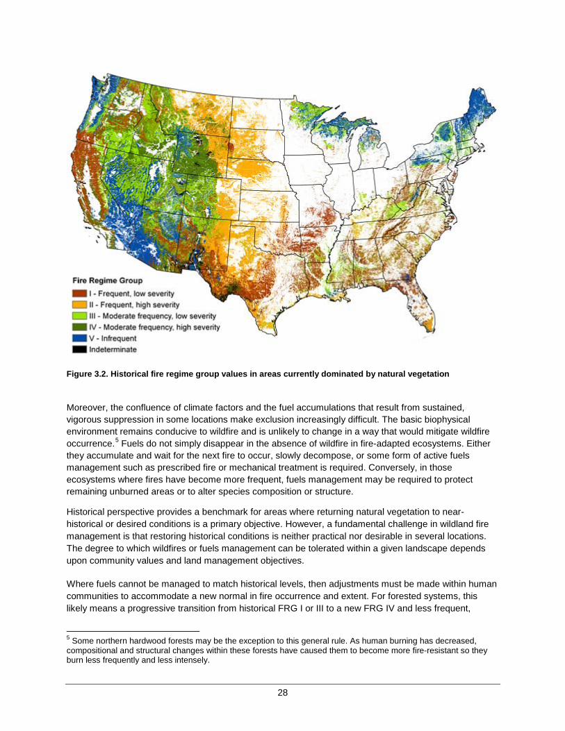
In general, more frequent burning is associated with less intense or severe wildfires. Conversely, infrequent burning generally leads to higher severity fires that consume much of the aboveground live and dead vegetation—the principal fuels in a wildfire. This pattern arises naturally from the accumulation of fuels between events, absent of any other disturbance or activity that reduces it. Ecologists use the concept of fire regime and fire regime groups (FRG) to characterize the relationship between fire frequency and fire severity and their ecological implications (table 3.2, from Barrett and others [2013]3).
Of note is the relatively high frequency of fires in FRGs I and II, which average 35 years or less between fire events and include many of the fire-adapted forest and rangeland types in the United States. Nearly half of the current undeveloped natural vegetation within the conterminous 48 states falls within lands that historically supported FRGs I and II (figure 3.2), totaling about 1.1 million square miles. If we presume that this area previously experienced a fire return interval of 35 years (the upper-bound), then a lower-bound estimate of roughly 31,000 square miles (over 20 million acres) would have burned on average each year within these two FRG areas alone. Such estimates provide a sense of perspective when compared to the annual acres burned in the recent decade, 2002 through 2011. The best estimate of annual area burned in counties dominated by FRGs I and II within the conterminous 48 states is roughly 7,800 square miles, or 1/4 of the historical lower bound for this area. Another way of stating this is that the average time between wildfires has more than quadrupled across a significant portion of our Nation.
3 Barrett, S.; D. Havlina; J. Jones; W. Hann; C. Frame; D. Hamilton; K. Schon; T. Demeo; L. Hutter; and J. Menakis. 2010. Interagency Fire Regime Condition Class Guidebook. Version 3.0 [Homepage of the Interagency Fire Regime Condition Class website, USDA Forest Service, U.S. Department of the Interior, and The Nature Conservancy]. [Online], Available: http://www.frcc.gov/.

27
Increasing the time interval between fires means that many fires occurring today are of higher severity than they were historically. Substantive shifts in vegetation away from fire-adapted species are also occurring. Changes in fire return intervals are not limited to just FRGs I and II. A previous analysis suggested increased fire return intervals throughout the United States except for some areas of the Southwest and Great Basin, where invasive grasses have contributed to reduced fire intervals and radically changed vegetative structure and composition. A second significant observation is that many of the large fires that occur today disproportionately occur in areas that historically were FRGs IV and V. These include many areas where the natural fire regime is relatively infrequent, high-severity fires—the most difficult and expensive to control or extinguish.
Table 3.2. Fire regime groups and descriptions
Group Frequency Severity Severity description
I 0 to 35 years Low / mixed
Generally low-severity fires replacing less than 25 percent of the dominant overstory vegetation; can include mixed-severity fires that replace up to 75 percent of the overstory
II 0 to 35 years Replacement High-severity fires replacing greater than 75 percent of the dominant overstory vegetation
III 35 to 200 years Mixed / low Generally mixed-severity; can also include low-severity fires
IV 35 to 200 years Replacement High-severity fires
V 200+ years Replacement / any severity
Generally replacement severity; can include any severity type in this frequency range
Source: Barrett and others (2010)
The issue is not as severe in areas under active prescribed fire regimes, including southeastern pine forests and some western forests and grasslands. For example, a recent survey reported 7.9 million acres of prescribed fire activity for silvicultural purposes in 2011, 6.5 million acres of which occurred in the Southeast.4 There also are areas within larger national parks, scattered wildlife preserves, and designated wilderness areas nationwide where natural fire regimes have been successfully reintroduced and maintained for decades.
Understanding these broad-scale changes in fire regimes is essential to crafting an effective national strategy that includes cost effective and targeted fuels treatments. Fire regimes are intrinsically and fundamentally connected to fuel accumulation, vegetation composition, and subsequent fire behavior when wildfires inevitably occur. More extreme fire conditions can be expected in areas where the time between fires has been extended, unless fuels have been reduced by other means. Human development and suppression can postpone wildfires, but not exclude them, except in unusual circumstances.
4 Melvin, Mark A. 2012. 2012 National Prescribed Fire Use Survey Report. Technical Report 01-12. Coalition of Prescribed Fire Councils, Inc. 19 p. Available at http://www.prescribedfire.net
28
Figure 3.2. Historical fire regime group values in areas currently dominated by natural vegetation
Moreover, the confluence of climate factors and the fuel accumulations that result from sustained, vigorous suppression in some locations make exclusion increasingly difficult. The basic biophysical environment remains conducive to wildfire and is unlikely to change in a way that would mitigate wildfire occurrence.5 Fuels do not simply disappear in the absence of wildfire in fire-adapted ecosystems. Either they accumulate and wait for the next fire to occur, slowly decompose, or some form of active fuels management such as prescribed fire or mechanical treatment is required. Conversely, in those ecosystems where fires have become more frequent, fuels management may be required to protect remaining unburned areas or to alter species composition or structure.
Historical perspective provides a benchmark for areas where returning natural vegetation to near-historical or desired conditions is a primary objective. However, a fundamental challenge in wildland fire management is that restoring historical conditions is neither practical nor desirable in several locations. The degree to which wildfires or fuels management can be tolerated within a given landscape depends upon community values and land management objectives.
Where fuels cannot be managed to match historical levels, then adjustments must be made within human communities to accommodate a new normal in fire occurrence and extent. For forested systems, this likely means a progressive transition from historical FRG I or III to a new FRG IV and less frequent,
5 Some northern hardwood forests may be the exception to this general rule. As human burning has decreased, compositional and structural changes within these forests have caused them to become more fire-resistant so they burn less frequently and less intensely.

29
higher-intensity fires. Higher-intensity fires lead to higher suppression difficulty, increased risks to firefighter and public safety, and more severe social or ecological damage when they occur. Changes in rangeland and shrubland systems also can lead to increased, more continuous fire extent, often with greatly increased rates of spread, which also increase suppression difficulty and risk to firefighters. Additionally, changes in fire frequency can lead to an undesirable mix of new species that move into these systems (e.g., invasive grasses such as cheatgrass or encroachment by woody species such as juniper).
Opportunities Discussion
The primary purpose of hazardous fuels management is to reduce the extent, intensity, and severity of wildfire if and when it encounters a treatment area during the lifespan of the treatments.6 To be effective, fuel treatments must reduce fireline intensities under the conditions most likely to result in harm. That is, they have to work across a range of weather conditions likely to occur during a wildfire. Depending on the ecosystem, reduced extent, intensity, and severity can have beneficial ecological effects. For example, wildfires burning less intensely may mimic historical fire effects more closely, helping to restore or enhance native, fire-adapted vegetation. In addition, less severe fires damage or kill fewer economically valuable trees and exhibit less soil erosion following fires. Strategically placed fuel treatments can have broader landscape effects that extend beyond the perimeter of the area physically treated, either through affecting fire behavior directly or by facilitating ecologically sensitive containment strategies. Such treatments can affect the spatial distribution of fires, leading to more desirable vegetation composition and structure, which reduces the potential for invasive species and can help preserve structure that is currently limited on the landscape (i.e., sagebrush).
Reduced intensity also means that suppression efforts are more likely to be effective and can be conducted more safely in areas where wildfires are unwanted or threaten communities. Fuel treatments near homes and communities also are an effective, proactive way of reducing the likelihood of structure ignition and enhancing the safety of firefighters and the public.
The three primary means of managing fuels are prescribed fire, managing wildfire for ecological purposes and resource objectives, and non-fire treatments involving mechanical, biological, or chemical methods. Treatments can occur in isolation or in combination, depending on management objectives and resource availability.
6 Here, vegetation treatments for the primary purpose of reducing hazard are distinguished from treatments that reduce vegetative fuels as a secondary benefit. For example, prescribed fire can be used for the primary benefit of promoting desirable vegetation in areas devoid of significant wildfire hazard (e.g., native rice fields). Many agricultural, silvicultural, and habitat enhancement practices have secondary fuels benefits, but are not conducted for that primary reason.
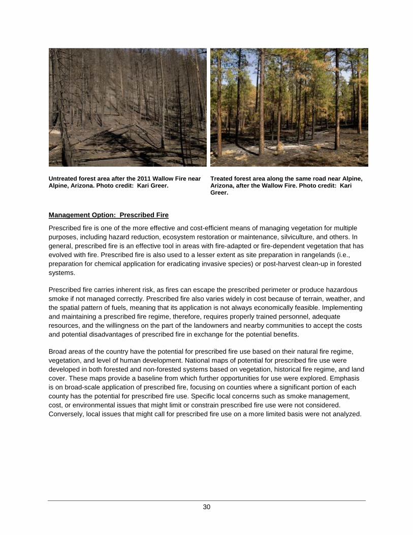
30
Untreated forest area after the 2011 Wallow Fire near Alpine, Arizona. Photo credit: Kari Greer.
Treated forest area along the same road near Alpine, Arizona, after the Wallow Fire. Photo credit: Kari Greer.
Management Option: Prescribed Fire
Prescribed fire is one of the more effective and cost-efficient means of managing vegetation for multiple purposes, including hazard reduction, ecosystem restoration or maintenance, silviculture, and others. In general, prescribed fire is an effective tool in areas with fire-adapted or fire-dependent vegetation that has evolved with fire. Prescribed fire is also used to a lesser extent as site preparation in rangelands (i.e., preparation for chemical application for eradicating invasive species) or post-harvest clean-up in forested systems.
Prescribed fire carries inherent risk, as fires can escape the prescribed perimeter or produce hazardous smoke if not managed correctly. Prescribed fire also varies widely in cost because of terrain, weather, and the spatial pattern of fuels, meaning that its application is not always economically feasible. Implementing and maintaining a prescribed fire regime, therefore, requires properly trained personnel, adequate resources, and the willingness on the part of the landowners and nearby communities to accept the costs and potential disadvantages of prescribed fire in exchange for the potential benefits.
Broad areas of the country have the potential for prescribed fire use based on their natural fire regime, vegetation, and level of human development. National maps of potential for prescribed fire use were developed in both forested and non-forested systems based on vegetation, historical fire regime, and land cover. These maps provide a baseline from which further opportunities for use were explored. Emphasis is on broad-scale application of prescribed fire, focusing on counties where a significant portion of each county has the potential for prescribed fire use. Specific local concerns such as smoke management, cost, or environmental issues that might limit or constrain prescribed fire use were not considered. Conversely, local issues that might call for prescribed fire use on a more limited basis were not analyzed.
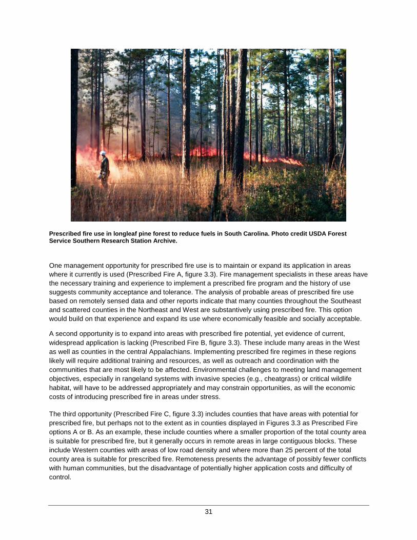
31
Prescribed fire use in longleaf pine forest to reduce fuels in South Carolina. Photo credit USDA Forest Service Southern Research Station Archive.
One management opportunity for prescribed fire use is to maintain or expand its application in areas where it currently is used (Prescribed Fire A, figure 3.3). Fire management specialists in these areas have the necessary training and experience to implement a prescribed fire program and the history of use suggests community acceptance and tolerance. The analysis of probable areas of prescribed fire use based on remotely sensed data and other reports indicate that many counties throughout the Southeast and scattered counties in the Northeast and West are substantively using prescribed fire. This option would build on that experience and expand its use where economically feasible and socially acceptable.
A second opportunity is to expand into areas with prescribed fire potential, yet evidence of current, widespread application is lacking (Prescribed Fire B, figure 3.3). These include many areas in the West as well as counties in the central Appalachians. Implementing prescribed fire regimes in these regions likely will require additional training and resources, as well as outreach and coordination with the communities that are most likely to be affected. Environmental challenges to meeting land management objectives, especially in rangeland systems with invasive species (e.g., cheatgrass) or critical wildlife habitat, will have to be addressed appropriately and may constrain opportunities, as will the economic costs of introducing prescribed fire in areas under stress.
The third opportunity (Prescribed Fire C, figure 3.3) includes counties that have areas with potential for prescribed fire, but perhaps not to the extent as in counties displayed in Figures 3.3 as Prescribed Fire options A or B. As an example, these include counties where a smaller proportion of the total county area is suitable for prescribed fire, but it generally occurs in remote areas in large contiguous blocks. These include Western counties with areas of low road density and where more than 25 percent of the total county area is suitable for prescribed fire. Remoteness presents the advantage of possibly fewer conflicts with human communities, but the disadvantage of potentially higher application costs and difficulty of control.

32
Figure 3.3. Prescribed Fire. Spatial distribution of the three management options suggested for maintaining or increasing the use of prescribed fire
Conclusion: Prescribed fire is a useful tool with potential for widespread increased application. Three possible options are identified, which collectively total approximately 55 percent of the land area of the conterminous 48 states. Considerations for application of prescribed fire and public acceptance of the use of prescribed fire as a tool vary nationally. Prescribed fire has inherent risks, such as the potential to human health and safety, which must be considered at the local level and may limit application.
Management Option: Managing Wildfire for Resource Objectives
Managing wildfire for resource objectives and ecological purposes refers to a strategic choice to use unplanned ignitions to achieve resource management objectives. Federal fire policies traditionally restricted use to Federal wilderness areas, national parks, or other remote areas under specific conditions or circumstances. These restrictions were intended to reduce risk and avoid potentially negative impacts or consequences to lands of other ownership. Guidance issued in 2009 regarding implementation of Federal fire policy ensures consistency among agencies and has led to expanded application of this method to manage wildland fuels. In contrast, most state and local jurisdictions are statutorily constrained to provide full wildfire suppression due to values at risk, human-caused fires, and protection of private lands. Like prescribed fire, allowing wildfires to burn for the purposes of ecosystem restoration or hazard reduction has inherent risk. These risks must be balanced with the potential benefits on an individual incident basis, which requires both pre-incident planning at the landscape scale and sophisticated incident management.
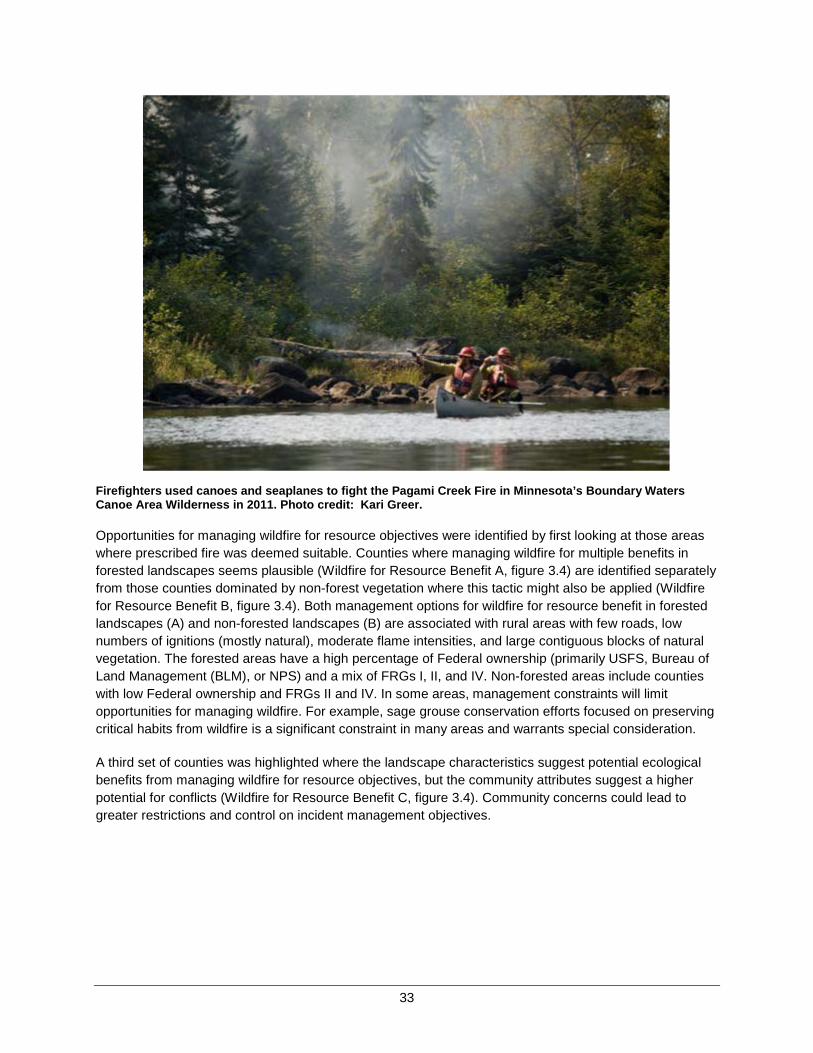
33
Firefighters used canoes and seaplanes to fight the Pagami Creek Fire in Minnesota’s Boundary Waters Canoe Area Wilderness in 2011. Photo credit: Kari Greer.
Opportunities for managing wildfire for resource objectives were identified by first looking at those areas where prescribed fire was deemed suitable. Counties where managing wildfire for multiple benefits in forested landscapes seems plausible (Wildfire for Resource Benefit A, figure 3.4) are identified separately from those counties dominated by non-forest vegetation where this tactic might also be applied (Wildfire for Resource Benefit B, figure 3.4). Both management options for wildfire for resource benefit in forested landscapes (A) and non-forested landscapes (B) are associated with rural areas with few roads, low numbers of ignitions (mostly natural), moderate flame intensities, and large contiguous blocks of natural vegetation. The forested areas have a high percentage of Federal ownership (primarily USFS, Bureau of Land Management (BLM), or NPS) and a mix of FRGs I, II, and IV. Non-forested areas include counties with low Federal ownership and FRGs II and IV. In some areas, management constraints will limit opportunities for managing wildfire. For example, sage grouse conservation efforts focused on preserving critical habits from wildfire is a significant constraint in many areas and warrants special consideration.
A third set of counties was highlighted where the landscape characteristics suggest potential ecological benefits from managing wildfire for resource objectives, but the community attributes suggest a higher potential for conflicts (Wildfire for Resource Benefit C, figure 3.4). Community concerns could lead to greater restrictions and control on incident management objectives.
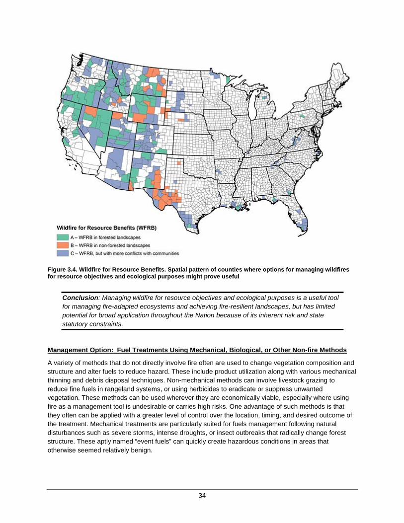
34
Figure 3.4. Wildfire for Resource Benefits. Spatial pattern of counties where options for managing wildfires for resource objectives and ecological purposes might prove useful
Conclusion: Managing wildfire for resource objectives and ecological purposes is a useful tool for managing fire-adapted ecosystems and achieving fire-resilient landscapes, but has limited potential for broad application throughout the Nation because of its inherent risk and state statutory constraints.
Management Option: Fuel Treatments Using Mechanical, Biological, or Other Non-fire Methods
A variety of methods that do not directly involve fire often are used to change vegetation composition and structure and alter fuels to reduce hazard. These include product utilization along with various mechanical thinning and debris disposal techniques. Non-mechanical methods can involve livestock grazing to reduce fine fuels in rangeland systems, or using herbicides to eradicate or suppress unwantedvegetation. These methods can be used wherever they are economically viable, especially where using fire as a management tool is undesirable or carries high risks. One advantage of such methods is that they often can be applied with a greater level of control over the location, timing, and desired outcome of the treatment. Mechanical treatments are particularly suited for fuels management following natural disturbances such as severe storms, intense droughts, or insect outbreaks that radically change forest structure. These aptly named “event fuels” can quickly create hazardous conditions in areas that otherwise seemed relatively benign.

35
An added advantage of mechanical treatments in forested ecosystems is the potential to use the removed woody material for other purposes. Forest thinning might result in excess stocking being utilized as sawlogs, wood chips, or specialty products made from small-diameter trees. If markets exist for the byproducts of the treatment, then there is a greater chance of treatments being economically viable.
Commercial timber harvest, as a viable fuels management option, has substantial potential to both offset economic costs and enhance effectiveness in many areas. Sustainable forest management for commercial timber or pulpwood can provide greater access, enhance other resource values, enhance control over both wildfire and prescribed fire, and reduce wildfire threat. To be effective in meeting fuel reduction and forest management goals, treatments must address slash and debris disposal without exacerbating spread of invasive species. Long-term interests of landowners and the strength of local markets will most likely determine the success of offsetting treatment costs. Mechanical treatments also are not wholly adequate surrogates for fire in terms of ecological effects, limiting their suitability in various situations.
Timber harvesting as part of a fuels management project on the Deschutes Collaborative Forest Project in Oregon. Photo credit: Deschutes National Forest, Sisters Ranger District.
Opportunities for using active timber markets to offset costs of mechanical fuels treatments in forests were identified by using data about timber jobs, mill production, and forested area available for mechanical treatment (Non-fire Fuels Treatments A, figure 3.5). These counties occur throughout the Northeast and Southeast, within the Pacific Northwest, and are scattered in the interior West.
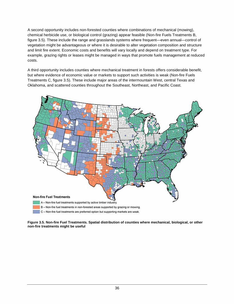
36
A second opportunity includes non-forested counties where combinations of mechanical (mowing), chemical herbicide use, or biological control (grazing) appear feasible (Non-fire Fuels Treatments B,figure 3.5). These include the range and grasslands systems where frequent—even annual—control of vegetation might be advantageous or where it is desirable to alter vegetation composition and structure and limit fire extent. Economic costs and benefits will vary locally and depend on treatment type. For example, grazing rights or leases might be managed in ways that promote fuels management at reduced costs.
A third opportunity includes counties where mechanical treatment in forests offers considerable benefit, but where evidence of economic value or markets to support such activities is weak (Non-fire Fuels Treatments C, figure 3.5). These include major areas of the intermountain West, central Texas and Oklahoma, and scattered counties throughout the Southeast, Northeast, and Pacific Coast.
Figure 3.5. Non-fire Fuel Treatments. Spatial distribution of counties where mechanical, biological, or other non-fire treatments might be useful

37
A variant on the theme of non-fire fuel treatments highlights areas where economically sustainable mechanical treatment could be used as a precursor to, and combined with, safer and more expanded use of wildland fire. The intent is to use mechanical treatments strategically to reduce the risks from wildland fire use across a broader landscape. For example, mechanical treatments in pine plantations that are located between communities and wildland areas might facilitate prescribed fire use or allow greater response flexibility in the wildlands. Essentially, this involves an intersection of the management options for both prescribed fire (Figure 3.3) and non-fire fuels treatments supported by active timber industry (Non-Fire Fuels A, Figure 3.5). The net result is the management option for non-fire fuels treatments as an economic precursor to managed fire (figure 3.6), which includes many southeastern counties, the Pacific Northwest, and scattered interior counties.
Figure 3.6. Non-fire Fuel Treatments Preceding Managed Fire. Spatial distribution of counties where mechanical treatments of forested areas might be used as a precursor to expanded wildland fire use
Conclusion: Fuel treatments involving mechanical, biological, or chemical methods offer many advantages in terms of greater control over the outcome and reduced risk of unintended consequences. The disadvantage is usually higher economic cost, which in some cases can be offset by active economic markets for the byproducts of the treatment.
38
Homes, Communities, and Values at Risk The aforementioned changes in fire regime are just one component of the overall historical changes in wildland fire that have occurred across the United States. Much has been written about the growth of the WUI and the concomitant risks from wildfire and challenges that it brings. There are several recent and accessible summaries of this literature, including Stein and others’ (2013) report, Wildfire, wildlands, and people: Understanding and preparing for wildfire in the wildland-urban interface—a Forests on the Edge report7 and references therein. Many of the data sets referenced by Stein and others (2013) are incorporated in the analyses described in Chapter 2 and below.
Opportunities Discussion
As described in Chapter 2, the motivation underlying the development of the community clusters is the recognition that risk to communities arises from the intersection of multiple factors, including the frequency and extent of wildfires, the distribution and density of homes within the WUI, and components of social vulnerability. These factors must be considered in total when identifying opportunities and designing management options for reducing risk to homes, communities, and other important values.
Many programs that strive to reduce losses to homes and communities from wildfires focus on the immediate vicinity of the home or the surrounding community. Research suggests that the public also is increasingly concerned with the overall environmental health of the land, with fire representing one influencing and important factor. Reducing the likelihood that a wildfire burning in adjoining vegetation will ignite homes or other structures is one of the more effective avenues to reducing losses. Individual homeowners can take many actions, but others require concerted effort at the community level to be effective. Similarly, community efforts without commensurate attention by local home and business owners are unlikely to succeed. Therefore, actions by property owners to reduce the ignitability of homes and other structures are prudent wherever structures are near flammable vegetation. Data on the incidence of buildings involved in outdoor fires suggest that essentially all communities would benefit from more attention by property owners. Beyond that first step, there are areas of higher risk where additional emphasis on home or community efforts might be placed.
7 Stein, S.M., J. Menakis, M.A. Carr, S.J. Comas, S.I. Stewart, H. Cleveland, L. Bramwell, and V.C. Radeloff. 2013. Wildfire, wildlands, and people: understanding and preparing for wildfire in the wildland-urban interface—a Forests on the Edge report. Gen. Tech. Rep. RMRS-GTR-299. Fort Collins, CO. U.S. Department of Agriculture, Forest Service, Rocky Mountain Research Station. 36 p.

39
This home was lost because it had not proactively reduced risks posed by wildfire through homeowner action and hazardous fuels reduction before the Wallow Fire in Arizona, in 2011. Photo credit: Kari Greer.
This home was saved because it was located in a thinned area which provided safety to firefighters who burned the ground fuels around it as the Wallow Fire approached. Photo credit: Kari Greer.
Recent patterns of structures lost or buildings involved in incidents help identify areas of possible prioritization. Figure 3.7 presents a series of bar charts that show the relative area burned, proportion of structures lost, and proportion of buildings involved for each of the eight community clusters from 2002through 2011. Here, the number of structures lost comes from an interagency reporting system that is primarily used to record larger incidents, while the count of buildings involved comes from the National Fire Incident Reporting System (NFIRS), which generally reports on more local incidents. The chart is scaled such that each set of bars sums to 100 percent. One can readily observe that the largest proportion of area burned and many of the structures lost occur in community cluster 2, while much of the area burned and the largest proportion of structures lost occur in community cluster 4. Thus, community clusters 2 and 4 are obvious candidates for greater focus on both community-level planning and individual structure protection. Community cluster 3 has the highest area burned among clusters common in the East and sizable numbers of structures involved. Community cluster 6 shares many of the same attributes with clusters 2 and 4 where it occurs in the West, and is similar to community cluster 3 in the East.Additional information on the configuration of the WUI in these four clusters reinforces the need for community-level planning, given that fires threatening homes often originate beyond the perimeter of the community itself.
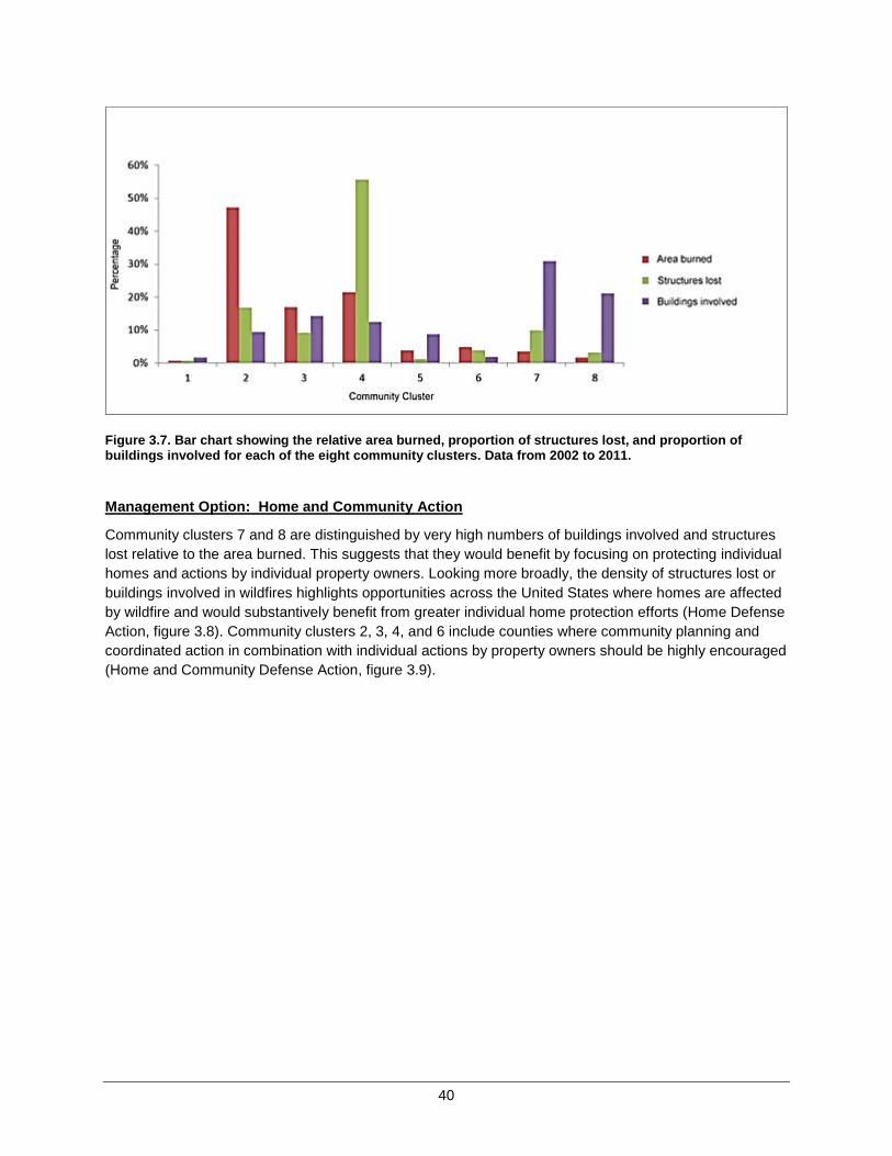
40
Figure 3.7. Bar chart showing the relative area burned, proportion of structures lost, and proportion of buildings involved for each of the eight community clusters. Data from 2002 to 2011.
Management Option: Home and Community Action
Community clusters 7 and 8 are distinguished by very high numbers of buildings involved and structures lost relative to the area burned. This suggests that they would benefit by focusing on protecting individual homes and actions by individual property owners. Looking more broadly, the density of structures lost or buildings involved in wildfires highlights opportunities across the United States where homes are affected by wildfire and would substantively benefit from greater individual home protection efforts (Home Defense Action, figure 3.8). Community clusters 2, 3, 4, and 6 include counties where community planning and coordinated action in combination with individual actions by property owners should be highly encouraged (Home and Community Defense Action, figure 3.9).
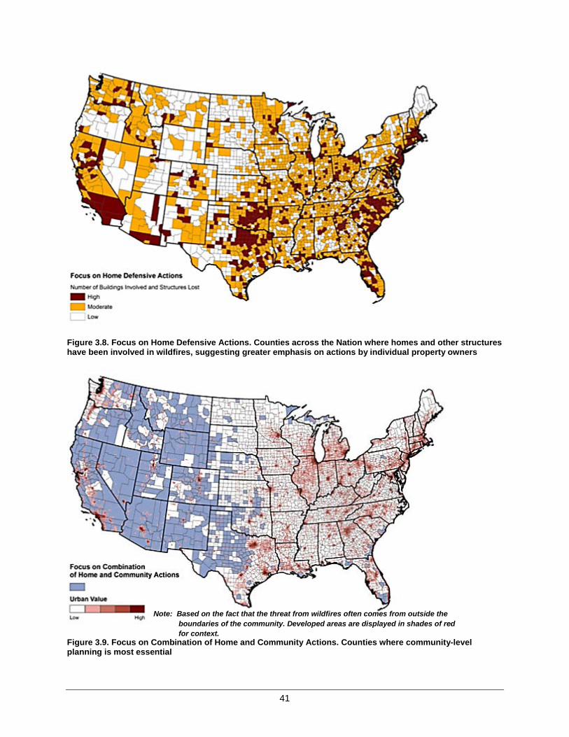
41
Figure 3.8. Focus on Home Defensive Actions. Counties across the Nation where homes and other structures have been involved in wildfires, suggesting greater emphasis on actions by individual property owners
Figure 3.9. Focus on Combination of Home and Community Actions. Counties where community-level planning is most essential
Note: Based on the fact that the threat from wildfires often comes from outside the boundaries of the community. Developed areas are displayed in shades of red for context.

42
Management Option: Building Codes
One approach to making homes and other buildings more resistant to ignition is to focus on building materials and construction standards. Such standards engage individual property owners and enhance the effectiveness of community-wide actions. Building standards and adjustments in infrastructure are more easily applied to new construction and development than to existing development, and communities can be designed or managed in ways that enhance response effectiveness or mitigate risk. Changes in building codes are more likely to be effective when targeted at areas of new construction in high-hazard areas, and consequently counties with increasing WUI area or increasing WUI home density growth—the latter being more closely aligned with increasing home construction overall—suggest opportunities where such efforts are most likely to have a significant effect. Because municipal and non-municipal areas tend to exhibit varying levels of ability to implement building standards, these are mapped separately (Building Codes A and B, figure 3.10).
Figure 3.10. Building Codes. Counties with higher than average rates of home construction and WUI growth where building ordinances might have a more positive effect on reducing home losses
Conclusion: Protecting homes from ignition by wildfire is a practical step that is applicable anywhere homes can be found adjacent to natural vegetation. Similarly, coordinated action at the community level is universally advantageous, but essential when wildfires originate outside the community perimeter and threaten all residents collectively. New construction offers risk-mitigation opportunities that may not be available elsewhere.
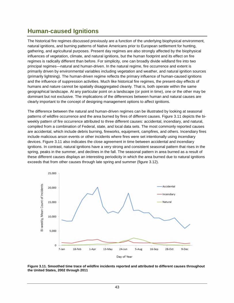
43
Human-caused IgnitionsThe historical fire regimes discussed previously are a function of the underlying biophysical environment, natural ignitions, and burning patterns of Native Americans prior to European settlement for hunting, gathering, and agricultural purposes. Present day regimes are also strongly affected by the biophysical influences of vegetation, climate, and natural ignitions, but the human footprint and its effect on fire regimes is radically different than before. For simplicity, one can broadly divide wildland fire into two principal regimes—natural and human-driven. In the natural regime, fire occurrence and extent is primarily driven by environmental variables including vegetation and weather, and natural ignition sources (primarily lightning). The human-driven regime reflects the primary influence of human-caused ignitions and the influence of suppression activities. Much like historical fire regimes, the present-day effects of humans and nature cannot be spatially disaggregated cleanly. That is, both operate within the same geographical landscape. At any particular point on a landscape (or point in time), one or the other may be dominant but not exclusive. The implications of the differences between human and natural causes are clearly important to the concept of designing management options to affect ignitions.
The difference between the natural and human-driven regimes can be illustrated by looking at seasonal patterns of wildfire occurrence and the area burned by fires of different causes. Figure 3.11 depicts the bi-weekly pattern of fire occurrence attributed to three different causes: accidental, incendiary, and natural, compiled from a combination of Federal, state, and local data sets. The most commonly reported causes are accidental, which include debris burning, fireworks, equipment, campfires, and others. Incendiary fires include malicious arson events or other incidents where fires were set intentionally using incendiary devices. Figure 3.11 also indicates the close agreement in time between accidental and incendiary ignitions. In contrast, natural ignitions have a very strong and consistent seasonal pattern that rises in the spring, peaks in the summer, and declines in the fall. The seasonal pattern in area burned as a result of these different causes displays an interesting periodicity in which the area burned due to natural ignitions exceeds that from other causes through late spring and summer (figure 3.12).
Figure 3.11. Smoothed time trace of wildfire incidents reported and attributed to different causes throughout the United States, 2002 through 2011
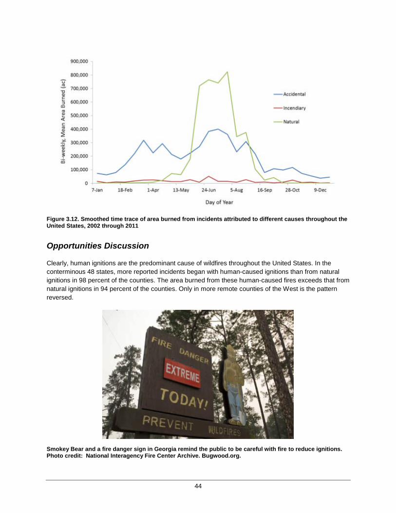
44
Figure 3.12. Smoothed time trace of area burned from incidents attributed to different causes throughout the United States, 2002 through 2011
Opportunities Discussion
Clearly, human ignitions are the predominant cause of wildfires throughout the United States. In the conterminous 48 states, more reported incidents began with human-caused ignitions than from natural ignitions in 98 percent of the counties. The area burned from these human-caused fires exceeds that from natural ignitions in 94 percent of the counties. Only in more remote counties of the West is the pattern reversed.
Smokey Bear and a fire danger sign in Georgia remind the public to be careful with fire to reduce ignitions. Photo credit: National Interagency Fire Center Archive. Bugwood.org.
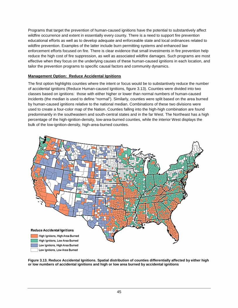
45
Programs that target the prevention of human-caused ignitions have the potential to substantively affect wildfire occurrence and extent in essentially every county. There is a need to support fire prevention educational efforts as well as to develop adequate and enforceable state and local ordinances related to wildfire prevention. Examples of the latter include burn permitting systems and enhanced law enforcement efforts focused on fire. There is clear evidence that small investments in fire prevention help reduce the high cost of fire suppression, as well as associated wildfire damages. Such programs are most effective when they focus on the underlying causes of these human-caused ignitions in each location, and tailor the prevention programs to specific causal factors and community dynamics.
Management Option: Reduce Accidental Ignitions
The first option highlights counties where the intent or focus would be to substantively reduce the number of accidental ignitions (Reduce Human-caused Ignitions, figure 3.13). Counties were divided into two classes based on ignitions: those with either higher or lower than normal numbers of human-caused incidents (the median is used to define “normal”). Similarly, counties were split based on the area burned by human-caused ignitions relative to the national median. Combinations of these two divisions were used to create a four-color map of the Nation. Counties falling into the high-high combination are found predominantly in the southeastern and south-central states and in the far West. The Northeast has a high percentage of the high-ignition-density, low-area-burned counties, while the interior West displays the bulk of the low-ignition-density, high-area-burned counties.
Figure 3.13. Reduce Accidental Ignitions. Spatial distribution of counties differentially affected by either high or low numbers of accidental ignitions and high or low area burned by accidental ignitions

46
Management Option: Reduce Intentional Ignitions
The second option similarly focuses on areas experiencing higher than normal incendiary ignitions or the area burned by such fires (Reduce Human-caused Incendiary Ignitions, figure 3.14). There is more congruence between ignition density and area burned with incendiary fires than with accidental fires. Thus, large portions of the East and more populated counties of the West exhibit a combination of both high incendiary ignitions and high area burned.
The NSAT assembled data sets that include a broad set of community metrics and more detailed causal information that can be explored to target specific causal factors within the various community contexts. For example, debris burning is one of the principal causes of accidental fires; its occurrence varies considerably among community clusters.
Figure 3.14. Reduce Intentional Ignitions. Spatial distribution of counties differentially affected by either high or low numbers of incendiary ignitions and high or low area burned by incendiary ignitions.
Conclusion: Human-caused ignitions, whether accidental or incendiary, are a universal problem that affects much of the United States. Targeting regions or counties with higher-than-normal levels of activity could prove productive, especially if targeted at specific causes.
47
Effective and Efficient Wildfire Response The United States benefits from an extensive and sophisticated wildland fire response organization composed of thousands of separate local, state, tribal, and Federal entities. Each organization has specific responsibilities for responding first to wildfires occurring within their jurisdiction (initial response). They also coordinate and share resources and responsibilities as fires become larger and exceed the local response capacity, requiring a more extended suppression response. Fortunately, local response capacity is generally adequate for controlling or extinguishing most wildfires, though escalating risks due to changing conditions in and around communities may impact response effectiveness in the future. Such preparedness does not come cheap; Federal suppression response expenditures alone in 2005 to 2012 exceeded on average $1.5 billion dollars per year.
The relatively small percentage of fires that escape initial response are vitally important, as they account for a disproportionate percentage of the area burned, damage to homes and communities, and injuries and fatalities. For example, a summary of available data shows that the top 3 percent of fires in terms of individual fire sizes account for over 90 percent of the total area burned nationwide from 2002 to 2011. Another way of viewing this is that if an additional 1 percent of the fires in the United States were to reach the size of the current top 3 percent, the total area burned would increase by 30 percent. Relatively few large fires also account for a major portion of total suppression costs nationwide, and the variation in large fires from year-to-year results in significant swings in total suppression expenditures. This variability creates major challenges from both a planning and funding perspective.
An effective and safe collective response organization is essential. Response is the last line of defense and action, coming after fires have started and there is little recourse. As with any large, complex endeavor, there are opportunities to increase efficiency (i.e., use resources to maximum advantage). Finding ways to contain large wildfires more efficiently is an ongoing and continuous struggle and an area of active research. Possible solutions generally include combinations of resources, organizational or administrative adjustments, and tactics. An additional avenue to improving efficiency is to match response efforts with other management options. For example, response personnel will find it easier to protect homes and communities when those same homeowners have proactively reduced hazards around their homes and prepared for wildfires.
Coordinated response is a complex nationwide issue. Multiple institutional arrangements have been negotiated and developed across the country to meet the challenge of delivering the appropriate resources and personnel required on each incident. The RSCs and others examined various ways of improving coordination within their regions and have suggested actions for improvement. Implementing these recommendations will require working through the details among the various national, regional, and local governance organizations. Analyzing the full implications of these varied recommendations is beyond the scope of this report. Several of the data sets that the NSAT accumulated could be useful within forthcoming regional and local discussions of these issues. At the national level, it is possible to highlight patterns that suggest areas of greater concern, or alternatively where a combination of response with other policy options might play out differentially.
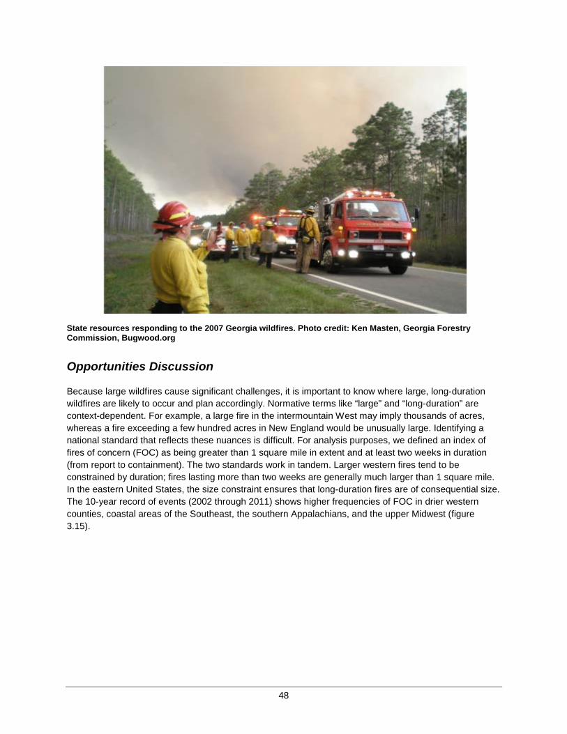
48
State resources responding to the 2007 Georgia wildfires. Photo credit: Ken Masten, Georgia Forestry Commission, Bugwood.org
Opportunities Discussion
Because large wildfires cause significant challenges, it is important to know where large, long-duration wildfires are likely to occur and plan accordingly. Normative terms like “large” and “long-duration” are context-dependent. For example, a large fire in the intermountain West may imply thousands of acres, whereas a fire exceeding a few hundred acres in New England would be unusually large. Identifying a national standard that reflects these nuances is difficult. For analysis purposes, we defined an index of fires of concern (FOC) as being greater than 1 square mile in extent and at least two weeks in duration (from report to containment). The two standards work in tandem. Larger western fires tend to be constrained by duration; fires lasting more than two weeks are generally much larger than 1 square mile. In the eastern United States, the size constraint ensures that long-duration fires are of consequential size. The 10-year record of events (2002 through 2011) shows higher frequencies of FOC in drier western counties, coastal areas of the Southeast, the southern Appalachians, and the upper Midwest (figure 3.15).

49
Figure 3.15. Relative frequency of occurrence of fires of concern during the period 2002 to 2011
Management Option: Prepare for Large, Long-Duration Wildfire
Realistically, 10 years is too brief an interval to precisely estimate the chance of a relatively rare event. Amore inclusive estimate of where these larger, longer-duration fires might occur in the future is obtained by extrapolating the 10-year sample to all combinations of resiliency classes and community clusters.8
The resulting map indicates that much of the West, Southeast, and mid-Atlantic regions display areas of relatively higher probability for fires of concern, as well as scattered counties of the upper Midwest (Prepare for Large, Long Duration Wildfire, figure 3.16). In these areas, preparing for large, long-durationwildfires is presented as a national response opportunity and management option.
8 Extrapolation requires treating the entire area within a combination class as a single sample unit rather than analyzing individual counties. Highly urban areas (Landscape Class A) are precluded from extrapolation due to high intraclass variation.
Note: Values are expressed in terms of the number of events in a 10-year period per 100 square miles.

50
Figure 3.16. Prepare for Large, Long-Duration Wildfire. The relative risk of experiencing a wildfire
Management Option: Protect Structures and Target Landscape Fuels
A second opportunity related to larger fires focuses on the relationship between area burned (as reported in Federal and state records) and structures lost (as reported in the nationwide ICS-209 incident reporting system). An index of the rate at which structures are lost relative to the area burned was created and compared to the area burned itself. A four-color map reflecting the intersection of those two indices reveals an interesting pattern (Protect Structures and Target Landscape Fuels, figure 3.17). The combination of high rates of structure loss with low area burned is dominant in the Central Plains and Eastern regions. Prioritizing response resources towards structure protection in these areas seems prudent. Conversely, the Intermountain West exhibits most of the area with high rates of area burned, but relatively lower rates of structures lost per unit area burned. The opportunity to employ greater flexibility in the tactics used in suppressing and containing fires in this region might be explored. Greater flexibility could lead to enhanced ecological benefits, reduced overall suppression costs, and perhaps less direct risk to firefighters.
Note: A fire of concern is greater than 1 square mile in extent and requires two weeks or more to contain

51
Figure 3.17. Protect Structures and Target Landscape Fuels. Spatial pattern of counties where the numbers of structures lost per area burned is high relative to the area burned, vice versa, and where both indices are high
Counties exhibiting a combination of both high area burned and high structure loss rates are few in number, but highlight some of the most problematic counties in the Nation from a response perspective. Management efforts to simultaneously emphasize structure protection in combination with efforts to reduce fire size through either increased response capacity or pre-fire fuels management seem warranted.
Aircraft applying slurry to try to protect a subdivision built in the wildland-urban interface of Colorado Springs, Colorado, from the approaching 2013 Black Forest Fire. Photo credit: U.S. Army photo by Sgt. Jonathan C. Thibaut
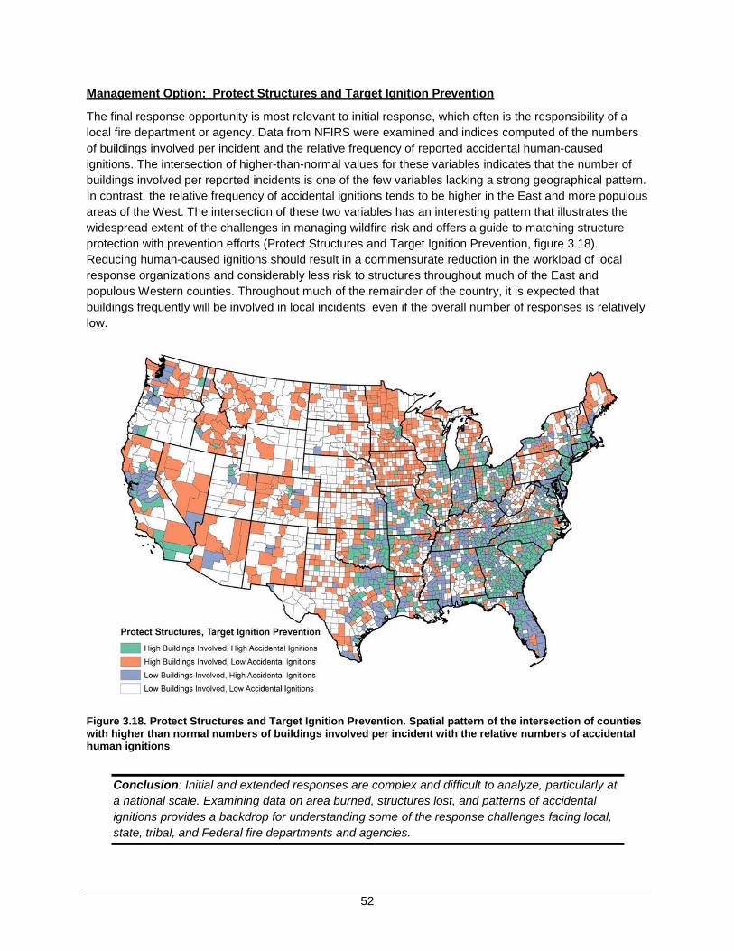
52
Management Option: Protect Structures and Target Ignition Prevention
The final response opportunity is most relevant to initial response, which often is the responsibility of a local fire department or agency. Data from NFIRS were examined and indices computed of the numbers of buildings involved per incident and the relative frequency of reported accidental human-caused ignitions. The intersection of higher-than-normal values for these variables indicates that the number of buildings involved per reported incidents is one of the few variables lacking a strong geographical pattern. In contrast, the relative frequency of accidental ignitions tends to be higher in the East and more populous areas of the West. The intersection of these two variables has an interesting pattern that illustrates the widespread extent of the challenges in managing wildfire risk and offers a guide to matching structure protection with prevention efforts (Protect Structures and Target Ignition Prevention, figure 3.18). Reducing human-caused ignitions should result in a commensurate reduction in the workload of local response organizations and considerably less risk to structures throughout much of the East and populous Western counties. Throughout much of the remainder of the country, it is expected that buildings frequently will be involved in local incidents, even if the overall number of responses is relatively low.
Figure 3.18. Protect Structures and Target Ignition Prevention. Spatial pattern of the intersection of counties with higher than normal numbers of buildings involved per incident with the relative numbers of accidental human ignitions
Conclusion: Initial and extended responses are complex and difficult to analyze, particularly at a national scale. Examining data on area burned, structures lost, and patterns of accidental ignitions provides a backdrop for understanding some of the response challenges facing local, state, tribal, and Federal fire departments and agencies.
53
Chapter 3 Summary
This chapter began with a simple conceptual model of wildland fire that highlights the five factors most responsible for determining the occurrence, extent, and intensity of wildfires; demonstrates how risk ultimately depends on exposure; and suggests strategic actions that contribute to reducing risk. The ensuing analysis and discussion clearly demonstrates, however, that the pathways between actions, causes, and consequences are not straightforward, but involve numerous complexities and nuances.
Four national challenges were identified:
• Vegetation and Fuels. The slow but steady accumulation of vegetation in areas that historically burned at frequent intervals exacerbates fuel conditions and inevitably leads to higher intensity fires that are more damaging, more costly, and threaten the safety and security of both the public and firefighters.
• Homes, Communities, and other Values at Risk. Many homes and communities are at risk simply because of their proximity to, or juxtaposition with, flammable natural vegetation in environments conducive to wildland fire. Similarly, other key values including infrastructure and ecological services are increasingly threatened by uncharacteristic wildfires.
• Human-caused Ignitions. Human-caused ignitions are a universal problem that account for the majority of reported wildfires throughout the Nation. The prevalence of human-caused ignitions requires an ever-present response organization in most locations.
• Effective and Efficient Wildfire Response. The United States uses a highly capable and effective multi-jurisdictional response capacity that quickly suppresses the vast majority of wildfires. Large or long-duration wildfires pose major challenges to response because of their inherent costs—both economically and ecologically—and the threats they pose to health and safety.
Fire regimes inevitably will change due to changing climatic conditions, population expansion and accelerated human development, impacts from invasive species, changes in resource utilization (food, fuel, and fiber), and other agents of landscape change. All are potentially important; all remain uncertain; all are active areas of research. Predictions of future conditions remain speculative, but the changes will likely exacerbate the challenges of managing wildland fire, not diminish them. Current conditions provide the best predictor of the immediate future until greater clarity is achieved. Our collective ability to meet tomorrow’s challenges will depend greatly on how well we meet today’s challenges.
Multiple opportunities for meeting today’s challenges were explored using the empirical data assembled and analyzed by the NSAT. These opportunities are displayed as a series of options, summarized in table 3.3. The insights gained by exploring each option are used along with the understanding of national differences described in Chapter 2 as the foundation for a national strategy.

54
Table 3.3. Summary of management options
National Goals National Challenges Management Options*
Restore and Maintain Landscapes
Fire-adapted Communities
Respond to Wildfires
Vegetation and Fuels
Prescribed Fire: Expand or maintain in areas of current use (figure 3.3) Prescribed Fire: Expand into areas of limited current use (figure 3.3) Prescribed Fire: Utilize on a limited basis (figure 3.3)
Manage wildfires for resource objectives: In forested systems (figure 3.4) Manage wildfires for resource objectives: In non-forested systems (figure 3.4) Manage wildfires for resource objectives: In areas where increased awareness of community risk is necessary. (figure 3.4)
Non-fire Treatments: Supported by forest products industry (figure 3.5) Non-fire Fuels Treatments: In non-forest areas (figure 3.5) Non-fire Fuels Treatment: In areas with limited economic markets (figure 3.5)
Fuels Treatments as a precursor to prescribed fire or managed wildfire (figure 3.6)
Homes, Communities, & Values At Risk
Focus on home defensive actions (figure 3.8) Focus on combination of home and community actions (figure 3.9)
Adjust building and construction codes, municipal areas (figure 3.10) Adjust building and construction codes, non-municipal areas (figure 3.10)
Human-caused Ignitions
Reduce accidental human-caused ignitions (figure 3.13) Reduce human-caused incendiary ignitions (e.g., arson) (figure 3.14)
Effective and Efficient Wildfire Response
Prepare for large, long-duration wildfires (figure 3.16) Protect structures and target landscape fuels (figure 3.17) Protect structures and target prevention of ignitions (figure 3.18)
*As related to addressing national challenges and in support of the three Cohesive Strategy goals. The three national goals are both related and interdependent upon each other, making management options supportive of achieving progress in all three goal areas but to varying degrees.

55
CHAPTER 4 – THE NATIONAL STRATEGY The first phase of the Cohesive Strategy began with the vision statement, “Safely and effectively extinguish fire, when needed; use fire where allowable; manage our natural resources; and as a Nation, live with wildland fire.” From there, three national goals and a set of guiding principles and core values were established. Since then, efforts have been progressively moving from goals and principles to actions. Success within the Cohesive Strategy requires finding balance. This balance is encapsulated within the vision statement. Finding acceptable balance is not a scientific optimization problem, but a sociopolitical exercise which science can advise.
The options explored in Chapter 3 suggest opportunities where management actions can be employed and leveraged to explicitly advance the national goals of the Cohesive Strategy. The options were intentionally crafted such that they are not mutually exclusive. That is, choosing to emphasize one option does not preclude implementing other options as well, even in the same location. Indeed, implementing multiple options is likely to have a synergistic or mutually reinforcing positive effect.
Having a set of options available to choose from is important, but it is not yet a strategy. In these times of limited fiscal resources, hard choices have to be made. Every choice involves a question of value, and unfortunately, not everything is a win-win solution. Choices made at a national or regional level to emphasize one option or set of activities over another invariably affect all constituencies differentially. The hardest part of defining a national strategy is deciding who does what, when, and where. Although many details will be worked through in collaborative exercises at multiple scales, the blueprint for those deliberations and commitments comes from national-level spatial and temporal prioritization.
This chapter seeks to explicitly define those national priorities using the information assembled and described in preceding chapters.
Risk Tradeoffs One unavoidable tenet of risk management is that choices made today affect all future options. For example, management choices made in the past have disrupted historical fire regimes, such that wildfires today are of much different character, magnitude, and extent than those that burned centuries ago. The net result is that vegetative fuels on much of the landscape exceed historical levels, continue to accumulate, and are likely to contribute to larger, higher-intensity fires. As a Nation, we must either accept and prepare for that eventuality or take active steps to reduce fuels. Fuel reductions carry their own risks, however, whether it comes from fire use or unintended collateral effects on other ecological or social values. Thus, all choices inherently involve trading one set of values for another.
The temporal nature of tradeoffs can be visualized as a series of curves reflecting various assumptions related to the level of risk or expected losses over time under different national policy scenarios (figure 4.1). Line A in Figure 4.1 represents the risk trajectory expected under a continuation of current policies and investments. This scenario assumes that fuel loads are accumulating in much of the landscape, expansion of the WUI continues, and climatic changes, invasive species, and other environmental factors are likely to contribute to worsening risk. More importantly, the incremental change in risk over time escalates at an increased rate. This leads to an ever-increasing slope much like the common compound interest curves in finance.
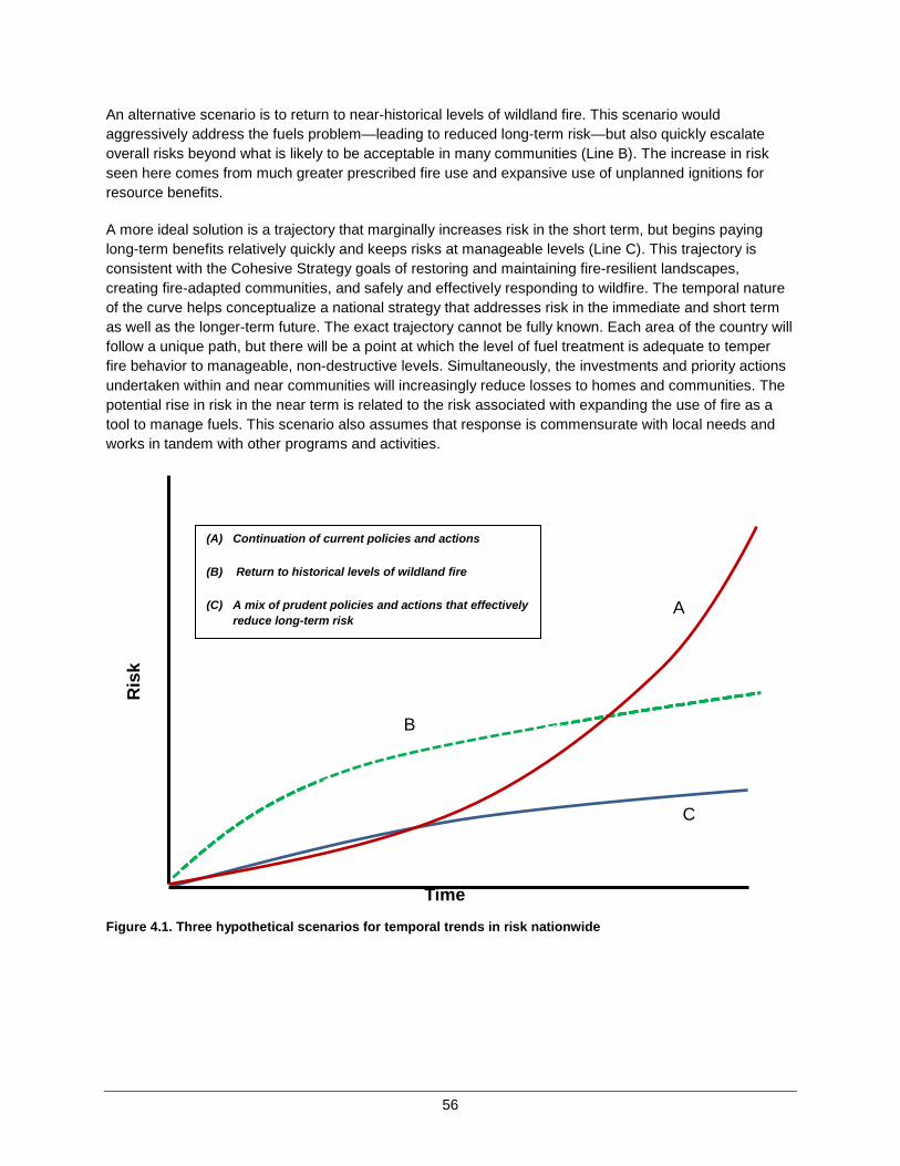
56
An alternative scenario is to return to near-historical levels of wildland fire. This scenario would aggressively address the fuels problem—leading to reduced long-term risk—but also quickly escalate overall risks beyond what is likely to be acceptable in many communities (Line B). The increase in riskseen here comes from much greater prescribed fire use and expansive use of unplanned ignitions for resource benefits.
A more ideal solution is a trajectory that marginally increases risk in the short term, but begins paying long-term benefits relatively quickly and keeps risks at manageable levels (Line C). This trajectory is consistent with the Cohesive Strategy goals of restoring and maintaining fire-resilient landscapes, creating fire-adapted communities, and safely and effectively responding to wildfire. The temporal nature of the curve helps conceptualize a national strategy that addresses risk in the immediate and short term as well as the longer-term future. The exact trajectory cannot be fully known. Each area of the country will follow a unique path, but there will be a point at which the level of fuel treatment is adequate to temper fire behavior to manageable, non-destructive levels. Simultaneously, the investments and priority actions undertaken within and near communities will increasingly reduce losses to homes and communities. The potential rise in risk in the near term is related to the risk associated with expanding the use of fire as a tool to manage fuels. This scenario also assumes that response is commensurate with local needs and works in tandem with other programs and activities.
Figure 4.1. Three hypothetical scenarios for temporal trends in risk nationwide
Time
Ris
k
A
B
C
(A) Continuation of current policies and actions
(B) Return to historical levels of wildland fire
(C) A mix of prudent policies and actions that effectively reduce long-term risk
57
Attaining the national risk trajectory described above and characterized by Line C will not be simple or easy. Three key assumptions or premises underlie meaningful reductions in risk:
1. Prioritization of investment and use of resources. Reducing risk significantly will require that existing resources are used more efficiently. From a national perspective, this may require reallocation of resources across agencies, geographical areas, or program areas.
2. Acceptance of increased short-term risk. Significantly reducing fuels across broad landscapes will require expanded use of wildland fire to achieve management objectives. Using fire as a tool carries inherent risks that must be considered in the short-term to achieve the longer-term benefits.
3. Greater collective investment. Even with greater efficiency and acceptance of short-term risk, current levels of investment may be inadequate to achieve the levels of risk reduction desired. All who have a stake in the outcome, from individual property owners to the Federal, state, tribal, and local governments, must share the costs and level of effort necessary to redeem responsibilities for reducing risks posed by wildfire.
The wide variation in conditions and circumstances across the country makes it impractical to identify specific actions that are best suited to each and every location. Nevertheless, the analysis of landscape classes and community clusters in Chapter 2 can be combined with management opportunities explored in Chapter 3 to suggest potential national priorities for increased emphasis.
In the following sections, the general principles for the National Strategy are outlined and the four national challenges are revisited to create spatial prioritization maps for the Nation.
National Guidance The first element of this National Strategy is a set of heuristics or rules of thumb to provide basic guidance when planning activities. Such heuristics are meant to be broadly applicable and generally accurate, but not rigidly enforced when local circumstances suggest more prudent courses of action.
The first rule is that safe and effective response to wildfires must be the highest priority of the National Strategy. Placing priority on protecting the safety and health of the public and firefighters implies the need for, and assumption of, a safe and effective response organization. This presumes that immediate threats are the most important—and wildfires are an immediate threat throughout the country. Improving preparedness can take many forms. Although resources such as equipment and personnel improve the ability to respond, improved coordination, communication, and training are important components of intergovernmental preparedness and should be included regional or national strategy. Large wildfires that threaten entire communities are relatively rare, yet their impact on public perception and the reality that large fires near communities can have catastrophic consequences requires special attention.
General guidance regarding response includes:
• Enhance wildfire response preparedness in areas more likely to experience large, long-duration wildfires that are unwanted or threaten communities and homes.
• Enhance wildfire response preparedness in areas experiencing high rates of structure loss per area burned.
58
• At the community level, emphasize both structure protection and wildfire prevention to enhance the effectiveness of initial response.
It would be shortsighted to assume that a safe and effective response to fire is the only priority. Indeed, one could argue that the suppression challenges today are symptomatic of more fundamental underlying issues. The current trajectory of increasing risk cannot be headed off by simply adding more preparedness and suppression resources.
The gradual accumulation of wildland fuels is perhaps the most difficult and challenging issue to address. An analogy can be made to walking up the down escalator. One has to be moving just to stay in place; the only way to move up is to move faster than the escalator is moving down. Despite current investments in priority areas being treated through fuels management or burned in wildfires, some landscapes are accumulating fuels at a rate faster than can be managed. Broad-scale efforts to reduce fuels across the landscape can be expensive and time-consuming and require strategic coordination regardless of which type of fuels management activity is implemented. Prescribed fire and managing wildfire for resource objectives have the greatest potential for treating large areas at lower cost than mechanical treatments, but use of fire entails greater inherent risk that must be addressed at a local level. Mechanical, biological, or chemical treatments play an important role wherever they are economically feasible. Success in collectively investing in managing fuels nationally with measurable results in the short- and long-term will not be achieved overnight.
General guidance regarding vegetation and fuels management include:
• Where wildfires are unwanted or threaten communities and homes, design and prioritize fuel treatments (prescribed fire, and mechanical, biological and chemical treatments) to reduce fire intensity, structure ignition, and wildfire extent.
• Where feasible, implement strategically placed fuel treatments to interrupt fire spread across landscapes.
• Continue and expand the use of prescribed fire to meet landscape objectives, improve ecological conditions, and reduce the potential for high-intensity wildfires.
• Where allowed and feasible, manage wildfire for resource objectives and ecological purposes to restore and maintain fire-adapted ecosystems and achieve fire-resilient landscapes.
• Use and expand fuel treatments involving mechanical, biological, or chemical methods where economically feasible and sustainable, and where they align with landowner objectives.
Activities that focus on individual homes or structures and community-level protection are important components of the National Strategy. Efforts that engage communities in taking proactive action before wildfires need public support, work in conjunction with other actions, enhance management flexibility in response, and are not necessarily expensive. General guidance regarding homes and communities include:
• Promote community and homeowner involvement in planning and implementing actions to mitigate the risk posed by wildfire to communities and homes situated near or adjacent to natural vegetation.
• Emphasize proactive wildfire risk mitigation actions, such as CWPPs and other methods of comprehensive community planning, where new development and expansion into natural vegetation is occurring.
• Pursue municipal, county, and state building and zoning codes and ordinances that mitigate fire risk to protect life and property from wildfire.
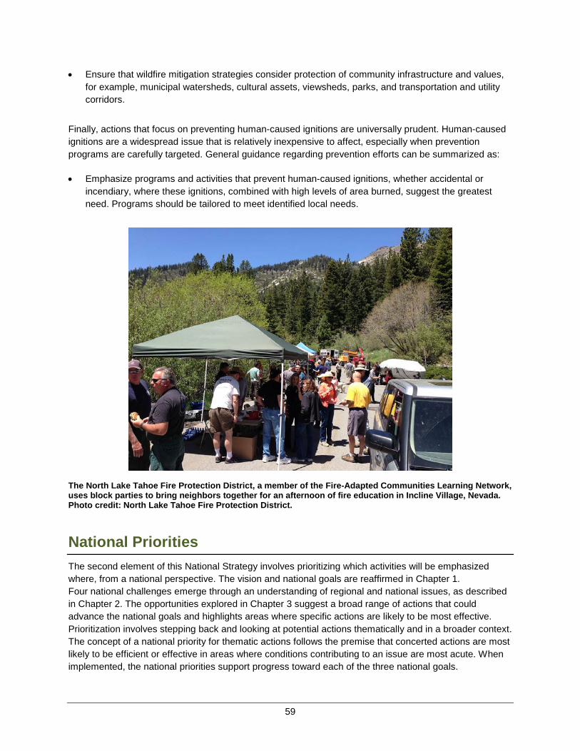
59
• Ensure that wildfire mitigation strategies consider protection of community infrastructure and values, for example, municipal watersheds, cultural assets, viewsheds, parks, and transportation and utility corridors.
Finally, actions that focus on preventing human-caused ignitions are universally prudent. Human-caused ignitions are a widespread issue that is relatively inexpensive to affect, especially when prevention programs are carefully targeted. General guidance regarding prevention efforts can be summarized as:
• Emphasize programs and activities that prevent human-caused ignitions, whether accidental or incendiary, where these ignitions, combined with high levels of area burned, suggest the greatest need. Programs should be tailored to meet identified local needs.
The North Lake Tahoe Fire Protection District, a member of the Fire-Adapted Communities Learning Network, uses block parties to bring neighbors together for an afternoon of fire education in Incline Village, Nevada. Photo credit: North Lake Tahoe Fire Protection District.
National Priorities The second element of this National Strategy involves prioritizing which activities will be emphasized where, from a national perspective. The vision and national goals are reaffirmed in Chapter 1. Four national challenges emerge through an understanding of regional and national issues, as described in Chapter 2. The opportunities explored in Chapter 3 suggest a broad range of actions that could advance the national goals and highlights areas where specific actions are likely to be most effective. Prioritization involves stepping back and looking at potential actions thematically and in a broader context. The concept of a national priority for thematic actions follows the premise that concerted actions are most likely to be efficient or effective in areas where conditions contributing to an issue are most acute. When implemented, the national priorities support progress toward each of the three national goals.

60
Figure 4.2 illustrates the basic relationship between national goals, challenges, options, spatially prioritized opportunities, and national priorities.
Figure 4.2. Generalized relationship between the three national goals and the development of national priorities.
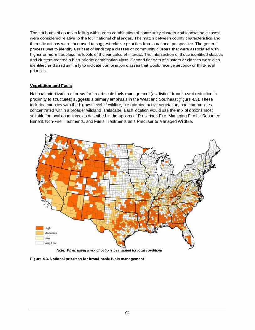
61
The attributes of counties falling within each combination of community clusters and landscape classes were considered relative to the four national challenges. The match between county characteristics and thematic actions were then used to suggest relative priorities from a national perspective. The general process was to identify a subset of landscape classes or community clusters that were associated with higher or more troublesome levels of the variables of interest. The intersection of these identified classes and clusters created a high-priority combination class. Second-tier sets of clusters or classes were also identified and used similarly to indicate combination classes that would receive second- or third-level priorities.
Vegetation and Fuels
National prioritization of areas for broad-scale fuels management (as distinct from hazard reduction in proximity to structures) suggests a primary emphasis in the West and Southeast (figure 4.3). These included counties with the highest level of wildfire, fire-adapted native vegetation, and communities concentrated within a broader wildland landscape. Each location would use the mix of options most suitable for local conditions, as described in the options of Prescribed Fire, Managing Fire for Resource Benefit, Non-Fire Treatments, and Fuels Treatments as a Precusor to Managed Wildfire.
Figure 4.3. National priorities for broad-scale fuels management
Note: When using a mix of options best suited for local conditions
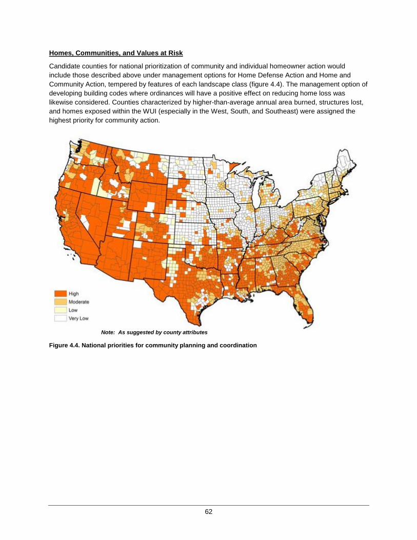
62
Homes, Communities, and Values at Risk
Candidate counties for national prioritization of community and individual homeowner action would include those described above under management options for Home Defense Action and Home and Community Action, tempered by features of each landscape class (figure 4.4). The management option of developing building codes where ordinances will have a positive effect on reducing home loss was likewise considered. Counties characterized by higher-than-average annual area burned, structures lost, and homes exposed within the WUI (especially in the West, South, and Southeast) were assigned the highest priority for community action.
Figure 4.4. National priorities for community planning and coordination
Note: As suggested by county attributes
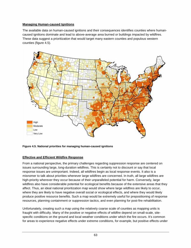
63
Managing Human-caused Ignitions
The available data on human-caused ignitions and their consequences identifies counties where human-caused ignitions dominate and lead to above-average area burned or buildings impacted by wildfires.These data suggest a prioritization that would target many eastern counties and populous western counties (figure 4.5).
Figure 4.5. National priorities for managing human-caused ignitions
Effective and Efficient Wildfire Response
From a national perspective, the primary challenges regarding suppression response are centered on issues surrounding large, long-duration wildfires. This is certainly not to discount or say that local response issues are unimportant. Indeed, all wildfires begin as local response events. It also is a misnomer to talk about priorities whenever large wildfires are concerned. In truth, all large wildfires are high-priority wherever they occur because of their unparalleled potential for harm. Conversely, large wildfires also have considerable potential for ecological benefits because of the extensive areas that they affect. Thus, an ideal national prioritization map would show where large wildfires are likely to occur, where they are likely to have negative overall social or ecological effects, and where they would likely produce positive resource benefits. Such a map would be extremely useful for prepositioning of response resources, planning containment or suppression tactics, and even planning for post-fire rehabilitation.
Unfortunately, creating such a map using the relatively coarse scale of counties as mapping units is fraught with difficulty. Many of the positive or negative effects of wildfire depend on small-scale, site-specific conditions on the ground and local weather conditions under which the fire occurs. It’s common for areas to experience negative effects under extreme conditions, for example, but positive effects under
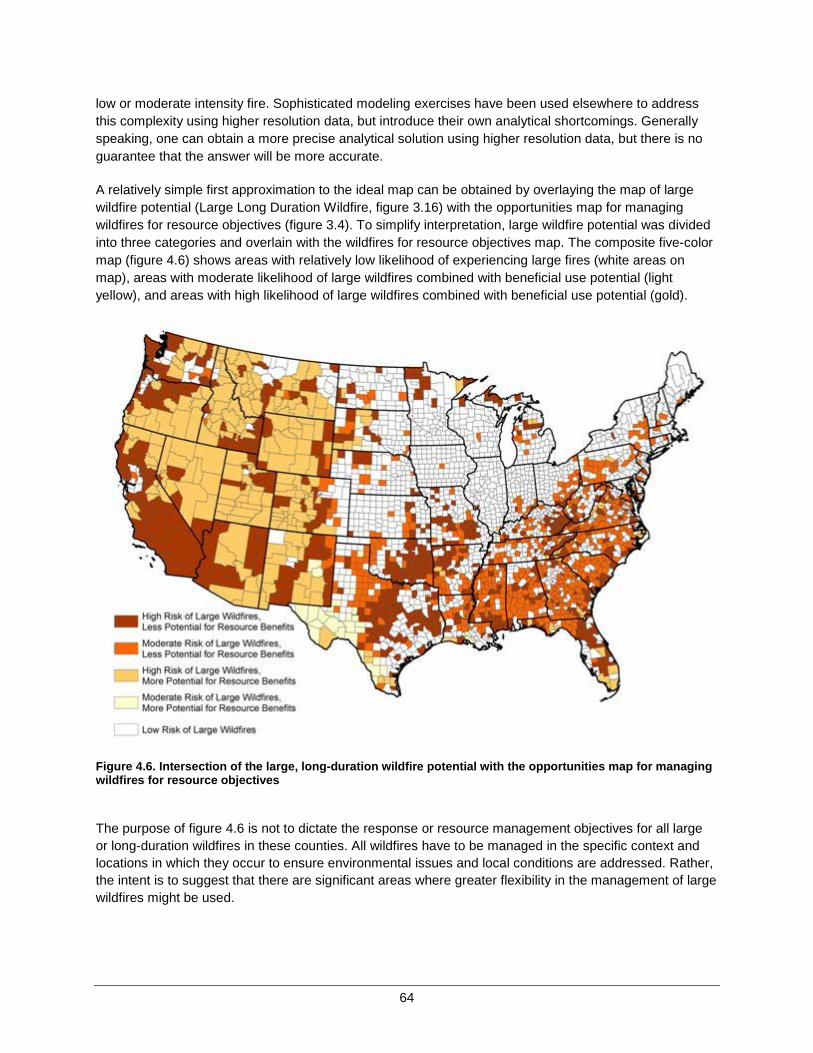
64
low or moderate intensity fire. Sophisticated modeling exercises have been used elsewhere to address this complexity using higher resolution data, but introduce their own analytical shortcomings. Generally speaking, one can obtain a more precise analytical solution using higher resolution data, but there is no guarantee that the answer will be more accurate.
A relatively simple first approximation to the ideal map can be obtained by overlaying the map of large wildfire potential (Large Long Duration Wildfire, figure 3.16) with the opportunities map for managing wildfires for resource objectives (figure 3.4). To simplify interpretation, large wildfire potential was divided into three categories and overlain with the wildfires for resource objectives map. The composite five-color map (figure 4.6) shows areas with relatively low likelihood of experiencing large fires (white areas on map), areas with moderate likelihood of large wildfires combined with beneficial use potential (light yellow), and areas with high likelihood of large wildfires combined with beneficial use potential (gold).
Figure 4.6. Intersection of the large, long-duration wildfire potential with the opportunities map for managing wildfires for resource objectives
The purpose of figure 4.6 is not to dictate the response or resource management objectives for all large or long-duration wildfires in these counties. All wildfires have to be managed in the specific context and locations in which they occur to ensure environmental issues and local conditions are addressed. Rather, the intent is to suggest that there are significant areas where greater flexibility in the management of large wildfires might be used.
65
Conversely, there are broad areas where the resource benefits from large or long-duration wildfires are likely outweighed by other concerns. One key to being able to use greater flexibility is the ability to anticipate or quickly assess the risk posed from an individual event. Ironically, the current suppression capacity in some areas is inversely proportional to the likelihood of a wildfire creating positive ecological benefits. That is, organizations as a whole are most effective at controlling wildfires that are likely to be beneficial, and least able to contain those wildfires that are likely to be most damaging. The net result is that we may be extinguishing many fires with the greatest potential for good. Enhanced, rapid risk assessment tools that help inform incident response decisions could be highly beneficial in this context.
Chapter 4 Summary
There are two primary elements to the National Strategy: a set of general guidelines for choosing among and implementing management actions and a set of four national priority maps. The spatial prioritization maps work in tandem with the opportunity maps presented in Chapter 3. Management options were mapped in an attempt to show where they would be most reasonable or potentially effective and generally were developed independent of each other. The prioritization maps reflect a higher level of aggregation in that multiple management options can be employed in the same location for similar purposes. Both sets of maps are intended to highlight opportunities and priorities, not to exclude the use of any management option from other locations.
Similarly, the purpose in developing the classification systems for counties that underlies the prioritization maps was to create a common set of narratives that would be broadly applicable, not to identify individual counties for a particular prescription. Therefore, if errors in data or interpretation erroneously led to a misclassification of a county, it is anticipated that more localized planning efforts would correct such errors and adjust county-level recommendations appropriately.
Additionally, implementation of any management option requires a trained, committed, and supported workforce. It is likely that the same individuals will be called upon to implement multiple facets of the overall strategy. For example, first responders may be the only ones with the requisite knowledge and experience to conduct prescribed burning in many locations. If they are occupied responding to wildfires, prescribed burning is cancelled or postponed. Similarly, the best ambassadors for prevention programs and community planning are often local firefighters.

67
CHAPTER 5 – IMPLEMENTATION The Cohesive Strategy effort is remarkable, indeed unique, in terms of its broad scope and inclusiveness. The broad aspirations of the effort and the collaboration needed to approach it offer great strengths, but do not come easy. Reaching across all lands and including all parties in the development of a comprehensive and coherent effort to manage and live with wildland fire has required unprecedented effort. Even more effort will be required during implementation—where the vision and strategy become a reality through real-world activities on the ground.
Successful implementation requires three basic elements to be operating in tandem:
• Strategic Alignment − All parties agree to the same goals, principles, and strategic course of action. • Communications and Collaborative Engagement − This includes governance, shared information
and resources, communications, and monitoring and accountability. • Programmatic Alignment − Individual agency or organization objectives are explicitly supportive of
the national cohesive strategy goals, recognizing the disparate missions, roles and responsibilities of each, the cascade of decisions required, and fiscal realities and constraints.
The WFLC provides a national, intergovernmental venue for a collaborative approach to implementing the National Strategy. All partners and stakeholders to the National Strategy have a commitment and responsibility to take necessary actions for implementation. Those actions should take place in a coordinated, collaborative manner, using the actions and activities identified in Regional Action Plans, as appropriate.
Strategic Alignment Considerable progress has been made with regard to strategic alignment during the multiple phases of the Cohesive Strategy efforts to date. The National Strategy presented herein and the subsequent National Action Plan set the strategic, intergovernmental direction for pursuing policy priorities and implementation of actions nationally. These outcomes of the Cohesive Strategy represent successful collaborative engagement at regional and national levels for the purposes of strategic planning. Moving into the next stages of implementation will require continuing and expanding collaborative engagement, but with a change in focus toward greater emphasis on programmatic alignment.
National Action Plan
The National Action Plan and the Regional Action Plans were developed to be complementary. The intent of the National Action Plan is to articulate a framework of national, strategic action for supporting the implementation actions and tasks necessary at various scales.
Actions will be derived from the following sources:
• National guidance and national priorities defined in this strategy; • The barriers and critical success factors identified in Phase II and III of the Cohesive Strategy; • Regional action plans containing actions that are national in scope or common to multiple regions.
68
Accountability and Monitoring
A set of national outcome performance measures will allow Congress, the national wildland fire management community, and other stakeholders to monitor and assess progress toward achieving the results for each of the three national goals. Establishing intermediate performance measures beneath the national outcome measures allows for a more narrowly focus means to measure the specific activities that must occur for progress to be made in achieving the desired national outcomes. Intermediate measures are statements describing the level of performance to be accomplished within a timeframe, expressed as a tangible, measurable objective or as a quantitative standard, value, or rate.
Throughout the Cohesive Strategy effort, it has been recognized that one size does not fit all in a country as large and diverse as the United States. Therefore, national outcome measures will flow directly from the national vision and goals, and will be intentionally broad to be inclusive of many different factors across geographic regions. Together, the national measures will enable us to communicate progress toward meeting the shared goals. The measures will help leadership and managers answer questions such as:
• Are landscapes resilient to wildfire in support of our management objectives? • Can human populations and infrastructure in communities at risk withstand wildfire without loss? • Is there effective collaboration in using risk management to improve the safety, effectiveness and
efficiency of our wildland fire management actions?
Federal agencies are accountable to the Administration and Congress through formal performance measures and reporting requirements. National outcome performance measures as a result of the Cohesive Strategy effort would not supersede the formal agency performance measures, but should be used to demonstrate and report progress toward achieving the Cohesive Strategy goals. Agencies and organizations with a stake in wildland fire management will be encouraged to seek alignment with or incorporation of a shared set of national outcome measures into their own planning and performance processes. National outcome measures are important to drive progress, implementation of the Cohesive Strategy will include actions and commitments to collect the information required for these measures.
In addition to national outcome and intermediate measures, associated efficiency measures for each goal have utility in measuring the efficiency of investments related to significant cost centers associated with each goal. Specifically, efficiency measures are used to:
• Track priority investments by Cohesive Strategy goal, over time with the intent of establishing trend information (where applicable) on the effects of investments to achieve goal outcomes.
• Help assess which investments are the most cost-effective means of achieving the goals in order to make informed investment tradeoffs with respect to wildland fire program appropriations.
Communication and Collaborative Engagement A National Communication Framework was developed to provide communication guidance and support to agencies, organizations, stakeholders, and interested individuals involved in implementing and institutionalizing the Cohesive Strategy. Keeping people informed, implementing communication processes that enhance and sustain collaboration among stakeholders, and guiding future communication efforts are all necessary components of implementation.
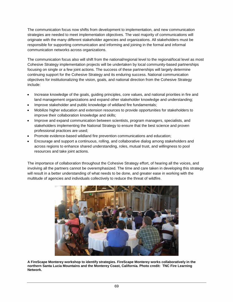
69
The communication focus now shifts from development to implementation, and new communication strategies are needed to meet implementation objectives. The vast majority of communications will originate with the many different stakeholder agencies and organizations. All stakeholders must be responsible for supporting communication and informing and joining in the formal and informal communication networks across organizations.
The communication focus also will shift from the national/regional level to the regional/local level as most Cohesive Strategy implementation projects will be undertaken by local community-based partnerships focusing on single or a few joint actions. The success of these partnerships will largely determine continuing support for the Cohesive Strategy and its enduring success. National communication objectives for institutionalizing the vision, goals, and national direction from the Cohesive Strategy include:
• Increase knowledge of the goals, guiding principles, core values, and national priorities in fire and land management organizations and expand other stakeholder knowledge and understanding;
• Improve stakeholder and public knowledge of wildland fire fundamentals; • Mobilize higher education and extension resources to provide opportunities for stakeholders to
improve their collaboration knowledge and skills; • Improve and expand communication between scientists, program managers, specialists, and
stakeholders implementing the National Strategy to ensure that the best science and proven professional practices are used;
• Promote evidence-based wildland fire prevention communications and education; • Encourage and support a continuous, rolling, and collaborative dialog among stakeholders and
across regions to enhance shared understanding, roles, mutual trust, and willingness to pool resources and take joint actions.
The importance of collaboration throughout the Cohesive Strategy effort, of hearing all the voices, and involving all the partners cannot be overemphasized. The time and care taken in developing this strategy will result in a better understanding of what needs to be done, and greater ease in working with the multitude of agencies and individuals collectively to reduce the threat of wildfire.
A FireScape Monterey workshop to identify strategies. FireScape Monterey works collaboratively in the northern Santa Lucia Mountains and the Monterey Coast, California. Photo credit: TNC Fire Learning Network.
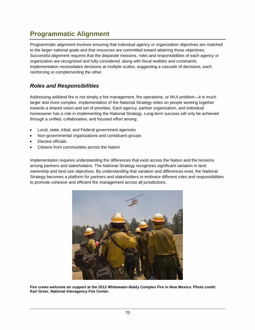
70
Programmatic AlignmentProgrammatic alignment involves ensuring that individual agency or organization objectives are matched to the larger national goals and that resources are committed toward attaining those objectives. Successful alignment requires that the disparate missions, roles and responsibilities of each agency or organization are recognized and fully considered, along with fiscal realities and constraints. Implementation necessitates decisions at multiple scales, suggesting a cascade of decisions, each reinforcing or complementing the other.
Roles and Responsibilities
Addressing wildland fire is not simply a fire management, fire operations, or WUI problem—it is much larger and more complex. Implementation of the National Strategy relies on people working together towards a shared vision and set of priorities. Each agency, partner organization, and individual homeowner has a role in implementing the National Strategy. Long-term success will only be achieved through a unified, collaborative, and focused effort among:
• Local, state, tribal, and Federal government agencies• Non-governmental organizations and constituent groups • Elected officials • Citizens from communities across the Nation
Implementation requires understanding the differences that exist across the Nation and the tensions among partners and stakeholders. The National Strategy recognizes significant variation in land ownership and land use objectives. By understanding that variation and differences exist, the National Strategy becomes a platform for partners and stakeholders to embrace different roles and responsibilities to promote cohesive and efficient fire management across all jurisdictions.
Fire crews welcome air support at the 2012 Whitewater-Baldy Complex Fire in New Mexico. Photo credit:Kari Greer, National Interagency Fire Center.
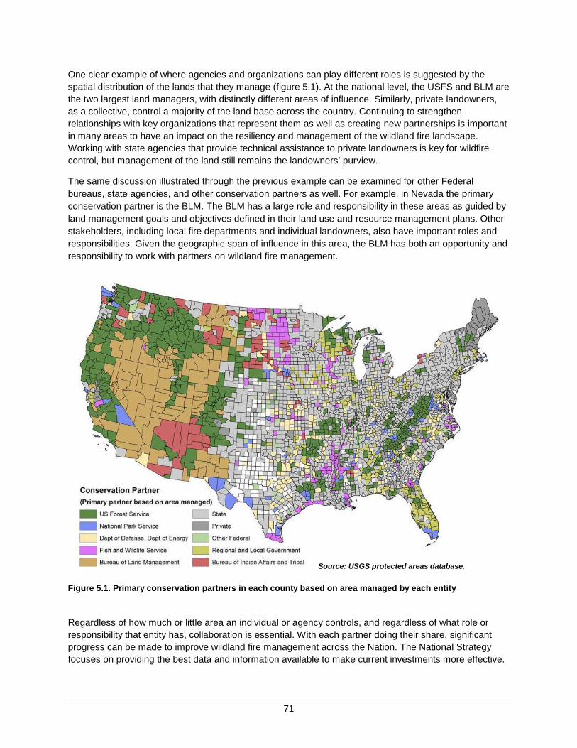
71
One clear example of where agencies and organizations can play different roles is suggested by the spatial distribution of the lands that they manage (figure 5.1). At the national level, the USFS and BLM are the two largest land managers, with distinctly different areas of influence. Similarly, private landowners, as a collective, control a majority of the land base across the country. Continuing to strengthen relationships with key organizations that represent them as well as creating new partnerships is important in many areas to have an impact on the resiliency and management of the wildland fire landscape. Working with state agencies that provide technical assistance to private landowners is key for wildfire control, but management of the land still remains the landowners’ purview.
The same discussion illustrated through the previous example can be examined for other Federal bureaus, state agencies, and other conservation partners as well. For example, in Nevada the primary conservation partner is the BLM. The BLM has a large role and responsibility in these areas as guided by land management goals and objectives defined in their land use and resource management plans. Other stakeholders, including local fire departments and individual landowners, also have important roles and responsibilities. Given the geographic span of influence in this area, the BLM has both an opportunity and responsibility to work with partners on wildland fire management.
Figure 5.1. Primary conservation partners in each county based on area managed by each entity
Regardless of how much or little area an individual or agency controls, and regardless of what role or responsibility that entity has, collaboration is essential. With each partner doing their share, significant progress can be made to improve wildland fire management across the Nation. The National Strategy focuses on providing the best data and information available to make current investments more effective.
Source: USGS protected areas database.

72
Informing Decisions at Multiple Scales
Translating national priorities into local action requires complementary implementation decisions to be made at multiple scales. This is often referred to as the “cascade of decisions.” While allocation and implementation decisions cannot be mandated, cooperating agencies and organizations have a better chance of reducing overall risks by adopting strategic direction in the National Strategy and sharing information and analytical tools developed collaboratively. To illustrate the cascade of decisions possible, two examples are described below. The examples illustrate how separate agencies might use the national priorities, analysis information and tools, and national and regional action plans to inform choices made at various scales. These examples are hypothetical and may be implemented differently than described, but they illustrate how the information could be used.
Example 1. Grants for Mitigation and Assistance to Communities
The Department of Homeland Security (DHS) through the Federal Emergency Management Agency (FEMA) oversees several grant programs aimed at providing support to states, counties, local fire departments, and communities to prepare for and recover from wildfire. It is possible that FEMA, with the assistance of the U.S. Fire Administration (USFA), could establish criteria recognizing that some counties across the United States are more likely to experience damaging wildfire than other counties. The National Strategy established spatially explicit priorities for addressing Home, Community and Other Values as Risk and national priorities for Managing Human-caused Ignitions. These priorities could be used to review and refine grant-funding priorities for applicants with proposals seeking to address wildfire risk in the high-priority areas. The states, in turn, could encourage and prioritize submissions from counties and communities that are within the high-priority areas. The current FEMA Assistance to Firefighters Grants and Fire Prevention and Safety Grants are competitively awarded directly to local fire departments (and other eligible applicants). The FEMA could use the National Strategy priorities to aid in reviewing and awarding grants.
Example 2. Federal Investment in Reducing Fuels
The USFS invests considerable effort in fuels reduction. The funding and prioritization process has regional and national components. The National Strategy’s priorities for broad-scale fuels management could help to inform the funding and prioritization processes at the regional and national levels. The current prioritization process could include the national spatial priorities for managing fuels as one layer in the overall analysis with emphasis on areas analyzed as likely to benefit from broad-scale fuels management treatments. If adopted at the regional and national levels, the use of funding to prioritize treatments should result in more efficient and effective treatments to achieve broad-scale fuels objectives.
A benefit of defining goals and priorities from an intergovernmental perspective is the ability of key stakeholders to contribute to a more holistic and effective approach to addressing wildfire risk. The examples discussed illustrate the potential applicability of the National Strategy to existing decision processes for resource allocation and implementation decisions. Reviewing existing allocation and implementation decision processes in light of the national strategic priorities may reveal opportunities for greater efficiency and effectiveness. Likewise, seemingly independent decisions can have a greater impact when focused on a priority that is shared among the many stakeholders. Leveraging resources—a guiding principle of the Cohesive Strategy—is enhanced by programmatic alignment of individual decisions with common goals and priorities.

73
Conclusion The ultimate success of the Cohesive Strategy effort depends on how strategic direction and national priorities can be translated into the on-the-ground, local actions of agencies, organizations, governments, and individuals with meaningful cumulative effects. Planning efforts thus far have established a firm foundation for achieving strategic alignment, one of the three pillars of a successful strategy. Collaborative engagement, a second pillar of success, has been a staple of the planning efforts thus far, and will continue to be a high priority for involved partners.
The final pillar, programmatic alignment, is unique in that it begins to shift the focus back to individual roles, responsibilities, and actions of entities, agencies, organizations, and the public at large. Alignment with the strategic direction and national priorities is essential in this shift. As implementation proceeds, actions become far more specific and less nebulous. Implications in terms of cost, who acts, and who benefits are describable. Tradeoffs among actions become clear. By establishing national priorities and ensuring alignment of programs, policies, regulations, and actions to national direction, meaningful reductions in risk are possible through concerted, collaborative implementation.


75
APPENDIX A: ACKNOWLEDGEMENTS – COMMITTEES, COUNCILS, AND WORK
GROUPS
National Science and Analysis Team
Phase III Contributors
The National Science and Analysis Team is led by Danny C. Lee (USDA Forest Service) and Thomas M. Quigley (METI Corporation) and included over 60 individuals from various agencies, organizations and universities (see Phase II report).
The national analysis described in this report was completed by a small team from the NSAT using much of the information assembled and prepared previously by the NSAT. In addition to Drs. Lee and Quigley, the national analysis team included Steve Norman and William Christie from the USDA Forest Service, and James Fox, Karin Rogers, and Matthew Hutchins from the University of North Carolina – Asheville.
In addition the NSAT, a national science advisory committee was assembled to support the NSAT in completing the national analysis. The members of that committee included Jenna Sloan (DOI), Rob Doudrick (USFS Research), Douglas MacDonald (IAFC and WRSC), Paige Lewis (TNC), Mike Zupko (SE RSC), Brad Simpkins (NE RSC), Caitlyn Pollihan (States), and Dan Olsen (FS).


77
Cohesive Strategy Subcommittee
Name Agency / Organization
Dan Smith, Chair NASF Patti Blankenship, Primary Member DHS-FEMA-USFA Sandra Burnett USDA-USFS Erin Darboven DOI-OWF Judith Downing USDA-USFS Danny Lee USDA-USFS; NSAT Co-Lead Katie Lighthall Contractor with WGA; WRSC Coordinator Doug MacDonald, WFEC Liaison IAFC Larry Mastic Contractor for NAASF; NE RSC Coordinator; Dan Olsen, Primary Member USDA-USFS Caitlyn Pollihan, Primary Member Coalition of Western State Foresters (CWSF) Alan Quan USDA-USFS Tom Quigley METI Corporation; NSAT Co-Lead Brad Simpkins NH State Forester; NASF; NE RSC Chair Jenna Sloan, Primary Member DOI-OWF Ann Walker, Primary Member WGA Mike Zupko, Primary Member Southern Governors’ Association; SE RSC Chair
Other Phase III Contributors
Cheryl Renner Writer/Editor; Contractor Amparo Garcia Presidential Management Fellow, USDA-USFS-FAM Pat Goude Writer/Editor; USDA-USFS Enterprise Team Rachel Smith Writer/Editor; USDA-USFS
National Communications Work Group
Mary Jacobs Assistant City Manager, Sierra Vista, AZ, National League of Cities (NLC), WFEC Liaison
Judith Downing, Co-coordinator USDA-USFS Erin Darboven, Co-coordinator DOI-OWF Diane Denenberg NASF Amparo Garcia Presidential Management Fellow, USDA-USFS-FAM Genevieve O'Sullivan NASF Shawn Stokes IAFC

78
Wildland Fire Leadership Council (WFLC)
Name Agency / Organization
Rhea Suh WFLC Chair and Assistant Secretary for Policy, Management and Budget, DOI
Robert Bonnie Undersecretary, USDA-Natural Resources and the Environment (NRE) Butch Blazer Deputy Undersecretary, USDA-NRE Tom Tidwell Chief, USDA-USFS Mike Black Director, DOI-BIA Neil Kornze Principal Deputy Director, DOI-BLM Dan Ashe Director, DOI-FWS Jonathan Jarvis Director, DOI-NPS Suzette Kimball Director, DOI-USGS Ernest Mitchell Fire Administrator, DHS-FEMA-USFA John Kitzhaber Governor, State of Oregon; Western Governors’ Association (WGA) Dan Shoun Commissioner, Lake County, OR; NACo Tony Harwood Confederated Salish and Kootenai Tribes; ITC Bob Roper IAFC, Wildland Fire Policy Chair Jim Karels State Forester, Florida Forest Service; Chair, Fire Committee, NASF;
Forest Fire Protection Committee Mary Hamann-Roland Mayor, City of Apple Valley, MN; NLC Mary Fallin Governor, State of Oklahoma; National Governors’ Association (NGA)
79
Wildland Fire Executive Council (WFEC)
Name Agency / Organization
Tom Harbour WFEC Chair and Director, Fire and Aviation Management, USDA-USFS Jim Douglas Director, DOI-OWF Jim Erickson Fire Technical Specialist, Intertribal Timber Council Glenn Gaines Deputy Fire Administrator, DHS-FEMA-US Fire Administration Mary Jacobs Assistant City Manager, Sierra Vista, AZ; National League of Cities William Kaage NPS Fire Director, National Wildfire Coordinating Group Jim Karels State Forester, Florida Forest Service; Chair, Fire Committee, NASF;
Forest Fire Protection Committee Douglas MacDonald Retired Fire Chief; IAFC Wildland Fire Policy Committee Ryan Yates Associate Legislative Director, National Association of Counties Vacant National Governors’ Association Representative
Support Staff
Shari Eckhoff Designated Federal Official; Senior Advisor DOI/OWF
WFEC Alternates
Patti Blankenship DHS-FEMA-USFA Erik Litzenberg IAFC, Wildland Fire Policy Committee Dan Olsen USDA-USFS-FAM John Segar DOI-FWS-NWCG Dan Smith NASF, Forest Fire Protection Committee

80
Northeast Regional Strategy Committee
Name Agency / Organization
Brad Simpkins – NE RSC Chair NH State Forester; NASF Larry Mastic – NE RSC Coordinator Contractor for NAASF George Baker IAFC Gene Blankenbaker USDA-USFS-R9 Maureen Brooks USDA-USFS-NA S&PF Erin Darboven DOI-OWF Dan Dearborn DOI-FWS Jim Erickson ITC; WFEC Terry Gallagher USDA-USFS-R9 Rick Goutermont County Commissioner, Lake County, MN; NACo Danny Lee NE NSAT Lead; USDA-USFS Jim Loach DOI-NPS Steve Olson Fond du Lac Reservation Tom Remus DOI-BIA Matt Rollins DOI-USGS Tom Schuler USDA-USFS Research
Other Phase III Contributors
Jolene Ackerman Wisconsin State WUI Coordinator Mark Boche USDA-USFS-R9 Paul Charland DOI-FWS Dave Crary DOI-NPS Tom Parent Executive Director, Northeast Fire Compact Ron Stoffel Minnesota State Fire Supervisor, Great Lakes Fire Compact Glen Stratton DOI-FWS Randy Swaty The Nature Conservancy (TNC) Rick Vollick DOI-FWS Randy White Pennsylvania State Fire Supervisor, Mid-Atlantic Fire Compact
81
Southeast Regional Strategy Committee
Name Agency / Organization
Mike Zupko – RSC Chair Southern Governors’ Association Liz Agpaoa – RSC Co-Chair Regional Forester, Southern Region, USDA-USFS Forrest Blackbear DOI-BIA Tom Boggus Texas State Forester; NASF Rob Doudrick Station Director, Southern Research Station (SRS), USDA-USFS Wade Johnson NACo Pete Kubiak Chief, Division of Fire Management, DOI-FWS Samuel Larry DOI-NPS Tom Lowry Choctaw Nation Will May IAFC Alexa McKerrow Biologist, DOI-USGS Kier Klepzig Assistant Director, SRS, USDA-USFS (SRS Alternate) Shardul Raval Assistant Director, FAM, Southern Region, USDA-USFS (USFS
Alternate)
Other Phase III Contributors
Vince Carver DOI-FWS Dave Frederick Technical Working Group Chair, SGSF Fire Director Darryl Jones SC Forestry Commission Jim Karels WFEC Liaison; Florida State Forester Mark Melvin Jones Ecological Center Dan Olsen (Past USFS Alternate) Deputy Director, Fire & Aviation
Management (FAM), WO USDA-USFS Alan Quan CSSC Liaison, USDA-USFS Rachel Smith USDA-USFS Tom Spencer TX A&M Forest Service
82
Western Regional Strategy Committee
Name Agency / Organization
Kent Connaughton Co-Chair; USDA-USFS Tony Harwood Co-Chair; Confederated Salish and Kootenai Tribes, ITC Ann Walker Co-Chair; Western Governors’ Association (WGA) Katie Lighthall WRSC Regional Coordinator; WGA Dick Bahr DOI-NPS Aitor Bidaburu DHS-FEMA-USFA; NWCG Gary Bowers DOI-BLM Kevin Burke City Manager, Flagstaff, AZ; NLC Chuck Bushey IAWF Robert Cope Lemhi County, ID; NACo Vincent Corrao Northwest Management, ID Carol Daly Flathead Policy Center, Co-Lead Dave Driscoll IAFC Amy Duffy Duffy Consulting, DOD Contractor Pam Ensley DOI-FWS Sam Foster Station Director, USDA-USFS-NRCS Colorado State Office Richard Homann Council of Western State Foresters Doug MacDonald WFEC Liaison; IAFC John Philbin DOI-BIA Alan Quan USDA-USFS; CSSC Liaison Vernon Stearns Spokane Tribes, ITC Craig Ziegler USDA-USFS-NRCS Regional Forester
Other Phase III Contributors
Leon Ben DOI-BIA (Alternate) Corey Butler CDC-NIOSH (Alternate) Rich Cowger Chief, Columbus Fire, MT; IAFC (Alternate) Jesse Duhnkrack DOI-NPS (Alternate) John Erixson Northwest Management (Alternate) Jonas Feinstein USDA-USFS-NRCS Colorado State Office (Alternate) Joe Freeland DOI-BLM (Alternate) Lynn Jungwirth Watershed Research and Training Council (WRTC) (Alternate) Phyllis Krietz DHS-FEMA-USFA (Alternate) Ron Mangold USDA-USFS Research Station (Alternate) Gary Moyer Colorado Association of Conservation Districts (Alternate) Peg Polichio USDA-USFS State and Private Forestry, Regions 6 and 10
(Alternate) Cheryl Renner Communications, Writer/Editor, Contractor Cyndi Sidles DOI-FWS Region 1 (Alternate)
83
APPENDIX B: COHESIVE STRATEGY ACHIEVEMENTS, RESOURCES AND
REFERENCES The catalyst for the effort to develop a cohesive strategy was the Federal Land Assistance, Management and Enhancement (FLAME) Act of 2009. Over the past three and a half years, significant milestones were achieved and described more fully as resources below. The National Cohesive Wildland Fire Management Strategy (Cohesive Strategy) effort was designed as a three-phased process to allow for the inclusiveness necessary to understand the complexities of managing wildfire risks across the Nation. Throughout the entire effort, applying best available science and creating environments for strong stakeholder engagement were established as critical to success.
Providing a Foundation
In 2010, the WFLC, agency leadership, and stakeholders agreed on the Cohesive Strategy goals: (1) Restore and Maintain Landscapes; (2) Fire-Adapted Communities; and (3) Response to Wildfire. In addition, the WFLC adopted the following vision for this century: To safely and effectively extinguish fire when needed; use fire where allowable; manage our natural resources; and as a Nation, to live with wildland fire.
More detailed information on the evolution of the Cohesive Strategy including public engagement, and approach can be found on www.forestsandrangelands.gov.
Foundational Documents
• Federal Wildland Fire Management Policy & Program Review 1995
• Quadrennial Fire and Fuel Review Report 2005
• Quadrennial Fire Review 2009
• A Call to Action, A New Wildland Fire Accord: It is in your Hands
• Mutual Expectations for Preparedness and Suppression in the Interface
• [“Missions Report”] Wildland Fire Protection and Response in the United States: The Responsibilities,
Authorities, and Roles of Federal, State, Local, and Tribal Government
• A Collaborative Approach for Reducing Wildland Fire Risks to Communities and the Environment: 10-
Year Strategy Implementation Plan (December 2006)
Phase I – The Blueprint
The first phase of the Cohesive Strategy was a blueprint for developing a wildland fire strategy that would not be limited to Federal lands, but would consider the needs of all lands and balance regional needs and perspectives with national planning.
Phase I set up the leadership and engagement structure for creating the strategy.
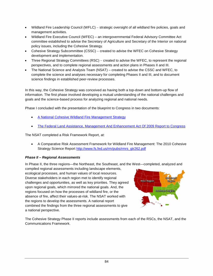
84
• Wildland Fire Leadership Council (WFLC) − strategic oversight of all wildland fire policies, goals and management activities.
• Wildland Fire Executive Council (WFEC) – an intergovernmental Federal Advisory Committee Act committee established to advise the Secretary of Agriculture and Secretary of the Interior on national policy issues, including the Cohesive Strategy.
• Cohesive Strategy Subcommittee (CSSC) − created to advise the WFEC on Cohesive Strategy development and implementation.
• Three Regional Strategy Committees (RSC) − created to advise the WFEC, to represent the regional perspectives, and to complete regional assessments and action plans in Phases II and III.
• The National Science and Analysis Team (NSAT) – created to advise the CSSC and WFEC, to complete the science and analyses necessary for completing Phases II and III, and to document science findings in established peer-review processes.
In this way, the Cohesive Strategy was conceived as having both a top-down and bottom-up flow of information. The first phase involved developing a mutual understanding of the national challenges and goals and the science-based process for analyzing regional and national needs.
Phase I concluded with the presentation of the blueprint to Congress in two documents:
• A National Cohesive Wildland Fire Management Strategy
• The Federal Land Assistance, Management And Enhancement Act Of 2009 Report to Congress
The NSAT completed a Risk Framework Report, at:
• A Comparative Risk Assessment Framework for Wildland Fire Management: The 2010 Cohesive Strategy Science Report http://www.fs.fed.us/rm/pubs/rmrs_gtr262.pdf
Phase II – Regional Assessments
In Phase II, the three regions—the Northeast, the Southeast, and the West—completed, analyzed and compiled regional assessments including landscape elements, ecological processes, and human values of local resources. Diverse stakeholders in each region met to identify regional challenges and opportunities, as well as key priorities. They agreed upon regional goals, which mirrored the national goals. And, the regions focused on how the processes of wildland fire, or the absence of fire, affect their values-at-risk. The NSAT worked with the regions to develop the assessments. A national report combined the findings from the three regional assessments to give a national perspective.
The Cohesive Strategy Phase II reports include assessments from each of the RSCs, the NSAT, and the Communications Framework.

85
National Resources
• A National Cohesive Wildland Fire Management Strategy-Phase II National Report • National Science Report – Phase
II http://www.forestsandrangelands.gov/strategy/documents/reports/phase2/NSAT_Phase_2_Summary_Report.pdf
• Communication Framework for A National Cohesive Wildland Fire Management Strategy
Regional Assessments
• A National Cohesive Wildland Fire Strategy: Southeastern Regional Assessment • A National Cohesive Wildland Fire Strategy: Northeast Regional Assessment, September 30, 2011 • A National Cohesive Wildland Fire Management Strategy: Western Regional Assessment and
Strategy
Phase III – Science-based Risk Analysis Reports and Action Plans
Phase III is the conclusion of the planning and development of the National Strategy and the National Action Plan. There were three distinct sets of milestones. The first part of Phase III focused on regional understanding and analysis of issues by the RSCs. The NSAT collected data from multiple sources to provide consistent information to the regions for their analysis of wildfire risk. The regions considered alternatives for emphasis, and Risk Analysis Reports were submitted and accepted by the WFEC. In additional to the individual Regional Risk Analysis Reports, a National Risk Analysis Report for Phase III was developed by the CSSC and accepted by the WFEC.
Regional Risk Analysis Reports
• Northeast Regional Risk Analysis Report • Southeast Regional Risk Analysis Report • Western Regional Risk Analysis Report
Regional Action Plans
The second part of Phase III focused on creating Action Plans for each region. The Action Plans looked at the issues identified in the Risk Analysis Reports and devised specific actions, tasks and responsible agencies to accomplish those actions. The Regional Action Plans were submitted and accepted by the WFEC. The WFEC tasked the CSSC to use the regional action plans to inform the development of the National Action Plan.
• Northeast Regional Action Plan, April 2013 • Southeast Regional Action Plan, April 2013 • Western Regional Action Plan, April 2013
The third part of Phase III focused on developing the National Strategy and National Action Plan. The NSAT also developed a science report based on the national risk analysis conducted to support the development of the National Strategy and National Action Plan.

86
Science and Analysis Published Work from Phase III
The Cohesive Strategy Decision Support Tools Library includes a number of resources based on the analysis completed as well as the published science report, Wildland Fire in America: The Scientific Basis for the National Cohesive Wildland Fire Strategy at: http://www.forestsandrangelands.gov/strategy/thestrategy.shtml
Cohesive Strategy Decisions Support Tools Library
Additional resources, tools, and information can be found in the Cohesive Strategy Decision-Support Tools Library at: http://www.forestsandrangelands.gov/strategy/thestrategy.shtml.

87
APPENDIX C: BARRIERS AND SUCCESS FACTORS
The Regional Strategy Committees (RSC) were tasked with conducting assessments, prioritizing actions that were responsive to regional goals, and identifying regional challenges and opportunities for improved land and fire management while ensuring consistency with the three national goals. In addition, the RSCs also identified a set of National Priority Barriers (barriers) and Critical Success Factors (success factors) that were found common to multiple regions. Barriers are obstacles that must be mitigated in order to be successful. Success factors are components that are important for improvement. Initially, a list of over 40 barriers and success factors was identified. Through discussions among the RSCs, the Cohesive Strategy Steering Committee (CSSC), and the WFEC, the following list of 11 were selected as being common to all regions and of significant importance to be addressed first.
• Success Factor: Fuels Management on Private Land
• Success Factor: Fuels Management on Federal Land
• Success Factor: Growth Management, Land Development, and Zoning Laws
• Barrier: Inefficiencies in the National Qualification Standards
• Barrier: Policy Barriers and Process Complexities for Sharing Resources
• Success Factor: Enforceable Fire Prevention State/Local Ordinances
• Success Factor: FEMA Grant Programs
• Success Factor: Assisting Communities at Risk
• Success Factor: Investing in Firefighting Workforce
• Success Factor: Improving Data that Support Fire Management Decisions
• Success Factor: Intergovernmental Wildland Fire Governance
The barriers and success factors informed both the national challenges and management options analyzed for this National Strategy. Additional detail on each barrier and success factor is included below.
• • Fuels Management on Private Land – There is a need to increase private land management assistance to complement and implement broader fuel reduction management objectives across fire-prone landscapes. There are a number of opportunities that should be examined to achieve increased fuels management on private land, including increasing the collaboration between actions taken on federal and private land as well as supporting federal conservation programs that provide assistance to achieve fuels management objectives across a landscape.

88
• Success Factor: Fuels Management on Federal Land – There is a need to increase private land management assistance to complement and implement broader fuel reduction management objectives across fire-prone landscapes. There are a number of opportunities that should be examined to achieve increased fuels management on private land, including increasing the collaboration between actions taken on federal and private land as well as supporting federal conservation programs that provide assistance to achieve fuels management objectives across a landscape.
• Success Factor: Growth Management, Land Development, and Zoning Laws – There is a need for growth management, land development, and zoning laws that require defensible space and wildland fire risk reduction actions as communities develop; and the maintenance of wildland fire risk reduction practices, e.g., defensible space, fire-resistant construction, hazard reduction, etc.
• Barrier: Inefficiencies in the National Qualification Standards – Address inefficiencies in the national qualification standards and procedures to increase response capabilities by developing one wildland fire qualification standard for the Federal, state, tribal, and local wildfire community. Currently, the publication National Wildfire Coordinating Group (NWCG) Product Management System (PMS) 310-1 provides qualifications for national mobilization and recognizes the ability to accept qualifications of local jurisdictions while in those jurisdictions. These standards are in sync with the Federal Emergency Management Agency National Integration Center (FEMA NIC) efforts to bridge the gap with local governments.
• Barrier: Policy Barriers and Process Complexities for Sharing Resources – There is a need to remove policy barriers and process complexities which affect the ability to effectively and efficiently share resources, not only for wildfire, but for fuels, prescribed fire work, and all-hazards situations. Under the 2010 Interagency Agreement for Wildland Fire Management (typically referred to as the Master Agreement) among the BIA, BLM, FWS, NPS, and USFS, agencies have the authority to share resources for fuels work; but the agencies are required to enter into separate agreements for personnel and other resources provided for planning and implementation of treatments and activities. Addressing inefficiencies in requirements and processes can improve the delivery and accomplishments of wildland fire management activities. Resource sharing is often hampered by travel restrictions, overtime caps, and administrative processes that require an inordinate amount of time to complete.
• Success Factor: Enforceable Fire Prevention State/Local Ordinances – There is a need to develop adequate, enforceable state and local ordinances related to wildfire prevention. There is clear evidence that small investments in fire prevention help reduce the high cost of fire suppression.
• Success Factor: FEMA Grant Programs – There is a need to examine existing grant programs aimed at providing support to states, counties, local fire departments, and communities to maximize fuels reduction across a landscape, and to prepare for and recover from wildfire. Grant programs present an opportunity to collaborate and promote fire-resilient landscapes and fire-adapted communities.
89
• Success Factor: Assisting Communities at Risk – Assist communities with evaluating their risk from wildfire. Provide communities with information and tools on how to mitigate risk from wildfire, create and conduct activities to become fire-adapted, and track their progress. Communications, education and outreach efforts must promote self-assessment and a connection to local expertise to sustain mitigation efforts.
• Success Factor: Investing in Firefighting Workforce – Invest in the firefighting capacity at the local level. Capacity from all entities with fire response responsibilities must be commensurate with the workload need and risks posed by wildfire, which in many areas is increasing. Investment in the fully trained firefighting workforce provides well-qualified firefighters on the ground to mitigate risk and hazards, capability to accomplish local risk mitigation projects, and initial attack success. In the long term we face a generation gap in the fire workforce available for future leadership of the program.
• Success Factor: Improving Data that Support Fire Management Decisions – Improved accuracy of LANDFIRE and other data is needed to support planning and analyses at various scales. LANDFIRE data are being used nationally to depict existing vegetation, surface and canopy fuels, fire regime condition class, and estimates of national fire hazard or risk. Without accurate data, many assumptions and actions based on these data will be compromised. There is a need for more realistic and accurate depiction of where wildland fire hazard or risk actually occurs across the country, which can be used to base decisions upon.
• Success Factor: Intergovernmental Wildland Fire Governance – There is a need for collaboration in intergovernmental wildland fire governance to serve the needs of all jurisdictions in both wildland fire and all-risk incidents.

91
APPENDIX D: GLOSSARY Abiotic – In biology, abiotic components are non-living chemical and physical factors in the environment.
Barriers – Policy or administrative impediments that must be removed for the Cohesive Strategy to be successful.
Biotic – Of, relating to, or resulting from living things, especially in their ecological relations
Collaboration - 1. Groups working together; 2. Groups working together to resolve difficult environmental issues through mediation, negotiation, and the building of agreements.
Critical success factors – Policies, programs, agreements, partnerships, resources, and other factors that must be present for the Cohesive Strategy to be successful.
Fire-adapted community – Human communities consisting of informed and prepared citizens collaboratively planning and taking action to safely co-exist with wildland fire.
Fire-adapted ecosystem – An ecosystem is “an interacting natural system, including all the component organisms, together with the abiotic environment and processes affecting them” (NWCG Glossary). A fire-adapted ecosystem is one that collectively has the ability to survive or regenerate (including natural successional processes) in an environment in which fire is a natural process.
Fire community – A term that collectively refers to all those who are engaged in any aspect of wildland fire-related activities.
Fire exclusion – The land management activity of keeping vegetation or ecosystems from burning in a wildland fire.
Fire management community – A subset of the fire community that has a role in and responsibility for managing wildland fires and their effects on the environment.
Fire science community – A subset of the fire community consisting of those who study, analyze, communicate, or educate others on the components of fire management that can be measured, such as fire behavior, fire effects, fire economics, and other related fire science disciplines.
Resilient – Generally referred to in this document as “resilient ecosystems,” which are those that resist damage and recover quickly from disturbances (such as wildland fires) and human activities.
Regime – A fire regime is the pattern, frequency, and intensity of wildland fire that prevails in an area.
Risk – A situation involving exposure to danger; the possibility that something unpleasant or unwelcome will happen.
Stakeholder – A person or group of people who has an interest and involvement in the process and outcome of a land management, fire management, or policy decision.
92
APPENDIX E: ACRONYMS BAER Burned Area Emergency Rehabilitation
BAR Burned Area Rehabilitation
BIA Bureau of Indian Affairs
BLM Bureau of Land Management
CWPP Community Wildfire Protection Plan
DHS Department of Homeland Security
DOD Department of Defense
DOI Department of the Interior
EACG Eastern Area Coordinating Group
FEMA Federal Emergency Management Agency
FEPP Federal Excess Personal Property
FFP Fire Fighter Property
FFT2 Firefighter 2
FLAME Federal Land Assistance and Enhancement Act
FLN Fire Learning Network
FRG Fire Regime Group
FWS U.S. Fish and Wildlife Service
FOC Fires of Concern
GACC Geographic Area Coordination Center
GAO Government Accountability Office
IAFC International Association of Fire Chiefs
IMT Incident Management Team
ITC Intertribal Timber Council
JFSP Joint Fire Science Program
MAC Multi‐Agency Coordination
MNICS Minnesota Incident Command System
MOA Memorandum of Agreement
MOU Memorandum of Understanding
93
NAASF Northeastern Area Association of State Foresters
NACo National Association of Counties
NASF National Association of State Foresters
NEMAC National Environmental Modeling and Analysis Center (UNC Asheville)
NFPA National Fire Protection Association
NGO Non‐Governmental Organization
NIFC National Interagency Fire Center
NLC National League of Cities
NPS National Park Service
NSAT National Science and Analysis Team (for Cohesive Strategy)
NWCG National Wildfire Coordinating Group
OWF Office of Wildland Fire (DOI)
PPE Personal Protective Equipment
RSC Regional Strategy Committee
SRS Southern Research Station (USDA-USFS)
TNC The Nature Conservancy
USDA U.S. Department of Agriculture
USFA U.S. Fire Administration
USFS U.S. Forest Service
VFA Volunteer Fire Assistance
VFD Volunteer Fire Department
WFEC Wildland Fire Executive Council
WFLC Wildland Fire Leadership Council
WG Working Group
WGA Western Governors’ Association
WUI Wildland-Urban Interface