
The Management of Protected Areas in Serengeti Ecosystem: A Case Study of Ikorongo and Grumeti Game...
29
Research Inventy: International Journal of Engineering And Science Vol.6, Issue 11 (December 2016), PP -22-50 Issn (e): 2278-4721, Issn (p):2319-6483, www.researchinventy.com 22 The Management of Protected Areas in Serengeti Ecosystem: A Case Study of Ikorongo and Grumeti Game Reserves (IGGRs) Zella, Adili .Y Department of Economic Studies The Mwalimu Nyerere Memorial Academy (MNMA)-Zanzibar P.O Box 307 Zanzibar, Tanzania Abstract: The study assessed the management of protected areas in Serengeti ecosystem using the case of IGGRs. Specifically, the study aimed at identifying the strategies used for natural resources management; examining the impacts of those strategies; examining the hindrances of the identified strategies; and lastly, examining the methods for scaling up the performance of strategies used for natural resources in the study area. The study involved two villages among 31 villages bordering IGGRs where in each village; at least 5% of the households were sampled. Both Primary data and secondary data were collected and analyzed both manually and computer by using SPSS software. The study revealed that, study population ranked IGGRs performance on protection of natural resources, especially on conserving wildlife for future generation and in reducing poaching to be good(53.3%). In addition, the relationship with IGGRs was said to be considerable good (46.7%). In the aspect of reducing poaching, the findings show that poaching has been reduced by 96.2% from 2009 to 2012. Furthermore, 81.4% of respondents said they use different strategies to control loss of natural resources which in turn has considerably improved the relationship between protected areas and the surrounding communities in some of the aspects. Despite of above successes, the study findings has revealed a number of challenges that hinders the full attainment of conservation objectives. Among the challenges are loss of life and properties (86.4%), shortage of water for livestock (68.9%) since water sources such as Grumeti and Rubana rivers are within protected area while the adjacent local communities do not have a free access to those water sources. Other challenges especially on the IGGRs management include insufficient fund base, working facilities and inadequate staffs. Based on the above findings, the study concluded that the strategies used for natural resources management of protected areas in Serengeti ecosystem is fairly sustainable and need functional participatory approaches of local people and other stakeholders in order to bring about a collaborative natural resources management network in the ecosystem. Furthermore, based on the findings above, equity in benefit sharing accrued from natural resource management in protected areas, more financial support to IGGRs and local community, the use of non-lethal deterrents for crop protection, integration of crop- livestock production systems, adoption of land use plans as a solution to land conflicts, strengthens of community based conservation (CBC), adoption of modern information technology such as geographical information system (GIS) and remote sensing are recommended. Keywords: Protected areas management (PAs), Wildlife conservation, Serengeti ecosystem I. Introduction 1.1 Background Information Wildlife conservation in Africa is not new to the indigenous people because from time immemorial they had practiced informal and traditional wildlife conservation. The formal or conventional wildlife conservation in Tanzania dates back from the German rule. These rulers created wildlife conservation areas (WCAs) which were known as Game reserves or Hunting reserves with the aim of regulating the exploitation of wild animals. For example, by the1911 the German rulers had set aside about 5% of the colony into 15 protected areas (PAs) to conserve wildlife (Baldus, 2000). Until then there was no WCA designated as national park. At the time of Tanzania‟s independence in 1961, there were only two national parks, that is, Serengeti and Lake Manyara. After independence Tanzania increased the wildlife conservation areas to 12 National parks, 31 game reserves, 38 game controlled areas and the Ngorongoro conservation area, all covering almost 28% of the land area (MNRT, 1998) In Africa destruction of wildlife habitats is a widespread phenomenon. Currently destruction is estimated to be 60% (Newmark & Hough, 2000). Human population pressure is cited as the main contributor to this loss, mainly through deforestation prompted by increased demand for arable land, settlements and fuelwood. According to Hinrichson,1994 the majority of sub-Saharan Africa's population is dependent on fuelwood: 82% of all Nigerians, 70% - Kenyans, 80% - Malagasies, 74% -Ghanaians, 93 - Ethiopians, 90% - Somalians and 81% - Sudanese. Tanzania as among of the African countries is not excluded from this scenario.
-
Upload
inventy -
Category
Engineering
-
view
11 -
download
2
Transcript of The Management of Protected Areas in Serengeti Ecosystem: A Case Study of Ikorongo and Grumeti Game...
Research Inventy: International Journal of Engineering And Science
Vol.6, Issue 11 (December 2016), PP -22-50
Issn (e): 2278-4721, Issn (p):2319-6483, www.researchinventy.com
22
The Management of Protected Areas in Serengeti Ecosystem: A
Case Study of Ikorongo and Grumeti
Game Reserves (IGGRs)
Zella, Adili .Y Department of Economic Studies The Mwalimu Nyerere Memorial Academy (MNMA)-Zanzibar P.O Box 307
Zanzibar, Tanzania
Abstract: The study assessed the management of protected areas in Serengeti ecosystem using the case of
IGGRs. Specifically, the study aimed at identifying the strategies used for natural resources management;
examining the impacts of those strategies; examining the hindrances of the identified strategies; and lastly,
examining the methods for scaling up the performance of strategies used for natural resources in the study area.
The study involved two villages among 31 villages bordering IGGRs where in each village; at least 5% of the
households were sampled. Both Primary data and secondary data were collected and analyzed both manually
and computer by using SPSS software. The study revealed that, study population ranked IGGRs performance on
protection of natural resources, especially on conserving wildlife for future generation and in reducing
poaching to be good(53.3%). In addition, the relationship with IGGRs was said to be considerable good
(46.7%). In the aspect of reducing poaching, the findings show that poaching has been reduced by 96.2% from
2009 to 2012. Furthermore, 81.4% of respondents said they use different strategies to control loss of natural
resources which in turn has considerably improved the relationship between protected areas and the
surrounding communities in some of the aspects. Despite of above successes, the study findings has revealed a
number of challenges that hinders the full attainment of conservation objectives. Among the challenges are loss
of life and properties (86.4%), shortage of water for livestock (68.9%) since water sources such as Grumeti and
Rubana rivers are within protected area while the adjacent local communities do not have a free access to those
water sources. Other challenges especially on the IGGRs management include insufficient fund base, working
facilities and inadequate staffs. Based on the above findings, the study concluded that the strategies used for
natural resources management of protected areas in Serengeti ecosystem is fairly sustainable and need
functional participatory approaches of local people and other stakeholders in order to bring about a
collaborative natural resources management network in the ecosystem. Furthermore, based on the findings
above, equity in benefit sharing accrued from natural resource management in protected areas, more financial
support to IGGRs and local community, the use of non-lethal deterrents for crop protection, integration of crop-
livestock production systems, adoption of land use plans as a solution to land conflicts, strengthens of
community based conservation (CBC), adoption of modern information technology such as geographical
information system (GIS) and remote sensing are recommended.
Keywords: Protected areas management (PAs), Wildlife conservation, Serengeti ecosystem
I. Introduction 1.1 Background Information
Wildlife conservation in Africa is not new to the indigenous people because from time immemorial
they had practiced informal and traditional wildlife conservation. The formal or conventional wildlife
conservation in Tanzania dates back from the German rule. These rulers created wildlife conservation areas
(WCAs) which were known as Game reserves or Hunting reserves with the aim of regulating the exploitation of
wild animals. For example, by the1911 the German rulers had set aside about 5% of the colony into 15 protected
areas (PAs) to conserve wildlife (Baldus, 2000). Until then there was no WCA designated as national park. At
the time of Tanzania‟s independence in 1961, there were only two national parks, that is, Serengeti and Lake
Manyara. After independence Tanzania increased the wildlife conservation areas to 12 National parks, 31 game
reserves, 38 game controlled areas and the Ngorongoro conservation area, all covering almost 28% of the land
area (MNRT, 1998)
In Africa destruction of wildlife habitats is a widespread phenomenon. Currently destruction is
estimated to be 60% (Newmark & Hough, 2000). Human population pressure is cited as the main contributor to
this loss, mainly through deforestation prompted by increased demand for arable land, settlements and
fuelwood. According to Hinrichson,1994 the majority of sub-Saharan Africa's population is dependent on
fuelwood: 82% of all Nigerians, 70% - Kenyans, 80% - Malagasies, 74% -Ghanaians, 93 - Ethiopians, 90% -
Somalians and 81% - Sudanese. Tanzania as among of the African countries is not excluded from this scenario.

The Management of Protected Areas in Serengeti Ecosystem: A Case Study of Ikorongo and Grumeti ..
23
In the late 1980s, the country had 43% of its original habitats (ca. 886 200 km2) lost (WRI, 1989). Local
extinction of fauna species and increased number of species that are prone to extinction in different localities
manifest the impact of this loss (Brooks et al., 2002).
Serengeti ecosystem is located in the northern Tanzania and extends to south-western Kenya between
latitudes 10 and 3
0 S and longitudes 34
0 and 36
0 E. It spans some 30,000 km
2 and forms one of the important
cross-border conservation regions in the world. The ecosystem – a home to about 70 larger mammal and some
500 avifauna species – supports one of the largest herds of migrating ungulates and the highest concentrations of
large predators in the world (Sinclair, 1979; Sinclair and Arcese, 1995). Its high diversity in terms of species is a
function of diverse habitats ranging from riverine forests, swamps, kopjes, grasslands and woodlands.
Over 80% of Serengeti ecosystem is legally protected through a network of protected areas (PAs).
These PAs include Serengeti National Park – SNP (14,763 km2), Ngorongoro Conservation Area - NCA (8,288
km2), and Kenya‟s Maasai Mara National Reserve - MMNR (1,368 km
2). NCA and SNP together were
designated as one Biosphere Reserve in 1981 and were inscribed separately on the World Heritage List in 1979
and 1981 respectively (UNESCO, 2003). Also included in the PAs network are four Game Reserves (GRs):
Maswa (2,200 km2), Ikorongo (563 km
2), Grumeti (416 km
2) and Kijereshi (65.7 km
2). Loliondo Game
Controlled Area – GCA (4,000 km2) and Ikoma Open Area – OA (600 km
2) are the lowest categories of the PAs
and, therefore, are the least protected against human impact. Neither human settlement nor extraction of natural
resources is permitted in the SNP and MMNR. The legal uses are research and game viewing. In the GRs
licensed trophy hunting is permitted. However, settlements are prohibited. Virtually all uses, other than
unlicensed hunting and cultivation, are allowed in the GCAs. Limited cattle grazing, firewood collection,
hunting (game cropping, resident and trophy hunting) and bee keeping are allowed in the Ikoma Open Area.
The Serengeti ecosystem supports the largest herds of migrating ungulates including the highest
concentrations of large predators in the world. It is estimated that there are about 1.3 million wildebeest,
200,000 zebras and 440,000 Thomson gazelles. Among predators, hyenas are thought to be the most numerous
estimated at about 9,000 followed by lions estimated at 3,000 and cheetahs at about 250. There is also an array
of other large and small mammals and over 500 species of birds (Sinclair & Arcese, 1995). The Serengeti
ecosystem is unique because of the migration system that it supports. This annual event consists of about 1.2
million wildebeest, 250,000 zebras, 5000 elands and 400,000 Thomson‟s gazelles. Except for the later species
the rest use the Mara system as the dry season refuge. The Serengeti migration system is the only big mammal
migration system remaining in Africa after the collapse of the kob (Sudan Uganda, Ethiopia). It is a natural
process that takes place on a large landscape with different vegetation types and ecological conditions.
The management regimes to some of protected areas are too weak to guarantee their effective
protection. However, all regimes have the same goal for reversing the current situation so as to maintain the
managerial integrity that consequently reflects the sustainable development of Serengeti ecosystem.
1.2 Statement of the Problem and Significance of the Study
The Serengeti ecosystem is of outstanding biological, scientific, aesthetic and economic value. The
majority of these values stem from the region‟s prolific wildlife diversity. As a result the ecosystem has been
internationally recognised as a World Heritage Site (Mackinnon et al., 1986). For many years the main duty of
park rangers and game wardens has been the curtailment of illegal meat and trophy hunting (Arcese et al.,
1995). Overexploitation of wildlife due to illegal hunting is likely to bring hazards to wildlife species falling as
victims, and which depend on the biological reproduction for their natural regeneration (Peek, 1986).
There is, however, a growing concern about the long-term viability of the ecosystem. Land use pressure
in the region is escalating rapidly bringing human populations into increasing conflict with the protected areas.
In the west, settlements and farms are appearing on the periphery of the Serengeti National Park and Ikorongo
and Grumeti game reserves (IGGRs) (MNRT, 1986). This habitation is affecting natural life of wildlife species
such as wildebeest, zebra, and Thomson gazelle (Gazella thomsoni) due to increasing human-wildlife interaction
(Maddock, 1979). In addition, there has been an increase in poaching, unplanned fires, and illegal tree cutting
(MNRT, 1986). In order to alleviate the situation, the government of Tanzania established the Ikorongo and
Grumeti game reserves (IGGRs) in the Government Notice No. 214 of 10th
June, 1994. Previously these
reserves were declared as game controlled areas through Government Notice No. 269 of 8th
November, 1974
(MNRT, 2002). The major aim of this was to form a buffer zone to the western part of the Serengeti national
park so as to protect migratory route and other natural resources present in the park.
This study aimed to find out the management status of PAs in Serengeti ecosystem. The study further
intended to suggest recommendations that may enhance better management of PAs in Serengeti ecosystem using
the case study of IGGRs.
The Management of Protected Areas in Serengeti Ecosystem: A Case Study of Ikorongo and Grumeti ..
24
1.3 Research Objectives
1.3.1 General Objective
The overall objective of this study was to examine the management status of PAs in Serengeti ecosystem.
1.3.2 Specific Objectives
Specifically the study intended to:
(i) identify strategies used for natural resources management in the study area
(ii) Examine the impacts of various strategies used in natural resources management in the study area.
(iii) Examine the hindrances to the identified strategies in the study area
(iv) Examine methods for scaling up the performance of strategies used in the study area
1.4 Scope of the Study
The study was been undertaken in Ikorongo and Grumeti game reserves in Serengeti ecosystem at
Serengeti and Bunda district in Mara region. The main focus of the study was to obtain information regarding
the management of PAs in Serengeti ecosystem. A total of 31 villages are existence along the reserve
boundaries; 12 in Bunda and 19 in Serengeti; the study concentrated on two villages where one in each district
was involved i.e. Nyamatoke and Bonchugu in Bunda and Serengeti districts respectively. Special attention was
assigned on identifying strategies used for natural resources management, impacts of various strategies used in
natural resources management, hindrances to the identified strategies and methods for scaling up the
performance of strategies.
1.5 Conceptual Framework
Figure 1 below explains the conceptual model of the study. It explains that Managerial integrity,
economic incentives, Policies, knowledge of indigenous people, and Land tenure systems lead to improved
management of protected areas (PAs) in Serengeti ecosystem which resulted from population growth,
Outstanding Resource values of the PAs, awareness creation, participation of local people and Poverty dynamic
of workers and PAs adjacent communities.
Managerial integrity, economic incentives, Policies, knowledge of indigenous people, and Land tenure
systems led to improved management of PAs. Population growth increase demand for resources (raw materials,
building materials, space for settlement, agriculture and live stock keeping). Poverty also increase demand of
domestic energy from natural resources and land for agriculture and livestock keeping which lead to wildlife
habitat loss due to demand for domestic energy, fire wood and charcoal, building materials, folder and pasture
and increase in number of livestock keeping. Clearance of forest for expansion of agriculture land adjacent to
PAs causes depletion of natural forest and wild animals where land remains bare and vulnerable to
environmental degradation as result of wildlife-human interaction and PAs management-local community
interaction either for good or worse.
Tanzania national energy policy and national environmental policy contradicting due to energy
shortage and alternative ways of getting energy fails due to poverty of the country and her people then high
demands of energy from forest resources, while enhance destruction of natural resources. Environmental and
wildlife policies enhance conservation and utilization of natural resources in sustainable way. Managerial
integrity is one of the biggest constraints to proper natural resources management where community awareness
in environmental conservation leads to better management of natural resources, understanding outstanding
resource values of PAs to community, national and international. Managerial integrity use different management
strategies (administration, operational issues and institutional issues) to make sure that Resource values of PAs
are maintained and utilized in sustainable way (e.g. eco-tourism) and reverse destruction of natural resources
(Anti-poaching) without forgetting the issue of poverty to the community who live adjacent to protected areas
(PAs).

The Management of Protected Areas in Serengeti Ecosystem: A Case Study of Ikorongo and Grumeti ..
25
Figure 1: A conceptual model depicting performance of PAs in managing Serengeti ecosystem
Source: Adapted from Kideghesho (2006)
II. Research Methodology 2.1 The Study Area
The researcher choose IGGRs as the study area because is the buffer zone to Serengeti national park.
Thus, it deals much with communities living adjacent to it. The communities living adjacent to IGGRs are the
one who can destroy or protect the Serengeti ecosystem. Furthermore there are about 31 villages bordering
IGGRs, so efforts made by this reserve in protecting natural resources results to proper preservation of Serengeti
National park.
2.1.1 Location, Boundaries and Area
Ikorongo and Grumeti game reserves with a total area of about 3767 km2 are situated north –west of the
Serengeti national park. Grumeti game reserve (1900 km2) is a long and thin area which stretches from Fort
Ikoma gate in the East to Lake Victoria in the west. In the South it borders Serengeti national park and in the
North Rubana river (latitude 204
/ to 2
010.5
/S and longitude 33
057
/ to 34
038
/E). To the North, Grumeti is also
bordering villages in Bunda and Serengeti Districts. The boundaries are as described by the Government Notice
No. 214 of 10th
June 1994.
Ikorongo game reserve (1867 km2) is to the west of Fort Ikoma and the reserve is divided in two by
Grumeti River. It is bordering the Serengeti national park to the East, Mugumu to the North and the road from
Mugumu to Fort Ikoma to the west. The southern part have Serengeti National park to the East and South and
Robanda open area to the west (latitude 1050.5
/ to 2
012
/S and longitude 34
036
/ to 34
049
/E).

The Management of Protected Areas in Serengeti Ecosystem: A Case Study of Ikorongo and Grumeti ..
26
Figure 1: Map of Serengeti ecosystem showing the study area
2.1.2 Topography
Plains with gently sloped hills form the major features in the south and east of IGGRs. The north and
western part of the reserve are hilly with Bangwesi (1635 masl) being the highest peak in the reserve.
Furthermore, Romoti, Rokare, Sasambe and Grumeti rivers disect the area with deep trenches.
The Grumeti Game Reserve has extensive plains in the west between Serengeti National Park and Rubana River.
The east has notable hills such as Kishelagaluga and Butamtam hills. The rest of the reserve slopes very gently
towards Grumeti River.
2.1.3 Soils
Three major soil types are dominant in all game reserves. These include the black cotton soil, sandy
loam soil and rocky out-crops. In Ikorongo game reserve the dominant soil is sandy loam soil (74.5%), Black
cotton soil (21.8%) and Rocky out crops (3.7%), while in Grumeti game reserve, sand loam soil forms a major
type (68.4%), followed by Black cotton soil (29.8), and Rocky outcrops (1.8%).
In both game reserves, Black cotton soil is found close to the river banks in both game reserves and in some
parts of the plains in Grumeti game reserve. The Rocky outcrops are close to the slopes of the hills and on the
gentle slopes of sandy loam soil.
2.1.4 Drainage Pattern
The Bangwesi hill in Ikorongo game reserve is an important water catchment area for Grumeti River. There are
several rivers that drain into Grumeti river; Rokare; Romoti, Sasambe, Nyabehu and Manchira.
In Grumeti the catchment area is smaller and the flat topography retains more rain water in the soil.
The main drainage system is Robana River which comes from Kitwetwe wetlands. It drains into Grumeti River
just before it reaches the road between Bunda and Mwanza. Other tributaries which drain into Robana River are
Raho and Makanyaka.

The Management of Protected Areas in Serengeti Ecosystem: A Case Study of Ikorongo and Grumeti ..
27
2.1.5 Climate
The average annual rainfall for Ikorongo and Grumeti game reserves varies from 750 mm in the east to
1050 mm in the north western parts (Campbell and Hoofer, 1995). The rain normally comes in two seasons, one
in September – December (short rains), and form March – May (Long rains). The dry season is from June to
October and from January to February.
The temperature shows a relatively constant mean monthly maximum of 270 -28
0C at Seronera. The minimum
temperature varies from 160C in the months of October – March to 13
0C during May – August (Sinclair, 1979c;
Campbell et al., 1991).
2.1.6 Vegetation Communities
The vegetation communities in Ikorongo and Grumeti game reserves vary slightly. Ikorongo game
reserve is dominated by more open wooded grasslands and thickets with grasslands being more prominent in the
southern plains. Dominant species include Acacia totilis, Acacia drenapanolobium, Acacia robusta and themeda
triandra.
In Grumeti game reserve, the common vegetation consists of open and bushed grasslands. Bushed
grasslands are dominant to the East from Nyasirori to Ikoma gate whereas open grasslands are more established
in the western part common trees species include Grawia bicolor, Commiphora spp, Acacia spp and Balanites
aegyptiaca. For grass species, Themeda triandra is a common reserve wide.
Commonly found in both reserves are strips of well established riverine forests especially along Grumeti and
Robana rivers. Dominant tree species include Acacia polyacantha. Others include a Lilly species called
Nymphaea lotus and grass species Cyperus immensus. Some parasitic plant species are commonly observed
growing on Acacia spp and Combretum spp.
On the hilly slopes and outcrops, vegetation adapted to dry, thin and rocky soils are prevalent. Most notable
species are the Loudentia simplecs (grass) and Grevia bicolor.
2.1.7 Wildlife Populations
Grumeti and Ikorongo wildlife populations include migratory as well as resident species. The reserves
are thus a host to one of the world‟s biggest migratory herds. More than one million wildebeest, several
thousand zebras and Thomson gazelles migrate through this area in May to July.
Common animal species found in the reserves include: impalas, buffaloes, leopards, lions, giraffes, topi and
many more antelope species. Among the rare wild animals, the cheetah, roan antelopes, the black and white
Colobus monkeys confined to Grumeti riverine forest, some wild dogs and recently elephants are also
significant in these reserves. The Bangwesi hills host good numbers of Klipspringers and lions. It is difficult to
comment on wildlife populations trends in the reserves, as information available relates to Serengeti ecosystem,
to which Ikorongo and Grumeti reserves form part.
Bird life is also abundant in the two reserves. Some are migrant bird species which use the areas as feeding
grounds. An attempt to come with a bird species inventory has so far recorded 88 different species.
2.1.8 Socio-Economics of the Surrounding Communities
The Ikorongo and Grumeti game reserves fall within Bunda and Serengeti district administrative
boundaries in Mara region. A total of 31 villages are existence along the reserve boundaries; 12 in Bunda and 19
in Serengeti. Demographic data from questionnaire survey show a population expansion trend at a rate of
between 2.8% in both districts. The residences in these villages are prominently subsistence farmers constituting
95% of the Bunda population and 75% to 85% for Serengeti population. Livestock keeping complements crop
cultivation. In Bunda only around 3% of the population are pastoralists compared to 10% for Serengeti.
Major crops like Sorghum, Cassava, Sweet potato, finger millet, maize and beans are grown as food crops. Cash
crops include cotton, groundnuts, simsim, maize, coffee, tobacco and sunflower.
Crop faming is still predominantly rain-fed.
2.2 Data Types and Sources
Both primary and secondary data were used. Primary data for the study was obtained from households‟
heads of Nyamatoke and Bonchugu villages in Bunda and Serengeti districts respectively, IGGRs staffs and
GRHL staffs using four main data collection methods: questionnaire survey, focus group discussion,
interviewing key informants and researcher‟s observations. Secondary data for this study were published and
unpublished obtained from IGGRs, SENAPA, Grumeti Reserves hunting company limited (GRHL), libraries
and other government offices. Data accessed were in the form of reports, manuscripts and other documents
found in office files and other collections.
The Management of Protected Areas in Serengeti Ecosystem: A Case Study of Ikorongo and Grumeti ..
28
2.3 Sampling Design
2.3.1 Sampling frame
The target population of this study was stakeholders of IGGRs (group, individual person or institution) where 86
respondents were sampled from different stakeholders to represent the entire stakeholders.
2.3.2 Sampling unit
According to Kothari, 2000; A sampling unit may be a geographically one or constructive unit such as
house, social unit or individual. The sample unit of the study was the stakeholder. Simple random sampling was
used to identify the sample units. In this method every stakeholder has an equal chance of being selected.
Household heads were picked from the updated village register book where all members of the village and
households are listed (Deaton, 1998). Households will be defined as a group of people living together and
identifying the authority of one person the household head, who is the decision maker for the household (Katani,
1999) and a stakeholder can be group, individual person or institution.
2.3.3 Sample size.
Sample size refers to the number of items to be selected from the universe to constitute a sample
(Kothari, 2000:69). In this study, given size of the population of the study area and the nature of the study, a
sample of 86 respondents were picked to represent the total population. Where by each 30 respondents from
Nyamatoke and Bonchugu Villages in Bunda and Serengeti Districts respectively, 6 Ikorongo and Grumeti
Game reserves (IGGRs) staffs and 5 Grumeti Reserves Hunting Limited (GRHL) staffs.
Then 15 respondents where the 2 village natural resources officers where by one from each village, 2
Ward and 2 Village Executive officers, 2 Village agricultural extension Officers, 2 Village Livestock extension
officers, 2 District Game officers, 1 Chief Park warden of SENAPA, 1 Project Manager of IGGRs, and 1
Director of Grumeti Reserves Hunting Limited. In this study the researcher selected this sample due to the
following reasons. One reason is due to the time limit which is three month for both data collection and report
writing. Another reason is the resource limit and geographical situation of the area, which is rural locality.
86 respondents was the sample size of the study which categorized in the table 1 below:
Table 1: Type of Stakeholders and Number of Respondents Stakeholders Number of respondents
Nyamatoke village 30
Bonchugu village 30
Village Executive Officers(VEOs) 2
Ward Executive Officers(WEOs) 2
Village Natural Resource Officers (VNROs) 2
District Game Officers(DGOs) 2
Chief Park Warden of SENAPA(CPW) 1
Director of Grumeti Reserves Hunting Limited (DGRHL) 1
Village Livestock Extension Officers(VLEO) 2
Village Agriculture Extension Officers(VAEO) 2
IGGRs project manager 1
IGGRs staffs 6
GRHL staffs 5
Total 86
2.3.4 Sampling procedure
Both probability and non-probability sampling were employed.
2.3.4.1 Probability Sampling
A multistage random sampling procedure was employed whereby stage one involves selection of
division, stage two selection of ward, stage three selection of village, stage four selection of respondents (Alreck
and Settle, 1985; Flowler, 1993). The villages picked in the study area were those bordering IGGRs and a total
of two villages were sampled which is about 6.5% of the total villages adjacent to IGGRs (31 villages: 12 Bunda
and 19 Serengeti). The villages picked were Nyamatoke in Bunda District, and Bonchugu in Serengeti District.
At most 5% of the households from each village were interviewed taking into consideration that, village with
greater than 30 households is deduced to 30 for effective representation of the population under study (Akitanda,
1994 cited by Mbwambo, 2000). The distribution of hoseholds in the study villages are shown in Table 2.
Table 2: Distribution of respondents by villages Districts Village Number of households 5% of the households Main ethnic groups
Bunda
Serengeti
Total
Nyamatoke
Bonchugu
299
764
1063
30
30
60
Kurya, Zanaki, Sukuma, Ikizu, Ikoma, Jita Kurya

The Management of Protected Areas in Serengeti Ecosystem: A Case Study of Ikorongo and Grumeti ..
29
2.3.4.2 Non –probability sampling
A Judgmental/purposive sampling technique was used to ensure that respondents such as VEOs, WEOs,
VNRO, DGO, CPW, DGRHL, VLEO, VAEO, IGGRs project manager, IGGRs staffs and GRHL staffs are
selected on the basis of their expertise and position as far as natural resource management is concerned.
2.4 Data Collection Methods
2.4.1 Primary Data Collection Methods
Primary data for the study were obtained from four main sources: questionnaire survey, focus group discussion,
interviewing key informants and researcher‟s observations.
2.4.1.1 Questionnaire Survey
The questionnaire consisted of open-ended and closed questions, and ranking scales. According to Newell
(1993) open questions allow the individuals to respond anyway they wish while the closed questions can be pre-
coded easily and do save time for both the interviewer and the respondent. A ranking scale is a form of closed
question that can be valuable when trying to ascertain the level of importance of a number of items. A list of
choices was provided and the interviewee was asked to rank them. Respondents were allowed to look at the
questionnaire showing the choices.
2.4.1.2 Focus Group Discussion
Group discussions provide access to a larger body of knowledge of general community information (Mikkelsen,
1995; Borrini-Feyerabend, 1997). Group discussions are cheaper and quicker to conduct than individual
interviewees with the same number of respondents. However, they have their own disadvantages that not every
one who was invited will attend but if some of them have shown up, you will have to run the session regardless
(Cooksey and Lokuji, 1995). Mikkelsen (1995) recommends groups of not more than 25 people since they will
be difficult to manage.
Sixteen respondents were invited to participate in focus group discussion for villages. Members
required were:
Village government chairman (1), village executive officer (1), village natural resources committee chairman
(1), village natural resources committee secretary (1), representatives from village government (2) (one female),
representatives from village natural resources committee (2) (one female), village game scouts (2) , prominent
livestock keepers (2), prominent farmers (2) , livestock extension officer (1), and agriculture extension officer
(1).
Group discussions were conducted in a classroom where a blackboard and chalk were available after
seeking permission from school authorities. Questions were written on the blackboard, and the chairman who
was elected by the participants guided the discussions by first reading the questions loudly for every member to
hear and allowed for contributions through raising a hand. The group leader‟s role also was to make sure that
one person does not guide the discussion, and encouraged ladies to contribute for those who were shy to speak.
The researcher took notes as well as probing questions when judged that the respondent‟s statement
was ambiguous. Probing involved a follow up questioning to get a full response, but the probe was as neutral as
possible not to incline the respondent to a particular response (Cooksey and Lokuji, 1995). The discussion
included the problem ranking, institutional ranking and participatory mapping in order to expose their
indigenous technical knowledge (ITK) on the natural resources available. The information collected was used to
supplement the household questionnaire survey. For the purpose of dialogue, information generation and
analysis, the researcher provided breakfast to participants for an effective participation.
2.4.1.3 Interviewing Key Informants
Interviews were conducted to government officials, conservation institutions and private companies. This
included the Chief Park Warden of the SENAPA, Project Manager of the IGGRs, the District Game Officers of
Serengeti and Bunda and the Director of Grumeti Reserves hunting company Ltd.
2.4.1.4 Researcher’s Observations
A researcher observation involves recording the various community and household activities, and wildlife
habitats in IGGRs. It was a useful tool for cross checking with the information obtained from the questionnaire
survey.
2.4.2 Secondary Data Collection
Supplementary data for this study were obtained from IGGRs, SENAPA, GRHL, libraries and government
offices. Data accessed was in the form of reports, manuscripts and other documents found in office files and
other collections.
2.5 Data Processing, Analysis and Presentation
2.5.1 Data Processing
Data were processed both manually and by the use of computers which provide tools such as SPSS (Statistical
package for social sciences) and MS-Excel softwares where the exercise involved editing questionnaires,
coding, clearing and verifying the entered data for easy interpretation.
The Management of Protected Areas in Serengeti Ecosystem: A Case Study of Ikorongo and Grumeti ..
30
2.5.2 Data Analysis
The quantitative and qualitative information collected through questionnaire survey were coded and
entered into the computer. The statistical package for social science (SPSS) was employed for analysis of the
data. Cross tabulations, frequencies and percentages were obtained. Data from focus group discussions were
summarized picking the main points and conclusions reached by the group members themselves (Cooksey and
Lokuji, 1995). Focus group discussions data was used in clarification of information obtained from the
household questionnaire survey.
2.5.3 Data Presentation
The results from research are presented in form of charts, graphs, tables and text.
2.6 Limitation of the Study
According to Cresswell (1994), limitations provide a potential weakness of any study. Fraenkel and
Wallen (2002) stated that, the characteristics of data gatherers may have an effect on nature of data obtained.
Therefore, the instruments employed in this study might have some shortcomings which made some of the data
obtained being imperfect to reflect the actual reality. In this case, the results of the study may not be used to
generalize the situation to all respondents in the study area, as was carried out in few selected households,
Government and private officials who are stakeholders of IGGRs in Serengeti and Bunda districts in Mara
region. To get information from questionnaires and interview depended on the willingness of the respondents.
This was solved by the personal administration of questionnaires and interviews because what people say and
how they say varied with circumstances and according to the person they were talking to.
III. Results and Discussion 3.1 General Information on Residents in the Study Villages
The study population comprised of males and females with different ages, family size and education
background (Table 3). Of the household heads interviewed, 61.7% of the respondents were above 35 years old.
This was important to the management of PAs because they understand the historical trend of their areas as well
as the various indigenous technical knowledge (ITK).
The study villages were found to have large household sizes. Results show that 38.3% have 1-5 persons
per household and 61.7% have more than 5 persons. This is due to the culture of marrying many wives
(polygamy) which results into a lot of dependants to feed and take care of. This implies that, population increase
is direct proportional to pressure of resources available as result of encroachment in PAs to get basic necessities.
Education background of the surveyed population was at most primary education (86.7%), very few
had at least secondary education (13.3%). This is due to shortages of schools especially primary school resulting
into children walking long distances to school. There was no single secondary school in the study villages. This
implies that, low education level provides low payment employment opportunities to tourism industry of PAs.
Table 3: General information on residents of study villages

The Management of Protected Areas in Serengeti Ecosystem: A Case Study of Ikorongo and Grumeti ..
31
The study villages found to have low income per month. Results shows that 53.3% have income less
than Tsh. 60,000, and 46.7% had an income of above Tsh.60, 000, whereas 33.3% had an income below Tsh.30,
000 which means below Tsh. 1,000 per day (See Table 3). This shows that those employed villagers have high
income compared to non-employed (see Table 4) which shows that 69.6% of employed villagers have income
per month above Tsh. 120,000 compared to unemployed villagers 86.5% have an income per month below Tsh.
60,000. Also the results show that the study population has 38.3% of employed villagers while 61.7% are
unemployed. Mostly those villagers who are employed work in Tourism industry, and those who are not
employed are likely to engage themselves in other socio-economic activities including (Illegal hunting-poaching
activities). Those unemployed people are the one who are poor compared to employed villagers.
Table 4: Income level of Respondent per Month Income per month: Employed
n=23
Unemployed
N=37
Overall
N=60
Below Tsh.30,000
Tsh.30,000-59,000 Tsh.60,000-89,000
Tsh.90,000-119,000
Tsh.120,000-149,000 Tsh.150,000-179,000
Tsh.180,000-209,000
Above Tsh.209,000
0(0.0%)
0(0.0%) 4(17.4%)
3(13.0%)
4(17.4%) 4(17.4%)
3(13.0%)
5(21.7%)
20(54.1%)
12(32.4%) 5(13.5%)
0(0.0%)
0(0.0%) 0(0.0%)
0(0.0%)
0(0.0%)
20(33.3%)
12(20.0%) 9(15.0%)
3(5.0%)
4(6.7%) 4(6.7%)
3(5.0%)
5(8.3%)
Household size increase and low income is resulted to pressure on wildlife resources in the protected
area. In study area it have seen that whites paid much compared to blacks and this is common in many tourism
companies includes Grumeti reserves hunting company LTD which invests in IGGRs. This implies that,
affirmative action policies may need to be adopted for a period of time to improve the conditions of the
excluded and to make for more equitable access to job opportunities.
3.2 Strategies Used For Natural Resources Management
3.2.1 Involvement of local people in IGGRs management
Involvement of local community in natural resources management within and adjacent to PAs is very
important as it help in extraction of indigenous technical knowledge (ITK) used by local community in
conservation of fauna and flora. During focus group discussion it showed that, most of tribes living adjacent to
IGGRs have ITK which restrict cutting down some tree species or killing some animal species. For example in
Kurya tribe there are several clan and each respect its own animal species, for instance Watimbalu respect
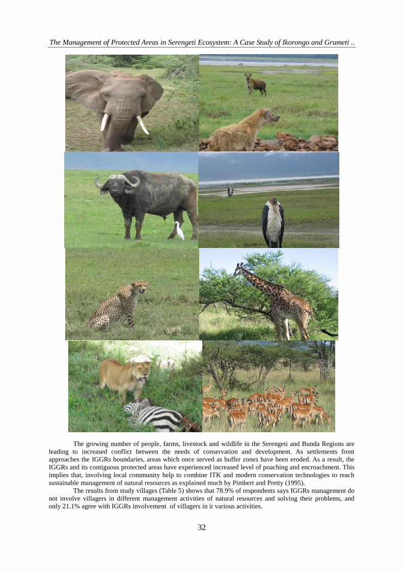
Elephant (Loxonda aficana) as among of their cultural beliefs, Wanyabasi respect Zebra(Equus burchelli) etc.
The pictures above and below are some of animals found in Ikorongo and Grumeti game reserves and other
areas of Serengeti ecosystem.
The Management of Protected Areas in Serengeti Ecosystem: A Case Study of Ikorongo and Grumeti ..
32
The growing number of people, farms, livestock and wildlife in the Serengeti and Bunda Regions are
leading to increased conflict between the needs of conservation and development. As settlements front
approaches the IGGRs boundaries, areas which once served as buffer zones have been eroded. As a result, the
IGGRs and its contiguous protected areas have experienced increased level of poaching and encroachment. This
implies that, involving local community help to combine ITK and modern conservation technologies to reach
sustainable management of natural resources as explained much by Pimbert and Pretty (1995).
The results from study villages (Table 5) shows that 78.9% of respondents says IGGRs management do
not involve villagers in different management activities of natural resources and solving their problems, and
only 21.1% agree with IGGRs involvement of villagers in it various activities.

The Management of Protected Areas in Serengeti Ecosystem: A Case Study of Ikorongo and Grumeti ..
33
Table 5: Involvement of Local Community in IGGRs Management
Involvement of local
Community:
Nyamatoke
n=28
Bonchugu
N=29
Overall
N=57
Yes
No
6(21.4%)
22(78.6%)
6(20.7%)
23(79.3%)
12(21.1%)
45(78.9%)
In the study area there is wildlife-livestock interaction in which transmitted diseases from each side to
another. The study villages shows that 63.2% said there is no diseases transmitted due to the interaction but
36.8% agree that wildlife livestock diseases are present because of the interaction, and diseases mentioned
includes Foot and mouth diseases, Tick-borne, and Rinderpest (See Table 6 ). This shows that those areas which
livestock graze are more disturbed and wildlife habitat loss is highly occurred such that wild animals move from
those areas to nearby PAs. If considerable efforts of community participation are not taken into account, the
disturbance of the ecosystem will be high and irreversible as explained much by wood, (1993).
Table 6: Wildlife-Livestock Diseases
Wildlife-Livestock Diseases: Nyamatoke
n=28
Bonchugu
N=29
Overall
N=57
Present
Absent
9(32.1%)
19(67.9%)
12(41.4%)
17(58.6%)
21(36.8%)
36(63.2%)
Due to those diseases occur as result of wildlife-livestock diseases interaction, response of IGGRs
management to that problem seems to be weak. Results form the study villages (Table 7) shows that 85.7% of
the respondent who agree in the presence of wildlife-livestock diseases claims that there is no response of
IGGRs management to those diseases and only 14.3% agree with the response of IGGRs to that problem.
Table 7: Response of IGGRs Management in Wildlife-Livestock Diseases
Response of IGGRs Nyamatoke
n=9
Bonchugu
N=12
Overall
N=21
Good No response
3(33.3%) 6(66.7%)
0(0.0%) 12(100.0%)
3(14.3%) 18(85.7%)
Generally IGGRs shows Considerable relationship status with adjacent community in study villages.
Results (Table 8) show 46.7% rank considerable relationship, 26.7 somehow, 13.3 good, 6.7% very little and
6.7% worse. This shows that IGGRs Community based conservation(CBC) section is not well equipped in
making good relationship with its adjacent community because of dependency on Serengeti regional
conservation project(SRCP) which phased out since 2008.
Table 8: Status of IGGRs to the Relationship with its Local Communities
Status of IGGRs Nyamatoke
n=30
Bonchugu
N=30
Overall
N=60
Worse
Very little
Somehow Considerable
Good
4(13.3%)
4(13.3%)
10(33.3%) 10(33.3%)
2(6.7%)
0(0.0%)
0(0.0%)
6(20.0%) 18(60.0%)
6(20.0%)
4(6.7%)
4(6.7%)
16(26.7%) 28(46.7)
8(13.3%)
3.2.2 Description of Boundaries
During focus group discussion in the study villages it shows that, people around IGGRs are not familiar
with the present boundary locations. For instance in Bonchugu village, they claim that boundaries of the
Ikorongo game reserve have been extended to include river Grumeti which has been cut off from their use.
Consequently local communities demand for boundaries review such that more fertile land and water
resources of Grumeti River become available for their use. It is perceived that, the land inside the reserve is
more productive per unit area than outside.
A more or less similar case is experienced with villagers of Nyamatoke concerning Rubana River. The
boundary descriptions are such that river Rubana is just inside the game reserve. People are demanding access to
the river water for livestock watering.
These demands are especially tense during the dry season when most water sources outside the reserves
dry up. Grumeti and Rubana rivers are the only perennial rivers within the reach of villagers. So IGGRs in
collaboration with other stakeholders are supposed to make sure this issue of boundary conflict is taken into
account by involving communities in demarcating and marking by using manmade and natural beckons present
in boundaries of IGGRs as stipulated much by MNRT, (2002)
The Management of Protected Areas in Serengeti Ecosystem: A Case Study of Ikorongo and Grumeti ..
34
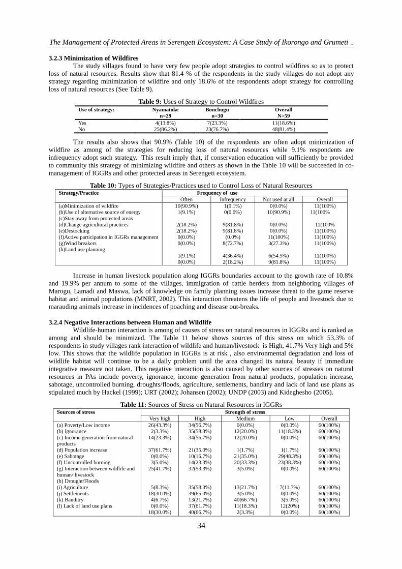
3.2.3 Minimization of Wildfires
The study villages found to have very few people adopt strategies to control wildfires so as to protect
loss of natural resources. Results show that 81.4 % of the respondents in the study villages do not adopt any
strategy regarding minimization of wildfire and only 18.6% of the respondents adopt strategy for controlling
loss of natural resources (See Table 9).
Table 9: Uses of Strategy to Control Wildfires
Use of strategy: Nyamatoke
n=29
Bonchugu
n=30
Overall
N=59
Yes
No
4(13.8%)
25(86.2%)
7(23.3%)
23(76.7%)
11(18.6%)
48(81.4%)
The results also shows that 90.9% (Table 10) of the respondents are often adopt minimization of
wildfire as among of the strategies for reducing loss of natural resources while 9.1% respondents are
infrequency adopt such strategy. This result imply that, if conservation education will sufficiently be provided
to community this strategy of minimizing wildfire and others as shown in the Table 10 will be succeeded in co-
management of IGGRs and other protected areas in Serengeti ecosystem.
Table 10: Types of Strategies/Practices used to Control Loss of Natural Resources Strategy/Practice
Frequency of use
Often Infrequency Not used at all Overall
(a)Minimization of wildfire (b)Use of alternative source of energy
(c)Stay away from protected areas
(d)Change agricultural practices (e)Destocking
(f)Active participation in IGGRs management
(g)Wind breakers (h)Land use planning
10(90.9%) 1(9.1%)
2(18.2%) 2(18.2%)
0(0.0%)
0(0.0%)
1(9.1%)
0(0.0%)
1(9.1%) 0(0.0%)
9(81.8%) 9(81.8%)
(0.0%)
8(72.7%)
4(36.4%)
2(18.2%)
0(0.0%) 10(90.9%)
0(0.0%) 0(0.0%)
11(100%)
3(27.3%)
6(54.5%)
9(81.8%)
11(100%) 11(100%
11(100% 11(100%)
11(100%)
11(100%)
11(100%)
11(100%)
Increase in human livestock population along IGGRs boundaries account to the growth rate of 10.8%
and 19.9% per annum to some of the villages, immigration of cattle herders from neighboring villages of
Marogu, Lamadi and Maswa, lack of knowledge on family planning issues increase threat to the game reserve
habitat and animal populations (MNRT, 2002). This interaction threatens the life of people and livestock due to
marauding animals increase in incidences of poaching and disease out-breaks.
3.2.4 Negative Interactions between Human and Wildlife
Wildlife-human interaction is among of causes of stress on natural resources in IGGRs and is ranked as
among and should be minimized. The Table 11 below shows sources of this stress on which 53.3% of
respondents in study villages rank interaction of wildlife and human/livestock is High, 41.7% Very high and 5%
low. This shows that the wildlife population in IGGRs is at risk , also environmental degradation and loss of
wildlife habitat will continue to be a daily problem until the area changed its natural beauty if immediate
integrative measure not taken. This negative interaction is also caused by other sources of stresses on natural
resources in PAs include poverty, ignorance, income generation from natural products, population increase,
sabotage, uncontrolled burning, droughts/floods, agriculture, settlements, banditry and lack of land use plans as
stipulated much by Hackel (1999); URT (2002); Johansen (2002); UNDP (2003) and Kideghesho (2005).
Table 11: Sources of Stress on Natural Resources in IGGRs Sources of stress Strength of stress
Very high High Medium Low Overall
(a) Poverty/Low income (b) Ignorance
(c) Income generation from natural
products (d) Population increase
(e) Sabotage (f) Uncontrolled burning
(g) Interaction between wildlife and
human/ livestock (h) Drought/Floods
(i) Agriculture
(j) Settlements (k) Banditry
(l) Lack of land use plans
26(43.3%) 2(3.3%)
14(23.3%)
37(61.7%)
0(0.0%) 3(5.0%)
25(41.7%)
5(8.3%)
18(30.0%) 4(6.7%)
0(0.0%)
18(30.0%)
34(56.7%) 35(58.3%)
34(56.7%)
21(35.0%)
10(16.7%) 14(23.3%)
32(53.3%)
35(58.3%)
39(65.0%) 13(21.7%)
37(61.7%)
40(66.7%)
0(0.0%) 12(20.0%)
12(20.0%)
1(1.7%)
21(35.0%) 20(33.3%)
3(5.0%)
13(21.7%)
3(5.0%) 40(66.7%)
11(18.3%)
2(3.3%)
0(0.0%) 11(18.3%)
0(0.0%)
1(1.7%)
29(48.3%) 23(38.3%)
0(0.0%)
7(11.7%)
0(0.0%) 3(5.0%)
12(20%)
0(0.0%)
60(100%) 60(100%)
60(100%)
60(100%)
60(100%) 60(100%)
60(100%)
60(100%)
60(100%) 60(100%)
60(100%)
60(100%)

The Management of Protected Areas in Serengeti Ecosystem: A Case Study of Ikorongo and Grumeti ..
35
Based on the results above and percentages of ranking, general comments can be as follows:
Table 12: Rank of Sources of Stress on Natural Resources in IGGRs
Sources of stress
Strength of stress
Very high High
Medium
Low Comments
(a)Poverty/Low income
(b)Ignorance
(c)Income generation from natural
products
(d)Population increase
(e)Sabotage
(f)Uncontrolled burning
(g)Interaction between wildlife and
human/ livestock
(h)Drought/Floods
(i)Agriculture
(j)Settlements
(k)Banditry
(l)Lack of land use plans
Poverty leads to anxious search of livelihoods
Leads to unsustainable practices
Unsustainable use can lead stress on the resources
Leads to greater demand on natural resources
Rigorous monitoring required
Lead to great damage to resources and
habitats
Leads to spread of infectious diseases
to wildlife, human and livestock.
Difficult to control and can cause great
damage (because of Natural hazards, climatic change and human cause).
Pressure on the reserves, disrupt wildlife movement
Pressure on the reserves, disrupt wildlife movement
Insecurity to wildlife and humans
Plans and good land use practices
would increase productivity and reduce encroachment
3.2.5 Provision of Areas for Local Community Hunting
Upgrading of the former Ikorongo and Grumeti game controlled areas into game reserves was followed
by declaring them as hunting blocks. The only area remain for local community hunting is Ikoma open area
which bordering SENAPA and IGGRs. Grumeti reserves hunting company limited previously VIP safari club is
the only company that invests in all this blocks for tourist hunting activities. Since 2004, this company in
collaboration with community buys those wildlife quotas for local hunting in terms of tourist price and make
Bunda and Serengeti councils to benefit from it. However, the distribution of the finance to villages adjacent to
those areas is questionable. This decision dramatically affected the community conservation activities of the
Serengeti Regional conservation Project (SRCP) which does no longer exist as result all staffs of SRCP join
IGGRs as directed by Director of Wildlife in 2008.
Personal observation from study villages shows that, there is no area for local community hunting as
Ikoma open area join with other areas and form Ikona WMA which effectively start doing different conservation
activities in 2009. The way this WMA works and use “Ritongo” way by asking poachers to pay for offence and
not repeat the incidence instead of enforcing wildlife conservation Act No.12 of 1974 which reviewed by
parliament in 2009, for the researcher experience in the area he think this strategy will fail because many people
will engage in poaching and when captured pays the price asked and continue with poaching as result weaken
other regimes in protection of natural resources. Cultural beliefs in this area detoriating as days go on caused by
interaction of many tribes in tourism industry and adoption of other culture, intermarriage and rural-urban
migration of youth group. Therefore village game scouts employed must do their job according to the
responsibilities given in the Wildlife regulations by allowing them to do the same job as done by Park Ranger or
Game Warden (adoption of conservation with people) as explained much by Kideghesho, (2005 and 2009).

The Management of Protected Areas in Serengeti Ecosystem: A Case Study of Ikorongo and Grumeti ..
36
3.2.6 Encroachment for Grazing, Fuelwood, Logging and Mining
The growing number of people, farms, livestock and wildlife in the Serengeti and Bunda Regions are
leading to increased conflict between the needs of conservation and development. Planting of trees help to
reduce shortage of fuelwood and logging which are important for households‟ consumption. The study villages
found to have high concentration of people who do no adopt planting of trees strategy contrary to the national
agenda suggestion. The results (Table 13) shows that 63% of the study villagers do not plant trees so the only
source of fuelwood and other needs results from trees are depended on cutting down natural trees available in
the village and inside IGGRs, only 37% of the respondents plant trees for different reasons, among which
fuelwood account 66.7% for Nyamatoke and 33.3% Bonchugu.
Table 13: Growing of Trees and its Purposes Information Nyamatoke
n=30
Bonchugu
n=30
Overall
N=60
(a)Growing trees:
Yes No
(b)Purpose of growing trees: Fuelwood
Building material
Soil fertility maintenance Wind breakers
Shades
13(43.3%) 17(56.7%)
2(66.7%)
7(63.6%) 3(60.0%)
6(66.7%)
12(66.7)
7(23.3%) 23(76.7%)
1(33.3%)
4(36.4%) 2(40.0%)
3(33.3%)
6(33.3%)
20(33.3%) 40(66.7%)
3(100%)
11(100%) 5(100%)
9(100%)
18(100%)
The study villages found to have no crucial measures taken for dealing with shortage of fuelwood.
Results (Table 14) shows that 95% of respondents in study villages are often adopting natural regeneration of
trees to tackle fuelwood shortage, 50% infrequent private tree planting, 36.7% infrequent agro-forest and 3.3%
claim to have infrequent communal tree planting. This implies more encroachment in study area.
Table 14: Measures taken to Deal with fuelwood Shortage Practice Frequency of use
Often Infrequent Not used at all Overall
(a)Agro-forest
(b)Private tree planting (c)Communal tree planting
(d)Natural regeneration
0(0.0%)
1(1.7%) 0(0.0%)
57(95.0%)
22(36.7%)
30(50.0%) 2(3.3%)
1(1.7%)
38(63.3%)
29(48.3%) 58(96.7%)
2(3.3%)
60(100%)
60(100%) 60(100%)
60(100%)
Increase in livestock population along IGGRs boundaries account to the growth rate of 10.8% and
19.9% per annum to some of the villages, immigration of cattle herders from neighboring villages of Marogu,
Lamadi and Maswa, lack of knowledge on family planning issues increase threat to the game reserve habitat and
animal populations (MNRT, 2002). This implies that, livestock-wildlife interaction threatens the life of the
people and livestock due to marauding animals increase in incidences of poaching and disease out-breaks.
Also during focus group discussion, it was found that, study population engage themselves in
encroachment of mining in the PAs. This was evidenced by having stone grinding machines located in Park
Nyigoti village where mining poachers sell their stones to mining brokers which scaled by using empty cement
bag ready for grinding to get gold and other mines.
Encroachment for grazing, fuel wood, logging and mining in IGGRs will be minimized if and only if
we adopt co-management system of natural resources by giving adjacent community high priority on all issues
concerning conservation. Functional participatory approach is preferable type of participation of reducing
encroachment in all protected areas and has foreseeable future for sustainable development as explained much
by Pimbert and Pretty, (1995).
3.2.7 Minimization of Conflicting Resource Use Values between Stakeholders
Conflicts are defined as struggles over values and claims to status, power and resources in which the
aim of the opponents is to neutralize, injure, or eliminate their rivals (Coser, 1956). Conflicts within protected
areas can seen to be the result of diverse interests, goals and aspirations that individuals or groups within legally
established and isolated environments have, which all too often resulted in either positive or negative impacts on
the use value of the area. It is necessary to have an understanding of the values attached to natural resource use
as found in such environments as protected areas because it largely determines the success of its conservation
goals (African Biodiversity Foundation for the Future, 1993).
Personal observation and interview in the study areas shows that, there is a still conflict of resource use
value between IGGRs and community adjacent to it. One villager in Bonchugu village interviewed on 30th
June,
The Management of Protected Areas in Serengeti Ecosystem: A Case Study of Ikorongo and Grumeti ..
37
2009 says:
“I can not stop graze and watering livestock, cutting building poles, cutting building thatches and any other
requirements in Ikorongo game reserve because is the area I used to live before repatriation in 2000 and is the
only conducive area near this village to get our necessities. Also nothing I benefit from its presence rather than
increase poverty to my family”
This statement implies that, communities do not have sense of ownership to the presence of IGGRs due
to the fact that, resources available in the protected area does not help to solve their problems. Therefore, in
order IGGRs to be sustainable in managing natural resources efforts are needed to combat poverty, providing
good environment for adopting land use plans so as to minimize the current situation because biodiversity losses
which are often irreversible could end in its unavailability for the unborn generations as explained much by
World Conservation strategy of the International Union for Conservation of Nature and Natural Resources
(1980); IUCN (1994); Brown (1990); Randall (1991); Swanson et al. (1992); Bisong 2001; Essien and Bisong
(2009).
3.3 Impacts of Various Strategies Used in Natural Resources Management
3.3.1 Minimizations of Bureaucracy in Follow Up of Cattle Rustlers
The study villages found to have very little population respond on answering the issue of minimization
of bureaucracy in follow up of cattle rustlers. Of which 38.5% says there is considerable minimizations of
bureaucracy in follow up cattle rustlers, 30.8% good, 23.1% very little and 7.7% somehow (See Table 15). This
implies that, IGGRs minimize bureaucracy in follow up of cattle rustlers.
Table 15: Bureaucracy in Follow up Cattle Rustlers Status of IGGRs Nyamatoke
n=6
Bonchugu
n=6
Overall
N=12
Very little
Somehow Considerable
Good
2(42.9%)
1(14.3%) 2(28.6%)
1(14.3%)
0(0.0%)
0(0.0%) 3(50.0%)
3(50.0%)
2(23.1%)
1(7.7%) 5(38.5%)
4(30.8%)
Moreover, during focus group discussion it was found that study villagers are of the opinion that it
takes long process before permissions are granted to villagers to pursue cattle rustlers. Anti-poaching officer of
IGGRs during interview with the researcher said that they respond quickly to cattle rustlers after given
information by using air patrols(helicopter from Grumeti reserves hunting company limited and plane from
SENAPA), and this restrict rustlers to do this job as result of decreased in cattle rustling cases who use PAs to
pass through.
3.3.2 Equitable Sharing by Stakeholders of Benefits Accrued From IGGRs
The study villages found to have misunderstanding of most issues concerning income benefits accrued
from the conservation of natural resources. The findings from study villages shows that tourism activities is the
only income benefits produced by IGGRs and providing 25% of its income to local community of Serengeti
district and Bunda districts. But in IGGRs since 2003 hunting is done only in July instead of July to December
and the remaining month photographing and game view activities experienced. Therefore 25% to be given to
community is very low depending on number and type of animal hunted in each block while the remaining
photographing and game viewing tourism is unexplained. For example July 2009, eleven guests hunt in Grumeti
, Ikorongo and Ikona WMA hunting block where 18 animals and 1bird killed amounting to U$$ 4670(IGGRs
Report, July 2009) (Table 16 shows number of permit, animal killed, hunting block, and price of each animal).
Of which 25% amounting U$$ 1167.5 will be distributed in all three blocks as seen in Table 16.
Table 16: Tourist Hunting Report for 2009 Season. No. Permit No. Type and Number of animal killed Hunting block
1. 23493 Guinea Fowl 1
Impala 1 Wildebeest 1
Grumeti G. R
W.M.A Ikona W.M.A Ikona
2. 23492 Wildebeest 1 Grumeti G.R
3. 23491 Wildebeest 1
Impala 1
Ikorongo G.R
Ikorongo G.R
4. 23490 Wildebeest 1 W.M.A Ikona
5. 23489 Wildebeest 1 Ikorongo G.R
6. 23462 Wildebeest 1
Impala 1
Ikorongo G.R
W.M.A Ikona
7. 23457 Wiledebeest 1 Thomson Gazelle 1
Grumeti G.R W.M.A Ikona
The Management of Protected Areas in Serengeti Ecosystem: A Case Study of Ikorongo and Grumeti ..
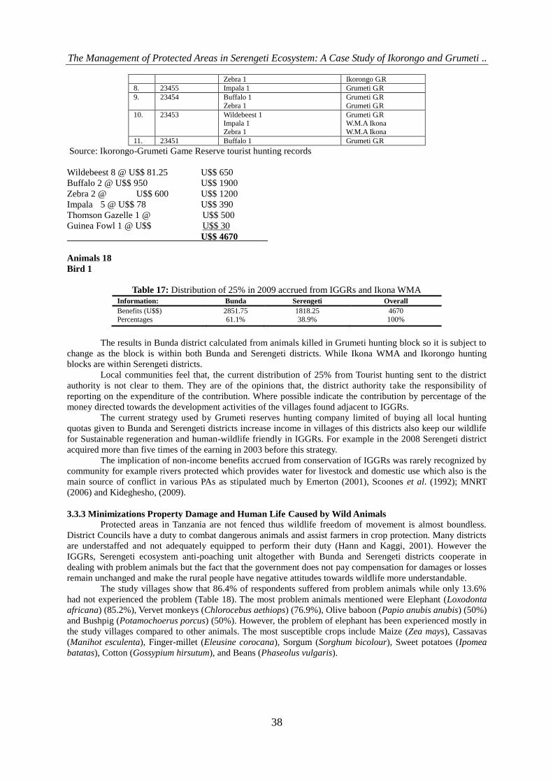
38
Zebra 1 Ikorongo G.R
8. 23455 Impala 1 Grumeti G.R
9. 23454 Buffalo 1
Zebra 1
Grumeti G.R
Grumeti G.R
10. 23453 Wildebeest 1 Impala 1
Zebra 1
Grumeti G.R W.M.A Ikona
W.M.A Ikona
11. 23451 Buffalo 1 Grumeti G.R
Source: Ikorongo-Grumeti Game Reserve tourist hunting records
Wildebeest 8 @ U$$ 81.25 U$$ 650
Buffalo 2 @ U$$ 950 U$$ 1900
Zebra 2 @ U$$ 600 U$$ 1200
Impala 5 @ U$$ 78 U$$ 390
Thomson Gazelle 1 @ U$$ 500
Guinea Fowl 1 @ U$$ U$$ 30
U$$ 4670
Animals 18
Bird 1
Table 17: Distribution of 25% in 2009 accrued from IGGRs and Ikona WMA
Information: Bunda Serengeti Overall
Benefits (U$$)
Percentages
2851.75
61.1%
1818.25
38.9%
4670
100%
The results in Bunda district calculated from animals killed in Grumeti hunting block so it is subject to
change as the block is within both Bunda and Serengeti districts. While Ikona WMA and Ikorongo hunting
blocks are within Serengeti districts.
Local communities feel that, the current distribution of 25% from Tourist hunting sent to the district
authority is not clear to them. They are of the opinions that, the district authority take the responsibility of
reporting on the expenditure of the contribution. Where possible indicate the contribution by percentage of the
money directed towards the development activities of the villages found adjacent to IGGRs.
The current strategy used by Grumeti reserves hunting company limited of buying all local hunting
quotas given to Bunda and Serengeti districts increase income in villages of this districts also keep our wildlife
for Sustainable regeneration and human-wildlife friendly in IGGRs. For example in the 2008 Serengeti district
acquired more than five times of the earning in 2003 before this strategy.
The implication of non-income benefits accrued from conservation of IGGRs was rarely recognized by
community for example rivers protected which provides water for livestock and domestic use which also is the
main source of conflict in various PAs as stipulated much by Emerton (2001), Scoones et al. (1992); MNRT
(2006) and Kideghesho, (2009).
3.3.3 Minimizations Property Damage and Human Life Caused by Wild Animals
Protected areas in Tanzania are not fenced thus wildlife freedom of movement is almost boundless.
District Councils have a duty to combat dangerous animals and assist farmers in crop protection. Many districts
are understaffed and not adequately equipped to perform their duty (Hann and Kaggi, 2001). However the
IGGRs, Serengeti ecosystem anti-poaching unit altogether with Bunda and Serengeti districts cooperate in
dealing with problem animals but the fact that the government does not pay compensation for damages or losses
remain unchanged and make the rural people have negative attitudes towards wildlife more understandable.
The study villages show that 86.4% of respondents suffered from problem animals while only 13.6%
had not experienced the problem (Table 18). The most problem animals mentioned were Elephant (Loxodonta
africana) (85.2%), Vervet monkeys (Chlorocebus aethiops) (76.9%), Olive baboon (Papio anubis anubis) (50%)
and Bushpig (Potamochoerus porcus) (50%). However, the problem of elephant has been experienced mostly in
the study villages compared to other animals. The most susceptible crops include Maize (Zea mays), Cassavas
(Manihot esculenta), Finger-millet (Eleusine corocana), Sorgum (Sorghum bicolour), Sweet potatoes (Ipomea
batatas), Cotton (Gossypium hirsutum), and Beans (Phaseolus vulgaris).
The Management of Protected Areas in Serengeti Ecosystem: A Case Study of Ikorongo and Grumeti ..
39
Table 18: Percentage response on problem animals destroying crops and Human Life Information: Percentages:
N=60
(a)Availability of problem animals:
Yes No
(b)Common problem animals: Elephant (Loxodonta africana)
Vervet monkeys (Chlorocebus aethiops)
Olive baboon (Papio anubis anubis) Bushpig (Potamochoerus porcus)
Warthog(Phacochoerus aethiopicus) Reed buck(Redunca spp.)
Wildebeest (Connochaetes taurinus)
86.4% 13.6%
85.2%
76.9%
50% 50%
17.3% 3.8%
1.9%
Multiple response answers were obtained
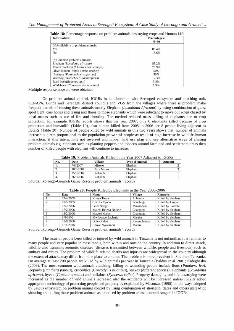
On problem animal control, IGGRs in collaboration with Serengeti ecosystem anti-poaching unit,
SENAPA, Bunda and Serengeti district councils and VGS from the villages where there is problem make
frequent patrols of chasing these animals mostly Elephant (Loxodonta Africana) by using combination of guns,
sport light, cars hones and lasing and flares to those elephants which were reluctant to move out when chased by
local means such as use of fire and shouting. The method reduced mass killing of elephants due to crop
protection, for example IGGRs reports shows that the year 2007, only 6 elephants killed because of crop
protection and humanlife (Table 19), also human killed from 2005 to 2006 are 8 people living adjacent to
IGGRs (Table 20). Number of people killed by wild animals in this two years shows that, number of animals
increase is direct proportional to the population growth of people as result of high increase in wildlife-human
interaction; if this interactions not reversed and proper land use plan and use alternative ways of chasing
problem animals e.g. elephant such as planting peppers and tobacco around farmland and settlement areas then
number of killed people with elephant will continue to increase.
Table 19: Problem Animals Killed in the Year 2007 Adjacent to IGGRs No. Date Village Type of Animal Amount
1. 7/6/2007 Miseke Elephant 2
2. 10/6/2007 Park Nyigoti Elephant 3
3. 25/6/2007 Robanda Elephant 1
4. 26/6/2007 Robanda Elephant 1
Source: Ikorongo-Grumeti Game Reserve problem animals‟ records
Table 20: People Killed by Elephants in the Year 2005-2006 No. Date Name Village Remarks
1. 27/4/2005 Kiteya Tuma Robanda Killed by elephant
2. 27/5/2005 Chacha Ryoba Bonchugu Killed by Leopard
3. 13/2/2006 Peter Ndege Makundusi Killed by Giraffe
4. 17/2/2006 Malele Helena Ntolele Changuge Killed by elephant
5. 18/2/2006 Magori Majusi Changuge Killed by elephant
6. 8/8/2006 Mwikwabe Zacharia Miseke Killed by elephant
7. 22/9/2006 Oule Onderi Rwamchanga Killed by elephant
8. 1/11/2006 Bhoke Nyakimori Matare Killed by elephant
Source: Ikorongo-Grumeti Game Reserve problem animals‟ records
The issue of people been killed or injured by wild animals in Tanzania is not unfamiliar. It is familiar to
many people and very popular in mass media, both within and outside the country. In addition to direct attack,
wildlife also transmits zoonotic diseases (diseases transmitted between wildlife, people and livestock) such as
anthrax and rabies. The problem of wildlife related deaths and injuries are widespread in the country although
the extent of attacks may differ from one place to another. The problem is more prevalent in Southern Tanzania.
On average at least 200 people are killed by wild animals per year in Tanzania (Baldus et al. 2001; Kideghesho
(2009). The most common wild animals attacking, killing or wounding people include lions (Panthera leo),
leopards (Panthera pardus), crocodiles (Crocodylus niloticus), snakes (different species), elephants (Loxodonta
africana), hyena (Crocuta crocuta) and buffaloes (Syncerus caffer). Property damaging and life destroying were
increased as the number of wild animals increased also the accidents will be increased unless IGGRs adopt
appropriate technology of protecting people and property as explained by Masunzu, (1998) on the ways adopted
by Selous ecosystem on problem animal control by using combination of shortgun, flares and others instead of
shouting and killing those problem animals as practiced by problem animal control rangers in IGGRs..

The Management of Protected Areas in Serengeti Ecosystem: A Case Study of Ikorongo and Grumeti ..
40
3.3.4 Improvement of Relationship between Hunting Companies and Local People
The study villages have only one hunting company (Grumeti reserves hunting co. Ltd) which invest in
three hunting blocks namely Ikorongo, Grumeti and Ikona WMA. This company plays a vital role in providing
social service to villages adjacent to this blocks like building class rooms, scholarships to primary, secondary
and higher learning institutions, plays in schools through “right to play organization”, water services by drilling
boreholes to villages suffer from domestic water shortages and seminars concerning conservation issues.
Data available shows that since the company took these blocks spent on Bunda district alone U$$
252,000 for water, Seminar U$$ 49,000 (2003 and 2005), Class rooms iron sheets U$$ 40,000, scholarships
given to children are depending on secondary schools studied and have uniform financial served: Tshs. 250,000
government secondary school and Tsh. 500,000 to private secondary school per annum and is given in ration of
15% to 75% for Bunda and Serengeti respectively; schools plays U$$ 500,000 (2005-2008) through “Right to
play” for all villages adjacent to IGGRs and water U$$ 252,000.
During focus group discussion and staffs interviews, it was found that, the villagers are confused with
the name of the company which resembles that of Grumeti game reserve. Local communities feel that the
company cheated the communities and obtained land without their consent. Having obtained the lease for the
area, the company refrained from fulfilling the promises made to the villagers, a condition which made villagers
to accept granting Sasakwa area to the company (Five star hotel built in this area). The company further denies
villagers from using natural resources found in the area. This implies that, the hunting company is not adapted
active participatory approach of local communities in its activities which is very important in management of
PAs.
In addition to that, the investors in protected areas such as hoteliers, tour operators and professional
hunters obtain benefits from wildlife whose survival is dangerous to rural communities. The foreigners are
among the top beneficiaries of Tanzania‟s wildlife resources. Foreigners collude with corrupt Ministry officials
to obtain the benefits. Some Legislators in Tanzanian National Assembly decried the lack of transparency in the
allocation of hunting blocks (This Day, Friday 25 April 2008 cited by Kideghesho 2009). They revealed that
foreign-owned hunting companies are given licences on lucrative hunting areas, in the process leaving
indigenous Tanzanians on the wayside. Twelve foreign companies were given 57 prime hunting blocks out of
the total 147 blocks allocated in 2006, with each company owning on average five blocks (This Day, Friday 25
April 2008 cited by Kideghesho 2009). Ten local companies owned only 16 hunting blocks in prime hunting
areas, on average owning two blocks per company.
3.3.5 Minimization of Bureaucracy for Access to Ritual Sites
Most of the study populations living adjacent to IGGRs used to live in these reserves before they
became game reserves in 1994.After the official gazettement these people were relocated. Their cultural and
ritual areas however remained within the present game reserves. The law governing game reserves prohibits
entry except by the prior permission of the Director of Wildlife. Ever since then, access of local communities
into the reserves to perform ritual worships has been denied. This situation is a cause to the prevailing bad
relationships between the management and local people.
During focus group discussion it was found that local communities request permission from project
manager (PM) to enter into IGGRs and this takes few hours and always villagers ask this permission from
nearby game post where game warden in charge tell the PM about the request of permission to enter into ritual
sites, day and time to be taken for the action. This procedure is too quickly as communications processes in
IGGRs are active twenty four hours by using radio calls or tell phones. For the case of good relationship with
local community no any bureaucracy taken to allow local people unless there is some information shows that the
person request the permit is not going only to ritual sites but he/she have other businesses which bring negative
impact to natural resources.
Furthermore, differing cultural value systems between protected area managers and their support
communities have frequently resulted in incidences of conflicts particularly as many of the native societies
within protected areas believe that the natural environments within these areas are sacred habitats which connect
them to their religious inclinations. Hence, such areas are consciously protected from any form of intrusion. For
example, farmers of the south East Asian region traditionally honour sacred groves- patches of wilderness
amidst agricultural fields and rural landscapes as abodes of their powerful deities. For the indigenous Indians of
Panama, patches of forests are regarded as super natural parks for the refuse of wild-life and spirits, while the
Tukano Indians of Brazil guard forests and waterways for spiritual recourse. The indirect effect of this is the
protection of over 60% of the streams within the locality as sanctuaries for fishes and other aquatic life.
Similarly the taboo and religious traditional value placed on orange-utang population in the upper reaches of
Butang-Ai river in southern Sarawak has resulted in the preservation of the animal population (James, 1991;
Ryan, 1992; Essien and Bisong, 2009).
The Management of Protected Areas in Serengeti Ecosystem: A Case Study of Ikorongo and Grumeti ..
41
3.3.6 Minimization of Reserve Boundary Conflicts
As discussed above part 3.2.2 concerned reserve boundary conflicts, the population growth of people
and livestock in study villages is so high and brings pressure on resources available as results of habitat
destruction and environmental degradation. The existence of conflicts within protected areas is based on the
differing term-utilization attached to the resources of the environment. The objectives behind the conservation
scheme is to conserve natural resources for long-term benefits, while the concern of the inhabitants of protected
areas is the need to have a means of livelihood for survival. The different functional interpretations given to
protected areas have generated the varying degrees of conflicts experienced.
However, regions deprived of development while having a constantly increasing population growth
could exert significant strains on the available natural resources such that crisis conditions set in (Waugh, 1995
cited by Essien and Bisong 2009). For example fuel wood resources is cyclical representation of the way
population exerts pressure on the available fuel wood resources is made. The environment constraints being
experienced in the natural environment are not entirely due to development; rather, the major cause of this
constraint is the result of the state of usage of these resources to meet up with the demands of the population.
Moreover, protected areas face various land use and management problems such as deforestation,
wildlife poaching, illicit loggings, uncontrolled bush fires, shifting cultivation and over grazing. The reason is
not far-fetched as the land environment is faced with dense population pressures, inequality and access to
natural resources (Ntagazwa, 1992; Essien and Bisong 2009). Land is thus needed for agriculture, housing,
industrial development, military establishments, etc. Hence, it becomes difficult to understand the rationale for
the preservation of large areas of biological significance exclusively for wild life conservation. The Queen
Elizabeth National Park in Uganda is an example of a protected area that is increasingly been affected by the
various land pressure for conversion from a forest land to cropland to meet the food requirements of its
inhabitants. Signs of continual conflicts over land-use are based on the many socioeconomic activities that are
performed within the park namely-fishing, cultivation, and livestock grazing, hunting, collection of firewood
and the harvesting of salt. Conflicts within the park environment are based on the access restrictions which
prohibit resources exploitation within the park (Kamugasha, 1995).
Other similar study done in Mount Kenya National Park is found to be an area that is under pressure to
be developed as farmlands. This is a result of the increased population concentration which had exceeded over
690,000 people in 1989. The population pressure thus lead to land and political conflicts among the ethnic
groups within the park. The consequence for the conservation effort was unsustainable exploitation of forest
resources characterized by unmanaged legal and illegal harvesting of fuel wood, timber, poles, bamboo, and
medicinal herbs. Within the parkland, there are a number of alterations of forestland to cropland. The reason for
it is not far-fetched as there is a high dependency on agriculture, a lack of alternative non-land sources of
livelihood, land scarcity as evidenced by increasing population-land ratio, low-level of productivity per unit area
of cultivated land, economic, social and political pressure for the excision of forests to human settlements, etc
(Gichuki, 1999:430-434; Essien and Bisong 2009).
3.3.7 Controls of Settlements in Migratory Routes
The study villages found to have increased in human population as a result enhanced demand of
settlements area for both agriculture and livestock keeping; thus obstructing migratory route which is important
for Serengeti-Masai Mara migratory Ecosystem (SMMME)(Personal observation). Local people regard the
IGGRs environment as their rightful property and rather view the reserve authorities as intruders on their land
and as such would willing go to superfluous lengths to preserve their heritage.
Reasons for the people to settle in such areas having substantive needs that have different goals to that
of reserve authorities. This is indicated by the needs of indigenous people for grazing lands, firewood, building
materials, medicinal plants and land for hunting as opposed to the conservation needs of reserve authorities for
sustainability.
Similar study done in Himalayan National Parks shows that, within the mountainous regions of Nepal
such as Langtan, Rara, Shey, Royal Chitan, and the Sagarmartha (Mount Everest) are protected areas which
were established to protect the flora and fauna of the environment. Little attention was given to the need to
respect local settlement and subsistence resource use of the indigenous communities. The Traditional Khumbu
Sherpas had inhabited the settlement within the Mount Everest regions and as such had developed conservation
values, institutions, and practices that were different from the conservation objectives of the protected managers.
The existence of a differing value system within the area resulted in conflicts (Stevens1997:81). The ownership
of land and sea within protected areas is one of the key factors responsible for conflicts within protected areas.
This is more so in sites having high human population density and areas which receive an influx of migrants
from surrounding regions. Thus accesses to land constitute a significant factor in conflict generations between
indigenous peoples and protected area authorities.
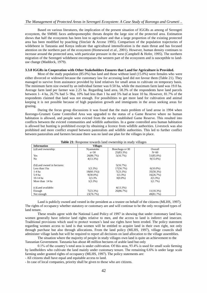
The Management of Protected Areas in Serengeti Ecosystem: A Case Study of Ikorongo and Grumeti ..
42
Based on various literatures, the implication of the present situation of IGGRs as among of Serengeti
ecosystem, the SMME faces anthropomorphic threats despite the large size of the protected area. Estimation
shows that half the ecosystem has been lost to agriculture and that a large proportion of the existing protected
area has been modified by poaching (Sinclair & Arcese 1995). Comparison of the population trajectories of
wildebeest in Tanzania and Kenya indicate that agricultural intensification is the main threat and has focused
attention on the northern part of the ecosystem (Homewood et al., 2001). However, human density continues to
increase around the protected area, with particular pressure in the west (Campbell & Hofer, 1995). The northern
migration of the Serengeti wildebeest encompasses the western part of the ecosystem and is susceptible to land-
use change (Maddock, 1979).
3.3.8 IGGRs in Cooperation with Other Stakeholders Ensures that Land for Agriculture is Provided.
Most of the study population (85.0%) has land and those without land (15.0%) were females who were
either divorced or widowed because the customary law for accessing land did not favour them (Table 21). They
managed to survive from assistance provided by kind relatives for small areas to cultivate on temporary basis.
The minimum farm size owned by an individual farmer was 0.50 ha, while the maximum farm land was 19.0 ha.
Average farm land per farmer was 2.25 ha. Regarding land area, 58.3% of the respondents have land parcels
between 1- 4 ha, 26.7% had 5- 9ha, 10% had less than 1 ha and 5% had at least 10 ha. However, 81.7% of the
respondents claimed that land was not enough. For possibilities to get more land for cultivation and animal
keeping it is not possible because of high population growth and immigrants in the areas seeking areas for
grazing.
During the focus group discussions it was found that the main problem of land arose in 1994 when
Ikorongo-Grumeti Game Controlled Area was upgraded to the status of a Game Reserve where no human
habitation is allowed, and people were evicted from the newly established Game Reserve. This resulted into
conflicts between the evicted communities and wildlife authorities. In a game controlled area human habitation
is allowed but hunting is prohibited except by obtaining a licence from wildlife authorities. Livestock was also
prohibited and more conflict erupted between pastoralists and wildlife authorities. This led to further conflict
between pastoralists and farmers because there was no land use plan for the villages in place.
Table 21: Response towards land ownership in study villages Information Villages
(a)Land ownership:
Yes No
(b)Land owned in hectares: Less than I ha
1-4 ha
5-9 ha 10-14 ha
More than 14 ha
(c)Land available:
Enough
Not enough
Nyamatoke
n=30
26(86.7%) 4(13.3%)
1(3.3%)
18(60.1%))
9(30.0%) 1(3.3%
1(3.3%)
7(23.3%)
23(76.7%)
Bonchugu n=30
25(83.3%)
5(16.7%)
5(16.7%) 17(56.7%)
7(23.3%)
1(3.3%) 0(0.0%)
4(13.3%)
26(86.7%)
Overall
N=60
51(85.0%) 9(15.0%)
6(10.0%)
35(58.3%)
16(26.7%) 2(3.3%)
1(1.7%)
11(18.3%)
49(81.7%)
Land is publicly owned and vested in the president as a trustee on behalf of the citizens (MLHS, 1997).
The rights of occupancy whether statutory or customary are and will continue to be the only recognized types of
land tenure.
These results agree with the National Land Policy of 1997 in showing that under customary land law,
women generally have inferior land rights relative to men, and the access to land is indirect and insecure.
Traditional provisions which used to protect women‟s land use rights have been eroded. The policy statement
regarding women access to land is that women will be entitled to acquire land in their own right, not only
through purchase but also through allocations. From the land policy (MLHS, 1997), village councils shall
administer village lands but will be required to report all decisions on land allocation to the village assemblies.
The situation where the majority of people in study villages own land is quite an achievement to the
Tanzanian Government. Tanzania has about 48 million hectares of arable land but only
0.1% of the country‟s total area is under cultivation. Of this area, 93.4% is used for small scale farming
by landholders who cultivate the land mainly under customary tenure. The remaining 6.6% is under large scale
farming under granted rights of occupancy (MLHS, 1997). The policy statements are:
- All citizens shall have equal and equitable access to land.
- In case of local companies, priority shall be given to those who are citizens.

The Management of Protected Areas in Serengeti Ecosystem: A Case Study of Ikorongo and Grumeti ..
43
- Non-citizens shall not be granted land unless it is for investment purposes under the
Investment Promotion Act.
Land shortage in the study villages can be ascribed to poor agricultural practices. With an average of 2.25 ha for
most individuals in the villages, and with proper application of agricultural inputs, food shortages could have
been somehow minimized.
3.3.9 IGGRs in Cooperation with Other Stakeholders Ensures that Land for Livestock keeping is
Provided
Livestock keeping in study villages shows that land available for keeping livestock can not sustain all
livestock but immigrants are the one who cause more stress to villages and as results use Ikorongo and Grumeti
game reserves for livestock keeping and watering (Personal observation).
The findings (Table 22) show that 63.2% of the study villages say there is no grazing land and 36.8%
have grazing land. The study villages found to have problems of availability of land for livestock keeping.
About 96.2% says land is not enough for livestock keeping while 3.8% says land is enough.
68.9% of respondents in the study villages graze their livestock both within the village and inside
IGGRs, 17.8% graze their livestock in IGGRs and 13.3% graze their livestock within the village. This shows
that majority of the villagers use village land as feeder roads towards protected area for grazing and watering
their livestock. In an interview with Project manager of IGGRs on 3rd
July, 2009 says “Problem of grazing
livestock inside IGGRs is very challengious especially in dry season and it mostly political problems because
people living adjacent to reserves knows that, it is not allowed to enter and doing any social, economical or
cultural activities in game reserve without prior permission from the director of wildlife who absconded by him
but people are doing it that‟s we have initiated an operation in IGGRs and Maswa game reserves from 14th
July,
2009 to tackle the problem as it cause more harmful to environment and destroy wildlife habitat”
Table 22: Responses towards Livestock keeping and land availability Information Villages
(a)Grazing area: Yes
No
(b)Adequacy of grazing area: Enough
Not enough
(c)Area used for grazing:
Within the village
Inside IGGRs Both within the village and inside IGGRs
Nyamatoke
18(64.3%)
10(35.7%)
2(7.4%)
25(92.6%))
4(16.7%
3(12.5%) 17(70.8%)
Bonchugu
3(10.3%)
26(89.7%)
0(0.0%)
25(100.0%)
2(9.5%)
5(23.8%) 14(66.7%)
Overall
21(36.8%)
36(63.2%)
2(3.8%)
50(96.2%)
6(13.3%)
8(17.8%) 31(68.9%)
The issue is too heavy in Bonchugu due to high population of 764 households compared to land
available but have few numbers of livestock. In Nyamatoke the issue is too heavy in number of livestock while
the number of households increased only 8 households (291 in 2004 and 299 in 299) (Ngowe, 2004). For
example Nyamatoke village have an area of 2145 ha in which 945 ha (44.06) is used for agriculture while
livestock categorized as there was 2966 cattle, 1978 goats, 1236 sheep and 1660 hens (VEO Office report,
2008). The land required for livestock keeping in Nyamatoke is 5,487.6 ha based on calculation of livestock
units (LU), where 1 LU = 1 cow/bull = 2 goats or sheep = 5 donkeys. 1 LU requires 1.2 ha. There is scarcity of
3342.6 ha for livestock keeping in the village, at the same time this area have livestock immigrants who own
large amount of livestock (Sukuma) where one livestock keeper has more than 1,000 cattle. This situation have
forced the community to graze their livestock in Grumeti game reserve and cause high loss of wildlife habitat,
land use conflicts, human-wildlife conflict, livestock-wildlife interaction and community-rangers conflicts on
conservation.
Also from IGGRs office report shows that at least TZS 19, 863,000 paid by livestock keepers as
compounding fees for entering and grazing their livestock in IGGRs from 2005 up to June 2009. This shows
that, Pastoralists have much desire to own as many animals as possible for social exchange, wealth and prestige.
The commercial attitude of keeping livestock is still very uncommon among them and there is a large variation
in the number of livestock kept.
However, in Africa, livestock and wildlife graze on the same land as a larger part of wildlife is living
outside protected areas (Baldus, 2001; Ngowe 2004). Despite many diseases that are transmitted by wildlife,
such as foot and mouth disease, tick-borne, and rinderpest, wildlife can be combined with livestock production

The Management of Protected Areas in Serengeti Ecosystem: A Case Study of Ikorongo and Grumeti ..
44
so long as there is just a 20% reduction of cattle stocking rate in order to create a niche for most wildlife species
to prosper (Standford, 1986; FAO, 1997a).
Therefore, an initial reduction in stock numbers if followed by good pasture management will enable
the land to carry more stock. Pasture management will essentially involve the introduction of some form of
rotational grazing coupled with the controlled use of fire to prevent bush regeneration or encroachment.
However, reduction in stock numbers demands a radical change in traditional pastoral way of life in that they
must be persuaded to abandon their custom of maximizing the number of animals they own for the purpose of
prestige or tribal obligation. To aid in increasing offtake of animals, it is necessary to establish more markets in
the villages, with access roads to buyers.
3.3.10 Sustainable Tourism
Ikorongo and Grumeti game reserves practice have attained sustainable tourism where game viewing
and photographic tourism is encouraged in the area while number of tours make sure are not increasing carrying
capacity and cause negative impact. Photographing and game viewing are done all month of the year except July
only in each year since 2003. January to June each year tourists use special permit for game viewing and
photographing while July to December use hunting permit as observers and pay fees plus fees for cars.
During July to December 2007, 110 photographic and game viewing tourists (Figure 2) entering IGGRs and the
government get a total amount of U$$ 208, 840 and a total of 1507 tourists entering IGGRs January to June
2006 to 2008 and government earn a total amount of U$$ 236,360 (Figure 3)
Figure 2: Photographic tourism fees from July to December 2007
Source: Ikorongo-Grumeti Game Reserve tourism records
Figure 3: Photographic tourism fees from January to December 2008
Source: Ikorongo - Grumeti Game Reserve tourism records

The Management of Protected Areas in Serengeti Ecosystem: A Case Study of Ikorongo and Grumeti ..
45
3.4 The Hindrances to the Identified Strategies for Natural Resource Management and Methods for
Scaling up the Performance of those Strategies
3.4.1 Financial Constrains
Funds allocated to the reserve from wildlife division under MNRT are far below budget requirements
for management to meet the development and operational function properly. Project manager said during
discussion that, “Fund allocated to IGGRs should be strengthened so as to increase performance of planned
activities however trend shows that every year budget increase somehow”. During daily activities Grumeti
reserves company limited give IGGRs 600 litres of diesel and pays TZS 4,000 to game wardens per day per
head for patrols activities and government pays ten to fifteen days in Government rank depending on
designation of staff mostly range from TZS 25,000 to TZS 35,000 inside IGGRs per head for patrol activities
depending on fund available.
The duty of protecting natural resources in IGGRs is done twenty four hours daily where by day and
night patrol is a mandatory to each game warden. So this requires fund to pay those staffs if we need to reach
goals, strategies and programmes for maintaining integrities of this reserves in the Serengeti ecosystem.
3.4.2 Cooperation from Local Communities
For better management of natural resources in IGGRs local people should cooperate with other
stakeholders to ensure natural resources within and outside game reserves are protected. Local are the one who
see and identify poachers and can give full cooperation to IGGRs staffs scouts so as to stop those encroachments
prior to action. This possible only when awareness raising to local people on resource use rights. Local
communities and their indigenous people must be consulted on plans involving protected area management. One
of the reasons behind the involvement of local communities in protected areas planning in the need to ensure
that these communities benefit and have a sustainable access to and use of natural resources. In other cases,
involvement is centered on the need to enhance the development of new sources of income as a trade-off for
restricted access to protected areas.
The present study found to have considerable role played by IGGRs in informing local community
conservation education. Results (Figure 4) show that 38.3% of study population rank considerable, 31.7
somehow, 18.3% good and only 5% rank worse. This shows that IGGRs must strengthen its community based
conservation (CBC) section so scale up awareness in all communities adjacent to it.
Figure 4: Role played by IGGRs in informing surrounding communities on conservation education
At the 1ST
World Conservation Congress (Montreal,1996) policies were promoted which recognized the
rights of indigenous peoples within protected areas to participate effectively in the managements of protected
areas established on their territories or lands and to be consulted on the adoption of any decision affecting their
rights and interests over those territories or lands. The concept of community-based approach to conservation is
a new phenomenon which was formulated based on the need to integrate local participation efforts in protected

The Management of Protected Areas in Serengeti Ecosystem: A Case Study of Ikorongo and Grumeti ..
46
areas. Community based approach to conservation therefore implies an equal partnership in conservation efforts
between local communities and conservation organizations at village, regional, state national, or international
levels. Seymour (1998) as quoted by Essien and Bisong (2009) distinguishes between community-based projects
that are motivated by external actors and those undertaken by local community actors themselves. Community
based efforts are those conceived and initiated by local community members. Such efforts are usually geared
towards natural resource use and livelihood security based on conservation. The external actors involve efforts
designed and often administered by external entities. The point of emphasis for external actors is on resource
protection and species preservation based on sustainable resource utilization strategies.
3.4.3 Lack of Staff and Shortage of Working Facilities
IGGRs is understaffed whereby currently there are 25 employees. This number is too small to meet
management tasks for an area of 3767 km2 i.e on average an individual patrols about 150.68 km
2. Phase out of
SRCP in 2008 made IGGRs to benefit by increased number of workers who directed by Director of wildlife to
join the IGGRs and handed all working facilities like cars, guns, offices and houses. The average staffs required
is 40 due to different IGGRs activities which involve patrols, tourism and other activities directed by director of
wildlife. The suggestation spelled by project manager of the 40 staffs is due to the presence of game scouts
employed by Grumeti Reserves Company Ltd since 2003 amounted 115 who work effectively in collaboration
with IGGRs staffs to reduce poaching and other activities done in game reserves which can bring loss to natural
resources available.
The study IGGRs found to have (Figure 5) 49.2% of considerable accomplishment of planned
objectives and general working status of its staffs, 45.8% good and only 5% somehow. This shows that instead
of having shortage of staffs and working facilities but local people still appreciate they job they do.
Figure 5: IGGRs accomplishment of planned objectives and general working status of its staff
However equipment and houses from former SRCP handed to IGGRs but still the problem of working
facilities existing interms of staff houses, guns, GPS, cars, computer systems and uniforms which is a chronic
problem since the former director of wildlife reshuffled where by 3 years consecutively no uniforms provided to
IGGRs staffs except shoes provided this and that given by investor (Personal observation and experience). In
terms of guns there is only 17guns in which 3 are not working, 7GPS, 3 land cruiser pick up and 1 TDI are not
enough for patrol activities. The presence of daily working equipments shows that efficiency and effectiveness
of the IGGRs staffs is unsustainable unless the present situation scaled up to the required level so as to
implement those identified strategies effectively.
3.4.4 Law Enforcement
Poaching remains a chronic problem in Wildlife Conservation in Protected Areas. In IGGRs areas
poachers mainly use wire snares, which severely catch up even unintended species of animals but mostly killed
animals include wildebeest, zebra, Topi, eland, Buffalo, Impala and others and processed them to dried meet
(Vimoro). These poaching activities are for both subsistence and business which is highly business in the area

The Management of Protected Areas in Serengeti Ecosystem: A Case Study of Ikorongo and Grumeti ..
47
where transported to Kenya via Sirali border on the way to central Africa mostly Somalia and Ethiopia
IGGRs is more priotised anti-poaching activity to be highly ranked than other activities and in
collaboration with Grumeti reserves Ltd succeeded to open 10 moving camps for patrols and 11 observation
points for working twenty four hours daily. Due to this it is easy to succeed in all identified management
strategies of IGGRs and its adjacent land uses.
The study area found to have decreased number of poachers arrested as time goes on. Results (Figure
6) show that, a total of 530 poachers arrested for the period of four years from 2006 to march 2009 and of which
226 poachers‟ cases are still in police for investigation while others are already sentenced and penalized.
Figure 6: Poachers arrested from 2006 to 2009
Also the study population found to have high trust on the management of IGGRs. Results (Figure 7)
show that 53.3% of study population rank good, 28.3% rank considerable, 8.3% Excellent and the remaining
percentage rank somehow and very little. This shows that IGGRs management should keep up with its
management strategies for the future generation.
Figure 7: IGGRs performance on protection of natural resources, keep our wildlife for the future generation or
success in reducing poaching.
The Management of Protected Areas in Serengeti Ecosystem: A Case Study of Ikorongo and Grumeti ..
48
IV. Conclusion And Recommendations 4.1 Conclusion
Generally, the findings from this study demonstrates that, the strategies used for natural resources
management of PAs in Serengeti ecosystem is fairly sustainable and need functional participatory approaches of
local people and other stakeholders in order to bring about a collaborative natural resources management
network in the ecosystem. Additionally, the impacts of identified strategies are constrained local people in
coping those strategies, both through land scarcity and hunting prohibitions. The study demonstrates that the
value of wildlife-induced damage to crops and livestock is considerable higher than the wildlife-related benefits
from IGGRs, while subsistence illegal hunting might not offset some of this distortion. Problem animals control
is a litigious issue in the communities where the risk of property damage and loss of life by wildlife is perceived
to be significant, local communities may be hostile to wildlife and oppose conservation programs.
Furthermore, the study demonstrates hindrances of those strategies used for natural resources
management includes shortage of manpower, financial constrains, working facilities and inadequate cooperation
from local people due to unequal benefit sharing between local community and government. Population growth
interms of human, livestock and wildlife in the vicinity of IGGRs may have implications on wildlife-related
benefits granted to people and, consequently, may corrode local support for conservation on the basis of „no
profit, no conservation‟ scenario.
4.2 Recommendations
IGGRs and other PAs in western part of Serengeti ecosystem face a number of challenges in managing natural
resources. Generally, the following recommendations are to be adapted in order to have sustainable natural
resource management:
Adapting more integrative approach which provides equity in benefit sharing accrued from natural
resources protection and that benefit must be enough for income and non-income poverty reduction for
individuals live adjacent to PAs instead of providing those benefits to all population in the district while
other villages do not know even how the elephant look like.
Adoption of appropriate mechanisms to induce change of individuals‟ behaviour to value natural resources
and be appreciated by local people in reducing their level of poverty and minimize the systems that exclude
some individuals/households/groups from access to resources and consequently obstruct the desire of
inducing positive conservation behaviors to local people.
More financial support of IGGRs and local community is needed in order to reduce risk sustainability of the
benefit-based approaches and undermine conservation objectives and goals which rely on income from
tourism in granting benefits to local people. Therefore, capacity building and adapting mechanisms already
applied in other sectors to strengthen the financial and economic incentives for biodiversity conservation in
and around PAs is vital.
Use of non-lethal deterrents for crop protection from wildlife raid includes a combination of shortgun
blanks and flares are effective in chasing out problem animals; other ways are planting tobacco and peppers
around farmlands proves to be successful in chasing elephants rather than the conventional method of
killing animals as means of vermin control.
Integration of crop-livestock production systems due to fact that, human population increases so farmers
need to intensify and diversify production of crops and livestock. Such integration use labour more
efficiently by employing draught animal power and livestock manure has been shown to improve cation
exchange, absorption of water and prevention of runoff and soil surface crusting.
Adoption of alternative sources of energy like animal dung is a preferred cooking fuel in many countries
and if applied in study villages could reduce pressures on fuel wood collection.
Increase number of livestock and agricultural extension officers in study villages to provide awareness of
the importance in integrating crop-livestock systems.
Adoption of land use plans as a solution to land conflicts due to human and livestock population increase in
study villages which cause land scarcity to fulfill all activities needed, then land use plans will be long-term
solution that limits immigrants.
Strengthens of CBC department in IGGRs because there is no considerable conservation education
provision to communities adjacent to IGGRs due to more dependence of strategies used by SRCP and
almost was covered the activities of such department since gazzetement of IGGRs in 1994. There is a strong
need to have the department more than ever and use those staffs taken from SRCP to do that job because of
experience they have and strong social capital they made to communities.
Adoption of modern information technology that incorporates geographic information systems (GIS) and
remote sensing in environmental monitoring particularly in detecting vegetation changes and degradation so
as to give early warnings triggered by undesired events can help to resolve complex land-management
issues.

The Management of Protected Areas in Serengeti Ecosystem: A Case Study of Ikorongo and Grumeti ..
49
References [1]. Alreck, P. L. and Settle, R. B. (1985). The Survey Research Handbook. IRWIN, Illinois, USA. 429 pp. [2]. Arcese, P., Hando, J. and Campbell, K. (1995). Historical and present day antipoaching efforts in Serengeti. In: Serengeti II:
Dynamics, Management, and Conservation of an Ecosystem. (Edited by Sinclair, A.R.E. and Arcese, P.) University of Chicago
Press, Chicago. pp. 506-533. [3]. Baldus, R. (2001). Conservation by the people. In: Experiences with Community based Wildlife Conservation in Tanzania. (Edited
by Baldus, R. and Siege, L.) Wildlife Division / GTZ, Dar es salaam, Tanzania. pp. 1-4.
[4]. Bisong, F. (2001). Natural Resources Use and Conservation Systems for Sustainable Rural Development: BAAJ International [5]. Borrini-Feyerabend, G. (Ed.) (1997). Beyond fences: Seeking Social Sustainability in Conservation. IUCN, Gland, Switzerland. pp.
11-17.
[6]. Brown (1990), in African Biodiversity: Foundation for the Future; A Framework for Integrating Biodiversity Conservation and Sustainable Development Beltsville: Professional Printing
[7]. Campbell, K. & Hofer, H. (1995). People and wildlife: spatial dynamics and zones of interaction. In Serengeti II: 534–570. Sinclair,
A. R. E. & Arcese, P. (Eds). Chicago: Chicago University Press. [8]. Cooksey, B. and Lokuji, A. (1995). Some Practical Research Guidelines. Research on Poverty Alleviation Special Paper No. 12.
Interpress of Tanzania Ltd, Dar es salaam, Tanzania. 54 pp.
[9]. Coser, L., (1956). „On Conflicts, their Resolution, Transformation and Management in Community Conflicts in Nigeria. Otite, O., Albert, I. (Eds) Ibadan: Spectrum Books.
[10]. Cresswell, JW (1994). Research Design Qualitative and Qualitative approaches, California; SGE Publication, Inca
[11]. Deaton, A. (1998). The Analysis of Household Surveys: A Microeconometric Approach to Development Policy. The Johns Hopkins University Press, Baltimore, Maryland, USA. 479 pp.
[12]. Emerton, L. (2001). Why wildlife conservation has not economically benefited communities in Africa. In D. Hulme, and M. W.
Murphree, editors. African Wildlife and Livelihoods: the Promise and Performance of Community Conservation. Harare, Zimbabwe: WEAVER
[13]. Essien E.A and Bisong F.(2009).Conflicts, Conservation and Natural Resource use in Protected Area Systems: An Analysis of
Recurrent Issues. European Journal of Scientific Research. ISSN 1450-216X Vol.25 No.1 (2009), pp.118-129 [14]. FAO, (1997b). Livestock and Environment: Interactions; Issues and Options. EEC/ World Bank, Rome, Italy. 276 pp.
[15]. Flowler, F. (1993). Survey Research Methods. 2nd edition, SAGE Publications, Newbury Park, London, UK. 155 pp.
[16]. Fraenkel, G.R. and Wallen , N.E (2002). How to design and evaluate Research. New York Mc Graw-Hill [17]. Gichuki, F. (1999) “Threats and Opportunities for Mountain Area Development in Kenya”. Ambio, 28 (5) 430-435.
[18]. Hahn, R. and Kaggi, D. (2001). Selous Game Reserve: Development of CBC in the Bufferzone, Facts and Figures. In: Experiences
of Community Based Wildlife Conservation in Tanzania. (Edited by Baldus, R. and Siege, L.) Wildlife Division/ GTZ, Dar es salaam, Tanzania. pp. 44-59.
[19]. Homewood, K., Lambin, E., Coast, E., Kariuki, A., Kivelia, J., Said, M., Serneels, S. & Thompson, M. (2001). Long-term changes
in Serengeti-Mara wildebeest and land cover: pastoralism, population, or policies? Proc. Natl. Acad. Sci. USA 98: 12544–12549. [20]. IUCN(1994). Guidelines for Protected Area Management Categories, IUCN Commission on National Parks and Protected Areas.
IUCN, Gland, Switzerland.
[21]. Johannesen, A. B. (2002). Wildlife conservation policies and incentives to hunt: an empirical analysis of illegal hunting in Western Serengeti, Tanzania. Economy, Trondheim.
[22]. Kamugasha, B-(1995). „Queen Elizabeth Park Uganda‟ Indigenous Peoples and Protected Areas: The Law of Mother Earth.
London: Earthscan. [23]. Katani, J. Z. (1999). Coping Strategies Against Deforestation: Impact of Social Economic Factors with Special Attention to Gender-
based Indigenous Knowledge: A case study of Mwanza District. Unpublished MSc Thesis, Sokoine University of Agriculture,
Morogoro, Tanzania. 110 pp. [24]. Kideghesho J.R (2006). A paper presented at the 11th Biennial Conference of the International Association June 19-23, 2006 for the
Study of Common Property in Bali, Indonesia
[25]. Kideghesho J.R, Nyahongo J.W, Shombe H.N, Tarimo T.C and Mbije N.E ( 2006). Factors and Ecological Impacts of Wildlife Habitat Destruction in the Serengeti Ecosystem in Northern Tanzania, Sokoine University of Agriculture (SUA), Morogoro.
[26]. Kideghesho J.R. (2006). Wildlife Conservation and Local Land Use Conflicts in Western Serengeti Corridor, Tanzania. Thesis for
the Degree of philosophiae doctor. Faculty of Natural Sciences and Technology, Department of Biology, Norwegian University of Science and Technology.
[27]. Kideghesho J.R. (2009). Who Pays for Wildlife Conservation in Tanzania and Who Benefits?, Sokoine university press, Morogoro [28]. Kideghesho, J. R., Røskaft, E., Kaltenborn, B.P. and T. C.Tarimo (2005). Serengeti shall not die‟: Can the ambition be sustained?
International Journal of Biodiversity Science and Management
[29]. Maddock, L. (1979). Migration and grazing succession. In: Serengeti Dynamics of an Ecosystem. (Edited by Sinclair, A.R.E. and Notorn-Griffith, M.) University of Chicago press, Chicago. pp. 104-129.
[30]. Masunzu, C. (1998). An assessment of crop damage and applications of nonlethal deterrents for crop potection east of Selous Game
Reserve. In: From Decline to Recovery. (Edited by Siege, L. and Baldus, R.). GTZ/ Wildlife Division, Dar es salaam, Tanzania. 60 pp.
[31]. Mbwambo, S. J. (2000). The Role of Local Knowledge and Organizations in Sustainable Conservation of Biordiversity: A Case
Study of Udzungwa Mountains, Tanzania. Unpublished MSc Thesis, Sokoine University of Agriculture, Morogoro, Tanzania. 133 pp.
[32]. Mikkelsen, B. (1995). Methods for Development Work and Research: A Guide for Practitioners. Sage Publications, London, UK.
296 pp. [33]. Ministry of Land and Human Settlement (MLHS) (1997). National Land Policy. Ministry of Land and Human Settlements, Dar es
salaam, Tanzania. 42 pp.
[34]. Ministry of Natural resources and Tourism (cited as MNRT) (1985). Toward a Regional Conservation Strategy for the Serengeti: Report of a Workshop held at Serengeti Wildlife Research Centre, Seronera Tanzania 2-4 December 1985. Ministry of Natural
Resources and Tourism, Seronera, Tanzania
[35]. Ministry of Natural Resources and Tourism (MNRT) (1986). Towards a Regional Conservation Strategy for the Serengeti. A report of a workshop held at Serengeti Wildlife Research Centre, Seronera, Tanzania, 2-4 December 1985. IUCN, Nairobi. 61 pp.
[36]. Ministry of Natural Resources and Tourism (MNRT) (1991). Serengeti Regional Conservation Strategy: A Plan for Conservation
and Development in Serengeti Region. Ministry of Natural Resources and Tourism, Dar es salaam. Tanzania. 166 pp.
The Management of Protected Areas in Serengeti Ecosystem: A Case Study of Ikorongo and Grumeti ..
50
[37]. Ministry of Natural Resources and Tourism (MNRT) (1998a). Wildlife Policy of Tanzania. Ministry of Natural Resources and
Tourism, Dar es salaam. 39 pp.
[38]. Ministry of Natural Resources and Tourism (MNRT) (2002). Ikorongo-Grumeti Game Reserve Management Plan from 2002-2007. Ministry of Natural Resources and Tourism, Dar es salaam. 09 pp.
[39]. Newmark, W. D. and Hough, J. L.(2000). Conserving wildlife in Africa: Integrated Conservation and Development Projects and
Beyond. Journal of Biological Science 50(7):585-592. [40]. Ngowe N.M (2004). The Role Of Local Communities In Wildlife Management: A Case Study Of The Serengeti Regional
Conservation Project, Tanzania
[41]. Ntagazwa, A. (1992). Welcome Address Presented by the Ministry of Lands, Natural Resources, and Tourism at the Workshop on Protected Area Management in Africa, Mweka, Tanzania.
[42]. Peek, J. M. (1986). A Review of Wildlife Management. Prentice-Hall, Englewood cliffs, NewJersey. 486 pp
[43]. Pimbert and Pretty J..N (1995). People, Professionals and Conservation, UNSIID, Geneva. [44]. Scoones, I., M. Melnyk and J.N. Pretty (1992). The Hidden Harvest: Wild Foods and Agricultural Systems, an annoted bibliography,
IIED, London with WWF, Geneva and SIDA, Stockholm.
[45]. Sinclair, A. R. E. (1979). The eruption of ruminants. In Sinclair, A. R. E. and Norton- Griffiths, M.(Eds). Serengeti - Dynamics of an ecosystem. Chicago: The University of Chicago Press,
[46]. Sinclair, A. R. E. (1995). Serengeti past and present. In Sinclair, A.R.E. and Arcese, P. (Eds) Serengeti II: Dynamics, Management
and Conservation of an Ecosystem . Chicago: The University of Chicago Press. [47]. Sinclair, A. R. E. and Arcese, P. (Eds) (1995a). Serengeti II. Dynamics, management, and conservation of an ecosystem. Chicago:
The University of Chicago Press.
[48]. Sinclair, A. R. E., and Arcese, P (1995b). Serengeti in the context of worldwide conservation efforts. In Sinclair, A.R.E. and Arcese, P. (Eds) Serengeti II: Dynamics, Management and Conservation of an Ecosystem. Chicago: The University Press of Chicago.
[49]. Sinclair, A. R. E., Mduma, S. A. R. and Arcese P. (2002). Protected areas as biodiversity benchmarks for human impact: agriculture
and the Serengeti avifauna. Proceedings of the Royal Society of London Series B-Biological Sciences 269:2401-2405. [50]. Standford, S. (1986). Management of Pastoral Development in the Third World. John Swanson, T., Barbier, E. (1992). Economics
for the Wilds: Wildlife, Wildlands, Diversity, and Development, np
[51]. The World Conservation strategy of the International Union for Conservation of Nature and Natural Resources (1980) [52]. TWCM. 1999. Aerial Census in Serengeti. Tanzania Wildlife Research Institute, Arusha, Tanzania
[53]. United Nations development program, United nations environment program, world Bank and World Resources Institute (2000),
World Resources 2000 – 2001: People and Ecosystems: The Fraying Web of Life(World Resources Institute, Washington DC) 400 pp. Accessed on 12 May 2009.
[54]. United Nations Development Programme (cited as UNDP) (2003). Human Development Report 2003: Millennium Development
Goals: A compact among nations to end human poverty. http://www.undp.org.np/publications/hdr2003/. Accessed on 8 January, 2009
[55]. United Nations Education, Science and Culture Organization (UNESCO). (2003). World Heritage List. (http://whc.unesco.org)-
accessed 23rd April, 2009. [56]. URT (1995). A Review of the Wildlife Sector in Tanzania. Volume I: Assessment of the Current Situation. Wildlife Sector Review
Task Force. Government Printer, Dar es Salaam
[57]. URT (1998). The National Poverty Eradication Strategy. Vice President Office, Government Printer, Dar es salaam, Tanzania.12 pp.
[58]. URT. 2005. Economic Survey 2005. http://www.tanzania.go.tz/economicsurvey1/2005/
[59]. Waugh, D. (1996). Geography: An Integrated Approach. Canada: Nelson Wiley and Sons, Newyork, USA. 316 pp. [60]. World Resources Institute (cited as WRI) (1989). An Assessment of the Resource Base that supports the Global Economy. New
York: Basic Books Inc.


![Singita Serengeti Housesingita.com/.../uploads/2013/08/Singita-Serengeti-House4.pdf · 2017-10-31 · Location of Singita Serengeti House [B] Singita Serengeti House is a welcoming](https://static.fdocuments.net/doc/165x107/5f0b17687e708231d42ece6d/singita-serengeti-2017-10-31-location-of-singita-serengeti-house-b-singita-serengeti.jpg)


![Singita Serengeti Housesingita.com/wp-content/uploads/2013/08/Singita-Serengeti-House.pdf · Serengeti House [B] Singita Serengeti House is a welcoming exclusive-use retreat for families](https://static.fdocuments.net/doc/165x107/5f13ea371c0588543a424fd4/singita-serengeti-serengeti-house-b-singita-serengeti-house-is-a-welcoming-exclusive-use.jpg)


